From left, Western States Ranches Agricultural Operations Manager Mike Higuera, Conscience Bay Research Program Officer Dan Waldvogle and Colorado State University researcher Perry Cabot. The three held a field day and ranch tour in August for other local ranchers to learn about water conservation and deficit irrigation. CREDIT: HEATHER SACKETT/ASPEN JOURNALISM
As reservoir levels continue to plummet at the end of another dismal water year, some agricultural water users are asking Colorado lawmakers to consider a bill next session that would make it easier for them to get credit for conserving water.
It would be the next step in creating a conservation pool in Lake Powell that the Upper Basin states could use to protect against water scarcity.
Over the past decade, Colorado, New Mexico, Utah and Wyoming have dabbled in programs that pay willing participants to use less water on a temporary basis. But so far, that saved water has flowed downstream unaccounted for. Changes to state laws would be needed to allow state officials to shepherd conserved water into a Lake Powell pool.
“Our message is simple: Protect Colorado agriculture by enabling voluntary, compensated water conservation without causing injury to other water users,” Dan Waldvogle told state legislators at an August meeting of the Water and Natural Resources Committee in Steamboat Springs. “Give us credit for the water we save and guarantee that conserved consumptive use is fairly and fully compensated … . The 2026 legislative session is our last best chance to take action and control our future.”
Waldvogle was speaking on behalf of the Colorado Farm Bureau and Rocky Mountain Farmers Union. He also works for Conscience Bay Co., a Boulder-based real estate investment firm that owns a cattle-ranching operation in Delta County known as Western States Ranches.
But allowing the state to shepherd conserved water resurrects old concerns for some on the Western Slope. They say it could open the state to speculators and interstate water markets, with Colorado water users selling their water to the highest bidder in the Lower Basin, which includes California, Arizona and Nevada.
“We’re saying you should not pass a standalone shepherding law or conserved consumptive use law that would allow and enable the state engineer to do that without having a thorough discussion with all stakeholders and encoding in legislation important sideboards and protections for our agricultural industry and our community,” Colorado River Water Conservation District General Manager Andy Mueller told lawmakers at the August meeting.
State Engineer Jason Ullmann said in an email that he does “not have authority to require water conserved through voluntary programs to bypass other Colorado water users’ headgates unless it is necessary to meet Colorado’s compact obligations.” The bypassing of other users’ headgate to deliver water to a point downstream is more commonly known as shepherding.
The General Assembly would need to pass legislation in order to give him that authority, many stakeholders believe.
Western States Ranches near Eckert enrolled some of its fields in the 2024 System Conservation Pilot Program. The ranch was paid about $278,000 to save about 550 acre-feet of water. CREDIT: HEATHER SACKETT/ASPEN JOURNALISM
The conservation conversation comes at a pivotal time for water users on the Colorado River, which remains wracked by drought and climate change. The most recent projections from the U.S. Bureau of Reclamation show water levels at Lake Powell potentially falling below the threshold needed to make hydropower by November 2026. The reservoir is currently about 28% full.
State Sen. Dylan Roberts, a Democrat who represents several Western Slope counties including Eagle, Garfield, Grand, Moffat, Rio Blanco, Routt and Summit and is the chair of the Water and Natural Resources Committee, told Aspen Journalism that as of now, no bill to address shepherding or future conservation programs is in the works in Colorado. But that may be because the seven states that share the Colorado River are still hashing out how reservoirs will be operated and how cuts will be shared when the current guidelines expire next year.
The potential path forward.
At the beginning of this summer, negotiators from the seven basin states agreed to a concept that would share water based on flows in the river and not on demands, but talks have since stalled. Federal officials have given the states a Nov. 11 deadline to come up with the outline of a deal.
“I remain fully committed to reaching consensus, but I want to be candid, especially with you all,” Becky Mitchell, Colorado’s lead negotiator, told lawmakers. “The discussions with my counterparts have been and continue to be challenging. I understand why this discussion is so challenging for our Lower Basin counterparts. They have developed a reliance on water that is above their apportionment that is simply not there.”
Colorado and the other Upper Basin states have been tiptoeing into voluntary conservation pilot programs since 2015, and the 2019 Drought Contingency Plan allowed for a 500,000-acre-foot conservation pool in Lake Powell. Late last year, Upper Basin officials offered up a 200,000-acre-foot pool in Powell as part of negotiations, and some type of future voluntary conservation program for the Upper Basin appears increasingly likely.
The System Conservation Pilot Program, which first ran from 2015 to 2018, was rebooted in 2023 and paid water users in the Upper Basin to cut back in 2023 and 2024. Over two years, the program doled out about $45 million to conserve just over 100,000 acre-feet of water across the four states.
A main criticism of the SCPP was that the conserved water was not tracked to Lake Powell, even though one of the program’s stated intents was to boost levels in the nation’s second-largest reservoir. In some cases, the water was probably picked up by a downstream water user, with no net gain to Lake Powell. This is the issue that new state legislation could remedy. Until now, the experimental conservation programs were allowed with temporary approvals from state officials.
“We want action,” Waldvogle said. “And I think the way I define action is for [lawmakers] to move forward in developing a program in order to really catalyze our communities into these discussions. To really develop all the sideboards necessary to have a program is going to take a longer time frame.”
Western States Ranches
Conscience Bay owns about 3,800 acres on parcels scattered throughout Delta County, 3,000 of which the company says are irrigated. About 3,200 of these total acres are clustered in Harts Basin near Eckert, making up the headquarters of the company’s reaching operation known as Western States Ranches. The ranch participated in the SCPP in 2024, with water to some fields shut off June 1 and others July 1. The ranch saved about 550 acre-feet, or 7% of its water, according to ranch managers.
Ranch representatives see participation in these early voluntary conservation programs as a way to have some control over their operations should water cuts become mandatory in the future. They say they are interested in innovative ways to adapt to water scarcity, and they partnered with Colorado State University scientists to study the effects on forage crops of taking irrigation off their fields that were enrolled in SCPP in 2024.
“We wanted to figure out how this is going to affect us, and if we are required to do this in the future, we want to have the knowledge to make good decisions,” said Mike Higuera, agricultural operations manager of Western States Ranches. “We assume that we are going to have to conserve water in this game.”
Western States Ranches in Delta County participated in the 2024 System Conservation Pilot Program. The ranch is working with Colorado State University researchers to learn what happens when water is removed from fields. CREDIT: HEATHER SACKETT/ASPEN JOURNALISM
Western States Ranches hosted an August field day in Eckert with the Western Landowners Alliance for other local farmers and ranchers to learn about drought-resilient ranching and share the findings from CSU researchers.
The ranch’s participation in SCPP has resurrected fears that the owners, who began purchasing the Delta County properties in 2017, are speculating — buying up land for its senior water rights and hoarding them for a future profit. With a water-conservation program in the Upper Basin all but guaranteed, some worry that Western States Ranches could be looking to profit off sending their water downstream.
The question came up at the August field day when a Paonia-area rancher said he had heard the ranch owners were speculators. Conscience Bay representatives have always denied that accusation.
“I can tell you there are a lot better ways to make money,” Higuera replied.
According to SCPP documents, the ranch was paid $278,372 for their water in 2024. Higuera said that amounted to about 10% of their revenue last year, with cattle sales making up the other 90%.
Colorado in recent years has tried to tackle the thorny issues of how to fairly roll out a conservation program while prohibiting speculation. Defining what speculation is and who is a speculator is slippery and hinges on determining the water rights purchaser’s intent — a nearly impossible thing to know or police with 100% certainty. The bottom line of the state’s existing anti-speculation policy is that water-rights owners must put that water to beneficial use.
Ultimately, a 2021 workgroup failed to find consensus about ways to strengthen protections against speculation and a drought task force failed to provide recommendations about conserved consumptive programs for lawmakers, underscoring the difficulty of protecting the state’s water without infringing on private property rights. Some agricultural producers balked at laws that could restrict their ability to make money by selling their land and associated water rights.
At the heart of speculation concerns is the fear of large-scale, permanent dry-up of agricultural lands. Mueller has long cautioned that conservation programs, if not done carefully, could disproportionately impact rural agricultural communities. Although SCPP was open to all water-use sectors, all of Colorado’s participants in SCPP in 2023 and 2024 were from Western Slope agriculture.
“Any program that we have must be designed for our state’s best ability to support the longevity of agriculture and the vitality of our communities, and we’ve got to be thoughtful and precise,” Mueller said.
This equipment in a field on Western States Ranches helps figure out how much water crops use. The ranch partnered with Colorado State University researchers to track what happens to a forage crop when water is removed mid-way through the irrigation season. CREDIT: HEATHER SACKETT/ASPEN JOURNALISM
Paying for programs
Another big question about Upper Basin conservation remains: How will it be paid for?
SCPP in 2023 and 2024 was funded with money from the federal Inflation Reduction Act. The bill that could have authorized SCPP again in 2025 is still stalled in the House. Over 2023 and 2024, the program doled out about $45 million to water users in the Upper Basin and saved about 101,000 acre-feet.
Without overhauling the West’s system of water rights, voluntary, temporary and compensated conservation programs are one of the only carrots to entice agricultural water users — who account for the majority of water use in the Colorado River Basin — to cut back. But they are expensive, and it’s unclear how future long-term conservation programs would be funded.
Colorado’s entire congressional delegation in early August sent a bipartisan letter to federal water managers, in an effort to shake loose $140 million in funding that was promised for projects addressing drought on the Western Slope in the final days of the Biden administration and then frozen by the Trump administration.
U.S. Sen. Michael Bennet, D-Colo., addressed the question at a Colorado Water Congress meeting in Steamboat Springs in August.
“We’re now not going to have a great federal partner for a while, I’m afraid, and we’re going to have to figure out how to rely on each other and do it in more imaginative ways than maybe we have in the past,” Bennet said.
Map of the Colorado River drainage basin, created using USGS data. By Shannon1 Creative Commons Attribution-Share Alike 4.0
Members of the House Committee on Natural Resources convene a hearing on public land funding at Jenny Lake Plaza in Grand Teton National Park on Sept. 5, 2025. Representatives pictured are Troy Downing, Doug LaMalfa, Harriet Hageman, Chairman Bruce Westerman and Teresa Leger Fernandez. (Angus M. Thuermer Jr./WyoFile)
Click the link to read the article on the WyoFile.com website (Angus M. Thuermer Jr.):
September 15, 2025
Four initiatives among federal agencies and in Congress would harm the Western landscape owned by all Americans, conservationists contend.
As Congress conducted a high-profile hearing in Grand Teton National Park 10 days ago to support parks funding, President Donald Trump’s administration and supporters were busy elsewhere eliminating public land protections across the West.
The Grand Teton hearing conducted by the House Committee on Natural Resources on Sept. 5 heard widespread support for resolving a backlog of maintenance at national parks, along with calls to restore DOGE staffing cuts.
But the committee meeting at the spectacular Jenny Lake Plaza came amidst a flurry of attacks against rules protecting wildlife, its habitat and preservation funds, conservationists said.
Those attacks include Agriculture Secretary Brooke Rollins’ move to rescind the Forest Service roadless rule that protects 59 million roadless acres considered vital to wildlife. Also, Interior Secretary Doug Burgum issued an order restricting use of the Land and Water Conservation Fund, which was created in 1964 to buy and preserve recreation lands.
Meantime, the U.S. House on Sept. 3 put on the chopping block a Bureau of Land Management plan in Montana that restricted coal leasing. If agreed to by the Senate, the bill would open the door to “legal and regulatory chaos” across the West, the Center for Western Priorities warned.
And on Thursday, the BLM opened comment on the plan to roll back its Public Lands Rule that gave conservation an equal footing with industrial uses of property owned by all Americans.
All that happened in 15 days — about one week on either side of the congressional Teton hearing. But while witnesses were supporting parks in the open air of the Teton Mountains, Trump allies were undercutting conservation with less visible methods, one public lands advocate said.
The rule changes, secretarial orders and legislation are complex and sometimes opaque, said Amy Lindholm, an Appalachian Mountain Club director and spokesperson for the Land and Water Conservation Fund Coalition.
“It’s not easy to understand what’s going on here,” she said, using Burgum’s order curtailing the LWCF as an example. “It flies under the radar [but] could be as serious as selling off pieces of federal public land.”
The MAGA messages
The administration and its supporters characterized the changes as necessary to help reduce the federal deficit, rectify allegedly unlawful policies and increase energy production, among other things.
“I am so baffled and mortified that for four years our government intentionally tried to impose energy poverty on the American people, all to please the vocal but minority climate lobby,” U.S. Rep Harriet Hageman said on the House floor when voting Sept. 3 for Joint House Resolution 104.
That bill states that the BLM’s Montana management plan restricting coal leasing in the Powder River Basin “shall have no force or effect.”
Designated roadless areas, like these timber stands on the Shoshone National Forest near South Pass, would be eliminated under rescission of the 2001 Roadless Rule that’s been announced by U.S. Department of Agriculture Secretary Brooke Rollins. (Mike Koshmrl/WyoFile/EcoFlight)
Hageman’s vote was one of three in the 211-208 tally that helped Republicans use the Congressional Review Act to move the bill through the House.
On another front, Agriculture Secretary Rollins’ roadless-rule rollback will allow loggers “to access our abundant timer [sic] resources,” U.S. Sen. Cynthia Lummis wrote to a constituent on Sept. 2. The roadless rule “has done nothing to advance our national interest or strengthen our communities,” Lummis wrote.
The rollback “will give state and local leaders, not distant federal agencies, the authority to manage forests responsibly, improve forest health, and implement real wildfire prevention strategies,” Lummis’ letter reads. “I will push back on any policies that endangers [sic] Wyoming families, communities or businesses.”
In ordering revisions to the Land and Water Conservation Fund, Interior Secretary Burgum wrote that changes will ensure funds “are managed efficiently and aligned with the goals of the Trump administration.” The account was used to buy and protect the 640-acre Kelly Parcel in Grand Teton National Park. While touting the revisions, Burgum said the Trump administration has “prioritized access to Federal lands and outdoor recreation.”
At the BLM, meanwhile, conservation should not be on equal footing with mining, drilling and grazing, according to a notice seeking public comment on the expurgation of the Public Lands Rule. Also known as the Conservation and Landscape Health Rule, the measure is “unnecessary and violates existing statutory requirements,” the notice reads.
Conservation doesn’t rise to a “principal or major use” of BLM land, the Western Energy Alliance said in a statement supporting rollback of the Public Lands Rule. Those principal uses are “mineral exploration and production, livestock grazing, rights‐of‐way, fish and wildlife development, recreation, and timber,” the statement said.
Greens see an assault
Conservationists and others are challenging those MAGA positions. Using the Congressional Review Act to undo the BLM’s Montana plan for the Powder River Basin coal — a move Hageman voted for — risks unleashing “legal and regulatory chaos across the West,” the Center for Western Priorities said.
“If courts interpret this action broadly, every management plan written since 1996 could be challenged in court — potentially invalidating oil and gas leases, grazing permits, and threatening public access to trails and campgrounds,” the Center’s Deputy Director Aaron Weiss said in a statement.
Without BLM resource management plans, operations would revert to “outdated frameworks … written before today’s recreation economy took off,” he said. “Outfitters, guides and businesses that depend on reliable access for rafting, off-roading, and other outdoor activities could face years of uncertainty, permit delays, and costly litigation.”
Road densities are especially high in Wyoming outside of wilderness areas and wilderness study areas, marked in blue in this map. Roads depicted are from the U.S. Geological Survey National Transportation Dataset. (Wyoming Wilderness Association)
On the roadless front, Lummis’ contention that roads can help prevent wildfires contradicts a 2007 study that found “current road systems increase risk of human-caused fire.” Authored by the Pacific Biodiversity Institute, the 40-page paper found that “[a]reas that are very close to roads have many times more wildfire occurrences than areas distant from roads.”
Roadless areas are critical to outfitter Meredith Taylor, who has worked successfully in them for decades, she told WyoFile. Industrializing them could endanger her family, community and business, she suggested.
“Unnecessary road development would ruin the value of these public lands for people and wildlife who appreciate them as they are,” Taylor said. The Jackson Hole Wildlife Foundation and others urged the public to comment before Sept. 19.
Conservation should be equal
Conservationists also decried the pending revocation of the BLM’s Public Lands Rule/Conservation and Landscape Health Rule. “The administration is saying that public lands should be managed primarily for the good of powerful drilling, mining and development interests,” Alison Flint, senior legal director at The Wilderness Society, said in a statement.
“They’re saying that public lands’ role in providing Americans the freedom to enjoy the outdoors, and conserve beloved places … is a second-class consideration,” Flint said. The rule “has solid grounding in a nearly 50-year-old directive from Congress,” she said.
Defenders of Wildlife said the existing rule “requires science-based decision-making and consideration of conservation.” The rule is “foolishly being yanked away in service of the ‘Drill, baby, drill’ agenda,” Vera Smith, national forests and public lands director at Defenders, said in a statement.
Addressing changes to the Land and Water Conservation Fund, which receives $900 million a year from oil and gas leasing, LWCF Coalition spokesperson Lindholm warned of dangers in Burgum’s order.
“There’s a provision encouraging states to use their state grant dollars [from the federal fund] to buy surplus federal land,” she said. “We don’t want states to use the funds to buy back federal land that’s already been protected, to pay for continued access to places they already have access to,” she said.
Given Burgum’s advocacy for developing federal land for housing, the changes create “a dangerous potential pathway for the selloff of federal lands,” she said.
The agency already has a process for the sale of property that works, Lindholm said. Burgum’s order will reexamine that process “with the intent of increasing the discretion of the secretary.”
Without Burgum’s stated selloff advocacy, “it’s not something we would have necessarily red-flagged,” she said.
Soul of Wyoming
Healthy landscapes and wildlife are the soul of northwestern Wyoming, state Rep. Liz Storer, a Democrat from Jackson, said. Her district covers Grand Teton and parts of Yellowstone national parks, the National Elk Refuge, parts of the Bridger-Teton National Forest and BLM property.
Those lands and the wildlife on them “define who we are,” she said at a Keep Parks Public rally in Jackson on Sept. 4.
Others at the forum chimed in. “These threats to public lands are very much alive,” Lauren Bogard, senior director of advocacy at the Center for Western Priorities, said after outlining DOGE cuts and threats to conservation.EcoTour Adventures founder and wildlife guide Taylor Phillips told the Teton congressional panel that scientists are scared. “In the next five to 10 years, the wildlife as we see it now will not exist unless drastic measures are taken,” Phillips testified of his talks with scientists.
They warn that humanity is just three years from overshooting the Paris Agreement’s 1.5°C target, with seas rising faster than ever. But the report also contains a little bit of good news.
The amount of heat trapped by climate-warming pollution in our atmosphere is continuing to increase, the planet’s sea levels are rising at an accelerating rate, and the Paris agreement’s ambitious 1.5°C target is on the verge of being breached, according to a recent report by the world’s top climate scientists.
“The news is grim,” said study co-author Zeke Hausfather, a former Yale Climate Connections contributor, on Bluesky.
A team of over 60 international scientists published the latest edition of an annual report updating key metrics that are used in reports of the Intergovernmental Panel on Climate Change, the leading international scientific authority on climate change.
Earth out of balance
Climate change is caused by variations in Earth’s energy balance – the difference between the planet’s incoming and outgoing energy. Nearly all incoming energy originates from the sun. The Earth absorbs that sunlight and sends it back out toward space in the form of infrared light, or heat. Greenhouse gases such as carbon dioxide absorb infrared light, and so increased levels in those gases trap more heat in the atmosphere, warming the planet’s surface and oceans.
The new report finds that as a result of this increasing greenhouse effect, Earth’s energy imbalance has been consistently rising every decade. In fact, the global imbalance has more than doubled just since the 1980s. And from 2020 to 2024, humans exacerbated the problem by adding about 200 billion more tons of carbon dioxide-equivalent greenhouse gases to the atmosphere.
This increase in trapped energy has continued to warm Earth’s surface temperatures. The new study estimated that at current rates, humans will burn enough fossil fuels and release enough climate pollution to commit the planet to over 1.5°C of global warming above preindustrial temperatures within about three more years, in 2028.
The most recent report from the Intergovernmental Panel on Climate Change, published in 2021, concluded that average temperatures had increased 1.09°C since the late 1800s. The new study updates this number to 1.24°C, driven largely by the record-shattering hot years of 2023 and 2024.
The paper also finds that global surface temperatures are warming at a rate of about 0.27°C per decade. That’s nearly 50% faster than the close to 0.2°C-per-decade warming rate of the 1990s and 2000s, indicating an acceleration of global warming.
Human-caused and total observed average global surface temperature increase since the Industrial Revolution. Created by Dana Nuccitelli with data by https://climatechangetracker.org/igcc from June 17, 2025.
That warming causes the water in the ocean to expand and land-based ice to melt, both of which contribute to rising sea levels. Since 1900, global sea levels have risen by nine inches, at an average rate of 1.85 millimeters per year. But the rate of sea level rise since 2000 has been twice as fast, at 3.7 millimeters per year. And over the past decade it’s risen faster yet, at 4.5 millimeters per year. In other words, sea level rise is also accelerating.
“Unfortunately, the unprecedented rates of global warming and accelerating sea-level rise are as expected from greenhouse emissions being at an all-time high,” University of Leeds climate scientist and the study’s lead author Piers Forster wrote by email.
Global mean sea level rise since the early 20th century, accelerating since the start of the 21st century. Created by Dana Nuccitelli with data by https://climatechangetracker.org/igcc from June 17, 2025.
A thin silver lining
Most, but not all, of the findings in the new paper are grim. For example, although humanity will almost certainly miss the more ambitious 1.5°C target in the Paris agreement, the study finds that its primary target of limiting global warming to 2°C remains within reach. At current emissions rates, 2°C global warming will be breached around midcentury, but that still leaves several decades to bring emissions down.
“Future emissions control future warming,” Forster said. “And if the world were to rapidly act on carbon dioxide and methane emissions, we could halve the rate of warming.”
The study identifies glimmers of hope that climate policies and solutions around the world could soon begin to move emissions in this direction.
“I think there is not much silver lining in the report per se given the apparent acceleration of warming,” Hausfather said in an email to Yale Climate Connections. “But I would note that global CO2 emissions have slowed notably over the past 15 years or so, and the cost of clean energy continues to fall. We are clearly moving away from the worst-case emissions scenarios, even if we are still heading toward potentially catastrophic warming of 3°C by 2100.”
China will be a key player in determining the future evolution of Earth’s climate. Because of its large population and rapid economic growth, China is responsible for nearly one-third of global climate pollution. But as the result of a rapid deployment of clean technologies, China’s emissions have begun to slightly decline over the past year.
“This is also the decade when global [greenhouse gas] emissions could be expected to peak and begin to substantially decline,” the report’s authors conclude. “Depending on the societal choices made in this critical decade, a continued series of these annual updates could track an improving trend.”
It took decades, stacks of legal paperwork and countless phone calls, but, in the spring of 2025, a California Chuckchansi Native American woman and her daughter walked onto a 5-acre parcel of land, shaded by oaks and pines, for the first time.
This land near the foothills of the Sierra National Forest is part of an unusual category of land that has been largely left alone for more than a century. The parcel, like roughly 400 other parcels across the state totaling 16,000 acres in area, is held in trust by the federal government for the benefit of specific Indigenous people – such as a family member of the woman visiting the land with her daughter.
Largely inaccessible for more than a century, and therefore so far of little actual benefit to those it is meant for, this land provides an opportunity for Indigenous people to not only have recognized land rights but also to care for their land in traditional ways that could help reduce the threat of intensifying wildfires as part of a changing climate.
In collaboration with families who have long been connected to this land, our research team at the University of California, Davis is working to clarify ownership records, document ecological conditions and share information to help allottees access and use their allotments.
California’s unique historical situation
As European nations colonized the area that became the United States, they entered into treaties with Native nations. These treaties established tribal reservations and secured some Indigenous rights to resources and land.
Just after California became a state in 1850, the federal government negotiated 18 treaties with 134 tribes, reserving about 7.5 million acres, roughly 7.5% of the state, for tribes’ exclusive use.
Then, in 1887, Congress passed the Dawes Act, which allowed Native people across the U.S. to be assigned or apply for land individually. Though it called the seized land – their former tribal homelands – the “public domain,” the Dawes Act presented a significant opportunity for the landless Native people in California to secure land rights that would be recognized by the government.
Allotments are in a wide range of ecosystems, though more are in blue oak woodlands than any other single type of habitat. Images created by James Thorne, Ryan Boynton, Allan Hollander and Dave Waetjan.
Many of these allotments were remote – ecologically rich, yet hard to access. They were carved out of ancestral territories but often lacked access to infrastructure like roads, water or electricity. In some cases, allotments were separated from traditional village sites, ceremonial areas or vital water resources, cutting them off from broader ecosystems and community networks.
Federal officials often drew rough or incorrect maps and even lost track of which parcels had been allotted and to whom, especially as original allottees passed away. As a result, many allotments were claimed and occupied by others, coming into private hands without the full knowledge or consent of the Native families they were held in trust for.
There were once 2,522 public domain allotments in California totaling 336,409 acres. In 2025, approximately 400 of these allotments remain, encompassing just over 16,000 acres. They are some of the only remaining, legally recognized tracts of land where California Native American families can maintain ties to place, which make them uniquely significant for cultural survival, sovereignty and ecological stewardship.
The allotments today
Because of their remoteness, many of these lands remained relatively undisturbed by human activity and are home to diverse habitats, native plants and traditional gathering places. And because they are held in trust for Native people, they present an opportunity to exercise Indigenous practices of land and resource management, which have sustained people and ecosystems through millennia of climate shifts.
We and our UC Davis research team partner with allottee families; legal advocates including California Indian Legal Services, a Native-led legal nonprofit; and California Public Domain Allottee Association, an allottee-led nonprofit that supports allottees to access and care for their lands. Together, we are studying various aspects of the remaining allotments, including seeking to understand how vulnerable they are to wildfire and drought, and identifying options for managing the land to reduce those vulnerabilities.
Allotments have a range of fire risk, though many are in very-high-risk areas. Images created by James Thorne, Ryan Boynton, Allan Hollander and Dave Waetjan.
Many of these parcels are located in remote, less-developed foothills or steep terrain where they have remained relatively intact, retaining more native species and diverse habitats than surrounding lands. Many of these parcels have elements like oak woodlands, meadows, brooks and rivers that create cooler, wetter areas that help plants and animals endure wildfires or periods of extreme heat or drought.
Allotment lands also offer the potential for the return of stewardship methods that – before European colonization – sustained and improved these lands for generations. For example, Indigenous communities have long used fire to tend plants, reduce overgrowth, restore water tables and generally keep ecosystems healthy.
Guided by Indigenous knowledge and rooted in the specific cultures and ecologies of place, this practice, often called cultural burning, reduces dry materials that could fuel future wildfires, making landscapes more fire-resilient and lowering both ecological and economic damage when wildfires occur. At the same time, it brings back plants for food, medicine, fiber and basketry for California Native communities.
Challenges on allotments
The Chuckchansi family who reached their land for the first time in the spring of 2025 would like to move onto the land. However, the parcel is surrounded by private property, and they need to seek permission from neighboring landowners to even walk onto their own parcel.
In addition, a small number of employees at the Bureau of Indian Affairs are responsible for allotments, and they must also deal with issues on larger reservations and other tribal lands.
Further, because the lands are held in federal trust, allottees’ ability to engage in traditional management practices like cultural burning often face more stringent federal permitting processes than state or private landowners – including restrictions under the Clean Air Act and the National Environmental Policy Act.
To our knowledge, no fire management plans have been approved by the Bureau of Indian Affairs on California Native American public domain allotments. Nonetheless, many families are interested in following traditional practices to manage their land. These efforts were a key topic at the most recent California Public Domain Allottees Conference, which included about 100 participants, including many allottee families.
People gather at the second annual California Public Domain Allottees Conference in May 2025. Nina Fontana, CC BY-NC-ND
One option could be to shift some of the regulatory authority from the Bureau of Indian Affairs to the allottees themselves. Shifting authority to Indigenous peoples has improved forest health elsewhere, as found in a collaborative study between University of California Extension foresters and Hoopa Tribal Forestry. That research found that when the Hoopa Tribe gained control of forestry on their reservation along the Klamath River basin in northern California, tribal leaders moved toward more restorative forestry practices. They decreased allowable logging amounts, created buffers around streams and protected species that were culturally important, while still reducing the buildup of downed or dead wood that can fuel wildfires.
At a time when California faces record-breaking wildfires and intensifying climate extremes, allotments offer rare pockets of intact habitat with the potential to be managed with cultural knowledge and ecological care. They show that adapting to change is not just about infrastructure or technology, but also about relationships – between people and place, culture and ecology, past and future.
EPA intends to retract a Biden-era regulation for four PFAS in drinking water.
Report on children’s health highlights MAHA concern with fluoride in drinking water.
GAO finds that the outcomes from Biden-era environmental justice focus are unknown.
Defense spending and harmful algal bloom bills move through Congress.
And lastly, Reclamation will do more analysis on an ag-to-urban Colorado River water transfer in Arizona.
“Following the completion of studies on fluoride, CDC and USDA will educate Americans on the appropriate levels of fluoride, clarify the role of EPA in drinking water standards for fluoride under the Safe Drinking Water Act, and increase awareness of the ability to obtain fluoride topically through toothpaste.” – Excerpt from the MAHA Commission strategy for improving children’s health.
By the Numbers
$1 Billion: Federal aid to livestock producers who were affected by wildfire and flooding in 2023 and 2024. The funds, announced by USDA, are intended to offset higher feed costs.
News Briefs
PFAS Regulation…And Others The EPA says it will attempt to retract its regulation of four PFAS in drinking water, a rule that was established during the Biden administration.
The agency will keep federal drinking water limits on two forever chemicals: PFOA and PFOS. But it wants to drop federal regulation of four others: PFHxS, PFNA, PFBS, and Gen X.
The EPA is also not defending the rule in court, asking judges to invalidate it, Bloomberg Law reports.
Utilities are challenging the rule on procedural grounds as well as objecting to its cost for small systems. Public health groups point out that federal law has “anti-backsliding” provisions to prevent existing drinking water limits from being weakened.
The agency signaled its intention to scrap limits on the four PFAS in the Unified Agenda, a semiannual listing of the federal government’s regulatory plans.
Other water-related regulatory actions mentioned in the agenda: perchlorate in drinking water, a definition of the “waters of the United States” that are subject to Clean Water Act permitting, and expanding the area in which oil and gas wastewater (a.k.a “produced water”) can be reused.
It instructs the department to provide clean drinking water from an alternative source to any household on a private well that is contaminated with PFAS due to military activities.
The bill also directs the military secretaries to assess water-supply risk at their bases. Each secretary will identify the three most at-risk bases under their command and develop a strategy to reduce water-supply risk.
The Senate, meanwhile, passed a bill that reauthorizes a federal program for harmful algal bloom research and monitoring.
Arizona Injection Well Management The EPA granted Arizona’s application to oversee permitting for wells that inject fluids and waste underground in the state.
Studies and Reports
Water and Children’s Health The Make America Healthy Again Commission released its strategy for improving children’s health.
The 20-page document refers to drinking water as a pathway for contaminants. But it provides vague direction on solutions. Federal agencies “will assess ongoing evaluations of water contaminants and update guidance and prioritizations of certain contaminants appropriately,” it states.
Several contaminants are called out. Fluoride, a favored enemy for the MAHA movement, is one. Others are pharmaceuticals and PFAS. Farm chemicals are indirectly cited, in a sentence that asks the USDA to research water quality and farm conservation practices. At the same time, EPA is directed to reduce permitting requirements to “strengthen regional meat infrastructure.”
The report is undermined by actions other federal agencies are taking – approving new chemicals for commercial use, cutting research and enforcement budgets, not defending PFAS regulations.
Evaluating Environmental Justice Push To help poor and disadvantaged communities overcome histories of pollution, racism, and poverty, the Biden administration ordered that they receive 40 percent of the benefits of certain federal spending. Donald Trump ended this Justice40 initiative in his first month in office.
What did the program achieve?
That’s hard to say, according to an audit by the Government Accountability Office.
Looking at three agencies that were key players in the program – EPA, Interior, and USDA – the audit concluded that, though they modified grant programs, provided assistance, and began to track outcomes, “overall results of agency actions are unknown.”
On the Radar
Arizona Water Transfer Following a court order for a more-thorough analysis, the Bureau of Reclamation will conduct an environmental impact assessment of an ag-to-urban transfer of Colorado River water that it already approved.
Queen Creek, a fast-growing Phoenix exurb, purchased water from GSC Farm, in La Paz County, on the opposite side of the state. The assessment will also consider the effects of moving the water to Queen Creek via the Central Arizona Project canal.
Cities and counties in western Arizona sued to block the water transfer.
Two virtual public meetings will be held on October 1 to gather comments. Log-in details are found here.
Senate Hearing On September 17, the Environmental and Public Works Committee will hold an oversight hearing on the Army Corps of Engineers.
House Hearings On September 16, an Oversight and Government Reform subcommittee will hold a hearing on weather modification. The subcommittee is led by Rep. Marjorie Taylor Greene, who incorrectly blamed Hurricane Helene on a “they” who control the weather. She introduced a bill in July to ban geoengineering, cloud seeding, aerosol injection, and other methods of altering the weather. Carbon emissions, however, are not explicitly mentioned.
Also on September 16, an Energy and Commerce subcommittee will hold a hearing on appliance efficiency standards, which Republicans and the president have criticized as limiting customer choice, even though they reduce water and energy consumption.
Federal Water Tap is a weekly digest spotting trends in U.S. government water policy. To get more water news, follow Circle of Blue on Twitter and sign up for our newsletter.
The San Juan River’s Navajo Dam and reservoir. Photo credit: U.S. Bureau of Reclamation
From email from Reclamation (Conor Felletter):
The Bureau of Reclamation has scheduled a decrease in the release from Navajo Dam to 500 cubic feet per second (cfs) from the current release of 650 cfs for Tuesday September 16, at 4:00 AM.
Releases are made for the authorized purposes of the Navajo Unit, and to attempt to maintain a target base flow through the endangered fish critical habitat reach of the San Juan River (Farmington to Lake Powell). The San Juan River Basin Recovery Implementation Program recommends a target base flow of between 500 cfs and 1,000 cfs through the critical habitat area. The target base flow is calculated as the weekly average of gaged flows throughout the critical habitat area from Farmington to Lake Powell.
This scheduled release change is subject to changes in river flows and weather conditions. If you have any questions, please contact Conor Felletter (cfelletter@usbr.gov or 970-637-1985), or visit Reclamation’s Navajo Dam website athttps://www.usbr.gov/uc/water/crsp/cs/nvd.html
Regional drought conditions expanded and worsened, especially near the Colorado-Utah border and western Wyoming, where extreme (D3) drought conditions now cover 23% of the region. The development of exceptional (D4) drought conditions contributed to the ignition and explosive growth of the 138,844-acre Lee Fire near Meeker, Colorado. Despite the degradation of drought conditions, portions of northern Utah, eastern Colorado and Wyoming received near to much above average August precipitation, and regional temperatures were generally above average with only a few isolated locations of record heat.
After an extremely dry July, August was somewhat wetter with monthly precipitation near to above average for many regional locations. Portions of eastern Colorado and northern Utah received greater than 150% of average August precipitation while portions of Wyoming received up to 150% of average August rainfall. The Four Corners region of Colorado and Utah remained dry with August precipitation at less than 75% of average.
August temperatures were generally warmer than average with large parts of the region observing temperatures up to two degrees (F) above average. Southwestern Colorado and southern and eastern Utah experienced temperatures that were up to four degrees above average. Isolated locations in western Colorado and southern Utah observed the hottest August temperatures on record. Scattered locations across all three states observed slightly cooler than average August temperatures.
Monthly streamflow conditions were below to much below normal across large parts of the region during August. Most river basins in Colorado and Utah experienced below to much below average streamflow for August, with record-low monthly streamflow observed in the Piedra River and at four streamflow gauges on the White River. Streamflow conditions were slightly better in Wyoming, but record-low monthly streamflow was also recorded along the Gardiner, Upper Green, and Wind Rivers
Drought conditions worsened in Colorado, Utah and Wyoming west of the Continental Divide while drought is mostly absent east of the Divide. Overall coverage of drought expanded to cover 67% of the region (up from 62% on 7/29); the entirety of Utah remains in drought, and drought coverage expanded in both Colorado and Wyoming. The headline drought story during August was the expansion of extreme (D3) drought conditions in western Colorado, eastern Utah and western Wyoming, and the emergence of exceptional (D4) drought in western Colorado. Portions of western Colorado and western Wyoming observed a two-category degradation of drought conditions during August.
Current eastern Pacific Ocean temperatures are near average, and ENSO remains in a neutral condition. ENSO-neutral conditions are the most likely outcome for the beginning of the 2026 water year and through winter 2026. The probability of La Niña conditions increases to 40% in late fall to early winter, but the probability of La Niña decreases for the remainder of winter 2026. The NOAA Monthly Precipitation Outlook suggests equal chances for above or below average precipitation for September except in southeastern Colorado where there is an increased probability of above average precipitation. The NOAA Seasonal Outlooks for September-November suggest and increased probability of below average precipitation and above average temperatures for the entire region.
Significant weather event: Extreme wet and dry conditions straddle the Continental Divide in Colorado. On the west side of the Divide, the emergence of exceptional drought conditions fueled the rapid growth of the 139,000-acre Lee Fire near Meeker, Colorado while extreme rainfall in Denver broke a daily record on August 10 with nearly 1.5” of rain and dropped nearly 3” in Limon. The Lee Fire ignited on August 2 from a lightning strike, experienced explosive growth and grew to 138,844 acres, making it the fifth largest wildfire in state history and the largest since the record-breaking 2020 fire season. As of September 3, the fire was 99% contained after burning three homes and 12 outbuildings. On the west side of the Divide, thunderstorms on August 10 brought extreme rainfall to the Denver area with 1.43” of rain at the Denver International Airport, breaking a 32-year-old record. A long-standing rainfall record was also broken in Limon with 1.34” and another site in Limon reported 2.95” of precipitation.
The San Luis Valley is running out of water and there’s no way around it.
In Saguache County specifically, the amount of water in Saguache Creek has consistently been going down, while the amount needed to irrigate remains the same. This lack of water due to climate change, drought and overuse affects every aspect of life. Impacts on water access and streamflow are making irrigation more complicated and unpredictable, and for a community that has been built around, and economically relies on, agriculture, this is concerning. Millions of dollars are being spent to try to find solutions and mitigate the impacts, but as these challenges persist, a broader discussion is opening up about the future of agriculture in the Valley.
The question at the heart of the issue: how do communities around the San Luis Valley, like Saguache, not only manage and survive this crisis, but sustainably adapt to a landscape with less water?
The answer is complicated.
Saguache Creek in September, 2025. Credit: Ryan Michelle Scavo
Since 2002, the entire American southwest has been experiencing a severe drought. The San Luis Valley is at the center of this crisis, warming faster than any other region. Increased temperatures, inconsistent precipitation, and decreasing snowpack – alongside overpumping and overuse – has created a dire situation in which the amount of water available for use in Saguache County is rapidly decreasing.
There are two ways to access water in the Valley: pulling directly from surface water sources like creeks, rivers, and lakes, or pumping from wells that pull from the aquifer below. The water system is all connected, and the water level of the aquifer contributes to the streamflow of creeks and surface water through groundwater discharge and baseflow.
Currently, the unconfined aquifer is down over a million acre-feet of water, an amount equal to the size of the Blue Mesa Reservoir in Gunnison. The San Luis Valley has both an unconfined and confined aquifer, but the part that is under Saguache in the north end of the Valley is the confined artesian aquifer. With the structure of a confined aquifer, the loss of water, though concerning, does not prevent well users from accessing water.
It does, however, impact surface water. Unlike the aquifer, where there is still water to pull from even with losses, for surface water, significant losses to the water system mean lower streamflow and sometimes a nonexistent water source.
“If the water table drops 3 to 5 feet, suddenly it becomes disconnected from the creek and doesn’t support the streamflows. The streams just start sinking into the ground,” said Tom McCracken, a farmer and former Saguache creek surface water user. “Streamflows are down across the board. It’s really really getting bad, and it’s exacerbated by the fact that the aquifer is so low. The water is just soaking into the ground instead of running out into the Valley like it used to.”
San Luis Valley Groundwater
This means that when the wells are pumping from the aquifer, if the water level drops low enough, they’re inadvertently depleting the flow of the creek, which is water somebody has a right to divert. While this pumping impacts the aquifer as a whole, and is not localized specifically to Saguache County, streamflow of surface water around the Valley feels the impacts. These losses are considered injurious depletions, and they have been disproportionately impacting surface water rights holders, who rely on streamflow to irrigate.
This is especially problematic because water rights in the Valley operate on the concept of prior appropriation, where the longer a water right has existed, the more seniority it gets. In times of water shortage, older water rights have priority over newer water rights.
Saguache rancher George Whitten, owner of Blue Range Ranch and San Juan Ranch. Credit: Ryan Michelle Scavo
“On a creek system like this, there’s a longstanding history of struggles between one ranch and the other because the doctrine of prior appropriation kind of sets up a struggle for water rights right from the very beginning,” said George Whitten, a lifelong rancher in Saguache, who owns Blue Range Ranch and San Juan Ranch. “It’s not a system of sharing but a system of allocation. You have all the water until there’s enough for the next guy and on down. And that changes daily depending on the flow of the stream.”
Generally, in Saguache County, surface water rights are older, and considered senior, often holding numbers that rank priority within surface rights, and well water rights are newer and considered junior.
This has created a unique and challenging problem, spurring tensions in the community, as surface water users, used to having senior water rights, are finding themselves with decreasing water access because of low streamflow, while well water users are able to continue pumping from the aquifer.
“People with surface water rights that are from the 1870s are never happy with the idea that a well that was drilled in 1970 could be flowing when their water right is not there anymore,” said Whitten. “As the Valley starts to dry up, with climate change and a lack of snow fall, surface rights are less and less dependable. We’re set up in this epic struggle for how to deal with that.”
The solution to this problem might seem simple: people just need to pump less water. And while that is true to a degree, addressing this problem is a lot more complicated than that.
“Most people want to restore the aquifer, really, in their heart,” said McCracken. “But it’s like ‘I’m not going to do it if my neighbor’s not going to do it. Why should I be the one to suffer?’”
Under the current state Division of Water Resources model, established with the passing of Senate Bill 04-222, the state provides subdistricts with a maximum amount of predicted depletions for the area annually. Subdistricts then must find enough water to repair those depletions before the growing season starts, mapping it out in an annual replacement plan, which is approved by the state.
That means that for wells to continue operation, the injurious depletions must be remedied, by putting an amount equal to the amount of depletions back into the creek, so that surface water users also have access.
If enough water isn’t located and the plan isn’t approved, users won’t be granted access until it can be figured out. This means water shut off during the growing season. In 2021, Subdistrict 5’s replacement plan was rejected, resulting in about 230 wells being shut off from April 1 through the end of June, when a challenge to the rejection was finally approved, granting water access. Nearly half of the growing season was lost, yielding serious economic consequences.
In order to meet these goals, the Rio Grande Water Conservation District (RGWCD) has been leasing and buying properties and water rights around Saguache County, retiring them from agricultural production, and redirecting the water to repair depletions.
In early 2022, Subdistrict 5 was looking to be in a similar spot as 2021: without enough water to counter the depletions and unable to agree on how to get that water. The RGWCD bought its first big property, the Hazard Ranch, in May of 2022. The purchase consisted of 110 acres of property and 143 acres of water rights from the Hazard family, who had been ranching in the Valley since the 1870s. The water from the Hazard sale was enough to replenish the remaining depletions and got the annual replacement plan approved, allowing other water users to stay in operation. This last-minute purchase ultimately saved Subdistrict 5’s water from being shut down for a second year in a row.
The way the process works is that the subdistricts can purchase water rights and sometimes also the property that those water rights sit on, retiring the land from agricultural use. But finding the right properties and water rights can be tricky. There are limited water rights that are available to be used by the subdistricts, because existing conservation easements along the creek and other factors restrict the locations of potential surface water rights purchases. Each subdistrict also has its own criteria and valuations for what water rights are valuable, and only certain properties meet those criteria.
Currently, Subdistrict 5 is funding projects using loans from the Colorado Water Conservation Board. Right now it has two loans worth about $12 million.
Once purchases have been made, the subdistrict files a change of use form that switches the water’s usage designation from irrigation to augmentation. Because this process is usually happening quickly in order to meet depletion needs, this form is often filed as a temporary change of use. A permanent change requires a lengthy court process that can take up to 20 years. As long as the subdistrict has started the court process to get the designation changed, it can continue to operate under the new, temporarily changed designation, until that is officially changed, which allows for more immediate action.
After the change of use, using augmentation wells that pump water to the creek, the water that was previously irrigation and consumptive use (the amount being consumed by the crops) can be redirected and returned, offsetting depletions.
For Subdistrict 5, when it makes this switch to augmentation, it isn’t actually retiring the water rights. The water remains available to be pumped if the subdistrict needs more water to meet requirements in years with large depletions. It is still conserving water because it usually isn’t pumping, and when it is, it isn’t getting anywhere near the historical levels that were pumped when pumping was used for agriculture.
“We all need to pump significantly less or else everybody is going to be shut down. So if we shut down these quarters here, it will allow the other quarters to continue to operate versus everyone being shut down,” said Chris Ivers, program manager for Subdistrict 5. “It’s not that we want to retire productive agricultural land, it’s just that the rules limit how much we can sustainably pump – the rules of nature, I mean.”
Subdistricts must meet both sustainability mandates and injurious depletion mandates from the state. Currently, to meet sustainability goals, Subdistrict 5 must remain within the limits of the historical pumping that took place between 1978-2000 for a 10-year period. Because the district is well within this sustainable range, it has been able to focus on buying water rights without having to prioritize full retirement for sustainability reasons, which is the main focus of some other subdistricts.
“What we’re seeing in the state’s annual measurement under the groundwater rules is that the Saguache response area, the aquifer, is actually recovering in that area at a greater rate than anywhere else in the confined aquifer in the Valley,” said Amber Pacheco, deputy general manager of the Rio Grande Water Conservation District.
The district’s next big purchase will likely be more of North Star Farm, from whom it has been leasing and buying property for years. North Star, one of the largest water users in the Valley, runs around 30 circles in Subdistrict 5, growing alfalfa for large dairy operations in California. North Star only holds junior, groundwater rights, and its operation consists of a system that pumps water from wells and irrigates using water pivots at the center of every circle.
Farm land in Saguache. Credit: Ryan Michelle Scavo
For surface water users, this purchase is a step in the right direction, as North Star’s water usage has been a point of contention for many years.
“It’s a difficult thing to see a sprinkler running on North Star Farm when the number 10 water right is off in Saguache Creek,”said Whitten, who is vice president of the Subdistrict 5 board of managers. “Seeing them able to pump a full supply of water without any surface rights whatsoever, when the people on the creek, due to the lack of inflows, are sitting there drying up and watching that go on – it’s a hard spot in this community for sure,” said Whitten. “I totally get it. I have a lot of land that is not usable anymore because of North Star.”
This situation acts as a prime example of the cultural clash that exists in the Valley, not only between surface and well water rights holders, but also between a large corporate entity in a sea of family-owned and operated businesses.
But even though North Star is an out-of-state corporation, the situation is complicated because the locals who are employed by North Star are a part of the community as well.
“You know the people who work there, who manage that farm, they live in Sanford, but they have kids in school and they’re part of the community too. If you get too focused on Saguache Creek you lose your perspective,” Whitten said.
Drying up North Star has been a longtime goal of the RGWCD and other community members. They have embarked on several endeavors over the years with the goal of purchasing the whole property and all of its water rights, but the price has always been just out of reach. Ultimately people want the land dried up and revegetated, with all of that water being put back into the creek.
Today, the goal remains the same, but instead of all at once, it’s starting to happen in small pieces. Starting in 2021, Subdistrict 5 was leasing one to three groundwater irrigated sprinkler quarter sections from North Star, negotiating those leases annually. Each quarter contains about 120 acres of irrigated ground. In 2024, Subdistrict 5 purchased the water rights to those three leased quarters, and Subdistrict 2 purchased two quarters as well. Subdistrict 5 is planning to purchase four additional quarters in the upcoming year, using funding from a loan approved in January of this year.
Having recently made big purchases like the Hazard Ranch and parts of the North Star property, Subdistrict 5 has a large quantity of water available to be redirected.
Some wells that already exist work as augmentation wells, but sometimes new augmentation wells need to be built in more optimal locations in order to connect certain groundwater areas to the creek. This is a priority for the subdistrict right now.
“Our current problem isn’t the amount of water. [With recent purchases], we have enough water, but we don’t have enough ability to deliver that water,” said Ivers. “We’re really focused on finding locations for augmentation wells on Saguache Creek.”
While things are moving in a positive direction, the situation will likely only intensify in the upcoming years. When the state model gets updated, predicted depletions change based on the water situation from the prior decade. The new calculations that have come out, which would go into effect in 2026, show a drastic jump in the amount of depletions Subdistrict 5 will have to remedy.
“It’s a pretty significant increase for the subdistrict, which means it’s going to have a significant and kind of an immediate impact on those subdistrict members to try to recover enough groundwater that they can pay for these increased depletions,” said Pacheco. “It’s going to be a big, big challenge for Subdistrict 5 especially, to try to be able to meet those with the limited availability of what they can use in the area. They’re working on it already and I have faith that we’ll be able to do that successfully, but it will be a challenge for sure.”
While the subdistricts operate individually, 1, 4, and 5 all owe depletions to Saguache Creek, and are combining efforts and sharing resources when they can to make sure depletions and goals get met.
“Subdistricts 1, 4, and 5 have agreed to work together as best they can to solve the problem as one. It’s kind of a good opportunity for a more collaborative effort for Saguache Creek,” said Ivers.
While the purchasing and retirement of agricultural land has been regarded as one of the only sustainable solutions to the problem, the strategy has been met with some questions and concerns – both economic and environmental.
The establishment of the state model was controversial in some circles because it created an irrigation season and seasonal restrictions on water access for all water rights holders. It was met with backlash from certain parts of the community, particularly surface water users, who were used to irrigating when they felt it was necessary, even if it was outside of the usual growing season. Many still don’t love it, and a consistent point of frustration has been centered around the impacts of climate change, which is causing fluctuations in the timing of runoff and snowpack melt. Earlier flows, coming down before the start of the state’s irrigation season, means farmers have to watch water go by in the river that can’t be diverted, while struggling with a lack of water later in the season.
How the property retirement and dry-up will impact taxes is another area of concern.
“Saguache County’s tax base could be drastically affected by all this dry-up. The property tax base is based on agriculture mainly, and if we lose that, we gotta find alternative ways to finance the county’s operations. It really should be part of the negotiations to dry up a circle to maintain that tax base, but it’s not at the moment. So I’m really concerned about it,” said McCracken, who serves on the Saguache County Board of Commissioners.
Property taxes are calculated based on how productive the land is, so when it gets dried up and stops, it loses that productivity and therefore also the tax classification. Losing large properties to dry-up, while good for water, could mean a huge loss to county coffers. The Rio Grande Water Conservation District says that this is something it takes into consideration.
“If the RGWCD buys the land and actually controls the land, we do work with the counties to try to continue the tax base for that property, even though it’s now gone to a different taxable classification,” said Pacheco. “We try to keep their budgets as whole as we can when we buy properties, so we pay Alamosa County, we get bills from Saguache County, all to try to minimize the impact on those government services.”
Retiring agricultural land also creates a few environmental concerns. First, putting surface water back into the ground, while sustainable, endangers riparian zones on the creeks going up into the canyons, which are critical wildlife habitats and for regional tourism.
Diverting a property’s water without the proper plan, especially with a persistent drought, can also create the optimal conditions for a dust bowl. Changing weather, with decreasing precipitation and strong, unpredictable winds, alongside the removal of water and crops, causes the topsoil to dry up. With no roots or vegetation to hold the soil in place, the potential for it to blow away increases.
“You potentially have these huge dust storms where you lose an inch of top soil in the storm, and there’s traffic pile ups on Highway 17 and there’s drifts of soil up to the top of the fencelines. I mean it’s just out of control,” said McCracken. “Those circles, if they’re dried up, have to be revegetated. It’s just an absolute necessity.”
The RGWCD, along with other groups in the Valley, is working to make revegetation a priority. Whitten is part of a group, along with Patrick O’Neill and Madeline Wilson from CSU Extension, that has been discussing the best ways to go about revegetation in the area. The goal would be to improve soil health and restore nutrients that have been stripped during prior agricultural use, by bringing in native plant cover and potentially grazing livestock as well. Different plans allow for a few inches of water to be left on retired land to support revegetation efforts in the first few years.
Enforcing revegetation is a problem the RGWCD and county officials are still working to address. If the RGWCD doesn’t control the land, either because it only owns water rights, or because landowners had to dry up land they couldn’t afford to farm, but aren’t connected to a program, the RGWCD can’t force them to revegetate. These situations are complicated, because while people may want those properties to be revegetated for environmental and aesthetic reasons, it’s unclear who has the authority, and whose responsibility it is, to make those decisions or enforce rules.
Many also question whether or not the millions of dollars being spent buying properties could be better allocated toward other sustainability and conservation efforts that impact water. Instead of so much money being used to buy properties, a portion could be going to farmers to help them start practicing more sustainable methods, like sequestering carbon and improving soil health, which naturally help reduce water usage while also restoring the ecosystem.
A view of silos in Saguache. Credit: Ryan Michelle Scavo
This concern is rooted in the idea that, if industrial agriculture practices are going to continue running through water and harming the soil, eventually requiring more and more land to be bought up and retired – which some call a “Band-aid solution” – it might be productive to look into reworking the agricultural system into a more sustainable model.
“We have farmers in the Valley using sustainable farming methods that have reduced their water usage by like 40 to 50 percent. Why aren’t we doing that? Why aren’t we taking the resources we have and spending at least some of them to try to change, not just take land out of agriculture permanently,” said McCracken. “Change their way of farming and maybe change some of the crops and the number of rotations that they do. Maybe we can get that water back if we do this right. Maybe we can keep more people in business. Maybe it doesn’t have to be only the corporations that survive all of this.”
The efforts being made around the Valley by Rio Grande Water Conservation District and other organizations are an important part of the search for a solution to what could be considered an impossible problem, one that communities around the southwest continue to grapple with.
“I’m really proud of the San Luis Valley and the RGWCD and the people here who have tried to figure out a way to mitigate those impacts on surface rights by well pumping,” said Whitten. “I’ve spent most of my life involved in this struggle and we’re way ahead of most people in the West, I think, in dealing with these issues.”
It will likely only continue to get more complex, as climate change, drought, and water availability become more unpredictable. But, it is a Valley-wide and basin-wide issue that affects everyone, and it seems as though, despite certain disagreement points, the community can agree that attempting to adapt and find sustainable paths forward is the only solution.
“What we endeavored to do back in the day was to control the collapse of the agricultural empire that we’ve built here. We’re running out of water and there’s just no way around that,” said Whitten. “So do you let everybody just pump until the last guy who can drill the deepest well is the last one left? Or do you somehow try to control this collapse of our economy and somehow salvage it? The natural world is going to prevail in the end. How do we control this and try to become sustainable and resilient?”
These questions remain at the center of conversations in Saguache County.
1869 Map of San Luis Parc of Colorado and Northern New Mexico. “Sawatch Lake” at the east of the San Luis Valley is in the closed basin. The Blanca Wetlands are at the south end of the lake.
This November, voters in the Town of Pagosa Springs will decide if they want to raise the sales tax within town limits to fund critical sewer repairs and a wastewater treatment plant. On Aug. 19, the Pagosa Springs Town Council approved the second reading of an ordinance calling for the coordinated election and setting the language appearing on the ballot…
The town’s Public Works Department, in conjunction with an assessment by Roaring Fork engineering, has concluded that the overall system is rated as “poor” to “fair,” with the challenges including an aging pipe system (50 years of age on average) with one-third of the total system rated as needing “critical repairs or failing.” Most of the challenges stem from the 500-foot elevation gain the sewage must travel before it arrives for treatment at PAWSD’s Vista plant, the website indicates. The town has estimated that it will cost between $80 million and $100 million to make the system healthy and efficient, with $15 million needed “immediately” to repair the aging pipes just to keep the current system operational. After considering other options to fund the needed repairs and upgrades, such as raising rates on wastewater customers or raising property taxes, both town staff and the council determined that the sales tax option was “the most efficient” way to obtain the funding needed. Town Manager David Harris has stated that a 1 percent sales tax increase within the town would generate an estimated $3.6 million in the first year and take an estimated 25 years to generate all the funds necessary to complete the project, if the town decides to build its own treatment plant.
The Colorado River District is working to buy the water rights to the Shoshone hydroelectric power plant for $99 million from Xcel Energy to ensure they exist in perpetuity, due to their importance in helping assure a sizable amount of Colorado River water continues flowing downstream at times of low water levels rather than being diverted. It is pursuing an instream flow right to protect the flows associated with the rights at times when the plant isn’t operating, and so the flows will continue should the plant ever close.Heather Sackett/Aspen Journalism
Front Range utility giant Denver Water has thrown its support behind the effort by Colorado’s entire congressional delegation to get the Bureau of Reclamation to release previously announced drought-mitigation funding for 15 Colorado water projects, including $40 million to help acquire the Shoshone hydroelectric plant water rights on the Colorado River. In a Sept. 5 letter to the bureau’s acting commissioner, David Palumbo, and Scott Cameron, acting assistant Interior secretary for water and science, Denver Water CEO/Manager Alan Salazar voiced the utility’s support for the funding for 15 Colorado projects selected for the bureau’s Upper Colorado River Basin Environmental Drought Mitigation funding opportunity. The money is part of a category of funding also known as “Bucket 2” or “B2E.”
[…]
In the waning days of the Biden administration, the Bureau of Reclamation announced the Shoshone funding and tens of millions of dollars of funding for other water projects in the state. Among the other projects are about $25.6 million for drought mitigation in southwest Colorado, about $24.3 million for the Grand Mesa and Upper Gunnison watershed resiliency and aquatic connectivity project, $4.6 million for the Mesa Conservation District and Colorado West Land Trust to work on drought resiliency on local conserved lands, and $2.8 million for the Fruita Reservoir Dam removal project on Piñon Mesa. Most of that funding has been frozen under the Trump administration, although it did eventually agree to release nearly $12 million to the Orchard Mesa Irrigation District for water projects that were among the projects previously announced for funding…
Of particular interest particularly for West Slope water interests is the Shoshone funding. The Colorado River District is trying to close a $99 million deal with Xcel Energy to buy what are large and senior water rights associated with the plant in Glenwood Canyon. Those rights, due to their seniority, have helped protect flows into the canyon and downstream, and the river district wants to protect those water rights and their associated flows in cases when the plant isn’t operating, and should it eventually shut down. The federal funding is key to the fundraising effort to buy the water rights. The river district has proposed dedicating the Shoshone water rights to the Colorado Water Conservation Board for instream flow use, Salazar noted in his letter.
Lincoln Creek, just above its confluence with the Roaring Fork River, on June 14, 2017. Passersby had left rock piles in the clear, warm, and shallow stream.
About 200 fish were found dead on Aug. 18 on the banks of Grizzly Reservoir, a popular fishing and camping site near Aspen. Colorado Parks and Wildlife officials determined that naturally occurring metals had become toxic for rainbow trout the agency had stocked in the reservoir. Kendall Bakich, an aquatic biologist with CPW, is part of a team measuring the concentration of metals in the reservoir. She said this new metal toxicity is part of a growing trend.
“I would probably say across the world, but certainly across North America, there’s rivers that are becoming more impacted by heavy metals from natural sources, due to climate change,” Bakich said.
Human-caused climate change has led to warming temperatures and drought, increasing the concentration of naturally occurring metals in bodies of water and creating deadly conditions for fish. Bakich said the main culprit in this case was copper, to which fish are especially sensitive. That copper comes from a body of heavy metals at the top of Lincoln Creek, which feeds into Grizzly Reservoir and eventually into the Roaring Fork River.
Please forgive me for being confused about the state of our nation, about the actions of our president, and about the reaction to it.
See, a decade ago, Western state politicians — particularly conservative Republicans and, if you will, Sagebrush Rebels — were up in arms, sometimes literally, about something they called “federal overreach.” In most cases, it referred to actions by the Bureau of Land Management and U.S. Forest Service that ranged from closing roads or prohibiting motorized vehicles in sensitive areas to attempting to round up cattle that had been grazing illegally on public land to arresting suspected pothunters to enforcing laws on federal land.
When a herd of assault-weapon toting self-proclaimed militia showed up at Cliven Bundy’s Bunkerville ranch in 2014, they were resisting federal overreach; when Phil Lyman led a flock of ATV riders down Recapture Canyon in Utah, he was protesting federal overreach; when Ammon and Ryan Bundy led the siege of the Malheur Wildlife Refuge in Oregon, they were protesting federal overreach.
In 2014, congressional Republicans even held a hearing on what they called “Threats, Intimidation, and Bullying by Federal Land Managing Agencies.” In this case, according to witnesses, “bullying” included enforcing the Endangered Species Act and failing to coordinate with the local sheriff.
Indeed, in 2011 Dennis Spruell, then-sheriff of Montezuma County, Colorado, threatened to arrest land management officials who dared to close roads across federal lands. He continued: “The sheriff is the ultimate law enforcement authority. I have an obligation to protect my county from enemies, both foreign and domestic. So if the federal government comes in and violates the law, it’s my responsibility to make sure it stops.”
A couple of years later, 28 Utah sheriffs wrote a letter to President Obama threatening violent revolt if he were to enact gun control. “No federal official will be permitted to descend upon our constituents and take from them what the Bill of Rights — in particular Amendment II — has given them,” they wrote. “We, like you, swore a solemn oath to protect and defend the Constitution of the United States, and we are prepared to trade our lives for the preservation of its traditional interpretation.”
All of which is a very wordy lead in to a question: Where the hell is the concern about federal overreach now?
The Trump administration is figuratively shredding the U.S. Constitution on an almost daily basis; masked federal ICE agents are terrorizing immigrants and citizens, alike; the administration is forcing utilities to keep operating coal plants; and not only has it sent the National Guard and even the Marines into Democratic-led cities unbidden in clear violation of states rights, but Trump himself declared “war” on an American city in a social media post. This makes a bit of BLM “overreach” look like child’s play.
If anything would warrant a response from the so-called militia, or the folks who oppose gun control because it would hamper their ability to resist tyranny, it would be this. Or so it seems. After all, sending the Marines to Los Angeles appears to have violated the Posse Comitatus Act, which makes it illegal “to employ any part of the Army of the United States, as a posse comitatus, or otherwise, for the purpose of executing the laws.” This Reconstruction-era law is often used by “constitutional” sheriffs and federal overreach crowd to bolster their positions.
So where’s Ryan Bundy and his pocket Constitution? Where are Richard Mack and the “constitutional sheriffs” and the folks that used to rail about posse comitatus? Where’s Phil Lyman, who repeatedly called the Obama administration and the BLM “despotic” for daring to increase protections on public lands and for sending in law enforcement officers to arrest folks who violated the Antiquities Act?
They are, it turns out, nowhere to be found. The reason is obvious: All of the “federal overreach” grievance was performative. An act based not on principle, but on false victimhood, on a sense of entitlement, on a selfish desire the liberty to do what they please, not for Liberty as a principle or creed. So long as ICE doesn’t come after them, their cattle, their guns, they don’t have any beef with federal overreach, no matter how egregious or harmful — especially if it’s done in the name of retribution and “owning the libs.”
But there is an exception, and a surprising one to me. Ammon Bundy, who led the armed takeover of the wildlife refuge in Oregon, told Mother Jones’ Stephanie Mencimer that he actually finds the military occupation of cities “very concerning.” I’ll admit I didn’t catch Mencimer’s story, which was published a month ago, until I was writing this piece, and was looking for possible Bundy reactions. Ammon told her he has been relatively subdued (he hasn’t occupied any federal facilities yet) in response to Trump because he’s got enough legal troubles as it is 1.
While I’m no supporter of Ammon Bundy, you got to hand it to him for his consistency. He rightly considers the ICE raids as an affront to the founding principles of the United States. And he points out — apparently referring to his one-time allies — “It has been my sad experience that most people will set principles, justice, and good aside to spite those whom they despise.” You got that one right. [ed. emphasis mine]
Sage Brush Rebellion folks, Recapture Canyon, Utah Photo credit: Jonathan P. Thompson
Like millions of people from around the globe, I watched the images of coup-pawns invading the U.S. Capitol on Jan. 6 with shock, rage, and sadness. But, like many others, I wasn’t surprised. After all, almost exactly five years earlier we had been transfixed and alarmed by another violent attack on an American institution, the occupation of the Malheur…
1 *Ammon Bundy was one of the few people to speak out against the Trump administration and FBI head Kash Patel for honoring the FBI agents who shot and killed LaVoy Finicum amid the Malheur occupation, and for fabricating the circumstances surrounding the incident.
As part of the sale, a new company is being formed by combining shares in two irrigation companies the Las Animas Consolidated Canal System and the Las Animas Consolidated Extension Canal, both in in Bent County. (Western Water Partnerships map)
Under the preliminary terms of the proposal, valued at more than $44 million, Xcel will sell 12,500 acre-feet of water to a newly formed irrigation company, 70% of which will be owned by farmers and 30% of which will be owned by Colorado Springs Utilities.
An acre-foot of water equals 326,000 gallons, enough to serve two to four urban households for one year, or enough to cover an acre of farmland with a foot of water.
The news comes as tensions continue to rise between farm interests in the Lower Arkansas River Basin and cities, such as Colorado Springs and Aurora, that continue to tap its water to supply growth.
Advocates say this new project may be an important new method for reducing those tensions by keeping farm water in the communities where it has historically been used.
The water sale is backed by a coalition that includes Xcel Energy, the Palmer Land Conservancy, farmers, and Colorado Springs Utilities. The planning work is funded by a $245,000 grant from the Colorado Water Conservation Board and additional support from Colorado Springs and Palmer.
“The new company means farmers will become owners,” said Jennifer Jordan, a spokesperson for Colorado Springs Utilities. “It also means the water will remain in the Arkansas Basin.”
Xcel bought the water back in the 1980s as part of a new coal-fired power plant project that never materialized. Since then, the power company has leased the water to farmers in the region under year-to-year contracts.
The decision to sell the water to farmers is an effort by Xcel to aid the community, according to Todd Doherty, a principal with Western Water Partnerships, which is coordinating the sale.
“Xcel is really wanting to leave this community as good as, or better off, than they found it,” Doherty said. “They could have sold the water to the highest bidder and walked away.”
Closing coal-fired power plants frees up water
Xcel officials did not respond to a request for comment. The power company is also involved in another, larger water sale on the Western Slope, where it has agreed to sell several hundred thousand acre-feet of water it owns on the Colorado River to local water districts and cities.
An appraisal placed the value of the water rights at $9,000 an acre-foot for municipal use and $1,250 an acre-foot for agricultural use, Doherty said. At those prices, the deal would be valued at $44.6 million.
Rebecca Jewett, president of the Palmer Land Conservancy, said the Las Animas project has the potential to create new tools to protect irrigated farm lands in Colorado. During the past 30 years, those lands have shrunk by 30% due to chronic drought, climate-related reductions in streamflows and municipal water purchases.
The state has tried for decades to find ways to keep farm communities whole and to protect their water supplies and economies. To do so, it has spent millions of dollars and crafted new laws that made it easier for farmers and cities to share water, largely through leasing deals. But farm economies have continued to suffer and farmers have called for better tools to protect their water.
Through the new company, farmers will control their water supplies and will be able to use their water each year. But some dry up of farmland will occur to provide 30% of the water to Colorado Springs, Doherty said.
Originally, some 6,500 acres were served by the irrigation systems that will now become part of a new consolidated ditch company. But because hundreds of acres of irrigated land on the system are no longer being used as farmers have left the system, the sale will likely require a dry up of just 100 new acres, once Colorado Springs Utilities begins taking its water out of the system. That will leave 4,100 acres still in production.
Farmer and rancher Glen Brown, president of the new company, said the intent of the sale agreement and the new company “is to keep the water in the valley. We’ve protected 70% of this water better than it has ever been protected before.”
But other growers in the valley remain concerned that this deal doesn’t provide enough long-term protection.
“If there is no perpetual tying of 70% of the water to the land, that would be a major concern of ours,” said Jack Goble, general manager of the Lower Arkansas Valley Water Conservancy District. “Who knows, when enough money is laid on the table 10 or 20 years down the road, unless it’s a perpetual agreement, what will happen.”
Doherty and Jewett acknowledge that the legal mechanism in place right now, which gives farmers majority control of the new company, might not prevent a future sale of the water if the farmers decided to do so themselves, but they say it would be extremely difficult to pull off.
“At Palmer, our ultimate goal is an unbreakable long-term tying of the water to the land,” Jewitt said, and she said more protections may be added before the final papers are signed early next year.
For now, Brown said, growers are ready to move forward with the purchase.
“Getting the water back on the ground is an opportunity that can’t be passed up,” he said.
From email from the Center for Colorado River Studies:
September 11, 2025
While Colorado River Basin attention is focused on negotiating post-2026 operating rules, a near term crisis is unfolding before our eyes. If no immediate action is taken to reduce water use, our already-thin buffer of storage in Lake Powell and Lake Mead could drop to just 9 percent of the levels with which we started the 21st century.
Water consumption in the Basin continues to outpace the natural supply, further drawing down reservoir levels. While Basin State representatives pursue the elusive goal of a workable and mutually acceptable set of post-2026 operating rules, our review of the latest Bureau of Reclamation data shows that the gap between ongoing water use and the reality of how much water actually flows in the Colorado River poses a serious near term threat. Another year like the one we just had on the Colorado River would nearly exhaust our dwindling reserves.
In a report issued today, we look at total mass balance in the system – reservoir storage, inflow, and water use – to help clarify how much water the Basin actually has to work with if next year’s snowmelt runoff is similar to 2025, and the risks if we do not take near term action to reduce our use. The findings are stark.
Jack Schmidt, Director, Center for Colorado River Studies, Utah State University, former Chief, Grand Canyon Monitoring and Research Center
Anne Castle, Getches-Wilkinson Center for Natural Resources, Energy and the Environment, University of Colorado Law School, former US Commissioner, Upper Colorado River Commission, former Assistant Secretary for Water and Science, US Dept. of the Interior
John Fleck, Writer in Residence, Utton Transboundary Resources Center, University of New Mexico
Eric Kuhn, Retired General Manager, Colorado River Water Conservation District
Kathryn Sorensen, Kyl Center for Water Policy, Arizona State University, former Director, Phoenix Water Services
Katherine Tara, Staff Attorney, Utton Transboundary Resources Center, University of New Mexico
Abnormal dryness (D0) and short-term moderate (D1) to severe (D2) drought continued to expand across the Lower to Middle Mississippi Valley, Ohio Valley, Central Appalachians, Northeast, and Southeast. However, heavy precipitation (2 inches or more) resulted in a 1-category improvement to central and eastern portions of Kentucky and Tennessee. Enhanced moisture, associated with Hurricane Lorena in the East Pacific, led to locally heavy precipitation and drought improvements to parts of the Desert Southwest. Following a relatively wet week for this time of year, minor improvements were made to parts of Oregon. Elsewhere, little to no changes were warranted for the Pacific Northwest and California. A strong cold front for early September triggered heavy precipitation and drought improvements across New Mexico and the Rio Grande Valley of Texas. Much of the Central to Northern Great Plains and Upper Mississippi Valley remained drought-free. 7-day temperatures (September 2-8) averaged below-normal across most of the central and eastern U.S. with above-normal temperatures limited to the Pacific Northwest, Northern Intermountain West, Great Basin, and California. Widespread drought of varying intensity continued for Hawaii, while Alaska and Puerto Rico remained drought-free…
Heavy precipitation (more than 2 inches) occurred in D-nada areas of central Kansas, but significant precipitation (1.5 to inches) led to a minor decrease in abnormal dryness (D0) in southwestern Kansas. Conversely, a slight increase in D0 and moderate drought (D1) was made to eastern Kansas. Significant precipitation (more than 0.5” and locally 2-3”) supported improvements across southern Colorado, while worsening SPIs led to a slight expansion of severe (D2) to extreme (D3) drought for northern Colorado. A majority of the Dakotas, Nebraska, and eastern Wyoming remain drought-free…
Colorado Drought Monitor one week change map ending September 9, 2025.
Heavy precipitation (1 to 2.5 inches) supported a decrease in severe (D2) to extreme (D3) drought around the Albuquerque, Santa Fe, and Las Cruces areas of New Mexico. In addition, NDMC’s long-term drought blend was used as guidance. Locally heavy precipitation led to improvements across portions of southeastern Nevada, southwestern Utah, and western to southern Arizona. Conversely, the continued drier-than-normal Monsoon (60-day precipitation averaged 50 percent below normal) supported an expansion of extreme drought (D3) for eastern Arizona. A favorable response to heavy precipitation (2 to 2.5 inches) two weeks ago led to the removal of extreme drought (D3) in southwestern Montana. Farther to the north, a 1-category degradation was made in northwestern Montana after a reassessment of longer term metrics including the NDMC blend. A small increase in extreme drought (D3) in eastern Washington was made to match up better with 6-month SPI. An unusually wet start to September resulted in small areas of improvement to Oregon. Elsewhere across the Pacific Northwest and California, no changes were needed…
Heavy precipitation (1.5 to 2 inches or more) supported a 1-category improvement to central and eastern Tennessee, while 30 to 60-day SPI along with soil moisture indicators resulted in the expansion of severe drought (D2) across western Tennessee, northern Mississippi, and northeastern Arkansas. Increasing 30 to 60-day precipitation deficits supported extending abnormal dryness (D0) south to the Mississippi Gulf Coast. For the long-term drought areas designated in Texas, a round of heavy precipitation (more than 1.5 inches) this past week resulted in 1-category improvements. Based on the 120-day SPI and NASA SPoRT soil moisture, D0 was expanded across southwestern Oklahoma with the addition of a small moderate drought (D1) area. 30 to 60-day SPIs along with declining soil moisture supported an increasing coverage of D0 across the Texas Panhandle and Edwards Plateau…
Looking Ahead
The drier pattern is likely to persist across much of the eastern and central U.S. through September 15. Along with the continued dryness dating back to August, a transition to warmer-than-normal temperatures is underway throughout the central U.S. and summerlike heat is forecast to expand east across the Mississippi and Ohio Valleys. From September 13 to 15, maximum temperatures are expected to reach the upper 90s to near 100 degrees F from St Louis south to Memphis. Another week of heavy rainfall is forecast to affect the southern third of the Florida Peninsula and portions of New Mexico. Showers and thundershowers will shift eastward from Oregon and the Northern Intermountain West to the Northern Great Plains.
The Climate Prediction Center’s 6-10 day outlook (valid September 16-20, 2025) favors above-normal temperatures for the nearly the entire lower 48 states, southeastern Alaska, and Hawaii. The largest above-normal temperature probabilities (70-80 percent) are forecast across the Mississippi Valley. The outlook leans towards the drier side across most of the Northeast, Mid-Atlantic, Ohio and Tennessee Valleys, and Lower Mississippi Valley. Above-normal precipitation is more likely for the Upper Mississippi Valley, Northern to Central Great Plains, Rockies, and Southwest. The outlook also favors above-normal precipitation for most of Alaska and Hawaii.
US Drought Monitor one week change map ending September 9, 2025.
As drought conditions continue to challenge Colorado’s water systems, the Colorado Drought Coordination Group (CDCG) is working to ensure that communities are better prepared, connected and informed.
In 2023, recognizing the need for more focused guidance on public communication within the water provider community, CDCG members established a voluntary Drought Communications Work Group. This collaborative effort aimed to build transparency, trust and consistency among communities involved in drought and water shortage communications.
This subcommittee identified and compiled successful communication practices from across Colorado, resulting in a new, practical resource for water providers of all sizes. The document, 2025 Colorado Drought Communications Current Practices and Resources, offers comprehensive overview of communication strategies that have proven effective in communicating drought and water shortages. The guide includes recommended outreach programs, helpful tools and lessons learned.
The free guidebook is now available through Colorado Water Wise. The full list of survey results taken to assist with the Drought Communications Document is also available for your review.
Consider how this guidebook might support your community’s drought communication efforts. As part of this initiative, new drought-focused materials are also being developed for the Colorado WaterWise Live Like You Love It® Toolkit, expanding public outreach tools available to water providers statewide.
Disclaimer: I am one of the authors of the guidebook.
Click the link to read the article on the Source NM website (Patrick Lohman):
September 9, 2025
Members of New Mexico’s congressional delegation are urging Republican leaders to prioritize the funding of tribal water settlements, even as President Donald Trump is proposing little to no funding to honor the nation’s longstanding treaty obligations.
In a letter to House and Senate leaders last week, New Mexico’s delegation — all Democrats — and their Republican colleagues in Montana called on House and Senate leadership to prioritize the passage of 10 water settlements, six of which are in New Mexico.
“Completion of these settlements will save taxpayers millions of dollars, provide water access and certainty to Tribal and non-Tribal water users across the West, avoid years of protracted and costly litigation, and support the United States’ trust responsibility to Tribes,” the members of Congress wrote in the Sept. 4 letter.
The letter notes that the settlements have “robust support” and have passed a Senate Committee and received a hearing in a House committee. But Congress has otherwise taken little action on them since members introduced the settlements in February, according to a congressional bill tracker.
New Mexico entered into five settlement agreements in 2022 with the Pueblos of Acoma, Laguna, Jemez and Zia, the Navajo Nation, Zuni Tribe and Ohkay Owingeh.
The New Mexico delegation subsequently introduced legislation to approve the deals, including approximately $3 billion to establish funds and build infrastructure. The settlements, which have required years and sometimes decades of costly negotiations, would settle tribal rights for the San José, Jemez, Chama and Zuni rivers.
Two other bills would correct technical errors in established Tribal water settlements and add an extension of both time and money to complete the long-delayed Navajo-Gallup water project. Federal funding granted the project a short reprieve, but it faces an upcoming deadline only Congress can delay.
The Navajo-Gallup project is the most expensive of the projects, with additional pending costs that Congress will need to approve.
However, President Donald Trump’s budget proposal does not include the roughly $175 million needed for the Navajo-Gallup project. U.S. Sen. Ben Ray Luján recently chastised a federal Interior Department official over the lack of funding, saying failure to pay for the pipeline would be the nation’s first-ever violation of a tribal water treaty.
The Interior Department’s budget request for the fiscal year beginning in October seeks Congressional approval of just $4 million for the Navajo-Gallup project, and it’s one of only two tribal water rights settlements to get any proposed funding, according to the budget request.
The letter calls on House and Senate leaders to extend the use of Customs User Fees, which the U.S. Customs and Border Patrol collects from international arrivals, to fund the settlements. Congress in 2010 funded four tribal settlements with the use of those fees, the letter notes, adding, “We urge you to consider prior precedent to offset the cost of these proposed settlements and appreciate your consideration.”
Native land loss 1776 to 1930. Credit: Alvin Chang/Ranjani Chakraborty
Select Douglas County water districts are poised to receive up to $2.75 million combined for projects dealing with sustainable drinking water or new pipelines. That’s on top of $20 million in American Rescue Plan Act funding already allocated for a wastewater project in northwest Douglas County. Back in May, U.S. Rep. Lauren Boebert of Colorado’s 4th Congressional District, had requested $9 million in federal funding for the Louviers Water & Sanitation District’s drinking water distribution replacement and Castle Rock Water’s Plum Creek to Reuter-Hess Reservoir pipeline projects. On July 22, the federal House Appropriations Committee advanced a bill that included $1.75 million specifically for Castle Rock’s project. The panel also advanced $1 million for the Louviers project, according to county officials…The funding still needs the full approval of Congress, which is expected later in the year…
Castle Rock Water officials said the $1.75 million is likely the most the project has ever received in outside funding. The money is needed for a new transmission water pipeline and pump station from Plum Creek in Castle Rock to the Reuter-Hess Reservoir in Parker, a roughly a seven-mile stretch. The $24.8 million project had earlier been “put on hold until additional funding could be secured,” according to Castle Rock Assistant Director Mark Henderson…A major water project aims to replace about 12,000 feet of aged galvanized steel pipe, including 86 service lines and 15 fire hydrants, in a small northwest Douglas County town. The project, called the Louvier’s Water & Sanitation District Water Distribution Replacement, will provide residents with “cleaner drinking water, increase system reliability, and enable better fire flow capacity,” Douglas County officials said in a news release…Meanwhile, near Louviers, a new million wastewater treatment facility near Chatfield Reservoir seeks to improve water quality in the area. The $20 million facility is funded with American Rescue Plan Act dollars. The project would benefit five nearby communities, according to Dominion Water & Wastewater officials, who oversee the project.
Protesters in Milwaukee take part in a 2019 march demanding action to address climate change. Fifteen young people are suing the state of Wisconsin for harming their future by allowing pollution that hastens climate change. (Photo by Isiah Holmes/Wisconsin Examiner)
Kaarina Dunn has grown up hearing stories of the Wisconsin winters her parents and grandparents got to enjoy. Winters with enough snow cover that the family of ski-enthusiasts could get on the slopes from Thanksgiving to Easter.
But despite the state’s continued connection with ice and snow, winters like those of her family’s past are gone. Climate change has caused Wisconsin’s winters to warm more than any other season. A number of recent winters have seen drought conditions with little to no snow across the northern part of the state — severely damaging winter tourism and canceling or modifying events such as the American Birkebeiner. While data shows that the amount of snowfall on average is similar to decades past, the weather doesn’t stay as cold throughout the winter, meaning that the snow melts before it can accumulate to the truly deep levels of previous generations.
Kaarina Dunn | Photo courtesy Midwest Environmental Advocates
“I hear all these great stories about how they got to ski over Thanksgiving, how they skied past Easter time, how they went on all these great trips around the state of Wisconsin to all these ski hills, mountains, all these amazing places,” Dunn, a 17-year-old Onalaska resident, tells the Wisconsin Examiner. “And I can’t help but feel incredibly saddened by this. I will never experience these things. These are family traditions, trips that my family would go on, with family members, with friends, and do all these amazing and fun things. And honestly, I do feel left out. I feel let down by my state. I can no longer enjoy these things due to the direct results of fossil fuels in the environment.”
Dunn is one of 15 young people suing the state of Wisconsin, arguing that state laws violate their constitutional rights and worsen climate change. The lawsuit mirrors a similar lawsuit from children in Montana, who successfully argued that the state had to consider the greenhouse gas emissions and climate change impact of permits involving fossil fuels.
The children are represented in the lawsuit by Madison-based Midwest Environmental Advocates and Oregon-based Our Children’s Trust.
In Wisconsin, the suit argues that state lawmakers have made a number of declarations that the state’s energy production should be decarbonized and the greenhouse gas emissions of that production should be reduced, but state laws prevent that from happening.
The state’s law for siting power plants requires that the state Public Service Commission determine that “[t]he proposed facility will not have undue adverse impact on other environmental values such as, but not limited to, ecological balance, public health and welfare, historic sites, geological formations, the aesthetics of land and water and recreational use.” However the law also prohibits the PSC from considering air pollution, including from greenhouse gas emissions, in that determination.
Additionally, the state set a goal in 2005 that 10% of Wisconsin’s energy come from renewable sources by 2015. That goal was met in 2013. However, now that the goal has been met, state law treats it as a ceiling on renewable energy the PSC can require.
“The Commission cannot require any electric provider to increase its percentage of renewable energy generation above the required level,” the lawsuit states, meaning that for more than a decade, Wisconsin’s energy regulators have been unable to push the state’s power companies to develop more renewable energy sources.
Skylar Harris, an attorney for Midwest Environmental Advocates, says that children today are going to spend most of their lives dealing with the effects of climate change on their health and lifestyles yet don’t yet have the ability to vote and influence environmental policy.
“I think people are really starting to acknowledge the direness of the situation that we’re in and the situation that climate change is causing, and how it impacts our inherent rights such as life and liberty and the pursuit of happiness,” Harris says. “And courts are really starting to see that without the right to a stable climate, which is what we’re arguing for in this case, the rights to life, the rights to liberty, the rights to the pursuit of happiness, they mean nothing, because people can’t pursue them to the fullest extent.”
Harris says that if the lawsuit is successful, she believes that the PSC will use its new authority to deny permits for new or expanded fossil fuel burning power plants and push the state’s power companies to expand their renewable capacities.
In the Montana lawsuit, officials argued that the state can’t be held responsible for the effects of climate change on the children in that lawsuit because climate change is caused by emissions from across the globe. Harris says that yes, climate change is a global problem, but it gets fixed by individual governments doing something about it.
“Climate change is a global problem, but there is no such thing as a global government,” she says. “So if we are to address this global issue, that means every individual, every business and every government, including the state of Wisconsin, has to step forward and do its part. And that’s what we’re trying to make sure is happening with this lawsuit.”
The 15 children in the lawsuit represent a wide swathe of Wisconsin. They live in urban and rural parts of the state and include athletes who have had wildfire smoke affect their sports, farm kids who have had droughts and heavy rains affect their families’ livelihoods and members of the state’s Native American tribes who have seen their cultural traditions put at risk.
Dunn has spent much of her childhood fighting for environmental causes as president of her local 4-H club and has won three grants for environmentally focused projects from the Bloomberg Philanthropies Climate Action Fund. She says she joined the lawsuit because it can help her community and kids like her across the state.
“I began my environmental work because I always believed in doing the right thing,” she says. “I believe in fighting for my community, fighting for my family, fighting for my siblings, fighting for everyone, fighting for youth and fighting for families.”
She adds that the PSC “knows that what they are doing is wrong. The governor and the Wisconsin Legislature have indicated that they want renewable energy, and the Public Service Commission simply isn’t changing the laws, and the Legislature isn’t changing the laws.”
Dunn’s family has lived western Wisconsin’s Driftless Region for generations and she spent most of her childhood in Vernon County. She says the Mississippi River is “almost a family member.”
But massive rain events causing flooding and erosion triggered a massive boulder to tumble down a bluff and into her backyard, making her family fear that it wasn’t safe in their home anymore. They moved north to La Crosse County.
“We felt very unsafe in the childhood home that I planned to live my entire life in. We made the difficult decision to move cities, move counties, move school districts,” she says.
A member of her school’s tennis team, Dunn says hotter summers and poor air quality caused by wildfires elsewhere on the continent have forced her to change how and when she practices. Flooding has prevented her and her family from swimming off the dock at her grandparents’ home and affected the work done at their walnut tree farm.
Dunn says that for her, joining the lawsuit is about standing up and trying to force her state government to admit it has a role to play in mitigating climate change and responding to the ways in which climate change has harmed her life and the lives of the other kids in the suit.
“Ultimately, our country knows the science that is creating climate change, the fossil fuel industry, and especially Wisconsin, they can no longer stand behind saying, ‘There’s nothing we can do. We don’t know about it. There’s nothing that we can do,’” she says. “But ultimately, we have the science and technology to make changes and to save my life and my future children’s life and have a safe and healthy environment.”
A flume and ditch is covered with silt, mud, rocks and debris along the White River following run-off damage from rains after the Lee Fire in Rio Blanco County.
Colorado Division of Water Resources/Courtesy photo
Irrigation ditch structures can be seen buried under mud in rural Rio Blanco County. Some livestock ponds are contaminated with ash and are unusable for animals. Residents posted post-rain videos last week of black, mucky water crossing roads, surging through culverts, rushing down bar ditches and running onto fields. Colorado Parks and Wildlife reports some fish have died in the White River on the northwest edge of the Lee Fire burn scar after heavy rains that pushed silt and ash into the river…With every rainstorm, there is another chance for flash flooding and debris flows, said Rio Blanco County Commissioner Callie Scritchfield.
An irrigation ditch is filled in with sediment and debris on Piceance Creek in Rio Blanco County due to run-off damage after the Lee Fire.
Colorado Division of Water Resources/Courtesy photo
[Suzan] Pelloni, a Realtor in Meeker, said ranchers and landowners are helping each other as best they can right now, such as sharing heavy equipment.
“They are pooling resources. They are working together to try and help the immediate needs of the neighbor,” Pelloni said.
Pelloni highlighted some example immediate concerns for the rural landowners ranging from water tanks where electricity service repair is delayed to a ranch where both summer and winter grazing lands were burned. Looking at the big picture, Pelloni said ranchers may have to sell cattle early or sell more cattle than anticipated, and ranchers who supplement their income with guided hunting likely will lose income this fall too…In the meantime, the White River & Douglas Creek Conservation Districts soil conservation agency, along with the Bureau of Land Management and Rio Blanco County, are hosting weekly question-and-answer sessions on Thursday afternoons continuing on Sept. 11 and 18. The meetings provide resources to assist with questions for residents in need of recovery recommendations and financial and technical recovery resources.
House passes a water and energy spending bill for fiscal year 2026 that boosts Army Corps construction budget.
White House uses an illegal maneuver to retract an additional $3.2 billion in foreign aid.
With Congress having returned from summer break, committees will hold hearings this week on water infrastructure, AI, energy efficiency, permitting reform, and the state of federal forests.
And lastly, NOAA expands a national flood mapping project..
“Energy strength is national strength – fueling jobs, innovation, and resilience in every community – and no longer will traditional energy sources be punished for being affordable and reliable.” – Rep. Tom Cole (R-OK) in a written statement after the House passed a fiscal year 2026 spending bill for water and energy agencies. Cole did not mention the failures of natural gas plants in the winter storm in 2021 that forced multi-day blackouts in Texas and led to a number of deaths. Nor that solar photovoltaic is the cheapest source of new electricity in the U.S.
By the Numbers
$3.2 Billion: Foreign aid spending retracted by Donald Trump using a “pocket rescission” that withholds spending late in the fiscal year. The retracted funds are from USAID’s development assistance program, which is meant for poverty reduction. But the administration opposes spending on things like climate adaptation abroad. The Government Accountability Office, an independent watchdog for Congress, calls the pocket rescission an illegal maneuver.
News Briefs
2026 Budget The 2026 fiscal year is just over three weeks away, and Congress is making typical slow progress on the budget bills.
The bill increases the Army Corps construction budget by nearly 40 percent, to $2.55 billion. That is for waterway navigation, flood protection, and ecosystem restoration. It also adds 10 percent to the operations and maintenance budget.
Energy efficiency and renewable energy programs, however, were cut 47 percent.
The bill does not include the EPA, which is handled in a separate piece of legislation.
Not making the September 30 deadline and needing to pass a continuing resolution to keep the government running is the way Congress now works. According to Pew Research, the last year that a budget was completed on time was 1997.
Studies and Reports
Flood Maps Real-time and predictive flood maps from NOAA are now available for 60 percent of the U.S. population.
The mapping service provides a model-based picture of areas currently underwater from river flooding. It also forecasts the area that will be flooded in the upcoming five days.
Regions that are not yet depicted in the maps include the intermountain West and the northern Plains.
Irrigation Organizations The USDA’s Economic Research Service published a report on the structure of irrigation organizations in the country. These are a mix of Bureau of Indian Affairs projects, mutual companies, unincorporated mutuals, and special-purpose government units.
On the Radar
California Water Meeting On September 9, the Bureau of Reclamation will hold its quarterly public meeting to provide updates on the coordinated operation of the two big canals in the state: the State Water Project and the Central Valley Project.
The meeting will run from 1:00 p.m. to 3:00 p.m. Pacific. Join via Microsoft Teams using this link. The meeting ID is 262 767 956 444 and the passcode is f74jJg
House Hearings On September 9, a House Natural Resources subcommittee will hold a hearing on the nation’s federal forests.
Also on September 9, a House Energy and Commerce subcommittee will discuss energy efficiency standards for buildings. Republicans have criticized efficiency standards for both water and energy as a waste of money.
And also on September 10, a Transportation and Infrastructure subcommittee will hold a hearing on implementation of previous iterations of the Water Resources Development Act.
Senate Hearing On September 10, a Senate Commerce subcommittee will discuss the Trump administration’s AI plan. The witness is Michael Kratsios, director of the White House Office of Science and Technology Policy.
Federal Water Tap is a weekly digest spotting trends in U.S. government water policy. To get more water news, follow Circle of Blue on Twitter and sign up for our newsletter.
Screenshot from Kestrel Kunz’s presentation at the CRWUA 2023 Annual Conference.
Amid tense negotiations over the Colorado River’s future, Nevada leaders came together Thursday to focus on the state’s strategy to meet the climate and drought crisis threatening Lake Mead and the Hoover Dam.
Democratic Rep. Susie Lee, whose district falls within the boundaries of Lake Mead and half of the Hoover Dam, brought together regional water and hydropower leaders to highlight mounting needs the state faces during her third annual Southern Nevada Water Summit at the Springs Preserve.
Before water was piped from the Colorado River to Las Vegas, the burgeoning community relied entirely on groundwater from the Las Vegas Springs located on the site where the Springs Preserve now sits.
That water soon dried up after demand from the growing city depleted the aquifer. Now water managers are working to ensure Lake Mead – which provides nearly 90% of the city’s water – does not meet the same fate.
The summit comes at a critical time as states run against a mid-November deadline to reach a consensus on how the river and its reservoirs should be managed after current guidelines expire at the end of 2026. If states can’t reach a deal ahead of the deadline, the federal government will likely step in and make those decisions for them.
“The reality is it’s a really tough set of negotiations right now, so we’re meeting pretty regularly,” said Southern Nevada Water Authority Deputy General Manager Colby Pellegrino.
“There’s a lot of work that still needs to be done. We are nowhere close to agreement,” Pellegrino said.
Still, it’s an improvement from December when representatives from Lower Basin states — Nevada, Arizona, and California — and Upper Basin states — Colorado, New Mexico, Utah, and Wyoming — left a major water summit in Las Vegas without even speaking to each other.
Upper and Lower Basin states have largely quarreled over which portion of the basin should decrease its water use, and by how much.
States did come closer to a consensus after a breakthrough proposal in July to share the waterway based on the actual flow of the river, as opposed to projected flows and historical agreements. The proposal is still in play, said Pellegrino.
“I personally think it’s really good public policy for us to pursue something like that. It’s very responsive to current conditions. It does a decent job of creating some equity between the Upper Basin and Lower Basin,” Pellegrino said.
“But we’ve got a long way to go to see if we can agree on the details,” she continued.
Water flows in the Colorado River are shrinking due to climate change, and the reality of what that means for states reliant on the river is becoming more stark.
Earlier this month, federal officials announced they would continue water allocation cuts on the Colorado River for the fifth consecutive year following a persistent drought that’s drained Lake Mead.
Lake Mead’s elevation is currently at about 1,054 feet above sea level – 175 feet below what’s considered full. Based on water storage, the reservoir is at 31% of capacity.
Nevada is ahead of the game when it comes to preparing for those reductions, said Pellegrino.
Nevada receives less than 2% of Colorado River water each year, the smallest share of any state in the basin. Those limitations have forced Nevada to become a conservation pioneer.
Southern Nevada hasn’t used its full allocation of Colorado River water for years. Conservation efforts have helped Southern Nevada use 36% less water from Lake Mead than it did two decades ago, according to the Southern Nevada Water Authority (SNWA).
Even under the most severe water shortage, the Southern Nevada Water Authority would be able to access its share of the river thanks to major infrastructure projects, including Intake 3 — the ‘third straw’ — and the Low Lake Level Pumping Station.
“Our intake and our infrastructure allows us to deliver water to this valley even when water cannot be released from Hoover Dam,” Pellegrino said.
Other water infrastructure projects in Nevada have been funded by the Southern Nevada Public Land Management Act, which allocated 10% of revenue derived from land sales to the Southern Nevada Water Authority.
To date, SNPLMA has generated more than $368 million to fund Nevada’s water priorities and infrastructure needs. Pellegrino said SNWA will continue leveraging that funding to support water conservation, infrastructure upgrades, long-term drought planning, and environmental restoration.
Additional sources of federal funding have also been a major contributor to water conservation on the Colorado River, said Lee.
The congresswoman highlighted the Inflation Reduction Act, which included $4 billion in investments for drought mitigation along the Colorado River Basin. She also highlighted the Bipartisan Infrastructure Law which provided $141 million for water conservation projects in Southern Nevada, including funding for the Las Vegas Wash, which carries millions of gallons of treated wastewater to Lake Mead.
That funding allowed California, Arizona and Nevada to collectively reduce water use by at least 3 million acre-feet through the end of 2026, stabilizing Lake Mead for several years.
Another major issue created by lower water levels at Lake Mead is the loss of hydropower productivity. Hoover Dam generates half the power that it did in 2000 due to consistently lower water levels in Lake Mead.
If Lake Mead falls another 20 feet, Hoover Dam’s capacity to generate electricity would be slashed by 70% from its current level.
The break point for hydropower is 1,035 feet. At that level, 12 older turbines at Hoover that are not designed for low reservoir levels would be shut down. Only five newer turbines installed a decade ago would continue to generate power.
There is a way to fix the problem, said the Colorado River Commission of Nevada’s director of hydropower Gail Bates.
Replacing the 12 older turbines would maintain power generation even at low levels, however it would require significant investment.
“We’re really getting to the point where they’re urgently needed. Bad news is the cost. They cost about $8 million each to install. So it’s a very heavy investment,” Bates said.
During the summit, Lee and Sen. Catherine Cortez Masto said they are working together to advance the Help Hoover Dam Act, a bill that would unlock some $50 million in stranded funding for the dam from an orphaned federal account.
The funds had been set aside for pension benefits for federal employees, but advocates for the bill say Congress funds pension benefits through other means and that the funds could be spent on dam upgrades if the Bureau of Reclamation was given the authority to do so.
“The dam is turning 100 years old in 2035 and the Bureau of Reclamation is estimating that it will require about $200 million in upgrades. This is money that’s just sitting there stranded. It would be so good to free that up so we can make those investments,” Cortez Masto said.
Nevada Current is part of States Newsroom, a nonprofit news network supported by grants and a coalition of donors as a 501c(3) public charity. Nevada Current maintains editorial independence. Contact Editor Hugh Jackson for questions: info@nevadacurrent.com.
Map of the Colorado River drainage basin, created using USGS data. By Shannon1 Creative Commons Attribution-Share Alike 4.0
It’s common for summer to be Utah’s dry season. But 2025 took things to another level. The main culprit was the missing monsoon — or as assistant state climatologist Jon Meyer designated it, a “non-soon”…Salt Lake City received just 0.35 inches of rain from June 1 to Aug. 24 — putting it on pace for the city’s fourth driest summer on record. That included 48 straight days with zero precipitation at the airport during the peak of summer heat from early July to mid-August. That’s the city’s longest such streak since 1963, and its sixth longest on record. Other Utah communities fared even worse. By Aug. 24, Bountiful, Provo and Logan were all on track for their driest summers on record. Meteorological summer runs from June through August…
Some monsoon moisture finally broke through in the last week of August. Communities from Salt Lake City to St. George to Logan got more rain in that one week than they’d received the entire summer up to that point. Still, it wasn’t nearly enough to claw Utah out of its summer deficit…Salt Lake City ended up with 1.1 inches of rainfall from June to August. That’s around half of its historical average from 1991-2020 and low enough to make it the city’s 29th driest summer in records that date back to 1874. Elsewhere, the late monsoon offered even less of a boost. Provo ended the season with less than a half-inch of rain, its third driest summer on record. Alta Ski Area in Little Cottonwood Canyon also ended up having its third driest summer, with just 1.29 inches of rain. And despite more than quadrupling its summer rainfall total in the final days of the month, Bountiful still ended the season with just under an inch of rain, making 2025 the city’s sixth driest summer on record. Ultimately, the late rains merely moved Utah from extremely dry to very dry, said National Weather Service senior meteorologist Monica Traphagan…Even in southern Utah, where the monsoon was a bit stronger, St. George ended up with only 0.66 inches of rain for the season — far below its historical average of 1.73 inches. And more than half of the summer rain St. George received came in the final days of August…
The seasonal forecast for fall doesn’t offer much optimism, either. The National Oceanic and Atmospheric Administration’s outlook calls for above-average temperatures and below-average precipitation across the state through November.
Funding for water in Colorado is seeing a surge, despite the state budget crisis, with cash from sports betting hitting a new high this year.
The gaming initiative brought in $37 million for the fiscal year that ended June 30, according to the Colorado Division of Gaming. That represents a nearly 21% increase from last year, when tax revenue came in at $30.4 million. But water projects statewide still are at risk as the legislature gears up for a special session next week to close a new $1 billion gap in Colorado’s budget.
Approved by voters in 2019, the sports betting tax is used to fund Colorado’s Water Plan.
Back then, early legislative forecasts for revenues that might flow from the program topped out at $29 million.
But the program has grown in popularity and lawmakers have, in recent years, expanded the amount of revenue from the gaming tax that can flow to water programs and also removed a tax break for free bets.
The Colorado Water Plan is run by the Colorado Water Conservation Board, the state’s lead water planning agency.
In addition to sports betting cash, the CWCB is financed using income derived from severance taxes, the state’s general fund, and other sources.
The agency sends millions of dollars across the state each year to help pay for water-saving programs for cities and farms, habitat restoration programs, storage projects, land use planning, irrigation system repairs and the purchase of environmental water supplies for water-short streams.
On Aug. 21, Gov. Jared Polis will convene a special session during which lawmakers will look for ways to fill a roughly $1 billion budget shortfall triggered by new federal tax cuts, which have an impact on Colorado’s tax collections as well.
The sports betting tax program, by law, can’t be tapped by lawmakers next week to fill budget holes. But how the CWCB and water programs financed through other unprotected funds will fare as budgets are trimmed isn’t clear.
Millions of dollars for water projects have already been committed this year, including $20 million in cash the CWCB set aside to help pay for the purchase of the historic Shoshone water rights on the Colorado River.
The CWCB did not respond to an interview request to discuss potential impacts on water projects due to the budget crisis. It said via email that it did not anticipate any impacts to its fiscal year 2026 budget. The fiscal year began July 1.
House Speaker Julie McCluskie, a Democrat from Dillon, said the financial outlook is bleak for all state agencies, including the CWCB.
“We are still too early in the process to determine exactly what water-related funding is at risk. However, this GOP-caused $1 billion hole in our budget will require some tough decisions, and nearly everything is on the table,” McCluskie said via email.
From left, Bryan Daugherty with Pitkin County Environmental Health, Matthew Anderson and Chad Rudow, both with the Roaring Fork Conservancy. The three spent Wednesday, Aug. 13 taking water quality samples at 14 sites from Lincoln Creek, the Ruby Mine outflow and the mineralized tributary. CREDIT: HEATHER SACKETT/ASPEN JOURNALISM
High above Aspen at 11,400 feet, past the ghost town of Ruby, at the end of a rough dirt road surrounded by willows and ramshackle cabins, Lincoln Creek runs clean and clear.
The mountain stream is barely more than a trickle at its headwaters, but it still supports fish that dart and hide in the cool shadows. But just a few hundred yards downstream, the creek begins to turn foul.
First by what appears to be a small tributary or groundwater that flows into the creek and leaves a white residue on the rocks, an indication of aluminum. Then comes the runoff from the abandoned Ruby Mine, which leaves a hardened orange crust on the ground where it joins the creek. Just downstream of the mine is the site where experts say the majority of the aluminum, copper, zinc and iron contamination is entering Lincoln Creek: the “mineralized tributary.”
Although it’s hard to pinpoint the exact source — the entire mountainside above the creek on the east side is stained orange, suggesting the widespread presence of metals — a group of scientists, government officials and local nonprofits are ramping up efforts to better understand the workings of the Lincoln Creek watershed and what can be done to improve its water quality.
On Wednesday [August 13, 2025], a team from the Roaring Fork Conservancy and Pitkin County spent the day collecting water quality samples from Lincoln Creek, the Ruby Mine discharge, the mineralized tributary and points downstream. It was the third time this summer scientists have collected water samples from the creek, and it is part of an overall effort with Colorado Parks and Wildlife and University of Colorado Boulder to test and monitor the area.
“I think one of our big goals is really to continue to fill in the data,” said Chad Rudow, water quality program manager with the Roaring Fork Conservancy. “As I like to tell people, science takes time. To even apply statistical analysis to it, you need to have a fair bit of data.”
Matthew Anderson, left, a water quality technician with the Roaring Fork Conservancy, and Bryan Daugherty with Pitkin County Environmental Health take samples from Lincoln Creek on Aug. 13, 2025. The creek has such high concentrations of some metals that it is toxic to aquatic life. CREDIT: HEATHER SACKETT/ASPEN JOURNALISM
Local residents, government agencies and environmental groups have long been concerned about Lincoln Creek, which, according to a report from the Environmental Protection Agency, is toxic to aquatic life. The tributary of the Roaring Fork River has been under increased scrutiny in recent years as fish kills and discoloration of the water downstream of Grizzly Reservoir have become more frequent.
“We’re worried about the aquatic health of the river,” said Bryan Daugherty, environmental health specialist with Pitkin County. “There certainly could be human impacts if it got really bad, but at this point it’s really the aquatic life that we’re concerned with.”
Since early 2024, the ad hoc Lincoln Creek Workgroup has been meeting to figure out what to do about the contaminated creek. Bolstered by a state grant of $100,000, the group is increasing water quality testing. The team of scientists has grown the number of testing sites this year from seven to 14 and are focusing current efforts on what’s happening above Grizzly Reservoir.
Pitkin County Healthy Rivers, whose mission is to maintain and improve water quality and quantity in the Roaring Fork River basin, is playing a crucial role by securing grant money and working with consultant LRE Water on phase II of the data collection and modeling project, which will cost $207,000. Colorado Parks and Wildlife staff have also set up conductivity loggers, which measure how well water conducts electricity, and trail cameras to take photos of Lincoln Creek.
“It’s definitely a team effort with a lot of different groups playing an important role in adding different pieces to the overall puzzle,” Rudow said.
The uppermost reaches of Lincoln Creek run clean and clear, and support aquatic life. Just a few hundred yards downstream, metals contamination begins to enter the creek. CREDIT: HEATHER SACKETT/ASPEN JOURNALISM
The outflow from the Ruby Mine produces an orange crust on the ground. The mine drainage flows into Lincoln Creek. CREDIT: HEATHER SACKETT/ASPEN JOURNALISM
Highly acidic concentrations
The process of metals leaching into streams can be both naturally occurring and caused by mining activities. In both cases, sulfide minerals in rock come into contact with oxygen and water, producing sulfuric acid. The acid can then leach the metals out of the rock and into a stream, a process known as acid rock drainage, which is happening in other mountainous regions of Colorado and around the West.
Prior to mining, snowmelt and rain seep into natural cracks and fractures, eventually emerging as a freshwater spring (usually). Graphic credit: Jonathan Thompson
The metals concentrations from acid rock drainage seems to be increasing in recent years and may be exacerbated by climate change as temperatures rise. But because the vast majority — 98.5% of the copper, according to the EPA report — of the contamination is from natural sources and not related to the Ruby Mine, the EPA is not authorized to clean it up. That leaves local and state agencies, and nonprofit organizations to fill the gap.
Wednesday’s testing revealed a pH of 7.29 on the upper reaches of Lincoln Creek (7 is considered neutral); 6.4 below the Ruby Mine and 3.2 below the confluence of the mineralized tributary. The pH scale is logarithmic, meaning a decrease of one whole number equals a 10-fold increase in acidity.
“The highly acidic concentrations that we’re seeing up here is part of the process that’s speeding up mobilizing the metals from the rock into the stream system,” Rudow said.
Scientists also collected data about dissolved oxygen, water temperature and salinity. The water samples are then shipped to a lab in Fort Collins, which tests for metals concentrations.
Rudow and others also used Wednesday’s trip to the high alpine as a chance to scout spots for an upcoming synoptic survey. At the request of LRE, scientists will pick a day this fall to take water quality samples and flow measurements at points along the entire length of the creek to better understand the sources of contamination. But only year-round tributaries — not seasonal snow-fed seeps — will be included.
“We’re pushing that into September because what we really want to focus on for that project is those year-round streams that are coming into Lincoln Creek,” Rudow said. “(LRE) is going to take all of this data and ultimately build a model to show what’s going on in the creek and how these different inputs are influencing the creek.”
Water quality sampling in 2024 focused on Grizzly Reservoir and points downstream to better understand the impacts of a dam repair project. Last summer the reservoir was drained for work on the dam, and a slug of sediment-laden, orange-colored water was released downstream, alarming Aspen residents.
Matthew Anderson, a water quality technician with the Roaring Fork Conservancy, takes a sample of water from the mineralized tributary on Aug. 13, 2025. Experts have determined this is a major source of the metals contamination on Lincoln Creek. CREDIT: HEATHER SACKETT/ASPEN JOURNALISM
Grizzly Reservoir, a forebay that collects water to send through the Twin Lakes Tunnel to the Front Range, sits in the middle of the Lincoln Creek watershed and connects water users on both sides of the Continental Divide. The reservoir was drained during the summer of 2024 so the dam could get a new face. CREDIT: HEATHER SACKETT/ASPEN JOURNALISM
Both sides of the divide
The water quality issues on Lincoln Creek bind together water users on both sides of the Continental Divide. Lincoln Creek feeds into the Twin Lakes Reservoir and Canal Company’s transmountain diversion system, in which Grizzly Reservoir is used as a collection pond before sending water through the Twin Lakes Tunnel to the Front Range, where it is used primarily in cities, including for drinking water. Colorado Springs Utilities owns about 55% of the water in the Twin Lakes system, while about 35% goes to the Pueblo area.
A map of the Independence Pass Transmountain Diversion System, as submitted to Div. 5 Water Court by Twin Lakes Reservoir and Canal Co.
Twin Lakes President Alan Ward, who also works as a water resources manager for Pueblo Water, is a member of the Lincoln Creek workgroup. Each organization contributed $5,000 toward the LRE Phase II work.
Ward said next summer Grizzly Reservoir will be drained again so Twin Lakes can work on the damaged outlet works that release water downstream to Lincoln Creek. To avoid another sediment release, the company will create a small basin with cofferdams where the last 10-12 acre-feet at the bottom of the reservoir can settle out before sending it downstream or through the Twin Lakes Tunnel.
Ward said impacts to drinking water aren’t much of a concern for the east side of the divide because the water from Lincoln Creek is diluted by the 141,000-acre-foot Twin Lakes Reservoir, which stores water from multiple sources.
“I think for us the concerns are more on Lincoln Creek itself because Grizzly Reservoir is right in the middle of it,” Ward said. “We just want to stay really engaged on this to figure out the water quality issues and how they impact Grizzly Reservoir itself and if there are ways to mitigate the problem.”
Lake Pleasant (pictured), located north of Phoenix, serves as the Central Arizona Project’s water storage reservoir, as well as being a popular recreational amenity. Water shortages are impacting Colorado River basin reservoirs such as Lake Mead in Nevada and Lake Powell, which stretches across northern Arizona and southern Utah. Environmental changes throughout the Southwest are presenting challenges to maintaining flows. Photo courtesy of Central Arizona Project
Arizona cities are joining together under one banner to advocate for Arizona in ongoing Colorado River talks…At a discussion on Wednesday, Phoenix Mayor Kate Gallego emphasized the need to get these negotiations right for the sake of Arizona’s future.
“For political reasons as well as drought, it [the river] is under threat, and we have to come together and tell the story of the really important work that we as the cities in the Central Arizona Project service territory are doing to protect our water,” Gallego said.
She is one of 23 Arizona mayors in the bipartisan coalition so far…The goal of the new Arizona coalition is to unite Colorado River water users and showcase the state’s ongoing water conservation efforts. Brenda Burman is the executive director of the CAP.
“I think when people have looked into our state from the outside, they haven’t seen us standing together. They’ve seen us making our own announcements, and that’s not how we feel, so we wanted to have a chance to be able to show it,” Burman said.
Burman said the coalition is only in its first phase and will expand to include other Arizona water users, like farms.
Extensive farmland receives irrigation water and 80 percent of the Arizona population receives municipal water through the Central Arizona Project, a massive distribution system in the state that Brad Udall’s father and uncle worked to establish. Accelerating evaporation in diversion systems such as this is a top concern resulting from climate change. Credit: Colorado State University
Can I just make a little confession: I don’t like constantly writing about the Republicans’ relentless attacks on Americans’ public lands, the agencies that oversee them, and the regulations designed to protect them. I’d much rather be delivering some good news, or pondering some historical mystery or old maps, or explaining the complicated workings of the Colorado River’s plumbing, the power grid, or oil and gas drilling.
And yet, the Trump administration and the GOP simply won’t let up, so neither can I. For those of you who come here for not-so-gloomy content, please stick around. The nightmare has to end sometime. Doesn’t it? (And just to be clear, much more heinous things are happening outside the public lands/environmental sphere like, you know, the loss of democracy and the rapid slide into authoritarianism — but this is the Land Desk, so I’ll stick to land coverage, mostly.)
The latest developments include:
In an unprecedented move, House Republicans this week voted to wield the Congressional Review Act to “disapprove” Bureau of Land Management Resource Management Plans in Alaska, Montana, and North Dakota. It is the first time the CRA — which allows Congress to revoke recently implemented administrative rules — has been used to eviscerate an RMP. That’s in part because RMPs are not considered “rules,” according to a January opinion by the Interior Department’s Solicitor. The Senate is expected to vote on the resolutions soon. These plans provide a framework for managing large swaths of land and authorize the BLM to permit mining, drilling, grazing, and other activities. They endeavor to balance the agency’s multiple-use mandate with environmental protections, guiding resource extraction and development away from sensitive areas and toward more appropriate ones, for example. They can take years to develop, and incorporate science, legal considerations, court orders, tribal consultation, and input from local officials and the general public.
Overturning the three RMPs in question would reopen: 2 million acres in Montana’s Miles City Field Office planning area to future coal leasing; 4 million acres to coal leasing and 213,000 acres to oil and gas leasing in North Dakota; and 13.3 million acres in Alaska’s Central Yukon planning area to oil and gas leasing and mining claims. The Alaska move would also revive the Ambler Access Project, a proposed 211-mile road through the Brooks Range foothills and the Gates of the Arctic National Park and Preserve that would provide mining companies access to copper and zinc deposits.
But it also throws management of these planning areas, covering some 30 million acres, into question. While the Miles City resolution only targets a court-ordered, coal leasing-specific amendment to the RMP, the others include the entire RMPs, and don’t say anything about whether the agency is supposed to revert back to the older — sorely outdated (the 2024 Central Yukon RMP replaced a 1986 version) — RMPs, or simply try to manage the land without RMPs (which they are not authorized to do). The CRA not only revokes the “rules,” but also bans the agency from issuing a rule in “substantially the same form.” That will severely limit the BLM in efforts to replace the revoked RMPs, and could hinder it from issuing any permits or authorizations at all.
Using the CRA in this way (as if RMPs were “rules”) also blows a cloud of uncertainty over every other RMP implemented since 1996, when the CRA was passed. First off, it makes other Biden-era RMPs subject to being revoked by Congress. More broadly, if Resource Management Plans are deemed subject to the CRA, wrote Interior Solicitor Robert Anderson in January, it would create “uncertainty as to whether post-1996 RMPs have ever gone into effect, which also raises questions as to the validity of implementation decisions issued pursuant to these plans …”
Prior to the House vote, 31 law professors and public land experts called on Congress to refrain from using the CRA to revoke RMPs. “The resulting uncertainty could trigger an endless cycle of litigation,” they wrote, “effectively freezing the ability of the BLM and other agencies to manage public lands for years, if not decades to come.”
The Interior Department has been on a bit of a tear recently, especially when it comes to blocking solar and wind projects and encouraging fossil fuel extraction, especially coal. Over the last month, the department has:
Fast-tracked the environmental impact statement for Canyon Fuel Company’s application to expand the Skyline Mine in Utah via lease modifications.
Approved Navajo Transitional Energy Company’s bid to expand its Antelope Coal Mine in the Powder River Basin to an additional 857 federal acres.
Moved forward with coal lease sales in Utah (the Little Eccles tract as requested by Canyon Fuel Company) and Montana (at the Navajo Transitional Energy Company’s Spring Creek Mine).
The Trump administration is moving to rescind the 2001 Roadless Rule, which limits new roadbuilding in parts of the National Forest that are currently roadless. It would open up nearly 45 million acres of public land to new roadbuilding and, by extension, new logging, mining, and drilling, including in the Tongass National Forest in Alaska. Colorado’s and Idaho’s state-specific roadless rules would be spared from this move. At least for now.
It’s important to remember that this rule didn’t and doesn’t shut down roads — of which there are already far too many criss-crossing our public lands — it just keeps new ones from being built. That’s important because roads are, well, pretty darned bad for forests and deserts and everywhere else.
Roads fragment landscapes, they enhance erosion, and liberate dust to be carried away by the wind, degrading air quality. Vehicles traveling on the roads leak oil and other nasty fluids, while also spewing exhaust and disrupting the natural sounds of the wild. A study found that a toxicant used to protect car-tires is winding up in streams, killing salmon. Most problematic: a backcountry road serves as a giant hypodermic syringe, injecting humanity and accoutrements deep into the backcountry, where they can do more damage to otherwise difficult-to-access, sensitive areas.
Interior Secretary Doug Burgum issued new restrictions on the Land and Water Conservation Fund yesterday, possibly hampering the program’s effectiveness.Still, it could have been worse.
Congress established the LWCF in 1964 to further conservation and enhance recreation by using offshore oil and gas drilling revenues to acquire private land in or near national parks, wilderness areas and forests, and then making it public. It has been popular with both parties, and in 2020, Congress passed the Great American Outdoors Act with bipartisan support, permanently funding the LWCF to the tune of $900 million annually and creating a separate account for national park and public lands maintenance. After the bill’s sponsor, Sen. Cory Gardner, R-Colo., showed Trump a photo of a spectacular parcel acquired by the fund in Black Canyon of the Gunnison National Park, the president agreed to sign the bill into law.
Initially Trump and Burgum wanted to divert hundreds of millions of dollars from the fund and use it to maintain infrastructure in national parks and other public lands. But they backed off, perhaps because they knew congressional Republicans would bear the brunt of the backlash. Instead, Burgum tacked a bunch of restrictions on how the funds can be used, which could slow or nix proposed land acquisitions.
A while back I mentioned the new surfing wave on the Animas River in Farmington and how that has been rendered un-surfable by low streamflows. I don’t have any good news to report on that, but I do have a link to a live webcam of the surf wave, which is pretty cool and a good way to check in on the lower Animas River from anywhere at anytime!
🤖 Data Center Watch 👾
Some readers have asked what they can do about data centers, AI, and their profligate energy and water use. There aren’t any easy answers. You can’t exactly boycott data centers unless you’re willing to remove yourself from the modern age. After all, virtually the entire digital world requires data centers to operate, including me sending you this newsletter. Abstaining from AI might be a little easier, except that you’re often using it without knowing, simply because the tech companies employ it as a default (try doing a Google search and you’ll see that the first result is usually an AI-generated answer; you can opt out by adding “-ai” after your search query, but you’re still using a data center).
I would recommend learning as much as you can about the technology and how much water and power each one uses. This piece from The Conversation provides a good breakdown of some of these things, and is a good place to start.
Here’s a crazy one: Texas firm BorderPlex Digital Assets is looking to build what they say will be a $165 billion data center complex in Doña Ana County, New Mexico. Holy frijole, that’s a lot of cash (all of the property in neighboring El Paso County is currently valued at $95 billion, according to El Paso Matters.
The developers are claiming Project Jupiter, as it’s called, would create 750 new jobs, use minimal amounts of water, and would be powered by a dedicated, on-site microgrid. But the details are sparse on exactly how they would cool the facilities (which is the where most of the water use comes from) and what their electricity generation sources would be. Solar? Natural gas? Nuclear?
Seems like these details should be made public before the county commissioners enter into a deal with the developers in which they would issue industrial revenue bonds and exempt the facility from property taxes in exchange for a $300 million payment. El Paso Matters has more on the plan.
Rocky Mountain Community Radio’s Caroline Llanes spoke with Chris Winter to find out what the report says about the basin’s future. Winter is the executive director of the Getches-Wilkinson Center for Natural Resources, Energy, and the Environment at the University of Colorado, Boulder’s School of Law…
Llanes: Let’s start by talking a little bit about the Bureau of Reclamation’s 24-month study projections. What is the agency saying about the Colorado River Basin in this study?
Projected Lake Powell end-of-month physical elevations from the latest 24-Month Study inflow scenarios.
Projected Lake Mead end-of-month physical elevations from the latest 24-Month Study inflow scenarios.
Winter: Yeah, so the latest projections are quite dire, and it’s not good news. So the Bureau typically says, ‘here’s what the reservoir levels are.’ And then it says, ‘over the next 24 months, we’re going to do our best to guess or estimate what those levels might be over time.’ And so this year in particular has been a really bad year for runoff and the Colorado River Basin, and that’s because of course we had a low snow year, especially for lots of areas on the Western Slope of Colorado and other areas. So, because we had less snow this year, that’s generating less runoff into the Colorado River and into Lake Powell. And so as a result of that, the reservoir levels are going down, because we’re withdrawing using more water than is going into the system—so, a basic supply-demand problem. The Bureau’s report basically starts saying, ‘here’s the elevation of Lake Powell and Lake Mead based on the water year that we’ve had so far,’ and I think that’s something, you know, somewhere around 3,555 feet, which is quite low, that number doesn’t mean a lot to a lot of folks, but those of us who focus on the Colorado River all the time are like, ‘wow, that’s not a good number,’ and that’s quite low for the reservoir levels in Lake Powell.
Llanes: Did they make any policy recommendations or (provide) actions for the states in the basin to take?
Winter: Yeah, so the report itself doesn’t make recommendations on how to change management of the system in response to this. This is really just a technical report that estimates how much water will be in the system over the next 24 months, but there’s preexisting operating guidelines in place from 2007. The reservoir levels, and the predicted reservoir levels, trigger under those operating guidelines, certain restrictions. And those restrictions generally require reductions in releases of water to lower basin and water users, states like California and Arizona. And so I think we’ve all been assuming that those restrictions are gonna kick in any way. So this isn’t really a lot of really new information on that front, but this report certainly clarifies that. But I think what it really does now is it places a lot of importance on the negotiations that are taking place among the states with the federal government to figure out how to allocate water in the future and especially what’s at stake and what kind of timelines we’re working with.
40 miles from Ridgway, high in the San Juans a water diversion structure diverts water into a pipe that then fills the storage reservoir for Ridgway’s water treatment plant. When a massive storm tore through the drainage in August 2024, it destroyed the town’s main water diversion system. More than a year later, construction is finally underway on a new, more resilient setup to keep clean water flowing. Town Manager Preston Neill says the storm caused an “unbelievable amount of water” to surge down Beaver Creek. The force of the water filled the diversion point and part of the Ridgway ditch with mud, boulders, and debris. The creek widened, undercut the diversion, and rerouted itself below the level of the town’s intake infrastructure, making it impossible for water to reach the town’s storage reservoir. Town staff said it was the most severe change to the creek in over 40 years.
“The Creek and the Ridgway ditch are no longer aligned,” Neill said in an interview with KVNF. “That just became buried in feet of boulders and mud and other debris.”
The town is now building an entirely new diversion system designed to withstand future high-flow events. Construction began in mid-August 2025, almost exactly one year after the flood. Neill says that timeline reflects the complex process of coordinating with state and federal agencies and securing funding. The bulk of the estimated $3 million project is being covered by outside sources. The Natural Resources Conservation Service is expected to reimburse up to 75% of construction costs, with the rest split betweenother agencies (both state and federal) and the Town of Ridgway. All engineering and pre-construction work has been reimbursed at 100% by federal funds.
The points and counterpoints are in: Colorado’s water heavyweights have laid out their arguments about the future of a powerful Colorado River water right ahead of a state hearing in mid-September.
A Western Slope coalition led by the Colorado River District and Front Range groups — Aurora Water, Colorado Springs Utilities, Denver Water and Northern Water — are debating a potential change to water rights tied to the Shoshone Power Plant in Glenwood Canyon. The influential water rights, owned by an Xcel Energy subsidiary, impact how water flows across the state.
The Western Slope wants to add an environmental use to the water rights, which currently allow Xcel to use the water for hydropower, mining, milling, manufacturing and other purposes. It’s part of the coalition’s broad plan to keep the Colorado River’s “status quo” flows at Shoshone Power Plant long into the future.
Front Range water managers and providers are concerned that their water supplies could be impacted, especially if the Colorado River District is overestimating the amount of water that should head west toward Shoshone, near Glenwood Springs, rather than east to growing Front Range cities.
Each side has insinuated that the other is swaying its estimate of past water use to send more water to their part of the state.
Graphic credit: Laurine Lassalle/Aspen Journalism
“We do not contest the environmental benefits. Protecting flows in Glenwood Canyon is valuable,” said Aurora Water in a rebuttal statement filed Friday. “Aurora’s participation in this hearing is not about securing any sort of ‘windfall,’ as some have wrongly alleged. That claim is baseless and pure projection. Our sole position is that Shoshone should be preserved as it has historically operated — no more, no less.”
Thirteen entities submitted rebuttal statements, totaling 367 pages,[to] the Colorado Water Conservation Board. It’s part of the state’s multistep review process in advance of the hearing at the board’s next meeting, Sept. 16-18.
For western Colorado communities, the Shoshone water rights impact their economies, quality of life and environments. Shoshone’s water rights are old enough that they have priority over other, more recent water rights in dry periods under state law. Over the past century, these communities have grown up relying on the power plant to send water westward — toward their farm diversions and rafting corridors — as it generates electricity.
For Front Range communities, the stakes are similar. Water providers rely on water from western Colorado to support growing cities, industries and farms. And in some cases, their water rights come in second to Shoshone’s under the “first in time, first in right” water administration system.
With high stakes on either side, Fresh Water News is breaking down some of the key questions in the debate.
What is an instream flow right?
An instream flow right is meant to help preserve the natural environment. In 1973, Colorado lawmakers allowed a state agency, the Colorado Water Conservation Board, to use water rights to keep water in rivers, streams and natural lakes through the Instream Flow Program.
At the time, Coloradans were concerned about stretches of streams that dried up when mountain runoff slowed while demand from humans — cities, farms and industries — continued. Shallower, slower streamflows impact habitat and food sources for native species while sometimes creating better habitat for their competitors.
The program aims to keep water in streams and natural lakes to reduce these impacts. Since 1973, the state has appropriated instream flow rights on nearly 1,700 stream segments covering more than 9,700 miles. In Shoshone’s case, the instream flow right would apply to a 2.4-mile stretch of the Colorado River between the point where Shoshone takes water out of the river and the point where it releases that water back into the river channel.
What’s this state-led process?
The state-led process will determine whether the water rights attached to the Shoshone Power Plant can be used to protect instream flows.
Colorado lawmakers designated the Colorado Water Conservation Board, a state water policy agency, as the sole entity that can own and operate instream flow rights. The agency’s board of directors is reviewing testimony, environmental analyses, and other materials as part of a standard, 120-day review process for proposed instream flow rights. The board is scheduled to make its final determination at its September meeting.
The Colorado River District kicked off the review period in May when it formally proposed adding an instream flow right to Shoshone’s water rights. Under the district’s proposal, the district would own the title to Shoshone’s water rights, but the state would manage it in perpetuity.
After the hearing, the proposed Shoshone environmental water right would also need to go through a water court process.
What is this “historical use” debate about?
In order to legally change Shoshone’s water rights to include environmental use, state officials need to know how much water has been used under Shoshone’s water rights in the past.
Shoshone’s 1905 water right allows the power plant to divert up to 1,250 cubic feet per second of water. A second, more recent, water right allows the plant to divert 158 cfs. But the amount of water that is actually used to generate power at Shoshone fluctuates or has paused because of facility maintenance.
Calculating past use is complicated. BBA Water Consultants, hired by the Colorado River District, looked at Shoshone’s operations from 1975 through 2003. The plant’s 29-year average historical use was 844,644 acre-feet, according to the consultants’ preliminary analysis.
They excluded years after 2003 because Shoshone had significant outages totaling 1,466 days over 19 years compared with 89 days during the study period.
Some Front Range water users say this estimate is too high or that more recent years should have been included.
Aurora Water said the Western Slope group used “cherry-picked data” and the historical use was closer to 538,204 acre-feet, a 36% difference.
Are there other disagreements?
In short, yes. The oft-repeated refrain in water deals is “the devil’s in the details.”
Colorado Springs Utilities raised concerns in its rebuttal about adding an environmental use to Shoshone’s more recent, or junior, water right, which currently allows water to be used for manufacturing and power generation. The Colorado River District’s plan would expand the junior right and potentially cause a water-administration ripple effect that would impact the utility’s water supplies.
Denver Water was concerned about historical use. It and Aurora Water also took issue with how the environmental water right would be owned and managed under the Colorado River District’s proposal. State lawmakers gave the CWCB exclusive authority to hold and use instream flow rights, but the River District’s plan encroaches on that authority by saying the district will hold the title, but the state agency will manage the right.
Northern Water shared many of these concerns, requesting that the state delay its decision.
For its part, the Colorado River District said everyone agrees on the main issue — adding an environmental use to the Shoshone water rights — but that the objectors “misstate the law” and are trying to distort the parameters of the state’s upcoming decision.
The district says the water court decides how much water is at stake, saying the water providers should leave “historical use” up to the court. It has also suggested the state stay neutral on the historical use amount.
This historical photo shows the penstocks of the Shoshone power plant above the Colorado River. A coalition led by the Colorado River District is seeking to purchase the water rights associated with the plant. Credit: Library of Congress photo
A Douglas County firefighting helicopter brought members of its helitack team to help fire the fire and made multiple drops of water on the late July blaze.
Fran and Terry Haury
Click the link to read the article on the Canyon Courier website (Jan Reuter). Here’s an excerpt:
August 13, 2025
Fran and Terry Haury were eating lunch in their mountaintop Conifer-area home July 22 when thunder and lightning struck.
“It was so instantaneous, and the noise was so loud, we didn’t even realize there was a light flash,” Terry Haury said. “I didn’t see any smoke, but another neighbor called and said they had. Sure enough, a tree was on fire. Then it just blew up, and the fire was higher than the trees.”
That was the start of the White Hawk fire. Due to the steep, rocky terrain and that day’s windy conditions, the blaze had the potential to be disastrous. Instead, just more than a single acre burned…Neighbors, firefighters and state officials attribute its minimal impact to two factors: mitigation and a swift attack…
A decade before, eight neighboring landowners used a grant and pooled their funds to pay the balance for the Jefferson Conservation District to mitigate 235 acres. JCD assists private landowners with planning and implementing forest and noxious weed management projects to restore ecosystems and mitigate wildfire hazards…Firefighter response was also crucial. Elk Creek Fire, the Conifer Wildland Division, the Jefferson County Sheriff’s Office and a Douglas County helicopter equipped with a water tank joined forces at the site…The JCD’s efforts, which also include a slash program, are voluntary. It exists to help private landowners address resource concerns about wildlife habitat, wildfire, water and invasive species…JCD’s preference is to mitigate across multiple landowner boundaries to make a treated area as large as possible. That magnifies the positive impact on wildlife and wildfire mitigation, Stephens said.
Colorado River “Beginnings”. Photo: Brent Gardner-Smith/Aspen Journalism
From email from the Arizona Department of Water Resources (Doug Maceachern):
September 2, 2025
It’s time to set the record straight regarding the negotiations among Arizona, California, Nevada, Utah, Wyoming, New Mexico and Colorado regarding the post-2026 Colorado River operations.
Amid the backdrop of prolonged drought and declining flows of the Colorado River, the seven states have the unenviable task of balancing the amount of water Mother Nature provides and the stressors related to the use of that water for 40 million people and millions of acres of farmland.
Udall/Overpeck 4-panel Figure Colorado River temperature/precipitation/natural flows with trend. Lake Mead and Lake Powell storage. Updated through Water Year 2024. Credit: Brad Udall
Discussions among the seven basin states continue, but finding common ground has been extremely challenging. The United States has told the seven basin states that if an agreement is not reached by November 11, 2025, they will move forward with an alternative. The terms and conditions of that alternative have not been disclosed. There is still an opportunity to avoid the path of federally imposed operating guidelines and the legal entanglements that would likely follow. But the clock is ticking.
However, Arizona, California, Nevada, and our partners in Mexico have not been idle. Over the last decade, we have reduced our water use so that the elevation of Lake Mead, the primary storage reservoir supplying water to our three states and Mexico, is over 100 feet higher because of those water-use reductions. That is over two trillion gallons of water. Arizona’s contribution to that success story? Nearly a trillion gallons of that total entirely on our own.
Those reductions have been painful, but they have not been enough to sustain the river. Moving forward, all seven states must do more.
That outcome requires bold thinking, sacrifice, and a willingness to share in protecting the Colorado River by all seven states that benefit from its bounty. The tool to achieve that goal is simple: reduce water use.
Arizona, California, and Nevada have put forth a Post 2026 operational proposal that requires mandatory, certain and verifiable water-use reductions of additional billions of gallons of water by the three Lower Basin states.
To the contrary, Colorado, Wyoming, Utah, and New Mexico have not agreed, nor have they proposed, any mandatory, certain and verifiable reductions in their water use. Not. One. Single. Gallon. Instead, they propose that water-use reductions needed to save the Colorado River come solely from Arizona, California and Nevada.
Map of the Colorado River drainage basin, created using USGS data. By Shannon1 Creative Commons Attribution-Share Alike 4.0
Crystal Dam, part of the Colorado River Storage Project, Aspinall Unit. Credit Reclamation.
From email from Reclamation (Conor Felletter):
September 4, 2025
On Saturday, September 6, 2025 at 6pm MT, Reclamation will decrease releases from Crystal Dam to 1,450 cfs from the current release of 1,500 cfs. Gunnison Tunnel diversions remain at 1025 cfs. Gunnison River flows in the Black Canyon/Gunnison Gorge, currently ~460 cfs, are anticipated to decrease to ~410 cfs. This schedule will remain in effect until a new notification is issued. Scheduled releases are subject to changes with changes in river flows and weather conditions.
Releases are made for the authorized purposes of the Aspinall Unit, and to maintain target base flows through the endangered fish habitat along the Gunnison River between Delta and Grand Junction.
Contact Conor Felletter (cfelletter@usbr.gov or 970-637-1985) for more information regarding Aspinall operations.
This U.S. Drought Monitor (USDM) week saw widespread degradation in drought-related conditions across areas of the Midwest, Mid-Atlantic, and Northeast where precipitation during the past 30-day period has been below normal. In these areas, rainfall deficits ranged from 3 to 5 inches with the largest deficits observed across areas of New England and Lower Midwest. Elsewhere, short-term dryness and drought impact reports from the agricultural sector led to degradations in isolated areas of the Southeast and South. For the week, most of the eastern half of the conterminous U.S. experienced unseasonably cooler temperatures, while temperatures out West were above normal, especially across the Pacific Northwest and Desert Southwest. In the West, conditions were generally dry, however, some isolated monsoon thunderstorm activity was observed in the Southwest, Sierra Nevada Range of California, Great Basin, and in the Rocky Mountains. In the Pacific Northwest, continued dryness as well as declining streamflow and soil moisture levels led to expansion of areas of exceptional drought in the Idaho Panhandle. In terms of reservoir storage in the West, California’s reservoirs continue to be at or above historical averages for the date (September 2), with the state’s two largest reservoirs, Lake Shasta and Lake Oroville, at 104% and 112% of average, respectively. In the Southwest, the U.S. Bureau of Reclamation is reporting (September 1) Lake Powell at 29% full (44% of average for the date), Lake Mead at 31% full (52%), and the total Colorado system (September 1) at 38% of capacity (compared to 44% of capacity the same time last year)…
On this week’s map, improvements were made in the region, namely in northern Kansas, and southern Nebraska, where some isolated shower activity (1 to 5+ inches) during the past week continued to help chip away at the longer-term precipitation deficits. For the past 60-day period, the Lincoln AP observed its 6th wettest on record with 10.24 inches (+3.69 departure from normal), according to the SERCC. Conversely, conditions deteriorated on the map in the southwestern extent of South Dakota where a combination of short and long-term precipitation deficits have persisted leading to expansion of areas of Moderate Drought (D1). For the week, above-normal temperatures (ranging from 2 to 10 degrees F) were logged across northern North Dakota, while much of the remainder of the region experienced below normal temperatures (ranging from 1 to 10 degrees F), especially in the southern extent of the entire region…
Colorado Drought Monitor one week change map ending September 2, 2025.
Out West, some isolated monsoon shower activity was observed across areas of the Desert Southwest, Sierra Nevada, and Great Basin as well as areas of the central and northern Rockies. Improvements were made on the map in Colorado, western Montana, southern Idaho, northern Utah, and southeastern California, while some degradations were made in north-central Arizona where monsoon-season precipitation has been below normal. According to the National Weather Service in Tucson, 2025 monsoon rainfall has been below normal across much of the state including Flagstaff, Phoenix, and Tucson. Conversely, a more active monsoon season has affected areas of New Mexico including southern and eastern portions of the state. For the week, average temperatures were below normal across areas of eastern California, central Great Basin, and areas of the Intermountain West including Utah, Colorado, and southern Wyoming where temperatures were 5 to 10 degrees below normal. In the Pacific Northwest, temperatures were above normal with anomalies ranging from 2 to 15 degrees F and the greatest departures observed in eastern Washington, Idaho Panhandle, and northwestern Montana…
On this week’s map, improvements were made in eastern Texas, northern Louisiana, northern Arkansas, and central Oklahoma in response to locally heavy rainfall (ranging from 2 to 6+ inches) observed during the past week. Elsewhere, short-term dryness led to introduction of areas of Abnormally Dry (D0) in areas of Texas including the Panhandle and Edwards Plateau. In Tennessee, degradations were made on the map in central and western portions in response to precipitation shortfalls (1 to 4 inches) during the past 30-day period. In terms of hydrologic conditions in Texas, the state’s reservoirs (cumulatively) were 77% full with many in the eastern part of the state in good condition (over 90% full), while numerous others in the western portion of the state continue to experience below-normal levels, according to Water Data for Texas (September 3). For the week, average temperatures were below normal (2 to 8 degrees F) across most of the region with the exception of southern and western portions of Texas where temperatures were 1 to 5 degrees above normal…
Looking Ahead
The NWS Weather Prediction Center (WPC) 7-Day Quantitative Precipitation Forecast (QPF) calls for moderate to heavy precipitation accumulations across areas of the Desert Southwest (southeastern Arizona) in association with remnant moisture from Hurricane Lorena. Additionally, heavy rainfall is expected in southern Florida, while light-to-moderate accumulations are expected across areas of the Pacific Northwest, Rockies, Texas, Lower Midwest, and Northeast. The Climate Prediction Center (CPC) 6-10-day outlooks call for a moderate-to-high probability of above-normal temperatures across most of the West, Central and Northern Plains, and Gulf Coast region. Conversely, below-normal temperatures are forecasted for the Midwest, Mid-Atlantic, Northeast, and areas of eastern California and western Great Basin. In terms of precipitation, there is a low-to-moderate probability of above-normal precipitation across most of the conterminous U.S. with exception of areas of the Southwest, Upper Midwest, and New England in proximity to the Great Lakes and Canadian border where below-normal precipitation is expected.
US Drought Monitor one week change map ending September 2, 2025.
Just for grins, here’s a slideshow of US Drought Monitor maps for early September for the last few years.
Every element that a wildfire needs in order to burn big, hot and fast converged in the northwestern corner of Colorado in early August.
Persistent daytime temperatures neared record highs. Winds gusted at 40 mph. Humidity levels hovered at about 2% — a percentage typically only seen in the Mojave Desert, said fire-behavior analyst Béla Harrington.
After six months of scant precipitation, the soil and vegetative fuels were bone dry, ready to explode with any extraneous spark.
The hot, thirsty air had sucked nearly every bit of remaining moisture out of the grasses, shrubs and trees.
With extremely low fuel moisture content levels in all types of vegetation, “The live fuels act like dead fuels,” Harrington said.
Between Aug. 6 and 9, the Lee and Elk fires near the town of Meeker scorched more than 100,000 acres.
By the time it was 95% contained on Aug. 31, the Lee Fire had become the state’s fourth largest fire in recorded history, with 138,844 acres burned.
“It’s the drought,” Harrington said from the Incident Command Center on Aug. 18 in Meeker, referring to why the Lee fire grew so big and so fast. At one point, the fire jumped across Highway 13 and came within less than 2 miles of the western edge of the town.
Had it not been for a change in wind direction that shifted the fire’s fury south toward Rifle — combined with the federal deployment of a massive amount of firefighting resources — the town may have faced a full evacuation.
On Aug. 11, the day before the larger region officially entered “exceptional drought” conditions, the Crosho fire started about 40 miles east of Meeker across the Flat Tops Wilderness, threatening the town of Yampa and ultimately burning more than 2,000 acres before it was declared fully contained Aug. 26.
Less than 30 miles to the south of the Crosho fire, lightning on Aug. 19 ignited the Derby fire on steep forested terrain, burning more than 5,700 acres near Dotsero.
Colorado’s only current area of D4 drought — the highest designation on the U.S. Drought Monitor’s 0-4 scale — encompasses the footprints of the four fires as well as nearly all of Garfield County, much of Rio Blanco County, and pieces of Moffatt, Routt, Eagle, Pitkin, Gunnison, Delta and Mesa counties.
The drought map of Colorado as of Aug. 28. Exceptional drought — the most extreme category — has fueled wildfires in the northwest region of the state.
Over much of the region, the soil is parched, the grass is yellow and wilted leaves are already changing colors.
From Meeker, Harrington pointed to red, orange and yellow serviceberry bushes on the hillside. “That doesn’t usually happen until October,” he said.
The monsoon season, which typically brings precipitation to the region starting in mid-July, didn’t show up until the end of August, said Colorado State climatologist Russ Schumacher. Before the season’s arrival this year, there were hot days, little cloud cover and very low humidity.
Mary Flynn, a fire prevention officer with the White River National Forest, said early color changes usually signal tree stress. Trees and shrubs in the region are going into winter dormancy early because of the drought, she said.
“With prolonged drought, trees are forced to conserve energy and resources. Lack of water will halt chlorophyll production and trigger leaf shedding to conserve water,” she said. “When a forest becomes severely impacted by drought, the small diameter plants, branches and grasses catch fire easily. Once the small diameter fuels are burning, fire spreads quickly to larger dry branches and plants. Once a fire is established, the resulting heat causes fire to spread even more quickly.”
In John Vaillant’s book “Fire Weather, he writes, “The drier the fuel and the hotter the air, the more explosive the fires, the more intensely they burn, the harder they are to extinguish and the more likely they are to produce their own weather in the form of wind and pyrocumulus clouds, which can generate fire whirls, tornadoes and more lightning, resulting in yet more fires that will perpetuate themselves for as long as fuel and weather conditions allow.”
On Aug. 9, the Lee fire created its own weather system, reaching above 30,000 feet with a pyrocumulus cloud.
The Lee fire’s smoke cloud was so big, it shaded the nearby Elk fire, Harrington said, cooling the smaller fire and giving firefighters an advantage. Burning along the White River just east of the Lee fire, the Elk fire was fully contained Aug. 16 at 14,518 acres.
A D4 drought is expected about once in 50 years, said Schumacher. “It’s reserved for the most extreme drought conditions,” he said.
But parts of Colorado have entered into exceptional drought at least five times since 2000.
“Based on tree-ring analysis, it has been determined that the American West is currently in the most severe drought of the past 1,200 years,” Vaillant writes in “Fire Weather.”
“Climate change is expected to continue to exacerbate impacts to forested ecosystems by increasing the frequency, size and severity of wildfires across the western United States,” according to a 2023 study by Tzeidle Wasserman and Stephanie Mueller and published in Fire Ecology.
And the trends are by no means isolated to the American West.
Canada set records in 2023 for its worst fire season and is currently experiencing its second-worst fire season in recorded history.
The European Union is experiencing its worst wildfire season on record.
National Interagency Fire Center public information officer Eric Coulter describes the fast moving progression of the Lee Fire in early August. CREDIT: KARI DEQUINE/ASPEN JOURNALISM
Good fire versus bad fire
Decades of excluding fire from the landscape inadvertently led to a mass buildup of fuel, said Angie Davlyn, executive director of the Roaring Fork Valley Wildfire Collaborative. Today, land managers are “doing great things to bring fire back in safe ways,” she said. However, Davlyn described this season’s drought conditions, when combined with the amount of “flammable stuff ready to ignite,” as “scary.”
Fire needs to be an essential part of the ecosystem, said Harrington. Some species of vegetation actually require heat in order to regenerate. Fire clears debris to make way for healthy new growth. “But you want low-intensity fire,” he said.
Schumacher said: “In the big picture, what we probably need is more fire on the landscape than less. But what we don’t want is really fast-growing, really intense fires. For one, they tend to be really hard to fight and raise the chance of approaching towns like Meeker or Rifle.”
Ecosystem recovery can also look different with higher-intensity fires, he said.
“When fires burn so hot and so intensely, they are not as healthy to the vegetation cycle regrowth,” he said. “When vegetation is scorched so completely, it takes a lot longer to come back,” and that creates conditions for invasive species such as fire-prone cheatgrass to infiltrate. “A really hot, intense, fast-moving fire can alter the ecosystem. That’s the difference.”
Fire severity — which is the extent of damage to vegetation and soil — is determined after a fire and plays a key role in recovery.
Drought can play a significant role in how fires affect ecosystems, according to a 2024 NASA analysis of 1,500 fires from 2014 to 2020 across the West. The research showed that “forests, grasslands and scrublands all struggle to recover from droughts that occur close in time with high-severity fires, which are becoming more common in the West,” writes Emily DeMarco, who is with NASA’s Earth Sciences Division. “That can lead to potentially lasting changes not only in the plant communities but also in local and regional water dynamics.”
Schumacher noted the increased fire risk after wetter years, when vegetation flourishes and grows dense.
“If it is dry, dry, dry all the time, the fuel never builds up, so you don’t have a lot of stuff to burn,” he said. “The amplification of extremes is a pretty common theme in what we can expect with a warmer climate.”
He also noted how wildfire burn scars increase the risk of flash flooding and mudslides, with vegetation killed and the topsoil layer turned hydrophobic, meaning it can’t absorb water. Schumacher pointed to the postfire mudslides that closed Interstate 70 in Glenwood Canyon the year after 2020’s Grizzly Creek fire, and deadly floods near Fort Collins two years after the Cameron Peak fire in 2020.
On July 8 in Ruidoso, New Mexico, destructive and deadly flash floods swept through the town that had been devastated by two wildfires in 2024.
The late-August rains prompted flash-flood warnings near the Lee fire with mudslides reported in Rio Blanco County. Although some area roads were impacted, no damage or injuries were reported.
Harrington said he had hope for renewed fertile pastures and healthy forage for deer and elk in at least some of the Lee fire’s footprint.
The Lee Fire smolders along Highway 13 south of Meeker on Aug. 18. The highway reopened on Aug. 16. CREDIT: KARI DEQUINE/ASPEN JOURNALISM
Bigger fires, longer seasons
A sign in Moffat County commemorates the 1988 “I Do” fire, which burned 15,000 acres and became, at that point, the state’s largest recorded fire.
The brutal fire season of 2002 brought many larger fires, including the Hayman fire, which became the largest ever in Colorado, at 137,760 acres. Then, in a single drought-fueled fire season in 2020, the Hayman was pushed to fourth place by the Cameron Peak fire (208,913 acres), the East Troublesome fire (193,812 acres) and the Pine Gulch fire (139,007 acres).
“Fire has always been a part of the landscape in the Western U.S.,” Schumacher said. “But these really big destructive fires are a relatively new phenomenon in western Colorado.”
Firefighter helicopter pilot and Basalt resident Steve Cohen said that in his 25-year career, he has seen firsthand fires steadily increasing in size. It wasn’t that long ago, he said, that “we’d never heard of a 100,000-acre fire.”
Cohen worked on the Lee, Elk and Crosho fires. Flying a six-seater A-Star helicopter, his duties include scoping out reports of smoke and transporting firefighters into and out of precarious terrain. Once he drops the crews, he takes the helicopter door off and sets up his neoprene bucket hanging at the end of a 100- to 150-foot cable, designed to scoop water from nearby ponds and lakes before dumping it on a fire.
Cohen also noted that many helicopter pilots are now required to work year-round contracts for what used to be a summer job. Thankfully grandfathered into his seasonal role, Cohen works as a ski patroller on Aspen Mountain in the winter.
A large aircraft drops retardant onto the edge of the Crosho Fire on Aug. 13 as it nears homes along County Road 8 near Dunkley Pass. CREDIT: KARI DEQUINE/ASPEN JOURNALISM
Firefighters save the day
While towns, surrounding neighborhoods and ranches were largely spared the wrath of the four northwestern Colorado fires, the Lee fire destroyed 30 structures, as well as an unknown number of cattle that could not be evacuated in time. According to the incident response team, seven of the structures were homes or cabins and 23 were “outbuildings.” Oil-and-gas infrastructure is still being evaluated for damage.
Eight structures were lost to the Elk fire, no structure was lost to the Crosho fire and one structure has been destroyed in the Derby fire, which was 6% contained as of Aug. 31.
The containment efforts by fire crews benefited significantly from the proximity of the fires to one another. When the Crosho and Derby fires ignited, abundant resources were already staged nearby, said Caleb Ashby, a Bureau of Land Management public affairs specialist with the National Interagency Fire Center (NIFC).
Crews worked on the Lee fire round the clock — bringing in a large amount of federal resources also protecting critical oil-and-gas infrastructure located near the fire’s northwestern boundary, said Eric Coulter, a NIFC public information officer.
At the Lee fire’s peak, there were nearly 1,300 inhabitants of the Incident Command Center staged at the Rio Blanco Fairgrounds in Meeker.
They utilized the most drones on any fire to date, Coulter said, including aircraft equipped with small “ping pong” balls filled with a chemical powder and then injected with glycol upon release, giving crews an aerial and overnight option to fight fire with fire in order to destroy fuel in the path of the fire and slow and control the burn.
At the Crosho fire, the federal response was immediate, and the air show was impressive. Not long after smoke was first reported, four red and yellow “Super Scooper” planes skimmed the surface of nearby Stagecoach Reservoir, filling their massive bellies before emptying them onto the fire.
Additional aircraft dropped countless loads of bright-pink retardant on the fire’s edges, while several different types of helicopters dumped water. Another plane flew high overhead, coordinating the whole show with military precision.
On Aug. 14, Colorado Gov. Jared Polis declared a disaster emergency and authorized the National Guard to help with the fire response, primarily utilized on the larger Lee and Elk Fires.
Rain fell on the Lee and Crosho fires on Aug. 15, helping turn the corner.
In communities near the four fires, handmade signs hung on fences and buildings expressing gratitude to the firefighters. Without the fast and massive local and federal responses — and lucky weather breaks — outcomes could have undoubtedly been worse.
Handmade signs of thanks cover the fence around the Rio Blanco County Fairgrounds — the temporary staging ground for the Lee and Elk fires’ incident command center. CREDIT: KARI DEQUINE/ASPEN JOURNALISM
Limited resources
The United States is currently at a Preparedness Level 4 (PL4), indicating that “national resources are heavily committed,” according to the NIFC.
A PL5 — the highest level — indicates “national resources are heavily committed, and additional measures are taken to support geographic areas. Active geographic areas must take emergency measures to sustain incident operations.”
At a PL5, it is possible that fire-response teams can’t get the resources that they request, Ashby said, although, ideally, resources are available but need to be moved around more strategically with a focus on protecting “values.”
“It is extremely impressive how fast we can move resources across the country to the folks who need them,” he said.
Still, “If we are at a PL5, resources are stretched extremely thin,” Ashby said. “Everyone is competing for the same resources.”
The values prioritized for protection include life, property, critical infrastructure and natural resources, Ashby said. With the critical fire weather conditions on display through most of August, the focus is on the initial attack.
“If we can keep a fire small before it grows into a large fire, that saves a lot of resources,” he said.
Collectively, the four fires surrounding the Flat Tops have cost the federal government about $65 million to fight, according to the most recent Incident Management Situation Reports.
The Lee fire alone has a price tag of $29.1 million as of Aug. 31. And that has not even been the state’s most expensive fire. The Turner Gulch fire, in Mesa County, has an estimated cost of $39.8 million to the federal government as of Aug. 28.
Ashby noted that these costs are just estimates at this time. Full costs include suppression repair, rehabilitation and local reimbursements, and they are not fully borne out until long after a fire has been extinguished.
On Aug. 6 and 7 the Lee Fire jumped across Highway 13, encroaching over the “Hogback” less than two miles from the edge of the town of Meeker. CREDIT: KARI DEQUINE/ASPEN JOURNALISM
The forecast
As fortuitous days of rain — heavy at times — fell on all four fires during the final week of August, it appeared that Mother Nature decided that the extremely drought-stricken corner of Colorado had had enough fire, for now.
The double-edged sword of precipitation also brought lightning and numerous new fire starts in the region, all of which were quickly contained.
Schumacher said he sees drought and fire comparisons to 2020, although he noted that the state’s second-biggest fire on record — East Troublesome — was ignited Oct. 14 of that year.
“2020 was exceptional in how long fire conditions persisted,” he said. “It remains to be seen if we have fires continue into the fall.”
At this time, the forecast is tilted toward a warmer-than-average fall, Schumacher said.
“The key question now is: Are we going to get relief here later in August and September, and see the end of fire season at that point? Or will we go back to a warm and dry fall and see things happening later in the season like 2020?”
Globally, 2025 is on track to become the second or third hottest year on record, behind 2024 and 2023.
Although there is only so much that humans can do in the face of bigger, hotter and faster fires, approximately 85% of wildfires nationwide are human-caused, according to the NIFC.
Davlyn said about half of Colorado’s annual average of 2,500 wildfires are caused by lightning.
Human-caused fires take resources away from lightning-caused fires, said Ashby. And although the late-August rains tempered the four fires and brought a collective sigh of relief from surrounding communities, “It’s not going to end this drought,” Davlyn said. “It’s not going to rehabilitate trees that have been in critical condition for months. It doesn’t work that instantaneously.”
Flynn echoed the need for continued vigilance. “This week’s moisture is providing much-needed relief on dry, stressed fuels in western Colorado,” she said. “But it may not be enough to significantly reduce fire danger moving into the fall.”
Up until late August, this summer has been particularly dry, both for the Denver region and for the West Slope, the source of half of Denver Water’s supply. And that combination has translated into a heavy workload for the utility’s largest reservoir, the 257,000-acre-foot Dillon Reservoir in Summit County.
Dillon Reservoir in Summit County is Denver Water’s largest reservoir. Photo credit: Denver Water.
A summer largely bereft of the monsoon rains (which bolster our water supply and reduce water use by our water-smart customers) combined with long stretches of days above 90 degrees pushed up demand among the 1.5 million people Denver Water serves.
The dry summer situation also triggered calls for more water from farmers and ranchers who have senior water rights that put them at the front of the line for receiving water from the South Platte River system. Denver Water’s supplies are also constrained on the north side of its system, as ongoing work on the Gross Reservoir Expansion Project requires the utility reduce the amount of water it stores in that reservoir during the project.
Dillon Reservoir provides Denver Water with a supplemental supply to use when the amount of water available from its south system source, the South Platte River, is not enough to meet demands.
That all combined to make Denver Water more heavily reliant on Dillon Reservoir than usual, forcing the utility to push higher volumes from Dillon through the Roberts Tunnel to the Front Range.
“A lot of factors combined to see us lean hard into our Dillon supplies this summer,” said Nathan Elder, manager of supply for Denver Water. “We know this impacts recreation, both what we release into the Blue River below the reservoir and the water levels for the marinas at Dillon Reservoir. We try very hard to maintain good conditions for recreation at Dillon, but this summer posed challenges.”
The Dillon Marina at Dillon Reservoir. Photo credit: Denver Water.
Overall, the amount of water flowing into Dillon was at just 70% of normal in the April-through-July stretch. July alone saw just 48% of typical flows into the reservoir — that’s 20,000 acre-feet below average, about the capacity of Antero Reservoir west of Fairplay.
The situation serves as a reminder for Denver Water customers to stay smart about water use.
Especially amid a hot, dry summer, customers should make sure to follow watering rules and skip irrigation during rainy periods. And they should consider landscape changes that replace thirsty turfgrass with plants that need less water.
Yet, despite relentless dry periods covering July and most of August, Denver Water customers did a good job managing irrigation. They used water at a rate of just about 2% above the five-year average, and just 1.6% above the longer term, 2000-2024 average.
These plants from Resource Central’s Garden In A Box program are water-wise and interesting throughout the year. Photo credit: Denver Water.
But even as Denver Water customers kept demands low by historical standards, the combination of conditions saw water levels in Dillon fall below levels optimal for the marinas at the reservoir by the end of August.
Typically, Denver Water tries to keep the surface of Dillon Reservoir at 9,012 feet in elevation through Labor Day. But this year, levels will fall a few feet below that.
And water volumes flowing out of Dillon into the Blue River — flows important to rafters and anglers — also fell significantly. Since late July, those outflows were about 100 cubic feet per second, about half of normal for this time of year. In August they dropped even further, to 75 cubic feet per second.
The overall picture began to improve slightly in late August, as the state benefited from a cooling trend and bursts of rainfall. The cooler, wetter weather in the metro area cut Denver Water customers’ demand for water in the Denver region, easing the need to pull as much water from Dillon.
Even so, the tough summer means Denver Water will likely enter the new, 12-month water year, which begins Oct. 1, with its reservoirs, including Dillon, at below-average elevations.
That puts the onus on the upcoming winter season to come through with a good snowpack, never a sure thing.
“We’ll hope to see water demands fall in September and then look to a good snowpack in the winter and spring,” Elder said.
“But we’ll be starting from behind. We hope we can make up the gap in reservoir storage with a wet winter and spring. And we’ll need our customers to help us with smart water practices.”
Summer’s officially over. Meteorological summer, that is. And damn what a dry and hot and smoky summer it was. It wasn’t one of those summers with superlative maximum temps: The mercury in Death Valley only climbed to 124 on a couple of occasions this summer, for example, far off the record high. But in most places the average temperatures for the months of July and August were far higher than normal.
Phoenix’s max temp hit 118°F on two occasions this summer and 117°F once. More significant, though, was the relentlessness of the heat, and the lack of much monsoon relief. The result was significantly higher average temperatures than normal. National Weather Service.
Meanwhile, almost everywhere in the West was cursed with below normal precipitation. The monsoon was late, and when it finally did arrive, it was a dud. At least it has been so far. Not only were rainfall amounts lower than usual, but the soil was so dry that it sucked up a lot of the moisture before it reached the rivers. That has meant that the typical August streamflow jumps never really materialized, especially in the Colorado River Basin. The fish aren’t doing so well. Heather Sackett of Aspen Journalism reports that the Crystal River, along with the rest of the Roaring Fork, Gunnison, and White/Yampa River Basins are hurting, prompting officials to institute voluntary fishing and floating closures.
About 82% of the West is in drought, with about 47% suffering from severe to exceptional drought. The hardest hit areas include northwestern Colorado and southwestern Wyoming (aka the Colorado River headwaters), southeastern Arizona and southwestern New Mexico, and the Idaho panhandle.
The combination of factors has resulted in low inflows into and steep declines in water storage in Lake Powell. The reservoir — which is both a barometer of the Colorado River’s health and the Upper Basin’s savings account — is now at about the same level as it was in early September of 2021. It both complicates and adds urgency to negotiations over how to split up the Colorado River in a warmer, dryer world.
Let’s look at some graphics:
What a difference a year makes. At the end of last summer, most of the West was fairly healthy, moisture-wise, and a wet September, October, and November further improved the situation. But after that, things started drying out and warming up, desiccating large swaths of the region, with only northern California, southern Oregon, and the plains getting a reprieve. Source: U.S. Drought Monitor.
These hydrographs for the Animas River in Durango, the Chaco River just above its confluence with the San Juan, and the Rio Grande through Albuquerque, show that the monsoon did, in fact, arrive, albeit dreadfully late and bringing nothing but chips and cheap bean dip (a potluck metaphor, by the way). The Chaco River ballooned from bone dry to raging river (off the charts!) in a matter of hours, but was nothing but a muddy trickle a couple days later. The Animas also got a boost, but nothing close to as big as it normally gets this time of year. For once, the Rio Grande looks the best, with flows jumping from zero to about 300 cfs, before plateauing around 120 cfs for several days now.
A couple of decent storms basically kept the Animas from drying up entirely, but not much more than that.
It looks like the Chaco River went from very, very dry to about 600 cfs (it literally jumped off the chart at 460 cfs, so….) and did so in the form of a wall of water.
The Rio Grande in Albuquerque was dry until the monsoon managed to kick it up to a not-dry 120 cfs or so.
Of course, these charts could turn around at any time. The monsoon may just be getting started, and will end up bringing steady, autumn rain and sustained higher streamflows with it. The biggest floods of the region have typically come in September and October, usually as tropical storms make their way inland and dump their load on the Interior West, think Oct. 1911 or Sept. 1970. That could happen again.
Even multiple deluges won’t reverse the Lake Powell deficit that’s built up this year, however. This water year’s actual inflows into the reservoir have been below normal for nearly every month, and were especially low in August. But more alarming are the unregulated inflows, which are an estimate of how much water would be flowing into the reservoir if there were no diversions or reservoirs upstream. This can look a bit weird, since in some months the estimate is a negative number.
During August, about 255,000 acre-feet ran into Lake Powell. This was just 58% of normal. But that’s more than 254,000 acre-feet more than it would have been without upstream reservoir releases.
Note that the unregulated inflow volume tends to be higher than the actual inflow volumes during spring runoff (when upstream reservoirs are holding water back) and lower during the summer (when upstream reservoirs are releasing water for irrigation and so forth). The unregulated inflows have been lower than normal all water year so far.
The negative numbers shouldn’t be taken literally — I don’t know what that would look like. It’s just showing that without upstream reservoir releases, the flows would have gotten pretty meager in August during the pre-dam days.
Lake Powell’s storage is at its second lowest level ever for the end of August. An average or below average winter could further drain it to critical levels by next year.
Rio Grande and Pecos River basins. Map credit: By Kmusser – Own work, Elevation data from SRTM, drainage basin from GTOPO [1], U.S. stream from the National Atlas [2], all other features from Vector Map., CC BY-SA 3.0, https://commons.wikimedia.org/w/index.php?curid=11218868
EPA withdraws a proposed rule to reduce wastewater pollution from slaughterhouses.
EPA will seek to cut federal protections for wetlands.
USDA will prepare an environmental impact statement for repealing the Roadless Rule that shields national forests and grasslands from logging and road building.
New Mexico and Texas agree to Rio Grande lawsuit settlement.
CBO reports on U.S. agriculture’s greenhouse gas emissions.
EPA proposes allowing Wyoming to manage its own coal-waste program.
Interior Department completes work on soil burn severity assessment for a large fire north of the Grand Canyon.
And lastly, the Department of Energy supports a feasibility study for what would be one of the country’s largest pumped storage hydropower projects.
“The seven states need to recognize that there is pain and sacrifice all over the place and try and get past that visceral perception and figure out what they can do to work together to provide water reliability for the 40 million people who depend on the Colorado River.” – Scott Cameron, senior adviser to the interior secretary, speaking at a meeting of the Glen Canyon Dam Adaptive Management Work Group on August 20. Cameron, who said he is “cautiously optimistic” about a seven-state deal on managing the river before the current operating rules expire at the end of next year, said the basin needs to look for strategies to reduce consumption and “to facilitate transfers and exchanges.”
By the Numbers
10 Percent: Share of U.S. greenhouse gas emissions generated by agriculture, according to a Congressional Budget Office report. The main pollutants in this total are nitrous oxide, a byproduct of fertilizer, and methane, which comes from livestock manure and cow burps.
$21 Million: Research and development funding from the Department of Energy for hydropower projects. The largest portion ($7.1 million) is to investigate the feasibility of a massive pumped storage hydropower project proposed for Navajo Nation land. Pumped storage toggles water between a lower and upper reservoir, a system that functions like a battery. New Mexico State University is the co-investigator for Carrizo Four Corners, the 1,500-megawatt pumped storage project that could provide 70 hours of energy storage, far more than the several hours of storage provided by the largest lithium-ion batteries.
News Briefs
Slaughterhouse Waste The Environmental Protection Agency will not strengthen wastewater discharge rules for meat and poultry producers. The rules were proposed during the Biden administration.
To justify the action, the agency cited its desire to lower food prices and reduce industry operating costs.
The Biden-era rule intended to reduce the volume of pollutants that enter waterways from some 3,879 slaughterhouses nationally. Those pollutants include nitrogen, phosphorus, organic matter, fecal coliform, and grease. They contribute to harmful algal blooms and low-oxygen dead zones in rivers, lakes, and coastal ecosystems.
A Narrow Wetlands Definition The EPA is preparing to release a rule by the end of the year that would shrink the number of wetlands with federal protection under the Clean Water Act, E&E News reports.
According to a slide presentation seen by E&E, the agency “would regulate wetlands only if they meet a two-part test: They would need to contain surface water throughout the ‘wet season,’ and they would need to be abutting and touching a river, stream or other waterbody that also flows throughout the wet season.”
The changes are in response to a 2023 Supreme Court ruling that provided narrower, but undefined criteria for determining which water bodies have federal protection.
Rio Grande Settlement By signing a settlement agreement, New Mexico, Texas, and the Justice Department are closer to ending a long-running dispute over water rights from the Rio Grande and the groundwater pumping that affects river flows, Inside Climate News reports.
“The settlement package includes new formulas to calculate how much water each entity is owed; an agreement for New Mexico to reduce groundwater depletion, and changes to the operating manual for the Bureau of Reclamation’s Rio Grande Project.”
Roadless Rule The U.S. Department of Agriculture is pushing ahead with its attempt to undo a 24-year-old rule that prevents logging and road building in “roadless” areas of national forests and grasslands.
Rescinding the Roadless Rule, which was adopted in the last month of the Clinton administration, will affect more than 44 million acres, mostly in 10 western states.
The department will prepare an environmental impact statement for its intent to repeal the rule. It argues that more local control over land management decisions are needed.
Comments are due September 19. Submit them via http://www.regulations.gov using docket number FS-2025-0001.
Studies and Reports
Dragon Bravo Fire Burn Severity An Interior Department team completed an evaluation of the soil burn severity of the Dragon Bravo Fire, which has burned across more than 149,000 acres north of the Grand Canyon.
The fire severely burned the soils on just over 2 percent of the acres. Another 26 percent was moderately burned. The most severe burns cook the soil, which increases surface runoff after storms. Erosion and downstream floods can be the result.
Emergency Alert System Improvements The Federal Communication Commission is beginning the process to assess and potentially upgrade the nation’s emergency alert systems that local agencies use to inform residents about natural hazards like floods and fires.
The commission is taking public comments through September 25. Submit them hereusing docket number 25-224.
Wyoming Coal Waste The EPA wants to grant more states the authority to regulate waste products from burning coal for electricity. Wyoming is the latest state to seek this power, called primacy.
The agency is proposing to approve Wyoming’s bid to oversee its coal ash permitting program.
A public meeting will be held October 30. Public comments on the proposed approval are due November 3. Details are in the above link.
Three states currently have primacy. North Dakota’s application is being reviewed.
Federal Water Tap is a weekly digest spotting trends in U.S. government water policy. To get more water news, follow Circle of Blue on Twitter and sign up for our newsletter.
At the town of Kremmling board of trustees meeting on Aug. 20, members approved an emergency declaration for watering restrictions due to ongoing drought conditions. The following Level 1 restrictions are in effect:
Even-numbered addresses (street numbers ending in 0, 2, 4, 6, 8) may use municipal water for outside irrigation and other outdoor purposes only on even-numbered days of the month.
Odd-numbered addresses (street numbers ending in 1, 3, 5, 7, 9) may use municipal water for outside irrigation and other outdoor purposes only on odd-numbered days of the month.
Town Parks will be watered no more than every third day.
“The restrictions are necessary because of a dry summer and our aging water treatment plant’s inability to keep up with current demands,” stated town manager Jen MacPherson. “They are important for residents to follow because we are in a position where we can hopefully prevent additional restrictions if everyone pulls together and cuts back now.”
The Rio Grande flows over 1,800 miles from the mountains of southwestern Colorado to the Gulf of Mexico. A lawsuit filed in 2013 between Texas and New Mexico over Rio Grande water has taken as many twists and turns as the river itself.
A settlement signed this week by New Mexico, the Department of Justice and two irrigation districts, and reviewed by Inside Climate News, lays out agreements for irrigation management on the Rio Grande. It is one part of a larger settlement package that will be presented to a special master in the case, Judge D. Brooks Smith of the U.S. Third Circuit Court of Appeals, for approval next month.
The outcome of the case is expected to have broad implications for cities that rely on the Rio Grande and farmers throughout New Mexico and far west Texas.
The settlement package includes new formulas to calculate how much water each entity is owed; an agreement for New Mexico to reduce groundwater depletion, and changes to the operating manual for the Bureau of Reclamation’s Rio Grande Project.
Under the settlement, New Mexico could transfer water rights from the Elephant Butte Irrigation District (EBID) in Southern New Mexico in order to meet its obligations to Texas. The state agrees in the settlement that it would compensate EBID.
The case began when Texas alleged that groundwater pumping in Southern New Mexico deprives the state of water it is owed under the Rio Grande Compact. Colorado and the United States are also parties to the case. Local irrigation districts, cities and agricultural interest groups have been involved as friends of the court. The case has evolved from a dispute between Texas and New Mexico to encompass conflicts between groundwater and surface water users in the area.
“We are ecstatic to have reached a settlement and look forward to continue delivering water to our farmers and the City of El Paso,” said Jay Ornelas, general manager of the El Paso Water Improvement District No. 1, an irrigation district. “The agreement provides long-term protection to El Paso farmers and the City of El Paso that rely on water from the federal Rio Grande Project.”
A Strained Inter-State Compact
The Rio Grande Compact, signed in 1938, lays out how much water Colorado, New Mexico and Texas can use from the Rio Grande. The compact only addresses surface water in the river. But hydrologists now understand that aquifers and rivers are connected. Wells drilled into adjoining aquifers can reduce the flow of water into the Rio Grande.
At issue in the case is a 100-mile stretch of the river between Elephant Butte Reservoir in Southern New Mexico and the Texas-New Mexico state line. Water is released from the reservoir for both Southern New Mexico and far West Texas, including El Paso.
As agriculture expanded and severe droughts hit the region, farmers drilled more wells into the aquifer. Texas argues these wells in Southern New Mexico are siphoning off water that should flow to Texas.
“In one way it’s a conflict between the state of Texas and the state of New Mexico,” said Burke Griggs, a professor of water law at Washburn University in Topeka, Kansas. “But the conflict that really matters here is the conflict between surface water rights and groundwater pumping.”
Climate change is impacting snowmelt in the river’s headwaters. Extreme heat is increasing evaporation rates from the river where it flows downstream through the desert. The case is closely watched in New Mexico, where scientists predict thatwithin 50 years water supply from rivers and aquifers will decline by 25 percent. The City of El Paso, which relies on Rio Grande water, has diversified its water sources as the river became less reliable.
The Supreme Court rejected a settlement that the states reached in 2022 because the federal government had not consented to its terms. The parties went back to the drawing board. A new settlement was announced on May 15, with the United States on board.
“The United States got what it needed in terms of firm commitments by New Mexico to reduce groundwater depletions,” Griggs said.
In a statement, the El Paso Water Improvement District No. 1 said that the settlement will improve efficiency, conserve scarce water resources and ensure that water is available for the district’s farmers and the City of El Paso. EBID has also signed on to the settlement.
Judge Smith, the special master, has called the parties to appear in court in Philadelphia on September 30 to explain the agreements. The details of the other parts of the settlement package have not been made public. As surface water dwindles across the Southwest, the settlement could bring to an end years of uncertainty surrounding the Rio Grande.
“We’ll know with this settlement, I think with much greater precision, how much water there is to be used, how much water people are going to be able to pump a year or two out,” Nat Chakeres, general counsel for New Mexico’s Office of the State Engineer, told lawmakers in Santa Fe earlier this month.
While Texas v. New Mexico may soon come to a close, water challenges in the desert Southwest are becoming ever more urgent. The settlement comes as Elephant Butte reservoir is at less than four percent capacity, nearly a record low, and the Rio Grande south of Albuquerque has run dry for over a month.
Rio Grande and Pecos River basins. Map credit: By Kmusser – Own work, Elevation data from SRTM, drainage basin from GTOPO [1], U.S. stream from the National Atlas [2], all other features from Vector Map., CC BY-SA 3.0, https://commons.wikimedia.org/w/index.php?curid=11218868
Every year, millions of tons of salt flows down the Colorado River. The Colorado Department of Agriculture works with local irrigation companies and agricultural producers to limit the amount drawn from Colorado’s farming industry. On Thursday [August 14, 2025], members of the Department of Agriculture and others toured different areas around Palisade from a lined canal to a peach orchard to see what methods are being used to limit how much salt the Grand Valley washes into the river. Colorado Department of Agriculture Salinity Program Coordinator Paul Kehmeier explained that the soils around the Grand Valley contain salt that can be washed into the river by irrigating fields too deeply.
“It doesn’t really feel like it this morning, but we’re actually standing on the bottom of an ocean right now,” Kehmeier said. “The water’s gone, but all the salt from the ocean is still here. When the water from the Colorado River gets in contact with it, it dissolves the salt and the salt gets into the water and it’s carried down on the river.”
Kehmeier said the salt content in the river in Colorado is still low, but more gets dissolved along the river’s course and there is a large amount by the time it reaches the Lower Colorado Basin states. In the 1970s, the federal government passed legislation to reduce the salt level in the river…Cindy Lair, the Colorado Department of Agriculture deputy director for conservation services division and climate resilience specialist, said over time the federal government shifted to allow states to take the lead in reducing salt levels in the river by providing grant funding. The types of projects that can reduce salinity include things like lining canals and helping farmers use more efficient irrigation systems that don’t soak down below the root level of the crops.
Laying pipe near Crawford, Colorado. Photo credit: USBR
This image was taken during the peak outflow from the Gold King Mine spill at 10:57 a.m. Aug. 5, 2015. The waste-rock dump can be seen eroding on the right. Federal investigators placed blame for the blowout squarely on engineering errors made by the Environmental Protection Agency’s-contracted company in a 132-page report released Thursday [October 22, 2015]
Click the link to read the article on The Denver Post website (Elise Schmelzer). Here’s an excerpt:
August 31, 2025
Three million gallons of acidic mine drainage flooded into the Animas River basin 10 years ago, turning the southern Colorado river a mustard yellow and making international headlines. Caused by federal contractors working to treat pollution from the Gold King Mine, the accidental release of water laden with heavy metals prompted the creation of a Superfund site and a reckoning with lingering environmental harms from the area’s mining legacy, including hundreds of abandoned mines high in the San Juan mountains. A decade later, community members and Environmental Protection Agency staff are still grappling with the long-term cleanup of the area’s mines and tailings piles. Forty-eight of them now make up the Bonita Peak Mining District Superfund site outside Silverton. They continue to leak heavy metals into local waterways and soils.
“We’re pleased that the EPA is at the point where in the next 18 months, we’re going to see some decisions made about how those sites are cleaned up,” said Chara Ragland, the chair of the site’s community advisory group.
Cement Creek photo via the @USGS Twitter feed
Studies have since shown that the Aug. 5, 2015, Gold King spill had little long-term environmental impact because the water already contained so many heavy metals from runoff and other mines. Locals hope the federal Superfund cleanup process will improve water quality in the Animas River basin so that it will be cleaner than before the Gold King incident.
The “Bonita Peak Mining District” superfund site. Map via the Environmental Protection Agency
Residents of Boone County, Indiana, had a lot to be anxious about in 2023 when state authorities revealed the scope of a nearly 10,000-acre innovation and high-tech manufacturing park they were developing outside Lebanon, a half-hour drive northwest of Indianapolis.
One concern was the public taxpayer cost of the LEAP project – short for Limitless Exploration/Advanced Pace – now nearing $1 billion. Another was the way authorities made big decisions for the “mega site with mega opportunities” with zero public consideration. Energy demand and managing the development’s wastes also commanded attention. Still, even in a Great Lakes state where water is commonly considered to be available in abundance, Boone County’s central worry was this: How much water would the project’s tenants need for operations?
Two years later that question has been resolved. Largely due to effective civic organizing that resulted in public meetings attended by hundreds of people of every political alignment – encompassing the right, the left, and everyone between – Indiana lawmakers set out to accomplish an all-too-rare display of good governance. In April, Republican Gov. Mike Braun signed a new state law to assure that water demands for new developments undergo evaluation and permitting so they don’t drain Indiana’s surface and groundwater reserves.
The intensity of the civic resistance and the state’s response opens one more all-too-rare opportunity. In an era rife with political disagreement, Americans are capable of finding common ground in the work of securing their water supply.
“Folks on the left, folks on the right got together,” said Kerwin Olson, executive director of Citizens Action Coalition, an Indianapolis-based environmental advocacy group that helped build public consensus. “Groups were formed. Meetings were held where there were in excess of 1,000 people. Legislators lost their jobs. It really, truly was water. Water is life. Water is a unifying issue.”
The idea that water can produce political unity is not new. International treaties to share water, like the one that the U.S. and Mexico signed in 1944 for three transboundary rivers, are common around the world. Across the arid American West, assuring ample water has been a requirement for new industrial development for decades.
Still, a convergence of powerful trends in climate, population growth, and the escalating water demands of advanced manufacturing and technology industries is driving water supply to new prominence as a public concern in places it never was before. In 2007, for instance, Indiana recruited Nestle to build a 215,000 square-foot water bottling plant in Greenwood with scant public attention to its water demand.
Such civic indifference no longer exists in America east of the Mississippi River. Examples abound.
Facing a sharp growth in demand, Georgia just approved $501 million for water treatment and water delivery infrastructure near Savannah to satisfy the needs of Hyundai’s new electric vehicle manufacturing plant.
Water supply lies at the center of public opposition to a new electric vehicle battery plant in Mecosta County, Michigan.
Indiana Compelled to Consider Water Water wasn’t a primary consideration when the Indiana Economic Development Corporation began assembling farm land outside Lebanon for LEAP. The central marketing message was that the immense development would sit alongside I-65 at the center of a “world without limits” 30 miles northwest of Indianapolis, the state’s capital and largest city, and easily accessible to Purdue University’s world-class science and technology programs.
That was enticing to Eli Lilly, the Indianapolis-based drug manufacturer, which jumped in with an investment that now totals $13 billion to build research, processing, and manufacturing plants for its next-generation therapies and for its diabetes and obesity medicines. Meta, the parent company of Facebook, also expressed interest in building a 1,500-acre mega-water-gulping data center. Other companies were and still are being recruited to build advanced manufacturing plants in agricultural products, electrified transportation, and computer chips.
When state authorities revealed proposals to build two water pipelines, each about 50 miles long, to transport 150 million gallons a day from surface and groundwater reserves to serve LEAP’s demand, public anxiety escalated into powerful civic resistance.
Enter Citizens Action Coalition and its compelling December 2023 report charging state authorities with operating in secret, and raising concerns about the development’s cost to taxpayers and utility ratepayers. Most importantly, the group found that the region north of the state capital may have insufficient supplies of water to support the LEAP development. CAC called for Indiana to develop a new statewide industrial development policy to “secure water availability for communities into the future.”
States too often treat public campaigns that raise big questions about the economy, policy, and security of natural resources as an imposition unworthy of either serious consideration or concerted action. Not this time in Indiana. Former Republican Gov. Eric Holcomb ordered two studies that found that the supply of water will meet LEAP’s requirements and future demand. The authors of both reports also called for more aggressive water conservation practices to ensure adequate supplies.
Then came passage of the new water supply law. Since then, “water has mostly died down,” said Kerwin Olson of CAC. Still, the public vigilance about LEAP’s tenants remains keen. “Other things have overwhelmed the conversation,” Olson added. “Like the energy piece.”
In two years, Indiana assembled civic restiveness, agency oversight, and legislative consideration into a consensus that quelled concern over the supply of an essential resource. The pace and success of the state’s response to overwhelming public concern is unusual and noteworthy in our era of political belligerence.
Current drought conditions across the state of Colorado, with San Miguel County outlined in black, as of Aug. 26. The Town of Telluride implemented outdoor water restrictions on Monday, Aug. 25, due to ongoing drought conditions and limited water availability locally. (Map courtesy of the U.S. Drought Monitor)
The Town of Telluride implemented outdoor water restrictions beginning Monday, Aug. 25, due to ongoing drought conditions and limited water availability locally. All water utility customers for the Town of Telluride, including Lawson Hill, Hillside and Sunnyside, are required to follow an irrigation schedule, with outdoor watering only permitted on Mondays, Wednesdays and Fridays. Watering must take place between 7 p.m. and 8 a.m. Irrigation systems should be set to 70-75% of normal water use, and all exterior water features must be turned off. No users are permitted to truck in additional water…Additionally, restaurants and businesses should serve water only upon request, and people are requested to fix any leaks immediately. Water audits and monitoring of water bills for excessive use can also help people regulate their use. Property owners who have landscaping that has been installed since spring 2024 can apply for additional permission to water. The public works department will review variances for new or modified landscaping on a case-by-case basis…
Although monsoonal rains have recently brought some moisture to the local area, it is still very dry. On the Western Slope, drought conditions remain dire, with several zones in northwestern Colorado in the category of ‘exceptional’ drought. Exceptional is the most severe category of drought and is often linked to hydrologic and agricultural issues.
“The ongoing lack of precipitation has been to blame for that, and it was very hot last week,” Allie Mazurek, engagement climatologist at the Colorado Climate Center, told the Daily Planet. “We have an elevated wildfire risk.”
[…]
Over 7% of Colorado remains under exceptional drought, and 1.86 million people are experiencing some type of drought, according to the most recent data from the U.S. Drought Monitor, published on Aug. 28. Exceptional drought typically happens about once every 50 years, although parts of Colorado also experienced exceptional drought in 2023. San Miguel County is faring slightly better than much of the Western Slope, although all of the county is under at least severe drought, and the eastern edge is under extreme drought…
Locally, the San Miguel River, measured at the Placerville gauge, ended up at 62% of normal total streamflow volume for the April through July period, and the Uncompahgre River at Ridgway Reservoir was at 66%. The Animas at Durango was also at 62% of median, and the Dolores was at 52%. Some of these streamflows are historical lows…This year’s observed streamflow for the Dolores and Animas is only in the ninth percentile out of more than 100 years of observation…For the most current information on Telluride’s Water Conservation Program, visit bit.ly/totwater or follow @townoftelluride on social media.
The Crystal River was running under 8 cfs on Aug. 24, 2025. This section of river is downstream of big agricultural diversions and ditches owned and maintained by the Town of Carbondale. CREDIT: HEATHER SACKETT/ASPEN JOURNALISM
Streamflows on the Western Slope have plummeted over the last month, sending water managers scrambling to boost flows for endangered fish and ranking it among the driest years in recent history.
According to the Natural Resources Conservation Service, the Roaring Fork River basin ended the month of July at 28% of average streamflows. The Colorado River headwaters was at 42% of average; the Gunnison River basin was at 34% of average and rivers in the White/Yampa/Green River basin in the northwest corner of the state were running at 24% of average. Prior to this week’s rains, the Crystal River near the Colorado Parks and Wildlife fish hatchery was running at 7.5 cfs, or 10% of average.
“We’ve been seeing pretty widespread well-below-normal flows across the entire upper Colorado River basin due to extremely dry conditions starting back in December,” said Cody Moser, a senior hydrologist with the Colorado Basin River Forecast Center.
For most of August, the Crystal River near fish hatchery was running at less than 15 cfs. These extremely low conditions plus water temperatures above 71 degrees Fahrenheit, prompted CPW to implement on Aug. 15 a full-day voluntary fishing closure on the Crystal from mile marker 64 on Highway 133 to the confluence with the Roaring Fork. This section of the Crystal is downstream from big agricultural diversions and ditches owned and operated by the town of Carbondale.
The upper Roaring Fork River and its tributaries are also suffering the consequences of low flows. On Aug. 25 the Colorado Water Conservation Board placed a call for the minimum instream flow on a seven-mile section of the Roaring Fork through Aspen, between Difficult and Maroon creeks. The call was released the next day after rain boosted flows above the 32 cfs minimum amount.
The CWCB is the only entity in the state allowed to hold instream flow water rights, which are intended to preserve the natural environment to a reasonable degree. It’s not uncommon for the CWCB to place calls for this stretch in late summer and it did so in other years, including 2012, 2018, 2020, 2021 and 2022.
Low flows have also affected recreation at the North Star Nature Preserve, a popular area for paddle boarders east of Aspen. On July 24, Pitkin County implemented a voluntary float closure — asking people to launch at South Gate instead of Wildwood — which occurs when the river falls below 60 cfs.
“At low water levels, users are at risk of touching bottom, which could damage the riparian habitat and would be considered trespassing,” a Pitkin County official said in an email.
Before this week’s rainfall, the Roaring Fork above Aspen hovered around 30 cfs.
Streamflows across the Western Slope are often at some of their lowest points of the year during the late summer and early fall when snowmelt has waned and irrigators are still drawing from streams. But this summer’s lack of precipitation and low soil moisture were the main drivers of dry streams. Much of the Western Slope is in extreme or exceptional drought, according to the U.S. Drought Monitor.
“The biggest factor is the dry spring conditions and layered on top of them a much drier than normal summer,” said Peter Goble, assistant state climatologist. “We will be watching those base flows but also soil moisture levels as we go into fall and early winter to see if those pick back up.”
Dry soils that suck up snowmelt before it makes it to streams can mean a normal snowpack translates into below-normal runoff.
This section of the Colorado River at the boat launch near Corn Lake dipped to around 150 cfs in lake August. Known as the 15-mile reach, this stretch of river should have at least 810 cfs to meet the needs of endangered fish. CREDIT: HEATHER SACKETT/ASPEN JOURNALISM
Stressed out fish
Another area hard hit by low flows is the 15-mile reach of the Colorado River between Palisade and the confluence with the Gunnison River. The chronically dry section is home to multiple endangered fish species and is downstream from some of the biggest agricultural diversions from the Colorado River in the state. Each year water managers work together to time voluntary releases from upstream reservoirs to boost late-season flows for the fish.
But even with many entities working with the Upper Colorado River Endangered Fish Recovery Program, a 2022 memo from the U.S. Fish and Wildlife Service found that during the irrigation season of dry years, flows did not meet the 810 cfs target 39% of the time.
This year, flows have not been above 810 cfs since July 9. And although flows in the 15-mile reach have been climbing since Aug. 23, — up to about 650 cfs on Aug. 27 — nearly all the water in the reach before this week’s rain was attributable to upstream reservoir releases specifically intended for endangered fish. Without releases for the recovery program, flows in the 15-mile reach could have dipped as low as 30 to 50 cfs.
“From my standpoint it’s amazing how a dry year just makes it really hard to get down even a third of that flow target,” said Bart Miller, healthy rivers director with Western Resource Advocates. “It’s a challenging time for water users, but a super challenging time for fish. For the fish it’s a huge stressor.”
This map shows the 15-mile reach of the Colorado River near Grand Junction, home to four species of endangered fish. Map credit: CWCB
This year there was about 29,175 acre-feet earmarked for endangered fish, according to a presentation by program staff. But by Sept. 1 nearly all this water was scheduled to be used up. The nonprofit Colorado Water Trust has stepped in to lease an additional 5,000 acre-feet out of Ruedi Reservoir. The water is owned by the town of Palisade, the Colorado River Water Conservation District and QB Energy. The releases of about 100 cfs are projected to begin Aug. 27 and continue through mid-October, said Danielle Snyder, a water resources specialist with the Colorado Water Trust.
“This particular stretch is very critical for the health of the ecosystem,” Snyder said. “We saw a lot of benefit for both the community and the environment and we thought this would be a great opportunity given we have the capacity and funds to provide water to that region.”
The CWCB will also lease an additional 2,350 acre-feet for fish flows.
Locally dwindling streamflows have big implications downstream. Projections released earlier this month from the U.S. Bureau of Reclamation show the nation’s two largest reservoirs — Lake Powell and Lake Mead — continuing to drop. Lake Powell could drop below the level needed to make hydropower by late 2026. As proof of how dry the month of July was across the basin, inflow to Lake Powell was just 12% of normal.
One bright spot in an otherwise bleak forecast is that parts of the Western Slope are finally seeing some relief from the hot and dry summer with rain this week. But it probably won’t be enough to make up for the months-long lack of precipitation.
“We have been dry for six-plus months so I don’t imagine it will have a significant impact long term, but it’s nice to finally see some precipitation in the forecast and observed over the last day or two,” Moser said.
Click the link to read the article on The Land Desk website (Jonathan P. Thompson):
August 26, 2025
🤖 Data Center Watch 👾
What I’m about to write is strange, even a little surreal, even to me. It seems over the top, hyperbolic, and alarmist, all things I try to avoid in my writing (unless I’m going for satire). But here it is: The Big Data Center Buildup is transforming the West (and other regions) as quickly and radically as the post-war Big Buildup of coal plants and other power infrastructure in the 1950s, ‘60s, and ‘70s.
See what I mean by hyperbolic? After all, data centers are just big box stores filled with walls of computer, processors, servers, and other equipment rather than cheap plastic items. How transformative could they really be?
Very, it turns out. As I’ve written here before, data centers use huge amounts of energy and water, and if they keep sprouting like weeds in business parks and rural areas, then they very well could not only hamper, but reverse the transition away from fossil fuels.
Tech bros will certainly say I’m being hysterical, and point to the latest estimates showing that each AI query uses a tiny fraction of the energy and water that a person consumes by doing other cyberspace activities or, for that matter, simply existing in modern times. Google, for example, says a “median” Gemini text query uses .24 watt-hours of electricity, which is about the same as watching 9 seconds of television, or microwaving for 1 second, or running a refrigerator for six seconds. And growing the beef for a single hamburger uses hundreds of times more water than hundreds of AI queries.
As far as I can tell, these figures are accurate. But what do they really tell us? I suppose we can feel a bit less guilty about succumbing to the temptation to use that iPhone AI thingy to identify something we photograph, or for asking ChatGPT to pen a song. It has no bearing, however, on what’s playing out on the ground, which is a sort of colonization of the power grid by larger and larger server farms.
I closely follow energy-related news as part of my job, and hardly a day goes by when I don’t encounter a story about the growing electricity demand from new data centers and utilities scrambling to keep up. Less than a decade ago, most Western utilities were expecting power consumption to plateau or even begin decreasing by now.
In 2018, for example, California utility regulators approved a plan to shutter Diablo Canyon’s two nuclear reactors in 2024 and 2025. Doing so would deprive the state’s grid of enough juice to power some 1.7 million homes. But Pacific Gas & Electric, the plant’s operator, figured it wouldn’t be a problem, since demand was expected to decline over time due to efficiency gains and more rooftop solar, and they could cover the rest with new renewables.
Instead, demand has increased substantially on PG&E’s grid since then, in large part due to new data centers in Silicon Valley, and it’s likely to continue to balloon over the next couple of decades. This forecast-blowing turnaround has prompted PG&E to toss out its old resource plans, work on acquiring more energy generation, and delay Diablo Canyon’s retirement for at least another five years. The pattern is being repeated all over the West with alarming regularity. It seems as if no place is safe from the invasion.
Some recent examples:
In late July, PG&E said it expects 10 gigawatts of new data center capacity to connect to its grid over the next ten years. Ten gigawatts, or 10,000 megawatts, is about one-fourth of the total demand on the California grid on a hot summer’s day, or equivalent to about five Diablo Canyons. It’s a crapload of power, in other words, and there’s no way they’re going to serve that kind of demand growth with just solar and wind, especially since a certain administration is doing all it can to stop all solar and wind from being built. It’s also notable because it’s a 20% increase in projected data center capacity since May.
NorthWestern Energy signed on to provide up to 1,000 MW of power — or nearly all of the utility’s generating capacity — to Quantica Infrastructure’s AI data center under development in Montana’s Yellowstone County. This would require the utility to either construct or purchase additional power, which could lead to higher rates for their existing customers. Now NorthWestern is proposing to merge with Black Hills Corp., another electricity and gas utility, saying the combined utility would be better positioned to meet rising power demand from, you guessed it, new data centers.
Xcel Energy expects to spend about $22 billion in the next 15 years to meet new data centers’ projected power demand in Colorado, potentially doubling or even tripling legacy customers’ rates. Also of concern: If the projections are overblown, Xcel could end up building a bunch of new generation that’s not needed, leaving the utility and its customers with a bunch of stranded assets.
Wyoming officials have worked to lure data centers and cryptocurrency firms to the state, and it seems to be working. Earlier this month energy firm Tallgrass proposed building an 1,800 MW data center, along with dedicated gas-fired and renewable power facilities, near Cheyenne. That adds to Meta’s facility in Cheyenne and the 1,200 MW natural gas-powered Prometheus Hyperscale data center under development in Evanston. Observers say electricity demand from these centers could transform the physical and regulatory utility landscape and potentially drive up costs for “legacy” customers.
New Mexico utilities are struggling to meet growing demand from an increasing number of data centers, while also complying with the state’s Energy Transition Act’s requirements for cutting greenhouse gas emissions.
Numerous companies are eyeing Delta, Utah, as a site for new data centers. This is in part because land is cheap there. But also because it is home to the Intermountain Power Project, a massive coal plant built during the Big Buildup. The plant is scheduled to be converted to run off natural gas and, ultimately, hydrogen, but Utah lawmakers want at least one of its units to continue to burn coal. They just need a buyer for the dirty power: Enter data centers. Fibernet MercuryDelta is looking to construct the 20-million-square-foot Delta Gigasite there; and Creekstone Energy plans to manage 10 gigawatts of capacity there, with power coming from coal, solar, and natural gas.
And Arizona’s largest utilities say demand from planned new data centers could increase total power load by 300% over current levels. Recently, Arizona Public Service announced it would keep burning coal at Four Corners Power Plant beyond its scheduled 2031 retirement to help meet this growing demand.
Sometimes the tech firms will purchase renewable power or build their own solar, wind, or geothermal facilities. But in most cases, they rely partly or wholly on fossil fuel generation, whether it’s from the grid — which is still largely dominated by natural gas and coal in many places — or from dedicated generators. While a lot of solar is still being added to the grid, it isn’t enough to keep up with rapidly growing demand. Plus, it may not last. The GOP phased out federal tax credits for wind and solar. And the Trump administration killed the Solar for All program that funded rooftop solar for lower-income households, and crippled the REAP program, which helps farmers install solar panels. Interior Secretary Doug Burgum has vowed to make it as difficult as possible to develop solar and wind on federal lands.
What that means is that we’re likely to see another Big Buildup for the cyber age. It will include single new data centers that span nearly 500 acres and consume more power than all of the homes of Montana and Wyoming combined. And it will include the generating facilities to run the servers and to keep them cool. In the absence of policies limiting fossil fuel burning and preventing cost shifts to existing customers, we’re all going to pay the price.
📸 Parting Shot 🎞️
Bullfrog Creek and the Little Rockies, Utah. Jonathan P. Thompson photo.
Revel in every drop of rain falling in your neighborhood right now, because the state is drying out again, with drought spreading, monsoon rains falling short, and a fall and winter forecast calling for dry weather.
Statewide, Colorado precipitation is measuring at just 81% of normal, well below last year’s mark at this time, when moisture registered at 104% of normal, according to Nagam Bell, hydrologist with the Natural Resources Conservation Service in Lakewood.
Bell’s report came Tuesday at a meeting of the state’s water monitoring committee, which tracks rain, snow and soil moisture levels to help urban and rural communities plan for shortages and, this year on the Western Slope, flood hazards.
Water officials said dry conditions have come back with a vengeance, said Allie Mazurek, a climatologist with the Colorado Climate Center at Colorado State University. “Over the last four weeks, lots of our state has begun experiencing drought. Colorado has become the epicenter of drought in the West.”
But the Western Slope has suffered the most, she said, as evidenced by the fierce wildfires.
Particularly worrisome, she said, are measurements that show at least one monitoring gauge in the Gunnison River Basin recording precipitation levels that are the lowest seen since 1894.
One buffer against dry times are Colorado’s water storage reservoirs, and those too are below normal, registering at 83%. In areas such as metro Denver, stored water supplies are holding their own, according to Nathan Elder, water supply manager with Denver Water, the state’s largest water utility.
“It’s not great, but it’s not dire,” Elder said.
The outlook in Highlands Ranch is more worrisome, said Swithin Dick, water resources administrator for Highlands Ranch Water, which serves the large residential community in Douglas County.
Dick said water use is up 25% this summer while stored water supplies have dropped to 58% of normal.
Last year, Mazurek said, the picture was much different. “Most of Colorado wasn’t experiencing any drought at the start of the water year,” she said, referring to the Oct. 1 through Sept. 30 period that water managers use to measure supplies. “But over the last water year we’ve had poor snowpack, followed by hot and dry conditions over the summer.”
Forecasts indicate the weather will begin to dry out more next month and that La Niña conditions will develop in the winter. These refer to a weather pattern over the Pacific Ocean in which cold temperatures prevail and trigger drier than normal winter weather in places such as Colorado.
“I don’t anticipate any issues this year,” Dick said, “but we will be watching the winter intensely and I am a little nervous about 2026.”
Under the 1922 Colorado Compact, the Upper Division states of Colorado, New Mexico, Utah and Wyoming share the river with the Lower Division states of Arizona, California and Nevada, with each Division apportioned 7,500,000 acre-feet of water annually. Over eighty percent of the water of the Colorado River originates as snowpack in the Upper Division, so sharing of the River’s flows is accomplished through Article 3.d of the Colorado Compact, which provides that the Upper Division States will not cause the flow of the river at Lee Ferry, which is in Arizona just below Lake Powell, to be depleted below an aggregate of 75,000,000 acre-feet for any period of ten consecutive years. Under a 1944 treaty, the Republic of Mexico is entitled to 1,500,000 acre-feet of Colorado River water each year. Lake Mead and Lake Powell, the largest reservoirs in the United States, hold Colorado River water for delivery to the states and Mexico and are operated under the authority of the Secretary of the Interior (Secretary) through the U.S. Bureau of Reclamation.
The U.S. Supreme Court’s ruling Arizona v. California, 373 U.S. 546 (1963) determined that Arizona entitled to divert 2.8 million acre-feet per year of Colorado River water in normal years. This is an important supply, constituting approximately 36% of Arizona’s total water use.
Glen Canyon Dam, which forms Lake Powell, was completed in 1963, and thereafter Lakes Powell and Mead were operated under guidelines finalized in 1970, called the Long Range Operating Criteria (LROC). In 2007, in response to several years of drought and declining reservoir levels, the Secretary, in collaboration with the Colorado River states and other stakeholders, adopted a new set of operating guidelines. The 2007 Guidelines were designed to help stabilize water levels in Lakes Powell and Mead, to provide certainty regarding shortage conditions and to incentivize conserving water in Lake Mead by providing flexibility in deliveries to certain entities through the creation of “assigned water” (also commonly known as “Intentionally Created Surplus”). The 2007 Guidelines expire on December 31, 2025 but its provisions generally remain in effect through the end of 2026. The 2007 Guidelines include three important aspects of Colorado River management that impact all who share the river. These are:
The amount of water the Secretary releases annually from Lake Powell into Lake Mead under different reservoir conditions.
Broadly speaking, the goal of these releases is to equalize the amount of water in Lakes Powell and Mead. Releases are based on water levels in Lake Powell relative to water levels in Lake Mead among other factors.1
2. The conditions under which the Secretary declares a shortage of Colorado River water in the Lower Division and of the amount of shortage assessed to each state.
A shortage is declared in the Lower Division when the U.S. Bureau of Reclamation annual August 24-Month Study projects that Lake Mead will be at or below elevation 1,075’ on the following January 1.
Arizona is shorted 320,000 acre-feet of water below Lake Mead elevation 1,075’ and above 1,050’ , 400,000 acre-feet of water below elevation 1,050’ and above 1,025’ and 480,000 acre-feet of water below elevation 1,025’. Nevada takes shortages at these levels proportional to its 300,000 acre-foot allocation and no shortages are defined at these reservoir levels for California’s allocation of 4.4 million acre-feet.
3. The terms under which entities can voluntarily create and hold volumes of assigned water in Lake Mead.
Assigned water is created and held in Lake Mead under the Secretary’s authority to allocate surplus water under Article II(B)(2) of the consolidated Supreme Court decree in Arizona vs California and via treaty with Mexico. It is assigned to and held by an individual entity separate from the priority system of water allocation to which all other water in Lake Mead available for delivery in the Lower Division is subject.2
As of 2024, the Central Arizona Water Conservation District, the Gila River Indian Community, the Colorado River Indian Tribes, the Metropolitan Water District of Southern California, the Imperial Irrigation District, the Southern Nevada Water Authority and the Republic of Mexico hold accounts of assigned water in Lake Mead.
Generally, water in Lake Mead available to but not ordered by one Colorado River contract entitlement holder can be ordered by another for delivery. Thus, for assigned water to be held in Lake Mead, several entities with contracts to Colorado River water must agree to forego their rights to order the same water over all of the years that the assigned water is held in Lake Mead. These entities signed a Forbearance Agreement in which they agreed not to order another entity’s assigned water under certain conditions. The Forbearance Agreement expires on December 31, 2025 but forbearance provisions for assigned water created through intentional conservation that exists as of that date continue through 2036 and through 2056 for assigned water created through other means.
Despite the efforts taken through the 2007 Guidelines, and due to chronic over-allocation of the river and continuing drought, water levels in Lakes Powell and Mead are at or near historic lows. To address continuing declines in water storage, various entities in Arizona, California and Nevada entered into several agreements including the 2019 Lower Basin Drought Contingency Plan, the 2021 500+ Agreement and the 2023 System Conservation Agreement. Through these agreements the states committed to:
Voluntarily leave specified volumes of water in Lake Mead as Drought Contingency Plan contributions 3 through the year 2026.
The voluntary contribution of water totals 192,000 acre-feet per year for Arizona between Lake Mead water levels below 1,090’ and above 1,045’ and totals 240,000 acre-feet per year below 1,045’.
The voluntary contribution of water totals 8,000 and 10,000 acre-feet per year for Nevada at these levels. California did not agree to voluntary contributions of water at Lake Mead water levels above 1,045’.
2. Through the year 2026, voluntarily leave some water in Lake Mead as unassigned water.
Unassigned water in Lake Mead belongs to no one entity and bolsters the supply of water available through the priority system to all Colorado River contract entitlement holders in the Lower Division (referred to as “System Conservation”).
The states agreed to leave approximately three million acre-feet of unassigned water in Lake Mead. The federal government paid various entities with entitlements to Colorado River water, such as municipal water providers, agricultural interests, Tribes and mining companies to leave this water in Lake Mead.
The Secretary agreed to take affirmative actions to create or conserve 100,000 acre-feet per annum or more of Colorado River system water to contribute to conservation of water supplies in Lake Mead.
For unassigned water to be left in Lake Mead, several entities with contracts to Colorado River water must agree to forego their rights to order the same water. However, in the case of System Conservation, the water is held in Lake Mead only in the year the conservation takes place and subsequently becomes available the next year for delivery through the priority system. A group of entities, including the Director of Water Resources on behalf of the State of Arizona, signed various forbearance agreements in which they agreed not to order another entity’s conserved water. In these cases, forbearance is only required in the same year in which the system conservation activity takes place. These agreements expire at the end of 2026.
If no new set of operational guidelines is in place, upon expiration of the 2007 Guidelines and the Forbearance Agreements:
Rules for annual releases of water from Lake Powell into Lake Mead revert to the guidelines set forth in the LROC.
Generally, annual releases from Lake Powell to Lake Mead are set at 8.23 million acre-feet as an objective subject to Secretarial discretion and other factors. Arguably the Secretary has more discretion under LROC to set annual releases than under the 2007 Guidelines, which more precisely define releases based on relative water levels in Lakes Powell and Mead.
2. The specified shortages assessed to Arizona and Nevada under the 2007 Guidelines become moot and shortage determinations revert to the Secretary’s authority, which has been broadly interpreted in times of shortage by the U.S. Supreme Court in its 1963 decision, Arizona v. California.
Under LROC, the Secretary has authority to “determine from time to time when insufficient mainstream water is available to satisfy annual consumptive use requirements of 7,500,000 acre-feet” after consideration of various factors.
• When insufficient water is available,
o Deliveries through the Central Arizona Project are cut to the extent necessary to meet the demands of more senior Colorado River rights or entitlement holders in Arizona, California and Nevada.
o If after these cuts there still remains insufficient water available to meet the demands of more senior Colorado River contract entitlement holders, the shortage provisions of Article II(B)(3) of the decree in Arizona v. California become effective, meaning that the rights of the Chemehuevi Indian, Cocopah Indian, Fort Yuma Indian, Colorado River Indian and Fort Mohave Indian Reservations are satisfied first, without regard to state lines, in order of their priority dates, and then present perfected rights are satisfied according to priority.
3. Some, but not all, forms of assigned water can no longer be created.
Creation of assigned water in Lake Mead through extraordinary conservation activities can no longer occur.
Creation of assigned water through importation of non-Colorado River system water and through certain tributary water into the Colorado River mainstem can continue to occur.
Creation of a special class of assigned water, called Developed Drought Supply, can continue to occur. Developed Drought Supply water can only be created during declared shortages and must be delivered in the same year it is created.
Rights to hold and deliver existing assigned water continue through 2036 for assigned water created through extraordinary conservation activities and through 2057 for assigned water used for Drought Contingency Plan contributions, and created through tributary water importation, non- Colorado River system water importation and Developed Drought Supply water.
Colorado River contract entitlement holders could theoretically continue to voluntarily leave water in Lake Mead as unassigned water, either compensated or not, but the expiration of the forbearance agreements means that another entity could simply order that same water for delivery.
Deliveries of Colorado River water to the Republic of Mexico are governed under a 1944 treaty and subsequent treaty minutes. Through various treaty minutes Mexico agreed to cuts to its deliveries under certain shortage conditions. These treaty minutes also allow Mexico to create assigned water in Lake Mead. The provisions regarding cuts to Mexican deliveries during shortage and the creation of Mexican assigned water expire at the end of 2026, though Mexico can continue to hold and request delivery of existing assigned water under generally the same terms and conditions that govern assigned water created by the Lower Division states through extraordinary conservation activities and used for Drought Contingency Plan contributions.
What Expiration of the 2007 Guidelines and the Forbearance Agreements Means for Arizona
Absent additional guidance from the Secretary or an agreement among the seven states that share the Colorado River, and assuming continued poor hydrology and runoff, water levels in Lakes Powell and Mead will continue to decline and Arizona can expect potentially very deep cuts to the Colorado River water imported into central Arizona via the Central Arizona Project. Eventually cuts could be deep enough to impact higher priority water users in Mohave, La Paz and Yuma Counties.
If less than 82,500,000 acre-feet of water is delivered to the Lower Division over any ten consecutive years, the United States and the Upper Division may have to contend with a legal demand from the Lower Division under Article 3.d of the Colorado Compact, which states that the Upper Division States “will not cause the flow of the river at Lee Ferry to be depleted below an aggregate of 75,000,000 acre-feet for any period of ten consecutive years.” The Lower Division asserts that the Upper Division is also responsible to deliver half of the obligation to Mexico, bringing the total ten-year obligation to 82,500,000 acre-feet. Under continued poor hydrology and runoff, it is likely that the ten-year consecutive total will fall below 82,500,000 in 2027. [ed. emphasis mine]
1 If Lake Powell were drawn down too far while Lake Mead remained relatively full, the risk that deliveries at Lee Ferry would be depleted below an aggregate of 75,000,000 acre-feet over ten consecutive years would increase, which would put the Upper Division at risk of failing to meet Colorado Compact requirements. At the same time, keeping Lake Mead relatively full avoids deep water shortages in the Lower Division. A goal of equalization between the reservoirs balances these risks.
2 Though, holders of Priority 1-3 entitlements would likely contest the Secretary’s authority to cut their deliveries while withholding assigned water from the priority system.
3 If assigned water is chosen as the form of DCP contribution, it remains recoverable above elevation 1,110 until 2057.
Udall/Overpeck 4-panel Figure Colorado River temperature/precipitation/natural flows with trend. Lake Mead and Lake Powell storage. Updated through Water Year 2024. Credit: Brad Udall
On August 21, Hurricane Erin passed about 200 miles east of North Carolina’s Outer Banks, with minimal weather impacts aside from gusty winds along portions of the Atlantic Seaboard. A peak northerly wind gust to 43 mph was clocked on Cape Hatteras, North Carolina. More broadly, Erin resulted in an extended period of Atlantic coastal impacts, such as life-threatening surf and higher-than-normal tides. Meanwhile, patchy downpours maintained adequate to locally excessive soil moisture in much of the upper Midwest, while locally heavy showers dotted the central and southern Plains and the lower Southeast. However, mostly dry weather in many other areas across the central and eastern U.S. led to declining topsoil moisture reserves, especially where combined with late-summer heat. Cooler air arrived, however, late in the drought-monitoring period, starting in the North and soon reaching all areas east of the Rockies but the northern High Plains and the Deep South. Meanwhile in the West, hot, mostly dry weather prevailed until late in the period, when shower activity increased and began to spread northward….
The High Plains region experienced a mix of drought improvement and deterioration. The region’s most significant drought exists across western sections of Colorado and Wyoming. On August 24, statewide topsoil moisture—as reported by the U.S. Department of Agriculture—was rated 70% very short to short in Wyoming. During the drought-monitoring period, the most significant drought improvement occurred in central Colorado, although there were also targeted improvements in Kansas, Nebraska, and South Dakota…
Colorado Drought Monitor one week change map ending August 26, 2025.
A hot weather pattern gradually yielded to increasingly cloudy and showery weather. In most areas, however, showers were insufficient to result in significant drought relief, except in central Colorado and environs. Still, there were several episodes of significant weather, including a thunderstorm-fueled haboob on August 25 in Phoenix, Arizona, where high winds (clocked to 70 mph at Sky Harbor International Airport) and near-zero visibility in blowing dust led to travel and electrical disruptions. By August 26, at the end of the drought-monitoring period, shower activity began to shift farther north and east. In the Northwest, where hot, dry weather prevailed for much of the period, there was some drought expansion, with two previously separate areas of severe drought (D2) merging across eastern Washington. Some of the worst agricultural conditions in the country have been noted in recent weeks across Washington, with the U.S. Department of Agriculture reporting that 47% of the state’s rangeland and pastures were rated in very poor to poor condition on August 24. On the same date, Washington led the U.S. with 57% of its barley and 53% of its spring wheat rated very poor to poor…
Flash-drought conditions across the mid-South contrasted with the arrival of heavy rain in Oklahoma and neighboring areas. On August 24, prior to the heavy rain, statewide topsoil moisture was rated 60% very short to short in Texas, along with 53% in Oklahoma. Portions of central and northwestern Oklahoma received 3 to 6 inches of rain during the drought-monitoring period. Meanwhile, topsoil moisture was rated more than one-half very short to short on August 24 in Arkansas (92%), Tennessee (63%), and Mississippi (53%). Aside from eastern Tennessee, southern Mississippi, and west-central Arkansas, where some heavy rain fell, conditions generally worsened across those three states, with broad expansion of abnormal dryness (D0) and moderate to severe drought (D1 to D2)…
Looking Ahead
A generally cool weather pattern will persist in most areas of the country for the remainder of the month. However, heat will gradually return across the West, with temperatures in parts of the Desert Southwest topping 110°F by the last day of August. East of the Rockies, anomalous warmth should be limited to the northern High Plains and the Deep South, mainly from southern Texas to southern Florida. Meanwhile, much of West will experience a drying trend, although late-month downpours in portions of the central and southern Rockies could lead to flash flooding and debris flows, especially on burn-scarred hillsides. Heavy, late-month rainfall (locally 2 to 4 inches or more) may also affect an area stretching from the mid-South to the southern Atlantic Coast. In contrast, little or no rain will fall during the next 5 days from the middle Mississippi Valley into the middle Atlantic States.
The NWS 6- to 10-day outlook for September 2 – 6 calls for the likelihood of below-normal temperatures in the central and eastern U.S., aside from warmer-than-normal weather in northern Maine, peninsular Florida, and the western Gulf Coast region. In contrast, late-summer warmth will dominate the West, except in the central and southern Rockies. Meanwhile, near- or above-normal precipitation across most of the country should contrast with drier-than-normal conditions in parts of the Pacific Northwest.
US Drought Monitor one week change map ending August 26, 2025.
Whether its potable water, agricultural needs, or recreation, seven different states between Colorado and the Pacific Ocean actively rely on the water that flows through Garfield County. Yet with consistently increasing yearly temperatures, decreasing yearly snowpacks, and constant threat of wildfires — the health of the legendary watershed has never been more important. The Colorado, Roaring Fork, Crystal, and Frying Pan Rivers all have individual and unique impacts that stretch from the local economy to produce and amenities…Following a “mixed” winter resulting in the lowest snowpack seen in 10 years, it was not unexpected that riverflows would fail to hit an 80-year median this summer season. But a dramatically dry summer took a bad situation and made it worse.
In 2025, the Colorado River peaked barely above 4,000 Cubic Feet per Second (CFS), measured by the United States Geological Survey near Dotsero. The 4,120 CFS peak on June 3 fell far short of the median of 6,200 CFS (1940-2025)…[Brendon] Langenhuizen said he was more concerned about the near-nonexistent monsoonal season this summer — and its implications for what future monsoon seasons could look like.
“The monsoons just aren’t really coming in like they were forecasted to three months ago,” he said.
He explained that the supplement of heavy rains in the higher alpine can both briefly reinvigorate the tributaries and provide much needed assistance to the ranching community.
“(The peak) means that it’s just a drier year,” Langenhuizen said. “I think that not getting those monsoons — which haven’t shown up yet — is really what has put us into this situation. We had average snowfall to lower yield, which put us into this dry category of year, and we haven’t had those monsoons that bolster those flows later throughout the late summer months.”
Monsoon storm near Tucson 2021. Image credit: Roberto (Bear) Guerra/High Country News


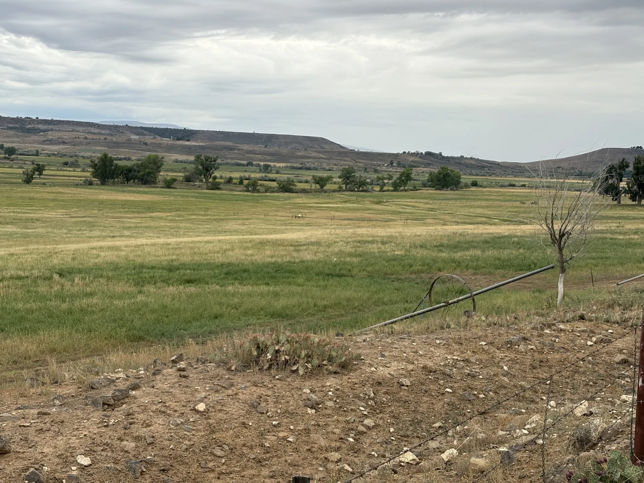


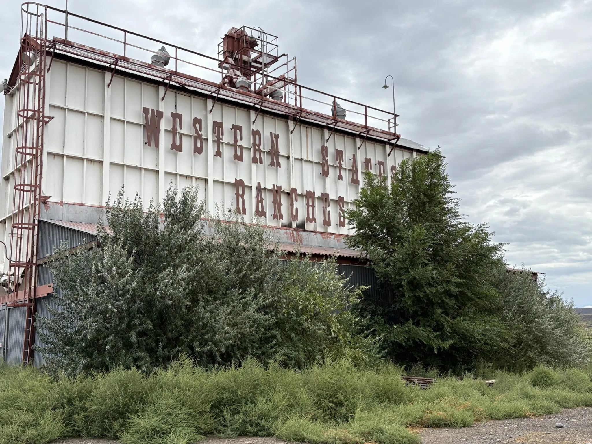


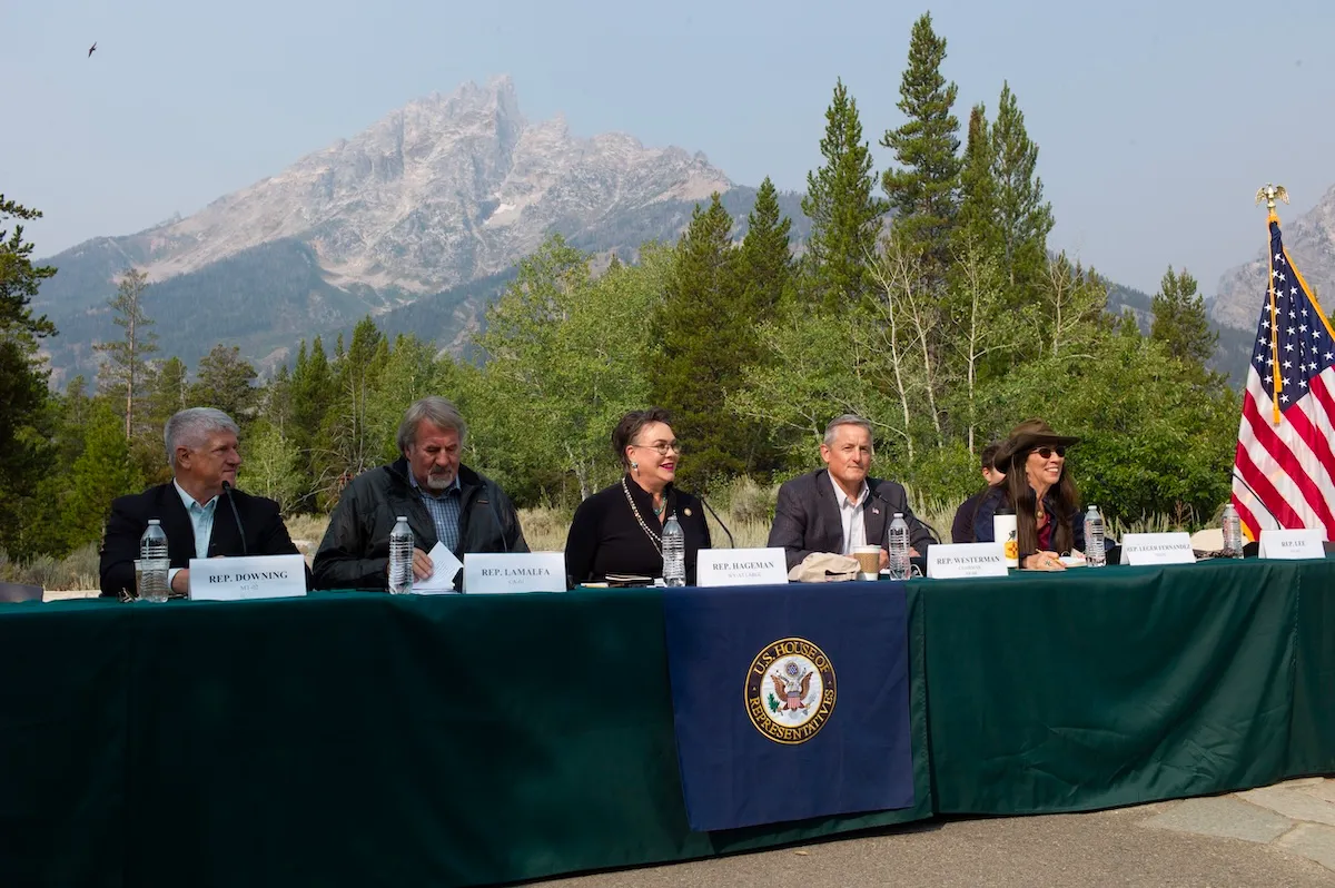
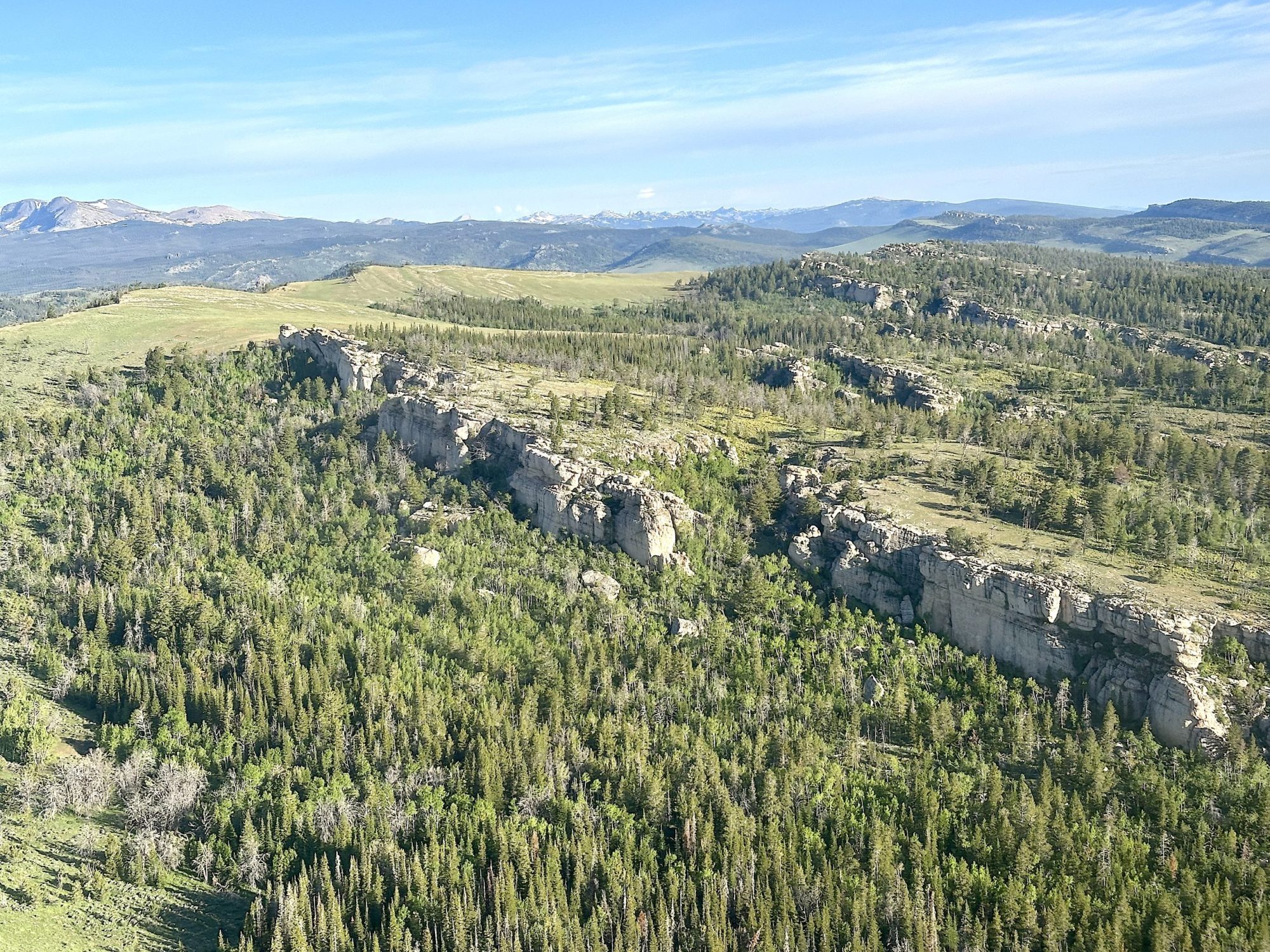
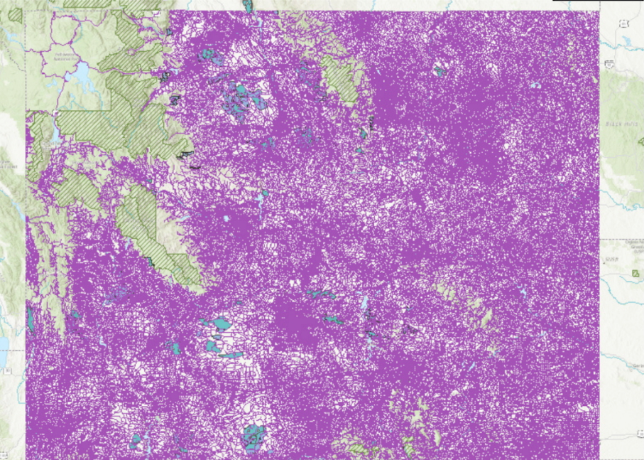
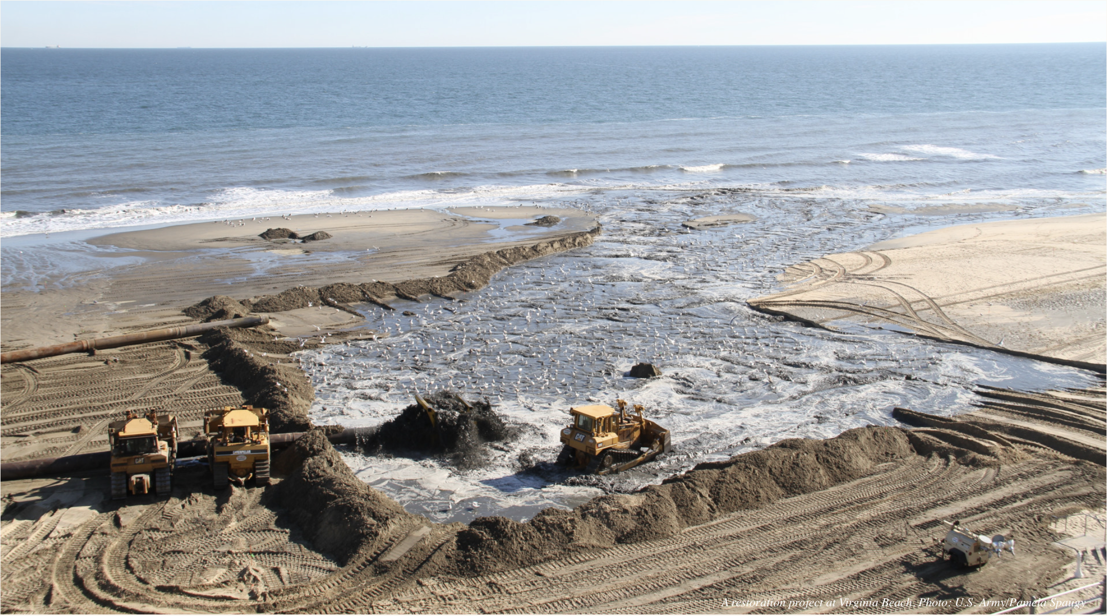


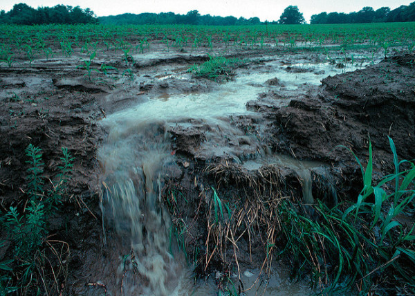


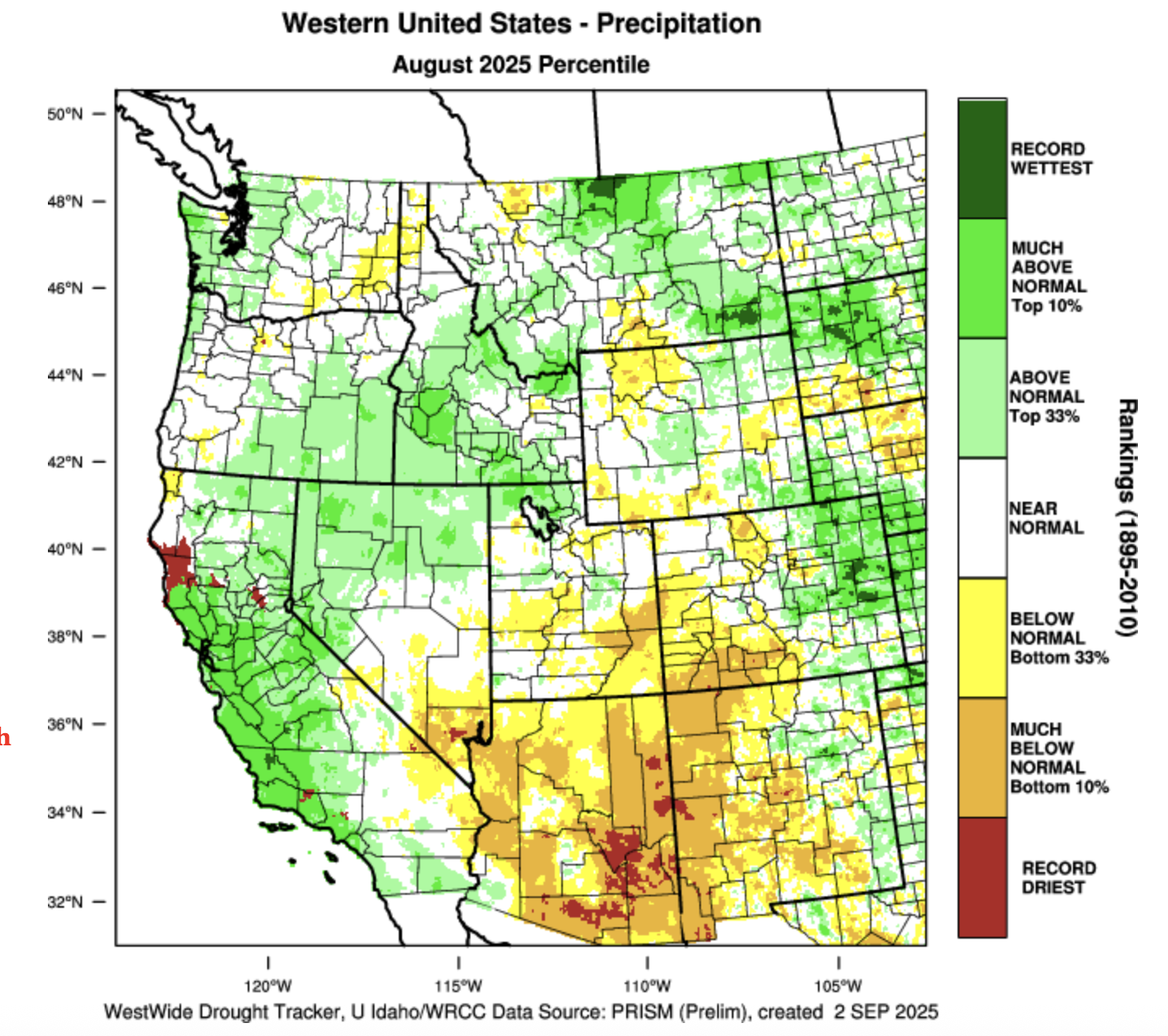
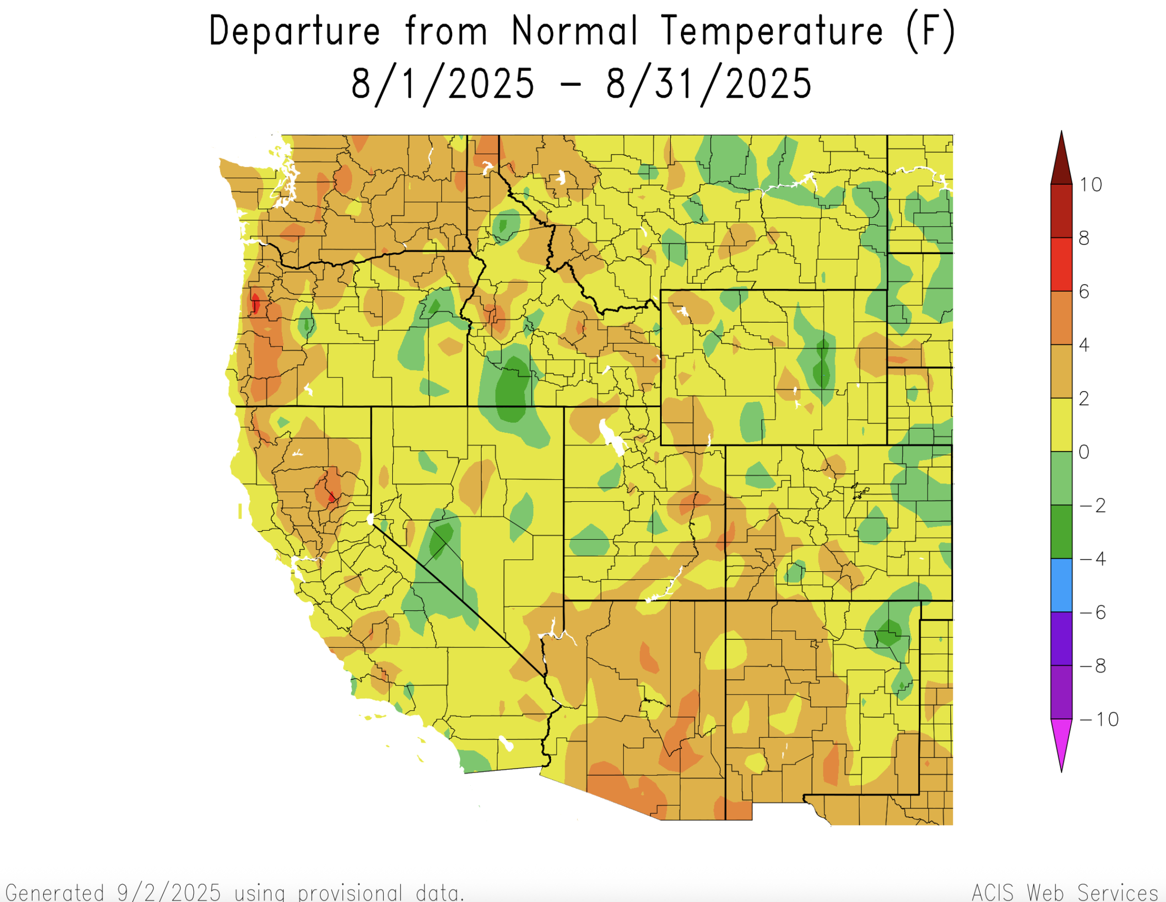
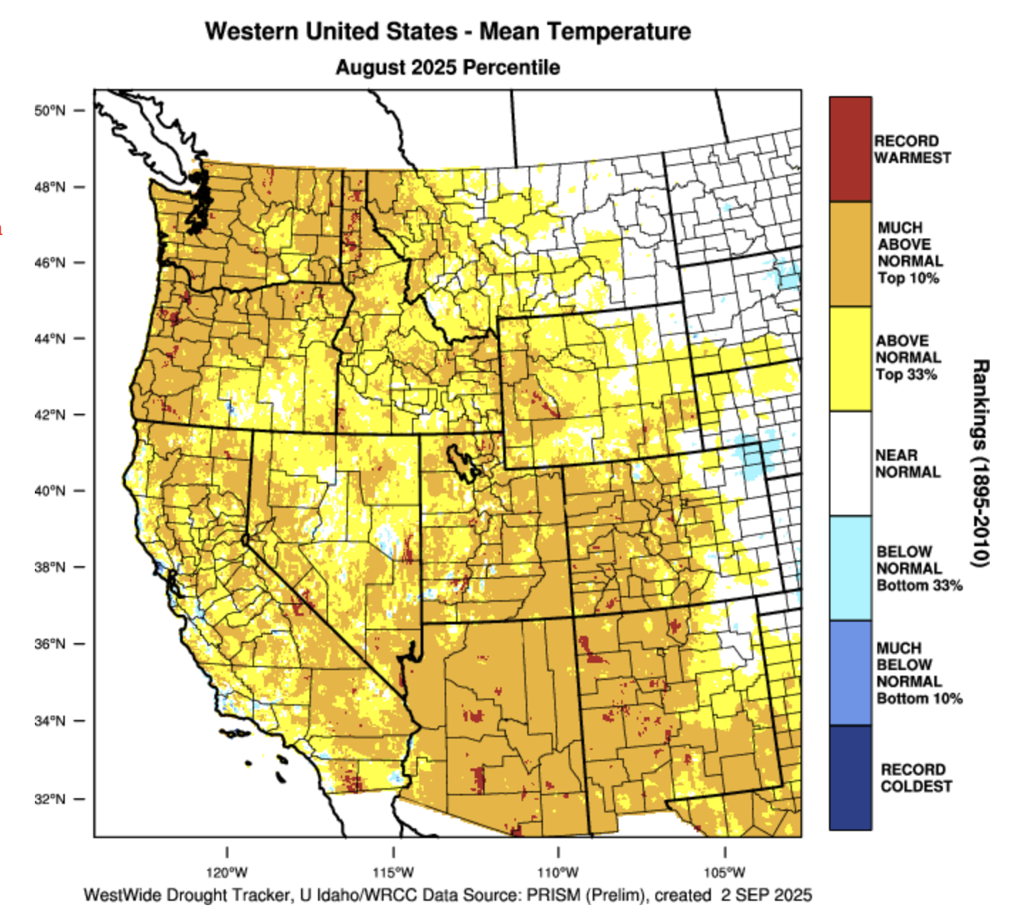
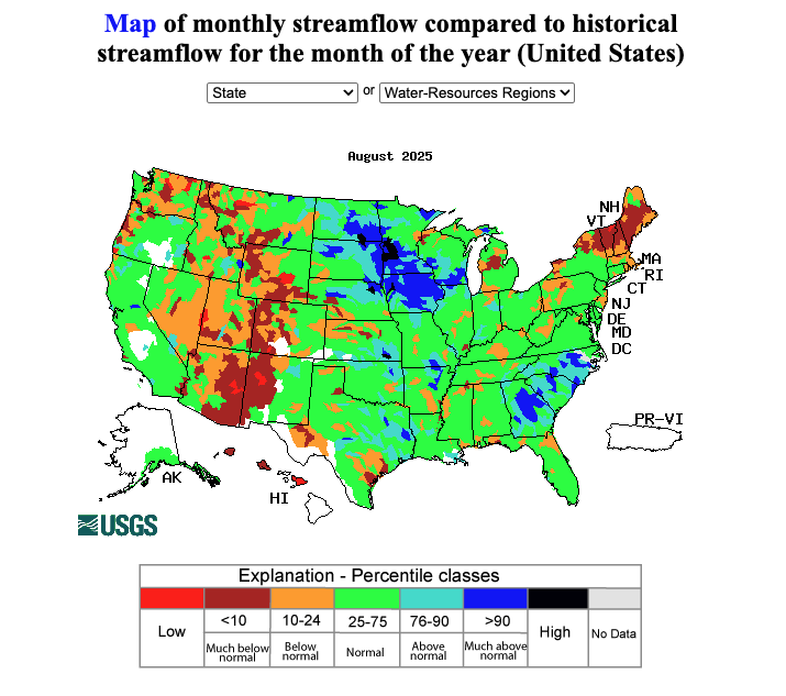
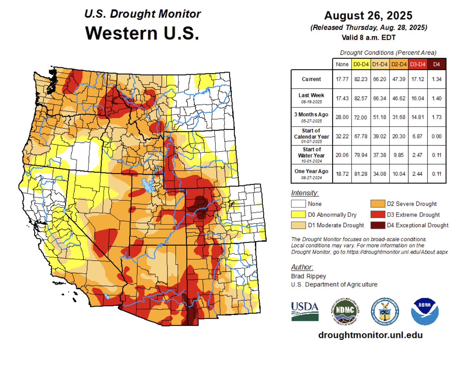


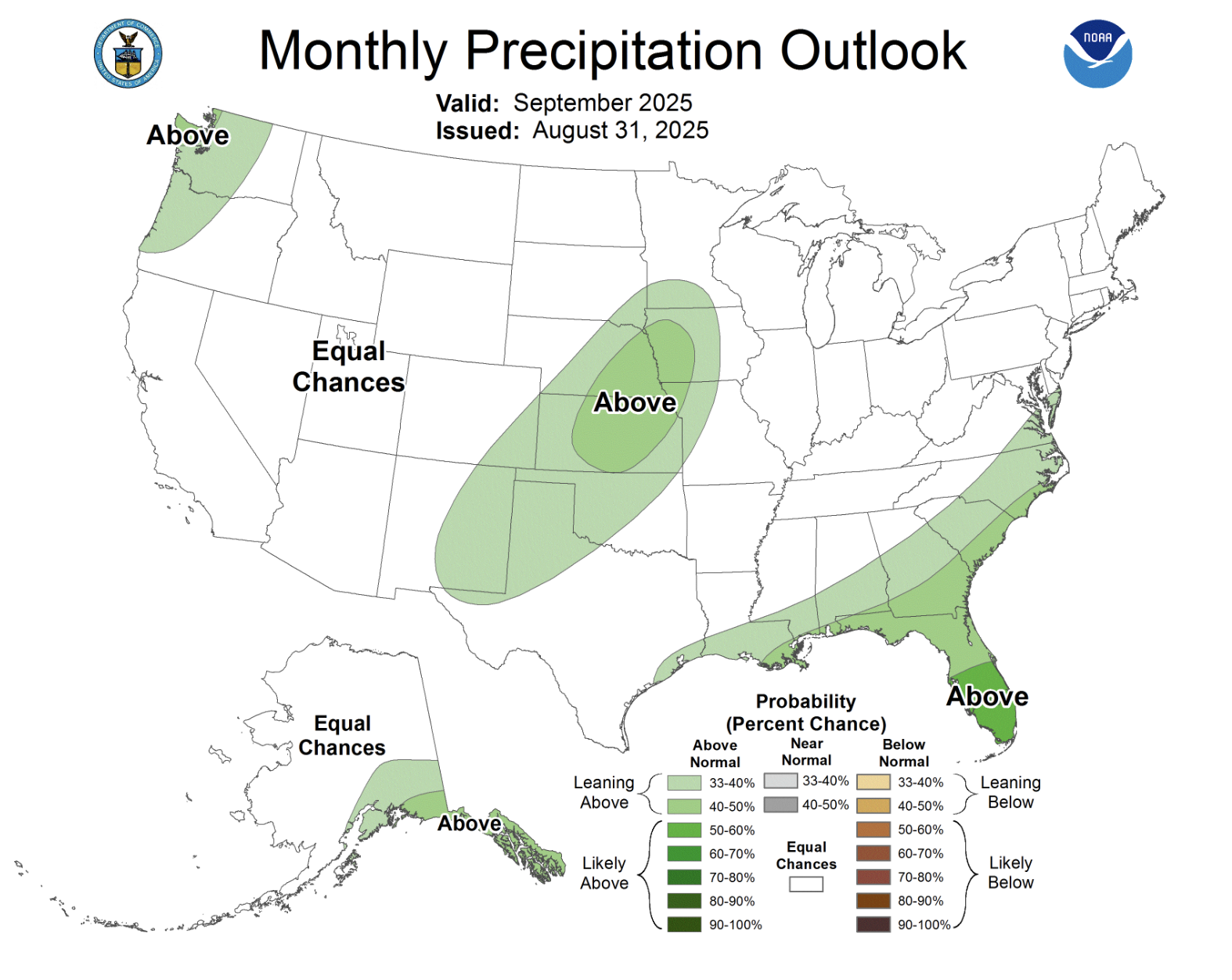
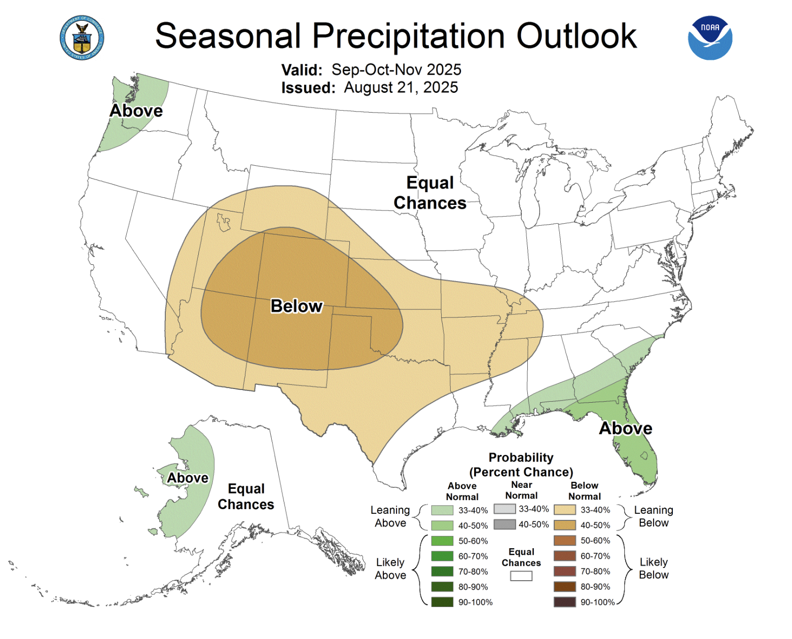
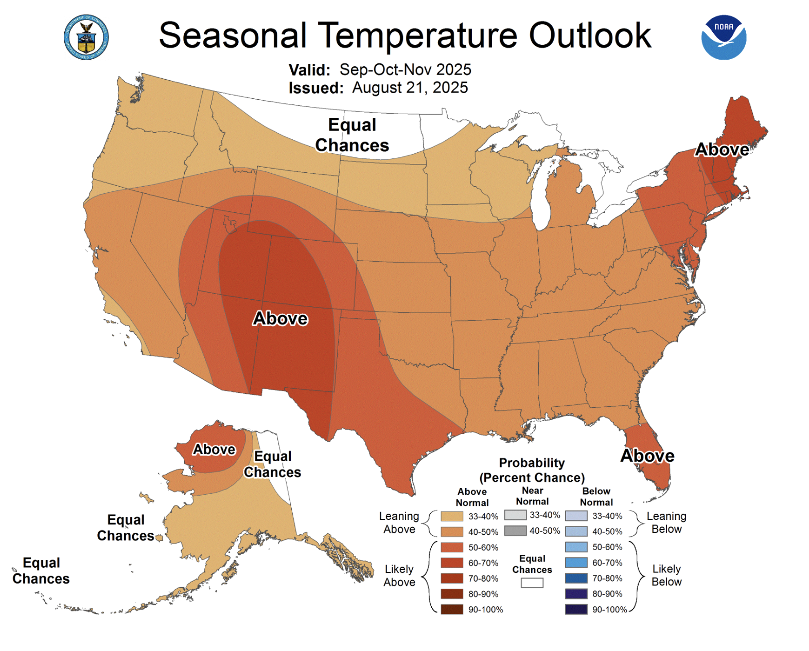
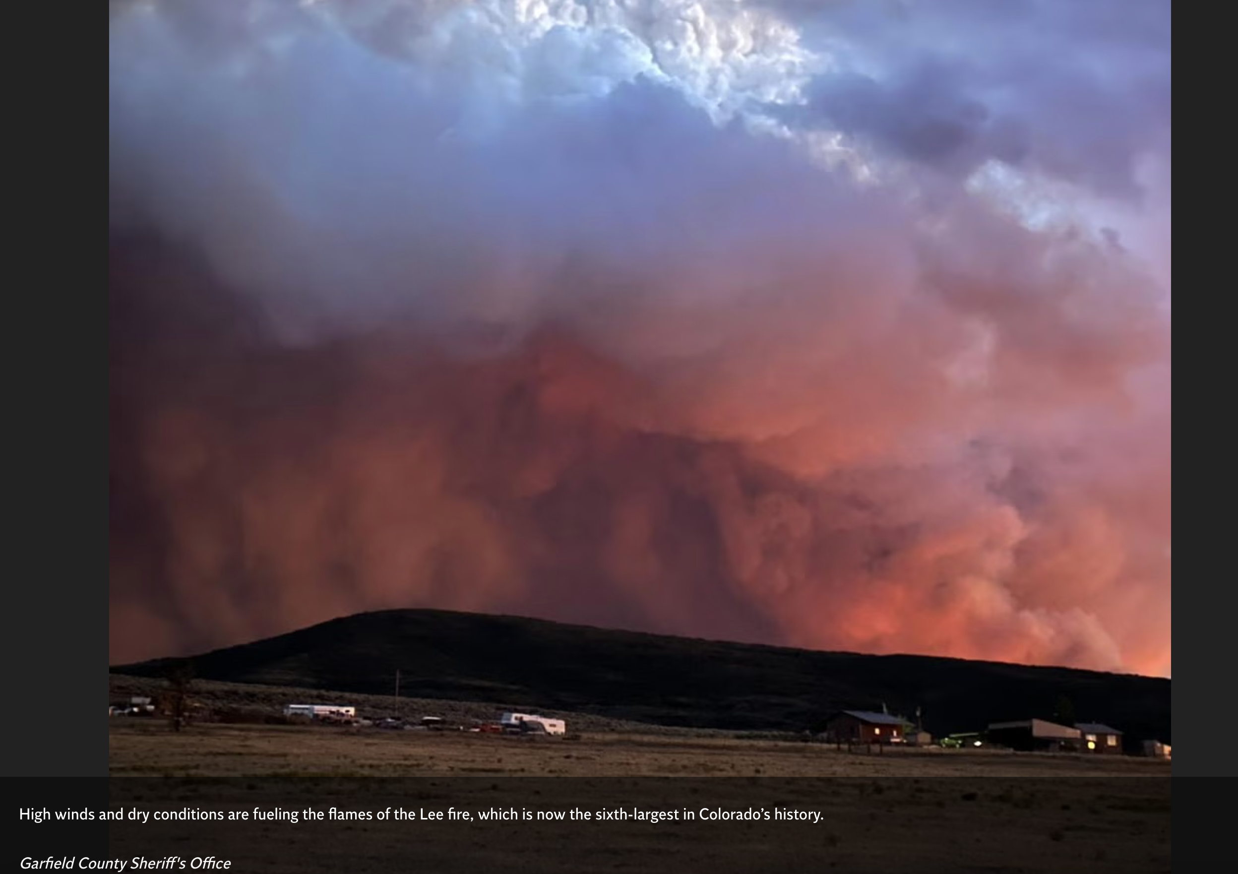


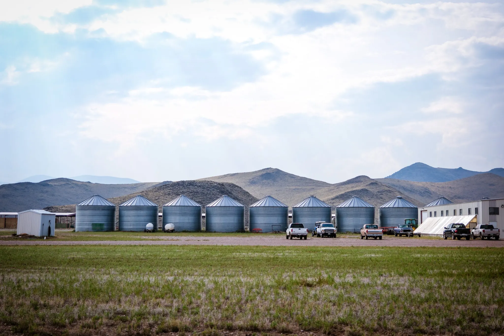
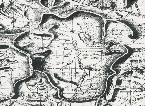
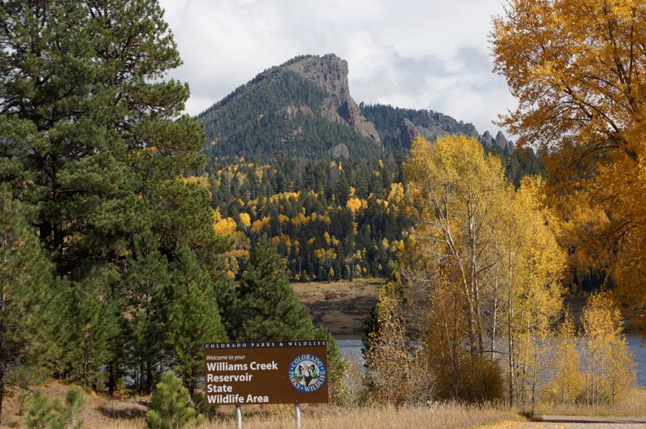

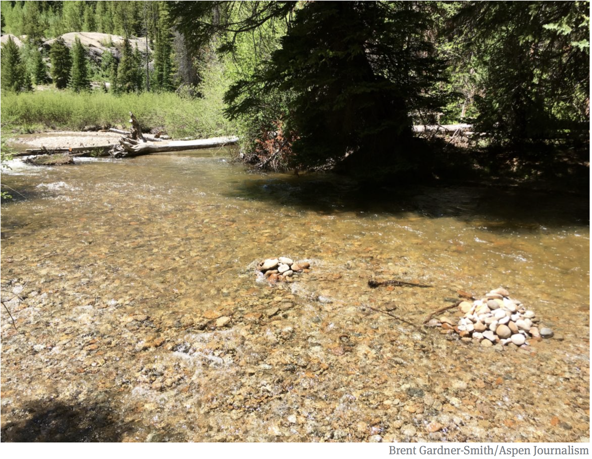


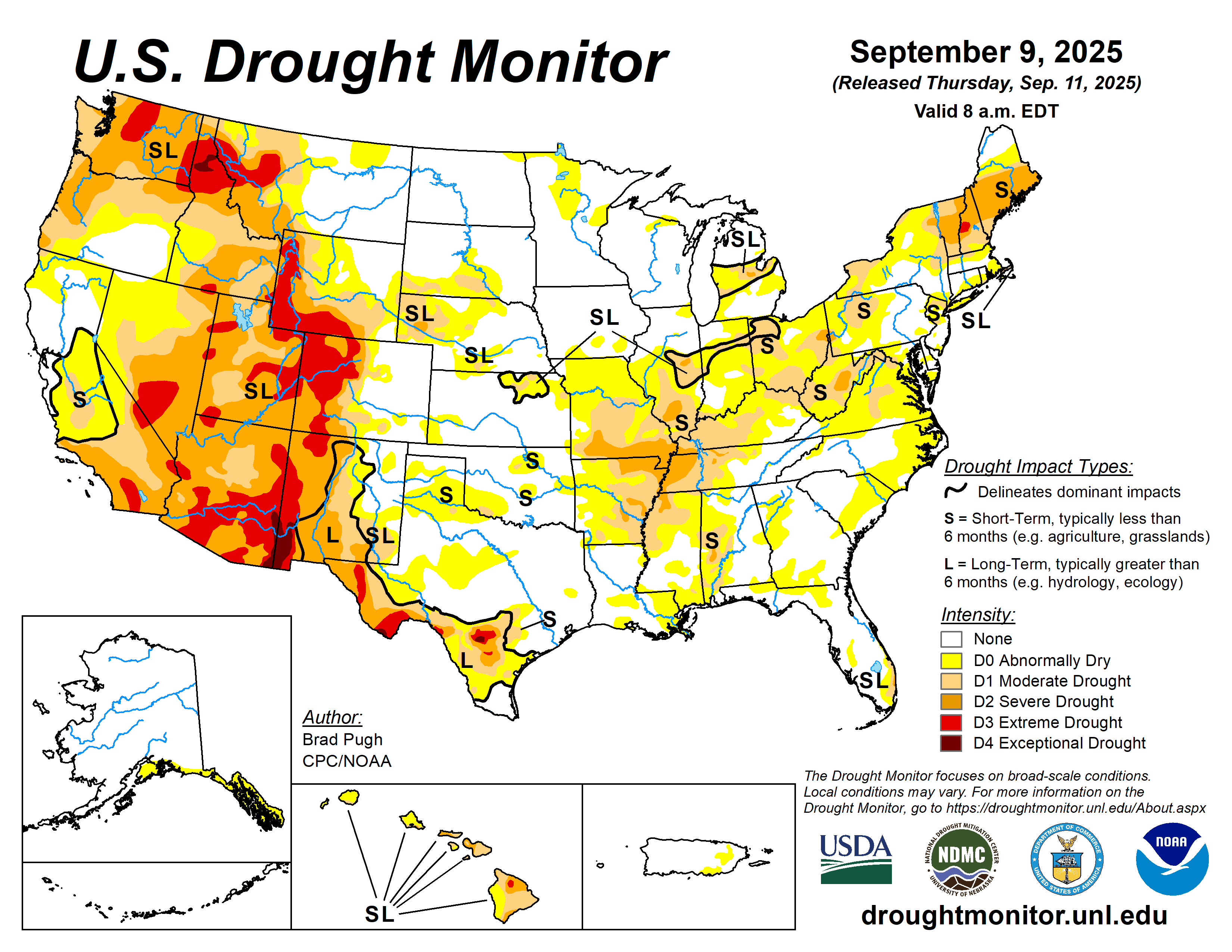
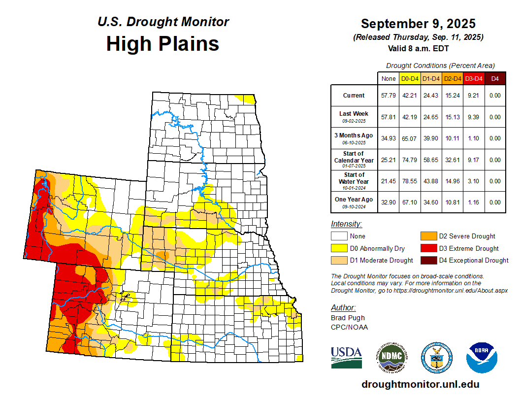
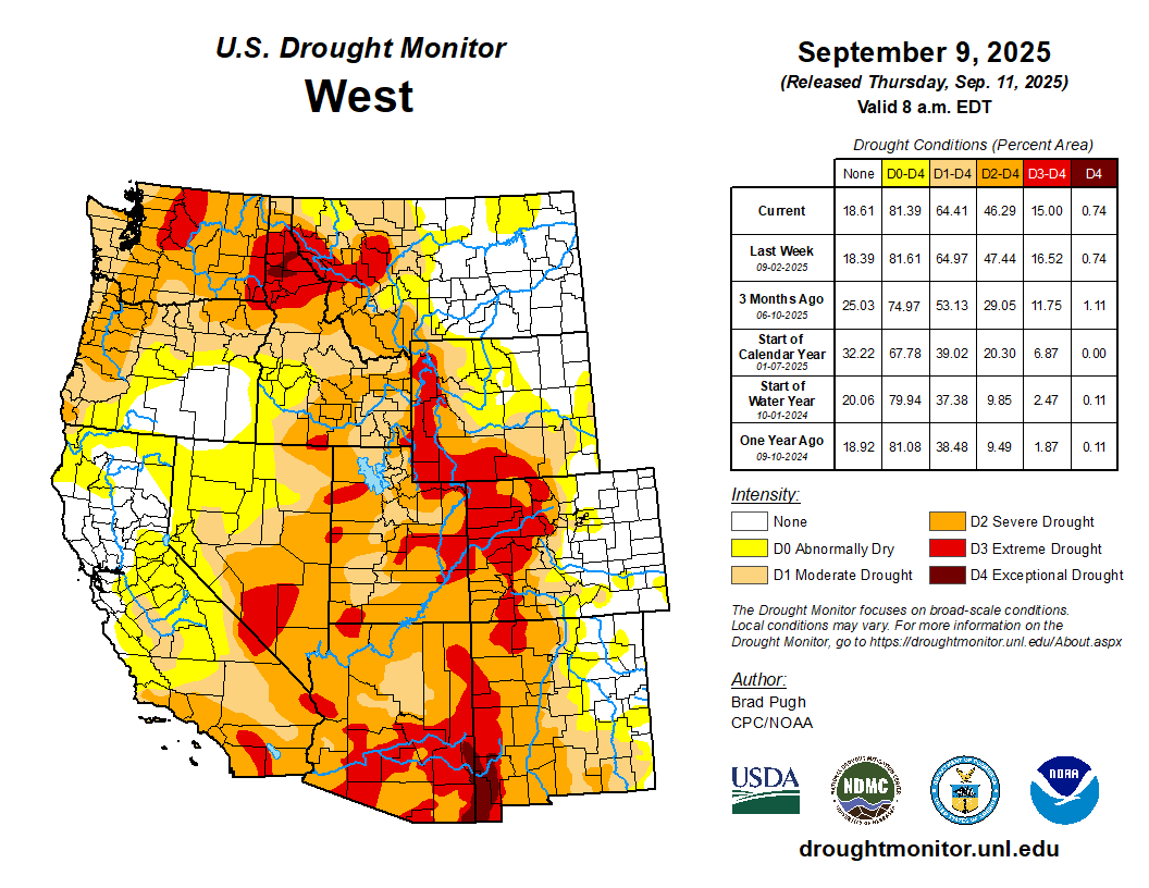
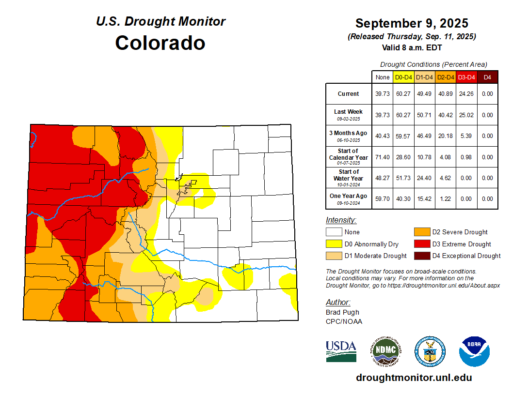
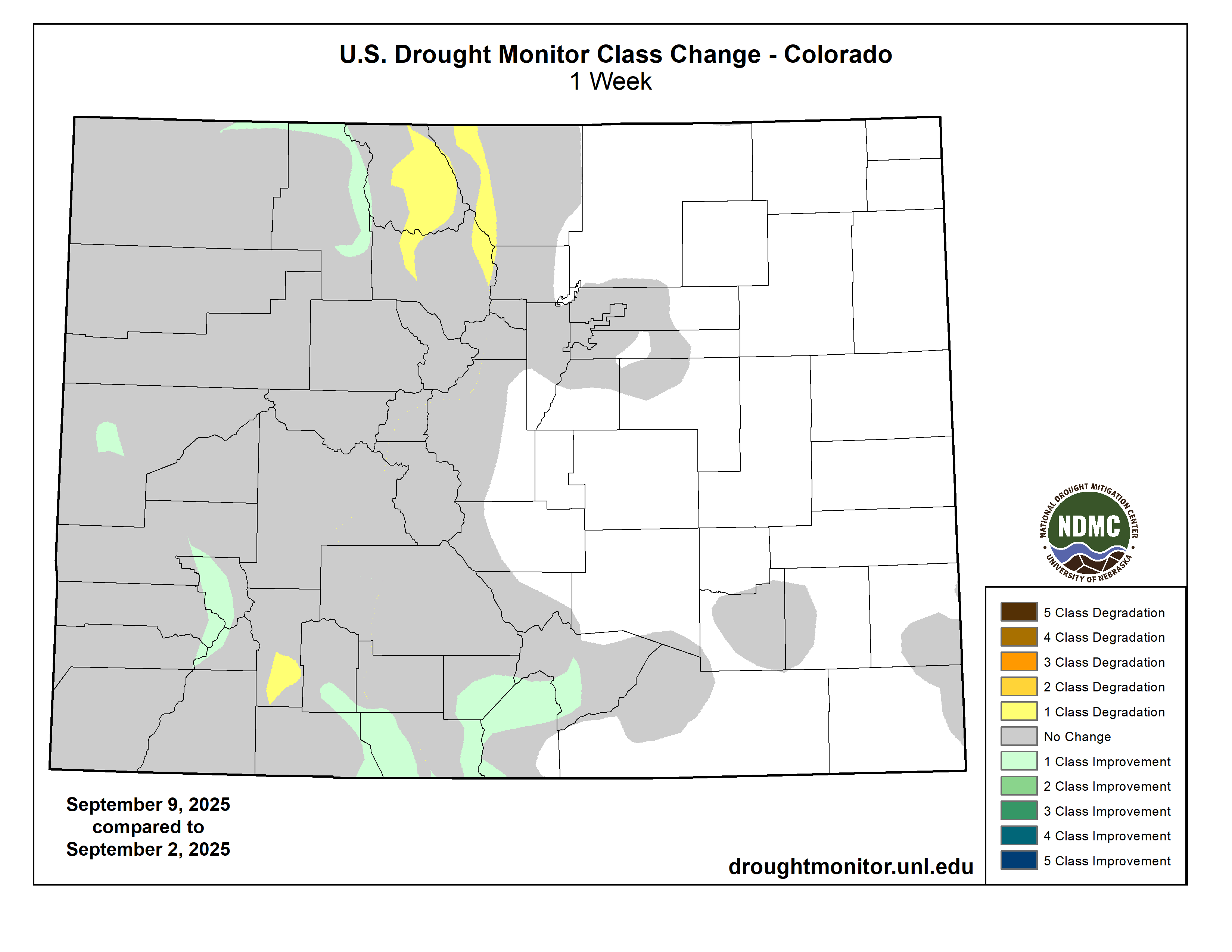


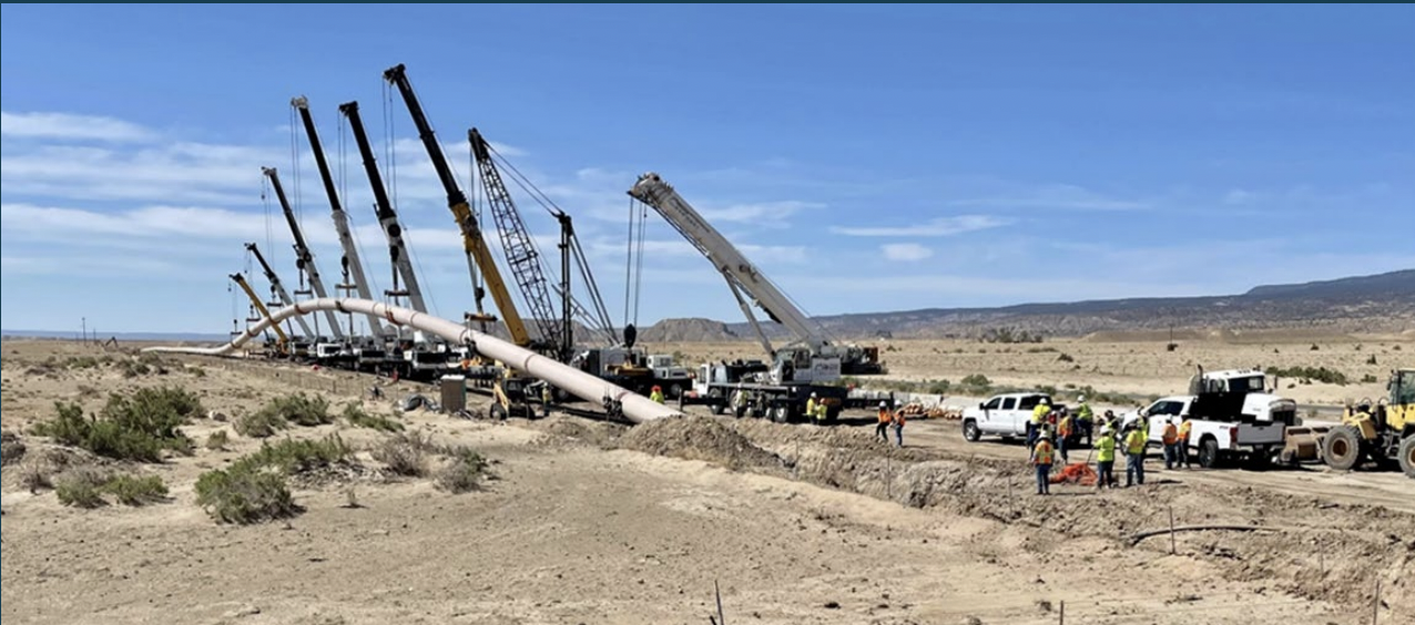


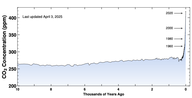

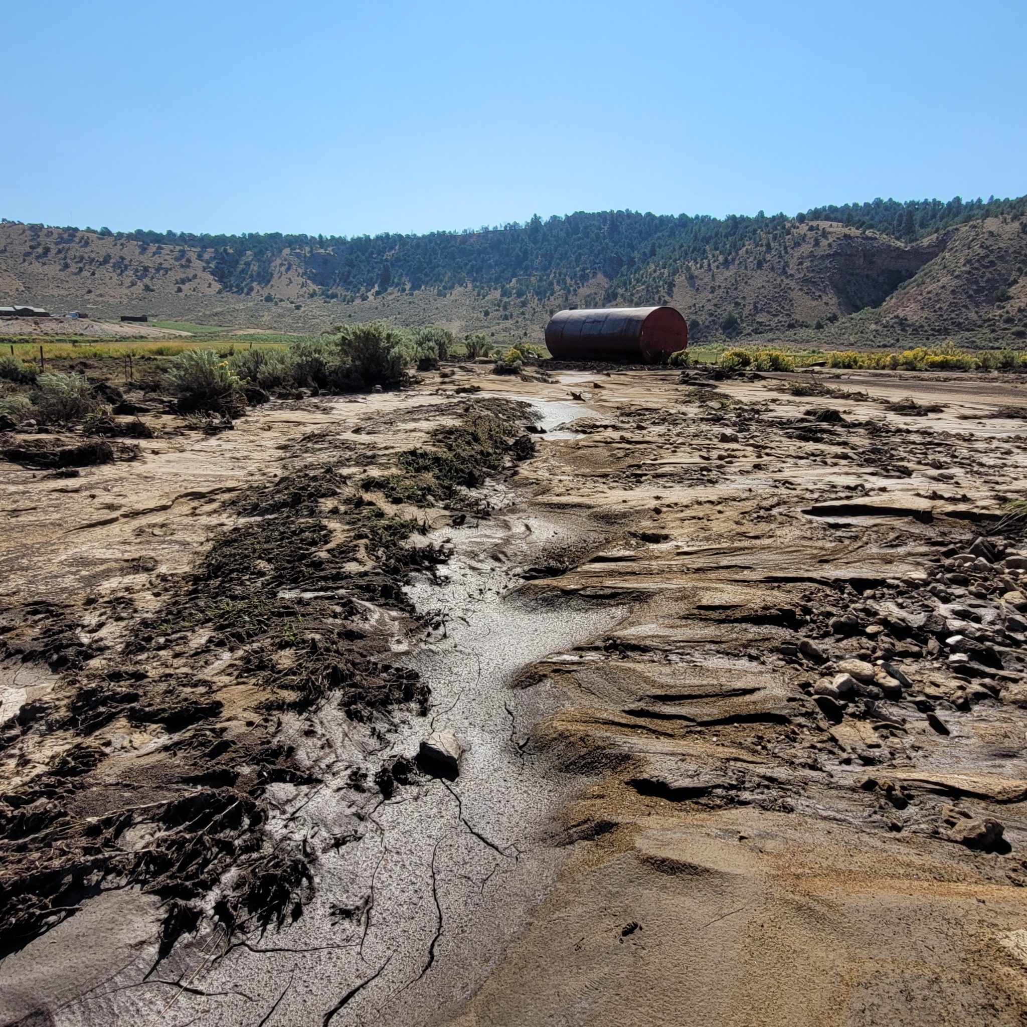


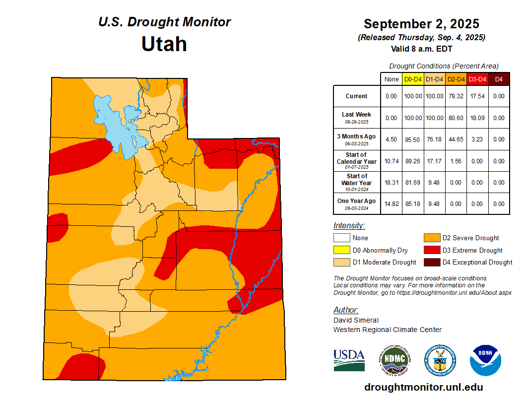

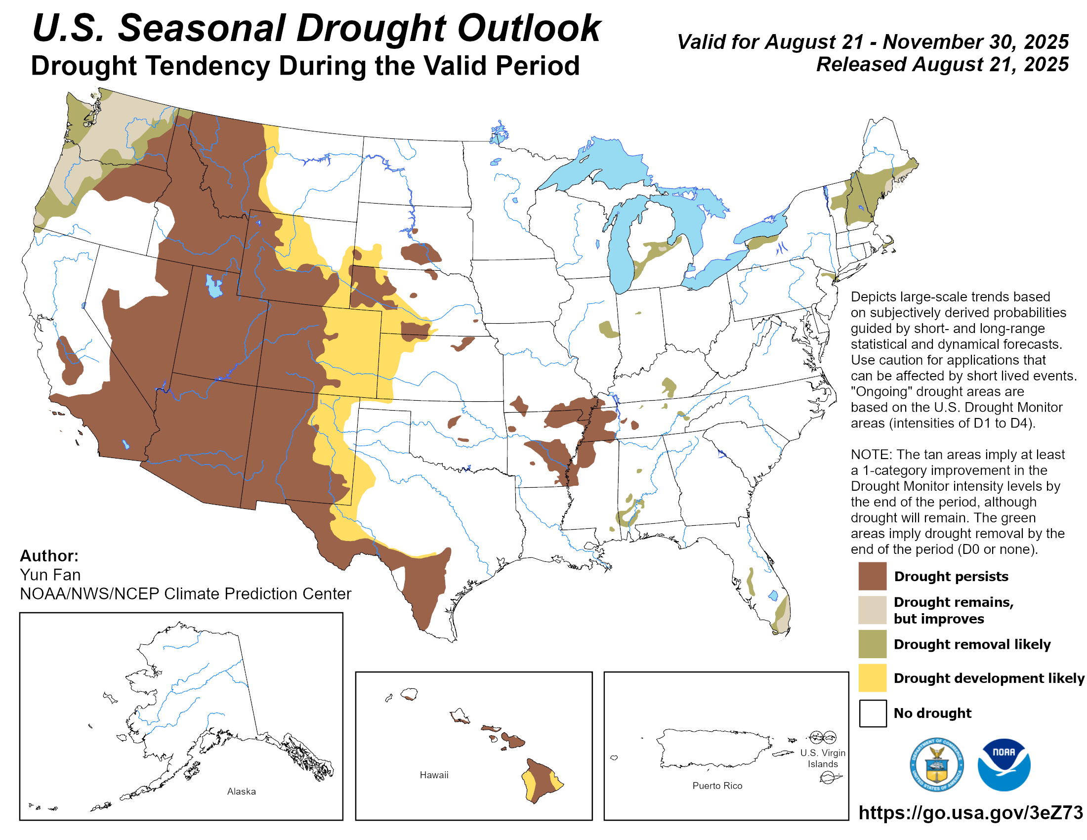
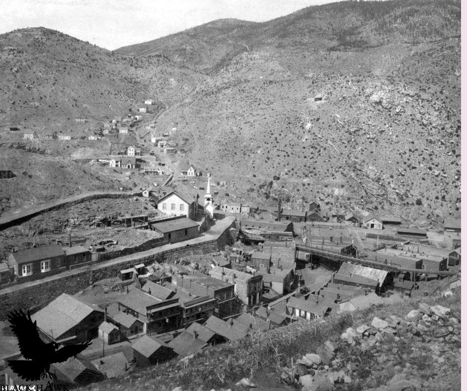


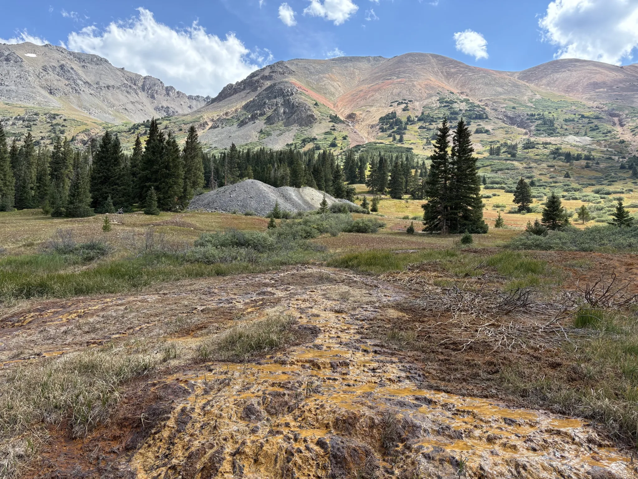

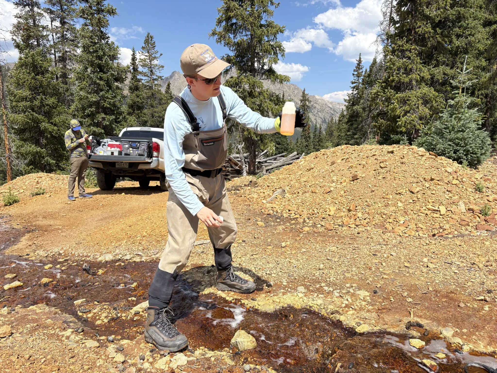
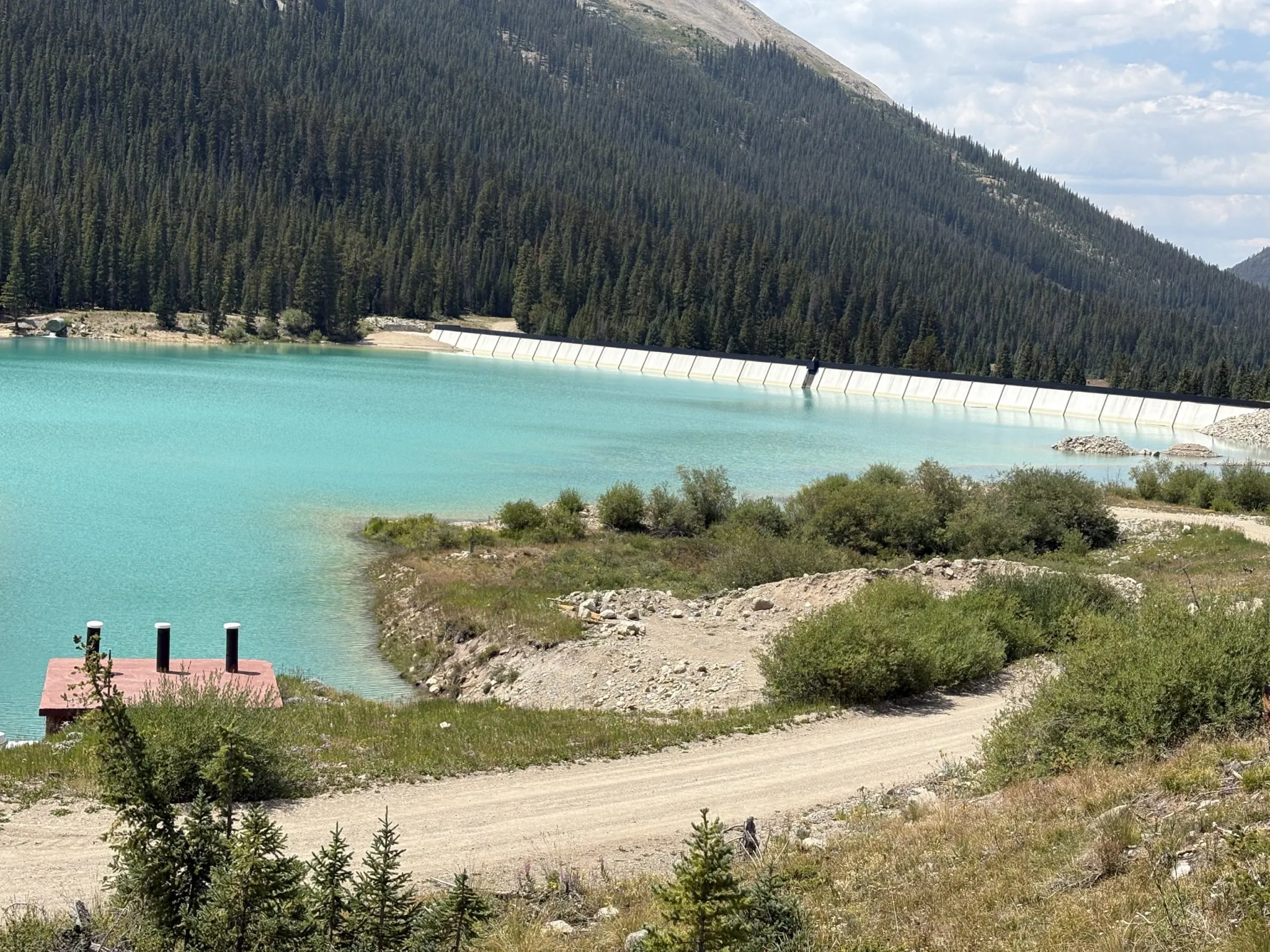

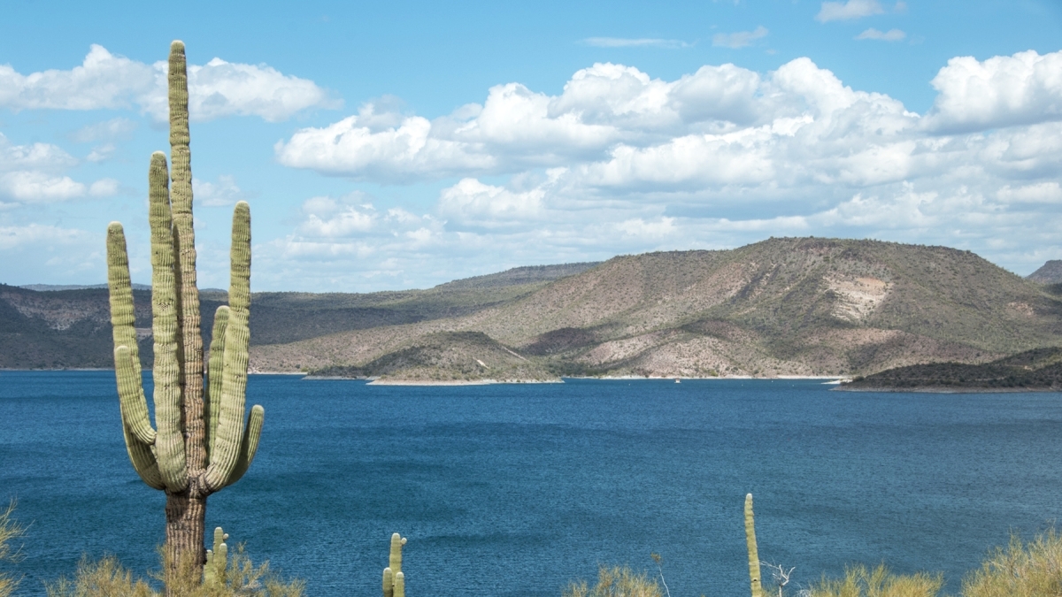


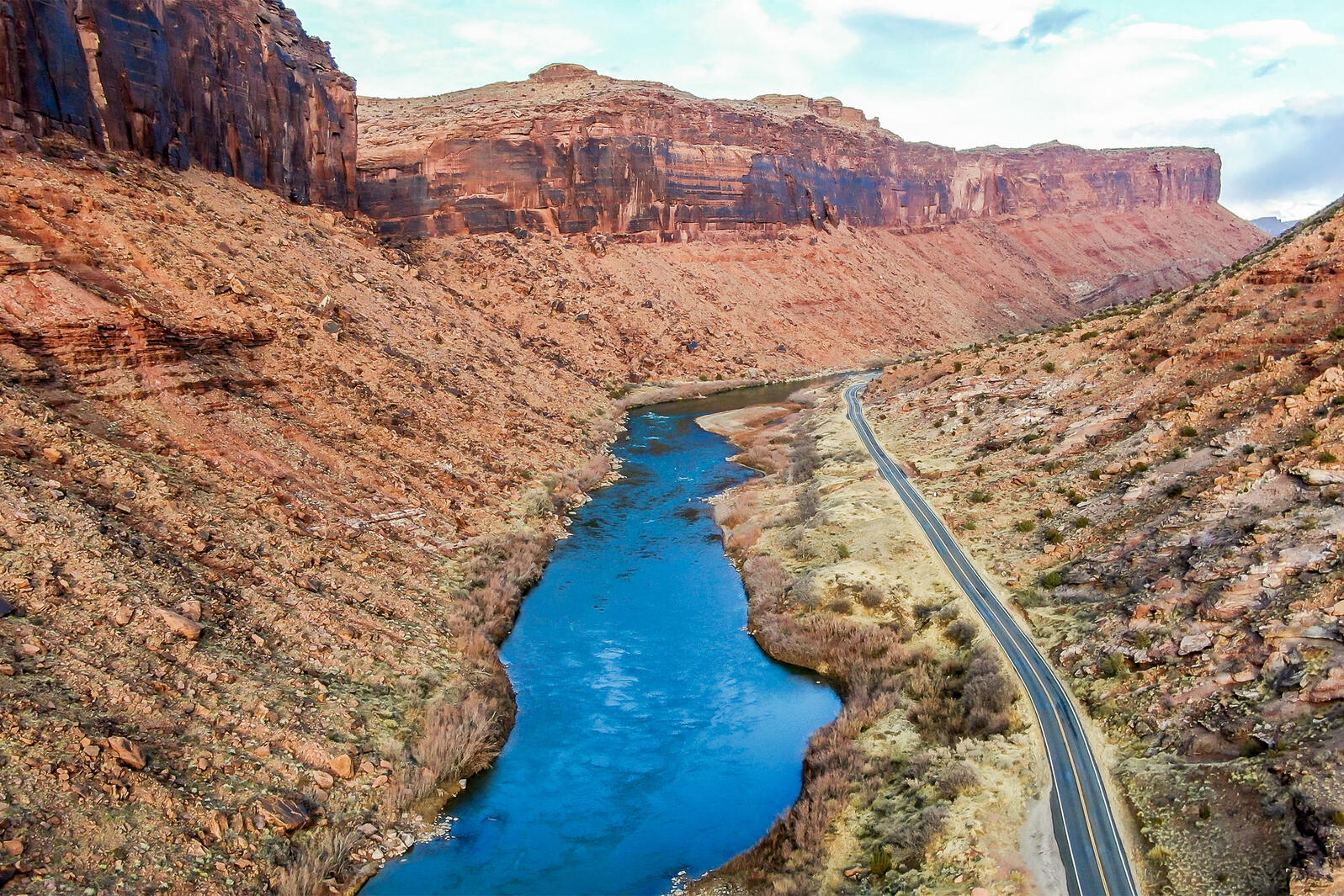


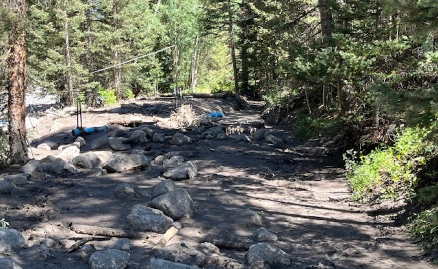


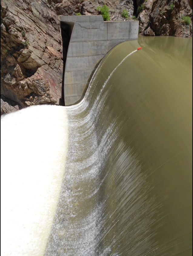

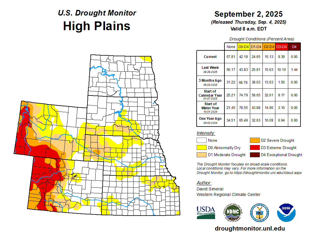

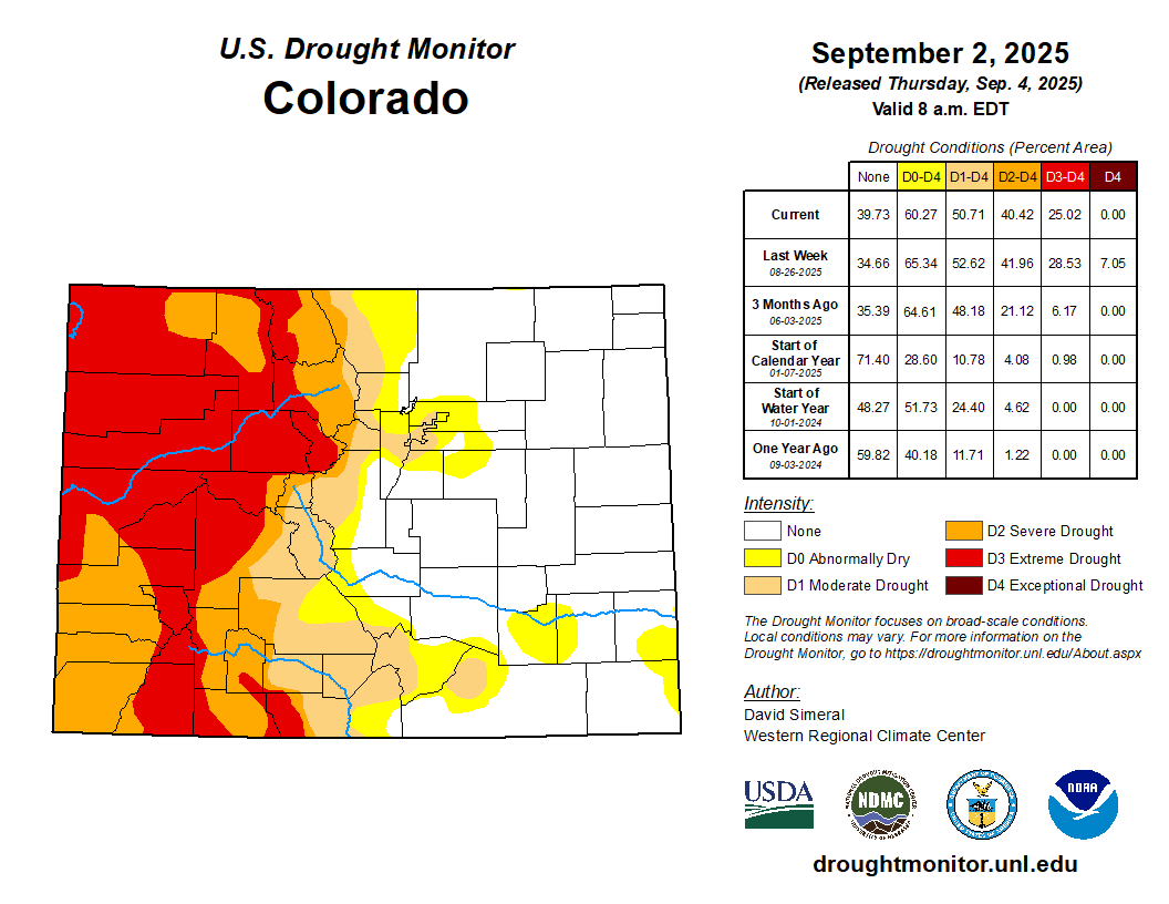
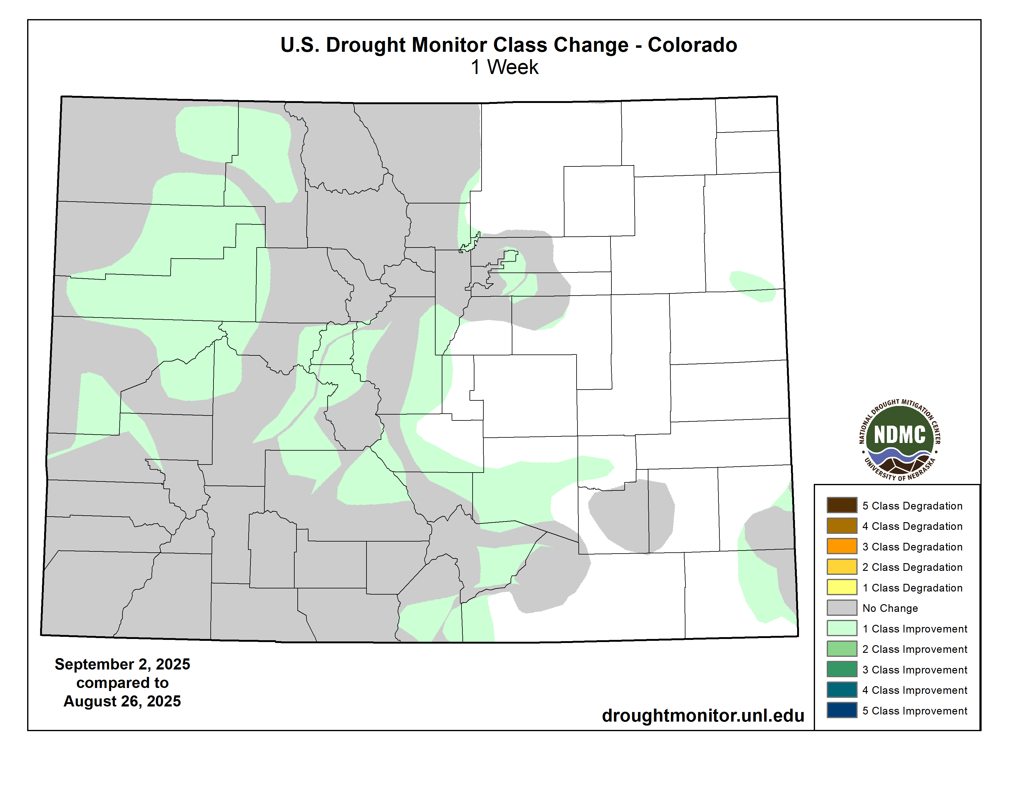

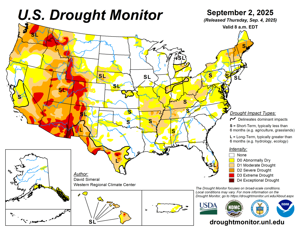
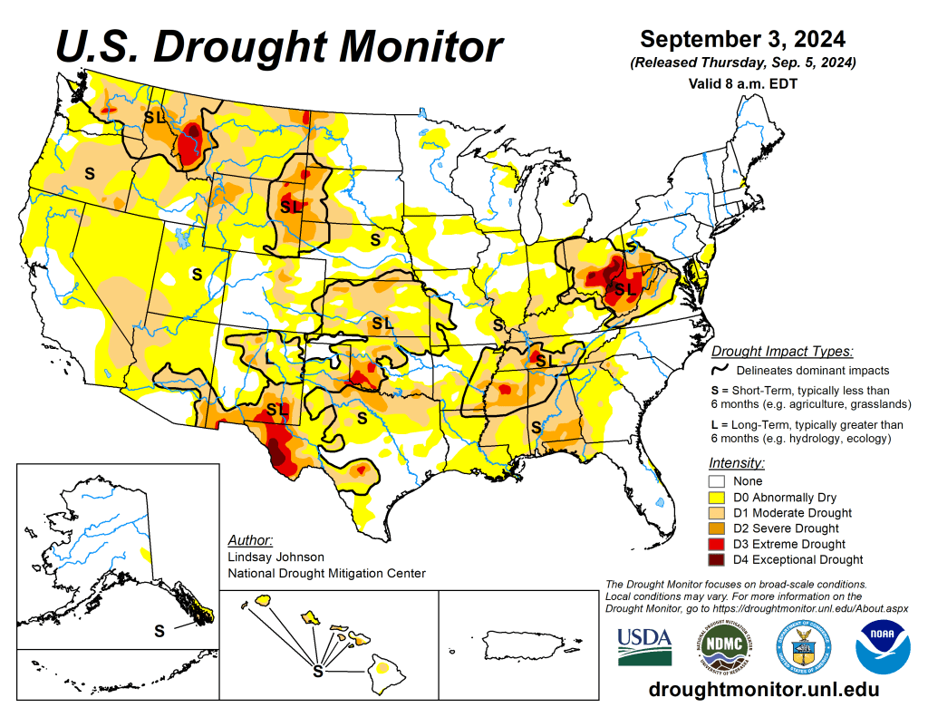
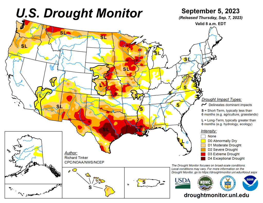
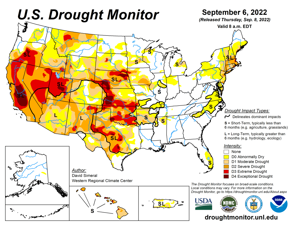

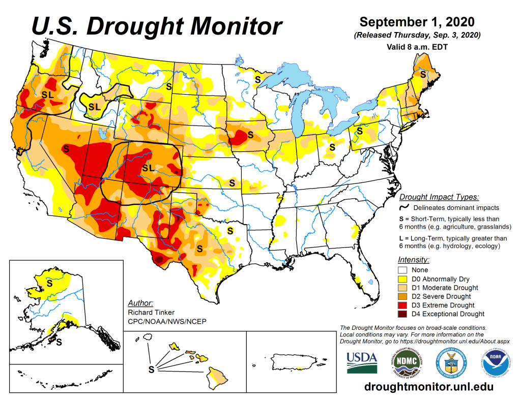

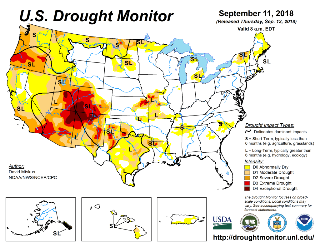

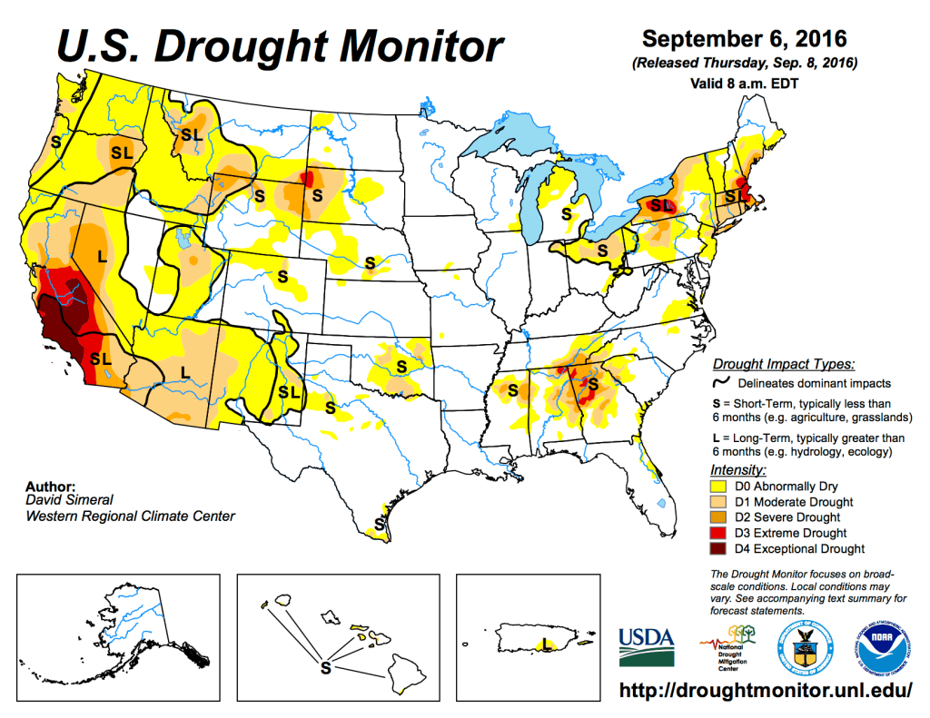
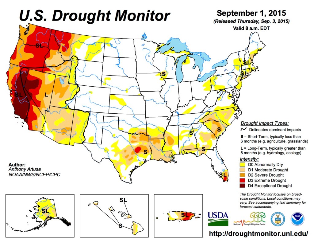
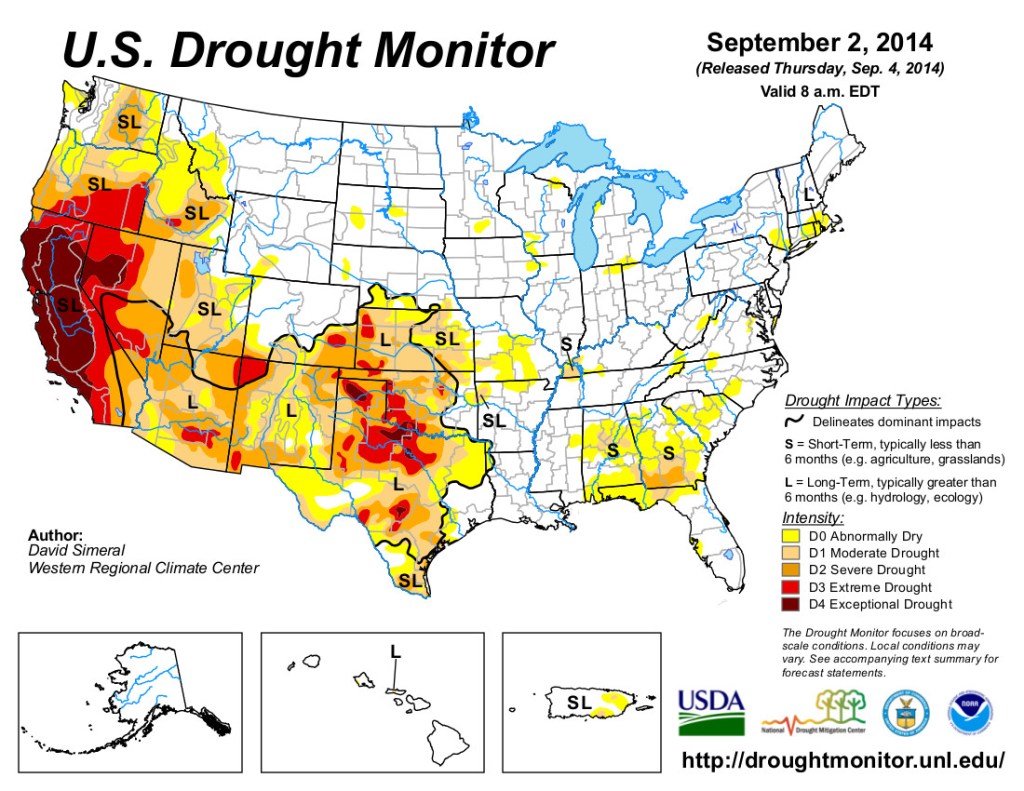
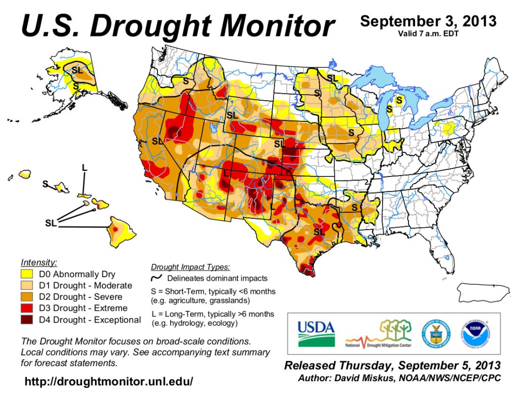
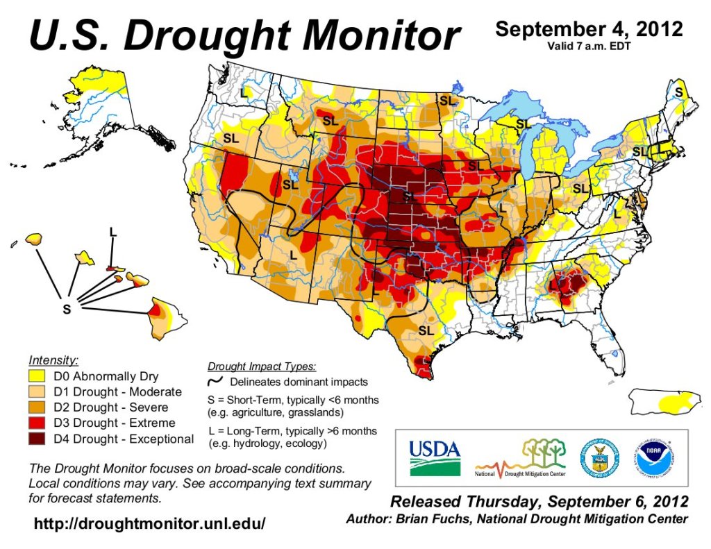
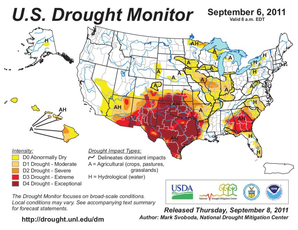

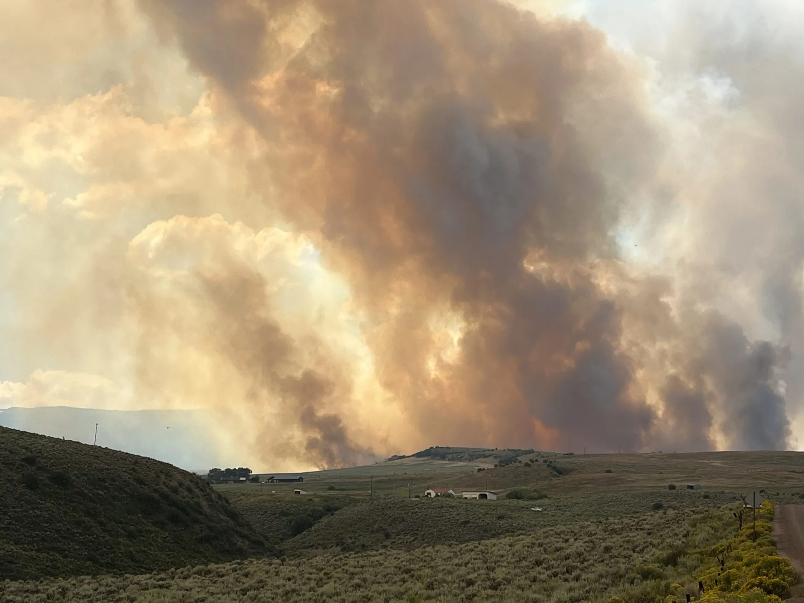
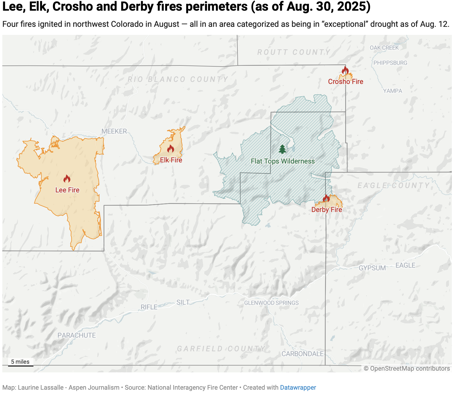
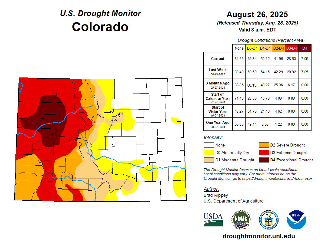

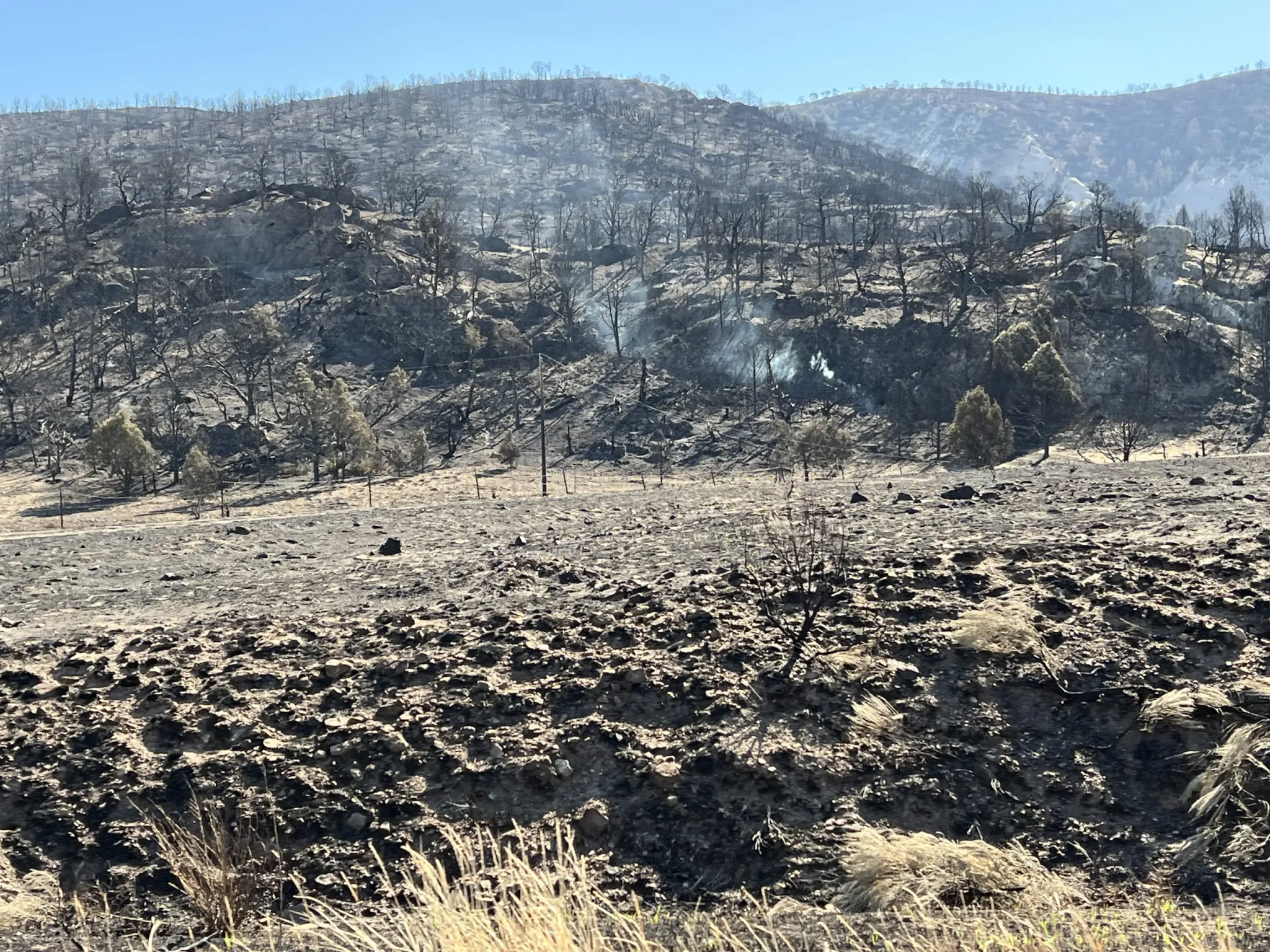
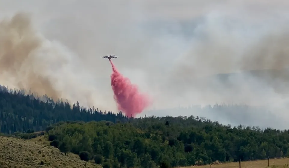
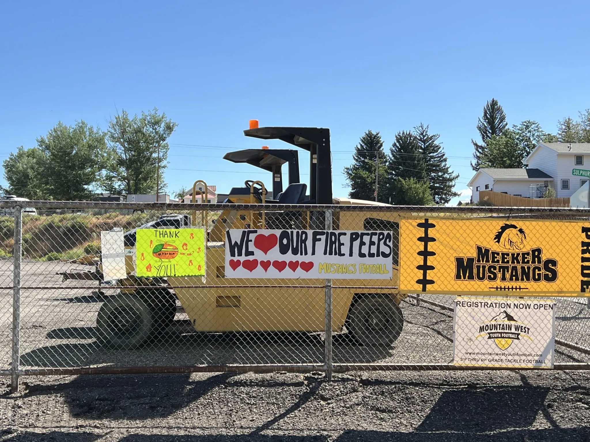
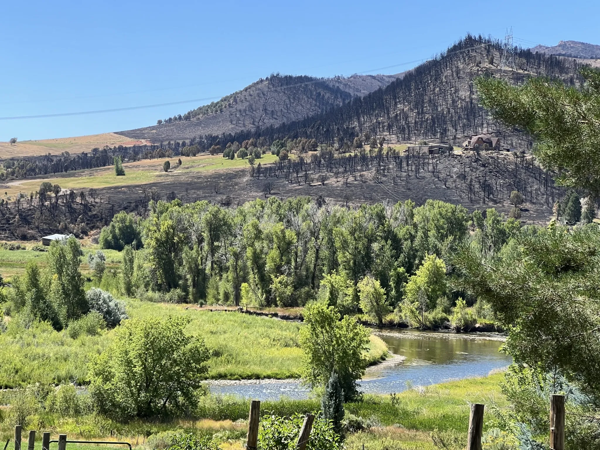
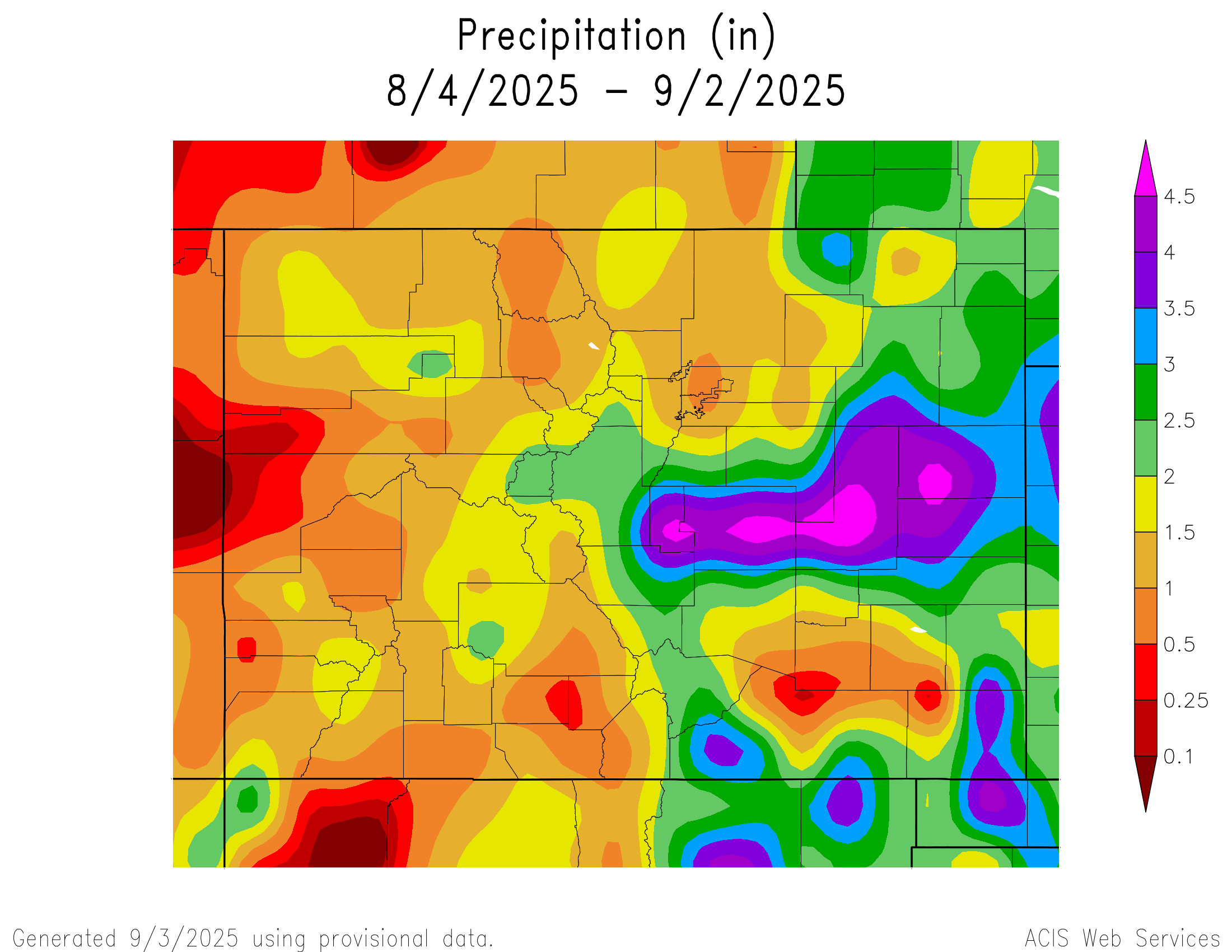
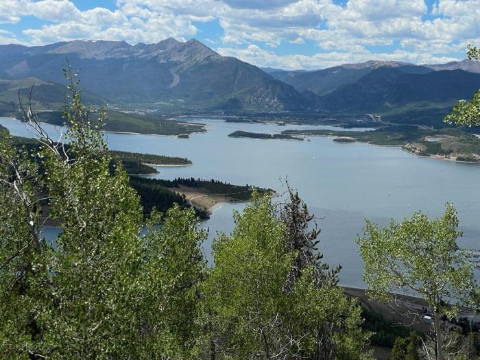
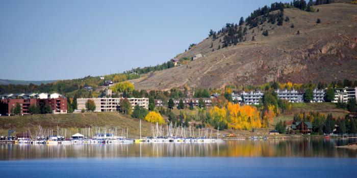


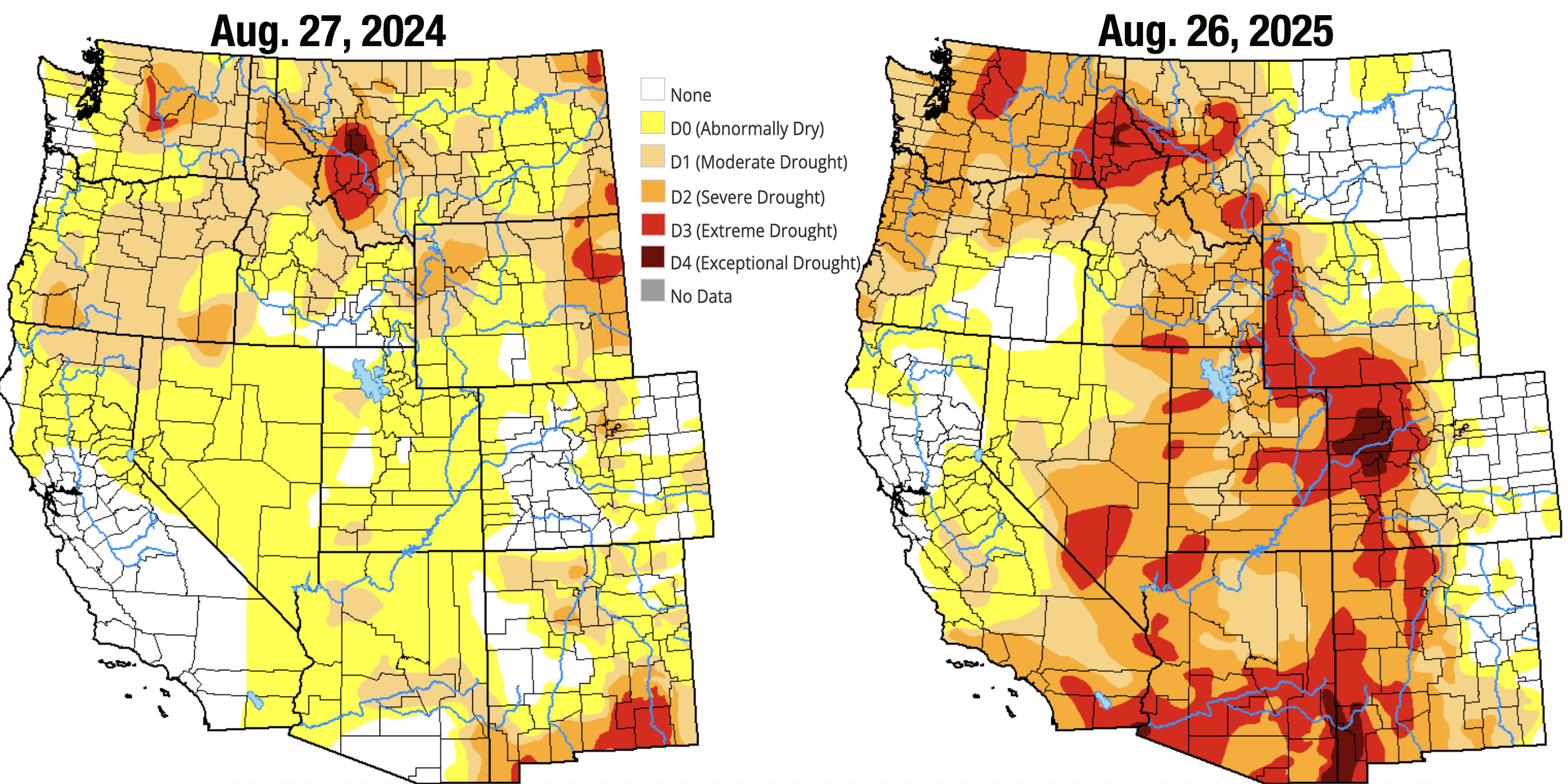
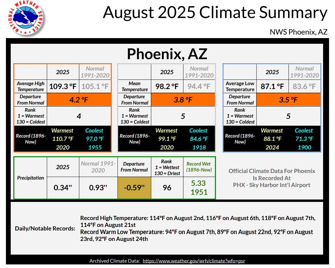
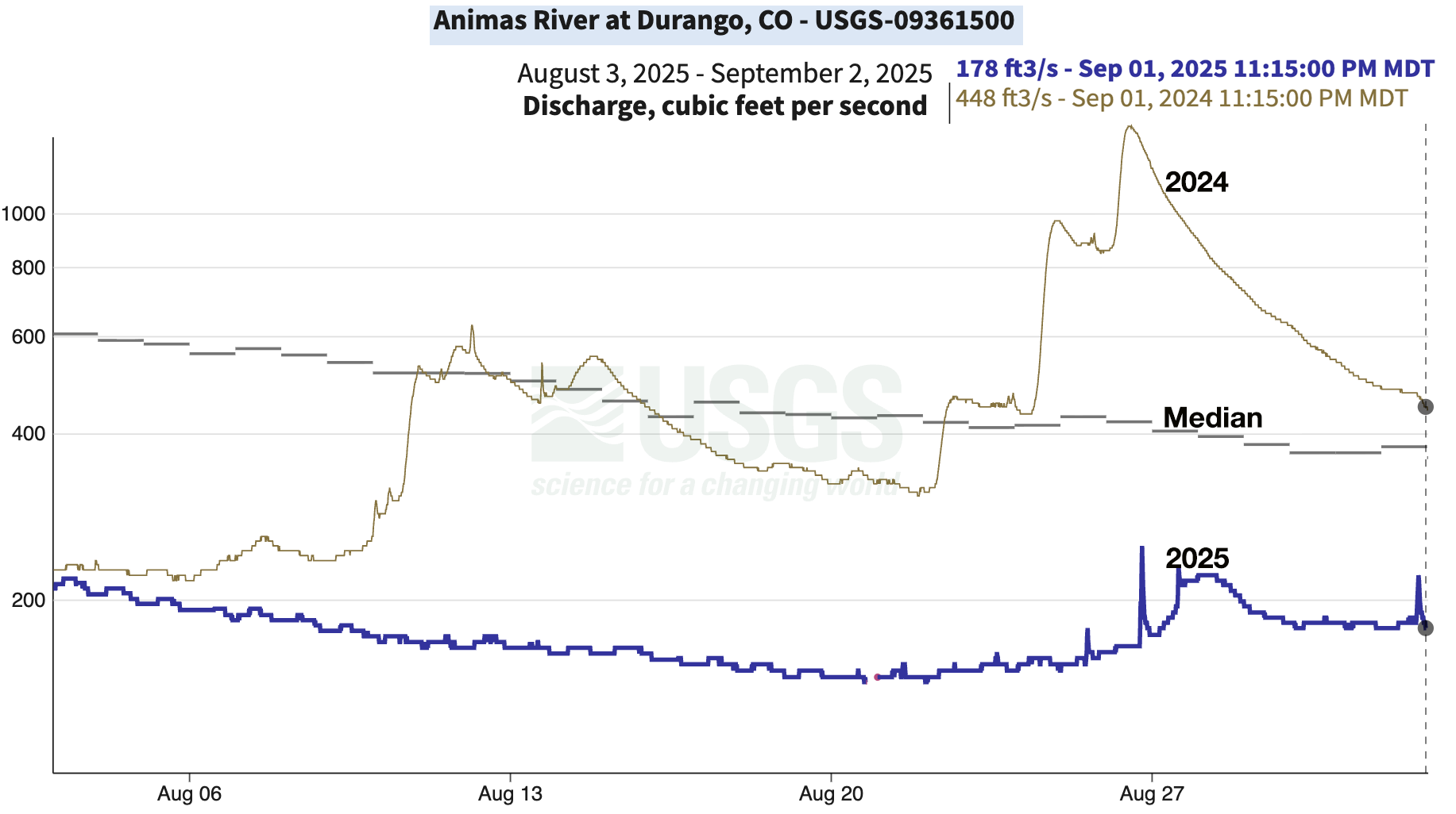
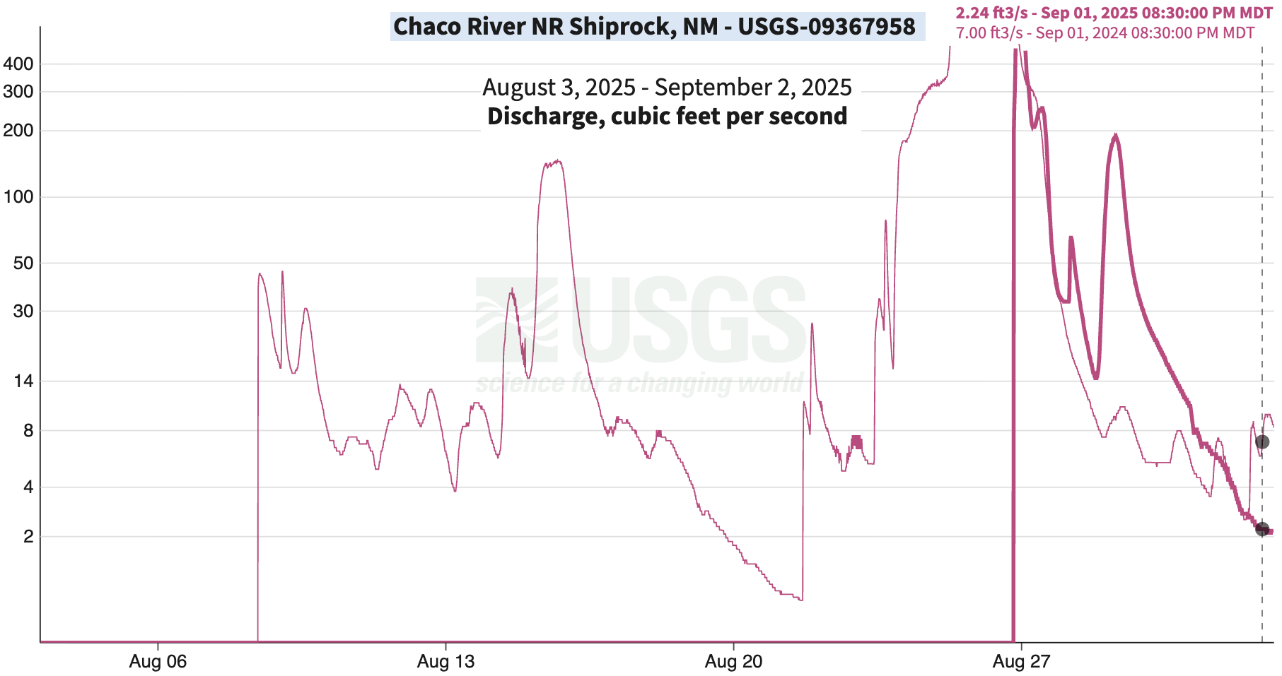

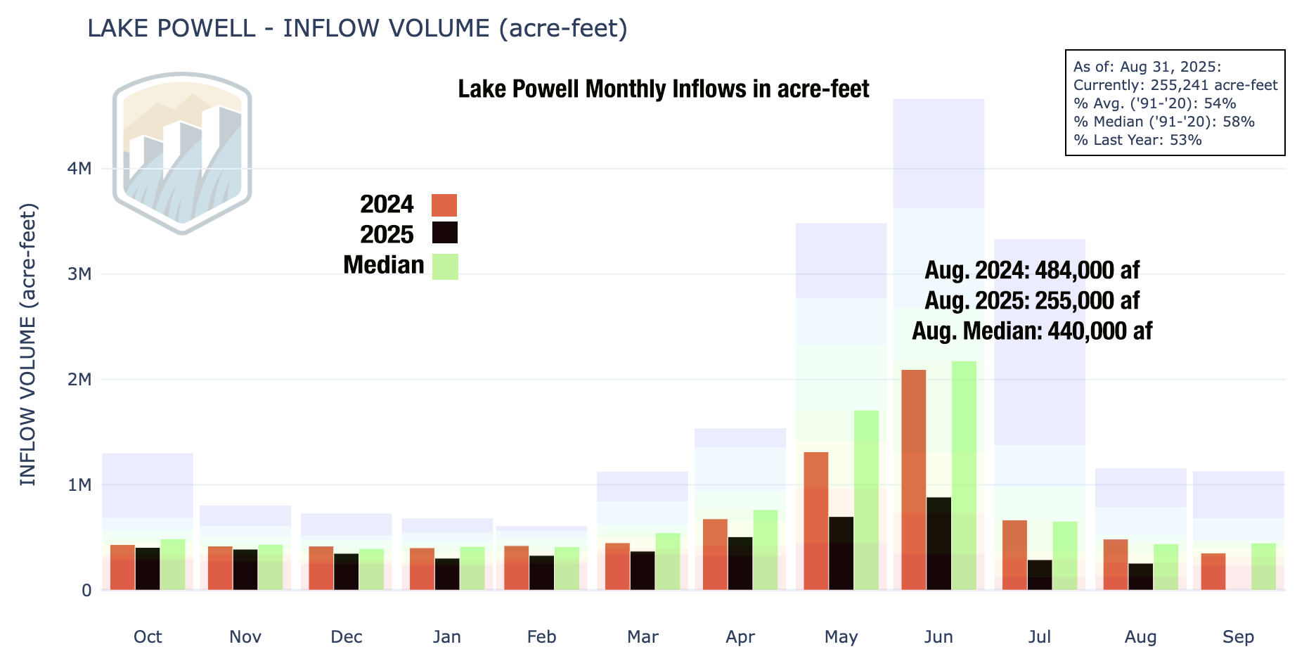
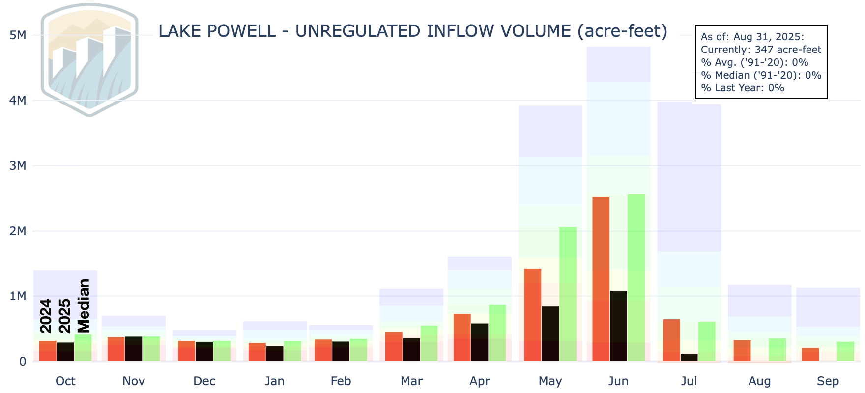
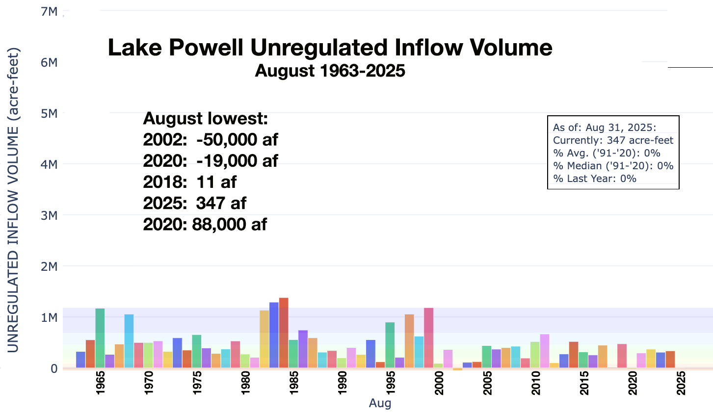
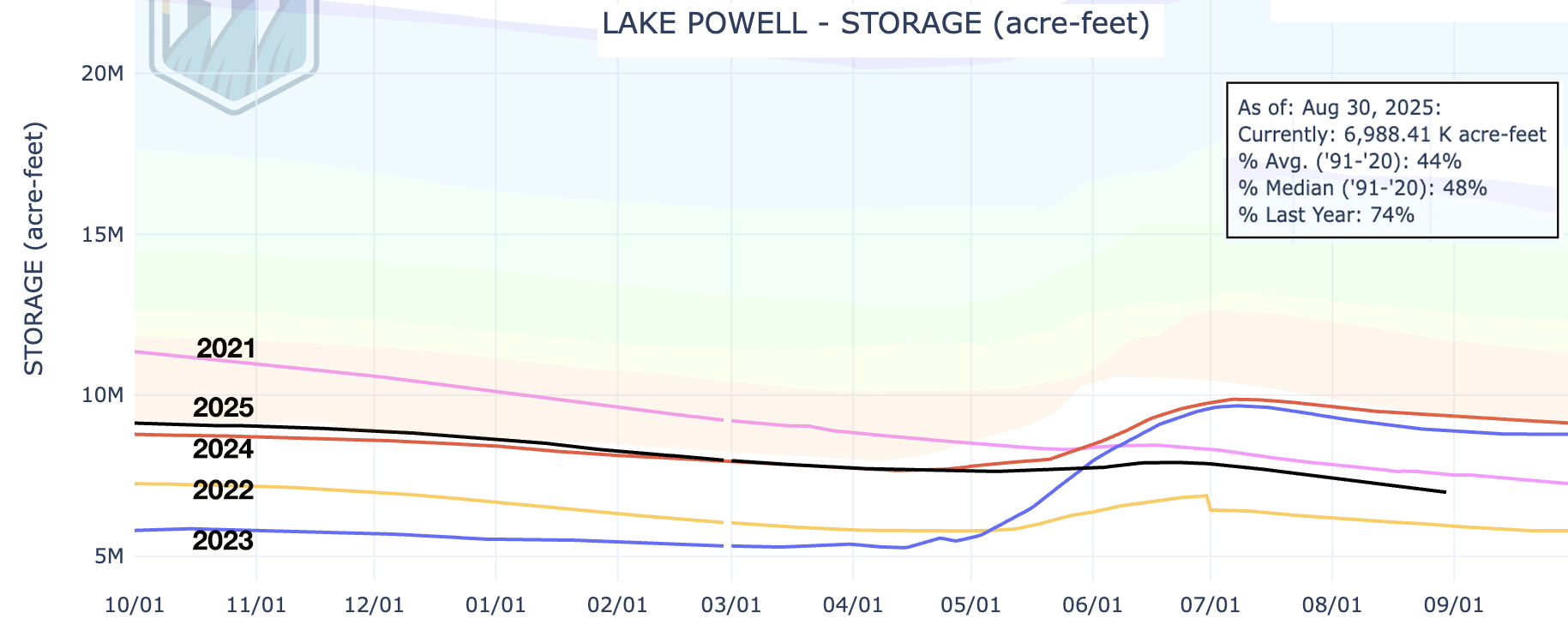

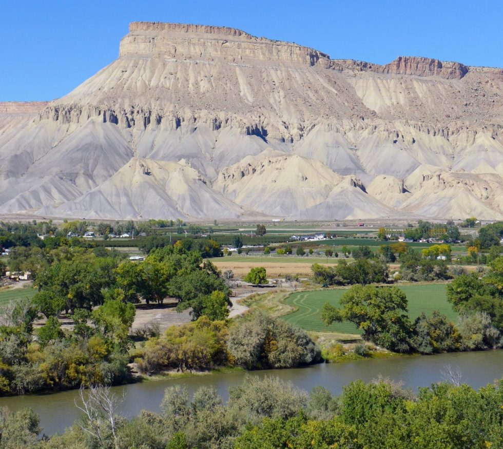
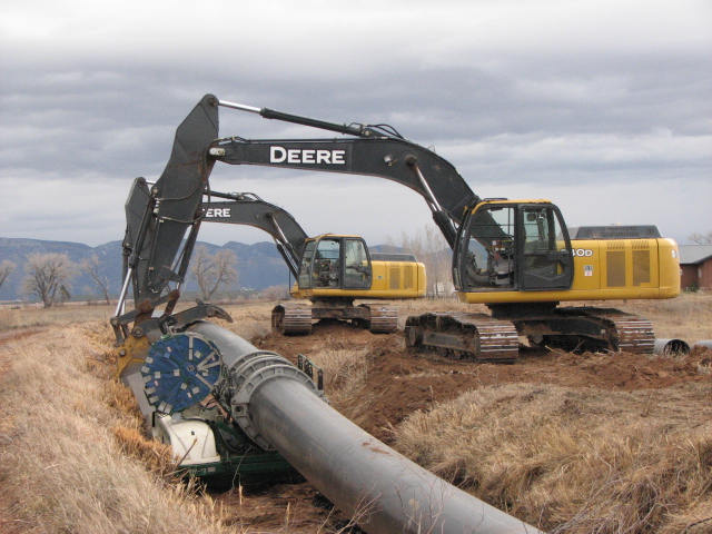


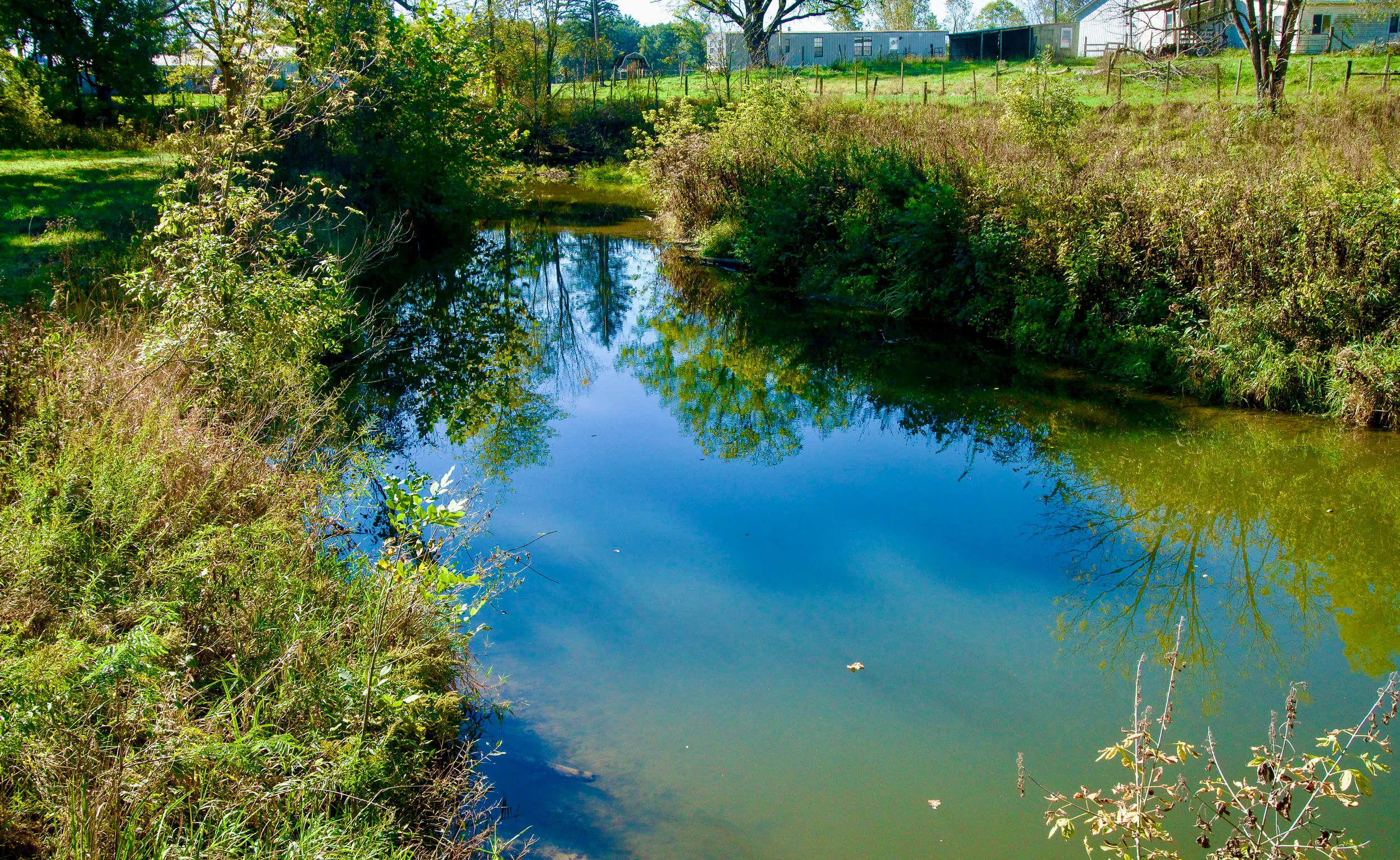
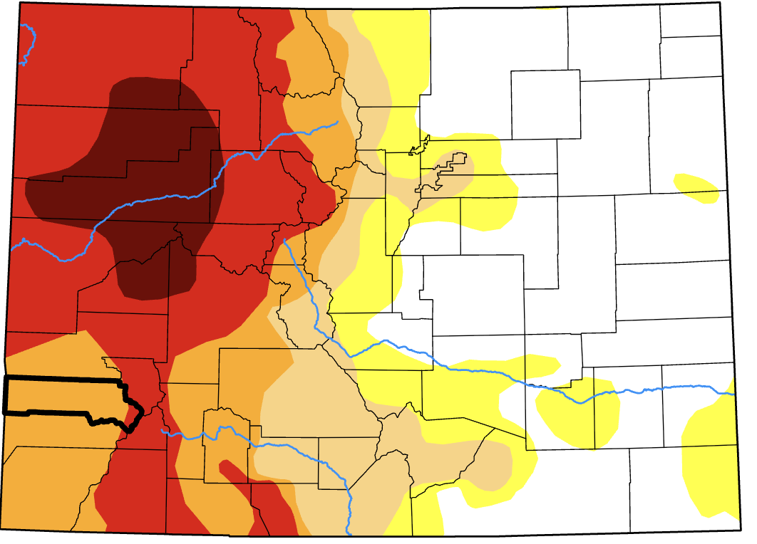


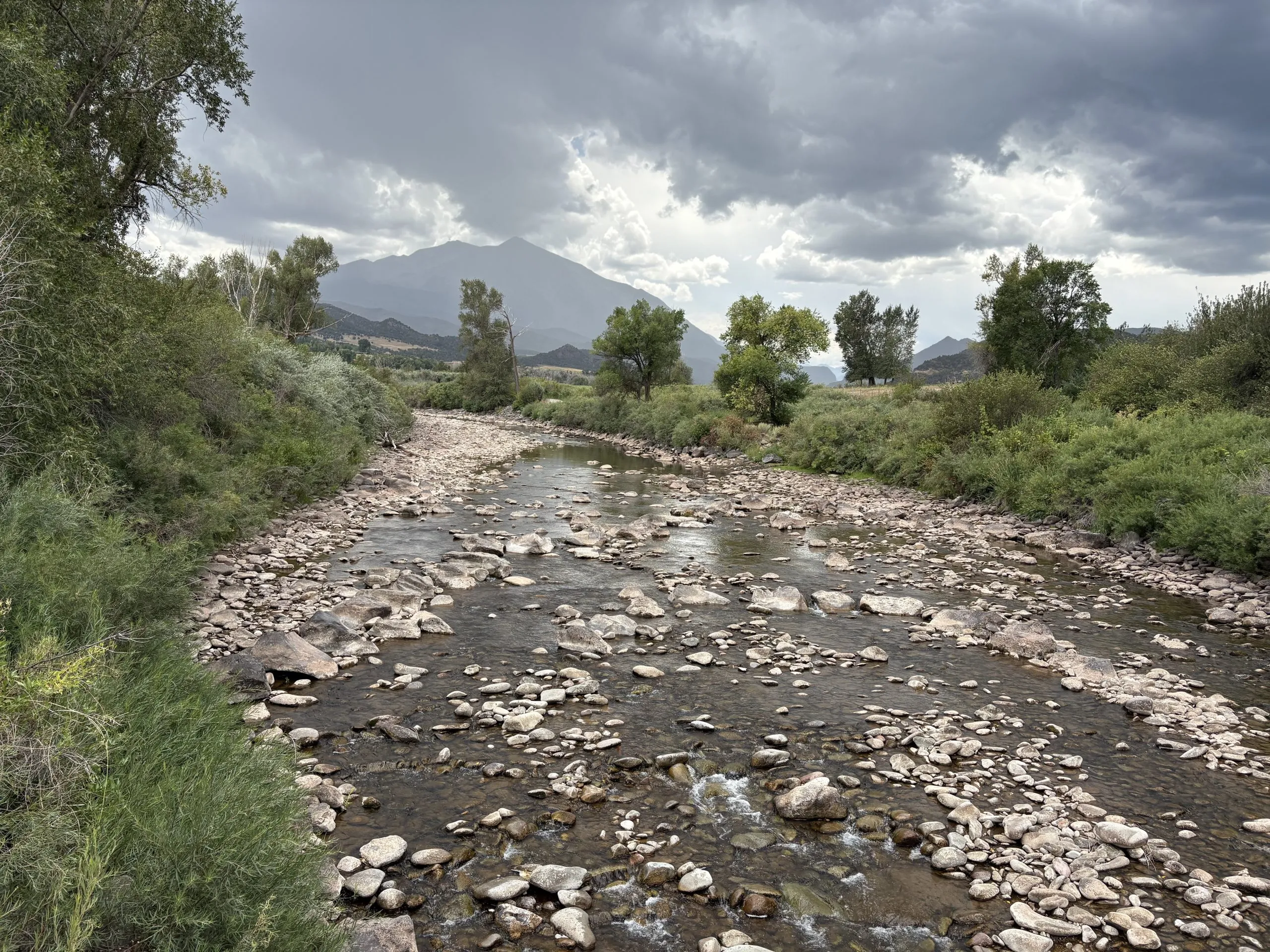

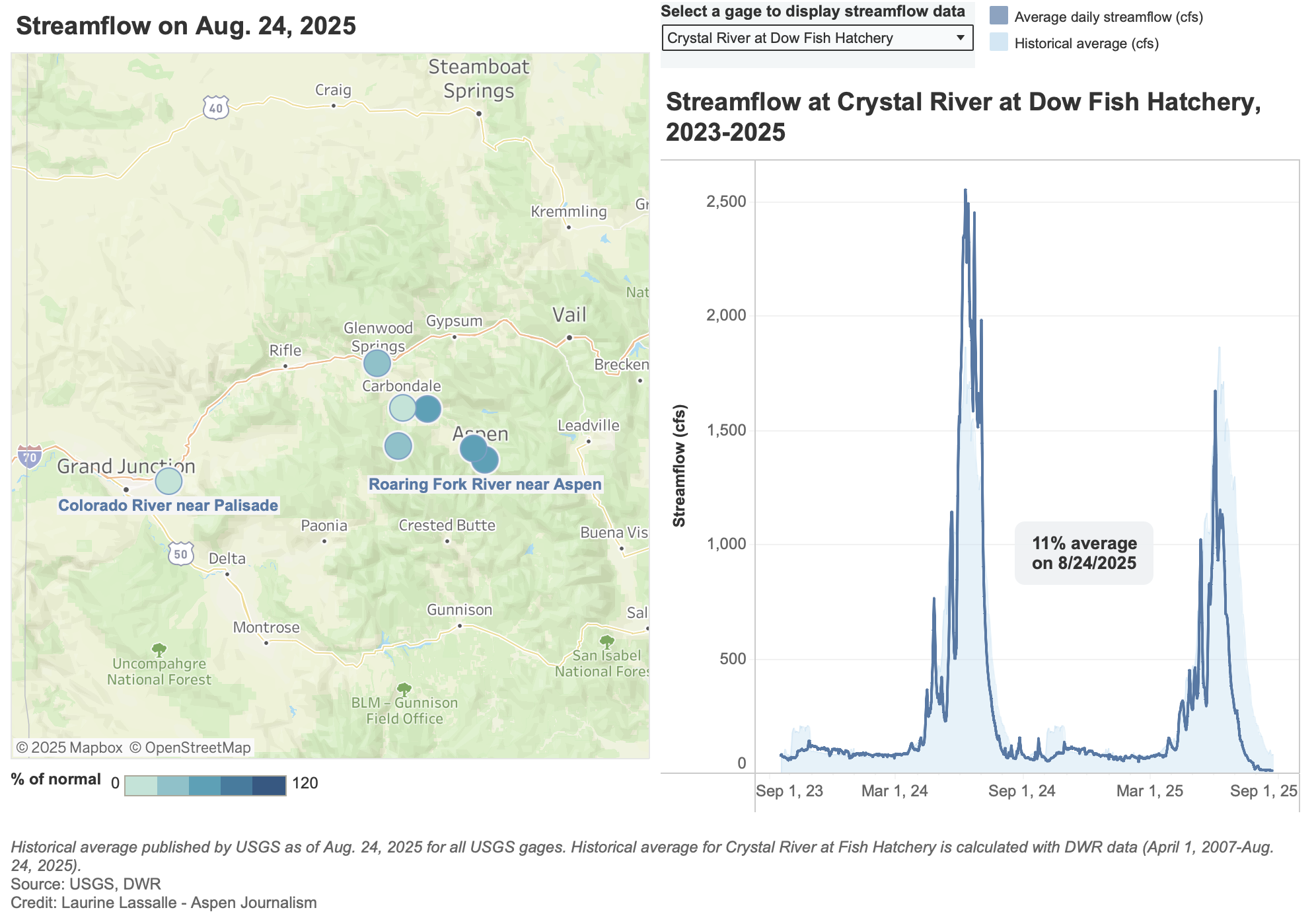
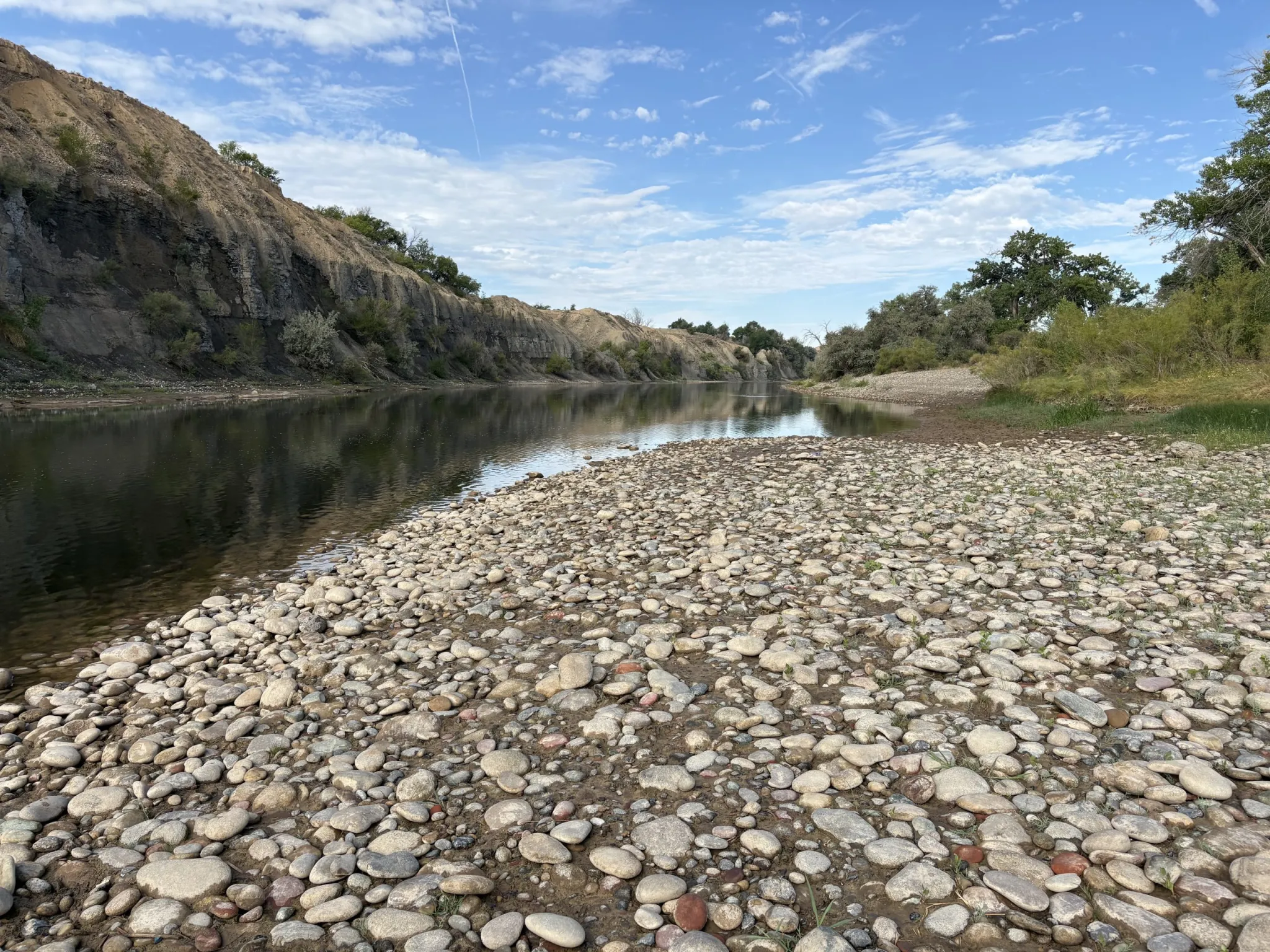

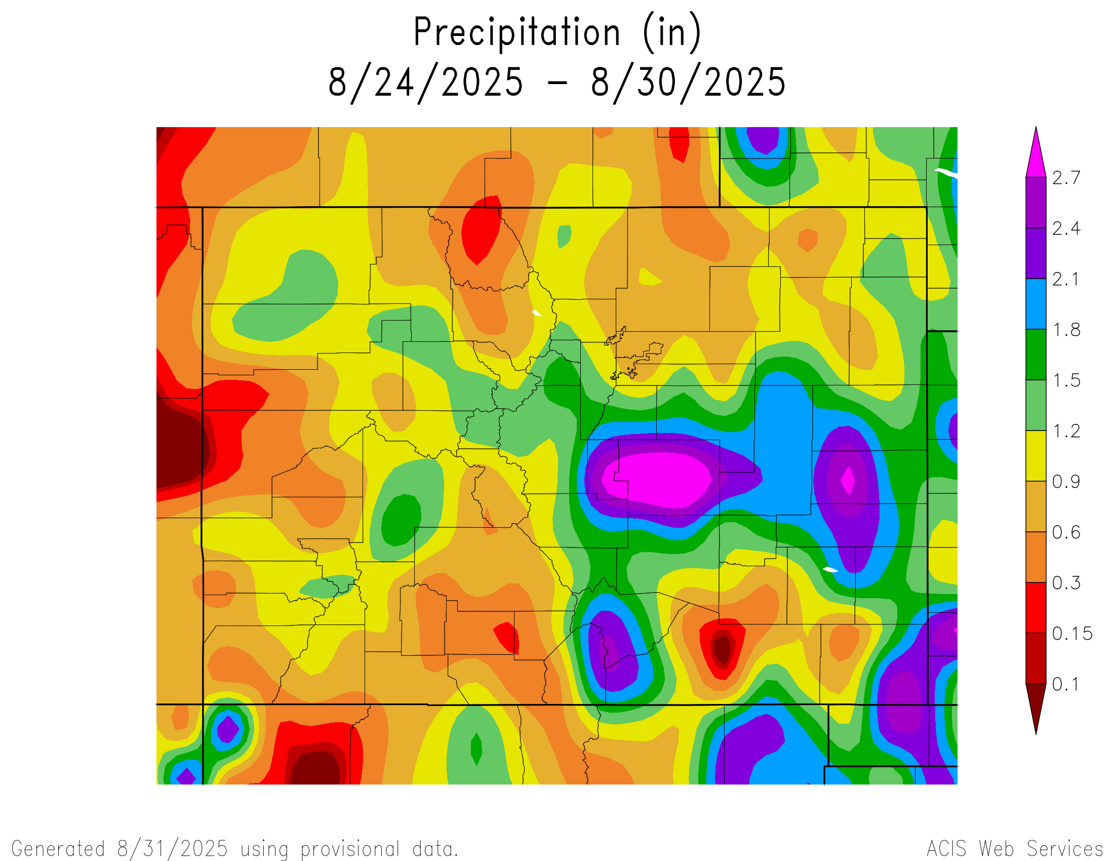
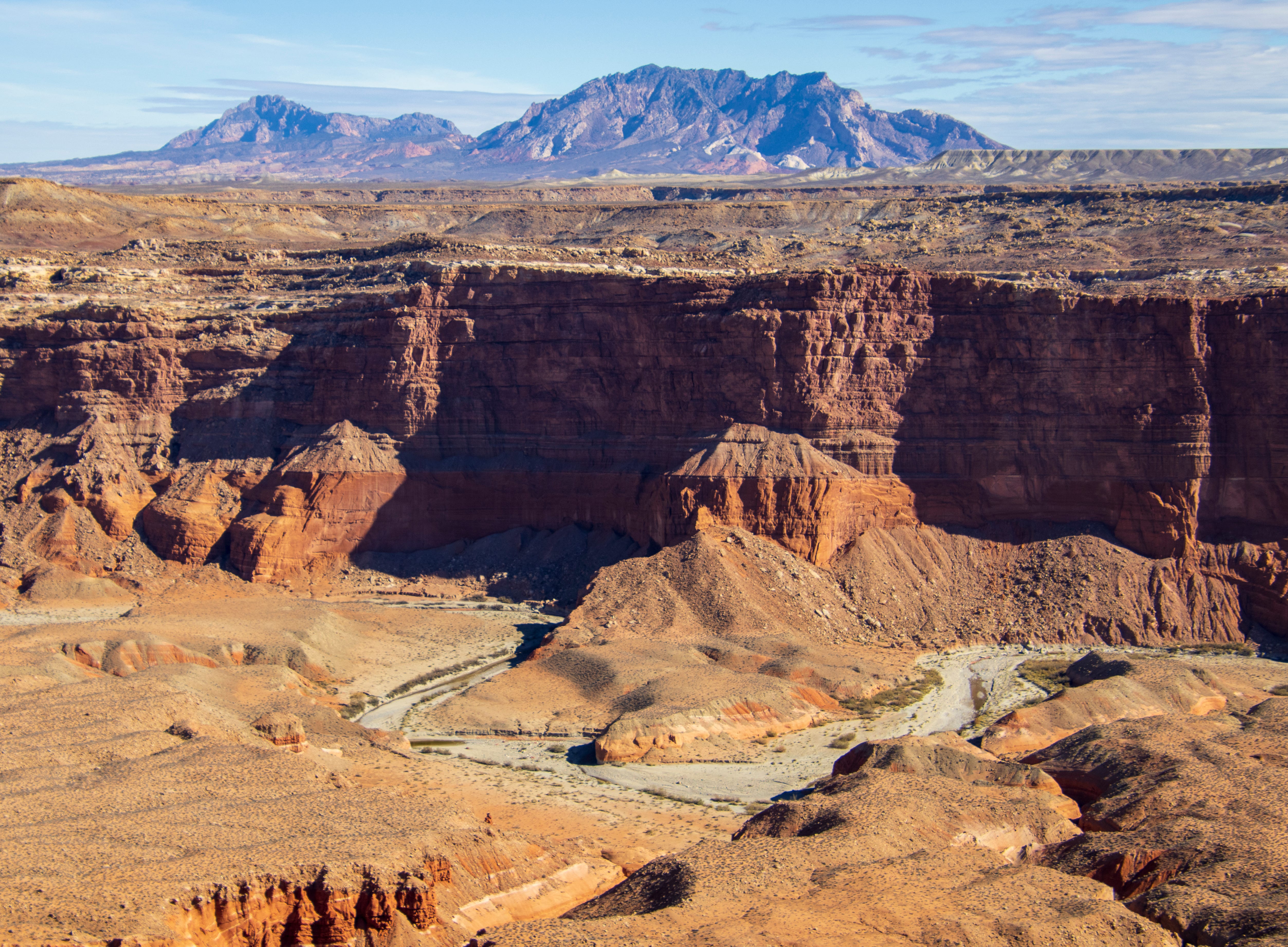
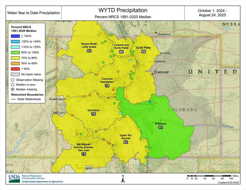
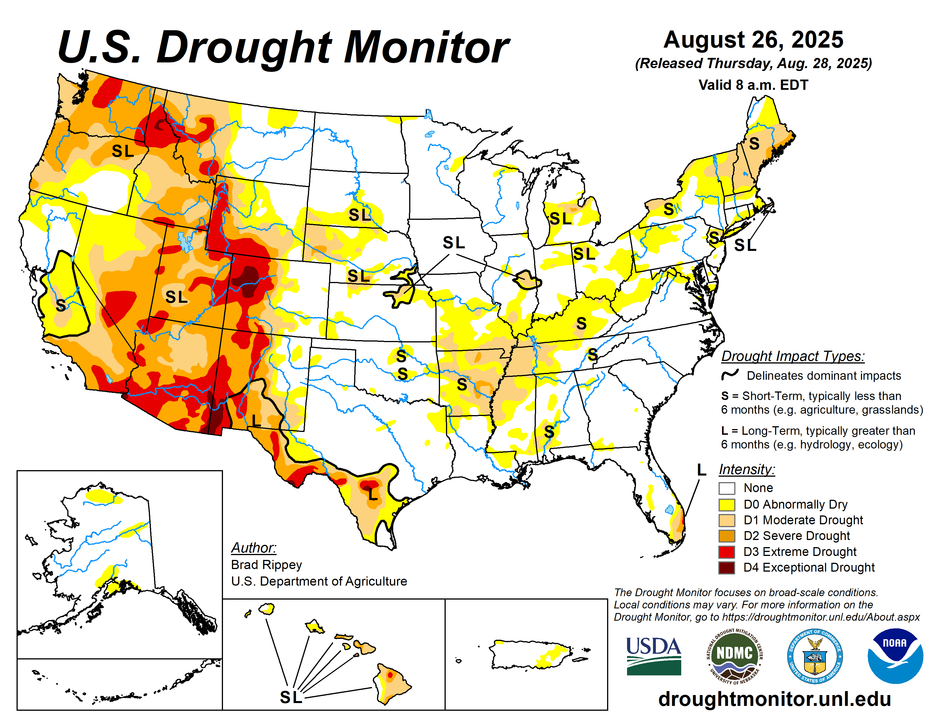
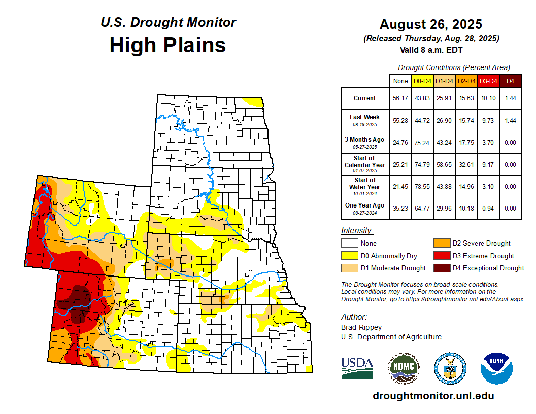
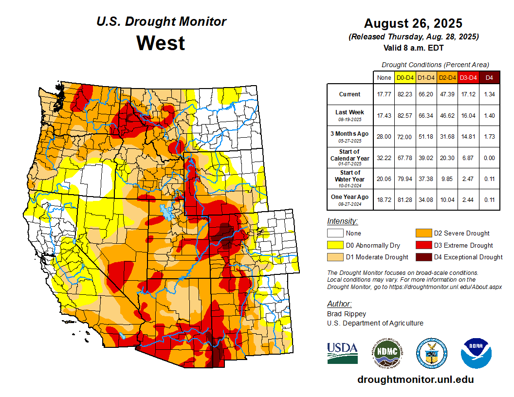
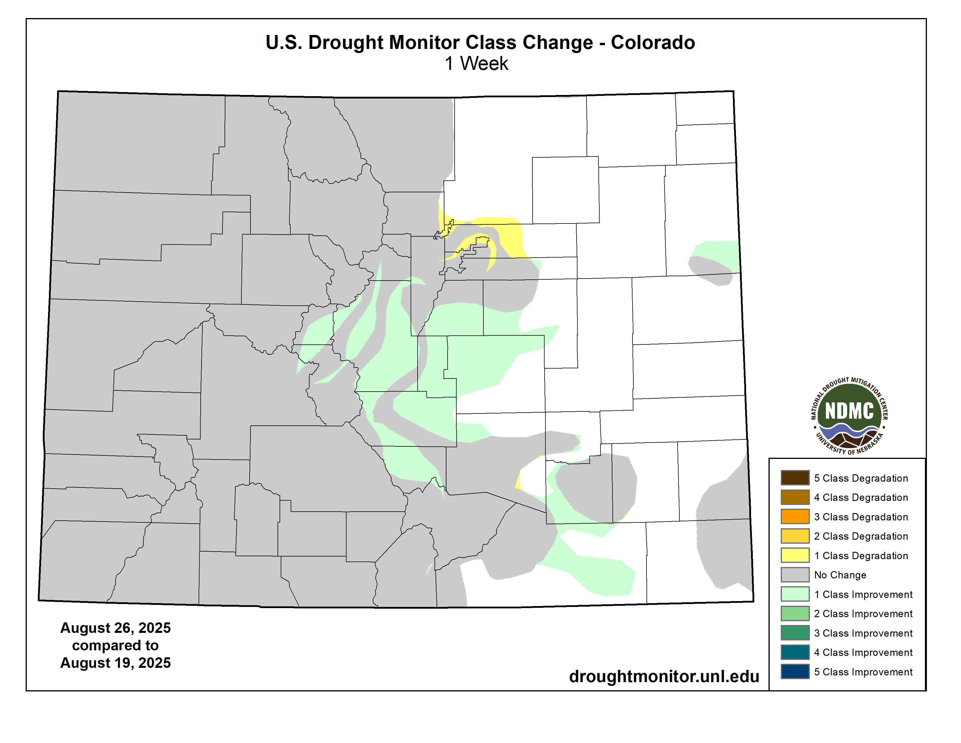
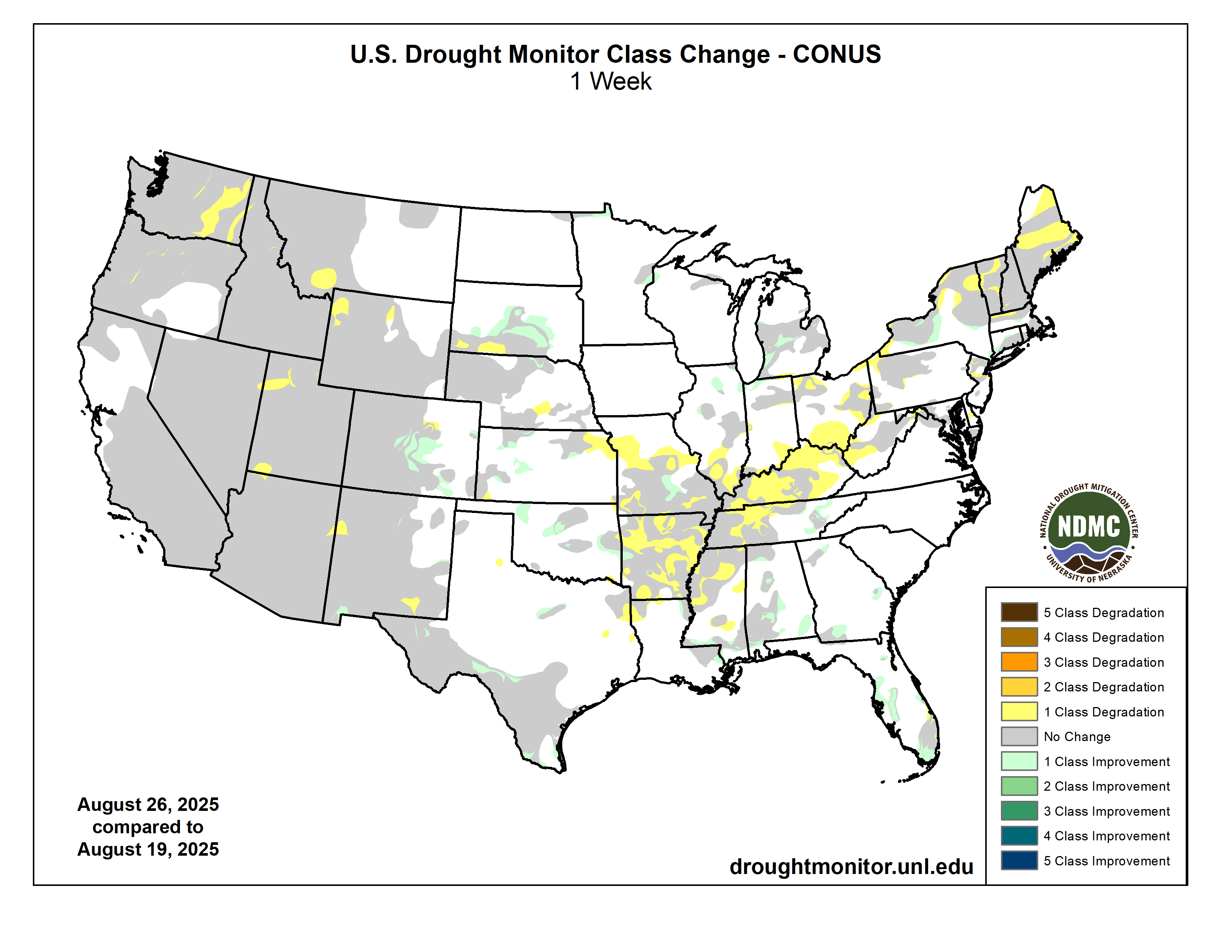

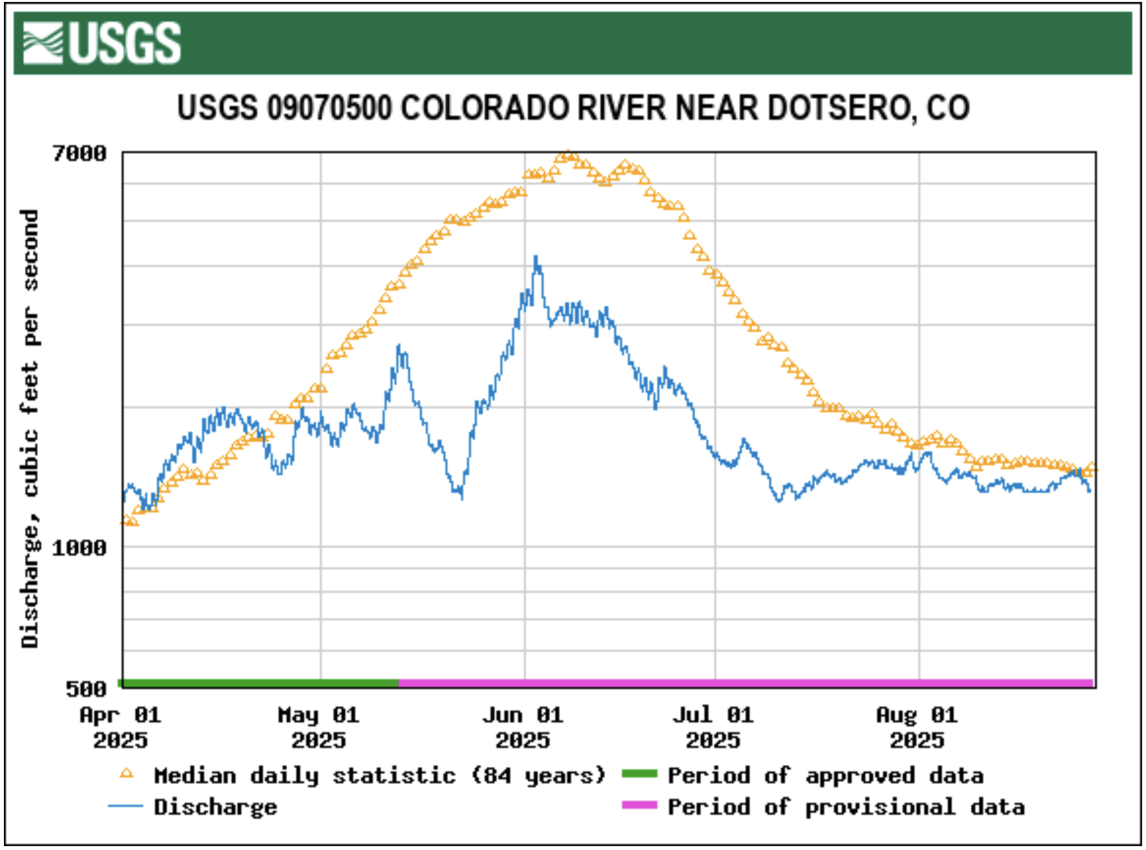
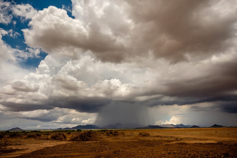