@WaterEdCO: Recovery to Resilience Flood Tour-September 18, 2018, Loveland, CO

Big Thompson Canyon before and after September 2013 flooding. Photo credit: Flywater.com

Click here for all the inside skinny:

Join Water Education Colorado on September 18 for a 5th anniversary, full-day tour of the 2013 flood-affected zone along the Front Range (to begin and end in Loveland). Jump on the bus with lawmakers, water managers, attorneys, engineers and members of the public to get an up-close look at various recovery projects. Participants will learn about the initial actions that were taken to protect lives and property as well as the subsequent projects that were undertaken to recover and build resilience. View the draft agenda here, then hurry and reserve your spot today. Seats are limited!

Register Now

@USFSRockyMtns opposes Fry-Ark conditional water rights in Holy Cross Wilderness — @AspenJournalism

Pristine Halfmoon Lake, shown here under hazy skies in August 2018, is on Lime Creek within the Holy Cross Wilderness and is near the location for a potential diversion dam and tunnel back toward the existing Fry-Ark Project to the south. Photo credit: Brent Gardner-Smith Aspen Journalism

From Aspen Journalism (Brent Gardner-Smith):

The U.S. Forest Service is questioning whether the Southeastern Colorado Water Conservancy District ever will be able to get approval to build six potential diversion dams and related tunnels and conduits in the Fryingpan River basin that are located on USFS land above 10,000 feet within the Holy Cross Wilderness.

In a statement of opposition filed last month in Division 5 water court in Glenwood Springs, attorneys for the USFS said it “cannot authorize development of these six conditional water rights … because they lie within a congressionally designated wilderness. Only the president has authority to approve water developments within the Holy Cross Wilderness.”

The USFS statement of opposition, which was the only one filed in the case (18CW3063), also said “as currently decreed, the subject water rights raise questions as to whether they can and will be perfected within a reasonable time.”

The opposition statement was submitted July 31 in response to a periodic diligence application filed with the water court by Southeastern on May 28.

Southeastern is seeking to maintain its conditional water rights that are part of the Fryingpan-Arkansas Project. The rights were decreed in 1958. Six of the rights are within the Holy Cross Wilderness, which was designated in 1980, but most are outside of it.

Southeastern, which is based in Pueblo, owns and manages the water rights for the Fry-Ark Project, which was built by the Bureau of Reclamation.

A detail of map of the Fry-Ark Project prepared by the Colorado River District, showing potential diversion points as purple circles. The map does not show the wilderness boundary.
A map prepared as part of a study by Wilson Water Group showing the locations of six potential diversion dams in the Holy Cross Wilderness, shown in light purple. The diversion points would be connected with tunnels and conduits and connected to the existing Fry-Ark Project system at Carter Creek, the most northern dam and tunnel in the existing system.
A map filed as part of Southeastern’s diligence application that shows the extent of the Fry-Ark Project. On its southern end, it diverts water from creeks near Aspen. The conditional rights within the Holy Cross Wilderness are on its northern end.

375 cfs

The six diversion dams inside the Holy Cross Wilderness would allow for the diversion of 10 cubic feet per second from an unnamed tributary of the North Fork of the Fryingpan River, for diversion of 135 cfs from Last Chance Creek and for 10 cfs from an unnamed tributary to Last Chance Creek, for 85 cfs from a creek called Slim’s Gulch and for 85 cfs from an unnamed tributary of Slim’s Gulch, and for 50 cfs from Lime Creek.

In all, the six conditional rights in the wilderness would allow for 375 cfs of additional diversions in the Fry-Ark Project.

The diversion structure on Lime Creek would be near pristine Halfmoon Lake, which is above Eagle Lake.

Chris Woodka, who is the issues management coordinator at Southeastern, said the conditional water rights in the wilderness “are like a bargaining chip that we really don’t want to give up.”

“If they could be developed at some point, we would still be interested in developing them, as far as getting the yield from there,” Woodka said. “But can we get more of a yield from the system using the mechanisms we have in place? Probably.”

The entrance to the Chapman Tunnel on the creek in Chapman Gulch, part of the existing Fry-Ark diversion system.

Maximizing limited yield

The Fry-Ark Project today includes 16 diversion dams and 26 miles of tunnels and conduits on the Western Slope that move water from the Hunter Creek and Fryingpan River basins to the centrally located Boustead Tunnel, which can divert as many as 945 cfs under the Continental Divide.

The water is sent to Turquoise Reservoir near Leadville and then farther into the Arkansas River basin for use by cities and irrigators.

The six potential dams and tunnels in the Holy Cross Wilderness would connect to the existing Fry-Ark Project at the Carter Creek dam and tunnel, which is the most northerly point of the system. It was completed in 1981.

James DuBois, an attorney in the environment and natural resources division at the Justice Department and who filed the USFS statement of opposition, said he could not discuss the case.

DuBois filed a similar statement of opposition in a 2009 diligence filing for Southeastern’s conditional rights.

In that case, the USFS eventually agreed, in a 2011 stipulation, that Southeastern would study “the potential for moving its conditional water rights off of wilderness lands” during the next six-year diligence period, which ended in May.

It also would look at other ways to increase the project’s “authorized yield.”

A view of the Slim’s Gulch area in the upper Fryingpan River basin. The Lime Creek basin is on the other side of the jagged ridge in the background, and a tunnel under the mountain would move water from Lime Creek to Slim’s Gulch.

Yield limits

Under the project’s operating principles, the authorized yield of the Fry-Ark Project is limited to diverting 120,000 acre-feet in any one year, and to diverting no more than 2.35 million acre-feet over a 34-year rolling average, or an annual average of 69,200 acre-feet.

From 2010 to 2015, the project diverted an average of 63,600 acre-feet, indicating there is more yield to be gained.

This year, a dry year, about 39,000 acre-feet was diverted. In 2011, the last really wet year, 98,900 acre-feet was diverted, according to an annual report on the Fry-Ark Project prepared by the Bureau of Reclamation.

A view of the Last Chance Creek basin in the upper Fryingpan River basin. The main stem of Last Chance Creek wraps around the forested mountain in the middle of the photo, and a tributary to the south is off to the right, just out of view in the photo. Photo credit: Aspen Journalism

Improving existing facilities

In accordance with the 2011 stipulation, a study on how to get more water out of the system was done by Wilson Water Group and presented to Southeastern in April.

In the presentation slides, Wilson Water told Southeastern’s board of directors that “analysis indicates contemplated project yield could be met through existing infrastructure and software upgrades.”

Another option studied was to move the six rights in the Holy Cross Wilderness downstream and out of the wilderness. However, Wilson Water said it would require pumping stations to lift the water back up to Fry-Ark system and the “cost per-acre feet is likely prohibitive.”

Despite the finding that improving the existing system would increase the yield on the project, Southeastern voted in April to file for diligence on the six conditional rights within the wilderness, along with other conditional rights, telling the court that “while the construction of certain conditionally decreed project features has not yet been started, there is no intent to abandon these features or any of the conditional water rights … .”

A sign marking the boundary of the Holy Cross Wilderness in the Last Chance Creek basin. The trail up the basin does not see a lot of hiking traffic. Photo credit: Aspen Journalism

‘Inappropriate location’

Upon learning of the diligence application this week, Will Roush, the executive director of Wilderness Workshop in Carbondale, said “the Holy Cross Wilderness is a completely inappropriate location” for the development of the conditional water rights.

“Lime Creek, Last Chance Creek and the surrounding lands and tributaries provide amazing opportunities for solitude and the rare opportunity to experience a landscape and alpine watershed free of human infrastructure and without the diversion of water,” Roush said.

An informational memo on the diligence case was presented to the Southeastern board of directors on Aug. 16, and there was no discussion of the case by the board.

An initial status conference in the diligence case has been set for Sept. 18.

Editor’s note: Aspen Journalism is covering the Roaring Fork and Colorado river basins in collaboration with The Aspen Times. The Times published this story on Saturday, August 19, 2018. This version of the story corrected the date of the earlier stipulation between Southeastern and USFS, which was reached in 2011, not 2012, when the case was closed.

#AnimasRiver: “We’ve got years’ worth of investigations to do” — Rebecca Thomas #GoldKingMine @EPA

On April 7, 2016, the Environmental Protection Agency proposed adding the “Bonita Peak Mining District” to the National Priorities List, making it eligible for Superfund. Forty-eight mine portals and tailings piles are “under consideration” to be included. The Gold King Mine will almost certainly be on the final list, as will the nearby American Tunnel. The Mayflower Mill #4 tailings repository, just outside Silverton, is another likely candidate, given that it appears to be leaching large quantities of metals into the Animas River. What Superfund will entail for the area beyond that, and when the actual cleanup will begin, remains unclear.
Eric Baker

From The Durango Herald (Jonathan Romeo):

Project to clean nearly 30 mines in 5 years has drawn criticism

The Environmental Protection Agency will not release public comments before it makes a final decision on a proposed plan to clean up 26 mine sites over the next five years in the Superfund area near Silverton.

In June, the EPA released the proposed plan, which identified quick action projects the agency wants to take while it comes up with a long-term plan for improving water quality in the upper Animas River. The proposed plan is expected to cost about $10 million.

“We’ve got years’ worth of investigations to do,” Rebecca Thomas, the EPA’s project manager, said in a previous interview. “These early actions are not intended to be a final remedy. They’re no-brainer activities to help get the water clean and reduce the amount of loading.”

The release of the plan kicked off a 30-day public comment period, which was extended another month in response to requests by the public. The comment period ended Wednesday.

When The Durango Herald asked EPA officials to review public comments, spokeswoman Cynthia Peterson said the public comments and the EPA’s response won’t be made available for review until the EPA makes a final decision.

“All significant comments, and EPA’s responses to those comments, will be compiled in a responsiveness summary. The responsiveness summary will be included in the final decision document – the Interim Record of Decision. The Interim Record of Decision will be published once the agency has had a chance to review and consider all comments received.”

Withholding of public feedback and the agency’s replies until after a final decision is made is in contrast with other comment periods the EPA has held. In 2015, for example, comments were posted in real time for the listing of the Superfund site.

“In some instances, such as federal rule-makings, comments can be made available in real time,” Peterson wrote. “However, significant comments on a site-specific Record of Decision are released in a responsiveness summary with the decision document.”

This image was taken during the peak outflow from the Gold King Mine spill at 10:57 a.m. Aug. 5. The waste-rock dump can be seen eroding on the right. Federal investigators placed blame for the blowout squarely on engineering errors made by the Environmental Protection Agency’s-contracted company in a 132-page report released Thursday [October 22, 2015]

From The Durango Herald (Jonathan Romeo):

Despite ash flows and mine waste, the river is resilient

It’s been a rough couple of years for the Animas River.

This weekend marks three years since the river, which runs through the heart of Durango, endured a massive mine waste spill from a blowout at the Gold King Mine. The waterway turned an electric orange and gained international attention.

The Aug. 5, 2015, spill brought to the forefront the longstanding issue of toxic metals leeching into the Animas River from legacy mining in its headwaters around Silverton.

This year has been an especially vicious dagger into the Animas.

A winter that never showed up in the San Juan Mountains resulted in one of the lowest snowpack years in recorded history. Then, through spring and early summer, extreme drought tightened its stranglehold on Southwest Colorado.

The Animas River saw its third lowest peak flow in more than 100 years of recorded history, and one of its earliest, hitting a high of about 1,000 cubic feet per second in May. Typically, the river peaks at about 4,700 cfs in early June.

Fish and other aquatic life were already stressed from low flows and high water temperatures when ash runoff from the 416 Fire burn scar came tumbling down north of Durango.

The dark-chocolate colored waters suffocated fish, which desperately washed ashore seeking oxygen. Though an official population survey won’t be conducted until this fall, it’s estimated thousands of fish died.

A raw sewage spill last week at Santa Rita Park was an extra twist of the dagger.

A river without fish
For some perspective, it’s likely aquatic life is either all but gone or dramatically depleted through the entire 126-mile stretch of the river from the headwaters in Silverton, down through Durango to the Animas’ confluence with the San Juan River in Farmington.

In recent years, the river from Silverton to Bakers Bridge (about 15 miles north of Durango) has been basically considered a dead zone because of toxic metal-loading from leeching mines.

The ash flows during the month of July killed most of the fish in the river through Durango. Even the most tolerant species – carp – was found dead along the river’s banks.

Fish in this stretch of the Animas River have been unable to reproduce because of a combination of factors, such as high water temperature and mining pollution. The fish that do live in the river are stocked by Colorado Fish and Wildlife.

The Southern Ute Indian Tribe declined to comment about how fish are doing in the Animas through tribal lands. Attempts to reach a biologist with New Mexico Fish and Game were unsuccessful. The Animas, however, has all but dried up before it reaches the San Juan River.

“It’d be unusual if everything was dead, but it’s probably to the point where it’s virtually that way,” said Jim White, an aquatic biologist for Colorado Parks and Wildlife.

But despite the onslaught of doom and gloom, there is reason to be optimistic: Rivers are resilient, and steps are finally being taken to make significant strides in the cleanup of the Animas River.

Improving water, habitat
After the Gold King Mine spill, for instance, the Environmental Protection Agency (which triggered the blowout while working at the inactive mine) declared a long-awaited Superfund listing, which will clean up nearly 50 mining sites around the Animas River headwaters.

Already, a temporary water-treatment plant built in 2015 has shown improvement in water quality downstream, said EPA spokeswoman Cynthia Peterson, though it’s too soon to know its effect on aquatic life…

While ash flows have decimated fish populations, research has shown aquatic species rebound quickly after wildfires, said Scott Roberts, an aquatic biologist for Mountain Studies Institute.

Gubernatorial hopefuls, other candidates to tackle #drought at @COWaterCongress Summer Convention

Vail Colorado via Colorado Department of Tourism

From ColoradoPolitics.com (Marianne Goodland):

Note: I will not be at the conference Tweeting away this year. I’m depending on all you other Tweeters to keep me informed.

The three-day conference, which starts Wednesday at the Hotel Talisa in Vail, is expected to draw more than 300 water policy experts as well as local, county and state officials who handle water issues…

Drought issues will be a key discussion topic this week, said Doug Kemper, the group’s executive director. Drought has hit the southern half of the state pretty hard, Kemper said.

“You’re looking at record low flows in some areas,” especially around Gunnison, he said. “We came into this year universally above average in every river basin, but will exit this water year in a different condition.”

Negotiations with the six other states that draw water from the Colorado River are at a critical point, Kemper said, even as a new governor and attorney general are coming to Colorado.

The conference will hear from the major candidates for both offices, marking the first time that many in the water community will meet them. They’ll likely be asked how they view the state water plan, whether the next governor will have a special water adviser, as Gov. John Hickenlooper has, and how they view the work of the basin roundtables, which carry much of the workload for the water plan.

Funding for the plan also is in question. Kemper said it’s still unclear whether funding will come from grants or loans and whether it will be spent on infrastructure, wastewater treatment or environmental protection.

The congress will meet Wednesday with Republican attorney general candidate George Brauchler, followed by Republican gubernatorial candidate Walker Stapleton.

Thursday, Democratic attorney general candidate Phil Weiser will speak to the congress.

U.S. Rep. Jared Polis, the Democratic gubernatorial candidate, is to address the group Friday.

Congressional candidates also will visit: Republican U.S. Rep. Scott Tipton will be at the congress Thursday, and Democratic opponent Diane Mitsch Bush will address the congress Friday.

Thursday, the Legislature’s interim water resources review committee will hold its August session at the congress. The committee is to review funding for the state water plan, the Colorado River compact and drought contingency plans for the Colorado River.

Thursday’s keynote address, “A New Culture of Certainty at EPA,” will be delivered by Doug Benevento, the EPA Region VIII administrator, and comes on the heels of a federal court order Thursday that the Trump administration reinstate the Obama administration’s “Waters of the USA” rule.

“One thing we know when it comes to water, Arizonans are very innovative” — Kathryn Sorensen

The Central Arizona Aqueduct delivers water from the Colorado River to underground aquifers in southern Arizona. UT researcher Bridget Scanlon recommends more water storage projects like the aqueduct to help protect against variability in the river’s water supply. U.S. Bureau of Reclamation.

From The Arizona Daily Star (Tony Davis):

The total stored is nearly 3.6 million acre-feet of water in 28 sites across Pima, Pinal and Maricopa counties. That’s well over two years worth of CAP deliveries. They’ve stored another 600,000 acre-feet for Nevada.

The total tab has topped $330 million for the state and the Central Arizona Project to design and build storage basins and recharge water in them by artificial means.

But all that work has left a key detail unsettled: how to withdraw the bank’s water when needed.

No wells or other infrastructure exists to pump the water from recharge sites where nearly 25 percent of the water-bank water is stored, including one of the system’s largest recharge facilities. While water is also banked in some of the cotton, alfalfa and grain fields served by CAP water, and they do have infrastructure to get the water out, many of these facilities are far from urban and tribal users…

Tucson is better primed than most cities for water-bank recovery. The water bank has put more than two years worth of the city’s water needs into city-owned recharge basins in the Avra Valley, many miles west and northwest of the city limits.

City wells to pump that water out are already in place. But that’s mainly because Tucson Water’s original delivery of CAP water in the 1990s was so problematic that it had to switch to something more innovative and farsighted like recharging its supply. The city first delivered corrosive CAP water that rotted out many homeowners’ pipes. That fiasco led to a citizen-backed initiative requiring the city to recharge CAP water rather than run it through a treatment plant.

But in general, many major questions about water-bank recovery remain unanswered. They include: How, when and where will the water be recovered? Who will recover it? How will this be done legally, meeting contractual obligations? How much will it cost?

The water-bank water is stored mainly for the benefit of Tucson and Phoenix and their suburbs, and tribes such as the Gila River Indian Community and the White Mountain Apache Tribe. (The Tohono O’odham Tribe near Tucson is not in line for water-bank water.) Water users along the Colorado River also have a claim to some of the bank’s water.

There is a recovery plan, done in 2014, but to many city water agencies, it’s longer on concepts than details: “It’s a plan to plan,” says Kathryn Sorensen, the city of Phoenix’s water service director. She is secretary for the Arizona Water Banking Authority’s governing commission, and one of many municipal water officials who has pushed hard for a more thorough plan…

The 2014 plan reflects the longstanding, conventional wisdom that CAP cutbacks to cities and tribes wouldn’t start until the mid-2030s at the earliest.

Today, the outlook for Lake Mead and the river in general is worse. Shortages cutting off agricultural water are expected in the early 2020s. Urban shortages are considered possible by the mid-2020s and maybe even 2022, under the worst-case, least-likely scenario.

So water officials are now grappling with the nitty-gritty details of putting together a more complete recovery plan, perhaps by the end of 2018.

The effort is being led by a committee representing various water utilities and other interests, and shepherded by the Central Arizona Water Conservation District, which runs CAP, the Arizona Department of Water Resources and the Arizona Water Banking Authority, which manages the water bank.

Wally Wilson, water service manager for the suburban Metro Water district, said that the big questions about recovery weren’t addressed before, “to the chagrin of many.”

[…]

“One thing we know when it comes to water, Arizonans are very innovative,” Sorensen said. “There are a lot of difficulties and a lot of uncertainties. But I know we’ll get there.”

Courts are blocking @POTUS’s attack on environmental rules

Scales of Justice

From The Washington Post (Juliet Eilperin):

Lawyer: “What the courts are saying is we’re going to enforce the laws that Congress wrote, and this administration is breaking those laws and needs to stop.”

Federal judges have ruled against the Trump administration three times in the last three days, arguing that the administration short-circuited the regulatory process in its push to reverse policies on water protections, chemical plant safety operations and the controversial Keystone XL pipeline. In each instance, the courts either reinstated the existing rule or delayed the administration’s proposal from taking effect.

On Friday, the U.S. Court of Appeals for the District of Columbia Circuit ruled that the Environmental Protection Agency’s move to delay new chemical and safety requirements was “arbitrary and capricious.” The day before, a judge on the U.S. District Court in South Carolina reinstated a rule in 26 states limiting the dredging and filling of streams and waterways on the grounds that the EPA had not solicited sufficient public input. And on Wednesday, a judge on the U.S. District Court of Montana ordered the State Department to conduct a more extensive environmental impact statement of the Keystone XL’s proposed route through Nebraska.

#Wildfire update #drought #ActOnClimate

Inciweb website screen shot August 20, 2018.

From The Grand Junction Daily Sentinel (Dennis Webb):

Never mind the ear plugs and duct tape available in the Parachute camp’s supplies section on that early August day, and take that contracted food service as one example. Even said she received a food invoice for $7,000 for the previous day. She said a typical daily bill for two hot meals and a sack lunch that provide firefighters with the 6,000 calories a day needed for toiling long hours on the fire line can run close to $15,000, depending on the number of personnel on the fire.

Such expenses quickly add up. Last year, wildland firefighting cost federal agencies a record $2.9 billion, and the U.S. Forest Service and Bureau of Land Management currently are on a pace this year to potentially exceed what they spent in 2017 for firefighting.

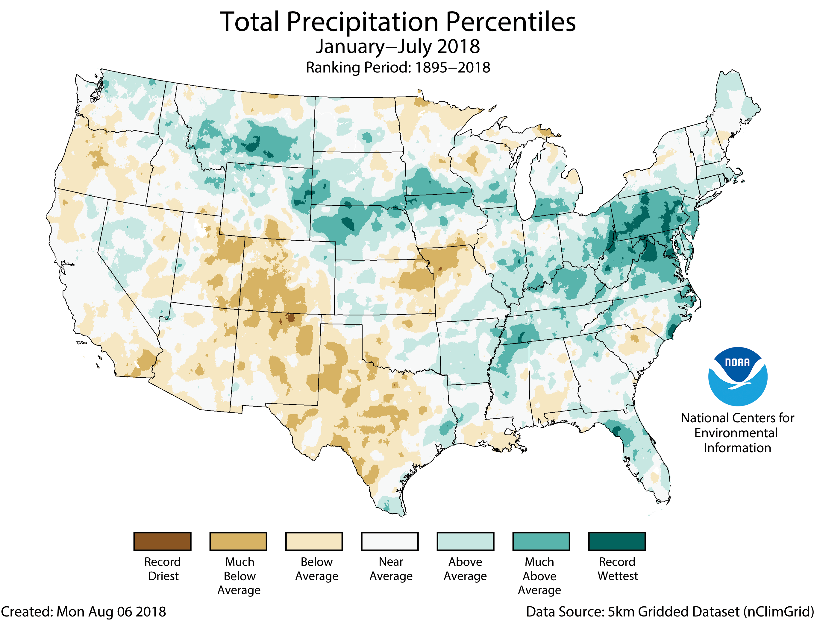
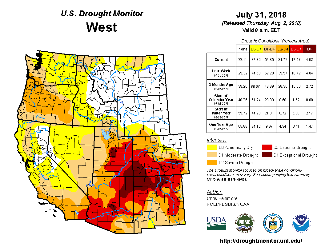
The interagency Rocky Mountain Area Coordination Center estimates that as of Wednesday, 60 large fires in Colorado this year had cost $144,774,523.61. That’s for fires that covered 431,606 acres as of that day, and the price tag is expected to increase as active fires keep burning and as other costs tied to all the fires are all eventually tallied.

Altogether, through Monday, the center had received reports of 1,585 wildfires in Colorado so far this year, covering 438,307 acres. Center spokesman Larry Helmerick said that tally may not include a number of fires not yet reported to the center by the state and counties.

In 2012, another bad year for wildfires in Colorado, 426,403 acres burned in the state. In 2002, 619,000 acres burned.

COSTLY ‘AIR SHOW’

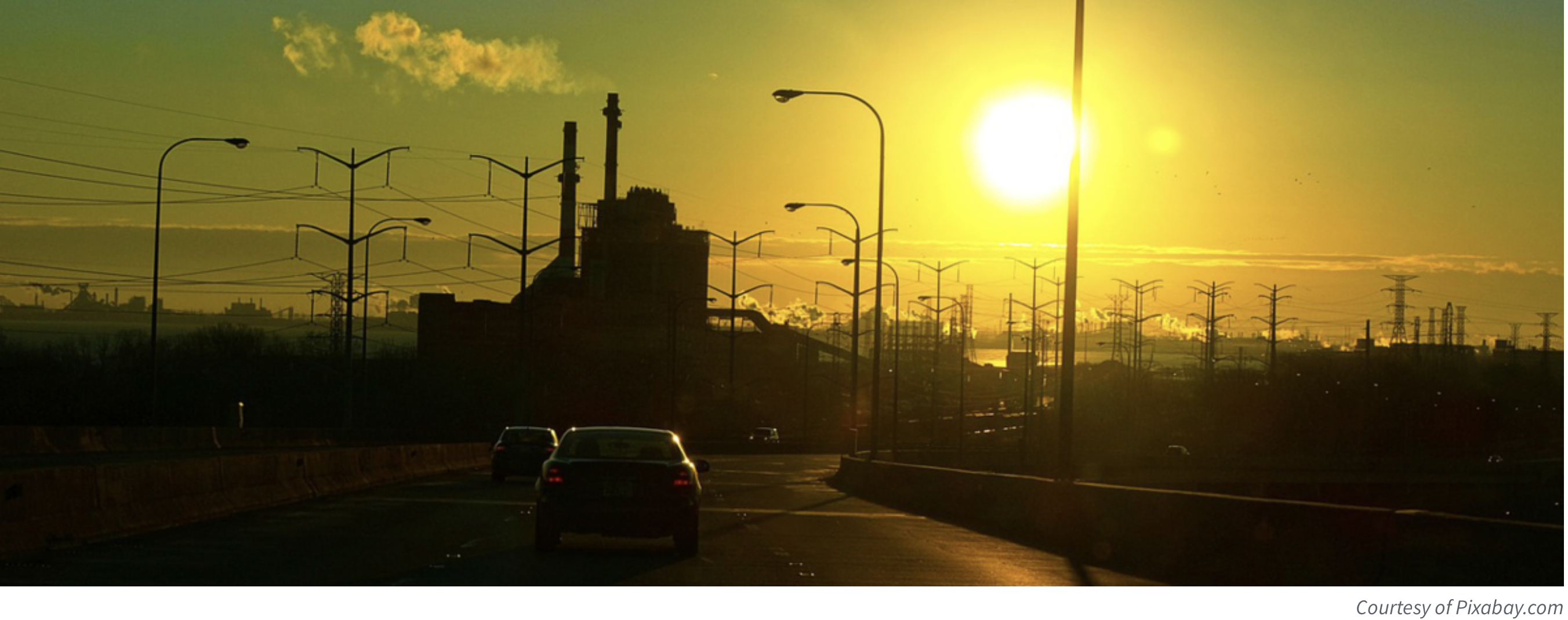
Figuring mightily into firefighting price tags is aerial firefighting.

“This one’s pretty much an air show,” Even said in reference to the amount of helicopters and airplanes that were being used to drop water and retardant on the Cache Creek Fire as of early August. She said that it was likely racking up $200,000 or more in aerial firefighting costs per day, noting that the cost of retardant alone was going for $2.71 a gallon.

Two hundred thousand dollars here. Two hundred thousand dollars there. Before you know it, you’re talking real money.

As of Friday, the 2,520-acre Cache Creek Fire — which earlier this month had calmed down enough that the Rocky Mountain Blue management team had turned it over to a local management team, but more recently has flared up again — had a price tag of $4.9 million.

Three Western Slope fires are among the five-costliest in the state so far this year.

The 54,000-acre 416 Fire in the Durango area is the most expensive, at nearly $40 million, and the 12,600-acre Lake Christine Fire near Basalt has cost $17 million.

Those fires are pretty well tamed, but the still-growing Bull Draw Fire northwest of Nucla had a price tag of $6.6 million as of Friday, when its acreage stood at 27,320.

Putting a total price on the costs of wildfire firefighting isn’t a simple matter in part because the costs can be borne among multiple agencies. Cost-sharing agreements factor in things such as what proportions of a fire burn on federal, private or other land.

Some of the fire expenses are borne locally. Earlier this month, Garfield County commissioners authorized the Sheriff’s Office to spend contingency funds for what are expected to be $250,000 in county costs for a fire this year in the area of the Oak Meadows rural neighborhood outside Glenwood Springs. That fire’s total costs are estimated at $450,000.

THE STATE’S ROLE

Caley Fisher, spokeswoman for the Colorado Division of Fire Prevention and Control, said that generally in the case of a fire that starts on private land, once it exceeds the capabilities of local responders, state assistance can be requested. If the state determines the fire is eligible for state responsibility, it assumes the costs, with ongoing involvement from local and county partners.

A number of state-level funding streams exist to help absorb costs. Forty-three of the county’s 64 counties voluntarily participate in contributing to an emergency fire fund, based on a formula considering their nonfederal forested acres and property tax valuation.

Resource mobilization funding exists to help local agencies during emerging fires, and a wildfire emergency response fund can be tapped through the governor’s office.

Fires qualifying as major disasters can tap Federal Emergency Management Agency reimbursement for up to 75 percent of eligible costs, if funding is requested while the fire is still burning.

The state also provides other assistance such as training, technical support, mutual aid equipment and aerial fire-detection and mapping flights.

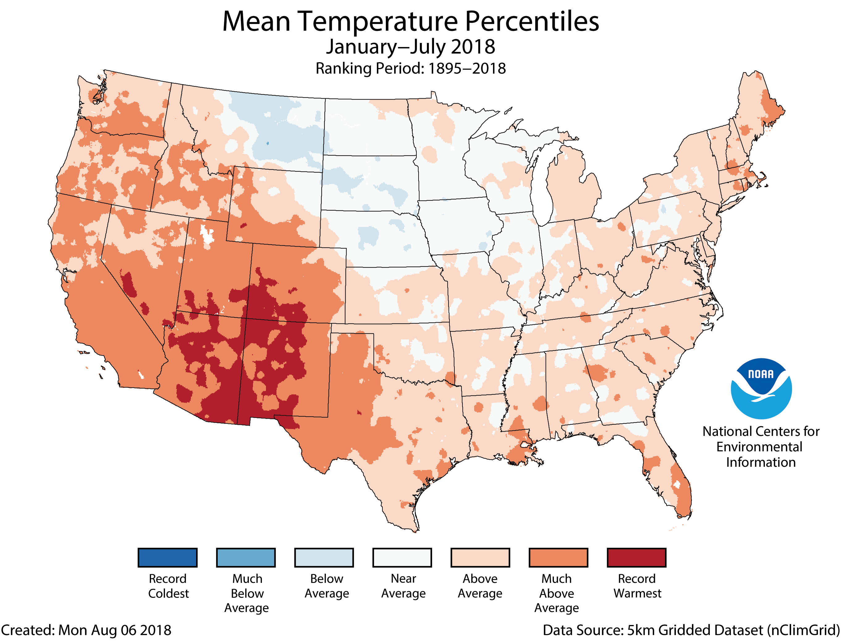
Fisher said that for the state, this year is on pace to rival other major wildfire years such as 2002 and 2012 in terms of state-responsibility fires, acres burned and suppression costs.

She said that as of Monday, her agency has spent about $39 million on firefighting so far this year.

“There’s a lot of different variables that play into that … so it could be more,” she said.

She said that through the multitude of available funding streams, her agency and the governor’s office will be there to support local-level responders. But she said there is a need for more state funding to help fight fires and pay for work such as vegetation treatments to reduce fire risk and helping homeowners reduce the threat from wildfires.

A $3 BILLION FEDERAL TAB

Funding challenges also have bedeviled national agencies — most notably the Forest Service — that also would like to spend more on things such as prescribed fires and fuel mitigation, not to mention on nonfire agency programs, but have been increasingly spending on fighting fires instead.

Last year federal agencies spent nearly $3 billion fighting fires covering about 10 million acres, according to the National Interagency Fire Center. Looking at data dating back to 1985, in only one other year, in 2015, did the agencies fight fires covering that much acreage, and the first time federal firefighting costs exceeded $1 billion was 2000.

Last year the Forest Service incurred a record $2.4 billion of the total federal firefighting cost. Agency spokeswoman Jennifer Jones said that as of Monday it has spent $1.8 billion this year.

The remaining $508,000 in federal firefighting costs last year was incurred by Department of Interior agencies. This year, Interior agencies so far have spent $338 million, the highest the department has spent at this point in any year, said Kari Cobb, a Bureau of Land Management spokeswoman at the National Interagency Fire Center. She said the BLM accounts for $223 million of that total.

Jones said fire seasons have grown larger, there have been more large wildfires, the average numbers of acres burned annually have grown and the number of homes in what’s known as the wildland urban interface has grown. Accordingly, firefighting funding has grown from 13 percent of the Forest Service budget in 1991 to 57 percent this year.

“That just leaves less and less money available for other programs,” said Scott Fitzwilliams, supervisor of the White River National Forest, which covers much of Colorado’s central mountain region.
He expects the firefighting costs on that forest this year to be somewhere in the $25 million to $30 million range, which he believes would be a record amount. The Forest Service will bear some of the costs associated with the Lake Christine Fire and with the Cabin Lake Fire in Rio Blanco County, which by Friday was nearly 6,000 acres in size and had racked up at least $4.3 million in costs.

Fitzwilliams has watched the toll firefighting costs have taken on the budget of the White River National Forest during his nine years as supervisor there. When he arrived, the forest’s appropriated funds and other funding totaled close to $30 million, and now the total is about half of that. Some of the drop is due to the end of some bark-beetle infestation work, but Fitzwilliams said the cost of firefighting is largely to blame.

‘FIRE BORROWING’ BURDEN

The impact has come as a result of what’s called “fire borrowing.” Jones said the Forest Service has historically determined its wildfire firefighting funding request each year based on the 10-year average of firefighting costs over the previous 10 years, adjusted for inflation.

Even with increases in that 10-year average, the agency’s costs have exceeded the average in all but three years since 2000. That has forced it to borrow funds from other forest programs to cover firefighting costs in some years, and in others to use money from unobligated sources, she said.

Fitzwilliams said fire borrowing in the Forest Service began for this fiscal year just this week, as the agency scrambles to make up for a projected shortfall of hundreds of millions of dollars.

He said fire borrowing has meant the White River National Forest has seen a steady erosion of funding for everything from seasonal rangers to road and campground maintenance and repairs. He’s thrilled that Congress acted this year to address the fire borrowing problem (see related story).

“That is going to be extremely helpful that we won’t have to go through this every year,” he said.

Randy Eardley, another BLM spokesman at the National Interagency Fire Center, said there has been fire borrowing at the Interior Department as well, but typically money borrowed from other accounts would be repaid in subsequent years, whereas the Forest Service has been borrowing year after year. He noted that Interior’s firefighting costs are a lot less than the Forest Service’s, which partly reflect that Forest Service fires typically burn in heavier fuels, for longer periods of time, and can be more complex to fight.

Eardley said the passage by Congress several years ago of what is called the FLAME (Federal Land Assistance, Management, and Enhancement) Act made something of a difference, reducing some of the fire borrowing by providing access to a separate account of firefighting funds after a certain level of spending was surpassed.

“But it didn’t really solve the problem,” he said.

Randi Spivak, director of the public lands program for the Center for Biological Diversity, said firefighting should occur to protect lives, but her group wants to make sure that federal agencies don’t receive a blank check for suppression and their activities are accountable and effective.

“There is some waste going on,” she said.

She said studies show retardant often is used in the wrong place, like in wilderness, or at the wrong time of day, sometimes with the goal of easing worries among the public and politicians even if it’s not effective.

“The Forest Service needs to start looking at this and spend those dollars more effectively,” she said.

‘THREE-HEADED MONSTER’

Spivak believes it’s important to do more prescribed burning, let more naturally ignited fires burn where possible, put more focus on creating defensible space around homes, and have local governments take action to not allow homes to be built in dangerous, fire-prone areas.

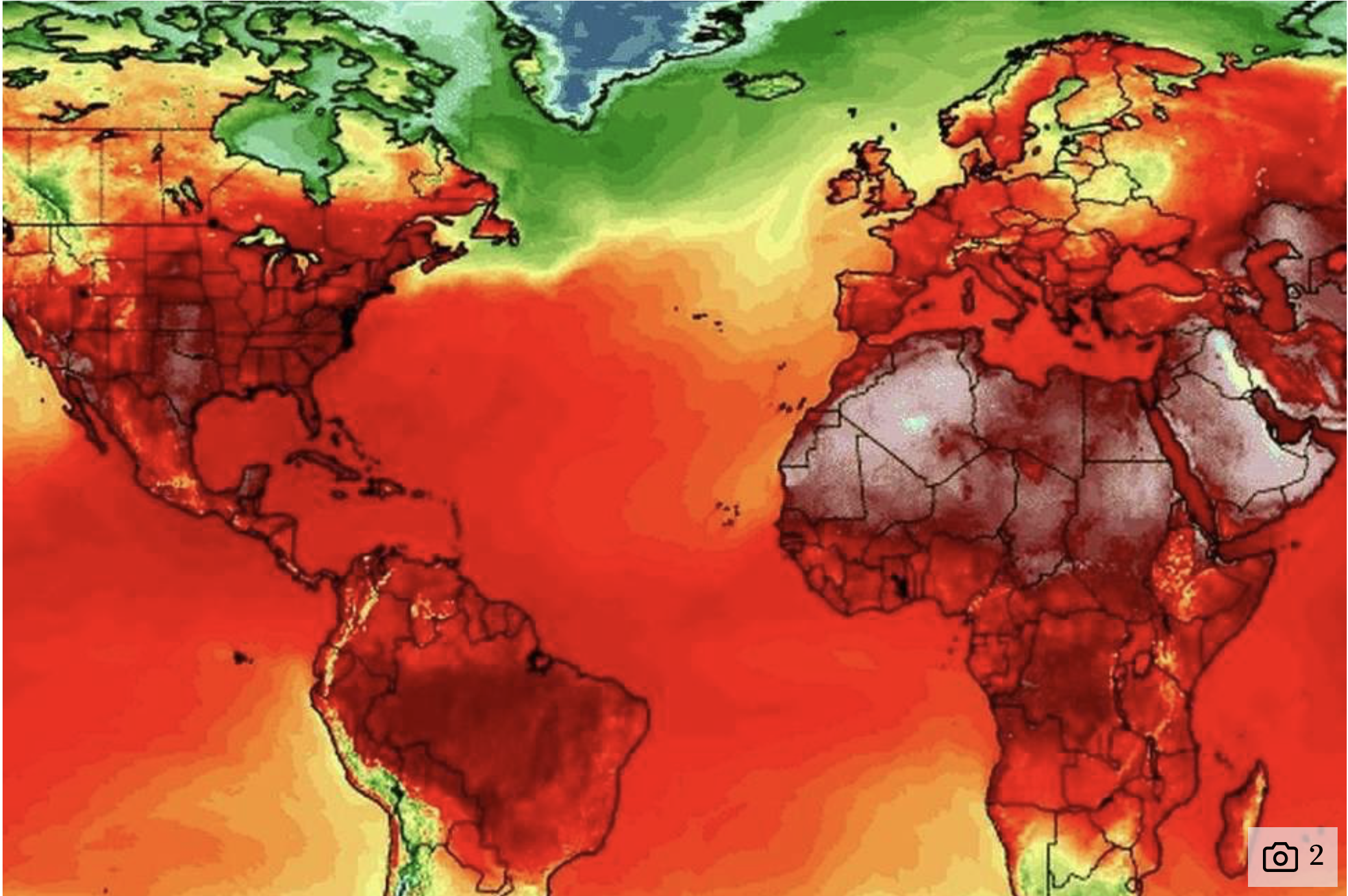
Fitzwilliams agrees with the need to focus on residential development in wildland areas. He said another looming factor is a changing climate that is resulting in longer wildfire seasons, record temperatures and fuel dryness, and more extreme fire behaviors such as fires making downhill runs at night, like when the Lake Christine Fire burned three homes.

“As many firefighters that I’ve talked to this summer have said, the (fire-behavior) norms are out the window. What we thought we knew often doesn’t apply anymore,” he said.

He said the Forest Service can work to do fuel mitigation, but it doesn’t have much control over the weather or climate and building homes in the wildland-urban interface.

“This is a three-headed monster and we’re only dealing with one head of the monster,” he said.

Eardley said fire seasons used to move around the country, starting in the Southeast early in the year, then moving to the Southwest, and so on. Now there’s more overlap between fire seasons in various parts of the country, raising the concern about the potential for fatigue for firefighters who used to sometimes get some down time between regional fire seasons.

In an extreme fire year like this one, a focus for officials like Fitzwilliams is the safety of firefighters and the public. Having once had to knock on a family’s door and tell them their son had died fighting fire, he never wants to repeat that experience.

“We cannot take the risk of losing someone to protect trees or houses. Human life is too precious,” he said.

Fitzwilliams said the White River National Forest’s strategy this year also is on initial attacks designed to put out fires as fast as possible.

“I can’t afford another big fire,” he said.

From Yale Climate Connection:

By July 4th this year, numerous fires were burning in Colorado — the 416 Fire near Durango, and the Spring Creek Fire in the southern part of the state have been the biggest so far.

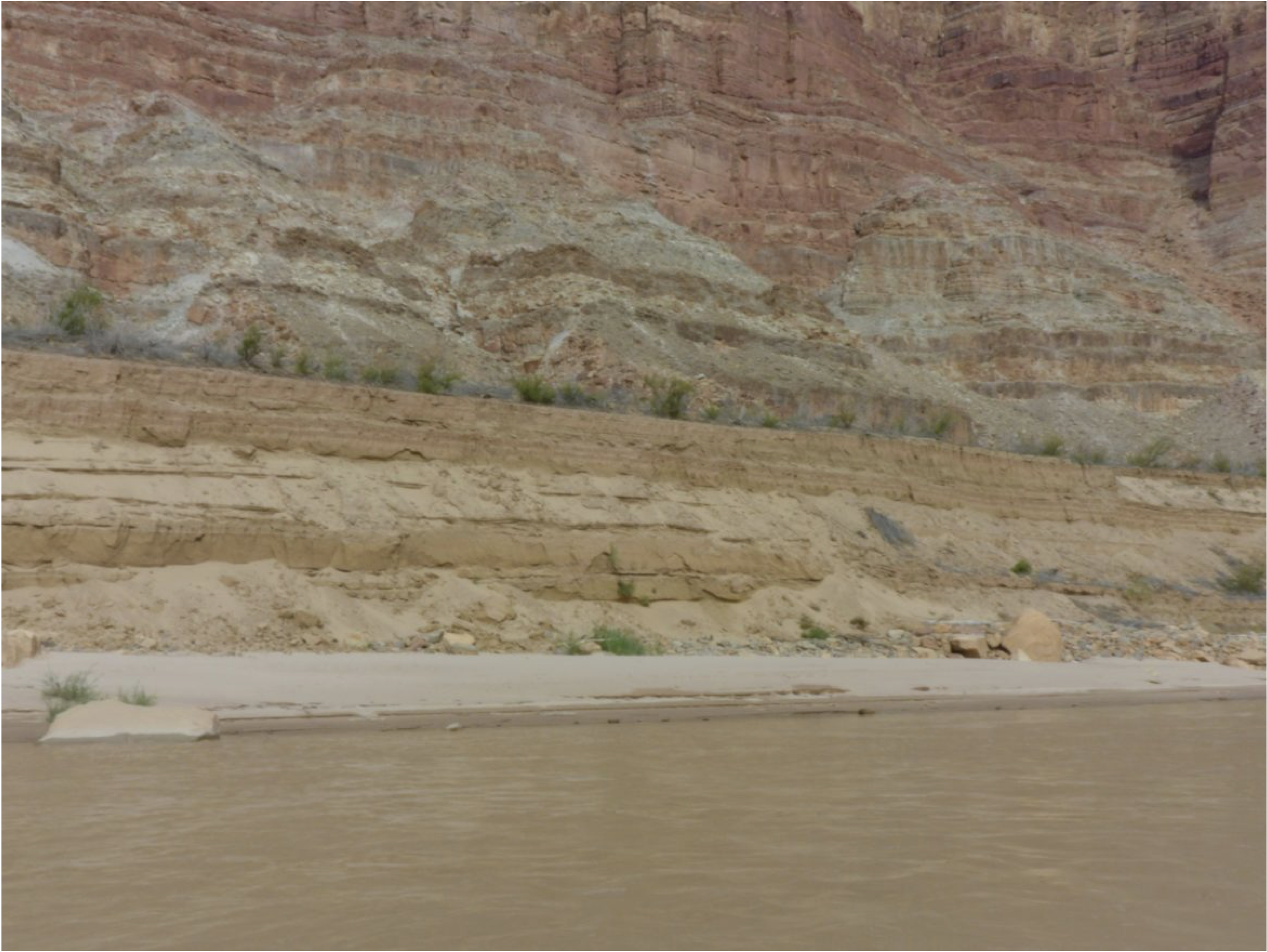
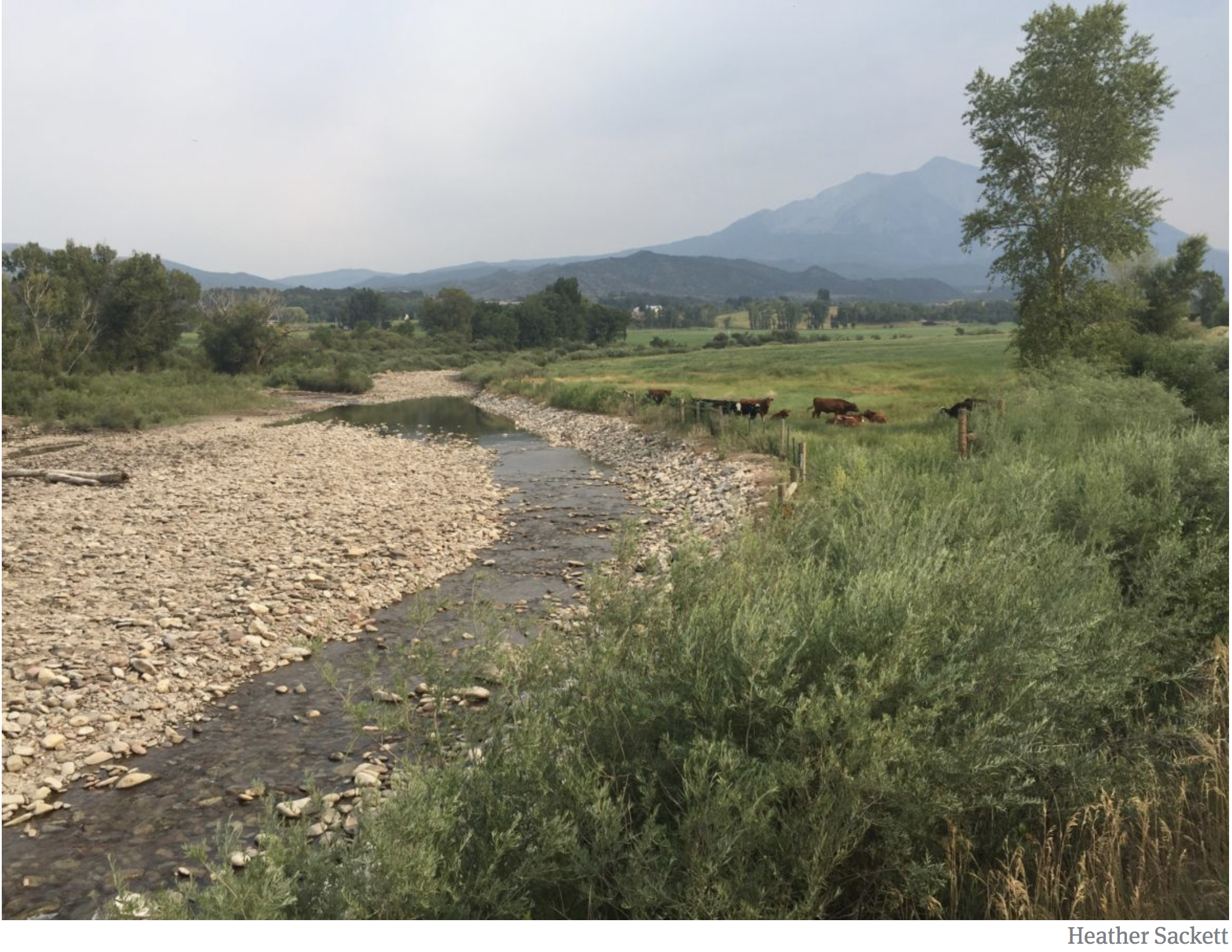
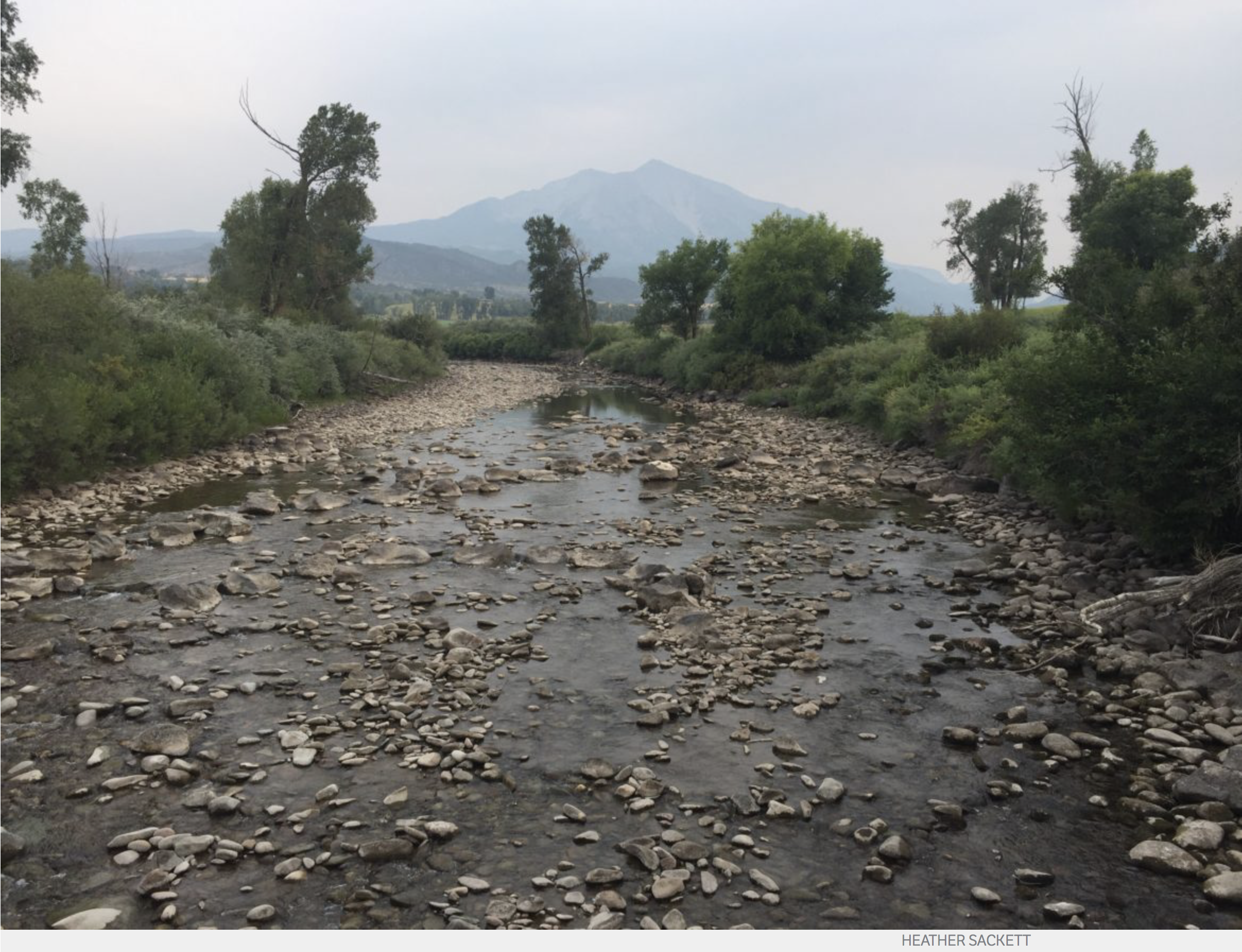
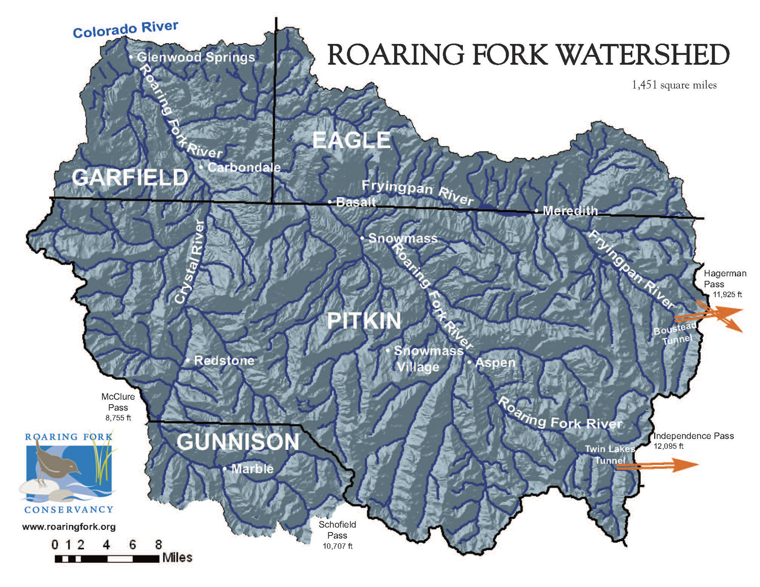
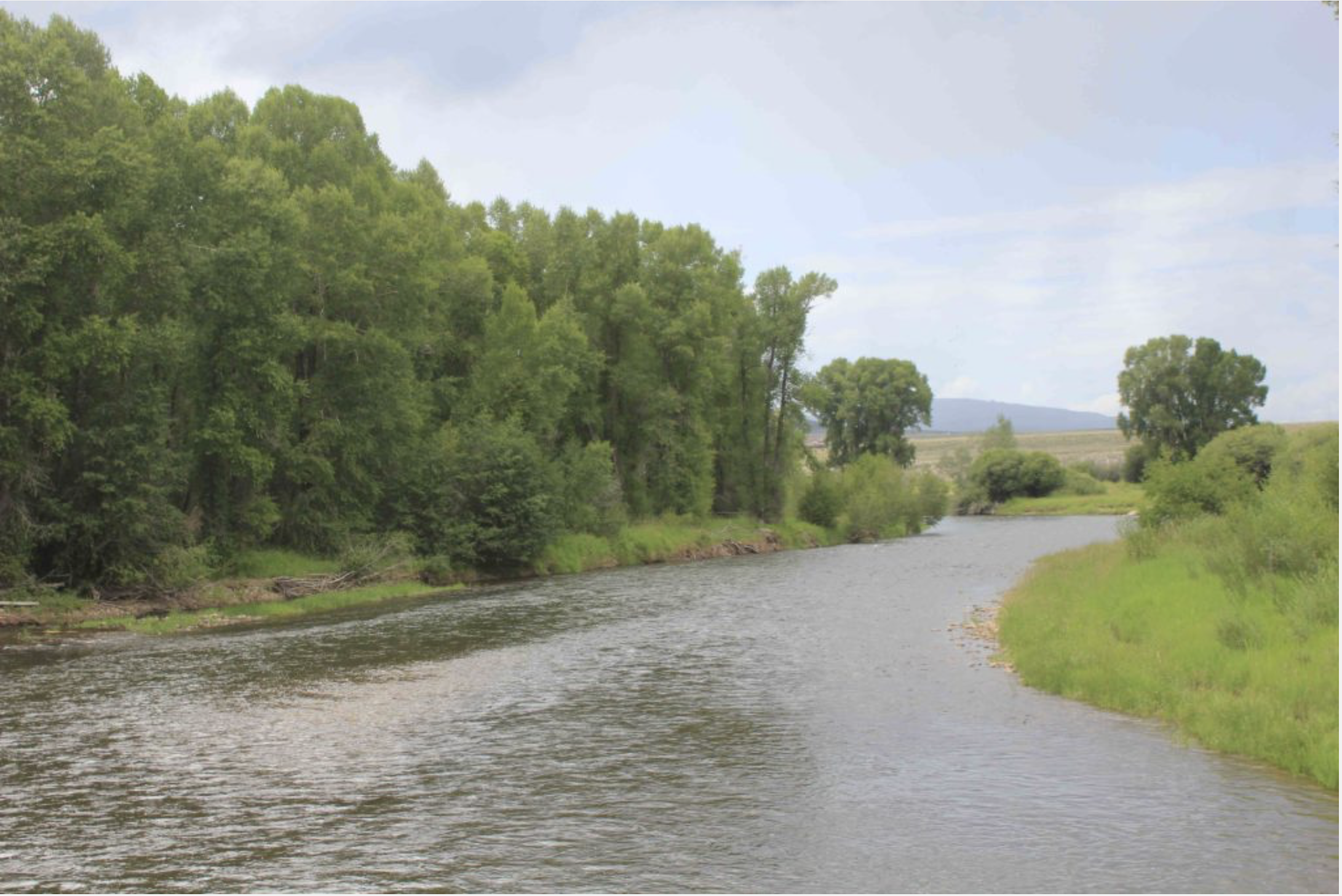
As everyone knows, fires destroy and reshape ecosystems, but they also affect the freshwater supplies we eventually drink. Water providers, like that in Fort Collins, Colorado, spend a lot of effort making sure that when their customers turn on the tap, clean water comes out. And if there have been fires in the watershed, providers don’t want the water to smell smoky – like you’re drinking out of a canteen near a campfire.

Until recently, says Jill Oropeza, water quality services manager for Fort Collins Utilities, there hasn’t been much research about how wildfires change the chemistry of water and what utilities would have to do to treat it. She said, “The High Park Fire which happened in 2012 was the first time that we had seen some really major and sustained impacts on water quality in the Poudre River, so we were suddenly needing to understand what is our new normal in this watershed.”

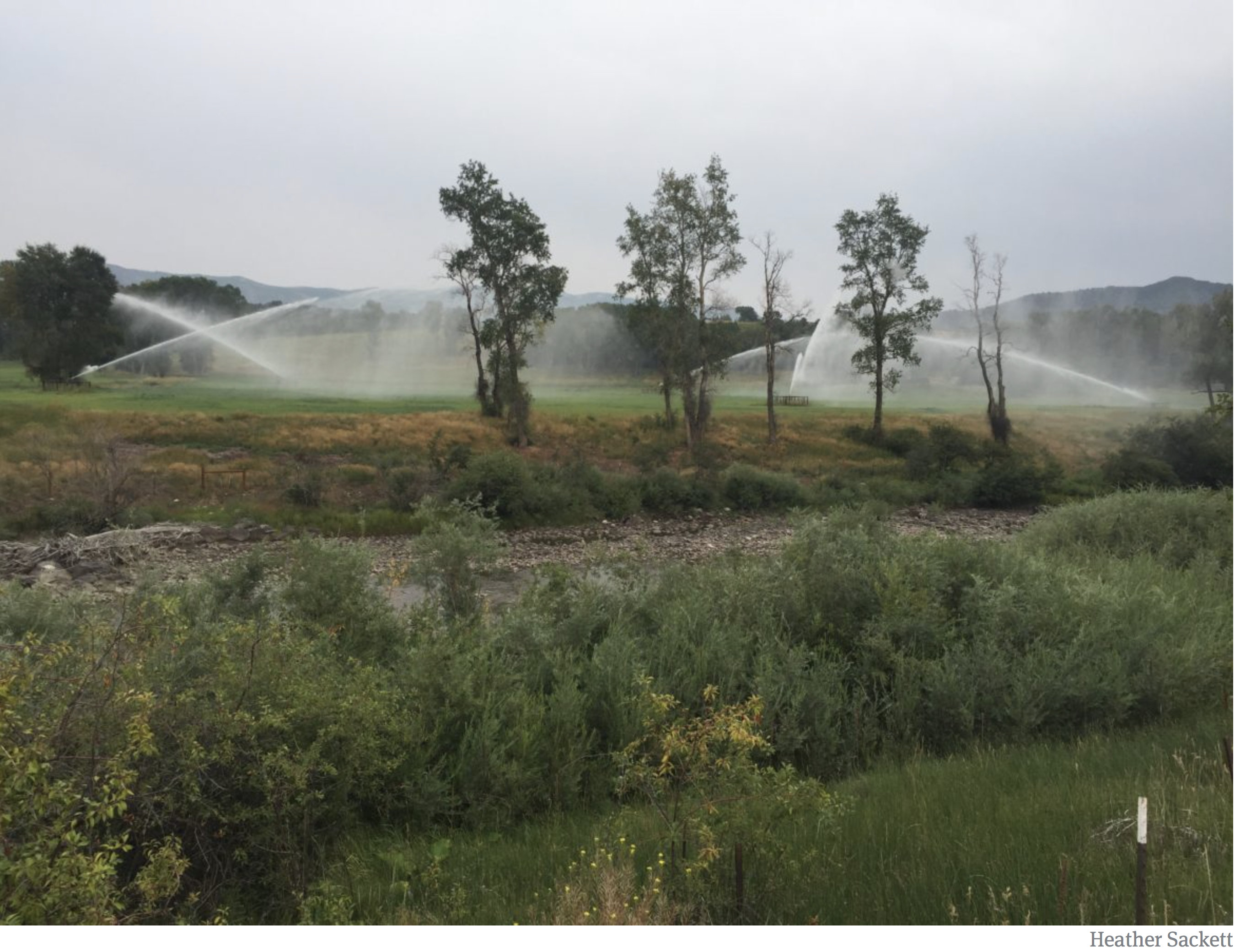
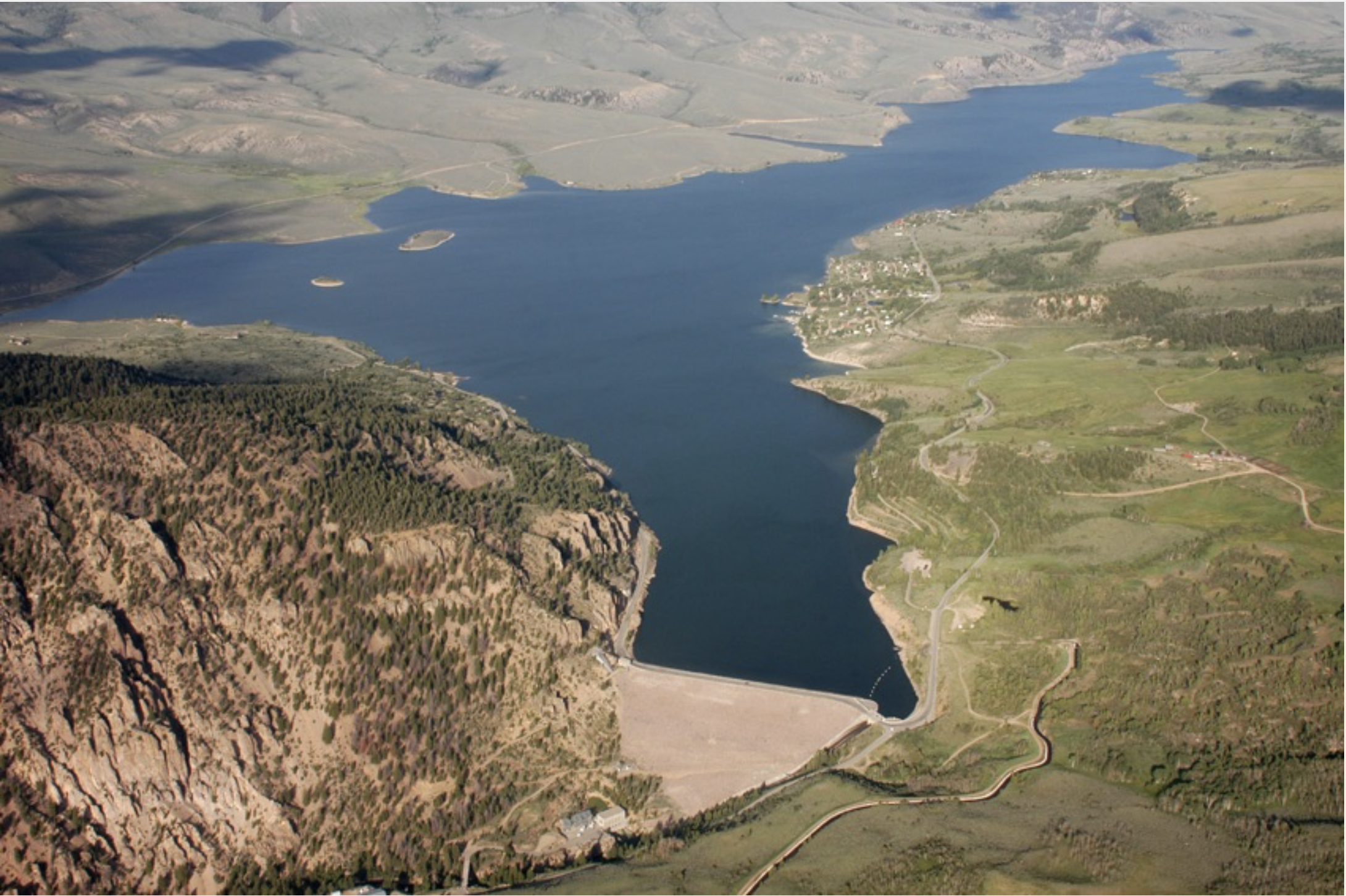
The High Park Fire was started by lightning six years ago, about 15 miles west of Ft. Collins, and it destroyed nearly 260 homes, burned more than 85,000 acres, and killed one person. The fire surrounded parts of the Cache la Poudre River – one of the two water sources for Ft. Collins.

The city reached out to the research community to help answer questions about how fires affect what comes down the river afterwards. They turned to Fernando Rosario, an associate professor, in the University of Colorado’s Civil, Environmental, and Architectural Engineering Program, who, with funding by the Water Research Foundation and the National Science Foundation, studied the issue. He began with much fieldwork and then took his research into the lab because, obviously, one can’t go start a new fire in the field to see what happens.

Rosario collected soils and litter from areas where fires occurred in order to simulate wildfire conditions by dissolving them in water. He then created wildfire-impacted water that matched some of the properties that were observed in the High Park Fire.

Next he did studies to see how to effectively treat those waters. One major problem that confronted water utilities was the amount of carbon the water contained. Oropeza with Fort Collins Utilities says they had to develop specific treatment requirements to get rid of as much of the organic carbon as possible.

The reason they have to get rid of the carbon is because it can interact with chlorine they use to treat the water and create disinfection byproducts that are carcinogenic and strictly regulated by the EPA. Ironically, the chemical used to treat water can become a contaminant if there are too many other contaminants in the water.

One finding as a part of Rosario’s research was that different levels of heat on soils factored into the amount of organic carbon that was released.

His team observed that while a high-temperature fire may result in more ash and sediment and might be more damaging to the watershed, the high temperatures caused lower amounts of carbon to be released from the soil than a low- to mid- temperature fire.

A lower temperature wildfire may be less damaging to the watershed, but by releasing more organic carbon, it creates more problems for water treatment professionals – and likely higher utility bills for consumers.

Oropeza says that before the new research no one was looking at how to treat wildfire-affected water. She says that the insights will allow providers to be more prepared, which can help to keep costs down for consumers.

And as far as global warming, she adds that because the number and intensity of fires influenced by climate drivers will likely increase, the requirements for water treatment will likely grow as well.

Reprinted with permission of H2O Radio, a Yale Climate Connections content-sharing partner.

From The Guardian (Ashifa Kassam):

About 566 wildfires are currently burning across the province [British Columbia], prompting the evacuation of 3,000 people

About 566 wildfires are currently burning across the west coast province, prompting the evacuation of some 3,000 people. Another 18,000 residents have been warned that they may have to flee their homes at a moment’s notice.

So far this year more than 1,800 fires have charred some 380,000 hectares (939,000 acres), making it the province’s fourth worst fire season since it began keeping track in 1950.

The fires have left a wide swath of western Canada, including metro Vancouver, blanketed in a thick layer of smoke and haze. Public health officials are warning residents in some regions to avoid strenuous exercise and stay indoors as much as possible.

More than 3,000 firefighters – from across Canada and as far away as Mexico and New Zealand – are working to contain the fires. Some 200 Canadian armed forces personnel are expected to be deployed in the coming days to help the province.

Officials said the decision to declare a state of emergency was based on advice from the province’s wildfire service.

“Public safety is always our first priority and, as wildfire activity is expected to increase, this is a progressive step in our wildfire response to make sure British Columbia has access to any and all resources necessary,” Mike Farnworth, the province’s public safety minister, said in a statement.

It marks the second year in a row that the province has declared wildfires a state of emergency; last year saw a record-setting 1.2m hectares (2,965,264 acres) scorched by fires raging in the province.

Climate change is having an impact, Farnworth said on Wednesday.

“We know that the fire season is starting earlier,” he told reporters. “And each year is different. The bulk of the fires – what we have seen this year – have been lightning-caused.”

The fires have sent huge plumes of smoke wafting across British Columbia, blotting out the sun and darkening skies.

“Ash has been falling like snow,” Shannon Hatch of Fort Fraser, a community in northern British Columbia that was put on evacuation alert this week, told the Globe and Mail. “Yesterday in the afternoon, it was pitch black, like nighttime.”

Congress Must Act Now to Preserve the Land and Water Conservation Fund — Westword

Roxborough State Park photo via Colorado Parks and Wildlife

From Westword (Paul Lopez):

Enacted into law in 1964, LWCF provides funding for the acquisition and management of federal, state and local public lands nationwide so that all Americans can enjoy access to the outdoors — and in a wonderful compensation improving local economies and community well-being. It is the only federal program devoted to the continued conservation of our national parks, forests, wildlife refuges, wilderness, Civil War battlefields and developing state and local parks.

Remarkably, LWCF does not cost taxpayers one dollar — it is funded using a small portion of the royalties paid by oil and gas companies to drill offshore. The fund is authorized for $900 million annually, but that has occurred only once since its inception.

Ensuring access to the outdoors for everyone is more than just a concept; it’s our Colorado way of life. It’s a value that every community, people and culture hold dear. As a Mexican American and native Coloradan, I believe the conservation of our land is a central value of our heritage for generations. In fact, recent results of a poll from the respected Colorado College Conservation in the West bear that out in six western states, showing that 75 percent of Latino voters support continued funding of the Land and Water Conservation. Simply put, protecting our land preserves our nation’s history.

In our home state of Colorado, LWCF has been a huge benefactor over the past five decades, contributing approximately $268 million to places like the Rocky Mountain and Great Sand Dunes national parks and hundreds of state and local park projects, including acquisitions at Golden Gate Canyon and Roxborough State Parks — investments that have helped to shape Colorado’s impressive $28 billion annual outdoor recreation economy.

The City and County of Denver alone has received nearly $4 million in LWCF grants that have supported over 75 projects; $1.2 million of LWCF money was invested along the South Platte River, which began a renewal of Denver’s downtown that continues today. If you’ve ever visited Confluence Park or Denver’s popular Washington Park, then you have enjoyed the benefits provided by the Land and Water Conservation Fund.

These city parks and others provide a wonderful place to gather with the extended family, eat and enjoy recreation together. Physical activity for our children is critical and, as such, the protection of parks, enabled by LWCF, should be a high priority for all people — no matter the zip code.

We are all fortunate in Colorado to have both senators Michael Bennet and Cory Gardner fully on board with permanently authorizing LWCF. With only weeks remaining before the expiration date, now is the “do or die” time for the rest of Congress to get on board and keep the bipartisan promise made to protect America’s public lands, water resources and cultural heritage. Without the certainty of LWCF renewal, Americans everywhere will be deprived of current and future opportunities to enjoy our Great Outdoors, whether that is a wildlife preserve or a community ballpark.

At zero cost to taxpayers, why would any member of Congress want that to happen?

Born and raised in Denver’s westside, Paul D. Lopez has been a Denver city councilman for District 3 since 2007.

How #Colorado’s water law affects you and our rivers — @AmericanRivers

Prior appropriation example via Oregon.gov

From American Rivers (Fay Augustyn):

In Episode 12 of We Are Rivers, we discuss the complicated nature of water law in the West. Listen in to learn more about how water law affects you and the rivers you love.

Water in the West is inherently complicated. A complex web of laws, compacts, and a little thing called “prior appropriation” dictates how and when people and entities are allowed to use water in the West, such as cities and towns, farms and ranches, and industry. This ability is what we call “owning a water right,” and explains much of how the West has been settled over the last century, and how many of the economic forces that affect our daily lives are driven by these water rights. Listen in to learn more about how water law affects you and the rivers you love.

Prior appropriation is the backbone of our water law system. Perhaps you’ve heard of “first in time, first in right,” – this phrase refers to the water law system. Prior appropriation allows individuals or entities who first apply water for a beneficial use to be entitled to that appropriation into the future (and has priority over subsequent users). Holding a water right doesn’t actually imply ownership over the water (water in Colorado is “owned” by the people) but is instead the right to use the people’s water for a beneficial use like agriculture, municipal water, and now more recently, in benefit of the environment as in-stream flows.

Even if the term “water rights” leaves you scratching your head, and you call a western state your home, you still are impacted by them. There’s a fairly high chance that you use water connected to a water right, (unless you have your own well or diversion). Water running through pipes in cities and towns across the West are likely municipal water obtained through a water right held by city or town. Your community has to have a water right themselves to divert and distribute the water that ends up in your home. Agriculture, industry, and even our rivers and streams all depend on the legal structure managing our water.

Join us in this month’s episode of We Are Rivers as we navigate through the complicated nature of water law in the West, including prior appropriation, instream flow rights, and the history of water law.

#Drought news: Aspen Enacts Mandatory Water Restrictions

West Drought Monitor August 16, 2018.

From the Associated Press via USA Today:

Extremely low water levels have forced the city of Aspen to declare a stage 2 water shortage for the first time in history.

The Aspen Times reports Aspen City Council approved the move Monday. Aspen Utilities Portfolio Manager Margaret Medellin says she anticipates stage 2 restrictions to remain in effect indefinitely.

Under the restrictions, Aspen water customers must not water lawns more than three days a week and no more than 30 minutes per sprinkler zone per day.

Restrictions also include no watering native areas more than two days a week and no watering lawns between 10 a.m. and 6 p.m.

From News Deeply (Emma Penrod):

Large reservoirs have buffered urban areas in the Southwest from the worst of the year’s dry conditions, but rural farmers and ranchers are bearing the brunt of water shortages and the economic fallout.

Farmer Scott Sunderland runs the numbers on his smartphone and the outlook is bleak. He needs $250,000 just to pay the taxes and debts he owes on the 700-acre farm he’s managed for more than three decades. If he’s lucky, he’ll have $220,000 by the end of the season.

“If the drought holds on another year,” he said, “we’re going to have to start liquidating … But once you start down that road, it’s almost a dead end.”

Chester, an unincorporated community in central Utah, has been hit by “exceptional” drought conditions, the most severe rating issued by the United States Drought Monitor. For much of the southwestern U.S., this past winter has marked one of the driest periods in recorded history.

Population centers in the West have been relatively insulated from the disaster, protected by large reservoirs capable of storing water for multiple years. But rural towns and the farmers and ranchers who populate them have been devastated. In many cases, struggling farmers have already been pushed off more fertile lands by urban development. Now, some of the remaining ones hope to sell out and scrape together enough cash to retire, while others have already begun to look for new jobs.

“It’s hard to paint a picture because a lot of the time when people talk about drought, you just shower less and water your lawn less,” said Cassidy Johnston, a rancher in Capitan, New Mexico. “In town, yeah, your lawn may be yellow, but here, you may have to move and sell the business your family has had for generations.”

A Regional Crisis

More than half the western U.S. is currently experiencing some level of drought, according to the U.S. Drought Monitor at the National Drought Mitigation Center at the University of Nebraska-Lincoln. Sparsely populated areas in Utah, Colorado, New Mexico and Arizona in particular are grappling with dry conditions of historic proportions – many small irrigation companies are reporting water shortages the likes of which have not been seen since the 1970s.

This isn’t necessarily because these areas got less snow over a disastrously dry winter than some of the surrounding environs, said Troy Brosten, a Utah-based hydrologist for the U.S. Department of Agriculture Natural Resource Conservation Service. The main issue is the lack of water storage in some remote areas.

Despite the lack of snowfall this past winter, Brosten said, larger reservoirs started the year with plenty of water left over from last year. These reservoirs are still mostly full, so the areas that draw from them haven’t experienced actual water shortages.

But some smaller reservoirs only have capacity for enough water to last about one year, Brosten said. They rely on each year’s snowpack to provide the following summer’s irrigation water. This year, there simply wasn’t enough snow to replenish their reserves.

Many farmers are increasingly reliant on these smaller reservoirs and water systems, said Kate Greenberg, who oversees western chapters of the national Young Farmers Coalition from her office in Durango, Colo. Farmers who once held senior rights in more secure reservoirs have, in some cases, opted to escape pressure from urban development by selling their lands and moving their operations further afield. The situation has been exacerbated by government policies to encourage water managers to secure water for urban growth by buying out farms, Greenberg said.

This was the fate of the Sunderland family farm, which was originally located in Lehi, Utah – a city that in a few short years has been completely transformed by the arrival of several big-name software companies, including Adobe.

The family knew that the new property in Chester was “drier country” when they moved more than 30 years ago to avoid being crowded out by development, Scott Sunderland’s brother Edwin said. But they were willing to take the risk so they could expand their operation and hopefully increase their earnings potential.

But compared to even a decade ago, Scott Sunderland added, Chester’s water doesn’t seem to go as far as it used to.

Chester doesn’t have access to a full-sized reservoir, but gets its water from a series of pipelines and storage ponds, said Edwin, who now manages a small portion of the family property. They started the season, he said, with about half their total water capacity. By July 4, the water was gone.

From The Rio Blanco Herald-Times:

Last Friday, Colorado Parks and Wildlife began releasing cooler water from Lake Avery in an ongoing effort to keep coldwater fish in the river alive as tough, drought conditions persist.

Trout have adapted to thrive in water temperatures between 50-60 degrees. According to CPW, some sections of the White River have exceeded 70-plus degrees consistently since early June. In addition, water flow in portions of the river have been running at or below the 25th percentile of the historical median in recent weeks.

When flows are low, water is susceptible to warming quickly and dissolved oxygen levels drop, leading to significantly stressed fish. They gather in residual pools and become easier to catch. Even if returned to the water immediately, stressed fish hooked under these conditions could quickly perish.

In addition to the water release, CPW has implemented a voluntary fishing closure between 2 p.m. and midnight on both north and south forks of the White River, from the boundary of the National Forest through the main stem down to the bridge at Rio Blanco County Road 5, west of Meeker.

CPW has implemented additional voluntary fishing closures across the region, due to similar conditions.

The White River within Rio Blanco County is renowned for excellent fishing, drawing thousands of anglers from across the world to catch the large rainbow, cutthroat and brook trout that typically thrive in these waters.

“It’s a great place to fish, but the White River fishery is also a critical resource that local residents depend upon for their livelihoods,” said deVergie. “Whether you run a hotel, a restaurant or an outfitting business, everyone up here has a vested interest in conserving this important natural resource.”

Since the voluntary closure went into effect last week, deVergie says he has seen excellent cooperation from the public. He stresses it could be a while before things improve.

“Now that we have a little more flow in the river, we are asking irrigators to leave as much of it as they can in the river for the benefit of the fish,” said deVergie. “Until we get some moisture, the release is one of the last remaining options we have to help prevent extensive fish mortality in the White River.”

Through an agreement with the Colorado Water Conservation Board, CPW can release water from Lake Avery to help the Board meet their instream flow right of 200 cubic feet per second. The goal is protecting aquatic life in Big Beaver Creek downstream of Lake Avery, and the White River downstream to the confluence with Piceance Creek.

The terms of the agreement allow for releasing 20 cfs up to 120 days. CPW will monitor water-quality conditions and fish to gauge the effects of the additional water, adjusting the release from Lake Avery as conditions warrant.
Due to similar climate conditions at the time, CPW released water from Lake Avery in 2012. Per the terms of the agreement, the agency can release water from the reservoir only one more time prior to 2022.

CPW recommends honoring all voluntary closures, fishing at higher altitude or fishing early when it’s cooler. Anglers should consider using barbless hooks, land fish quickly and release them quickly. Wet your hands before handling and let them go immediately, preferably without removing them from the water.

For more information about conditions on the White River, contact CPW’s Meeker office at 970-878-6090.

For general information about fishing in Colorado, visit the CPW website.

From The Durango Herald (Jennifer Oldham):

In the state known as the “mother of rivers,” the third–warmest and driest period in more than a century is wreaking havoc on waterways that provide the economic lifeline for rural communities and high–alpine habitat for Colorado’s signature fish, the greenback cutthroat trout.

The extremes of temperature and precipitation – too much of one, too little of the other – have grounded rafting companies in places that usually offer white-knuckle rides. With water barely lapping over jagged rocks, some outfitters have moved operations to rivers fed by reservoirs higher up in the parched Rockies.

“Boats can get piled up and people can get hurt if they flip, and guides were having to use their backs to pull the rafts off of rocks,” said Alan Blado, owner of Liquid Descent Rafting, which is based about 40 miles west of downtown Denver. “We didn’t want them to get injured.”

[…]

Summer 2018 came after a rough winter in which some areas received 30 percent of what once was typical snowpack. A warm spring thawed drifts early, causing rivers to peak in May, weeks before the busy summer season. Severe to exceptional drought now covers two–thirds of Colorado, and some of the worst wildfires in state history have broken out.

In a warming world , the fight for water can push nations apart — or bring them together — The Texas Observer #RioGrande #ActOnClimate

Map of the Rio Grande watershed. Graphic credit: WikiMedia

Here’s the introduction to a nine-part series about cross-border river administration from The Texas Observer:

The Rio Grande Valley of Texas is one of the fastest-growing places in the United States. Already hot and arid, and growing hotter, the booming, heavily Latino region depends almost entirely on the shriveling Rio Grande for water. Considered one of the most endangered rivers in North America, the Rio Grande provides drinking and irrigation water to 6 million people and 2 million acres of farmland on both sides of the Texas-Mexico border. Droughts and heat waves in the Valley are becoming more intense, exacerbating water scarcity.

Despite opinion surveys showing that Valley residents are deeply concerned about how climate change is affecting them, local and state officials are paying little heed to their constituents. According to a 2013 federal study (pdf), even before accounting for climate change the region is expected to run a “staggering” water supply shortage of almost 600,000 acre-feet in 2060. At the same time, some Texas border cities have been at the forefront of water conservation, and the US and Mexico have found ways to cooperate on protecting the Rio Grande.

This nine-part collaboration between the Texas Observer and Quartz explores the complexities of border water in search of answers for how people can work together in a hotter, drier world.

Brewing Beer Takes Lots Of Water. That’s Why This Brewery Donates To Conservation Causes — Colorado Public Radio

From Colorado Public Radio (Nancy Lofholm). Click through to listen to the program:

Drink beer, help rivers. That’s the mission behind Many Rivers Brewing, a Western Slope craft beer operation that doubles as a conservation project. Many Rivers brews an amber ale and IPA, and 100 percent of the profits from those two beers goes to river improvement projects. The brewery has donated the boozy benefits to the Colorado Riverfront Commission, Mesa Land Trust, Roaring Fork Conservancy and others.

Tim Carlson, Many Rivers’ beer brewer and board president, talked to Colorado Matters about founding the eco-friendly brewery. Before picking up the pint glass, Carlson was an environmental engineer who spent more than 40 years cleaning up rivers.

Wild Sounds Of The West: The Territorial Chorus Of Coyotes’ Group-Yip-Howl — @NewsCPR

You know that I can’t help but highlight my cousins! From Colorado Public Radio (Sam Brasch). Click through to listen:

The sounds of coyotes for travel for miles. And biologist say coyotes sing a particular songs once they have settle in an area. It’s called the group-yip-howl. In this episode, Mary Ann Bonnell, a park ranger in Jefferson County Open Space, introduces us to how coyotes broadcast their territory.

Critically low #LakeMead levels highlight need for Arizona action — Environmental Defense Fund #ColoradoRiver #COriver

From the Environmental Defense Fund (Kevin Moran):

Lake Mead water users this week learned we once again narrowly avoided water cutbacks by the skin of our teeth.

A 24-month projection released Wednesday by the U.S. Bureau of Reclamation shows we skirted federal mandatory water cuts this year, but prospects for 2019 and 2020 do not look good. The forecast found Lake Mead water levels will end this month at 1,079 feet – a mere four feet away from the 1,075-feet threshold that would trigger a federal shortage declaration and mandatory cuts.

The report predicted Lake Mead will dip just below the threshold to 1,075 feet as early as May 2019 – in nine months. At the beginning of 2020, Lake Mead levels are predicted to be at approximately 1,070 feet and then predicted to fall to as low as 1,053 feet in the summer of 2020.

An official shortage declaration has been staved off until at least August 2019. That’s when the next key projection comes out, for January 1, 2020.

Graphic credit: USBR via the Environmental Defense Fund

How did it come to this, and where do we go from here?

Located nearly 25 miles from the Las Vegas Strip, Lake Mead is the largest reservoir in the U.S. and supplies 40 percent of Arizona’s water. Factors like population growth, declining snowpack and rising temperatures have made drought the norm and are stretching this vital source of Colorado River water to the limit.

The latest Lake Mead forecast comes a week after a 40-member steering committee in Arizona held its second meeting to craft agreements between Arizona water agencies and water users that would enable the state to sign on to the Lower Basin Drought Contingency Plan (DCP) – a plan developed by Arizona, California, Nevada and the federal government to reduce risks in the Colorado River system. The precariously low Lake Mead water levels projected this week make this steering committee’s work more important than ever.

Developing intra-Arizona conservation and water sharing agreements and gaining approval by the Arizona legislature next year will hopefully be among the last steps in a multi-state effort to address the decline in the water elevation of Lake Mead, which also supplies water to California, Nevada and two states in Mexico. It’s time for Arizona to fully acknowledge the region’s grim hydrology and implement plans to create a more sustainable future.

Reaching an agreement on the Lower Basin DCP is critical to Arizona’s long-term water security and to the state’s economic future. Failing to adopt a plan could result in federal agencies stepping in to impose mandatory cuts overnight.

We need collaboration to avoid potential catastrophe

Environmental Defense Fund is participating in the Arizona steering committee to ensure that Arizona reduces its withdrawals from Lake Mead to create a more sustainable Colorado River water system. My colleagues and I believe the near-term solution – to operate under a Lower Basin DCP agreement with our neighbors – should emphasize conservation and water sharing agreements among Arizona water uses.

Leaders in Arizona need to collaborate to take bold actions and expand the use of proven conservation strategies like the “system conservation” agreement reached last year. This multi-agency agreement compensated the Gila River Indian Community to leave 40,000 acre feet of water in Lake Mead – the amount used by approximately 100,000 people in a year.

Lake Mead bathtub ring Mark Henle Arizona Republic

Some innovative ideas already on the table

The good news is that the Arizona steering committee is off to a promising start.

At its first meeting on August 9, the committee created a smaller working group to focus on one of the biggest challenges – a mitigation plan for Central Arizona agriculture, which could be heavily affected by cuts. Options on the table include using some of the water stored by Central Arizona Project in Lake Pleasant or creating a fund to purchase mitigation water from higher priority water users.

Several members of this Central Arizona agriculture mitigation working group have already been meeting over the past several months and, with this head start, I am hoping they will bring some promising ideas to the full steering committee at its next meeting on August 23.

I am cautiously optimistic that the steering committee can succeed in hammering out intra-Arizona plans for increased conservation and water sharing agreements by the end of this year.

With those plans in hand, we would have the support we need to convince the state legislature to pass a concurrent resolution (as required by Arizona law) to authorize the Department of Water Resources to sign the Lower Basin DCP.

It’s time to face the reality of the situation

Arizona is running out of time to figure out new ways of conserving and creatively sharing an increasingly scarce water supply. We need to collaborate now in order to avoid catastrophic and economically destabilizing impacts in the very near future.

Adapting successfully to the new water realities in our region – reduced Colorado River supplies and increased uncertainty and risk – will require increased agility, collaboration and innovation. The success of the Arizona economy and health of our ecosystems depend on it.

“If these projections materialize, we’re very quickly going to lose control of how to manage the deteriorating conditions on the #ColoradoRiver” — John Entsminger #COriver #drought

Lake Mead bathtub ring Mark Henle Arizona Republic

From The Associated Press (Dan Elliott):

A vital reservoir on the Colorado River will be able to meet the demands of Mexico and the U.S. Southwest for the next 13 months, but a looming shortage could trigger cutbacks as soon as the end of 2019, officials said Wednesday.

A forecast from the U.S. Bureau of Reclamation echoes previous warnings that a nearly 20-year trend toward a drier regional climate coupled with rising demand could drain so much water from the Lake Mead reservoir that cutbacks would be mandatory.

The report increases the pressure on seven U.S. states that rely on the river to finish a long-delayed contingency plan for a shortage.

“If these projections materialize, we’re very quickly going to lose control of how to manage the deteriorating conditions on the Colorado River,” said John Entsminger, general manager of the Southern Nevada Water Authority, which serves 2.1 million people, including the city of Las Vegas.

The Colorado River system — including the giant Lake Mead and Lake Powell reservoirs — serves about 40 million people and 6,300 square miles (16,300 square kilometers) of farmland. Arizona, California, Colorado, Nevada, New Mexico, Utah and Wyoming rely on the river, along with native American reservations and northwestern Mexico…

The Bureau of Reclamation forecast says all the users will get their usual share through September 2019. But the report projects that by October 2019, the surface of Lake Mead could fall below 1,075 feet (330 meters) above sea level, the agreed-upon point that would trigger an announcement of cutbacks that would occur sometime in the following 12 months…

The chances of a shortage in late 2019 remain at 52 percent, the same odds the bureau announced in May, he said. Lake Mead has never had a shortage and if next winter provides enough snow in the mountains that feed the river, it could be averted, Duke said.

Here’s the latest report from the Bureau of Reclamation:

The operation of Lake Powell and Lake Mead in this August 2018 24-Month Study is pursuant to the December 2007 Record of Decision on Colorado River Interim Guidelines for Lower Basin Shortages and the Coordinated Operations of Lake Powell and Lake Mead (Interim Guidelines), and reflects the 2018 Annual Operating Plan (AOP). Pursuant to the Interim Guidelines, the August 2017 24-Month Study projections of the January 1, 2018, system storage and reservoir water surface elevations set the operational tier for the coordinated operation of Lake Powell and Lake Mead during 2018.

Consistent with Section 6.B of the Interim Guidelines, the Lake Powell operational tier for water year 2018 is the Upper Elevation Balancing Tier. With an 8.23 million acre-feet (maf) release from Lake Powell in water year 2018, the April 2018 24-Month Study projected the end of water year elevation at Lake Powell to be above 3,575 feet and the end of water year elevation at Lake Mead to be below 1,075 feet. Therefore, in accordance with Section 6.B.4 of the Interim Guidelines, Lake Powell operations shifted to balancing releases for the remainder of water year 2018. Under Section 6.B.4, the contents of Lake Powell and Lake Mead will be balanced by the end of the water year, but not more than 9.0 maf and not less than 8.23 maf shall be released from Lake Powell. Based on the most probable inflow forecast, this August 24-Month Study projects a balancing release of 9.0 maf in water year 2018.

Consistent with Section 2.B.5 of the Interim Guidelines, the Intentionally Created Surplus (ICS) Surplus Condition is the criterion governing the operation of Lake Mead for calendar year 2018.

The August 2018 24-Month Study projects the January 1, 2019 Lake Powell elevation to be below the 2019 Equalization Elevation of 3,655 feet and above elevation 3,575 feet. Consistent with Section 6.B of the Interim Guidelines, Lake Powell’s operations in water year 2019 will be governed by the Upper Elevation Balancing Tier, with an initial water year release volume of 8.23 maf and the potential for an April adjustment to equalization or balancing releases in April 2019. Consistent with Section 6.B.4 of the Interim Guidelines, an April adjustment to balancing releases is currently projected to occur and Lake Powell is projected to release 9.0 maf in water year 2019.

The August 2018 24-Month Study projects the January 1, 2019 Lake Mead elevation to be above 1,075 feet. Consistent with Section 2.B.5 of the Interim Guidelines, the Intentionally Created Surplus (ICS) Surplus Condition is the criterion governing the operation of Lake Mead for calendar year 2019.

The 2019 operational tier determinations will be documented in the 2019 AOP, which is currently in development.

The Interim Guidelines are available for download at: https://www.usbr.gov/lc/region/programs/strategies/RecordofDecision.pdf.

The 2018 AOP is available for download at: https://www.usbr.gov/uc/water/rsvrs/ops/aop/AOP18.pdf.

Current runoff projections into Lake Powell are provided by the National Weather Service’s Colorado Basin River Forecast Center and are as follows: Observed unregulated inflow into Lake Powell for the month of July was 0.123 maf or 11 percent of the 30-year average from 1981 to 2010. The forecast for August unregulated inflow into Lake Powell is 0.165 maf or 33 percent of the 30-year average. The preliminary observed 2018 April through July unregulated inflow is 2.602 maf or 36 percent of average.

In this study, the calendar year 2018 diversion for Metropolitan Water District of Southern California (MWD) is forecasted to be 0.941 maf. The calendar year 2018 diversion for the Central Arizona Project (CAP) is forecasted to be 1.466 maf. Consumptive use for Nevada above Hoover (SNWP Use) is forecasted to be 0.277 maf for calendar year 2018.

Due to changing Lake Mead elevations, Hoover’s generator capacity is adjusted based on estimated effective capacity and plant availability. The estimated effective capacity is based on projected Lake Mead elevations. Unit capacity tests will be performed as the lake elevation changes. This study reflects these changes in the projections.

Hoover, Davis, and Parker historical gross energy figures come from PO&M reports provided by the Lower Colorado Region’s Power Management Office, Bureau of Reclamation, Boulder City, Nevada. Questions regarding these historical energy numbers can be directed to Eric Carty at (702) 293-8129.

From InkStain (John Fleck):

Today’s release of the Bureau of Reclamation’s August 24-month study is what in my old newspaper days we would have called “a great news peg”. It’s been clear for a while that we’ll likely have a first-ever federal shortage declaration in the Lower Colorado River Basin in 2020, and that chance is growing. But in the interests of never letting a good Colorado River shortage news peg go unused….

A shortage on the Colorado River, which would force water supply cutbacks for users in Arizona and Nevada, is likely in January 2020, according to a new analysis from federal scientists released Thursday.

In the Bureau’s “most likely” scenario – essentially the median of a bunch of model runs reflecting various hydrologic scenarios under the current rules – Lake Mead would end 2019 at elevation 1,070.35. Anything below 1,075 and Arizona and Nevada have to reduce their use of Colorado River water.

This will happen even though Lake Mead is forecast to get more “bonus water” in 2019 – water released from Lake Powell above and beyond the Upper Basin’s legal compact delivery obligations* of 8.23 million acre feet. The current projected release is 9 million acre feet, but despite that bonus water, Lake Mead is projected to drop 9 feet next year.

I’m in the midst of a book chapter diving into this stuff, so let me obsessively share numbers because I spent all day staring at them, and they might shed some light on where the problem lies. That “bonus water” delivered by the Upper Basin is a big clue.

The Upper Basin has only been using ~4-4.5 million acre feet of water a year, well below its Colorado River Compact entitlement of 7.5maf.

Since 2000, the Upper Basin has delivered 9.7 million acre feet above the amount required under the current rules (8.23 million acre feet per year). So the Upper Basin is a) using less water, and b) delivering more to the Lower Basin. (Brad Udall, who’s been helping me think about all these numbers, sent me the graph above showing the accumulating surplus.)

By the time next year is over, the Lower Basin will have gotten 10 million acre feet of “bonus water” in the 21st century. 10 million acre feet more than the Colorado River Compact requires. Yet Lake Mead keeps dropping. It’s pretty clear where the “supply-demand imbalance” lies here. Looking at you, my Lower Basin friends.

Everyone can plausibly argue that they’re living within the rules here, but if we keep defending our actions with “But the rules say it’s OK!” the Colorado River system is going to crash.

From The Denver Post (Bruce Finley):

The feds are imploring Western states to do more now to cut water use.

A U.S. Bureau of Reclamation forecast issued Wednesday for water in the Colorado River — an over-subscribed lifeline for 40 million people — anticipates declaration of a shortage in September 2019 that would trigger the reduced water releases from federal reservoirs in “lower basin” states including Nevada and Arizona.

Colorado and other “upper basin” states Utah, Wyoming and New Mexico would face increased scrutiny of flows from headwaters into the Lake Powell reservoir. On Wednesday, Lake Powell measured 49 percent full and Lake Mead measured 38 percent full.

“Water stored in Lake Mead and Lake Powell has blunted the impacts of the ongoing drought and helped ensure consistent, reliable water and power,” said Brent Rhees, the bureau’s regional director for the upper basin. “We must continue to work to protect water in the basin. Completing drought contingency plans this year will provide better certainty. …. We can’t afford to wait for a crisis.”

Colorado Water Conservation Board Director Rebecca Mitchell said “there’s no doubt” managing the river presents challenges. “Realistic predictions on the Colorado River are for increasing demand and decreasing supply,” Mitchell said.

Declaration of a water shortage along the Colorado River would be unprecedented. Federal officials are committed to waiting until the water level in Lake Mead drops below the elevation of 1,075 feet above sea level. Then they’d cut deliveries, first targeting Arizona, Nevada and Mexico.

The water level on Wednesday: 1,078 feet.

“We’re within three feet. We’re not going to declare a shortage in 2019,” agency spokesman Marlon Duke said. “There’s a 52-percent chance we will have to declare a shortage in 2020. … We cannot just sit back and think the river is going to provide all the water we need, especially as our cities continue to grow. It all depends on what Mother Nature sends us next year.”

[…]

“We see this train coming, and we’re trying to get ready for it,” said James Eklund, Upper Colorado River Basin commissioner for Colorado, who negotiates river matters with commissioners from the other states, including California.

“Right now we’re OK. If they declare a shortage in the lower basin, it is going to pull more water out of Lake Powell. That would mean we are going to have to put more water into it,” Eklund said.

“The ‘shortage’ is like a yellow traffic signal that says, ‘Hey. Watch out. You’ve gotta be mindful of demands exceeding supply to such a degree that our system doesn’t work.’”

U.S. Bureau of Reclamation Commissioner Brenda Burman has warned states they must act. Burman demanded “drought contingency plans” by the end of the year. The publication of the Colorado River forecast covering the next two years is expected to spur planning, if not immediate smarter use of water.

Federal government scientists have concluded that climate change is creating conditions in the Colorado River Basin that are more variable with more extreme precipitation and more extreme drought. Scientists say precipitation increasingly will come from rain, rather than snow, as temperatures increase. The reservoirs constructed along the river have become increasingly important in easing the impact during a dry period that began 18 years ago and ranks among the driest periods in 1,200 years.

The forecast says river flows into Lake Powell from Colorado and other upper basin states, from snowpack, probably won’t exceed 75 percent of average next year. It says 8.23 million acre-feet of water will flow from Lake Powell to Lake Mead in 2019. That’s more than the amount expected to flow into Lake Powell.

Colorado, Wyoming and Utah depend heavily on mountain snowpack and have been delivering water to Lake Powell as required under the Colorado River Compact. The efforts in these states to develop a plan for conservation should a shortage be declared reflects a common interest of states in managing the river cooperatively — avoiding a federal intervention to control flows into and out of reservoirs.

That plan will be done by the end of the year, Eklund said.

“We in the upper basin face water shortages every year because the nation’s two largest reservoirs sit below, not above, us. We have to work with whatever falls from the heavens. Anytime we have to administer water under our priority system, someone in the upper basin is taking a shortage. That happens every year,” he said.

“We have ways to use less water. We fallow fields. We take water out of pipelines. We conserve. But we have less snow to work with than in the past and more people than ever reliant on the Colorado River system,” Eklund said…

Water advocacy groups embraced the forecast as evidence the West’s water challenges are reaching a critical point.

People in the seven southwestern states “must learn to live with less water,” said Kim Mitchell of the Boulder-based Western Resource Advocates. “Unless we take decisive, proactive steps now, major water users, farmers, cities, businesses, and the environment all will lose water. … Leaders at all levels throughout the basin must understand that more water is being pulled out of the Colorado River than is being replaced and the problem is compounded by a long-term drought and climate change.”

From The Las Vegas Review-Journal (Henry Brean):

Despite another dry winter on the Colorado River, Lake Mead and the millions of people who rely on it will avoid a water shortage for at least one more year.

According to new projections from the Bureau of Reclamation, there will be just enough water in the reservoir east of Las Vegas at the end of 2018 to stave off a first-ever federal shortage declaration that would trigger mandatory cuts in Nevada and Arizona.

But without a significant change in the weather — and additional human intervention — shortage could be unavoidable in 2020.

Forecasters now expect Lake Mead to finish the year with a surface elevation of 1,079 feet above sea level, four feet above the trigger point for a shortage. That’s actually an improvement in the near-term forecast since last month, when officials were predicting a lake elevation of 1,077 by year’s end.
Meanwhile, the outlook for next year has worsened somewhat, with a projected lake level of 1,070 — well below the shortage line — by Jan. 1, 2020.

Colorado River expert John Fleck said water users in Nevada, Arizona, California and Mexico have “put off the inevitable” so far with water conservation measures that have reduced some strain on the over-taxed system…

Once a shortage is declared, Nevada will have to reduce its annual Colorado River use by 4 percent, while Arizona takes an 11 percent cut. Shortage cuts are not expected to directly impact water users in Southern Nevada, at least not at first…

The valley gets 90 percent of its water from the Colorado River by way of Lake Mead. Southern Nevada Water Authority officials say the community has already conserved more than enough to easily absorb a 4 percent cut to its river allotment, but prolonged shortages and deeper cuts could make it hard to meet future water demands as the community continues to grow…

The worst winters

From April to July, the Colorado River swells with snow melt from the mountains of Colorado, Utah and Wyoming. But dry winters generally lead to below-average flows. Here are the 10 lowest April-to-July flows on the Colorado over the past 50 years by their percentage of the long-term average:

2002: 13 percent
1977: 17 percent
2012: 29 percent
2013: 36 percent
2018: 36 percent
1981: 42 percent
1990: 44 percent
1989: 48 percent
2004: 49 percent

#Drought news: Expansion in Summit, Grand, Rio Blanco, Routt, Eagle and Clear Creek counties

Click here to go to the US Drought Monitor website. Here’s an excerpt:

Summary

The week was drier than normal across northern portions of New England, and wetter than normal in the southern parts of the Northeast. D0 was trimmed from western Suffolk County on Long Island where 90-day precipitation was above normal, but otherwise no changes were made to the drought depiction in the Northeast. D0-D1 continued in the northern portions. In Maine, dry conditions were affecting wells as groundwater levels continued their slow decline over the summer. According to August 12 U.S. Department of Agriculture (USDA) reports, 31% of the pasture and rangeland in New Hampshire was in poor to very poor condition, and 43% of the topsoil and 45% of the subsoil was short or very short of moisture; 88% of the topsoil and 87% of the subsoil in Vermont was short or very short of moisture. As summarized by the National Drought Mitigation Center (NDMC), water restrictions or water shortages were reported in communities in New York and Massachusetts…

South

Most of the South was wetter and cooler than normal this week. Heavy rain fell from central Texas to southeast Oklahoma and much of Arkansas. Reports of 4 inches or more of rainfall were common. The rains missed other portions of the region, especially coastal Texas, the panhandles of Texas and Oklahoma, the worst drought areas of southwest Oklahoma, and parts of Louisiana. D0-D3 contracted across much of Texas, Oklahoma, Arkansas, and northern Louisiana. But D0-D4 expanded in parts of Texas and Mississippi which missed the beneficial rains. The resulting pattern of D0-D4 in Texas reflected dryness at several time scales. Based on a crucial drought indicator, the Standardized Precipitation Index (SPI), it was dry at the 30-day time scale in the Trans-Pecos, northern panhandle, and Gulf coast; dry at 60 days in the Trans-Pecos and northern tier counties; dry at 90 days from the southern Rio Grande, across central Texas to the north central and northeast areas; the 120-day timescale is similar to 90 days except there was more severe dryness and includes the Trans-Pecos; 6 months has dryness mostly in west to central Texas, with a spot over the Gulf coast; 9 months is the 6 month pattern except lots drier; 12 months is like 6 and 9 months; 24 months has some spotty dryness mostly central to north central and northeast. When soils are parched from dryness of these timescales, a one-week rainfall of 4 inches is helpful, but not a drought-buster. As summarized by the NDMC, water restrictions or water shortages were reported in Waco and other Texas communities, specifically media reports that recent rain did not improve water supplies in Waco where 50 million gallons on average were used daily this summer. Voluntary water restrictions were taking effect in other central Texas cities like Robinson. By early August, drought impacts in many parts of Texas included pastures and rangeland in poor to very poor condition or declining condition, forage production has stopped, stock ponds receding or low water supplies for livestock, and, in central Texas, total loss of all dryland crops. The rains this week were helpful, but not for the crops that were already lost. According to August 12 USDA reports, 36% of the corn crop and 57% of the pasture and rangeland in Texas were in poor to very poor condition, and 71% of the topsoil and 76% of the subsoil was short or very short of moisture; 29% of the pasture and rangeland in Louisiana was in poor to very poor condition, and 43% of the topsoil was short or very short of moisture; 45% of the pasture and rangeland in Arkansas was in poor to very poor condition, and 50% of the topsoil was short or very short of moisture…

High Plains

Above-normal rains from the upper-level low reached parts of Kansas by the Tuesday morning data cutoff time, but the rest of the region was much drier than normal, with little rainfall reported. D0-D2 were contracted in central and southern Kansas, but the northeast part of the state was still drier than normal for the week. D2-D4 expanded in northeast Kansas, and D0-D1 were expanded in southeast Nebraska, to reflect dryness at the 3 to 9-month time scale. D0-D1 expanded, and D2 was introduced, in the Dakotas. A weaker-than-normal monsoon, coupled with record 1-month evaporative demand due to high temperatures, have stressed vegetation and lowered streamflows in Colorado. D0 was trimmed slightly in eastern Colorado where it has been wet, but D2-D3 expanded in the northwest to central region where precipitation deficits mounted and stream levels were low. According to August 12 USDA reports, 59% of the pasture and rangeland in Colorado was in poor to very poor condition, and 42% of the topsoil was short or very short of moisture; 35% of the pasture and rangeland in Kansas was in poor to very poor condition. As noted by the South Dakota State Climatologist, the lack of rain and high evaporation accompanying hot temperatures have taken a toll on crop conditions in the central and north central regions. Impacts include soybeans, which are in a critical time for grain fill, are flipping their leaves to reduce water use/loss, corn is turning brown and dead in places, and stock ponds are at very low levels. Statewide, according to USDA reports, 16% of the pasture and rangeland in South Dakota is in poor to very poor condition and 38% of topsoil and 39% of subsoil is short to very short of moisture…

West

Monsoon showers gave southern Arizona drenching rains, but most of the West was drier than normal, with no rain falling across most of the Pacific Northwest and California. The Arizona rainfall improved the percent of normal statistics for the last 1 to 9 months, but there was still significant dryness at the 12-month time scale, and this region has experienced on-and-off drought for much of the last several years. D3 was pulled back in southwest Arizona, and the nearby D4 was deleted, where the heaviest rains fell. D0 expanded in Idaho and Montana, D1 extended down the coast in northern California, D1 expanded in Idaho, D1-D2 expanded in Oregon, and D3 was introduced in southwest Oregon. Lowering streamflows and reservoir storage, and increased fuel load (for wildfires) caused by unusually warm temperatures, increased drought stress in western Idaho. In Oregon, during years with poor winter snowpack and hot and drier-than-normal summers, the water systems for the smaller communities are stressed and run out of water. These water systems are stretched even in good years. As noted by the Oregon State Climate Office, a town in Baker County is running out of water and imposing fines on watering, and getting water shipped in. According to August 12 USDA reports, 63% of the pasture and rangeland in Oregon was in poor to very poor condition, and 90% of the topsoil and 88% of the subsoil was short or very short of moisture (dry to very dry); in southwestern Oregon, many ranchers reported pastures one half of normal production, creeks dried up and several were reported at lower levels than observed in previous drought years. As noted by the NDMC, the dry summer in the Pleasant Hill, Oregon, area has taken a toll on saplings and prevented even mature Christmas trees from growing much; Washington residents reported unusually high numbers of dead and dying Douglas-fir trees to the Washington State Department of Natural Resources this spring and summer as drought and bark beetles ravaged the trees; and water restrictions or water shortages were reported in eastern and northern Utah and northwestern Oregon. According to the National Interagency Fire Center, over 100 large wildfires were burning across the U.S. on August 13. These were concentrated in the West, especially northern California to southwestern Oregon, Arizona, western Colorado to northeast Utah, northern Oregon to central Washington, and western Montana into adjacent Idaho. According to August 12 USDA reports, 65% of the pasture and rangeland in Washington was in poor to very poor condition, and 90% of the topsoil was short or very short of moisture; 27% of the pasture and rangeland in Idaho was in poor to very poor condition, and 72% of the topsoil and 67% of the subsoil was short or very short of moisture; 63% of the pasture and rangeland in Montana was in poor to very poor condition, and 90% of the topsoil and 56% of the subsoil was short or very short of moisture; 61% of the pasture and rangeland in New Mexico was in poor to very poor condition, and 74% of the topsoil and 77% of the subsoil was short or very short of moisture; 47% of the pasture and rangeland in Utah was in poor to very poor condition, and 68% of the topsoil was short or very short of moisture; 30% of the pasture and rangeland in Nevada was in poor to very poor condition, and 65% of the topsoil and 60% of the subsoil was short or very short of moisture; 35% of the pasture and rangeland in California was in poor to very poor condition, and 70% of the topsoil and 70% of the subsoil was short or very short of moisture. According to USDA reports, last week 98% of the pasture and rangeland in Arizona was in poor to very poor condition. The rains this week improved pastures and rangeland to 88% poor to very poor…

Looking Ahead

Since the Tuesday morning cutoff time of this week’s USDM, heavy rain has fallen across some of the drought areas in Missouri, with additional rain over Kansas; rain was moving across Nebraska and South Dakota in the Plains and into the Ohio Valley and across parts of the Northeast; and monsoon precipitation had overspread parts of the Southwest. For August 16-20, dry weather will continue across the Far West and much of Texas; monsoon showers will bring a few tenths of an inch to locally over an inch of rain to the Southwest; and fronts and low pressure systems will bring over an inch of rain to a large area stretching from the central and northern Plains, across the Midwest, to most of the Southeast and Northeast, with up to half an inch to an inch across the Rockies to High Plains. Less than an inch of rain is expected for parts of the Great Lakes, Florida, and the Mid-Atlantic. Temperatures are expected to be warmer than normal across the West and cooler than normal in the Great Plains, with near-normal temperatures east of the Mississippi River. For August 21-29, odds favor below-normal precipitation across the Pacific Northwest to northern Plains, and above-normal precipitation for the Southwest to Southeast, Ohio Valley to Great Lakes, Northeast, and most of Alaska. There is a higher probability for warmer-than-normal temperatures in the West, along the Gulf of Mexico coast, along the East Coast, and in much of Alaska, while cooler-than-normal temperatures are favored to dominate the Plains to Midwest.

@ColoradoClimate: Weekly Climate, Water and #Drought Assessment of the Intermountain West

Click here to read the current assessment. Click here to go to the NIDIS website hosted by the Colorado Climate Center.

@Denver Water, Aurora in dispute with state over lead treatment — @WaterEdCO

Roman lead pipe — Photo via the Science Museum

From Water Education Colorado (Jerd Smith):

Denver Water and three other organizations are seeking to overturn a state order that directs Denver to adopt a strict new treatment protocol preventing lead contamination in drinking water.

Denver is not in violation of the federal law that governs lead, but it has been required to monitor and test its system regularly since 2012 after lead was discovered in a small sample of water at some of its customers’ taps.

In March of this year, after Denver completed a series of required tests and studies, the Colorado Department of Public Health and Environment (CDPHE) ordered the utility to implement a treatment protocol that involves adding phosphates to its system. It has until March of 2020 to implement the new process.

Denver, which serves 1.4 million people in the metro area, has proposed instead using an approach that balances the PH levels in its treated water and expands a program replacing lead service lines in the city. Old lead service lines are a common source of lead in drinking water.

Treating lead and copper in water systems is a complex undertaking governed by the federal Lead and Copper Rule. In Denver, for instance, there is no lead in the water supply when it leaves the treatment plant. But it can leach into the supply via corrosion as water passes through lead delivery lines and pipes in older homes. Denver has 58,000 lead service lines in its system. Lead has continued to appear in samples it has taken at some customers’ taps, according to court filings, though not at levels that would constitute a violation of the federal law.

Eighty-six samples taken since 2013 have exceeded 15 micrograms per liter, including one tap sample which measured more than 400 micrograms per liter, according to court filings. The 15-microgram-per-liter benchmark is the level at which utilities must take action, including public education, corrosion studies, additional sampling and possible removal of lead service lines.

In response to the state’s order, the City of Aurora, the Metro Wastewater Reclamation District and the nonprofit Greenway Foundation, which works to protect the South Platte River, sued to overturn it, concerned that additional phosphates will hamper their ability to meet their own water treatment requirements while also hurting water quality in the South Platte. Denver joined the suit in May.

Because Denver Water services numerous other water providers in the metro area and participates in a major South Metro reuse project known as WISE, short for Water Infrastructure and Supply Efficiency, anything that changes the chemical profile of its water affects dozens of communities and the river itself.

Among the plaintiffs’ concerns is that phosphate levels in water that is discharged to the river have to be tightly controlled under provisions of the Clean Water Act. If phosphate levels in domestic water rise, wastewater treatment protocols would have to be changed, potentially costing hundreds of thousands of dollars, if not more, according to a report by the Denver-based, nonpartisan Water Research Foundation.

From an environmental perspective, any increased phosphate in the South Platte River would make fighting such things as algae blooms, which are fueled by nutrients including phosphorous, much more difficult and could make the river less habitable for fish.

But in its statement to the court, the CDPHE said the state’s first job is to protect the health of the thousands of children served by Denver Water in the metro area.

“The addition of orthophosphate will reduce lead at consumers’ taps by approximately 74 percent, as opposed to the cheaper treatment favored by plaintiffs [PH/Alkalinity], which will only reduce levels by less than 50 percent,” CDPHE said in court documents. “This is a significant and important public health difference, particularly because there is no safe level of lead in blood…Even at low levels, a child’s exposure to lead can be harmful.”

How much either treatment may eventually cost Denver Water and others isn’t clear yet, according to state health officials, because it will depend in part on how each process is implemented.

Denver, Aurora and Metro Wastewater declined to comment for this story, citing the pending lawsuit.

The Greenway Foundation did not respond to a request for comment.

In late July, all parties agreed to pause the legal proceedings while they examine water treatment issues as well as the environmental concerns raised by higher levels of phosphorous in Denver Water’s treated water supplies. If a settlement can’t be reached by Nov. 1, the lawsuit will proceed.

Jonathan Cuppett, a research manager at the Water Research Foundation, said other utilities across the country may be asked to re-evaluate their own corrosion control systems under a rewrite of the Lead and Copper Rule underway now at the U.S. Environmental Protection Agency.

The newly proposed federal rule is due out for review later this year or by mid-2019.

Cuppett said the changes may lean toward more phosphate-based treatment for lead contamination. In fact, the EPA issued a statement in March in support of the CDPHE’s order to Denver Water.

“Within the [Lead and Copper Rule] there are a variety of changes that may be made. Depending on what those changes are other utilities may have to evaluate their strategy again or more frequently. And if that is the case, we may see more of this issue where someone is pushing for phosphorous for control for public health, creating a conflict of interest with environmental concerns,” Cuppett said.

Colorado public health officials said they’re hopeful an agreement can be reached, but that they have few options under the federal Safe Water Drinking Act’s Lead and Copper Rule.

“The [Lead and Copper Rule] is a very prescriptive, strict rule,” said Megan Parish, an attorney and policy adviser to CDPHE. “It doesn’t give us a lot of discretion to consider things that Metro Wastewater would have liked us to consider.”

@USBR selects 16 projects to receive $3.5 million for desalination and water purification research

Desalination plant, Aruba

Here’s the release from the Bureau of Reclamation (Peter Soeth):

The projects will help develop innovative, cost-effective and efficient desalination technologies

Bureau of Reclamation Commissioner Brenda Burman announced that 16 entities will receive $3.5 million for laboratory and pilot-scale research projects as part of the Desalination and Water Purification Research Program. The DWPR Program works with Reclamation researchers and partners to develop more innovative, cost-effective and technologically efficient ways to desalinate water.

“Desalination is an increasingly important source of water for Western communities” Commissioner Burman said. “Investing in innovative technologies to make desalination more affordable and energy-efficient will help many communities across the United States.”

Nine laboratory projects and seven pilot-scale projects were selected for funding. A laboratory-scale study is typically a bench scale study involving small flow rates. They are used to determine the viability of a novel process, new materials, or process modifications. Research at this stage often involves a high degree of risk and uncertainty.

A pilot-scale project tests a novel process at a sufficiently large scale to determine the technical, practical, and economic viability of the process and are generally preceded by laboratory studies that demonstrate if that the technology works. The $3.5 million will be matched with $4.8 million in non-federal funding.

The nine laboratory projects are:

  • Argonne National Laboratory – Compressible foam supercapacitor electrodes for energy-efficient and low-cost desalination. $150,000
  • Colorado State University – Developing relationships between mineral scaling and membrane scaling and membrane surface chemistry to improve water recovery of inland brackish water desalination. $133,634
  • Fraunhofer USA, Inc – Plasma activated biochar for high-efficiency capacitive desalination. $72,173
  • New Mexico State University – Portable wind turbines for potable water through electrodialysis treatment. $150,000
  • Trussel Technologies, Inc. – Novel online surrogates to monitor reverse osmosis performance in reuse applications. $150,000
  • University of Arizona – Near zero-liquid discharge water reuse with a closed-circuit ozone-membrane distillation process. $146,361
  • University of California, Davis – Flow cytometric monitoring of waterborne pathogens to facilitate water treatment and direct potable water reuse. $149,178
  • University of Notre Dame – High performance biocatalytic membranes with cell surface display enzymes for improved concentrate management. $149,995
  • Vanderbilt University – Polyelectrolyte/Micelle multiplayer nanofiltration membranes with drastically enhanced performance. $150,000
  • The seven pilot-scale projects are:

  • Carollo Engineers, Inc – Pilot testing a two-stage, fixed bed biotreatment system for selenium removal. $279,246
  • Gradiant Osmotics, LLC – Counter flow RO – Innovative desalination technology for cost-effective concentrate management and reduced energy use. $400,000
  • Massachusetts Institute of Technology – Pilot testing dynamic optimized, photovoltaic-powered, time-variant electrodialysis reversal desalination system. $400,000
  • New Mexico Institute of Mining and Technology – Geothermal membrane distillation for large-scale use. $200,000
  • New Mexico State University – Assessment and implementation framework for transboundary brackish groundwater desalination in south-central New Mexico. $399,353
  • The City of Daytona Beach – Tracking the occurrence and removal of microbial and toxic hazards during potable reuse through online monitoring and advanced analytics. $400,000
  • University of California, Riverside – Innovative water reuse systems harnessing chloramine photochemistry for potable water reuse. $200,000
  • The DWPR program is supporting the Department of the Interior’s priorities, including: creating a conservation stewardship legacy second only to Teddy Roosevelt, utilizing our natural resources, and restoring trust with local communities, among others.

    To learn more about Reclamation’s Desalination and Water Purification Research Program and see complete descriptions of the research projects please visit http://www.usbr.gov/research/dwpr.

    El Paso County: Hearing delayed on class-action suit over tainted water

    Widefield aquifer via the Colorado Water Institute.

    From The Colorado Springs Gazette (Tom Roeder):

    A hearing to determine whether 7,000 southern El Paso County residents can act as a class to sue chemical manufacturers over tainted water in the Widefield aquifer has been delayed.

    David McDivitt, whose firm is representing the plaintiffs, said it could be fall before the issue is decided. If the federal court allows a class-action suit, the plaintiffs could argue their case as a group, rather than suing the chemical companies one at a time…

    The suit, which targets chemical giant 3M and other manufacturers of a firefighting foam used by the Air Force, claims the firms knew or should have known that the foam contained harmful perfluorinated compounds. The chemical companies have denied the allegations.

    The Air Force, which used the foam at Peterson Air Force Base, is not named in the suit, even though studies have shown the chemicals sprayed at the base wound up in the aquifer. The federal government is largely immune from lawsuits over the actions of the military.

    The lawsuit has survived initial efforts to have it dismissed but remains years from resolution.

    Photo via USAF Air Combat Command

    From The Colorado Springs Gazette (Tom Roeder/Jakob Rodgers):

    The acronyms read like a helping of toxic alphabet soup: PFOA, PFOS, PFNA, PFHpA.

    They number in the thousands — each representing a different compound with the same chemical foundation as those contaminating the aquifer beneath Security, Widefield and Fountain.

    But as the number of those chemicals known to researchers grows, a central question about the federal government’s plans for protecting residents from those chemicals remains unresolved.

    Will the EPA widen its approach and focus on the thousands of perfluorinated compounds as a group? Or will federal regulators continue addressing only one or two at a time — part of a lengthy process that experts and clean water advocates say could last for decades, if not longer?

    At meetings last week in Colorado Springs, advocates gave the EPA an earful about the agency playing “whack-a-mole” with the chemical — chasing down each variation for its own set of regulations.

    “The solution is to regulate perfluorinated compounds as a family to protect our families,” the Sierra Club’s Fran Silva-Blayney told EPA bosses at their Wednesday gathering in town.

    Perfluorinated compounds entered the local lexicon in 2016, when testing revealed that drinking water for thousands of households in southern El Paso County exceeded an EPA health advisory for the chemicals due to contamination in the Widefield aquifer. Millions of other Americans were affected, too.

    Testing later identified a likely source for the local contamination: firefighting foam used for decades at Peterson Air Force Base that spread into the aquifer after it was sprayed on the ground in training exercises.

    Since then, two other communities in Colorado have discovered the compounds in their drinking water. One site, in western Boulder County, appears to have been fouled by the same toxic firefighting foam, according to the Colorado Department of Public Health and Environment.

    Requests to approach all the perfluorinated chemicals as a group — and to regulate them with enforceable drinking water standards — were among the most prevalent voiced to the EPA regulators who visited Colorado Springs on Tuesday and Wednesday during the third stop of a nationwide listening tour.

    They echoed similar requests made during the agency’s previous two stops in New Hampshire and Pennsylvania, said William Cibulas Jr., acting director of the Agency for Toxic Substances and Disease Registry’s division of toxicology and human health services…

    For years, the EPA has chosen a narrower route — issuing a health advisory for the two best-known types of chemicals on that list, but withholding judgment on thousands of others. Both chemicals — perfluorooctane sulfonate, or PFOS, and perfluorooctanoic acid, or PFOA — were found in the Widefield aquifer.

    In recent months, the EPA has doubled down on that course — voicing a desire to possibly stiffen regulations on those same two chemicals, while possibly developing baseline toxicity values for two others.

    At a meeting Wednesday, residents and clean water advocates said that the agency can’t afford to continue addressing the chemicals one by one…

    Jennifer McLain, the EPA’s deputy director of groundwater and drinking water, said the agency was trying to take a broad-based approach to oversight of the chemicals. Still, details aren’t expected until the agency’s release of a management plan for the toxic chemicals, which is due by the end of the year.

    “It’s not possible to do everything chemical by chemical, but it is also important to study some of these important chemicals one by one,” McLain said. “It’s something that we see as being necessary for the future of our understating — is to have an understanding of how these chemicals behave in classes, as well as getting a deep understanding of some of the specific chemicals we’re finding in the environment.”

    The number of such chemicals — also known as per- and polyfluoroalkyl substances, or PFAS — is unknown, said Christopher Higgins, a Colorado School of Mines chemist who has studied the chemicals. Some scientists have estimated as many as 3,000 or 5,000 exist.

    They’re all man-made. But the vast number of products that they have been used in — and the complex chemistry used in making them — have complicated researchers’ efforts to make a final count.

    And some of the chemicals change in the environment — often into versions federal officials say appear most threatening to human health…

    The American Chemistry Council, which represents chemical manufacturers, opposes a group-based approach to regulation. The chemicals’ properties vary widely, along with their uses and benefits, said Jon Corley, a spokesman for the organization. He argued that not all such chemicals require “risk-based regulation,” and that lumping them together would ignore their vast differences.

    “We don’t think that would be based on good science,” Corley said.

    Still, some experts say anything less than addressing the chemicals as a group will only prolong the risks Americans face. At a time when thousands of other such chemicals are known to exist, the rationale for keeping a narrow focus is questionable at best, they say.

    “They’re all chemically so much alike that you’d expect one to act like the other in a biological setting,” said Dr. Paul Brooks, a West Virginia physician who led the nation’s only large-scale study of a community whose water was contaminated by the chemicals.

    Projections On Inflow Into #LakePowell In The Coming “Water Season”: They’ve Looked Better — @ADWR #ColoradoRiver #COriver

    Silt walls in upper Lake Powell. Photo credit Brent Gardner-Smith @Aspen Journalism.

    From the Arizona Department of Water Resources:

    The Colorado Basin River Forecast Center has released its August- projections for unregulated runoff into Lake Powell for Water Year 2019, and, in keeping with recent drought-inspired trends, the outlook isn’t pretty.

    The Forecast Center — which provides Colorado River data to the federal Bureau of Reclamation for its crucial August 24-Month Study — foresees an inflow of 8.1 million acre-feet of runoff into Lake Powell. If accurate, that “most probable” inflow represents about 75 percent of the 30-year average of inflow into the great Colorado River system reservoir.

    That estimate of 8.1 million acre-feet is down 100,000 acre-feet from the Center’s estimate of a month ago when its modeling projected 8.2 million acre-feet.

    The skill level on such longer-range projections is generally low, given the lengthy time period involved and the wide number of variables.

    Not the least of those variables is the uncertainty of the region’s upcoming snowpack-season and resulting runoff. The Forecast Center attempts to incorporate a range of possibilities for the coming season’s climatic conditions.

    Predictably, snowpack is a big factor in those range of possibilities. But soil-moisture conditions also factor in heavily. And, soil-moisture conditions going into the approaching snowpack season are expected to be drier than normal.

    In addition to its “most probable” projection, the Center’s modeling projects a “minimum probable” inflow of 4.8 million acre-feet (44 percent of average), and a “maximum probable” projection of 15.6 million acre-feet (144 percent of average).

    A Water Year runs from October 1 of each year to September 31 of the following year.

    The unregulated runoff modeling projections come on the eve of the Bureau of Reclamation’s much-anticipated August 2018 24-Month Study.

    The August projections are used by the Bureau and the Lower Basin States, among other things, to determine whether Lake Mead may fall to levels that could trigger a shortage declaration.

    Last month’s 24-Month Study projected Lake Mead’s end-of-2018 elevation to be just above 1,077 feet. While the troubled reservoir’s water levels have inched downward toward the shortage-triggering level – that being an elevation below 1,075 feet – previous modeling results indicate that Lake Mead should remain above that critical level for Water Year 2019.

    The modeling, which employs simulations using the Colorado River Simulation System, or CRSS, is updated and maintained on a continuous basis by the Bureau of Reclamation’s Upper and Lower Colorado Regions.

    Conservation efforts have had a great impact on keeping Lake Mead from falling into a “Tier 1” shortage.

    In 2017 alone, over seven feet of elevation was added to bolster Lake Mead by its water suppliers and users in the Lower Basin States.

    Navajo farmers and ranchers file civil suit against @EPA and 8 private entities over #GoldKingMine spill #AnimasRiver

    The orange plume flows through the Animas across the Colorado/New Mexico state line the afternoon of Aug. 7, 2015. (Photo by Melissa May, San Juan Soil and Conservation District)

    From The Farmington Daily Times (Noel Lyn Smith):

    The civil complaint states that plaintiffs in New Mexico, Utah, Arizona and Colorado were forced to stop using water from the San Juan River for crop irrigation, livestock watering and household purposes due to contamination from mine waste released on Aug. 5, 2015.

    Group members claim crop harvests were lost due to the lack of irrigation and that livestock were unable to graze or drink water from the river. In addition, several ranchers sold livestock at a reduced price due to a decline in the animals’ quality.

    The 114-page complaint was filed Aug. 3 in U.S. District Court of New Mexico. It seeks approximately $75 million in damages.

    Along with the federal agency, the complaint lists as defendants Environmental Restoration LLC, Kinross Gold Corp., Kinross Gold USA Inc., Sunnyside Gold Corp., Gold King Mines Corp., Weston Solutions Inc., Salem Minerals Inc. and San Juan Corp., which the document describes as either EPA contractors or mine owners…

    Kate Ferlic, lead attorney for the plaintiffs, said in a press release today that farmers and ranchers used various resources to try to save their crops and livestock, but to no avail.

    “They trucked in water, they hand-carried gallons of water down long dirt roads, some even tried to use their tap water. The spill was a very real crisis for the Navajo people,” Ferlic said.

    She added that while each of the 295 plaintiffs filed administrative claims with the EPA, the agency still has not acted on those requests…

    Navajo Nation President Russell Begaye and tribal council Speaker LoRenzo Bates weighed in on the litigation in the press release.

    Begaye said the spill was a disaster for the tribe and tribal members.

    “The San Juan River has enormous cultural and spiritual significance for our nation in addition to its practical and economic importance. It is our lifeblood. Most of the farmers and ranchers have lived and farmed on these lands for generations,” the president said.

    Bates said the spill resulted in farmers being unable to irrigate crops, causing a loss of the harvest, which is the sole source of income for many people.

    While some farmers could save their crops by using other sources of water, a stigma developed about water contamination and crops grown in the area, resulting in people not purchasing produce from farmers, he added.

    “Our people endured clear and significant losses, and I look forward to the court doing them justice by ordering the EPA and the other responsible parties to pay up for those losses,” Bates said.

    Low water affecting rafting businesses

    From KRDO (Dan Beedle):

    Rafting experts in Fremont County along the Arkansas River say low waters haven’t hampered business, but the rafting experience has changed, especially when compared to past years.

    Water levels on the Arkansas have been high the past three rafting seasons. Despite the lower waters, business remains steady.

    “Our revenue numbers are about exactly the same that they were last year,” said Whitewater Adventure Outfitters Owner Tony Keenan. “[The low water level] affects business in some ways. I think the biggest effect is we had fewer people from the Front Range this year because they are a little more knowledgeable of snowpack numbers.”

    The low waters are noticeable, and some of the guides say more boats are likely to tip over with shallower waters.

    Many state agencies have taken notice, and have taken action.

    Kennan says the state will add 10,000 acre-feet of water to the river during the summer months to help the rafting business. However, this past summer, various state agencies have added roughly an additional 16,000 acre-feet. Just last Tuesday, Colorado Springs Utilities donated 1,000 acre-feet to keep the waters higher through August.

    The increase in water also helps keep the flow of the river moving at an acceptable rate for rafting. Officials say it’s been a struggle to keep the river at about 550 cubic feet per second; the preferred flow is about 750 CFS.

    “Cooperation has been extraordinary this year to keep flows at a reasonable recreational experience and at a level that is manageable for our guides to get down river,” said Keenan.

    From The Washington Post via The Denver Post:

    The extremes of temperature and precipitation – too much of one, too little of the other – have grounded rafting companies in places that usually offer white-knuckle rides. With water barely lapping over jagged rocks, some outfitters have moved operations to rivers fed by reservoirs higher up in the parched Rockies.

    “Boats can get piled up and people can get hurt if they flip, and guides were having to use their backs to pull the rafts off of rocks,” said Alan Blado, owner of Liquid Descent Rafting, which is based about 40 miles west of downtown Denver. “We didn’t want them to get injured.”

    Blado hung on there until his usual run, Clear Creek, was just too low. He relocated his school buses and bright blue rafts to the small Rocky Mountain town of Kremmling and now is trying to salvage the late season by persuading clients to drive the extra 72 miles to float a wide blue-green stretch of the Upper Colorado.

    “With Clear Creek being cut short, everybody pretty much takes a pay cut,” Blado said.

    This state boasts more headwaters than almost any in the country. Heart-stopping rapids, smooth tributaries and deep holes on the Colorado, Arkansas and the Animas rivers, among others, draw outdoors enthusiasts from around the world.

    Last year, thanks to the winter’s heavy snows, outfitters served a record number of visitors. Conditions this year are far different – and far more in line with the pattern of recent decades. Since the late 1990s, three intense droughts have buffeted the state’s $193-million rafting industry.

    Summer 2018 followed a rough winter in which some areas received 30 percent of what once was typical snowpack. A warm spring thawed drifts early, causing rivers to peak in May, weeks before the busy summer season. Severe to exceptional drought now covers two-thirds of Colorado, and some of the worst wildfires in state history have broken out.

    “Not just in Colorado, but U.S. wide and globally, we’re seeing this disturbing warming trend that is amplifying over the last few decades going back to late 1960s,” said Brad Rippey, a meteorologist with the U.S. Department of Agriculture. “It brings a lot more evaporation and makes semiarid areas like Colorado prone to quick-hitting droughts.”

    Record hot daily high temperatures in #Montana #ActOnClimate

    From Pacific Standard (Bob Berwyn):

    As the 20th century ended, there were still quite a few mountain men in Austria—guides, farmers, and the like—who were not at all convinced that humans were causing the planet to warm. Theirs wasn’t a cynical ideological skepticism, but rather a pragmatic view of the world based on a close connection to the rhythm of nature in the mountains.

    The mountains have always changed, they would tell you over a mug of beer and a shot of pungent schnapps brewed from the roots of mountain herbs. We are small, nature is great, they would say, nodding in respect toward the lofty crags of the Alps.

    But 2012 marked a turning point. During a brutal summer heat wave, the summit cross on the 3,660-meter Grossvenediger threatened to topple over. Relentless heat thawed the permafrost that had held the giant marker steady for decades.

    By the end of that summer there were few, if any, doubters remaining. Even the most grizzled old-timers started acknowledging that a steady build-up of greenhouse gas pollution was visibly reshaping their world within the span of a human life. Forests are moving uphill, glaciers are vanishing, and plants are blooming several weeks earlier than just 30 years ago.

    .

    2017 data show a continuing trend of significant negative alpine glacier mass balance #ActOnClimate

    New Leader Takes Over as the Upper #ColoradoRiver Commission Grapples With Less Water and a Drier #Climate #COriver #aridification

    Amy Haas, executive director, Upper Colorado River Commission (Source: Bureau of Reclamation via the Water Education Foundation)

    From the Water Education Foundation (Gary Pitzer). Click through to read the whole interview, here’s an excerpt from the article:

    Amy Haas recently became the first non-engineer and the first woman to serve as executive director of the Upper Colorado River Commission in its 70-year history, putting her smack in the center of a host of daunting challenges facing the Upper Colorado River Basin.

    Yet those challenges will be quite familiar to Haas, an attorney who for the past year has served as deputy director and general counsel of the commission. (She replaced longtime Executive Director Don Ostler). She has a long history of working within interstate Colorado River governance, including representing New Mexico as its Upper Colorado River commissioner and playing a central role in the negotiation of the recently signed U.S.-Mexico agreement known as Minute 323.

    As executive director of the Upper Colorado River Commission, Haas is likely to play a major role in helping to address changing hydrologic conditions along the Colorado, drought planning and ongoing water conservation efforts, as well as tribal water rights among Native Americans and their impact in the Colorado River Basin.

    The commission, created by the Upper Colorado River Basin Compact of 1948, is comprised of representatives from Colorado, New Mexico, Utah and Wyoming, all of whom rely extensively on the Colorado River and its tributaries to support important agricultural economies and the demands of a growing urban sector. Among the commission’s duties is a key one: Ensuring the flow of the Colorado River at Lee Ferry, the dividing point between Upper and Lower Basins, does not drop below 75 million acre-feet for any 10 consecutive years as required by the 1922 Colorado River Compact.

    That task is challenging because the two basins have many differences, not the least of which is geography. In the Lower Basin, Lake Mead sits above the big cities and farms and is the bank where conserved water is stored. Not so in the Upper Basin where Lake Powell sits below the majority of water users. Conserved water stored in Powell cannot be returned to users in the Upper Basin.

    Haas talked with Western Water in July, shortly after she was named to her new position, about the Upper Basin’s challenges, including drought planning, climate change and tribal water rights. The transcript has been edited for space and clarity.

    The latest #GunnisonRiver Basin newsletter is hot off the presses

    Gunnison River Basin via the Colorado Geological Survey

    Click here to read the newsletter. Here’s an excerpt:

    Ouray, Montrose, and Delta counties are all under fire restrictions. Up to date information for each county and details on the restrictions for each ‘stage’ of fire restrictions can be found here.

    General Gunnison River Basin water level reports can be found through this late July article by the Montrose Daily Press. As always, the most up-to-date data and river levels can be found on our Gunnison River Basin website.

    Read some of our curated water news archives:

    Voluntary water efforts don’t always prompt users to save water as desired, but Paonia brought about water conservation with measured success.

    Manhattan #Kansas: Republican River Compact Administration to Meet August 21, 2018

    From the Republican River Compact Administration via The High Plains/Midwest Ag Journal:

    The Republican River Compact Administration will hold its 58th annual meeting at 10 a.m. CDT on Aug. 21. The meeting will be hosted by the Kansas Department of Agriculture at 1320 Research Park Drive in Manhattan, Kansas.

    The RRCA meeting will focus on water-related issues and activities, including compact compliance, within the Republican River basin in Kansas, Colorado and Nebraska.

    In addition, RRCA will hold a work session to prepare for the annual meeting at 8 a.m. CDT Aug. 21, also at the KDA Manhattan office. Both the work session and the annual meeting are open to the public.

    Kansas, Colorado and Nebraska entered into the Republican River Compact in 1943 to provide for the equitable division of the basin’s waters, remove causes of potential controversy, and promote interstate cooperation and joint action by the states and the United States in the efficient use of water and the control of destructive floods. The RRCA is composed of three commissioners representing Kansas, Colorado and Nebraska: Kansas Department of Agriculture, Division of Water Resources Chief Engineer David Barfield; Colorado State Engineer Kevin Rein; and Nebraska Department of Natural Resources Director Jeff Fassett.

    Individuals who have questions regarding the meeting should contact KDA water management services program manager Chris Beightel at Chris.Beightel@ks.gov or 785-564-6659 for more information.

    For additional information about the Republican River compact and this year’s annual meeting, please http://visitagriculture.ks.gov/RRCA.

    #Drought news: Glenwood Springs moves to Level 2 of their #drought plan

    Glenwood Springs via Wikipedia

    From 4 CBS Denver (Matt Kroschel):

    Glenwood Springs initiated Level 2 of its Drought Management Plan earlier this week rolling out the call for residents to lower their water usage drastically.

    According to officials, stream flows in Grizzly Creek and No Name Creek, the city’s primary raw water sources, are at historically low levels.

    Water personnel are concerned whether adequate water supply can be diverted to treatment facilities to maintain current demands if stream flows continue to drop.

    Low stream flow conditions will likely persist until heavy and continuous rainfall occurs.

    City officials are asking all water users to keep water usage at a minimum until water levels improve.

    Specifically, the city is strongly encouraging all water users to avoid outdoor water irrigation from 8 a.m. to 6 p.m. when temperatures and direct sunlight are high…

    Additional water conservation information and drought management plans are available on the City’s website: http://cogs.us/196/Water.

    Burlington: Republican River Compact Use Rules meeting, Monday, August 13, 2018

    Downtown Burlington (2014) via Wikipedia.

    From The Yuma Pioneer:

    A public meeting will be held in Burlington on Monday to go over the state engineer’s Republican River Compact Use Rules.

    The meeting will be 10 a.m. at the Burlington Community and Education Center, 340 S. 14th St. State Engineer Kevin Rein and staff will provide updates involving the rule making.

    An advisory committee of volunteers met with the State Engineer’s Office monthly for a while to provide input. The committee has not met in quite some time as the state worked on various issues.

    Republican River Water Conservation District General Manager Deb Daniel explained the formulation of these “basin rules” came about as the Republican River Domain is larger than the RRWCD boundaries.

    The RRWCD was created through legislation in the Colorado Legislature early last decade, to assist the State of Colorado in coming up with ways to help bring the state into compliance with the 1942 Republican River Compact.

    Well owners within the RRWCD pay an assessment fee annually to help fund augmentation efforts, such as the creation of the compact compliance pipeline located at far east edge of Yuma County right by the state line with Nebraska. Many wells also have been retired through the CREP program, and surface water rights purchased — all in an effort to get the State of Colorado in compact compliance.

    Most of the wells located within the domain but outside the RRWCD are located south of Burlington and down into Cheyenne County.

    The wells owners have not been subjected to the assessment fee, but Daniel explained the wells still are factored into compact compliance. Those wells do not have an augmentation plan.

    Eventually, when these new rules are put into place with the Water Court, there possibly could be forced curtailment unless an augmentation plan is put in place. The wells could be brought into the RRWCD, and pay the annual assessment fee.

    Daniel said efforts to have a bill carried in the Colorado Legislature to change the RRWCD boundaries to match the Republican River Domain have not come to fruition.

    Any interested parties are invited to attend Monday’s public meeting.

    @ColoradoClimate: Weekly Climate, Water and #Drought Assessment of the Intermountain West

    Click here to read the current assessment. Click here to go to the NIDIS website hosted by the Colorado Climate Center.

    #Drought news: Some areas of D4 (Exceptional Drought) and D3 (Extreme Drought) erased from the depiction for SE #Colorado #monsoon

    Click here to go to the US Drought Monitor website. Here’s an excerpt:

    South

    Moderate rainfall was less common in this region than farther east, with 7-day rainfall exceeding an inch restricted to portions of southeastern Texas, west-central and southeastern Louisiana, southern and east-central Mississippi, eastern Tennessee, and small pockets in the western Oklahoma Panhandle and adjacent Texas. Large portions of western Tennessee, northern Mississippi, northeastern Louisiana, Arkansas, Oklahoma (excluding the Panhandle), and interior Texas received little or no rainfall. As a result, dryness and drought improved across the northwestern Oklahoma and the northern Texas Panhandle, but persisted or intensified farther south and east. Small areas of D4 were introduced in central and southwestern Texas and southwestern Oklahoma (mostly based on large multi-month rainfall shortages and (in central Texas) depleted moisture in grass, shrubs, and even large trees that could serve as efficient fuel for wildfires). D3 expanded to cover a large area from southwestern to northeastern Texas, and smaller regions of D3 now cover several patches in northwestern Louisiana, along the Red River Valley, and in northwestern Texas. Across Texas, primarily outside the Big Bend and the northern Panhandle, mandatory water use restrictions have been imposed by 665 public water supply authorities according to the Texas Drought Preparedness Council, with a few mandating moderate to severe restrictions. Voluntary cutbacks have been requested by another 400 authorities. 90-day rainfall totals below two-thirds of normal are common in the D3 areas, and across the D2 regions of northwestern Texas. A few patches in southwestern and interior northeastern Texas recorded less than 25 percent of normal during this period. Substantial multi-month rainfall deficits are less widespread (scattered to broken in coverage) north and east of the Red River Valley…

    High Plains

    Moisture deficits have been slowly increasing in northern parts of this region for the past several weeks. However, significant deficits are patchy and relatively short-term in nature, so only modest D0 and D1 expansion was brought into the drier parts of the Dakotas. Severe to exceptional drought is limited to southern parts of this region, primarily in south-central through western Colorado and parts of central and eastern Kansas. Drought conditions were essentially unchanged here, save for some small, spotty areas of improvement in eastern Kansas. Between these two areas, across southeastern Colorado and western Kansas, above-normal rainfall has been the rule for the past few months. 90-day rainfall totaled 4 to locally 10 inches more than normal here. To wit, broadscale improvement was assessed, eliminating dryness in much of southwestern Kansas, and leaving moderate to severe drought covering most of southeastern Colorado…

    West

    Periods of heavy rainfall have affected parts of New Mexico for several weeks now, sufficient to bring improvement into portions of central and west-central sections of the state. But despite these beneficial rains, exceptional drought (D4) still covers most of north-central and northwestern New Mexico. some west-central, south-central. In contrast, there was a palpable worsening of conditions along much of the northern tier of Montana, south-central Washington, southwestern and east-central Oregon, and a small area near the mountains of extreme northwestern Utah. Livestock progress and production has been seriously impaired by the drought, particularly in southern Oregon and part of northeastern Utah. Farther south, California was seasonably dry, and only isolated locales in Arizona and Nevada reported light rain. Dryness and drought remained essentially unchanged in these states…

    Looking Ahead

    For the next few days (through August 14, 2018), a broad area of moderate to heavy precipitation is forecast in central and southeastern Arizona, across southern and eastern New Mexico, and from northern and central Texas eastward to the Atlantic Coast. Rainfall totals exceeding an inch should be widespread, with two or more inches expected in the eastern half of the Carolinas and from southern Arkansas westward through the northern tier of Texas (excluding the Panhandle), part of the Big Bend, and southeastern New Mexico. Similar amounts (one to locally two inches) are expected in western and northern Maine. Heavy to excessive amounts (three to five inches) are forecast in western Texas in a region bounded by the Pecos, San Angelo, Wichita Falls, and Lubbock areas. In contrast, light rain at most is anticipated from the Lower Ohio Valley, the central Plains and Rockies, and northern Arizona northward to the Canadian Border and westward to the Pacific Coast, though a little more may fall on parts of the Great Lakes Region. Nationally, above-normal temperatures will cover most of the country. Daily nighttime lows should average near or slightly above normal across most of the Plains and Mississippi Valley, and at least 3°F above normal from the High Plains westward to the Pacific Coast, across the northern Plains and Great Lakes Region, and from the Appalachians through the Eastern Seaboard. But despite unremarkable minimum temperatures, daytime highs should average significantly below normal (anomalies -3 F or lower) where persistent rainfall is forecast, specifically in the swath from the upper Southeast and interior Lower Mississippi Valley westward through Oklahoma, central and northern Texas, New Mexico, and southern Arizona. Highs will average 6°F to locally 10°F below normal across southern Oklahoma, central and northern Texas, and eastern New Mexico. Meanwhile, anomalous heat will continue across areas from the central and northern Rockies westward through the Intermountain West. Daily highs averaging 9°F or more above normal are forecast in western Montana, the northern Intermountain West, and northern Great Basin.

    Surplus precipitation is favored for the ensuing five days (August 14 – 18, 2018) in the Desert Southwest, southern Rockies, central Great Plains, Texas (outside the southeast tier), middle Mississippi Valley, Ohio Valley and adjacent Great Lakes Region, and central and northern sections of the Appalachians and Eastern Seaboard. All but the western and northern tiers of Alaska are also expected to record above-normal precipitation. Meanwhile, subnormal rainfall is favored in the South Atlantic States, central Gulf Coast, and in a swath from the northern Intermountain West eastward into the western Great Lakes Region. Enhanced chances for warmer-than-normal conditions cover much of the contiguous 48 states, with only the region north of the immediate Gulf Coast extending from the central and southern Appalachians westward through the lower Ohio Valley, middle and lower Mississippi Valley, most of Texas, and the southern Rockies excluded. Odds favoring abnormally cool weather are limited to areas from the southern tier of Arizona and New Mexico eastward through the Big Bend, central and northern Texas (excluding the Panhandle), central and eastern Oklahoma, and adjacent Arkansas.

    #Kansas, #Colorado reach agreement on Republican River

    More than 9,000 Landsat images provide vegetation health metrics for the Republican River Basin. Credit: David Hyndman

    From the Kansas Department of Agriculture via The High Plains Journal:

    The Governors and Attorneys General of Kansas and Colorado announced that they recently reached a settlement of claims regarding Colorado’s past use of water under the Republican River Compact. The Compact allocates the waters of the basins between the states of Colorado, Nebraska and Kansas.

    “This settlement is an investment in the basin to ensure a better future for Kansas water users.” said Kansas Gov. Jeff Colyer. “Kansas and Colorado are committed to continuing to make the Compact work for the benefit of the citizens of our states, and this settlement recognizes the ties that bind our states together and is an important step for the economic development of the region.”

    Kansas Attorney General Derek Schmidt also expressed his approval. “The Kansas water team at the Department of Agriculture and our legal team at the Attorney General’s office have done an outstanding job of resolving years of past disputes without litigation,” Schmidt said. “This settlement going forward promises a more cooperative approach to what really matters—the best possible management of the water resources in the basin’s South Fork on both sides of the state line.”

    Colorado Gov. John Hickenlooper agreed that “This settlement provides funds that could be used in the Republican River Basin within Kansas and Colorado and creates additional opportunities for cooperative water management between the States.”

    Colorado Attorney General Cynthia H. Coffman also expressed her approval, saying the agreement “avoids the costs and uncertainty of litigation and furthers the principles of the Compact, including removing controversy and fostering interstate cooperation.”

    The agreement resolves the existing controversies between the two states regarding Colorado’s past use of water under the Republican River Compact and allows them to continue to work collaboratively through the compact as part of an overall ongoing effort which also involves the state of Nebraska.

    The settlement was signed by the governors and attorneys general of both states. A copy of the settlement is available at http://agriculture.ks.gov/RRCA.

    Crystal River low streamflow update

    Cows graze near the Crystal River, just upstream from the fish hatchery. The Crystal just downstream was running at around 8 cfs on Aug. 1, spurring action by state officials. Photo credit: Heather Sackett via Aspen Journalism

    From The Sopris Sun (Will Grandbois):

    A voluntary afternoon fishing ban is in place for sections of the lower Crystal and Roaring Fork rivers, among others.

    “When those flows drop, you reduce habitat space, and warm waters are extremely stressful for trout,” explained Liza Mitchell, Education and Outreach Coordinator for the Roaring Fork Conservancy (which is opening its new River Center at 11:30 a.m. Aug. 10). “It seems like there’s been pretty good compliance. It’s pretty cool when you have everyone in the industry working together.”

    Mitchell sends out the Conservancy’s weekly streamflow report, which of late shows mostly red (meaning flows less than 55 percent of average) or only-recently-needed maroon (less than 30 percent). The one bright spot is the Fryingpan River, which is flowing at slightly above average thanks to an agreement that increases how much is released from Ruedi Reservoir, as well as the “Cameo call” on the Colorado River which has basically shut down diversions to the Eastern Slope in favor of senior water rights downstream.

    The Colorado Water Conservation Board has also placed a call on the Crystal, but the junior water rights may not be enough to keep water in the river. Additionally, a recent agreement aimed at reducing agricultural diversions won’t be enacted this year.

    Still, Mitchell sees efforts at conservation as a step in the right direction amid increasing aridity. She praised the Town of Carbondale’s decision to enact water restrictions on both treated and ditch systems, and encouraged individual residents to do what they can to reduce their use.

    “It’s easy to become complacent, but it’s better to act than not act,” she said. “Any little thing you do shows that you’re invested in protecting our local waterways.”

    Reservoir releases are bolstering #ArkansasRiver streamflow

    Headwaters of the Arkansas River basin. Photo: Brent Gardner-Smith/Aspen Journlaism

    From KOAA.com:

    “This year has been a particularly challenging year. Not the best of snowpacks and an extremely hot and dry spring and summer,” said Arkansas Headwaters Recreation Area, Manager, Rob White. It means the water level in the river could be at its lowest in decades for this time of year. The solution is supplemental water from reservoirs.

    This week water from Colorado Springs Utilities reservoir storage is going into the river to help make it through next week. The middle of August typically ends the peak season along the river. “It looked like we may not have a large enough bucket to make it to the 15th,” said Echo Canyon River Expeditions, Owner, Andy Neinas, “That’s where the cooperation and coordination among so many water owners and water providers really came to save the day for many of us.”

    The rivers natural flow is supplemented every summer through agreements with the Bureau of Reclamation. This year even more water was needed. Colorado Parks and Wildlife made a deal with Pueblo Water earlier in the summer.

    Colorado Springs Utilities agreed to help this week. CSU will send water from storage at Twin Lakes to storage in Pueblo Reservoir.

    It is good for rafting and also fishing. The fish population can be threatened when the water gets too low and too warm.

    @EPA PFAS “community engagement” hearing recap

    Widefield aquifer via the Colorado Water Institute.

    From TheDenverChannel.com (Lance Hernandez):

    Residents who live in Fountain Valley southeast of Colorado Springs are asking the Environmental Protection Agency to regulate the perflourinated compounds which have contaminated their drinking water supplies.

    The requests came during a two day “community engagement” event sponsored by the EPA.

    “I think this is a big deal,” said Fran Silva-Blayney of the Sierra Club’s Fountain Creek Water Sentinels. “It’s a big deal in terms of bringing public awareness to the issue and in terms of the EPA recognizing that we need to take regulatory action.”

    Silva-Blayney said the community wants the EPA to set “maximum contaminant levels.”

    […]

    The contamination in the public water supplies of Fountain, Security and Widefield came from firefighting foam, which was used for decades at Peterson Air Force Base.

    Health Impact

    Several residents and former residents raised questions about the health impact of long-term exposure.

    “My father died of kidney cancer last year,” said Mark Favors, a member of the Fountain Valley Clean Water Coalition.

    Favors told Denver7 that he was born and raised in the valley, and then moved to New York eight years ago.

    “My cousin was here yesterday,” he said. “His grandson, at 14 years of age, had to have a kidney replaced, a transplant last year.”

    “We would really like to know, do we have hereditary cancers, or do we have environmental cancers?” said Liz Rosenbaum, who founded the Fountain Valley Clean Water Coalition.

    “Summit was amazing”

    Rosenbaum said she is encouraged by what’s going on.

    “The community wants to be more actively involved,” she said, adding that it’s a way to stay informed.

    “When you’re scared, you get angry,” she said, “and if you know what’s going on, you can develop solutions and ideas.”

    State health officials say they don’t know yet how widespread the contamination problem is in Colorado.

    So far, contamination has been found during tests of public wells in the Fountain Valley, Commerce City and at a fire station on Sugar Loaf Mountain in Boulder County.

    “We’re in the initial stages of identifying potential sources in the state,” said Kristy Richardson, an environmental toxicologist with the Colorado Department of Public Health and Environment. “We’re looking at all those sources that have been used in industry and manufacturing.”

    Advisory limit

    The EPA’s advisory limit for Perfluorooctanesulfonic acids (PFOs) and PFAS is 70 parts per trillion.

    Residents who attended the EPA’s meetings would like to make it a regulatory standard and much tougher than 70 ppt.

    “We have a health advisory for two substances, in a family of 3,000… so we don’t know if we’re removing all of them,” Richardson said. “Residents are very concerned about getting them out (of the water) and making sure they’re not exposed to them anymore.”

    From KRCC.org (Jake Brownell):

    The Colorado Springs meeting was the third of four community forums scheduled across the country this summer, each hosted by the EPA, to collect feedback from people on the ground dealing with PFAS contamination.

    “Understanding and addressing emerging contaminants such as PFAS is difficult, but critically important,” explained Doug Benevento, administrator of EPA Region 8, which includes Colorado and other western states. “The experiences and perspectives shared by state and local officials as well as community groups today, in addition to the numerous members of the public, will be invaluable as EPA develops a plan to manage PFAS.”

    PFAS contamination is a growing concern among public health and water management professionals nationwide, with at least 40 states experiencing some form of contamination, according to the Environmental Working Group. The EPA says it has identified the issue as a high priority, and is in the process of developing new rules to regulate contamination levels in drinking water…

    “We need regulatory infrastructure in order to, number one, compel investigation and clean up, but also to promote a more consistent approach to addressing PFAS nationwide,” Tracie White of the Colorado Department of Public Health and Environment told EPA officials Wednesday.

    Her concern was echoed by members of the public and by those responsible for managing affected drinking water systems, who urged the EPA to establish a legally-binding Maximum Contaminant Level, or MCL, for the chemicals.

    “Health advisories have the same connotations and effect as maximum contaminant levels, but none of the support that an MCL provides,” said Brandon Bernard, water manager for Widefield Water and Sanitation.

    For their part, EPA officials didn’t say whether an MCL would be forthcoming, but said the agency is looking at a range of options to regulate the chemicals, including listing them as “Hazardous Substances” under the Comprehensive Environmental Response, Compensation, and Liability Act, otherwise known as Superfund. Jennifer McLain, deputy director of the agency’s Office of Groundwater and Drinking Water, said she couldn’t give a timeline for any future regulatory decisions, but stressed that the agency is “moving as quickly as possible.”

    Over the course of the two day forum, residents of Security, Widefield, and Fountain also shared their experiences with contamination in the area. Liz Rosenbaum, who has lived in Security and Widefield for 15 years, spoke on behalf of the grassroots group, Fountain Valley Clean Water Coalition…

    Many community members also said that they feel they’ve been left out of important discussions about the future of their drinking water, and haven’t been treated as stakeholders in the process.

    Still, Rosenbaum said the community forum was a good first step, and that she was encouraged by the dialogue that took place. Going forward, she said she hopes the conversation can continue, so that the “community feels more connected in decision making processes” as the EPA and other agencies work to address the issue of PFAS contamination here in El Paso County and nationwide.

    From The Colorado Springs Gazette (Jakob Rodgers):

    Over and over, residents and clean water advocates implored the Environmental Protection Agency on Tuesday evening to set enforceable drinking water standards for the toxic chemicals contaminating their water — and at tighter levels than the agency currently deems acceptable.

    Their pleas came during the EPA’s third stop in a nationwide tour meant to help its leaders create a management plan for the toxic chemicals, called perfluorinated compounds. It marked the first opportunity in more than two years for people affected by the toxic chemicals to sound off to the EPA on the contamination of their drinking water.

    Many argued that the EPA’s response was past due.

    His voice cracking, Mark Favors, 49, listed several family members who drank the water most of their lives and have since died, many from kidney cancer. He read the obituary of one, Shelton Lee King, a retired master sergeant who served in Vietnam and died in 2012 of kidney cancer…

    The EPA’s current process for regulating chemicals does not call for instituting any new drinking water standards for perfluorinated compounds until 2021.

    Jennifer McLain, the agency’s deputy director in charge of groundwater and drinking water, said the agency is trying to accelerate that process, though she gave no timeline for when that might happen.

    “We are working as quickly as we can,” McLain said.

    So far, the EPA has only committed to evaluate the need for an enforceable drinking water standard for the two best-known types of perfluorinated compounds: perfluorooctane sulfonate, or PFOS, and perfluorooctanoic acid, or PFOA.

    The EPA also is seeking to propose that those two chemicals be classified as “hazardous substances,” easing the process for seeking Superfund cleanup funding. And it is seeking to develop groundwater cleanup recommendations for both chemicals.

    In addition, the agency is working to set toxicity levels for two other types of perfluorinated compounds. Neither was included in a different agency’s recent list of possibly dangerous chemicals.

    The EPA’s management plan is due out by the end of the year.

    From Colorado Public Radio (Anne Marie Awad):

    Water managers for the El Paso County communities of Security, Widefield, Stratmore Hills, and Fountain have been working to rid their drinking water systems of Perfluorinated Chemicals since 2016. The contamination, discovered that year, traces back to firefighting foam used at nearby Peterson Air Force Base.
    “Fifty years from now, 100 years from now, the Widefield Aquifer will still be contaminated if we don’t figure out a way to clean it,” said Fran Silva-Blayney, chair of the Sierra Club Fountain Creek Water Sentinels. “Is remediation even possible?”

    Silva-Blayney was one of a handful of community stakeholders invited to speak at a listening session organized by the Environmental Protection Agency. Her comments and others carried the same message: the EPA isn’t doing enough.

    “We are past the point of evaluating, proposing and recommending,” Silva-Balyney said. “People’s lives have been compromised. It’s time to regulate, enforce and remediate.”

    In a statement, EPA Regional Administrator Doug Benevento said the community listening session would “inform our path forward in addressing PFAS in communities here in Colorado Springs and across the country.” Regulations are under consideration that would create an enforceable drinking water standard for two of the most common PFCs — mainly PFOS and PFOA.

    Right now, EPA has an advisory in place, which isn’t enforceable. Water districts in the area have chosen, voluntarily, to make sure drinking water has no more than 70 parts per trillion of the chemicals. The agency could also classify certain PFCs as hazardous, and they’re developing groundwater cleanup recommendations if contamination is found.

    @NOAA: Assessing the U.S. Climate in July 2018 #ActOnClimate

    Click here to go to the NOAA website. Here’s an excerpt:

    The contiguous United States had its 11th warmest July on record

    The July 2018 contiguous U.S. temperature was 75.5°F, 1.9°F above the 20th century average. This tied with 1998 as the 11th warmest July on record. Much-above-average temperatures stretched across the West, Northeast and parts of the South. California had its hottest July and hottest month on record at 79.7°F, surpassing the previous record set in 1931. Near- to below-average temperatures were observed across the central U.S. For the year-to-date, the national temperature was 53.1°F, 1.9°F above average, also the 11th warmest on record. Of note, the last three month-period, May through July, ranked as the warmest such period on record with a national temperature of 70.9°F, 3.4°F above average. This surpassed the previous record of 70.6°F in 1934.

    The July precipitation total for the contiguous U.S. was 2.80 inches, 0.02 inch above average, and ranked near the middle value in the 124-year period of record. Above-average precipitation was observed for parts of the Southwest, East Coast and Great Plains. Record precipitation fell in parts of the mid-Atlantic where Pennsylvania had its wettest July on record with 176 percent of average precipitation. Below-average precipitation was observed in the Northwest and parts of the northern to central Rockies, Midwest and South. The year-to-date precipitation total for the Lower 48 was 18.65 inches, 0.56 inch above average, ranking near the middle value in the record.

    See all July U.S. temperature and precipitation maps.

    This monthly summary from NOAA’s National Centers for Environmental Information is part of the suite of climate services NOAA provides to government, business, academia and the public to support informed decision-making.

    July Temperature

  • Above-average July temperatures stretched from the West Coast to the Rockies, through the South and into parts of the Northeast. Seventeen states had July temperatures that were much-above-average, including California which was record warm. The monthly average July temperature for Death Valley, California, was 108.1°F, making it the hottest monthly temperature on record for any station in the world, according to NCEI’s data holdings. This surpassed the record of 107.4°F set just last July in 2017 at Death Valley.
  • The warm and dry conditions across the West created ideal wildfire conditions. Numerous large and destructive fires burned across the region with many continuing to burn into August. These included, but were not limited to:

  • The Spring Creek Fire in Colorado burned over 108,000 acres and destroyed 251 homes. This was the third largest wildfire on record for Colorado.
  • The Carr Fire in California burned over 164,000 acres, destroyed more than 1,000 residences and was responsible for at least seven fatalities. This marks the sixth most destructive fire in terms of property loss on record for California.
  • The Ferguson Fire in California burned over 94,300 acres, was responsible for at least two fatalities and forced the closure of parts of Yosemite National Park.
  • The Mendocino Complex Fire in California burned over 283,800 acres and marked the largest wildfire on record for the state, surpassing the Thomas Fire that burned 281,000 acres in late 2017.
  • Near- to below-average temperatures stretched from the Great Plains into parts of the Midwest and Southeast. In the central U.S., maximum temperatures, or afternoon highs, were particularly cool during July. Above-average precipitation in parts of the region contributed to the below-average temperatures.
  • The Alaska July 2018 temperature tied with 2016 as the fifth highest since statewide records began in 1925. Parts of the Alaska Panhandle were record warm, including Juneau and Annette. Each of those locations also observed their warmest month of any month on record. Ketchikan had its second warmest July. The warm conditions contributed to a fish kill near Petersburg, Alaska.
  • July Precipitation

  • Above-average precipitation was observed across parts of the Southwest, Great Plains and along the East Coast. In the Southwest, an active monsoon season brought heavy thunderstorms to the region. In the East, record and near-record precipitation was observed for much of Pennsylvania and parts of Maryland. Pennsylvania had its wettest July on record with 7.37 inches of precipitation, 3.18 inches above average. Maryland had its second wettest July with 8.72 inches, 4.55 inches above average.
  • Below-average precipitation fell across much of the Northwest and in parts of the northern to central Rockies, Midwest and South. Idaho had its sixth driest July on record with just 0.24 inch of precipitation, 0.59 inch below average. Much of Alaska was also drier than average, particularly the central regions and the panhandle.
  • According to the July 31 U.S. Drought Monitor report, 34.1 percent of the contiguous U.S. was in drought, up from 29.7 percent at the beginning of July. Drought conditions worsened in the Northwest, Central Rockies, Southern Plains, mid-Mississippi Valley and Great Lakes. Drought improved in the Southwest, Northeast and parts of the Central to Northern Plains. Outside of the contiguous U.S., drought worsened for parts of Hawaii, but abnormally dry conditions improved for parts of southern Puerto Rico.
  • Year-to-Date (January-July) Temperature

  • Above-average January-July temperatures were observed across the West, Southern Plains, East Coast and much of the Midwest. Nine states in the West and South had much-above-average year-to-date temperatures, including Arizona and New Mexico which were record warm. The Arizona statewide average temperature was 62.7°F, 4.0°F above average, and the New Mexico temperature was 56.5°F, 3.9°F above average. Near- to below-average temperatures were observed in the north-central contiguous U.S.
  • The Alaska statewide average temperature for the year-to-date was 29.9°F, 4.0°F above average, and tied 2014 as the sixth warmest on record. Above-average temperatures were observed across western and northern areas of the state, with near-average temperatures in southern Alaska.
  • Year-to-Date (January-July) Precipitation

  • Above-average precipitation was observed in the Northern Plains, Midwest and along parts of the East Coast. Record precipitation was observed across parts of the mid-Atlantic, where Pennsylvania was record wet with 34.08 inches of precipitation, 9.01 inches above average. Six additional states in the East were also much wetter than average.
  • Below-average precipitation was observed for locations across the West and Southern to Central Plains. Colorado had its 12th driest year-to-date on record with 8.79 inches of precipitation, 2.38 inches below average.
  • “There’s nothing we can do to make more water appear in the river” — Linda Bassi @AspenJournalism @CWCB_DNR

    The lower Crystal River was running at 8 cfs near the state fish hatchery on Aug. 1, 2018. Lows flows on the Crystal have spurred action from the state, including curtailment and a call for instream flows. Photo credit: Heather Sackett via Aspen Journalism

    From Aspen Journalism (Heather Sackett):

    Extremely low flows on the Crystal River have led to action by state officials, including turning down a diverter’s headgate and placing a call for water.

    On Friday, the Colorado Water Conservation Board placed a “call” on the Crystal River, asking Division of Water Resources officials to administer an instream flow right on the river. The CWCB has an instream flow right on the Crystal for 100 cubic feet per second between Avalanche Creek and the confluence with the Roaring Fork River from June 1 through Sept. 30 each year.

    The CWCB used the river [gage] near the state fish hatchery in Carbondale to determine that flow conditions were too low. As of Friday morning, the Crystal at that location was running at roughly 8.8 cfs.

    Instream flow rights are owned and used by the state to help preserve and protect the natural environment, ecosystems and aquatic life, especially fish.

    These rights, however, are junior to most agricultural and municipal rights in Colorado, which means the call may not do much to leave more water in the Crystal. The CWCB’s right on the Crystal dates to 1975.

    Cows graze near the Crystal River, just upstream from the fish hatchery. The Crystal just downstream was running at around 8 cfs on Aug. 1, spurring action by state officials. Photo credit: Heather Sackett via Aspen Journalism

    The goal, Bassi said, is to make sure future augmentation plans take into account instream flow rights.

    “We have a duty to protect these water rights that we hold for the people of the state and we take it seriously,” said Linda Bassi, stream and lake protection chief at the CWCB. “It’s useful to have a record of when instream flow is not being met.”

    Not having enough water in the lower Crystal River has been a concern in recent years. The 2012 drought left a section of the Crystal between Thompson Creek and the state fish hatchery dry during the late summer irrigation season. Several large diversions, including Town of Carbondale ditches, are located on that section.

    This year conditions are approaching a similarly dry state, despite a goal of the 2016 Crystal River Management Plan to leave an additional 10 to 25 cfs in the river during moderate drought.

    “It’s a sad state of affairs,” Bassi said. “There’s nothing we can do to make more water appear in the river.”

    Sprinklers irrigate land on the east side of the Crystal River (in foreground), which is facing one of its driest years in recent history. Low flows on the Crystal have spurred action from the state, including curtailment and a call for instream flows. Photo credit: Heather Sackett via Aspen Journalism

    Waste curtailed

    On July 23, amid rapidly dropping flows on the Crystal, District 38 Water Commissioner Jake DeWolfe made the decision to turn down the headgate of the Lowline Ditch.

    The diversion point for the Lowline is located on the Crystal River just north of the KOA campground, and has two water rights: one from 1902 for 19 cfs and one from 1936 for 21.5 cfs. The ditch irrigates land on the west side of Highway 133 roughly between River Valley Ranch Golf Club and Sustainable Settings.

    At issue was a “tail ditch,” which is used to return water to the stream after it is used for irrigation. The amount of water in a tail ditch can vary during the irrigation season, but if irrigators are being efficient, in theory, not much water should be returned to the stream.

    “There was excess water coming out of one of the tail ditches,” DeWolf said. “If there is an excess, we can go ahead and turn (the headgate) back down and leave the water in the river.”

    DeWolf said they first turned the Lowline’s headgate down by about 5 cfs on July 23, then again the next day for a total reduction of about 8 cfs.

    “There have been a couple of years when we asked the irrigator to turn it down themselves,” DeWolf said. “We did not even give them the opportunity in this case. We have the option to go ahead and curtail the ditch, which is what we did this time.”

    The problem, Wolfe said, was not that the Lowline was diverting more than its decreed amount of 40.5 cfs; in fact it was diverting slightly less. The problem was that the Lowline Ditch was violating the newly implemented state guidelines regarding wasting water.

    An internal guide to understanding waste, approved in June 2017 by the Colorado Division of Water Resources, defines “waste” as diverting water when not needed for beneficial use or running more water than is reasonably needed for application to beneficial use.

    So how much is too much water in a tail ditch?

    The guidelines say it is a judgement call that should be made on a case by case basis, but that “if the water commissioner can make adjustments to a diversion with no risk of depriving the irrigated land of the water necessary to accomplish the consumptive use of the plants being irrigated, then the amount of water at the tail end of the ditch is not reasonable and is waste.”

    These new guidelines are a departure from the age-old Colorado water law doctrine of “use it or lose it,” which encourages water users to divert their full decreed amount, lest their water right be considered abandoned.

    “With our new direction, (curtailment) is become more common,” DeWolfe said.

    Because of diminishing flows on the Crystal, Wolfe said the Lowline Ditch was diverting roughly half the volume it was running at after it was curtailed July 23, which was about 19 cfs as of Friday.

    But in a dry year like 2018, the Crystal River flows, not the state, will dictate if and how much diverters can take. There is so little water, in some cases senior water rights holders are having trouble getting enough water into their headgates, DeWolf said.

    “There might be some ground to go unirrigated in this second cutting,” he said.

    Editor’s note: Aspen Journalism is collaborating with The Aspen Times and the Glenwood Springs Independent on coverage of water and rivers. This story appeared in the Aug. 6, 2018 print edition of both papers.

    Map of the Roaring Fork River watershed via the Roaring Fork Conservancy

    #Colorado agrees to $2 million payment to #Kansas to benefit the South Fork of the Republican River

    South Fork of the Republican River

    From the Associated Press via KOAA.com:

    Colorado has agreed to pay Kansas $2 million in a settlement resolving claims regarding Colorado’s past use of water under the Republican River Compact.

    Kansas Gov. Jeff Colyer said in a news release Friday that the settlement is an investment in the basin to ensure a better future for Kansas water users…

    Under the provisions of the settlement , Kansas agreed to pursue “a good faith effort” to spend the money Colorado paid for the benefit of the South Fork of the Republican River Basin within Kansas.

    Colorado also agreed to pursue an effort to spend an additional $2 million by 2027 in the basin within Colorado.

    Pep Workgroup: Free local showing of the newly released documentary – “The #ArkansasRiver: From Leadville to Lamar,” August 16, 2018

    Arkansas River Basin via The Encyclopedia of Earth

    Click here to go to the website. From Rena Brand:

    Folks in SE Colorado! 🤠Join us next week, Thurs, Aug 16, 6:30pm, Las Animas Community Center, for a free local showing of the newly released documentary – “The Arkansas River: From Leadville to Lamar”.

    Here’s the trailer:

    @WaterEdCO: Recovery to Resilience Flood Tour-September 18th Loveland, CO

    Storm pattern over Colorado September 2013 — Graphic/NWS via USA Today

    Click here for the inside skinny and to register:

    Join Water Education Colorado on September 18 for a 5th anniversary, full-day tour of the 2013 flood-affected zone along the Front Range (to begin and end in Loveland). Jump on the bus with lawmakers, water managers, attorneys, engineers and members of the public to get an up-close look at various recovery projects. Participants will learn about the initial actions that were taken to protect lives and property as well as the subsequent projects that were undertaken to recover and build resilience. Read the draft agenda here, then hurry and reserve your spot today. Seats are limited!

    #YampaRiver: @COWaterTrust bumping up releases to 25 CFS

    Yampa River Basin via Wikimedia.

    From Steamboat Today (Eleanor C. Hasenbeck):

    The Colorado Water Trust began releasing 15 cubic feet per second of water into the river July 14. That’s about the equivalent of 15 soccer balls worth of water rolling by per second, said Zach Smith, an attorney at the Colorado Water Trust.

    New funding sources have allowed the Water Trust to purchase more water and increase the releases to 25 cfs. The additional water brings the total acre-feet intended to be released into the river from 600 acre-feet to 1,800 acre-feet.

    “That’s actually a huge help for the river,” said Kelly Romero-Heaney, water resources manager for the city of Steamboat Springs. “If we can get some additional flow to the river, that increases the available habitat for the aquatic life, in addition to helping to bring down the stream temperatures, so it’s really important given how dry and hot the summer has been.”

    The boost could help the Yampa River meet criteria to re-open the river to recreation within city limits. The magic numbers to lift the voluntary closure are a flow consistently greater than 85 cfs at the Fifth Street Bridge and a water temperature below 75 degrees. Managers also consider the levels of dissolved oxygen in the water. Conditions in the Yampa don’t meet these criteria right now.

    Colorado Parks and Wildlife has also instituted a voluntary closure of the river from Chuck Lewis State Wildlife Area to the western edge of Steamboat. The agency recently lifted a second, mandatory fishing closure of the tailwaters of Stagecoach Reservoir.

    The closures are intended to protect fish, riparian plants and other life that depends on the river. Trout are cold-water fish that have evolved to function best in water temperatures around 50 to 60 degrees, according to a Parks and Wildlife news release. When temperatures exceed 70 degrees, they often stop feeding and become more susceptible to disease.

    “We’ve worked closely with partners up there, including Colorado Parks and Wildlife, to determine that this is an appropriate increase in flows and will create some real benefits for aquatic life and recreational users up there,” said Mickey O’Hara, a water resources engineer at the Colorado Water Trust. “It sounds like that reach below Stagecoach Reservoir, since it opened back up, has seen some significant use, and these flows should help fish especially through that region all the way down through the city.”

    #ColoradoRiver District to release water for Grand Valley irrigators, Fryingpan and Roaring Fork will benefit

    Colorado River Basin in Colorado via the Colorado Geological Survey

    From The Grand Junction Daily Sentinel (Dennis Webb):

    The Colorado River District has agreed to boost water levels to help fish in the Roaring Fork River watershed while also conserving water for use by local irrigators later in the season and improving the chances for boosting flows this fall for endangered fish.

    The action also could help protect water quality in the case of anticipated ash in waterways due to expected flooding and debris flows resulting from the Lake Christine Fire near Basalt.

    The river district is releasing water from Ruedi Reservoir above Basalt to boost flows in the Fryingpan River and Roaring Fork River to help reduce water temperatures to benefit trout. Low flows and warm temperatures in western Colorado have led to Colorado Parks and Wildlife urging anglers to avoid fishing later in the day on numerous western Colorado waterways due to the stress trout currently are facing.

    The U.S. Bureau of Reclamation approved the river district releases last week. They are expected to range between 50 and 100 cubic feet per second.

    River district spokesman Zane Kessler said the water to be released is owned and managed by the river district’s enterprise…

    The water technically is being delivered downstream for Grand Valley irrigation needs but is creating environmental benefits on its way there. The water otherwise would have been delivered from Green Mountain Reservoir south of Kremmling.

    Kessler said the Ruedi releases will allow for conserving a part of what’s called the historic users pool at Green Mountain Reservoir for use later in the season, which would benefit Grand Valley irrigators. The releases also increase the chances that, despite it being a dry year, that pool can be declared to have a surplus. That surplus could then be delivered in September and October to what’s known as the 15-Mile Reach, a stretch of the Colorado River in the Grand Valley where the flows would benefit endangered fish.

    “This has never been done before,” Kessler said of the flow agreement. “But we’ve rarely seen river levels like this before either.”

    The potential for easing the impacts of ash flow also could be felt in the Grand Valley. There is concern that ash flows could force the Clifton Water District to suspend use of Colorado River water. Area water providers have an agreement to help each other in meeting short-term water needs should that kind of emergency situation arise, but doing so this year would further deplete drought-stressed supplies.

    Kessler said retaining some Green Mountain Reservoir water for release later in the year also could benefit recreational uses of the Upper Colorado River.

    Meanwhile, the river district is taking another step aimed at helping ensure that benefiting fish in the Roaring Fork Valley doesn’t harm fish on the Colorado River upstream of the Roaring Fork confluence. The district is currently delivering what Kessler called “fish water” from Wolford Reservoir north of Kremmling into the upper Colorado River because it is having to lower the reservoir’s water level in preparation for doing some work on the dam there.

    #ArkansasRiver: @CSUtilties to release 1,000 AF from Twin Lakes for voluntary flow management program

    Twin Lakes via Wikipedia

    From The Mountain Mail:

    Colorado Parks and Wildlife announced that whitewater boaters and the fishery in the Arkansas River will get a late-season boost in river flow, effective Tuesday.

    Colorado Springs Utilities has agreed to move 1,000 acre-feet of water from Twin Lakes Reservoir to Lake Pueblo in support of the Voluntary Flow Management Program (VFMP), according to a press release.

    Springs Utilities’ water customers will not be impacted by the release because the water will be collected in the utility’s storage account in Lake Pueblo…

    The transfer also will provide cool relief for trout, which have been struggling with unseasonably warm temperatures, Josh Nehring, senior aquatic biologist for Colorado Parks and Wildlife’s Southeast Region, said.

    “This water should help to reduce and stabilize water temperatures into mid-August,” Nehring said, noting it will help the trout survive until cooler weather arrives in a few weeks…

    White said it a great example of what the voluntary flow program is all about – river partners managing their water requests to the benefit of everyone.

    “Early in the summer, Pueblo Water released over 2,650 acre-feet of water in support of the VFMP,” White said. “Then the Bureau of Reclamation, in cooperation with the Southeastern Colorado Water Conservancy District, released 13,100 acre-feet of water. Now we are getting an additional 1,000 acre-feet of water from Colorado Springs Utilities.”

    All-time hottest temperature records set all over the world this week — Evening Standard #ActOnClimate

    This map of maximum temperatures from July 3 showed the northern hemisphere “roasting” ( Climate Reanalyzer from the University of Maine )

    From The London Evening Standard (Eleanor Rose):

    Parts of the globe are experiencing “one of the most intense heat events ever seen”, according to climate scientists.

    Climate scientists are worried after several locations in the northern hemisphere saw record high temperatures over the past week.

    Meteorologist Nick Humphrey said in a blog post that the extreme spell of hot weather amounted to “a true roasting”, writing: “It is absolutely incredible and really one of the most intense heat events I’ve ever seen for so far north.”

    The mercury hit 30.1C in Castlederg in Northern Ireland on June 29 – a new record – while temperatures in Tbilisi, Georgia, and Yerevan, Armenia, rose this week to 40.5C and 42C respectively.

    In the US, the Washington Post reports that heat in Denver, Colorado soared to an all-time high of 40.6C on June 28.

    Guinness World Records has said that in the town of Quriyet, Oman, on June 26, the lowest temperature over the 24-hour period was a sweltering 42.6C – making a new record for highest “low”.

    Deaths linked to a heat wave in Canada’s Quebec province reached 33 on Thursday, health officials said after the region’s largest city Montreal recorded its record high of 36.6C on July 2.

    In the UK the heatwave pushed mean temperatures for last month up to 14.8C, making it provisionally the third warmest June since records began in 1910.

    According to Humphrey, who interpreted a heat map from the University of Maine’s Climate Reanalyzer, even northern Siberia “has been getting blowtorched” with maximum temperatures of above 32C.

    Click here to use a celsius to fahrenheit calculator.

    Flows in Roaring Fork and Crystal rivers are nearing record levels, and that’s not good news — @AspenJournalism

    From Aspen Journalism (Brent Gardner-Smith) via The Glenwood Springs Post-Independent:

    Like children, every water year is different, but 2018 is now hanging out with some of the most notorious low-flow years in history.

    This year started with a thin snowpack that ran off early and now has found trouble in a hot and dry summer.

    The Bureau of Reclamation determined this week that 2018 had produced the fifth-lowest amount of runoff from the Colorado and Green rivers down to Lake Powell, between April and the end of July. That puts 2018 behind only 2013, 2012, 1977 and 2002, the low-water mark.

    And locally, this year is now revealing dry reaches in the Roaring Fork and Crystal rivers not seen since 2012 or 2002.

    Friday just before noon, the upper Roaring Fork River was dribbling through Aspen at 9.12 cubic feet per second, well below the environmental flow level of 32 cfs set by the state.

    Also Friday morning, which saw some rare rain to the valley, a section of the lower Crystal River just above the state fish hatchery outside of Carbondale was barely running at 8.86 cfs.

    The state’s environmental flow level in that reach of the Crystal is 100 cfs, and the 2016 Crystal River Management Plan set a less-ambitious flow target of 40 cfs for the reach.

    Hunter Creek in Aspen was “flowing” at 0.48 cfs at its confluence with the Fork on Friday. That’s less than even half-a-basketball full of water in the stream bed.

    “It’s a bad year,” said Alan Martellaro, a division engineer with the Colorado Division of Water Resources who manages water in the Colorado River basin above Grand Junction. “It’s not 2002, I don’t think, but it’s up there.”

    This year already has a bad reputation on Colorado’s Western Slope, and especially in the southwest corner, which remains under exceptional drought conditions.

    “Hydraulically, 2018 is stacking up across western Colorado as, potentially, depending upon your specific location, the driest year on record,” said John Currier, the chief engineer for the Colorado River District.

    Another indicator of how dry 2018 is shaping up to be is the gage on the Roaring Fork River at Stillwater Road, just east of Aspen.

    The gauge showed the Fork on Friday was flowing at 28 cfs, without any significant upstream diversions dropping the flow. The lowest flow on Aug. 3, in 53 years of record-keeping, was in 2002, when the river was flowing at 31.7 cfs.

    A similar indicator can be found on the Crystal River at the gage that measures the river’s flow below Redstone, and above a series of diversion structures on the lower river.

    Friday morning, that gauge showed the Crystal flowing at 68.5 cfs. The lowest flow on Aug. 3, in 62 years of record keeping, was in 1977 when the river was at 64 cfs.

    In response to such low flows in the region, the River District on July 27 started releasing water it controls out of Ruedi Reservoir into the Fryingpan River, something it has not arranged to do since 2002.

    By increasing flows by about 80 cfs up to 200 cfs in the lower Fryingpan, which runs into the Roaring Fork in Basalt, the District’s water helped cool the warm water in the Fork down to its confluence with the Colorado River in Glenwood Springs.

    The water then also helped boost flows in the Colorado River near Grand Junction, where senior water rights known as “the Cameo call” are still calling for more water.

    Such calls are often met by releasing water from Green Mountain Reservoir, south of Kremmling. But the River District and other water managers want to keep as much water as they can in Green Mountain until September, and the water released from Ruedi helps with that.

    There was the added incentive this year to add water to the Fork and Pan to dilute the still-expected flow of ash and mud from Basalt Mountain in the wake of the Lake Christine Fire and the next heavy rainstorm.

    There’s no easy way, however, to add water to the nearly-dry sections of the upper Roaring Fork and the lower Crystal rivers.

    On Friday, for example, no water was being diverted upstream off the top of the Fork via the Twin Lakes/Independence Pass diversion system, and a related 3,000 acre-foot allotment of water that can be used to bolster flows already has been sent downstream.

    In response to the low-flows, the city of Aspen has dropped its diversions into the Wheeler Ditch, which takes water from the Fork near the Aspen Club, from a potential maximum diversion of 10 cfs down to 0.5 cfs.

    On the Crystal, a non-diversion agreement between the Colorado Water Trust and Cold Mountain Ranch, which diverts water from the Crystal, was not implemented this year, despite the dry conditions.

    The agreement was meant help boost moderately low flows in the Crystal of around 40 cfs, not to help bring the river up from, say, 10 cfs to 25 cfs, which may not help the environment that much.

    “If it’s not going to have an ecological benefit, it is not worth irrigators making the sacrifice,” said Heather Tattersall Lewin, the watershed action director at the Roaring Fork Conservancy.

    On Thursday evening, Jim Kravitz, the naturalist program director at the Aspen Center for Environmental Studies, took note of the distressing lack of water in the upper Fork and lower Hunter Creek.

    “I didn’t think flows were going to get this bad locally,” he said after walking up a dry Hunter Creek. “It’s eerie to hike up with no sound from the creek.”

    Editor’s note: Aspen Journalism is covering rivers and water in the Roaring Fork and Colorado river basins for The Aspen Times. More at http://www.aspenjournalism.org.

    West Drought Monitor July 31. 2018

    Heeding science in managing the #ColoradoRiver — The Mountain Town News #COriver

    Eric Kuhn has retired as manager of the Colorado River Water Conservation District, but he believes he has an important message about the Colorado River. Photo credit: Allen Best/The Mountain Town News

    From The Mountain Town News (Allen Best):

    A time of big pivots for Colorado water — with yet another reckoning to come

    Eric Kuhn is now retired as general manager of the Colorado River Water Conservation District, but he may be working on the most important project of his career, a book.

    In that book, working with John Fleck of Albuquerque, he’s trying to make the case that science should not be ignored in figuring out how to manage the Colorado River during the 21st century—as it was when Congress approved the 1922 compact governing allocations among the seven states, Indian tribes, and, somewhat more fuzzily, Mexico.

    Kuhn was honored recently in Glenwood Springs by his staff and others from around Colorado for his 37 years of work.

    Trained as an electrical engineer, Kuhn had been a naval office on a nuclear-powered submarine before pursuing a career in nuclear power plants. But even in 1981, he could see that nuclear power wasn’t going in the right direction. When he noticed an advertisement in the Wall Street Journal for a position at the Glenwood Springs-based water district, he applied.

    Obviously, he got the job, moving from energy to water, from California to Colorado.

    It was sharp pivot in Kuhn’s life. And Colorado since 1981 has also pivoted hard in very fundamental ways in its conversations about water.

    Tom Alvey, who grows fruit and operates a packing shed in Hotchkiss, credited Kuhn with providing transparency and “getting the facts right” during his time as general manager of the Colorado River Water Conservation District, beginning in 1996.

    Bill Trampe, who owns a ranch that sprawls between Crested Butte and Gunnison, lauded Kuhn for having “the foresight to see where we were headed and what we needed to do to be effective in protecting water for the Western Slope.”

    Peter Fleming, the river district’s general counsel, testified to Kuhn’s “highly intellectual approach to negotiations.” As arguments and counterarguments were waged at one session, said Fleming, he observed Kuhn scribbling into a notepad. Peering over his boss’s shoulder, he said, he saw numbers. What did they represent? “He was calculating complex integers,” Fleming discovered. In that scribbling could be seen a larger lesson.

    “He wasn’t disinterested in what was going on,” said Fleming. “He just knew that the timing wasn’t right for him to offer what would inevitably be a good solution.”

    Denver Water’s Jim Lochhead was also at the gathering in Glenwood, just a few blocks from where he had for many years staffed the “Aspen office” of one of the state’s leading law firms. Lochhead drew attention to Kuhn’s influence beyond Colorado’s traditional Eastern Slope versus Western Slope schisms to the broader seven-state Colorado River Basin. There, Kuhn’s voice about preparing for a warming climate has become influential.

    “He is collaborative. He is innovative. He thinks about different solutions. He listens. He tries to find the common ground,” said Lochhead, now chief executive of Denver Water, an agency that provides water to 25 percent of all Colorado residents.

    A time of pivots

    Nobody, however, spoke directly to the giant pivots in water politics, policies and problems in the 37 years since Kuhn arrived in Colorado.

    One of the largest pivots had already begun in 1981. The federal government had spent most of the 20th century building the giant dams, canals and other hydraulic infrastructure in the West. In Colorado, the greatest ambition was evident in the gigantic transfer of water from the Colorado River headwaters near Grand Lake to the benefit of farmers in northeastern Colorado. It’s called the Colorado-Big Thompson Project.

    The transfer—some would call it a heist — was opposed on the Western Slope, of course. One result of the compromise was a 1937 state law that created the river district and charged it with “conservation, use and development of water in the Colorado River and its principal tributaries in Colorado.” It covers 15 counties, including Pitkin, Garfield and Eagle. Southwestern Colorado has a similar district.

    Another outcome was federal construction of Green Mountain Reservoir, on the Blue River north of Silverthorne. The dam had immediate benefits to the Western Slope, helping regulate flows to the benefit of farmers around Grand Junction. Much later, the regulated flows were crucial to providing water for endangered fish species in the Colorado River.

    Green Mountain Reservoir, on the Blue River between Kremmling and and Silverthorne, was built for Western Slope interests. Photo/Northern Colorado Water Conservancy District via The Mountain Town News.

    A later enterprise, the Fryingpan-Arkansas Project, hewed to the same template: It diverts water from the Roaring Fork drainage to farmers in southeast Colorado. For this, the Western Slope got Ruedi Reservoir. It was completed 50 years ago.

    More projects were proposed, but in 1977 President Jimmy Carter announced they wouldn’t get funded. Westerners bristled and ridiculed Carter as a peanut-farmer in rain-drenched Georgia who didn’t understand the West. Ronald Reagan, arriving at the White House in 1981, was heralded as a Westerner who would right things. He only went half-way: Locals would have to come up with half the money for their dams and diversions. For most projects, it wasn’t nearly enough.

    The Colorado River originates in Rocky Mountain Natonal Park and soon descends into the bucolic loveliness of Middle Park. Photo/Allen Best

    Kuhn noted that during his time, two of the five projects on Carter’s hit list in Colorado were eventually built, if not to the sizes originally envisioned. One of them, Ridgway Reservoir (originally called Dallas Divide), provides hydroelectricity that is part of Aspen Electric’s 100 percent renewable portfolio.

    Altogether, however, the river district during Kuhn’s time had a hand in building five smaller-size reservoirs. Wolford Mountain Reservoir near Kremmling, by far the largest, is two-thirds the size of Ruedi. It was built in co-operation with Denver Water.

    The River District under Kuhn also worked with Denver Water on other projects. But when Kuhn started work in Glenwood Springs, the relations were rocky. Denver wanted to build a giant dam in the foothills southwest of the city. Two-thirds of the water behind the Two Forks Dam was to have come from the Western Slope, primarily Summit County. Water was to go to Denver’s fast-growing suburbs.

    Kuhn had been assigned to represent the river district on a task force appointed by then-Gov. Dick Lamm, to help sort through the controversy. The Western Slope task force aligned with the environmental community and together they conceded need for a small Two Forks as well as expanded diversions from Winter Park area for an enlarged Gross Reservoir west of Boulder. In exchange, the task force said, Denver needed to commit to greater water conservation. Denver Water’s leaders, confident of their rightness to the point of cockiness, refused.

    The drama was cut short in 1991 when the administration of President George H.W. Bush vetoed the project, which was to be on federal land, based on environmental impacts.

    Kuhn points out that the levels of conservation the Western Slope and environmentalists asked of Denver were much less than what has actually occurred. Denver Water now uses the same water for roughly double the number of people it did in 1990. The default expectation of ever-more water supplies has been shattered.

    “You have this decoupling of municipal growth and water use, and we really didn’t see that coming in the early 1980s,” Kuhn said in an interview last week.

    Denver, Aspen and other communities have been part of a national trend of declining per-capita use of water that may be far from over. It’s a simple matter of economics. Wringing the sponge of water conservation is cheaper. More expensive is buying water from farms on the Great Plains, but it’s still cheaper than developing new supplies.

    The Colorado River wends its way through southern Utah and, at Glen Canyon, is impounded into Lake Powell. Photo/Allen Best

    Still being debated is how much water Colorado has to develop out of its entitlement, under compacts governing the Colorado River. As with Two Forks, a notion that the solution to water shortages is to build more dams and divert more still lingers. It assumes water remains available. A state report issued several years ago concluded that Colorado had as much as 1.5 million acre-feet of water in the Colorado River to develop.

    Kuhn scoffed at that estimate. He said then that no more than 150,000 acre-feet remained—and, quite possibly, not even that. Even allocations for existing water uses are questionable because of the dangling uncertainty of the warming climate.

    After rummaging around climate change science beginning in about 2000, Kuhn became increasingly vocal through published papers and other work about the need to recognize the profound implications of a warming climate on water supplies in the Colorado River and the demands.

    “I was just reading some of the work that was coming out in the early 2000s, and it’s largely proven to be generally correct,” he said last week. “I am surprised how quickly it has come on, because there is so much noise in the system,” he added, referring to the inherent variability of weather, both temperature and precipitation. “Even from one year to the next there can be a lot of noise.”

    A cloudy crystal ball

    What this means exactly for Colorado is still hard to say. There’s still too much uncertainty about impacts to justify significant infrastructure investments at this time, according to even Denver Water. Kuhn agrees.

    “It will take a long time to see how that pattern (of change) sets up,” he said.

    Climate modeling suggests—but with low confidence—less snow and precipitation for southern Colorado and more for northern Colorado. The Elk Range between Aspen and Crested butte can be seen as a divide between that wetter and drier future.

    “If I were in the southwest, in Durango, I would be a heck of a lot more concerned than if I were in Steamboat Springs, based on what we know now—but it’s still a guess,” he said.

    Just inside the Mexican border, at San Luis Rio Colorado, nothing remains of the Colorado River except for its sandy bed. Photo/Allen Best

    For the broader Colorado River Basin, though, Kuhn expects less water in the Colorado River as it flows into the Grand Canyon past Lees Ferry. In this, last winter was a harbinger of the future. There are profound implications for how the seven states of the Colorado River Basin – plus Mexico—move forward.

    And that is the big idea for the book now being written. In it, he and Fleck point to a report issued before the Colorado River Compact was formally adopted by Congress in 1928. The framers of the compact had assumed 16.4 million acre-feet average flows in allocating the waters among the seven basin states — with more yet due Mexico. In fact, flows during 20th century proved to be somewhat less, about 15 million acre-feet. The report provided accurate evidence of lesser flows beginning in 1875 and, more circumstantially, to 1850.

    In other words, it was wishful thinking to assume so much water — and based on what is known about global warming, it’s fair to assume even less water in the 21st century. Through the first 14 years of the century, according to the research of Brad Udall and Jonathan Overpeck, flows have declined 19 percent.

    “It’s a story about ignoring inconvenient science,” Kuhn said of the book. “If you had accepted the science, it would have made the political job [of apportioning the waters] much more difficult.”

    It’s a story from a century ago, he said — but one fully relevant going forward.

    For more of Kuhn’s thinking about the future of the Colorado River, see brief white paper: “Tne Upper Basin is Watching.”

    @NOAA: Weather Data: Beyond the Forecast

    From NOAA:

    NCEI supports services that help businesses and economy

    When weather events happen, economic repercussions usually follow. Consumer behavior as well as supply and demand for a product or raw material can be affected. Energy demand soars during heatwaves; insurance claims rise after hailstorms; snow slows in-store shopping but can increase online sales; and grain prices spike during drought.

    Using NOAA’s data archive at NCEI, a broad array of third-party services are meeting the practical needs of companies and their customersUnderstanding how those impacts affect the U.S. economy has spurred a growing demand for analysis of weather and climate data. Using NOAA’s data archive at NCEI, a broad array of third-party services are meeting the practical needs of companies and their customers.

    NOAA Data Support Weather Service Providers
    Today, more than 250 weather service providers support businesses with information that helps answer how weather and climate affect economic outcomes. For many parts of the U.S. economy, third-party weather vendors are stepping in by analyzing data based on sector-specific issues. The vendors, also known as weather service providers or decision support providers, tailor applications to weather-related questions based on a wide range of needs.

    By combining NCEI data with business-specific information, third-party weather vendors are taking the guesswork out of potential market changes. Many businesses use third-party services on a regular basis to study consumer behavior, logistics, weather patterns, and much more. Economic sectors include energy producers, retailers, seasonal maintenance crews, transportation, law firms, and insurance companies.

    An increasing number of companies are faced with the need to adapt their business models based on weather volatility. Weather alone can cause the gross domestic product (GDP) to fluctuate 3 to 6 percent a year, or as much as $1.3 trillion, based on a National Weather Service analysis. Demand for value-added weather services is projected to grow by 10–15 percent a year, according to a new study for NCEI that illustrates the important uses of data by leading third-party service providers.

    NCEI Weather and Climate Data Lay the Foundation
    As the chief repository of NOAA data, NCEI houses a wealth of environmental data that weather service providers use in product and service development. Weather service providers apply NCEI’s data in many ways. Providers, such as The Weather Company, WeatherBELL Analytics, Baron, and AccuWeather, use NCEI’s data a step beyond developing weather forecasts.

    For instance:

  • Energy traders develop consumer-demand forecasts when weather is expected to impact a region
  • Insurance companies apply forensic analysis to weather-related accidents and claims
  • Transportation providers determine where to build facilities so that fog, snow, or other weather factors pose fewer challenges to logistics
  • Retailers analyze how seasonal patterns can affect merchandising and operations
  • With NCEI data, tailored services are poised for continued growthThe third-party weather service industry, currently valued at $7 billion, creates customized products such as maps, charts, graphics, and reports, or software tools and dashboards based on user specifications. Providers often accompany products with consultation services. With NCEI data, tailored services are poised for continued growth.

    Arizona’s #nuclearpower caught in crossfire — @HighCountryNews #ActOnClimate

    From The High Country News (Elena Saavedra Buckley):

    West of Phoenix, Arizona, where cooling towers billow steam into the air, the Palo Verde Nuclear Generating Station churns out more carbon-free energy than any other power producer in the country. But, in the light of a controversial ballot measure meant to steer Arizona towards renewable energy, Palo Verde’s fate has been caught in the crossfire of a battle between state utilities and environmentalists.

    Clean Energy for a Healthy Arizona, a committee backed by former Californian hedge fund manager Tom Steyer, drives the initiative. They submitted over twice the amount of signatures needed to get on the ballot. If successful, the measure would constitutionally require Arizona utilities to use 50 percent renewable resources by 2030, holding them accountable for certain percentages each year. But Arizona Public Service, the state’s largest utility, funded a lawsuit filed last week against the initiative. The political action group that filed the suit claims most of the signatures are fraudulent, which the initiative denies. The utility has bigger worries than the signatures, though — they’re worried the measure would force Palo Verde to close in six years. An oversupply of solar, they say, would render the plant useless.

    “A clean energy future is something we support,” the utility’s spokesperson Jenna Rowell said, “but you get there through a flexible plan.” The utility owns about a third of the plant, which they licensed to operate until the 2040s.

    Palo Verde is the nation’s largest power-producing plant. A new ballot initiative could threaten its longevity. Photo credit: By Cuhlik – Own work, Public Domain, ttps://commons.wikimedia.org/w/index.php?curid=11039169

    In Nevada, an identical, Steyer-backed measure is already on the ballot. If the measures pass in November, the two states will join California as the West’s most ambitious examples of renewable commitment. Whether the measure succeeds will determine a step in the West’s path towards cleaner energy — and whether nuclear power, the country’s stronghold of carbon-free power, will be along for the ride.

    On its face, the fight between the Clean Energy initiative and utilities is about the price tag. The Arizona utility claims that customers would see a $1,200 average annual uptick in their bills were the initiative to pass. That prediction is based on estimates done by the utility for solar infrastructure and maintenance costs between now and 2030, Rowell said. The Navajo Nation, whose coal generating plant is on shaky ground, also opposes the initiative because of its rumored rate hikes.

    The Clean Energy committee disputes the $1,200 figure, saying solar would be cheaper for customers. Wesley Herche, an energy researcher at Arizona State University, released a study that found no correlation between renewable standards and rate increases in U.S. states. He said that solar prices have dropped more than four times what they were in 2006, when Arizona first committed to a renewable standard of 15 percent by 2025.

    The two sides agree on little about the measure’s possible effects. Herche said that it’s difficult to convince old-guard utilities, especially those with financial stakes and decades-long commitments to plants like Palo Verde, to pivot to fast-changing renewables technology.

    “If you’re a company that operates one way, and you’ve always operated that way, it’s hard to all of a sudden to ask them to change, to be nimble, to be Silicon Valley-like,” he said.

    As the lawsuit stymies the ballot measure, Palo Verde’s future is a loose end. Arizona Public Service says the plant will shut down if the measure succeeds. If it closes, thousands of employees would lose their jobs. But the Clean Energy group points to predictions that say the plant could stay open even if the measure passes.

    Beyond Arizona, nuclear energy’s place in the carbon-free future of the West is an open question. In California, whose renewable goal is already 50 percent by 2030, nuclear plants have closed decades before their licensed expiration dates, struggling to compete with cheaper natural gas and solar. Whether nuclear plants should stay open as a stable alternative to fossil fuels divides environmentalists. Amanda Ormond of the Western Grid Group, which promotes incorporating clean energy into the grid, thinks nuclear power is an obstacle to a functional renewable future.

    “Transitions have costs, and this is a huge transition,” Ormond said of the ballot measure’s proposals. “Palo Verde might close anyway. It’s an inflexible, expensive resource, and it will face the consequences of any resource.”

    In the meantime, a utility regulator has proposed an alternate clean energy plan to the Arizona Corporation Commission, the organization that regulates the state’s utilities. Commissioner Andy Tobin wants to require utilities to meet an 80 percent target, including nuclear, by 2050. “The one thing I know about energy right now is that everything is uncertain,” Tobin said. He wants his plan to push clean energy without amending the constitution.

    Time and legislative obstacles stand in the way of the Clean Energy initiative. But even if it fails, numbers show that Arizona voters are ready for renewables — in two recent polls, Arizonans wanted their state to prioritize solar power over all other resources. “We’re moving to renewable energy,” Ormond. “The question is how fast.”

    Elena Saavedra Buckley is an editorial intern at High Country News.

    @EPA seeks to dismiss #GoldKingMine lawsuits — @HighCountryNews #AnimasRiver

    Cement Creek photo via the @USGS Twitter feed

    From The High Country News (Jodi Peterson):

    BACKSTORY

    On Aug. 5, 2015, Environmental Protection Agency workers at the long-abandoned Gold King Mine near Silverton, Colorado, accidentally released 3 million gallons of acidic water. The orange plume, laden with iron, zinc, cadmium and arsenic, flowed into the Animas River, then on into New Mexico and Utah (“Silverton’s Gold King Reckoning,” HCN, 5/2/16). Those two states and the Navajo Nation filed lawsuits seeking to recoup millions of dollars in cleanup costs from the EPA.

    Cement Creek aerial photo — Jonathan Thompson via Twitter

    FOLLOWUP

    In late July, the EPA filed a motion to dismiss the combined lawsuits. The agency says that court intervention is unnecessary because it’s already working on cleaning up the mess — the Gold King and 47 other mine sites got Superfund status in 2016. The EPA ran out of room for storing the sludge waste from water treatment, and in mid-June, workers began moving it to a controversial new site northeast of Silverton. Critics say that location endangers fish, and in early July, a sludge truck crashed, spilling 9 cubic yards into a creek. The EPA is still working on a long-term cleanup plan for the Superfund sites in the Upper Animas watershed.