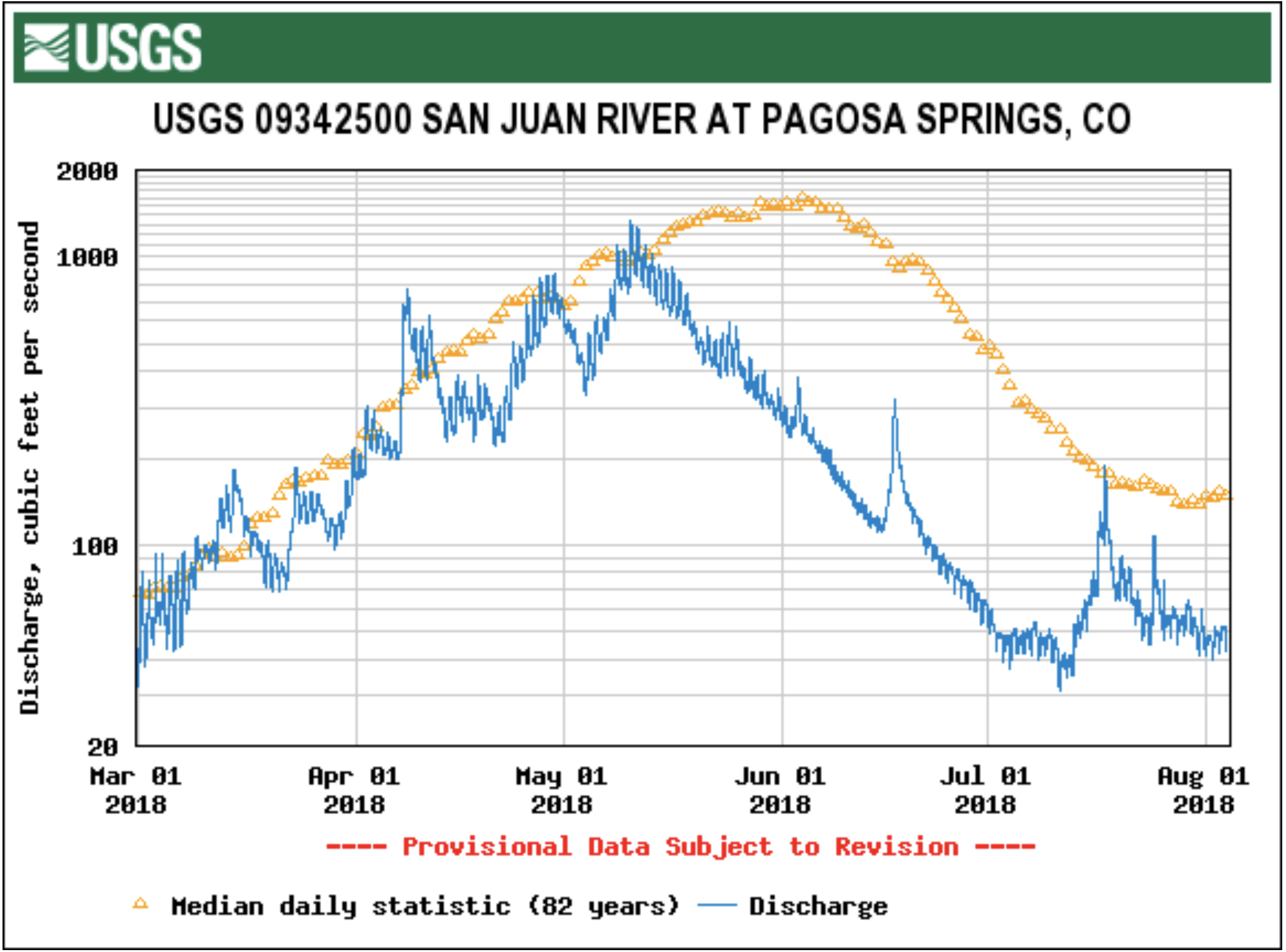
As of July 25, the San Juan River is currently flowing at 73.2 cubic feet per second (cfs).
According to Colorado Basin River Forecast Center (CBRFC) Senior Hydrologist Greg Smith, his- torically, the San Juan River is usu- ally flowing around 150 or 160 cfs.
“That’s kind of the mid-range, that’s kind of the median value, historically. So, I mean, we’re less than half that,” Smith said.
The San Juan River is above flows that were recorded back during the drought of 2002, Smith added later.
During the 2002 drought, cfs levels were around 45-50, Smith explained.
“Still, it’s kind of in the bottom few years, you know, the current flows,” Smith said.
These low river flows stem from the “dismal” winter season that Archuleta County had with poor snowpack conditions, Smith added further.
“And then, of course, we entered the spring somewhat dry as well, which didn’t benefit things. And you still have draws on the river from ir- rigation, especially as you go further downstream,” Smith explained.
This year, Smith described, was the “perfect storm” for low river flows.
Additionally, the seasonal spring runoff volume is currently at 71,000 acre feet (AF) for the San Juan River in Pagosa Springs, Smith added.
“It’s probably not going to be a lot more than that when it’s all to- taled up, the April through July for this year,” Smith said. “And that’s going to be, probably, it looks like to me, the third lowest on record.”
The lowest recorded spring run- off volume was recorded in 2002 with 23,000 AF flows, Smith noted.
The CBRFC has records for spring runoff volumes for the San Juan River dating back to 1936, Smith added later.
“Kind of the only hope we have at this point is if we can just get enough active monsoon weather to at least give us some additional runoff from rain flow,” Smith com- mented.
“The bulk of what you get comes from snow melt. You can get some pretty good stream flows due to the monsoon, due to thunderstorms, but they’re short-lived,” Smith said later.
Public perception
When the public sees such low cfs numbers for the San Juan River, Smith explained that educating the public depends on what its uses are for the river.
“I mean there’s concern for everybody when you get real low flows, you know, from people get concerned about the fisheries and the amount for irrigation,” Smith explained.
A lot of the general concern for the public is if this current year is a low-flow year for the river, what will happen next year, Smith noted.
“Right now at least we have a benefit from how wet last year was,” Smith described. “You know, Navajo Reservoir managed, as you get further downstream, to have some pretty good storage carry over from last year.”
Some of that storage is “saving people” this year, Smith noted.
Another dry year could create some significant concerns among the public, Smith added later.
“There’s been enough water, at least below, for folks below the reservoir. As my understanding this year that they didn’t have re- ally serious shortages,” Smith said.
Low in-stream flows can affect recreational activities as well as irrigation, Smith explained.
However, because of last year’s wet season, Smith notes that there is some optimism to be felt.
“It is cause for concern when you get flows that low. But, you know, this year, again, I think we benefited from last year being so wet. So, it could have been so much worse this year, especially as you get further downstream below the reservoirs,” Smith explained.
Next year will be a year that the CBRFC watches closely, Smith stated.
“Because we could be in a tough situation next year if we had an- other year like this,” Smith said.
Unfortunately, low river flows are a problem that just can’t be solved physically, Smith later com- mented.
“You’re just kind of at the mercy of what happens. Below reservoirs you have a little more control of course in maintaining certain levels for fisheries or for irrigation needs as long as you have the wa- ter source,” Smith said. “But when you’re away from that, when you’re up in the higher elevation headwa- ters, you’re pretty much just at the mercy of mother nature.”
People are seeing flows that are certainly among the lower ones that have been on record for this type of year, Smith added later.
“If folks are saying ‘Wow, I haven’t really seen this,’ then, you know, they probably haven’t,” Smith explained.
“It’s amazingly low. Hopefully we’ll get some monsoon moisture here to push us through the rest of the summer.”
Swim class on the San Juan River. Photo: Brent Gardner-Smith/Aspen Journalism
At the intersection of bluegrass & carbon ranching in Colorado
TELLURIDE, Colo. – If both lie within Colorado, eight hours apart by car, Telluride and Lamar would seem to have little in common.
From Lamar, it’s 35 minutes to Kansas, too far away to see even the faint outline of the Rocky Mountains. It was on the Santa Fe Trail and has lots of interesting history. But today it’s a just-getting-by farming town where the politics run red. In the last presidential election, 70 percent of voters in Prowers County voted for Trump, 24 percent for Clinton.
It’s almost exactly opposite in Telluride and San Miguel County: 24 percent voted for Trump and 69 percent for Clinton. The setting is different, of course. Telluride is a place that can cause jaws to literally drop if people arrive for the first time when a rainbow is arching at the end of the box-end canyon on a summer evening. Oprah sprang $14 million for a house a couple years ago. Other billionaires fly on private jets in and out of the airport on a nearby mesa. Those less well-heeled arrive by car for the nearly non-stop festivals that run through the summer.
Now, these two physically and demographically disparate places in Colorado have become connected financially through a carbon offset program.
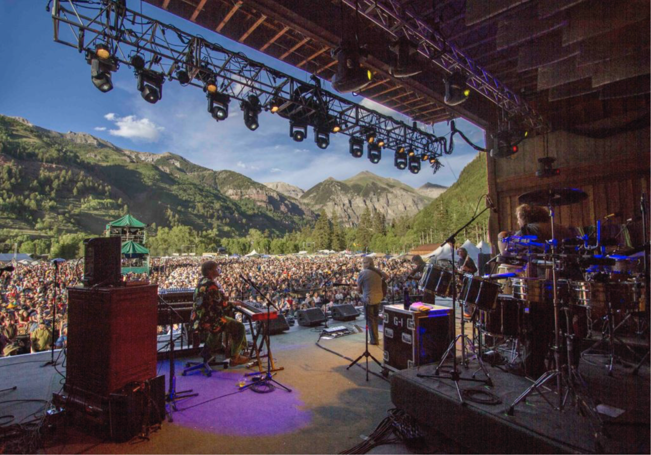
That relationship came into sharper focus in June as 15,000 people gathered at the 45th annual Telluride Bluegrass Festival. Most of the “festivarians” come from Colorado, particularly Denver and other Front Range cities, but 20 to 25 percent fly to Colorado. Every state is represented and about 10 foreign countries. This sort of thing can be tracked both in post-surveys but also in on-line registrations.
Festival organizer Planet Bluegrass has long been conscious of the festival’s role in generating carbon dioxide and other greenhouse gas emissions. Steve Szymaski, who has been with Planet Bluegrass since 1988 and is vice president, says the company began making efforts to offset the carbon emissions its causes in 2003. “It’s really a philosophy of wanting to understand that that everything has impacts, and that there are ways to encourage renewable energy.”
Planet Bluegrass has invested in both renewable energy certificates and carbon offsets, two parallel but different financial devices.
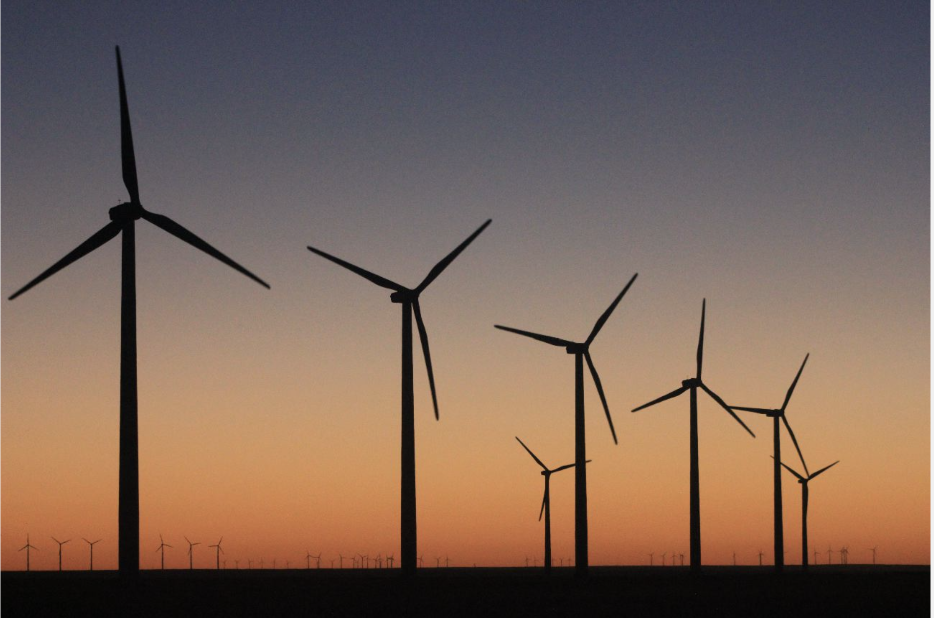
In the early years, Planet Bluegrass purchased renewable energy certificates for wind, solar and hydro. Most of the money went to wind farms, including one in Minnesota. For three years the money went to a methane-reduction project at a dairy in the Central Valley of California. For two years, money went to a methane-capture project at landfill in Colorado’s Larimer County.
Planet Bluegrass has expanded its accountability over the years. Electricity—produced mostly by burning coal and natural gas—represents just 1 percent of electrical use associated with the festival. lodging represents another small component. Travel—trucking equipment, by performers, even shuttles during the festival—represents the lion’s share. Largest of all is travel by the attendees, 87 percent of the festival’s carbon footprint. The festival last year generated an estimated 2,100 metric tons of carbon dioxide emissions.
Photo via TellurideValleyFloor.org
This year, the bluegrass festival took a new tac. Keeping the dollars local or at least semi-local was important. Telluride’s Pinhead Climate Institute offered an appealing opportunity in a package deal.
The Town of Telluride is also participating for five years, offsetting operations of the in-town bus shuttle, called the Galloping Goose. Mountainfilm last year participated, and a program involving jet travel from the mesa-top Telluride Regional airport, highest in the county to offer commercial service, is also being assembled.
Shepherding the program is Adam Chambers, one of the three co-founders of the climate offshoot of the Pinhead Institute. He has worked extensively in carbon offset programs elsewhere in the country, from the Carolinas to California. “If I were to characterize myself as anything, it would be as a carbon accountant,” he says.
The Pinhead’s carbon offset work got launched through a $50,000 grant from the Telluride Foundation’s program designed to foster innovation. To get the grant, the idea had to get strong community support. It did. Telluride has vowed to become a carbon-neutral community. The sign at the entrance to town says so.
Why not just avoid carbon in energy use? Not likely any time soon, at Telluride or other mountain resort towns. Chambers says that residents of Telluride, Mountain Village and San Miguel County altogether have double the national carbon footprint. This estimate may skew conservative, as it makes no attempt to take responsibility for how its visitors get there or get home except as it may involve sale of fossil fuels locally. The mesa-top airport sells 500,000 gallons of aviation fuel annually. Most guests arrive at other airports outside the county.
There’s only so much switching out of lightbulbs possible. Electricity for Telluride still comes primarily from coal- and natural gas-fired power plants, so even if the town had electric buses they would have a carbon footprint. Jets burn gas—and lots of it. This energy transition is far from complete.
Along the Santa Fe Trail
That’s where the 14,500-acre May ranch near Lamar comes into the picture. Its native sod has never been turned by a plow. That’s a rarity on the Great Plains.
The ranch lies near the Arkansas River. Traders on the Santa Fe Trail wheeled their carts along the river in the 1830s and 1840s, stopping at Bent’s Fort. In late 1864, just a few years after the founding of Denver 200 miles to the northwest, Arapaho and Cheyenne Indians had taken shelter along Sand Creek, at a site north of today’s ranch. The promises were broken when soldiers under the command of John Chivington, the hero of a Civil War battle in New Mexico, whooped down with guns blazing at dawn. Today, the Sand Creek Massacre is observed by Native Americans and Anglos both each year the day after Thanksgiving.
Greenhouse gas emissions from tailpipes and smoke stacks have occupied much of the attention of the environmental movement. They’re not everything, though. The Environmental Protection Agency in April said that 9 percent of U.S. greenhouse gas emissions come from farms and deforestation.
The May Ranch near Lamar, Colo., has never been plowed. Photo/Ducks Unlimited via The Mountain Town News
Most of the attention usually goes to logging of rainforests in Brazil, Indonesia and elsewhere. But the plowing of the Great Plains, the world’s most productive farm region, also ranks high—and, some say, higher.
The great plow-up continues. The World Wildlife Fund, in an October 2017 report called “Plowprint,” estimated 2.5 million acres of grassland on the Great Plains of the United States and Canada had been plowed the prior year. The organization worries about the grasslands being an “absolutely underappreciated ecosystem,” in the words of Martha Kauffman, of the non-profit office in Bozeman, Mont.
Native grasslands sequester carbon as they grow grass. That’s the key to this new connection between Telluride and the May Ranch. Plowing releases carbon into the atmosphere. That makes keeping the land unplowed worth something in the fledgling market of carbon offsets.
Owners of the ranch, the May family, are being paid essentially to stay the course, to do nothing different.
That’s a tricky concept to absorb, kind of like negative numbers. This is how Chambers explains the concept:
“You are saying to farmer Dallas May, ‘You have a stock of carbon in your carbon bank account, and you are agreeing to keep that carbon forever in your bank account without pursuing other crop options that would allow you to deplete that carbon stock. You are not a regulated entity, so you can emit to the atmosphere without any negative repercussions. So, nice work on being a carbon shepherd. You are forgoing plowing the soil to grow soybeans or some other crop. But this carbon farming might be more predictable than commodity prices.”
Spare the plow?
How the ranch came to spare the plow for so long is not clear. What is clear, according to the testimony of Ducks Unlimited, a key partner in preserving its unbroken character, is that there have been threats from every direction. A large diary operation was interested in plowing the native vegetation to plant feed crops with center-pivot irrigation. Next to the ranch, on other property, 2,400 acres of prairie were plowed up in just one month several years ago.
This statistic comes from Billy Gascoigne, an economist and environmental markets specialist for Ducks Unlimited. Based in Fort Collins, Colo., he previously worked in the Prairie Potholes region in the Dakotas. That’s where Ducks Unlimited negotiated the first large carbon transaction in 2015.
Now, the same principles and protocols for determining value have been applied to the 14,500-acre ranch in Colorado.
Billy Gascoigne. Photo credit: The Mountain Town News
Using protocol established by the American Carbon Registry, Ducks Unlimited determined that plowing the native grasses to grow corn or wheat would release around 8,000 metric tons of carbon dioxide per year for the next 50 years. Conserving these grasslands equates to removing the annual emissions of 50,000 cars, according to the calculations of the registry.
The ranch is “literally surrounded on all four sides by cropland and had many offers to plow up the grasslands,” says Gascoigne. “We worked with our partners in the land trust community to get ahead of the plow and make sure that carbon stays in the belowground soil.”
The owner of the ranch, the May family, had been on the property for 30 years and only recently had purchased it. Dallas May, the patriarch of the ranch family, wanted to find a way to preserve the ranch, and hence begin reaching out to conservation organizations to explore options that would not damage the wildlife habitat and would allow continued livestock grazing to occur.
May had come to appreciate the value of the property as wildlife habitat. The Audubon Society has designated the ranch as an area of significance for birds as well as an essential corridor link between two populations of lesser prairie chickens. It also has ducks.
More common
Carbon offsets have become more common. They represent the act of reducing, avoiding, destroying or sequestering the equivalent of a ton of greenhouse gas in one place to “offset” an emission taking place somewhere else, as GreenBiz explained in 2009.
The market remains a voluntary one in Colorado and most places. The Disney Corporation, Shell, Chevrolet and others have used the device to offset emissions.
Another major multi-national corporation will soon announce another offset project involving land in eastern Colorado, says Chambers.
Colorado Green, located between Springfield and Lamar, was Colorado’s first, large wind farm. Photo/Allen Best
This is a voluntary market. Only California has a price on carbon emissions among U.S. states. As relates to prairie ecosystems, there are two protocols for establishing the value of the offset. But because the market for offsets remain small, values are still being determined.
Planet Bluegrass’s Szymanski says his company paid $30,000 this year to offset the impacts of the festival in Telluride. Other years, he says, he has paid as little as $10,000. “This is a small drop in the bucket compared to what Fortune 500 companies can do,” he says. “But we were there at the start.”
The Pinhead Institute wanted to keep it “local,” and Colorado fits within that definition. Other places, closer to Telluride, could in theory work. But getting small plots of land, such as conservation easements on hillsides that might otherwise be carved up into estates, is impossible to do. “The numbers just aren’t large enough to pull it off,” says Gascoigne.
Planet Bluegrass was happy to keep the money local, too. “We feel it was important to get behind this because it was new and they were hungry,” says Szymanski.
The most important point, says Gascoigne, is you don’t have to go preserve a rain forest on another continent to do good work. He believes he is doing very consequential work just eight hours from Telluride.
Avon photo via Jack Affleck and the Mountain Town News.
Click here to view the announcement and to register. Here’s an excerpt:
The Color of Water: Exploring the Spectrum October 9 -11, 2018 Westin Riverfront Resort – Avon, CO
FEATURED PRESENTER: ANTHONY POPONI
In a galaxy far, far away in another lifetime Anthony was a watershed professional and worked on rivers and creeks in the Gunnison Valley for several years. During his professional career Anthony has always been a communicator and favored roles where he either entertains or educates and occasionally he even does both. Anthony loves connecting dots in both simple drawings and in complex settings where his inner-networker brings together individuals to catalyze collaboration and patnerships. He does it all with an authentic personality and always weaves in humor into everything he touches. Laugh and learn along the way with Anthony.
The plan calls for 2020 fuel-efficiency standards to be frozen in place through 2026 while sorting out what a new rule could look like, as well as ending California’s ability to set its own, more stringent standards. The end result will be a huge uptick in carbon emissions.
The Obama rules were made in 2012 after consultation with the auto industry and would have increased car fuel-efficiency standards to 54.5 miles per gallon by model year 2026. The new proposal—announced by the Environmental Protection Agency and the Department of Transportation—would freeze efficiency standards at 43.7 mpg through model year 2026.
California has the ability to set even stricter standards for auto emissions, thanks to a waiver the EPA granted the state in 2013. There are a dozen other states that follow those standards as well. Revoking that waiver, despite the EPA commitment to “cooperative federalism,” is an, uh, odd move.
Robbie Orvis, an analyst with policy research group Energy Innovation, told Earther that revoking California’s waiver is “not in the spirit of the Clean Air Act, and the way it’s been implemented in the past.”
On an existential front, the new rule proposal will commit a hell of a lot more carbon to the atmosphere. The Union of Concerned Scientists estimates that it will result in an extra 130 million metric tons of carbon dioxide going into the atmosphere in 2030. That’s the equivalent of adding 30 coal-fired power plants to the grid.
Because people are likely to hang onto their cars for many years, the impacts would continue to play out beyond 2030. An analysis by Energy Innovation found that by 2035, U.S. transportation emissions will be 11 percent higher than they would be if the Obama-era standards and California’s waiver were kept in place.
The move will also put the U.S. behind the curve globally. While our weirdo climate-denying president obviously doesn’t care about the atmosphere or having a habitable planet, other countries do. And they’ve responded by putting in place stringent fuel efficiency standards, including many based on those in California.
The rollback ensures that the U.S. will be spinning its wheels on climate while the rest of the world forges ahead. That could have very real impacts on the fate of U.S. automakers viability and profits as they produce a wider range of cars. It could also inspire countries to be less ambitious.
“The top vehicle standards in the rest of the world are in line with existing standards,” Orvis said, referring to the Obama-era standards. “Undoing this will make U.S. automakers less competitive with automakers in other markets who are moving ahead making more efficient vehicles. It’s moving us in the wrong direction and making us less competitive with the rest of the world.”
Stanford researchers map out groundwater at stake in the wake of a court decision that bolsters Native American rights to the precious resource across an increasingly arid West.
California’s Coachella Valley may be ground zero for a new chapter in water rights for Native American tribes, according to a new Stanford study published in the journal Science.
Local water agencies have pumped so much water from aquifers to supply homes, farmland and resorts in the Coachella Valley that the land is sinking. The Agua Caliente Indian Reservation, created in 1876, runs in a checkerboard pattern in the area of Palm Springs. (Image credit: Tim Roberts Photography / Shutterstock)
Better known for lush golf courses, glittering pools, a popular music festival and temperatures topping 120 degrees, this inland desert is also home to the Agua Caliente Band of Cahuilla Indians, which has fought since 2013 for federal courts to affirm its right to groundwater beneath its reservation. Lower courts ruled in the tribe’s favor, and in late 2017 the U.S. Supreme Court denied an appeal.
Observers immediately recognized that the decision could set a powerful precedent for tribal groundwater claims, which have suffered murky legal status for more than 100 years. But how much groundwater is at stake as tribes assert this newly bolstered right – and where these claims may clash with nontribal users in an increasingly arid West – remained uncharted until now.
Sizing up water rights
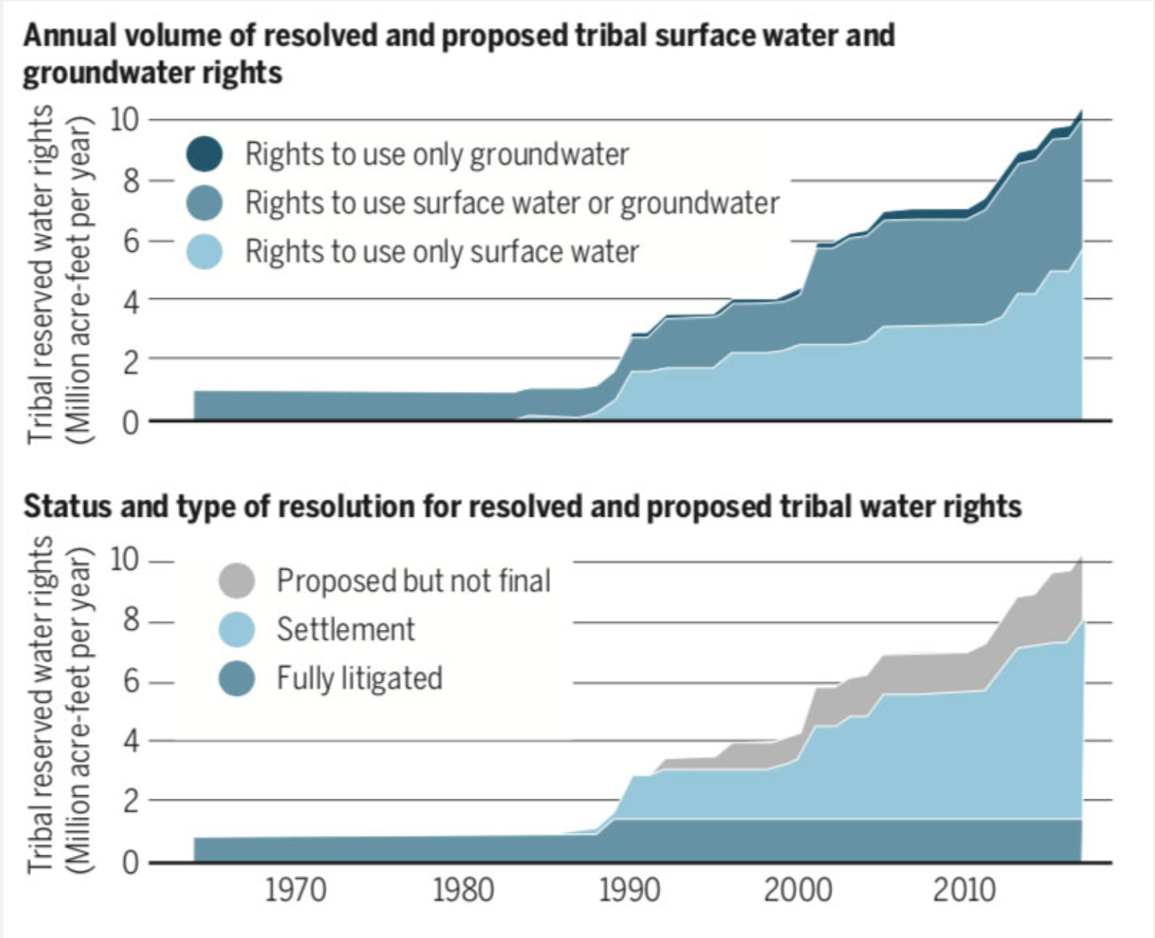
The study reveals that court decrees and settlements have resolved or proposed rights for tribes in western states to use more than 10.5 million acre-feet of surface water and groundwater annually. To put that in perspective, this would be nearly enough water to irrigate all of the alfalfa, almond and rice fields in California for a year. “It’s a major volume,” said lead author Philip Womble, a PhD student in environment and resources in the Stanford School of Earth, Energy & Environmental Sciences (Stanford Earth).
Most unresolved Native American claims to groundwater exist in areas where there’s reason to believe major aquifers could yield significant amounts of groundwater, including in some places where nontribal wells already dot the landscape and increased pumping by tribes might disrupt their production. (Image credit: Philip Womble)
Before the Agua Caliente ruling, the study shows, tribal rights exclusively for groundwater made up a small portion – 4 percent – of all tribal freshwater rights in 17 western states. Now, more tribes will likely seek to resolve their rights to control and use water from the aquifers beneath their land, according to Womble and his co-authors, who include Water in the West executive director and Woods Institute of the Environment professor Leon Szeptycki, as well as Water in the West non-resident fellows Debra Perrone and Rebecca Nelson.
This shift comes at a time when questions of who owns the aquifer and how they can use the water holds increasing urgency, as western states face the likely prospect of demand outstripping the supply of legally available freshwater in most western watersheds by 2030.
“Indigenous communities in several countries have struggled to gain rights to their natural resources,” said study co-author Steven Gorelick, a professor of Earth system science at Stanford Earth and director of the Global Freshwater Initiative. Almost half of all homes on Native American land lack adequate access to drinking water or waste disposal facilities, compared to less than 1 percent for U.S. homes overall. The Agua Caliente ruling, Gorelick said, “is a very important step forward in restoring balance to those injured Native American tribes.”
Competing for a precious resource
In the Coachella Valley, the Agua Caliente tribe has for decades purchased water from local agencies, which have pumped so much water from the region’s aquifers that the land is sinking. Now, as the next phase of Agua Caliente’s lawsuit unfolds in federal court, the tribe is seeking to have judges put a number on its groundwater rights, establishing how much water it can pump from the Coachella Valley aquifer – potentially before most other users are entitled to a single drop.
Before the Agua Caliente ruling in late 2017, tribal rights exclusively for groundwater made up a just 4 percent of all tribal freshwater rights in 17 western states. (Image credit: Philip Womble)
Today, the study shows, fewer than 60 tribes in the western U.S. have this level of legal certainty around their rights to fresh water from any source – whether from lakes and rivers on the surface, or from aquifers underground. Many more tribes have unresolved rights: According to the study, as many as 236 tribes in the western U.S. have lands with groundwater rights that have not been finally quantified in court or in settlements. In all, the research suggests, tribes control at least some water from so many aquifers across the West that any plan to sustainably manage water in the region would be incomplete without considering their role.
These unresolved groundwater claims span large swaths of Arizona, Oklahoma, South Dakota and Utah, and smaller clusters can be found in all other western states except Colorado. Most of them exist in areas where there’s reason to believe major aquifers could yield significant amounts of groundwater, including in some places where nontribal wells already dot the landscape and increased pumping by tribes might disrupt their production.
Ripple effects for laws and markets
“Court disputes usually focus on the specific facts of a given case,” said Womble, who specializes in water policy in the Emmett Interdisciplinary Program in Environment and Resources (E-IPER) at Stanford Earth. He is also an attorney. His team has captured a bigger picture that could help inform decisions about groundwater management throughout the U.S. and in other countries that recognize indigenous community water rights, including Australia, Canada, Chile and New Zealand.
“Even though a U.S. court decision clearly isn’t binding in another country,” Womble said, “it could provide a persuasive precedent that courts confronting this issue in other nations might look to.” Historically, he said, courts in Canada and Chile have adopted some terminology and approaches from U.S. water law.
Already, Gorelick added, the study results suggest that the creation of market-based systems for renting water rights could work to indigenous communities’ advantage. “With this ruling,” he said, “Native American tribes with higher priority rights are now in the driver’s seat to potentially benefit from participating in water markets.”
Steven Gorelick is also Stanford’s Cyrus Fisher Tolman Professor and a senior fellow at the Woods Institute for the Environment. Additional co-authors are from the University of California, Santa Barbara, the University of Washington Law School and Harvard Law School.
The research was funded by the Switzer Foundation and the Stanford Interdisciplinary Graduate Fellowship.
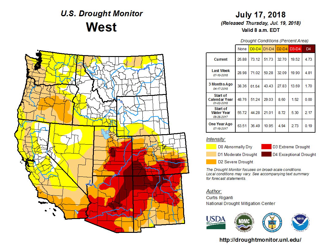
Click here to go to the US Drought Monitor website. Here’s and excerpt:
Summary
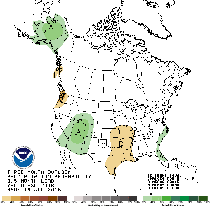
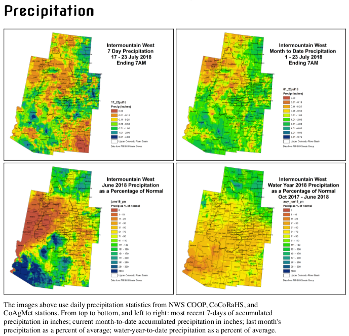
Early in the drought week, moderate precipitation fell along the East Coast with the heaviest rains falling in the eastern Carolinas and central Pennsylvania. Much-needed rains fell in a swath of area covering eastern Wyoming, much of Nebraska, Kansas and Oklahoma, eastern Colorado and the majority of New Mexico. The northern Plains, Midwest and South saw lighter precipitation amounts. Central and south Texas saw little to no precipitation during the week while the dry pattern continued for much of the West. For the month of July, preliminary statewide temperature data suggest much of the U.S. was warmer than average. The West, Southwest, South, and Northeast were among the warmest third of historical records which date back 124 years. Total precipitation amounts for the month of July were below average for much of the Midwest and Northwest. Also during the month of July, above average precipitation fell in the Mid-Atlantic States to Northeast, Southwest and parts of the High Plains…
Much-needed precipitation fell across most of Oklahoma and west central Arkansas, prompting the contraction of drought in some locations. Anywhere from a half inch to nearly 3 inches fell mostly north of I-40 in Oklahoma and south of I-40 in Arkansas. There was a precipitation surplus in parts of western Oklahoma stretching into north Texas, prompting the further contraction of drought and abnormal dryness there as well as in the central part of Oklahoma. In northeast Oklahoma, abundant precipitation the past 30 days prompted the removal of D3. Drought/dryness continued for much of Texas. Precipitation departures mounted, with precipitation approaching 10 percent of normal at the 30-, 60-, and 90-day time periods in much of south and east Texas. Exceptional drought was added to some locations in the south central part of the state where the dryness is the worse as well as in north central Texas along the Oklahoma border. Moderate to severe drought was contracted in southwest Arkansas where moderate rains fell…
A swath of light to moderate precipitation fell in an area roughly covering north and east Wyoming, east Colorado and much of Nebraska and Kansas. The heaviest precipitation fell in western Nebraska, Kansas and eastern Colorado where amounts of 2 inches were widespread. Despite the rains, long-term drought was hardly effected. There was a slight improvement in southeast Colorado, and D1 was removed in southwest Kansas where short term indicators have rebounded. Despite the monsoon season ramping up, dryness continued in west central Colorado where D3 was expanded. Moderate drought was expanded in southwest Wyoming where it remained dry during the period. There was also a slight expansion of D0 and D1 in North Dakota while D0 was contracted in southeast North Dakota into northeast South Dakota…
A swath of light to moderate precipitation fell in an area roughly covering north and east Wyoming and east Colorado. Monsoon rains continued to provide drought relief for some areas of the Southwest. Southern New Mexico saw the greatest improvements as drought was roughly reduced by 1-category in many areas. The heaviest rains have yet to reach east central New Mexico where extreme drought was expanded. The Northwest remains dry as precipitation during the past 6 months was 50-75 percent of normal across much of the region. Wetness prevailed in much of southern Montana. Abnormal dryness (D0) was expanded in Idaho where short-term deficits exist. Based on preliminary data, July ranked as one of the ten driest July’s on record in Idaho. The dry season continued in California and typically no changes are made there this time of year. However, some indices were showing greater drought than what is currently depicted. If negative impacts start to come in, then perhaps degradations would be needed. Wildfires continue to burn in the West. Of those, the Goose Creek fire in Nevada has burned more than 120,000 acres and the Carr Fire, outside of Redding, California, has burned more than 110,000 acres…
Looking Ahead
During the next five days, moderate to heavy precipitation is projected to fall along the East Coast with amounts generally totaling up to five inches. The heaviest rains are forecasted to fall in the Southern Appalachians and the Panhandle of Florida. Much of the South is forecasted to remain dry during the next five days but average temperatures are expected to remain near normal. Temperatures could be as much as 10-20 degrees F below normal for parts of the Midwest early in the period along with 1-2 inches of precipitation. Temperatures in this area are expected to rebound later in the period. The Southwest Monsoon is expected to continue, producing beneficial rains for New Mexico and parts of Arizona. The Climate Prediction Center expects the greatest odds of above normal temperatures in the Southern Rockies stretching into the High Plains and in the Northeast during the next 6-10 days. The greatest probability of below normal precipitation during this period is centered in the High Plains.
Click here to read the newsletter. Here’s an excerpt:
USE MEAD AS A BATTERY?
A proposal to use Lake Mead to store energy by pumping water into it from downstream using solar power and then releasing the water through the dam’s hydropower plant to meet peak energy demands has generated excitement and controversy. This Nevada Independent article sums up the potential and the complications of implementing such a plan.
Building a pipeline from Lake Nighthorse to Farmington could cost between $83 million and $173 million without calculating the cost of acquiring right of way access, a consultant to the San Juan Water Commission told the group today.
Rick Cox, a senior engineer for the engineering firm AECOM who also serves as a consultant for the San Juan Water Commission, targeted that figure while delivering a presentation for the water commission during its monthly meeting here.
The commission spent about $20,000 on a study to look at three alternatives that could help local water users if another mine spill occurred in Colorado and dumped toxic material in the Animas River. Those alternatives included building a small-diameter pipeline from Lake Nighthorse, building a large-diameter pipeline from Lake Nighthorse and building additional storage reservoirs.
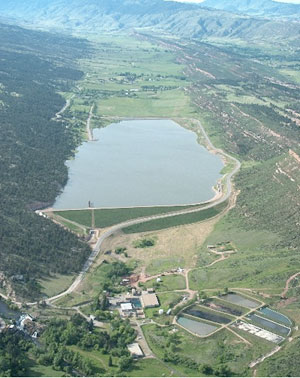
The lake is a storage facility located in a recently annexed portion of the city of Durango, Colorado. It stores water from the Animas River for several member entities including the Navajo Nation, the Ute Mountain Ute Tribe, the Southern Ute Tribe, the city of Durango and the San Juan Water Commission.
Building shallow ponds to increase the storage capacity by 50 million gallons at the lake was the least expensive of the three options cited during today’s meeting. Cox said it would cost about $18 million. The additional 50 million gallons of storage would last about 14 days.
The San Juan Water Commission represents Aztec, Bloomfield, Farmington and rural water users in San Juan County. Cox said not all of those water utilities would require additional storage capacity if another mine spill takes place.
He explained that some water utilities, such as the Lower Valley Water Users, already have enough storage capacity. Other water users, such as the city of Bloomfield, could benefit from additional storage capacity, Cox said.
Pipeline could provide water during drought
While the additional water storage capacity would help local water users if another mishap like the Gold King Mine spill of August 2015 occurs, it would not provide much help during drought conditions, Cox said.
A large-diameter pipeline could provide the water users with water for up to 114 days during drought, Cox said.
The commission is considering having a more extensive feasibility study conducted on the three alternatives presented by Cox. San Juan Water Commission executive director Aaron Chavez said that would cost about $250,000…
The San Juan Water Commission has rights to 20,800 acre-feet of water stored in Lake Nighthorse. During a drought, the water commission can call upon the Animas-La Plata Operations, Maintenance and Replacement Association, which oversees Lake Nighthorse operations, to release water for San Juan County water users. Currently, the only way to get that water from Lake Nighthorse to the water users in New Mexico is to release it back into the Animas River. A pipeline would ensure all the water released from Lake Nighthorse reaches water users in San Juan County.
Animas-La Plata Operations, Maintenance and Replacement Association general manager Russ Howard warned commissioners not to rely on Lake Nighthorse. Howard said it could take years to refill the reservoir after water is withdrawn. He warned if there was a multiple-year drought, Lake Nighthorse could only be an option for one year.
From the University of Colorado (Molly Phannenstiel):
Jessica Ghent has had an eventful summer.
As part of a nine-week research internship at CU Boulder, the Front Range Community College student is studying the topography of Colorado’s Mount Princeton to find the ideal placement for ground control points, which are physical markers that drones can follow to create a digital map of the area.
Ghent will use the drone images to make a 3D digital elevation model of the area to understand how to help prevent debris flows, which are fast-moving masses of rock that can destroy towns and homes in a matter of minutes.
She wants to find out how debris flows start and how to improve early-warning systems in the future.
Ghent is one of 11 students participating in the Research Experience for Community College Students (RECCS) program hosted by the Cooperative Institute for Research in Environmental Sciences (CIRES).
Now entering its fifth year, RECCS gives Colorado community college students hands-on research opportunities as they look ahead in their careers.
“The RECCS program is amazing, and it’s so beneficial,” Ghent said. “We all go into something lacking confidence and feel like we don’t know enough, but it’s cool to be around a lot of different people with science backgrounds and learn more about things that you wouldn’t have necessarily come into contact with.”
Sean Will, a student at the Community College of Denver, is studying beaver habitats by looking at water properties and soil permeability to study how this might affect droughts. The research will help reveal whether beaver dams can efficiently manage a limited water supply.
“The research experience is very valuable, not just if I continue on with the research career track, but even if I go back into business or something, I can take a lot of the skills from the RECCS program,” Will said.
RECCS Director Anne Gold and Program Manager Renee Curry Minaya say the program teaches community college students valuable skills that will help them in their careers.
“Being part of a professional research group gives a lot of skills: multitasking, organization, professionalism, interpersonal professional communication skills and how to set goals realistically and work towards them,” Gold said.
Students are assigned a research question to answer on their own while they work alongside their faculty mentors to answer big picture research questions. At the end of the program, they present their findings to their peers, their mentors and the general public.
With RECCS funded for two more years via the National Science Foundation, Gold and Curry plan to continue expanding the program’s reach.
“We are trying to reach more rural community colleges, because for them, the lack of access to resources is even stronger than Front Range community colleges,” Gold said.
Their efforts are already beginning to push past the Front Range. Susannah Rozak, a member of this year’s RECCS class from Pikes Peak Community College in Colorado Springs, has always been passionate about research and the program has been a perfect way to expand her knowledge.
“There’s so much about the world that we don’t know yet and so being able to take part in finding things out and discovering things and sharing those discoveries is really fun,” said Rozak, who is studying student engagement in climate change. “I feel like RECCS has helped me grow a lot and be more confident.”
Ghent hopes to transfer to CU Boulder in the fall, possibly continuing her research into debris flows under her faculty mentors.
“I’ve gained experience in really tangible ways that I’ll be able to take to my future career,” Ghent said.
In the lower levels of the Denver Botanic Gardens, the nonprofit’s herbarium holds more than 70,000 plant specimens as well as fungal samples and plant DNA. The plants are pressed in blotting paper to remove water and preserve the specimen.
Christina Alba, a research associate at the Gardens, has been working since April to collect a small portion of the samples from the High Line Canal trail system. The project will span into September to collect plants from all seasons.
“These collections are living data,” she said. “It’s not just dusty old stuff stuffed away. People are actively using it.”
The herbarium at the Botanic Gardens, 1007 York St., is mostly concentrated on plant samples from Colorado, Alba said. Her recent project with the Denver-based High Line Canal Conservancy will help create a better picture of what plant life lives along portions of the 71-mile trail system…
Alba and a team of 10 volunteers have been collecting samples from every plant along the canal to take back to the Botanic Gardens herbarium. From there, botanists can use microscopes to indentify the plant. Then, the Botanic Gardens will research that plant and whether it’s native to Colorado.
The data being collected by the Botanic Gardens across Colorado is not being hoarded in the herbarium for only scientists to see, Alba said. The organization has been digitizing its archives and making them available online for people to research plant trends and species data.
“People 20 years from now can search the High Line Canal and link to the species list that we generate,” Alba said.
The amount of plant life along the trail depends on the area and how much water it gets. Human interaction in the area has also changed the types of plants growing there. In some spots, residential gardens are directly next to the trail. Plants from those gardens have traveled across the path and down toward the canal itself.
“There’s a lot of influence onto the corridor,” Alba said. “There’s that native ecosystem, or the original ecosystem, and what kind of plants were there, but now there’s that human imprint laid over that.”
Plant counts will help bring data back to the Highline Canal Conservancy, which is working to build a new master plan for the canal’s future.
The master plan will also look at landscaping around the trail, including drought-tolerant plants and using storm water. Josh Phillips, manager of community initiatives with the conservancy, said Denver Water will stop delivering water to the canal in the next few years. The conservancy’s master plan is looking into retrofitting the canal to use storm water for other properties.
“We really want to understand how the ecology of the canal might change as storm water is introduced into the system,” Phillips said.
He added that retrofitting the canal for storm water use would be cheaper than building new storm water retention facilities. The conservancy is hoping that storm water will help keep the vegetation around the canal thriving.
The Colorado River District is working with state and federal water managers to increase flows in the Fryingpan River by as much as 100 cubic feet per second (cfs), helping trout in the watershed survive warm temperatures while supplying water for downstream irrigation needs in the Grand Valley.
Anticipated releases are expected to range between 50 cfs and 100 cfs and will be coordinated between the River District, the U.S. Bureau of Reclamation and the U.S. Fish and Wildlife Service to increase flows in the Fryingpan and Roaring Fork rivers downstream from Ruedi Reservoir.
“This should significantly benefit flows below Ruedi Reservoir,” said John Currier, chief engineer for the district. “We expect that the supplement flows may also help to mitigate water-quality problems anticipated from fire-related ash and debris flows stemming from the Lake Christine Fire on Basalt Mountain.”
Technically, the water will be delivered downstream for Grand Valley irrigation needs while creating environmental benefits as it flows downstream. Green Mountain Reservoir releases will be reduced by an equal amount in order to conserve storage for late-season releases, which in turn will be needed to help endangered fish near Grand Junction.
The coordinated approach was given final approval by the Bureau of Reclamation on Monday. In order to boost Fryingpan levels while the plan awaited approval, the U.S. Fish and Wildlife Service implemented a 50 cfs release from its dedicated endangered fish pool in Ruedi on Friday. Those flows were supplemented by 30 additional cfs Monday, bringing the flow in the Fryingpan to 200 cfs.
Both Ruedi and Green Mountain reservoirs contribute water to the Upper Colorado River Endangered Fish Recovery Program. In this case, the changed water release plan will benefit trout below Ruedi while endangered fish still receive water from upstream Colorado River reservoirs.
Increased flows of cold water out of Ruedi should also help to alleviate some stress on trout fisheries in the watershed brought on by higher-than-normal water temperatures. Colorado Parks and Wildlife announced voluntary fishing closures earlier this month on sections of the Colorado and Roaring Fork rivers.
Looking west into the narrows after the Big Thompson Flood July 31, 1976
Big Thompson River near RMNP
Big Thompson Flood, Colorado. Cabin lodged on a private bridge just below Drake, looking upstream. Photo by W. R. Hansen, August 13, 1976. Photo via the USGS.
Here’s the Coyote Gulch 40th anniversary post from 2016. There’s a great passage from Allen Best who was part of the rescue effort back then. Click through for all the links to the Coloradoan and other online content.
If you live in Denver subscribe to The Denver Post. Their link for Allen’s article is still up. And since I”m pitching journalism here subscribe to Allen’s Newsletter.
Clovis, New Mexico. Photo credit: Clovis and Curry County Chamber of Commerce
Here’s the abstract from WorldScientific.com:
Municipal water demand has declined over the past several decades in many large cities in the western United States. The same is true in Clovis, New Mexico, which is a small town in arid eastern New Mexico, whose sole water source is from the dwindling southern Ogallala Aquifer. Using premises-level monthly panel data from 2006 to 2015 combined with climate data and additional controls, we apply a fixed effects instrumental variable approach to estimate municipal water demand. Results indicate that utility-controlled actions such as price increases and rebates for xeriscaping and water saving technology have contributed to the decline. Overall water demand was found to be price inelastic and in the neighborhood of −0.50; however, premises receiving toilet and washing machine rebates were relatively more price inelastic and premises receiving landscaping rebates were more price elastic, though still inelastic. In addition, the average premises receiving its first toilet rebate reduced water use by 8.4%, washing machine rebates lowered use by 9.2%, and the average landscaping rebate reduced water use by less than 5.0%. From the utility’s perspective, and assuming a 5.0% discount rate, levelized cost analysis indicates that toilet rebates are 34% more cost effective than washing machine rebates and nearly 800% more cost effective than landscaping rebates over their respective lives per volume of water conserved. While this research focuses on Clovis, estimation results can be leveraged by other small to mid-sized cities experiencing declining supplies, confronting climate change, and with little opportunity for near-term supply enhancement.
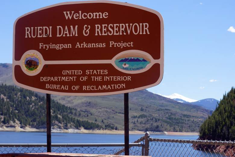
Here’s the release from the Bureau of Reclamation (Peter Soeth):
The Bureau of Reclamation has scheduled the annual public meeting to discuss the Ruedi Reservoir Water Operations for the 2018 water year.
The meeting will be held on August 9, 2018, from 6:30-8:00 p.m. at the following location:
Roaring Fork Conservancy River Center
22800 Two Rivers Road
Basalt, CO 81621
The meeting will provide an overview of Ruedi Reservoir’s 2018 projected operations for late summer and early fall, which are key tourist seasons in Basalt. Also, representatives of the Colorado Water Conservation Board and the U.S. Fish and Wildlife Service will give a presentation on the upcoming implementation of the Ute Water Conservancy District lease of Ruedi Reservoir water to the Board for instream flow use in the 15-Mile Reach of the Colorado River. The meeting will include a public question and answer session.
For more information, please contact Tim Miller, Hydrologist, Eastern Colorado Area Office, by phone or e-mail: (970) 962-4394, or tmiller@usbr.gov.
Fryingpan-Arkansas Project via the Southeastern Colorado Water Conservancy District
Click here for all the inside skinny and to register. From the website:
The risk of draining a half-full Lake Powell is real. The risk one-third full Lake Mead going lower and triggering big water cutbacks is real. Uncle Sam has told the states to develop drought plans or else the U.S. will do it for them. Speakers and panels from the Southern Nevada Water Authority, the Upper Colorado River Commission, the Colorado River District and others will detail current conditions on the river and what the states plan to do about them. Whether you are a toothbrusher, ag producer, angler or rafter, there’s a lot to care about.
Cost is $30 and that includes lunch; $35 at the door. Students are free unless staying for lunch, which is $10
For information, call Meredith at 970-945-8522 or email mspyker@crwcd.org.
Speakers include:
John Entsminger, General Manager, Southern Nevada Water Authority
Amy Haas, the new Executive Director of the Upper Colorado River Commission (UCRC) (invited)
Eric Kuhn, retired Colorado River District General Manager, adviser to the UCRC
Andy Mueller, General Manager of the Colorado River District
Brenda Burman, Commissioner, U.S. Bureau of Reclamation (invited)
and more . . .
Click here to view the Twitter fest from last year (#crdseminar).
Rejecting a Trump administration request, the high court let the case proceed toward a trial that’s scheduled for later this year. The administration sought to block further progress on the three-year-old Oregon case until a federal trial judge acts on the government’s bid to throw out the lawsuit.
The justices’ order said the administration’s request was premature. The court added that breadth of the lawsuit’s claims was “striking” and the question of whether they can be decided by a court “presents substantial grounds for difference of opinion.” The justices said the trial judge should take those matters into account in considering whether to make a “prompt ruling” on other government efforts to end the lawsuit.
The group of mostly teenagers say government policies have exacerbated global warming in violation of their constitutional rights and those of future generations. They want the government to put in place a plan to phase out carbon emissions and stabilize the Earth’s climate…
The lawyers pressing the case said the government was trying to short-circuit the usual litigation process. They contended that “the harm to the climate system threatens the very foundation of life, including the personal security, liberties, and property” of the youths involved in the case.
The case is United States v. U.S. District Court for the District of Oregon, 18A65.
The tamarisk, which was brought to the U.S. from Eurasia in the late 1800s for erosion control, windbreaks and decoration, is much detested. Since its introduction, tamarisk – also known as salt cedar – has been blamed for choking waterways, hogging water and salting the earth as its range expands, driving out such native trees as cottonwood and willows. In Palisade, Colorado, a state lab is breeding beetles whose sole purpose is to destroy tamarisk. At one point, the University of Nevada published a poster about the plant titled WANTED – Dead, Not Alive!
“There’s been a concerted effort to demonize tamarisk,” said Matt Chew, a historian of invasion biology at Arizona State University’s School of Life Sciences. But he thinks this war is aimed at the wrong enemy.
The tree, he said, is a scapegoat for our struggle with something much bigger and messier than weedy fields: our relationship with water in the West.
The tamarisk has a reputation for hogging water – but is it warranted?
“This is one of the constant counts against tamarisk – that it’s wasting water,” Chew said. “That particular idea got started in the late 1930s and early 1940s for a very particular reason.”
Back then, Chew says, the Phelps Dodge Corp. wanted to expand its copper mine in Arizona, but it didn’t have the water it needed for the additional mining and processing. All the water rights to a nearby creek and river had been allocated.
“What they needed was an excuse to say there was more water in the rivers so that Phelps Dodge could have more water,” Chew said. “So, where are they going to get more water?”
Phelps Dodge inspected nearby water sources and found lots of tamarisk growing along the banks, Chew said. Mine officials rationalized that if they could prove the tamarisk was draining river water, he said, the mine could potentially get the rights to the “extra” water available by killing tamarisk.
“Phelps Dodge did a bunch of experiments which were later picked up by the Agriculture Department,” Chew said, adding that Phelps Dodge ended up getting its water rights through other means, but the tamarisk’s image was destroyed.
As Chew writes in the “Journal of the History of Biology,” “with water shortages, economic development during the Depression and copper mining for national defense during World War Two, federal hydrologists moved quickly to recast tamarisks as water-wasting foreign monsters.”
Since then, researchers have shown that the tree doesn’t use more water than native riparian vegetation, including cottonwoods.
To make matters worse, big changes were occurring in the 1930s and ’40s in the way that water was being moved through the West. Dams and diversions were changing the patterns of flooding, patterns that used to be in sync with the reproductive cycle of more sensitive native plants, such as cottonwoods.
“To some extent, the way we were managing Western rivers actually created a giant tamarisk housing project,” Chew said. If the tamarisk is a monster, he said, it’s because we created it.
“If you want good, old-fashioned 17th-century riparian areas in the western U.S.,” Chew said, “you can’t take all the water out of the river. You can’t have big irrigated fields. You can’t have huge cities.”
Anna Sher, an invasive species biologist at the University of Denver and author of the book “Tamarix: A Case Study of Ecological Change in the American West,” agrees that Tamarix (the species’ genus) isn’t all bad.
Yes, Tamarix can create saltier surface soil that retards other vegetation, and its dense wood can fuel more intense fires. Sher even has heard that a boater drowned in Arizona because rescuers couldn’t get through the dense thickets of tamarisk crowding the shore in time to help him.
But, she says, “I certainly do not hate this plant.”
It provides nesting spots for the Southwestern willow flycatcher, for example, and she says it’s entirely possible for the trees to be a part of the landscape without completely taking over.
“It’s only behaving badly because of the way that we’ve managed our rivers,” Sher said.
Although the way we manage our rivers isn’t going to change anytime soon, Sher sees hope for restoring the landscape. It’s called the Field of Dreams hypothesis.
“The Field of Dreams hypothesis predicts that when you remove the invasive species, there’s an opportunity for the desirable species to come in,” she said.
Initially, Sher and other ecologists suspected the hypothesis was a pipe dream.
“But after doing surveys of hundreds of sites throughout the American Southwest, we can see that, on average, native species will come back and they’ll come back proportionally to how much tamarisk has been removed,” she said. “More tamarisk taken out, more native plants can come in.”
There are two conditions required for successful restoration. First, there has to be enough water in the rivers and streams to supply the new vegetation. Second, the public has to remain open to what native plants might come back. They might not be the cottonwoods and willows people hope for.
“It’s a new game now with Tamarix here and with the water needs that we have now,” Sher said, and humans will have to get used to plants that can handle the landscape as we’ve shaped it.
Those plants might be drought-adapted shrubs and grasses instead of picnic-worthy trees. And they will most certainly have a tamarisk or two as neighbors.
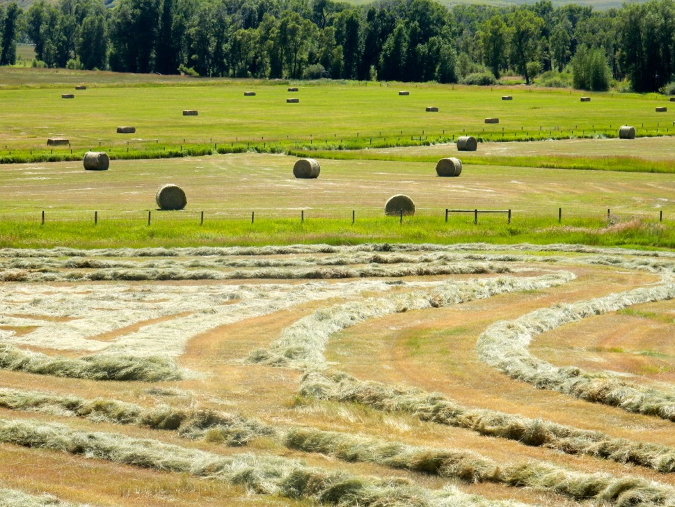
Hay prices are spiking this year, driven up by a drought-induced shortage of the crop. It’s affecting ranchers across the board, but horse owners in particular are feeling the pinch. Horses eat higher quality hay, so it’s harder to get. It’s forcing horse owners in Colorado to buy more hay from neighboring states like Wyoming, Idaho, and Montana and that’s driving the cost up even more.
Kathy Sherer had never set up a crowd-funding campaign before. But she had three hungry horses at her home in Durango, Colorado. Because of the drought in the southwest part of the state, she couldn’t find any hay to feed them. All her usual sources had dried up.
When she finally found a source, it was some three hundred miles away, and the trucking costs would increase the price by about a third. That was a crippling expense not only for herself but for everyone she knows who has horses, which is pretty much everyone in her community.
So she started a GoFundMe page in hopes of getting some donations to help defray the cost of hay for herself and her neighbors. She raised enough money to help get hay to several people in need, but then the funds ran dry. She said the local hay bank is a fall-back source of feed for animals in tough times, but even they didn’t have inventory…
It’s been hard for Patty Carlisle too. She keeps rescue horses and grows hay in Ignacio, Colorado. She usually supplies Kathy Sherer with hay. But she’s had to turn all her regular customers away this year.
Carlisle said she’s down below a third of her normal production level due to the heat, winds, lack of irrigation water, and zero rain. She says growers with better water resources, like irrigation rights from a river, might be better off…
Kent Gordon, a hay broker near Colorado Springs, said sourcing hay from big ranches with very strong irrigation rights is what enables him to keep going in drought years like this…
Gordon said last year he could find hay at five or six dollars a bale. “In those exact locations now,” he said, “we’re finding a lot of those are ten to twelve dollars a bale.” And, he said, “unfortunately it’s probably going to go up more during the winter.”
Gordon said even at these higher prices customers are rushing to stock up. He’s hoping he can keep with the demand but it’s a challenge. “We can have a semi come in seven or eight o’clock in the morning,” he said, “and by noon you know those seven hundred bales are gone.” He said that happens almost every day.
Gordon is happy to be busy. But he hopes for his customers’ sake that next year’s hay season might give them some relief.
Despite promises of a wet monsoon season, Colorado’s arid reality has spread into Summit, which is now part of the 60 percent of the state experiencing “severe drought.”
Nathan Elder, manager of raw water supply for Denver Water, said low water levels at the South Platte reservoir in Littleton created a need for a big draw from Dillon. Even though human consumption is Denver Water’s primary use, Elder said they do keep the marinas in mind.
“We are very concerned with how that affects the recreation industry and keeping marinas in the reservoir,” Elder said. “We plan to keep marinas operating from June to Labor Day, but this has been an exceptional year. The water levels won’t go back to normal this year, and what happens next year depends on the snowpack we get this winter.”
The U.S. Drought Monitor, which tracks drought across the country and assigns drought severity based on conditions, assigns dryness levels from D0 to D4. D0 is considered “abnormally dry” but not severe enough to be considered a drought, while D4 is considered an “exceptional drought” that means there is a serious water emergency that causes “exceptional and widespread” crop and pasture losses.
Summit County’s “severe drought” is at level D2. At that stage, crop and pasture losses are likely, water shortages are common and water restrictions are imposed.
Victor Lee is a hydrologist and civil engineer for the Bureau of Reclamation, which manages the Green Mountain Reservoir in Heeney. Lee said that the monsoon is kicking in late due to less-than-ideal weather patterns.
“One of the reasons the monsoon has been slow to start is the high pressure system that normally forms over the southwest needs to be closer to Texas than the four corners region,” Lee said. “The high pressure system we’ve been experiencing is more to the west, and that’s bringing in warmer air but not more of the moist air from the Gulf of Mexico.”
Combined with an early spring, that makes for a long period without significant precipitation. Lee said that there is no threat to water supplies for human consumption, yet. A few years of healthy precipitation has meant that reservoirs across the state have managed to keep healthy levels in reserve and have been steadily releasing water to keep rivers and streams flowing.
“Without the reservoirs in the system, the stream flows we would be seeing throughout the upper Colorado would be much more dire,” Lee said.
If this drought persists into yet another year, the reasons for worry will multiply and tough decisions will be made.
“These are critical times in Colorado and the southwest,” Lee said. “If the drought goes into another year, there won’t be the same amount of carry-over storage, and it will become a much more complicated issue.”
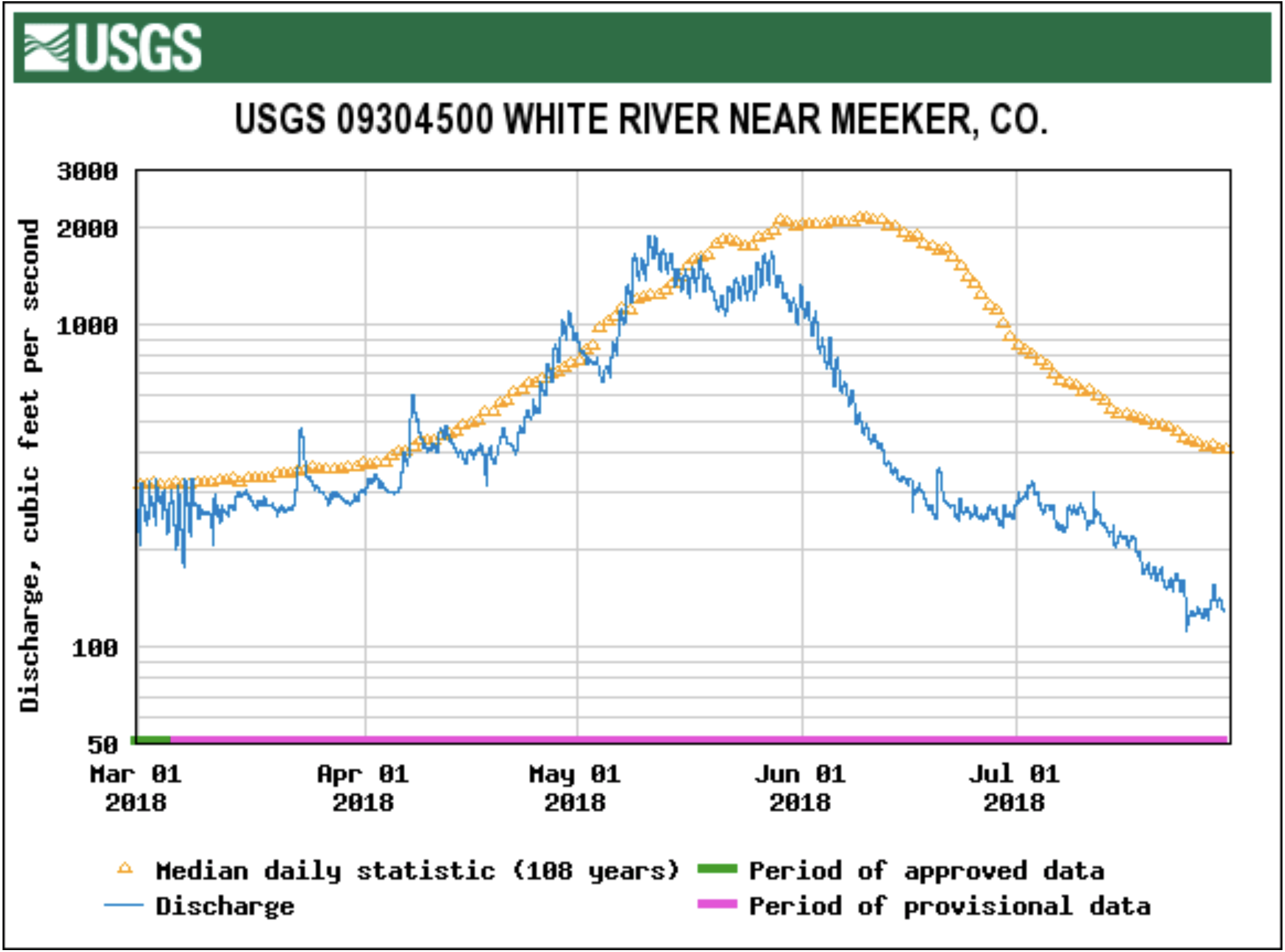
Due to the low flows, dry conditions and extreme heat, higher water temperatures in the White River are nearing danger levels for cold-water fish. CPW officials have been encouraging anglers to fish in the early morning, when water temperatures are cooler and less stressful to fish. Last Friday, CPW, out of Grand Junction, asked for voluntary fishing closures on western Colorado rivers due to the high water temperatures and low flows.
CPW Area Wildlife Manager Bill de Vergie said before the meeting, “It’s important that ranchers, landowners, ditch users, fishing guides and fishing ranch managers, anglers, and other members of the public work together to protect our fishery and our river.”
CPW and the Colorado Water Conservation Board (CWCB) entered into a water lease agreement in 2012. The agreement allows the partial release of CPW’s water stored in Lake Avery to help meet minimum instream flow needs of 200 cubic feet per second (cfs) at the County Road 4 (Wakara) bridge. Users at Lake Avery would see declining water levels in the lake whenever any releases are initiated. deVergie said CPW would give at least 48 hours notice prior to any releases.
In 2012, the lake level at Avery dropped about six feet as 1300 acre-feet out of the 7600 acre-foot storage capacity reservoir was used. Water released comes from the bottom of the reservoir, is relatively cold, and able to be quickly oxygenated. Releases this year could use twice as many acre-feet from the reservoir and drop the lake level up to 14 feet.
“If we do make releases from Avery (a.k.a. Big Beaver Reservoir), we will ask water diverters to avoid taking the additional water and instead leave it in the river to give the fish and river habitat a chance,” said de Vergie. “We all know how important this river is to our economy, and we expect that people will comply to ensure the river continues to be a destination fishery.”
The meeting was attended by local water users including ditch operators and users Don Hilkey, Tad Edwards, Wayne Johnson, Jerry Belland, Tel Gates, Joe Conrado, Chris Collins, Rob Raley, Forrest Nelson and Ben Rogers. CPW employees at the meeting included water resource specialist David Graf of Grand Junction, instream flow coordinator Jay Skinner, Katie Birch from Denver, aquatic specialist Melynda May, wildlife managers Bailey Franklin and Ross McGee, fisheries specialist Tory Eyre and Lori Martin, senior Northwest Region aquatic biologist. Erin Light, the Division 6 water engineer with the Division of Water Resources in Steamboat Springs, was also in attendance…
River advocates attending included Shawn Welder, Bob Dorsett of Colorado River Watch, Roy Wedding and Bob Regulski. Upriver fishing ranch interests were noticeably absent from the meeting. One such individual told the Herald Times after the meeting that neither he nor his manager had heard anything about the meeting beforehand.
Graf told the meeting that his agency is evaluating how their water rights statewide might be better used to improve difficult situations like the White River now faces which might differ, to varying degrees, from the related water right decrees.
Dorsett cautioned the group not to think of this as an unusual circumstance, that current data trends are for these low flows to be more the norm. This concern evoked some discussion about needing more water storage in the valley, which could possibly include enlarging Lake Avery.
Local diverters are anxious to avoid any call on the river. Light reinforced concern that any flows cannot really be legally protected unless the whole river is under a call for administration by the Division of Water Resources. Cooperation between irrigators and other users in times of low water is critical and, in the past, has prevented a call. Several irrigators indicated how well retired water commissioner Bill Dunham had facilitated cooperation between water users. Light said she was confident that the current commissioner, Shanna Lewis, would work as well with diverters and that she had her blessings to do so…
Johnson, a Miller Ditch irrigator, wondered why we were trying to save fish and habitat in the White River when there is so little public access to the river for fishing, to which de Vergie responded that the duty of CPW was to provide a viable fishery and to serve all members of the public, including those that avail themselves of fishing on the private ranches.
Lake Avery releases of 10 to 15 cfs in 2012 didn’t occur until Aug. 30 and continued until Oct. 3. That year, de Vergie said, we experienced some good rain in July that postponed the need to release Avery water until late August.
The threshold factors CPW said are critical for the fish are a flow of less than 200 cfs at the Wakara bridge, water temperatures above 70 degree Fahrenheit there, and dissolved oxygen levels of less than 5 ppm. These are the factors that will trigger releases.
Last week, the endangered Greenback cutthroat trout got a major boost from Trout Unlimited volunteers and agency partners in Colorado.
Once thought to be extinct, this rare fish is making a big comeback thanks to the efforts of the Greenback Cutthroat Recovery Team – a partnership that includes the US Forest Service, Bureau of Land Management, US Fish and Wildlife, the National Park Service, Colorado Parks and Wildlife, the Western Native Trout Initiative, and Trout Unlimited.
Over the course of two days in mid-July, 1,700 Year 1 Cutthroats (~4-6 inches) made their way into two headwater drainages in the Clear Creek watershed, an hour west of Denver. The Dry Gulch and Herman Gulch creeks represent the first major river populations for this threatened species since it was rediscovered in 2012.
To help agency partners stock these important little fish, over 80 Trout Unlimited volunteers carried the cutthroats in large packs up steep switchbacks and bushwacked through dense brush to get to the remote rivers. Some people hiked over six miles into the top of the drainage (over 11,500 feet)! These volunteers came from 10 different TU chapters and represented all walks of life – anglers and conservationists coming together to recover this native trout.
“We couldn’t do it without the volunteers,” says Paul Winkle, Colorado Parks and Wildlife biologist for the Clear Creek drainage. It was a major undertaking that took a lot of support from agency staff, non-profit partners, and local businesses.
At Colorado TU, we are very proud of the hard work and dedication that our chapters and volunteers provide to these projects. It shows what can happen when people focus on collaboration and overcoming differences. It didn’t matter whether someone was young or old, Democrat or Republican, a dry fly purist or never fished before – we were all side by side, climbing those steep trails together. All to save the Greenback.
The event even drew local media attention and even made it on the nightly cable news:
FromThe Grand Junction Daily Sentinel (Dennis Webb):
Southwest Colorado and some of the higher elevations in the region have seen increased moisture recently that has allowed for lifting of fire restrictions, including by the Grand Mesa, Uncompahgre and Gunnison national forests, the Bureau of Land Management’s Montrose-based Uncompahgre Field Office, and Montrose County, all on Friday.
But the picture has been different, as in drier, in the Grand Valley. Through Friday, Grand Junction was experiencing its driest July in a decade, with just 0.08 inches for the month, according to National Weather Service data. It hasn’t been drier since just 0.02 inches fell during all of July 2008.
Charnick said that by this time in an average July Grand Junction has received about a half-inch of rain for the month.
The summer monsoon season typically brings moisture up from the south into much of western Colorado. But Charnick said high pressure to the south “is sort of directing the monsoonal moisture more to our west.”
A clockwise circulation forms around that high pressure, so what’s needed is for the high pressure to move a bit east so moisture from the south is brought up into the area, he said.
Still, Charnick said the area isn’t necessarily running behind in getting monsoonal rains.
“Usually August is a better month for that monsoonal moisture” in Grand Junction, Charnick said. “So while we are a little bit below average right now we’re still very early on in this whole monsoon pattern, so things can shift in the month of August.”
He noted that average precipitation in August in Grand Junction is 0.95 inches, compared to 0.61 inches in July. The monsoon can extend into September.
“Actually September is usually our wettest month of the year,” Charnick said, averaging 1.19 inches.
Peter Goble, climatologist and drought specialist at Colorado State University’s Colorado Climate Center, said Grand Junction is heading into its wettest time of year. He said that’s all relative, given that a month with 1.19 inches of precipitation would be considered a dry month in a lot of places. Still, any time an area is heading into its wettest season climatologically, it brings hope of getting precipitation to reduce moisture deficits, Goble said.
On the down side, Goble said if an area misses out on getting much moisture during what is supposed to be its wettest time of year, it can be stuck with a deficit for quite a while.
Goble noted that the National Weather Service’s Climate Prediction Center is saying there’s an above-average chance of getting above-average precipitation over the next three months in western Colorado…
He said the Grand Junction area’s monsoon season typically peaks later than for a lot of the state, in late August or early September, but it’s still a bit disconcerting that it hasn’t started yet.
Essentially all of Mesa County is now in the extreme drought category — the second-worst category. Charnick said that reclassification occurred in early July.
A tiny sliver of the far southern part of the county is in the exceptional category, which is the driest. Much of the Four Corners area also is in exceptional drought.
Goble said the last time the entire county was in extreme drought was the summer of 2012. He said the county got out of the extreme drought category by the middle of the snow season in 2013.
The county reached the exceptional drought category in the summer of 2002.
Joe Burtard, spokesman for the Ute Water Conservancy District, one of the Grand Valley’s major water providers, said the current drought is one of the worst on record for his agency, one of four major episodes that also include the 2002 and 2012 droughts and one in 1977.
“This year has been a really abnormal year for us in all aspects,” he said.
He said it’s when the area moves into the extreme and exceptional drought categories that area water providers start seriously considering mandatory water restrictions, rather than the voluntary ones now in place.
“We’re really waiting to see what these monsoon rains do for the valley,” he said.
Ironically, though, those rains are expected to pose a challenge to local water providers rather than just simply benefits. The Lake Christine Fire near Basalt has charred more than 12,000 acres, and the rains are expected to bring flooding that will result in ash reaching local rivers, and ultimately the Colorado River.
Burtard said that will affect the Clifton Water District, which gets water out of the river. As a result it will impact Ute Water, which would serve as a backup water source for Clifton Water as part of an agreement among local providers to help each other in emergency situations.
That will further tax Ute Water, which already has been pulling from limited resources this summer, Burtard said.
“It’s not a matter of if, it’s a matter of when, because when we get that monsoon rain that ash is coming our way,” he said.
Ute Water also recently purchased water rights from the Ruedi Reservoir in the Fryingpan River Valley above Basalt to help in drought years and in planning for population growth in its service area. That water also could help in a situation such as a fire on Grand Mesa that could impact watersheds serving Ute Water.
But for Ute Water to tap the Ruedi supply for any reason, the water would have to run through Basalt and down the Roaring Fork and Colorado rivers.
By 2042, the city of Loveland is projected to demand 30,000 acre-feet of water a year, according to projections calculated by Loveland Water and Power staff. Comparatively, the city currently needs about 18,000 acre-feet annually, and the city’s diverse portfolio of water sources yields a firm 22,400 acre-feet each year.
One acre-foot is enough water to cover one acre of land, one foot deep. It’s about enough water to supply two homes for a year, said Larry Howard, a senior civil engineer in the city of Loveland’s water resources division.
Meanwhile, both the city’s population and acreage is growing.
Loveland’s 2017 data and assumptions report states the city now has a population of 74,385 within a 35 square mile area, and at ultimate buildout will cover 66 square miles. By 2042, Loveland’s population is estimated to hit 110,000 people, according to the same report.
But, simultaneously, per-capita water consumption has been steadily falling nationwide over the past 20 years due to efficient fixtures and conservation initiatives, Bernosky said. Additionally, the introduction of metered water rates has played a role in reducing use compared to the previous flat monthly fee, Greene said.
Luckily for the city, one variable is already locked in: The city of Loveland’s water district is surrounded on all sides by other districts, so the area it will serve is finite.
Nevertheless, Bernosky said it is very difficult to take these trends and accurately predict the city’s water needs. There are a lot of pitfalls in forecasting the future as development patterns shift or decline, technology advances, natural events like droughts take place, economic factors play in and unexpected events occur, he said.
“It’s very, very confusing right now,” he said. “A lot of it is very much in flux.”
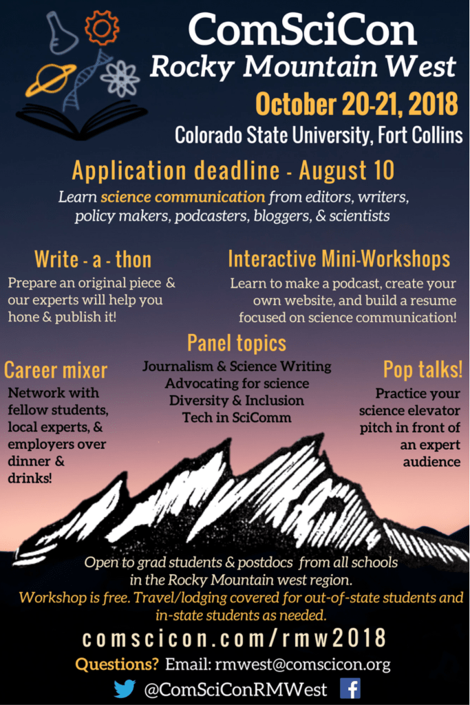
ComSciCon-Rocky Mountain West 2018 will be held October 20-21, 2018 in Fort Collins, CO at Colorado State University. The application deadline is August 10th. Questions may be directed to rmwest@comscicon.org.
There shouldn’t be any doubt that some of the deadliest of this summer’s disasters—including flooding in Japan and wildfires in Greece—are fueled by weather extremes linked to global warming, said Corinne Le Quéré, director of the Tyndall Centre for Climate Change Research at the University of East Anglia.
“We know very well that global warming is making heat waves longer, hotter and more frequent,” she said.
“The evidence from having extreme events around the world is really compelling. It’s very indicative that the global warming background is causing or at least contributing to these events,” she said.
The challenges created by global warming are becoming evident even in basic infrastructure, much of which was built on the assumption of a cooler climate. In these latest heat waves, railroad tracks have bent in the rising temperatures, airport runways have cracked, and power plants from France to Finland have had to power down because their cooling sources became too warm.
“We’re seeing that many things are not built to withstand the heat levels we are seeing now,” Le Quéré said.
Penn State climate scientist Michael Mann said this summer’s extreme weather fits into a pattern he identified with other researchers in a study published last year. The jet stream’s north-south meanders have been unusually stationary, leading to persistent heat waves and droughts in some areas and days of rain and flooding in others, he said. “Our work last year shows that this sort of pattern … has become more common because of human-caused climate change, and in particular, amplified Arctic warming.”
[…]
Temperatures in Algeria reached 124 degrees Fahrenheit, setting a record for the African continent. A few weeks earlier, a city in Oman is believed to have broken a global record when it went more than 24 hours with temperatures never falling below 108 degrees. Japan set a national record of 106 amid a heat wave that has been blamed for more than 80 deaths.
Regional western heat events are becoming so pronounced that some climate scientists see the current extremes in the U.S. as a climate inflection point, where the global warming signal stands out above the natural background of climate variability.
Here’s the release from Colorado Parks and Wildlife:
Low water flow, high temperatures and dry conditions continue to affect fisheries across Northwest Colorado this summer.
In the past two months, Colorado Parks and Wildlife has initiated several voluntary fishing closures across the northwest region to ease pressure on fish stressed by the heat and dry conditions. Today, the agency is adding sections of the Fraser and Colorado Rivers in Grand County to the list. In addition, a voluntary fishing closure is now in effect on the north and south forks through the main stem of the White River in Rio Blanco County.
“It’s been tough for coldwater fish so far this year, and we are very concerned,” said Northwest Region Senior Aquatic Biologist Lori Martin. “Voluntary fishing closures and compliance from our anglers are very helpful but unless Mother Nature cooperates very soon, some of the region’s most popular fisheries could be in substantial trouble.”
Effective immediately, these sections of river are under voluntary closure between 2 p.m. and midnight each day:
Fraser River from Grand County Road 8 in Fraser, downstream through the towns of Tabernash and Granby to the confluence with the Colorado River near Windy Gap Reservoir
Colorado River from the confluence with the Fraser River near Windy Gap Reservoir downstream to its confluence with the Williams Fork River near Parshall
The north fork of White River at the National Forest boundary, thorough the main stem of the river to the County Road 5 bridge, downstream of the Rio Blanco Lake State Wildlife Area
The south fork of the White River from the National Forest boundary thorough the main stem of the river to the County Road 5 bridge, downstream of the Rio Blanco Lake State Wildlife Area
For a complete list of additional closures currently in effect, visit the CPW website
CPW says while anglers will not receive citations if they choose to fish in areas under voluntary closure, the agency is asking for the public’s cooperation to help protect fish.
When water flows are minimal, agency biologists say fish will gather in residual pools. Combined with high temperatures, fish become stressed due to low oxygen levels and increased competition for food. Under these conditions – primarily affecting coldwater species – fish become much easier targets for anglers, an added stressor that can result in increased mortality due to being hooked.
“Trout have adapted to thrive in water temperatures between 50 and 60 degrees,” said Area Aquatic Biologist Jon Ewert. “Once the temps exceed 70 degrees, they become extremely stressed. In some areas, we have recently recorded temps at or above 75 degrees. That’s not a good situation at all.”
For much of this summer, Ewert says water in the Fraser River at Tabernash has run below the 25 percentile of historic flow and exceeded 70 degrees multiple times in July. In the town of Granby, the Fraser River has exceeded 70 degrees almost daily during the second half of July. On July 14, temperatures reached 75 degrees, considered extremely high for this stretch. The Colorado River downstream of Windy Gap has climbed to 70 degrees numerous times this month and moved approximately at the 25 percentile of historic flow.
Ewert says recent reservoir releases from Williams Fork, Wolford, and Green Mountain reservoir’s have helped cool the water downstream of Parshall.
On the main stem of the White River, area officials have observed several stretches exceeding 70 degrees most days in July and river flow is moving below the 25 percentile of historic average.
“We’ve discussed the issue with the local public, and thankfully, we have seen great cooperation from everyone,” said Area Aquatic Biologist Tory Eyre. “People understand how important the White River’s fish resource is, not only for its great outdoor recreation but also for the benefits it provides to the local economy.”
Colorado’s world-class fishing attracts thousands of anglers each year, providing a source of income to businesses that depend on outdoor recreation. Wildlife officials warn when a fish population is significantly affected by unfavorable environmental conditions, it could take several years for it to fully recover. If that happens, local businesses that depend on the state’s fisheries for their livelihoods may experience long-term negative economic effects.
“We hope to have continued cooperation from the angling public,” said Martin. “Most people that benefit from this natural resource want to do what they can to conserve it.”
Martin recommends fishing at higher altitude or fishing early when it’s cooler. Anglers should consider using barbless hooks, land fish quickly and release them quickly. Wet your hands before handling and let them go immediately, preferably without removing them from the water.
Anglers are asked to watch for signs and posters advising of current closures, or call their local CPW office for more information.
For more information about fishing Colorado, and information about CPW’s fishing app for smartphones, visit CPW website.
FromThe Washington Post (Joel Achenbach and Angela Fritz):
In the United States, 35 weather stations in the past month have set new marks for warm overnight temperatures. Southern California has had record heat and widespread power outages. In Yosemite Valley, which is imperiled by wildfires, park rangers have told everyone to flee.
The brutal weather has been supercharged by human-induced climate change, scientists say. Climate models for three decades have predicted exactly what the world is seeing this summer.
And they predict that it will get hotter — and that what is a record today could someday be the norm.
“The old records belong to a world that no longer exists,” said Martin Hoerling, a research meteorologist at the National Oceanic and Atmospheric Administration.
It’s not just heat. A warming world is prone to multiple types of extreme weather — heavier downpours, stronger hurricanes, longer droughts.
“You see roads melting, airplanes not being able to take off, there’s not enough water,” said Katharine Hayhoe, director of the Climate Science Center at Texas Tech University. “Climate change hits us at our Achilles’ heel. In the Southwest, it’s water availability. On the Gulf Coast, it’s hurricanes. In the East, it’s flooding. It’s exacerbating the risks we already face today.”
[…]
The proximate cause of the Northern Hemisphere bake-off is the unusual behavior of the jet stream, a wavy track of west-to-east-prevailing wind at high altitude. The jet stream controls broad weather patterns, such as high-pressure and low-pressure systems. The extent of climate change’s influence on the jet stream is an intense subject of research.
This summer, the jet stream has undulated in extreme waves that have tended to block weather systems from migrating. The result has been stagnant high-pressure and low-pressure systems with dire results, such as heat waves in some places and flooding elsewhere.
“When those waves are very big — as they have been for the past few weeks — they tend to get stuck in place,” said Jennifer Francis, a professor of atmospheric science at Rutgers University. Last year, scientists published evidence that the conditions leading up to “stuck jet streams” are becoming more common, with warming in the Arctic seen as a likely culprit.
Gone are the days when scientists drew a bright line dividing weather and climate. Now researchers can examine a weather event and estimate how much climate change had to do with causing or exacerbating it…
Said Hayhoe: “The biggest myth that the largest number of people have bought into is that ‘climate change doesn’t matter to me personally.’ ”
The heat waves have hit hard where people don’t expect them — the Netherlands, Sweden, Britain, Ireland and Canada.
“Our office doesn’t have air conditioning. I do have a fan,” said Geert Jan van Oldenborgh, a climate researcher at the Royal Netherlands Meteorological Institute. He spoke by phone from the city of Gouda, where the temperature hit 96 degrees Thursday…
Human activity, primarily the burning of fossil fuels, has added greenhouse gases to the atmosphere, trapping heat and making extreme weather events even more extreme. The amount of carbon dioxide in the atmosphere reached 410 parts per million in May, the highest the Mauna Loa Observatory in Hawaii had measured since Charles David Keeling started keeping records in 1958. NASA estimates Earth has warmed almost one degree Celsius (1.8 degrees Fahrenheit) since the late 1800s. Of that, half a degree (around one degree F) has accrued since 1990 alone…
Overall precipitation has decreased in the South and West and increased in the North and East. That trend will continue. The heaviest precipitation events will become more frequent and more extreme. Snowpack will continue to decline. Large wildfires will become even more frequent.
Kevin Trenberth, a climate scientist with the National Center for Atmospheric Research, said even modest heat from global warming can build up over time.
“The accumulated energy over one month is equivalent to a small microwave oven at full power for six minutes over every square foot of the planet,” Trenberth said. “No wonder things catch on fire.”
The National Western Center Youth Water Project, now in its second year, is an eight-week internship program created by CSU’s Colorado Water Institute to foster collaboration between high school and University students around water conservation, education, and policy. The program is designed to inspire underrepresented youth to engage and inform their peers about water-related issues and resources.
Eight students are participating in this year’s program — four high school students from the Globeville, Elyria, and Swansea neighborhoods in north Denver, and four CSU students participating in CSU’s Water Sustainability Fellows program. The 2018 cohort identifies as the 5280 Youth Water Project.
The student interns have been able to attend a number of conferences and events, including CSU’s inaugural Water in the West Symposium. The internship’s primary objective, however, is to plan and deliver Colorado’s first Youth Water Expo, which will be held in Argo Park on Saturday, August 4, from 11 a.m.-4 p.m. The family-friendly event is free and open to the public.
Organizations supporting the event include the Mayor’s Office of the National Western Center, Denver Water, Metro Wastewater, the Gateway II fund of The Denver Foundation, Hunter Industries, CH2M Jacobs, the Walton Family Foundation, and Groundwork Denver. The Expo will be included as part of the lineup for the fifth annual Denver Days, a week-long event created by Denver Mayor Michael Hancock.
Aliyah Fard, 18, graduated from Colorado Academy in June and supports the group’s outreach and event planning efforts. Recently, she received an acceptance letter from Whitman College in Washington, where she plans to major in environmental science.
“I’ve really been enjoying the actual event planning and pulling everything together — reaching out in the community,” said Fard. “I think [people] should attend because we’re going to have a lot of valuable information. And it’s also going to be fun!”
Fard is particularly interested in water rights, and is debating whether to pursue a career in water law or politics after college.
Hugo Lezama, 22, is a senior at CSU, majoring in civil engineering. His second year participating in CSU’s Water Sustainability Fellows program, Lezama went outside his “comfort zone” by taking the lead on the project’s marketing efforts — teaching himself Adobe Photoshop and developing the group’s social media presence.
“All of the activities we’re going to put on are made specifically for the people in the Globeville, Elyria, and Swansea communities,” said Lezama, noting that his neighbors “don’t think about simple things like watering their lawns at certain times, or how to use their water effectively.”
The Expo will deliver various water-related resources and activities to north Denver residents and provide context around the National Western Center redevelopment project taking place in their neighborhoods over the coming years. The expansion will include a building focused on water education and community engagement.
“I’ve been focused on getting my work done and haven’t really taken a step back to see how important this really is. It’s kind of a big deal!” Lezama said.
Post-college, Lezama intends to pursue a Masters degree to equip himself for an engineering career, with a focus on water.
“At some point, if I have enough money — which is why I want to get my Masters — I want to start my own foundation and start funding those kids [in the Latino community],” said Lezama. The foundation he envisions would provide internships, scholarships, networking opportunities, mentoring, and “everything you need to be successful.”
Following the Expo, the 5280 Youth Water Project team hopes to create a Youth Water Advisory Board to encourage more youth to get involved in water conversations. The group aims to have participation from at least 10 youth from communities of color, with a 50-50 mix of male and female members. The Advisory Board would host monthly meetings to explore opportunities to bring water education and advocacy to other underrepresented youth in Colorado and beyond.
The program is set to sunset this fall, so without action from Congress the LWCF could go away. A bipartisan group had proposed reauthorizing it through a rider attached to a spending bill for the Department of Interior. But senators ultimately decided not to go that route.
Craig Gehrke is with the Wilderness Society in Idaho. He says that’s not necessarily a bad thing.
“It should be its own special bill,” Gehrke says. “You know, we think that funding the reauthorization should be a formal piece of legislation that’s debated on its own special merits.”
Gehrke wants the funding for the Land Water and Conservation Fund to be permanent, instead of requiring reauthorization every few years as it does now.
Lake Powell April 12, 2017. Photo credit Patti Weeks via Earth Science picture of the day.
FromAspen Journalism (Brent Gardner-Smith) via The Aspen Times:
Two Western Slope water conservation districts are moving forward with the third phase of a “risk study” exploring at how much water might be available to bolster water levels in Lake Powell, and they are doing so without state funding to avoid Front Range opposition to the study.
Lake Powell today is half-full and dropping and water managers say several more years like 2018 could drain the reservoir, which today contains 12.3 million acre-feet of water. And the looming water shortage is revealing lingering east-west tensions among Colorado’s water interests.
Officials at the Colorado River Water Conservation District and the Southwestern Water Conservation District, whose boundaries include the Yampa, Colorado, Gunnison, and San Juan river basins on the Western Slope, are eager to answer some forward-looking questions.
How much water in a hotter and drier world might still be available from Western Slope rivers to divert and put to beneficial use, for example.
And how much water might be made available from current water users to send downriver from each of the major Western Slope river basins to help fill Lake Powell?
Those are sensitive questions in Colorado, on both sides of the Continental Divide.
And powerful Front Range water interests think the state should be answering them, not the two Western Slope conservation districts.
A state agency, the Colorado Water Conservation Board, approved a $32,000 grant in March 2015 to help pay for the first phase for the Western Slope’s “risk study.”
Then the CWCB kicked in $40,000 in March 2017 for the second phase of the Western Slope’s risk study.
But that second grant-review process brought opposition from the Front Range Water Council, which unsuccessfully sought to block the requested funding from the Western Slope.
“The opposition to Phase II of the risk study was focused on concerns related to the direction and management of the study coming solely from the West Slope without East Slope involvement, and being funded by the state,” said Jim Lochhead, the president of the Front Range Water Council and the CEO of Denver Water, in a statement released July 20. “Risks on the Colorado River are of statewide concern and any such studies are better conducted by the state, through its Colorado Water Conservation Board.”
The Front Range Water Council is an ad-hoc group that includes Denver Water, Northern Water, Aurora Water, the Pueblo Board of Water Works, Colorado Springs Utilities, the Southeastern Colorado Water Conservancy District, and the Twin Lakes Reservoir and Canal Company.
The first two phases of the Western Slope’s risk study showed that 1 million to 2 million acre-feet of water from current water users may be needed to bolster levels in Lake Powell, especially if more water is also diverted to the Front Range.
Today, irrigators on the Western Slope use about 1.3 million acre-feet of water a year, while the Front Range uses about 541,000 acre-feet from the Western Slope to meet municipal and agricultural demand.
As such, officials at the Western Slope conservation districts are now asking if, say, 10 percent of that water use was cut back over time, in a voluntary and compensated demand management program, and the saved water was banked somewhere — ideally Lake Powell itself — would that be enough to keep the big reservoir full enough to still produce power at Glen Canyon Dam and deliver enough water downstream to the meet the terms of the Colorado River Compact?
And if it was enough, how much should come from each Western Slope basin?
On Monday in Glenwood Springs, Andy Mueller, the general manager of the Colorado River Water Conservation District, acknowledged that the 2017 funding request from the Western Slope “ran into a lot of political opposition from the Front Range, basically saying, ‘You guys are asking questions that may harm our state.’ And the questions that were posed in Phase II were essentially dumbed down in order to comply with that request so that we could get the [state funding]. So our board and the Southwestern board voted unanimously to proceed to fund [Phase III of the study] on their own.”
Mueller was addressing the members of the Colorado Basin Roundtable when he described the 2017 process. The roundtable, which reviews grants for the CWCB, had twice voted to fund the risk study, along with three other Western Slope roundtables.
And even without state funding, it’s still important to the two Western Slope conservation districts that the four Western Slope basin roundtables now conceptually support the third phase of the risk study.
On Monday, the members of the Colorado roundtable unanimously passed a resolution to that effect.
Mueller assured the roundtable members that the two districts will work to make the mechanics, and the results, of the evolving water-modeling tool available.
“We really want to make sure that what we’re doing is an open and transparent modeling process,” Mueller said. “Because we think that data that everybody can agree on is data that can then elevate the conversation with respect to the risk in the Colorado River.”
Mueller also told the roundtable that interest from the Front Range is welcomed during the third phase of the study, up to a point.
“We have reached out to the Front Range,” he said. “I went over to their joint roundtable in May and explained to them what we were doing and welcomed their participation, input, their views. Didn’t welcome their censorship, but welcomed their thoughts.”
Heather Sackett of Aspen Journalism contributed to this story. Aspen Journalism is reporting on water and rivers in the Roaring Fork and Colorado river basins in collaboration with The Aspen Times and other news organizations.
Click here to go to the US Drought Monitor website. Here’s an excerpt:
Summary
During the period covering July 17-24, precipitation fell across a vast majority of the East, the heaviest of which flooded parts of Maryland, including the Washington D.C. area. Heavy rains also fell in parts of Florida, Kentucky and South Carolina. In the central U.S., moderate precipitation fell in parts of the High Plains while lighter rains provided little to no relief in parts of Kansas. The drought-stricken areas of Oklahoma and Texas saw little to no precipitation and triple digit temperatures, exacerbating drought conditions…
Across much of the South, no measureable rains fell during the period. This was especially true for Texas, Oklahoma, and Louisiana. Arkansas, Mississippi and Tennessee received moderate precipitation – generally less than 2 inches, although eastern Tennessee had locally higher amounts of 3-5 inches during the period. Departures during the last 30- and 60-days were generally about 10-25 percent below normal. One of the driest parts of the region was around the borders of Arkansas, Louisiana, Oklahoma, and Texas where two separate areas of extreme drought (D3) were introduced this week. Extreme drought was also introduced in a small area to the west of Dallas, Texas. The drought has been exacerbated by extreme heat. Many locations in Texas have had two straight weeks of maximum temperatures reaching 100 degrees F or more. On July 23, Waco, Texas recorded an all-time high temperature of 114 degrees F. The heat also stretched into Louisiana where, on the 22nd, Shreveport hit 108 degrees F, besting its monthly record. Conditions in some parts of Texas are being compared to the drought of 2010 and 2011. One rancher reported that he had only had 6 inches of rain since January and another reported just 4.5 inches. The persistent heat and dryness has browned grasses, dried up stock tanks and ponds and increased fire danger…
Precipitation across this region was scattered during the USDM week. The heaviest amount, generally in the range of 2-4 inches, fell in the eastern Dakotas and parts of Nebraska. Short- and long-term effects of drought/dryness remain along the Canadian/North Dakota border and northeast South Dakota. Recent rains in South Dakota contracted drought along the southern portion of the depiction, but expanded the abnormal dryness (D0) in the western part. Abnormal dryness was introduced in south central South Dakota. In Nebraska, drought/dryness began to creep back into the southeast part of the state where 30-day precipitation departures were apparent. Drought/dryness worsened in Kansas during the period, especially in the eastern half of the state where precipitation deficits have grown. Year-to-date precipitation percent of normal values were 25-50 percent across parts of east central Kansas. Exceptional drought (D4) was slightly expanded in this area and the two areas of extreme drought (D3) were connected. Drought conditions remained unchanged for the most part In Colorado. The lone exception was a slight contraction of exceptional drought in the southeast where heavy rains recently fell. Severe drought was expanded slightly in the north central part of Colorado…
Drought remained entrenched in the Four Corners region but, as the monsoon season begins to ramp up, there is hope that improvement is on the way. In fact, 30-day surpluses of 2-3 inches were common near and west of Flagstaff. Year-to-date precipitation totals were now reaching the positive side. It was reported that the Eastern Rim and the White Mountains have also seen very beneficial rains. As a result of the robust start of the monsoon season, there was some contraction of D3 and D4 in Arizona. In the Pacific Northwest, dryness in Oregon prompted the expansion of D2 across the Cascades and into the Willamette Valley. In California, persistent heat and dryness increased fire danger. As of July 24, it was reported that the Ferguson fire had burned 57 square miles in Yosemite, but was only 25 percent contained. Yosemite Park was closed for the first time in 28 years due to the fire hazard there…
Looking Ahead
During the next 5 days, moderate precipitation (2-4 inches) is forecasted to fall in parts of the drought stricken areas of the Midwest and High Plains. The heaviest of these rains is projected to fall in southwest Missouri and eastern Kansas and Oklahoma. The front range of Colorado is also expected to receive 2-4 inches of rain. Elsewhere, lighter precipitation (1-2 inches) is expected to fall in the Northeast, Coastal Carolina’s and south Florida. Temperatures are forecasted to be cooler-than-normal for much of the High Plains and Midwest during the next week. Above normal temperatures are projected for much of the West and East. The 6-10 day outlook from the Climate Prediction Center calls for an increased chance of below-normal precipitation in the drought stricken areas of Missouri as well part of the High Plains and Northwest. The probability of above-normal temperatures are highest in the Southwest and Northeast while the probability of below-normal temperatures are the highest in the Southeast.
The water year, which runs from October to October, is the third warmest in the 123 years the state has been keeping those records, said Becky Bolinger of the Colorado Climate Center at Colorado State University on Tuesday.
The average for this water year has been 2.9 degrees above average from October through June, she reported.
This warm year includes three months with above-average temperatures: last November, which was the warmest on record; May, which was the second warmest; and June, the third warmest.
Temperatures in June and July have been averaging three to five degrees above average, she said. And that’s not likely to change for the next three months, either, especially in Southwestern Colorado, which is facing the worst drought of any part of the state. At the same time, rainfall in June and July are still below normal, no surprise to many drought-stricken parts of the state, where rainfall is 4.21 inches below the state’s average annual rainfall of 12.74 inches.
But the moisture numbers, beginning in July, are promising, she said. Drought monitors are predicting a more active monsoon season, particularly for western Colorado. And an El Niño watch has been issued, which means that there’s a greater than 70 percent chance that an El Niño weather pattern will develop this fall and into the winter.
For Colorado, that means water, almost everywhere.
Bolinger sees it as a bright spot that will mean Colorado could be at the tail end of its current drought. She hopes for a “nice, snowy winter,” especially for Colorado’s southern mountains, which this year have been hit the hardest by lack of snow and rain and faster than average melting of the snowpack.
Brian Domonkos, a hydrologist with the National Resource Conservation Service of the U.S. Department of Agriculture, reviewed the situation for each of Colorado’s major river basins.
The Gunnison basin is at its worst point, Domonkos said, with rainfall in June at just 17 percent of average, drawing a comparison to the rain that failed to fall in 2002, the state’s worst drought year. Combined with a record low snowpack, Domonkos called the situation in the Gunnison basin “a double whammy.”
However, the start of the July monsoon season has been welcome in the area, which is drawing 75 percent of its normal precipitation.
The news for southwestern Colorado, home to the San Miguel, Dolores, Animas and San Juan rivers, is better — sort of. The area, which has been plagued all summer by the 416 fire, had 64 percent of average rainfall in June and 106 percent, or above average rainfall, so far in July. But that’s for an area that only sees an inch of rain per month, and the area’s reservoir levels are still fairly low, he said.
If you’re a farmer, the news on water supply in Colorado’s northeastern region couldn’t be better. There’s been record moisture in some parts of the South Platte River, the main waterway that serves that area, Domonkos said.
The state is so far at about 85 percent of normal rainfall through the first three weeks of July, not counting Monday or Tuesday’s heavy downpours in much of the state.
But the heavy rains are now creating other problems, according to southwestern Colorado representatives on the task force. Heavy rain in the 416 burn area has led to ash and other debris flowing into the Animas River. That’s led to a massive fish kill, according to Ryan Unterreiner, the southwest region water resource specialist for Colorado Parks and Wildlife. He believes the fish kill will be fairly significant and that it will take years for the fish population to recover.
Narraguinnep and Groundhog reservoirs are at their lowest level in 16 years, said Brandon Johnson, general manager for the Montezuma Valley Irrigation Co.
The limited water supply caused a reduction in allocations for MVIC shareholders Thursday to 36 inches, or 3 acre-feet per share. Shareholders who have reached that allocation will be shut off on Friday…
During normal snowpack years, a full allocation is 48 inches, or 4 acre-feet per share…
Groundhog Reservoir has a capacity of 21,700 acre-feet, but is at 11,000 acre-feet right now, Johnson said. It is expected to be drawn down to the minimum level of 4,000 acre-feet that is required for the fish pool.
During normal years, Groundhog is kept at 13,000 acre-feet going into winter.
“It will take two to three years of normal winters to refill Groundhog,” Johnson said.
MVIC owns Groundhog and Narraguinnep and also has storage and water rights in McPhee Reservoir. MVIC officials are releasing water from Groundhog, via the Dolores River, into McPhee to be delivered into the MVIC canal system.
As a result, the Dolores River is running at 182 cubic feet per second, but 150 cfs of that is coming from the Groundhog Reservoir release.
The irrigation supply in McPhee Reservoir is also running low, but the system is still delivering water, said engineer Ken Curtis.
Farmers had shortages this year, and the season was reduced from the usual three cuttings of alfalfa to two cuttings for most farmers.
During average years, irrigation supply in McPhee is 240,000 acre-feet of water, but this year, only 150,000 acre-feet was available, or 60 percent of normal. And most of the supply was carried over from the previous above-average winter.
There will be no carryover going into next year’s water season.
Colorado’s diverse landscape has a rich natural and agricultural heritage that fuels the economy. Photo: Michael Menefee
Here’s the release from Colorado State University (Jenny Frank):
The Colorado State University System is conducting monthly listening tours to gather ideas from people around the state about the type of educational programming they would like to see at the future National Western Center (NWC).
“CSU is committed to serving all of Colorado through the National Western Center project, and these listening tours are a first step toward understanding how best to do that,” said Jocelyn Hittle, CSU’s director of Denver program development and a participant in the tours.
The tours are a brainchild of Christie Vilsack, a lifelong educator and the former first lady of Iowa, who, along with her husband and former U.S. Secretary of Agriculture, Tom Vilsack, joined CSU in April 2017 as special advisors for the NWC.
Christie Vilsack recognizes the importance of not only providing updates to communities around the state, but also listening to ideas and insights to create a space that reflects the needs and wants of Colorado residents.
Kathay Rennels, associate vice president for Engagement at CSU, sees the tours as a way to ensure the future NWC is as much a part of Colorado as the National Western Stock Show has been for the last 112 years.
“The input and ideas from all across the state are important,” Rennels said. “All citizens of Colorado need to see themselves at the NWC and the NWC needs to reflect all of Colorado.”
Building collaboration for the future
Many Colorado communities are already doing great work around water, energy, food systems, the environment, and health – CSU’s five themes at the NWC. And, as Vilsack often points out during the tour’s community meetings, there’s no need to reinvent the wheel.
“As we travel to communities around the state, our CSU team is learning about the wealth of STEM-Ag related programming that local communities have developed for their students,” she said.
“I look forward to partnering with schools, organizations, and communities around the state as CSU develops K-12 programming for the water building, the animal and equine health center and the CSU food systems center.”
Hittle agrees.
“We want to hear from educators, our Extension and Engagement staff, elected officials and leaders, and others who work in community and economic development to best understand how the NWC can showcase the excellent work that is happening statewide, and to connect communities across the state to the various types of resources that the NWC will be uniquely suited to provide,” she said.
Creating statewide understanding
The tours also provide the opportunity for CSU to share its vision for the National Western Center beyond the Denver metro area, where it is most well-known. Darlene Carpio, regional director for U.S. Senator Cory Gardner, helped organize stops in Yuma County and expressed her appreciation for the tour.
“The listening tour provided valuable information and connections on the expansion of the National Western project,” said Carpio. “The effort to include the rural portions of Colorado in the conversation was greatly appreciated and will prove to be positive to the entire state moving forward.”
Colorado communities visited to-date include Fort Morgan, Sterling, Yuma, Wray, Burlington, Lamar, La Junta, Rocky Ford, Castle Rock, Lone Tree, Steamboat Springs, Rifle, Grand Junction, Montrose, Gunnison, Greeley, Center, Alamosa, Pueblo, Eagle, Keystone, Frisco, and Lake City; and more tours are planned for the fall.
The CSU team notes that the experience of connecting with constituents around Colorado has been important to the process of creating a well-rounded project and understanding the topics that matter to different communities – but they admit it hasn’t been all work.
“Traveling the state to introduce the current plan and vision has been so much fun,” said Rennels.
Arkansas River Basin via The Encyclopedia of Earth
Click here to read the newsletter. Here’s an excerpt:
A lake on Colorado’s southeastern plains whose salinity levels at times rival those of the Great Salt Lake has residents of a small town ready to do battle with water officials over how to keep its alarmingly salty waters from reaching the Arkansas River.
The 250 or so residents of Lake Cheraw, the town that shares the lake’s name, want the lake to drain because they fear its high levels will damage their farms and homes. When lake levels rise, so do nearby water tables, seeping into basements and farm fields. Eventually that water reaches the Arkansas River.
But to drain the lake, water officials worry, would cause salinity levels in the already salt-burdened Arkansas River to rise high enough to trigger potential legal battles with the state of Kansas, which has a right to a portion of the river’s waters.
The two states’ relationship with the river and its supplies is governed by the much-litigated Arkansas River Compact and both states have spent tens of millions of dollars fighting over who gets how much of the water. The compact also dictates that water crossing the state line be “usable” for Kansas. Highly saline water is a concern because it can cause severe damage to crops.
Demonstrating their commitment to address growing risks to Arizona’s Colorado River supply, Arizona and federal water leaders answered questions from the public for nearly three hours last week in central Phoenix.
The July 10 briefing gave the public an opportunity to get answers to their questions about the terms of the Lower Basin Drought Contingency Plan (DCP), a plan designed to bolster water levels in Lake Mead to avoid potentially draconian reductions to Arizona’s Colorado River supply, and to discuss the potential impacts of the DCP in Arizona.
The panel also discussed the uncertainty Arizona faces if the reservoir should fall to critically low water levels such as 1,025 or, even 1,000 feet.
The three presenting agencies – the Arizona Department of Water Resources (ADWR), the Central Arizona Project, and the U.S. Bureau of Reclamation – all had technical staff prepared to respond.
The event at the Heard Museum auditorium in central Phoenix was a follow-up to a June 28 public briefing held at the Arizona Historical Society auditorium in Tempe. In all, ADWR and CAP received more than 50 questions at and in the week following the June 28 briefing.
At the meeting, Arizona Department of Water Resources Director Tom Buschatzke emphasized the importance of creating flexibility for the participating states, which he said incentivizes the creation of stored or conserved water, known as intentionally created surplus (ICS), in Lake Mead. That water, he explained, helps raise the elevation in Lake Mead. California currently has about 550,000 acre-feet of stored water in Lake Mead.
As the Director noted at the Heard Museum briefing, California water officials have indicated that if there is not a DCP in place, the state may take all or some of its existing ICS from Lake Mead “to avoid stranding the water in the lake.”
“Having the water potentially stranded during a shortage is a disincentive for the creation of the intentionally created surplus in the first place.”
In all, ADWR and CAP received more than 50 questions at the Tempe event and in the week following the June 28 briefing. CAP General Manager Ted Cooke was asked why California should be allowed to take more than its allocation in a year when Arizona may receive less than its normal 2.8 million acre-foot allocation.
Cooke observed that California is “pre-loading” its DCP contribution obligations in Lake Mead. That, he said, is what that 550,000 acre-feet the state already has stored there represents.
Cooke added that if California still has ICS in Lake Mead by 2026, “that to me is a good thing.”
“That means that they put more water into Lake Mead than they needed to meet their ICS obligations.”
The next public meeting on the DCP is scheduled for July 26 at 1-4 p.m. at Central Arizona Project’s board room, 23636 N. 7th St. in north Phoenix.
There, a newly appointed steering committee will begin the effort to identify ways to help mitigate the impacts of DCP within Arizona, hopefully paving the way for legislative approval in early 2019 for the ADWR Director to approve the DCP on behalf of Arizona. Buschatzke noted that there is recent precedent of Arizona stakeholders coming together to develop creative solutions around Colorado River issues, in the public process that led up to ADWR’s 2006 Shortage-Sharing Recommendation.
“We did it then, we can do it again.”
ARIZONA DISCUSSION ON LOWER BASIN DROUGHT CONTINGENCY PLAN (JULY 10 BRIEFING)
It was on this day, July 25, in 1921 when U.S. federal legislation was passed to officially re-name the river from the “Grande” to the “Colorado”. How many place names can you think of named “Grand”? Grand Canyon, Rio Grande Railroad, Grand Junction, Grand Lake, and the list goes on. They were presumably named before 1921.
I want to share a handful of success stories below from the past couple months. In spite of wildland fires, drought, smokey haze, dangerously low river levels, and the rocky uncertain political landscape there is still a lot to celebrate. I find hope in the people, youth, and organizations/institutions that continue to be consistent, tenacious, and unrelenting in standing firm by their mission of making the world a better place for all each and every day.
Enjoy the rest of the summer and keep praying for rain in western Colorado.
Working Together for a Healthier Colorado River Basin
For millions across the West, the Colorado River is life. This magnificent river and its tributaries supply drinking water to communities big and small, keep thousands of ranches and farms in business and provide critical habitat for fish and wildlife. But the Colorado is a river at risk.
Water in the West is a series of stories about the people working to address threats to water supply in the Colorado River Basin and find conservation solutions that make economic sense for people and communities. The Walton Family Foundation is working with partners throughout the basin, in the U.S. and Mexico, to ensure healthy rivers by restoring riparian areas, encouraging water efficiency and pursuing flexible, market-based solutions that improve water management.
Enjoy a few photos from the Coyote Gulch archives.
Just inside the Mexican border, at San Luis Rio Colorado, nothing remains of the Colorado River except for its sandy bed. Photo/Allen Best
Low water on the Colorado River near Westwater. Photo: Brent Gardner-Smith/Aspen Journalism
On the Colorado River. Photo: Brent Gardner-Smith/Aspen Journalism
Sean, recreating, on the Colorado River. Photo: via Aspen Journalism
Colorado River Basin with out of basin uses shown in magenta. Credit: Wikipedia.org
The upper Colorado River, above State Bridge. Photo: Brent Gardner-Smith/Aspen Journalism
Prior to 1921 this section of the Colorado River at Dead Horse Point near Moab, Utah was known as the Grand River. Mike Nielsen – Dead Horse Point State Park
The upper Colorado River below the Pumphouse put-in.
The Colorado River and other crucial sources of water in the West are declining, thanks to climate change. brewbooks/CC Flickr
In 1922, Federal and State representatives met for the Colorado River Compact Commission in Santa Fe, New Mexico. Among the attendees were Arthur P. Davis, Director of Reclamation Service, and Herbert Hoover, who at the time, was the Secretary of Commerce. Photo taken November 24, 1922. USBR photo.
Colorado River headwaters tributary in Rocky Mountain National Park photo via Greg Hobbs.
Delph Carpenter’s 1922 Colorado River Basin map with Lake Mead and Lake Powell shown. The two giant reservoirs have always been part of the governance of the river.
President Hoover at the signing of the Colorado River Compact.
Upstream view of the Colorado River at the mouth of the Roaring fork River
Colorado National Monument from the Colorado River Trail near Fruita September 2014
Colorado River pulse flow (Minute 319) reaches the Sea of Cortez for the first time since 1998 on May 15, 2014 via the Sonoran Institute
Upper Basin States vs. Lower Basin circa 1925 via CSU Water Resources Archives
Lake Granby spill June 2011 via USBR. Granby Dam was retrofitted with a hydroelectric component and began producing electricity earlier this year as water is released in the Colorado River.
Cache la Poudre River May 2018. Photo credit: Greg Hobbs
FromThe Fort Collins Coloradoan (Jacey Marmaduke):
A group of Northern Colorado water users and stakeholders is quietly piecing together a plan to prevent that from happening down the road. If the group’s efforts succeed, their plan could increase flows in the Poudre through Fort Collins and beyond. It could also mitigate the impacts of future water storage projects.
The project is somewhere between back-of-the-napkin and final draft stage, but the goal is to create a virtual barter market on the Poudre where cities, farmers and ditch companies can lend their water rights to a stretch of the river before taking it back further downstream. Fort Collins, Greeley, Thornton and other stakeholders are involved in the project, which has been in the works for years.
“All these diverse interests are collaborating and cooperating on an approach to help flows in the Poudre,” said Linda Bassi, the Colorado Water Conservation Board’s Stream and Lake Protection Section chief. “Everyone’s putting all their brain power into it to find a way to make it work.”
The Poudre starts running out of water as soon as it tumbles from the canyon mouth. More than 20 major diversions suck water from the river before it even gets to Fort Collins…
For decades, the river that fostered growth in Northern Colorado communities has been plagued with low flows and dry spots that hurt recreation, tourism, water quality and flood resilience.
Preserving river flows “is not just about ecology and fish,” Fort Collins Natural Areas Director John Stokes said. “It’s also about how we manage this volatile natural system in order to create all the co-benefits we care about.”
The cities, joined by the Cache la Poudre Water Users Association, Colorado Water Trust, Colorado Water Conservation Board and Northern Water, are parsing nearly 50 miles of the Poudre into five segments running from the canyon to the river’s confluence with the South Platte. They’re working together to decide target flows for each section and draft a water court application.
A lot of crucial details still need to be worked out: The water users involved in the plan need to identify “seed water” for the project and figure out where to release it and where to pick it back up. The organizers say it’s crucial to craft a plan that doesn’t infringe on other people’s water rights.
Putting the plan in action could take years, if it works. But Poudre water users have already spent decades trying to tackle the problem of low river flows.
The Poudre was the birthplace of western water law, a notoriously complex system that allows people who possess older or “senior” water rights to use their water before junior users. Seniority becomes important during dry times when there might not be any water left for the users at the end of the line.
Our water laws have allowed cities, farmers and industry to coexist along the Poudre, but the system can make it hard to keep water in the river.
“There really isn’t any water out there that isn’t going to be managed and used and owned by somebody,” Stokes said.
The Colorado Water Conservation Board is the only entity in the state allowed to hold a water right purely for the purpose of preserving or enhancing river flows. Everyone else must prove they’re using the water for something else, like municipal drinking supply or irrigation.
The board has a couple ways to protect water in rivers: It can create a new, junior water right, or it can buy an older water right from someone else.
“Both of those have limitations,” said Emily Hunt, water resources manager for city of Thornton. “Appropriating new water rights on a stream that’s already stressed isn’t going to get you very far, because you’re at the end of the line. And acquiring senior water rights requires a willing seller and money.”
The new approach is different because it would basically allow water users to temporarily sell or lease their water to the Colorado Water Conservation Board. That means the water would be protected from diversions or exchanges and the user that loaned the water would be able to take it back downstream.
“There’s currently no mechanism to protect that flow from point A to point B,” Hunt said. “That’s the real issue. If entities are going to voluntarily do this, we want to make sure the water is protected.”
The planning group was born as a sub-group of the local Poudre Runs Through It work group. Colorado Water Trust, a statewide group that works to restore river flows, pitched the concept. It’s essentially a scaled-up version of the program that allows the Colorado Water Conservation Board to purchase senior water rights, said Zach Smith, Colorado Water Trust’s staff attorney.
Building the legal foundation for the water transactions ahead of time will simplify the process, and the program will also offer flexibility because people who participate won’t be obligated to put water in the program every year, Smith said.
“Colorado already has a water market,” Smith said. “Water rights are property rights, and they’re bought and sold all the time. A program like this just gives the environment a seat at the table.”
The group could submit its application to Colorado water court as early as next year. Group leaders plan to conduct more outreach with Poudre River water users to help them nail down the specifics of the plan.
“People are committed to solving the problem,” Hunt said. “This is one approach. It has some legs and we hope it keeps them, but by no means are we there yet.”
Mystic canyon on the Yampa River: Photo: Brent Gardner-Smith/Aspen Journalism
From Sens. Bennet and Gardner via the The Boulder Daily Camera:
As thousands of outdoor enthusiasts attend Colorado’s Outdoor Retailer Summer Market this week, it reminds us that the wild and scenic spaces surrounding us are not just an important part of our state’s heritage and identity; they drive our economy. That is in no small part thanks to the Land and Water Conservation Fund (LWCF).
For over half a century, LWCF has used a portion of federal offshore energy revenues — at no cost to taxpayers — to conserve our lands, water, and open spaces and protect the outdoor recreation opportunities they offer.
But now this fund, which has maintained broad, bipartisan support since its inception, is in danger of expiring at the end of September.
LWCF has invested over $268 million in Colorado, leading to the protection of iconic landscapes like Black Canyon of the Gunnison National Park and lesser-known gems like the Ophir Valley in the San Juan Mountains.
Core to its model, LWCF also empowers communities — not Washington — to set conservation priorities.
Through matching funds to state, local and tribal governments, LWCF investments have expanded public access to lakes, built trails and neighborhood parks, and created opportunities for kids to learn outside. To take one example, the Montbello Open Space in Denver’s northeast corridor — funded by LWCF and set to open this fall — will offer outdoor recreation opportunities to underserved families that previously had none.
LWCF also lends support to critical habitats in danger of being lost. When a ranch in the San Luis Valley considered exporting its waters out of the region, LWCF helped fund the purchase of that ranch, ensuring the long-term protection of the valley’s agriculture, wetlands and wildlife. Those acres became the Baca National Wildlife Refuge, a key piece of the Great Sand Dunes National Park and Preserve ecosystem and a major draw for outdoor and wildlife enthusiasts.
Put simply, LWCF works. It is a time-tested and effective way to boost the economy and increase tourism in an industry responsible for $28 billion in consumer spending and 229,000 direct jobs in our state.
Yet Congress has never permanently authorized or fully funded it. In the Senate, we have cosponsored legislation that would permanently reauthorize the program and prevent the chipping away of its funding each year. We must harness the program’s bipartisan support and pass this bill before LWCF expires.
LWCF is a critical tool for fulfilling our basic responsibility to give the next generation the same opportunities our parents and grandparents gave to us. It is time for Congress to stop the serial, short-term extensions of this program and make LWCF permanent with the full dedicated funding it deserves.
Synopsis: ENSO-neutral is favored through Northern Hemisphere summer 2018, with the chance
for El Niño increasing to about 65% during fall, and to about 70% during winter 2018-19.
ENSO-neutral continued during June, as indicated by slightly above-average sea surface temperatures (SSTs) across the central and eastern equatorial Pacific. The latest weekly Niño indices were between +0.3°C and +0.6°C, except for the Niño-1+2 index, which was -0.2°C. Positive subsurface temperature anomalies (averaged across 180°-100°W) continued over the past month, and the volume of anomalous warmth now extends to the surface in the eastern part of the basin. Convection remained suppressed near the Date Line and was near-average over Indonesia. Low-level wind anomalies were near average across the equatorial Pacific Ocean, except in the east- central Pacific, where anomalies were westerly. At upper-levels, winds were easterly over the east-central Pacific and near the International Date Line. Overall, the oceanic and atmospheric conditions reflected ENSO-neutral.
The majority of models in the IRI/CPC plume predict ENSO-neutral to continue through the Northern Hemisphere summer 2018, with El Niño most likely thereafter. The forecaster consensus favors the onset of El Niño during the Northern Hemisphere fall, which would then continue through winter. These forecasts are supported by the anomalous subsurface warmth across the eastern half of the tropical Pacific Ocean. In summary, ENSO-neutral is favored through Northern Hemisphere summer 2018, with the chance for El Niño increasing to about 65% during fall, and to about 70% during winter 2018-19 (click CPC/IRI consensus forecast for the chance of each outcome for each 3-month period).
FromThe Durango Herald (Jonathan Romeo) via The Cortez Journal:
Southwest Colorado may escape the arid grip of the La Niña weather pattern, with forecasters saying there’s a good chance El Niño, and the moisture it brings, will return this fall.
One of the major dictators of weather in Southwest Colorado is surface water temperatures in the eastern-central Pacific Ocean that come in cycles known as the “El Niño-Southern Oscillation climate pattern.”
When surface water temperatures in the ocean are colder than normal, a La Niña pattern kicks in. La Niñas typically bring above-average temperatures and little, if any, precipitation to Southwest Colorado.
This past year has been a classic La Niña pattern, with little snowpack and virtually no precipitation, resulting in one of the driest years in Southwest Colorado’s recorded history.
Since April, the region has been listed in “exceptional drought” – the most intense drought category, according to the U.S. Drought Monitor. As of Tuesday, the region still holds this listing.
However, the National Oceanic and Atmospheric Administration’s Climate Prediction Center released some good news recently: El Niño, which holds the promise for more moisture, could be on its way.
The opposite of La Niña, an El Niño, which often brings Southwest Colorado winters with plentiful snowfall, occurs when surface water temperatures in the Pacific Ocean are warmer than normal, which results in a better chance for precipitation.
Michelle L’Heureux, a climate scientist for NOAA’s Climate Prediction Center, said Southwest Colorado has been in a “neutral” weather pattern since the effects of La Niña subsided a few months ago.
This map of a typical El Nino weather pattern shows Colorado right on the edge of moisture impacts. (Courtesy: National Weather Service)
olorado Springs Utilities is trumpeting a water-sharing deal involving several parties in the Lower Arkansas River Valley. The agreement is the first of its kind in the state, aligns with the Colorado Water Plan’s edict to share water among users and helps the city secure a water supply for decades to come.
But several people in the valley are skeptical, saying the agreement could transfer irrigation water for crops, much like the so-called “buy and dry” deals of the 1970s and 1980s that exported Crowley County farmers’ water rights held in mountain lakes to municipalities along the Front Range, thereby decimating agriculture.
“Any time water leaves the lower valley it’s a great concern,” says former Bent County Commissioner Bill Long, who’s advising current commissioners on the matter.
But Springs Utilities officials say it’s another step toward assuring adequate water supplies for the city’s population, which is expected to swell to 740,000 people by 2070. Despite the 2016 activation of the controversial Southern Delivery System water pipeline from Pueblo Reservoir, the city needs more water, they say.
“We are exploring developing additional supplies from the Arkansas River basin to diversify our portfolio,” Pat Wells, Springs Utilities’ general manager of water resources and demand management, says. “We are acquiring these water rights as a first step to plan for the future.”
Essentially, the complicated deal gives Utilities access to 2,000 acre feet of water — more than enough for 4,000 households per year — for five out of 10 years from water rights held by the Lower Arkansas Water Management Association. LAWMA, which is entitled to use the water for the other five years, is a member-owned nonprofit that replaces water to the Arkansas River for its members’ depletions caused by irrigation pumping.
The city bought 2,500 LAWMA shares owned by Arkansas River Farms at $3,500 per share, or $8.75 million. The city also paid LAWMA $1.75 million for 500 acre feet of water storage in a former gravel pit in the Lamar area, giving LAWMA flexibility to manage its water rights.
Utilities can place a call on the water any February for that year, and LAWMA is allowed to say “no” for one year in 10. Utilities would take the water through a series of exchanges that involve Pueblo Reservoir.
As Utilities senior project manager Scott Lorenz says, “LAWMA is betting that by doing the deal with CSU they will not only immediately benefit from the 2,000 acre feet in five out of 10 years, but they will also have set in place a replicable model that will allow them to further increase their water portfolio.”
Don Higbee, LAWMA general manager, described it this way in a news release: “We will gain a more reliable water supply that will increase crop yields for the average shareholder in both wet and dry years. If we are collaborating with municipalities for water, we are not competing with them for water. The alternative is we risk buy and dry, which permanently removes water from the valley. This agreement keeps water in the valley.”
[…]
Exporting water, even periodically, makes Mauch nervous, because the 113-mile-long canal serves 94,000 irrigated acres between La Junta and Lamar. Those acres are owned by roughly 200 farmers. “It remains to be seen how it works out for the Fort Lyon Canal, Bent County and the neighbors,” [Dale Mauch] says.
That’s because there are ancillary promises tied to the deal. Arkansas River Farms, which sold water rights as part of the Utilities plan, has vowed to revegetate acreage left without water in the years Utilities uses it, Long says. The farming operation also has said it would build a $40 million dairy and a commercial tomato greenhouse, erect irrigation sprinklers to more efficiently water their acreage in dry years and plant native grasses, as well as provide Bent County a $1.7 million letter of credit and some cash to cover lost property taxes. Property taxes are lower on dryland acreage than irrigated.
“If they [Arkansas River Farms] fulfill their commitments, then it will have success for both parties,” Long says. “If they do not complete revegetations and they do not do the economic mitigation they propose, then we’ll be sorely disappointed and definitely on the short end of the stick.
“The commissioners understand things change,” Long adds, “and we need to use water more efficiently down here, and what Arkansas River Farms has proposed will provide that. If they don’t deliver, I think it would be difficult to do another one like this one.”
And that’s important, because Lorenz says valley water-rights owners and Utilities hope the LAWMA agreement is just the beginning.
Many water users want to explore such agreements, Lorenz says, as they try to secure supplies amid climate change, which adds uncertainty to how much water is available in any given year.
“The partnership allows them [LAWMA] to start to meet that gap both through the additional water and storage,” he says. “If this project is successful CSU will have a path forward to acquire part of the water it needs in the future, as will LAWMA. When it comes to developing future water supply, the status quo isn’t working.”
The Colorado Water Plan specifically calls for water sharing, dubbed “alternative water transfers,” which will benefit agriculture and municipal users. The goal, it says, is to seek contributions from the farming industry while “maximizing options for alternatives to permanent agricultural dry-up.”
In other words, Lorenz notes, “The state of Colorado says, ‘Work things out, so we don’t have to impose things on you.’ This is the first shot at that.”
Utilities gets most of its water from the Western Slope through trans-mountain transfers, but one of those sources, the Colorado River Basin, isn’t producing water to adequately supply the appropriations already committed to.
“There is increased competition for limited water supplies, and our existing system has not yielded as much as we thought back in 1996,” when the SDS project was first conceived, Wells says.
Noting that Utilities used to consult the historical record and assume the past would repeat in the future, Wells says, “What we’ve come to understand with climate change is that hydrology is expected to take a turn for the worst, so we’re mitigating our risk for our customers.”
The deal with LAWMA now goes to water court for approval, although Utilities can use the water pending that approval. That’s good, Lorenz notes, because drought conditions might require Utilities to call on the water as early as next year.
Straight line diagram of the Lower Arkansas Valley ditches via Headwaters
In a memo to the district’s elected board, communications and public affairs manager Diane Johnson wrote that streamflows measured on Gore Creek, the Eagle River near Minturn and the Eagle River at Avon are all running significantly below seasonal norms.
As of July 22:
• Gore Creek was running at 36 cubic feet per second, 38 percent of the normal flow.
• The Eagle River near Minturn was running at 49 cfs, 43 percent of normal.
• The river at Avon was running at 108 cfs, 36 percent of normal.
Those readings are among the lowest on record. Only the drought years of 2002 and 2012 showed lower streamflows from April 1 to July 22. Even in those drought years, the graph lines show the occasional bump, when rainfall temporarily boosted streamflows.
This year, those bumps haven’t developed.
North American Monsoon graphic via Hunter College.
THE MISSING MONSOON
The short boosts to streamflow in those other years started coming in about mid-June, the result of the annual “monsoon” flow that generally brings some significant moisture to the area.
The U.S. Climate Prediction Center in late spring predicted a better-than-average change of precipitation into the summer. That hasn’t developed so far this year.
Tom Renwick, a forecaster at the Grand Junction office of the National Weather Service, said the monsoonal flow in Western Colorado usually develops when a high-pressure system sets up over Texas and Oklahoma and a low-pressure system develops over the desert Southwest United States. When that happens, moisture is sucked up from the south and ends up being deposited in Western Colorado.
Renwick said high pressure has been setting up in the wrong place so far this year.
That high pressure usually means dry conditions. At the moment, high pressure is farther west than it needs to be to bring rain.
“It’s basically on top of us,” Renwick said.
While Western Colorado hasn’t been getting its usual summer rainfall, Renwick said other areas are seeing seasonal precipitation. The monsoons have hit Mexico.
CONCERN FOR AQUATIC LIFE
Locally, the lack of the monsoon rains is starting to concern water providers.
In an email, Johnson wrote that the district and other water providers “are now back to a bit worried about how our streams will do during the normal low-flow months of August on.”
That said, there are adequate supplies for domestic use.
Aquatic life can be hard-hit by low streamflows, especially when those low flows are combined with warm temperatures.
Colorado Parks and Wildlife last week called for a voluntary fishing closure on portions of the Eagle, Colorado, Crystal and Roaring Fork rivers. Anglers are asked to stop fishing from 2 p.m. to midnight on stretches of those streams. Water temperatures near or above 70 degrees Fahrenheit can be damaging to fish that are caught and released back into the water.
Rainfall and cooler water temperatures are good for both aquatic life and landscaping. Until those rains come, though, district customers are being asked to let their landscaping dry out a bit.
When the monsoonal flow might develop remains an open question, but Renwick said he’s optimistic.
There’s a possible monsoonal pattern developing later this week for New Mexico, the Front Range and parts of Wyoming, but not Western Colorado.
Center pivot sprinklers in the Arikaree River basin to irrigate corn. Each sprinkler is supplied by deep wells drilled into the High Plains (Ogallala) aquifer.
From the University of Denver Water Law Review (Jeremy Frankel):
The grain-growing region in the High Plains of America—known as America’s breadbasket—relies entirely on the Ogallala Aquifer. But long term unsustainable use of the aquifer is forcing states in the region to face the prospect of a regional economic disaster. As the High Plains states reach the verge of a major crisis, the states have taken different approaches to conservation with varying results.
The Ogallala Aquifer supports an astounding one-sixth of the world’s grain produce, and it has long been an essential component of American agriculture. The High Plains region—where the aquifer lies—relies on the aquifer for residential and industrial uses, but the aquifer’s water is used primarily for agricultural irrigation. The agricultural demands for Ogallala water in the region are immense, with the aquifer ultimately being responsible for thirty percent of all irrigation in the United States. The Ogallala Aquifer has long been unable to keep up with these agricultural demands, as the aquifer recharges far slower than water is withdrawn.
Aside from the obvious agricultural ramifications from the Ogallala’s depletion, recent studies have shown that groundwater depletion also has a severe effect on freshwater ecosystems in the region. Each state has had to confront the issue in their own way, but the depletion of the aquifer has become severe enough to warrant the attention of the federal government as well. At the state level, the focus has been on maintaining an orderly depletion of the aquifer rather than developing a plan for sustainable use. However, some states have achieved some level of success in slowing down the aquifer’s depletion. Kansas, for example, has recently achieved mild success by adopting a program that put conservation in the hands of the State’s farmers. On the other hand, Nebraska has seen more success than Kansas by being tougher on farmers and exercising its enforcement powers. The federal government has also set up financial and technical assistance for farmers who commit to conservation and is funding large-scale pipeline projects to bring in water to the more desperate areas of the High Plains.
Trained as an electrical engineer, Kuhn was pursuing a career in nuclear power plants when he happened to notice a job advertisement in the Wall Street Journal for a position in Glenwood Springs. That was in 1981. Obviously, he got the job, moving from energy to water, from California to Colorado.
It was sharp pivot in Kuhn’s life. And Colorado since 1981 has also pivoted hard in very fundamental ways in its conversations about water.
Tom Alvey, who grows fruit and operates a packing shed in Hotchkiss, credited Kuhn with providing transparency and “getting the facts right” during his time as general manager of the Colorado River Water Conservation District, beginning in 1996.
Bill Trampe, who owns a ranch that sprawls between Crested Butte and Gunnison, lauded Kuhn for having “the foresight to see where we were headed and what we needed to do to be effective in protecting water for the Western Slope.”
Peter Fleming, the river district’s general counsel, testified to Kuhn’s “highly intellectual approach to negotiations.” As arguments and counterarguments were waged at one session, said Fleming, he observed Kuhn scribbling into a notepad. Peering over his boss’s shoulder, he said, he saw numbers. What did they represent? “He was calculating complex integers,” Fleming discovered. In that scribbling could be seen a larger lesson.
“He wasn’t disinterested in what was going on,” said Fleming. “He just knew that the timing wasn’t right for him to offer what would inevitably be a good solution.”
Denver Water’s Jim Lochhead was also at the gathering in Glenwood, just a few blocks from where he had for many years staffed the “Aspen office” of one of the state’s leading law firms. Lochhead drew attention to Kuhn’s influence beyond Colorado’s traditional Eastern Slope versus Western Slope schisms to the broader seven-state Colorado River Basin. There, Kuhn’s voice about preparing for a warming climate has become influential.
“He is collaborative. He is innovative. He thinks about different solutions. He listens. He tries to find the common ground,” said Lochhead, now chief executive of Denver Water, an agency that provides water to 25 percent of all Colorado residents.
Nobody, however, spoke directly to the giant pivots in water politics, policies and problems in the 37 years since Kuhn arrived in Colorado.
One of the largest pivots had already begun in 1981. The federal government had spent most of the 20th century building the giant dams, canals and other hydraulic infrastructure in the West. In Colorado, the greatest ambition was evident in the gigantic transfer of water from the Colorado River headwaters near Grand Lake to the benefit of farmers in northeastern Colorado. It’s called the Colorado-Big Thompson Project.
The transfer — some would call it a heist — was opposed on the Western Slope, of course. One result of the compromise was a 1937 state law that created the river district and charged it with “conservation, use and development of water in the Colorado River and its principal tributaries in Colorado.” It covers 15 counties, including Pitkin, Garfield and Eagle. Southwestern Colorado has a similar district.
Another outcome was federal construction of Green Mountain Reservoir, on the Blue River north of Silverthorne. The dam had immediate benefits to the Western Slope, helping regulate flows to the benefit of farmers around Grand Junction. Much later, the regulated flows were crucial to providing water for endangered fish species in the Colorado River.
A later enterprise, the Fryingpan-Arkansas Project, hewed to the same template: It diverts water from the Roaring Fork drainage to farmers in southeast Colorado. For this, the Western Slope got Ruedi Reservoir. It was completed 50 years ago.
More projects were proposed, but in 1977 President Jimmy Carter announced they wouldn’t get funded. Westerners bristled and ridiculed Carter as a peanut-farmer in rain-drenched Georgia who didn’t understand the West. Ronald Reagan, arriving at the White House in 1981, was heralded as a Westerner who would right things. He only went half-way: Locals would have to come up with half the money for their dams and diversions. For most projects, it wasn’t nearly enough.
Kuhn noted that during his time, two of the five projects on Carter’s hit list in Colorado were eventually built, if not to the sizes originally envisioned. One of them, Ridgway Reservoir (originally called Dallas Divide), provides hydroelectricity that is part of Aspen Electric’s 100 percent renewable portfolio.
Altogether, however, the river district during Kuhn’s time had a hand in building five smaller-size reservoirs. Wolford Mountain Reservoir near Kremmling, by far the largest, is two-thirds the size of Ruedi. It was built in co-operation with Denver Water.
The River District under Kuhn also worked with Denver Water on other projects. But when Kuhn started work in Glenwood Springs, the relations were rocky. Denver wanted to build a giant dam in the foothills southwest of the city. Two-thirds of the water behind the Two Forks Dam was to have come from the Western Slope, primarily Summit County. Water was to go to Denver’s fast-growing suburbs.
Kuhn had been assigned to represent the river district on a task force appointed by then-Gov. Dick Lamm, to help sort through the controversy. The Western Slope task force aligned with the environmental community and together they conceded need for a small Two Forks as well as expanded diversions from Winter Park area for an enlarged Gross Reservoir west of Boulder. In exchange, the task force said, Denver needed to commit to greater water conservation. Denver Water’s leaders, confident of their rightness to the point of cockiness, refused.
The drama was cut short in 1991 when the administration of President George H.W. Bush vetoed the project, which was to be on federal land, based on environmental impacts.
Kuhn points out that the levels of conservation the Western Slope and environmentalists asked of Denver were much less than what has actually occurred. Denver Water now uses the same water for roughly double the number of people it did in 1990. The default expectation of ever-more water supplies has been shattered.
“You have this decoupling of municipal growth and water use, and we really didn’t see that coming in the early 1980s,” Kuhn said in an interview last week.
Neither did Aspen, for that matter. Both Denver and Aspen have been part of a national trend of declining per-capita use of water that may be far from over. It’s a simple matter of economics. Wringing the sponge of water conservation is cheaper. More expensive is buying water from farms on the Great Plains, but it’s still cheaper than developing new supplies.
Still being debated is how much water Colorado has to develop out of its entitlement, under compacts governing the Colorado River. As with Two Forks, a notion that the solution to water shortages is to build more dams and divert more still lingers. It assumes water remains available. A state report issued several years ago concluded that Colorado had as much as 1.5 million acre-feet of water in the Colorado River to develop.
Kuhn scoffed at that estimate. He said then that no more than 150,000 acre-feet remained — and, quite possibly, not even that. Even allocations for existing water uses are questionable because of the dangling uncertainty of the warming climate.
In retirement, Kuhn may be working on the most important project of his career. Working with John Fleck of New Mexico, he’s writing a book about the Colorado River in a time of global warming.
After rummaging around climate change science beginning in about 2000, Kuhn became increasingly vocal through published papers and other work about the need to recognize the profound implications of a warming climate on water supplies in the Colorado River and the demands.
“I was just reading some of the work that was coming out in the early 2000s, and it’s largely proven to be generally correct,” he said last week. “I am surprised how quickly it has come on, because there is so much noise in the system,” he added, referring to the inherent variability of weather, both temperature and precipitation. “Even from one year to the next there can be a lot of noise.”
What this means exactly for Colorado is still hard to say. There’s still too much uncertainty about impacts to justify significant infrastructure investments at this time, according to even Denver Water. Kuhn agrees.
“It will take a long time to see how that pattern (of change) sets up,” he said.
Climate modeling suggests — but with low confidence — less snow and precipitation for southern Colorado and more for northern Colorado. The Elk Range can be seen as a divide between that wetter and drier future.
“If I were in the southwest, in Durango, I would be a heck of a lot more concerned than if I were in Steamboat Springs, based on what we know now—but it’s still a guess,” he said.
For the broader Colorado River Basin, though, Kuhn expects less water in the Colorado River as it flows into the Grand Canyon past Lees Ferry. That, he thinks, should have profound implications for how the seven states of the Colorado River Basin – plus Mexico—move forward.
And that is the big idea for the book now being written. In it, he and Fleck point to a report issued before the Colorado River Compact was formally adopted by Congress in 1928. The framers of the compact had assumed 16.4 million acre-feet average flows in allocating the waters among the seven basin states — with more yet due Mexico. In fact, flows during 20th century proved to be somewhat less, about 15 million acre-feet. The report provided accurate evidence of lesser flows beginning in 1875 and, more circumstantially, to 1850.
In other words, it was wishful thinking to assume so much water — and based on what is known about global warming, it’s fair to assume even less water in the 21st century. Through the first 14 years of the century, according to the research of Brad Udall and Jonathan Overpeck, flows have declined 19 percent.
“It’s a story about ignoring inconvenient science,” Kuhn said of the book. “If you had accepted the science, it would have made the political job [of apportioning the waters] much more difficult.”
It’s a story from a century ago, he said — but one fully relevant going forward.
Morning on the upper Colorado River. Photo: Brent Gardner-Smith/Aspen Journalism
Click here to read the newsletter. Here’s an excerpt:
As the summer continues to become drier and hotter, the importance of water in our lives is becoming magnified even if you don’t work with it on a day to day basis. Splashing in some water is a great, fun way to keep you cool on the weekends, but a lot of us along the Middle Colorado rely upon water for our recreational business, our industry, or our agricultural fields, which at the very least we all enjoy as part of the open Western Slope landscape.
There are lots of awesome ways to get out and see or even beautify your watershed this summer. Glenwood Springs is hosting it’s annual RiverFEST on August 4th, with a river clean up from 9am-noon (join the MCWC Clean Up Team!) and stand up paddleboarding demos, fly fishing demos, and music afterwards. We’re hosting two public meetings in August to determine what to put in our new Interpretive Center and we need your input (see below), and we’re hosting a Watershed by Bike tour on September 15th down the Glenwood Canyon Recreation Trail for a morning of beautiful downhill riding with three short educational stops with speakers along the way. Pick one and join us sometime this summer!
A federal appeals court in San Francisco on Friday rejected the Trump administration’s renewed bid to dismiss a lawsuit by young activists who say the U.S. government is ignoring the perils of climate change.
By a 3-0 vote, the 9th U.S. Circuit Court of Appeals said the government fell short of the “high bar” needed to dismiss the Oregon case, originally brought in 2015 against the administration of President Barack Obama.
Twenty-one children and young adults, ages 11 to 22, accused federal officials and oil industry executives of violating their due process rights by knowing for decades that carbon pollution poisons the environment, but doing nothing about it.
The government contended that letting the case proceed would be too burdensome, unconstitutionally pit the courts against the executive branch, and require improper “agency decision-making” by forcing officials to answer questions about climate change.
But the appeals court said the issues raised “are better addressed through the ordinary course of litigation.”
A trial is scheduled for Oct. 29 in the federal court in Eugene, Oregon…
The activists are seeking various environmental remedies.
Julia Olson, one of their lawyers, said in a phone interview, “The 9th Circuit sees that this case needs to go to trial with a full factual record on the young plaintiffs’ harms, their constitutional rights and climate science.”
The case is U.S. et al v U.S. District Court for the District of Oregon, Eugene, 9th U.S. Circuit Court of Appeals. No. 18-71928.