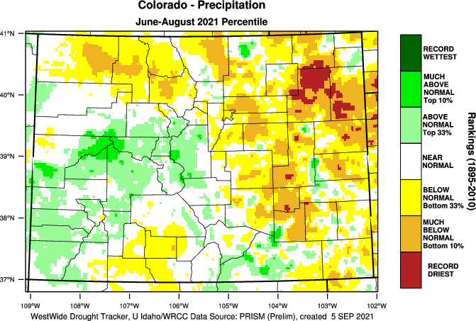
FromColorado Public Radio (Michael Elizabeth Sakas):
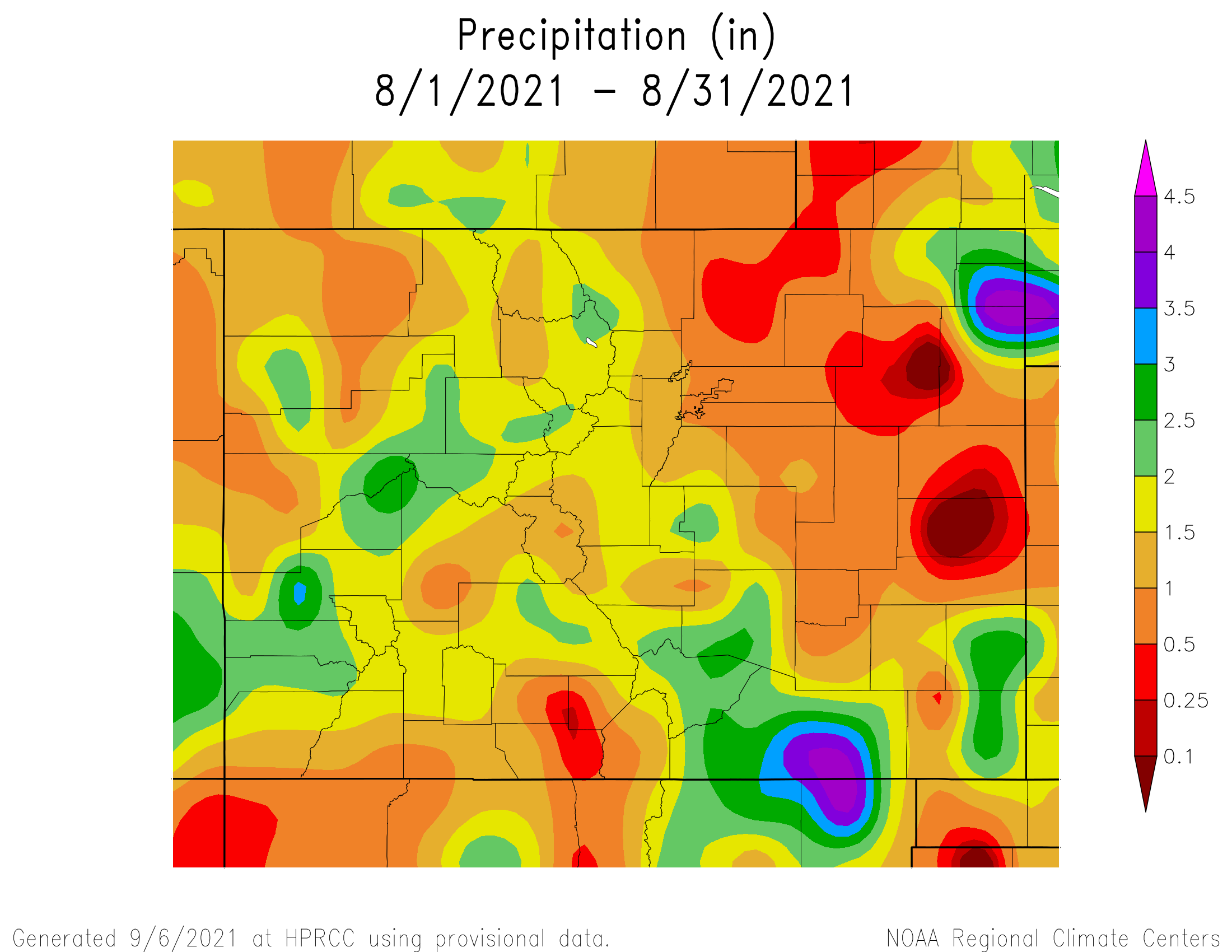
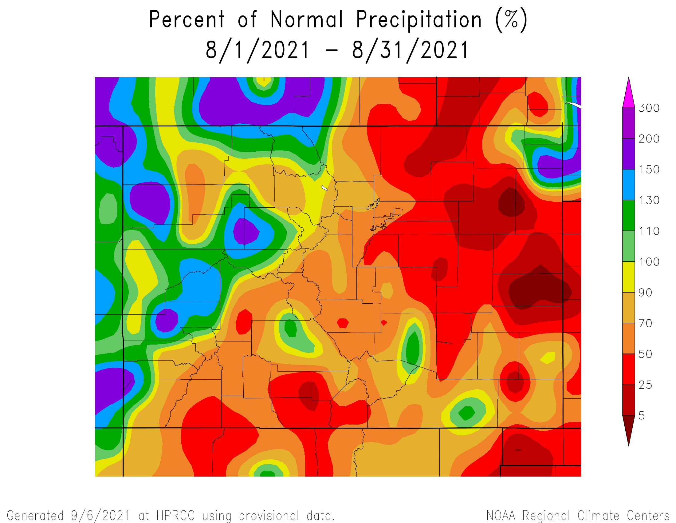
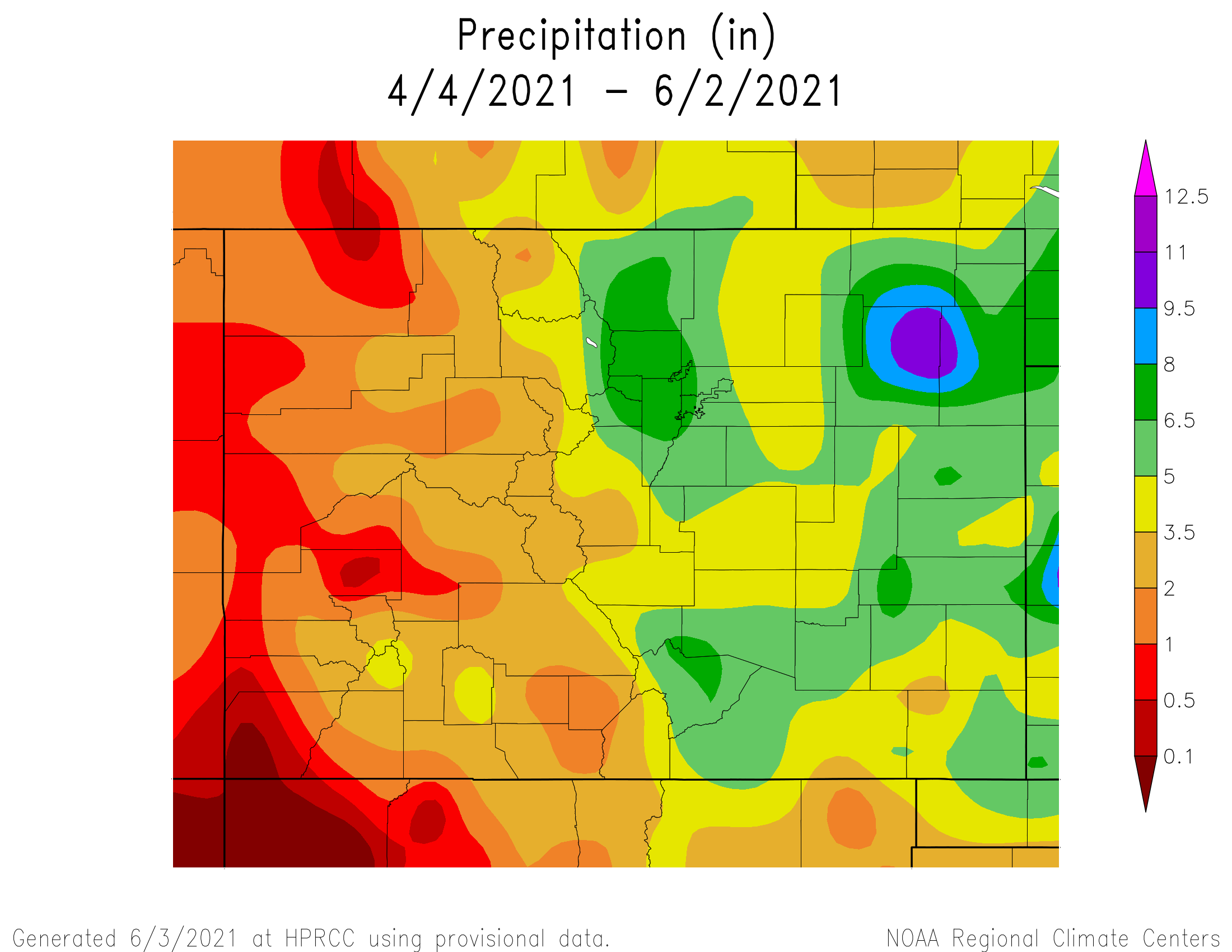
Colorado’s Eastern Plains saw a lot of rain in the spring, which helped half of the state escape drought.
Summer was a different story. Many areas got much less rain than normal, and some spots around Washington and Yuma counties recorded their lowest amount of precipitation on record.
Courtesy of Russ Schumacher, from West Wide Drought Tracker
State climatologist Russ Schumacher said a weather station in Akron recorded its second-wettest spring, followed by the driest summer recorded there.
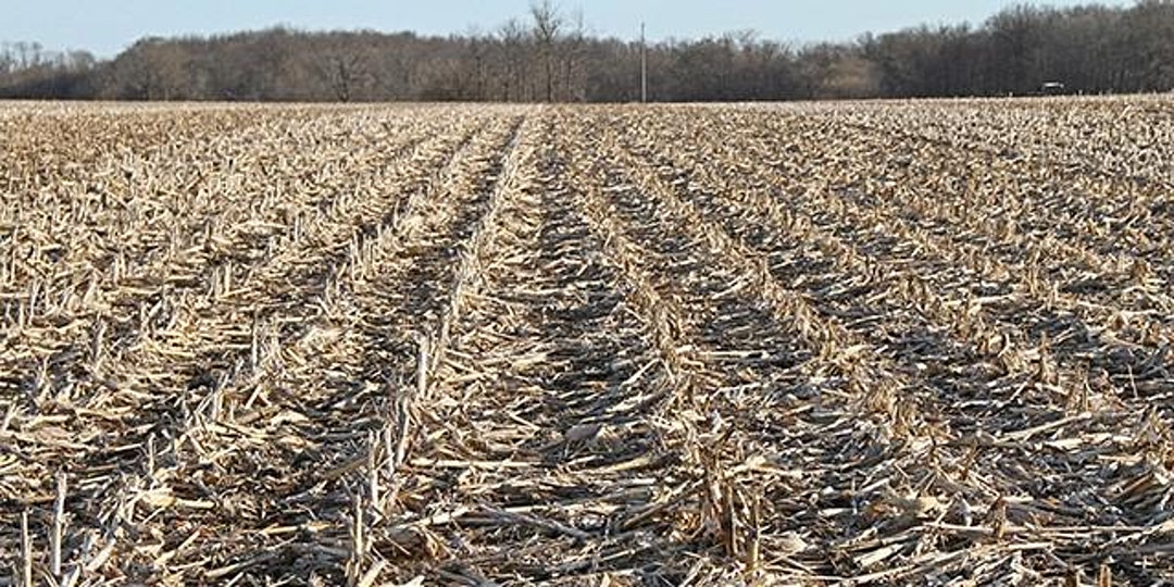
Joel Schneekloth, a regional water resource specialist with Colorado State University Extension, said if the extra spring moisture had been met with average summer rainfall, it would have been a “fantastic” year for many crops.
Schneekloth said the “saving grace” of this summer for the plains was the wet spring and closer-to-normal temperatures meant farmers used just a little more water than average. He said that made the biggest difference compared to historically dry summers in years like 2012 and 2002…
The wet spring meant most corn growers in Washington County will likely have a better year than they did in 2020, Schneekloth said. The county’s average corn crop yielded around 15 bushels per acre in 2020, but that average could increase to 35 this year.
What’s hurting the most this summer is proso millet, which was the third-largest crop for Washington County, according to 2017 data from the USDA.
“In our area for the most part, it’s a disaster,” Schneekloth said.
The millet is planted in early June, and the area’s last good rain was weeks before that. Schneekloth said the shallow roots failed in the dry soil. Those dry soils will have a long-term effect going into the fall because they will make planting wheat before the winter tough, Schneekloth said. He hopes some rain will fall before then…
Ron Meyer, an agronomist for Colorado State University Extension, said the extreme rain helped some crops on the Eastern Plains.
Meyer worried there wouldn’t be any wheat to harvest after a dry fall and winter in 2020 and into 2021. But the moisture got the wheat-growing again in March, which resulted in an above-average crop.
Once it stopped raining again in the summer, spring-planted crops like corn, sunflower and millet are now struggling.
Crop residue. Photo credit: Joel Schneekloth
Meyer said the dry summer shows why it’s important for farmers and ranchers to adapt to a warming climate. One way is through “banking” soil moisture by adopting practices that promote soil health and reduce tilling, as well as using drought-adapted varieties of crops to improve their chances of having a good harvest in extreme conditions.
The work managed by the Fountain Creek Watershed, Flood Control and Greenway District can be “unrecognizable,” but its leaders want citizens to recognize the importance of its flood control projects, as well as understand why it’s crucial to find more funding.
One of those projects in Pueblo is the restoration of approximately 3,000 feet of the creek that runs under the US Highway 47 bridge near Jerry Murphy Road, completed in November 2018.
“It was $6.6 million for something you would drive by and not recognize, while at the same time it protects a major thoroughfare,” District Executive Director Bill Banks said while giving the annual tour of the district’s projects on Sept. 10.
After Highway 47 Project. Photo credit: Fountain Creek Watershed Flood Control And Greenway District
In this instance, a 2015 flooding event catalyzed the Colorado Department of Transportation to partner with the district to realign the creek in order to protect the bridge. CDOT contributed $1.5 million to the project, which also included major landscaping design to provide bank and floodplain stabilization…
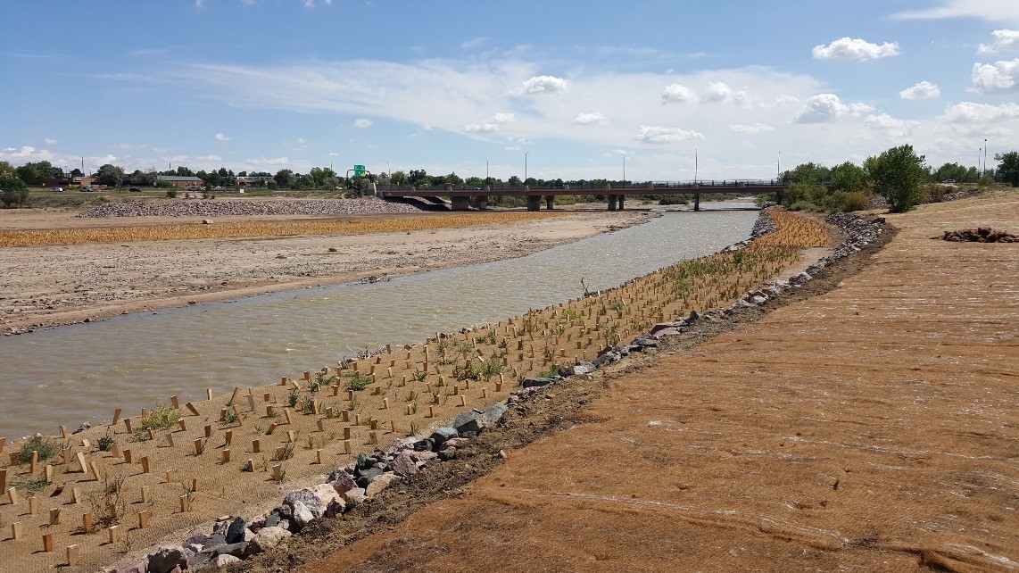
Pueblo Channel Project at 13th Street before. Photo credit: Fountain Creek Watershed Flood Control And Greenway District
Another large project the district completed in June 2021 is a 2,600 feet stretch of the creek that ends at the 8th Street bridge on the East Side. That $3.4 million project narrowed the creek channel from 600 feet to an average of 150 feet. This both stabilized the channel and made it easier for the water to push sediment through, rather than dumping it haphazardly along the banks.
“A lot of conventional wisdom is to make a channel really wide in order to convey as much water as possible to prevent flooding,” said Aaron Sutherlin, who oversaw the 8th Street bridge project with Matrix Design Group. “When you make things as wide as possible, you lose the ability to transport sediment. What you get in a system is sediment that dumps out in places you don’t know where it’s going to go. That’s exactly what happened at this site.”
That project also built the creek to withstand up to 6,000 cubic feet per second, a so-called “100-year flood.”
Pueblo Channel Project at 13th Street after. Photo credit: Fountain Creek Watershed
That influx was a $50 million payout from Colorado Springs Utility to offset the impact of its water delivery system from the Pueblo Reservoir to the cities of Colorado Springs and Fountain. So far, Banks said the district has spent about $27 million from those funds and has identified over $200 million worth of projects.
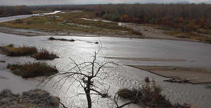
The dry bed of the Arkansas River near the Santa Fe Trail crossing at Cimarron, Kansas. The Ogallala aquifer groundwater levels in much of western Kansas started dropping in the 1950s as pumping increased, according to the Kansas Geological Survey. File Photo / Max McCoy
For decades, the Texas Panhandle was green with cotton, corn and wheat. Wells drew a thousand gallons (3,785 liters) a minute from the seemingly bottomless Ogallala aquifer, allowing farmers to thrive despite frequent dry spells and summer heat.
But groundwater that sustained generations is drying up, creating another problem across the Southern plains: Without enough rain or groundwater for crops, soil can blow away — as it did during the Dust Bowl of the 1930s.
“We wasted the hell out of the water,” says Muleshoe, Texas, farmer Tim Black, recalling how farmers irrigated when he was a kid. Water flooded furrows or sprayed in high arcs before farmers adopted more efficient center-pivot systems.
His grandfather could reach water with a post-hole digger. Black is lucky to draw 50 gallons (189 liters) a minute from wells up to 400 feet (122 meters) deep.
Now farmers are facing tough choices, especially in parts of Texas, New Mexico and Oklahoma.
Some are growing less-thirsty crops or improving irrigation. Others, like Black, are replacing some cash crops with cattle and pastureland.
And more are planting native grasses that go dormant during drought, while deep roots hold soil and green with the slightest rain…
Black, a former corn farmer, plants native grasses on corners of his fields, as pasture for cattle and between rows of wheat and annual grass.
The transition to cattle, he hopes, will allow his oldest son to stay on the land Black’s grandparents began plowing 100 years ago. His younger son is a data analyst near Dallas…
More than half the currently irrigated land in portions of western Texas, eastern New Mexico and the Oklahoma Panhandle could be lost by the end of the century, according to a study last year. And the central part of the aquifer could lose up to 40% of irrigated area by 2100.
Those losses might be slowed as farmers adapt to lower water levels, researchers say. But the projections underscore the need for planning and incentives in vulnerable areas.
The U.S. Department of Agriculture is prioritizing grasslands conservation in a “Dust Bowl Zone” in parts of Colorado, Kansas, New Mexico, Oklahoma and Texas.
But reestablishing native vegetation in the sandy soil over the Ogallala has proven difficult where irrigation ceased on former Kansas farmland. The same is true on land outside the Ogallala previously irrigated with river water, including in Colorado’s Arkansas River Valley.
Extended periods of drought that plagued the Southwest over the past 20 years likely will continue, says meteorologist Brad Rippey with the USDA.
So farmers may need to use some remaining groundwater to reestablish native grasses, says study co-author Meagan Schipanski, an associate professor of soil and crop sciences at Colorado State University.
Historic photo of the High Plains in Haskell County, Kansas, showing a treeless semi-arid grassland and a buffalo wallow or circular depression in the level surface. (Photo by W.D. Johnson, 1897)
For Colorado Springs, August is making weather headlines as the 4th driest and 2nd warmest on record for the city. The average temperature was 74° which ties 2nd place for warmest with 2020. The record-holder is 2011 at an average temperature of 74.1°.
Colorado Springs saw a measly 0.20″ of rain in August, making for the 4th driest on record. August is typically the second wettest month for the city at an average of 2.96″.
In Pueblo, the stats aren’t as dramatic with August being the 15th warmest on record at 76.4°. Pueblo received 1.23″ of rain which is 0.88″ below average.
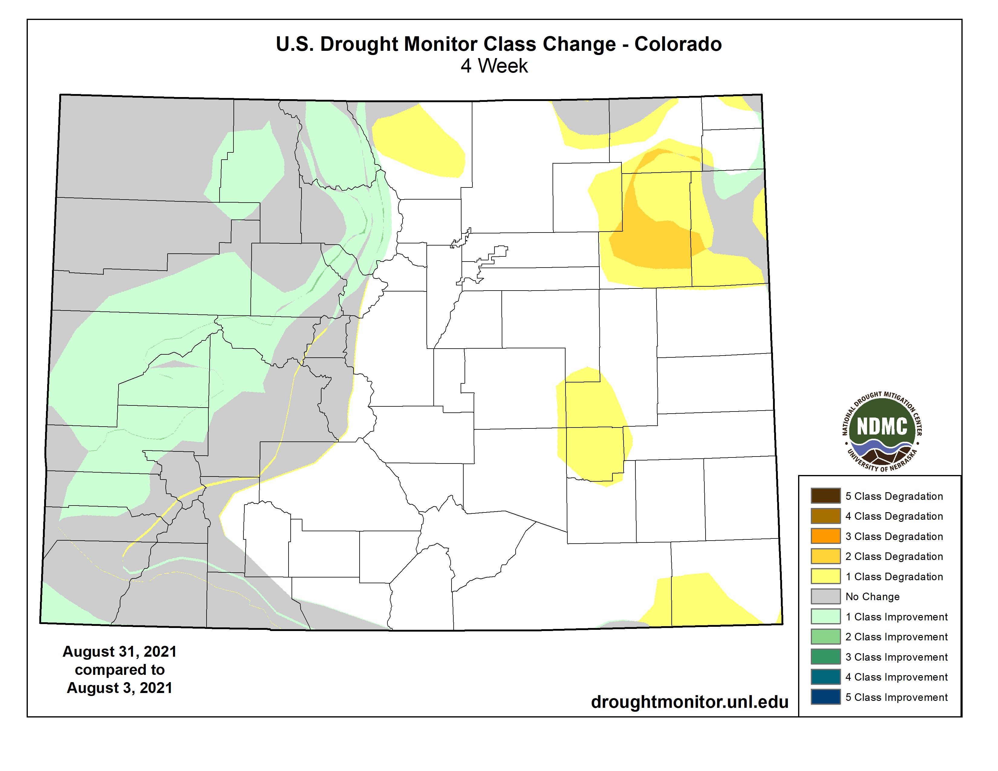
Statewide, eastern Colorado was hot and dry this month and western Colorado was wet and cool.
These patterns had an influence on drought, with improvement seen in the west and worsening in the east.
Colorado Drought Monitor one month change map ending August 31, 2021.
But as a whole, Colorado Springs is running near average for the 2021 water year thus far, after running on a surplus from spring and early summer.
Could a $134 million pipeline recycling suburban water help wean communities off depleted aquifer sources? The latest complex solution for the arid, fast-growing West…
For the H20 molecules lying thousands of feet underground in the Denver Basin aquifer, trapped by millions of years of geologic shifts, there would be a long journey ahead.
Should they get sucked up a well owned by a northern El Paso County water agency, the water drops may first be sprinkled on a lawn in, say, the Woodmoor district east of Monument. From there, the water would sink back underground and flow downhill toward Monument Creek. On into Fountain Creek, and south toward the Arkansas River.
Then the drops would ripple past Colorado Springs, which is desperate to entrap more water of its own for future growth, and is pushing for unloved dams 100 miles away to bring more Western Slope water over the Continental Divide.
On the water would glide past Security, Widefield and other communities, which are struggling to secure clean water supplies of their own in the wake of contamination from polyfluoroalkyl substances (PFAS) running off firefighting foam used for decades at a local military base.
Still going, the hardworking aquifer water then would pass farmland that will eventually be dried up by Woodmoor and other northern suburbs buying agriculture water for their own growth. At the town of Fountain, the water would pass a town that has slowed new homebuilding because it doesn’t have enough future supply for new water taps.
Chilcott Ditch looking towards headgate. Photo credit: Chilcott Ditch Company
And then those precious H20 molecules would hit a curve of Fountain Creek where the Chilcott Ditch headgate looms like an ominous fork in the road of life: If Woodmoor and its allies get their way, the molecules they pulled from the timeless aquifer will get diverted here and sent into a $130 million-plus pipeline, to be shipped back north to the top of El Paso County. The journey for those molecules would begin all over again, in a project appropriately dubbed The Loop, until — in the official water rights phrase — the original aquifer water has been “used to extinction.”
But that only happens if El Paso County and local water agencies convince the keepers of the federal American Rescue Plan that the stimulus funds can be used for water projects like the Loop, and not just highways.
Can this tortured trip for the ancient, sandstone-filtered water really be the best solution to Colorado’s relentlessly expanding water demands?
“There’s something in it for everybody,” said Jessie Shaffer, Woodmoor Water and Sanitation District manager and a key proponent of the Loop…
Backers of the Loop idea say it would solve many problems at once.
It would reduce unsustainable withdrawals from the Denver Basin aquifers, with local water providers already on notice they need to find alternative sources. The pipeline would allow the homes in subdivisions north and east of Colorado Springs to use southern water rights they’ve already purchased but can’t access. And it would promote water recycling, considered a key to Colorado’s water use future, by allowing those northern areas to reuse aquifer water after it’s run off into Fountain Creek and shipped north again by the Loop.
From a purely practical standpoint, drilling new wells into the aquifer is getting so expensive that the suburban districts think twice even when they own the rights. As the aquifer sinks from overuse, drilling prices soar.
Williams mentioned a northern exurban community that spent more than a million dollars on a well to water its new golf course…
A map being shown around El Paso County by suburban water agencies traces the path of the Loop, a complex $134 million pipeline and pumping project that would allow northern and eastern communities in the county to reuse aquifer water returning to Fountain Creek, and pipe along water rights they have bought up on the southern side of the county. (Provided by Woodmoor Water and Sanitation District)
El Paso County grew by more than 17%, and more than 100,000 people, between 2010 and 2020. As developers work to build out planned communities in areas like Flying Horse or Banning Lewis Ranch, the county’s population is projected to expand by hundreds of thousands more in the coming decades.
State water engineers who control withdrawals from aquifers have allowed cities and other water buyers to take out water at a rate protecting a 100-year life for the underground pools. Alarmed at the drops in the Denver Basin pools, El Paso County changed the local standard to preserve 300 years of life for the aquifers. That was another push to local water providers to find other sources.
The Loop pipeline, Shaffer said, is a key to shifting “off of a finite and exhaustible water supply onto a long term, renewable and sustainable water supply.”
[…]
That’s where the American Rescue Plan, signed by President Biden in March, comes into the picture. State and local agencies will battle over the $1.9 trillion stimulus funding for years to come, but Colorado water officials are hopeful some grants can be used for drinking water supply projects. There also may be far more stimulus and infrastructure funding to come, in a building package awaiting final U.S. House approval and a greatly expanded recovery budget that may pass under reconciliation.
Colorado Springs residents will decide in November whether to allow the city to keep up to $20 million in tax revenue to create a wildfire mitigation fund.
The Colorado Springs City Council voted unanimously to place on the ballot a question asking voters to retain the money and spend no more than 5% of the funding annually. The city needs voter approval to keep the funds because they are in excess of the Taxpayer Bill of Rights cap, a limit on how much tax revenues can grow each year.
Any additional funding over $20 million will be refunded to voters through their city utility bills, Mayor John Suthers said.
Colorado Springs Fire Chief Randy Royal said the new funds would help protect the 35,000 homes in the wildland urban interface, where homes are adjacent to wooded areas where fire danger is highest…
The city could use the funds to pay crews to do direct fire mitigation such as trimming back trees, shrubs and other vegetation. It could also use the funds for evacuation planning and community wildfire education.
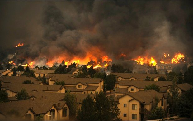
Waldo Canyon Fire. Photo credit The Pueblo chieftain.
Mitigation could help prevent the level of catastrophe the city saw during the Waldo Canyon and Black Forest fires, Councilman Richard Skorman said…
The ballot question does not list all the ways the money could be used to mitigate fire to ensure the city can use the money as it’s needed, Suthers said. He expects the money to be used throughout the community, including areas such as Palmer Park and Corral Bluffs Open Space on the east side. The money can also be used outside the city’s boundaries if necessary.
If the question passes, the city expects to invest the money and use interest from the funds for mitigation and a portion of the main funds, he said.
The city could also replenish the fund with future TABOR retention questions, he added.
Skorman said he didn’t want to see the 5% limit on spending placed in the ballot question in case the city had an important opportunity for wildfire mitigation funding come up.
However, Suthers supported the limit to help show the community the money wouldn’t be spent all at once. The council as a whole supported the limitation as well in its vote.
The boat ramp at Ruedi Reservoir allows motor boats to access the water. The Bureau of Reclamation is projecting that the reservoir will fall to 55,000 acre-feet this winter. CREDIT: HEATHER SACKETT/ASPEN JOURNALISM
Bureau of Reclamation warns of potential impacts to Aspen hydro plant, water contract holders
Water levels at Ruedi Reservoir could fall so low this winter that the city of Aspen could have difficulty making hydro-electric power and those who own water in the reservoir could see shortages.
That’s according to projections by the Bureau of Reclamation, which operates the reservoir near the headwaters of the Fryingpan River. At the annual Ruedi operations meeting on Aug. 5, officials estimated the reservoir will fall to around 55,000 acre-feet this winter, what’s known as carry-over storage. According to Tim Miller, a hydrologist with the Bureau of Reclamation who manages operations at Ruedi, the lowest-ever carry-over storage for the reservoir was just over 47,000 acre-feet in 2002, one of the driest years on record. Last year’s carry-over was about 64,000 acre-feet.
At 55,000 acre-feet, the elevation of the water is about 7,709 feet. That’s about two feet lower than Aspen officials would like.
“We don’t like being below 7,711,” said Robert Covington, water resources/hydroelectric supervisor for the city.
That’s because the hydro plant needs a certain amount of water pressure to operate. The higher the water elevation, the more water pressure there is.
According to Covington, power providers Xcel Energy and Holy Cross Energy sometimes temporarily and quickly shut down the hydro-electric plant when there are problems with transmission lines or they need to do repairs.
“It’s very common for these types of plants to automatically shut down,” Covington said.
The problem is that restarting the plant requires a larger amount of water than the 40 cubic feet per second that is roughly the minimum amount required to operate the plant efficiently.
“It’s very difficult for us to get back online so we end up pushing more water through for a very short period of time,” he said.
If Aspen has to shut down the plant because flows are too low, the city could purchase more wind power to maintain its 100% renewable portfolio.
“When we go lower on hydro, we go with wind, which is generally the most cost-effective,” said Steve Hunter, utilities resource manager with the city.
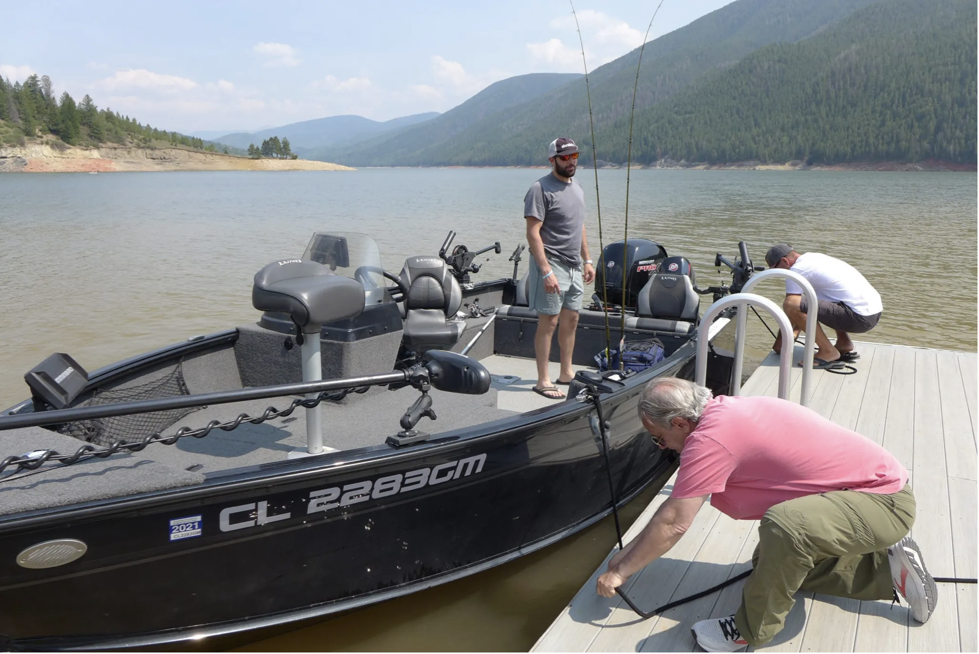
Anglers dock at Ruedi Reservoir on Aug. 5. Bureau of Reclamation officials project that low carry-over storage combined with another low runoff year could lead to shortages for water contract holders. CREDIT: HEATHER SACKETT/ASPEN JOURNALISM
Shortages to contract holders
Another consequence of low carry-over storage means that Ruedi will start out even lower next spring when the snow begins to melt and the reservoir begins to fill again. That means if there is below-average runoff again, some contract holders who own water in Ruedi could have to take shortages, something that has never happened before, Miller said.
There are 32 entities that have “contract water” in Ruedi, which the bureau releases at their request. This is water that has been sold by the bureau to recover the costs of building and operating the reservoir. The contract pool is separated into two rounds and contract holders will take a previously agreed upon shortage amount depending on which round they are in.
“If we get another similar type of runoff this year, there will be shortages most likely to the contract pool,” Miller said.
The 15-Mile Reach is located near Grand Junction, Colorado
But there are still uncertainties in predicting how low the reservoir will go. The biggest of these is how much water will be released for the benefit of the endangered fish in the 15-mile reach of the Colorado River near Grand Junction.
There is a 10,412 acre-foot pool available for the fish, but in dry years entities that store water in Ruedi will sometimes coordinate to release more fish water in the late summer and fall. This would draw down the reservoir even further. It’s still not clear how much water will be released this fall for the four species of endangered fish.
“The release defines the carry-over,” Miller said.
Despite initial bureau forecasts in April that projected Ruedi could probably fill to its entire 102,373 acre-foot capacity, Ruedi ended up only about 80% full this year. July 11 was the peak fill date at 83,256 acre-feet and an elevation of 7,745 feet.
“It was probably a little over-optimistic,” Miller said of the April forecast. “But at the time our snowpack was average. It was a reasonable forecast given the conditions.”
As climate change worsens the drought in the Western U.S., Ruedi is not the only reservoir to face water levels so low that they threaten the ability to produce hydroelectric power. Last month, the bureau began emergency releases from Upper Basin reservoirs, including Blue Mesa on the Gunnison River, to prop up levels in Lake Powell and preserve the ability to produce hydropower at Glen Canyon Dam.
This story ran in the Aug. 10 edition of The Aspen Times.
Release of firefighting foam. PFAS are substances found in firefighting foams and protective gear, as well as many household products, like pizza boxes and rain jackets. Graphic credit: ITRC
Here’s an in-depth report from Laura Paskus that’s running in The Santa Fe Reporter. Click through and read the whole article. Here’s an excerpt:
Today, we know the [firefighting] foam contained toxic chemicals responsible for polluting the water around hundreds of military bases nationwide, including Cannon and Holloman Air Force bases in New Mexico. And the toxic chemicals are present in the drinking water of millions of Americans…
Over the years, [Kevin] Ferrara has learned that the military knew Aqueous Film Forming Foam (AFFF) was dangerous—and so did the companies that manufactured it. But without federal regulations that set drinking water standards or hazardous waste limits, states like New Mexico still can’t hold the Pentagon accountable for the pollution that has crept from the bases into the wells of local residents and businesses. Meanwhile, military firefighters like Ferrara wonder what’s happening within their own bodies—and the bodies of those whose water they polluted.
In the waning days of Gov. Susana Martinez’s administration, the New Mexico Environment Department (NMED) was grappling with a problem. A “forever” problem, as it turns out.
Contractors hired by the military were investigating whether AFFF used at the state’s three Air Force bases had contaminated groundwater with PFAS.
In an August 2018 conference call, Air Force officials told state officials that PFAS had been found in wells at Cannon Air Force Base at concentrations above the US Environmental Protection Agency’s lifetime health advisory of 70 parts per trillion. Further studies showed the levels exceed 26,000 parts per trillion—more than 370 times that EPA health advisory—and that PFAS was also in off-base wells that supply homes and dairies in Clovis.
In October, NMED, the New Mexico Department of Health and the New Mexico Department of Agriculture publicly announced the presence of the contamination on and off the base. They advised private well-owners within a 4-mile radius of the base to use bottled water. NMED issued a notice of violation against the Air Force for breaking state regulations. The agency issued “corrective action permits” with cleanup mandates for the military’s state permits.
But in January 2019, just after Gov. Michelle Lujan Grisham took office, the US Department of Defense sued New Mexico, challenging the state’s authority to mandate cleanup.
And although the state made no announcements nor issued any corrective actions, a report the Air Force submitted to NMED during the Martinez administration showed that groundwater samples of PFAS at Holloman Air Force Base were as high as 1.294 million parts per trillion. In February 2019, NMED issued a notice of violation against the Air Force over Holloman, too.
The following month, in March 2019, New Mexico filed its own lawsuit, asking a federal judge to compel the Air Force to act on, and pay for, cleanup at Cannon and Holloman.
But that hasn’t worked out as planned.
“We wanted action quickly. When that wasn’t available, or that wasn’t on the table, that’s when we litigated,” NMED Secretary James Kenney says in an interview.
The lawsuit has been lumped in with hundreds of other PFAS-related lawsuits. One court in South Carolina now oversees all cases regarding PFAS and the military’s use of the AFFF—more than 750 separate actions.
Even though New Mexico has tried to extricate itself from the multidistrict litigation, hoping to pursue its case against the Air Force without being tied to those hundreds of other cases, a judge has denied that request. And in June, the Biden administration’s Defense Department called New Mexico’s attempts to compel cleanup under state permits “arbitrary and capricious.”
In summary, three years after the Air Force notified New Mexico of the PFAS pollution, there are no clean-up plans in place at Cannon or Holloman, though earlier this year, Cannon announced an on-base pilot project to test the best ways to remove PFAS from water. And even though the military knows when, why and how the contamination happened, it has sued New Mexico to say the state can’t make it clean up the problem.
Meanwhile, state Environment Sec. Kenney says the EPA needs to set federal pollution standards for the toxic substances.
In 2016, the EPA established a lifetime health advisory for two types of PFAS found in firefighting foams, perfluorooctanoic acid (PFOA) and perfluorooctane sulfonic acid (PFOS). But that advisory of 70 parts per trillion isn’t a regulatory limit. That means states like New Mexico don’t have any legal tools to require that polluters like the military clean up PFAS.
Boaters at Cedar Springs Marina on Flaming Gorge Reservoir. The reservoir’s levels are expected to drop 2 feet a month under an emergency release of water designed to keep Lake Powell’s hydropower system operating. July 22, 2021 Credit: Jerd Smith
John Rauch and his family have operated the Cedar Springs Marina here since 1986. But three weeks ago, when the federal government suddenly ordered millions of gallons of water to be released from Flaming Gorge Reservoir down the Green River to Lake Powell, Rauch wasn’t prepared.
“It was a total gut punch,” he said on a recent hot, sunny morning. As visitors trekked down to rent his pontoon boats, and others slid their fishing craft into the reservoir, Rauch and his employees were already planning which boat docks and ramps would have to be relocated to keep them afloat. The reservoir is projected to drop as much as 2 feet a month through the fall as water is released.
Drought has plagued the Colorado River Basin for 20 years, but it hit crisis proportions this summer, pushing lakes Powell and Mead to historic lows and triggering, for the first time, emergency releases of water from Utah’s Flaming Gorge, Colorado’s Blue Mesa, and New Mexico’s Navajo reservoirs.
All told, 181,000 acre-feet of water are to be sent to Lake Powell by the end of December. Powell has dropped so low that its hydropower plants, which supply millions of homes with electricity and generate revenue for such things as a critical Colorado River endangered species program, may stop operating as early as next year if water levels continue to drop as they have been. The U.S. Bureau of Reclamation estimates there is a 3 percent chance of this occurring next year and a 29 percent chance of this occurring in 2022. But given the speed of the Powell’s decline, no one wants to risk a hydropower shutdown.
Savings accounts
Since their construction in the 1960s these reservoirs, known as Reclamation’s Colorado River Storage Project reservoirs, have acted as a giant savings account, helping ensure that if a crisis erupted on the river, the Upper Colorado River Basin states of Colorado, Wyoming, Utah and New Mexico would have enough water on hand to fulfill their legal obligation to deliver water to Nevada, Arizona and California, known as the Lower Basin states.
Credit: Chas Chamberlin
Colorado’s Blue Mesa Reservoir, part of the Aspinall Unit, is already low, at just 43 percent of capacity as of last month. Fed by the Gunnison River, a major tributary of the Colorado, the reservoir is tourism hot spot on Colorado’s West Slope.
Kathleen Curry, a former Colorado lawmaker, sits on the Colorado River District Board. She said she understands the need for the releases, but she said the changes in the shoreline at Blue Mesa aren’t going unnoticed.
“It’s taking residents and visitors by surprise, just because I don’t think anyone was expecting it,” she said.
The releases come under a special Upper Basin Drought Contingency Plan approved by Colorado, Wyoming, Utah and New Mexico in late 2018. A similar drought plan is in place for the Lower Basin, and they have been cutting back withdrawals from Lake Mead for the past two years.
Still the river system is drying out. And water leaders in Colorado are deeply worried that their carefully protected savings account is going to dry up too quickly to solve the Colorado River’s long-term problems.
Will it work?
“I understand and support the necessity of the Secretary [of the Interior] taking this action,” said Jim Lochhead, CEO of Denver Water. “The major concern I have is that Reclamation says the 181,000 acre-foot release will raise Lake Powell three feet. But I don’t know that they can even show that. I don’t know that they have accounted for transit losses and other losses.
“It’s important when these releases are made that they are accounted for, that we know where this water is going. If it doesn’t actually get down to [Lake Powell] to accomplish what it was designed to do, we should have kept it in that savings account,” Lochhead said.
Becki Bryant, a spokesperson for the U.S. Bureau of Reclamation’s Upper Colorado River region, said the agency is working to create a hydropower buffer in Lake Powell and believes the releases are adequate to accomplish that. But Reclamation is not yet doing the kind of precise tracking and accounting known as water “shepherding,” to ensure flows make it downstream, that Lochhead is requesting.
On Aug. 1, Lake Powell’s elevation stood at 3,553.8 feet above sea level. The action point, or so-called target elevation is 3,525. When that point came close in July, Reclamation moved quickly to order the emergency releases.
Powell’s hydropower plant stops generating power when it drops to 3,490 feet in elevation, according to Reclamation.
“Reclamation expects the additional release of water will be sufficient to protect Lake Powell’s target elevation through 2021. That target elevation provides a 35-vertical-foot buffer designed to minimize the risk of dropping below the minimum power pool elevation of 3,490 feet, and balances the need to protect the infrastructure at Powell’s Glen Canyon Dam.
“Shepherding water would be beneficial but is challenging on many levels for Colorado River Basin states,” said Bryant via email.
Bleak forecasts
Bryant said Reclamation will continue to consult with the Upper Basin states as it monitors reservoir levels and weather forecasts. Should conditions deteriorate further, the agency could examine whether to declare the releases futile and stop them, as it is allowed to do under the 2018 Drought Contingency Plan.
The water being released is so-called “system water,” meaning that it isn’t owned by a particular user.
Held by the federal government for the benefit of the Upper Basin states, the amounts of water specified in the release plan are jaw-dropping: 125,000 acre-feet from Flaming Gorge; 36,000 acre-feet from Blue Mesa; and 20,000 acre-feet from Navajo. An acre-foot of water is enough to cover one acre of land to a depth of 12 inches.
If that same amount of water were going to cities, it would be enough to serve more than 362,000 homes for one to two years. If going to farms, it could irrigate more than 113,000 acres, depending on the crop.
If the historic, 20-plus-year drought cycle doesn’t end soon, refilling those reservoirs is going to be difficult. And that has water managers worried.
“My level of concern is quite high,” said Becky Mitchell, director of the Colorado Water Conservation Board, the state’s lead water planning and policy agency. She also sits on the four-state Upper Colorado River Basin Commission, which advises Reclamation on river issues.
“And I can’t tell yet if [the releases] are going to do the trick,” she said. “But we have to respond to the levels in Powell.”
Cedar Springs Marina near Dutch John, Utah, on Flaming Gorge Reservoir in the early 1960s. In a first, emergency releases are being made under the 2018 Upper Colorado River Basin Drought Contingency Plan. Photo courtesy of the Rauch family.
Legal reckoning?
Under the 1922 Colorado River Compact, Colorado and the other Upper Basin states must deliver 7.5 million acre-feet (maf) [per year, 75 maf per 10 years] of water to the Lower Basin on a 10-year running average. Right now, the Upper Basin is delivering roughly 9.2 maf, Mitchell said, meaning that there is still time to help the system come back into balance before the Lower Basin states could legally call for more water than they currently receive.
Lake Powell is the Upper Basin’s largest storage pool on the system and is designed to be the four Upper Basin states’ major source of protection. Because of their legal obligations, Colorado water users are closely monitoring this year’s plunge in Powell, with the threat to hydropower production being seen as a dangerous antecedent to a compact call.
“That the system continues to deteriorate is concerning,” Lochhead said.
Roughly half of Denver Water’s supplies are derived from water rights it owns on the Colorado River system. While one portion of its portfolio dates back to 1921, and would therefore trump a 1922 compact call, several other rights were established later, meaning the utility might have to stop pulling from those water sources if Colorado were forced to cut back in order to meet compact obligations.
Other Front Range water providers, who also have Colorado River rights, are even more vulnerable, including the Pueblo-based Southeastern Colorado Water Conservancy District.
Southeastern’s rights date only to 1957.
Contingency v. reality
Lee Miller, Southeastern’s attorney, said the Colorado River crisis remains a long-term problem for his agency.
The rapid deterioration this year, however, is prompting everyone to rethink how much time they have to balance the massive river system as drought and a warming climate, as well as population growth, continue to sap its flows.
“Both the Upper and Lower Basin have now had to initiate elements of their drought contingency plans. When we passed it a couple of years ago everyone thought, “It’s good to have a contingency plan.’ But I don’t think anyone thought we would have to use the plans this quickly. It’s gone from being a contingency to being a reality, and that’s concerning.”
Back up at Flaming Gorge, John Rauch is watching the levels drop and making his own contingency plans.
“We are planning for the worst,” Rauch said. “For the foreseeable future, the outlook is dry. If it ends up that by the end of all of this that the reservoir becomes a river channel, we will be down there at water’s edge selling worms.”
Jerd Smith is editor of Fresh Water News. She can be reached at 720-398-6474, via email at jerd@wateredco.org or @jerd_smith.
These wetlands, located on a 150-acre parcel in the Homestake Creek valley that Homestake Partners bought in 2018, would be inundated if Whitney Reservoir is constructed. The Forest Service received more than 500 comments, the majority in opposition to, test drilling associated with the project and the reservoir project itself. Photo credit: Heather Sackett/Aspen Journalism
A group of Colorado residents demonstrated Saturday against the construction of a reservoir in the Homestake Valley, marching through the streets of Red Cliff and treating passing vehicles to a variety of colorful signs.
If you were headed south on Highway 24 on Saturday afternoon, you might have been able to read a clever statement like “Stop the whole dam thing,” and “They can’t ‘fen’ for themselves.”
Or you might have noticed a message or two that was more direct. Using an elongated trash picking tool to hoist her sign, Silverthorne resident Jan Goodwin wrote “CO Springs doesn’t need Red Cliff’s water.”
The group is opposed to building a new reservoir in the Homestake Valley 6 miles southeast of Red Cliff, which would be used by the people of Colorado Springs and Aurora, who hold water rights in the area, including the rights to the water in the existing Homestake Reservoir.
These wetlands in the Homestake Creek valley are near the site of the proposed Whitney Reservoir. The Forest Service is considering whether to issue a permit for drilling and a geotechnical study to test whether the site would support a dam. Photo credit: Heather Sackett/Aspen Journalism
But the nuances of the issue, including the sensitive wetlands known as “fens” and the study required for “the whole dam thing,” as referenced in the signs, was also discussed among the demonstrators. In order to construct a new dam and reservoir, the area will require some study, and the Forest Service has already approved that study, which will allow the cities to drill “10 bore samples up to 150-feet deep using a small, rubber-tracked drill rig as well as collect geophysical data using crews on foot,” according to the Forest Service, along with the construction of more than a half-mile of temporary roads to facilitate the work.
The effort could also impact up to 180 acres of wetlands on lower Homestake Creek, wetlands that include fens — groundwater-fed wetlands which began forming during the last ice age. A scientifically unproven idea to relocate the fens is being spearheaded and paid for by Aurora Water and the Board of Water Works of Pueblo…
A map prepared by Aurora Water that shows a potential 500-acre adjustment to the Holy Cross Wilderness boundary near the potential Whitney Reservoir on lower Homestake Creek. The map as current as of July 16, 2019.
[Charles] Fleming said he would like to see the people of Colorado Springs and Aurora make more of a good faith effort toward water conservation before seeking another reservoir in the Homestake Valley.
“I’d like to see them get rid of the green grass and focus more on xeriscaping first,” he said.
Parks said as a hotelier in Red Cliff, she sees the recreational appeal of the Homestake Valley as a wild space, not a space that would benefit from the creation of a National Recreation Area or reservoir.
One version of the reservoir envisions an encroachment into 500 acres of the Holy Cross Wilderness area of the White River National Forest, which would require an act of Congress.
The Chaffee County Board of Commissioners voted Tuesday to approve the conditions under which a water bottling company could continue to pull water from a spring connected to the Arkansas River.
They are allowed to do so through the water right they bought back in 2010, but the county gives the green light if it finds the company follows all of the rules.
The 1041 permit process outlines specific conditions that BlueTriton has to meet in order to pull water out of Chaffee County. BlueTriton, previously known as Nestle, owns two wells. State water records obtained by 9Wants to Know show the company can pull up to 196 acre-feet of water each year…
[Della] Malone said regardless of the amount of water BlueTriton will take, Colorado is at the point where as much water as possible needs to stay in the river to keep fish, and the birds that feed on them, alive…
For the most part, BlueTriton has been a good steward of the water. The county hired W.W. Wheeler and Associates to conduct an updated analysis in 2020 and said the company is not using as much water as it could be.
Gary B. Thompson, an engineer for the water engineering firm W.W. Wheeler and Associates, found the utilization of the wells was not causing problems…
Jennifer Davis, Chaffee County attorney, said in an email that Monroe’s report led to increased wetlands monitoring in the 2009 contract. Any 2021 contract would have similar measures that would allow the county to cancel the contract if there was evidence that the wetlands were being stressed.
“It is important to note that during the recent hearings, evidence was presented that the applicant has substantially complied with those plans over the past 10 years,” Davis wrote. “…If [BlueTriton Brands] fails to comply with the plans, the permit can be suspended or terminated.”
In 2020, Wheeler found the nearby wetlands are healthy and the permit has “adequate” monitoring protocols.
Turrquoise Reservoir, which stores water brought under the Continental Divide from the Eagle, Fryingpan and Roaring Fork river headwaters. Photo credit: Aspen Journalism
Clear Creek Reservoir
The well permits allow for a maximum of 196 acre-feet per year. On average, the Wheeler report found the wells pulled in 111.7 acre-feet on average. The well had not been tapped for more than 100 acre-feet per year since 2014, according to the report. Any water taken for the water bottling operation is replaced with water from the nearby Turquoise Reservoir and Clear Creek Reservoir…
How much water goes to water bottles?
Kevin Rein, a state engineer and the director of the Colorado Division of Water Resources, said water bottling facilities use a small portion of the state’s water. He wrote in an email that one fairly standard-sized Colorado bottled water company found it was responsible for 0.0006% of the state’s annual water use.
For context – 85.2% of the state’s water goes to agriculture each year and 6.6% are used by cities and commercially according to data from the Colorado Division of Water Resources…
Other requirements of the permit
Other requirements of the contract have mostly been met. Davis said in an email BlueTriton did not finalize a conservation easement, but that commissioners did not penalize the company because deadlines were not clearly explained in the permit.
According to a letter from the Colorado Department of Natural Resources, Nestle did not begin discussions about donating land for an easement until 2019, 10 years after the original 1041 permit was issued by the Chaffee County Commissioners…
BlueTriton will pay $1.2 million across 10 years to various causes like water sustainability, forest health and affordable housing. It will pay $430k in just the first year, then $92,500 each year afterward.
Nestle sold its North American water brands to BlueTriton for $4.3 billion dollars.
Arkansas River Basin — Graphic via the Colorado Geological Survey
With a limited budget, growing needs, drought and an ever-present demand for water, the city’s Department of Parks, Recreation and Cultural Services is taking steps to reduce its “water footprint.”
In recent years, the department has replaced some Kentucky bluegrass with native grasses in parks and on medians; native grasses are more drought-resistant and need less water.
Replacing grass with artificial turf on heavily-used athletic fields is another strategy being used, as well as xeriscaping (natural landscaping) and other landscaping to replace grass in some areas.
Parks & Rec also is investing more in technology to water grass more efficiently by monitoring water usage and reducing waste.
The department spent $515,000 in 2019 and 2020 on replacing irrigation systems, and expects to spend $150,000 this year; but nearly two-thirds of its present systems are 30 years old or more and replacing those outdated systems will cost an estimated $6.7 million — a process that will take 60 years with current funding levels.
That situation is partly why the department will ask voters in November to approve a slight sales tax increase to pay for a backlog of maintenance and other needs.
Parks & Rec also plans to build or upgrade parks that incorporate some or all of these amenities. Examples are the newer Venezia Park on the city’s northeast side, and the current renovation of Panorama Park on the southeast side.
The city budgeted around $4.7 million for parks watering in 2020 and used 98% of that amount, although some areas needed more than the amount of water allocated; this year’s usage is expected to fall below the budgeted amount of $4.4 million because of wetter weather…
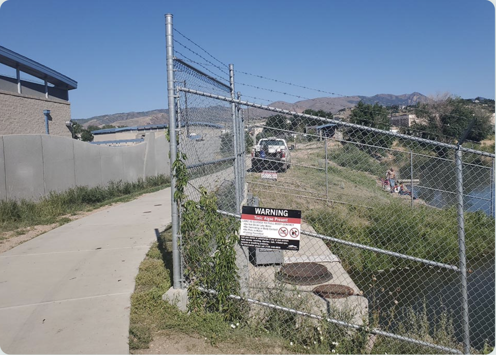
Warning sign for Blue-green algae at Pikeview Reservoir July 2021. Photo credit: Colorado Springs Utilities
Here’s the release from Colorado Springs Utilities:
Pikeview Reservoir, a popular fishing spot in central Colorado Springs and part of our water system, has tested positive for blue-green algae. While the reservoir is still safe for fishing, humans and pets are prohibited from entering the water until further notice. Anglers are directed to thoroughly clean fish and discard guts.
Pikeview has been removed as a source for drinking water until the reservoir is determined to be clear of the algae. There are no concerns about this affecting water supply for the community.
“It’s our responsibility to provide safe, reliable drinking water to our community and to always consider public safety at our reservoirs. We will continue to closely monitor our reservoirs and take appropriate actions,” Earl Wilkinson, Chief Water, Compliance and Innovation Officer said.
We conduct more than 400 water quality tests a month and collect approximately 12,000 water samples throughout our water system annually. With the increased risk of the blue-green algae, we are increasing the frequency of testing reservoirs at lower elevations.
In the past several years, there’s been increasing occurrence of toxic blue-green algae in reservoirs across the United States, forcing limitation of recreational access to the bodies of water for public safety.
Sickness including nausea, vomiting, rash, irritated eyes, seizures and breathing problems could occur following exposure to the blue-green algae in the water. Anyone suspicious of exposure with onset of symptoms should contact their doctor or veterinarian.
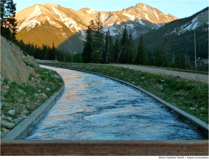
High up on Colorado’s Independence Pass, a narrow, winding road weaves through the evergreens and across mountain streams, up and over the Continental Divide at more than 10,000 feet. At one point that road crosses a canal.
It’s easy to miss if you’re not looking for it, but that canal is part of water infrastructure that makes life on Colorado’s Front Range possible.
The state has a geographical mismatch between where water shows up and where much of the population has settled.
“Wherever you are in this state, you’re either at the source of the drinking water supply, you’re in the middle of the drinking water supply, or you’re at the end of the tap,” said Christina Medved, outreach director at Roaring Fork Conservancy. “So on the Western slope, we are at the source of the water.”
About 80% of Colorado’s water falls on the western side of the state. Much of it is high-mountain snow and rain that eventually trickles down into streams and rivers like the ones on Independence Pass.
But about 80% of Colorado’s people live on the east side of the mountains. Because of gravity, that water doesn’t flow to them naturally. Instead, Colorado’s heavily-populated Front Range relies on a massive plumbing system to keep drinking water flowing to its taps.
Colorado transmountain diversions via the State Engineer’s office
For a century and a half, engineers have carved up the mountains with tunnels and canals that pipe water across the state through trans-mountain diversions. Some of that infrastructure is nestled near the high-alpine headwaters of the Roaring Fork River, which eventually flows through Aspen and Glenwood Springs on its way to the Colorado River. Near Lost Man reservoir, a dam and tunnel create a juncture between water that will follow that natural path westward to the Colorado, and water that will be diverted eastward through the mountains and onto cities such as Colorado Springs.
A tunnel through the mountains draws in water that will pass through two reservoirs and the Arkansas River on its way to the southern portion of the Front Range. Water diverted from the Colorado River basin, through trans-mountain diversions, makes up 60 to 70% of the water used by Colorado Springs. Denver, Greeley, Fort Collins and smaller municipalities on the Front Range also rely heavily on Western Slope water.
And these kinds of set ups aren’t confined to Colorado. Similar systems bring water to big cities all across the region. Salt Lake City, Albuquerque and Los Angeles rely on canals and tunnels to ship faraway water into their pipes. New ones are in the works on the Front Range and in southern Utah.
But these systems aren’t without critics.
Water from the Roaring Fork River basin heading east out of the end of the Twin Lakes Tunnel (June 2016), which is operated by the Twin Lakes Reservoir and Canal Co., a member of the Front Range Water Council. Photo: Brent Gardner-Smith/Aspen Journalism
“When you first learn about it, the concept of a trans-mountain diversion is crazy,” said Andy Mueller, general manager of the Colorado River Water Conservation District. “It seems wrong. It seems antithetical to the health of the river. And I have to say all of that’s true.”
His organization was set up in the 1930s to oppose these diversions and ensure that there is enough water for people on the Western side of the state…
The issue is, contemporary environmental values aren’t written into the West’s water law. Instead, water use is defined by regulations written when Colorado first became a state in the 1800s. The rules say that if you have rights to use water, it doesn’t matter if you want to use it hundreds of miles away from its source – even if that requires miles of cross-mountain plumbing to do so.
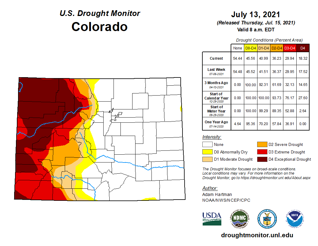
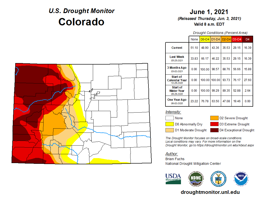
Colorado Drought Monitor map July 13, 2021.
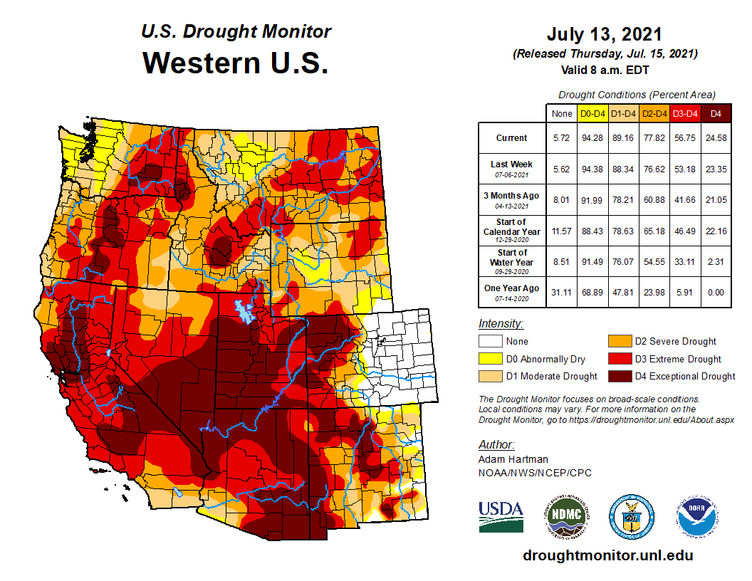
At this moment, there is less water to pull from in every part of the state. The Front Range escaped from drought after steady spring rains, but those high-mountain areas that usually provide a dependable source of water for all of Colorado are experiencing a different fate. The western slope is deep in the second year of drought conditions, leaving snowpack and river flows lower than they should be.
Mueller thinks that only sharpens the need for the Front Range to curtail its water use. Although they retain the legal right to use a certain amount of water, he’s asking them to use less – which he says will promote the health of rivers and their ecosystems west of the divide.
The ditch that moves water from Lost Man Reservoir to Grizzly Reservoir and then under the Divide to the South Fork of Lake Creek and the Arkansas River.
On the Front Range, those on the receiving end of diversions say they are listening to their western counterparts when they put up distress signals during particularly critical times. They also say deliberate conservation work is paying off in the longer term. Nathan Elder, water supply manager for Denver Water, said over the past two decades, per capita water use in his district is down by 22%.
“Everyone in Colorado needs to decrease their use,” he said…
Amid tension between demands for water on both sides, exacerbated by extreme drought conditions, is the fact that there is not much of an alternative. Colorado’s water system is built to accommodate the fact that the majority of its people and the majority of its water are far from each other. Without fundamental changes to the bedrock of water law, those asking for water will have to work within a system built on trans-mountain diversions…
Some contingency planning – within the reality of a diversion-centric system – is already in place. In Colorado Springs, which receives some of the flow diverted from the top of Independence Pass, re-use practices are helping the city get more mileage out of the water it’s apportioned.
Graphic credit: Water Education Colorado
Abby Ortega, water resources manager for Colorado Springs Utilities, said reused water accounts for 26% of the city’s total portfolio and the city relies heavily on storage to get through dry years like this one.
Brad Udall: Here’s the latest version of my 4-Panel plot thru Water Year (Oct-Sep) of 2019 of the #coriver big reservoirs, natural flows, precipitation, and temperature. Data goes back or 1906 (or 1935 for reservoirs.) This updates previous work with @GreatLakesPeck
But climate change threatens to increase the frequency and intensity of droughts, which has water managers on edge and looking more intently at ways to maximize what’s available.
“Every water planner in the state has some worry with the rapidly declining hydrology on the Colorado river,” Ortega said.
Late on Friday afternoon, July 16, the consumer protest organization calling itself Unbottle & Protect Chaffee County Water (“UPCCW”), a Colorado non-profit corporation, delivered a notice from the law offices of John Barth, of Hygiene, Colorado to the Chaffe Board of County Commissioners, and Chaffee Planning Director Dan Swallow. Interestingly enough, the notice did not include the county attorney’s office.
In it, the group issued a set of complaints; in their view, Chaffee County has failed to follow the required permitting procedure for issuance of a 1041 permit. The group’s basis for that claim; that the county plans to review a draft of the proposed 1041 permit and conditions at the upcoming July 20 BoCC meeting, but that it hasn’t yet made the document available. It also issued its own set of permit conditions.
The UPCCW group takes the position that since the BoCC hasn’t yet made that draft available, the failure to do this constitutes a violation of the law. Further, it claims that the county violated the law by voting to approve the issuance of a 1041 permit for the project, before considering a draft proposal of the 1041 permit and conditions.
The UPCCW was formed specifically to protest the Nestlé Waters North America/BlueTriton 1041 permit. Its nonprofit membership includes residents of Chaffee County opposed to the renewal of a 1041 permit for Nestlé Waters North America — now BlueTriton Brands.
That permit allows the company to pump spring water from Ruby Mountain Spring, on property Nestlé owns in Chaffee County, transfer it to its pumping station in Johnson Village, then trucking it to its Denver bottling plant.
The notice goes on to state that the county didn’t reopen public comments during the last session (this, after multiple public sessions with the most extensive public comment ever held in the county on a proposal, and formal notification of the process laid out to be followed). The group’s complaint; that by not specifically seeking their input on the language of the 1041 permit conditions as it has been drafted, that this also constitutes a violation of the law.
The document also cites numerous state statutes for what it claims; then makes an assertion that it is their perception that Chair Greg Felt has a conflict of interest that should have prevented him from ruling on this. In fact, in what many will consider an audacious request, it asks that the BoCC’s July 6 decision to approve the permit be rescinded and that Mr. Felt recuse himself from the proceedings.
Felt has addressed the issue of conflict of interest not once, but twice during the proceedings. While the protest groups make reference to his role as the Vice–Chairman of the Upper Arkansas Water Conservation District (UAWCD) it’s stated as a perceived conflict; the mission of the UAWCD is to secure and manage water resources to meet the needs of the Upper Arkansas River Valley.
During their July 6 session, following the 2 to 1 vote on the permit, which ended months of lengthy questions and debate, the BoCC openly discussed the necessary timing to proceed with a new 1041 permit, and the development of what will be complex conditions. They pushed county legal, which was concerned about the tight timeframe, to get a first draft ready for them to review in the public meeting on July 20, which they explained would be the beginning of the permit development public process.
Once, or if, the BoCC finalizes a written resolution containing the conditions of the permit renewal, the issuance of that resolution and written 1041 permit will trigger the statute of limitations for any challenges to the BoCC’s actions under Colorado Rule of Civil Procedure 106.
Since mid-May, Woodland Park residents and businesses have confronted Level 2 water restrictions conditions, which can affect their daily and weekly watering habits.
Property owners can only water their lawns so often, and the restrictions impact big commercial users, like the Shining Mountain golf course in Woodland Park. Area linksters will be forced to abide by cart-path-only rules for some time due to the lingering drought and because of the city’s limited availability of H2O…
With all the recent rainfall, locals may be wondering why these restrictions are still in place. The story is complicated, as much of the city’s water supply depends on sources some 200 miles away.
According to drought.gov website, in collaboration with The National Oceanic and Atmospheric Administration, (NOAH) and National Integrated Drought Information System, (NIDIS), no one in Teller are affected by drought at this time. Drought.gov states that May of 2021 was the 24th wettest period in 127 years, at 1.52 inches above normal for Teller County.
However, drought.gov also states that 36.4-percent of Colorado is under a “severe drought” and 30-percent of the state is under “extreme drought” conditions. The western slope of Colorado is where the majority of these “severe” and “extreme” drought conditions exist. The western slope headwater drainages are the major source of the city’s augmentation water.
As a result of the drought conditions on the western slope, On July 1, a declaration of a drought emergency for Western Colorado by Gov. Jared Polis opened up federal and state dollars to help those most affected by the lack of moisture. As of July 1, the US Drought Monitor lists 18 counties as being in extreme or exceptional drought.
Drought conditions are so bad on the Colorado river, that water storage in Lake Mead is at historic lows. Lake Mead, the largest US reservoir, and fed by the Colorado River — fell below the elevation of 1,075 feet. It has hit that mark only a handful of times since the Hoover Dam was finished in the 1930s, but it always recovered shortly after. It may not this time, at least not anytime soon…
Lake Mead is currently 16 feet below where it was this time last year and the reservoir is only 37-percent full.
The second largest reservoir in the Colorado river basin, Lake Powell, is not faring any better.
Lake Powell is down 35 feet from last year and sits at just 34-percent of the lake’s total capacity…
According to Wiley, “The amount of water in a share varies according to the source. Our shares never get cut off. We always own those shares. It’s the production of those shares (amount per share). The production is controlled by the amount of precipitation and snowpack and then how water rights are allocated. The only thing that happens is in a dry year the yield (amount) is less on those shares.”
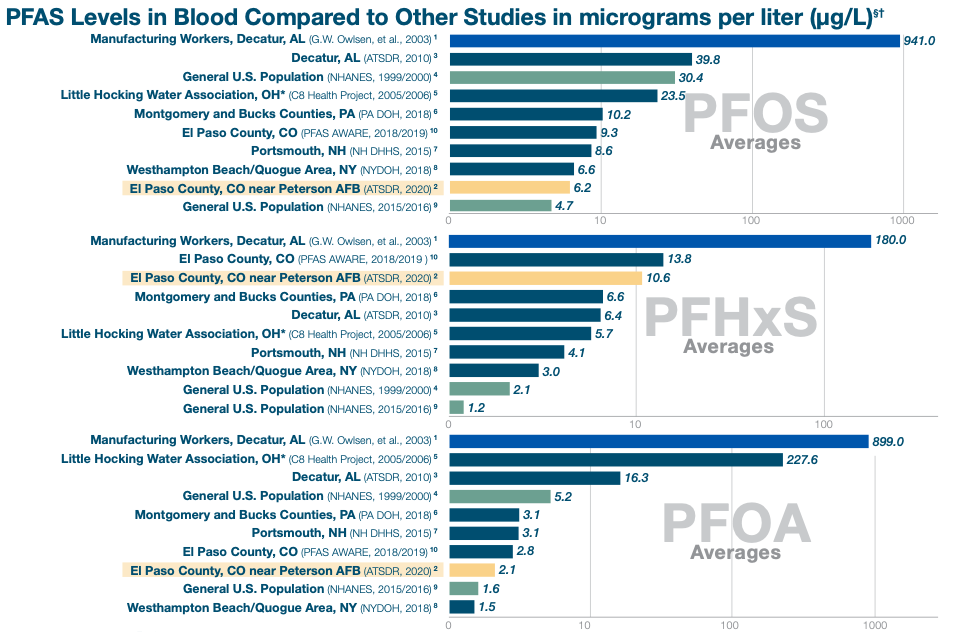
Recruitment for a large-scale study on the health effects of “forever chemicals” will start in the Fountain Valley this month and its results could help set federal limits on the chemicals in drinking water.
The work is part of the second large-scale study in the country to examine exposure to perfluorinated compounds — a family of manmade chemicals that linger in the body and have earned the nickname “forever chemicals” — and the health risks they pose.
The first large-scale study was done 15 years ago in Ohio and West Virginia and found probable links between the chemicals and conditions including high cholesterol, thyroid disease, kidney and testicular cancers, said epidemiology professor Anne Starling, with the University of Colorado.
This study through the Agency for Toxic Substances and Disease Registry is set to investigate health effects of the chemicals including impacts to the immune system, kidneys, liver and thyroid. It will also help determine if the chemicals change neurobehavioral outcomes in children trough tests of their attention, memory and learning abilities. The study was expected to begin last fall but it was delayed by the pandemic, Starling said.
Researchers plan to study 7,000 adults and 2,100 children exposed to perfluorinated compounds across seven states, including 1,000 adults and 300 children 4 and older in the Fountain Valley…
The study will also be the first to include people with high levels of a chemical found in firefighting foam in their blood, Starling said.
Firefighting foam from used by the military at Peterson Air Force Base contaminated the aquifer that residents in Widefield, Security and Fountain used for drinking water, studies have determined. After the contamination was found in 2016, drinking water providers for all three communities worked to ensure the water was safe. Since then, the Air Force has paid $41 million for three new water treatment plants to bring the level of chemicals down to nondetectable levels.
Researchers will take one-time blood and urine samples to help determine how the chemicals may have affected residents’ kidneys, liver and sex hormones, among other bodily functions. It will not examine whether the chemicals cause cancer.
The urine samples will likely be more indicative of forever-chemicals residents have recently been exposed to, Starling said…
The tests and residential histories should allow researchers to estimate the cumulative lifetime exposure residents have had to the chemicals, according to a news release.
The work will also examine the neurobehavioral effect of the chemicals in children because some smaller studies have suggested that exposure to the forever chemicals early in life may affect children’s development and response to vaccines, but the connection is not yet well established, she said.
The researchers plan to have children complete puzzles and problem-solving tasks, similar to activities they might do in school, as part of the study, she said…
The neurobehavioral tests will not diagnose problems in individual children, she said.
The upcoming study expects to build on a recent study of 220 residents in the Fountain Valley that found the median level of a chemical specific to firefighting foam in residents was 10 times higher than the national median. Some residents had levels of the chemical that were much higher, said Colorado School of Mines Professor Christopher Higgins, a lead researcher on the study…
Scientists don’t know whether the chemical specific to the foam is more or less dangerous than other forever chemicals, Starling said.
The levels of chemicals in residents seem to be dropping and that may be good if some of the health effects are reversible. But some people may still be experiencing long-term health effects…
Study participants will receive individual test results that could be shared with their doctor. The test results may not indicate a problem, but more and more doctors are becoming aware of the potential health effects of forever-chemical exposure, Starling said.
In the long-term, the Environmental Protection Agency and the National Academies of Science could use results from this study to help set enforceable limits on water contamination. No federal maximum limits on forever chemical contamination of drinking water exist, she said.
Recruitment for the study is expected to start later this month and researchers have set up an office in Fountain to meet with residents. Data collection could take 12 to 18 months. The entire study could be completed in 2024, although researchers should have results to share before that, Starling said.
Those interested in participating in the study can find more information at http://co-scope.org. Those interested in participating can email coscope@cuanschutz.edu or call (719) 425-8828.
The dry bed of the Arkansas River beneath the Second Street Bridge at Dodge City, Kansas. The barricades and barbed wire are to prevent access from city property, but the river bed is public land. File Photo / Max McCoy via The Kansas Reflector
Out past the 100th meridian things get dry damned quick.
The meridian traditionally marks the line where the west begins and agriculture is difficult without irrigation. You can find it easily on a map of Kansas. Just look for Dodge City, in the lower western third of the state. The meridian runs right through town. There’s a marker at the old railway depot, but the line is really a few blocks to the east. An Eagle Scout named Michael Snapp determined the location, with the help of GPS, and in 2007 planted a 600-pound limestone post to mark the spot. It’s on the south side of Highway 50, between avenues L and M.
The Arkansas River also runs through Dodge City. Or at least it used to. It’s been a dry bed now for decades. If you (carefully!) make your way past the wire and barricades at Wright Park you can see what has become of it. The river is nothing but hard-pack sand and tire tracks, from the four-wheelers that tear up and down the old channel. The Arkansas is one of three legally navigable rivers in the state (the other are the Kaw and the Missouri), but you’d have a hard time getting a boat down it now. It’s a legal absurdity that sums up our state’s complicated relationship to water.
I wrote about this in my book, “Elevations: A Personal Exploration of the Arkansas River,” published by the University Press of Kansas. By following the Arkansas River from its headwaters at the Continental Divide above Leadville, Colorado, all the way to the Oklahoma line below Arkansas City, I learned a few things.
The most important lessons came from experts like Rex Buchanan, the former director of the Kansas Geological Survey, who for years has braved January weather to drop steel tapes down sometimes remote wells to physically measure water levels. Because of volunteers like Rex, Kansas has some of the best statistics available, and they go back decades.
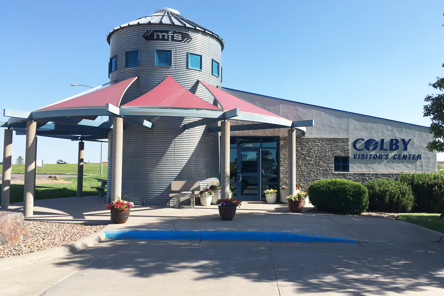
I won’t pretend to speak for Rex — he’s articulate and passionate about water, and is among the state’s foremost advocates for water conservation — but I can say that water levels in the High Plains Aquifer have been going steadily down since the 1950s. The explosion of pumping technology after World War II allowed more, and deeper, water to be pumped than ever before, which was a boon to agriculture. The feeling at mid-century was that the Ogallala Aquifer — a shallow aquifer that runs for hundreds of miles below the 100th meridian, from South Dakota down to the Texas panhandle — would provide an inexhaustible supply of water. Not only does the Ogallala irrigate crops, it also provides water for industry and tap water for municipalities like Colby, along Interstate 70 in northwestern Kansas.
The Visitor Center at Colby, Kansas. Water is supplied to this western Kansas town from deep wells drawing from the Ogallala Aquifer. Kansas Reflector / Max McCoy via The Kansas Reflector
The problem is, the aquifer isn’t a uniform depth. Imagine an egg carton, with some deep pockets and other shallow ones, and you have some idea of the Ogallala. Because the aquifer has to be recharged by rainwater — and because things west of Dodge City are, well, arid — some places are in danger of exhausting the water supply quicker than others. Dodge City and Colby are in two of the most critically depleted parts of the aquifer of all, marked by swaths of angry red on most groundwater maps. Colby is in Thomas County, where the Kansas Geological Survey predicts the water will be depleted in less than 25 years.
I had a friend who flew into Denver recently from back east who asked me if all the circles he saw from the window seat of his airliner were some kind of crop circles or navigation aids. No, I said, that’s pivot irrigation — and it’s killing western Kansas.
Drought has hit areas like Dodge City particularly hard in recent years, because the less rain fills, the more water has to be pumped out of the ground to keep the crops growing. Some local water management districts in the state are taking conservation seriously. There are five such districts across the state, governed by local boards. And some of them — particularly toward the Nebraska line — have a chance of achieving sustainability by reducing usage by 20 or 30%. But for places like Dodge City, where demand is high and rain is slow in coming, it would take hundreds of years for the aquifer to recharge, even if all irrigation stopped today. If we drain it, some scientists say, it might take 6,000 years for it to refill naturally.
Right now, the west is experiencing a severe water crisis, with the Colorado River basin experiencing a historic, extended drought. There’s talk of the New Water Wars, with municipalities vying with farms and industries for tap water. At the same time, the heat wave of late June and early July — driven by climate change — broke records in the Pacific Northwest, with Portland hitting a jaw-dropping 116 degrees Fahrenheit.
In Kansas, we’ve so far escaped the worst of the heat wave, and an unusually wet summer has prevented drought. But we are headed into what is traditionally our hottest period, from late July to early August. The record high temperature for the state was recorded July 24, 1936, at Alton, in north central Kansas, at 121 degrees, according to the National Weather Service.
The dry bed of the Arkansas River near the Santa Fe Trail crossing at Cimarron, Kansas. The Ogallala aquifer groundwater levels in much of western Kansas started dropping in the 1950s as pumping increased, according to the Kansas Geological Survey. File Photo / Max McCoy
While researching my book about the Arkansas River, I was interested in not only the natural landscape, but also the history of how human beings have interacted with the river. What I found was disturbing. Because of irrigation and climate change, much of the river has simply dried up between Garden City and Great Bend. This has resulted in the disappearance of cottonwood trees along the riverbed, the desertification of some areas, the loss of ecosystem, and the destruction of one of the state’s most important natural features. The Arkansas is really two unconnected rivers now, the upper and the lower.
I grew up in southeast Kansas, on the edge of the Ozark Plateau. Like much of the eastern third of the state, it is a wet region, with plenty of rainfall and plenty of creeks and rivers. But out past the 100th meridian — the rainfall curtain — it’s a different and in many ways more fragile world.
Rivers of Kansas map via Geology.com
One of the things I remember most about my meeting with Buchanan, that committed soul who actually goes out and measures water levels, was a map he showed me of the historic rivers and creeks in western Kansas. The waterways looked like veins in a leaf, spreading across the high plains. Then he showed me a recent map, and many of those waterways were simply gone, erased from the landscape.
That was a few years ago. The situation has just gotten worse since.
Sign marking the 100th Meridian West at the train depot at Dodge City, Kansas. The actual meridian is a few blocks to the east. File Photo / Max McCoy
To save what is left of the water in western Kansas, we must change our relationship with water. The history of water rights in Kansas has been a troubled one. Since 1945, Kansas has been a “prior appropriation” state, like most western states, which means the right to use is based on “first in time, first in right.” It’s a property right, clear down to the aquifer. This doctrine places an emphasis on legacy water rights and prioritizes recognized “beneficial” uses, which are economic in nature.
Recognizing the hazard posed by water scarcity, Kansas since 1978 has enacted three novel legal strategies to cope with drought and dwindling resources. The first was the ability of the chief engineer — the state’s chief water administrator, at the Kansas Department of Agriculture — to designate some areas as Intensive Groundwater Use Control Areas. The second, in 1991, was to require conservation plans from some water rights applicants. The third, in 2012, gave communities within IGUCAs the authority to voluntarily create, through a public hearing process, a Local Enhanced Management Area with more restrictions. There are currently five LEMAs in the state, with Wichita County (in far western Kansas) being the newest.
But as Caleb Hall pointed out in a 2017 journal article, such efforts are insufficient to combat increased water depletion caused by climate change. Hall is an environmental attorney, a Kansas City native and a University of Kansas School of Law alum.
“IGUCAs allow established, yet still unsustainable, agricultural practices to continue,” Hall writes, “never questioning if water usage is truly beneficial if it is being applied to thirsty corn.”
If the western water rights model does not voluntarily change now, Hall argues, climate change will force it to do so in the future.
The question at the heart of the problem is what is truly beneficial.
Instead of viewing water as a property right to be exploited for personal profit, we must become guardians of that which remains. Twentieth century technology allowed us to use water at a rate far beyond what was sustainable. Climate change has brought the crisis to a head. Nothing is going to bring back the Arkansas River in western Kansas in our lifetimes, but if we start changing our laws now, we just might be able to save what’s left of the Ogallala Aquifer.
The Ogallala aquifer, also referred to as the High Plains aquifer. Source: National Oceanic and Atmospheric Adminstration
Monument Creek, taken looking south from the northern section of Monument Valley Park via Loraxis
FromThe Tri-Lakes Tribune (Benn Farrel) via The Colorado Springs Gazette:
With limited water resources, the Town of Monument looks to encourage water conservation among residents while the area is experiencing high temperatures in its semi-arid climate and increased water demand.
As the town invests $22 million in improvements to the infrastructure of its water system, an increase in water production and additional storage is in the near future. However, to maintain healthy landscapes around the community, the town is encouraging responsible water practices, implementing water restrictions and has offered tips to efficient water use…
Properties within the service of Triview Metropolitan District are also under restrictions from May 1 through Sept. 30 every year…
Properties which use the Woodmoor Water and Sanitation District are restricted from June 1 to Sept. 30…
Photo from the Colorado Independent.
On May 31, the Town of Monument released an informational video, “Conserving water using rain barrels,” on its YouTube channel, informing residents of their rights to conserve rainwater with rain barrels and how to do it. A few years ago, the State of Colorado legislature passed House Bill 16-1005 which allows single-family residences to collect rainwater in two barrels maximum, each up to 110 gallons, to be used solely for outdoor use and not consumption or indoor use. It also mandates the top of the barrels must be sealed to prevent pests from getting in.
The bill was geared toward helping homeowners offset the use of their irrigation systems for their landscaping.
Residents of the Town of Monument, who use of the town’s water system, are offered a $50 rebate if receipts for the rain barrel purchases are provided and their account with the Monument Water Department is current. The rebate is given in the form of a credit toward the account.
Tips for installing the rain barrels are available on the Town of Monument’s YouTube channel, or by visiting the town’s website, tomgov.org, clicking on the “Community” tab and visiting the Garden & Landscaping page.
Denver Basin Aquifer System graphic credit USGS.
The Triview Metropolitan District is presently making a transition from making use of the non-renewable groundwater from the Denver Basin to renewable surface water. Last year, the district acquired 568-acre feet of water rights and purchased another 1,000-acre feet of water storage in April. Triview acquired nearly 850 acres of land to be used for the development of two large reservoirs which are near completion.
The Fountain Creek Watershed is located along the central front range of Colorado. It is a 927-square mile watershed that drains south into the Arkansas River at Pueblo. The watershed is bordered by the Palmer Divide to the north, Pikes Peak to the west, and a minor divide 20 miles east of Colorado Springs. Map via the Fountain Creek Watershed Flood Control and Greenway District.
Developers have dreams for Fountain that would quadruple the community’s size up to about 40,000 homes.
“It just hit us, that huge number of quadrupling,” Fountain City Manager Scott Trainor said. The requests to build the tens of thousands of homes poured in over the past two years, with many developers wanting to start immediately, he said.
Trainor said the city’s chances of adding more than 30,000 homes are “slim to none,” even with Security and Widefield water and sanitation districts serving about 20% of the city’s land.
The flood of proposals forced Fountain officials to take a step back and look at the critical needs with water at the top of the list. The community currently owns enough water to serve a little more than the equivalent of 1,200 taps and is setting out to find more as part of a water master plan.
The rush to build tens of thousands of new homes in Fountain is indicative of the growth pressure facing the bedroom community that supports Colorado Springs, Fort Carson and Pueblo. Fountain homes have traditionally been more affordable than those in Colorado Springs, in part because the land is cheaper, but the community has not been immune to rising housing construction costs, such as lumber, Trainor said.
If Fountain’s water supply can’t support the growth, developers will have to look for water from other sources and new residents may be pushed out to communities such as Pueblo West…
With current water supplies, Fountain officials said they expect to serve five new developments that will help fill the immediate need for housing…
The city will need to purchase, lease or otherwise secure water to meet additional demands outside of the Fountain and Widefield services areas and it is working on a water master plan to identify those future water sources, Blankenship said. The plan will work to identify water for the next 30 years, he said…
Not all of Fountain is dependent on the city’s water supply because Widefield and Security water and sanitation districts are serving numerous projects. Among them, the Security district may serve a shopping center redeveloping near Highway 85 and Main Street, and the Widefield district may provide water to a new subdivision of 1,180 homes called Corvalis, Trainor said.
Monument is planning to install a new water treatment system in the coming months that will remove radium from one of its wells allowing it to start serving the town again.
The town expects to spend about $1.5 million on the new water treatment system, an associated building and lab space. The work will expand an existing facility at Second Street and Beacon Lite Road, said Tom Tharnish, Monument’s public works director.
Extended exposure to radium, a naturally occurring element and common along the Front Range, can cause cancer and other health problems over time, according to the Environmental Protection Agency…
The problem was discovered in the city’s 9th well about four years ago and no unsafe levels of radium ever reached residents’ taps. Monument’s engineers designed a system that diluted the radium to safe levels, but that proved to be only a temporary fix. The well was shut down late last year while the town worked on a more permanent solution, Tharnish said.
The new filtration system will employ a resin that will filter out the radium at the end of the water treatment process, he said…
The new technology will also come with ongoing maintenance costs. The resin will need to be replaced every year to 18 months and will require between $18,000 to $20,000, Tharnish said…
Monument’s board of trustees approved drilling a 10th well in November to help offset the loss of water from the well that had to be shut off because of radium pollution. The work was expected to cost $624,975. The new well is expected to be in production next week, Tharnish said.
The community is also seeking additional water rights, so that it doesn’t need to rely as heavily on its groundwater, Wilson said.
Those caught in the July 1 rainstorm said it was like weeks of monsoon rains — that came all at once.
Thursday evening’s deluge gave the entire county some much-needed moisture — but it flooded Salida’s main streets several inches deep in places, as the storm sewers couldn’t keep up. Tourists and visitors in downtown Salida scrambled to find shelter from the continuing downpour that began there just before 7:00 p.m., as the slow-moving front hung over the Arkansas River Valley.
The National Weather Service issued flood warnings throughout the area from late afternoon onward. As of 1:00 p.m. Friday, it again issued flood warnings across the Chaffee County area until at least 4:00 p.m. MST. They included the message that the storms have the potential for dangerous and life-threatening situations to develop…
The storm caused the infamous Chalk Creek Canyon “dip” to flow, closing CR 162 and routing residents and camping visitors to the canyon onto the gravelled back route south of Mt. Princeton Hot Springs, where the downpour had flooded parts of that county road as well…
Chaffee County quickly moved from immediate concerns over agricultural ditch water shortages and drought to flooding concerns, especially in the burn scar areas left by the Decker Fire and the Hayden Pass Fire.
While residents of Buena Vista reported much lower rain amounts, more than two inches fell in the Chalk Creek Canyon, with estimates of three to four inches in the southern half of the county…
Muddy torrents are shown above, coursing through the CR 111 flood diversion ditch in Salida. Earlier flows washed over the banks, as evidenced by the pooled waters on either side. Video courtesy of area resident Maureen Parsons.
In other parts of the south end of the county, localized flash floods occurred on the north side of Methodist Mountain. Most flood controls worked but there is damage reported between CR 110-111.
Flooding also appears to have happened up and downstream along the South Arkansas (unconfirmed at press time), which has had little water the past few days…
Residents of the Central Colorado Rockies know that what is called the “summer monsoon flow” is what we depend upon for summer moisture. The storm clouds that boil up over the Sawatch and Sangre de Cristo mountain ranges in mid-afternoon often bring short-lived showers, clearing again in time for evening barbeques.
Strong storms brought heavy rain to Colorado’s Front Range on Thursday, causing flash flooding in some areas with more rain likely on the way.
Many streets in Greeley experienced flash flooding on Thursday afternoon after torrential downpours dropped an estimated 3 to 4 inches of rain in about an hour over the city, according to the National Weather Service (NWS) in Boulder.
Colorado Water Court for the Arkansas River Basin (Division 2) has issued a decree expanding the area within which the Upper Arkansas Water Conservancy District can provide augmentation water. The expansion includes parts of Custer and Fremont counties.
Attorney Kendall Burgemeister reported the news at the June meeting of the Upper Ark District board of directors. The decree is the culmination of a 3-year legal process that required the District to demonstrate its ability to provide replacement water and protect local water rights within the expanded boundary.
District General Manager Terry Scanga said the decree has already spurred several requests for water to replace evaporation from ponds within the new augmentation boundary, or “blue line.”
The Division 2 Engineer’s Office, Colorado Division of Water Resources, recently began evaluating ponds in the Arkansas River Basin for evaporative losses, identifying more than 10,000 ponds with no legal right to divert or store water.
An agency fact sheet describing the new pond management effort states, “For every acre of pond surface area, up to 1 million gallons of water is lost to evaporation each year.”
Under Colorado water law, water lost to evaporation from the ponds in question is injuring water rights owners by depriving them of water to which they are legally entitled.
The significance of these cumulative water losses prompted Division 2 Engineer Bill Tyner to implement the pond management initiative.
Tyner told Aspen Journalism, “Once we put the data together and we could look at the images of ponds and get a count of the number and relative sizes on average of those ponds, it did make us just very sure that this was a problem that could have some very negative consequences for the basin if we didn’t get more aggressive about the way that we took it on.”
Property owners within the new blue line are now seeking augmentation water from the Upper Ark District to avoid having to drain their ponds.
Scanga said the District’s agreements for pond augmentation are “curtailable.” During drought years, the district will stop augmenting ponds, and the pond owners will have to release water, which essentially provides a backup water supply.
Scanga said almost 50 parties filed statements of opposition in the case but that most opposers did not remain active in the case, including Custer County, prompting the judge to dismiss those filings “for lack of participation.”
Once stipulations were agreed upon with the handful of opposers did participate, the blue line decree was issued without the need for a trial.
There are no water restrictions for residents in Pueblo, per Pueblo Water.
The utility released a statement Monday stating that “there are no water restrictions in place” and that “some communities not served by Pueblo Water have implemented water restrictions.”
One community with water restrictions in place is Pueblo West. Residents there are currently on Stage 1 voluntary water restrictions. That only applies to those in Pueblo West — not within the city.
“While everyone should use water as efficiently as possible,” the Pueblo Water release reads, “Pueblo Water does not plan to issue any restrictions this year.”
Three consecutive years largely without monsoons, record-low soil moistures in the fall and below average winter snowpack have set the stage for the giant smoke plumes rising over Colorado this week…
The Sylvan fire was one of seven large fires in the state this year that collectively have burned 26,114 acres as of Friday. The fires put the state way ahead of where it was last year at this time. The Rocky Mountain Area Coordination Center, which helps to coordinate firefighting across five states, upgraded its preparedness level to 3 this week which did not happen until Aug. 7 last year. The level reflects the number of fires and crews needed to fight them, said Larry Helmerick, a spokesman for the agency…
As a potentially dry summer sets in, the state has been split by vastly different fire-danger conditions. Two back-to-back drought years have set the Western Slope up for an early and intense fire season while eastern Colorado made an unexpected recovery with a cold and wet May that has given rise to green slopes. The new, tall grasses could pose their own danger if hot temperatures dry them out in the coming months, experts say.
However, the conditions on the Western Slope and many part of the west are already reaching record drought levels. It’s possible the coming wildfire season could be worse than last year in the extreme conditions, said Jeff Colton, a warning coordination and incident meteorologist for the National Weather Service…
Colorado Drought Monitor map June 22, 2021.
When the monsoon largely failed for the third year in a row on the Western Slope in 2020, the soils hit record low moisture levels and that dry soil soaked up the below average snowfall, hurting runoff, he said. Then last week, high temperatures hit in force with even Aspen hitting 90 degrees, he said. Humidity has also been extremely low, a contributor to fire risk…
Conditions in Colorado Springs
In Colorado Springs, the fire danger is higher than it would be in an average year even though the community is not currently in a drought, Fire Marshal Brett Lacey said.
The tall green grasses that flourished after a wet spring will likely pose a risk as they go dormant or die and dry out during the predicted hot and dry summer, he said.
When the grass catches fire they can produce flame lengths, up to triple the height of their own height, he said…
In eastern Utah the vegetation is starting to disappear, similar to conditions seen in 2012 when the region saw blowing dust.
Much of the groundwater pumped up from the Denver basin in northern and central El Paso County flows down Monument or Fountain creeks, never to be seen again after it’s been used and treated once.
Colorado Springs Utilities, Monument and six groundwater districts want to see that water returned back to homes and businesses to be reused and to help ease the pressure on groundwater.
The groundwater that’s already flowed through showers, sinks and toilets once could potentially be treated and reused twice, and that could help the diminishing aquifer last longer, said Jenny Bishop, a senior project engineer with the water resources group within Colorado Springs Utilities.
Reusing the water could reduce the amount of fresh groundwater that must be pumped annually, limit the need for new wells, give districts more time to pursue additional water rights and make the most of a finite resource, she said. The deeper groundwater in El Paso County is not replenished by rain or other natural sources.
Denver Basin Aquifer System graphic credit USGS.
While Colorado Springs Utilities does not rely on Denver basin groundwater, future water reuse projects identified by an ongoing study involving Monument and the groundwater districts could rely on Utilities infrastructure. In recent years, Utilities has also started to focus more on effective water use across the county.
Utilities “recognizes that long-term water security for the Pikes Peak region depends on the efficient use and reuse of reusable water supplies,” Bishop said.
The Pikes Peak Regional Water Authority Regional Water Reuse Study is going to determine how and where groundwater could be diverted from Monument or Fountain creeks and returned to the water providers. It’s possible the water could be diverted below Colorado Springs and may require new water storage, such as a reservoir or a tank, she said.
Larger projects that could serve multiple water providers, such as Tri-View and Forest Lakes metro districts, are expected to be efficient, Bishop said. The study could also recommend more than one project to recapture water, she said.
Not all of the groundwater that is pumped up from the ground will be available for reuse, because some of it goes into outdoor irrigation, some is used up by thirsty residents, some is lost in the treatment process and some is lost to evaporation in the creeks, among other points of loss. But the water returned to districts could be substantial…
Study participants
The following water providers are participating the water reuse study although not all of them would benefit from groundwater flowing back to be used again. Some are interested in portions of the project like additional water storage
Woodmoor Water and Sanitation District
Town of Monument
Triview Metropolitan District
Forest Lakes Metropolitan District
Cherokee Metropolitan District
Donala Water and Sanitation District
Security Water District
Colorado Springs Utilities…
The $100,000 study to identify the projects that would allow the most water reuse may be finished by the end of the year. The document is expected to project cost estimates for construction and operation of the projects. The work could include new water storage, such as reservoirs.
Funding, permitting and designing the projects is expected to take a few years as well, Bishop said.
This view is from the top of John Martin Dam facing west over the body of the reservoir. The content of the reservoir in this picture was approximately 45,000 acre-feet (March 2014). By Jaywm – Own work, CC BY-SA 4.0, https://commons.wikimedia.org/w/index.php?curid=37682336
The Arkansas Valley Conduit promises to bring clean drinking water to more residents of southeast Colorado
n the 1940s, the Arkansas River was dammed south of town to build [John Martin Reservoir], a place locals call the Sapphire on the Plains. The reservoir was tied up in a 40-year battle until Colorado and Kansas came to an agreement, in 2019, to provide an additional water source to help keep the levels high enough for recreation and to support fish.
Forty years may seem like a long time to develop a plan to save fish and improve water levels for a reservoir, but southeastern Colorado is used to long fights when it comes to water…
Arkansas Valley Conduit map via the Southeastern Colorado Water Conservancy District (Chris Woodka) June 2021.
For nearly a century, leaders in southeastern Colorado have worked on plans to bring clean drinking water to the area through the proposed Arkansas Valley Conduit, but progress on the pipeline project stalled after a major push in the 1960s. Pollution, water transfers and years of worsening drought amid a warming climate continue to build stress for water systems in the area. Adding to that, the area continues to see population decline combined with a struggling economy.
The water needed for the conduit will be sourced from melting snowpack in the Mosquito and Sawatch mountain ranges [ed. and Colorado River Basin]. Under the Fryingpan-Arkansas Project Act, passed in the early 1960s, the water has been allocated for usage in the Lower Arkansas Valley. The water will be stored at Pueblo Reservoir and travel through existing infrastructure to east Pueblo near the airport. From there, the conduit will tie into nearly 230 miles of pipeline to feed water to 40 communities in need.
Renewed plans to build a pipeline to deliver clean drinking water to the Lower Arkansas Valley are bringing hope for many people in southeastern Colorado. But in an area that is inextricably linked to its water, the future can seem unclear…
“Deliver on that promise”
“It was nearly 100 years ago, in the 1930s, that the residents of southeast Colorado recognized that the water quality in the lower valley of the Arkansas River was quite poor,” said Bill Long, president of the Southeastern Colorado Water Conservancy District and a former Bent County commissioner.
Water systems in the district, which includes Pueblo, Crowley, Bent, Prowers, Kiowa and Otero counties, have two main issues affecting drinking water.
The first is that a majority of those systems rely on alluvial groundwater, which can have a high level of dissolved solids. This can include selenium, sulfate, manganese and uranium, which are linked to human health concerns.
Second, the remaining systems in the water district rely on the Dakota-Cheyenne bedrock aquifer that can be affected by naturally occurring radionuclides. Radium and other radionuclides in the underlying geologic rock formation can dissolve into the water table and then be present in drinking water wells, also carrying health risks.
John F. Kennedy at Commemoration of Fryingpan Arkansas Project in Pueblo, circa 1962.
In 1962, residents in southeastern Colorado thought President John F. Kennedy was delivering a solution to their drinking water problem during a ceremony in Pueblo. Congress had passed the Fryingpan-Arkansas Project Act, and Kennedy came to Pueblo to authorize the construction of a pipeline to deliver clean drinking water…
Residents of the 1930s began working on ideas to deliver clean drinking water to southeastern Colorado. By the 1950s, they were selling gold frying pans to raise money to send backers to Washington, D.C., to encourage Congress to pass the Fryingpan-Arkansas Project Act. But it wasn’t until 1962 that the pipeline authorization became a reality.
Fast forward 58 years, and two more politicians came to Pueblo to address a crowd about the same pipeline project. This time, on Oct. 3, 2020, it was at the base of Pueblo Dam. Because of funding shortfalls, the Arkansas Valley Conduit was never built after it was authorized in 1962.
The Colorado communities could not afford to cover 100% of the costs, as initially required, so in 2009, the act was amended to include a 65% federal share and a 35% local cost share. Additionally, in 2020, Congress appropriated $28 million more toward the project, according to the water conservancy district.
That October day, Sens. Michael Bennet and Cory Gardner took turns talking about the importance of the project. They told a small crowd that when the pipeline is built, it will provide clean drinking water to 50,000 residents in southeastern Colorado…
The water conservancy district estimates the pipeline project’s cost will range from $546 million to $610 million…
Physical construction of the pipeline won’t start until 2022, according to the water district…
“The solution to pollution Is dilution”
A hand-painted sign with stenciled letters welcomes travelers on Highway 96 into Olney Springs. The highway cuts across four blocks that make up the width of the small town with around 340 residents.
Olney Springs is one of six water systems in Crowley County that plans to have a delivery point, known as a spur, on the Arkansas Valley Conduit. The plans for the pipeline call for two spurs in Pueblo County, three in both Bent and Prowers counties, and one in Kiowa County. Out of the 40 total participants, the remaining 25 are in Otero County…
Located along the Arkansas River about 70 miles east of Pueblo, La Junta is the largest municipality in Otero County. With its population around 7,000 and a Walmart Supercenter, a Holiday Inn Express and Sonic Drive-In, La Junta can feel like a metropolis when compared to Olney Springs.
La Junta is one of two Arkansas Valley Conduit participants, along with Las Animas, that uses reverse osmosis to remove potentially harmful and naturally occurring toxins from the water. Reverse osmosis is a process that uses pressure to push water through a membrane to remove contaminants. According to the Department of the Interior and the Bureau of Reclamation’s Arkansas Valley Conduit Environmental Impact Statement, reverse osmosis can treat source water to meet standards, but the brine from the process “is an environmental concern, and operation costs are high.”
The other participants use conventional methods to treat water. The environmental impact statement said those methods can be as simple as adding chlorine for disinfection and filtration or adding chemicals to remove suspended solids, but that those treatments “…cannot remove salt or radionuclides from water.”
Tom Seaba, director of water and wastewater for La Junta, said out of a total of 24 water districts in Otero County, 19 were in violation with the state due to elevated levels of radionuclide.
Four of the 19 came into compliance with the state’s drinking water standards after La Junta brought them onto its water system. The remaining 15 are still in violation with the state, according to Seaba.
La Junta spent $18.5 million to build a wastewater treatment plant that came online in 2019 to help meet water standards for its community. But the city’s water treatment came with its own issue: selenium.
After La Junta treats its water using reverse osmosis, the water system is left with a concentrate, which is safe drinking water. However, it’s also left with a waste stream high in selenium. “That wastewater has to go somewhere,” Seaba said. It goes to the city’s new wastewater treatment plant…
According to the environmental impact statement, “La Junta’s wastewater discharge makes up about 1.5% of average annual flow in the Arkansas River.” The study goes on to say that during drought or low-flow events, the wastewater discharge can contribute up to half of the streamflow downstream from the gage.
Seaba is looking to the Arkansas Valley Conduit as a possible answer. “The solution to pollution is dilution,” he said. The water from the pipeline will not have a selenium problem, Seaba explained. By blending water from the conduit with the selenium waste from reverse osmosis, La Junta hopes to reduce costs and stay compliant with Environmental Protection Agency standards to discharge into the river.
The environmental review studied a section of the Arkansas River from where Fountain Creek runs into the river east to the Kansas border. The study found that a section of the river was impaired by selenium…
“I sure don’t drink it”
The EPA sets a maximum contaminant level in drinking water at 5 picocuries per liter of air for combined radium and 30 micrograms per liter for combined uranium. If contaminant levels are above those numbers, the water system is in violation of drinking water regulations, which the state enforces.
According to data provided by the Colorado Department of Public Health and Environment, the Patterson Valley Water Company in Otero County, one of the 40 pipeline participants, had the highest result of 31 picocuries per liter for combined radium in 2020. In that same county, Rocky Ford, another pipeline participant, had a high result of 0.2 picocuries per liter for combined radium. According to the state health department, Rocky Ford’s combined radium sample numbers were last recorded in 2013.
Manzanola, also in Otero County and a pipeline participant, topped the list with the highest result of 42 micrograms per liter for combined uranium in 2020. In contrast, 19 other pipeline participants, from across the valley, had results of 0 micrograms per liter for combined uranium, according to the most recent numbers from the state health department.
Levels of the two carcinogens are sporadic throughout the valley. The average of the highest results of all 40 participants in the pipeline for combined radium is roughly 8 picocuries per liter and combined uranium is roughly 5 micrograms per liter. According to Seaba, averaging the members’ highest results might seem unfair to some individual water systems because it brings their numbers up, but what those averages do show is that water in Pueblo Reservoir, which will feed the future conduit, is approximately three times less affected by combined radium and combined uranium than the average of current water used by pipeline participants. In 2020, the highest result of combined radium in the Pueblo Reservoir was 2.52 picocuries per liter, and the highest result of combined uranium was 1.7 micrograms per liter…
“I sure don’t drink it,” said Manny Rodriquez. “I don’t think anybody in town drinks the water.”
Rodriquez, who grew up in and still lives in Rocky Ford, was not sure if the water at his apartment was in violation of the state’s clean drinking water act or not. State data showed at that time his water was not in violation. Colorado is required to notify residents if their water system is in violation of the clean drinking water act…
MaryAnn Nason, a spokesperson for the Colorado Department of Public Health and Environment, used an example to show how violations can add up: “If a public water system has two entry points that fail for both combined radium and gross alpha (measures of radionuclides), and they have those same violations for 10 years each quarter, that is going to appear as 160 violations on the website. But really, it is one naturally occurring situation that exists for a relatively long time,” Nason said.
For some residents like Ruby Lucero, 83, it makes little difference to her if her water is in violation with the state or not. She plans to buy her drinking water no matter what the results say about her tap water…
Straight line diagram of the Lower Arkansas Valley ditches via Headwaters
“The struggling farmer”
In the past decade, Otero County has seen a 2.9% drop in population. Residents have a ballpark difference of $38,000 in the median household income compared to the rest of the state, and the county is not alone. All six counties that are part of current plans for the Arkansas Valley Conduit are seeing economic hard times.
Adding to those factors is drought. Years of drought keep hitting the area’s No. 1 industry: agriculture.
The Rocky Ford Ditch’s water rights date back to 1874, making them some of the most senior water rights in the Arkansas River system. In the early 1980s, Aurora was able to buy a majority of those water rights. Over time, Aurora acquired more shares and has converted them to municipal use…
“We still have a heavy lift before us”
Planned off the main trunk of the Arkansas Valley Conduit, a pump station near Wiley will push water along a spur to support Eads in Kiowa County. Water that ends up in Eads will have traveled the longest distance of the pipeline project. The majority of the pipeline will be gravity-fed, but this section will need to be pumped uphill.
The journey is a good representation of Eads’ battle with water. Not only is clean drinking water needed, but the area is also desperate for relief from years of drought exacerbated by climate change…
Long said that Eads is different from a majority of the other participants in the project because it is not located along the Arkansas River…
The domestic water that will be delivered via the conduit is even more important for a town like Eads, said Long. “It’s very difficult to attract new industry when you have a limited supply of very poor water.”
Long believes the conduit will make a huge difference to support communities in the Lower Arkansas River Valley…
Long has been working on the Arkansas Valley Conduit project for nearly 18 years.
“After such a long fight, to finally be where we are feels good, but honestly I can say it doesn’t feel as good as I thought it would. Only because I know we have so much work still to do, and I know how difficult the past 18 years have been,” Long said. “We still have a heavy lift before us.”
Arkansas River Basin via The Encyclopedia of Earth
The city of Colorado Springs posted a request for proposals (RFP) on June 3 for Flying Horse Pond 1 Retrofit, a detention pond noted as a potential violation of the Clean Water Act in the lawsuit filed by the Environmental Protection Agency against the city in 2016.
Deadline for proposals is July 8.
The EPA lawsuit has since been settled, and the city is expected to pay up to $45 million for additional projects to satisfy the EPA and the Colorado Department of Public Health & Environment. City Council raised stormwater rates, which kick in on July 1, to fund the settlement.
The scope of work for the Flying Horse pond is stated this way in the RFP: “Reconstruct existing detention pond with new concrete facilities that include sediment forebays and outlet structure. Construct soil rip rap trickle channels and overflow spillway, maintenance/access roads, MSE retaining walls, boulder lined permanent aesthetic pond and extensive riparian and upland plantings.”
[…]
But how much is this project costing and who’s paying for it?
Stormwater manager Rich Mulledy says via email that this pond project cited in the RFP is, indeed, the same pond referenced in the lawsuit.
The budget for the project is $2,541,419, he says. Design will cost $284,878 and the construction costs are estimated at $2,256,541.
But the city’s Stormwater Enterprise will pay for only the design. Construction is being picked up by a grant the city received, he says.
“The developer is not responsible to contribute for several reasons,” Mulledy says.
“First, the City reviewed and accepted the facility as designed and constructed when it was built. The City believed then and believes now that the facility was designed and constructed correctly and in compliance with our criteria at the time,” he says.
Mulledy emphasizes that the pond issue wasn’t ever ruled upon by the court as to whether it, in fact, was a water quality regulation violation.
The city settled the case before that happened.
Mulledy continued, “The main reasons we are reconstructing the facility are to make it easier to maintain and to eliminate any potential water rights issues with the permanent pool of water. We are also redesigning the facility to accept future flows from the Powers Blvd. extension.”
Stormwater fees generate $16 million to $17 million a year, which will grow by several million dollars through the rate hike set by a Feb. 23 City Council vote that takes effect next month.
Residential rates will rise to $7 this year, $7.50 next year and $8 in 2023, a cumulative increase of 60 percent. Non-residential rates will increase to $40.50 per acre this year, $43 in 2022 and $45 in 2023, an overall hike of 50 percent.
Colorado Springs with the Front Range in background. Photo credit Wikipedia.
FromThe Fort Carson Mountaineer (Susan C. Galentine):
Colorado Springs Utilities, with approval by the City of Colorado Springs, launched new water-wise rules last year to encourage the efficient use of water in the community.
The rules align with other Colorado municipalities in conserving water during irrigation season every year, not just during drought conditions. These practices are considered foundational to water use efficiency programs in Colorado to conserve limited resources.
Springs Utilities is focusing on water-wise rules education and resources to help customers have healthy landscapes while being water wise.
The impact of the new program on Fort Carson residential water users depends on where people live.
Fort Carson Family Homes, as a large-water user, will operate under a water allocation plan for managed irrigation areas within housing, said Victor Rodriguez, utility manager, DPW. On-post housing residents may water up to three days a week of their choosing to comply with Springs Utilities guidance.
Off-post Springs Utilities residential water customers will be required to follow the water-wise rules outlined below.
Six key customer rules to new water-wise rules:
Customers can water up to three days a week on days of their choice.
In warmer weather, from May 1 to Oct. 15, run sprinklers before 10 a.m. or after 6 p.m. to reduce evaporation.
Do not let water pool on hard surfaces or flow down gutters.
Repair leaking sprinkler systems within 10 days.
Use a shut-off nozzle when washing anything with a hose.
Clean hard surfaces (such as driveways, sidewalks and patios) with water only if there is a public health or safety concern.
From the Town of Buena Vista via The Ark Valley Voice:
On Monday, June 21, the first day of summer, the town of Buena Vista implemented voluntary water restrictions, reminding residents that “this year, summer water usage is critical and it is drier than usual this year.”
After months of drought conditions in Colorado, it is more important than ever to use water efficiently. The town is asking residents to abide by the following outside water tips to help reduce the risk of additional water restrictions by following voluntary summer watering rules now.
The town’s MAKE EVERY DROP COUNT Voluntary Restrictions:
Water during cooler times of the day — either early morning and evening
Do not water lawns between 10:00 a.m. and 6:00 p.m.
Water no more than three days per week
Do not allow water to pool in gutters, streets, and alleys
Do not allow water to spray on concrete and asphalt
Do not irrigate while it’s raining or during high winds
Use a hose with a shut-off valve when washing your car
Adjust your sprinklers for maximum efficiency and repair any leaks
Install soil moisture and water sensors
Add mulch around plants and trees to hold moisture at the root level.
Buena Vista is also offering these best practices and tips for efficient outdoor water use. A good way to keep a water schedule is to water on the following days:
Odd number addresses: Tuesday—Thursday—Saturday
Even number addresses: Wednesday—Friday—Sunday
The Water-rest-water Routine that Maximizes Water Effectiveness
To maximize efficiency and allow the soil the time to soak up water, add multiple start times and reduce each zone’s watering time. For example, for a 14-minute run time, irrigate one zone for 7 minutes, then turn it off while another zone is irrigated, then irrigate the first zone again for 7 minutes to achieve the total 14 minute run time.
A reminder that if you water during the heat of the day, you may lose up to 50 percent of the water to evaporation, which is simply a waste of water.
Those with questions should call Public Works at 719-395-6898.
I spent runoff season this year chasing whitewater along the spine of the Rockies, where the impacts of a long-range megadrought feel increasingly painful and obvious. More than half of the western United States is currently experiencing extreme drought, according to the U.S. Drought Monitor, and it’s rapidly getting worse.
Although the Mountain West’s high-country snowpack—the source of water for a wide swath of land on both sides of the Continental Divide—was around 80 percent of its average this winter, the past 12 months have been among the hottest and driest on record there. As the snow melted, runoff was soaked up by parched soils, which are still dry from last year’s monsoon-free summer and fire-filled fall. When it’s as hot as it has been, every living thing needs more water, so plants sucked in moisture, too. In the same area of the mountains where the snow was 80 percent, river flows dripped out at 30 percent of their average. Ted was right: there’s not much water when there’s this level of aridity.
Paddling, for me, is a benchmark, a tangible way to understand what all those drought maps and numbers mean. And these days, the bottom-scraping springtime runs feel like a creepy indicator of how bad things will be downriver, where those waterways are used to grow food, maintain ecosystems, fight wildfires, and provide drinking water. I paddled Westwater Canyon on the Colorado River in Utah while it was running at one-tenth of its average flow, and I checked in on the dam-released drip formerly known as the Dolores River—a sight that made my stomach drop. On the other side of the Divide, I took a turgid run down Browns Canyon on Colorado’s Arkansas River—the most heavily commercially rafted section of river in the nation—and winced watching the guides trying to keep their clients paddling through the slack water, which was flowing well below the midsummer dam-released minimum of 700 cubic feet per second. It’s the scariest year I’ve ever been a river runner, and I’m not alone in thinking that…
“I’m nervous looking forward. It’s wishful thinking to assume it will get better,” says Eric Kuhn, former general manager of the Colorado River District and coauthor of Science be Dammed. Kuhn has worked in water management for decades and believes the way we’re currently managing rivers isn’t sustainable and hasn’t been for a while. It’s coming to an inflection point where things will really have to change.
The signs (like dry rivers) and symptoms (the wave of early-season fires) are cascading on top of each other. In 2019, I wrote a book called Downriver about water policy with a subtitle that now feels painfully flippant: “Into the future of water in the West.” That was two years ago. Now the future is here—hotter, drier, sooner than predicted, and scarier than imagined.
By June 1, snowpack in the Sierra Nevada was at zero percent of its average, and California’s governor had declared a drought emergency in two-thirds of the state’s counties. After a record-breaking fire year in 2020, wildfire risks were already high, and the state’s agriculture industry, which supplies a huge amount of the country’s veggies, fruits, and nuts, was facing shortages and cutting crops to compensate. In Oregon, fragile, threatened salmon are dying because streams and lakes are drying up. Wide swaths of northern New England and the upper Midwest are abnormally dry. Even Hawaii is at elevated risk for wildfires.
In the Colorado River Basin—a bellwether for dryland watersheds because it’s crucial to millions of people and drying fast—the two big reservoirs in the system, Lake Powell and Lake Mead, are crashing toward their lowest levels ever and approaching elevations that will trigger the first-ever federally mandated usage cutbacks. In other words, states, starting with Arizona, will have to start taking less from reservoirs than they’ve historically been legally promised.
A few glaring reasons indicate why we’re at this tipping point. The first is that we’re not operating within our limits. The Colorado River, for example, has been overallocated since the Colorado River Compact was signed in 1922. The agreement, often referred to as the law of the river, gave the seven states in the basin more water than exists in the river. Brad Udall, senior water and climate-research scientist at Colorado State University, found that we’ve been using 1.2 million acre-feet of water more than the river’s natural flow each year, which is one of the reasons why the reservoirs are plummeting. We’re also continuing to build rampantly in dry places and depleting groundwater as we do.
And we’re ignoring scientific limits and increasing demand while climate change is shrinking our supply even further. “This is the new baseline, and there’s no more water left in the system,” Kuhn says. According to a 2017 report coauthored by Udall, we can attribute at least half of the decline in water supply to greenhouse-gas-related warming. For every one degree Celsius of warming, he expects another 9 percent decline in the Colorado’s flow, and similar patterns are showing up in rivers globally.
We know that the supply is shrinking, and now the huge, complicated challenge is changing the way we operate within those limits. Kuhn believes that Mead and Powell are test cases for whether we can adapt to climate change, and what the realities are of doing that. He points out that we can’t call these climatic conditions a drought anymore, because that implies it will end. Years are variable, and snowpack, rainfall, and temperatures oscillate, but we have to look at the science and assume that the hot, dry trends we’re seeing will continue—and continue to get worse.
And then we have to get realistic about cutbacks. Demands have to shrink along with supply.
Part of that is reliant on state, tribal, and federal water managers, who are responsible for allocation. Right now on the Colorado River, those entities are renegotiating what are called interim guidelines, which outline the water levels that trigger those planned cutbacks and delineate which places have to sacrifice water first. Last year a voluntary set of shortages, called the Drought Contingency Plan, was put in place as a stopgap to keep the river from spiraling into crisis.
As the water managers come up with the next set of guidelines, which are slated to go into place in 2026, they’ll have to be much stricter, while also trying to be equitable. It’s going to be extremely difficult, because these decisions are tangled up in states’ rights, environmental equity, and philosophies about growth. Kuhn says he hopes desperation might drive more concession and collaboration than there’s been before. As those negotiations and cutbacks happen on the Colorado—which brings water to 40 million people in the western U.S.—they can be a template for other rivers and other dry places that are facing similar conditions.
To prevent waste and avoid sparking an interstate legal battle, Colorado has started cracking down on what may seem like a drop in the proverbial bucket — illegal ponds.
Martin Mendine recently found himself in the state’s crosshairs. His family ranch is a wide, grassy expanse near southern Colorado’s Spanish Peaks. A fork of the Purgatory River meanders through the land which supports about a hundred cattle, and herds of elk. Migratory sandhill cranes pass through each year…
It’s wet enough to support all this life in part because of a cascade of five small ponds, held in place by dams made of dirt. The ponds are more than 80 years old, Mendine said. They were built when his grandfather tended the ranch.
“So we’ve been running this water now for, you know, damn near (a) century and they’re telling me I can’t use it,” Mendine said…
He got a notice in the mail recently telling him the ponds have been identified as potentially illegal. It said the storage rights needed to create and sustain the ponds don’t exist. To be compliant, he either needs to drain them or come up with a state-approved plan to fill them from a different water source or replace any losses from evaporation…
“Our basin has been over-appropriated for a long period of time,” said Bill Tyner, Colorado’s division engineer for the Arkansas River basin, where Mendine’s ranch is located. The Purgatory River is a tributary to the Arkansas, and runs across an arid stretch of southeastern Colorado…
Using satellite imagery to build an inventory of human-made ponds in the basin, and then cross-referencing with water rights on the books, the state has identified about 10,000 illegal ponds just in the Arkansas basin, Tyner said. He likens it to a string of pearls. Each individual pearl isn’t that costly or consequential on its own. But when pulled together in a line, it’s highly valuable…
His office is now in the midst of a systematic review of all ponds in the Arkansas basin. Using the satellite data, water commissioners, the people who enforce water law on the ground, have been following up with pond owners, letting them know they’ve ended up on a list of potentially illegal ponds, and laying out their options to make them legal…
The ponds in question encompass everything from pools for livestock watering to decorative fountains in business parks to duck ponds scattered across the grounds of a mountainous mansion.
It’s not just the Arkansas basin that’s seeing increased enforcement. State officials have pursued illegal ponds in the upper reaches of the Colorado River basin as well.
The problem with ponds, Tyner said, is evaporation. Water in a shallow pond evaporates more than when it’s flowing through a narrow stream. The state views evaporated water as wasted water…
Without money or access to new water supplies, a landowner’s options to make their ponds legal are limited. There are some exceptions for ponds used for erosion control or livestock watering, but they’re limited in scope. And because the Arkansas basin is one of the most over-appropriated in the state, there’s very little excess water to tap into…
A recent dispute over ponds went to the Colorado Supreme Court last year, where the state prevailed. The ponds in question aren’t allowed to be filled, and the owner was ordered to pay $92,000 in civil penalties, plus attorney’s fees. Machado’s takeaway from that ruling?
“Once the state finds an illegal pond and says you need to drain it, you better do it,” he said.
Arkansas River headwaters. Photo: Brent Gardner-Smith/Aspen Journalism
FromColorado Public Radio (Michael Elizabeth Sakas):
Colorado Springs is one of the fastest growing regions in the state. Homes are getting more expensive and harder to buy. The boom is expanding into nearby cities — and the pressure is building…
There are currently fewer than 9,000 taps, or connections, to Fountain’s water supply. Over the last year, Blankenship said developers have applied for nearly 30,000 new taps to the city’s water system.
[Dan] Blankenship is telling developers, Fountain is tapped out…
To support that many new taps, the city would need to buy additional rights to use more water. They would also need a place to store that water, and the city would need to treat it and find a way to get it to homes.
Summary of Observed Wet & Dry Surface Water Hydrology via SCW
That’s getting harder to make happen in a state like Colorado, where most of the people live on the Front Range but most of the water is on the Western Slope.
Where the city of Fountain gets its water from
Fountain gets most of its water from the Pueblo Reservoir, which is filled with water that would otherwise end up in the Colorado River. The reservoir project was built in the 1970s. It’s unlikely the city would be able to build something similar today, Blankenship said. It’s a lot tougher to do that now, just because of the environmental concerns…
Smith said it’s becoming more common for developers to have to secure water rights and pay for additional water infrastructure if they want to build a big project.
But he said the situation in Fountain is unusual…
Fountain hasn’t finalized any plans yet, but they say developers are going to need to help pay the millions of dollars to buy those new water rights, reservoirs, and pipes needed to support that kind of growth. Blankenship, Fountain’s utility director, said instead of the city paying for that upfront, he wants to shift that cost to developers…
No matter how a developer might have to secure water for a new project, the cost will get rolled into the price of a new home, said Kevin Walker, with the housing and building association in Colorado Springs…
Kevin Reidy, a senior water conservation specialist with the Colorado Water Conservation Board, said other water utilities are also worried about how to keep up with growth. Fountain is just the first to talk so openly about the issue…
A big part of Reidy’s job is to get water and land planners to work together, which he said have been too siloed. Reidy helps host training events to get water and land people in the same room to talk about these issues.
“I think we’re kind of hitting that point where people are kind of saying, ‘Okay wow, we’ve got to do things differently,’” Reidy said.
For Fountain, that means telling developers this town doesn’t have the water you need. If you want to build here, you’ll have to bring your own.
Click here for all the inside skinny and to register:
Join us June 11 or 12 along Cottonwood Creek for the inaugural Urban Water Cycle Bike Tour in Colorado Springs!
Join us for a fun, free regional bike tour along Cottonwood Creek in Colorado Springs. This tour will connect community members to local water and recreation resources through an approximately 9-mile (mostly downhill) ride.
Both tour days start at Frank Costello Park, with a short ride to Cowpoke Flood Detention and Development. You will then ride downhill all the way to a creek restoration site on Monument Creek. With a short ride back uphill, you will end at Crit Cafe for our final speakers, networking and refreshments on your own.
Tour topics include:
What are the Cottonwood Creek, Fountain Creek, and Arkansas River watersheds?
Why water quality is important? What is stormwater? What is point source and nonpoint source pollution?
How is Colorado Springs conserving water and planning for its future water supply?
How are community partners connecting neighborhoods to trails and creeks?
How can maintaining pipes allow us to restore creeks?
How do we ensure our water is clean and safe?
How can you protect stream health?
We thank our supporters at Colorado Department of Public Health & Environment, Colorado Springs Utilities, El Pomar Foundation, and Fountain Creek Watershed District. In addition, our partners at the Trails and Open Space Coalition and the City of Colorado Springs Stormwater Enterprise (SWENT) and Parks, Recreation, and Cultural Services made this tour possible. We look forward to a fun and educational day along Cottonwood Creek!
FromKRCC (Shanna Lewis) via Colorado Public Radio:
Pueblo is remembering the victims of the flood that devastated the city a century ago. And on June 3, exactly 100 years later, celebrating its newly rebuilt Arkansas River levee.
The original flood control structure was constructed after the deadly 1921 deluge. Repairs to bring the 2.8-mile long levee up to current FEMA standards began in 2014 and cost some $25 million…
The top of the levee now sports a walking trail, and a million-dollar pedestrian suspension bridge connects the trail to the bike path on the other side of the river.
Grants from the Colorado Department of Transportation and Department of Local Affairs paid for the bridge. Leaf-shaped shade structures, benches and bike racks will be added to the trail later this year.
It’s all part of a larger recreation plan that includes a second bridge, upgrades to the existing whitewater park and better access to the river from various neighborhoods.
Along with flood protection and outdoor fun, there’s also a cultural aspect to the levee. Artists covered the old concrete facing of the levee with huge murals over the years, like a giant outdoor art gallery…
The Pueblo Downtown Association and Pueblo Arts Alliance are hosting a celebration of the new levee on Saturday, June 5, from 9 a.m. to 1 p.m. Activities will include a walk on the levee, actors telling the story of the 1921 flood and group drone photos on the new bridge.
May in Pueblo brought nearly five inches of rain to the county, marking the month as the third wettest May in the region’s history, and also colder than average.
Only May 2015, where 5.5 inches of rainfall was recorded, and May 1957, when 5.43 inches of rainfall was recorded, beat the nearly five inches of rainfall in May 2021.
On May 25th, most of the eastern plains and eastern mountainous region of Colorado have been declared drought-free, defying forecasts from earlier in the year that predicted low precipitation amounts throughout the spring, leading to further drought levels in the summer.
Colorado Drought Monitor map June 1, 2021.
In fact, drought levels west of the Continental Divide remain in extreme and exceptional levels, while east of the Divide has shifted the opposite direction. The shift is dramatic, as severe to extreme drought levels have persisted since August 2019…
Pueblo averages about 1.6 inches of rainfall in May, [Tony] Anderson explained, and the area received about 4.95 inches this May. The trend was similar across the region, with areas like Colorado Springs recording almost double rainfall amounts from the averages used by the National Weather Service.
Anderson called the drought clearing “remarkable,” but also expressed concerns that the area could still have a poor water year…
He also noted that reservoir levels are part of the bad news in this “good news/bad news year.” He said the Arkansas river reservoirs are on average about 80% full, and reservoirs in the Rio Grande are averaging about 67%. “So there’s a lot of storage to fill up going into next year,” he said…
Anderson explained that the split of drought and non-drought levels in Colorado resulted from storms rising from the east and dropping precipitation as it hit the mountains, instead of the standard Colorado weather pattern of storms approaching from the west.
Todd Ballard, an agronomy extension agent with Colorado State University who works in Sedgwick County, noted in a recent column that the above average rainfall could be a boon for the state’s eastern agricultural businesses.
Over three days in June 1921, Pueblo experienced a natural disaster that forever changed the course of its history.
Even a century later, the effects of the Great Flood of 1921 can be seen throughout the Home of Heroes, particularly in the city’s infrastructure and economy, which were completely transformed by the devastating flood and Pueblo’s decades-long recovery.
Many Pueblo natives know most of the city’s seminal story by heart: a cloudburst brought heavy rains to the area on June 2, causing the Arkansas River – which was already prone to seasonal flooding – to swell. More intense rain on June 3 caused the Arkansas River to overflow Pueblo’s levee at just more than 18 feet and envelope downtown Pueblo in water.
By midnight on June 4, according to the Colorado Encyclopedia, the flooding peaked at more than 241 2 feet. The im- mense volume was enough to break levees in several spots and it took only two hours for Pueblo’s entire business district to become submerged.
Men stand outside the Union Depot in Pueblo (Pueblo County), Colorado. One man wears a badge. Shows water, mud and debris on the ground, and a flood damaged passenger car wrecked beside the stone depot. Probably a cleaning crew works on mud covered tracks nearby June 1921. Photo credit: Denver Public Library Special Collections
Damage from the flood, most of which occurred on the second day when both the Arkansas River and Fountain Creek overran their banks, was unimaginable. The flood inundated 300 square miles. More than 500 homes were carried away in the floodwaters along with 98 businesses or industrial buildings, 61 stores, 46 locomotives and more than 1,200 railroad cars. A local lumberyard caught fire; burning lumber was sent floating down flooded city streets. Telephone lines were destroyed, and corpses of cows, horses and other livestock littered the valley. A 1921 report on the flood by the United States Geological Survey estimated the total property damage to be more than $19 million. Adjusted for inflation, that equates to more than $280 million today. Other estimates go as high as $25 million in damage, or nearly $373 million today. The death toll was also catastrophic, though there’s no universally accepted total. Estimates range from fewer than 100 deaths to more than 1,500. The USGS report said 78 bodies were recovered in the aftermath, which is likely a fraction of the actual lives lost. Many bodies washed downstream and were either recovered months later or never found. And many of the dead were poor immigrants, making their absence more difficult for authorities to detect. But even after the water receded, mud and debris had been removed from city streets and the recovered dead were buried, the impacts of the flood on Pueblo were just beginning.
View of damage from the Arkansas River flood at the Union Depot rail yard in Pueblo (Pueblo County), Colorado. Denver and Rio Grande Western passenger cars are near the passenger platform. Damaged cars are turned over and logs and lumber is scattered across the rail yard June 6, 1921. Photo credit: Denver Public Library Special Collections
A recovery with dire consequences
In the aftermath of the flood, it became apparent that Pueblo’s infrastructure was not sufficient to prevent another devas- tating flood event. The city needed a new, larger river channel to ensure that when the Arkansas swelled from spring rains and Rocky Mountain snowmelt, it could not cause such destruction again. Legislation was passed at the Colorado Capitol to create the Pueblo Conservancy District, which set about building a new channel to divert the river away from Downtown Pueblo. “When it was set up years ago, the conservancy district had to move the river to its current location,” said Corinne Koehler, the current president of the Pueblo Conservancy District.
“Back then, that’s where a lot of the train tracks were, so they had to tear up and move the train tracks, they had to rebuild bridges, it was a multi-faceted project. It wasn’t just putting up a levee, they had to redo roads, bridges, anything that was destroyed that would have been crossing over the Arkansas River.” The levee was completed ahead of schedule in March 1926. And although its completion was a breath of relief for Pueblo in terms of preventing future floods, the creation of the conservancy district came with dire conse- quences to the Pueblo economy.
Peggy Willcox, a researcher with the Pueblo County Historical Society who helped write a recently published book about the flood entitled, ‘Mad River,’ said the district’s creation was a necessity following the flood, but the legislation enacted had major drawbacks for Pueblo.
“In order to create the conservancy district to pay for the flood control, they had to get the legislature to approve it,” Willcox said.
“Well the northern counties, some of them had been wanting a tunnel west from Denver ever since (Gen. William Jackson Palmer) built the (Denver & Rio Grande Western Railroad), because there was no viable way to ship goods from Denver west on the D& RG.” Prior to that time, every train going west had to come through Pueblo. So northern Colorado counties, particularly in the Denver area, sought to bypass Pueblo by building a tunnel that could ship freight or passenger trains directly west.
West Portal Moffat Tunnel.
To get its conservancy district, Pueblo would have to approve the construction of the Moffat Tunnel – a railroad and water tunnel that cuts through the Continental Divide. It officially opened in 1928.
“They held Pueblo hostage,” Koehler said, “And said, ‘If you want a conservancy district and a levee, you have to vote for the Moffat Tunnel.” The creation of the Moffat Tunnel was the beginning of the end of Pueblo’s prominence as a railroad hub…
Aerial view of the flooded Arkansas River in Pueblo (Pueblo County), Colorado. Shows freight cars at the washed out Missouri Pacific Railway Company yard, railroad bridges over the river and the Nuckolls Packing Company building beside standing water. Photo credit: Denver Public Library Special Collections
Economic impacts in the aftermath of Pueblo’s great flood
Pueblo’s eventual fall from grace as Colorado’s primary railroad hub was far from the only way the flood devastated the city’s economy. In the days immediately following June 5, many businesses were severely damaged and closed their doors, some forever. “After the flood there were industries that never reopened,” Willcox said. “Pueblo was then the smelter capital of the world, that’s what they called it, and there were only two smelters left and both of them were severely damaged by the flood and never really reopened. ‘So that was a large number of jobs.” Not long after the flood, Willcox said, the CF& I steel mill shut down for several months due to a shortage of raw supplies as well as a lack of railroad access, as the flood heavily damaged lo- cal rails. Several smaller manufactories in flooded areas closed. Many of those that eventually reopened did so in cities outside of Pueblo where there were more workers and easier access to rail transporta- tion. But the bigger impact, Willcox said, was how the flood seemed to dry up investments from out-ofstate capitalists, which were common prior to 1921. “That money kind of dried up after the flood,” Willcox said. “The investment from outside of Pueblo diminished greatly.”
There was a decades-long recovery effort in Pueblo after the flood
With some of its most prominent economic drivers devastated by the flood, Willcox said Pueblo’s economy seemed to become more one-di- mensional. “It’s not so much that Pueblo never recovered, it’s that it never recovered the growth rate that it had prior to the flood,” Willcox said. “When you look at the city’s population and the number of industries that were here prior to the flood Pueblo was a manufacturing center it was really a diverse group of manufactories. “And then after the flood some of them never came back but some of them were no longer as prevalent in the market as they had been and eventually died out. So I think, anecdotally, we became more dependent on the steel mill because of that.” Jonathan Rees, a history professor at Colorado State University Pueblo who has researched the flood extensively, said one of the biggest impacts of the flood was the opportunity cost Pueblo paid in the years that fol- lowed. “There’s the cost of rebuilding the town, there is the economic damage caused by the lost business but there’s also a cost as to what doesn’t happen because Pueblo has to spend so much time rebuilding from the flood,” Rees said. “Different things could have happened to Pueblo but didn’t because we were too busy trying to prevent future disasters.” In the 1920s, the United States economy was seeing one of its strongest periods of prosperity. But while other communities were able to leverage those desirable economic factors for improvement, Pueblo was stuck rebuilding. “You’re investing in the future in the sense that you’re trying to prevent future floods, but you’re not growing businesses, you’re not helping businesses that might not have been able to reopen, you’re not doing the kinds of things that cities that aren’t effected by the flood are doing at the same time,” Rees said.
“So when America is roaring, Pueblo isn’t.” After the Great Depression came the New Deal, and Rees said although Pueblo did benefit some from the New Deal, it likely would have had a greater effect on Pueblo and its growth if flood recovery efforts were not still taking place. As Pueblo struggled, its neighbor to the north, Colorado Springs, was put in a position to pros- per. “I would simply imagine that any program that came to Colorado Springs between 1921 and 1965, could have come to Pueblo under different circum- stances,” Rees said. “It’s safe to say that before World War II we were a much bigger place. We have certain advantages over Colorado Springs like our steady supply of water. However, we are engaged in rebuilding the entire downtown for a very long time.” Rees said that rebuilding Pueblo and redesigning its infrastructure was a necessary endeavor, but one that set Pueblo’s development back years, if not decades.
“While we’re doing that to guarantee our future existence, other places are taking advantage of good economic times or government programs in bad economic times to help become bigger and more economically active than they had before,” Rees said.
“And Pueblo was essentially holding in place for most of the 20th century.”
View of a flood on Fountain Creek in Pueblo (Pueblo County), Colorado. Shows a washed out railroad bridge partly buried in mud and silt in the creek. A Denver and Rio Grande Western train is beside the creek in the distance. June 1921. Photo credit: Denver Public Library Special Collections
When it came to covering the flood of June 3, 1921, The Colorado Daily Chieftain, also known as The Pueblo Chieftain, went to extraordinary measures to keep the citizens of Pueblo informed as news of the devastation unfolded. It all started with a Saturday, June 4, 1921, special edition emblazoned with the all-caps headline, “FLOOD EXTRA.” The two-page special edition had no photographs and no advertisements. It even had empty space at the bottom of the second page, a testament to how hastily it was put together. A June 9 edition of the Chieftain reported, “it was utterly impossible” to print regular editions of the paper, “because of the failure of electric power and gas,” and the editor promised to republish the extra editions “when regular conditions are restored.” That first extra edition was chock full of stories about “The largest flood visiting Pueblo since Decoration Day 1894,” which “gutted the business and wholesale business districts of the city.” Initially, the paper announced, “More than a score of lives were reported lost when both the Missouri Pacific and the Denver and Rio Grande passenger trains were swept into the river near Nuckolls Packing company. Many others were reported dead.”
View of flooded buildings, debris and flood water from the Arkansas River in Pueblo (Pueblo County), Colorado. Shows submerged commercial buildings, houses and telephone poles in Goat Hill (Tenderfoot Hill) in northeast Pueblo June 6, 1921. Photo credit: Denver Public Library Special Collections
Puebloans faced rebuilding one-seventh of the city
By June 12, the newspaper reported the city faced “the necessity of rebuilding about one-seventh of its present area. It is inconceivable that this great industrial city, so favorably located for commerce, should drop out of existence or shrink to the proportions of a village.” That same issue shared stories of large objects moved by the flood waters like a freight car forced sideways through a brick apartment house, another freight car carried a block and a half and a 3,000-pound safe that traveled across Union Avenue.
There also was an instance of a body in a steel casket that traveled a distance of more than a mile. Tales of Puebloan’s generosity were shared as both known and unidentified bodies were laid to rest with flowers paid for by “warm sympathetic hearts. Pueblo’s undertakers and florists have bestowed the humane tribute in every case, whether high or low, rich or poor, black or white, known or unknown.” Official water depths were reported including the McCarthy block, at North Main and Union, where the water reached a depth of 12-feet-6 inches. The width of the flood was reported as one mile “through the center of the city’s business section, with losses totaling more than $3 million.” The city’s drinking water was finally declared safe to drink on June 12. One story reported that P.A. Payne of Pueblo, who had been arrested by Colorado Springs police on a bootlegging charge, was saved from certain death as “the flood sweat away every vestige of the house.” Another story reported the body of Missouri Pacific passenger train Engineer S.G. Evans was recovered 10 miles downriver and shortly afterwards, “the body of a two-day old baby was recovered in the same district.” By June 15, the newspaper looked to the future and urged, “The matter of making the Arkansas flood proof is the big subject now in hand. ‘Pueblo’s flood was not one of something breaking, accidental or unforeseen, but has been a real live danger of the past and is a remaining danger of the future unless checked,” one prominent businessman, who was unnamed, was quoted. The June 15 issue also had a story under the headline, “How the flood left the heart of Pueblo,” indicated that once the water subsided, the mud was “over 2 feet deep” and “workers prodded through the mud in search of victims buried in the slime.” The June 16 issue of the newspaper had a story about the brave dog “Casabianca” who stayed on a shed roof for three days even though the distance to the dry land was short. Other dogs even waded out to visit her, but she stayed put until her owner arrived and carried her to safety along with a bundle of clothes which she had apparently been guarding. By June 16, the newspaper also was reporting on damage downstream of Pueblo in La Junta.
View of a small house that was carried by the flood waters of the Arkansas River and came to rest against the side of a brick garage in Pueblo, Colorado. The garage has damaged walls. Two men pose beside the garage. Ruts in the deep mud are near the buildings. Photo credit: Denver Public Library Special Collections
Meteorologically speaking, an event like this can and will happen again. The largest floods in state history generally happen along the front range, specifically along main rivers (Arkansas, Cache La Poudre, Big Thompson, South Platte, etc.).
The north-south oriented Rockies create a barrier for wind flow, forcing air to rise and condense along the front range, creating rain and thunderstorms.
During the June 1921 flood, a persistent easterly flow of warm and humid was funneled along the Arkansas River from wide-open Pueblo county into the sharper canyon in Fremont county. This led to 5 days of heavy rain totaling over 6 inches in Florence and Pueblo. This rain was most intense the night of June 3rd and the morning of June 4, where a cloudburst (extremely heavy burst of rain) led to the Arkansas river cresting at a whopping 24.66 feet.
At its peak, the Arkansas river flow was at 103,000 cubic feet per second (cfs), where the levees were built for 40,000 cfs at the time.
Pueblo levee Arkansas River.
The main concern about future floods is whether infrastructure can withstand them. Pueblo was able to rebuilt just a few years after the flood and increased the city’s ability to withstand another flood of 1921.
The Centers for Disease Control and Prevention (CDC) and the Agency for Toxic Substances and Disease Registry (ATSDR) have released the initial results of exposure assessments conducted in communities near current or former military bases known to have had per- and polyfluoroalkyl substances (PFAS) in their drinking water.
Individuals who participated in the assessments provided blood and urine samples to CDC and ATSDR for analysis. The assessment focused on El Paso County near Peterson Air Force Base, in the Fountain Valley and Security-Widefield areas.
The assessments measured the levels of three specific PFAS chemicals in 346 residents’ bodies: PFOS, PFHxS, and PFOA, and found levels higher than in the general U.S. population, as measured by National Health and Nutrition Examination Survey (NHANES). Most people in the United States have been exposed to PFAS and have PFAS in their blood…
Results of the 2020 PFAS exposure assessment in El Paso County. Courtesy Centers for Disease Control and Prevention and the Agency for Toxic Substances and Disease Registry
While levels of PFOA and PFOS chemicals were only slightly higher than the general population, levels of PFHxS in El Paso County residents were higher than any other population surveyed, except the people who manufactured the chemicals in Alabama. “What we’ve been fighting for, for five years, is identifying how contaminated we are from the toxic firefighting foam, the PFHxS,” said Rosenbaum. “We are highly contaminated in El Paso County.”
The most recent results from the CDC and ATSDR were presented alongside results from the 2018 and 2019 PFAS Aware study conducted by the Colorado School of Public Health, and showed a slight decrease in PFAS levels overall. “[PFAS Aware] did a 200 person blood study and then a final 50,” said Rosenbaum. “I was in the 200 and the final 50, and my levels dropped from 19 [micrograms per liter, μg/L] to 12 [μg/L]. You can see just how high we are from 2019, and it’s dropping a little by 2020, because as we’re not drinking this water, it’s not bio-accumulating in our system. What’s been in our system is slowly filtering out as we go to the bathroom.”
Middle and high school students from around Colorado competed May 15 and 16 in the 2021 FIBArk RunOff, a series of slalom and downriver races.
“The weekend of racing was a huge success, although water levels were lower than normal,” Alli Gober, FIBArk river events coordinator, said. “It’s always exciting to see younger paddlers stepping into the competition mind-set. Some of these young paddlers may go on to race internationally in the future, and it all starts here.”
From helping farmers keep an eye on their crops to capturing video footage for business marketing, Barn Owl Drone Services is working to take flight in Southeastern Colorado.
The business launched in August 2017 when Jaron Hinkley, his sister Sarah Hinkley and her husband, Brian Stafford, felt obligated to move “back home” to the La Junta area when their grandparents needed help due to medical issues…
Barn Owl Drone Services launched its drone and robotic services for farmers with the first drone in the air during the growing season of 2018. A fleet of seven drones helps the company’s five employees monitor crops and plant conditions.
On the robotics end the service uses “owl perches” which are artificial-intelligence supported weather stations, to detect insects and disease. The stations also can measure soil moisture and soil temperatures, to “help our farmers and to help reduce the use of resources like water,” Sarah said…
With hemp farmers the company offers male plant detection and removal. Although the company focuses on farmers, other clients from gravel pits and landfills to feed lots can benefit by having the drones keep tabs on volumes and supplies.
Abstract
In the Southwest and Central Plains of Western North America, climate change is expected to increase drought severity in the coming decades. These regions nevertheless experienced extended Medieval-era droughts that were more persistent than any historical event, providing crucial targets in the paleoclimate record for benchmarking the severity of future drought risks. We use an empirical drought reconstruction and three soil moisture metrics from 17 state-of-the-art general circulation models to show that these models project significantly drier conditions in the later half of the 21st century compared to the 20th century and earlier paleoclimatic intervals. This desiccation is consistent across most of the models and moisture balance variables, indicating a coherent and robust drying response to warming despite the diversity of models and metrics analyzed. Notably, future drought risk will likely exceed even the driest centuries of the Medieval Climate Anomaly (1100–1300 CE) in both moderate (RCP 4.5) and high (RCP 8.5) future emissions scenarios, leading to unprecedented drought conditions during the last millennium.
INTRODUCTION
Millennial-length hydroclimate reconstructions over Western North America (1–4) feature notable periods of extensive and persistent Medieval-era droughts. Such “megadrought” events exceeded the duration of any drought observed during the historical record and had profound impacts on regional societies and ecosystems (2, 5, 6). These past droughts illustrate the relatively narrow view of hydroclimate variability captured by the observational record, even as recent extreme events (7–9) highlighted concerns that global warming may be contributing to contemporary droughts (10, 11) and will amplify drought severity in the future (11–15). A comprehensive understanding of global warming and 21st century drought therefore requires placing projected hydroclimate trends within the context of drought variability over much longer time scales (16, 17). This would also allow us to establish the potential risk (that is, likelihood of occurrence) of future conditions matching or exceeding the severest droughts of the last millennium.
Quantitatively comparing 21st century drought projections from general circulation models (GCMs) to the paleo-record is nevertheless a significant technical challenge. Most GCMs provide soil moisture diagnostics, but their land surface models often vary widely in terms of parameterizations and complexity (for example, soil layering and vegetation). There are few large-scale soil moisture measurements that can be easily compared to modeled soil moisture, and none for intervals longer than the satellite record. Instead, drought is typically monitored in the real world using offline models or indices that can be estimated from more widely measured data, such as temperature and precipitation.
One common metric is the Palmer Drought Severity Index (PDSI) (18), widely used for drought monitoring and as a target variable for proxy-based reconstructions (1, 2). PDSI is a locally normalized index of soil moisture availability, calculated from the balance of moisture supply (precipitation) and demand (evapotranspiration). Because PDSI is normalized on the basis of local average moisture conditions, it can be used to compare variability and trends in drought across regions. Average moisture conditions (relative to a defined baseline) are denoted by PDSI = 0; negative PDSI values indicate drier than average conditions (droughts), and positive PDSI values indicate wetter than normal conditions (pluvials). PDSI is easily calculated from GCMs using variables from the atmosphere portion of the model (for example, precipitation, temperature, and humidity) and can be compared directly to observations. However, whereas recent work has demonstrated that PDSI is able to accurately reflect the surface moisture balance in GCMs (19), other studies have highlighted concerns that PDSI may overestimate 21st century drying because of its relatively simple soil moisture accounting and lack of direct CO2 effects that are expected to reduce evaporative losses (12, 20, 21). We circumvent these concerns by using a more physically based version of PDSI (13) (based on the Penman-Monteith potential evapotranspiration formulation) in conjunction with soil moisture from the GCMs to demonstrate robust drought responses to climate change in the Central Plains (105°W–92°W, 32°N–46°N) and the Southwest (125°W–105°W, 32°N–41°N) regions of Western North America.
RESULTS
We calculate summer season [June-July-August (JJA)] PDSI and integrated soil moisture from the surface to ~30-cm (SM-30cm) and ~2- to 3-m (SM-2m) depths from 17 GCMs (tables S1 and S2) in phase 5 of the Coupled Model Intercomparison Project (CMIP5) database (22). We focus our analyses and presentation on the RCP 8.5 “business-as-usual” high emissions scenario, designed to yield an approximate top-of-atmosphere radiative imbalance of +8.5 W m−2 by 2100. We also conduct the same analyses for a more moderate emissions scenario (RCP 4.5).
Over the calibration interval (1931–1990), the PDSI distributions from the models are statistically indistinguishable from the North American Drought Atlas (NADA) (two-sided Kolmogorov-Smirnov test, p ≥ 0.05), although there are some significant deviations in some models during other historical intervals. North American drought variability during the historical period in both models and observations is driven primarily by ocean-atmosphere teleconnections, internal variability in the climate system that is likely to not be either consistent across models or congruent in time between the observations and models, and so such disagreements are unsurprising. In the multimodel mean, all three moisture balance metrics show markedly consistent drying during the later half of the 21st century (2050–2099) (Fig. 1; see figs. S1 to S4 for individual models). Drying in the Southwest is more severe (RCP 8.5: PDSI = −2.31, SM-30cm = −2.08, SM-2m = −2.98) than that over the Central Plains (RCP 8.5: PDSI = −1.89, SM-30cm = −1.20, SM-2m = −1.17). In both regions, the consistent cross-model drying trends are driven primarily by the forced response to increased greenhouse gas concentrations (13), rather than by any fundamental shift in ocean-atmosphere dynamics [indeed, there is a wide disparity across models regarding the strength and fidelity of the simulated teleconnections over North America (23)]. In the Southwest, this forcing manifests as both a reduction in cold season precipitation (24) and an increase in potential evapotranspiration (that is, evaporative demand increases in a warmer atmosphere) (13, 25) acting in concert to reduce soil moisture. Even though cold season precipitation is actually expected to increase over parts of California in our Southwest region (24, 26), the increase in evaporative demand is still sufficient to drive a net reduction in soil moisture. Over the Central Plains, precipitation responses during the spring and summer seasons (the main seasons of moisture supply) are less consistent across models, and the drying is driven primarily by the increased evaporative demand. Indeed, this increase in potential evapotranspiration is one of the dominant drivers of global drought trends in the late 21st century, and previous work with the CMIP5 archive demonstrated that the increased evaporative demand is likely to be sufficient to overcome precipitation increases in many regions (13). In the more moderate emissions scenario (RCP 4.5), both the Southwest (RCP 4.5: PDSI = −1.49, SM-30cm = −1.63, SM-2m = −2.39) and Central Plains (RCP 4.5: PDSI = −1.21, SM-30cm = −0.89, SM-2m = −1.17) still experience significant, although more modest, drying into the future, as expected (fig. S5).
Fig. 1 Top: Multimodel mean summer (JJA) PDSI and standardized soil moisture (SM-30cm and SM-2m) over North America for 2050–2099 from 17 CMIP5 model projections using the RCP 8.5 emissions scenario. SM-30cm and SM-2m are standardized to the same mean and variance as the model PDSI over the calibration interval fromthe associated historical scenario (1931–1990). Dashed boxes represent the regions of interest: the Central Plains (105°W–92°W, 32°N–46°N) and the Southwest (125°W–105°W, 32°N–41°N). Bottom: Regional average time series of the summer season moisture balance metrics from the NADA and CMIP5models. The observational NADA PDSI series (brown) is smoothed using a 50-year loess spline to emphasize the low-frequency variability in the paleo-record. Model time series (PDSI, SM-30cm, and SM-2m) are the multimodel means averaged across the 17 CMIP5models, and the gray shaded area is the multimodel interquartile range for model PDSI.
In both regions, the model-derived PDSI closely tracks the two soil moisture metrics (figs. S6 and S7), correlating significantly for most models and model intervals (figs. S8 and S9). Over the historical simulation, average model correlations (Pearson’s r) between PDSI and SM-30cm are +0.86 and +0.85 for the Central Plains and Southwest, respectively. Correlations weaken very slightly for PDSI and SM-2m: +0.84 (Central Plains) and +0.83 (Southwest). The correlations remain strong into the 21st century, even as PDSI and the soil moisture variables occasionally diverge in terms of long-term trends. There is no evidence, however, for systematic differences between the PDSI and modeled soil moisture across the model ensemble. For example, whereas the PDSI trends are drier than the soil moisture condition over the Southwest in the ACCESS1-0 model, PDSI is actually less dry than the soil moisture in the MIROC-ESM and NorESM1-M simulations over the same region (fig. S7). These outlier observations, showing no consistent bias, in conjunction with the fact that the overall comparison between PDSI and modeled soil moisture is markedly consistent, provide mutually consistent support for the characterization of surface moisture balance by these metrics in the model projections.
For estimates of observed drought variability over the last millennium (1000–2005), we use data from the NADA, a tree-ring based reconstruction of JJA PDSI. Comparisons between the NADA and model moisture are shown in the bottom panels of Fig. 1. In the NADA, both the Central Plains (Fig. 2) and Southwest (Fig. 3) are drier during the Medieval megadrought interval (1100–1300 CE) than either the Little Ice Age (1501–1849) or historical periods (1850–2005). For nearly all models, the 21st century projections under the RCP 8.5 scenario reveal dramatic shifts toward drier conditions. Most models (indicated with a red dot) are significantly drier (one-sided Kolmogorov-Smirnov test, p ≤ 0.05) in the latter part of the 21st century (2050–2099) than during their modeled historical intervals (1850–2005). Strikingly, shifts in projected drying are similarly significant in most models when measured against the driest and most extreme megadrought period of the NADA from 1100 to 1300 CE (gray dots). Results are similar for the more moderate RCP 4.5 emissions scenario (figs. S10 and S11), which still indicates widespread drying, albeit at a reduced magnitude for many models. Although there is some spread across the models and metrics, only two models project wetter conditions in RCP 8.5. In the Central Plains, SM-2m is wetter in ACCESS1-3, with little change in SM-30cm and slightly wetter conditions in PDSI. In the Southwest, CanESM2 projects markedly wetter SM-2m conditions; PDSI in the same model is slightly wetter, whereas SM-30cm is significantly drier.
Fig. 2 Interquartile range of PDSI and soil moisture from the NADA and CMIP5 GCMs, calculated over various time intervals for the Central Plains. The groups of three stacked bars at the top of each column are from the NADA PDSI: 1100–1300 (the time of the Medieval-era megadroughts, brown), 1501–1849 (the Little Ice Age, blue), and 1850–2005 (the historical period, green). Purple and red bars are for the modeled historical period (1850–2005) and late 21st century (2050–2099) period, respectively. Red dots indicate model 21st century drought projections that are significantly drier than the model simulated historical periods. Gray dots indicate model 21st century drought projections that are significantly drier than the Medieval-era megadrought period in the NADA.
When the RCP 8.5 multimodel ensemble is pooled together (Fig. 4), projected changes in the Central Plains and Southwest (2050–2099 CE) for all three moisture balance metrics are significantly drier compared to both the modern model interval (1850–2005 CE) and 1100–1300 CE in the NADA (one-sided Kolmogorov-Smirnov test, p ≤ 0.05). In the case of SM-2m in the Southwest, the density function is somewhat flattened, with an elongated right (wet) tail. This distortion arises from the disproportionate contribution to the density function from the wetting in the five CanESM2 ensemble members. Even with this contribution, however, the SM-2m drying in the multimodel ensemble is still significant. Results are nearly identical for the pooled RCP 4.5 multimodel ensemble (fig. S12), which still indicates a significantly drier late 21st century compared to either the historical interval or Medieval megadrought period.
Fig. 3 Same as Fig. 2, but for the Southwest.Fig. 4 Kernel density functions of PDSI, SM-30cm, and SM-2m for the Central Plains and Southwest, calculated from the NADA and the GCMs. The NADA distribution (brown shading) is from 1100–1300 CE, the timing of the medieval megadroughts. Blue lines represent model distributions calculated from all years from all models pooled over the historical scenario (1850–2005 CE). Red lines are for all model years pooled from the RCP 8.5 scenario (2050–2099 CE).
With this shift in the full hydroclimate distribution, the risk of decadal or multidecadal drought occurrences increases substantially. We calculated the risk (17) of decadal or multidecadal drought occurrences for two periods in our multimodel ensemble: 1950–2000 and 2050–2099 (Fig. 5). During the historical period, the risk of a multidecadal megadrought is quite small: <12% for both regions and all moisture metrics. Under RCP 8.5, however, there is ≥80% chance of a multidecadal drought during 2050–2099 for PDSI and SM-30cm in the Central Plains and for all three moisture metrics in the Southwest. Drought risk is reduced slightly in RCP 4.5 (fig. S13), with largest reductions in multidecadal drought risk over the Central Plains. Ultimately, the consistency of our results suggests an exceptionally high risk of a multidecadal megadrought occurring over the Central Plains and Southwest regions during the late 21st century, a level of aridity exceeding even the persistent megadroughts that characterized the Medieval era.
Fig. 5 Risk (percent chance of occurrence) of decadal (11-year) andmultidecadal (35-year) drought, calculated from the multimodel ensemble for PDSI, SM-30cm, and SM-2m. Risk calculations are conducted for two separate model intervals: 1950–2000 (historical scenario) and 2050–2099 (RCP 8.5). Results for the Central Plains are in the top row, and those for the Southwest are in the bottom row.
DISCUSSION
Within the body of literature investigating North American hydroclimate, analyses of drought variability in the historical and paleoclimate records are often separate from discussions of global warming–induced changes in future hydroclimate. This disconnection has traditionally made it difficult to place future drought projections within the context of observed and reconstructed natural hydroclimate variability. Here, we have demonstrated that the mean state of drought in the late 21st century over the Central Plains and Southwest will likely exceed even the most severe megadrought periods of the Medieval era in both high and moderate future emissions scenarios, representing an unprecedented fundamental climate shift with respect to the last millennium. Notably, the drying in our assessment is robust across models and moisture balance metrics. Our analysis thus contrasts sharply with the recent emphasis on uncertainty about drought projections for these regions (21, 27), including the most recent Intergovernmental Panel on Climate Change assessment report (28).
Our results point to a remarkably drier future that falls far outside the contemporary experience of natural and human systems in Western North America, conditions that may present a substantial challenge to adaptation. Human populations in this region, and their associated water resources demands, have been increasing rapidly in recent decades, and these trends are expected to continue for years to come (29). Future droughts will occur in a significantly warmer world with higher temperatures than recent historical events, conditions that are likely to be a major added stress on both natural ecosystems (30) and agriculture (31). And, perhaps most importantly for adaptation, recent years have witnessed the widespread depletion of nonrenewable groundwater reservoirs (32, 33), resources that have allowed people to mitigate the impacts of naturally occurring droughts. In some cases, these losses have even exceeded the capacity of Lake Mead and Lake Powell, the two major surface reservoirs in the region (34, 35). Combined with the likelihood of a much drier future and increased demand, the loss of groundwater and higher temperatures will likely exacerbate the impacts of future droughts, presenting a major adaptation challenge for managing ecological and anthropogenic water needs in the region.
MATERIALS AND METHODS
Estimates of drought variability over the historical period and the last millennium used the latest version of the NADA (1), a tree ring–based reconstruction of summer season (JJA) PDSI. All statistics were based on regional PDSI averages over the Central Plains (105°W–92°W, 32°N–46°N) and the Southwest (125°W–105°W, 32°N–41°N). We restricted our analysis to 1000–2005 CE; before 1000 CE, the quality of the reconstruction in these regions declines.
The 21st century drought projections used output from GCM simulations in the CMIP5 database (22) (table S1). All models represent one or more continuous ensemble members from the historical (1850–2005 CE) and RCP 4.5 (15 models available) and 8.5 (17 models available) emissions scenarios (2006–2099 CE). We used the same methodology as in (13) to calculate model PDSI for the full interval (1850–2099 CE), using the Penman-Monteith formulation of potential evapotranspiration. The baseline period for calibrating and standardizing the model PDSI anomalies was 1931–1990 CE, the same baseline period as the NADA PDSI. Negative model PDSI values therefore indicate drier conditions than the average for 1931–1990.
To augment the model PDSI calculations and comparisons with observed drought variability in the NADA, we also calculated standardized soil moisture metrics from the GCMs for two depths: ~30 cm (SM-30cm) and ~2 to 3 m (SM-2m) (table S2). For these soil moisture metrics, the total soil moisture from the surface was integrated to these depths and averaged over JJA. At each grid cell, we then standardized SM-30cm and SM-2m to match the same mean and interannual SD for the model PDSI over 1931–1990. This allows for direct comparison of variability and trends between model PDSI and model soil moisture and between the model metrics (PDSI, SM-30cm, and SM-2m) and the NADA (PDSI) while still independently preserving any low-frequency variability or trends in the soil moisture that may be distinct from the PDSI calculation. The soil moisture standardization does not impose any artificial constraints that would force the three metrics to agree in terms of variability or future trends, allowing SM-30cm and SM-2m to be used as indicators of drought largely independent of PDSI.
Risk of decadal and multidecadal megadrought occurrence in the multimodel ensemble is estimated from 1000 Monte Carlo realizations of each moisture balance metric (PDSI, SM-30cm, and SM-2m), as in (17). This method entails estimating the mean and SD of a given drought index (for example, PDSI or soil moisture) over a reference period (1901–2000), then subtracting that mean and SD from the full record (1850–2100) to produce a modified z score. The differences between the reference mean and SD are then used to conduct (white noise) Monte Carlo simulations of the future (2050–2100) to emulate the statistics of that era. The fraction of Monte Carlo realizations exhibiting a decadal or multidecadal drought are then calculated from each Monte Carlo simulation of each experiment in both regions considered here. Finally, these risks from each model are averaged together to yield the overall risk estimates reported here. Additional details on the methodology can be found in (17).
UPPLEMENTARY MATERIALS
Supplementary material for this article is available at http://advances.sciencemag.org/cgi/ content/full/1/1/e1400082/DC1
Fig. S1. For the individual models, ensemble mean soil moisture balance (PDSI, SM-30cm, and SM-2m) for 2050–2099: ACCESS1.0, ACCESS1.3, BCC-CSM1.1, and CanESM2.
Fig. S2. Same as fig. S1, but for CCSM4, CESM1-BGC, CESM-CAM5, and CNRM-CM5.
Fig. S3. Same as fig. S1, but for GFDL-CM3, GFDL-ESM2G, GFDL-ESM2M, and GISS-E2-R.
Fig. S4. Same as fig. S1, but for INMCM4.0,MIROC-ESM, MIROC-ESM-CHEM, NorESM1-M, and NorESM1-ME models.
Fig. S5. Same as Fig. 1, but for the RCP 4.5 scenario.
Fig. S6. Regional average moisture balance time series (historical + RCP 8.5) from the first ensemble member of each model over the Central Plains.
Fig. S7. Same as fig. S6, but for the Southwest.
Fig. S8. Pearson’s correlation coefficients for three time intervals from the models over the Central Plains: PDSI versus SM-30cm, PDSI versus SM-2m, and SM-30cm versus SM-2m.
Fig. S9. Same as fig. S8, but for the Southwest.
Fig. S10. Same as Fig. 2, but for the RCP 4.5 scenario.
Fig. S11. Same as Fig. 3, but for the RCP 4.5 scenario.
Fig. S12. Same as Fig. 4, but for the RCP 4.5 scenario.
Fig. S13. Same as Fig. 5, but for the RCP 4.5 scenario.
Table S1. Continuous model ensembles from the CMIP5 experiments (1850–2099, historical + RCP8.5 scenario) used in this analysis, including the modeling center or group that supplied the output, the number of ensemble members, and the approximate spatial resolution.
Table S2. The number of soil layers integrated for our CMIP5 soil moisture metrics (SM-30cm and SM-2m), and the approximate depth of the bottom soil layer.
This is an open-access article distributed under the terms of the Creative Commons Attribution-NonCommercial license, which permits use, distribution, and reproduction in any medium, so long as the resultant use is not for commercial advantage and provided the original work is properly cited.
Members of the Upper Arkansas Water Conservancy District board of directors agreed to support a stream restoration project for a 2-mile section of Oak Creek on the Van Norman Ranch near Cañon City.
Luke Javernick, executive director of Cañon City-based River Science, provided an overview of the project at the District’s May board meeting.
As a demonstration project, the endeavor promises to provide important information to guide future restoration efforts, and since the land lies within the Upper Ark District, directors and staff agreed on the importance of being involved to better understand the risk to water rights as well as the benefits.
Javernick said the benefits of “process-based stream restoration” include wildfire suppression and habitat improvements in the stream as well as in the riparian zone. “But the real impact is restoring hydrologic connectivity between the surface water and groundwater.”
Process-based restoration involves hand-building stream features that mimic natural structures, he said. “We’re mimicking nature, encouraging natural river processes for beneficial restoration,” and those structures can be modified or removed to accommodate the dynamics of the stream. “It takes time … five to 10 years.”
From the District’s perspective, one of the most important questions the project will attempt to answer is how stream restoration effects flows and, therefore, water rights.
“If you’re slowing the water down and allowing it to soak into the aquifer, when do you get that equilibrium?” Javernick asked. “We need UAWCD support because you’re the experts in water rights administration. … We need your help in navigating what types of creative solutions might be available.”
The Van Normans have an Oak Creek water right. However, the Town of Rockvale has the senior water right on Oak Creek, Javernick said, and “the Town is onboard.”
The Colorado Water Conservation Board has awarded a $99,900 grant to the Van Norman Project, and Javernick indicated that the Phase I project budget includes $10,000 for the Upper Ark District. “We’re asking for a $10,000 (in-kind) match.”
Jessica Woelfel’s family is weighing whether or not they can continue living in their home of six years in Midway, south of Fountain, as affordable water options dry up.
“It’s forcing us out of our home,” said Woelfel. “We’re going to have to move and we own this place. We’re kind of down to the last resort here.”
Because her family doesn’t live in Fountain City limits, they can’t receive Fountain City water. Because they don’t live in Pueblo, they can’t get a key for access to Pueblo water. The family says Wigwam utilities quoted them $50,000 for a new water tap and pipes to their home. Unable to afford that hefty bill, her household pays Koury Transport to truck in water from the Pueblo area at a rate of $85 per 1,000 gallons…
Owner of Koury Transport, Grant Koury, says he does everything he can to keep costs low. But the business model factors in upfront water costs, rising fuel prices, heavy equipment, insurance, delivery, and labor fees.
Koury told 13 Investigates the company services 20 to 40 Midway-area homes twice a week. Each roundtrip takes about five hours. Koury says his business also faces limited water supply coupled with increasing demand…
Meanwhile, the Fountain Utilities Department is evaluating how it can accommodate thousands of new taps amid rapid development plans…
The city of Fountain currently provides water to 8,700 taps. A recent study revealed a way to improve the water delivery system. City leaders are implementing a plan that would increase the number of available water taps in Fountain by 1,000 to 1,200…
The Fountain Utilities Department calculated the demand for new water taps across all proposed development projects. It’s more than three times the current supply.
Kevin Foley, president of Performance Tours Rafting, said Friday, May 14, that recent reports he has received from Denver Water indicate the organization is likely to prioritize filling the Dillon Reservoir.
“What we are being told is, right now, the reservoir is low and snowpack is below average, so their model this year going to be more fill and spill,” Foley said.
Each spring and summer, Denver Water determines how much water it will release into the Blue River north of the Dillon Dam based on how much water is needed in different locations throughout an intricate network of water systems and reservoirs that service water users.
Foley said current conditions and a low water level in Dillon Reservoir point to Denver Water filling the reservoir with any new snow or rain in the coming weeks, rather than diverting flows downstream into the Blue River.
Foley said he will find out more from Denver Water at a meeting next week, but as of now, he said it’s unlikely there will be an extended season on the Blue…
The Class 2 to 3 Blue River stretch, which usually takes just over an hour for commercial trips, runs 5 to 6 miles from a U.S. Forest Service put-in at Hammer Bridge through Boulder Canyon down to a take-out at Columbine Landing. Foley said Performance Tours and KODI Rafting’s cutoff for the stretch is usually 500 cfs, signaling when they can start and stop. He said the best rafting on the Blue is at 1,000 cfs.
The commercial rafting season on the Blue is notoriously fickle, sometimes very short at just a couple of weeks in dry years to up to two months of rafting in wet seasons…
Foley said drainages down on the Arkansas River near Buena Vista are looking much better than the Blue. He credited the voluntary flow management program on the Arkansas that enables commercial companies to raft on good, augmented flows deep into summer. Trips out of Buena Vista have been operating for some commercial companies since May 1.
Thursday morning, Colorado U.S. Senator Michael Bennet released a statement welcoming a new federal initiative that supports a Senate effort he began in 2019. The Biden Administration’s “America the Beautiful” initiative is focused on achieving the conservation goal of conserving 30 percent of U.S. lands and waters by 2030 through locally-led and voluntary efforts.
“Land and water conservation is a critical part of our effort to tackle the climate crisis. This report is a strong start and lays out a vision that aligns with the kind of conservation efforts we know to be successful in Colorado — efforts that take a locally led, collaborative, and inclusive approach and bring into the fold the private landowners, farmers, and ranchers who are already stewards of our natural resources. It’s the same approach that brought together the ranchers, hunters, anglers, and local elected leaders who worked for over a decade to draft the CORE Act.”
Bennet went on to say he was glad to see the administration’s commitment to empowering local communities to drive the process.
Here in Chaffee County, as in many other western counties and states, local conservation efforts have often been the driving force behind conservation efforts. In the past four years, they have also been the voice of local opposition to the opening of public lands to commercial development, and the marring of pristine public land and natural resources.
Three new water treatment plants in Fountain, Security and Widefield needed to remove toxic “forever chemicals” from the groundwater, carrying a heavy price tag of $41 million, are nearing completion.
The plant in Widefield was finished in February, the Security plant is expected to be operational this week and the Fountain plant is expected to be complete in June, following a pause in construction that lasted more than a month, officials with each district said.
Construction of the Fountain plant was halted because the supplier of critical piping for the plant could not provide it, said Dan Blankenship, utilities director for Fountain, adding that the supplier’s work was delayed by the coronavirus. In a written statement the Air Force Civil Engineer Center said work on the $7 million plant in Fountain is expected to resume May 3. The other two plants are expected to cost a combined $34 million, the statement said.
The Air Force is paying for the water treatment plants that will remove per- and polyfluoroalkyl substances (PFAS) from groundwater because investigations showed the contamination came from Peterson Air Force Base, where firefighters used a foam rich in one of those compounds for decades to put out aircraft fires…
Widefield aquifer via the Colorado Water Institute.
Water providers stopped using the groundwater after the contamination was discovered in 2015 and 2016, and studies are still ongoing to learn about the long-term health consequences of the contamination. The compounds’ ability to stay in the body led to their nickname “forever chemicals.”
Encouraging results from one of the studies conducted by the Colorado School of Public Health and Colorado School of Mines showed that the amount of chemicals in blood samples taken from 53 exposed residents dropped from 2018 to 2019, according to a presentation of results. The median level of the chemical most closely associated with firefighting foam dropped 50% in the participants, results showed…
The new treatment plants are meant to protect the public from additional exposure to the chemicals and allow the districts in some cases to return to using a key water source.
In Security, the new plant was tested in December, and water samples showed it was removing problematic chemicals down to undetectable levels, said Roy Heald, general manager of the Security Water and Sanitation Districts.
It’s hard to imagine, but for some rafting company owners, COVID concerns did not decimate business last summer. In his 10 years at the helm of Rocky Mountain Outdoor Center, owner Brandon Slate has never been as busy as he was last summer despite the global pandemic.
“Last year (in the spring) phones were not ringing at all and we ended up having the busiest season since I’ve been running the company,” Slate said. “It was crazy.”
Andy Neinas, Echo Canyon River Expeditions owner, said he is ready to put the challenging year of 2020 behind him and focus on the upcoming summer season. It was the restaurant portion of his business and the high costs of transporting customers to the river that hurt his bottom line…
According to the Colorado River Outfitters Association’s annual report, the late start to the rafting season was compounded by the health regulations which forced rafting companies to run at partial capacities…
“Reduced rafting participation is reflected in the 2020 economic impact on the state’s economy,” the report reads. “Due to high unemployment, the downturn in travel and reduced discretionary spending, this report reflects the significant impacts our industry encountered.
“However, outfitters displayed resiliency and adaptability in an unprecedented environment.”
Overall number of rafters taking to Colorado waterways totaled 430,175 last summer, a reduction of 112,230 customers or a nearly 21% decline. On the Arkansas River, the impact was not as stark.
There were 182,005 rafting clients boating the Arkansas in 2020, down just 8,241 customers or 4.3% less when compared to 190,246 rafters in 2019.
The statewide economic impact for commercial rafting in 2020 was $148. 7 million, compared to a 2019 impact of $184.9 million. Although there was a $26.2 million difference, the numbers were “much more robust than anticipated,” according to the report.
In the Arkansas River Valley, rafting brought $24.5 million in direct expenditures to rafting companies in 2020, down just $1.3 million from 2019’s $25.8 million. All totaled, the economic impact of rafting — when other expenditures such as lodging, restaurant, dining and gasoline sales are figured in — was $62.9 million to the area in 2020, down $3.1 million for 2019.
The truth is, cold and wet weather this time of year can buy some time for the snowpack, which began to recede earlier this month as the weather warmed. That’s fairly normal, albeit a tad on the early side. The question is, how fast it will melt off and how much of that mountain water will go where we need it most?
The easy answer, perhaps another snappy comeback, is that nobody knows for certain at this point. But after a 2020 that saw record wildfires in the state, a no-show for the mountain monsoons, this year parched soils will almost certainly suck up runoff as it travels toward waterways. In a best-case scenario, Chaffee County needs a cool spring, regular precipitation and not a lot of wind.
If it’s warm, dry, sunny, and windy, as was the case in early April, that’s another situation. “When you put all four of those together, that’s when you’re really losing snow,” said Chaffee County Commissioner Greg Felt. He’s a longtime river outfitter who sits on numerous water-related commissions, including the Colorado Water Conservation Board, and was recently appointed to the board of directors for the Southeastern Colorado Water Conservation District.
Felt said Chaffee County is looking relatively good in terms of municipal water supplies and assets coming into the Arkansas River for the summer season. That includes the significant supply from the Fry-Ark Project, which imports an average of 58,000 acre feet from the headwaters of the Fryingpan River to the Arkansas Basin. Waters from Fry-Ark get used for agriculture, well augmentation, and municipalities, as well as fisheries and meeting recreation goals in the Arkansas River Voluntary Flow Management Program. That program aims to keep minimum boating flows of 700 cubic feet per second(cfs) at the Wellsville Gauge each year between July 1 and Aug. 15.
Snowpack doesn’t guarantee stream flow, according to Felt. There’s the matter of soil condition and how much water it draws, as well as sublimation, where the snow is lost into warm, windy air.
So the past week’s cold and wet weather has been a blessing in that regard.
The Arkansas River Basin snowpack on April 1 was measuring at 105 percent of median, and to our south, the Upper Rio Grande was at 110 percent. To the west, the Gunnison River Basin lags at 89 percent of normal and has yet to stage a comeback.
The Front Range was certainly feeling less wrung-out after the record snowstorms in mid-March. The month came in as the second wettest March since 1872 and it toned down the U.S. Drought Monitor’s sea of red that depicted extreme drought in eastern Colorado. At the beginning of March, 99 percent of Colorado was in moderate drought or worse, with 56 percent in the extreme category.
Colorado Drought Monitor April 20, 2021.
As of April 15, however, 92 percent of Colorado remained in a moderate drought, and the extreme drought areas had scaled back to 32 percent. So the precipitation helped. The Drought Monitor is updated on Thursdays, so it’s too soon to say if the recent snow in the high country has changed the hot colors on the map.
It does appear that the precipitation and cold weather have boosted the snowpack for now. In the Arkansas River Basin, for example, snowpack was measuring at 77 percent of median on April 13, but was up to 85 percent April 20.
Here’s the release from the Sand County Foundation:
The May Ranch of Lamar has been selected as the recipient of the 2021 Colorado Leopold Conservation Award®.
Photo credit: May Ranch via The Conservation Fund
The May Ranch is owned and operated by the Dallas and Brenda May family of Prowers County. The conservation practices that the Mays have implemented on their cattle ranch have improved the wildlife habitat, water quality and grass and soil health.
The award, given in honor of renowned conservationist Aldo Leopold, recognizes ranchers, farmers, and forestland owners who inspire others with their voluntary conservation efforts on private, working lands.
The Mays will be presented with the award on Monday, June 21 at the Colorado Cattlemen’s Association’s 2021 Annual Convention held at the Double Tree by Hilton in Grand Junction.
In Colorado the award is presented annually by Sand County Foundation, American Farmland Trust, Colorado Cattlemen’s Association, Colorado Cattlemen’s Agricultural Land Trust, Tri-State Generation and Transmission Association, and USDA Natural Resources Conservation Service.
“The 2021 Leopold Conservation Award nominees and applicants showcased the diversity of agriculture in Colorado and the immense dedication farming and ranching families have to the lands they steward, their communities, and their families,” said Erik Glenn, Colorado Cattlemen’s Agricultural Land Trust Executive Director. “This year’s applicants featured an impressive array of families and operations from around the state. CCALT is proud of this year’s recipient the May Ranch and the entire May family.”
“Colorado farming and ranching families proudly produce the food that feeds the world and provide invaluable benefits to their communities and the environment. These contributions, in addition to outstanding stewardship practices and conservation achievements, are exemplified by all the Leopold Conservation Award applicants,” said Janie VanWinkle, Colorado Cattlemen’s Association President. “CCA warmly extends its congratulations to the May family on their well-deserved recognition, and being leaders in Colorado’s conservation and ranching industry.”
“Recipients of this award are real life examples of conservation-minded agriculture,” said Kevin McAleese, Sand County Foundation President and Chief Executive Officer. “These hard-working families are essential to our environment, food system and rural economy.”
“As the national sponsor for Sand County Foundation’s Leopold Conservation Award, American Farmland Trust celebrates the hard work and dedication of the Colorado recipient,” said John Piotti, AFT president and CEO. “At AFT we believe that conservation in agriculture requires a focus on the land, the practices and the people and this award recognizes the integral role of all three.”
Among the many outstanding landowners nominated for the award were finalists: Fetcher Ranch of Clark in Routt County, and LK Ranch of Meeker in Rio Blanco County.
The Leopold Conservation Award in Colorado is made possible thanks to the generous contributions from American Farmland Trust, Colorado Cattlemen’s Association, Colorado Cattlemen’s Agricultural Land Trust, Tri-State Generation and Transmission Association, USDA Natural Resources Conservation Service, Sand County Foundation, Stanko Ranch, Gates Family Foundation, American AgCredit, Colorado Department of Agriculture, The Bird Conservancy of the Rockies, The Nature Conservancy in Colorado, and McDonald’s.
Sand County Foundation presents the Leopold Conservation Award to landowners in 22 states for extraordinary achievement in voluntary conservation.
“We understand that our ranch is not just a collection of land, plants, cattle, and wildlife,” says Dallas May, “but it is a community.”
Conserving that community in a sustainable way is a goal shared by Dallas and his wife Brenda, and the families of their grown children: Holly, Riley and Haley.
Intense pressures to develop native grasslands cannot compete with the family’s desire to protect their land’s biodiversity. The Mays have partnered with wildlife and conservation organizations that share their land ethic. Their collaborations have improved water quality and quantity by restoring streams, wetlands, and eight playas. Managed grazing on grasslands, installation of wildlife-friendly fencing, native tree plantings, and expanded watering locations have produced a model of how livestock and wildlife can thrive together.
The wetlands on May Ranch provide an oasis for migratory birds. Beef from their grass-fed cattle is marketed with a “Raised on Bird Friendly Land” label as part of the Audubon Society’s Conservation Ranching Program. Forty years of selective breeding of registered Limousin cattle has produced cattle with traits complimentary to grasslands and a semi-arid climate. Audubon Society guidelines track the ranch’s environmental sustainability, and health, welfare and feeding of the cattle. It’s just one way the Mays use third-party verifications to measure and manage conservation success.
Their property is monitored for rangeland health as part of an innovative carbon credit offset program that assigns a fair market value for sequestering carbon in the soil of grazing lands. May Ranch has hosted surveys of bird and botanical species, including when the Denver Botanical Gardens’ floristics team identified more than 90 plant species never documented in Prowers County. A conservation easement held by the Colorado Cattlemen’s Agricultural Land Trust ensures the operation will never lose its wildlife habitat and conservation values. Off the ranch, Dallas serves on a variety of community, water, and conservation committees and boards, including the Colorado Parks and Wildlife Commission.
Prior to 1994 the May’s cropland was irrigated entirely by flood irrigation. Since then, irrigation sprinklers have vastly improved their water efficiency, allowing them to raise more crops with less water. The Mays purchase composted manure from area dairy farms as fertilizer to grow corn and alfalfa that is sold as feed for the dairies. Following the corn harvest, turnips, field radishes, and winter rye are planted as cover crops to benefit the soil.
Conservation’s impact on the May Ranch is seen in ways large and small. There’s the seven miles of Big Sandy Creek that runs through the ranch. While this tributary of the Arkansas River has been reduced to pools of water and remnant patches of wetland elsewhere, its entire reach across the ranch contains surface water and healthy wetlands. Then there’s what a botanical survey discovered. The Wright’s false willow is the host plant on which painted grasshopper nymphs can feed.
“Even though it seems disproportionate to compare grasshopper nymphs and the small area they inhabit to miles of wetland and riparian areas and all of the associated species in that large landscape,” Dallas May said, “both contribute significantly to the diversity needed for a healthy and thriving ecosystem.”
Whether it is the ecosystem, community, or ranch, it’s in good hands with the May family.
# # #
LEOPOLD CONSERVATION AWARD PROGRAM
The Leopold Conservation Award is a competitive award that recognizes landowner achievement in voluntary conservation. Sand County Foundation, and national sponsor American Farmland Trust, present the award in California, Colorado, Kansas, Kentucky, Missouri, Montana, Nebraska, New Mexico, New York, North Dakota, Oklahoma, Pennsylvania, South Dakota, Texas, Utah, Wisconsin, and in New England (Connecticut, Maine, Massachusetts, New Hampshire, Rhode Island and Vermont). http://www.leopoldconservationaward.org
John F. Kennedy at Commemoration of Fryingpan Arkansas Project in Pueblo, circa 1962.
Here’s the release from the Southeastern Colorado Water Conservancy District (Chris Woodka):
Five Directors were reappointed to the Board of Directors of the Southeastern Colorado Water Conservancy District, and were sworn in on Thursday, April 15, 2021.
Reappointed are: Seth Clayton, Executive Director of Pueblo Water, representing Pueblo County, and Secretary of the Board; Andrew Colosimo, Government Affairs Manager for Colorado Springs Utilities, representing El Paso County; Greg Felt, Chaffee County Commissioner and a member of the Colorado Water Conservation Board; Carl McClure, a Crowley County farmer; and Howard “Bub” Miller, an Otero County farmer and rancher.
The Southeastern District is the state agency responsible for the Fryingpan-Arkansas Project, which is operated by the Bureau of Reclamation. The Fry-Ark Project includes Pueblo Reservoir, Twin Lakes, Turquoise Reservoir, Mount Elbert Forebay and Power Plant at Twin Lakes, Ruedi Reservoir, a West Slope Collection System, and the Boustead Tunnel.
The Fry-Ark Project is designed to import 69,200 acre-feet annually for use by cities and farms in the Arkansas River basin from the Fryingpan River watershed near Basalt. Fry-Ark Operating Principles list environmental conditions that must be met when water is diverted.
The District also operates the James W. Broderick Hydropower Plant at Pueblo Dam, which was completed in 2019 under a Lease of Power Privilege with Reclamation.
The District is working with Reclamation to build the Arkansas Valley Conduit, a pipeline that will deliver a clean source of drinking water to 50,000 people in 40 communities east of Pueblo.
The District includes parts of nine counties, and has 15 directors who are appointed to 4-year terms by a panel of District Court judges.
Other directors of the Board are: President Bill Long, Bent County; Vice-President Curtis Mitchell, El Paso County; Treasurer Ann Nichols, El Paso County; Pat Edelmann and Mark Pifher, El Paso County; Patrick Garcia and Alan Hamel, Pueblo County; Tom Goodwin, Fremont County; Kevin Karney, at-large; and Dallas May, Prowers and Kiowa Counties.