Interior Secretary Deb Haaland, at the microphone, speaks during a visit to Heil Valley Ranch in Boulder County on April 11, 2022. Sens. John Hickenlooper, left, and Michael Bennet, third from left, Rep. Joe Neguse, second from left, U.S. Forest Service Chief Randy Moore, second from right, and regional forester for the Rocky Mountain Region Frank Beum, right, also joined. (Sara Wilson/Colorado Newsline)
Colorado will receive over $18 million this fiscal year from the federal government to treat thousands of acres susceptible to increasingly damaging wildfires, part of a strategy leaders hope will emphasize lowering fire risk before disaster strikes.
The Colorado Front Range is one of 10 landscapes selected by the U.S. Department of Agriculture and U.S. Forest Service to benefit from an initial $131 million investment with funding from last year’s Bipartisan Infrastructure Law.
In Colorado, money will head to nine identified projects in the Arapaho and Roosevelt National Forests and four projects in the Pike and San Isabel National Forests. It will treat up to 10,000 acres this year.
GET THE MORNING HEADLINES DELIVERED TO YOUR INBOX
“At this point, there is no margin for error. We must and we will continue to stay coordinated, because the reality is that these days, as everyone has said, fire season is now fire years,” Interior Secretary Deb Haaland said during a visit to Heil Valley Ranch on Monday, with trees still blackened from the 2020 CalWood Fire on a hillside behind her.
“Climate change is making the fire seasons more intense, as our firefighters deal with hotter, drier conditions and more extreme fire behavior. The increased frequency in urban areas is impacting more homes, businesses and communities every year,” she said.
Colorado faced a record-year for wildfires in 2020 with the CalWood, East Troublesome and Pine Gulch fires. In December, the Marshall Fire burned over 6,000 acres and destroyed entire neighborhoods in Boulder County.
Colorado also faces harsh, ongoing drought.
“It is all the more reason and motivation for us to take wildfire mitigation and resiliency seriously,” Rep. Joe Neguse, a Democrat who represents the state’s 2nd Congressional District, said during the press conference with Haaland.
Climate change has increased the risk of dangerous wildfires in Colorado, and it has contributed to a drought in the Southwest that has lasted more than two decades. Rising concentrations of greenhouse gasses in the Earth’s atmosphere, largely due to human activity, have caused many parts of the state to warm by an average of more than 4 degrees Fahrenheit above pre-industrial levels.
Haaland said the financial investments enabled by last year’s bipartisan legislation will facilitate a “collaborative, multi-jurisdictional approach” to reducing wildfire risk. Wildfires, after all, do not discriminate between land managed by the county, private citizens, the Forest Service or the National Park Service, and experts say the best approach is informed by all land managers.
Those projects are about reducing the grasses, shrubs, trees, dead leaves and fallen pine needles that increase the chances of a catastrophic wildfire, forest supervisor for the Arapaho and Roosevelt National Forests Monte Williams said.
“It’s about fuel,” he said. “And not just the fuel that’s standing up, but about the fuel that is actually laying on the ground. For a long time, we thought all we needed to do was go thin the forest, and that would create a place where the fire would hit, slow down and stop because there would be nothing left to burn. The truth is we recognize it’s a lot more than that.”
In addition to forest thinning, Williams said prescribed burns are crucial in wildfire mitigation. It’s a similar strategy that he said prevented the 2020 Cameron Peak fire from spreading on two of its largest days. In that case, it was coordinated treatments on local, state and federal lands that stopped the fire in its tracks.
“The actual results of this have already been shown,” he said of the type of projects the incoming money will fund.
A view from the highway of the massive East Troublesome wildfire smoke cloud near Rocky Mountain National Park in Colorado on October 16, 2020. Photo credit: Inciweb
The beginning of a long process
U.S. Forest Service Chief Randy Moore said it is necessary to combat the scale of recent wildfires with an appropriately large response. A 10-year strategy from the Forest Service calls for the treatment of tens of millions of acres across the country. This fiscal year’s investment will begin the implementation of that ambitious strategy.
“This is an opportunity for us to come from a place of want into a place of have,” Moore said. “For a long time, we’ve known what to do, but we have not had the ability to do it at a scale that made a difference on the landscape.”
Sen. Michael Bennet said there’s still a chance Congress could pass a reconciliation bill — what was known as the Build Back Better Act — that has $27 billion in additional investments for wildfire risk reduction. That would be the largest investment into forestry in United States history. Build Back Better was stalled after holdout from Sen. Joe Manchin, D-W.Va.
“That may or may not pass now,” Bennet said. “But what we’ve been able to do this year, with the 5.6 (billion dollars) we’ve been able to put in the bipartisan bill, is demonstrate that the country, for the first time, really recognizes the scale of the challenge that we have.”
It will take much more money to implement the full 10-year plan, but Bennet said the financial puzzle is well worth it, comparing an estimated $50,000 per acre cost to fight a wildfire versus a $1,500 per acre to do mitigation work.
“I am optimistic that we will figure out how to do it over the long haul,” he said.
Sen. John Hickenlooper also attended the event.
Agriculture Secretary Tom Vilsack was slated to join the visit to Heil Valley Ranch with Haaland and members of the congressional delegation, but he is quarantining after testing positive for COVID-19.
The other regions that will benefit from this initial investment are in Arizona, California, Idaho, Montana, New Mexico, Oregon and Washington.
GET THE MORNING HEADLINES DELIVERED TO YOUR INBOX
Colorado Newsline is part of States Newsroom, a network of news bureaus supported by grants and a coalition of donors as a 501c(3) public charity. Colorado Newsline maintains editorial independence. Contact Editor Quentin Young for questions: info@coloradonewsline.com. Follow Colorado Newsline on Facebook and Twitter.
We write to you today, on behalf of our organizations and tens of thousands of supporters across the American West, to express extreme concern over Renewable Water Resources’ proposal to develop a groundwater pumping project in the San Luis Valley that would then export water to the Colorado Front Range. This project represents a serious threat to the water security of the San Luis Valley and to the plant, wildlife, and human communities that depend on this water source. As downstream neighbors we have grave concerns over the cascading effects of this project throughout the entire Rio Grande Basin, and we urge the Commission to reject this proposal.
The Rio Grande Basin cannot afford for any water to be exported out of the Valley.
This project would be the first pipeline built in the San Luis Valley with the intent to export water. But the idea of taking water out of the San Luis Valley for use in other basins is not new. Renewable Water Resources’ proposal is the most recent in a string of such schemes that began in the 1980s. Similar proposals have been decidedly shut down by Colorado courts, which have noted the adverse effects these proposals would have on the aquifer and to surface water rights. In fact, surface waters in the Valley have been recognized as over appropriated since the early 20th century, meaning every drop that flows through the Valley and more is promised to someone. It is incredibly clear that the San Luis Valley has no water to spare.
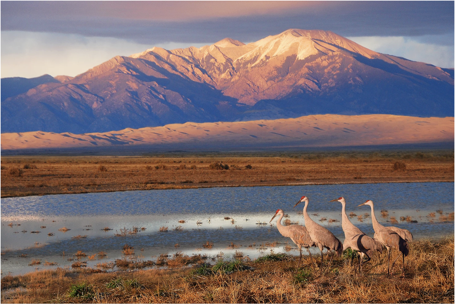
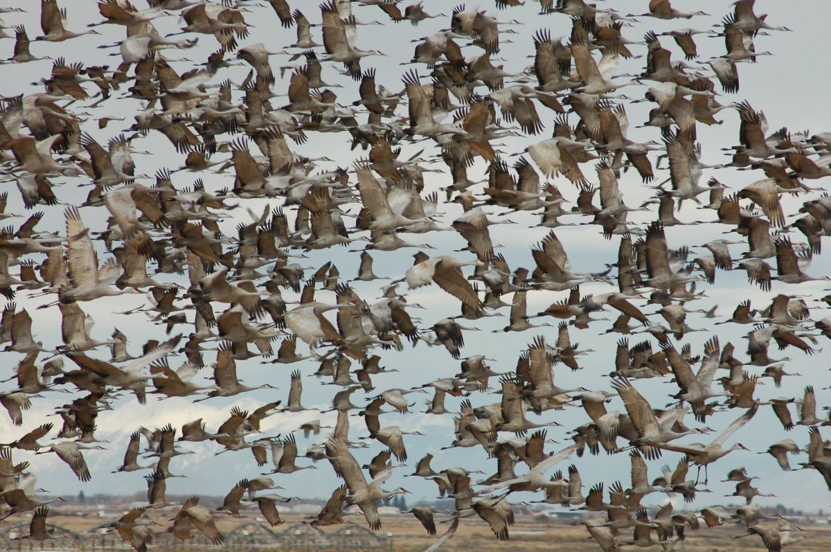
Sandhill Cranes West of Dunes by NPS/Patrick Myers
Exporting water from the San Luis Valley will threaten hope for a sustainable aquifer.
In addition to surface waters, groundwater is also over appropriated in the Valley. We have serious concerns over the effects of the proposed pumping on overall groundwater levels and their impacts to surrounding wetlands and streams. Of particular concern are potential effects to the Great Sand Dunes National Park and Preserve and the Baca National Wildlife Refuge. Farmers in the Valley are already working together and making sacrifices to reduce water demand through the sub-district project, which was created following decades of drought conditions. This voluntary project facilitates farmers within the Valley combining efforts to ensure groundwater levels are maintained. Renewable Water Resources’ proposal undermines years of this difficult work. The demands for water and challenges associated with allocating it equitably will only increase as the impacts of climate change continue to intensify, this proposal will make an already challenging situation worse and undo years of community-driven efforts to find solutions.
Rio Grande and Pecos River basins. Map credit: By Kmusser – Own work, Elevation data from SRTM, drainage basin from GTOPO [1], U.S. stream from the National Atlas [2], all other features from Vector Map., CC BY-SA 3.0, https://commons.wikimedia.org/w/index.php?curid=11218868
Exporting water from the San Luis Valley will have consequences for the entire Rio Grande Basin.
The concerns over this project expand beyond the San Luis Valley. The project also has the potential to threaten the downstream communities and the environment in the Rio Grande Basin for thousands of miles. The Rio Grande Compact and the 1944 treaty with Mexico define how much water must flow from the Rio Grande’s headwaters in Colorado to New Mexico, Texas and Mexico. As a headwaters state, Colorado has a significant responsibility to its neighbors and it is keenly felt downstream when those responsibilities are ignored. For example, during the twentieth century, Colorado consumed more water than it was allotted under the Compact and subsequently accrued a nearly one-million-acre-foot debt to downstream states. This overuse had consequences to downstream communities, agricultural production, and ecosystems. It resulted in lawsuits that ultimately ended with the U.S. Supreme Court requiring Colorado to repay this debt over time. Luckily for Colorado, a wet period of hydrology that filled downstream reservoirs triggered a provision of the Compact that forgave the prior debt and wiped the slate clean for better management going forward. With projected precipitation regime shifts under climate change, we are unlikely to see such a wet period again.
The water challenges we are facing within the Rio Grande Basin make it painfully obvious that a repeat of this situation would be catastrophic for water users across all three states and Mexico. We must think more holistically about the river systems on which we all depend. The San Luis Valley is an integral part of the Rio Grande Basin, a river that runs nearly 1,900 miles and sustains municipal and irrigation uses for more than six million people and two million acres of land across three states and two countries. We urge the Commission to not further complicate this situation by taking vital water from the San Luis Valley and threatening it and others’ water futures.
The communities of the San Luis Valley are working to address their water scarcity challenges in collaborative and inclusive ways. Although there is still much work to do to create a sustainable aquifer and healthy Rio Grande for people and the environment, Renewable Water Resources’ proposal flies in the face of these efforts. Please do the right thing for the communities within the San Luis Valley and those that depend on the water, also vital downstream, by rejecting this ill-advised project.
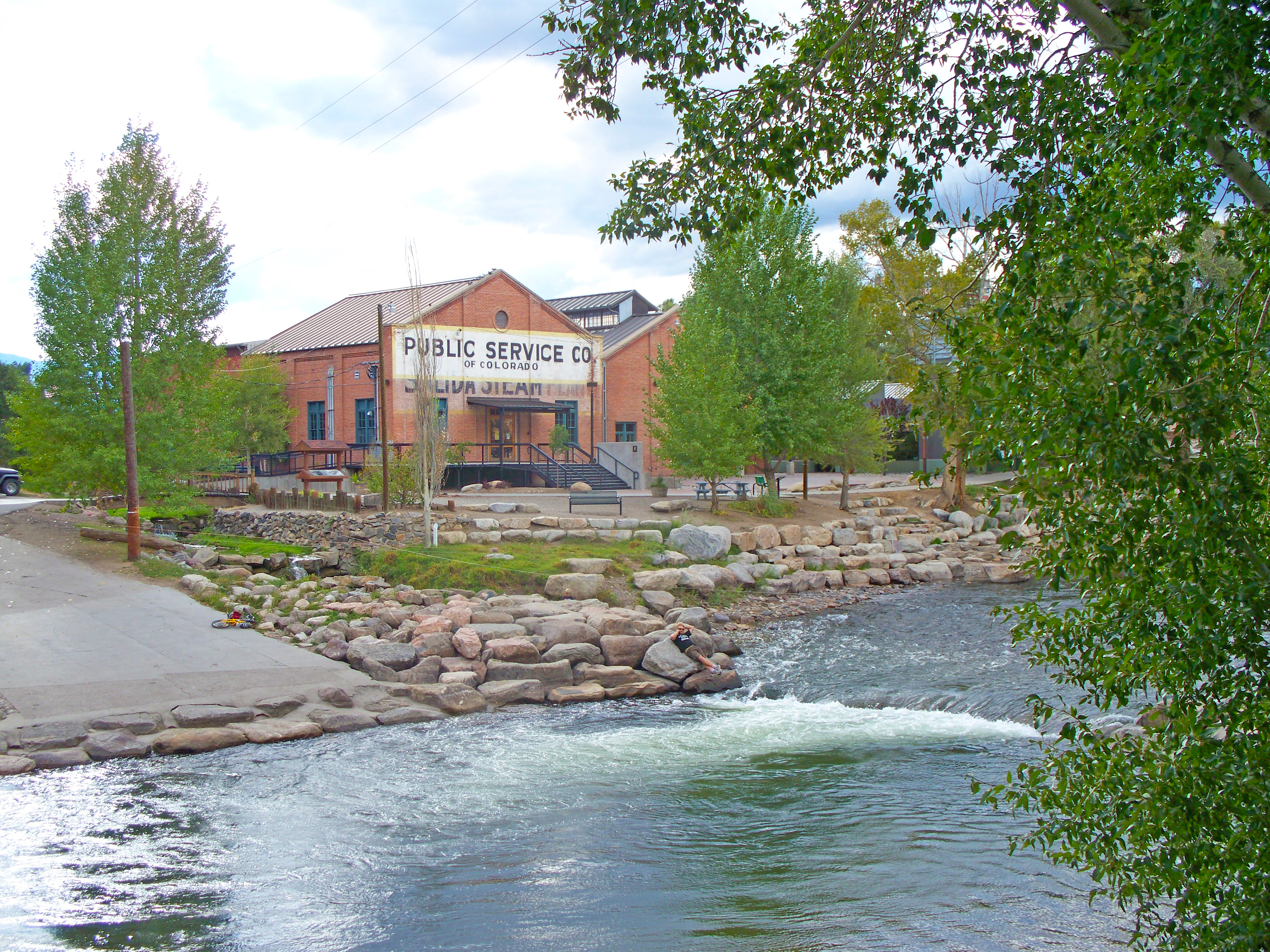
2022 Ark Basin Water Forum returns to the Salida Steam Plant “Risk and Resilience in the Arkansas Basin” restores in-person event after 2-year pandemic pause”
The 26th episode of the Arkansas River Basin Water Forum, the basin’s premiere water event, will feature the state’s top water experts discussing critical issues facing all segments of water users – agriculture, municipal, recreation, environmental and industrial – and engage attendees in seeking solutions to the many challenges faced in planning for a secure water future for the largest of Colorado’s river basins.
Taking place Thursday and Friday, April 28-29, the 2022 Arkansas River Basin Water Forum will focus on “Risk and Resilience in the Arkansas Basin,” exploring topics that include the effect of Colorado River policies on the Arkansas River, ongoing drought and potential aridification in the southwestern United States, the impact of wildfires on water supplies, and much more (see attached draft program).
Keynote presentations will be provided by Dan Gibbs, Executive Director of the Colorado Department of Natural Resources, and Chris Sturm, Watershed Program Director, Colorado Water Conservation Board.
The Forum format continues to evolve, influenced by attendee needs and the resources available to provide interactive experiences for attendees. In addition to expert presentations and panel discussions in the morning sessions, a variety of outdoor field trips will be offered on the afternoons of both days of the Forum. Full information on registering for the Forum, including afternoon field trips, is online at http://www.arbwf.org.
Registration costs for the Forum remain an excellent value:
Two-day full registration, including lunches – $200
One-day registration, either Thursday or Friday, including lunch – $100
Percolation and Runoff networking dinner – $20
Plan on joining us Thursday evening for what is, hands-down, one of the funnest parts of the Forum. Not to be missed, the Percolation and Runoff social networking event is designed to raise money for our college scholarship fund. The $20 cost includes a delicious dinner, drinks and sparkling conversation. You won’t find a better dinner and drinks deal in Salida. All proceeds from this event support the scholarship fund, helping us to help students and working professionals in their education and research in water resources, watershed studies, hydrology, natural resources management and other water-related fields.
For more information, contact Jean van Pelt, Forum Coordinator, at arbwf1994@gmail.com
Click the link to read the article on the Pueblo Chieftain website (Tracy Harmon). Here’s an excerpt:
New water tap sales in Pueblo West could be limited to 400 this year to try to slow explosive growth in the face of a dwindling water supply, Pueblo West Metro District officials said at a meeting Tuesday.
The district’s water team proposed that around 1,050 water taps should be sold over the next three years, a middle-ground figure between FCS Group consultant Jason Mumm’s estimate that Pueblo West will have enough water to serve about 2,771 new water taps and a more conservative estimate from Alan Leak at RESPEC who estimated the district has enough water for about 695 new taps. District water officials recommended the sale of 400 water taps this year, 400 next year and just 100 in 2024. The remaining 150 taps should be “held in reserve for sale at the board’s discretion,” they proposed.
Last year, Pueblo West sold 538 water taps, said Jeffrey DeHerrera, deputy director of utilities. The recommendation to scale back sales isn’t set in stone and can be reevaluated as the district obtains more water resources, he said. Director of Utilities Jim Blasing agreed, pointing out his team is aggressively seeking what water rights it can get on behalf of Pueblo West. The board will reach a recommendation when it meets Monday and water tap sales could resume the next day, after being suspended since Jan. 24…
Pueblo West Metro District Board President Doug Proal said staff are working on a plan to roll out taps fairly. The board’s recommendations, along with what new water taps will cost and by how much water and sewer rates will increase, are expected to be decided on at the board’s meeting on Monday at 5 p.m. at Fire Station 3, 729 E. Gold Drive.
Construction workers build a single family home in Castle Rock. The community needs new surface water supplies to reduce its reliance on non-renewable groundwater. Credit: Jerd Smith
Castle Rock’s building boom has barely slowed over the past 20 years and its appetite for growth and need for water hasn’t slowed much either.
The city, which ranks No. 1 in the state for water conservation, will still need to at least double its water supplies in the next 40 years to cope with that growth. It uses roughly 9,800 acre-feet of water now and may need as much as 24,000 acre-feet when it reaches buildout.
With an eye on that growth and the ongoing need for more water, Douglas County commissioners are debating whether to spend $10 million in federal American Rescue Plan Act funding to help finance a controversial San Luis Valley farm water export proposal.
Thirteen Douglas County and South Metro regional water suppliers say they have no need or desire for that farm water, according to Lisa Darling, executive director of the South Metro Water Supply Authority. [Editor’s note: Lisa Darling is president of the board of Water Education Colorado, which is a sponsor of Fresh Water News]
“It is not part of our plan and it is not something we are interested in,” said Mark Marlowe, director of Castle Rock Water. “We have invested hundreds of millions of dollars in our long-term plan and we are pursuing the projects that are in that plan. The San Luis Valley is not in the plan.”
Renewable Water Resources, a development firm backed by former Colorado Gov. Bill Owens and Sean Tonner, has spent years acquiring agricultural water rights in the San Luis Valley. It hopes to sell that water to users in the south metro area, delivering it via a new pipeline. In December, RWR asked the Douglas County commissioners for $10 million to help finance the $400 million plus project.
Tonner did not respond to a request for comment for this article, but he has said previously that the water demands in south metro Denver will be so intense in the coming decades, that the San Luis Valley export proposal makes sense.
Opposition to the export plan stems in part from concern in the drought-strapped San Luis Valley about losing even a small amount of its water to the Front Range. But RWR has said the impact to local water supplies could be mitigated, and that the proposed pipeline could help fund new economic development initiatives in the valley.
Stakes for new water in Douglas County and the south metro area are high. In addition to demand fueled by growth, the region’s reliance on shrinking, non-renewable aquifers is putting additional pressure on the drive to develop new water sources.
Denver Basin Aquifer System graphic credit USGS.
Marlowe and other water utility directors in the region have been working for 20 years to wean themselves from the deep aquifers that once provided clean water, cheaply, to any developer who could drill a well. But once growth took off, and Douglas County communities super-charged their pumping, the aquifers began declining. Because these underground reservoirs are so deep, and because of the rock formations that lie over them, they don’t recharge from rain and snowfall, as some aquifers do.
At one point in the early 2000s the aquifers were declining at roughly 30 feet a year. Cities responded by drilling more, deeper wells and using costly electricity to pull water up from the deep rock formations.
Since then, thanks to a comprehensive effort to build recycled water plants and develop renewable supplies in nearby creeks and rivers, they’ve been able to take pressure off the aquifers, which are now declining at roughly 5 feet per year, according to the South Metro Water Supply Authority.
The goal among Douglas County communities is to wean themselves from the aquifers, using them only in times of severe drought.
Ron Redd is director of Parker Water and Sanitation District, which serves Parker and several other communities as well as some unincorporated parts of Douglas County.
Like Castle Rock, Parker needs to nearly double its water supplies in the coming decades. It now uses about 10,000 acre-feet annually and will likely need 20,000 acre-feet at buildout to keep up with growth.
Parker is developing a large-scale pipeline project that will bring renewable South Platte River water from the northeastern corner of the state and pipe it down to the south metro area. Castle Rock is also a partner in that project along with the Lower South Platte Water Conservancy District in Sterling.
Redd said the San Luis Valley export plan isn’t needed because of water projects, such as the South Platte Water Partnership, that are already in the works.
“For me to walk away from a project in which we already have water, and hope a third party can deliver the water, just doesn’t make sense,” Redd said.
The costs of building two major pipelines would also likely be prohibitive for Douglas County residents, Redd said.
“We would have to choose one. We could not do both.”
Steve Koster is Douglas County’s assistant planning director and oversees new developments, which must demonstrate an adequate supply of water to enter the county’s planning approval process.
Koster said small communities in unincorporated parts of the county reach out to his department routinely, looking for help in establishing sustainable water supplies.
He said the county provides grants for engineering and cost studies to small developments hoping to partner with an established water provider.
“All of them are working to diversify and strengthen their water systems so they are sustainable. Having a system that encourages those partnerships is what we’re looking at,” Koster said.
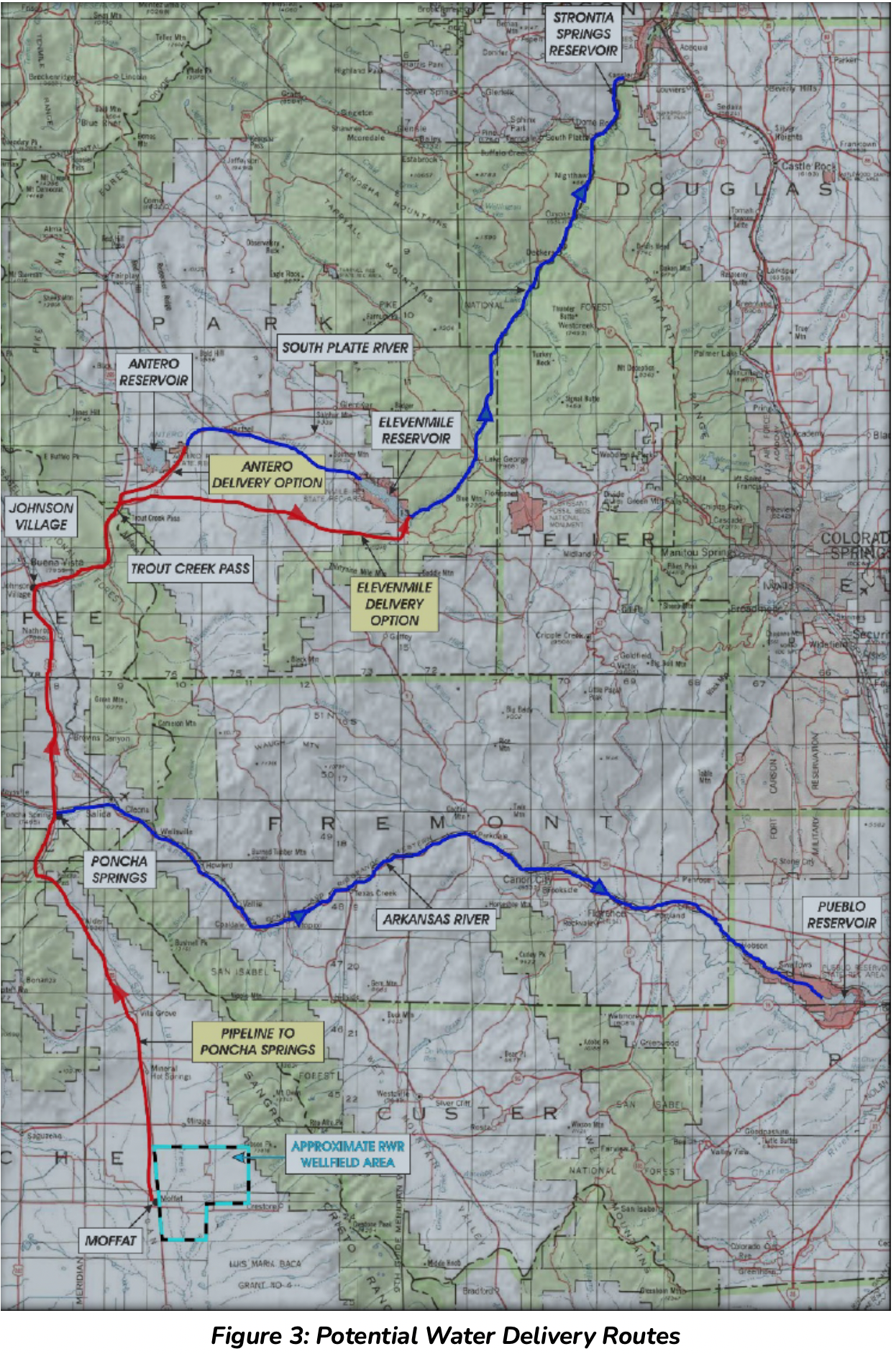
Potential Water Delivery Routes. Since this water will be exported from the San Luis Valley, the water will be fully reusable. In addition to being a renewable water supply, this is an important component of the RWR water supply and delivery plan. Reuse allows first-use water to be used to extinction, which means that this water, after first use, can be reused multiple times. Graphic credit: Renewable Water Resources
Whether an RWR pipeline will play a role in the water future of Douglas County and the south metro area isn’t clear yet.
Douglas County spokeswoman Wendy Holmes said commissioners are evaluating more than a dozen proposals from water districts, including RWR, and that the commission has not set a deadline for when it will decide who to fund.
Jerd Smith is editor of Fresh Water News. She can be reached at 720-398-6474, via email at jerd@wateredco.org or @jerd_smith.
El Paso County is accepting applications for its American Rescue Plan Act Water and Wastewater Infrastructure Grant funding opportunity. According to a news release, “[t]he county has allocated $20 million in ARPA funding for necessary investments in water and wastewater infrastructure, to include improvements to drinking water infrastructure, upgrading facilities, managing sewage and other eligible uses.”
“The community has expressed great interest in this particular grant, and it truly is going to be a once-in-a-lifetime opportunity for many communities and projects,” Commissioner Holly Williams said in the release. “This grant will have a monumental impact for decades to come, as it increases peoples’ access to clean drinking water, and replaces many aging infrastructures.”
According to the release, “[a]ll levels of infrastructure have seen increased demands during the pandemic, and our water and wastewater infrastructures are no exception. This $20 million allocation will help El Paso County preserve and be better stewards of our most precious and scarce resource, and is an investment directly allowed under ARPA guidance.”
The application opens Monday, March 28, 2022, and will remain open through 5 p.m. Friday, April 22.
Application Eligibility:
All projects must meet federal eligibility requirements, which include 17 project categories under guidelines published through the Environmental Protection Agency’s Clean Water State Revolving Fund and the Drinking Water State Revolving Fund.
Projects must be located in El Paso County.
The entire allocation for this funding is $20 million and the county expects to fund several projects, the release said, adding a portion of the funding will be reserved specifically for smaller communities and projects.
El Paso County will be hosting a pre-application webinar at 11:30 a.m. on April 4 to answer specific application related questions. To participate in the webinar, join using this link. Participants are encouraged to send questions ahead of time to ARPArequests@elpasoco.com. If you require accommodations or need a translator, send an email to JyotsnaKhattri@elpasoco.com by March 30.
The application is a fillable PDF available here and on El Paso County’s ARPA page. All completed applications and supporting documentation must be submitted electronically to ARPArequests@elpasoco.com. For more information, visit http://admin.elpasoco.com/arpa.
Thousands of people in the Lower Arkansas Valley who’ve struggled to deal with contaminated water for more than 20 years will have access to clean water by 2024 under a new agreement signed by the federal government and two Colorado water agencies last week.
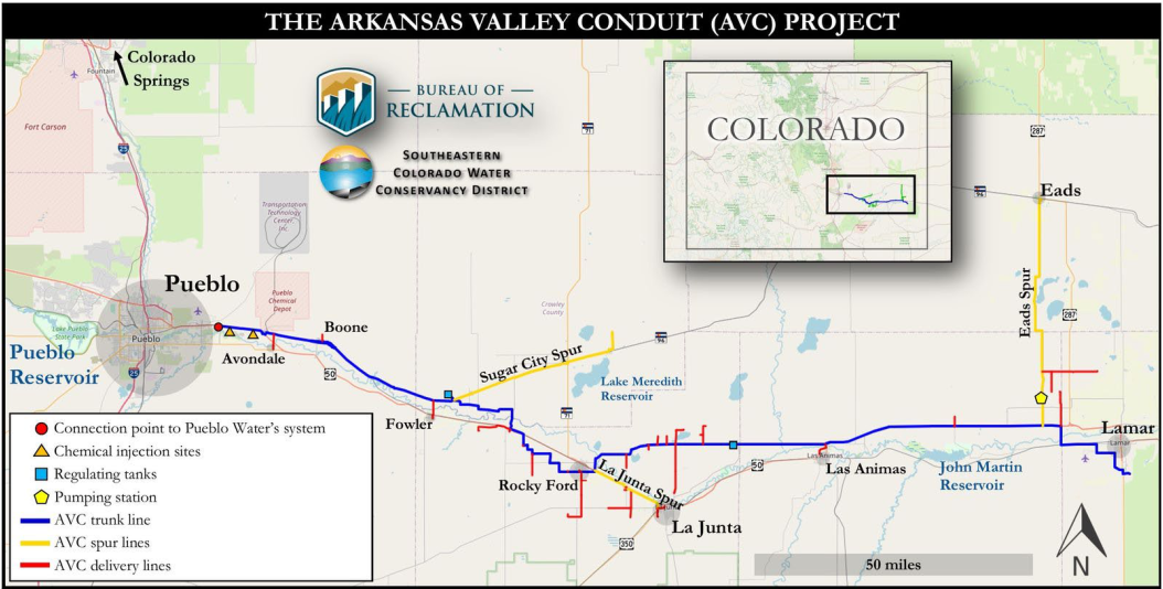
The Arkansas Valley Conduit (AVC), as the clean water delivery project is known, will bring water from Pueblo Reservoir through the city of Pueblo and out to communities on the Eastern Plains, such as Avondale and Boone, by 2024, and other communities, such as La Junta, as soon as 2027.
Arkansas Valley Conduit map via the Southeastern Colorado Water Conservancy District (Chris Woodka) June 2021.
Water officials said the entire pipeline should be completed by 2035 if not sooner. The project will ultimately serve 50,000 people, officials said.
Under the agreements, signed by the U.S. Bureau of Reclamation, the Pueblo Water Board, and the Southeastern Colorado Water Conservancy District March 18, some $40 million in federal and local funding will be available to launch construction, with subsequent funding for the $600 million project anticipated to come from Congress and local water agencies.
In addition, the agreement allows Reclamation and Southeastern to pipe the water through the city of Pueblo’s water system, rather than building a separate system to move the water out to the Eastern Plains. Officials said this new agreement will shave costs and several years off the project.
“This contract signing marks one of the most significant milestones to date towards making the AVC a reality and bringing clean water to communities that desperately need it. It advances the project over 14 miles east from Pueblo Reservoir which puts us much closer to our first participants in Avondale and Boone,” said Brent Esplin, regional director of the Missouri Basin and Arkansas-Rio Grande-Texas Gulf regions for Reclamation, in a statement.
Naturally occurring selenium and lead, as well as radionuclides, have dogged the region’s water systems since the 1960s. Many of the communities face enforcement actions from the state health department because they don’t have the financial resources to treat the water for drinking and then to treat it again for discharge into the wastewater systems that discharge to the Lower Arkansas River and its tributaries, according to Chris Woodka, senior policy manager with the Southeastern Colorado Water Conservancy District. Southeastern operates the federal Fryingpan-Arkansas Project’s Pueblo Reservoir.
“This project will relieve some of the pressures that they face. They will get better quality drinking water and they will see improvements to their discharged water,” Woodka said.
Pueblo Reservoir
The idea is to deliver clean water from Pueblo Reservoir directly to the communities via the 34-mile pipeline, reducing and sometimes eliminating the contaminants that the water now picks up when it travels through streams and irrigation ditches.
The conduit has been on planning boards for more than 50 years but it wasn’t until a new federal law was approved in 2009 stipulating that the federal government would pick up 65% of the costs that the plan began to advance, Woodka said.
Since then the region has wrestled with getting federal cash to start work and convincing local water agencies and the communities who need the water to cooperate on design issues and costs, Woodka said.
“People are convinced it will get built,” Woodka said. “Now the questions are about affordability.”
And for small towns, those are big questions.
Tom Seaba is La Junta’s director of utilities. His city has comparatively clean water, with no radionuclides and a selenium issue that it is treating via reverse osmosis.
“It could be the silver bullet that everyone would like to take care of the contaminants that are in the water. The flip side is the cost,” Seaba said.
La Junta charges customer $2.50 per thousand gallons for water now, which includes treatment costs. The new water will cost $2.19 per thousand gallons, untreated, and La Junta will still have to find a way to recoup the cost to disinfect and treat the water.
“Now that we’re getting down to brass tacks, we need to see if the underlying reality will do for us what everyone hopes it will. If we can connect and that takes care of the problems we have, sign us up. But if it doesn’t, we will have to do something else,” Seaba said.
Jerd Smith is editor of Fresh Water News. She can be reached at 720-398-6474, via email at jerd@wateredco.org or @jerd_smith.
THIS was supposed to be the week that the three Douglas County Commissioners, Lora Thomas, Abe Laydon and George Teal, visited the San Luis Valley to host a community meeting on Douglas County’s consideration of the Renewable Water Resources proposal to export water out of the Valley north.
There’s still an expectation that Laydon and Teal will find their way down, on their own, away from the public spotlight in their own pursuit of reasons to support or not the Renewable Water Resources plan.
For her part, Thomas has been opposed from the outset and prefers that Douglas County focus on a water project in its own backyard – the Platte Valley Water Project with Parker Water & Sanitation and Castle Rock Water.
She’s also been troubled by what she sees as conflicts of interest among her fellow commissioners for their public positioning of RWR and their perceived coziness with Republican moneyman Bill Owens, a former governor of Colorado, and his entourage at Renewable Water Resources.
It would have been those dynamics, a split and at times feuding Douglas County commission, that would have arrived at the Ski Hi Regional Events Complex in Monte Vista to hear from Valley residents. But after Teal made comments that there was nothing to gain from such a meeting since Valley residents didn’t seem interested in finding a deal with Douglas County and supporters of RWR felt threatened and silenced, the commissioners punted.
That doesn’t mean Douglas County – and Laydon and Teal, specifically – has lost interest in RWR. Quite the contrary. What’s puzzling is nobody outside RWR understands why, particularly since Douglas County is not a provider of water services and would find itself entangled in years of litigation at a minimum.
“I have zero ulterior motives, other than wanting to secure proactive win/win water solutions for both communities,” Laydon said to Alamosa Citizen. “I’m persuaded by facts, not noise or propaganda. We have engaged in a deep-dive water series and study with a hydrologist and water attorney who have yet to compile their findings into final recommendations.”
The three commissioners huddled in executive session for two hours Monday to hear from Stephen H. Leonhardt with the law firm Burns Figa & Will, and Tom Hatton from Applegate Group, Inc. Leonhardt and Burns Figa & Will have been retained as special counsel to help Douglas County understand the legal issues surrounding the Renewable Water Resources proposal, while Applegate Group, Inc., has been retained to consult on engineering and hydraulic aspects of the RWR plan, according to public files.
Both the special legal counsel and Applegate consultants had their contracts recently amended to include more money and more time on the RWR plan. Douglas County also this month issued a request for qualifications (RFQ) for additional water consultant services. The RFQ has an April 8 deadline.
Following Monday’s lengthy executive session, the commissioners will receive a confidential memo summarizing what they heard. Where they are with a decision on RWR is harder to determine. Since Thomas is opposed and Teal is in support of RWR, the past weeks have become the Abe Laydon show to see where he lands.
“I don’t know where we’re headed,” said State Sen. Cleave Simpson, who is also general manager of the Rio Grande Water Conservation District and is a farmer and rancher in the San Luis Valley.
San Luis Valley Groundwater
Like others who have made presentations to help Douglas County commissioners understand the ever-declining water conditions of the San Luis Valley aquifers – the unconfined and confined – and threats to the Valley’s ecosystem from 20 years of drought and loss of wetlands, Simpson is frustrated at the spectacle Douglas County has created.
“To make this thing work they have to change the rules and regulations that we all have lived under and crafted over the last 20 years,” he said of the Renewable Water Resources proposal.
It’s not simply Laydon casting the deciding vote to move the RWR proposal forward. If he were to take that gamble for Douglas County, RWR then would have to ask State Engineer Kevin Rein to change the rules governing water to meet the intent of their proposal, said Simpson.
“If I was Douglas County I’d say ‘I’m not going to give you a dime until you get the rules changed’ and the likelihood of them changing the rules here is nearly zero percent from my perspective,” Simpson said.
Coming out of Monday’s executive session with their special counsel and hydrologist consultant, Laydon said he was happy to hear the expertise and “objective facts” that were discussed. He and Teal have made it a point to say Valley representatives and residents they’ve heard from are not objective and instead overfilled with emotion.
“I very intentionally have taken the emotion out of my presentations and conversations with them,” said Simpson. “And honestly, even the folks at RWR from the very beginning, I said ‘I appreciate this is a business proposition from your perspective, I’m happy to sit down with you and let’s debate the pros and cons, but you can’t put out false information.’
“They claim we’re putting out false information and I can say with absolute certainty none of the stuff that I’ve presented or the meetings I’ve been in with them is false information. It’s all 100 percent accurate and quite the contrary from the other perspective. I can demonstrate without doubt that the information they’re getting is false.”
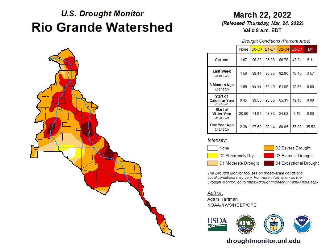
Rio Grande River basin drought monitor map March 22, 2022.
Simpson has sat with Laydon and extended invitations to bring in others like Ken Salazar, the U.S. ambassador to Mexico and one of Colorado’s foremost experts in water law, to help Laydon better grasp the drought conditions and over pumping situation in the Valley. Former Alamosa County Commissioner Darius Allen is another person Laydon has been invited to hear from.
For Laydon, he’s focused on the consultants that Douglas County has hired to help him make a decision. Presumably he heard some of what he’s looking for in Monday’s closed meeting. Following it he, Thomas and Teal sat through their first presentation on the Platte Valley Water Project.
Here’s the release from Southeastern Water (Chris Woodka), USBR (Elizabeth Smith), and Pueblo Water (Joe Cervi):
A three-party contract allowing for the Arkansas Valley Conduit to deliver clean drinking water to 50,000 people in 39 communities east of Pueblo was signed by the Bureau of Reclamation on March 18, 2022, following approval by the Southeastern Colorado Water Conservancy District Board and the Pueblo Board of Water Works (Pueblo Water). The contract was drafted after negotiations that began in November 2021.
“This contract signing marks one of the most significant milestones to date towards making the AVC a reality and bringing clean water to communities that desperately need it. It advances the project over 14 miles east from Pueblo Reservoir which puts us much closer to our first participants in Avondale and Boone,” said Brent Esplin, Regional Director of the Missouri-Basin and Arkansas-Rio Grande-Texas Gulf regions for Reclamation. “It is also the culmination of years of collaboration between Reclamation, Southeastern, and Pueblo Water to deliver a more cost-effective project to people of the lower Arkansas Valley.”
The contract will allow the Southeastern District to use capacity in Pueblo Water’s system to treat and deliver AVC water to a pipeline being constructed by Reclamation. The connection point for AVC is at the east end of Pueblo Water’s system, at 36th Lane and U.S. Highway 50.
Arkansas Valley Conduit map via the Southeastern Colorado Water Conservancy District (Chris Woodka) June 2021.
The water will be either Fryingpan-Arkansas Project water or from participants’ water portfolios, not from Pueblo Water’s resources. The route of the AVC follows the Arkansas River corridor from Pueblo to Lamar, with spurs to Eads and Crowley County. Reclamation is building the trunk line, while the Southeastern District will build the spur and delivery lines. Estimated total cost is about $600 million.
The Southeastern and Pueblo Water boards both unanimously approved the contract on March 15 and 17, 2022, respectively.
“This project is vitally important to the people of the Lower Arkansas Valley,” said Bill Long, President of the Southeastern District board. “It would not be viable, and certainly not affordable without the partnership with Pueblo Water, and I would like to express my appreciation to the board.”
“This is a truly monumental achievement and marks the culmination of decades of hard work, dedication, and collaboration by those who have devoted their lives to the business of water,” said Seth Clayton, executive director of Pueblo Water. “Pueblo Water is proud to be an integral participant in this important time in history.”
Many of the Lower Arkansas Valley water systems face water-quality enforcement actions for radionuclides or surface contaminants in groundwater sources. They face ever increasing costs to cope with these problems. The AVC will eliminate or reduce the effects of those contaminants by delivering filtered water from Pueblo Reservoir.
To deliver the full volume of water through the system, Pueblo Water must make some upgrades, and will receive a $20 million construction recovery fee. In addition, Pueblo Water will receive a $2 million investment payment. As the needs of AVC grow, Pueblo will receive funding for necessary improvements.
This is seen as a win-win opportunity by both Pueblo Water and the Southeastern District because it reduces the cost of an earlier plan to build a new pipeline south of Pueblo.
“Not only does the agreement save the AVC project hundreds of millions of dollars and years of construction time, but it also benefits Pueblo Water customers by providing an opportunity to use the excess capacity we have in our system and deliver water to our neighbors in the Lower Arkansas Valley,” Clayton said.
Pueblo Water will charge an initial rate of $2.19 per 1,000 gallons delivered, which reflects the operation and maintenance costs of those parts of the system needed by AVC. The rate will increase annually at the same rate as Pueblo Water’s other customers.
Pueblo Water will also renew its contract to store excess capacity water in Pueblo Reservoir for a 50- year period under the contract.
Finally, the contract spells out environmental commitments and operating conditions related to AVC.
“The significance of this action is that everybody will have the opportunity to have a clean source of drinking water after more than 20 years of work,” said Jim Broderick, executive director of the Southeastern District.
Alan Hamel, a Southeastern Board member, and former Pueblo Water executive director, said the idea for the AVC actually goes back 60 years, to the 1962 signing of the Fryingpan-Arkansas Project into law.
In 1968, there was a plan to jointly build a federal treatment plant for Pueblo Water and the water line for AVC.
The AVC was put on hold because of the inability of communities to pay for it. The AVC concept was revived in 2000, and a 2009 federal law provided for 65 percent federal funding, to be matched by 35 percent in other funding.
Reclamation issued a Record of Decision in 2014 which endorsed construction of the AVC to proceed via the “Comanche North” alignment. The alignment was modified in 2019 through a collaborative effort between Reclamation, Southeastern, and Pueblo Water which replaced the pipeline around Pueblo with this contract.
Federal funding so far has totaled $40 million, while $100 million in loans or grants is available to AVC through the Colorado Water Conservation Board. The District has contributed $4.8 million through its Enterprise, while participants have paid $1.5 million since 2011.
Pueblo County recently contributed $1.2 million to build delivery lines to Boone and Avondale through local American Rescue Plan Act funds, and other counties or cities in the Arkansas Valley are expected to contribute as well.
Arkansas Valley Conduit map via the Southeastern Colorado Water Conservancy District (Chris Woodka) June 2021.
Click the link to read the article on the Pueblo Chieftain website (Tracy Harmon). Here’s an excerpt:
Rural Pueblo County residents are expected to see improvements to their drinking water in the next few years, thanks to $12.7 million in federal American Rescue Plan Act Funds being disbursed by Pueblo County Commissioners…Projects receiving funding include the Southeastern Colorado Water Conservancy District, which is working to deliver drinking water to Avondale and Boone as part of the U.S. Bureau of Reclamation’s Arkansas Valley Conduit project, said Chris Woodka, issues management coordinator for the district. It will receive $1.2 million to build delivery lines out of the bureau’s trunk line in eastern Pueblo County. That will bring water to about 1,600 Avondale residents and 230 Boone residents. Avondale Water District also will receive $3.2 million and the town of Boone’s water project will get $1.5 million…
The communities’ water will come out of the Pueblo Reservoir. Once the water arrives in the eastern Pueblo communities, water managers will only have to re-chlorinate it before getting it to their customers, Woodka said…
Of the remainder of the $12 million water infrastructure funds, Beulah Water Works and Colorado City Metro will get more than $3 million. Last July, the Colorado City Metropolitan District dealt with a low water pressure crisis caused by an internet outage at the district’s water treatment plants.
Click the link to read the article on the Mountain Mail website (D.J. DeJong). Here’s an excerpt:
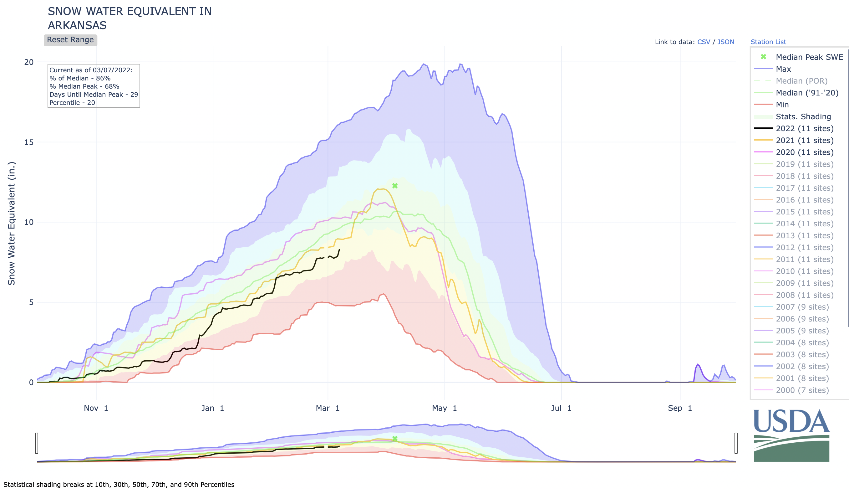
Colorado river basins remain near normal in precipitation for the water year to date despite below-normal precipitation in January and February, according to the National Resources Conservation Service. Southern Colorado basins fared better than other parts of Colorado. The Arkansas River Basin received 112 percent of median precipitation in February…
Snowpack for the Arkansas River Basin stood at 90 percent of median as of March 1. Current statewide streamflow projections are 88 percent of normal…
The current projection for the Arkansas Basin is 81 percent of median streamflow.
Statewide reservoir storage has remained below average this water year. The Arkansas Basin stands at 89 percent of median storage as of March 1. The NRSC states more precipitation is needed through the remainder of winter to increase reservoir storage in addition to improving drought conditions in the state…
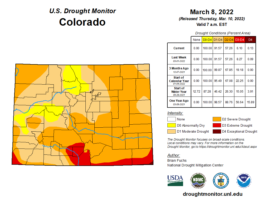
Colorado Drought Monitor map March 8, 2022.
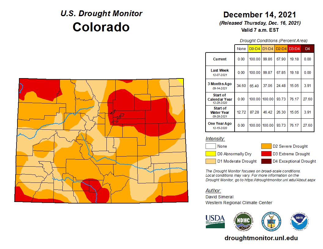
As of Thursday, the National Drought Mitigation Center at University of Nebraska Lincoln, reports Chaffee County remains in moderate drought conditions in the western part of the county with severe drought conditions in the eastern half.
SOUND UP for today's moment of Zen. Hear the trumpet of Sandhill cranes arriving by the 1000s for stopover @COParksWildlife's @JohnMartinSP near Lamar. DYK CO gets mostly Greater sandhill cranes EXCEPT on SE plains where subspecies Lesser SCs migrate & breed? 📸= Sami Covlin pic.twitter.com/3YaF5nycHP
The Metro District Board is set to meet at 5 p.m. Monday, March 14, to vote on a possible extension of the temporary pause on permit sales until April 12. The board initially voted to pause the sales in January and had hoped to resume them this month…
According to a report from Alan Leak at RESPEC Engineering, Pueblo West could support the sale of 14,000 total water taps “without a significant reduction in water stored in Pueblo West’s accounts in Pueblo Reservoir and Twin Lakes over the next 5 years.”
Pueblo West currently has about 33,000 residents, so total growth could be about 47,000 people. The district’s 1972 service plan called for growth to 39,000 residents…The halt on water tap sales came after a standing- room-only crowd of residents urged the board to stop explosive growth at the Nov. 8 meeting, making it clear they don’t want to see skyrocketing water and sewer rates….
Data provided by the district’s consulting groups will be available for residents to review prior to Monday’s meeting at http://pueblowestmetro.com/waterstudy.
Potential Water Delivery Routes. Since this water will be exported from the San Luis Valley, the water will be fully reusable. In addition to being a renewable water supply, this is an important component of the RWR water supply and delivery plan. Reuse allows first-use water to be used to extinction, which means that this water, after first use, can be reused multiple times. Graphic credit: Renewable Water Resources
The decision to cancel the event came during a March 9 work session in which county staff told the commissioners they were expecting 300 to 400 people to attend and that it appeared a protest was planned to take place…
Commissioner George Teal, who has voiced his support for the project, said was in favor of canceling the meeting, adding that he had initially hoped to have “actual conversations” with residents and “get past the visceral, emotional aspects of this project.”
He said he’s heard from people in the valley who support the RWR project but feel they are being intimidated to remain quiet….Commissioner Abe Laydon, who has said he hasn’t yet decided if he supports the project, said he still wants to go to the valley but said the event had been “hijacked by a group of folks” and said he didn’t want to be part of it…Commissioner Lora Thomas, who has vocally opposed the plan, said she’s not interested in going to the valley…
When asked where the county learned of reports of intimidation, a county spokesperson referenced comments from a speaker during one of the commissioners work sessions on the topic — Jerry Berry, who is a farmer in the San Luis Valley and a representative for RWR…
In a Feb. 28 meeting, executive director of the South Metro Water Supply Authority Lisa Darling told the commissioners that none of the major water districts in Douglas County are interested in the water from RWR.
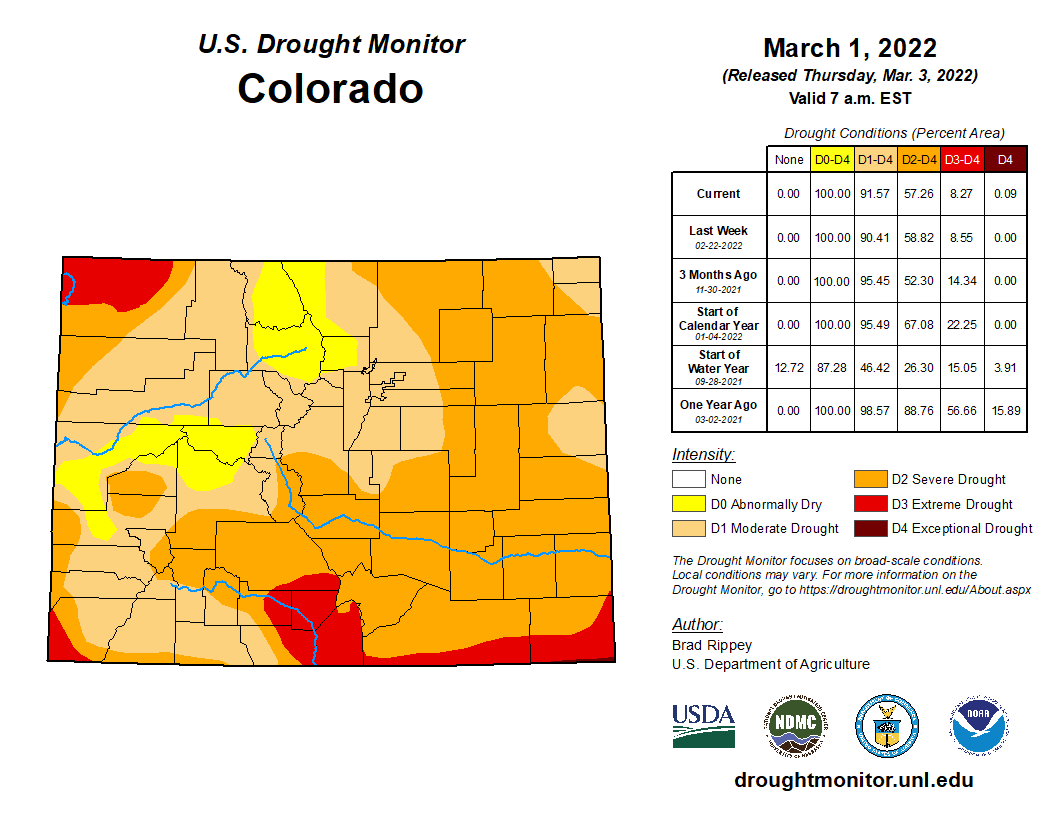
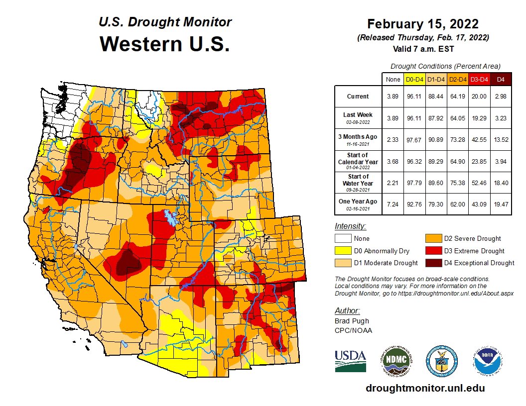
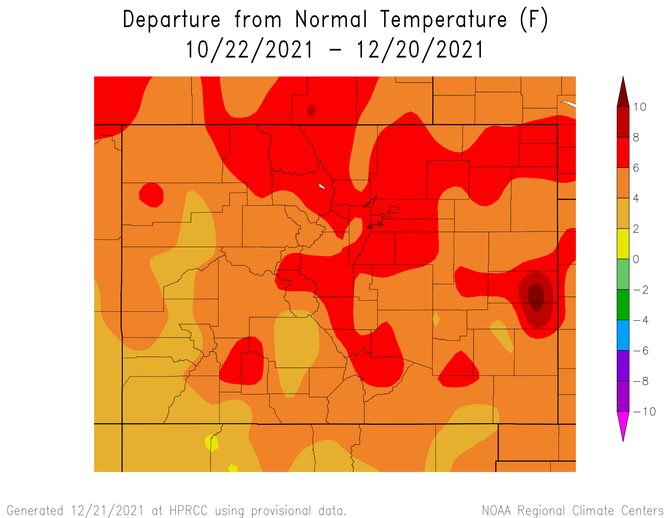
Colorado’s February precipitation failed to maintain Arkansas River Basin snowpack compared to the past 20 years. The U.S. Drought Monitor shows severe drought persisting in most areas in the basin with extreme drought in the southern edge of the lower Ark Basin in Colorado as well as the two western corners of Colorado (i.e., 9% of the state). The NOAA three-month temperature outlook projects higher than normal temperatures across all of Colorado through May. The three-month outlook also predicts lower than normal precipitation for the entire state.
Snowpack
The latest National Resources Conservation Service (NRCS) Snowpack Telemetry (SNOTEL) report shows basin-wide snowpack at 76% of median for snow-water equivalent (SWE) and precipitation at 83% of median. The highest snowpack readings continue to be recorded at Porphyry Creek (119%) and Saint Elmo (115%). Snowpack at Fremont Pass has dropped from 102% of median a month ago to a current reading of 90%. The Apishapa SNOTEL station reports 75% while the Hayden Pass station improved from 40% a month ago to 69% at present.
Reservoir Storage
Statewide reservoir storage was reported at 78% of average and 43% of total capacity during the February Governor’s Water Availability Task Force meeting. This link accesses the latest NRCS reservoir report, which is unfortunately producing suspect and incomplete data for February. The issue should be resolved soon.
River Flows
As of March 5, Arkansas River flows were 252 cfs at Granite, 393 cfs at the Wellsville gauge near Salida and 361 cfs at Cañon City. Below Pueblo Dam, flows were 64.9 cfs, increasing to 276 cfs near Avondale before dropping to 155 cfs near Rocky Ford. The flow was 1.64 cfs below John Martin Reservoir and 10.6 cfs at Lamar. Boustead Tunnel discharge rates were not available as of this writing.
River Calls
The Arkansas River Basin had eight active calls as of March 5. The Fort Lyon Storage Canal remains the calling water right on the Arkansas mainstem with a March 1, 1910, priority date. The Holitas Reservoir has a call on the Cucharas River with a March 20, 1901, priority date. The Upper Huerfano No. 2 is the calling structure on the Huerfano River with a priority date of March 15, 1869. The Model Ditch (March 20, 1862) continues its call on the Purgatoire River, as does the Tenassee Ditch (April 30, 1880) on the South Arkansas River. Additional calls are in place on Fourmile Creek and Greenhorn Creek. The Winter Water Storage Program ends March 14, which will likely impact calling water rights.
The Chaffee County Risk Mapping, Assessment and Planning (Risk MAP) Study is underway across the county through the Colorado Water Conservation Board (CWCB). The Chaffee Risk MAP Study will collect data on field conditions in areas of the county believed to be at risk for impacts from future flooding, erosion, debris flow, or related hazard events. This information will be used to update flood risk information and floodplain mapping in certain watersheds and create tools that provide a data-driven framework for land use and other decision-making in affected areas. The study is funded by the Federal Emergency Management Agency (FEMA).
Buena Vista
The Local Risk
Based on assessments performed for the 2021 Chaffee County Hazard Mitigation Plan, overall flood risk is an important consideration due to precipitation and snowmelt runoff, and is categorized as medium to high risk in most populated areas of Chaffee County. Countywide, an estimated $34.5 million in property losses is at risk to a one-percent annual chance flood hazard. The unincorporated areas of the county together make up the majority of this exposure, with an estimated $26.7 million in losses at risk. Of the municipalities in Chaffee County, Buena Vista is at the highest risk with $6.1 million in estimated losses in a one-percent annual chance flood, followed by Poncha Springs and Salida with approximately $1.1 million and $460,000 in estimated losses respectively.
Floodplain survey activities are currently planned between March and June
The survey work will be focusing on several flooding sources in all of the incorporated communities and the unincorporated county areas. According to the CWCB, the survey crews will be collecting elevation and other basic information on the land around the waterways being studied, and will not dig around nor disturb the areas…Wood and Merrick & Company are the floodplain mapping and field surveying contractors working with CWCB for Chaffee County’s study. Wood is also familiar with Chaffee County through their work with the 2021 update of Chaffee County’s Hazard Mitigation Plan.
The El Paso County Board of Commissioners wants to be transparent about the allocation of the American Rescue Plan Act Funds, saying $25 million will go to surface and stormwater infrastructure.
El Paso County ranks second in receiving the most funds in the state, with nearly $140 million in funds. County Commissioner for District 4 Longinos Gonzalez says they are planning to use the leftover funds on water, storm, and road infrastructure…
This comes after the U.S. Treasury Department released the final rule for the state and local recovery funds in January allowing counties to use those dollars for the provision of government services…
As for stormwater infrastructure, the El Paso County Department of Public Works has identified seven projects which amount to $10 million, an additional $5 million will be allocated for future projects…
The county is also asking the community to submit proposals for an additional $20 million in water infrastructure grants.
Fort Lyon Canal Company has seen a storm of litigation, brushes with debt, and general upheaval in its 125 years of existence. It is a credit to its survival the company has issued a commemorative medal to the farmers and landowners owing their very existence to the water sources and reservoirs developed over 125 years. Judy Hensley received one of these medals, as her land, farmed by Nate Cranson, is one of the beneficiaries of that precious water.
Straight line diagram of the Lower Arkansas Valley ditches via Headwaters Magazine
The headwaters and the main gate of the Fort Lyon Canal, the longest and most complicated canal in Colorado, is located just north of North La Junta. “The Fort Lyon Canal’s first 100 years” by O. Ray Dodson is a document based on the 1910 report on “Property of The Fort Lyon Canal Company” by James D. Schuyler, and is the source of historical information gathered by Chris Woodka, former water reporter for the Pueblo Chieftain and now with the South East Water Conservancy District.
The canal, at the time of Dodson’s writing, had a total length of about 113 miles from its head gate to the extreme end at Big Sandy Creek east of Lamar. The principal supplier of water is the Arkansas River, but some of the sources are upslope at Horse Creak Reservoir and other reservoirs developed over the years.
The battle for the water that flows in the Fort Lyon Canal continues to the present time. High Plains A&M, a group of investors led by entrepreneur Terry White, began quietly buying shares in Fort Lyon Canal about five years ago. “It owns or controls 28,566 of the canal’s 98,989 shares, about 30 percent,” wrote Chris Woodka recently. “Its plan, rejected Monday by the Colorado Supreme Court, was to market the water in 28 counties within and outside the Arkansas Valley. Most of the uses listed were domestic or municipal. High Plains owns 115 farms on the canal, directly controlling more than 20,000 shares. It secured options on the remaining shares.”
Woodka further wrote: “The Independent Shareholders Group is aligned with High Plains, which is paying its legal expenses. The ISG owns another 8,287.5 shares of the ditch, about 9 percent, and includes 45 landowners.
• High Plains filed for its change of use decree in late 2002. In November 2003, Fort Lyon shareholders – after five days of hearings – approved diverting water from the canal, as long as it was taken “in priority” along the canal.
• Pueblo Chief District Judge Dennis Maes dismissed change-of-use applications by High Plains and ISG on July 2, 2004. High Plains appealed that decision on Aug. 17, 2004. Oral arguments were held in June. The Colorado Supreme Court upheld Maes’ decision Monday.”
The decision rendered by Pueblo Chief District Judge Dennis Maes was argued for the Lower Arkansas Water Conservancy District by the late Bart Mendenhall of Rocky Ford and Peter Nichols, still the main attorney for LAVWCD.
The May Ranch near Lamar, Colo., has never been plowed. Photo/Ducks Unlimited via The Mountain Town News
Click the link to read the article on Ark Valley Voice (Jan Wondra):
A megadrought is defined as a drought lasting two decades or longer. According to Climate Scientist Jason Smerdon, co-author of a drought study by the Lamont-Doherty Earth Observatory of Columbia University, not only do they give us a 94 percent certainty that this mega-drought will continue, they say we could face years of continued drought.
In fact, University of California Los Angeles geographer Park Williams, the study’s lead author, said with dry conditions likely to persist, it would take multiple wet years to remediate the effects. “It’s extremely unlikely that this drought can be ended in one wet year,” he said.
As we in Chaffee County and surrounding counties know from the past couple of years, as spring arrives, the snowpack is just soaking into the parched earth, rather than running off into streams and rivers. This doesn’t bode well for the four major rivers that originate in the Colorado Rockies; the Colorado, the Platte, the Arkansas, and the Rio Grande, and the reservoir systems and hydroelectric plants they serve…
By analyzing tree rings, the scientists observed that periods of severe drought are marked by high degrees of soil moisture deficit; this is the moisture variance from normal saturation.
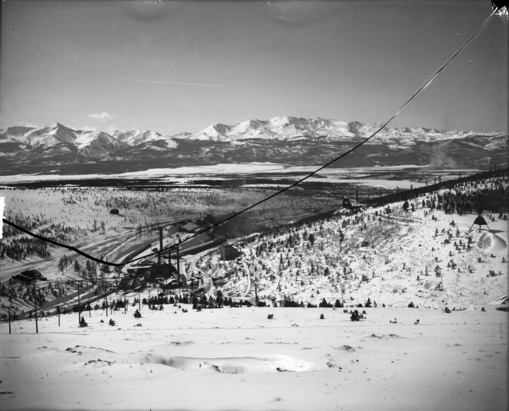
View of the Yak Tunnel and Mine Complex in California Gulch near Leadville, Colorado; shows mill buildings and ore car tracks. Mount Elbert, Mount Massive, and the Sawatch Range are in the background. Denver Public Library Special Collections Creator Beam, George L. (George Lytle), 1868-1935. Date: 1908
The Arkansas River Watershed Collaborative (ARWC), which also includes groups like Trout Unlimited, submitted an initial application last fall under the project title “Upper Arkansas Comprehensive Watershed Restoration Project.” The application requested $5 million from damages associated with the California Gulch Superfund Site for various initiatives, including culvert replacement and fuels mitigation…
Commissioner Sarah Mudge, who helped submit the application in December, said the group will submit a new request in February for consideration under a new round of funding. Mudge said ARWC has altered the scope of work slightly for the new application, but that culvert work and fuels mitigation will remain a priority.
Last September, the trustees, including Colorado Attorney General Phil Weiser, visited Lake County for a landmark tour of California Gulch, a Superfund site that was heavily impacted by mining operations. After the tour, the trustees heard proposals from groups like ARWC, which presented the “Upper Arkansas Comprehensive Watershed Restoration Project.”
[…]
Fuels mitigation will entail thinning efforts and the implementation of a county-wide slash management program. Mine impact mitigation refers to ongoing efforts to prevent soil and water pollution from old mine operations. And river restoration will include post-wildfire flood defense along waterways and culvert repair in four or five areas throughout Lake County.
Prior to mining, snowmelt and rain seep into natural cracks and fractures, eventually emerging as a freshwater spring (usually). Graphic credit: Jonathan Thompson
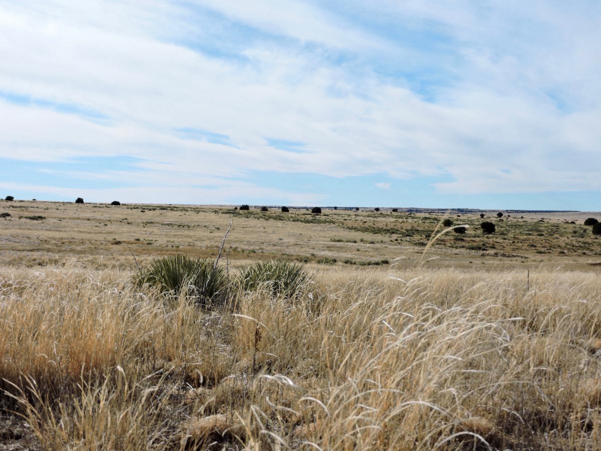
Fresh Tracks prairie landscape in southeast Colorado. Photo credit: Colorado Open Lands
From email from Colorado Open Lands:
Colorado Open Lands is excited to once again partner with the Southern Plains Land Trust (SPLT) to add additional protections on the shortgrass prairie of southeast Colorado! SPLT’s mission is to preserve these lands for the native species – both plant and animal – that thrive on them. The Fresh Tracks easement combines several parcels owned by SPLT into one 2,559-acre addition to their wildlife preserve holdings. It also represents COL’s first easement in Baca County, bringing our total counties served to 50 out of 64!
Fresh Tracks is home to species great and small, including mountain lion, mule deer, pronghorn, Colorado Species of Special Concern ferruginous hawk and swift fox, and Colorado Threatened Species burrowing owl, as well as the rare Colorado green gentian plant.
The city plans to spend upward of $500 million over 20 years to put the brakes on the volume of water pouring into Fountain Creek and points south from storm drainage…
But while the city currently complies with the federal consent decree imposed in 2020 and the 2016 agreement with Pueblo County, city officials are walking a tightrope to avoid stiff penalties and more onerous oversight.
Rich Mulledy, as head of the city’s water resources engineering division, manages that tightrope walk, which is reshaping existing drainage systems. That’s no easy trick, considering some waterways have carved 40-foot-tall cliffs along creek beds, and others sped storm runoff into tributaries via concrete channels adding to the consequent flooding downstream.
Come April, the city will mark six years under the $460 million, 20-year intergovernmental agreement (IGA) with Pueblo County to fix the city’s drainage problems. The IGA emerged as a condition of Pueblo County’s approval of activation of Colorado Springs Utilities’ $825 million Southern Delivery System pipeline from Pueblo Reservoir to Colorado Springs.
Last fall, the city passed the one-year mark in the $95 million settlement of the lawsuit filed by the Environmental Protection Agency and state regulators alleging Clean Water Act violations stemming from its neglected stormwater system.
Mulledy and a regiment of inspectors and planners are working under those two edicts, engineered by Mayor John Suthers, who inherited the problem when elected in 2015. Besides negotiating the two agreements, Suthers persuaded voters to pony up millions of dollars to fund the city’s catch-up game.
Sharing water with farmers in our native Arkansas River Basin is one of the ways we are meeting our water needs for the future. This innovative program provides water for Colorado Springs customers while protecting rural communities and the agricultural economy in our region.
Agricultural water sharing is an Alternative Transfer Mechansim, or ATM, and it’s one way we are diversifying our water supply portfolio. Our sustainable water plan – the Integrated Water Resource Plan (IWRP) – outlines our future needs over a 50-years planning horizon, including the need to add 15,000-25,000 acre-feet of water supply through agricultural water sharing and other ATMs.
In the past, water transfers between agriculture and municipalities primarily involved purchasing farms and transferring the associated water rights to the city. Today, balancing municipal needs with farmers’ needs involves a partnership to share the water. These partnerships range from storage cooperation to the development of perpetual 3-in-10-year lease/fallowing programs. Sometimes water becomes available when the farmer transitions to more efficient irrigation methods and needs less water to produce the same amount of crops. The farmer’s productivity per acre is preserved, while the city receives the unused water.
In essence, water sharing agreements help us and farmers manage water supplies while keeping water in agriculture and sustaining economic growth in the Arkansas Basin region.
We continue to build on the successes of our first water sharing agreements, started in 2015. In 2018. we established the Lower Arkansas Water Management Association (LAWMA) project, which provides water for Colorado Springs municipal use in five of every 10 years, while farmers in the Las Animas and Lamar areas take additional water during the other five years. We also supported LAWMA’s development of storage to help them manage the program and their supplies.
It emphasizes collaboration rather than competition for water. Both partners benefit.
It provides multiple ways to create stability for municipal supplies and agriculture.
It reduces large scale transfers and permanent removal of water from agriculture.
When working with an augmentation entity, water sharing supports the use of more efficient irrgation technology resulting in more efficient use of water.
Flood irrigation in the Arkansas Valley via Greg Hobbs
Two Bent County farmers will shift away from flood irrigation to more efficient agricultural sprinklers that circle around a center pivot. Colorado Springs will acquire the rights to use the water saved by this change…
The total cost for this acquisition is about $2 million. Additionally, the farmers will rotationally fallow their fields three years out of every ten and Colorado Springs Utilities will lease that water.
In all, it’s a small amount of water, but Benyamin said it’s the first of a series of similar deals the utility is working on as it diversifies its water supply portfolio.
Growing Front Range municipalities have, in the past, purchased water rights using what’s known as “buy and dry,” meaning that land in rural areas was often left barren and unfarmable.
Councilmember Wayne Williams, who chairs the utilities board, said that “buy and dry” has far-reaching negative effects on rural communities that results in a declining population in Colorado’s Eastern Plains…
Colorado Springs City Council approved the agreement [February 1, 2022]. Next, the city will complete the purchase and submit the permanent water transfer request to the state.
That process can take years to go through water court, but Colorado Springs Utilities staff said there’s an administrative approval process to allow the water to be immediately available for municipal use.
Colorado’s Court of Appeals has cleared the way for 80-year-old fisherman Roger Hill to fight for his right to fish in peace on his favorite stretch of the Arkansas River as it flows down from snow-packed mountains.
This court ruling also means any other Colorado resident who has been forced off a river, from the Animas to the Yampa, can go to court to protect public access. A three-judge panel unanimously rejected the position of Colorado’s government, which sided with landowners against Hill. Colorado allows private ownership of riverbeds while all other states treat rivers deemed “navigable” as public…
“We’re going to get a chance to establish this as the law of Colorado – the freedom to wade in rivers, whether you fish or not, the freedom to have your feet on the bottom of a river,” he said. “It could open access to waters I am dying to fish if I live long enough.”
Back in August 2012, Mark Warsewa and Linda Joseph, owners of land adjacent to the Arkansas, ordered Hill off the river as he was catch-and-release fishing about five miles downstream from Cotopaxi where Texas Creek flows in and brown trout abound along with occasional rainbows, court records show. Hill’s initial complaint alleges Joseph threw baseball-sized rocks down on him to drive him away.
The appeals judges’ Jan. 27 ruling says state courts must decide river access cases depending on how rivers were used in 1876 when Colorado became a state. That’s the “navigability at statehood” test, based on whether rivers could be used commercially in their ordinary condition, that the U.S. Supreme Court set for states in determining whether a riverbed can be private property.
In Hill’s case, Colorado Attorney General Phil Weiser contends only state authorities, not residents, can fight in court for public access to rivers. Weiser wrote in a July 21, 2021, letter to a concerned southwestern Colorado resident that allowing residents to press claims in court “would destabilize property rights throughout the state” and jeopardize “partnerships” state officials have negotiated with landowners that allow limited public access for fishing…
No state laws or regulations define navigability.
Hill in 2018 filed a lawsuit in federal court challenging Warsewa and Joseph after they forced him off Arkansas River. Colorado’s attorney general at the time, Republican Cynthia Coffman, joined the case backing the landowners.
Since then, Hill and his attorneys — University of Colorado law professor Mark Squillace and Dillon-based attorney Alexander Hood — have fought in federal court and back to state court on procedural grounds, insisting that Hill should be able to be heard in a court.
Colorado appeals judges in their decision wrote that “if, as Hill alleges, the relevant segment of the river was navigable at statehood, then the Warsewa defendants do not own the riverbed and would have no right to exclude him from it by threats of physical violence or prosecution for trespass.”
Hill’s case is based on historical evidence that the Arkansas below Leadville was used for commerce around the time Colorado became a state, specifically the transport of beaver pelts, logs, and railroad ties down the river…
Hill’s case will turn on an intense factual battle over “navigability” in 1876, and “floating logs and beaver pelts” shouldn’t be enough to satisfy the federal test, [Steve] Leonhardt said…
As Colorado’s population and outdoor recreation industry expand, future legal fights over access to rivers have emerged as a possibility. Gov. Jared Polis could set up a process for efficiently determining which stretches of rivers were “navigable” at statehood, Squillace said.
“Here is a land where life is written in water.” — Thomas Hornsby Ferril, Colorado Poet Laureate
Colorado Supreme Court Justice Gregory Hobbs Jr. was a respected authority on Colorado water law, and his recent death represents a great loss to Colorado, the state’s water community in particular. Justice Hobbs was also an excellent writer, a poet, actually, and Coloradans are fortunate to have his writings about the state’s unique system of water allocation. In the “Citizen’s Guide to Colorado Water Law,” Justice Hobbs describes the history of the framework for using and managing Colorado water.
As Hobbs notes in the “Citizen’s Guide,” Colorado’s system of water allocation and management began to take shape 170 years ago when the first settlers arrived from New Mexico, bringing their Spanish tradition of community irrigation ditches, or acequias. The oldest continuous water right in Colorado, the 1852 People’s Ditch of San Luis, dates to this period.
In 1858, gold-seekers swarmed into the region, and mining operations were some of the first to claim water, loosely following an appropriation system established during the California gold rush. Most mining operations were short-lived, but the miners helped establish Colorado’s system of water rights.
Rocky Ford Melon Day 1893 via the Colorado Historical Society
Early settlers found good farmland in the Lower Arkansas Valley and diverted water from the Arkansas River into the Rocky Ford High Line Canal to irrigate their crops. The canal has an 1861 water right.
After Congress created the Colorado Territory in 1861, federal court rulings established a water law framework different from the Riparian Doctrine of Eastern states, which provides a water right to anyone who owns land adjacent to a body of water.
The 1862 Homestead Act and 1866 Mining Act allowed Colorado settlers to build ditches and reservoirs to divert water from public land to locations where it was needed for mining and agriculture. Otherwise, Congress allowed Western territories and states to create water law through legislation and court rulings.
In “Chaffee County: Our Water Story,” Kay Marnon Danielson describes early settlers in the Upper Arkansas Valley as predominantly farmers and ranchers. With a growing season of about five months a year, farming in the valley was limited, but large tracts of government land provided opportunities for grazing cattle.
Trout Creek Pass.
Cattle require winter feed, so alfalfa became, and still is, a major crop. Cattle and food crops were raised to feed growing Front Range cities in addition to the boomtowns in mountain mining districts. These Upper Ark Basin agricultural activities required water, which required irrigation ditches like the Trout Creek Ditch, the oldest ditch in Chaffee County with an 1864 appropriation date.
Adopted in 1876, the Colorado Constitution formalized the Prior Appropriation System as the basis for state water law. Under Prior Appropriation, water users with earlier water right decrees hold a “senior” right and can take water to meet their needs before holders of more recent or “junior” rights.
As an example, the Rocky Ford High Line Canal’s 1861 appropriation date gives it priority over the Trout Creek Ditch’s 1864 water right. So, in a dry year water diversions for the Trout Creek Ditch can be curtailed to ensure that the High Line Canal receives its water (because the High Line has the older water right, i.e., the earlier appropriation date).
Coffin vs. Left Hand Ditch location map via the Left Hand Watershed Center
In 1882, the Colorado Supreme Court ruled that, under the Prior Appropriation System, water can be appropriated in one watershed and imported to a different watershed to be put to beneficial use (Coffin v. Left Hand Ditch Co.).
Colorado transmountain diversions via the State Engineer’s office
Since 80% of Colorado’s water occurs west of the Continental Divide and 90% of the state’s population resides east of the Divide, planners and water managers have historically looked to the West Slope watersheds to support Front Range agriculture and population centers. As a result, “24 tunnels and ditches move 500,000 acre-feet of water from west to east each year.”
The Arkansas River Basin is no exception. It has the largest land mass of Colorado’s river basins, but it yields one of the smallest quantities of native water, contributing to its status as the most over-appropriated basin in the state.
Limited quantities of native water have also prompted “trans-basin diversions,” which bring an average of 130,000 acre-feet of water per year from the Colorado River Basin into the Arkansas River Basin – nearly 15% of the Ark Basin’s water supply, as calculated by the Colorado Division of Water Resources.
As this diagram (Snake Diagram) shows, native flows in the Arkansas River Basin are dwarfed by the amount of water in West Slope basins (created by the Colorado Water Conservation Board).
The Prior Appropriation System provides a process by which water users can obtain a court decree for their water rights. That process, called adjudication, sets:
The date of the water right.
The source of the water.
The point from which that water is diverted.
The type of beneficial use.
The place where the water is used.
To legally appropriate water in Colorado, the water user must put the water to a “beneficial use,” which requires a plan to divert and/or store the water for a legally recognized beneficial use. Colorado water law defines beneficial use as a lawful “appropriation” of water employing efficient practices to use the water without waste.
According to Justice Hobbs, the goal is to avoid waste so that as much water as possible is available to as many right holders as possible.
Water uses recognized as “beneficial” have expanded through the years and include, among others: agricultural irrigation, municipal uses, commercial uses, domestic uses, industrial uses, recreational uses and snowmaking. In-stream flows were legally recognized as a beneficial use in 1979. Since then, the Colorado Water Conservation Board has claimed in-stream flow water rights for thousands of miles of Colorado waterways, but those rights remain junior to most other water rights.
For more than 125 years now, the Colorado Division of Water Resources has fulfilled the responsibility of administering the Prior Appropriation System. Directed by the State Engineer, this work is carried out through the Division Offices – one for each of the Colorado’s seven major river basins – each led by a Division Engineer. The Arkansas River Basin is administered by Division 2.
New Colorado Springs homes could be surrounded by far more native grasses and flowers like penstemons and coneflowers, rather than endless seas of Kentucky bluegrass, to help preserve water.
The proposed Colorado Springs zoning code could limit the amount of grass irrigated with sprinklers around new homes to 25% of the yard, excluding areas where plants can’t grow, such as a driveway, patio or deck. The code would also encourage drought resistant and native plants. The limits on lawns would not apply to existing homes.
Putting in native plants rather than lawns would not only help conserve water but also help support native insects and birds, said Judith Rice-Jones, co-manager of the Mid Shooks Run Community Garden and a local conservation advocate…
As the U.S. urbanizes and new neighborhoods spring up with nonnative grass planted around every home it cuts into habitat and many species have to look elsewhere for food, she said. Lawns are the No. 1 irrigated crop in the country, according to NASA. In 2005, three times as many acres were dedicated to lawns compared to corn.
Instead of trying to replicate what grows easily in the Midwest, the new standards could better fit what grows naturally in town, Rice-Jones said…
Moving away from water-hungry grass is also key for the community as hundreds of thousands of new people move to the area and Colorado Springs Utilities seeks to bring in additional water from other basins to serve them. The city is already heavily dependent on outside watersheds, with up to 70% of the city’s water coming from the Colorado River basin. The river has been hit hard by drought in recent years with Lake Powell, a major reservoir for the western U.S., hitting a record low.
About 40% of total water use in Colorado Springs is used for outdoor irrigation, depending on weather. In the summer months, irrigation can make up about 60% of consumption, said Scott Winter, project manager for Utilities Water Resources and Demand Management.
The proposed landscaping rules that encourage native, drought tolerant plants are expected to be a “significant component” of future water conservation efforts, in part because the city has so much land yet to be developed, he said. For example, the 21,000-acre Banning Lewis Ranch on the city’s eastern edge that accounts for one-third of the community is largely undeveloped.
A view of public lands around the Sangre de Cristo Mountains and just south from the area Renewable Water Resources has proposed a wellfield for water exportation. Photo credit: Alamosa Citizen
CALLING it a “carefully crafted plan,” former Colorado Gov. Bill Owens defended efforts by Renewable Water Resources to export water from the San Luis Valley in a pointed opinion published Sunday.
Owens is leading the RWR plan and called out “status-quo politicians who are stoking fear doubling down on one valid reality: the San Luis Valley is one of the most economically challenged areas of our state.”
“When the attorney general and state Sen. Cleave Simpson claim they will do all they can to stop the voluntary selling of water rights, they are saying to Coloradans that they know better than you do what to do with your private property,” Owens penned in the op/ed published in ColoradoPolitics.com.
Simpson responded during Monday’s Douglas County commissioners work session on the RWR plan. Douglas County is vetting the proposal for a $20 million investment, using its federal COVID relief money to potentially buy into the RWR plan and pump groundwater in perpetuity to Douglas County from the Valley.
“Myself and the Rio Grande Water Conservation District very intentionally have not tried to implement any type of rule or legislation that would interfere with private property rights,” Simpson said. “If folks are interested in selling water rights to Renewable Water Resources we’ve not stood in the way. We certainly would challenge that a change in the water right and the proposal as crafted isn’t good for the community, and likely our position would be ‘I’m not sure you can do it without injuring other water rights.’”
Simpson was joined by other Valley water managers who briefed Douglas County commissioners on the most current groundwater withdrawals and condition of the unconfined and confined aquifers in the Upper Rio Grande Basin. The RWR groundwater pumping and exportation plan draws from the confined aquifer in Saguache County and is in a part of the Rio Grande Basin considered not sustainable due to current withdrawals.
Owens, making a point in his opinion piece that there is water in the San Luis Valley available for exportation, said “the San Luis Valley pumps over 600,000 acre-feet of water from the aquifers every year.” Actual water flow meter readings show Valley farmers pumped 458,000 acre-feet in 2020, according to data presented to Douglas County commissioners.
The commissioners also saw figures that show the Rio Grande with an average flow of 550,000 acre-feet over the past 20 years, down 15 percent from the Rio Grande’s historical average going back to 1890 when water flows on the Rio Grande started to be measured.
“We’re not guessing at the numbers that we pump. We’re not guessing at the amount of water we’re withdrawing, and we’re not guessing at what it takes to farm in the San Luis Valley,” said Conejos County farmer Nathan Coombs. He is on the board of the Rio Grande Water Conservation District’s Subdistrict 3.
San Luis garden. Photo credit: The Alamosa Citizen
“We don’t have different points of view on the same subject, we have different interests on the same subject,” Coombs said. “The San Luis Valley, we’re needing just to survive in our agriculture economy and with our neighbors. The Renewable Water proposal is just about money. It’s about an exportation of a cash commodity.
“We are struggling to keep our ship correct and to try to recover our aquifer, and then here comes this seemingly predatory-natured entity to exacerbate our problem when we’re in the middle of a hardship.”
Coombs showed Douglas County commissioners where he farms in Conejos County and how it’s 53 miles away from Renewable Water Resources’ proposed wellfield. He said it’s incomprehensible to think the RWR groundwater pumping and exportation of water to Douglas County wouldn’t impact his operations and farming operations in the Valley as a whole.
Denver Basin Aquifer System graphic credit USGS.
“Those of us who have voluntarily worked our tails off to become sustainable, it’s a slap in the face. Who am I? I’m expendable? Denver Basin aquifer should be sustained, San Luis Valley should not? We should import water so unsustained growth on the Front Range continues to expand, where I have to limit the size of my operation because I have to live within my means?
“Why are we trading one aquifer for the other? I think we all matter don’t we? Why can’t agriculture interests in the San Luis Valley matter as much as the Denver aquifer?”
For Owens, the former governor of Colorado, it’s a “false assertion that there is ‘no water’ available in the SLV.”
Potential Water Delivery Routes. Since this water will be exported from the San Luis Valley, the water will be fully reusable. In addition to being a renewable water supply, this is an important component of the RWR water supply and delivery plan. Reuse allows first-use water to be used to extinction, which means that this water, after first use, can be reused multiple times. Graphic credit: Renewable Water Resources
FromColorado Politics (Marianne Goodland) via The Colorado Springs Gazette:
The project by Renewable Water Resources, a water developer, proposes to tap 25 new groundwater wells in a “confined” aquifer in the valley. That would bring 22,000 acre feet of water to the South Platte River and eventually to a yet-to-be unidentified water provider in Douglas County.
The Renewable Water Resources proposal, which has been underway since 2017, claims a billion acre-feet of water exists in the larger of two San Luis Valley aquifers, a figure disputed by San Luis Valley water experts…
San Luis Valley Groundwater
Renewable Water Resources’ project wants to tap the confined aquifer, which is larger both by geographic footprint and by water volume. The company argued the project is needed to ensure water reliability for Douglas County, and maintained that the plan is sustainable — both for residents of the county and the valley.
Under the proposal, the wells would be situated on land either owned or controlled by RWR, which currently owns approximately 9,800 acres and has options to acquire approximately 8,000 additional acres.
The 22,000 acre-feet of water represents 2.5% of the aquifer’s annual recharge, defined as water pumped back into the aquifer through precipitation, and a volume that RWR claims would not affect diminish the base.
The proposal noted that Colorado’s water law mandates that, in order to develop water, it must be “retired at the same rate,” a doctrine informally known as the “one-for-one” law in the water community. That means every drop of water removed must be replaced by the same amount.
As it turns out, Division 3 Water Court in in Alamosa, where RWR plans to submit its proposal, is the only water court that uses that law…
Under the plan, Douglas County would kick in $20 million from American Rescue Plan federal money, which is already raising questions about whether that’s a legitimate use of the federal relief funds, and whether years of legal battles would run out the clock for using those dollars, which, under federal guidelines, must be spent by December 2024…
Bruce Lytle of Lytle Water Resources, who is working with RWR, told commissioners the aquifer has the water needed for the project. That’s in stark contrast to what they heard from State Deputy Engineer Mike Sullivan, who told the commissioners the aquifer’s water is over-appropriated, meaning there’s nothing left for Douglas County…
Colorado Politics asked most of the 47 water districts, including the dozen largest ones, whether they intend to participate in the project, either as the end user, or, in the case of Denver, allow the reservoirs the county manages to hold that water.
The answer was “no” from all but one potential end-user. Denver Water, which manages the reservoirs, also shot down the idea…
Greg Baker, a spokesman for Aurora water, answered similarly: RWR has not engaged in discussions with Aurora Water regarding storage or conveyance and does not plan to participate in the RWR acquisition…
That Dominion and Sterling Ranch could be the end users — both entities vigorously deny any interest in San Luis Valley water and maintain their supply is sufficient to meet needs — is bolstered by RWR’s proposal, which says the project “will maximize use of existing infrastructures, ultimately supporting the county’s goals of enhancing solutions along the I-85 corridor.”
[…]
Teal said it could be Sterling Ranch, Castle Rock or Parker Water. Regarding Castle Rock, Teal explained that the town provides water to customers outside of its boundaries, part of an I-85 partnership between Castle Rock and Dominion.
The Smethills, in a Jan. 24 letter to Colorado Politics, disputed the story, saying any depiction of Sterling Ranch as a recipient of water from the RWR project or that it is short on water is factually inaccurate…
Castle Rock Water spokeswoman Mary Jo Woodrick said in an email that “at this time, we do not intend to acquire water from RWR’s San Luis Valley project.”
[…]
The state engineer
Among RWR’s claims in its proposal is that State Engineer Kevin Rein “recently urged Denver Metro water providers, including those located in Douglas County, to seek renewable sources of water other than the Denver Aquifer.”
That comes as news to Rein. He told Colorado Politics there have been no new rulings that apply to what RWR describes.
“We are a regulatory agency but we have made no ruling relevant to what the report describes,” Rein said in an email.
The advice to limit the use of the Denver aquifer, he pointed out, came out in 1996, although a memo in 2020 provided guidance to the staff of the engineer’s office that is “a recitation” of the 1996 memo…
RWR has promised valley residents $50 million for economic development, which the company claims is far more than farmers and ranchers would ever get from agriculture. That “community fund” would assist local communities with schools, broadband or food banks, senior services or job training, the company said, adding a separate pool of money, about $68 million, would pay farmers and ranchers who agree to sell their water rights, known in agriculture circles as “buy and dry.”
[…]
RWR has promised valley residents $50 million for economic development, which the company claims is far more than farmers and ranchers would ever get from agriculture. That “community fund” would assist local communities with schools, broadband or food banks, senior services or job training, the company said, adding a separate pool of money, about $68 million, would pay farmers and ranchers who agree to sell their water rights, known in agriculture circles as “buy and dry.”
[…]
In addition, Weiser and Simpson wrote, the proposal will not comply with rules from the State Engineer or the state Supreme Court. The RWR proposal seeks to change the rules, which would undermine Colorado’s compliance with the Rio Grande compact, they said.
As the population grows along the Front Range, many water utilities in El Paso County are seeing declines in the productivity of wells that draw from the Denver Basin, a geological formation that stretches north into Weld County and across much of the Front Range.
Some water managers are looking at a potential $134 million project that could help them, now and in the future…
The Cherokee Metropolitan District is among the handful of water utilities looking at ways to work together to circulate water between the farthest northern and southern reaches of the county.
The idea is to use new and existing infrastructure — like the big blue pipeline — to create a giant loop system that could take water flowing south in Monument and Fountain creeks and pump it north again through ditches and pipelines.
Woodmoor Water and Sanitation District is another primary collaborator in the project. The utility supplies water to residents in the northern part of the county, but has water assets in the southern part, including a quiet 80-acre lake called the Callahan Reservoir. It could become part of the Loop system too…
A map being shown around El Paso County by suburban water agencies traces the path of the Loop, a complex $134 million pipeline and pumping project that would allow northern and eastern communities in the county to reuse aquifer water returning to Fountain Creek, and pipe along water rights they have bought up on the southern side of the county. (Provided by Woodmoor Water and Sanitation District)
Manager Jessie Shaffer says because of declines in their Denver Basin wells, the utility purchased surface water rights from Fountain Creek.
“But the problem is those renewable water rights are located just south of the city of Fountain,” Shaffer said. “We need a way to transport those water supplies.”
The proposed Loop would allow Woodmoor and other districts to get to water they own the rights to but haven’t been able to access. It would also allow them to more easily recycle indoor wastewater that comes from Denver Basin wells and now drains into the sewer…
“Water is absolute. It is game, set, match,” she said. “If you don’t have water, your highways don’t matter. Your human services don’t matter. All of those issues don’t matter if there’s not water. So we have to get the water equation finished, we have to find the long-term answer.”
On Monday night, the Pueblo West Metro District Board of Directors voted to freeze applications for any new building or water tap permits, until a meeting on March 14. Board President Doug Proal says the pause will give the Water Team time to assess drought conditions and a potential new water source in Chaffee County…
At a public hearing in November, Pueblo West residents packed the room with concerns over a potential rise in costs in order to provide more water to the Metro District…
However, some developers and builders tell News 5 the several-week pause will cause major setbacks for them, especially while they continue dealing with the effect of the pandemic. Pueblo West will reevaluate how many permits are available after March 14.
Colorado securities regulators have filed a $19 million fraud suit against a troubled Colorado water company, charging that it misled investors and sold shares in subsidiaries illegally.
The lawsuit, filed Dec. 10 in Denver District Court, alleges that Denver-based Two Rivers Water & Farming LLC, failed to properly register its stock sales as required by law and misappropriated money.
The Two Rivers subsidiaries, including GrowCO, Inc. and TR Capital Partners, among others, were described to investors as cannabis businesses that planned to build high-tech greenhouses for growing hemp.
In court filings, however, the state securities commission alleges that only one $5 million greenhouse in southern Colorado was ever built, and that other funds raised were misappropriated.
In a Jan. 18 response to the state’s suit, former Two Rivers officers denied the state’s allegations, saying that in several instances cited by the state, the securities weren’t required to be registered and that during certain periods between 2014 and 2019, the defendants weren’t responsible for Two Rivers’ actions because they were not officers at the time.
The defendants, including John McKowen, Jan McCaffrey, George McCafffrey, Wayne Harding, Edward Wallick, Richard WiWi and Kirsty Cameron, asked that the state’s suit be dismissed.
Neither Colorado Securities Commissioner Tung Chan, or Martin Berliner, the attorney representing the Two Rivers’ defendants, responded to requests for comment.
A message left at Two River’s Denver office for current CEO Greg Harrington was not returned.
Two Rivers Farming and Water is listed under the symbol TURV on the Over The Counter (OTC) index. Unlike major stock exchanges, such as the New York Stock Exchange, OTC stocks aren’t closely regulated, nor are they required to provide as much financial information to investors.
TURV stock is listed as an OTC security on the website OTC Markets, but is flagged with warnings, in part because it has failed to file the required financial reports for several years.
In 2020, the Colorado Water Conservation Board (CWCB), moved to foreclose on land and water rights in the Arkansas Valley owned by Two Rivers, to satisfy $1.4 million in delinquent loan payments and dam repair bills.
Last August, however, Two Rivers paid the state $161,000 to cover the late payments, causing the state to stop foreclosure proceedings, according to Kirk Russell, who oversees the CWCB’s loan program.
“When they came to us (in 2012) and desired to get ag land back into production, we thought it was a great idea,” Russell said. “But the organization was just a bad one to start with.”
How many people still own shares in the company isn’t clear. Its stock has traded for as little as 12 cents a share to more than 70 cents a share. In various debt offerings since 2012, the company has issued millions of shares of stock, often using them as collateral for loans from investors.
Chris Scott is a tax attorney and a Two Rivers shareholder. He, along with 55 other investors, is suing Two Rivers in a separate suit. He said it’s not clear what will happen as a result of the Colorado Securities Commission’s action. But he said he would like to see a new management team installed at the company.
“The only reason I invested was because people I formerly trusted told me what a great deal this was going to be,” he said.
Two Rivers’ next payment to the state is due March 1, Russell said. If that payment is missed, the CWCB has said it will resume legal proceedings against the company.
Jerd Smith is editor of Fresh Water News. She can be reached at 720-398-6474, via email at jerd@wateredco.org or @jerd_smith.
ON Instagram Karen Lundquist asks, “Other than locally voting, what else can be done to oppose this horrible proposal?”
“What a crock,” writes Don Richmond on Facebook.
You can say the Valley is gearing up for another fight over its water.
“This fight has now come to the forefront in what would seem to be a David vs. Goliath scenario,” said Alamosa City Councilman Mike Carson, who used last week’s meeting to rally his fellow city council members to the urgent matter of the day – beating back the latest effort to move water out of the Upper Rio Grande Basin and the San Luis Valley. (Read his full statement HERE.)
“The current proposal ‘threat’ to the water security challenges in the San Luis Valley presented by Renewable Water Resources is once again a demonstration of self-serving financial speculation at the expense of others,” said Cleave Simpson, general manager of the Rio Grande Water Conservation District and state senator representing the San Luis Valley and counties east of the Valley.
The conservation district has launched ProtectSanLuisValleyWater.com as its public-facing strategy to address the RWR plan. You can go back through the decades to find other water exportation efforts, including American Water Development Inc.’s (AWDI) application to the Colorado Division 3 Water Court in the 1990s to pump groundwater from the Valley.
This past week Renewable Water Resources engineer Bruce Lytle presented the RWR plan to Douglas County commissioners. They’re weighing whether to use $20 million of Douglas County’s federal COVID relief funding to invest in the RWR plan as a way to bring additional water to the growing Denver-metro county.
Douglas County Commissioner Abe Laydon, who holds what appears to be the deciding vote on the three-member county commission, emphasized Douglas County’s growth and the importance of positioning Douglas County for the future as a basis for any decision he makes on whether to support the RWR plan.
“I have not made any decision whatsoever, nor will I without the input of the community and water experts,” Laydon told AlamosaCitizen.com. “We still have a lot to learn but I hope everyone that is interested will join us in these public meetings and provide their input along the way.
“What I can assure you of is that I will not do anything that is not a clear win/win for both our citizens and the people of the San Luis Valley. That is my commitment, on the record, and I will not deviate from that.”
Laydon is in a position to decide whether the RWR plan moves forward to a formal state review after one his colleagues, Douglas County Commissioner Lora Thomas, voiced opposition to taking water from the San Luis Valley and another, Commissioner George Teal, leaned to supporting it.
On Monday [January 24, 2022], the Douglas County commissioners are scheduled to meet with three attorneys who will talk to them about Colorado water law as it relates to the RWR plan. The attorneys are James Eklund of Eklund Hanlon LLC; John Lubitz, partner with Lewis Brisbois Bisgaard & Smith LLP; and Glen Porzak, managing partner with Porzak, Browning & Bushong LLP.
The backdrop for the RWR push to transfer 20,000 acre-feet of water per year from the confined aquifer of the Upper Rio Grande Basin is an over-appropriated, drought-stricken San Luis Valley that has fewer wetlands, lower stream flows, diminishing natural spring flows, and fewer irrigated acres as the result.
The San Luis Valley Ecosystem Council is raising concerns about damage to the Blanca Wildlife Habitat, among other environmental concerns. RWR’s proposal neighbors the Great Sand Dunes National Park on the northeastern end of the Valley, and RWR’s engineer Bruce Lytle emphasized in his presentation to Douglas County that the plan is “designed to take advantage of the rim recharge coming off the Sangre de Cristos.”
“It’s difficult to get your mind wrapped around the potential environmental impacts of the Renewable Water Resources proposal because effects are so numerous and far-reaching that to quantify on any practical level, we’d have to also keep in mind the exponential affects, because this RWR proposal is asking for perpetuity of ground water withdrawal, so the aquifers potentially won’t ever be able to recharge once the pumps are turned on,” said Chris Canaly, director of the SLV Ecosystem Council.
The San Luis Creek and Rio Alto Creek move through the preliminary wellfield of 22 to 25 groundwater wells that RWR showed to Douglas County.
“The environment in this area has already been changing over time,” said Canaly. “This area is now struggling, in terms of desertification, so RWR’s proposal is just adding fuel to an already burning fire.”
Baca National Wildlife Refuge
Just southwest of the RWR proposed wellfield is the Baca National Wildlife Refuge, where biologists for Colorado Parks and Wildlife and the US Fish and Wildlife Service (USFWS) have been working to conserve two native Rio Grande fish, according to Canaly. The Baca refuge is also home to one of only two aboriginal populations of Rio Grande sucker and Rio Grande chub in the state. Important fish habitat also resides in Crestone Creek, which runs through the refuge, and work in 2017 replaced old culverts to restore fish passage and enhance connectivity in the stream.
“This is the type of restoration work that the RWR project would likely undermine and dismantle,” Canaly said. She said, “if you look at the ‘impact maps’ that RWR Engineer Bruce Lytle displayed, that entire area of the Sangre de Cristo foothills watershed/alluvial fan will be impacted.”
Denver Basin Aquifer System graphic credit USGS.
Whether or not RWR makes it to the phase of well drilling and exportation, what remains is the growth of Colorado’s Front Range from Colorado Springs north and concerns with the Denver Basin.
“Many conversations have and are taking place as to why Front Range cities and towns are going to need to depend less on the Denver Aquifer,” said Monica McCafferty with Renewable Water Resources. “And, why water providers in the Front Range are scrambling to find non-Denver aquifer sources.”
In a world where water is becoming an even more scarce and sought-after natural resource, water exportation proposals like RWR’s only need to win one time in court to sink wells in the ground and pump water north. The San Luis Valley, on the other hand, has to win each and every time to protect one of the most unique ecosystems in North America.
The sandhill cranes are back in the San Luis Valley (2020) on their spring migration. Photo credit: Colorado Parks & Wildlife
RENEWABLE Water Resources has made an “inaccurate portrayal of the State Engineer’s actions and the facts” in its pitch to Douglas County to partner in exporting water from the San Luis Valley, State Engineer Kevin Rein said.
Rein, in an email response to a series of questions from AlamosaCitizen.com, said RWR misrepresents Douglas County’s reliance on the “Denver Aquifer” and how a “proposed rule change” from the state engineer would drastically affect Douglas County’s relationship with the aquifer.
“The cumulative effect of RWR’s statements is an inaccurate portrayal of the State Engineer’s actions and the facts,” Rein said.
Kevin Rein, Colorado state water engineer, explains why Colorado needs stepped-up measuring of water diversions in the North Park and other rivers in Northwest Colorado while Erin Light, Division 6 engineer, looks on during a meeting in Walden on Oct. 22. Credit: Allen Best
Rein said his office has not taken a position on the RWR proposal because the project, led by former Colorado Gov. Bill Owens, has not been formally submitted for regulatory review to the State Engineer’s Office. RWR is courting Douglas County as an investor in its efforts to export water from the San Luis Valley to Colorado’s Front Range. To move the project to formal review both by Rein’s office and state Division 3 Water Court, RWR needs to identify an end user for its effort to export water from the Valley.
The project has created an uproar, with city officials from Monte Vista the latest to blast it as a “scheme to transport our valuable water resources out of the San Luis Valley.”
“The idea that there is an abundance of water for Douglas County suburbia to continue to sprawl at the San Luis Valley’s expense is shameless,” Monte Vista officials said in a letter to AlamosaCitizen.com. The full letter is here.
Denver Basin Aquifer System graphic credit USGS.
In its pitch, Renewable Water Resources said Douglas County is overly dependent on the Denver Aquifer as its main water supply, and remaining dependent on it threatens the Denver suburb’s property values, economic growth and quality of life.
“Additionally, a proposed rule change could drastically impact Douglas County’s relationship with the Denver Aquifer,” RWR states in its pitch to Douglas County for money. “Colorado’s State Water Engineer recently urged Denver Metro water providers, including those located in Douglas County, to seek renewable sources of water other than the Denver Aquifer. This new guidance will limit the use of the Denver Aquifer and essentially maintain the Aquifer as a ‘preserve.’”
Rein, when asked about the accuracy of RWR’s statements, said, “First, as a matter of hydrogeology, there is one hydrogeologic feature known by scientists and water users as the ‘Denver Basin.’ It stretches from approximately Greeley to Colorado Springs and from the foothills to Limon. Within the Denver Basin is a layering of discrete aquifers that for administration purposes are treated as separate sources. Those aquifers, from the top layer to the bottom layer are: the Dawson Aquifer, the Upper Dawson Aquifer, the Lower Dawson Aquifer, the Denver Aquifer, the Arapahoe Aquifer, the Upper Arapahoe Aquifer, the Lower Arapahoe Aquifer, and the Laramie-Fox Hills Aquifer.
“This information is relevant because the (RWR) report states that ‘Douglas County is currently overly dependent on the Denver Aquifer as its principal water supply…’ However, I know that Douglas County municipal water suppliers and private well owners rely on nearly all of the aquifers I’ve listed, from the Dawson to the Laramie-Fox Hills. Their reliance is not on only the Denver Aquifer.
“Second, the (RWR) Report states, ‘Additionally, a proposed rule change could drastically impact Douglas County’s relationship with the Denver Aquifer.’
“The Report does not cite the claimed ‘rule change.’ For your information, the Division of Water Resources recently proposed amended Statewide Nontributary Ground Water Rules, which rules we regard as consistent with the General Assembly’s statutorily-described allocation of nontributary ground water (see SB73-213; section 37-90-137(4), C.R.S.). To my knowledge, neither RWR nor those Douglas County entities have shown evidence that the State Engineer has ever shown a different application of the General Assembly’s intended allocation. Therefore, I find no support for RWR’s claim that ‘a proposed rule change could drastically impact Douglas County’s relationship with the Denver Aquifer.’ As the State Engineer I believe that RWR should account for this claim since it appears to have no basis.
“In summary, there has been no rule change. If RWR believes the State Engineer’s long-standing application of state statute ‘drastically impacts’ Douglas County, they should also be aware that the State Engineer has not changed its application of the statute in the last 48 years. I am not aware of any evidence to the contrary.”
Renewable Water Resources said it relied on information from a January 2021 environmental law and policy alert on a call for public comment around the proposed amended statewide nontributary groundwater rules.
“Many conversations have and are taking place as to why Front Range cities and towns are going to need to depend less on the Denver Aquifer. And, why water providers in the Front Range are scrambling to find non-Denver aquifer sources,” said spokesperson Monica McCafferty. “This is a known fact in the Front Range and likely to be discussed more in the Douglas County public hearings.”
Rein had a third rebuttal to RWR when the group said in the proposal to Douglas County that Rein had recently urged Denver Metro water providers “to seek renewable sources of water other than the Denver Aquifer,” and called it “new guidance” from the State Engineer.
“I see no basis for this claim,” Rein told Alamosa Citizen. “Since 1996, the State Engineer’s Office has included notes on our correspondence to Douglas County regarding subdivision water supplies that remind the county of the non-renewable nature of the Denver Basin as a water supply. We include the same information on Denver Basin well permits that we issue. We provide this information as a courtesy since we are an agency that knows the science and administrative aspects of the Denver Basin.
“The next statement in the report states that ‘(f)or Douglas County, this ruling is an imminent and practical challenge and catalyst for necessary change.’ The basis of this statement is confusing since there has been no ‘ruling.’ The non-renewable nature of the Denver Basin is the result of hydrogeologic events that occurred millions of years ago. Allocation directives that were put in statute in 1973 reflect that nature of the Denver Basin. Nothing that the State Engineer has done has made the challenge any more ‘imminent.’
“Each of these items may seem small,” Rein said, “but the cumulative effect of RWR’s statements is an inaccurate portrayal of the State Engineer’s actions and the facts.
“I have only commented on the aspects of the letter that portray the State Engineer and our actions in a way that I believe is inaccurate. I will not comment on RWR’s opinions or judgments of Douglas County’s ongoing efforts.”
RWR also misrepresents a Dec. 2018 letter from Rein to the Rio Grande Water Conservation District, Rein said. At that time, Rein had sent correspondence to General Manager Cleave Simpson on the amended Plan of Water Management for Subdistrict 1, and the legal authority he has to curtail groundwater diversions from Subdistrict 1 wells if the conservation district isn’t making progress toward restoring the unconfined aquifer to a sustainable level as ordered by the state water court.
RWR said in its proposal to Douglas County that Rein would shut down wells in the subdistrict for a minimum of three years, boosting its project since its efforts do not rely on the unconfined aquifer.
“Regarding RWR’s reference to my December 2018 letter, if the State Engineer is put in a position of curtailing wells, it would not be ‘…so the objective of the Subdistrict 1 groundwater management plan can be achieved…’ as I read in the proposal. Rather, it would be the result of a regulatory decision that would be necessary due to the fact that the Subdistrict’s Annual Replacement Plan does not meet the objectives of the Rules and the Groundwater Management Plan. This is stated in the December 2018 letter. My letter did not address the amount of time the wells would be curtailed and I don’t know the basis of RWR’s claim that the wells would be curtailed for a minimum of three years.
“As I noted earlier, for RWR’s concept to operate, among other things, they would need to demonstrate through a detailed court approved plan that they would have no impact on the basin as a whole. That is yet to be seen.”
To say that Aurora has a prolific portfolio of water rights and reservoirs is apt. Spanning across three water basins, Aurora water is transported 180 miles through a vast and complicated system.
But it hasn’t always been that way…
Aurora was wholly served by the City and County of Denver until 1954, when Denver put into place a “blue line” no longer granting permits for new taps in the ever-growing metropolitan area, leaving parts of Aurora out of Denver’s service region.
In 1957, Aurora purchased the water rights to the Last Chance Ditch and diverted the water that ran through it to be stored near the Cherry Creek Dam.
The completion of phase one of the Homestake Reservoir, which the city shares with Colorado Springs, was in 1967 and with that, Aurora was able to become completely self-reliant when it came to supplying the wet stuff to its residents.
The next 20 years saw rapid growth of Aurora’s water rights acquisitions, including rights in the three major basins being Colorado, Arkansas and South Platte. The city has continued to purchase water rights in areas spanning from Park to Eagle counties.
While the water rights are large in number for Aurora, 95% of the municipality’s water comes from reusable water…
Prairie Waters schematic via Aurora Water.
This is where the Prairie Waters filtration system plays its vital role in supply for the city. Meeting approximately 10% of the demands of the city’s water, the system begins at the South Platte River in southern Weld County, and through a system of 23 wells, water is ushered through hundreds of feet of sand and gravel which serves as a filter to clean out impurities in the water. It is then pumped into basins where it goes through another level of filtration removing even more contaminants. The water is then sent to one of three different pump stations and finally to a purification facility.
UV pretreatment Peter D. Binney Purification Facility.
The Peter D. Binney Purification Facility uses what are some of the most advanced processes of purification in the country, through ultraviolet oxidation, water officials say. With the ability to treat 50 million gallons a day, it’s the largest facility in the nation to use this technology…
With Aurora’s acquired water rights and the Prairie Waters System, Aurora looks to be prepared for the city’s growth.
Aurora Water serves more than 91,000 accounts in a city of more than 386,000 people and that number is rapidly increasing. The population is expected to double in the next 30 to 40 years.
With a bevy of new housing developments popping up on the eastern plains, it’s imperative that Aurora has the water to serve the increasing population with the most recently announced development promising 5,000 new homes.
Aurora water managers have long said that the city is set to provide water to tens of thousands of additional residents for at least another half century. Projections have shown that the city could need more than 40 billion gallons of water a year by 2070, more than double the usage in 2015.
In order to accommodate that amount, there needs to be ample storage, and Aurora has plans for that, too. Aurora currently has 156,000 acre feet of water storage, and enough to provide water to the city for three years, were there not to be another drop.
With 12 current reservoirs along the front range and throughout the mountains, Aurora has plans for three more reservoirs throughout the next 50 years.
One such reservoir has a litany of hurdles to jump, and might even require an act of Congress.
This map shows the location of test holes Homestake Partners plans to drill as part of its geotechnical investigation into the feasibility of a dam site in the Homestake Creek valley. The Forest Service has received more than 500 comments, most of them in opposition to, the drilling and the overall reservoir project. Credit: USFS via Aspen Journalism
The proposed Whitney Reservoir on U.S Forest land in Eagle County would be shared with Colorado Springs. U.S. Forest Service District Ranger Leanne Veldhuis approved the plan this spring allowing the cities to test for possible sites…
With 95% of Aurora’s water being surface, or reusable water, there is always the risk of a low snow-pack, quick evaporation or plain-old drought. The new reservoirs will prevent Aurora having to sell or lease water resulting from not having enough storage.
Wild Horse Reservoir, which looks to be the next reservoir completed, hopefully by decades end, was planned with the purpose of not only providing adequate and better storage, but work in providing better management of exchanged water.
The country’s second largest potato producing region, is in its 18th year of drought in 2020. The San Luis Valley in Colorado is known for its agriculture yet only has 6-7 inches of rainfall per year. San Luis Valley via National Geographic
RWR’s proposal to Douglas County is, for an initial payment of $20 million, to build a pipeline that would bring 22,000 acre-feet of water from the San Luis Valley aquifer to the Front Range. If Douglas County agrees, the $20 million would come from ARPS stimulus money.
Struggling with water scarcity, changing climate, and aquifer depletion, San Luis Valley residents object to the proposal. A formidable group has organized around the belief that there is no water available to move outside the San Luis Valley.
Protect Our Water–San Luis Valley lists as members: 15 local water districts and entities; 22 cities and towns; 22 conservation and environmental groups; and two farm groups. On its website local governments in opposition to RWR’s proposal include the Rio Grande Water Conservation District and the Towns of Crestone and Saguache.
Despite their marketing assertions, RWR’s plan to export water from the San Luis Valley was not devised by locals nor will it benefit the entire valley.
RWR needs to find a customer like Douglas County to move its proposal forward. The plan relies on drawing water from the Upper Rio Grande Basin and exporting it to the Front Range. Without an identified end user for the exportation and sale of the water, RWR can’t file its plan in Colorado Water Court.
While the project has been in the works for some time, many questions remain unanswered.
RWR does not own municipal water rights, and RWR would need to buy wells and well rights before filing in court to convert irrigation water rights to municipal water rights.
Until recently, RWR executives asserted specifics about project locations, timetables, or costs were uncertain because they are focused on winning valley support and filing a legal case in Colorado’s water court, which could take three to five years to process. That case would help determine whether the San Luis Valley has enough water for RWR to legally export without hurting existing users.
In general, the proposal before Douglas County Commissioners reveals that RWR would build a wellfield northeast of Moffat. A pipeline would carry water north along state Highway 17, more than 1,000 feet up and over Poncha Pass to two access points along the South Platte River Basin, one at Antero Reservoir and another Elevenmile Reservoir, both in Park County.
In addition, a $50 million “community fund” would be developed under the RWR proposal to assist local communities with schools, broadband or food banks, senior services or job training. A separate pool of money, about $68 million, would pay farmers and ranchers who agree to sell their water rights, known in agriculture circles as “buy and dry.”
Those dollars will come from long-time private investors, according to Sean Duffy, a spokesman for RWR.
An agreement using stimulus money would give Douglas County access to needed water at less than half the typical rate of $40,000 to $50,000 per acre-foot, said RWR spokesman Sean Duffy…
Duffy also pointed out that both the water and economic status quo in the valley are not currently sustainable. Critics say the RWR project will only make the situation worse, while supporters argue it offers a more sustainable solution to the state’s water woes.
The San Luis Valley is described as one of the most arid regions in Colorado, receiving less than 9 inches of precipitation annually. In recent years snowfall on the Sangre de Cristos has been perceptibly less, resulting in reduced stream flows and reduced recharge of the two aquifers below the valley floor.
The shallow unconfined aquifer has been tapped with wells for crop irrigation for several generations and is over-appropriated. Below lies the confined aquifer which Renewable Water Resources believes holds a billion-acre foot of water.
That one-billion-acre foot estimate is highly disputed by local water managers, farmers and ranchers.
San Luis Valley Groundwater
Since 2012 many farms and ranches in the valley have already made self-imposed cuts in irrigation to try and prevent further depletion of the shallow aquifer. A number of subdistricts have been formed as local farmers’ only way of buying more time to solve depletions to the aquifer in their own way. Each subdistrict has until 2031 to replenish water to a predetermined level. Failure to meet those targets could result in the State Engineer’s office shutting down wells until the aquifer reaches that target through unimpeded recharge with no groundwater pumping.
RWR’s proposal is offering very similar benefits to those proposed by Stockman’s Water in 1998, a project that ultimately failed.
Stockman’s Water proposed to export at least 100,000 acrefeet annually, mitigating any water losses by offering, in exchange, 25,000 to 50,000 acre-feet of senior water rights.
Gary Boyce, the manager/ owner of Stockman’s Water, also promised a $3 million trust fund to be administered by Saguache County, and environmental benefits—more riparian and wetland habitat. Renewable Water Resources offers the potential opportunity to add over 3,000 acres to the Baca Wildlife Refuge located off of County Road T.
Cleave Simpson has met with the Douglas County Commissioners. Using federal American Rescue Plan Act funds for the RWR proposal is a twist he didn’t see coming.
“I think it’s unconscionable to use those federal dollars to diminish one community in support of another community,” he said. In addition to representing the San Luis Valley in the Colorado Senate, Simpson is the general manager of the Rio Grande Water Conservation District, which is leading the opposition to the RWR plan.
Simpson reminds us that there is a long history of legal fights over water export claims in the San Luis Valley. The Rio Grande Water Conservancy District already had money set aside to challenge the RWR proposal after the court awarded valley residents legal fees from a previous failed export case involving a developer in the 1970s, called American Water Development Incorporated.
Here’s the release from the Bureau of Reclamation (Elizabeth Smith):
The Bureau of Reclamation released a draft environmental assessment to supplement a final environmental impact statement (FEIS) completed in 2013 for proposed changes associated with construction and operation of the Arkansas Valley Conduit (AVC).
“Reclamation released an AVC Supplemental Information Report, in June 2021, that identified proposed changes in the AVC footprint, AVC participants, and a three-party contract with the Southeastern Colorado Water Conservancy District (Southeastern) and Pueblo Water,” said Reclamation Eastern Colorado Area Manager, Jeffrey Rieker. “This draft environmental assessment provides the supplemental analysis of the information in that report.”
Arkansas Valley Conduit map via the Southeastern Colorado Water Conservancy District (Chris Woodka) June 2021.
Reclamation would construct the AVC trunkline and Southeastern while AVC participants and others would construct AVC spur and delivery pipelines under the Proposed Action. The AVC project would utilize Pueblo Water’s existing system to treat and deliver AVC water from Pueblo Reservoir to a connection point east of the City of Pueblo along U.S. Highway 50, and eliminate 24.7 miles of pipeline construction around the city of Pueblo that was originally included the FEIS’s selected alternative.
The three-party contract will address AVC’s use of Pueblo Water’s water treatment plant and water delivery system, as well as Pueblo Water’s continued use of excess capacity storage in Pueblo Reservoir. The contract also incorporates the storage of additional water rights associated with the Bessemer Ditch and will replace an existing 25-year excess capacity contract that expires in 2025.
The environmental assessment has been prepared in compliance with the National Environmental Policy Act and is available for public review and comment at: https://www.usbr.gov/gp/ecao/avc/. The 2013 AVC FEIS, 2014 AVC Record of Decision, and 2021 AVC Supplemental Information Report can also be accessed from this webpage. Reclamation is requesting that any comments on the draft environmental assessment be submitted by January 30, 2022. Comments can be sent to tstroh@usbr.gov. For additional information, please contact Terence Stroh, Environmental Specialist, at 970-461-5469 or the above email address.
AVC is and authorized feature for the Fryingpan-Arkansas Project in Southeastern Colorado in Pueblo, Crowley, Otero, Bent, Prowers and Kiowa Counties. You can find more information on the Fryingpan-Arkansas Project at: https://www.usbr.gov/projects.
The statewide snowpack has grown over the past month due to winter storms across the western slope, but much of southeast Colorado has remained without significant precipitation, leaving the mountains with very little snow at the start of the winter.
Right now, according to data from the Natural Resources Conservation Service Colorado, the Arkansas River Basin has only measured 76% of the snowpack average for this time of year. In contrast, the Gunnison River Basin to the west has already reached 118% of that area’s average snowpack. If this continues, the limited runoff could contribute to harsher conditions when the seasons change, according to National Weather Service meteorologist Mark Wankowski. These conditions are due in large part to the climate pattern La Niña, Wankowski said, which…impacts the weather around the world and in the United States every few years…
Tope of Pike’s Peak looking northeast December 28, 2021. Credit: The City of Colorado Springs
So far, Colorado has seen between two and four feet of snow across Wolf Creek Pass and other areas throughout December, which has helped to boost the statewide snowpack, he said. “But for Southeast Colorado, the Arkansas River Basin is lagging. And this is pretty typical for especially the southeastern mountains,” he said. “The headwaters of the Arkansas River in the last month have been doing well but as you can tell … there’s no snow on Pike’s Peak, or very little.” This low snowpack level in southeastern Colorado is normal for a La Niña year, Wankowski said, but it still carries with it some potential consequences. And while the state as a whole is catching up in terms of the annual snowpack, the coming months will be critical in determining what the runoff will look like for the southeastern part of the state. “We need to continue this onslaught of snow,” Wankowski said. “If we don’t see much in the southeast mountains, which again is pretty typical for La Niña, we will be in danger of seeing drought continue to grow and get worse as well as the potential for spring and summer wildfires.”
November of 2021 was a very warm and dry month across most of south central and southeast Colorado, as well as the state as a whole, with November of 2021 coming in as the 3rd warmest and 11th driest November on record in Colorado. Despite a good dose of mountain precipitation over the past week, the persistent dry and warm weather experienced from the late summer through the fall has allowed for drought conditions to persist and deepen across south central and southeast Colorado.
Extreme drought (D3) conditions are indicated across southern Baca County into extreme southeastern Las Animas County. Severe drought (D2) conditions are depicted across the rest of Baca County, southern Prowers County, southeastern Bent County and eastern portions of Las Animas County.
Moderate drought (D1) conditions are indicated across Kiowa County, the rest of Crowley County, central Las Animas County, Otero County, and the rest of Bent and Prowers Counties. More information about drought classification can be found at: http://droughtmonitor.unl.edu/About/AbouttheData/DroughtClassification.aspx
AGRICULTURAL:
The persistent warm, windy and generally dry weather has continued to dry out soils, with CPC soil moisture data, as well as short term (1 week and 1 month) and longer term (2 and 3 month) Evaporative Demand Drought Index (EDDI) data, indicating very dry conditions across much of south central and especially southeast Colorado.
Arkansas River Basin High/Low graph December 16, 2021 via the NRCS.
HYDROLOGIC:
NRCS data indicated November statewide mountain precipitation was only 52 percent of median, as compared to 90 percent of median in November of 2020. This brings the statewide 2022 water year to date precipitation total to 77 percent of median overall, compared to 71 percent of median overall for 2021 water year to date precipitation.
In the Arkansas basin, November precipitation was 52 percent of median overall, as compared to 95 percent of median in November of 2020. This brings the Arkansas basin 2022 water year to date precipitation total to 57 percent of median, compared to 90 percent median overall for 2021 water year to date precipitation.
In the Arkansas Basin, water storage at the end of November came in at 90 percent of median overall, as compared to the 92 percent of median storage available at this same time last year.
NRCS data also indicated statewide snowpack was at 78 percent of median as of December 19th, 2021, with the Arkansas Basin coming in at 66 percent of median and the Rio Grande Basin coming in at 81 percent of median. Snow pack in Rio Grande basin saw an impressive increase over the past week, as December 1st snow pack data indicated the Rio Grande basin was at 35 percent of median overall at the end of November.
CLIMATE SUMMARY:
The average temperature in Alamosa for the past month of November was 35.0 degrees. This is 4.7 degrees above normal and makes November of 2021 the 2nd warmest November on record.
The average temperature in Colorado Springs for the past month of November was 45.9 degrees. This is an amazing 6.4 degrees above normal and makes November of 2021 the 2nd warmest November on record in Colorado Springs, just behind November of 1949 when the average monthly temperature was 47.4 degrees.
The average temperature in Pueblo for the past month of November was 45.3 degrees. This is 4.8 degrees above normal and makes November of 2021 the 8th warmest on record in Pueblo.
The Fountain Creek Watershed is located along the central front range of Colorado. It is a 927-square mile watershed that drains south into the Arkansas River at Pueblo. The watershed is bordered by the Palmer Divide to the north, Pikes Peak to the west, and a minor divide 20 miles east of Colorado Springs. Map via the Fountain Creek Watershed Flood Control and Greenway District.
One of the Pikes Peak region’s largest real estate development companies is planning thousands of homes on roughly 5,600 acres on Fountain’s east edge, but it might take Colorado Springs’ water to transform the prairie.
La Plata Communities had banked on Fountain to provide at least some of the water necessary for a new company development, known as Amara; a southern portion of the property, the Kane Ranch, was annexed by Fountain in 2008.
Now the company is asking to remove, or de-annex, the 2,400-acre Kane Ranch from Fountain’s boundaries, likely in favor of requesting Colorado Springs to annex the land.
The company framed its need to leave Fountain as a failure of the city to plan ahead for future water needs, according to documents La Plata submitted to the city. Fountain officials say they are facing unprecedented demands on the city’s water system and could not have anticipated so much growth at once.
The unusual de-annexation proposal by La Plata Communities — the Springs-based developer of Briargate, a master-planned residential and commercial development that covers 10,000 acres on the city’s north side — underscores water’s importance as the lifeblood of development in the Pikes Peak region.
In an arid climate where water is precious, developers who don’t have it can’t do business. And that’s why Colorado Springs and its vast water resources have always been appealing.
Colorado Springs Utilities is planning to serve nearly 54% more people — an increase from 470,000 to 723,000 — in the next 50 years. The agency has developed an extensive plan that includes new reservoirs, water reuse and conservation to meet future needs.
Some of the hundreds of thousands of new residents could move into new subdivisions to the city’s north, east and south.
A city of Colorado Springs map shows 158 square miles that the city would consider annexing for new development. The map is not a commitment to annex those properties, but it does help guide decisions, Planning and Community Development Director Peter Wysocki said.
A large portion of La Plata Communities’ new Amara development is considered an area Colorado Springs would annex and it would make sense for the whole project to be annexed, if the city determines it can provide services to it, Wysocki said.
The proposed Amara development is composed of two areas.
The 3,200-acre Tee Cross Ranch Properties lies in unincorporated El Paso County, east and north of Fountain; the late rancher, developer and philanthropist Robert Norris, known as the Marlboro Man because of his appearance in advertisements for the cigarette brand, owned the property as part of the more than 95,000 acres he controlled in the county.
The 2,400-acre Kane Ranch, south of Squirrel Creek Road, is within Fountain’s boundaries and at the heart of La Plata’s frustration outlined in a fiery petition the company submitted seeking to remove it from the city’s boundaries…
Fountain’s decision to ask the developers to bear the costs of infrastructure development and water storage also was “unworkable,” it said…
Fountain has faced a flood of developer requests to build — together representing 30,000 new homes across 24 projects in 14 months — more than it could immediately serve, said Todd Evans, Fountain’s deputy city manager…
It would be like the city of Colorado Springs trying to expand from 600,000 taps, or buildings needing water service, to 1.8 million, he said.
Demand just from the Kane Ranch property would have represented 25% of the demand of the city’s entire system, Fountain Utilities Director Dan Blankenship said…
The Fountain City Council will decide in the coming months whether to grant La Plata’s de-annexation request and return the Kane Ranch to El Paso County’s jurisdiction. If the property is removed from Fountain’s city limits, La Plata could ask for annexation by Colorado Springs.
Colorado Springs already is weighing the annexation of a northern portion of Amara and a decision on that parcel is possible in 2022, Wysocki said.
Some of the highest concentrations of radium-contaminated drinking water in the nation are clustered in rural southeast Colorado, according to a recent compilation of data.
The problem is hardly new. The presence of radium in the area’s groundwater, which is linked to an increased cancer risk particularly for children, has been known for decades. The newly compiled data shows that out of the 50,000 water systems included in the research, six of the ten worst radium levels in the nation are in Colorado.
The water providers are required to inform their customers of the contamination, and they say they’d like to fix the problem, but providing clean, radium-free tap water in the most remote areas comes with an untenable price tag.
A massive infrastructure project that promises to largely resolve the problem, the Arkansas Valley Conduit, broke ground this year, but its completion is years away and the bulk of its funding hasn’t materialized yet.
For now, most are hopeful that the conduit will be fully funded and fully built, but until then, the faucets in the area will still provide water with as much as four times the legal radium limit…
Radium poses a unique risk to children, because it is treated by the human body like calcium and deposited into developing bones, where it remains radioactive and can kill and mutate cells.
Although the area’s groundwater was known to have contaminants, high levels of radium in Colorado’s groundwater became a regulatory problem around 20 years ago, when the Environmental Protection Agency promulgated new radionuclide standards. Federal law allows up to 5 picocuries of radium-226 or radium-228, the most common versions of the element, per liter of water…
Rocky Ford Melon Day 1893 via the Colorado Historical Society
According to the Environmental Working Group’s new drinking water contamination data compilation, the worst radium content in the nation is found in Rocky Ford, where there was an average of 23 picocuries of radium per liter of water.
Eighteen other water systems in Colorado contain more than the legal limit. Most are clustered around the small rural towns of Rocky Ford, Swink and La Junta, about an hour’s drive east from Pueblo. The new data show one in every six Otero County resident has tap water above the federal limit.
After years of testing, studies and planning, the solution that‘s emerged is one proposed sixty years ago: The Arkansas Valley Conduit, the massive clean water delivery system proposal that stalled for decades over the project’s equally massive price tag.
Elsewhere in the state the Peak View Park mobile home park, situated on a wooded hillside along U.S. Route 24 in Woodland Park, registered more than twice the legal limit of radium for years, as the owners struggled to get the problem fixed…
But a key feature of the system Peak View Park installed is the access to Woodland Park’s sewer system. LaBarre said he had to make arrangements with the city’s wastewater treatment officials about the timing of their extraction system’s wastewater disposal, so that they can send the radium-saturated byproduct of the extraction process into the sewer when the system can adequately handle it…
The lack of a sewer system is what cripples any similar efforts in the more rural areas around La Junta. There, where many of the residents use septic tanks, storing an extraction byproduct would be prohibitively expensive…
Bill Long, the president of the Southeastern Colorado Water Conservancy District, said the towns along the first 12 miles of the [Arkansas Valley Conduit], Boone and Avondale, should be getting clean water from the conduit by 2024.
More funding will be needed to finish the project, and Long said he believes there will be money allocated from the recently passed federal infrastructure bill, and that the funds could help get the conduit finished, but that the details aren’t yet clear.
Arkansas River Basin alluvial aquifers via the Colorado Geological Survey
This fall Colorado has launched two new programs, one aimed at removing firefighting foam containing so-called “forever chemicals” from fire departments, military bases and other properties and an emergency grant program aimed at helping communities where the chemicals have appeared in drinking water.
The chemicals, known broadly as PFAS or poly- and per-fluoroalkyl substances, have long lifespans and have been linked to certain cancers. Contained in such common substances as Teflon and Scotchguard, they are also widely used to fight fires, particularly those involving jet fuel.
“We’re learning more every day about PFAS and its exposure in our environment,” said Erin Garcia, a spokeswoman with the Colorado Department of Public Health and Environment (CDPHE).
Widefield aquifer via the Colorado Water Institute.
The unregulated substances were once thought to be rare, but since at least 2015 have shown up at alarming levels in communities such as Fountain and Security, where groundwater was contaminated by runoff from the nearby Peterson Air Force Base. Those two communities were forced to shut down their water systems, find temporary substitute supplies, and build new treatment systems.
The chemicals have also been found in groundwater wells that serve Commerce City and in areas near the Suncor Refinery in Adams County and Buckley Air Force Base in Aurora, among other sites.
Two years ago, as more testing revealed more contaminated sites, the CDPHE vowed to boost its oversight. Since then the Colorado Legislature has provided the health department with more authority and money to combat the problem, including conducting surveys to identify contaminated sites and drinking water systems, and providing as much as $8 million to buy contaminated firefighting foam and store it, and to help communities whose water has been tainted by the compounds.
Sugarloaf Mountain fire station.
Dozens of fire departments, military facilities, water utilities, and commercial properties as diverse as hotels and apartment complexes, are now monitoring and testing for the substances.
As Colorado has ramped up its oversight, last month the EPA announced it would begin work on a regulation that will, for the first time, set a limit on PFAS compounds in drinking water. It is set to be available for public review next fall and would be finalized by the fall of 2023.
Ron Falco, CDPHE’s safe drinking water program manager, said he’s pleased the EPA is moving to regulate PFAS, but he said fast action is critical.
“We want the EPA to hit that timeline,” he said.
The South Adams County Water and Sanitation District, which serves Commerce City, is watching the state’s progress carefully. It discovered PFAS contamination in 2018 when it began testing voluntarily for the substances after the crises in Fountain and Security.
It already had in place a carbon filtering system and was able to strengthen it to reduce PFAS contamination in its system to 35 parts per trillion (ppt), half of the EPA’s voluntary 70 ppt guideline. It also had to shut down wells whose contamination levels were so high, 2400 ppt, that no amount of carbon filtering could remove the chemicals fast enough to keep the drinking water safe.
“The key here is that we can treat the current levels,” said Kipp Scott, manager of drinking systems at the South Adams County district, but better treatment will be needed once the federal regulation takes effect.
And that means the district will need to install a new system that uses an ion exchange technology to remove the chemicals. Its estimated cost is $70 million. Scott said the district hopes the state’s emergency grant fund and new federal infrastructure dollars will help cover the cost.
“I hope this moves in the right direction, and we can continue to provide safe water to our customers,” Scott said.
Jerd Smith is editor of Fresh Water News. She can be reached at 720-398-6474, via email at jerd@wateredco.org or @jerd_smith.
FromThe High Country News [November 23, 2021] (Sarah Tory):
Every summer in Colorado’s San Luis Valley, a long, high desert valley ringed by mountains, Jose Martinez watches in admiration as water flows from an irrigation pipe across the contours of his land, feeding the eight acres of alfalfa he grows near his home in San Francisco, a town of less than 90 people. The water comes from a network of communal irrigation ditches, or acequias, which comes from an Arabic word meaning “water bearer.” The acequias were built in part by his ancestors who arrived in southern Colorado more than 150 years ago with other Hispanic families from what is now New Mexico, establishing seven villages around Culebra Creek.
“I get to thinking, back in the day, these men dug it all by what we call pico y pala — pickaxe and shovel,” Martinez, 76, told me when I visited recently. We were sitting in his kitchen on a cold October day with his wife, Junita, 70, while the two of them explained how acequias work.
Unlike normal irrigation ditches, acequias are a communal resource, collectively owned and governed by their parciantes, or members — the group of small-scale farmers with water rights to the ditch. Acequias are egalitarian, too: whether you irrigate one acre or 100 acres, you get one vote in decisions about the ditch in exchange for helping to clean and maintain the acequia. The parciantes elect a three-member commission to make decisions around ditch maintenance and operations, as well as a mayordomo to manage the irrigation infrastructure and tell people when they can irrigate and when they have to shut their gates.
Junita and Jose Martinez on their vara land, which is pipe irrigated with acequia water. Jose remembers when his family would plant vegetables on their plot, but now he plants hay, which requires less labor, and yields a larger profit. Luna Anna Archey
In Colorado, acequias are found in four of the southernmost counties and irrigate only a tiny fraction of the state’s agricultural output. But in a region where some water rights have been sold to the highest bidder and private gain is sometimes prioritized over collective well-being, acequias remain a powerful antidote to the forces threatening rural communities — a way of valuing local resources beyond their dollar amount and a catalyst for sharing them in times of scarcity. During dry years, acequias work to ensure that everyone weathers the shortages equitably; occasionally, Jose has opted to forego his water entirely when he sees no prospect of a decent crop, so that other parciantes can have more.
“Our concept is community,” Junita explains. “If I can’t get something, why should I hurt my neighbor, if I could just let him have my water — maybe he can grow something?”
The Culebra-Sanchez Canal, a feeder ditch in the acequia system in the San Luis Valley. Luna Anna Archey
THAT COMMUNAL MINDSET originates in part from the families who arrived in the southern San Luis Valley in the mid 19th century to settle the one-million-acre Sangre de Cristo Land Grant. Drawn by promises of land and resources, they established small farming communities on land where the Cuputa band of Ute people had roamed for thousands of years, until they were gradually killed or forced out by European colonizers beginning in the 1600s. The families settling the valley beginning in the 1850s were primarily from Mexico, which had sold the territory now known as New Mexico — including the southern end of the San Luis Valley — to the U.S. government a few years earlier at the conclusion of the Mexican-American War.
Families built acequias and shared access to a mountainous tract of land in the nearby Sangre de Cristo mountains, known locally as La Sierra, which they relied on for water, firewood and foraging. The land grant was eventually sold, but its subsequent owners honored the historical rights of local families to access La Sierra.
Growing up, Jose Martinez remembers how families built cellars to store the vegetables grown on the land nourished by the acequias, as well as meat from deer and elk hunted in La Sierra — food that would last them the winter. Although they live in what is now one of Colorado’s most impoverished counties, “we ate like kings,” he said.
That all changed in 1960, when John Taylor, a North Carolina timber baron, bought 77,500 acres of La Sierra, renaming it the Cielo Vista Ranch and closing it off to the local community to create a logging operation. Taylor’s logging wrought lasting damage on the land. Poorly constructed roads created erosion, reducing the amount of water that flowed from the mountains into the acequias, according to area residents.
One of many gates blocking public access to privately-owned Cielo Vista Ranch. Residents with ancestral rights to the land won access in a Supreme Court ruling. They now have keys to the gates, but are only able to use the land for specific purposes, like gathering firewood, and they often face harassment by Ranch employees. Luna Anna Archey
The water wasn’t the only resource reduced or eliminated as a result of Taylor’s actions. Without access to La Sierra for grazing, local families lost their herds and the culture of self-sufficiency that had sustained them for decades. Many, like Jose Martinez’s family, moved out of the valley. Those that stayed saw their health and well-being deteriorate. People went on food stamps and rates of diabetes soared. There were psychological impacts, too.
“You lose the relevance of what your land means,” said Shirley Romero Otero, the head of the Land Rights Council, which formed in the town of San Luis in the late 1970s to stop Taylor from denying access to the property. (A group of San Luis community members are participating in The Colorado Trust’s Community Partnerships strategy; Romero Otero previously was part of this effort.)
In 1981, the Land Rights Council mobilized local residents to sue Taylor for blocking their historical right to access the property. The ensuing legal battle lasted 40 years, fought by generations of the same families and leading to an April 2003 Colorado Supreme Court ruling, Lobato v. Taylor. The ruling granted people the right to graze their animals, cut timber and gather firewood on the land, if they could prove they were heirs to property that was part of the original Sangre de Cristo land grant.
The privately-owned Culebra Range in the background of San Francisco, Colorado. Residents call the mountains La Sierra. Luna Anna Archey
“WE’RE SUCH DIEHARDS,” Junita told me, pointing to an old black-and-white photo from the early days of the land rights struggle taped to their refrigerator. Her husband was among the roughly 5,000 people given keys to access the ranch gates after a nearly 15-year process of identifying the land grant descendants.
“We won’t let go,” Jose added.
The Martinezes owe their persistence in part to the acequias, which are the lifeblood of each village, binding people to the land and to each other. Every spring, acequia communities gather for an annual ritual called La Limpieza to clean the ditch in preparation for the irrigation season. For families, it serves as a de facto reunion — regardless if someone has moved to Denver or to California, people come back for La Limpieza.
For Junita, that communal aspect is why acequias are important: working together to cultivate a shared resource. It’s also why she feels so strongly about protecting those resources from wealthy outsiders who threaten that culture. “We’re a land- and water-based people,” Junita explained.
The current owner of the Cielo Vista Ranch is William Harrison, heir to a Texas oil fortune, who bought the Cielo Vista property in 2018. According to its real estate listing, the ranch was listed at $105 million and encompasses 23 miles of the Sangre de Cristo Mountains, including 18 peaks over 13,000 feet and one over 14,000 feet, Culebra Peak — the highest privately owned mountain in the U.S., and quite possibly the world.
Harrison’s ranch hands have intimidated and harassed local people who tried to access the property, according to court filings and residents — despite the legal rulings affirming the rights of the land grant heirs. With the threat of a violent confrontation growing, Jose and Junita’s children told their father they don’t want him going up onto the ranch alone to collect firewood, which he, like many locals, uses to heat their home.
A week before I visited, the Land Rights Council filed a motion in Alamosa Municipal Court to safeguard local residents’ rights to access the ranch. During a two-day hearing, a judge heard testimony about how the ranch’s aggressive surveillance tactics infringed on the community’s hard-won traditional land rights, including tracking people with drones and armed ranch hands approaching people with dogs. The ranch denied use of such tactics.
In an email, Harrison, through his lawyer, wrote that he believes that a few “bad apples” have abused those rights on occasion, illegally hunting, joy-riding ATVs and sneaking onto the property to fish. “That being said, we are fully committed to bringing the animosity of the past to a close, and are making a good-faith effort to bring healing and peace,” he added.
A sign in the town of San Luis provides notification of a community meeting about accessing La Sierra. Luna Anna Archey
IF ACEQUIAS are the seams holding communities together, they are also what makes them vulnerable: the stitching that can come undone. In recent years, developers have approached communities elsewhere in the San Luis Valley to buy their water rights and then move the water from the aquifer below the valley over Poncha Pass and into the Arkansas River for growing Front Range cities.
“Some of those places look like ghost towns because of that,” said Peter Nichols, a lawyer with the Acequia Project, a pro-bono legal assistance program supported by the University of Colorado Boulder Law School.
Thus far, acequia communities have resisted those efforts, ensuring their water stays with the land. With the help of the Acequia Project and Colorado Open Lands, an environmental nonprofit, acequias have adopted bylaws that protect acequias from outside buyers.
Still, like any collaboration, acequias are not perfect, said Sarah Parmar, the director of conservation at Colorado Open Lands. “It’s messy because there are human relationships involved, and anytime you have a community that goes back multiple generations, there are going to be grudges and things that have happened that they’re going to bring into those situations,” Parmar said.
But more than anything, acequia communities recognize that water is not just an asset; “it’s a piece of everything,” Parmar told me. “If you pull on that thread, the whole sweater unravels.”
Junita and Jose Martinez at their home in San Francisco, Colorado. Nana Ditch, the “mother ditch,” runs through their property. Luna Anna Archey
JOSE GRABBED JUNITA’S ARM to steady her as the two walked outside to show me the Nana Ditch, the “mother ditch” that gurgles beneath the willow trees in their backyard.
“It would kill me to see water flow by that doesn’t belong to us,” Junita said. “We’d have to go away.”
Today, abandoned houses are scattered amongst the roads and villages of the Culebra watershed — a reminder of how this community, like so many rural communities, has changed. North of the villages, giant agricultural operations have replaced the smaller family-run vegetable farms that once filled the San Luis Valley, while their high-tech center pivot irrigation systems are depleting the aquifers beneath the valley floor at an alarming rate.
Meanwhile, so many people have left, with the population of Costilla County nearly half what it was in 1950. When their children were growing up, Jose and Junita moved to Colorado Springs so the girls could get a better education. But people are returning to the valley, too, like Martinezes did in 2002. Jose began growing alfalfa on his family’s eight acres again, and a few years ago, two of the girls bought the lots on either side of their parents, where they hope to one day build their own homes.
In the Spanish dialect spoken in northern New Mexico and southern Colorado, there is a term called querencia, which translates roughly to “heart home or place.” Even after they left the valley, Jose and Junita would bring the girls back to San Francisco every summer to remind them: “This is where you come home.”
Junita and Jose Martinez’s land on the periphery of San Francisco, Colorado. Luna Anna Archey
This story was republished with permission from Collective Colorado, a publication of The Colorado Trust.
Sarah Tory writes from Carbondale, Colorado. Follow @tory_sarah
Acequia La Vida via Greg Hobbs.
Santa Cruz River, Acequia de La Puebla, Chimayo
Selection of the 2015 native heirloom maize harvest of the seed library of The Acequia Institute in Viejo San Acacio, CO Photo by Devon G. Peña
An acequia along the Las Trampas in northern New Mexico is suspended on a trestle. (Eddie Moore/Albuquerque Journal)
Fig. 2. Mexican Land Grants in Colorado and New Mexico. The Baumann map depicted here mislabels these Mexican land grants as “Spanish”. Source: Paul R. Baumann 2001. SUNY-Oneonta.
Water from acequias, a shared collection of gravity-fed irrigation ditches have been a historical part of irrigation in the San Luis Valley. Acequia San Antonio via Judy Gallegos
Acequia del Cerro, San Luis
Acequia cleaning prior to running the first water of the season
San Pedro Acequia. The headgate of the second oldest acequia in Colorado. Photo by Devon G. Peña
Bella Cruz has lived next to the People’s Ditch in San Luis for more than 60 years. Appropriated in 1852, it is the first surface water right in Colorado. Photo credit: Alamosa Citizen
San Luis People’s Ditch March 17, 2018. Photo credit: Greg Hobbs
San Luis People’s Ditch spanning the long lot system
Local youth participate in the production of chicos del horno at Corpus A. Gallegos Ranch. San Luis, CO Photograph by Devon G. Peña
San Luis People’s Ditch via The Pueblo Chieftain
The country’s second largest potato producing region, is in its 18th year of drought in 2020. The San Luis Valley in Colorado is known for its agriculture yet only has 6-7 inches of rainfall per year. San Luis People’s Ditch
La Niña intensifies the average atmospheric circulation—surface and high-altitude winds, rainfall, pressure patterns—in the tropical Pacific. Over the contiguous United States, the average location of the jet stream shifts northward. The southern tier of the country is often drier and warmer than average. NOAA Climate.gov illustration.
Most years by Nov. 9, Puebloans would have already experienced their first snowfall and retired their lighter jackets for heavy winter coats.
That’s not the case this year.
“The weather patterns have just been really unfavorable for any sort of snow here in Pueblo so far this year,” said Cameron Simco, a meteorologist with the National Weather Service in Pueblo. “It’s just been kind of warm and the systems that come through are really fast and don’t give us a lot of time to get snow here.”
With temperatures in Pueblo reaching 80 degrees over the weekend of Nov. 6-7, the city came just a few degrees short of setting new record high temperatures for those dates.
Meanwhile, Colorado Springs and Alamosa were both hot enough over the weekend to set new record highs, according to the NWS.
What this means for Pueblo’s winter ultimately comes down to the larger climate patterns moving through the atmosphere.
“I know we’re forecasted from our climate partners to have a La Niña, which gives Pueblo generally a drier, warmer winter,” Simco said.
The city of Fountain is on the hunt for more water to support growth and the most likely short-term option is an agreement with Colorado Springs Utilities.
“Fountain is coming to the ceiling of the treated water supply,” said Mike Fink, city water resources manager, during a recent board meeting.
While the city owns enough water rights to double its treated water capacity, enough to serve 8,800 taps, developing the infrastructure to treat that water will take time and purchasing water could provide a more immediate solution, Utilities Director Dan Blankenship said.
In the long-term, the town expects residents could consume about four times as much water as they do now, a recent water master planning process showed, Fink said. The study showed the town uses about 3,167 acre feet of water annually, or about 1 billion gallons and it will need 11,527 acre feet or about 3.75 billion gallons, he said. The town’s maximum daily demand for water could also increase four fold, he said…
The need for more water is not tied to a calendar date, rather it will be driven by the speed of growth within the city’s service area. Those developments will also be expected to pay for additional water infrastructure, Blankenship said.
The town’s service area is distinct from the town’s boundaries because five water providers serve homes and businesses within the city’s boundaries, Fink said.
To meet the need, Blankenship said he recently put in a formal request to Colorado Springs Utilities to purchase treated water and would like to have an agreement in two years, he said…
the water could be delivered to Fountain by way of a new water main line that could run from the Edward Bailey Water Treatment Plant south to the eastern side of Fountain, he said.
Blankenship would like to see an agreement to purchase water over 15 to 25 years until the water is needed to serve Colorado Springs, he said…
Fountain is also working on a new reservoir so it can use water rights it already owns. It has purchased gravel pits on the very southwest side of Fountain west of Interstate 25, just north of the Nixon power plant and has hired a consultant that is designing the new facility. However, the excavation company must complete reclamation on the property before the town can start work, Blankenship said.
Widefield aquifer via the Colorado Water Institute.
Town officials are also exploring other options, such as injecting the Widefield aquifer with surface water from Fountain Creek to store it, he said. When water is stored in existing aquifers none of it is lost to evaporation.
The Widefield aquifer is contaminated with chemicals from firefighting foam that used to be used on Peterson Space Force Base and all the water from the aquifer goes through extensive treatment to ensure its safe for consumption.
Still, Fountain, Security and Widefield are interested in the injection as a potential to increase water storage, Blankenship said…
“There’s science that indicates the aquifer could be cleaned over time,” he said.
Denver Basin Aquifer System graphic credit USGS.
Fountain could also become a partner in the project to recapture Denver basin groundwater water released into Fountain Creek by northern water users.
A map being shown around El Paso County by suburban water agencies traces the path of the Loop, a complex $134 million pipeline and pumping project that would allow northern and eastern communities in the county to reuse aquifer water returning to Fountain Creek, and pipe along water rights they have bought up on the southern side of the county. (Provided by Woodmoor Water and Sanitation District)
Colorado Springs Utilities, Monument and six groundwater districts are working together on the feasibility of capturing the water.
It’s possible the water could be diverted below Colorado Springs and may require new water storage, such as a reservoir or tank, Colorado Springs Utilities said in the past.
Changes in landscaping regulations for new Colorado Springs developments are on the horizon, the latest effort to curtail the use of water-thirsty lawns as drought continues to grip the West and pressure the Colorado River, the source of up to 70 percent of the city’s water supply.
The rules would reduce the amount of turf a residential lot would be allowed to have to minimize use of the city’s water supply on landscaping.
Part of Retool COS, a revamp of all city regulations governing development, the turf restrictions could be adopted as early as next May.
But those rules won’t affect existing sprawling lawns and high water-using plants. Officials hope the use of tiered water rates and education will encourage property owners to reduce demand, which already has happened.
As the consequences of severe drought become more apparent, Colorado Springs residents should recognize the condition of the state’s rivers has a direct impact on them, says Colorado Springs Utilities spokesperson Natalie Eckhart…
West Drought Monitor map October 26, 2021.
Drought in the West has spanned 20 years, and on Oct. 18, the Bureau of Reclamation released its Two-year Probabilistic Projections that updated modeling for inflows at Lake Powell and Lake Mead, fed by the Colorado River, showing the reservoirs are at risk of reaching critically low levels…
The Bureau of Reclamation study removed the wet period of the 1980s from the calculations and “further underscores the possible dire drought conditions that the [Colorado] Basin may experience in the next two years and the need for immediate action to bolster resiliences going forward,” the Water for Colorado Coalition said in a release. The coalition is made up of nine organizations — including The Nature Conservancy, Conservation Colorado, Trout Unlimited and Western Resource Advocates — that work to ensure the state’s rivers support those who depend on them.
The study and projections illustrate “the grim state of hydrology in the Basin and offers an impetus for urgent collaborative action,” the coalition said.
“The Colorado River is in trouble, and under the status quo there is uncertainty as to how the River system will continue to support thriving economies, communities, and river systems within the state, let alone the 40 million people, trillion dollar economic market, diverse cultures, and myriad fish and wildlife habitats that rely on it.”
The coalition urged water users to incorporate all the tools available to “increase preparedness and resilience to climate change,” including voluntary conservation efforts, forest management and restorative agricultural practices to boost soil health and reduce loss of water…
For Colorado Springs Utilities, the need to monitor and conserve water is a pragmatic one, not being located on a river system but rather relying heavily on transmountain supplies, most notably from the Colorado River.
About 50 percent of the city’s water supply comes from the Colorado River Basin. That portion rises to 70 percent with reuse, a method that allows for additional use of previously used water. For example, once water is used for domestic purposes, it’s treated and reused in the city’s non-potable system.
“We take the risks very seriously and employ a number of mitigation strategies,” Colorado Springs Utilities Board Chair Wayne Williams says via email.
Among those:
• Diversifying Colorado River sources by acquiring and developing rights from various other sources, including share agreements with lower Arkansas River Valley agricultural users.
• Expanding the current infrastructure to allow for more storage. Utilities has spent millions of dollars in recent years repairing and upgrading dams at its reservoirs for maximum storage potential. It secured the equivalent of a third of the city’s supply by inking a storage contract at Pueblo Reservoir and building the Southern Delivery System pipeline to Colorado Springs, which became operational in 2016. It’s also in the planning and research stage of building a new reservoir in the White River National Forest in Eagle County to perfect water rights owned by the city and Aurora since the 1950s.
• Reducing per capita water consumption through efficiency and conservation measures. Data show the average use per person in Colorado Springs dropped from 139 gallons per day in 2000 to 82 gallons per day this year, Springs Utilities spokesperson Jennifer Kemp says. Moreover, of that 139 gallons some 20 years ago, 60 percent went for outdoor use, while outdoor use today comprises only 41 percent of total usage per person.
• Exploring more uses for the city’s non-potable water supply.
• Researching the feasibility of incorporating recycled water into the domestic supply.
Now, the city’s Retool COS land use code proposes to incorporate “recognized water conservation principles” into development requirements to conserve water.
The proposal calls for reducing consumption through use of xeriscape concepts and “standards for the selection, installation, and maintenance of organic soil amendments and plant materials, and the conservation of indigenous plant[s].”
Those steps will, in turn, reduce mowing and fertilization requirements of limited turf areas, preserve species habitat, and curtail air, water and noise pollution, Retool COS says.
Specifically, the proposed code change would apply to all single-family and two-, three- and four-family residential projects by limiting turfgrass to no more than 25 percent of the portion of the lot not covered by a primary or accessory structure or a driveway, patio, deck or walkway.
Also, no contiguous area of less than 100 square feet could be planted with high-water-use turfgrass or other landscaping with spray irrigation. This provision’s intent is to minimize pockets of high water turf outside of the “tree lawn” — that space between a detached sidewalk and street curb, Planning Supervisor Morgan Hester says in an email…
Past efforts have included education about plants and their individual watering needs, and tiered rate structures that increase the per-unit cost of water based on levels of usage. Simply put, the more water you use, the higher the price, or the less water you use, the lower your bill will be.
Colorado’s map from the Oct. 26, 2020, U.S. Drought Monitor looked like some kind of fresh hell, its swaths of red and orange highlighting what happens when there is too much heat and not enough water for a long time. Colorado’s resulting fire crisis had good company; much of the Western United States had similar stories of people running from their homes as the fires closed in.
It was so 2020, as further evidenced by the strain on the Colorado River and the ongoing wake-up calls in communities that receive its water – directly or diverted.
Locally, Chaffee County’s economies lean on supplemental summer releases into the Arkansas River. Despite two decades of drought and aridification, the Arkansas has been able to remain visually stunning in the high season – not entirely due to the workings of nature. It’s uncertain how that may change.
Colorado Drought Monitor October 27, 2020.
One year later, the colors on Colorado’s map have softened to shades of beige and an innocuous-looking lemon-yellow, with darker spots remaining in the northwest corner and the far southwest edge. With some rain to its credit over this past summer and perhaps just plain luck, Colorado managed to escape the land-killing infernos such as the Cameron Peak Fire and the aptly named East Troublesome Fire of 2020.
Nobody knows exactly how those 2020 fires would have raged had not a major snowstorm rolled in on Oct. 25 last year and snuffed their trajectories. As it stood, East Troublesome charred 193,212 acres and 580 structures.
Snow is good. And traditionally it has been the utility player, if not hero, in the seven-state region served by the Colorado River, where, in a perfect world, it stores naturally on Colorado’s mountain peaks. Upon melting with a timed grace and running off in mid-spring, it flows south and west to the Gulf of California, serving some 40 million people en route.
Thanks to warmer temperatures and aridification, that sweet rhythm is off. Spring runoff gushes from the peaks too fast and sinks into the parched landscape before enough of it gets to its intended waterways.
Colorado Drought Monitor map October 26, 2021.
That said, later-season snows helped address an alarming dry trend in the spring of 2021, helping Chaffee County look better on the Drought Monitor and delighting those with fixations on the SNOTEL system and its high-country snowpack reports. The infusion of summer rain gave the appearance of a kinda-maybe monsoon pattern locally.
Water flowing through the Fry-Ark system, the trans-basin diversion from the Colorado River that flows out of the Frying Pan River in Pitkin County and which is released from Turquoise Lake and Twin Lakes, once again plumped the moneymaking waves in the Arkansas River from July 1 until mid-August this year.
Under the Voluntary Flow Management Program with the Southeastern Colorado Water Conservancy District (SECWCD), 10,000 acre-feet of water is allocated during that time; moved to benefit recreation. All told, Fry-Ark sends out an average of 58,000 acre-feet each year, much of it going to agriculture below the Pueblo Reservoir.
It didn’t hurt that the Pueblo Board of Water Works was able to release 6,000 acre-feet from Clear Creek Reservoir early in the summer season. It echoed the cooperative dance of moving large amounts of water that has, by necessity, developed between water entities. This highlights the increased communication that is one of the upsides in the long-reaching, exhaustive conversations about water among an exhaustive list of stakeholders in Colorado and the West.
Chris Woodka, Senior Policy and Issues Management Manager with the Southeastern Colorado Water Conservancy District, said the increasing pressures on water have caused groups to come to the table and seek solutions. “What’s different is we’re talking all the time with each other,” he said. “There was a time when people were wary of how other people were moving water. Everyone now realizes it’s to their advantage to talk.”
With water from Fry-Ark and Clear Creek Reservoir – not to mention rain, the fattened Arkansas River gurgled through the county once again and gave more than a passing nod to the local economies over the summer. Pandemic aside, things seemed nice and easy.
“It almost gives you a false sense of security,” [Greg] Felt said, noting that with continuing drought and aridification, there are increasing signs of hydrological systems not being able to correct themselves.
“That whole program is built on Fry-Ark water,” he said. “There’s a lot at stake here. Diversions from the Fry-Ark project could be seriously impacted, and that’s a major concern.”
“It’s a no-brainer, probably, that a voluntary flow management program will be a lower priority than delivery for consumptive use,” he added.
Indeed, nothing is truly nice and easy anymore as the West faces challenges to just about everything that is known about water and how it continues to serve us…
…with average temperatures in the Colorado River Basin running 2 degrees Fahrenheit hotter than in the 20th century, those original nice ideas [Colorado River Compact] are being retooled or sidelined in the name of badly needed, better ideas; addressing drought, aridification and salination, and how to feed people when the river can’t help so much anymore. A new plan for operating the Colorado River is due in 2026.
This is the preliminary notice for the upcoming Arkansas River Compact Administration Annual and Committee Meetings. Please note that the meeting dates and location were changed at the ARCA Annual Meeting held in December 2020. The meeting specifics and draft agendas will be provided at a later date.
The 2021 Annual Meeting of the Arkansas River Compact Administration (ARCA) will be held on Thursday, December 9, 2021. The Engineering, Operations, and Administrative/Legal Committees of ARCA will meet on Wednesday, December 8, 2021. Tentatively, these meetings are to be held at the Clarion Inn in Garden City, Kansas. The meetings are intended to be in person, but it will depend on the circumstances. We are exploring the options to have a hybrid meeting that will allow remote access. If the circumstances warrant, the meeting will be held virtually. More information will be provided as it becomes available. Any final decision should be made prior to November 29th.
Meetings of ARCA are operated in compliance with the federal Americans with Disabilities Act. If you need a special accommodation as a result of a disability please contact Stephanie Gonzales at (719) 688-0799 at least three days before the meeting.
A new federal system for projecting Colorado River water flows in the next two years confirms dire news about drought draining the West’s key reservoirs, and increases pressure on Colorado to conserve water immediately to avoid future demands from down-river states, conservation groups say.
The federal Bureau of Reclamation’s new system for projecting vital Colorado River flows in the next two years drops earlier, wetter years out of the historical reference, and gives more weight to two recent decades of drought. The regular October update this week shows water runoff into Lake Powell, the storage basin for four Upper Colorado Basin states, was only 32% of average for the 2021 water year, which runs from October to September.
The new projections for the next two years show that even with federal officials draining portions of Blue Mesa, Flaming Gorge and Navajo reservoirs to get more water to Lake Powell’s hydroelectric generating station, a moderate winter would leave the Colorado River in the same crisis a year from now. And a low-water scenario this coming winter season would drop Lake Powell well below the minimum level required to generate electricity by November 2022.
In addition to federal officials trying to protect hydroelectric generation at Lake Powell, and at Lake Mead as the downstream water bank for the Lower Basin states, water compacts govern how much Colorado River water needs to go downstream for use by agriculture and cities…
“We don’t have any more time to talk about it,” Matt Rice, co-chair of the Water for Colorado Coalition and Director of American Rivers’ Colorado River Basin Programs, said after reviewing the latest Bureau of Reclamation update.
Starting with the October update, the bureau begins the historical average calculations in 1991, instead of the 1981 cutoff used until now. The 1980s were much wetter in the Colorado River Basin, Rice said.
“These projections are worse than they have been in the past, but they’re also more realistic,” Rice said. Many conservation groups find that a positive step despite the bad news, Rice added, because it increases pressure on state water officials, local water conservancy districts, agriculture interests, cities and environmentalists to work faster on solutions.
At the same time, Rice said, the updated numbers should drive home the reality that there is 20% less water available now in the Colorado River than as recently as 2000. “There’s no more flexibility in the system, right? We’re looking over the edge of the cliff.”
Water conservation experts in Colorado have worked for years to avoid their worst-case scenario, which is a “call” or a sudden demand from federal managers to deliver more water for hydropower or to satisfy the compacts with the Lower Basin. Without advance planning, a call would force the state water engineer and local conservancy districts to cut irrigators’ water rights based only on the seniority of their water-use rights.
While state and local officials have been working with nonprofits on conservation plans, there are legal tangles that could require new legislation, and seemingly endless ethical questions about which parts of the state would suffer the most water loss, said Sonja Chavez, director of the Upper Gunnison River Water Conservancy District…
The boat ramp at the Lake Fork Marina closed for the season on Sept. 2 due to declining reservoir levels. The Bureau of Reclamation is making emergency releases out of Blue Mesa Reservoir to prop up levels in Lake Powell and preserve the ability to make hydropower. CREDIT: HEATHER SACKETT/ASPEN JOURNALISM
Blue Mesa Reservoir in her region has been nearly drained by drought and by federal officials taking extra from Western reservoirs to solidify Lake Powell’s power pool. Blue Mesa is projected to soon be down to 27% full, Chavez said. Blue Mesa was 33% full in mid-September, according to Bureau of Reclamation records.
State and private officials have cooperated to experiment with “demand-management” programs, where instead of buying agriculture land and its accompanying water rights outright, they buy the right to rent the water for a few years out of a decade. That rented water can be sent downstream in dry years, and in theory the restoration of water in other years should preserve the farm or ranch land while providing income for the farmer.
But renting or buying of water rights on the scale to meet compact demands would require hundreds of millions of dollars, with no current pot of money to pull from, water experts say. Colorado officials have mentioned the possibility of using money from the infrastructure stimulus plan currently under debate by Congress, but it’s uncertain whether the bill will pass, and how much water-related money will be in it if it does…
The largest amounts of water to be conserved are in agriculture, by far, but Front Range residents must be part of the statewide discussion about finding more water for the downstream Colorado River, Rice and Chavez said.
“You’re not going to get as much out of a city compared to what is the amount of irrigation water diverted for agriculture,” Chavez said. “But there’s also agriculture on the Front Range that benefits from our transmountain diversions,” some of which are created and controlled by urban water departments. “That has to be part of the picture.”
Front Range cities take water from the Roaring Fork River basin in a transmountain diversion through the Twin Lakes Tunnel. The city of Aspen is studying the potential for an Alternative Transfer Method, or ATM, to increase its water supplies, which could include approaching transmountain diverters about participating in a water-sharing agreement. Photo credit: Elizabeth Stewart-Severy/Aspen Journalism
FromThe Ag Journal (Candace Krebs) via The La Junta Tribune-Democrat:
As seasonal farmers markets move into the final stretch, the produce is abundant, even if water availability in some cases curtailed production early on.
A sustained period of warm, dry days have been good for the peppers, tomatoes, melons and pumpkins, one La Junta area farmer said…
Every summer for the past 38 years, there’s been a Hanagan on this street next to the park selling produce, Hanagan said, serving multiple generations. The Old Colorado City market in Colorado Springs is one of the oldest in the state.
Frank Schmidt, owner of Schmidt Apiaries and the long-time operator of the market, said the venue was thriving. Even so, over the years it has become harder to retain actual farmers to anchor the market, while artisans and crafters proliferate, he said.
Schmidt is grateful to have around five or six farms still bringing produce, but he’s lost a few long-time produce vendors in recent years. Lusk Farms, of Rocky Ford, switched from growing produce to full-time hay production. Lippis Farm, of Florence, quit largely in frustration over the time, effort and expense involved in maintaining organic certification…
Farming is getting tougher, and most farmers feel like agriculture, in general, is under attack from a combination of rising costs, cumbersome regulations and controversial voter petitions backed by special interest groups, [Chuck] Hanagan said…
That’s why the agriculture community was so alarmed by the proposed PAUSE Act, short for Protect Animals from Unnecessary Suffering, which would have banned routine animal husbandry practices and required animals to live out a certain amount of their lives before slaughter, among other provisions.
It was struck down on legal grounds before ever being placed on the ballot, but it would have prohibited preg-checking and artificial insemination, practices Hanagan said are fundamental to good agricultural management, by conflating them with deviant sex acts…
The Colorado Department of Labor and Employment is in the process of drafting the new bill, which is due for final adoption no later than Jan. 31. It is aimed at addressing overtime wages for farm workers and making sure they have access to key service providers and heat stress protections…
A Colorado Agricultural Labor Survey conducted by Colorado State University last year found that among 213 respondents, the median wage range was $13-$15 per hour, consistent with the most recent averages reported by the National Agricultural Statistics Service Farm Labor Survey…
Farms such as Hanagan’s that bring in Mexican farmworkers through the federal H2A program are already required to provide housing, utilities and transportation, he said.
“Farmers are very good with managing natural resources because they have to be,” he said. “People think of that as soil and water, but just as important — and maybe more important — is their labor. You have to take care of that or you’re not going to be successful.”
Hanagan said his family has worked with some of the same employees from south of the border for 30 or 40 years, which creates mutual trust and allows for a great deal of flexibility in how they do their jobs.
In 1979 the Upper Arkansas Water Conservancy District was formed. Since that time innumerable benefits have been provided to the citizens of the district.
The primary goal of the district is protection of water rights within the Upper Arkansas. Continuous monitoring and involvement in legislative measures that impact water rights, involvement in water court cases that have the potential to negatively impact Upper Basin water rights and operating umbrella augmentation plans that prevent injury to water rights by making weekly water replacements to affected rivers and streams by out-of-priority uses are the major areas of work.
Other areas include conducting water studies such as ground water monitoring, water balance studies with the U.S. Geologic Survey, identification of and development of alluvial water storage, watershed health activities such as spearheading the Monarch Pass Steep Slope Timber Harvesting Project and water education programs. The benefits of these programs are not always recognized by citizens of the district.
Water resource development is essential to an effective water right protection program. The most obvious and direct benefit of this is the district’s umbrella augmentation plan program. Augmentation is a little understood water resource concept that was developed in 1969 when Colorado fully recognized in legislation the connection between tributary ground water and surface water. With this recognition all ground water production was brought under and regulated by the prior appropriation system.
Basically, this meant that the right to extract ground water for use would be governed by the date of first use. In an arid country such as Colorado, and in particular eastern Colorado, there is never enough water to satisfy all legal claims. Thus, priority of use is controlled by the established date of first use or “First in Time Is First in Right.” This legislation prevented most well use except when a “fully consumable” water source was used to replace the amount of water used up by the well. In other words, the well use would have to be augmented with a court-decreed “Plan of Augmentation.”
The full impact of this was not completely felt until the decision of the Kansas-Colorado Compact lawsuit and the adoption by Colorado in 1995 of the “Amended Rules and Regulation on Tributary Ground Water Use in the Arkansas Basin.”
Fortuitously, the district had filed in 1992 and obtained an umbrella augmentation plan in 1994. The benefits have been enormous for citizens within district boundaries of its decreed augmentation areas needing augmentation to use their wells, surface diversion or ponds.
The value of being able to enroll into the district’s augmentation plan and continue to use one’s well is best quantified by cost savings. Typical residential well augmentation requires a source of fully consumable water, storage, an engineering plan and a water court decree. The typical current cost for such a plan ranges from a low of $80,000 to $150,000 per residence. The cost per residence with the district’s plan is less than $4,500, a savings per residence of $75,000 to more than $145,000.
Presently the district provides augmentation to over 2,000 wells. The vast majority of these are for residential use. This savings expressed in dollars would represent a cost savings to district citizens of as much as $290 million.
The additional and as important benefit is to rivers and streams in the district. Annually more than 700-acre feet of water is released to our streams and available to support water rights and protect them from injury.
Further benefits are the water infrastructure that is maintained and constructed that supports recreation and the environment. Many of the area lakes and reservoirs are filled with district owned and controlled water rights, such as O’Haver Lake.
The studies and watershed health projects the district has undertaken in its 35 years of existence provide a wealth of knowledge and data for present and future understanding of our water resource and a roadmap to future water development.
Ralph “Terry” Scanga is general manager of the Upper Arkansas Water Conservancy District.