Click here for all the inside skinny and to register.

Click here for all the inside skinny and to register.

From the Moab Sun News:
Finding solutions to keep more water in the Colorado River for people and nature is the goal of the 2017 Southeastern Utah Water Workshop on Monday, Oct. 16. The Colorado River supplies drinking water to more than 36 million people, irrigates more than 5.5 million acres of land and supports a $26 billion recreation and tourism industry. However, this lifeline of the West is facing serious challenges, including water quantity and quality.
Featuring prominent speakers from across the region addressing key topics on water-related issues around southeastern Utah and the Colorado River Basin, the workshop will be held at the Moab Valley Inn, 711 S. Main St.“Enduring solutions to our most pressing water issues (depend) on the active involvement of people and partners,” said Sue Bellagamba, Canyonlands Regional Director for The Nature Conservancy in Utah. “This inclusive event is designed to generate positive action that provides the most benefit for people who live near, use, visit and otherwise depend upon the waters (of) the Colorado River system.”
“As the second driest state in the nation, Utah faces a constant challenge to its limited water resources that sustain our communities, our farms and industries and our natural world,” Emery Water Conservancy District Manager Jay Humphrey said. “By working cooperatively together, we can develop solutions that benefit both people and nature.”
Increasing water demands and climate change bring immense challenges to water users in seven states. The workshop will showcase an innovative, market-based conservation program that allows landowners, ranches and cities to take part in a voluntary, compensated water use reduction program. There will also be presentations on endangered fish species, the Colorado River Compact, policy, water-resilient landscape design and nature-based solutions, among other subjects.
The event is coordinated by The Nature Conservancy, Utah State University-Moab, Hutchins Water Center at Colorado Mesa University, the Utah Division of Water Rights and the Emery Water Conservancy District.
The workshop begins at 9:30 a.m. and runs to 4:30 p.m. on Monday, Oct. 16. Early-bird tickets cost $30 before Friday, Oct. 6. All ticket sales after Oct. 6 are $40. Spots are limited. Register at: http://coloradomesa.edu/water-center.
Click here for the inside skinny and to register:
Join us Saturday, October 7th to learn about how the Grand Valley’s economy depends on our rivers for its growth and vitality.
10 am-5 pm- meet at Edgewater Brewing, 905 Struthers Ave, Grand Junction
Tour Includes:
Talbott Farms
Orchard Mesa Pump & Power Plant site
Lunch at a farm
Las Colonias Park/Watson Island
Happy Hour at Edgewater!This event is being organized in collaboration with Business for Water Stewardship, Alpine Bank, Colorado River District, Grand Junction Chamber of Commerce, Grand Junction Economic Partnership, and the Grand Junction Outdoor Recreation Coalition.
Sponsors: Hutchins Water Center at CMU, Business for Water Stewardship, Denver Water, Walton Family Foundation
Click here to read the newsletter. Here’s an excerpt:
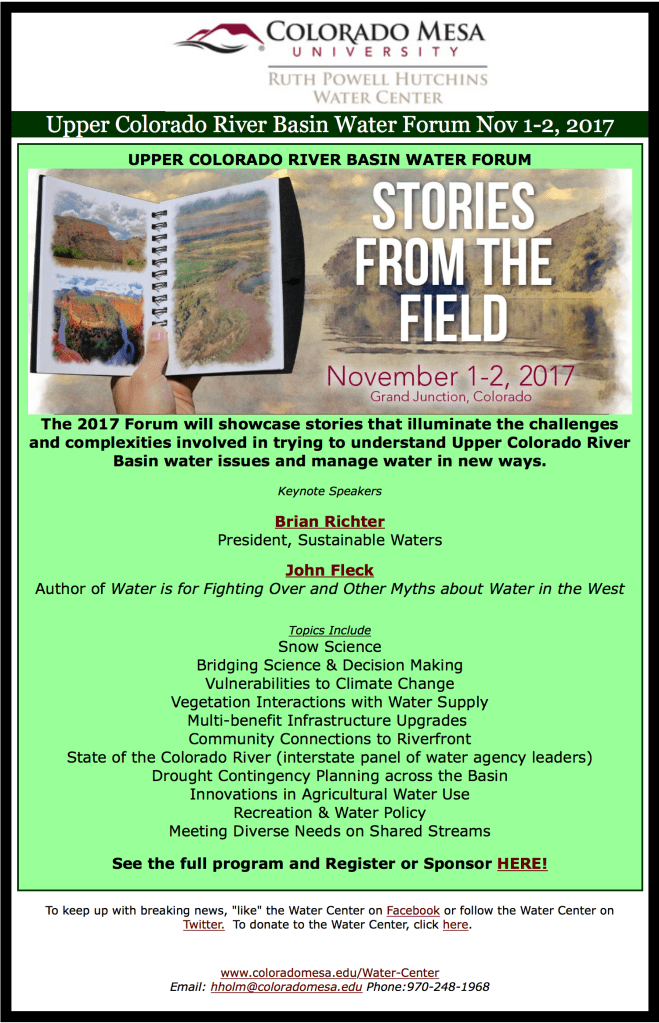
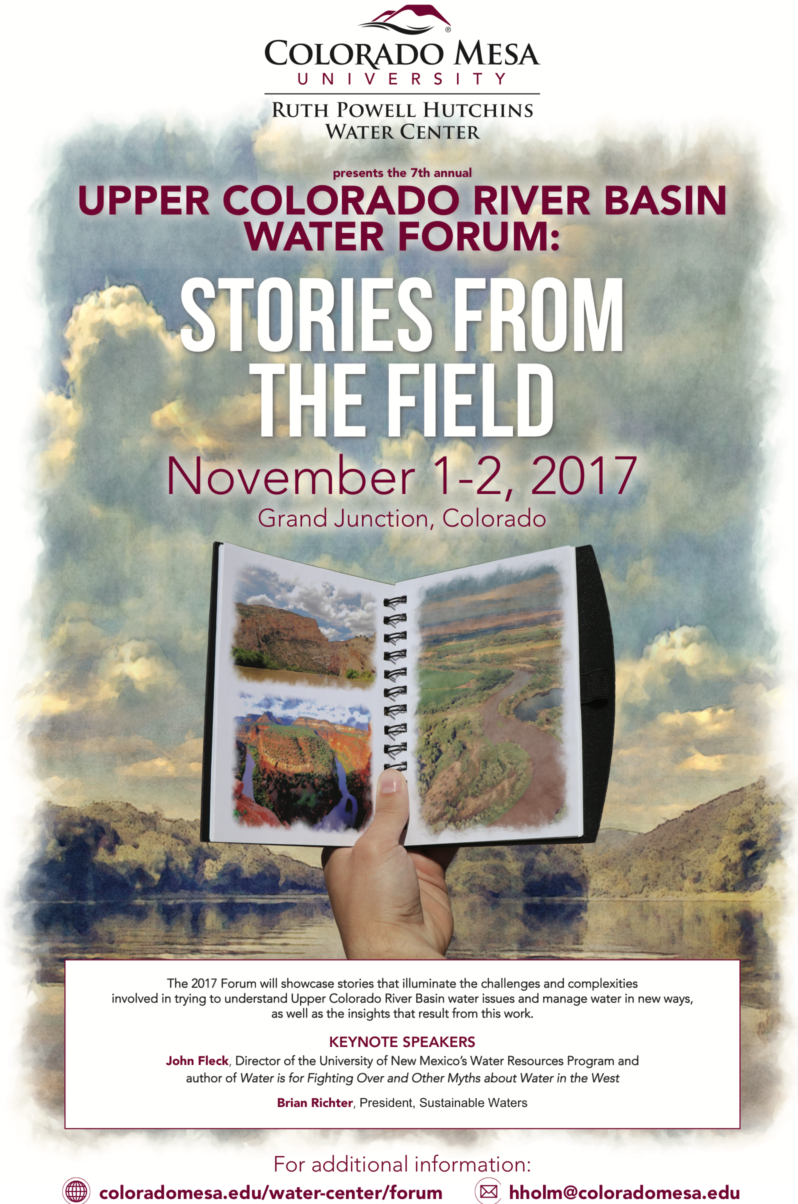
Upper Colorado River Basin Water Forum
Keynote Speakers!
John Fleck, Director of the University of New Mexico’s Water Resources Program and author of Water is for Fighting Over and Other Myths about Water in the WestBrian Richter, President, Sustainable Waters

From The Grand Junction Daily Sentinel (Gary Harmon):
The Colorado River is a still largely unrecognized asset that could flood the Grand Valley with economic opportunities, speakers said at a State of the River conference Monday.
“We’re not maximizing use of the river from a commercial perspective,” Sam Williams, general manager of Powderhorn Mountain Resort, told about 50 people at the conference at the Avalon Theatre in downtown Grand Junction.
Williams spoke on a panel with Palisade-area fruitgrower Bruce Talbott, Grand Junction Economic Partnership Executive Director Kristi Pollard, Alpine Bank Senior Vice President David Miller and Sarah Shrader, owner of Bonsai Design in Grand Junction and a founder of the Outdoor Recreation Coalition.
“We sell lifestyle” when trying to attract businesses to the Grand Valley, and a large part of that is the presence of “this amazing asset we have,” the Colorado River, Pollard said.
Shrader, whose company is developing an outdoor-recreation business park along the river, noted that other cities that have taken advantage of the river through town to use as an attraction have seen a turnaround in the business climate to one of optimism and activity.
“This community is poised to do something really fantastic,” Shrader said.
Involving businesses and people in the river can aid with the recovery of the four endangered fish species in the Colorado River Basin, as well as others, such as the Western yellow-billed cuckoo, by encouraging an ethic of stewardship, Shrader said.
All of Alpine Bank’s branches sit on or near the banks of the Colorado or one of its many tributaries, Miller said.
That has served as a reminder that the health of the river is directly tied to the health of the businesses along it, Miller said.
Alpine Bank has moved to reduce its water use by 40 percent and has saved $12,000 annually in doing so, he noted.
Agriculture in the east end of the Grand Valley — peaches and grapes specifically — has served to make his family business “the darling of the valley,” Talbott said.
It’s been successful on the financial score, as the 2,500 acres of fruit lands generate some $60 million in ultimate retail sales, Talbott noted.
Nonetheless, it’s clear that fruitgrowers and others are well served to look out for their water supplies because, “We farm at the consent of the public,” Talbott said.
“We have to grow (crops) as inexpensively as possible” while looking to assure long-term water supplies, Talbott said.
The meeting was sponsored by The Colorado River Water Conservation District, the Ruth Powell Hutchins Water Center at Colorado Mesa University and the Business for Water Stewardship. Alpine Bank, the Tamarisk Coalition and Club 20 also supported the conference.
From NBC11News.com (Carly Moore):
There were many speakers at the ‘State of the River’ event, taking a critical look at the resource flowing through the valley. They explained the challenges the water supply faces…
Experts are concerned because they believe the river is operating at a long-term deficit, meaning more water is used than the amount we gain from rain or snow.
“Water is really important in Colorado because we are an arid state,” said Aaron Clay, a Delta water law attorney. “It takes water to make any economy run, whether it’s agriculture, manufacturing or municipal.”
“So between people and industry asking more of the river system — and this is all states states on the river — and warming temperatures, that has put a burden on supply,” said Jim Pokrandt, the community affairs director of the Colorado River District.
Gigi Richard, faculty director of the CMU’s Water Center, said the only source of water is precipitation. With a third of the Colorado River Basin getting fewer than 10 inches of rain each year on average, the Colorado River relies on melted snow pack.
“In a sense we’re snow farmers,” Pokrandt said. “While some people may paying attention to commodity prices, our commodity is snow pack.”
Richard said more than 80 percent of Mesa County’s water is used for agricultural irrigation.
Though it’s valuable for family homes to conserve water as much as possible, Clay said that doesn’t put a dent in it.

From the Colorado River District via The Grand Junction Daily Sentinel:
Learn more about the Colorado River
The public is invited to a free day of learning about the Colorado River at the annual Mesa County State of the River meeting from 3:30 to 8 p.m. on May 15 at the Avalon Theatre.
The event is organized by the Colorado River District, Business for Water Stewardship and the Ruth Powell Hutchins Water Center at Colorado Mesa University. The event is supported by Alpine Bank, Club 20 and the Tamarisk Coalition.
For more information, contact Jim Pokrandt at the Colorado River District at 970-945-8522 x236, or edinfo@crwcd.org; or Molly Mugglestone of the Business for Water Stewardship, molly@businessforwater.org.


Click here to read the newsletter. Here’s an excerpt:
DOUBLE PEAK SNOWPACK MELTING
The amount of water in the Upper Colorado Basinwide snowpack peaked early, started to melt and then bumped back up, before dropping steeply again. Similar stories unfolded in the sub-basins, with the Upper Green and Duchesne groups showing the most impressive peaks and the Yampa/ White group the only one to post lower than average numbers. To see how the total accumulations by month add up in Colorado’s basins, choose the stacked bar option on this page.
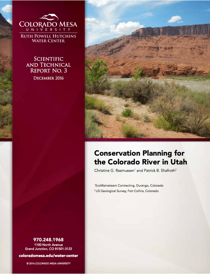
Click here to read the report. Here’s an excerpt (Christine G. Rasmussen and Patrick B. Shafroth):
Strategic planning is increasingly recognized as necessary for providing the greatest possible conservation benefits for restoration efforts. Rigorous, science-based resource assessment, combined with acknowledgement of broader basin trends, provides a solid foundation for determining effective projects. It is equally important that methods used to prioritize conservation investments are simple and practical enough that they can be implemented in a timely manner and by a variety of resource managers. With the help of local and regional natural resource professionals, we have developed a broad-scale, spatially-explicit assessment of 146 miles (~20,000 acres) of the Colorado River mainstem in Grand and San Juan Counties, Utah that will function as the basis for a systematic, practical approach to conservation planning and riparian restoration prioritization. For the assessment we have:
1) acquired, modified or created spatial datasets of Colorado River bottomland conditions; 2) synthesized those datasets into habitat suitability models and estimates of natural recovery potential, fire risk and relative cost; 3) investigated and described dominant ecosystem trends and human uses; and 4) suggested site selection and prioritization approaches. Partner organizations (The Nature Conservancy, National Park Service, Bureau of Land Management and Utah Forestry Fire and State Lands) are using the assessment and datasets to identify and prioritize a suite of restoration actions to increase ecosystem resilience and improve habitat for bottomland species. Primary datasets include maps of bottomland cover types, bottomland extent, maps of areas inundated during high and low flow events, as well as locations of campgrounds, roads, fires, invasive vegetation treatment areas and other features.
Assessment of conditions and trends in the project area entailed: 1) assemblage of existing data on geology, changes in stream flow, and predictions of future conditions; 2) identification of fish and wildlife species present and grouping species into Conservation Elements (CEs) based on habitat needs; and 3) acquisition, review and creation of spatial datasets characterizing vegetation, fluvial geomorphic and human features within the bottomland. Interpretation of aerial imagery and assimilation of pre-existing spatial data were central to our efforts in characterizing resource conditions. Detailed maps of vegetation and channel habitat features in the project area were generated from true color, high resolution (0.3 m) imagery flown September 16, 2010. We also mapped channel habitat features at high flow on 1.0-m resolution, publicly available, true color imagery. We obtained additional layers such as land ownership, roads, fire history, non-native vegetation treatment areas, and recreational use features from public sources and project partners.
From The Grand Junction Daily Sentinel (Dennis Webb):
A new report published by Colorado Mesa University aims to help in planning and prioritizing river restoration projects along 146 miles of the Colorado River from the Colorado-Utah border to the upper reaches of Lake Powell.
“Conservation Planning for the Colorado River in Utah” is the third in a series of scientific and technical reports issued through CMU’s Ruth Powell Hutchins Water Center.
Gigi Richard, a geology professor and faculty director for the center, said the report is available to anyone who’s interested, at http://www.coloradomesa.edu/water-center/scientific-technical-reports.html…
The river restoration report was written by Patrick Shafroth of the USGS and Christine Rasmussen of EcoMainstream Contracting in Durango.
It’s expected that federal and state agencies, conservation groups and others will be able to use the assessment and datasets to identify and prioritize projects to improve wildlife habitat and make the river’s ecosystems more resilient. Already, such entities have been involved in an effort called the Colorado River Conservation Planning Project…
The datasets include maps of existing habitats, areas inundated during high and low flows, and locations of campgrounds, roads, invasive vegetation treatment areas and other features.
The report says that “detailed resource maps can be used in project planning to help maximize the benefits of restoration dollars and minimize overlap of restoration efforts.” The report can identify where conservation efforts could address multiple habitat needs and prioritize projects with the potential to recover without intervention.


Click here to register. From the website:
The rivers that roll past our cities, towns, homes, and highways are reflections of all things that happen upstream and uphill. In this lecture, we will learn to see rivers as a sum of their parts, learning the roles, forms and functions of water, sediment, and vegetation. Blue, the role of water, mobilizing and shaping; Brown, the role of sediment, filling, re-routing and building; and Green, growing, holding and slowing all things mobile. From this context, we will launch into discussions of river health, riparian resilience in the face of climate change, and what we can do to protect habitats critical to fish and wildlife and our riverside communities. We’ll see river cameos of the hard-working Dolores, the now-famous Animas, and the unfettered wildness of the Yampa.
Presented by Dr. Chris Rasmussen of EcoMainstream Contracting, and hosted by Abby Burk of Audubon Rockies.
Click here to read the newsletter. Here’s an excerpt:
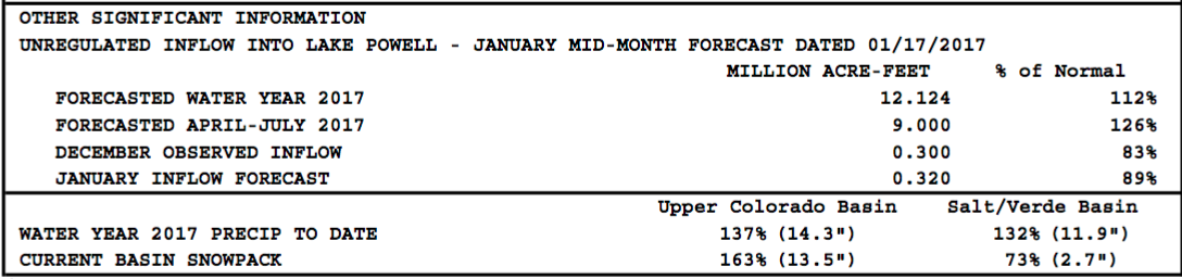
The snowpack graphs in the latest National Integrated Drought Information System/ Colorado Climate Center water supply and drought briefing show near-vertical lines in sub-basins across the Upper Colorado Basin as snowpack levels vauted from way below to way above average. Read the briefing here. As a result, the Bureau of Reclamation’s Jan 17 forecast for unregulated water year inflows to Lake Powell rose to over 12 million acre feet (maf), according to its weekly Lower Colorado Water Supply Report. That’s up from the Bureau’s 9.5 maf forecast on Jan 4 and 7.83 maf forecast on Dec 1, as reported in its monthly 24-Month Studies.
Click here to read the newsletter. Here’s an excerpt:
This year has been an exciting one, and the Hutchins Water Center is looking forward to continued progress in 2017 in pursuing our mission to perform and facilitate interdisciplinary and collaborative research, education, outreach, and dialogue to address the water issues facing the Upper Colorado River Basin.
We got a tremendous response to our spring screening of the documentary River of Sorrows: Inheriting Today’s Dolores River. The reception, screening and panel discussion created the kind of convivial, entertaining and thoughtful atmosphere we seek to create as we enlarge the community of informed water thinkers in the region.
From the Hutchins Water Center at Colorado Mesa University (Hannah Holm) via The Glenwood Springs Post Independent:
It’s been very dry in Colorado’s mountains this fall. It’s still early, and the snowpack could catch up to “normal,” but when I flew over those mountains on Nov. 15, they were brown. Just the barest dusting of white covered the highest ridges and north-facing slopes.
This delayed onset of winter provided a sobering backdrop to ongoing discussions about what to do if the Colorado River Basin slips back into severe drought with Lakes Powell and Mead, the two largest reservoirs in the basin, already half-empty.
If Lake Mead drops too low, farms and cities in the lower basin that have become accustomed to steady water supplies will have to drastically cut back. If Powell drops too low, Glen Canyon Dam will be unable to keep generating power or maintain sufficient releases to honor the 1922 agreement between the states that share the river.
No one knows exactly how upstream water users would be affected in that scenario, but if it’s a crisis reaction, it’s unlikely to be pretty. The environment could take a hit as well because low lake levels would make it impossible to conduct periodic high releases designed to mimic historical floods in order to benefit habitat conditions in the Grand Canyon.
In the lower Colorado River Basin, discussions among Arizona, California and Nevada have centered on who will cut their water use, by how much, and at what “trigger” levels in Lake Mead. This is necessary even without an intensified drought, because lake levels keep falling even with normal water deliveries from Lake Powell. The degree of drought just ratchets the urgency up or down.
In the upper Colorado River Basin, which straddles Colorado, Utah, Wyoming and New Mexico, there is no single outlet at the top of the system that can be cranked up or down. Instead, there are thousands of drainages feeding into the Colorado River, with widely dispersed ranches, farms and communities taking sips and gulps along the way, including some sizeable straws pulling water across the Continental Divide to Colorado’s Front Range.
A recent modeling effort coordinated by the Colorado River District concluded that if we were to experience another drought like the one of the early 2000s, with the reservoirs levels as low as they are now and without any additional conservation, Lake Powell could essentially be drained in just a few years.
Efforts are underway to figure out how to craft a demand management system that can entice upper basin water users to voluntarily dial back their consumption and get paid for it, in order to keep Powell from falling to critically low levels.
That’s complicated. For an agricultural demand management system to work for farmers, it needs to provide adequate compensation, not impede long-term operations, have simple paperwork and not put water rights at risk. For irrigation providers, it needs to pay its own way, be easy to manage, and not put water rights at risk. And for such a system to work for communities, you can’t have large swaths of fields left brown and unkempt, supply dealers left without customers and farmworkers left jobless.
GRAND VALLEY ACTIVITIES
A pilot project in Western Colorado’s Grand Valley is testing an approach to cutting back agricultural water use that seeks to work for everyone.
The location, just east of the Utah state line, is significant. About half of the water that flows into Lake Powell flows through Colorado’s Grand Valley first, some of it flowing through the river, and some detouring through irrigation ditches and farm fields before returning. Much of the water diverted does not return, of course, instead getting transpired through leaves of alfalfa, corn or grass, or plumping up peaches and wine grapes.
The Grand Valley Water Users Association (GVWUA), the biggest irrigation provider in the valley, is managing the pilot project to reduce that water consumption. At an October meeting to explain the pilot program to other regional water managers and irrigators, GVWUA manager Mark Harris said that the potential for future water shortages is driving the organization’s participation in the pilot.
For the 2017 irrigation season, GVWUA will conduct the $1 million pilot with funding from the Colorado Water Conservation Board, the Nature Conservancy and the Water Bank Work Group.
In 2017, 10 farm operators dispersed across the valley, each with 120 or more acres under irrigated cultivation, will participate in the GVWUA program.
The total reduction in water consumption achieved by the GVWUA pilot is predicted to be 3,200 acre feet, only a drop, but an important first drop to test the system. So far, the project appears to be on course work well for the participating farmers and the GVWUA. There is adequate compensation, management isn’t too complicated and water rights are protected.
Making the program acceptable for the rest of the community isn’t too complicated at this small scale, although some eyebrows may be raised at the odd brown field in the spring. If brought to sufficient scale to meaningfully benefit Lake Powell, however, this would become a more significant consideration.
In the meeting about the GVWUA program, several people voiced concern that agriculture was being expected to shoulder the burden of bringing supply and demand back into balance in the Colorado River Basin. Some cities are, in fact, also participating in programs to cut diversions to protect the reservoirs, and most have made large strides in conservation in recent decades. However, there is still a feeling that they can do more, particularly in the area of integrating land use and water planning.
If snow piles up in the mountains at reasonable levels over the next few years, it will buy time to fine tune and gradually scale up programs like the one GVWUA is testing, as well as experiments underway in other settings and on other crops, like high mountain hay meadows. Bolstering administrative capacity to coordinate a broad suite of such programs and developing legal mechanisms to ensure that conserved water reaches Lake Powell without being intercepted by other users must occur before such programs can be effective at a large scale.
If a moderate amount of conserved water is sent to Lake Powell each year or retained in upstream reservoirs, it will reduce the chances that more drastic cuts will be needed in any one year – avoiding the deepest impacts to agriculture and communities.
If the mountains keep staying brown late into the fall, however, the upper basin’s demand management efforts will have to accelerate significantly. Under that scenario, it will be harder to keep everyone happy.
Hannah Holm is coordinator at the Hutchins Water Center at Colorado Mesa University.

Click here for all the inside skinny and register.