The Upper Colorado River Commission plans to revive a program that pays irrigators and other valid rights holders to voluntarily leave water in streams that feed the beleaguered Colorado River.
The System Conservation Pilot Program is one strategy among a handful that Upper Colorado River Basin states — Wyoming, Colorado, Utah and New Mexico — have offered to help satisfy their role in meeting a challenge by federal officials to conserve 2 million to 4 million acre-feet of water system-wide in 2023.
“The goal is to have water conservation projects underway in April 2023 to reduce consumptive uses in the Upper Basin Colorado River system,” the UCRC stated in a Dec. 14 press release. More “durable” and “longer-term” solutions are still needed, however, the UCRC said. “The SCPP is a significant step to begin to partially mitigate the water supply crisis in the Upper Colorado River Basin brought on by a drier climate and depleted storage.”
The SCPP was initially implemented from 2015 through 2018 using funds from Lower Colorado River Basin stakeholders, including large municipalities such as Las Vegas. This time around, the UCRC proposes to instead use $125 million from the Inflation Reduction Act — an appropriation that backers hope Congress will approve in a spending bill.
Water users have only until Feb. 1 to submit proposals in response to a call for applications that was issued Dec. 14.
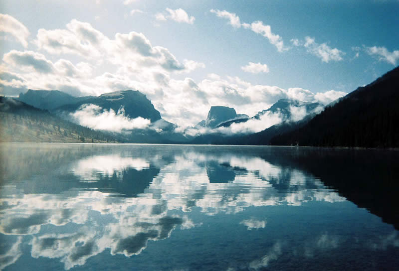
Water users are urgently trying to keep Lake Powell on the Utah-Arizona border from dropping to a point where Glen Canyon Dam can no longer generate electricity. (Source: Bureau of Reclamation)
The UCRC scrambled in recent months to relaunch the SCPP water conservation program under pressure to lay the groundwork for both short- and long-term water savings amidst a growing crisis along the Colorado River. The river system serves some 40 million people in seven western states and Mexico.
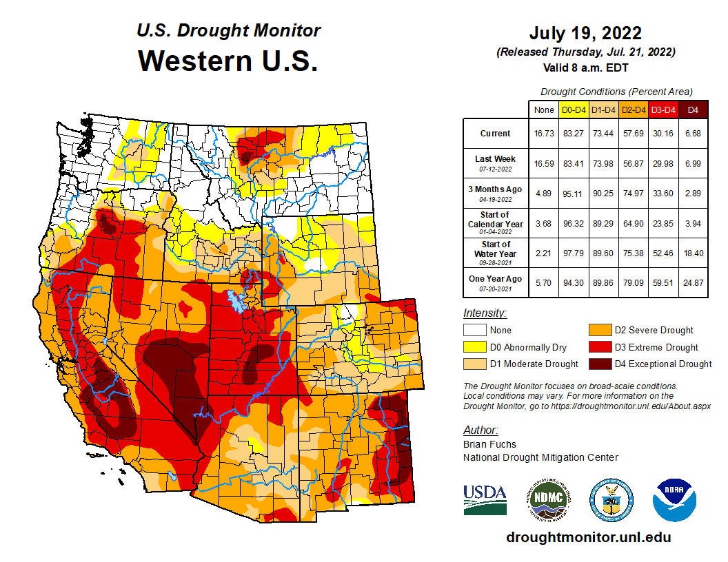
The 22-year “megadrought” that has parched much of the American southwest — combined with growing demands on the river — has drained Lake Powell and Lake Mead to their lowest levels in history and shows no signs of abating, according to the federal Bureau of Reclamation.
The ongoing crisis, if drought conditions continue, could result in mandated water curtailments in Wyoming by 2028, according to the Wyoming State Engineer’s Office. Municipalities, including Cheyenne, Green River and Rock Springs, are among the most vulnerable because — generally — they hold junior water rights that, under the Colorado River Compact and Wyoming water law, would be among the first to be restricted under a curtailment. About one-fifth of Wyoming’s population relies on domestic water supplies subject to a curtailment under the Colorado River Compact.
Compensated conservation
Despite the quick turnaround to attract volunteer projects under the revived SCPP, water officials and conservation advocates in Wyoming believe there’s growing interest. Conservation groups such as Trout Unlimited played an integral role in the first iteration of the SCPP, seeing an opportunity to promote water conservation measures that also benefit fisheries and the general biological health of waterways by keeping more water in streams and rivers late in the summer.
Wyoming Trout Unlimited Water & Habitat Program Director Cory Toye helped introduce many agricultural water users to the SCPP in the first go-round, and that work has resumed in recent months, he said.
“It’s certainly on people’s minds,” Toye told WyoFile. “For the most part, it still makes economic sense for a lot of [irrigated ag] operations.”
Participation among Wyoming water users increased incrementally over the first four years of the program. All told, the SCPP in Wyoming saved a total 23,886 acre-feet at 26 project sites. It cost $4,079,233 — about $171 per-acre foot, according to a report by the upper basin commission.
For now, the commission envisions a “fixed term” compensation of $150 per acre-foot under the SCPP in 2023, although it may consider higher rates based on circumstances, according to the agency’s request for proposals.
Dipping toes
Eric Barnes, an irrigator on Fontenelle Creek — a tributary of the Green River in western Wyoming — was among the first SCPP participants in the state, and he’s eager to enroll in the program in 2023, he said. Barnes irrigated as usual in the spring to grow an early season crop, he said, then curtailed irrigation later in the summer — a water conservation practice known as “split season deficit irrigation.” All 26 projects in Wyoming during the first four years of the program fell under this category.
“It was beneficial for me,” Barnes said. “I was able to take advantage of the water early in the season and then shut [irrigation headgates] off and get paid for [conserving water] in the same year.”
A pump pulls water from the Green River at a Sweetwater County-managed recreation area Sept. 27, 2022. (Dustin Bleizeffer/WyoFile)
The practice — at least on Fontenelle Creek, Barnes said — left more water in the creek to support the trout fishery; a benefit to the local recreation economy and a priority for groups like Trout Unlimited.
“It was a good way to help people understand what life may look like with less water and what diversifying [irrigation] operations might look like,” Toye said. “And the scale of the projects went from scattershot those first couple of years to tying entire tributaries together.”
For now, the program makes sense for a lot of Wyoming ag irrigators subject to the Colorado River Compact, according to Toye, particularly in the upper reaches of the Green River and its tributaries. Although Wyoming and its fellow upper Colorado River basin states are eager to revive the program, it will soon evolve and be replaced by a larger conservation program with more sophisticated water-accounting protocols that are recognized by stakeholders throughout the system.
Those changes may entice ag irrigators like Barnes to take on water conservation strategies beyond simply foregoing a second round of summer irrigation, Toye said. However, he added, the program isn’t intended to shrink or replace ag production.
“The goal is to make sure people can do as much as they have historically with less water, or at least be prepared to do that,” Toye said. “So the intent is to explore different irrigation patterns and perhaps identify places where efficiencies can occur.”
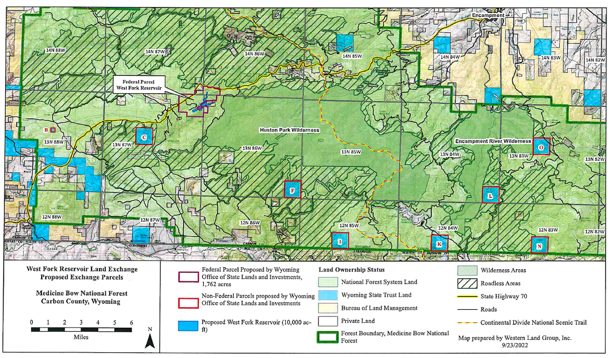
Wyoming moved to expedite the construction of a 280-foot-high concrete dam in the Medicine Bow National Forest last month by proposing a 6,282-acre land exchange.
The state wants 1,762 acres of federal property for a dam and reservoir on the West Fork of Battle Creek in the Sierra Madre Mountains, according to a Nov. 30 letter and map from Jenifer Scoggin, the director of Wyoming’s Office of State Lands and Investments. In exchange, Wyoming would transfer ownership of up to 4,520 acres of state school trust lands to the federal government. That school trust land lies inside the boundaries of the Medicine Bow-Routt National Forest.
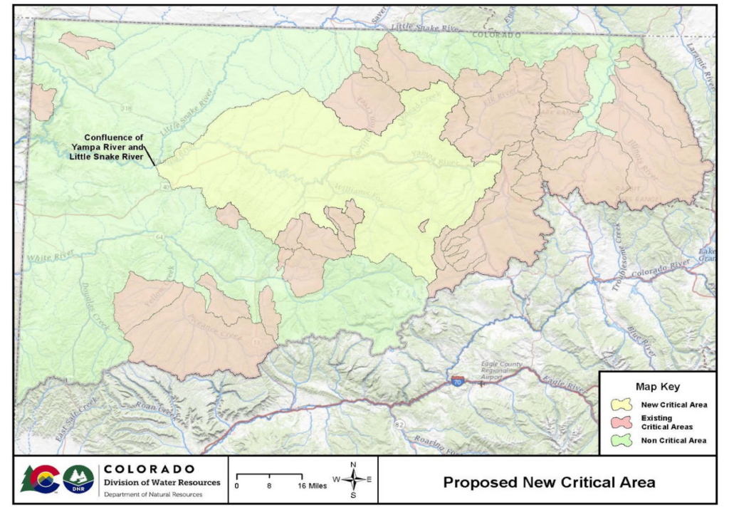
The Medicine-Bow announced the application in a press release setting three public meetings that will be held on the evenings of Jan. 10, 11 and 12 in Craig, Colorado, Baggs and Saratoga respectively. The dam would be built on a tributary of the Little Snake River that flows into the Yampa, Green and Colorado Rivers.
“Conveying this parcel out of Federal ownership would eliminate the need for a USFS special use permit for the reservoir as well as provide for efficient management of the reservoir and surrounding lands,” states the 19-page notice of intent and proposal, which Scoggin sent to Brush Creek/Hayden District Ranger Jason Armbruster in Saratoga. Wyoming needs the federal property to construct the reservoir and meet “fiduciary obligations to produce income to support public schools and other state institutions,” the letter reads.
WyoFile obtained a copy of Scoggin’s letter, the proposal and map Tuesday from deputy director Jason Crowder.
The state Board of Land Commissioners last summer conceptually approved investigating a land exchange that would have covered some 24,000 acres. That approval allowed state officials to offer a smaller exchange in an effort to accelerate the West Fork Dam and reservoir project, Crowder said.
Smaller would be faster
“[T]he reality of getting something like that [larger exchange] done isn’t all that hot,” Crowder said. The Forest Service would have to examine a larger exchange through the National Environmental Policy Act process, which would take considerably longer than what’s being proposed, he said.
“Something that large isn’t anything that could get done in a timely fashion,” Crowder said. “It’s probable that a larger exchange … wouldn’t be feasible or successful in the near term.”
Instead, an exchange “that was more narrowly focused [on the land] needed for the reservoir construction and implementation would be OK,” he said.
Instead of writing an environmental impact statement that’s common for major proposals under NEPA, the Forest Service will instead conduct a “feasibility analysis/study,” Medicine Bow officials said in a statement. “The resulting product is referred to as a Public Interest Determination,” that would approve or reject the exchange, the Forest Service news release states.
The Forest Service study will focus on the future use and management of the lands and the effect of the exchange on the lands that adjoin them, the Medicine Bow release said.
Estimated in 2017 to cost $80 million, the proposed West Fork Reservoir would serve 67 to 100 irrigators. A 130-acre reservoir would hold 10,000 acre feet of water primarily for irrigation. The project is sponsored by: Savery-Little Snake Conservancy District and Pothook Conservancy in Colorado, the Forest Service said.
The proposed reservoir would impound and divert water from the troubled Colorado River Basin where residents in seven states and Mexico are at odds over how to use dwindling flows.
“It is important to note that the Forest Service has not yet determined if this is a feasible exchange, nor has the agency agreed to initiate it,” the Medicine Bow statement reads.
The Jan. 10 meeting in Craig will be from 5-7 p.m. at Colorado Northwest Community College. A virtual option will be available through the Forest Service website.
The meeting Jan. 11 in Baggs will be held from 6:30-8:30 p.m. at the Valley Community Center. The Saratoga meeting the following day will be from 5:30-7:30 at the Platte Valley Community Center.Land exchange proposal details will be available the week of the public meetings on the Forest’s project website, the Medicine Bow announcement stated.
“We pray for the rains to come, for the snow to fall, for moisture in the earth. Not just for the Hopi, but for everybody. For every living thing that’s out there.” – Dennis Hopper, Hopi Elder
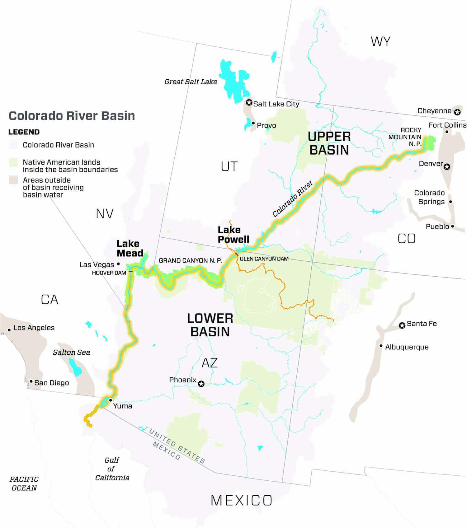
The Green and Colorado river systems form the backbone of the American West. Once spanning a 1,450-mile journey from the Rocky Mountains to the Gulf of California, today, none of the sediment-rich water reaches the Pacific Ocean. Instead, its water lies stymied in reservoirs and siphoned off to feed and nurture 40 million people from Salt Lake to Los Angeles.
One hundred and fifty years after John Wesley Powell’s historic descent of the Green and Colorado rivers, an unlikely crew of scientists, artists, educators, and river lovers repeated his journey on a trip that was simultaneously a celebration of modern river life and a critical look at how we interpret the Colorado River’s history and use its waters.
As the demand we place on the water of the Colorado continues to exceed its supply, we are forced to face uncomfortable truths about decisions made in our past. And we are reminded that the way we think about water—and all those dependent upon it—needs to shift if we want things to change for our future.
“Water is a life force for all of us. It has a spiritual and physical being to it that deserves respect. It’s not something that you take for granted.” – Lyle Balenquah, Hopi archaeologist
Map of the Colorado River drainage basin, created using USGS data. By Shannon1 Creative Commons Attribution-Share Alike 4.0
Flows in the White River (pictured above) and other Upper Basin tributaries have declined dramatically over the last 20 years, a trend experts warn will worsen as the West becomes hotter and drier. (Source: The Water Desk)
Rio Blanco County Commissioners and staff discussed the nuance and minutiae of water administration in the White River Valley during a special work session Tuesday. “It will be tough for sure” said Commissioner Ginny Love, noting that residents will have to adjust to using less water, or even having water shutoff at certain times of year.
“There’s not much we can do about it, it’s more of how to learn to live with it,” said Colorado River District water commissioner Betty Kracht. She visited with the board to share background info about Rio Blanco Water Conservancy District’s (RBWCD) call on the river and answer questions about how water administration will affect residents of Rio Blanco County.
RBWCD placed a “standing call” on the river using multiple water rights, beginning with a 1966 decree for 620 cubic feet per second (CFS). Kracht explained that once the first right is met, another call (from another junior water right) would then kick in. Whenever the call is in-effect, water rights holders junior to RBWCD’s 1966 decree will be subject to shutoff/curtailment. According to Kracht, about one-third of rights in the drainage are junior to 1966. Senior water rights holders can still use their allocated amount during the call, though Kracht warned they’ll still be affected by administration if they’re not in compliance with state water regulations. “With this call, anyone who wants to irrigate must have a headgate, must have a measuring device,” said Kracht, noting the measurement rules affect the entire county, not just people upstream from the Taylor Draw Dam. Kracht further detailed results of water administration, which will include stricter enforcement of water use. For example, water decreed for irrigation can’t be used for livestock watering, or vice-versa.
Click the link to read the guest column from the Colorado Division of Water Resources on the Steamboat Pilot & Today website:
The Colorado Division of Water Resources staff in Steamboat Springs reminds landowners with existing unpermitted wells, and ponds fed by ground water, to file permits for those water structures by Dec. 31 to be evaluated without the well impacts treated as injurious, or harmful to water rights.
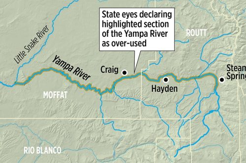
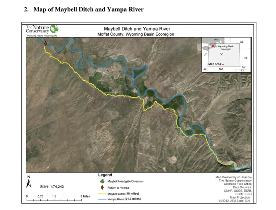
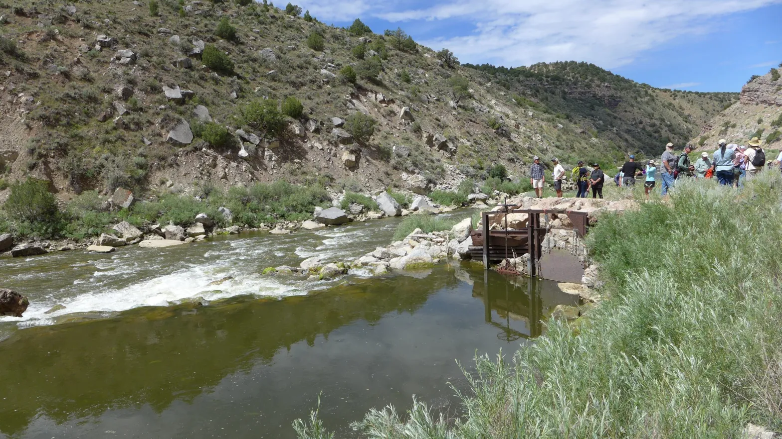
The state water engineer designated the middle Yampa River basin from west Steamboat Springs to the confluence with the Little Snake River west of Maybell, including all of its tributaries, as over-appropriated on March 1. Through the end of 2022, owners of existing unpermitted wells in that area can obtain a well permit without negative impacts if the well owner can demonstrate the well and its uses existed prior to March 1. The wells may include but are not limited to pond wells or other structures that expose groundwater to the atmosphere.
Water resources officials estimate hundreds of unpermitted wells exist in that area. A map of over-appropriated areas is available online at dwr.colorado.gov/division-offices/division-6-office, and click on the link “Report Designating Yampa River as Over-Appropriated.”
For applications for existing unpermitted wells filed on or after Jan. 1, Division of Water Resources staff will consider the injurious impacts from those existing wells when evaluating applications, which may result in a permit issued that considerably limits the use of water from the well. For questions, call the state’s well information desk at 303-866-3587. Permitting information is available online at Dwr.colorado.gov/services/well-permitting.
Credit: Chas Chamberlin via Water Education Colorado
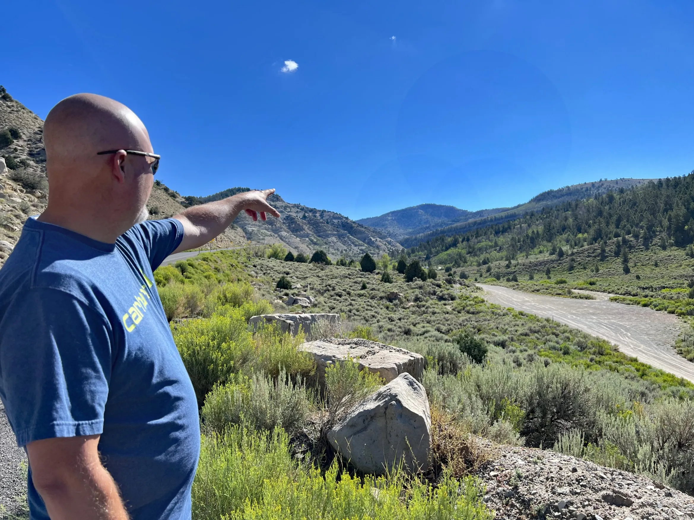
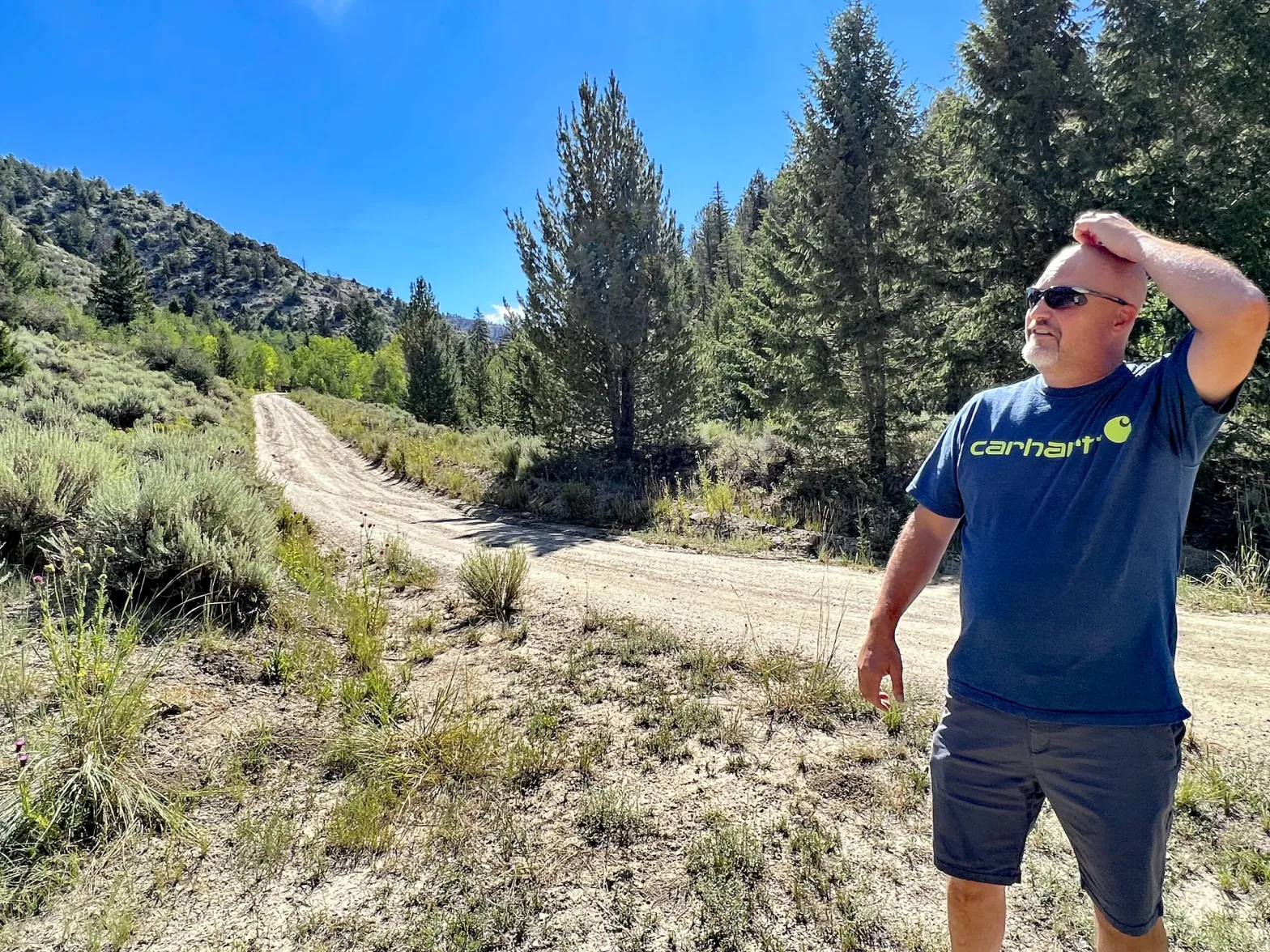
Darrell Fordham points toward a tunnel entrance for the proposed Uinta Basin Railway that would run near a mountain retreat property he owns in Argyle Canyon, Utah. U.S. Highway 191 is on the left in the photo. CREDIT: AMY HADDEN MARSH/ASPEN JOURNALISM
Darrell Fordham is heartbroken. It took years for the resident of Lehi, Utah, to purchase 20 acres above Utah’s Argyle Canyon and build a cabin for family retreats. “I’ve sunk about $150,000 into that property,” he told Aspen Journalism. “We bought it back in 2006 just as a place to raise our kids. Get ’em out of the city, get ’em unplugged and off the cellphones.”
The cabin is at about 6,000 feet at the edge of the Ashley National Forest on the West Tavaputs Plateau, surrounded by aspens and conifers in a small, tightknit, off-the-grid community known as Argyle Canyon Estates. “Being off-grid and about 3 1/2 miles off the pavement, the quiet is the whole appeal of that property,“ said Fordham. But that quiet is in jeopardy due to the proposed Uinta Basin Railway (UBR).
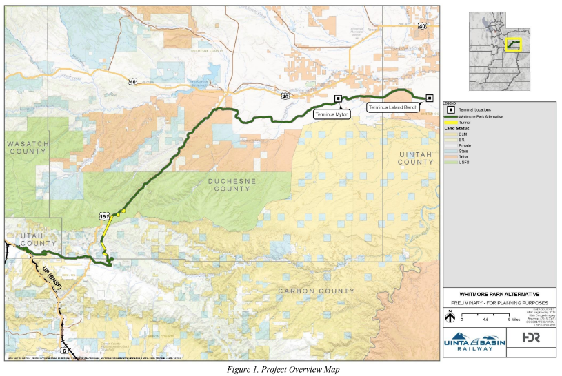
The UBR is not yet under construction but received necessary approvals from the Federal Surface Transportation Board (FSTB) in December 2021 and the U.S. Forest Service in July 2022. The 88-mile-long railroad would connect the fracked-oil fields in northeast Utah’s Uinta Basin to the national rail network. The crude would then be transported in heated tanker cars through Colorado on its way to Gulf Coast refineries.
Fordham began organizing his neighbors against the UBR in 2019 when it looked like two potential alignments — the Indian Canyon route and the Wells Draw route — would run through local properties and uncomfortably close to his community. As the Argyle Wilderness Preservation Alliance, the community wrote letters against the UBR in July 2020, shortly after the Seven County Infrastructure Coalition (SCIC), a quasi-governmental board created in 2014, applied for approval from the FTSB. Fordham said the group hired a lawyer that year and filed lawsuits in Utah district court but to no avail.
In 2014-15, 26 potential UBR routes were identified in Utah Department of Transportation feasibility studies, but none passed the initial screening process. Five years later, the SCIC added the Indian Canyon, Wells Draw and Craig routes as alternatives. The Craig and Wells Draw routes were eventually scrapped. The Indian Canyon route morphed into the preferred 88-mile Whitmore Park route, named for a large valley south of the Tavaputs Plateau.
According to maps provided by Fordham, the Whitmore Park route would still pass 2,550 feet from his property line. He said it feels as if his concerns have fallen upon deaf ears. “I think it’s communities like ours that are impacted by things like this because we’re just common people,” he said. “We don’t have hundreds of thousands of dollars to fight the government and the big oil companies, so they know they can just run it right over the top of us and there’s really nothing we can do about it.”
Overview of Argyle Canyon area that would be impacted by the proposed Uinta Basin Railway.
CREDIT: PHOTO COURTESY OF ECOFLIGHT
FSTB legal appeals in the works
In February, environmental groups and Eagle County filed separate appeals in response to the FSTB’s decision last December to approve the UBR. (The two cases have since been consolidated.) At issue are the approval decision and the U.S. Fish and Wildlife Service’s September 2021 biological assessment, upon which the FSTB relied to make its decision.
Most Uinta Basin oil is trucked to refineries in Salt Lake City, but production is capped at 80,000 to 90,000 barrels per day due to air pollution restrictions on the Wasatch Front. By connecting the Uinta Basin fracked-oil fields to the national rail line at Kyune, Utah, the UBR promises to quadruple production by bringing Uinta Basin crude — which must be heated for transportation purposes so that it doesn’t solidify — to the global market.
But increased oil production means increased air pollution in the Uinta Basin. Ted Zukoski, CBD attorney, told Aspen Journalism that air pollution in the basin is already listed as marginal. “This means it’s on the edge of becoming a nonattainment area because of wind inversions that trap pollution from drilling in the basin and lead to very unhealthy air quality.”
A 2013 study by state and federal agencies revealed federal ground-level ozone standards violations in the basin due to oil and gas production. In 2016, the state of Utah recommended nonattainment designations for National Ambient Air Quality Standards in five Utah counties, including Duchesne and Uintah, both in the Uinta Basin. A lag in oil and natural gas production lowered methane levels from 2015 to 2020. But methane leaks in production infrastructure effectively canceled out those gains. As of October, the Uinta Basin remains in nonattainment status.
Zukoski said the FSTB ignored the air pollution impacts and the downstream impacts of greenhouse gases released from consumers burning gasoline refined from Uinta Basin crude. “It could lead to as much as 53 million tons of additional CO2 going into the atmosphere,” he said. “The Forest Service knows how bad climate change is, so it’s hypocritical for this agency to support this project.”
Eagle County argues that the FSTB failed to look at the cumulative impacts of increased rail traffic on the Union Pacific line, which passes through the county, and possible impacts should Colorado’s Tennessee Pass railway be reactivated. County officials added that the scope of the FSTB’s environmental analysis was too narrow, focusing only on the 88 miles of the UBR in Utah.
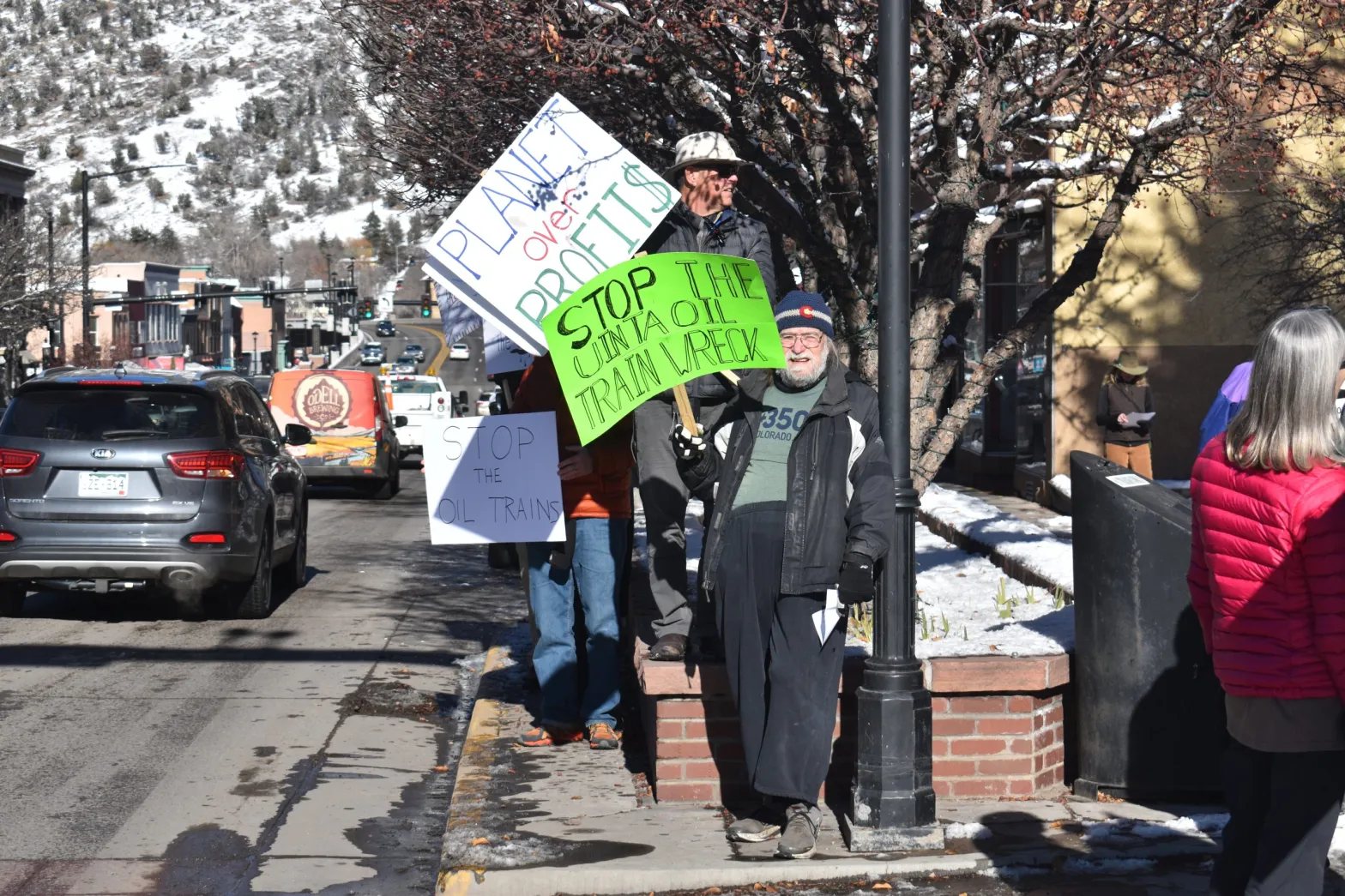
A man holds a picket sign that reads “Stop the Uinta Oil Train Wreck” in Glenwood Springs on Saturday, Dec. 10.
CREDIT: RAY K. ERKU/GLENWOOD SPRINGS POST INDEPENDENT
Colorado officials join the legal fray
In late October, the city of Glenwood Springs and the towns of Minturn, Avon, Red Cliff and Vail filed an amicus brief in support of Eagle County and the FSTB appeal. Karl Hanlon is an attorney with Karp, Neu, Hanlon, a Colorado firm that works with the cities of Glenwood Springs, Minturn and Red Cliff.
“What’s being proposed is 18 miles a day of train cars on the main [Union Pacific] line going through the city of Glenwood Springs and passing alongside the Colorado River through Garfield, Eagle and Grand counties,” he told Aspen Journalism. “The risks are tremendous with regard to the potential for an accident, the socio-economic impacts and the environment.”
Hanlon added that the FSTB did not consider whether running up to 185,000 heated tanker cars full of waxy crude alongside Interstate 70 is a good idea, particularly through Glenwood Canyon. The 2020 Grizzly Creek Fire shut down I-70 through the canyon for two weeks. Rockslides and mudslides from heavy rains the following summer closed the canyon again, resulting in lengthy detours for commercial trucks and other traffic, and decimating the Glenwood Springs economy at the height of tourist season.
“One major incident in Glenwood Canyon ends the livelihood of Glenwood Springs,” said Hanlon. “Not only is it a huge environmental disaster that is almost impossible to clean up, it will be the death knell for the community.”
He said the FSTB’s decision ignored Coloradans. “Frankly, the board just kind of thumbed their nose at all these communities,” he said. “FSTB focused on the 88 miles of new line in Utah and did their entire analysis there.”
Routt, Boulder, Chaffee, Lake and Pitkin counties, near the Union Pacific line, also signed on to the amicus brief. Routt County Manager Jay Harrington told Aspen Journalism that U.S. Highway 40 is the main northern traffic detour when I-70 is closed. “A rail accident does not have to occur close to Routt County to cause problems,” he said. “Every time I-70 [in the Glenwood Canyon ] is closed, traffic is rerouted right through here.”
The amicus brief references climate change impacts, wildfire risks from heated train cars, and the domino effect of an oil spill on downstream Colorado River users. Hanlon said the FSTB should start over and revisit the indirect impacts, including communities outside Colorado. “That waxy crude has to go a long way to get to a refinery,” he said. “There are communities all across the [country] going down towards the Gulf Coast that are facing similar impacts from this.”
Dirt track to the right leads to a borehole site for a tunnel under the Ashley National Forest roadless area, part of the Uinta Basin Railway proposal which U.S. Forest Service officials approved in July.
CREDIT: AMY HADDEN MARSH/ASPEN JOURNALISM
USFS:A railroad is not a road
The Forest Service greenlighted a 12-mile stretch of the Whitmore Park route in July that would cut through an inventoried roadless area (IRA) in the Ashley National Forest. Prior to the approval, CBD and other conservation groups sent a letter to national Forest Service Chief Randy Moore, urging him to reject the Ashley National Forest’s application. But Moore refused, stating in a November 2021 response letter, “By definition, a railway does not constitute a road under the Roadless Rule.”
Then, in July, Ashley National Forest Supervisor Susan Eickhoff approved that 12-mile portion of the UBR. Two months later, CBD, Living Rivers, Sierra Club and Utah Physicians for a Healthy Environment filed suit. Zukoski said the argument is more than whether a railroad is a road; it’s also about the UBR’s effect on the general intent and purpose of a roadless area. “We raised many issues, including a failure of the Forest Service to consider the impact on roadless values,” he said.
The 2001 Roadless Rule established wilderness attributes and values to define an IRA, such as remoteness, quiet and solitude within the natural world. But, Zukowski said, roadless areas offer more than solace for humans. “The Forest Service understood that these areas had a particular and special value because of their protection of storehouses of biodiversity,” he said.
This map, included in U.S. Forest Service documents evaluating the Uinta Basin Railway proposal, shows the 88-mile length of the route. Tunnels are shown in yellow.
CREDIT: COURTESY IMAGE
The UBR track, with a right-of-way between 100 and 200 feet wide, would run mostly parallel to U.S. Highway 191, cutting through private property and agricultural fields in Indian Canyon before slicing through the Ashley National Forest. The railroad’s footprint would alter an estimated 167 acres within the IRA, with an additional 235 acres affected in the construction process but planned for reclamation. Three tunnels on Forest Service land, including two spiral tunnels and a portion of a 3-mile-long straight tunnel, would have a total length of 2.6 miles.
In a January interview for ChannelV6.com, a local broadcaster in northeast Utah, Kyle Robe, deputy project manager for Rio Grand Pacific, discussed the spiral tunnels planned for Indian Canyon and the 3-mile-long straight tunnel. “[We will] drill holes into the face of the rock and high-pressure grout those holes,” he said. Then come massive machines called “roadheaders.” “They’ve got a big arm and big rotors on the end with teeth on them [that] chip away at that rock,” said Robe. “We’ll get about 25 feet a day on each end of rock that we’ll tear out of the mountain.” Robe did not respond to interview requests from Aspen Journalism. A spokesperson for the Seven County Infrastructure Coalition also declined to comment, citing pending litigation.
Track construction also means carving out miles of cuts, siding track and embankment fill, and placing culverts and other infrastructure, including five bridges. Temporary work areas, including camps to house workers, could be up to 1,000 feet wide. Once completed, up to 10 trains per day would rumble through the IRA, each hauling up to 100 tanker cars of crude.
Darrell Fordham stands near a tunnel entrance for the proposed Uinta Basin Railway, which would pass near his family’s mountain retreat in Argyle Canyon, Utah.
CREDIT: AMY HADDEN MARSH/ASPEN JOURNALISM
CBD attorney Wendy Park pointed to a bigger, overarching issue. “Under [President Joe] Biden’s 2021 executive order, combating climate change is something that all federal agencies should be doing everything in their power to address,” she told Aspen Journalism. In his 2021 letter to CBD, Moore cherry-picked components of the executive order to support the touted economic benefits of the project, stating that the UBR would support Biden’s policy to build a sustainable economy. But Biden’s order states that the United States will develop a finance plan to promote “the flow of capital toward climate-aligned investments and away from high-carbon investments.”
Eickhoff, of the Ashley National Forest, also amended the 1986 Ashley National Forest Land Resource Management Plan (LRMP) to allow for the UBR corridor through the IRA. The LRMP calls for maintaining the area’s scenic values. But Eickhoff’s amendment exempts the UBR right of way.
The SCIC must meet conditions of the Forest Service approval, including federal and LRMP mitigation measures, before track construction can begin. But despite approving the UBR last summer, the Forest Service has yet to issue the actual permit.
The agency could still change course, which is what activists in Utah, Colorado and points east are hoping for. Protests last week in Boulder, Denver, Salt Lake City and Glenwood Springs called on U.S. Secretary of Agriculture Tom Vilsack to revoke the permit. “It’s worthwhile to continue to put pressure on the Biden administration and Secretary Vilsack because this project is a carbon bomb,” said CBD campaigner Deeda Seed. “This is a poster child for the harm from climate change.”
This story ran in the Glenwood Springs Post Independent on Dec. 13.
Lower water levels at Flaming Gorge Reservoir, which have left several boat ramps and docks high and dry, are likely the “new normal” for years to come, according to federal officials.
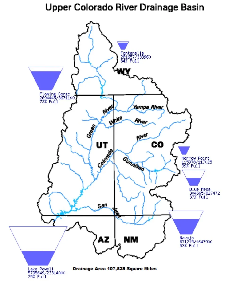
The Bureau of Reclamation’s most recent water-balancing adjustment under the Colorado River drought contingency plan, announced this month, maintains current plans at Flaming Gorge Reservoir on the Wyoming-Utah border. Those plans entail releasing an extra 500,000 acre-feet of water through April as per actions implemented in May. However, Flaming Gorge — along with two other major Upper Colorado River Basin reservoirs, Blue Mesa in Colorado and Navajo in New Mexico — remains a primary backup water source and may likely be tapped for more water, according BOR officials.
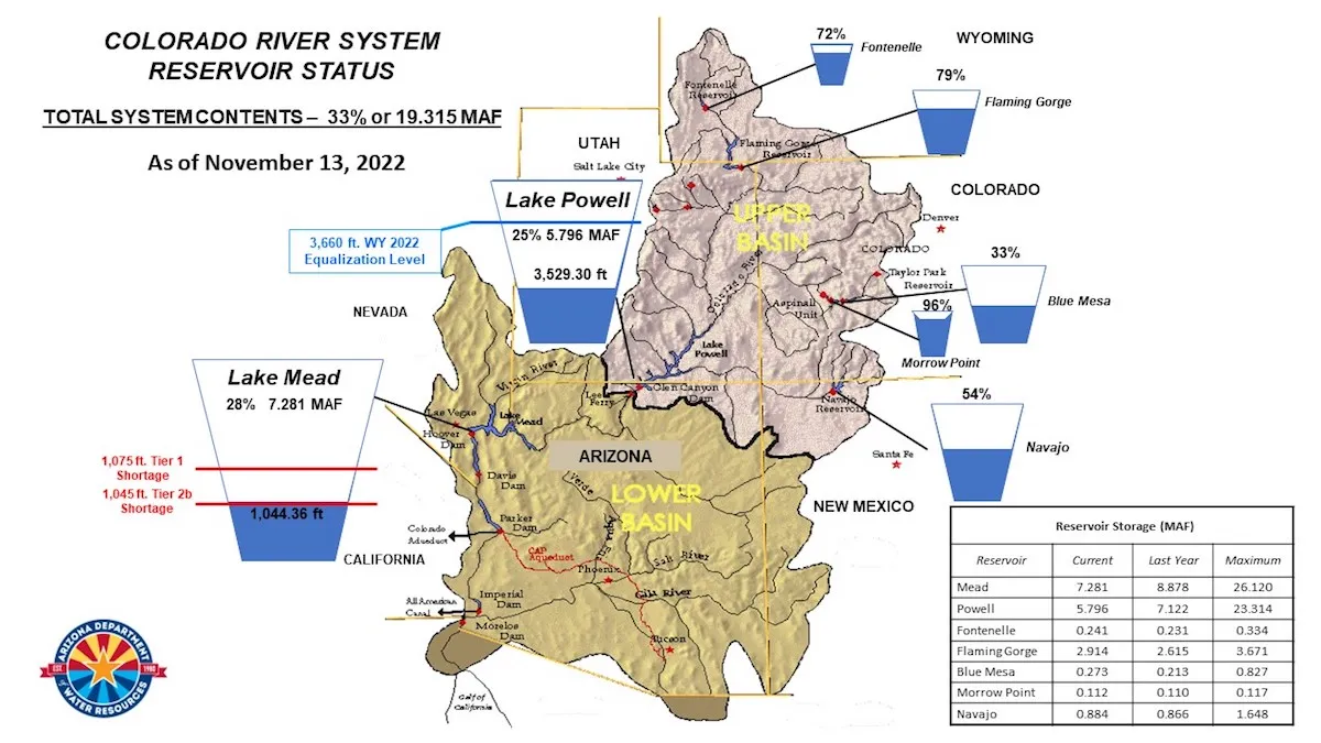
This graphic indicates Colorado River reservoir levels as of November 2022. (Arizona Department of Water Resources)
The BOR, meanwhile, will reduce releases from the Glen Canyon Dam at Lake Powell by 523,000 acre-feet of water from December through April, then allow that same volume to flow downstream to Lake Mead during the summer months. Future adjustments will likely include siphoning more water from Flaming Gorge, according to BOR officials.
Ongoing incremental adjustments are intended to sustain hydropower generation at the Glen Canyon and Hoover dams as a 22-year drought — exacerbated by human-caused climate change — continues to push the Colorado River Basin into a water scarcity crisis.
Taken all together, that means the bathtub rings of exposed shoreline at Flaming Gorge represent what is likely a “new normal” for the reservoir, Drought Response Operations program manager for the Upper Colorado Basin Region Dale Hamilton told WyoFile.
“We will continue to work with our Basin partners to consider additional releases implemented under the Upper Basin [drought contingency plan] from the upstream Colorado River Storage Project initial units, which includes Flaming Gorge,” Hamilton said.
Much depends on winter precipitation and spring runoff, Hamilton added, so any decision regarding further actions at Flaming Gorge is likely months away. “Those actions are still being discussed,” he said.
New normal
After decades of relatively steady water levels at Flaming Gorge, the reservoir is undergoing unprecedented changes as water managers release extra water in an attempt to to help balance water levels among major downstream storage reservoirs along the Colorado River.
The BOR released an extra 125,000 acre-feet of water from the reservoir in 2021 as part of the Colorado River drought contingency plan, dropping the surface level by about 5 feet. The current “extra” release of 500,000 acre-feet of water, combined with lower-than-average natural infill (just 57% of average from April through July) diminished the reservoir to 72% capacity in November, according to the BOR.
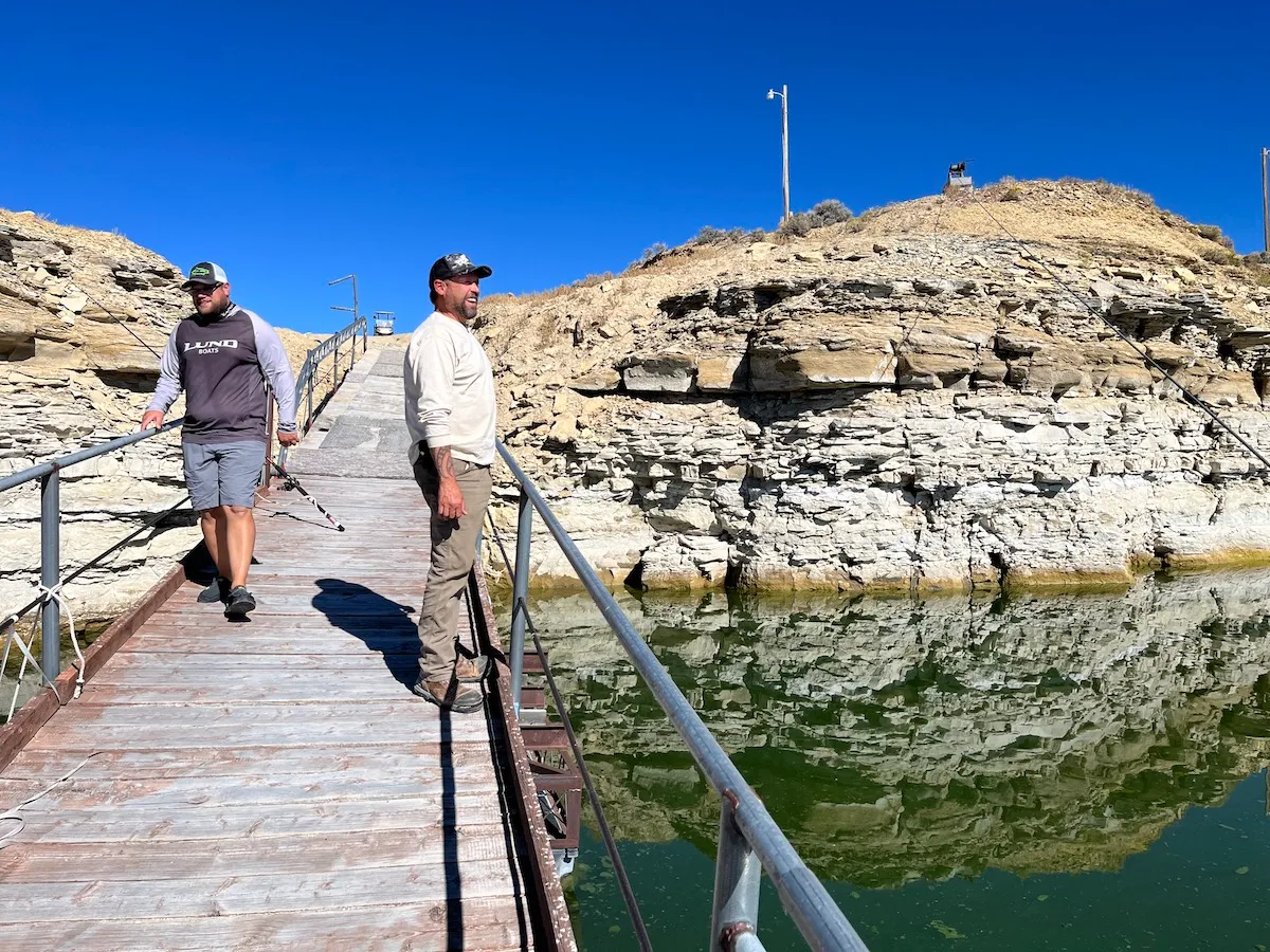
Recon Angling owner Shane Dubois (left) and Buckboard Marina owner Tony Valdez observe water levels at Flaming Gorge Reservoir Sept. 26, 2022. (Dustin Bleizeffer/WyoFile)
The reservoir has dropped by about 9 feet this year, exposing vast areas of lakebed at the upper reaches and water-ring patterns on canyon walls in some areas.
Recon Angling fishing guide Shane DuBois tried his luck ice-fishing Monday in 7 feet of water where, normally, the water depth should be nearly 40 feet, he said.
“A lot of [fishermen] have been fishing different spots for burbot,” DuBois told WyoFile. “I think [lower water levels are] going to start messing up everything, especially with all the sediment that’s pushed up on the rocks where [fish] usually spawn. It’s not going to be conducive for successful spawning for, really, any fish.”
Recreational access is becoming increasingly difficult, as water recedes from boat ramps. The ramp at the Anvil boat launch area on the west side of the reservoir in Wyoming was closed recently, DuBois said, while the Buckboard Marina in Wyoming continues to try to keep boat docks in the water.
“We’re not naive,” DuBois said. “Even if we have a big-snow year, they’re probably just gonna take all that water right back out.”
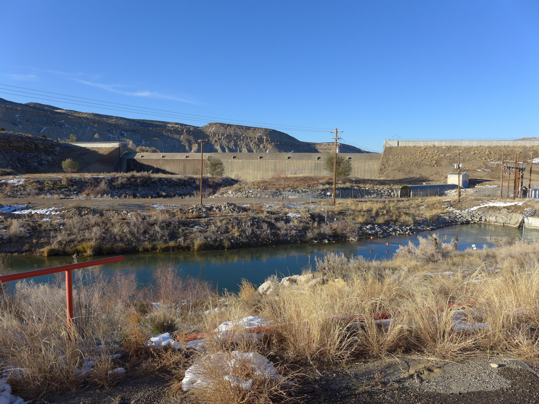
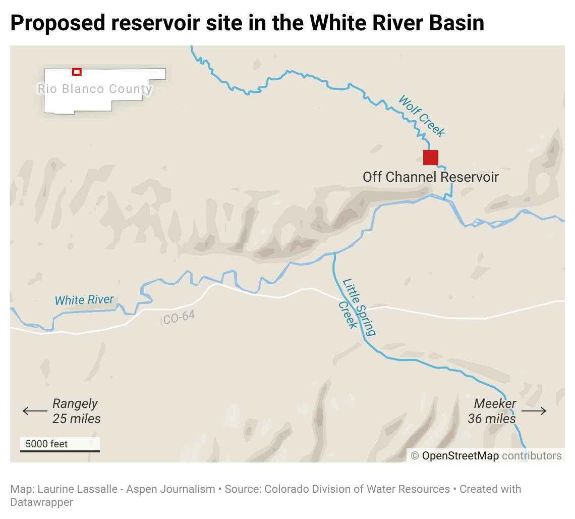
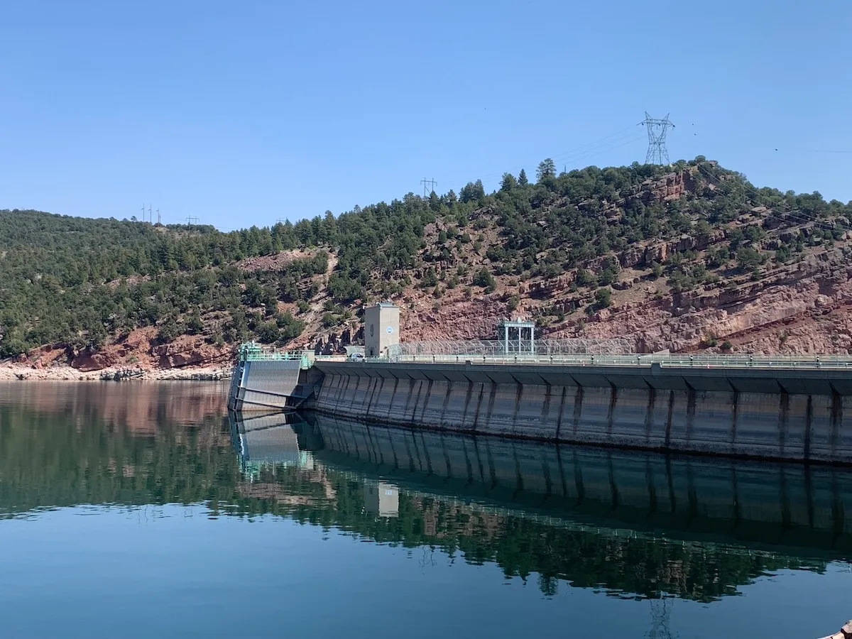
Taylor Draw Dam on the White River in northwest Colorado forms Kenney Reservoir. The dam has a hydropower facility tied to a 1966 water right for 620 cfs. Photo credit: Heather Sackett/Aspen Journalism
A water conservancy district has put a call on the White River, an action that has the potential to alter the system for other water users.
On Dec. 1, the Rangely-based Rio Blanco Water Conservancy District placed a call for its water right of 620 cubic feet per second at the Taylor Draw Dam hydroelectric plant, which the district owns and operates. It is only the second-ever call on the White River. A call occurs when a water rights holder isn’t getting the full amount of water to which they are entitled and upstream water users are shut off or “curtailed” so that the downstream user can get their full amount.
“I think maybe it’s a little strong to say it’s going to be life-changing, but it’s going to be significant, especially if we start seeing a call year-round,” said Colorado Division of Water Resources Division 6 Engineer Erin Light. “I think it could really change the regime that everyone in that basin is accustomed to. I think there’s not much question that the basin would become overappropriated.”
DWR designated the nearby Yampa River basin as overappropriated earlier this year, which means that there’s more water on paper than real water in the system at certain times of year and new well users will have to get a water-replacement plan, known as an augmentation plan.
Under Colorado water law, older water rights get first use of the river. In this case, water users junior to the district’s 1966 water right are being shut off. This time of year, that mostly means some industrial users and those who pull water from the river to water their livestock but who don’t have a water right for that specific use, Light said.
Under Colorado water law, watering livestock from ditches during irrigation season is included under an irrigation water right. But in the winter, when fields are not being irrigated, ranchers need a separate decree specifically for livestock watering if they want to continue using their ditches to water the animals.
The Rangely-based Rio Blanco Water Conservancy District has placed a call on the White River for its 620-cfs water right at the hydropower plant. Division of Water Resources staff have shut off water to some upstream users who water their livestock with ditches in the winter.
CREDIT: HEATHER SACKETT/ASPEN JOURNALISM
Reduced hydropower revenues
According to a news release from the district, the ongoing drought has significantly reduced seasonal inflows into Kenney Reservoir, which has reduced power production at the dam. According to the district, electricity production has been reduced by 35%, which has reduced the district’s revenues.
District General Manager Alden Vanden Brink said in an email that the district’s full water right was not being met several months out of the year and that the call will remain on until the full water right or capacity of the turbine is met. The district also has a 1982 water right for 125 cfs.
The news release said the district is sensitive to the hardships that the call may have on other water users and is working to create a White River augmentation plan, with a backup water supply for junior users.
Light said her office has curtailed about 10 ditches and two industrial water users since the call came Dec. 1, but assuming the call will be on whenever the river flows at less than 620 cfs, there will be more water rights and water usage curtailed in the summer and fall. During the irrigation season, there will be about 500 ditches and pumps that water commissioners will have to visit to see how much water they are using and whether they are using it legally, she said.
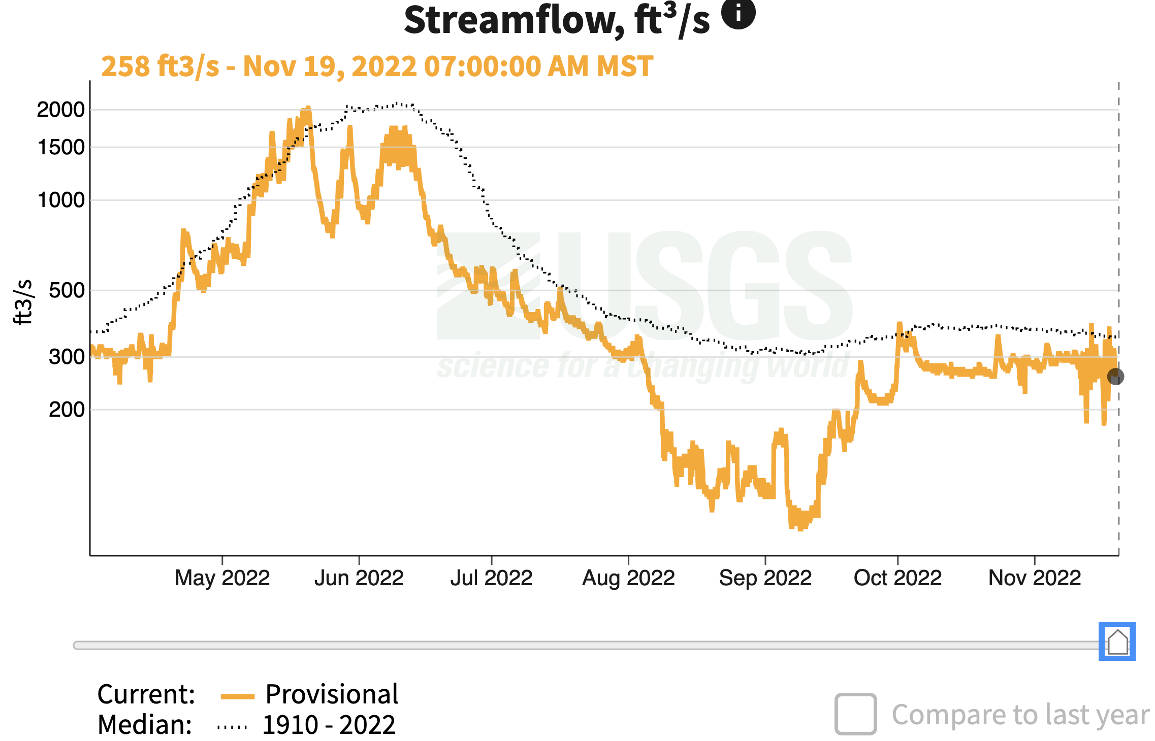
The U.S. Geological Survey stream gauge on the White River above Rangely is currently ice-affected and not giving a reading, but Light said she is certain that the 620-cfs water right at the dam is still not being met, even with curtailing upstream junior users. The river is probably running at about 300 cfs going into Kenney Reservoir, she said. Stream gauge data over the last half dozen years show that outside of seasonal peak flows, the White River near Rangely normally runs below 620 cfs.
Ducks swim on Kenney Reservoir, which sits near Rangely, in late October 2020. Kenney Reservoir, five miles east of Rangely, in October 2020. The Rio Blanco Water Conservancy District owns and operates the reservoir.. Photo credit: Heather Sackett/Aspen Journalism
Wake-up call
The White River flows from the Flat Tops west through Meeker and Rangely to its confluence with the Green River in Utah. This sparsely populated basin has seen little regulatory oversight from the state, and water users could generally take as much water as they needed. But that is changing. For the past few years, Division 6 staffers have been pushing water users to install measuring devices on their ditches and canals.
“In Division 6, our basin that has the most number of structures by far without measuring devices is the White River,” Light said. “Unfortunately, probably at the onset of this call in the summer, we will be shutting people off without measuring devices.”
Will Myers is an engineer and rancher on the Williams Fork, a tributary of the Yampa River, and he also serves as the agriculture representative on the Yampa/White/Green Basin Roundtable. Getting a water court decree for stock watering is the best way for agricultural producers to protect their practices, he said, especially in an area not used to strict administration by state officials because there has historically been enough water to go around.
“Any time you have something like this happen, it’s kind of a wake-up call for those in the ag community,” Myers said. “Just because you’ve always done something doesn’t mean you’re not susceptible to an actual legit administrative call.”
Ongoing drought and the impacts of a warming climate are at least partially fueling a trend in never-before-seen calls in parts of western Colorado. In 2018, the Yampa River saw its first-ever call, and the Crystal River saw its first-ever senior irrigation call.
“If that’s indeed true — that we are going to continue to see a drying climate — we are going to continue to see senior water rights not being met,” Light said. “I think that’s become clearly evident in the last four years.”
Aspen Journalism covers water and rivers in collaboration with The Aspen Times.
For users in the Yampa River Basin, which lacks any reservoirs controlled by the Bureau of Reclamation, Rossi said the focus needs to be on how to exist with the water that is there, not what the [Colorado River Compact] theoretically allows…
Lindsey Marlow, executive director of Friends of the Yampa, said many strategies to help with drought issues, erosion and overall river health are outlined in the newly updated Yampa Integrated Water Management Plan. Completed in September, the update involved dozens of volunteers and stakeholder groups working together for nearly four years.
“The recommendations that came out of (the management plan) were to ensure we are managing a river in balance, so that all user groups can use it effectively while keeping it healthy and sustainable,” Marlow said…
Marlow said the plan has 20 recommendations ranging from increased education for users to adding new infrastructure to the system. Recommendations include conducting a return flow study to understand the impact of water used for agriculture, securing funding to upgrade diversion structures in Routt and Moffat counties and creating a centrally located dashboard for a variety of data concerning river health, among other recommendations. Rossi pointed to a number of initiatives the Upper Yampa district is leading in the management plan, such as exploring water diversions on Coal Creek and Morrison Creek that could add water to district-owned reservoirs and installing a network of soil moisture monitors in the basin.
“I’m not too concerned with what the Bureau of Reclamation asks us to do. I’m more concerned about how can our water users survive through drying times because they’re here to stay,” Rossi said. “When it goes dry, we just don’t have anything to use.”
Stillwater Reservoir was drained in August 2021 for inspections to determine upgrades needed to the aging infrastructure.
Colorado Division of Water Resources/Courtesy photo
When the 75-foot dam for Stillwater Reservoir was built in 1939 by the Civilian Conservation Corps for the former Yampa Reservoirs Public Irrigation District, it was well constructed to meet engineering standards at the time. But by today’s standards, the dam’s abutments would be addressed differently, said Dana Miller, dam safety engineer with the Colorado Division of Water Resources in Steamboat Springs. As a result, the aging dam infrastructure needs expensive upgrades to bring the structure up to current safety standards, Miller said. Since it was constructed, the dam at approximately 10,300 feet elevation has experienced consistent seepage issues where the sides of the dam abut the hillsides. If not addressed, the seepage could eventually lead to a failure of the dam, Miller explained. Although the seepage has been worked on through the years with minimal results, lasting improvements could cost millions, according to the owner Bear River Reservoir Co. The reservoir water is owned by 18 agricultural shareholders and the town of Yampa, and those southern Routt County hay growers have been affected financially due to lower water storage allowances, plus years of drought.
The Stillwater Reservoir was placed on a fill restriction by the state in June 2019 and currently is limited to approximately 80% capacity, which the water storage level may reach during wetter years. The structure is classified as a high-hazard dam, which is not based on its condition but because “loss of life and significant damage is expected downstream if the dam were to fail,” Miller explained. The 129-acre reservoir, which is also known for the trailhead to popular Devil’s Causeway hike, was drained to a small dead pool in August 2021 for inspections of the upstream side of the reservoir outlet gates. The reservoir was drained again in October for work on the hydraulic operating system, said Andi Schaffner, secretary for Bear River Reservoir Co. Yampa resident Schaffner said the owners of the private, nonprofit reservoir company have contributed more than $100,000 to help with dam issues in the past 11 years, and total upgrades to the hydraulics are predicted to cost $300,000.
The recent trends of 75-plus degrees for high summer water temperature are about 10 to 15 degrees warmer than most stream fish prefer, said Billy Atkinson, aquatic biologist for Colorado Parks and Wildlife. The Fifth Street gauge is an expensive station that includes temperature monitoring. It is also one key to deciding about timing and amounts for upstream water reservoir releases and recreational river closures. Thirty other temperature gauges of varying quality and permanence exist on the Yampa River from above Stagecoach Reservoir to Deerlodge Park in Dinosaur National Monument, according to Julie Baxter, Steamboat Springs water resources manager…
The city and partners such as Friends of the Yampa, Upper Yampa Water Conservancy District and U.S. Geological Survey have recently or are installing new temperature monitoring locations in the river based on the gaps and priorities identified in the recently completed Yampa Integrated Water Management Plan. More and improved temperature monitoring will help water managers make better decisions long term. Some of the city’s past temperature loggers have been lost from washing downstream during disturbances, Baxter said, and she supervised a small committee and consultant to move forward on a recommendation from management plan. The plan was released in September and is available online at YampaWhiteGreen.com/iwmp…
The conservancy district added temperature measurement to the USGS gauge above Stagecoach Reservoir. Friends of the Yampa installed temperature loggers in several tributaries and downstream of the hot springs. The city contracted with an engineering firm to install more permanent, continuous, real-time temperature monitoring above and below the Wastewater Treatment facility. After the temperature gauges are added or improved, the goal is to post as much real-time temperature information as possible on the forthcoming Yampa River Dashboard, which is another of the 20 management plan‘s recommendations. The conservation district along with the Colorado Water Trust and nonprofit Friends of the Yampa are working to establish the online dashboard by late 2023. The dashboard would provide stakeholders a one-stop location for information related to water management such as snowpack, current climate conditions, temperatures and soil moisture.
The river tried its best in 2022 but didn’t get much help. Total precipitation at the headwaters was low, again. Temperatures at the headwaters were much higher than normal, again. Consequently, total runoff came near historic lows, and daily flow hovered below the 25th percentile for most of the year. Again. Following are summary data documenting the historical records of climate and flows in the White River Basin.
Peak runoff in the White River also occurs earlier in the year. Historically, peak runoff occurred in early June, but peak is trending earlier. April runoff is increasing and June runoff is trending downward (data not shown). Longer periods of low flow in the summer provide favorable conditions for algae growth, increase stress on fish, and also decrease available irrigation and municipal water supplies.
The data presented here document global and regional trends toward a hotter, drier world. Updated climate models predict that climate conditions in the White River Basin 30 or 40 years from now will resemble the present brush and sandstone regime of southeastern Utah (Talsma et al, 2022; NCA 2018).
On a positive note: we haven’t seen a big algae bloom for the past couple years. It’s not at all clear what happened to stifle the algae. Low water and higher water temperatures, such as we are seeing in the basin, generally encourage algae growth. A plausible assumption is that efforts by the Conservancy Districts and the White River Alliance are paying off. People have stepped up to try to reduce nutrients going into the river and to reduce insecticide application. A final report from the USGS algae study group is still pending, and some particulars, such as point sources of nutrients, are not available. However, we can take some hope that people are making a positive difference in the health of the river.
When Cheyenne’s municipal water board approved a deal in October to supply up to 14,500 acre-feet of water over 15 years for a proposed gold mine west of town, attorneys insisted on inserting a clause in the contract. It retained the right to cut water deliveries if the city itself has to curtail its water use due to the Colorado River crisis.
“The majority of our water comes from the Colorado River [basin] and if that call [requiring upstream users to cut consumption] comes in, we’re in big trouble,” Cheyenne Mayor Patrick Collins said.
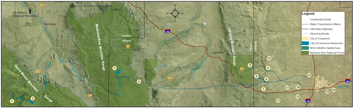
About 70% of the city’s municipal water supply originates 150 miles west in the Little Snake River drainage, a part of the Colorado River Basin. A complex “trans-basin” system of pumps, tunnels and pipelines transports the water under the Continental Divide in the Medicine Bow Routt National Forest to the city.
Cheyenne’s legal claims to the Colorado River Basin water were appropriated from 1954 to 1982 — making it a relatively new user in the system. If there is a curtailment, it would be applied to the newest or most “junior” appropriations, then work back in time to the 1922 Colorado River Compact. That means, depending on how far back in time a curtailment extends, 70% of the city’s water supply could be shut off — an action that could come as soon as 2028 if hydrological conditions keep trending for the worse, according to the Wyoming State Engineer’s office.
This map depicts Cheyenne’s municipal water supply system, which funnels in water from the Little Snake River Basin. (Cheyenne Board of Public Utilities)
“If we lose 100% of our Colorado River Compact water, we’re upside down,” Collins said, adding that about 80,000 people rely on the city’s municipal water system. “We wouldn’t have enough water to meet our current needs.”
For now, Cheyenne, Baggs, Rock Springs, Green River, Pinedale and a handful of other towns that depend on water from the Little Snake and Green River basins in Wyoming are assessing where they stand in the pecking order of appropriated water rights in the event of a curtailment. Although municipalities make up a small percentage of Wyoming water users under the Colorado River Compact and associated laws, their legal claims to the water are among the most vulnerable.
First in time, first in right
If the Upper Colorado River Basin Commission issues a curtailment for Wyoming, it would not necessarily force all water users subject to the compact to close their spigots completely.
There’s no curtailment priority in terms of use — whether it’s irrigation for cattle and alfalfa fields, water consumed for cooling at the Jim Bridger coal-fired power plant or water piped to homes for domestic use. Instead, a curtailment would be applied based on the first-in-time, first-in-right water appropriations doctrine: Those who gained their water appropriation latest in time would be the first ordered to shut off their water.
For example, if the state had to curtail 100,000 acre-feet of water — approximately one-sixth of its annual Colorado River Basin consumptive water use — the state engineer would begin with the newest appropriations and work back in time until the 100,000 acre-feet of consumptive water use curtailment was met.
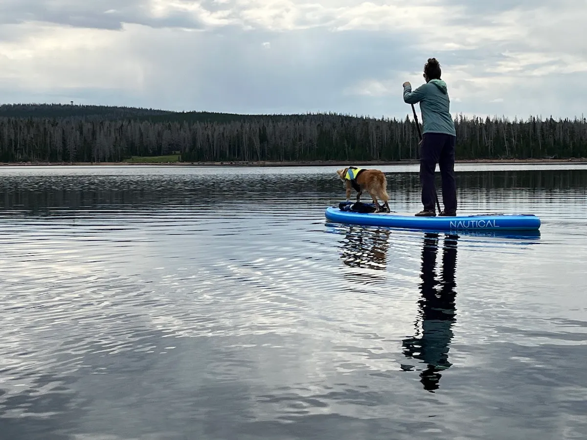
Shauna Gray and her dog, Lula Mae, paddle at Rob Roy Reservoir July 31, 2022. The reservoir is part of a trans-basin water system that supplies water to Cheyenne. (Dustin Bleizeffer/WyoFile)
If, let’s say, that required turning off all Colorado River Basin water appropriations back to 1970, that would choke off all water appropriated since then — whether for industrial, municipal or agricultural use. The cities of Rock Springs and Green River, which share a municipal water system that serves some 39,000 residents, would lose access to 75% of their Green River water appropriation. The towns would still be allowed to tap the 4,343-acre-feet-per-year appropriation they secured in 1928 and the 2,895-acre-feet-per-year appropriation that predates the 1922 compact. The rest — 75% — was appropriated in 1971 and after.
This type of variable vulnerability applies to many Colorado River Basin water users with appropriated rights that were obtained at different times. The exact order for how a curtailment would be applied is well documented and under continual review, according to the state engineer’s office.
Small straw, big vulnerability
Agriculture accounts for 83.7% of Wyoming’s consumptive use of water in the Colorado River system, according to the SEO. Municipal water use accounts for about 2.8% — or 3.3% if you include rural domestic water use. Industry — trona facilities, coal power plants, oil and natural gas processing — make up most of the remaining 13%.
Approximately 70% of agricultural irrigation water rights in Wyoming were appropriated before 1922. Those pre-1922 appropriations are not subject to the Colorado River Compact and cannot be shut off under a curtailment. The pre-1922 protection applies to all Colorado River Basin water users.
A majority of Colorado River Basin water appropriations held by Wyoming municipal water authorities, however, are post-1922. That means some 125,000 urban Wyoming residents and businesses are vulnerable to a curtailment.
Given the curtailment clause in Cheyenne’s water contract, gold mine developer Gold King Corp. is shopping around to secure alternative water resources, according to Mayor Collins. The city of Cheyenne — as well as Green River, Rock Springs and others — are doing the same.
“There is the possibility that we would not be able to collect any water from the Little Snake System if [a] curtailment call goes below 1954,” Cheyenne Board of Public Utilities Administrator Brad Brooks told WyoFile. “We are looking for additional water to mitigate this possibility and planning for the worst case that our Little Snake water will not be available.”
Green River and Rock Springs are in the same boat. Their joint municipal water system collects 100% of its water from the Green River and its tributaries to serve some 39,000 residents in and around the two cities. Only 10% of their Colorado River Basin water appropriations pre-date the 1922 compact.
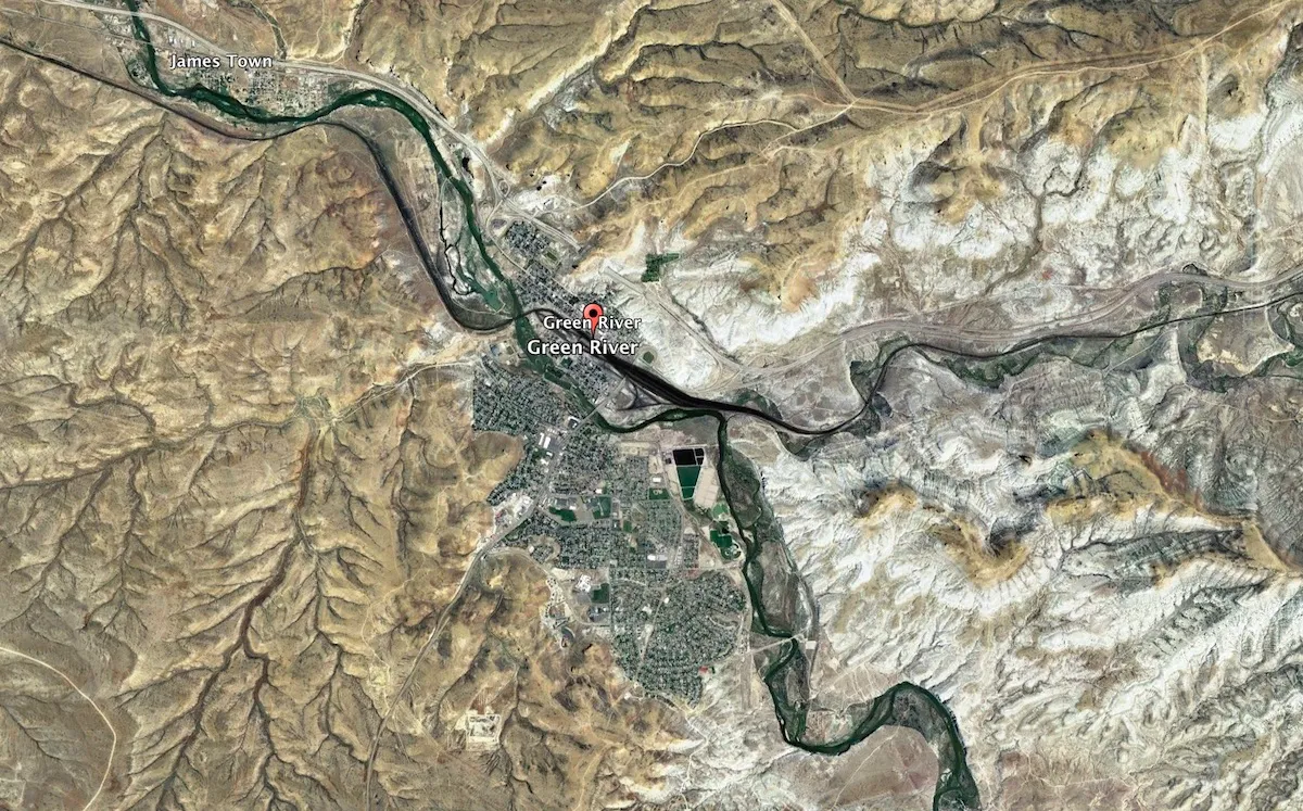
Green River. (Google Earth)
Although the cities don’t rely on the full volume of their legal claims to Colorado River Basin water, the time to plan for supplemental water sources is now; 2028, the year Wyoming might first see a curtailment, isn’t far away, Green River/Rock Springs Joint Powers Board General Manager Bryan Seppie said.
“Understand, [a curtailment] probably isn’t a one-year event,” Seppie told WyoFile, adding that much depends on what Mother Nature has in store. “We’ve got to secure other water resources to serve as replacement water if [a curtailment] were to happen. Conservation is a tool, but with these types of curtailments, conservation is not going to get you out of it.”
Backup water
Part of the Gold King deal provides Cheyenne’s Board of Public Utilities approximately $5 million in fees that would help cover the cost to expand Cheyenne’s groundwater capacity. The city’s water board is also seeking up to $10.5 million in grants from the Wyoming Water Development Commission for its Borie wellfield expansion project. The expansion would add approximately 3,300 acre-feet of water per year to the city’s water portfolio, according to the board.
That would boost Cheyenne’s non-Colorado River Compact water source portfolio to 9,900 acre-feet per year. But the city would still be in trouble in the event of a curtailment because its average annual use is about 14,000 acre-feet.
“We are actively pursuing possibilities” for additional water resources, Brooks of the city’s BOPU said.
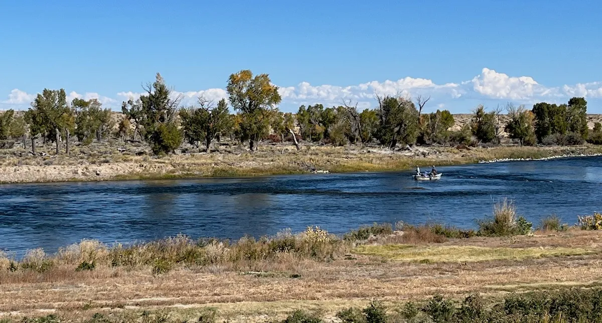
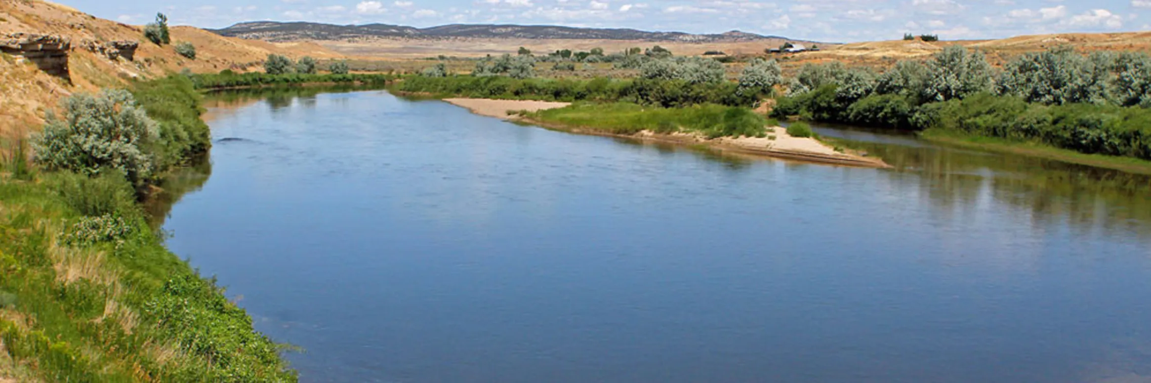
Anglers try their luck on the Green River at Seedskadee National Wildlife Refuge on Sept. 27, 2022. (Dustin Bleizeffer/WyoFile)
Expanding groundwater capacity, however, isn’t an affordable option for Rock Springs and Green River, according to Seppie. Instead, the cities are looking to those in the state with pre-1922 appropriations to share some water.
The federal System Conservation Program pays water users to curb consumption. Congress recently re-appropriated funding for the program, while the Inflation Reduction Act includes some $4 billion for efforts to modernize Colorado River Basin infrastructure and water management practices. Another $8.3 billion from the bipartisan Infrastructure law is available to address water and drought challenges throughout the U.S.
The SCP is an attractive option, Seppie said, for both ag irrigators and municipalities. Ag irrigators who volunteer for the program can use payments to upgrade their irrigation systems to waste less water.
“It’s a voluntary thing. It’s preemptive, and it’s benefiting the entire system,” Seppie said. “We haven’t gotten to a point where we’re having those discussions [with city officials]. But we have somewhat of a timeframe; 2028 is not all that far off.”
Click the link to read the article on the Steamboat Pilot & Today website (Dylan Anderson). Here’s an excerpt:
Routt County approved more support to complete upgrades at Sheriff Reservoir on Tuesday, Nov. 8, this time for installation of a new head gate at Oak Creek’s nearly 70-year-old water source. The $80,000 from the county will be used with an equal amount of town funding to get a matching grant from the Colorado Department of Local Affairs. If the grant is awarded as officials expect, the state and local funding would total $380,000…
Sheriff Reservoir has two problems. First, the original head gate is 68 years old, and both town officials and state water managers worry it could fail if it is not replaced. Installing a new gate is what the latest county funding would be used to support. The town has put installation of a new head gate out to bid twice, but each effort produced bids that far exceeded initial engineering estimates for the cost of the work and the available funding. That estimate was $187,000, but the lowest bid the town received was $405,000. The town has purchased the new head gate equipment already with the help of DOLA and the Colorado Water Conservation Board.
Click the link to read the article on the WyoFile website (Angus M. Thuermer Jr.):
Lawmakers will seek $500,000 to study water lost from canals in the Green and Little Snake River basins to ensure Wyoming is accurately credited for conservation when it chooses or is forced to close irrigation systems in the troubled Colorado River Basin.
The study could help Wyoming limit reductions in water diversion as seven Western states and Mexico wrangle with an over-allocated and dwindling supply in the drainage. Members of the Legislature’s Joint Select Water Committee voted to draft a measure to seek the money from the general fund when the legislative session commences early next year.
“I could see [a conveyance loss study] very easily reaching $500,000,” Jason Mead, interim director of the Wyoming Water Development Office told lawmakers Wednesday. State Engineer Brandon Gebhart said his “mind was right at $500,000 for this,” but that “it could be a lot more.
“I do think that this is a really good start,” he said.
One hundred years after the signing of the Colorado River Compact, water managers cannot accurately measure what’s used and have not agreed on how to resolve conflicting views on rights to use what water there is.
The amount of incidental seepage and phreatophytic losses — canal-side, plant-used water — associated with irrigation is an “area of agriculture data collection that need[s] to be updated and verified,” the U.S. Bureau of Reclamation states in its 2022 Upper Colorado River Basin Consumptive Uses and Losses report.
The proposed Wyoming study could help the state claim that when it shuts off water to a field of crops, it is saving that crop’s consumption plus what’s lost in the conveyance system of canals and ditches that carry the flow from river to field.
By showing it saves more, Wyoming would cut off fewer users in a “curtailment” situation where water managers require conservation. The data could also better inform the purchase of temporary water rights transfers from one user to another.
“Understanding what that conveyance loss is,” Gebhart said, “could benefit the water users in our state.”
80% loss?
Conveyance loss is significant in Wyoming’s Green River Basin, one lawmaker told the committee.
“We know in Sublette County that we have some canals that are over 20 miles long that go through a glacial till and alluvium that, anecdotally we’ve heard, they lose up to 80%,” Sen. Larry Hicks (R-Baggs) told the committee. Irrigators estimated losses in a survey conducted by the Water Development Office, but none has reported losses as high as 80%; the statewide average is 24%.
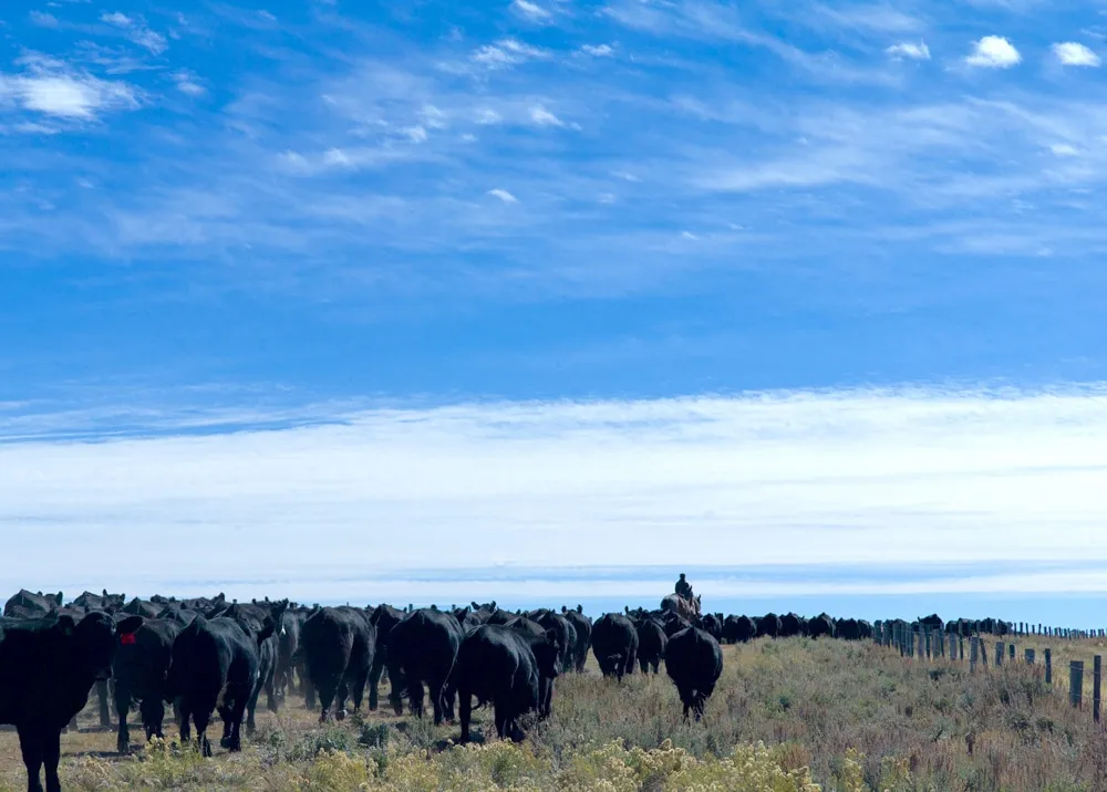
A cowboy herds cattle home from the range in the Green River drainage in Sublette County. (Angus M. Thuermer, Jr./WyoFile)
A contractor would lay out the groundwork for the study starting next spring, identifying perhaps eight sites and 50 miles of canals in the Green and Little Snake River drainages that could be monitored. Investigators would install water-pressure sensors in canals to record water-level fluctuations through a season.
Once in place, consultants would measure and record flows and pressures in the 2024 irrigation season. Mead of the WWDO described how the survey would work.
Investigators would be “going out there four or five, six times to actually get measurements on the canal at four or five or six different spots down, say, a 15-mile section,” he said.
The results would show, for example, the difference in canal seepage at the beginning of an irrigation season when the ground is drier compared to seepage in mid-summer when the canal has been flowing and “things are wetted up and primed,” Mead said.
Engineer Gebhart distinguished between two categories of conveyance losses — consumptive loss and seepage — and whether Wyoming could claim credit for staunching either.
Consumptive loss is the amount consumed by ditch-side plants and trees, the amount lost to evaporation, plus that which leaks into an aquifer “that does not return back to the [Colorado River] system,” he said.
Gebhart defined the second category — seepage loss — as leakage that returns to the system. “It may be delayed, but it does return back to a stream,” he said.
As Wyoming calculates what’s consumptively used — and what it can save if that consumptive use is taken off-line — it might not be credited for reducing some associated seepage.
“Seepage [that] returns to the system … that is not considered a consumptive use,” Gebhart said. “I would say a majority of ditch loss is lost to seepage.”
Results from the study would be ready in late 2024 or in 2025, according to a scenario painted by Mead.
Wyoming buffer
Wyoming doesn’t expect to face curtailment — when it might be forced to shut down users — until 2028, if drought continues. Wyoming and its sister states in the Upper Division or upper basin — Colorado, Utah and New Mexico — would face mandatory cuts if the Lee Ferry gauging station just below Lake Powell shows a flow of less than 75 million acre-feet in the previous 10 years.
Under the 1922 Colorado River Compact, “[t]he States of the Upper Division will not cause the flow of the river at Lee Ferry to be depleted” below that level. The upper basin encompasses about 45% of the drainage area but produces 92% of the runoff.
Colorado River laws apportion Wyoming rights to 14% of the upper basin’s water, officials say. They believe upper basin states are not yet at the critical “75/10” metric where reductions are necessary.
“We’re currently about 85 million acre-feet,” Gebhart said, referring to the previous 10 years. “So we’ve got a little buffer.”
“We’ve blown through the hydrology, we’ve used most of the storage in the Colorado River Basin,” Hicks said. “And now … the director of the Bureau of Reclamation, [is] looking for somewhere between 2 [million] and 4 million acre-feet of reductions in the Colorado.”
The original estimate was 15 million acre-feet were in the system annually, but that water, “it doesn’t exist,” Hicks said. In the last decade, it’s averaged 12 million acre-feet or less, he said. One water administrator in Colorado has said experts tell water managers to plan for 9 million acre-feet a year as a worst-case scenario.
Municipalities and industry — usually holding inferior, junior water rights and so the first to face curtailment — could be looking for water. In Wyoming, agriculture holds 80% of the water rights, Hicks said, and could be approached to sell through a temporary-transfer system or some other arrangement.
“That’s the water bank that you’re looking at,” Hicks said of agriculture.
“At some point in time, we’re gonna have to recognize that there’s not 15 million acre-feet to be divided up,” he said. “That’s really the issue. This is why all the states are lawyering up.”
Wyoming is preparing for negotiations, measurements, debates and possibly fights over water rights. In the last year, the state has added a Colorado-River staffer to the state engineer’s office and also the attorney general’s office, Hicks told the committee.
Brad Udall: Here’s the latest version of my 4-Panel plot thru Water Year (Oct-Sep) of 2021 of the Colorado River big reservoirs, natural flows, precipitation, and temperature. Data (PRISM) goes back or 1906 (or 1935 for reservoirs.) This updates previous work with @GreatLakesPeck. Credit: Brad Udall via Twitter
Boaters float the Yampa River. According to the updated state Water Plan, summer recreation flow needs may not be met in the future due to lower peak flows, fueled by climate change.
CREDIT: HEATHER SACKETT/ASPEN JOURNALISM
Click the link to read the guest column on the Steamboat Pilot & Today website (Michelle Meyer and Lindsey Marlow). Here’s an excerpt:
The Yampa White Green Basin Roundtable led the development of an Integrated Water Management Plan for the Yampa River in 2019. The process combined community input with science and engineering assessments to identify actions to protect existing and future water uses and support healthy river ecosystems in the face of growing populations, changing land uses and climate uncertainty. While that sounds technical and even slightly boring … keep reading! Working to sustain, protect and care for the Yampa River impacts us all. The IWMP is a community effort, led by people who live and work in the Yampa Valley, and care about the river and its future. This is not a political issue, but a stakeholder-driven plan with a shared passion for the river as common ground. The IWMP seeks to identify and spur projects and strategies that benefit water users, the environment and recreational users. These multi-benefit efforts cannot be accomplished by one entity alone but require collaboration among water users and landowners, nonprofit organizations and local governments. The project’s work included stakeholder input via surveys and interviews conducted in 2020. Our team collected ideas from a variety of stakeholders to identify priority reaches for improved river health and recreation, as well as ideas to better meet water users’ needs. A technical team worked to assess current river conditions. Inventories of water use, river flows, riverside land condition, fishery health and water quality have helped to characterize current conditions and identify knowledge gaps.
The final piece of the IWMP has been to prioritize issues and develop consensus on action plans. The true success is in the collaborative partnerships and relationships developed through countless hours of meetings. The Yampa IWMP final report can be found at YampaWhiteGreen.com/iwmp. Multi-benefit projects include a focus that recognizes agriculture, recreation, environment, municipal and industrial water needs as equally important. Some recommendations to highlight include a basin wide temperature monitoring program that will help inform and identify opportunities for improved river health.
Coordinated efforts in developing a Yampa River Data Dashboard and River Scorecard will not only bring scientific work and data together for informed management decisions but will allow the community to understand the state of the Yampa River over time. Several IWMP recommendations specifically call out support and coordination for agriculture water users to address common challenges and opportunities to sustain a balanced river.
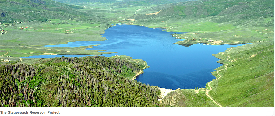
Stagecoach Reservoir. Photo credit Upper Yampa River Water Conservancy District.
Click the link to read the article on the Steamboat Pilot & Today website (Dylan Anderson). Here’s an excerpt:
Soil moisture is the measurement many researchers believe is missing, and a new climate measurement station perched on private land just southwest of Stagecoach Reservoir hopes to help fill the data gap.
“It is another variable that we’re understanding is more and more important,” said Madison Muxworthy, soil moisture, water and snow program coordinator for the Yampa Valley Sustainability Council…
The station — paid for by the Upper Yampa District and installed in partnership with the sustainability council and the Center for Western Weather and Water Extremes — includes a soil moisture monitor that takes measurements at six different depths down to 40 inches. It’s the first of a network of 25 similar stations planned for the Yampa Valley. Rossi said the station will be an important tool when making decisions that have shrinking margins for error amid climate change…The station was installed in the middle of September, and Muxworthy said it generally takes about three months for everything to settle. It will likely take another decade to have enough soil moisture data to have a good understanding of that soil-runoff relationship, she added. But the station is taking measurements every two minutes and updating data every hour. Soil moisture measurements are taken at 2, 4, 6, 8, 20 and 40 inches, which shows how deep moisture from precipitation is soaking into the ground.
A water fight is brewing in the West, and Wyoming water officials want to prepare for it with a study aimed at parsing and defining the state’s consumption from its Colorado River tributaries.
Anticipating a drier future and either voluntary or imposed restrictions, Wyoming should undertake a “conveyance-loss study,” Jason Mead, interim director of the Wyoming Water Development Office, told the state Water Development Commission on Oct. 6. The goal, State Engineer Brandon Gebhart told the WWDC, is to have a “defensible consumptive-use number to take to the other states,” when and if push comes to shove and Colorado River Basin water users face cuts to irrigation, industrial or municipal uses.
When Colorado River Basin water rights were divvied up starting in 1922, officials overestimated the amount of water the system would produce each year and ultimately promised more water to stakeholders than actually existed. Climate change, drought, shifting weather patterns and a population explosion in the region have exacerbated that initial over-subscription.
Further complicating the picture, the U.S. Bureau of Reclamation — the government’s Western water agency — admits there’s “an inability to exactly quantify these uses.” This “has led to various differences of opinion” regarding who gets to use how much water, the BOR states in a 2022 accounting of the river’s flows and uses.
Coyote Gulch near the confluence of the Little Snake and Yampa Rivers July 2021.
As a result, the Colorado River and its tributaries — including Wyoming’s Green and Little Snake Rivers — do not have as much water as originally thought and apportioned. On top of that, the water that does flow can’t be precisely measured, and the 40 million people in the seven states and Mexico who rely on it haven’t agreed on how to resolve conflicting views on their rights to use what water there is.
The goal of the conveyance-loss study is to pin down Wyoming’s consumptive use in case it needs to engage in those types of water rights’ conversations with other states.
As a foundation to that study, Wyoming has “a pretty good handle on consumptive use of the crop,” Mead told the water commission. But the state is less certain about another key measurement — the loss from canals and ditches that carry the water diverted from rivers and streams to crops, and how those losses should be accounted for. Only some of those losses may be a debit to Wyoming’s share of the basin’s flows.
With the proposed study, Wyoming would be able to more precisely measure the differences between diverted flows and consumptive use.
That would allow the state to say “when we shut off a ditch … we’re actually saving this amount of consumptive use just along the ditch,” Gebhart told the WWDC. With such information at hand, “I think we could make a sensible argument that we would have to shut off less users.”
Ticking clock
Wyoming doesn’t expect potential curtailments any earlier than 2028, Gebhart told the Water Development Commission. Not all stakeholders agree with that timeline assessment, however, and say a “pinch point” in 2025 could prompt debate and conflict among states.
“The first pinch point [in 2025] raises the issue of the Upper Basin’s obligation to Mexico, if any, under the 1922 [Colorado River] Compact,” Chris Brown, a senior assistant attorney general in the Wyoming Attorney General’s office Water and Natural Resources Division wrote WyoFile.
Upper Colorado River basins. (The border of Wyoming and Colorado is mislabeled.) (U.S. BOR)
Mexico was not part of the 1922 compact, but the Mexican Water Treaty Act of 1944 granted that country 1.5 million acre-feet of Colorado River water annually. The compact and treaty are part of a suite of decrees, agreements and court decisions that make up what’s known as the Law of the River.
Regarding Mexico’s share, “the Upper Basin and the Lower Basin have different opinions about that obligation,” Brown wrote. That difference should be addressed before 2025 to “avoid a dispute” he stated.
“That does not mean we will curtail our water uses and, under current circumstances, we will not curtail when we reach that [2025] pinch point…” he wrote. “The difference of opinion itself will not result in a curtailment.”
Sen. Larry Hicks (R-Baggs), an influential water developer in the Little Snake River Basin, recommended the study, Mead and Gebhart said. It’s an “officially proposed project” Gebhard said, and will be discussed by the WWDC further in November with an eye toward securing funding, either from over-subscribed state water accounts, through a different appropriation from the Legislature or some other source.
The study’s first phase could be completed in 2025, after two irrigating seasons of research, officials said.
Pinning down losses
After water is diverted from a river or stream into conveyance systems of canals, ditches and pipes, some of it feeds crops. But leaks and seepage in those canals and ditches also results in loss. Water managers agree that some ditch losses return to “the system” that sustains a river’s flow.
Like “return flow” water that runs back into a river after flooding an irrigated field, conveyance losses that then return to the system shouldn’t count as a debit or depletion against Wyoming’s share of Colorado River Basin water, state officials say, and a study could help determine how much that is.
“Ditch losses that do return to the system (seepage), at some point, are not considered depletions because the water re-enters the stream,” Gebhart wrote in an email.
Some diverted water, however, doesn’t benefit a crop or return to the river and must be counted as a debit. “Losses from ditches that do not return to the system, at some point, are depletions, also known as consumptive use,” Gebhart stated.
These types of losses could be from evaporation, consumption by non-crop plants like willows, consumption by trees on the ditch bank, recharge to deep groundwater aquifers that don’t flow to the Colorado River and other, similar things, Gebhart wrote.
The loss from canals and ditches is only estimated today, and only by some irrigation districts. In a 2021 accounting by the WWDC, only half of the 157 irrigation districts, ditch and canal companies and other irrigation entities contacted by the agency responded.
An irrigation headgate on a canal in the Upper Green River Basin has a lock that can be used to regulate flows. (Angus M. Thuermer Jr./Wyofile)
Statewide, the survey estimates an average of 24% of the water that runs through the conveyance systems is lost. In the Green River and Little Snake drainages, estimates include as little as 0.5% for the Austin Wall Irrigation District on the Blacks Fork and 25% at the New Fork Irrigation District.
Yampa River Basin via Wikimedia.
Many entities in the Green and Little Snake basins did not respond to the latest survey, including districts where water developers and irrigators want to spend millions of state dollars building or enlarging impoundments to aid irrigation and other uses.
Depletions, losses and consumptive uses
Experts agree that more water is promised to Colorado River Basin water users than the system can actually deliver — essentially 7.5 million acre-feet annually each to the four Upper Division states and three Lower Division states, plus 1.5 million acre-feet to Mexico for a total of 16.5 million acre-feet. The calculation of available water on which the U.S. allocations were based in 1922 was flat-out wrong, many agree, and 23 recent years of drought coupled with climate change have left Lakes Powell and Mead at 28% of capacity, an historic low.
Now some experts say managers should anticipate only 9 million acre-feet annually system wide, according to proceedings at a September water seminar covered by Colorado Public Radio. That’s about three-quarters of what was used by all states, tribes and Mexico in 2021, CPR reported, and far short of the original 15 million acre-feet estimated in 1922.
If Wyoming faces curtailment or some other regulation in the Colorado River Basin, Gebhart said his office would need more staffers to monitor headgates and diversions. Today, a crew of six oversees more than 2,500 headgates in the basin, he said, and that might need to be increased to 36 or so.
Scrutiny by the state engineer is necessary because the 1922 compact prohibits Upper Division states from diminishing Colorado River flows at Lee Ferry, a gauge just below Lake Powell’s Glen Canyon Dam, below 7.5 million acre-feet annually on a running 10-year average. Wyoming is promised 14% of what’s left over to the Upper Division states.
From 2016-2020, the latest data available, a provisional U.S. Bureau of Reclamationreport lists Wyoming’s average annual use at 421,000 acre-feet. Ranchers irrigated 305,800 acres in the Green and Little Snake River Basins in 2020, the report states. The population of those basins was 83,800, the BOR said.
At full supply — 7.5 million acre-feet available to the Upper Division states annually — Wyoming’s yearly portion amounts to a little over 1 million acre-feet, experts say. Should the Upper Division supply dwindle to 4 million acre-feet, under the Law of the River and 1944 Mexico treaty obligation, Wyoming would have rights to use only 553,000 acre-feet, according to a presentation by Gebhart’s office in Pinedale in September. In addition to Wyoming’s conveyance-loss study, Upper Division states want to use an up-to-date model to determine river flows and uses.
Buckboard Marina owner Tony Valdez stands next to a stake that indicates the extent of lowering water levels at Flaming Gorge Reservoir Sept. 26, 2022. (Dustin Bleizeffer/WyoFile)
Click the link to read the article on the WyoFile website (Dustin Bleizeffer):
The shoreline of this large reservoir on the Wyoming-Utah border has steadily receded this summer as the Bureau of Reclamation pumped more water out to help maintain critical water levels 500 miles away at Lake Powell.
The water shrunk from boat ramps and forced marinas to scoot docks ever inward. By September, 6 feet of vertical drop in the water level translated into vast areas of exposed lakebed, leaving many boat ramps on the northern reaches of the reservoir high and dry. All told, the reservoir’s elevation is about 12 feet lower today than two years ago, according to the U.S. Geological Survey. Thousands of acres that had been underwater for 58 years now comprise a rainbow of boggy sediment, grasses and invasive plants.
Buckboard Marina owner Tony Valdez and his staff scrambled all summer to keep boat docks in the water, but they couldn’t always keep up. Two large floating docks near a drop-off sank so low that their access ramps became too steep to safely walk. Toxic cyanobacterial blooms have also migrated further down the lake.
Buckboard Marina owner Tony Valdez observes toxic cyanobacteria blooms at Flaming Gorge Reservoir Sept. 26, 2022. (Dustin Bleizeffer/WyoFile)
“I can’t take my grandkids or my dogs to the water,” Valdez said, motioning to big green globs and sheets of muck as he stood on a boat dock. “We’re losing our marina. It will be gone after next year.”
When Valdez bought the marina in 2019, he immediately began making renovations. It was a solid investment, he believed, for a popular service at the largest recreational draw in southwest Wyoming.
The BOR had maintained seasonably stable water levels at Flaming Gorge since 1964 when the dam was completed. Businesses in Wyoming and Utah built an economy around the fishermen, boaters, bird-watchers and others drawn to the massive impoundment.
Things began to change, however. Valdez first noticed that vehicles and boat trailers with plates from California, Arizona and other southwestern states became increasingly prevalent at the marina, he said, as reservoirs along the Colorado River began drying up.
Campers, seen here Sept. 26, 2022, are set up in areas previously under water across the bay from the Buckboard Marina at Flaming Gorge Reservoir. (Dustin Bleizeffer/WyoFile)
More than 20 years of drought — intensified by human-caused climate change — have pushed the Colorado River Basin and the 40 million people who depend on it into a water crisis. The system’s two largest reservoirs, Powell and Lake Mead, sank below 30% capacity this summer — the lowest levels since they were constructed. If the situation worsens, Powell and Mead could reach “deadpool” status at which the reservoirs would no longer release water downstream into the Colorado River.
The crisis is traveling upstream to places like Flaming Gorge, where it has implications for everything from riparian ecosystems to economic livelihoods. Currently, Flaming Gorge is at about 74% storage capacity, according to the U.S. Geological Survey. Whether the reservoir shrinks further depends on whether the BOR will continue to tap Flaming Gorge and how quickly it might be naturally replenished.
Lower Green River Lake
Emergency water supply
In a legal sense, Flaming Gorge Reservoir, which is fed by headwaters in western Wyoming, was created for a moment like this. Its primary purpose, according to federal officials and Colorado River Compact scholars, is to serve as a backup water bank to help maintain the Colorado River system. Specifically, Flaming Gorge and a handful of other reservoirs in the upper Colorado River Basin states of Wyoming, Colorado, Utah and New Mexico are key to ensuring a minimum flow of 7.5 million acre-feet of water at Lees Ferry just downstream of Powell on a running 10-year average.
So far, the upper basin states have met the threshold. Nonetheless, when Powell and Mead saw drastic lows in 2021, the BOR drew an extra 125,000 acre-feet of water from Flaming Gorge. This past spring when the situation in the lower basin states became even more dire, the BOR initiated a draw of an additional 500,000 acre-feet, estimating a 15-foot vertical drop in the reservoir over the water season ending in April 2023.
The Drought Response Operations Agreement, signed by Colorado River Compact stakeholders in 2019, authorizes the BOR to make those, and possibly additional emergency draws from Flaming Gorge, to help maintain critical water levels and hydropower generation at Powell and Mead. If this summer is any indication, continual draws from the reservoir might drastically alter an aquatic ecosystem and fishery that local businesses have relied on for decades.
Map credit: AGU
“This has been held at a premium, high-water mark, recreational lake for [58] years,” Valedz said. “Why wasn’t this addressed 15 years ago if we knew this was coming?”
The BOR is expected to decide whether to implement another “extra” draw from Flaming Gorge in April 2023.
Flaming Gorge fishery
Kokanee salmon and trophy-sized lake trout draw tens of thousands of visitors to Flaming Gorge each year, supporting a recreational economy in southwest Wyoming and northeast Utah. But as the lake is drawn down, water recedes from shallow shorelines and fish are forced into a smaller space, essentially shrinking the fishery toward the dam side of the reservoir.
Fishing guides and Wyoming Game and Fish have cooperated to maintain an appropriate balance to the predator-prey relationship between lake trout and kokanee, according to Recon Angling owner Shane DuBois. Now, the decreasing water levels threaten to drastically alter that balance and may require shifting management strategies.
Recon Angling owner Shane Dubois (left) and Buckboard Marina owner Tony Valdez observe water levels at Flaming Gorge Reservoir Sept. 26, 2022. (Dustin Bleizeffer/WyoFile)
Kokanee spawning beds have been exposed, which will force the fish to spawn in areas covered in silt, reducing the reproduction success rate, according to Wyoming Game and Fish Regional Fisheries Supervisor Robert Keith. If Flaming Gorge’s normal water levels are restored, the episode will likely improve traditional spawning beds, Keith said. However, if BOR withdrawals from Flaming Gorge substantially outpace natural inflows for several more years, the fishery will suffer.
“That’s going to be an economic impact to communities around the reservoir that depend on the anglers showing up,” Keith said. “And If we don’t have any ramps in Wyoming that anglers can launch from, then they’re all going to launch further down the reservoir and those dollars are going to be spent down in Utah.”
The BOR is in consultation with the Wyoming State Engineer’s office and local recreation and fishery managers regarding drawdowns at Flaming Gorge. The Flaming Gorge National Recreation Area — managed by the U.S. Forest Service — as well as Wyoming Game and Fish, can apply for federal funds set aside to aid in the Colorado River Basin water crisis. But maintaining critical water levels at Powell and Mead remains a priority, while projects involving reconstructing boat ramps and shifting fishery management would take years.
For DuBois, who depends on both a healthy fishery at Flaming Gorge and functional boat ramps, the situation threatens his livelihood. He recently invested tens of thousands of dollars in a new fishing boat and hopes it pays off.
“How does the Bureau of Reclamation not know [the recent drawdown] would leave most boat ramps unusable?” DuBois asked.
As he continues to relocate and reconstruct boat docks to adjust to lower water levels, Valdez is considering how to expand his scope of clientele to make up for losses.
“I didn’t buy this place to come up here and watch this go to shit,” Valdez said.
While the Yampa River has not closed quite as much this year as it did last year, local fishermen lost out on most of July and August and a chunk of September in 2022…
“There’s three criteria that would determine a closure or trigger a closure,” [Johnny] Spillane said. “One is water temperature, another is water flow meaning (cubic feet per second) and the third criteria is dissolved oxygen in the river. If any of those three criteria are not being met, that will trigger a closure and that seems to be fairly common in the last five, six or seven years.”
As far as the rain’s effect on fish behavior, Spillane says it is complicated but mostly acts as a good thing for the fish and therefore a good thing for those fishing.
Yampa River. Photo credit: Allen Best/The Mountain Town News
The state has neither the legal right, nor inclination, to preemptively curtail water use in the ongoing Colorado River crisis, according to Chris Brown, senior assistant attorney general for the state engineer’s water division. Only a determination by the Upper Colorado River Commission can result in a water curtailment order for Wyoming users subject to the Colorado River Compact, he said.
The earliest a curtailment order might happen, in Brown’s estimation, is 2025, if drought conditions persist and Colorado River flows at Lees Ferry downstream of Lake Powell in Arizona fall below a certain threshold. If that happens, the Wyoming State Engineer’s Office will implement water restrictions.
“The way things are going, it’s coming,” Brown told a crowd of more than 100 at the Sublette County Public Library in Pinedale Tuesday afternoon.
Exactly when and how much water Wyoming might be asked to conserve due to the Colorado River crisis depends on myriad factors — none more important, from a legal standpoint, than Wyoming’s obligation to the Colorado River Compact, according to Brown. And that “ends at Lees Ferry,” he said.
Chris Brown of the Wyoming Attorney General’s Office discusses the implications of the Colorado River Compact with water users in Pinedale Sept. 27, 2022. (Dustin Bleizeffer/WyoFile)
Wyoming and the other upper Colorado River Basin states — Utah, Colorado and New Mexico — are obligated to send 7.5 million acre-feet of water to Lees Ferry annually, on a running 10-year average. Modeling by the federal Bureau of Reclamation suggests flows could fall below the threshold by 2025 or 2028. Much also depends on how the BOR regulates flows out of Lake Powell, Brown said.
Ultimately, all seven Colorado River Basin states — along with the federal government, tribes and Mexico — have much to negotiate. Meantime, the state engineer’s office is initiating conversations with irrigators, municipalities and industrial water users about how they can use less water and still meet their needs. Voluntary and compensated conservation measures — backed by $4 billion from the Inflation Reduction Act — will be key to minimizing disruptions when there is a curtailment order, Brown said.
“How can you do more with less water?” Brown asked the Pinedale audience. “And what can we do to help you do your work with less water?”
Who’s vulnerable
In the event of a curtailment, Wyoming is only held responsible for its actual use, which averages about 600,000 acre-feet of water annually. Irrigated agriculture accounts for nearly 84% of the state’s consumptive use, according to the engineer’s office.
Other water users are also considered vulnerable, however, including trona processing plants, coal-burning power plants and municipalities. The City of Cheyenne, for example, relies on a water collection system that diverts otherwise Colorado River Basin-bound water for 70% of its municipal water supply. These water users are among some of the most “junior” in the pecking order of water rights, and therefore could be among the first ordered to reduce consumption.
A pump pulls water from the Green River at a Sweetwater County-managed recreation area Sept. 27, 2022. (Dustin Bleizeffer/WyoFile)
Water rights in Wyoming are appropriated within the first-in-time, first-in-right doctrine. The earlier a water right was obtained, the more senior, the later are most junior. A curtailment order would be applied to those with the most junior water rights and work back in time until the curtailment volume is met. However, the Colorado River Compact, struck in 1922, does not apply to those with water rights appropriated before 1922. No matter how much water Wyoming might be asked to curtail under the compact, it would only apply to those with water rights adjudicated after 1922, according to Brown.
One audience member asked Brown, “What if you’re one of the [junior] water rights holders and everything you have is going to get cut — are we just SOL?”
“You could be SOL,” Brown answered.
However, the Interior Department is expanding existing programs, and initiating new ones, to support trading, buying and leasing water allocations to encourage balance among users. Another irrigator at the meeting, George Kahrl, said he’s interested in forgoing some of his normal water use to help those with more junior rights — for compensation.
Ideally, those who benefit monetarily from voluntarily reducing their water use will invest that money into more efficient operations so they can maintain their agriculture operations with less water, Brown said.
Wyoming ag operators need assurance that that’s how such programs will actually work out, Rep. Albert Sommers (R-Pinedale) said. “I don’t know what those programs are or what they’re going to pay for, but we have to [maintain agricultural production] or we’re going to get hurt.”
Click the link to read the article on the WyoFile website (Distin Bleizeffer):
The state’s top water authority will outline Wyoming’s role in the ongoing Colorado River Basin water crisis, including voluntary conservation and efficiency programs, at a public meeting [September 27, 2022] in Pinedale.
Though Wyoming declined to commit specific volumes to the U.S. Bureau of Reclamation’s call for 2023 water savings, the state’s water users in the Green River drainage — a tributary of the Colorado River — will likely be called upon to voluntarily curb water consumption in coming years, according to the State Engineer’s Office.
Wyoming Drought Monitor map September 20, 2022.
SEO officials will provide information about ongoing drought conditions, Wyoming’s rights and obligations under the Colorado River Compact and options to “prepare ourselves to not only mitigate impacts to our water users, but to potentially help offset negative impacts to the rest of the system,” Wyoming senior assistant attorney general for the SEO’s water division Chris Brown said.
The meeting will be from 2-5 p.m. Tuesday at the Sublette County Public Library.
Why it matters:
Two decades of drought exacerbated by human-caused climate change has sapped the Colorado River Basin water system that serves some 40 million people across the West and in Mexico. The two largest reservoirs in the system, Lake Powell and Lake Mead, shrank to historic lows this summer, threatening hydroelectric power production.
This “teacup” diagram displays reservoir storage levels as of Sept. 21, 2022. (Bureau of Reclamation)
There’s simply not enough water in the system to fulfill the water allotments divvied among stakeholders by the 1922 Colorado River Compact, and the situation is expected to get worse, according to federal officials.
“Every sector in every state has a responsibility to ensure that water is used with maximum efficiency,” Interior Department Assistant Secretary for Water and Science Tanya Trujillo said in a prepared statement. “In order to avoid a catastrophic collapse of the Colorado River System and a future of uncertainty and conflict, water use in the Basin must be reduced.”
Among other strategies, Wyoming plans to resume participation in the federal System Conservation Program, which pays water users to curb consumption, according to the Wyoming State Engineer’s office. Congress recently re-appropriated funding for the program, while the Inflation Reduction Act includes some $4 billion for efforts to modernize Colorado River Basin infrastructure and water management practices. Another $8.3 billion from the bipartisan Infrastructure law is available to address water and drought challenges throughout the U.S.
View below Flaming Gorge Dam from the Green River, eastern Utah. Photo credit: USGS
History
To help make up for shrinking water levels in Lake Powell, the Bureau of Reclamation tapped Flaming Gorge Reservoir on the Wyoming-Utah border for an extra 125,000 acre-feet of water in 2021 and an extra 500,000 acre feet this year. Water levels at the reservoir are expected to drop by 15 feet total this fall.
As one of three “upper basin” states, Wyoming’s plays an integral role in supplying water to the Colorado River system. Agriculture accounts for most of Wyoming’s water use in the system. However, Wyoming’s total water contribution mostly depends on seasonal climate and precipitation, Wyoming State Engineer Brandon Gebhart contends.
Those conditions have become more erratic, especially as average temperatures at Wyoming’s highest elevations — where seasonal snowpack serves as a “water bank” — warm at an alarming rate.
…after years of drought conditions in Colorado, any lingering optimism for a return to previous patterns of rain showers most afternoons in the High Country is not a realistic outlook. Water managers now need to use the most conservative, lower water flow predictions to manage shrinking water resources effectively, said Andy Rossi, general manager of the Upper Yampa Water Conservancy District…
The annual volume of water in the Yampa River Basin was 1.5 million-acre-feet in the early 1900s but now is 1.12 million-acre-feet, Rossi noted. Rossi compared the two consecutive years from 2011 and 2012 as one example of water projection difficulties. During the wetter 2011 at the Fifth Street river gauging station in downtown Steamboat, the flow on June 7 was 4,780 cubic feet per second compared to 305 CFS on the same date in 2012. Last week, at the same gauging station, the natural river flow contributed only half of the flow because approximately 50% of the flow was from storage releases from Stagecoach Reservoir, he said…
Although precipitation levels in the Yampa River Basin historically include highly variable ups and downs, data shows an “incredibly sharp recent decrease in precipitation” that led to five of the lowest water inflows into Stagecoach Reservoir during the past 10 years, Rossi said. From 2010 to 2021, the annual precipitation in Routt County dropped by 5.26 inches, he said…
Community members were urged to learn more about local water issues and to review the final version of the Yampa Integrated Water Management Plan that was released earlier this month available online at the Yampa-White-Green Basin Roundtable website at YampaWhiteGreen.com
A view looking down the Wolf Creek valley toward the White River. The proposed off-channel dam would stretch between the dirt hillside on the right, across the flat mouth of the valley, to the hillside on the left. CREDIT: BRENT GARDNER-SMITH/ASPEN JOURNALISM
U.S. Bureau of Land Management officials have decided to increase the opportunities for members of the public to weigh in on a controversial reservoir project in northwest Colorado with an additional round of public engagement.
Members of the BLM’s Northwest Resource Advisory Council last week expressed support for early public engagement on the Wolf Creek reservoir project between Meeker and Rangely in Rio Blanco County. This will be an extra opportunity for interested people to get involved, in addition to the scoping, public comment and protest periods of the normal National Environmental Policy Act permitting process.
Some pointed out that the Wolf Creek project is sure to get lots of scrutiny and, perhaps, national attention, especially with the current spotlight on the declining reservoirs of the Colorado River system. RAC member Jeff Comstock, who represents the Moffat County Natural Resources Department, said he is very much in support of additional public sessions.
“Moffat, myself, most of your collaborators … have always been requesting public involvement prior to Notice of Intent,” Comstock told BLM staffers at the Thursday meeting in Glenwood Springs. “I am a big supporter of having those meetings.”
The project applicant, the Rio Blanco Water Conservancy District, is proposing an off-channel reservoir with a dam 110 feet tall and 3,800 feet long, with water that will be pumped from the White River. In January 2021, the district secured a water right for 66,720 acre-feet, which can be used for municipal purposes in the downstream town of Rangely, for mitigation of environmental impacts, for recreation, for fish and for wildlife habitat.
The BLM is overseeing the NEPA process because the federal agency would need to amend its resource management plan and grant a right of way to build Wolf Creek reservoir since the project site is on BLM land. The formal NEPA process is on a tight timeline, and once the BLM issues the Notice of Intent, it has two years to enter a Record of Decision on whether to allow the right of way. The additional public engagement may delay the start of this timeline, but it is unclear by how long.
This map shows the location of the proposed Wolf Creek reservoir in northwest Colorado. The BLM is moving forward with an additional early public engagement process, prior to the NEPA permitting process, on the Wolf Creek Reservoir project.
Grave concerns
[Two] people who oppose and have concerns about the reservoir project spoke during the public comment portion of the meeting. Matt Rice, Southwest regional director at environmental group American Rivers, encouraged BLM staff to focus on as much public participation as possible.
“We have grave concerns about this project,” Rice said. “As everybody is aware, the Colorado River is in crisis. … This project is going to be extremely controversial.”
[…]
Deirdre Macnab, whose 4M Ranch is adjacent to the reservoir site, also spoke and gave her reasons for opposing the project. She said a new reservoir in the proposed location would lead to water loss through evaporation.
“Now is not the time to facilitate new reservoirs in hot, dry, desert areas,” she told RAC members. “Consider the ramifications of this proposal for future generations and just say no.”
Securing the water right for the project took longer than the conservancy district expected because for five years, Colorado’s top engineers at the Department of Water Resources argued the project was speculative because Rio Blanco could not prove a need for the water. The water right was eventually granted after years of back and forth in water court, and the decree came after an 11th-hour negotiation right before the case was scheduled to go to trial. The water right gave Rio Blanco the amount of water it was seeking, but it does not allow the district all the water uses that it initially wanted, including for irrigation or Colorado River Compact compliance.
What the additional public engagement will look like remains unclear. BLM staff will now refer the project to their Collaborative Action and Dispute Resolution Program to figure out the best strategy.
“One thing we want to avoid is just doing what we typically do for scoping twice,” said Heather Sauls, BLM project manager and planning and environment coordinator. “Whether we would have public meetings or workshops to talk about focused topics, I don’t know the answers to that yet.”
Rio Blanco Water Conservancy District General Manager Alden Vanden Brink was unavailable for comment.
The BLM plans to create a webpage about the project. Those who want to join the mailing list and get alerts about future public-engagement opportunities can email BLM_CO_Reservoir@blm.gov.
Click the link to read the article on the Mother Jones website (Stephanie Mencimer). Click through and read the whole article, here’s an excerpt:
Found nowhere else in the world, the native razorback has occupied the waterways of the Colorado River basin for at least 3 million years, one reason why Olsen says they’re known as the “dinosaurs” of the Colorado. Known as “detritivores,” the bottom-feeding fish were once an important part of the river’s food chain because they nosh on dead plant and animal matter that might otherwise build up and cause disease while returning essential nutrients to the ecosystem. The fish have adapted to the harsh monsoon-to-drought cycles of the desert rivers that flood with melted mountain snowpack in the spring and are parched in the late summer. Razorback suckers can grow up to three feet long, 80 pounds, and live for 50 or 60 years. But such geriatric monster fish are rare in the wild today.
The native fish have not fared so well over the past century since humans began trying to make the western desert bloom by damming the Colorado and its tributaries, a watershed that was once one of the most biologically diverse in North America. “They’re a bellwether for the health of the entire river ecosystem, from Wyoming to the Gulf of California,” says Taylor McKinnon, senior public lands advocate at the nonprofit Center for Biological Diversity…
The US Fish and Wildlife Service first listed the razorback as endangered in 1991, and the species would be extinct in the Upper Basin but for the hatchery program, which was established in 1996 as part of the Upper Colorado River Endangered Fish Recovery Program and is funded by the US Fish and Wildlife Service. The program has been successful enough that last year, FWS proposed downlisting the razorback from “endangered” to merely “threatened” under the Endangered Species Act. But the extreme mega-drought of the past two years makes that proposal seem wildly optimistic…
Meanwhile, the biggest ongoing threat to the Colorado’s endangered fish is other, nonnative fish. Only 12 fish are native to the Upper Colorado River Basin, Breen says. But now more than 50 species compete in the rivers. Many that were intentionally introduced to promote sport fishing are highly predatory in a way the razorback and others have not evolved to survive…The recovery program spends more than $2 million a year trying to eliminate the non-native fish from the Green River and elsewhere in the system—a move that is not always popular with local anglers who like to fish for the bass. “For the record: I love smallmouth bass,” says Breen. “I grew up fishing for smallmouth bass in the Midwest. But that’s where they’re supposed to be. Bass are very predacious, and they’re not supposed to be in that river.”
Green River BasinMap of the Colorado River drainage basin, created using USGS data. By Shannon1 Creative Commons Attribution-Share Alike 4.0
The Maybell Ditch headgate in the lower left pulls water from the Yampa River for irrigation. A major reconstruction project will fix the diversion structure to create better passage for fish and boats. CREDIT: HEATHER SACKETT/ASPEN JOURNALISM
The Maybell Ditch is the largest diversion on the Yampa River and irrigates about 2,500 acres of grass and alfalfa in northwest Colorado. But the remote and antiquated headgate, along with a hazardous diversion structure and 18 miles of nearly flat canal, create problems for irrigators, boaters and endangered fish alike.
Now the Maybell Irrigation District and The Nature Conservancy are working together on an ambitious project to rehabilitate and modernize the historic structure with the goal of improving conditions for all the water users on this stretch of river. So far, TNC has secured about $3.5 million in funds for the project, which it hopes can begin next summer.
Yampa River Basin via Wikimedia.
The Yampa River flows from the Flat Tops Wilderness, through the city of Steamboat Springs, then turns west and eventually joins with the Green River in Dinosaur National Monument. Along the way it turns the semi-arid landscape of Routt and Moffat counties into a ribbon of green, irrigated meadows.
In recent years the Yampa has started experiencing issues that have long been a part of other river basins like over-appropriation, calls and water shortages.
“That reach has seen declines in water levels over time with drought and long-term climate impacts,” said Jennifer Wellman, TNC project manager. “(The Maybell Ditch project) was one of those that rose to the surface where we could hopefully work with the water users to have a greater impact in that basin … . That whole reach is really special, and it warrants more water if it’s available, especially during the low flow periods.”
This map shows the 18 miles of the Maybell Ditch, which irrigates land with water from the Yampa River. The Nature Conservancy is planning an overhaul and modernization of the headgate and diversion structure.
Challenges for irrigators, boaters, fish
Maybell Irrigation District manager Mike Camblin said historically some ranchers couldn’t get their full amount of water unless the ditch, which was constructed in the 1890s, was running full blast.
“We had one field where if the ditch wasn’t full, they couldn’t get it wet because there wasn’t enough elevation to it,” he said. “It was too flat.”
That meant more water was being sent through the ditch as “push water” to make sure flows make it to dry fields. It also meant more water was flowing back into the Yampa River at the end of the approximately 18-mile-long ditch, known as tailwater. If there’s too much tailwater, that can mean a ditch is taking more out of the river than it is able to use, a no-no according to the state Division of Water Resources.
A first round of improvements to the ditch added a liner to reduce seepage and check structures, which slow the flow of water. Those measures only partially addressed the issues.
The project that is now being proposed is much more extensive and involves reconstructing the diversion and modernizing the headgate, which controls the flow of water from the river into the ditch. By fixing a grade control structure — essentially arranging boulders in mid-stream that push up the water in the river upstream of the headgate — it creates more elevation to allow gravity to move water into the ditch, which should reduce the need to push water. It will also smooth out a passage for both fish and boats.
The twin, circular headgates of the Maybell Ditch are rusted, antiquated and must be open and closed manually. A modernization project includes plans to make it possible to operate the headgate remotely.CREDIT: HEATHER SACKETT/ASPEN JOURNALISM
Remote location
The twin, circular, century-old headgates are rusted and hard to operate.
“There’s no way those things are easy to adjust,” said Erin Light, Division 6 engineer at the state Division of Water Resources. “Quite frankly, if the water commissioner had to adjust it, I don’t think he or she could. We would have to rely on (the irrigation district) to do that, which is not preferred.”
The remote location of the headgate — a three-mile round trip hike down the rugged Juniper Canyon off an already-remote dirt road — is a challenge for the district. When all the headgates on the ditch are opening and closing according to the differing schedules and water needs of the irrigators, it can be hard to coordinate the manual operation of the main headgate. The new headgate will be automated and controlled remotely.
“That’s a four- or five-hour deal by the time you drive up there, walk up there, adjust it and drive home,” Camblin said. “The automation on that will be huge. As far as management, it will be our biggest tool.”
But construction won’t be easy. Heavy equipment can’t make it down to the river along the ditch and will have to access the diversion using newly constructed roads on Bureau of Land Management land. The BLM considers the ditch a cultural resource and project proponents will have to be careful to avoid impacts to it.
Western Colorado Area Manager for JUB Engineers Luke Gingerich explained the complexities of the project on a site visit in July.
“They are going to have to create a couple miles of nice road to get in,” Gingerich said. “It will be a large disturbance and we’ve got to come back and make sure we return this as close as we can to the condition it was in before.”
According to Camblin, it was the federal Upper Colorado River Endangered Fish Recovery Program that first pushed the district to take a look at where it could manage its water better. That stretch of river is designated critical habitat for species of endangered fish. Water is released out of the upstream Elkhead Reservoir for the fish, and the new automated headgate will allow the Maybell Ditch to more easily let that water flow past it, to get to where it’s needed.
The Maybell Ditch diversion, located in Juniper Canyon in northwest Colorado, takes water from the Yampa River to irrigate hay fields. The Nature Conservancy is fundraising for a project that would overhaul and modernize the diversion structure and headgate.CREDIT: HEATHER SACKETT/ASPEN JOURNALISM
Boon for boaters
The diversion reconstruction project will also be a boon for boaters. River advocacy nonprofit Friends of the Yampa said in a letter of support for the project that the Maybell Diversion is the most significant barrier for safe, passable recreation along a 200-mile stretch of the Yampa River. Boaters often have to get out to portage the rapid formed by the diversion structure. The new diversion will create a boat passage, connecting two sections of boatable river.
At July’s site visit, recreation and education coordinator for Friends of the Yampa Kent Vertrees said he’s grateful for the collaboration between the agriculture, recreation and environmental water users.
“As a recreation person, I’ve said all along we get the dregs of all the other water users,” Vertrees said. “We rely on agriculture more than anyone to make sure there’s water in the river. It’s really great, our partnerships in northwest Colorado.”
But that partnership was a bit of a hard sell at first, Camblin said. Some Maybell Ditch irrigators were skeptical about a project spearheaded by an environmental group. Tensions can sometimes run high between irrigators, who take water out of rivers, and environmental groups, who want to leave water in rivers. Camblin said the district held several meetings between irrigators and TNC to assure water users their water rights or how they manage their ranch wouldn’t be threatened.
“One of our goals we talked about when we started this was, we wanted to show people the agriculture community can work with groups they don’t normally work with,” Camblin said. “We are hoping other ag communities say, ‘Hey, you know what? Some of this stuff is possible. I might have to reach across the table to make it work but this will be a beneficial project to so many people.’”
The headgate and diversion reconstruction could come with a hefty price tag and TNC is still fundraising for what could end up costing more than originally thought due to supply chain interruptions and inflation. The project has secured almost $3.5 million so far, nearly $2 million of which comes from a Bureau of Reclamation WaterSMART grant. The Colorado Water Conservation Board has contributed about $1 million so far; the Colorado River Water Conservation District will give $500,000; $40,000 will come from the Yampa River Fund and the irrigation district is also contributing money and in-kind resources. However, the total final price tag remains unknown and is likely to be higher than what’s already been secured. Wellman said some of the additional funding needed will also come from the National Resources Conservation Service.
Aspen Journalism covers water and rivers in collaboration with The Aspen Times. This story appeared in the Sept. 11 edition of The Aspen Times.
Utah’s Flaming Gorge Reservoir, which Colorado River officials have used twice during the past two years to add water to the rapidly deteriorating river system, likely only has enough water left for two more emergency releases, according to the U.S. Bureau of Reclamation.
Last summer, Reclamation ordered the release of 125,000 acre-feet of water from Flaming Gorge to help keep Lake Powell from falling too low to produce power. Then, earlier this summer, Reclamation announced that it would release another 500,000 acre-feet of water from Flaming Gorge and hold back 480,000 acre-feet in Powell instead of releasing it to Lake Mead, as it would normally do.
Another 30,000 acre-feet was released from Colorado’s Blue Mesa Reservoir last summer, which along with Flaming Gorge, New Mexico’s Navajo, and Powell itself, was supposed to act as a critical savings account for the river system.
The Colorado River Basin, which is divided into two regions, includes seven states: Colorado, New Mexico, Utah and Wyoming make up the Upper Basin, while Arizona, California and Nevada comprise the Lower Basin. Lake Powell serves as the largest water bank for the Upper Basin, while Lake Mead holds water for the Lower Basin states.
Colorado River Basin. Credit: Chas Chamberlin/Water Education Colorado
But as drought and climate change continue to sap the Colorado River, even the water in the Upper Basin’s high elevation storage ponds, namely Flaming Gorge, Blue Mesa and Navajo, isn’t enough to protect the larger system, and those kinds of releases can’t go on indefinitely, said Jim Prairie, a hydrologic engineer with Reclamation.
“We could release from Flaming Gorge maybe two more times,” Prairie said at a conference convened by the Colorado Water Congress last week.
And Blue Mesa and Navajo, now at less than 50% of capacity themselves, are considered too low to provide much, if any, additional relief.
It is analyses like these that prompted Reclamation Commissioner Camille Touton in June to order the seven basin states to find ways to come up with 2 million to 4 million acre-feet of water next year, to inject into the reservoirs to keep them full enough to generate hydropower and supply water.
That means determining which water users and states are going to cut back use.
Tensions are rising as the federal government and the states continue to fail in their efforts to develop a concrete plan that will cut water use enough to come up with that 2 million to 4 million acre-feet.
“If we failed at anything in the [drought contingency planning done in 2019] it is that our vision was insufficiently dark,” said Wayne Pullan, director of Reclamation’s Upper Colorado Region.
As the freefall on the river continues, veteran federal hydrologists and engineers at Reclamation are scrambling to come up with new ways to forecast what is going to happen, using, among other tools, a stress test that is based on recent observed inflows, rather than models.
Hydrologists are also using data that excludes measurements from extremely wet years back in the 1980s, and focuses instead on the most recent dry periods.
Reclamation estimates that Powell will receive just 6.2 million acre-feet of water from the mountain snows in Colorado, Utah, Wyoming and New Mexico in 2022, using its new forecasting models. That is far below the 9.6 million acre-foot average, a figure based on a 30-year average that includes extremely wet periods.
Right now, Powell stands at 3,533 feet, just 8 feet above the top of a buffer pool that must be maintained to keep the reservoir’s power turbines operating. Lake Mead is similarly low, with an elevation of 1,043.42.
Reclamation expects the reservoirs’ levels to continue dropping next year as well. “This could be where our hydrologies are going to stay,” Prairie said.
But it isn’t only the one-year outlook that is so troubling, Prairie said. It is the wildly varying temperature scenarios, low soil moisture levels, and shrinking snowpacks that are making it difficult to determine the best methods for keeping the giant river system, and Powell and Mead, from crashing.
Ironically, 2022 is shaping up to be slightly wetter than 2021, when inflow was just 3.5 million acre-feet, well below the 6.2 million acre-feet expected for this year.
Urging water users to move quickly to find ways to deliver and keep more water in the system, Prairie said, “Even if we have a good year next year, it is not going to save us.”
Jerd Smith is editor of Fresh Water News. She can be reached at 720-398-6474, via email at jerd@wateredco.org or @jerd_smith.
Click the link to read the article on the Craig Daily Press website (Amber Delay). Here’s an excerpt:
Craig has been awarded a $3.3 million Economic Development Administration Assistance to Coal Communities Grant for construction of the Yampa River Corridor Project. The corridor project is the result of a multi-year planning process with local agencies designed to stabilize and diversify the economy in Craig and Moffat County after the closure of the coal mines and power plant. The city and county collaborated to secure this federal funding for the project, which will upgrade the city’s water intake infrastructure, as well as add new visitor amenities along the river.
The EDA funding will support approximately 70% of the project costs, which were estimated at $4.6 million this year. Yampa River Corridor Project Manager Melanie Kilpatrick said that match partners have committed to the remainder of the project funding, and the only variable could be inflation, which has affected other projects over the years.
Loudy-Simpson Park improvements. Credit: Riverwise Engineering
The corridor project encompasses several improvements to Loudy Simpson Park, including a new concrete boat ramp, access road and parking area, as well as improving the existing diversion dam site with a whitewater park, access road, parking area and park amenities. According to a statement from Kilpatrick, the project fits into Craig’s master plan for parks, recreation, open space and trails. It also fits within the Moffat County Vision 2025 Transition Plan, which outlines proactive strategies to help the community transition from a coal-centered economy.
The goal of the EDA funding is to support economic resilience by diversifying the region’s economic base. The idea is that having an outdoor recreational amenity so close to town will attract more visitors to spend time in town, creating a ripple effect in the local economy. While visitors bring in tourism dollars, the employees who serve those tourists then spend money on other goods and services in town. There have been studies in other communities where similar projects have taken place to measure the economic impact of whitewater parks.
A 2006 study in Durango estimated that whitewater recreation created 33 jobs for $1 million in annual sales from tourist dollars.
In 2009, the University of Idaho estimated that a whitewater park in Cascade, Idaho, generated $8.2 million annually from this ripple effect.
A whitewater park in Truckee, Nevada, reported economic benefits ranged from $1.9 million to $4.1 million annually.
Good Vibes River Gear and the Craig RV Park, local employers whose businesses would directly benefit from growth in river tourism, have committed to adding over 30 new full-time employees. And it’s estimated that the project will create approximately 129 new jobs in both direct and adjacent industries…
Credit: Riverwise engineering
Craig’s current city water intake diversion dam is a 200-foot wide and 10-feet high barrier made of concrete and rip rap boulders. Kilpatrick said in a statement that the existing diversion is in disrepair and needs to be updated. In its current condition, the diversion can also be a hazard for boaters, and it blocks passage for numerous fish species, several of which are federally listed endangered species. Replacing the current diversion dam with a natural channel design will allow the city to continue to draw its allotted water from the river and will improve boater safety and year-round fish passage.
“This sustains the city’s water supply in a fiscally responsible way. That’s hugely important to us,” Kilpatrick said. “We get improved fish passage, and healthier aquatic and riparian habitat. We get better access to the river. And we get the economic development associated with whitewater recreation.”
Near the end of July, flows into Stagecoach Reservoir from the Yampa River dropped below 40 cubic feet per second for a few days. That threshold is important because it helps, in part, determine how much water flows out of the reservoir and continues downstream to Steamboat Springs. If the flow coming in is more than 40 cfs, then at least 40 cfs is usually discharged at the bottom of Stagecoach Dam. If the inflow drops below 40 cfs, the outflow generally would as well, leaving less water for critical fish habitat below the dam and in the river in general.
The long-term deal is one of the first in the state and was made possible by a 2020 state law allowing such agreements. Before, groups like the Water Trust and Upper Yampa district needed to rehash out a contract each year…
But this year has been different. While the snowpack wasn’t impressive, spring precipitation slowed melting, and there was still snow in the basin until June 23, according to the Natural Resources Conservation service. Monsoon rains have further buoyed the river, with Steamboat measuring more than 10 inches of rain from May to July. While not necessarily a good roll, this year doesn’t seem like a bad one.
“I think it is on the low side of average,” said Emily Lowell, the district engineer for the Upper Yampa Water Conservancy District. “Runoff was pretty average, and I think monsoonal rains this summer have made it sustain that average.”
But even in a close-to-average year, releases from the reservoir are still needed, though not to the same extent. Since the first releases at the end of July, inflows and outflows have both stayed above 40 cfs and more of the trust’s water hasn’t been needed.
A paddler plies the placid waters of the upper Green River, with the Bridger Wilderness of the Wind River Mountains as a backdrop. The Green River is the main tributary to the troubled Colorado River. (Angus M. Thuermer Jr/WyoFile)
Click the link to read the article on the WyoFile.com website (Dustin Bleizeffer):
Wyoming joined the three other Upper Colorado River Basin states this week in telling federal officials they will take on additional water conservation efforts, but cannot commit to sending specific volumes of water to downstream states in 2023.
“We stand ready to participate in and support efforts, across the Basin, to address the continuing dry hydrology and depleted storage conditions,” Upper Colorado River Commission Executive Director Charles Cullom stated in a July 18 letter to the Bureau of Reclamation. “The options the Upper Division States have available to protect critical reservoir elevations are limited.”
The federal government in June asked for firm, voluntary water conservation commitments among all seven Colorado River Basin states that would keep an additional 2 million to 4 million acre feet of water flowing into Lake Powell and Lake Mead in 2023. That’s the estimated volume of additional water necessary to keep the levels at Powell and Mead high enough to continue generating hydroelectricity next year. Wyoming is one of four upper-basin states governed by the Colorado River Compact.
Map credit: AGU
For comparison, the Flaming Gorge Reservoir straddling the Wyoming-Utah border has a storage capacity of 3.8 million acre feet of water.
If unsatisfied with the voluntary commitments, the Bureau of Reclamation and Interior Department are prepared to use their federal authority to implement mandatory water conservation actions, according to Bureau of Reclamation Commissioner Camille Touton. Touton issued the challenge to Colorado River Basin states in June, giving them 60 days to submit their voluntary water savings commitments. States have until Aug. 15 to respond.
But for Wyoming, one of the four Upper Basin states along with Utah, Colorado and New Mexico, it’s impossible to either quantify or guarantee a specific volume of water savings under the ongoing Colorado River Drought Response Operations Plan, according to Wyoming State Engineer Brandon Gebhart.
Mother Nature is the biggest reason behind that, he said. As a headwaters state, Wyoming’s role in the Colorado River system is that of a supplier, and that supply varies wildly depending on seasonal snowfall, evaporation and soil moisture — even more so than volumes of water used by ag producers, industry and municipalities.
“We really are unable to commit to any specific volumes by the deadline [Aug. 15],” Gebhart said. “The [water supply estimating] process requires forecasting data that isn’t available until late winter and early spring of 2023.”
Further, Gebhart added, the federal government lacks the authority to force those with water rights in Wyoming to curtail their water use, and the state is reluctant to do so because it would require coordination among thousands of water rights users. “We would much rather have the water rights users decide how they want to be involved than for us to go in and regulate.”
Flaming Gorge Reservoir on the Utah side near the dam in September 2021. (Dustin Bleizeffer/WyoFile)
Wyoming and other Upper Colorado River Basin states should feel an obligation to do a better job of accounting for their water use compared to seasonal water availability, Great Basin Water Network Executive Director Kyle Roerink said. That would help those states set more specific targets in contributing to the system-wide drought response plan.
“For right now, the response from the Upper Basin states has been ‘hell no, we’re not giving up a drop,’” Roerink said.
Colorado River crisis
The continuing climate change-driven aridification across much of the West has depleted Colorado River reservoirs to historic lows, threatening hydroelectric power generation and water supplies to some 40 million people who rely on the river system. The surface elevation at Lake Powell fell to 3,522 feet in June, the lowest since construction of the Glen Canyon Dam in the 1960s. Water intake ducts at the dam’s hydroelectric power station would no longer function if the lake’s surface level reaches 3,490 feet, according to the Bureau of Reclamation.
Increasing demand for water throughout the southwest combined with climate forecasts suggest the situation will only become worse for those dependent on the river system.
“The conditions we see today, and the potential risks we see on the horizon, demands that we take prompt action.” Interior Department Assistant Secretary Tanya Trujillo told reporters in May.
Boat ramps stretch to the water at Flaming Gorge Reservoir in September 2021. (Dustin Bleizeffer/WyoFile)
The Bureau of Reclamation owns and operates a large complex of reservoirs along the Colorado River and its tributaries that serve as a water banking system. That includes the Flaming Gorge Reservoir on the Green River in Wyoming and Utah. The Green River, the chief tributary to the Colorado River, originates in the Wind River Range, flows to Flaming Gorge Reservoir, then connects with the Colorado River in Canyonlands National Park in Utah.
In June, the Bureau of Reclamation announced it would release an extra 500,000 acre feet of water from Flaming Gorge Reservoir this year, dropping the surface level by an estimated 15 feet sometime in the fall. The agency also plans to withhold 480,000 acre feet of water in Lake Powell, while Colorado River Lower Basin users agreed to increased water conservation measures.
Federal and state officials worry that more drastic measures may be required to maintain critical water levels at Lake Powell and Lake Mead next year and for the foreseeable future.
“Despite the actions taken by the [Bureau of Reclamation], significant and additional conservation actions are required to protect the Colorado River system infrastructure and the long-term stability of the system,” Commissioner Touton testified to the Senate Committee on Energy and Natural Resources in June.
More conservation tools
Rather than committing to sending specific volumes of water downstream, the four Upper Basin states say they need the Interior’s help in pushing Congress to reauthorize the 2014 System Conservation Pilot Project. The program offered payments to water rights users who voluntarily cut back on their normal water diversions.
“[Reauthorization] is a Congressional action,” Gebhart said. “And because [the SCPP program] is voluntary, we don’t know what amount of participation will occur.”
U.S. Sens. John Barrasso (R-Wyoming) and John Hickenlooper (D-Colorado) said they would bring a reauthorization bill to the Energy and Natural Resources Committee this month.
Other elements of the Upper Colorado River Commission’s counter-offer, or “5 Point Plan,” include asking the federal government to fund better water measurement, monitoring and reporting tools. Combined with reauthorizing the SCPP, Wyoming and other Upper Colorado River Basin states can build a more “permanent” program to manage water demand, according to Gebhart and the Wyoming Attorney General’s Office.
Setting up a comprehensive conservation plan is the best Wyoming can offer for now, said Chris Brown, Wyoming Senior Assistant Attorney General for the office’s water division.
“It’s something we can do to try to help the system within the time period that the [Bureau of Reclamation] commissioner asked for,” Brown said. “We’ll set that up and do what we can to try to incentivize reductions in use.”
Committing specific volumes of water savings is “logistically impossible” to do by the Aug. 15 deadline, he added.
Meantime, Gebhart said he and other Wyoming officials will continue to work within Gov. Mark Gordon’s Colorado River Working Group and with all the Colorado River Basin stakeholders in figuring out how Wyoming can help stabilize the river system under worsening conditions.
DUSTIN BLEIZEFFER
Dustin Bleizeffer is a Report for America Corps member covering energy and climate at WyoFile. He has worked as a coal miner, an oilfield mechanic, and for 22 years as a statewide reporter and editor primarily… More by Dustin Bleizeffer
The Biden administration is set to approve another key permit for a new railroad in Utah that is expected to drastically increase the amount of crude oil hauled through Colorado by rail, dismissing objections from environmental groups and Colorado communities along the impacted route.
Officials with the U.S. Forest Service on Tuesday rejected a challenge to its decision to allow part of the proposed 88-mile Uinta Basin Railway to cross a protected roadless area in the Ashley National Forest. Securing the right-of-way is a critical step for the project, which is backed by a public-private partnership between seven Utah county governments, Drexel Hamilton Infrastructure Partners and the Rio Grande Pacific railroad company.
Utah’s oil and gas industry has eagerly supported the proposed rail line, which is projected to significantly increase oil production in the Uinta Basin by connecting the region to the national rail network, allowing crude oil to be transported over the Rocky Mountains to refineries along the Gulf Coast. An environmental impact statement prepared by federal regulators estimated that the increased production from the Uinta Basin alone could increase total annual U.S. greenhouse gas emissions by nearly 1%, at a time when scientists are urging drastic global emissions cuts to avoid the worst impacts of climate change.
GET THE MORNING HEADLINES DELIVERED TO YOUR INBOX
“President Biden should be doing everything in his power to respond to the climate emergency, but he’s about to light one of the nation’s biggest carbon bombs,” Deeda Seed, a senior campaigner with the Center for Biological Diversity, said in a statement. “This is pouring another 5 billion gallons of oil on the fire every year and bulldozing a national forest in the process. It’s a horrifying step in the wrong direction.”
Much of the additional crude oil produced as a result of the Uinta Basin Railway would be hauled through Colorado on a route that passes through Glenwood Canyon along the Colorado River, then through the Moffat Tunnel and central Denver. Up to 10 two-mile-long trains would travel the route daily, and because the Uinta Basin produces a type of oil known as “waxy” crude, the tank cars used to transport it need to be heated, creating additional safety and environmental risks.
Dozens of cities, counties and water districts along the route have voiced opposition to the project, including Glenwood Springs, where city officials worry about potential impacts to the Colorado River Basin, and Eagle County, which has joined environmental groups in suing the U.S. Surface Transportation Board in a federal appeals court over its 4-1 vote to approve the project as a whole in December.
This is pouring another 5 billion gallons of oil on the fire every year and bulldozing a national forest in the process. It’s a horrifying step in the wrong direction.
– Deeda Seed, a senior campaigner with the Center for Biological Diversity
At least 21 oil train derailments have occurred in the U.S. and Canada since 2013, according to a 2021 report from the nonprofit Sightline Institute. Such incidents frequently result in fires and spills, including the 2016 derailment of an oil train in Oregon’s Columbia River Gorge, in which an estimated 42,000 gallons of crude oil were spilled.
The partnership behind the railway project says it’s “committed to minimizing and mitigating environmental impacts where possible,” and will comply with “all federal, state, and local environmental regulations.”
In a notice sent on Tuesday, Forest Service officials rejected the Center for Biological Diversity’s challenge to the Ashley National Forest right-of-way permit, writing that despite some “concerns” about the environmental impact statement prepared by the Surface Transportation Board, the agency believes the analysis “supports permit issuance.”
“There is nothing in the proposal that would suggest that the Forest Service must reject the proposal or deny the application,” wrote Deb Oakeson, deputy regional forester for the USFS Intermountain Region. “Analysis in the (environmental impact statement) has led to certain protective measures and mitigations that would be stipulated conditions of any potential special use permit.”
Backers say the $1.5 billion Uinta Basin Railway would be the largest new railroad project in the United States in nearly 50 years. Construction could begin as early as next year.
Opponents, however, still hope to prevail in several legal challenges, including Eagle County’s suit against the Surface Transportation Board and a separate complaint alleging misuse of state funds in connection with the project’s financing. Eagle County and other petitioners in the federal lawsuit are scheduled to file opening briefs in the case by Aug. 4.
In a letter sent earlier this year, more than 50 Colorado city and county governments urged Democratic Sens. Michael Bennet and John Hickenlooper to speak out in opposition to the project. Both senators have said that they share Colorado communities’ “concerns” about the proposal.
Meanwhile, more than 100 environmental groups from Colorado, Utah and other Western states have voiced their opposition, objecting to the railway’s potential to do “tremendous harm to the environment.”
“This area is already facing water and air quality issues,” Jonny Vasic, executive director of Utah Physicians for a Healthy Environment, said in a statement Wednesday. “The railway will quadruple production of oil in the Uinta Basin, resulting in dire consequences for air quality, public lands, water, public safety and the climate.”
SUPPORT NEWS YOU TRUST.
Colorado Newsline is part of States Newsroom, a network of news bureaus supported by grants and a coalition of donors as a 501c(3) public charity. Colorado Newsline maintains editorial independence. Contact Editor Quentin Young for questions: info@coloradonewsline.com. Follow Colorado Newsline on Facebook and Twitter.
The Yampa Valley has seen above average rainfall for the second straight month, with June seeing just shy of 3 inches of precipitation compared to the 1.6-inch average. While this year is trending better than the past handful, Van De Carr said talk of a closure [of the river] could swiftly surface…
The Yampa River below Stagecoach closed to fishing in early June because of low flows, which dropped to just 10 cfs flowing out on June 14. On Sunday afternoon, about 51 cfs was flowing into the reservoir and about 41 cfs out, according to data from the U.S Geological Survey…
Click the link to read the article on the Big Pivots website (Allen Best):
Colorado’s largest electrical utility has halved its coal generation since 2005 and will achieve effectively zero by 2030. Surely this investment ranks as among the biggest, most important of the last century
A cliché seems like a terrible way to begin a story that strives for deeper analysis of this milestone in Colorado history, but I’m not clever enough to come up with my own simile or metaphor, so here goes:
Colorado’s reinvention of its energy system is like trying to rebuild an airplane in mid-air. Plans by Xcel Energy, by far the state’s largest utility, to revamp its electrical generation constitute the most compelling exhibit.
Colorado has been flying a plane using technology and infrastructure from the 1970-1990s. The rebuilding has been underway for awhile now, particularly since 2016, after prices of wind, in particular, had plummeted, and utilities satisfied themselves that they could integrate renewables without endangering reliability.
Now comes the giant stride. This coupled with new transmission could yield investment of up to $10 billion.
I’d suggest that Colorado has had few singular rivals in the last 100 years in terms of investment in public and quasi-public infrastructure. The splurge of roadbuilding unleashed by the National Interstate and Defense Highways Act of 1956 certainly surpasses this. I’d single out the Colorado-Big Thompson water diversion project of the ‘40s and ‘50s. Arguably construction of DIA, too. Buy me a beer, and we can chew through this at length.
But by whatever yardstick you choose, this is – and you knew I had to say this – a Big Pivot. This represents Colorado’s most muscular turn yet from centralized power generation from fossil fuel sources to more dispersed renewables.
Click the image to go to Xcel’s project page and the interactive map.
The landscape of eastern Colorado can be expected to look substantially different by the end of 2025. The plans — approved conceptually in a series of meetings during recent weeks by the Colorado Public Utilities Commission —will yield thousands and thousands of new wind turbines during the next few years scattered across eastern Colorado, likely massive amounts of solar, and game-changing amounts of storage. I can’t cite precise numbers, because they are yet to be worked out.
More clear is the transmission needed for this farm-to-market delivery of renewable energy: up to 650 miles of high-strung wires looping around eastern Colorado in a project called Power Pathway. Also possible is a 90-mile extension from a substation north of Lamar to the Springfield area.
Driving this hurried, gold rush-type of development in Colorado’s wind-rich regions is the state’s determination to dramatically reduce carbon dioxide emissions from electrical generation during this decade. It aims to do this even as it displaces use of fossil fuels in transportation and for space and water heating in buildings.
A hard deadline is imposed by the expiration of federal tax credits for wind and solar at the end of 2025.
An Xcel representative, Amanda King, had testified to the importance of completing the first two Power Pathway transmission segments sooner rather than later. The PUC commissioners cited that testimony in their June 2 decision approving the transmission lines:
“The company asserts that by having these segments in-service by the end of 2025, wind and solar developers will be able to interconnect resources prior to the expiration of the production tax credit and step-down of the investment tax credit, which would represent cost savings of approximately $300 million per (gigawatt) of interconnected wind capacity and $100 million per (gigawatt) of interconnected solar capacity, in net present value, to customers,” the decision said.
“It’s a pretty amazing amount of infrastructure that needs to go into the ground in a really short time,” says one individual, a stakeholder in the PUC process, speaking on condition of confidentiality.
Because of that exigency, a written decision is likely in July, no later than August. Appeals by Xcel or other stakeholders could delay the actual green light, but not for long.
For some, this represents a triumph of arguments going back almost two decades.
“It helps unleash the innovation we need to build the 21st century electrical system,” said Leslie Glustrom, who wears various hats but was speaking as a representative of the Colorado Renewable Energy Society the day I talked with her.
She uses the metaphor of inheritance vs. income. In this case, fossil fuels are the inheritance. In the future we must live off the income of renewables.
“If you were lucky enough to have a big inheritance you could buy three houses and five condos,” she said. Living off income poses a major challenge, she says, especially if you haven’t acquired the skills you need.
“We can do it,” she adds, “especially if we are better at matching our demands to the times when we have an abundance of wind and solar.”
Risk is inherent in this process of transition. But risk cuts both ways, as pointed out by Gwen Farnsworth, senior policy advisor for Western Resource Advocates. The PUC deliberations are focused on how to evaluate those risks of relying upon fossil fuel generation in terms of system reliability and climate change. The commission, she says, is “pushing Xcel so that its future resources are cleaner, more flexible and more reliable.”
With this triumph also comes anxiety. The three commissioners used the word “uncertainty” maybe a dozen times when they deliberated during a long afternoon on June 10.
Eric Blank. Photo via Big Pivots
“We are making decisions about billions of dollars of investments under conditions that may have unprecedented uncertainty,” said Eric Blank, the chair, while mentioning climate change, inflationary pressures, rising labor costs, and supply chain disruptions.
Renewables won’t be the steal they were in 2018. Demand has grown. This is the gold rush. California alone wants to add 8,000 megawatts of renewable generation.
Closely related is the growing concern about “resource adequacy” mentioned by Commissioner Megan Gilman and also Commissioner John Gavan. Can Xcel keep the air conditioners on during a really, really hot day—or, as in February 2021, on a very cold day?
After, I talked with Jeffrey Ackermann, the chair of the PUC for four years prior to Blank, to get his big-picture assessment of what this represents.
“I think everyone – regulators and utilities, but stakeholders, too – are eager to move forward while also realizing that you can’t get it mostly right. It has to be 100% right.”
Ackermann was referring to the greater complexity of the electrical grid being assembled with its more diverse resources and greater interplay between utilities and consumers. The stakes have also elevated.
Jeffrey Ackermann. Photo via Big Pivots
Overlay that onto the burgeoning Western markets that are still taking shape, which provokes new questions about resource adequacy and reserve margins. What if the interconnected utilities from Montana to New Mexico get struck by a heat wave at the same time?
In the PUC handling of this complex case, Ackermann commends his successor, Blank.
“I like how this chairman has sequenced the conversation,” he said. “It affirms the complexity of this and also the uncertainty. At the same time it doesn’t shy away from realizing that some tough decisions need to be made now if you want to achieve 2030 goals and beyond. It’s a tough balance.”
Ron Lehr, who chaired the PUC beginning in 1983, concedes the complexity, acknowledges the uncertainty – although pointing out that in 1983, interest rates stood at 18%. (I can confirm; I was suffocating that year, paying 21% interest on my loan for a purchase of a trailer in Granby).
Colorado’s planning process, says Lehr, deserves credit. For outsiders, it’s maddeningly complex and anything but transparent. Even those deeply engaged in the process sometimes get frustrated with the filing system at the PUC. Joe “Schmo,” public citizen? Fuggedaboutit.
Despite these shortcomings, Lehr argues the process itself has been very effective and has improved over time. It creates a forum for diverse voices to exchange ideas.
That process yields some crackpot ideas, he said, “but you weed through them. Then you can diversify your thinking and create a lower-risk template that can attract investment from the private sector.”
Colorado’s process, he added, has drawn national attention for yielding lots of bids for electrical generation — and lower prices.
“The more inclusive and integrated our planning and the more far-sighted the planning, the better we can handle the uncertainty,” he told me.
The story about moving on from coal is the easy story here, but Lehr thinks a side story – about the impacts of Winter Storm Uri on natural gas prices in Colorado — will move the needle past natural gas, too.
“Gas is a bankrupt long-term strategy. You don’t have it when you need it.”
Back to the metaphor of rebuilding the airplane in mid-flight. It was given to me by Mike Kruger, the chief executive of the Colorado Solar and Storage Association, and in a far more colorful way than I’ve articulated here.
We wouldn’t be remodeling this plane in flight if it wasn’t necessary, he says. Yes, uncertainties exist, and likely new uncertainties will become apparent. But the status quo of centralized fossil fuel generation isn’t working.
“We have to try something.”
Despite its cumbersome aspect, he believes Colorado’s legal structure and the stakeholders – Xcel but also the business, consumer, environmental, government, and other groups – have enough flexibility to respond rapidly if necessary.
“If in two and a half years we find we missed the mark on something, I would be surprised if the industry and the environmental and labor groups and Xcel would not be able to figure how to correct it quickly.”
Segments of wind turbine towers at the former Vestas (now CS Wind) factory in Pueblo with the smokestacks of Comanche Generating Station in the background, unit 3 on the left. Photo/Allen Best
That brings up Colorado’s newest coal plant, not quite a dozen years old, and also its largest, at 750 megawatts: Comanche 3.
(Some refuse to call it by that name in the belief that it besmirches tribal people. I couldn’t help note that almost invariably in the PUC discussions it was referred to as unit 3 or Pueblo unit 3.” Maybe Leslie Glustrom’s rants on this are being heard).
When the plant was formally approved in 2005, Colorado’s first major wind farm, Colorado Green, located near Lamar, had just begun producing electricity. It was the future, not coal, but most utilities had not yet gotten that memo. Tri-State was about to start spending $100 million on a humongous coal plant downstream along the Arkansas River in Kansas—a decision from which it has not fully recovered. And, of course, Comanche 3 cost upwards of $1 billion in today’s dollars. Xcel still had humongous debt, a central issue in how soon it is retired.
Coal’s rapid fall from favor and competitiveness is told in these numbers. The fuel produced 66% of Xcel’s electricity for Colorado retail and wholesale customers in 2005. Last year It had fallen by more than half, to 32%. It should be close to zero by 2030. (Xcel may still buy some power from the market that will come from coal plants).
As Noah Long of the Natural Resources Defense Council pointed out in a May 25 posting, this electric resource plan being approved could put Xcel on track to achieve approximately 90% carbon emissions’ reductions as compared to 2005 when Comanche closes, no later than New Year’s Eve of 2030.
Actually, the plant will likely close before then, perhaps long before.
Operations of Comanche will be determined, in part, by a new filter, the social cost of carbon, as specified by new Colorado laws in the last several years.
Another element of the plan being approved by the PUC will create a performance-incentive mechanism (PIM, in the acronym-heavy soup of PUC discussions) to give Xcel financial incentives to steer the plant with decarbonization goals in mind.
The PUC commissioners are going beyond the settlement agreement submitted to them in May by Xcel and the various stakeholder groups. At the suggestion of Blank, the commissioners plan to adopt an additional review governing operations and management that is to be tripped if another major investment is needed to continue operations of the plant.
At issue is how much money will be poured into propping up what one person close to these proceedings described as a “dog.” The analogy is to a car. At what point do you just walk away from it?
“Five years down the road we may have another turbine-bearing outage, and it just isn’t worth it,” said Commissioner Gavan, alluding to the cause of the most recent outage that has had “Pueblo unit 3” off-line for most of 2022 (it’s back in operation now). It was also off-line for most of 2020.
It seemingly has been cursed with problems since it began operations in the summer of 2010. The latest evidence was the deaths of two men in a slide of coal outside the plant on June 5. Their bodies were found under about 60 feet of coal.
A sharper definition of the closing should come into view during a “Just Transition” proceeding that begins in 2024. That proceeding will consider another round of new generation, presumably renewables, likely with a preference for those that can be added to property tax rolls in Pueblo County, to compensate for the loss of property tax there as the coal plants get retired.
The Pawnee Power Plant near Brush is to be converted to natural gas, but with retirement of some components of the coal-burning operation. Photo/Allen Best
In all this, the PUC has much balancing to do. Xcel is ultimately responsible for reliability of electricity, the PUC in protecting the interests of ratepayers. At least in theory – and I believe in practice – both have an interest in reducing greenhouse gas emissions, while Xcel has the additional motivation of delivering profits to investors.
This gets into a complex area of cost-recovery. As Glustrom points out, “these are not insignificant numbers.” The Colorado Renewable Energy Society documented undepreciated assets of the Hayden coal units of somewhere around $70 million, the Pawnee plant at Brush of $170 million, Comanche 3 even more.
Glustrom has long argued that state regulators allow Xcel and its investors unreasonably large returns on their investments. The authorized rate of return is 9.3%. If the utility’s decisions are risk free, then the return on equity should be below 5%, she says. Most everybody else is inclined to be more generous to Xcel than Glustrom.
What almost certainly will come into play is a concept called securitization. It’s fundamentally a way for an investor-owned utility to shuffle its debt into lower-interest long-term bonds. This will be part of the process going forward and, once again, could alter the retirement date of Comanche 3.
This area of cost recovery, almost certainly will be controversial – and might trigger an appeal by Xcel.
Three of the many additional elements of this deserve mention.
Pre-construction development
One is the idea advanced by Blank to give Xcel some leeway to begin planning and incurring expenses for gas-fired generation, but also wind, solar, and storage – with the expectation that the company will be able to recoup costs short of actual commissioning construction of the assets. It’s called “pre-construction development assets.”
This provision reflects the concern about the uncertainties and fluidities that Blank talked about in the June 10 meeting. This gives the company some rope to move forward but only so far.
Yampa River. Photo credit: Yampa River Integrated Water Management Plan website
Status of water
Another new element never seen before in Colorado – and perhaps no other state, either – is a provision that Xcel must report the status of its water rights associated with its retiring coal plants. Think particularly of Hayden, although Xcel has an interest in the coal plants at Craig, too. And then there is Comanche 3.
At first glance, this seems like a strange requirement. After all, Colorado state government already has a Division of Water Resources. Why does the PUC need to poke its nose into water?
That was essentially Xcel’s argument. The PUC commissioners, though, hesitated not at all in embracing this requirement
The idea had been advanced by Western Resource Advocates. WRA’s Ellen Howard Kutzer explains the expansive view here: Water is an essential component of the coal-fired steam plants built by the monopoly to create a public good, the production of electricity. As the coal plants go, the PUC should have some purview over the disposition of those assets. And Xcel has the staff that can provide the essential information in a way that is understandable to PUC staff.
True, the state water agency gets the same information. But the water world gets weirdly wonky at times. So, Xcel’s water staff can translate it for non-water-wonks. It won’t be a major imposition.
Five coal-burning units at Craig and Hayden now require water, but by 2030 those uses of Yampa River water will crease. Future uses remain unclear. 2020 photo/Allen Best
But why does this information matter?
Xcel likely has not decided, and certainly has not disclosed, what it will do at Hayden. It has talked about molten salt but has not dismissed the possibility for green hydrogen or other technologies that may – or may not – be ready for prime time. They can involve water.
The way Western Resource Advocates sees the water, it should be considered as part of the just transition process for Yampa Valley communities. The water that is kept there will most benefit the local communities.
The fear here is of water export, particularly to the Front Range. I dove deeply into this in late 2019 and early 2020 on behalf of Aspen Journalism. Geography matters entirely here. Exporting the water would require pumping it over two mountain ranges. That’s a big lift. That said, money has surfaced recently to reanimate the even bigger stretch of exporting water from Flaming Gorge Reservoir to the Front Range, so who knows.
Just how much water is involved in water for the coal plants? I forget the precise volumes, but they are not as much as you might think, but neither were they insignificant. Importantly, they have relatively high seniority.
WRA’s position, Howard Kutzer said, is that it’s not right to leave the utility to do with the water entirely what it pleases.
“They used these public resources to create a public good, so ultimately — not now, but in the future — the PUC should be able to say whether transferring those water rights is in the public interest.”
Level playing field for storage
Finally, the PUC affirmed their support for the treatment of storage proposed by Colorado Solar and Storage.
“Storage will be a critical path to getting the grid of the future that we want,” said Gilman at the June 10 meeting of the commissioners in endorsing the recommendation of the trade group.
The critical issues here are of the value assigned to storage and the role of private operators in providing that storage as opposed to company-owned storage. The limitations of storage are well known. Lithium-ion batteries currently can store reserves for about four hours. Because of that, Xcel Energy wanted to assign a lower value, but others wanted a higher value. This outcome favors higher value and hence greater incentive for private developers to propose projects.
Fred and Kay Lynn Hefley arranged to have a wind turbine erected on their farm near Walsh, in southeastern Colorado, to record the wind speeds and durations. 2021 photo/Allen Best
Other elements of this plan being approved could deserve mention. An entire story could be written through the lens of Pueblo County (and maybe I will—later).
Or through the lens of Akron, or Cope or Walsh, places on the eastern plains near which these new transmission lines will be draped, along with wind turbines. I hear diverse voices. Some resent the coming wind turbines, an intrusion into rural life to benefit city residents. Others – more commonly those who will directly benefit from lease payments – welcome the development of wind and solar resources.
This won’t solve all the problems of eastern Colorado, where mechanization has left farmers arguably more prosperous but it’s the main street of towns ever more anemic. Many, like Yuma County, had larger populations 100 years ago than they do today. Several times in recent years, I’ve had young people from eastern Colorado say to me, “I just wish Kit Carson had two or three restaurants,” or “It would be nice if Lamar was just a bit bigger.”
This won’t make that happen, but it will at least slow some of the erosion.
What’s next in this transition? So many things are up in the air. Rules are being drawn up governing the minimized use of natural gas in buildings (and boy, is that stuff tedious).
Then there will be the question of demand-side management and energy efficiency. Xcel is expected to submit its plans for that and for beneficial electrification of buildings on July 1. Expect a lot of push and pull here, as there has been over Comanche 3. The environmental community believes Xcel has vastly under-estimated what it can do in terms of reducing demand and shaping demand to better correspond with this vast fleet of renewables soon to take shape on Colorado’s High Plains.
There’s good cause for high-five’s, but there will be little time to dawdle.
How water works: An important series by the Rio Grande Basin Roundtable
The Rio Grande Basin Roundtable does a great job of explaining how water works in the San Luis Valley and across Colorado with a running series of articles that are published monthly on AlamosaCitizen.com. The latest article looks at the Yampa River. Past articles have gone in depth on water augmentation in the San Luis Valley and work being done to improve snowpack and refined streamflow forecasting.
You can find all the articles here and watch for more each month. They are educational and beneficial in understanding the water puzzle of the Upper Rio Grande Basin and other critical river basins in the state.
Yampa River below North Side Ditch… 6-1-22 30 CFS & Dropping. Photo credit: Scott Hummer
Click the link to read the article on the Colorado Public Radio website (Michael Elizabeth Sakas). Here’s an excerpt:
The state has closed a heavily fished stretch of the Yampa River south of Steamboat Springs in an emergency move to protect the river’s health and fish from low streamflows. The mandatory closure, once rare, has become more common in recent years as decades of climate change-fueled drought continues to plague the West and the Colorado River Basin. The Yampa River feeds the Colorado River, which supplies water to 40 million people across the West. The fishing closure covers about a half-mile section of the Yampa River downstream of Stagecoach Reservoir. In 2021, the same stretch of the river was closed from late May until November. Colorado Parks and Wildlife aquatic biologist Billy Atkinson said the section has cool, clear water released from the lake that attracts a lot of fishing.
Atkinson said water releases from Stagecoach would drop to 15 percent of what’s normal for this time of year because of how little water is flowing into the reservoir. He said Stagecoach was down about 12 feet going into the winter of 2021, which he said is about three times lower than normal. Not enough snow collected in the Yampa River Basin to greatly improve streamflows or water supplies this year. Snowpack numbers climbed to above-average in early January but dropped and stayed below average through May. Recent snowstorms improved snowpack conditions, but Atkinson said years of intense drought has dried out the soil. As the snow melts, the soil takes much of the water before it reaches streams and reservoirs.
Flaming Gorge is clearly a marvel of engineering, from pendulum-like “plumb lines” that help Reclamation employees ensure the 60-year-old concrete structure isn’t moving around too much, to “weep holes” that reduce pressure buildup by allowing water to seep through fissures in the canyon walls on either side of the dam. Electric lines extend upward from the blockish power plant, soaring out of the canyon through a series of transmission towers that send carbon-free energy to the Black Hills, Burbank and beyond…
The Biden administration said this month it would release an extra 500,000 acre-feet of water from Flaming Gorge Reservoir over the next year, as part of a desperate effort to stop Powell from falling so low that Glen Canyon Dam can no longer generate power. That’s on top of the 125,000 acre-feet that Flaming Gorge contributed to Powell in a first-of-its kind series of releases last year…
Hydropower has long been a backbone of the Western power grid, with rivers from the Colorado to the Columbia fueling the growth of cities including Los Angeles, Phoenix and Seattle. And even as some environmental activists campaign to demolish certain dams and restore the ecosystems they destroyed, hydropower turbines have become an increasingly valuable tool for keeping the lights on after sundown, when solar panels stop generating electricity. The threat of power shortages is real — especially on stiflingly hot summer evenings when the entire West is baking, and people have no choice but to keep blasting their air conditioners after sundown. Those are the kinds of conditions that prompted rolling blackouts in California in August 2020, with state officials warning that the potential for outages could be worse this summer.
Click the link to read the article on The Water Desk website (Jake Bittle, Grist). Here’s an excerpt:
A new agreement calls for Western states to leave their drinking water in the reservoir — and act as if they didn’t.
Late last week, the states agreed to forfeit their water from Lake Powell in order to ensure that the reservoir can still produce power. The deal puts a finger in the metaphorical dike, postponing an inevitable reckoning with the years-long drought that has parched the Colorado River — and a wrenching tradeoff between power access and water access for millions. It does so, in part, through an unusual act of hydrological accounting.
The deal has two parts. The first and more straightforward part is that the federal government will move 500,000 acre-feet of water (about 162 billion gallons) from the Flaming Gorge Reservoir into Lake Powell, bumping up water levels in the latter body. Flaming Gorge, which stretches across Wyoming and Utah, is mostly used for water recreation, so the immediate effects of the transfer will be minimal. The feds could do more of these water transfers later in the year if things get worse, drawing on water from other nearby reservoirs.
The second part is more complicated — and less helpful. In ordinary circumstances, the Bureau of Reclamation releases water from Lake Powell into an even larger reservoir called Lake Mead, from which it then flows to households and farms across the Southwest. As part of the deal, the states that rely on Mead water are agreeing to leave about 480,000 acre-feet of that water in Lake Powell, thus lowering the water levels in Mead. (Reclamation already announced earlier this year that it would delay the release of 350,000 acre-feet of water in Powell in anticipation of spring snow runoff.)
Cliffs tower over Flaming Gorge Reservoir in Utah. (RJ Pieper)
Click the link to read the article on the WyoFile website (Dustin Bleizeffer):
The U.S. Bureau of Reclamation will release an extra 500,000 acre feet of water from Flaming Gorge Reservoir to help maintain hydroelectric generation at Lake Powell’s Glen Canyon Dam amid drought conditions that have parched the West for more than two decades.
The action will draw down Flaming Gorge Reservoir’s surface about 10 feet by August and possibly a total of 15 feet later in the fall, according to the BOR. News of the Flaming Gorge release follows calls on two other river systems in Wyoming in April. Those actions were also prompted by “supply side” water shortages due to persisting drought and lower snowpack.
Flaming Gorge Reservoir, on the Green River, straddles the Wyoming-Utah border south of Rock Springs. The Flaming Gorge dam, on the Utah side, was completed in 1964 and is a critical component of the Colorado River water storage system. The Green River, the chief tributary to the Colorado River, originates in the Wind River Range, flows to Flaming Gorge Reservoir, then connects with the Colorado River in Canyonlands National Park in Utah.
Flaming Gorge Reservoir, on the Green River, straddles the Wyoming-Utah border south of Rock Springs. The Flaming Gorge dam, on the Utah side, was completed in 1964 and is a critical component of the Colorado River water storage system. The Green River, the chief tributary to the Colorado River, originates in the Wind River Range, flows to Flaming Gorge Reservoir, then connects with the Colorado River in Canyonlands National Park in Utah.
Flaming Gorge Reservoir, the largest in Wyoming with a storage capacity of nearly 3.8 million acre feet of water, is well-suited to provide extra flows to help address supply shortages on the Colorado River, according to former Wyoming State Engineer Patrick Tyrrell, who represents Wyoming on the Upper Colorado River Commission.
“There will be no additional regulation for municipalities or irrigators or industry in the Wyoming part of the [Colorado River] basin because of what’s going on at Flaming Gorge,” Tyrrell said. “However, we have to be vigilant.”
‘Unprecedented’ conservation measures
The release from Flaming Gorge is part of an “unprecedented” water conservation effort on the Colorado River, which serves tens of millions of people in the American southwest and northern Mexico.
In addition to the release from Flaming Gorge, the BOR will withhold 480,000 acre feet of water in Lake Powell, while Colorado River Lower Basin users have agreed to increased water conservation measures. The Upper Colorado Basin 2022 Drought Response Operations Plan will remain in effect until early 2023.
“We have never taken this step before in the Colorado River Basin,” Interior Department Assistant Secretary Tanya Trujillo said during a press call on Tuesday. “The conditions we see today, and the potential risks we see on the horizon, demands that we take prompt action.”
Flaming Gorge Reservoir on the Utah side near the dam in September 2021. (Dustin Bleizeffer/WyoFile)
The surface elevation at Lake Powell recently fell to 3,522 feet, the lowest since construction of the Glen Canyon Dam in the 1960s. Water intake ducts at the dam’s hydroelectric power station would no longer function if the lake’s surface level reaches 3,490 feet, according to the BOR.
The rebalancing of water supplies between the Upper Basin — which includes Wyoming — and Lower Basin stakeholders is necessary to ensure hydroelectric generation and water supply for the LeChee Chapter of the Navajo Nation and the city of Page, Ariz., the BOR said. Stakeholders in all seven Colorado River Basin states, along with partners in Mexico, agreed to BOR’s conservation actions for this year through a process spelled out in the Colorado River 2019 Drought Contingency Plan.
Although the BOR’s authority over the Colorado River water storage system didn’t require Wyoming’s approval for the drought contingency actions, Wyoming supports the effort, said Tyrrell, adding that it is also in the state’s interest.
“We can’t sit by and just keep [Flaming] Gorge full while everybody else below us is drying up,” Tyrrell said. “Protecting the power pool Lake Powell is really an ultimate goal for all of us — from compact compliance, to the power grid, to funding for reclamation, to environmental programs. Lake Powell is a very key component in that river.”
The Highway 191 Cart Creek Bridge spans Flaming Gorge Reservoir in Utah. (RJ Pieper)
Flaming Gorge Reservoir July 2020. Photo credit: Utah DWR
Click the link to read the article on the 9News.com website (Cory Reppenhagen). Here’s an excerpt:
The Upper Basin Drought Response Operations Agreement (DROA) identifies an elevation of 3,525 feet as a target level to take action because a level of 3,490 feet would threaten the infrastructure and hydropower resources at Glen Canyon Dam.
“We are concerned, we are watching,” said Becky Mitchell, the director of the Colorado Water Conservation Board and Governor Polis’s representative on the Upper Colorado River Commission. “There are significant challenges facing the Colorado River system.”
She said that two unprecedented measures are being taken to help prevent Lake Powell from hitting that critical level of 3,490 feet. One, which has already been approved, is to move an unprecedented 500,000 acre-feet of water out of the Flaming Gorge Reservoir in northern Utah and southern Wyoming, into Lake Powell over the next 12 months. A second proposal, which [was approved by the basin states this week], is to withhold nearly 480,000 acre-feet of water that is scheduled to be released from Lake Powell and sent to Lake Mead.
Front row (left to right): Ryan, Adyson, Shelley, and Jack Pankey. Back row: Justin, Shea, Keith, Kevin, and Sarah Pankey. Photo credit: Sand Country Foundation
The Pankey family’s resilience was put to a test when a wildfire burned nearly half of their ranch in 2018. Among the devastating impacts of the fire was livestock and wildlife could no longer drink from ponds because they were covered in ashes.
Keith and Shelley Pankey raise beef cattle with their sons, Kevin and Justin and their families, in Moffat and Routt counties. They have a history of doing right by their land. Following the fire, they cleaned the ponds and aerially reseeded native grasses on 900 acres in the fire’s path. It’s not the first time investing in conservation practices has paid off for this family and the landscape they share with livestock and wildlife.
Keith’s great grandfather homesteaded an area of high desert known as Great Divide. The Pankeys are still able to graze cattle in the drought-prone region from spring through fall thanks to improved water distribution and rotational grazing systems.
They replaced windmill-powered wells with solar pumps. New water storage tanks and nearly three miles of natural flow pipelines were also added. By expanding the number of watering stations (from six to 12) the Pankeys increased their ability to properly graze cattle while creating wildlife habitat across the ranch.
Precipitation, range conditions, and animal performance all impact how the Pankeys plan pasture rotations and stocking rates. They analyze pasture rotations to determine which areas benefit from early, middle or late season grazing. They’ve also found that some areas benefit from longer or shorter periods of grazing, while others benefit from being grazed twice in the same season.
When cattle widely disburse themselves, the Pankeys find that grass recovers at a faster rate, and taller grass is left behind when the cattle are rotated to another pasture. The ranch’s wildlife populations have greatly increased thanks to rotational grazing and the improved water system. By working with neighbors to control noxious weeds, desirable grasses have become dominant across the ranch.
Pankey Ranch borders Colorado’s largest Greater sage-grouse lek, a breeding ground for this declining species. The Pankeys hosted Colorado State University students to study grasses, insects, and Greater sage-grouse habitat in the Great Divide range. Their study was helpful in determining which conservation practices to adopt. The Pankeys fenced off a large area around a natural spring to provide cover. They also equipped water storage tanks with overflows that provide water and prolonged green vegetation to encourage production of insects that grouse chicks consume.
The Pankeys are involved with a large-scale conservation effort led by Trout Unlimited to stabilize Elk Head Creek’s riparian corridor. They have installed rock toe and erosion control mats, and reseeded stream banks to prevent erosion. Hundreds of willow trees have been planted in corridors to preserve wetlands and fish habitat. Less erosion in the creek means cleaner water downstream in the Elk Head Reservoir and Yampa River. This family’s leadership in raising awareness of the creek’s impaired health, and commitment to on-the-ground conservation practices, is inspiring other landowners to follow suit.
The Pankeys also provide public hunting opportunities on their land. In 2011, they obtained a conservation easement on their Routt County property through the Colorado Cattlemen’s Agricultural Land Trust to ensure future agricultural uses on the land. As a longtime volunteer with the Moffat County Fair, Keith shares his land ethic and conservation practices with youth, neighbors and the general public.
Click the link to read “Pankey Ranch’s conservation efforts earn attention from Colorado Cattlemen’s Association” on the Craig Press website (Amber Delay). Here’s an excerpt:
According to the Colorado Cattlemen’s Association, the Leopold Award was created in honor of renowned conservationist Aldo Leopold to recognize farmers, ranchers and forestland owners who inspire others with their voluntary conservation efforts on private, working lands…
The Pankeys will be presented with the award June 13 at the Colorado Cattlemen’s Association Convention in Colorado Springs…
To mention a few who have contributed in addition to Trout Unlimited were: The National Resources Conservation Services, Colorado Parks and Wildlife, U.S. Fish and Wildlife Service, the City of Craig, The Yampa-White-Green-Basin Roundtable and The Lower Colorado River Habitat Partnership Program.
Colorado snowpack sub-basin filled map March 29, 2022 via the NRCS.
Click the link to read the article on the Craig Press website (Dylan Anderson):
The amount of water in the snowpack blanketing the Yampa River Basin started declining on Friday, March 25, potentially marking the earliest peak since 2017…Erin Light, engineer for the Colorado Division of Water Resources, has put the river under administration three of the last four years. At the Colorado River District’s State of the Yampa River event last week, she said 2022, so far, is tracking in line with other dry years over the last two decades.
This year’s snowpack is rivaling that of 2002 and 2012 — two of the driest years during the current 22-year drought that is the worst ever recorded, Light said…Snowpack is important, but precipitation in the spring and late summer is also a key metric, and it seems harder to come by…
The Yampa is one of most free flowing rivers in Colorado. Of the five main reservoirs feeding into the Yampa, Light estimated that at least two and maybe three of them won’t fill up this year. Stillwater Reservoir is the farthest upstream and was sitting at about 310 acre-feet when it was last measured in October. Light said there was water released last year for both agricultural purposes and for work on the dam. Farther downstream, Yamcolo Reservoir was about 45% full, and Stagecoach reservoir was 75% full as of late last week. Two reservoirs in the basin — Fish Creek Reservoir on Buffalo Pass, where Steamboat Springs gets much of its water, and Elkhead Reservoir near the Routt and Moffat county line — are both likely to fill, Light said.
Westwide SNOTEL basin-filled map March 29, 2022 via the NRCS.
A story of transition and renewal in the rural west, Craig, America shares the many perspectives that encompass a community upheld by coal but looks towards a future without it. It brings to life the unique story of Craig, Colorado, and how its people, economy, and community are both resilient and adaptive.
Craig, Colorado is a small town in Northwest Colorado, about 40 miles west of Steamboat Springs. While Craig lies in the high mountain plains above the meandering Yampa River, it is a case study as a town, and region, that is in transition. Craig has traditionally been a town defined by the extraction of fossil fuels and ranching. There are multiple coal mines, and energy generating stations (power plants) in the area. Under pressure from environmental groups and government agencies state-wide and nationally, the owners of Craig Station voted unanimously to close all three units of Craig Station, one of Colorado’s largest coal-fired power plants, by 2030. The decision to close the plant will send waves of change across the city of Craig and surrounding Moffat Country for decades to come, costing the region hundreds of high-paying jobs, removing an estimated 60% of the town’s tax revenue, and forcing a reckoning with its future.
Fortunately, Craig sits in a region of abundant beauty, and accessible opportunities for outdoor recreation, hunting and fishing, rafting, hiking and mountain biking and other pursuits or plentiful. As the recreation economy grows, Craig is in an ideal position to make that transition as well. As Jennifer Holloway, the new Executive Director of the Craig Chamber of Commerce puts it, “Craig is a community with a lot of opportunities, and in a unique moment to seize them.” As the town reckons with the closure of the plant and surrounding mines, a growing coalition of leaders and community advocates are working to save their town and move from a extraction based economy to one focused in recreation, tourism, and that centers the health and well being of our planet and its inhabitants.
This situation in Craig is one in which we are currently seeing across the United States. As renewable sources of energy continue to grow in demand and the profitability of coal continues to plummet in tandem with its role in climate change, small towns and cities that depend on these industries are questioning their future. The story of Craig can be a moment of hope for many regions across the country, and potentially a guidepost for how they can embrace the natural beauty of their regions, rather than think of them only for extraction and consumption.
Yampa River. Photo credit: Yampa River Integrated Water Management Plan website
Click the link to read the article on the Steamboat Pilot & Today website (Clinton Whitten and Lyn Halliday). Here’s an excerpt:
The Routt County Conservation District (RCCD) and the Natural Resources Conservation Service (NRCS) are looking at the basin from a watershed health perspective and developing programs to improve and protect the private lands that catch the precipitation in much of the basin.
The foundation of a healthy watershed is healthy soils. Not only do soils allow vegetation to grow, but they can act as a sponge that absorbs and stores precipitation. They provide the nutrients that allow life to flourish. At its base, soil is a combination of sand, silt and clay, but it’s much more than that. A single teaspoon of soil can contain billions of living organisms that make up an entire ecosystem. When this ecosystem is thriving, it provides the glues that hold the soil particles in place as water rushes through them, it cycles nutrients that would otherwise be unavailable for plant growth and it helps to build organic matter in the soil. Keeping a healthy soil ecosystem can help increase plant productivity, increase drought resilience and decrease the need for additional inputs.
NRCS has developed five principles that can be followed to maintain and develop healthy soils.
The first is to minimize soil disturbance. Plowing the soil not only destroys the habitat that these microorganisms have created, but it negates all of the benefits that they provide.
Crop residue November 4, 2021. Photo credit: Joel Schneekloth
The second is to keep the soil covered with plant residue. Residue increases infiltration and decreases erosion.
The third is to maximize plant diversity. Just like any ecosystem, soil ecosystems benefit from diversity, and diversity above ground means diversity below ground.
The fourth principle is to maintain a continuous growing root in the soil. We are limited by a short growing season, but that doesn’t mean that we can’t keep a live root in the soil year-round.
The fifth and final principle is to integrate livestock into the growing system. Livestock play a critical role in nutrient distribution and residue cycling.
A good first step to improving soil health on your property is to get a soil test that will give you a baseline to better understand where nutrients are limited or in abundance. The Routt County Conservation District has a grant program available that can pay for a soil test on fields that have the ability and intention of implementing management changes that could improve soil health.
Lyn Halliday is the Board President of the Routt County Conservation District, and the Upper Yampa River Watershed coordinator. Clinton Whitten is the resource team lead with the National Resource Conservation Service. For more about the Community Agriculture Alliance, go to CommunityAgAlliance.org.
Conservation groups sued the U.S. Surface Transportation Board, challenging its approval of a new rail line designed to quadruple oil production in northeast Utah’s Uinta Basin and send most of the crude to Gulf Coast refineries.
“It’s appalling that the board approved this climate-killing project and deeply undermined President Biden’s commitment to address the climate emergency,” said Deeda Seed, senior public lands campaigner at the Center for Biological Diversity. “We can’t make progress toward a more stable climate when our government keeps lighting fuses on giant carbon bombs. The board’s action completely ignored the pollution that will directly result from this filthy railway, and that’s illegal.”
Flanked by the Uinta Mountains to the north and the Book Cliffs to the south, the Uinta Basin of northeast Utah is a spectacular expanse of wild high desert with extensive public lands, open spaces, and unique fish and wildlife. Oil and gas exploitation in the Uinta Basin has already extensively damaged public lands, polluted the region’s air and water, and released massive amounts of climate pollution.
Today’s [February 11, 2022] lawsuit confronts the U.S. Surface Transportation Board’s failure to comply with the National Environmental Policy Act. In approving the Uinta Basin Railway, the Board failed to address the fact the proposed Uinta Basin Railway will spur increased oil production in the Uinta Basin — estimated at an additional 350,000 barrels a day — and carry up to 10 two-mile-long oil trains daily through the Colorado Rockies to the Gulf Coast.
“The Uinta Basin oil railway promises only economic and environmental ruin,” said Jeremy Nichols, climate and energy program director for WildEarth Guardians. “It will fuel more air and climate pollution, endanger clean water and undermine our transition to a clean and sustainable clean energy economy. While it may line fossil fuel industry executives’ pockets, it will leave Utahns and many others to shoulder the cost.”
The board ignored the fact that extracting and processing this oil would add 53 million tons of carbon dioxide per year to the atmosphere, conflicting with its December conclusion that the railway is in the public interest.
“We need a full accounting of the climate cost of fossil fuel infrastructure projects like the Uinta Basin Railway,” said Dan Mayhew, conservation chair for the Utah Chapter of the Sierra Club. “Millions of dollars of public money that could be funding social programs and municipal services are instead benefitting a select few fossil fuel extraction companies, without accountability to the local community. Utahns deserve accountability and an adequate analysis of the impact on our climate and communities.”
In 2020 conservation groups sued a Utah state agency for improperly diverting nearly $28 million in public funds from community projects to aid the oil railway. That lawsuit is pending in Utah district court.
In addition to climate damage, the railway will harm public lands, rare plants and wildlife habitat. According to a federal environmental analysis, the 88-mile-long railway would dig up more than 400 Utah streams and strip bare 10,000 acres of wildlife habitat, including crucial areas that pronghorn and mule deer need to survive. In Emma Park, a remote sagebrush valley known to birdwatchers, bulldozers and train traffic could drive imperiled greater sage grouse out of their mating and nesting grounds.
Today’s lawsuit also challenges the U.S. Fish and Wildlife Service’s failure to protect rare plants protected by the Endangered Species Act that the rail line will destroy.
“If ever there was a project to walk away from, this is it,” said John Weisheit, conservation director for Living Rivers in Moab, Utah. “Imagine all the expense and consumption to perform deep, horizontal drilling techniques, to bring a waxy crude to the surface. Then to transport that crude over sensitive landscapes, then process it at distant coastal refineries. And then ship all that oil to transoceanic markets. All of this, at every step, creates more climate disruption for our living communities.”
Nearly all the railway through Ashley National Forest in Utah — 12 miles with plans for five bridges and three tunnels — would be on public lands protected by the Roadless Area Conservation Rule. The oil trains would increase the risk of fires and oil spills along the route through Colorado, including the vulnerable Colorado River corridor. Ramped-up fossil fuel production in the Uinta Basin would likely increase smog in western Colorado.
“The proposed Uinta Basin Railway would harm all Utahns, as well as communities across the country and around the world,” said Jonny Vasic, executive director of Utah Physicians for a Healthy Environment. “The railway would roughly quadruple oil production in the Uinta Basin, resulting in dire consequences for air quality, public health, water use and quality, public safety and climate change.”
A train, with oil cars, moves along the banks of the Colorado River, downstream of Loma. Photo: Brent Gardner-Smith/Aspen Journalism
Click the link to read the article “Utah rail line could bring 10 crude oil trains through Denver daily, drawing concern across Colorado” on the Denver Post website (Conrad Swanson). Here’s an excerpt:
The proposed 85-mile line would allow drilling operations in northeastern Utah’s Uinta Basin to expand and connect to refineries in Texas and Louisiana, rolling through Colorado in the process, likely alongside Interstate 70 and the Colorado River. Work on the new line could begin as early as next year but the project faces new hurdles after Eagle County and several conservation groups sued to require a deeper environmental investigation. Dozens of other cities and counties in Colorado have also asked the state’s U.S. senators to intervene.
Drilling for more fossil fuels is the wrong move as the American West suffers from a decades-long megadrought, record-setting wildfires and other consequences of climate change, Glenwood Springs Mayor Jonathan Godes told The Denver Post. And rolling massive quantities of crude oil through the heart of his city, through the heart of the state, presents even more immediate risks…
Utah’s Uinta Basin is notoriously inaccessible, undeveloped and wild, Seed said. So a group of Utah counties, called the Seven County Infrastructure Coalition, proposed the rail line in 2019 to help companies move the waxy crude out of the basin and to expand drilling operations…
Eagle County officials agreed and sued the board in federal appeals court in Washington D.C., last month to try and force another environmental study…Ted Zukoski, a senior attorney for the Center for Biological Diversity, said his organization, alongside the Sierra Club and three other conservation groups also sued last month. Their case has since been consolidated with Eagle County’s, he said. Forty-two Colorado cities, 11 counties and 20 water sanitation districts also voiced their opposition to the project, asking senators Michael Bennet and John Hickenlooper to help stop the work.
The community-based collaborative Yampa River Fund is accepting applications through April 4 for $195,000 in funds available for conservation and restoration activities that positively impact Yampa River basin flows and support natural resource-based livelihoods including agriculture and recreation.
Eligible applicants include state and local government entities, public districts, irrigation entities, mutual ditch companies, homeowner associations and nonprofit organizations. The grant guidelines and application are posted at YampaRiverFund.org/grants. Technical support is available for applicants to help develop grant proposals.
The Yampa River Fund, which launched in September 2019, is dedicated to identifying and funding activities that protect the water supply, aquatic habitat and multi-beneficial opportunities provided by the Yampa River. The fund was created through a partnership of 21 public, private and nonprofit entities representing the Yampa River basin. Total grants for $200,000 from the endowment fund were awarded to six projects in 2021 stretching along the Yampa River from Maybell to Craig and Steamboat Springs to Oak Creek. In 2020, five projects were awarded a total $200,000.
The Fetcher Ranch in northwest Colorado was started by John Fetcher in 1949. His son, Jay, says his dad was passionate about water issues. CREDIT: HEATHER SACKETT/ASPEN JOURNALISM
Northern Colorado rancher Jay Fetcher looked out over the snowy fields of his family’s sprawling ranch 20 miles north of Steamboat Springs.
Cows grazed on hay on a bright, frigid February morning in the tiny settlement of Clark. Fetcher has been ranching the 1,400 acres of hay meadows and pastures in view of the Mountain Zirkel Wilderness for most of his life.
Fetcher’s late father, John, was a legend in the Steamboat area, who moved there to ranch in 1949. A founder of the Steamboat Ski Resort, he was also on the board of the Upper Yampa Water Conservancy District and a director of the Colorado Water Conservation Board.
“He was crazy passionate about water,” Fetcher said.
One of his legacies was putting the family ranch under a conservation easement, meaning the land would never be developed.
“If we chose to develop it, we could put 70 homesites, but now, it will stay open space forever,” Fetcher said. “It feels good knowing there won’t be golf courses out here.”
The land also has ample water rights. The ranch is flood-irrigated by a system of ditches that pull water from Sand Creek, McPhee Creek, Cottonwood Creek and the Elk River. But Fetcher is facing a complicated situation regarding one of the smaller, more junior rights in the portfolio that state officials believe has been “abandoned.”
Abandonment is the official term for one of Colorado’s best-known water adages and concepts: “use it or lose it.” Every 10 years, engineers and water commissioners from the Colorado Division of Water Resources review every water right — through diversion records and site visits — to see whether it has been used at some point in the previous decade. If they don’t see evidence of use, they could place the water right on the abandonment list and a water court could make it official.
Abandonment means the right to use the water is essentially canceled and ceases to exist. The water right goes back to the stream where another user can file an application to claim it and put it to beneficial use.
Fetcher’s water right that is in jeopardy is 2.5 cubic feet per second from the Hoover Jacques Ditch that dates to 1972. This ditch pulls water from the Elk River and flood-irrigates a pasture. In a letter to Fetcher, officials from the Colorado Division of Water Resources say that aerial imagery and their data suggest that the land has not been irrigated in quite some time.
Fetcher admits that it has been challenging to get water from the diversion point to the pasture five miles away through an unlined ditch, and the 40-acre pasture that it irrigates doesn’t produce much hay anyway. Fetcher often couldn’t take his full amount because the water just wasn’t available, but he hesitated to place a call because it didn’t seem worth it, he said.
Water users who aren’t receiving their total share can place what’s known as a call, which forces upstream junior users to cut back so the senior water right can get its full amount. Older water rights get first use of the river.
“It was really hard to get water through all our neighbors to actually use it,” he said. “By the time water gets there, it’s a trickle. And we just didn’t have time to run up there and irrigate a little bit of pasture.”
The Fetcher property has eight different ditches, and a huge amount of work is necessary to maintain them, he said.
“We want to make sure we don’t fall on the abandonment list with these other ditches,” he said. “We try to limit the labor on the ranch to make it profitable, so how does someone taking care of 800 cows have time to run around and make all of them work?”
The Yampa River winds through hay meadows in the Yampa Valley in 1987, prior to construction of the dam that formed Stagecoach Reservoir. Photo credit: Bill Fetcher via Aspen Journalism
Colorado State Capitol. Photo credit: Allen Best/Big Pivots
Click the link to read the article on Big Pivots (Allen Best):
A bill proposing study of nuclear energy in Colorado was killed in an obscure legislative committee last week by the majority Democrats.
This debate isn’t over, though, nor will it be until we’ve learned how to store our bounty of renewable energy for weeks or even months.
We have made huge strides since voters in 2004 mandated Colorado’s largest utilities achieve 10% of their generation from renewables by 2015. Xcel Energy now expects to achieve 86% penetration of renewables by 2030. Nearly all other utilities, large and small, expect to be close behind, or like the Glenwood Springs-based Holy Cross Energy, further ahead.
Sharing of renewables across broad, multi-state areas will be imperative. Smaller, incremental approaches will help. For example, new programs will help us run our dishwashers and charge our electric cars when renewable energy is most abundant.
This gets utilities to maybe 90% emissions-free electricity without imperiling reliability or jacking up costs. It’s that last 10% that perplexes.
Possible paths include molten-salt storage. Xcel Energy considers this an option at Hayden, in northwestern Colorado, when it closes those coal units by 2028. Tri-State, operator of the three coal units at Craig, has indicated an openness to all options, including green hydrogen, which is made from renewable electricity and water in a still-expensive process. Some hope for improved batteries.
Divide West Unaweep Canyon. Photo credit: Atlas Obscura
Another answer may be pumped-storage hydro, as Xcel has been thinking about in Unaweep Canyon, in western Colorado. Others have similar hydro thoughts for the Yampa Valley.
State Sen. Bob Rankin, a Republican from Carbondale, represents Craig and Hayden. An electrical engineer by training, Rankin had a career in technology, including a stint managing the aerospace division of Ford Motors. He pitched nuclear energy last week to members of the Senate State, Veterans and Military Affairs Committee as necessary for Colorado to meet its decarbonization goals.
That a Republican representing coal country accepts that coal is not coming back is itself noteworthy. In Wyoming, many have not.
The second major component of the bill was the most telling. Rankin initially wanted Colorado’s economic development agency to commission the $500,000 study (pared to $250,000 before the vote). The Colorado Energy Office, the more obvious choice, was too strictly focused on wind and solar, he said.
That’s not entirely accurate. Wind and solar have been major successes, but just weeks before, the energy office released a study about the legal framework Colorado needs for carbon capture and storage. Carbon capture would allow continued burning of natural gas—a possible way to get to 100%—or, for that matter, burning of coal.
Rankin was absolutely on target in describing nuclear power as being a way to make use of existing infrastructure, both the coal plant sites at Hayden and Craig and transmission. Nuclear could also produce jobs and tax base for those communities. Just as 100% emissions-free energy (at an affordable price) remains elusive, so do the answers for Craig’s economy once the coal plants close. For the same reasons, commissioners in Pueblo County last summer quietly began pushing the idea of nuclear energy.
Cost is the conversational crux of nuclear. The technology has a history of high costs for construction. A new generation of small, modular reactors, if done in many places, may be more economical. One such reactor backed financially by Bill Gates is proposed for a Wyoming coal town, but it’s years from breaking ground. It may be the future—but it’s a big gamble.
Atmospheric CO2 at Mauna Loa Observatory August 7, 2021.
Climate change is an even larger, more costly gamble. That’s one reason nuclear power does not fall neatly along a Republican/Democratic divide. One person who testified in support of Rankin’s bill identified himself as a card-carrying Democratic activist.
Democrats were unpersuaded, even after Rankin moved the study to the energy office. He never explained exactly what answers this study would have delivered that couldn’t be found elsewhere. The bill seemed more intent on making a political statement than delivering useful information. But then Democratic legislative leaders had made a statement themselves by not assigning the bill to the energy committee.
Had the bill advanced, we would have heard from State Sen. Chris Hansen, a Democrat and a key architect of Colorado’s energy transition. Growing up in a Kansas farm town, Hansen became enamored of nuclear energy. Even as he earned a bachelor’s degree in nuclear engineering, though, he pivoted his studies to economics, capping it with a Ph.D. The economics of nuclear energy, he told me last June, is why he believes the technology won’t be a major answer to the climate emergency.
Until we get to 100% renewables, though, it’s likely to be on the table.
Click the link to read the article on The Craig Press (Eliza Noe). Here’s an excerpt:
As industries across the Western Slope continue to watch snow and water levels as the days until summer close in, the Colorado River District hosted water experts Tuesday to discuss what certain data points mean and how they reflect the current state of Colorado’s water levels…
Before Monday, snow in 2022 had been sparse for the northwest corner of the state. According to the USDA’s Natural Resources Conservation Service, the White and Yampa River Basin is currently at 86% of the median snowpack level since 1991. To get this median, the NRCS takes all of the snow patterns over the past 30 years and finds the middle of all of the peaks and snowpack levels. This median is often used as a standard to measure how dry a year is…
This winter, snow water equivalent (SWE) levels for the White-Yampa Basin are currently at 13.4 inches as of Tuesday (the latest available data). SWE is a commonly used measurement used by hydrologists and water managers to gauge the amount of liquid water contained within the snowpack. In other words, it is the amount of water that will be released from the snowpack when it melts.
The SWE median for that same date is 15.5 inches, and this year is slightly behind last winter’s levels, which was at 14.4 inches. The median peak of these levels (meaning the highest amount of SWE levels before they dip) usually happens around April 8. During the most recent drought, this peak has happened earlier in the year, and it sometimes does not reach that average peak, either. In 2021, the peak of snowpack happened during the last week of March, topping at 18 inches. The median peak is 23.1 inches…
“One thing to keep in mind is that the percentage of normal numbers based on the SNOTEL network and snow course measurements are used for runoff prediction,” [Jeffrey] Deems said. “They are not a SWE volume measure. And so they’re used in a statistical forecasting method by the NRCS to project April through July runoff.”
A stock pond that is normally full of water stands dry because of drought on the Little Bear Ranch near Steamboat Springs, Colo., on Aug. 11, 2021. Due to low snowpack, warming temperatures and dry soil during the past two years, followed by the same in 2021, Northwest Colorado is in a severe drought. Credit: Dean Krakel, special to Fresh Water News.
[…]
Across the entire western part of the United States, the trend of a multi-decadal drought is continuing. Gov. Jared Polis visited Craig last summer to speak with local ranchers about the drought’s impact on the Yampa Valley. Currently, agriculture workers in different facets of the industry are looking to see if 2022 might provide some relief.
Yampa River. Photo credit: Yampa River Integrated Water Management Plan website
Here’s the memorandum from the Colorado Division of Water Resources (Kevin Rein):
Background
On March 17, 2021, Erin Light submitted a letter request to me on the subject of Designation of the Yampa River as Over-Appropriated (“Report”). The Report contains climate, hydrologic, and administrative call information to support a description of the Yampa River and its tributaries upstream of its confluence with the Little Snake River as over- appropriated and requests that I make a formal determination that the Division of Water Resources (“DWR”) designate that reach of the river and its tributaries as over-appropriated and treat them accordingly for the purposes of administration. For the purposes of the DWR’s administration and well permitting decisions, a stream is considered over-appropriated when “at some or all times of the year, the water supplies of said stream system are insufficient to satisfy all the decreed water rights within that system”1 (“Over-Appropriated”). The Report is comprehensive and shows that the Yampa River upstream of the confluence with the Little Snake River is Over-Appropriated. The Report is available for review at this link.
Yampa River Basin via Wikimedia.
Designation
Based on my review of the Report, I have determined that, effective March 1, 2022, the reach of the Yampa River upstream of the confluence with the Little Snake River, including all of its tributaries, as more clearly shown on Attachment A (“Affected Area”), is Over-Appropriated. My determination (”Designation”) recognizes the climate, hydrologic, and administrative call conditions that are now present on the Yampa River for the Affected Area. The Designation does not impact the legal ability to appropriate water from the Yampa River nor does it change administration of surface water rights on the Yampa River.
The purpose of the Designation is to provide the formal basis for DWR to consider the injurious impacts of wells during DWR’s evaluation of new applications for well permits.
Evaluation of Well Permit Applications
For applications for new well permits or permits to expand the use of existing wells.
Beginning March 1, 2022, DWR staff will treat the Affected Area as Over-Appropriated for the purpose of evaluating applications, filed on or after March 1, 2022, for new well permits or permits to expand the use of existing wells.
For applications to permit existing wells, where the well and its uses existed prior to March 1, 2022.
To allow a reasonable period of time for the owners of existing wells to obtain a well permit, for wells where the well owner can demonstrate that the well and its uses existed prior to this Designation date of March 1, 2022, DWR will accept applications to permit those existing wells and evaluate the applications without treating their impacts as injurious through December 31, 2022. Such wells may include but are not limited to pond wells or other structures that expose groundwater to the atmosphere. For applications for such existing wells filed on or after January 1, 2023, DWR staff will consider the injurious impacts from those existing wells for the purpose of evaluating the applications.
For these two categories of well permit applications, effective on the dates shown above, DWR staff will presume that the well will materially injure the vested water rights of others and the well permit application must be denied unless the well qualifies for a statutory presumption of no injury or other provision in statute, alone or in combination with State Engineer Policy and/or Guideline, or the well permit applicant has obtained a plan for augmentation decreed by the water court or a substitute water supply plan approved by the State Engineer.
Scott Hummer, water commissioner for District 58 in the Yampa River basin, points out how snowmelt flows from high elevation down to the valley where the water is used for irrigation. Hummer said most water users in the Yampa are complying with a state order issued nearly a year ago that requires measuring devices. Photo credit: Heather Sackett/Aspen Journalism
FromColorado Public Radio (Michael Elizabeth Sakas):
A growing demand for a shrinking water supply in northwest Colorado has led state water officials to officially declare most of the Yampa River as over-appropriated. The designation is a formal recognition there’s no longer enough water for everyone who wants it. That triggers changes in how the state will grant permits for new wells in the area.
Smaller sections of the upper Yampa and some of its tributaries have already been deemed over-appropriated, including the upper Yampa River when increased development in Steamboat Springs put more demand on the river. But as climate change and extended periods of drought continue to dry up the West, state engineer and director of the Colorado Division of Water Resources Kevin Rein said it was necessary to expand the designation to the lower part of the river, too.
A map of the new and existing areas along the Yampa River considered as over-appropriated. Courtesy of the Colorado Division of Water Resources
The declaration will change how permits for groundwater wells are approved but doesn’t affect how the water that flows on the surface of the Yampa River and its tributaries is managed and used, Rein said…
Augmentation plans are obtained through water court, a process Rein said can be difficult for individuals to navigate. Rein said the Great Northern Water Conservancy District plans to create a blanket augmentation plan that water users could sign up for, like the Upper Yampa River Conservancy District has done in recent years.
The decline in the Yampa River’s flows has also prompted the state to now require water users in the area to measure how much water they use, as decades of climate change-fueled drought have diminished supplies on the Western Slope.