South Platte Roundtable meeting recap

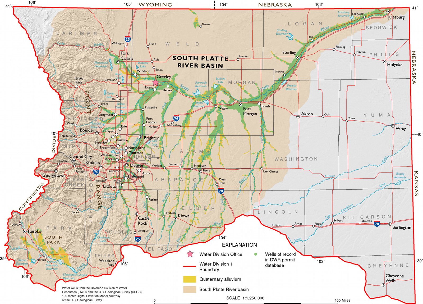
HB12-1278 study area via Colorado State University

From The Greeley Tribune (Tyler Silvy):

With dozens of people and thousands of acres of farmland affected by high groundwater in Weld County, the South Platte Roundtable on Tuesday accepted recommendations from its Groundwater Technical Committee to solve the problem.

The Tribune previously reported many of the solutions, including pumping water out of the ground and directly to the river, something Gilcrest is doing with a dewatering well officials recently turned on, resulting in groundwater receding by 7 inches in the past two weeks.

For some, though, the recommendations are either too expensive or simply don’t address the root problem…

In a survey of Farm Bureau members, Kammerzel found 40 of 94 people reported groundwater problems. The problems covered 2,154 acres, and conservative estimates put damages among Farm Bureau members at $4 million.

The high water table has inundated and destroyed basements, but it also has increased salinity levels in soils, making it impossible for farmers to grow some crops. Some crops like potatoes have been found rotting in the fields, sitting in high groundwater.

Even those presenting the recommendations say there’s no magic solution to a problem that has caused millions of dollars in damage around the county.

“I don’t know that our work will ever be done,” said John Stulp, a member of the technical committee and an adviser to Gov. John Hickenlooper on water issues.

Here’s where they’re at for now:

Increase groundwater use in high groundwater areas — This is easier said than done, as farmers have a certain well pumping quota, and it’s often wise to save that well pumping allotment until the end of the year in case rainfall doesn’t cover crop needs.

Multi-purpose storage — Basically, this involves buying or developing more storage, something officials at Central Colorado Water Conservancy District constantly are working to do. Increased storage can help provide replacement water for pumping, meaning farmers could be allowed to pump more.

Multi-use pipelines — Gilcrest pumps water out from under its wastewater treatment plant, puts that water in a 4- to 6-inch pipeline and takes that water to the river. The pipeline also is used for sewage effluent and stormwater, though, meaning its capacity is quite limited. There’s talk of a partnership between Gilcrest and Central Water on a new pipeline both could use, with Central using it for augmentation (replacement) water.

Conveyance improvements — Lining irrigation ditches, at $1 million per mile, is not only expensive, but it also takes away a key augmentation strategy. Ditch owners fill ditches, allow the water to seep into the ground and get to claim credit for recharging the aquifer and use that water at a later date.

Improving drains — The Big Bend Drain, located in and around Gilcrest, has fallen into disrepair, and the committee recommends fixing it, re-digging it and allowing it to serve its initial purpose: draining high water around Gilcrest.

There were recommendations, too, for individual farmers or landowners. But there also was this: A minority report from retired water consultant and engineer Bob Longenbaugh, who also made a presentation.

Longenbaugh’s key recommendations include gathering more data, as well as curtailing big artificial recharge projects — where organizations such as Central Water dump water into shallow ponds to recharge the aquifer and claim water credits. Longenbaugh contends artificial recharge around Gilcrest is exacerbating the high groundwater problem.

Randy Ray, executive director for Central Water, won’t go for that, as artificial recharge is a key tool for allowing more well pumping for Central customers.

As for the committee report, Ray said he’d like to see more research.

“We strongly feel that if an acre foot of water is pumped it needs to be replaced, but we need to work on timing, location and volume of depletions,” Ray said.

Farmers around Weld County have long said the formula used to replace depletions doesn’t match Mother Nature, a point Longenbaugh hit on Tuesday, as well.

Colorado Legacy Land taking over at Lincoln Park/Cotter Mill

From The Canon City Daily Record (Sarah Rose):

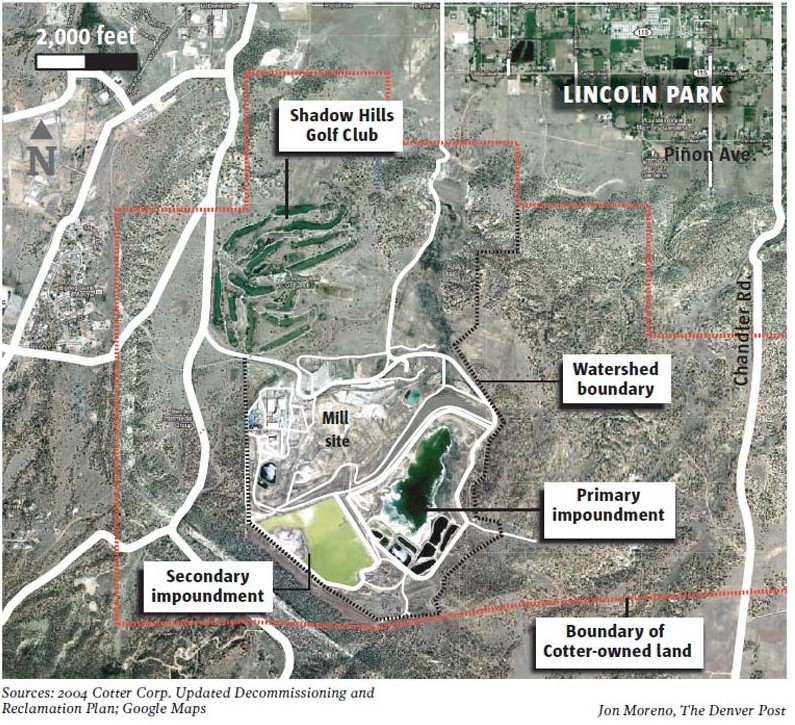
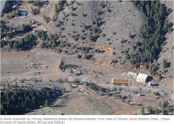
The Cotter Corp. owned the non-operating uranium mill property south of Cañon City for decades before it was sold Friday to Colorado Legacy Land. The [Ralston Creek near Golden] Schwartzwalder Mine also was sold to the company.

Colorado’s State Radiation Program, which is part of Colorado’s Department of Public Health and Environment, is an agency that reviewed and approved the Radioactive Materials License transfer.

“… The review evaluated Colorado Legacy Land’s decommissioning funding plan and technical qualifications for site remediation, reclamation and closure, as well as routine site maintenance, radiation safety, and occupational and environmental monitoring,” stated a press release from the CDPHE. “The review determined that Colorado Legacy Land and the proposed key personnel are technically qualified to manage the Cotter mill site closure and the radioactive materials license.”

Colorado Legacy Land is a partnership between Colorado Legacy Land Stewardship and Alexco Environmental Group. Colorado Legacy Land was set up to clean the Lincoln Park Superfund Site and the Schwartzwalder Mine, said Eric Williams, president of Colorado Legacy Land Stewardship.

“Alexco Environmental Group is very good at cleaning up contaminated properties around the country but particularly good with mining companies in Colorado,” Williams said, adding that Alexco helped to clean up the Gold King Mine site, which caused the Animas River to be contaminated with mining waste in 2015. “Colorado Legacy Land is a public benefit corporation. Part of our mission is to clean up contaminated properties, as well as putting those back into some productive use, typically going toward eco-friendly uses, like renewable energy or open space recreation, those kinds of things. The directors of Colorado Legacy Land have close to 100 years of experience in dealing with environmental cleanup sites and putting properties back into productive use.”

Colorado Legacy Land first expressed interest in the Lincoln Park Superfund site about a year ago.

“The process in purchasing it took a long time,” Williams said. “This was a very complex transaction because of the regulatory side of things.”

Williams said Colorado Legacy Land will “start immediately” on the cleanup process.

“We are already very much up to speed with the environmental conditions,” Williams said. “Our focus in the immediate short-term is to work with the Community Advisory Board and the regulators to continue the process of planning and the cleanup of the properties.”

Steve Cohen, who was Cotter’s mill manager for the Lincoln Park site, will continue to be the mill manager under the new management.

Cohen said many employees who worked for Cotter will stay at the mill. Cohen said there were some layoffs at the property but didn’t specify how many.

The CAG invites the public to attend its monthly meeting, where members and representatives of agencies overseeing the cleanup, discuss what’s occurring at the Lincoln Park Superfund site. The next meeting will be from 1 to 4 p.m. Thursday at the Fremont County Administration Building, 615 Macon Ave. Meetings are scheduled every third Thursday of the month.

#AnimasRiver: U.S. Court of Appeals D.C. Circuit says @EPA followed the rules for Bonita Peak Mining District Superfund designation

From The Durango Herald (Jonathan Romeo):

Judges say EPA followed rules when including mining sites in cleanup area

The U.S. Court of Appeals D.C. Circuit issued the decision Tuesday to deny Sunnyside’s petition, which was filed by the mining company – a “potentially responsible party” in the Superfund cleanup – in December 2016.

Sunnyside had argued that of the 48 mining sites in the upper Animas River watershed the EPA included in the “Bonita Peak Mining District Superfund” site, 29 had not been properly evaluated and should be removed.

Sunnyside owns two of the 29 sites mentioned, including the Sunnyside Mine and the Mayflower tailings.

“We have no objections to there being a Superfund listing,” Sunnyside spokesman Larry Perino previously said. “The petition is only challenging the unlawful listing of sites that were not assessed at all under the EPA’s own Hazard Ranking System.”

Perino did not immediately respond to requests for comment Tuesday afternoon.

However, the U.S. Court of Appeals D.C. Circuit decision says the EPA did act lawfully and within its own protocols in the Superfund process.

In determining whether the mining district around Silverton qualified for a Superfund listing, the EPA scored 19 pollution sources under the agency’s Hazard Ranking System.

Each of the sources received a high enough score that indicated pollution was bad enough to be eligible for a Superfund listing. As a result, EPA proposed the entire mining district, scored and unscored sources, should be listed.

The Bonita Peak Mining District Superfund site was declared in September 2016.

Months later, Sunnyside argued the EPA was wrong to create a Superfund site that had unscored sources, claiming the EPA must score each contributing source of contamination before adding it to the broader Bonita Peak site.

But the court said text of the HRS process “alone is enough to refute this assertion,” which says a Superfund “may include multiple sources and may include the area between sources.”

“The BPMD is a site (comprised) of the 19 scored sources and the areas ‘between’ them, as the HRS explicitly permits,” the court said. “Sunnyside’s mine falls into the category of an ‘area between sources’ and therefore did not need to be scored.”

The court said: “Sunnyside’s real concern became apparent at oral argument. It claims its mine has been fully remediated and had no part in the present pollution of the site, but it may nevertheless be required to pay for some or all of the cleanup.”

Sunnyside Gold is considered the largest “potentially responsible party” in the district – a term the EPA uses for entities it considers financially on the hook for cleanup.

@UCLA: 100% local water possible for Los Angeles by 2050 #ColoradoRiver #COriver

Map of the Los Angeles River watershed via Wikimedia.

Here’s the abstract for the recently released study:

This report assesses the potential to improve water quality standards while integrating complementary One Water Management practices that can increase potential local water supplies for the City of Los Angeles (the City). This final report summarizes the current practices and future opportunities at the City-owned Water Reclamation Plants and underlying groundwater basins and highlights the importance of considering all aspects of integrated water management even when dealing with water quality or supply-focused projects.

Implementing watershed-scale best management practice programs to meet stormwater permit requirements will significantly improve water quality in all watersheds. However, additional mechanisms such as increasing Low Impact Development implementation and comprehensive source tracking and source control mechanisms will be required to potentially eliminate water quality exceedances. There are multiple efforts occurring in the City and the region to increase the recharge of recycled water into the ground and the volumes of remediated groundwater extracted.

This research further assessed the impacts of potential water supply portfolios, with greater volumes of locally-supplied water, on GHG emissions and energy needs of supplying LA’s water. Conservation will be another powerful tool to decrease our dependence on imported water. This research demonstrates the complex interrelationships between all aspects of urban water management, including, for example, stormwater management and local water supply.

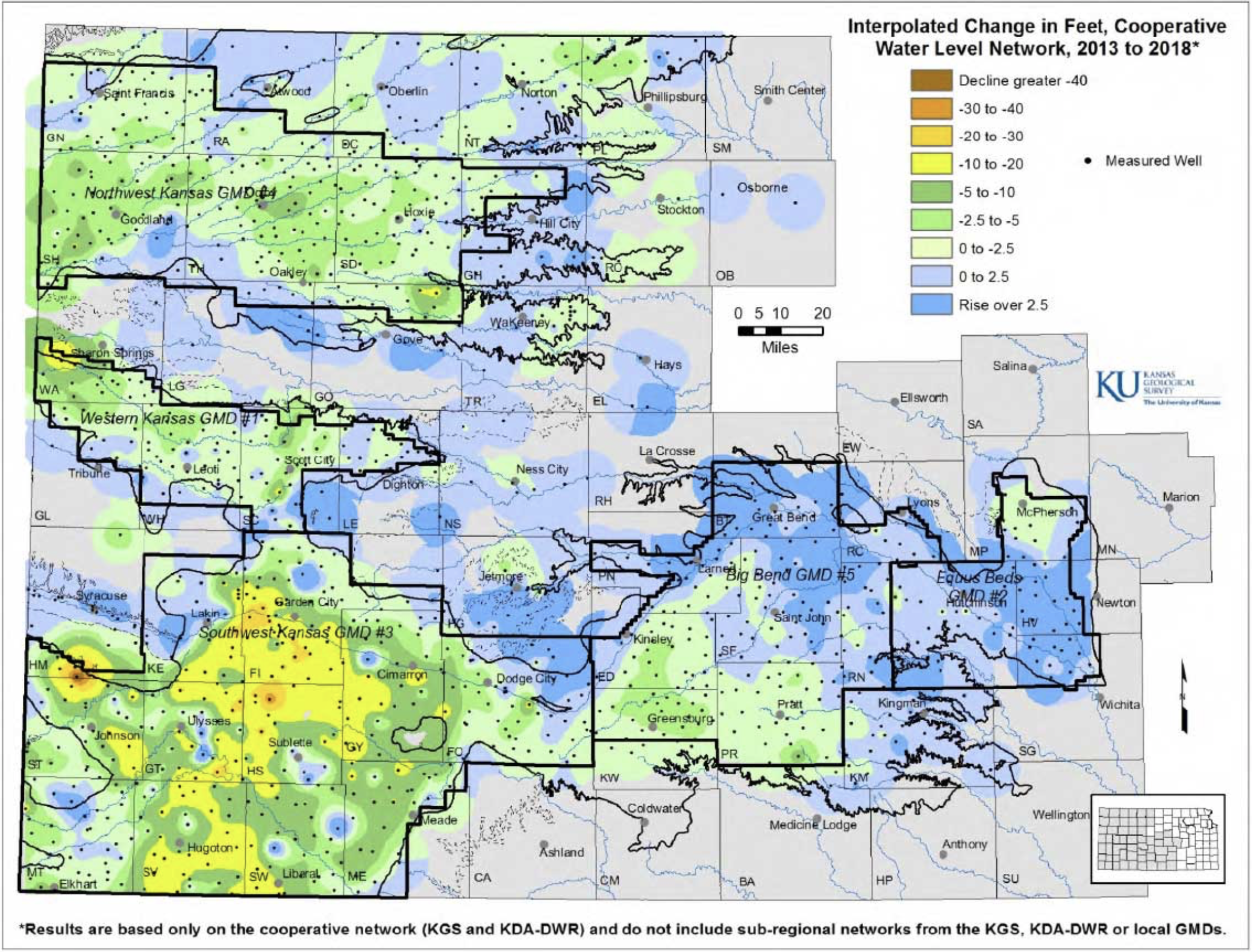
Groundwater levels steady in western Kansas, decrease around Wichita — @KUNews

Graphic via the University of Kansas.

From the University of Kansas:

Groundwater levels during 2017, on average, rose slightly or nearly broke even in western Kansas but fell in the Wichita area, according to preliminary data compiled by the Kansas Geological Survey. This was a reversal from 2016 when overall groundwater levels dropped in western Kansas and increased significantly near Wichita.

The KGS — based at the University of Kansas — and the Division of Water Resources (DWR) of the Kansas Department of Agriculture annually measure levels in about 1,400 water wells in western and central Kansas. The collected data are used to monitor the condition and long-term trends of the High Plains aquifer, the state’s most valuable groundwater resource, as well as smaller deep and shallow aquifers.

The High Plains aquifer is a network of water-bearing rocks that underlies parts of eight states and, in Kansas, comprises three individual aquifers—the far-reaching Ogallala aquifer that makes up the majority of the High Plains aquifer, the Equus Beds around Wichita and Hutchinson, and the Great Bend Prairie aquifer in the center of the state. Ninety percent of the measured wells draw from these three aquifers.

Water level changes or stability in the Ogallala aquifer in western Kansas correspond primarily with the amount of water withdrawn for irrigation, which in turn is influenced by the rate and timing of precipitation.

“Much of the western border of Kansas and eastern Colorado saw above normal precipitation patterns in 2017, especially through most of the growing season,” said Brownie Wilson, KGS water-data manager. “As a consequence, water levels were at or above the 2016 levels in much of the region.”

Water level increases in western Kansas mainly occur when the levels in wells rebound as pumping slows. Recharge — water seeping down from the surface — is negligible in western Kansas. In central Kansas, where the aquifer is shallower and average precipitation is higher, recharge can make a difference.

“For areas that have higher local recharge capabilities, such as along and north of the Arkansas River in the Equus Beds and Great Bend Prairie aquifer, precipitation generally influences both pumping and recharge,” Wilson said. “There you can get large swings in declines and rises from year to year.”

The 2017 growing season around the Equus Beds was fairly dry, which led to low recharge and higher withdrawal for irrigation, industry and municipal water supplies. Consequently, the Equus Beds declined nearly 2 feet. The Great Bend Prairie aquifer, which encompasses Great Bend, Kinsley, Greensburg and Pratt, fared better with an increase of about a quarter of a foot.

Most of the wells in the network monitored by the KGS and DWR are within the boundaries of the state’s five Groundwater Management Districts (GMDs), which are organized and governed by area landowners and local water users to address water-resource issues.

In Southwest Kansas GMD 3, average levels dropped just 0.05 feet, the lowest decline there since since the state began administrating the water-level program in 1996. In comparison, the average level fell a total of 23 feet over the previous 10 years.

“Water levels were notably higher in Morton County and along and north of the Arkansas River,” Wilson said. “Still, there were localized areas in the GMD that experienced declines of 1 to 3 feet.”

Even with better overall measurement results in the region for the year, the aquifer is nearly depleted in places.

Wells monitored in GMD 3 are drilled into the Ogallala aquifer except in a few areas where they draw from the deeper Dakota aquifer. The district includes all or part of Grant, Haskell, Gray, Finney, Stanton, Ford, Morton, Stevens, Seward, Hamilton, Kearny and Meade counties.

Another rare water-related event in the region occurred in the summer of 2017 when the Arkansas River flowed in Garden City. The river there has been mainly dry for decades due to high water use and less river flow from Colorado. When there is surface water in the river, it interacts with groundwater in an adjacent shallow alluvial aquifer.

Western Kansas GMD 1 experienced a slight drop of 0.19 feet in 2017 following a 0.55 feet in 2016. Although decreases there have been less drastic than farther south, annual levels have risen only twice since 1996. The GMD includes portions of Wallace, Greeley, Wichita, Scott and Lane counties, where the majority of wells are drilled into the Ogallala aquifer.

Northwest Kansas GMD 4 had an average increase in water levels of 0.33 feet after falling slightly in all but two year since 1996. GMD 4 covers Sherman, Thomas, Sheridan and parts of Cheyenne, Rawlins, Decatur, Graham, Wallace, Logan and Gove counties. Groundwater there is pumped almost exclusively from the Ogallala aquifer and shallow alluvial sources associated with streams.

Big Bend GMD 5 had an average increase of 0.26 feet following an increase of 0.88 feet in 2016. Since 1996, annual levels there rose nine times and fell 13 times. The GMD is centered on the Great Bend Prairie aquifer underlying Stafford and Pratt counties and parts of Barton, Pawnee, Edwards, Kiowa, Reno and Rice counties.

Equus Beds GMD 2, a major source of water for Wichita, Hutchinson and surrounding towns experienced a decline of 1.93 feet, which followed an increase of 2.08 feet in 2016. Since 1996, annual levels there rose nine times and dropped 13 times. The GMD covers portions of Reno, Sedgwick, Harvey and McPherson counties.

“Even with the big declines in GMD 2, this is one of the best years we’ve seen in quite a long time,” Wilson said.

The KGS measures approximately 570 wells in western Kansas each January, and DWR staff from field offices in Stockton, Garden City and Stafford measure about 220, 224 and 360 wells in western and central Kansas, respectively. Most of the wells, spread over 48 counties, are used for irrigation and have been measured for decades.

Measurements are taken primarily in January when water levels are least likely to fluctuate due to irrigation. Infrequently, however, later-than-normal pumping during dry conditions may affect measurement results.

The results are provisional and subject to revision based on additional analysis. Data by well will be available in late February at http://www.kgs.ku.edu/Magellan/WaterLevels/index.html.
The University of Kansas is a major comprehensive research and teaching university. The university’s mission is to lift students and society by educating leaders, building healthy communities and making discoveries that change the world. The KU News Service is the central public relations office for the Lawrence campus.

#AnimasRiver: Federal Judge denies contractor’s motion in #GoldKingMine spill

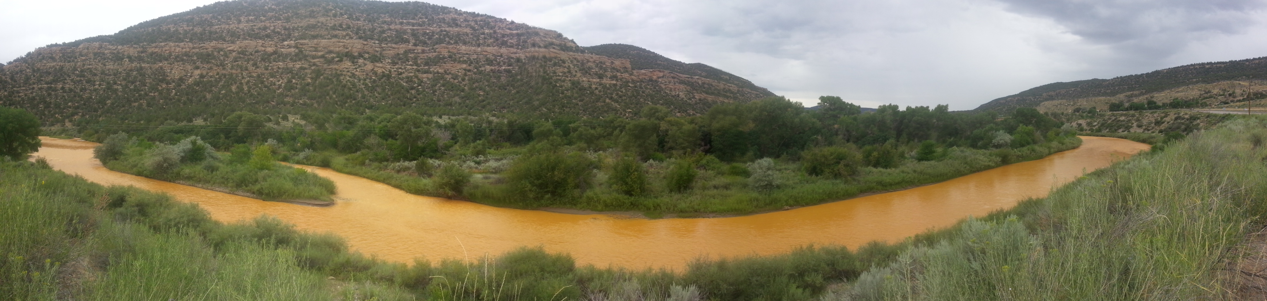
The orange plume flows through the Animas across the Colorado/New Mexico state line the afternoon of Aug. 7, 2015. (Photo by Melissa May, San Juan Soil and Conservation District)

From The Farmington Daily Times (Noel Lyn Smith):

A federal judge in Albuquerque ruled Monday that certain claims can proceed in consolidated civil lawsuits filed against a contractor for the August 2015 Gold King Mine spill.

U.S. District Judge M. Christina Armijo dismissed part of a motion filed by Environmental Restoration LLC, one of the companies contracted by the U.S. Environmental Protection Agency to conduct environmental remediation at the mine.

The St. Louis-based company was among those named in separate lawsuits filed in 2016 by the state of New Mexico and the Navajo Nation.

The state and the tribe claim environmental and economic damages have occurred due to the EPA and its contractors releasing more than three million gallons of acid mine drainage and 880,000 pounds of heavy metals into the Animas River watershed as the result of a breach at the mine.

The state and the tribe are seeking compensation for the claims filed under the Comprehensive Environmental Response, Compensation and Liability Act, or CERCLA.

Environmental Restoration sought to dismiss the complaints and argued it was not liable for damages because it was not an operator, arranger or transporter as defined under CERCLA.

Armijo ruled Environmental Restoration cannot be released from the lawsuit, and the state and the tribe’s claims can proceed.

She also denied the company’s motion to strike the tribe’s request for punitive damages…

New Mexico Attorney General Hector Balderas and New Mexico Environment Department Secretary Butch Tongate issued a joint statement on Wednesday regarding the court decision.

“We are pleased that our lawsuit against EPA’s contractor, Environmental Restoration LLC, will proceed and we look forward to continuing to work alongside the Navajo Nation to recoup the damages done to our environment, cultural sites and our economy,” the statement said.

The tribe called the decision “victorious” in its press release on Wednesday.

South Platte Roundtable meeting recap

Illustration shows water availability, in blue circles, compared with demand at various places along the South Platte River. The yellow area is the study area. (Illustration by Stantec).

From The Greeley Tribune (Tyler Silvy):

A yearlong study centered on a decades-long trend of Colorado sending too much water to Nebraska via the South Platte River yielded dozens of potential storage projects.

But high costs, potential environmental impacts, and bureaucratic and regulatory hurdles could doom the road ahead for any of those possibilities, according to a study presented Tuesday night at the South Platte Basin Roundtable meeting in Longmont.

Further, even if several of the identified projects happen, they would barely put a dent in what’s expected to be a Front Range water needs gap of 500,000 acre feet per year.

The $200,000 study, ordered by the Colorado State Legislature and paid for by the Colorado Water Conservation Board, looked at the South Platte from Greeley to the state line and identifyed potential storage solutions along the way.

Putting any of those solutions — with costs estimates ranging from $190 million to $1 billion — to work most likely will take more time, money and study…

Consultants from Stantec Consulting Services and Leonard Rice Engineers completed the study in December and have toured the state making presentations. The Legislature has yet to get a presentation, but here are the key points legislators will hear:

A large amount of water is physically and legally available but only during wet years and during short periods.

Mainstream options have the most benefit but likely are not permittable and have significant social impacts.

Many off-channel options appear to be feasible and could be combined in different concepts.

Even multiple projects won’t make a big dent in the supply gap.

One reason for the lack of impact is how the South Platte works. When farmers divert water from the South Platte to irrigate crops, some of that water soaks underground and slowly moves back to the river. That’s called a return flow, and return flows feed the South Platte to allow it to flow long after snowmelt water is gone for the season.

That’s why the Sterling No. 1 ditch can completely dry out the river with a diversion and then a mile downriver it’s flowing again.

That’s why the best possible place for a reservoir would be near the Colorado-Nebraska border, and the best solution for keeping as much water as possible — a mainstream reservoir — is the solution that likely never will happen.

A mainstream reservoir along the South Platte essentially would be a lake on the South Platte, with the western portion feeding into the lake and the eastern portion running when the lake releases water.

Water experts agree that would be nearly impossible to get approved.

But the consultants did identify storage options away from the river, including old gravel pits.

Still, building ditches or pipes to fill those gravel pits would prove costly.

The consultants also talked about the 2013 flood and high flows in 2015, which ended up sending 1.9 million acre feet of water to Nebraska — exponentially more water than Nebraska is entitled to via the 1923 compact with Colorado.

But managing or diverting water during a flood event like that would take technology water experts said just doesn’t exist. Instead, ditch companies did everything they could to keep the flood water out of their ditches, lest they get damaged by the torrent.

Groundwater storage also was touched on, but concerns were raised about water losses and the co-mingling of other water rights. Once the water flows under another landowner’s property, for example, they would have the right to pump that water to irrigate crops.

The conversation circled back to the reason for the study. Essentially, lawmakers on the Western Slope long have pointed to the excess water the Front Range sends to Nebraska. Rather than divert more water from the Western Slope, the argument goes, Front Range farmers and municipalities need to figure out how to keep what they have.

Mike Schimmin, a water rights attorney on the roundtable, said his fear is the study will reinforce those feelings and that people will ignore the high cost to capture the extra water.

@CSUtilities may offer water to outlying communities in El Paso County

The new north outlet works at Pueblo Dam — Photo/MWH Global

From The Colorado Springs Independent (Pam Zubeck):

Should the city be a good neighbor and share its water with those who don’t live within its boundaries?

Yes, says the Colorado Springs Utilities Policy Advisory Committee, which after a year of study has formed draft recommendations that call for removing barriers for bedroom communities to hook up to city water and wastewater systems. The recommendations — due for delivery to the Utilities Board, composed of City Council members, on March 21 — would lower the cost of hookups by up to 26 percent while opening the door to long-term agreements.

So what’s in it for city ratepayers? Plenty, according to Dave Grossman, Utilities strategic planning and government supervisor. New sales could help pay off debt for the $825 million Southern Delivery System (SDS) pipeline from Pueblo Reservoir, erase headlines that give the city a bad name and help outside water providers’ groundwater supplies last longer…

Still, the move raises a lot of questions. Why should city ratepayers share their resources with those who chose to live outside city limits, didn’t pay the costs of major Utilities projects and don’t pay city property taxes? Why allow outsiders to become dependent on city water, when the city will likely need that water for its own population in the future? And, at a time when the city is trying to attract more development within city limits, why give away one of the city’s best bargaining chips?

[…]

Until 2010, the city didn’t sell water outside its limits. The policy changed to accommodate sales for three years or less to districts that experienced water shortages or other problems. But they paid 150 percent of city customer charges. There are 11 water districts, six water and wastewater districts and four wastewater districts in El Paso County. Not all would necessarily want to buy city services, but some would.

Many rely largely on groundwater from the Denver Basin, which is rapidly depleting. Despite state and county measures to assure supplies last, the water table continues to drop.

Utilities has had outside deals with Cherokee Metropolitan District east of Powers Boulevard and Donala Water & Sanitation District east of the Air Force Academy. Cherokee needed water temporarily after court decisions prevented its use of some wells, while Donala uses the city’s pipes to convey water it obtained from Pueblo Board of Water Works.

Water districts form such a patchwork that Sean Chambers, who’s worked for several districts and now runs Chambers Econ & Analytics, has teamed with Peak Spatial Enterprises to create an online tool to compile district information in seven counties from Denver to Pueblo. Funded in part by the Colorado Water Conservation Board, it will feature maps, water rates, sources, conservation practices, water quality reports, consumption and the like, listed by address, for use by the public and the real estate industry.

But what if those districts had access to Springs Utilities’ supply? The city’s roughly 140,000 water customers use about 40 million gallons a day during the winter and more than 100 million gallons a day in the summer, Grossman says. If pressed, the city could provide well over that amount short term, he says.

Besides completing SDS in 2016, which increased the city’s water supply by a third, the city’s abundant supply is linked to conservation measures taken since 2001 that reduced per-person consumption from 130 gallons a day to 82. The city’s system also has capacity; the Bailey Water Treatment Plant, part of SDS, runs at about 10 percent capacity.

As for wastewater, the city has plenty of capacity, Grossman reports, for the next 30-plus years.

More than a year ago, Utilities began looking into whether extending service could benefit everyone. For one thing, the Advisory Committee found, water issues anywhere in the Pikes Peak region impact the city’s reputation and the region’s economy.

For example, in 2016, it was found that groundwater wells had been contaminated with perfluorinated chemicals (PFCs) from firefighting foam at Peterson Air Force Base. The chemicals fouled wells serving Fountain, Widefield/Security and other areas…

Under the committee’s recommendation, outside users would still pay more than city customers — 120 percent of the normal charge for water and 110 percent for wastewater. Currently, the city charges 150 percent for both…

Districts aren’t apt to buy their entire supplies from the city, however, Chambers says. That’s because their goal is conjunctive use — a combination of wells and surface water; if districts can buy water during wet years and pump from their wells in dry years, the aquifer gets a rest and a chance to recharge, he says.

That’s the concept behind WISE (Water, Infrastructure and Supply Efficiency), a coalition of 12 entities, including Denver Water, Aurora Water and the South Metro Water Supply Authority created after the 2002 drought.

Chambers notes that outside sales could help the city retire debt and fund maintenance and operations. Having attended most of the committee’s meetings, Chambers attests the city’s top goal is to serve existing customers. “Utilities has been very protective,” he says, “saying regionalization will not happen unless it’s a benefit to the citizen owners and ratepayers.”

For example, Grossman notes the committee wants to include options for conveying and treating water, but that no outside contracts would be executed if they’d erode the city’s targeted storage benchmarks.

Elbert County growth fueled by sweet spot in the Denver Basin Aquifer system

Denver Basin aquifer map

From ColoradoPolitics.com (Marianne Goodland) via The Colorado Springs Gazette:

Water watchers concerned

There’s also worry about how much water the development would need, and whether that water will truly stay in Elbert County.

The county is in what some residents call a “sweet spot.” There are four major aquifers under the county: Dawson, Denver, Fox Hills and Arapahoe. No other county on the Front Range sits on all four. The Denver Basin, which includes the four aquifers, is the major water supply for the south metro Denver area, and reaches all the way to Colorado Springs to the south and Greeley to the north.

Virtually all of the water providers in the south metro area are looking for ways to save the rapidly diminishing water in the Denver Basin aquifers, which do not respect county lines. That’s meant millions of dollars spent to find other water sources.

And Colorado history is replete with examples of water rights in rural eastern plains counties or those surrounding towns being sold to urban interests, which adds to the wariness of Elbert residents.

Elbert County plans to tap the aquifer to satisfy its projected growth. Last year, a company hired by the county conducted a rural water supply study that would project water demands for the Independence project and another near Kiowa, the county seat, up to 2035 and 2050. Will Koger of Forsgren Associates told those gathered at a community forum that the two developments would require about 9,000 acre-feet per year by 2050, or about 3.2 billion gallons per year.

There are alternatives available, too, Koger said, noting that agricultural land that is developed for residential use will also provide water and the water rights that go with it to satisfy those developments.

That didn’t sit well with some of those at the forum, who pointed out that tapping the aquifer means pumping nonrenewable groundwater, and that could affect wells, the primary source of water for just about everyone in Elbert County.

The county has little in the way of options, with little surface water available from streams or rivers, according to an April 2017 presentation from the state Division of Water Resources.

But the demand for aquifer water is low compared to the available supply, Koger told the audience, and the developments would tap less than 1 percent of what’s available.

The plaintiffs in the lawsuit against the Independence project question whether the issue of water is about the development or if it’s about selling water to next door Douglas County. They point to a map included in the Forsgren presentation that they said shows a proposed one-way pipeline that goes from the Independence site to Rueter-Hess Reservoir in Douglas County.

The development schematics includes a proposal for six special districts that would manage the water, which strikes Richard Brown and other concerned residents as odd. The six districts, according to a water and sanitation proposal developed for the county, would be contained within a small section of the development that would not include any homes. One district is an “overlay” that would control the rest.

The developer, Craft Companies, and its owner and board would be the only voters in those districts, according to the water and sanitation proposal.

@EPA is considering deploying robotic explorers to ascertain conditions in troublesome mines

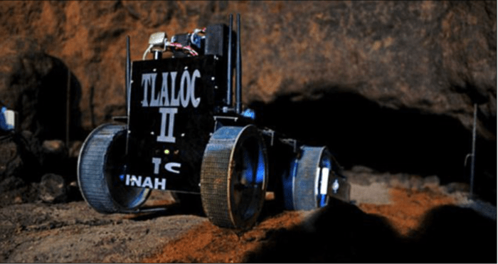
Explorer: This robot may have made a momentous discovery in a 2,000-year-old tunnel in Mexico. Photo credit: DailyMail.com.

From the Associated Press (Dan Elliott) via The Detroit News:

the EPA is considering using robots and other sophisticated technology to help prevent these types of “blowouts” or clean them up if they happen. But first the agency has to find out what’s inside the mines, some of which date to Colorado’s gold rush in the 1860s.

Wastewater containing toxic heavy metals has been spewing from hundreds of inactive mines nationwide for decades, the product of complicated and sometimes poorly understood subterranean flows.

Mining creates tainted water in steps: Blasting out tunnels and processing ore exposes long-buried, sulfur-bearing rocks to oxygen. The sulfur and oxygen mix with natural underground water flows to create sulfuric acid. The acidic water then leaches heavy metals out of the rocks.

To manage and treat the wastewater, the EPA needs a clear idea of what’s inside the mines, some of which penetrate thousands of feet into the mountains. But many old mines are poorly documented.

Investigating with robots would be cheaper, faster and safer than humans.

“You can send a robot into an area that doesn’t have good air quality. You can send a robot into an area that doesn’t have much space,” said Rebecca Thomas, project manager for the EPA’s newly created Gold King Superfund site, officially known as the Bonita Peak Mining District.

Instruments on the robots could map the mines and analyze pollutants in the water.

They would look more like golf carts than the personable robots from “Star Wars” movies. Hao Zhang, an assistant professor of computer science at the Colorado School of Mines, envisions a battery-powered robot about 5 feet long with wheels or tracks to get through collapsing, rubble-strewn tunnels.

Zhang and a team of students demonstrated a smaller robot in a mine west of Denver recently. It purred smoothly along flat tunnel floors but toppled over trying to negotiate a cluttered passage…

A commercial robot modified to explore abandoned mines – including those swamped with acidic wastewater – could cost about $90,000 and take three to four years to develop, Zhang said.

Significant obstacles remain, including finding a way to operate remotely while deep inside a mine, beyond the reach of radio signals. One option is dropping signal-relay devices along the way so the robot stays in touch with operators. Another is designing an autonomous robot that could find its own way.

Researchers also are developing sophisticated computerized maps showing mines in three dimensions. The maps illustrate where the shafts intersect with natural faults and provide clues about how water courses through the mountains.

“It really helps us understand where we have certainty and where we have a lot of uncertainty about what we think’s happening in the subsurface,” said Ian Bowen, an EPA hydrologist. “So it’s a wonderful, wonderful tool.”

The EPA also plans to drill into mines from the surface and lower instruments into the bore holes, measuring the depth, pressure and direction of underground water currents.

Tracing the currents is a challenge because they flow through multiple mines and surface debris. Many tunnels and faults are connected, so blocking one might send water out another.

“You put your finger in the dike here, where’s the water going to come out?” Thomas said.

Once the EPA finishes investigating, it will look at technologies for cleansing the wastewater.

Options range from traditional lime neutralization – which causes the heavy metals dissolved in the water to form particles and drop out – to more unusual techniques that involve introducing microbes.

The choice has consequences for taxpayers. If no company is found financially responsible, the EPA pays the bill for about 10 years and then turns it over to the state. Colorado currently pays about $1 million a year to operate a treatment plant at one Superfund mine. By 2028, it will pay about $5.7 million annually to operate plants at three mines, not including anything at the Bonita Peak site.

The EPA views the Colorado project as a chance for the government and entrepreneurs to take risks and try technology that might be useful elsewhere.

But the agency – already dealing with a distrustful public and critical politicians after triggering the Gold King spill – said any technology deployed in Colorado will be tested first, and the public will have a chance to comment before decisions are made.

On April 7, 2016, the Environmental Protection Agency proposed adding the “Bonita Peak Mining District” to the National Priorities List, making it eligible for Superfund. Forty-eight mine portals and tailings piles are “under consideration” to be included. The Gold King Mine will almost certainly be on the final list, as will the nearby American Tunnel. The Mayflower Mill #4 tailings repository, just outside Silverton, is another likely candidate, given that it appears to be leaching large quantities of metals into the Animas River. What Superfund will entail for the area beyond that, and when the actual cleanup will begin, remains unclear.
Eric Baker

ADWR hydrologists to “sweep” into Arizona’s Northwest Basins for data on aquifer depths

From the Arizona Department of Water Resources:

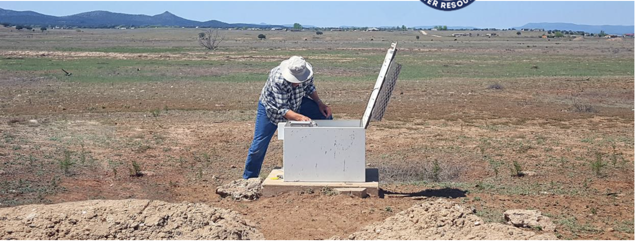
Beginning the week of February 5, Arizona Department of Water Resources (ADWR) will be making an extensive effort to measure water levels in wells in the Northwestern Region Basins of Arizona.

Field personnel will be conducting water level measurements in wells located in the Sacramento Valley, Detrital Valley, Hualapai Valley and Meadview groundwater basins.

These measurements are being conducted as part of ADWR’s annual and periodic basin-wide water-level data collection program, which measure groundwater levels throughout the state.

Each year, the Department targets at least one area of the State for such “sweeps,” which are intended as a “deep dive” into regional groundwater conditions.

Data from the water-level survey provides valuable information on hydrologic conditions in the aquifers of the area. ADWR personnel will be in the Northwestern area conducting water level measurements for approximately 3 to 4 weeks.

Every year the Department’s hydrologists collect water levels in a statewide network of about 1,600 to 1,800 “index” wells that have typically been measured annually over the last several decades.

There are roughly 51 index wells measured annually and 7 with daily water levels from automated monitoring sites in the Northwestern basins, which include the Hualapai Valley, Sacramento Valley, Detrital Valley and Meadview basins.

The Department last conducted a “sweep” in the region, known in planning terms as the Northwest Planning Area, in January-February 2006.

As noted below, the involvement of well-owners in “sweeps” is entirely voluntary. ADWR greatly appreciates the cooperation of well owners who participate in the well survey.

Some Frequently Asked Questions about basin “sweeps”:

What will the ADWR do with the data?

The department uses the information from the basin survey to develop water level maps to support scientific, planning and management studies of the basin’s aquifer system.

The department produces invaluable “Hydrologic Map Series” reports, and “Water Level Change” reports which show groundwater conditions statewide.

What if well owners don’t want the ADWR measuring their well depth?

Participation and cooperation with the department’s basin survey is entirely voluntary.

The data collected from basin surveys has proved valuable to property owners and lessees just as much as it is to state and municipal water planners.

Why here? And why now?

Historically, the department measures its index wells in the Northwestern Region Basin area in the late winter/early spring. During this time, the water levels in the aquifer have typically recovered from the previous summer “pumping” levels and represent a more “static” condition which gives a more representative picture of what’s happening with the aquifers in the area.

Do well owners and lessees get to review the data?

Data collected will be made available by early to mid-summer 2018 via the Department’s Ground Water Site Inventory (GWSI) database at azwater.gov – Data Center: https://gisweb.azwater.gov/waterresourcedata/GWSI.aspx

#Texas v. #New Mexico and #Colorado update: #Drought is testing the accounting methods for supply and diversions below Elephant Butte

From Water Deeply (Jerry Redfern):

Texas and New Mexico are squaring off over water rights in a case before the U.S. Supreme Court, but the issues at the heart of the disagreement were settled in 2008.

Insert drought: for most of the past 20 years, this whole disputed territory has suffered a series of droughts. Elephant Butte has not regularly filled as originally planned, and farmers have turned to pumping groundwater to meet their needs.

Texas’ main argument in the suit is that groundwater pumping for irrigation wasn’t covered under the 1938 compact. Texas contends that the groundwater is essentially attached to the water in the Rio Grande and Elephant Butte Reservoir. River water is drawn into the ground in times of high pumping, and more water then needs to be released from the reservoir to reach the quota bound for Texas. But Texas says that water is meant to be stored for Texas farms in drought years.

None of this is new. In fact, after years of previous wrangling, the three players directly involved in the dispute – Elephant Butte Irrigation District, which manages water between the dam and the Texas border; El Paso County Water Improvement District, which manages water on the Texas side; and Bureau of Reclamation, which manages the physical water system – collectively created the 2008 Operating Agreement. That document clearly laid out water use and metering of both surface and groundwater along the disputed stretch.

“It wasn’t pleasant, I’ll be honest with you,” Gary Esslinger, Elephant Butte Irrigation District manager and treasurer, said of those negotiations. But in the end, both water districts felt they had a deal they could work with, and farmers could get on with farming.

Enter the State of New Mexico and then-Attorney General Gary King, who, in 2011, sued the Elephant Butte Irrigation District, El Paso County Water Improvement District and the Bureau of Reclamation in both state and federal courts. He argued that the Operating Agreement gave too much water to Texas. And in light of that, two years later, Texas began its Supreme Court fight.

“Make no mistake, we had it solved,” said Phil King, professor of civil engineering at New Mexico State University. He helped negotiate the 2008 agreement with Elephant Butte Irrigation District.

“We still think to this day that we might not be in the Supreme Court, had New Mexico not threatened the 2008 agreement,” Esslinger said.

The stakes are high. If New Mexico loses, the state could be penalized for misappropriated water as far back as the 1940s – a bill that could reach north of $1 billion. In addition, the state may have to allocate more of its water to Texas in the future.

Meanwhile, farmers continue to operate under the 2008 agreement. Also, the Elephant Butte Irrigation District, El Paso County Water Improvement District, Bureau of Reclamation and other, smaller water users in New Mexico’s lower Rio Grande Valley are in closed-door talks to try to hammer out another deal – one amenable to both states and that makes the Supreme Court case moot. New Mexico’s current attorney general, Hector Balderas, has also indicated he wants to settle the case.

“I’m really very optimistic that something will work out,” says John Fleck, the director of the Water Resources program at the University of New Mexico. But “however this gets resolved, there will probably be less water for farming in the lower Rio Grande.”

And that’s because of drought.

@AuroraWater Pursues New Water Source: Water rights purchase provides environmental benefits

Here’s the release from Aurora Water (Greg Baker):

On Monday evening, Aurora Water received approval from City Council to buy water rights associated with the London Mine, located near Alma, in Park County. 1,411 acre feet (af) is being purchased at a price of $22,000 per af, with additional costs of $3 million for the option to additional water rights as they are developed. An acre foot of water is 325,851 gallons, enough water to serve 2.5 households on average. The seller of the rights is MineWater Finance, LLC and No Name Investors, both Colorado companies. The total value of this initial sale is $34,042,000. As additional water rights are developed, Aurora may purchase these rights for $21,500 per acre foot. The sellers are confident that the source of the rights could ultimately result in an average annual deliverable of 5,400 af.

The source of this water is from a basin that is recharged from snowmelt on London Mountain. A geologic fault contains the water underground and prevents it from discharging into South Mosquito Creek, a tributary of the South Platte River. This water will be pumped from the basin to a water tunnel in the London Mine and from there, discharged into South Mosquito Creek. Since this water is not naturally connected to the streams, it is decreed under Colorado Water Law as non-tributary. This has special meaning as this water is fully reusable and can be recaptured utilizing Aurora’s Prairie Waters system, a potable reuse system.

Aurora Water has been a national leader in water efficiency, including an acclaimed water reuse system called Prairie Waters, and a nationally recognized water conservation program. Water acquisition is still necessary to meet future demands.

“Looking for new water supplies in the arid west requires innovative thinking,” said Marshall Brown, Director for Aurora Water. “This is a supply that historically has not been tapped by water providers, but the easier supplies are gone.”

The environmentally positive aspects of purchase have resulted in praise from organizations such as the Boulder-based Water Resource Advocates (WRA).

“New water supplies in Colorado are extremely limited and, at the same time, nearly 2,000 miles of streams in Colorado are polluted by mines,” Laura Belanger, Water Resources and Environmental Engineer with WRA stated. “We commend Aurora Water for taking a leadership role in finding this inventive and environmentally beneficial solution to meeting its customers’ water needs.”

The Aurora City Council will vote on the purchase agreement at its regular session on Monday, January 22, 2018. Aurora Water will have a 180 day due diligence period prior to the final closing. Additional water rights under the options provision will be purchased as they are adjudicated and decreed through Colorado’s Water Courts.

Video b-roll of Aurora Water staff touring London Mine with MineWater on November 1, 2017 is available at https://youtu.be/uCNLNvJsu24

Photos of mine and Tour are available from our DropBox location at https://www.dropbox.com/sh/dfv7kd1qi364910/AADyyKHcWctPZrJUy9FpH8kfa?dl=0

From The Denver Post (Bruce Finley):

CDPHE officials on Thursday declined to discuss the London Mine deal. Colorado Department of Natural Resources officials also declined to discuss it.

But “if they have a water right, they may extract the resource,” according to an emailed response that an agency information gatekeeper said could be attributed to Ginny Brannon, director of the agency’s division of reclamation, mining and safety.

State officials didn’t raise any concerns. They say their agency “partners” with others to reduce pollution “and additional partners and funding can always be used to reduce pollution from these large numbers of … inactive mines,” the statement said.

On Monday, Aurora council members, who have discussed the deal with utility officials in an executive session, will consider an initial purchase of 1,400 acre-feet of water for $32 million. That works out to about $22,000 per acre-foot, comparable with what utilities pay to acquire surface water. A second transaction would expand the pumping to extract up to 5,400 acre-feet a year, depending on a state water court determination of what is sustainable.

Money for the deal would come from fees charged to developers of new homes.

A Southwest water dispute reaches the Supreme Court — @HighCountryNews

From The High Country News (Sarah Tory):

Southern New Mexico’s Mesilla Valley is like an island: a fertile patchwork of farm fields and groves of pecan trees surrounded by the brown Chihuahuan Desert.

For Mesilla Valley farmers, the metaphor rings true in other ways as well. Though they live in New Mexico, the residents of the roughly 90,000-acre-area are caught between their own state and Texas. The Rio Grande water they depend on is not technically New Mexico’s water, but rather part of the water that goes to Texas under the Rio Grande Compact, a treaty ensuring that Texas, New Mexico and Colorado get their fair share of the river. New Mexico’s delivery obligation to Texas hinges on collecting enough water in Elephant Butte Reservoir, 90 miles from the Texas border and the neighboring Mesilla Valley. Unfortunately, that leaves the farmers downriver in a complicated no-man’s-land of interstate water management.

“We cringe when we hear, ‘Not one more drop to Texas,’ because that means not one more drop for us,” says Samantha Barncastle, the lawyer for the Elephant Butte Irrigation District, which manages and delivers irrigation water to Mesilla Valley farmers.

After more than a decade of back-and-forth between New Mexico and Texas, the fight has finally reached the Supreme Court. The first round of oral arguments took place on Jan. 8, with a final decision expected by early spring. For the farmers, the conflict has only heightened their sense of isolation from their own state — and made the costs of poor water management in a hotter and drier West more obvious than ever.

Elephant Butte Dam is filled by the Rio Grande and sustains agriculture in the Mesilla Valley of New Mexico.
Sarah Tory

Built in 1916 by the Bureau of Reclamation, Elephant Butte Dam made a large-scale agricultural economy possible in New Mexico’s dry south. But disputes between states over the river continued, especially during times of drought.

The latest stems from a 2014 lawsuit filed by the state of Texas, claiming that by allowing farmers in southern New Mexico to pump groundwater, New Mexico was depleting the water destined for Texas under the Rio Grande Compact.

Farmers in the Mesilla Valley receive a yearly allocation of 36 inches of water per acre from the reservoir, as long as flows in the Rio Grande are sufficient. But in the 1950s, a severe drought curtailed that allotment. To supplement irrigation supplies, the Bureau of Reclamation encouraged local farmers to pump groundwater.

“Everyone did,” recalls Robert Faubion, a fourth-generation local farmer.

When the current drought began in 2003, farmers came to rely more on their groundwater wells, sometimes receiving almost 80 percent of their yearly irrigation needs from the aquifer. (The region’s towns and cities, including Las Cruces, rely 100 percent on groundwater.) According to the U.S. Geological Survey Mesilla Basin Monitoring Program, between 2003 and 2005 the Mesilla Valley aquifer declined by up to 5 feet and held steady until 2011, when it began dropping sharply again. In some places, groundwater levels fell by 18 feet.

As the situation worsened, the Elephant Butte Irrigation District and its longtime rival in Texas, the El Paso County Water Improvement District, agreed that the time had come to resolve their grievances. So the two agencies settled on an “operating agreement” in 2008, which required New Mexico to relinquish some of its Rio Grande water to Texas in exchange for Texas ceasing its complaints about groundwater pumping.

The signing coincided with Valentine’s Day. “We had sort of a love fest,” says Gary Esslinger, the treasurer and manager of the Elephant Butte Irrigation District.

The love lasted until 2011, when, in a surprise move, then-New Mexico Attorney General Gary King sued the irrigation district and the El Paso County Water Improvement District No. 1 as well as the Bureau of Reclamation, arguing that the deal gave away too much of New Mexico’s water. The decision to sue one of its own irrigation districts was, to Barncastle, “incredibly strange.”

In 2014, Texas fired back with its own lawsuit against New Mexico, bringing us to today’s scenario: If the Supreme Court rules against New Mexico, the state budget will take a hit. New Mexico could owe billions of dollars in damages — on top of the $15 million already spent on legal fees — and potentially have to find additional sources of water to send to Texas, as a way to make up for its groundwater pumping.

According to Barncastle, the case is motivating stakeholders in southern New Mexico to work on a framework for better groundwater management. The impacts of climate change are adding yet another layer of uncertainty, since no one knows how weather patterns might affect water scarcity in the future.

Regardless, the outcome will have major implications, says southern New Mexico Sen. Joe Cervantes. Most of the state’s population and industry is located along the riparian corridor. “If the health of the Rio Grande is threatened, then all of those communities are put at risk,” Cervantes warned.

Correspondent Sarah Tory writes from Paonia, Colorado. She covers Utah, environmental justice and water issues.

Glenwood Springs: South Canyon Hot Springs development update

South Canyon Hot Springs

From The Aspen Times (John Stroud):

Steve Beckley, owner of the Iron Mountain Hot Springs and Glenwood Caverns Adventure Park with his wife Jeanne, is offering to lease the site from the city of Glenwood Springs for 18 months in order to do the necessary pre-engineering and come up with a development plan.

A concept plan presented by Beckley and land planner Ron Liston to City Council on Thursday envisions designed hot springs facilities and a campground at the site along Garfield County Road 134, just below the city’s landfill.

In addition, Beckley wants to build a campground at the city’s upper South Canyon property where a new mountain biking trail system is about to be constructed.

A lease would allow for water quality testing at the springs and the pool that exists, plus a test well to determine the potential for development and availability of potable water in the area. Beckley and his team also would use the time to design the lower and upper RV park/campgrounds, and obtain any city, county and state permitting that would be necessary.

Two pools exist at the makeshift site that has been a popular hangout over the years for those looking for a free soak.

#Texas v. #NewMexico and #Colorado update

Map of the Rio Grande watershed, showing the Rio Chama joining the Rio Grande near Santa Fe. Graphic credit WikiMedia.

From the Colorado Attorney General’s office via the Valley Courier:

[On Monday, January 8, 2018], Colorado Attorney General Cynthia H. Coffman’s office presented arguments in the U.S. Supreme Court in Texas v. New Mexico and Colorado, No. 141, Original, to protect the authority and jurisdiction of the Western States to manage water rights within their own borders and across state lines in cooperation with neighboring state officials.

The case reached the U.S. Supreme Court after Texas sued New Mexico over a dispute regarding water in the Rio Grande Basin. Colorado, Texas and New Mexico are all parties to the Rio Grande Compact, an agreement that since 1938 has regulated the interstate apportionment of the waters of the Rio Grande. Texas did not make any claims against Colorado, but because Colorado is a party to the Compact, Colorado was also included in the case.

While Texas’s claims against New Mexico were pending, the U.S. government attempted to independently sue the State of New Mexico under the Rio Grande Compact. The Supreme Court invited the State of Colorado to present arguments on whether the United States has a right to sue a State under an interstate water compact, despite not being a party to it.

“Arguments over water rights have been going on since the beginning of statehood, but the authority to manage this critically important natural resource has always belonged first and foremost to the States,” said Attorney General Coffman. “We cannot allow the federal government to encroach on our rights and interfere with our ability to manage water resources on equal footing with our Sister States.”

Colorado Solicitor General Fred Yarger argued on behalf of the State, explaining that the federal government does not have a right to sue New Mexico under the Rio Grande Compact. The United States is not a party to the Compact, he explained, and the authority, jurisdiction and responsibility to manage the water of the Rio Grande lies with the States. Solicitor General Yarger argued that allowing the federal government to sue under the Compact to which it is not a party would set a very concerning precedent, harming the ability of States to work together to solve water disputes cooperatively, without federal government intrusion.

#SCOTUS #TX v. #NM and #Colorado: “New Mexicans, though, lift their faces to the rain” — Laura Paskus

Map of the Rio Grande watershed, showing the Rio Chama joining the Rio Grande near Santa Fe. Graphic credit WikiMedia.

Here’s a report from Laura Paskus writing for The New Mexico Political Report. Click through and read the whole article. Here’s an excerpt:

In its U.S. Supreme Court case against New Mexico and Colorado, the State of Texas says that by letting farmers in southern New Mexico pump from wells near the Rio Grande, our state has failed to send its legal share of water downstream. The water fight has some New Mexicans gnawing their nails—and not just southern farmers whose water rights could be cut if Texas prevails.

Monday’s oral arguments before the court, over whether the feds can intervene under the Rio Grande Compact, drew a large crowd from the Land of Enchantment. Watching the proceedings from the audience were some of the state’s most prominent water attorneys, as well as Attorney General Hector Balderas, State Engineer Tom Blaine, an entire crew of employees from the Office of the State Engineer, officials from the City of Las Cruces and the Albuquerque Bernalillo County Water Utility Authority, and U.S. Sen. Tom Udall.

Like everyone else, New Mexico’s senior senator, a Democrat, had to check his coat and belongings before entering the court, and after arguments, Udall said he wanted to be there because the case will affect the management and division of water use by farmers and communities for decades.

“Regardless of the ultimate decision, it’s critical that we understand that one of the root causes of the dispute is the increasing scarcity of water in the Southwest, and climate change is making that worse,” he said. “We must seek cooperative solutions or there will be more disputes over water—not fewer.”

There’s a lot at stake: The state has already spent $15 million on staff and legal fees. And if the Supreme Court decides in favor of Texas, New Mexico could owe a billion dollars or more in damages and be forced to curtail groundwater pumping around places like Hatch, Las Cruces and Mesilla.

Intervening interests

Now entering its sixth year, No. 141, Original: Texas v. New Mexico and Colorado stems from a deal two irrigation districts signed with the federal government during the drought of the 2000s.

After the relatively wet decades of the ’80s and ’90s ended, the Elephant Butte Irrigation District and El Paso County Water Improvement District No. 1 watched reservoir levels drop. In 2008, they decided to share water through dry times. The two signed a new agreement with the U.S. Bureau of Reclamation, operator of the Rio Grande Project, which is anchored by Elephant Butte Reservoir.

But the two states weren’t parties to that agreement—and then-New Mexico Attorney General Gary King sued the federal government, alleging too much water was being given to Texas.

In 2013, Texas fired back against New Mexico and Colorado, pointing out that by allowing farmers to pump groundwater connected to the Rio Grande, New Mexico had for decades taken more than its legal share of water under the Rio Grande Compact of 1938.

That’s the case moving through the US Supreme Court. But things are even more complicated than they seem.

That’s in part because under the compact, New Mexico doesn’t deliver Texas’ water at the state line. Rather, water goes to Elephant Butte Reservoir, about 100 miles north of Texas. From there, the Bureau of Reclamation delivers it to farmers in both southern New Mexico and Texas.

Now, the United States says that by allowing farmers to pump groundwater, New Mexico has harmed its ability to deliver water under the compact, as well as under the international treaty with Mexico.

And that brings us to Monday’s oral arguments before the Supreme Court…

During the fast-paced arguments, seven of the nine justices questioned each of the attorneys, parsing their way through Western water rights and the role Reclamation plays in both Texas and New Mexico. (Clarence Thomas stayed characteristically quiet and Samuel Alito asked no questions.) Many asked questions about the compact, the Reclamation Act of 1902 and treaty rights.

For Associate Justice Stephen Breyer, however, the case was clear.

In response to Colorado’s opposition of federal intervention, Breyer cited the U.S. Constitution, which allows the federal government to intervene in cases in its own interest.

“Obviously, the founders who wrote this wouldn’t want three or four or five or six states to enter into some compact that might wreck the Union,” Breyer said. “So doesn’t that suggest that they do have a right, the United States, to intervene, at least where there is a federal interest?”

It seems “quite simple,” he said: “The Constitution foresees that they can intervene where there’s an interest. They have several interests. End of case, unless there is something that I don’t see.”

Colorado and New Mexico don’t see it that way, of course.

New Mexico doesn’t object to the US joining the case; in fact, the state argues it is a necessary party to the suit. But New Mexico doesn’t want the federal government to raise a claim under the Rio Grande Compact.

After questions from multiple justices, including Ruth Bader Ginsburg, Sonia Sotomayor and Elena Kagan, New Mexico’s Rael tried to clarify that distinction, noting that the U.S. doesn’t own water rights itself under the compact or through the Rio Grande Project.

“Those water rights are owned by the landowners themselves who are represented by their individual states as parens patriae,” he said to Kagan. “And so the United States has an interest in the project, and they can certainly sue to enforce to make sure that we’re meeting our—that we’re not interfering with its project obligations, but it can’t sue us under the compact.”

[…]

She also worries that if the justices decide that the U.S. can assert a federal interest in a case between states, that could affect other interstate river compacts.

What [Samantha Barncastle] seems to want more than anything, though, is an end to fighting. It would be better for people to control their own destiny, she says, and work together instead of litigating.

“When you’re talking about a multi-billion dollar agricultural economy and municipalities and colonias, and all these different water users, you have got to look at other solutions beyond pure litigation,” she says. As interesting as it was for everyone to come to the Supreme Court this week, she says, how things might shake out is scary.

Leaving the court later that day, past the contemplative figure of Justice and her scales, the gray sky starts to spit freezing rain. Women flip open umbrellas, men hunker down into their scarves. New Mexicans, though, lift their faces to the rain.

Here’s the timeline for the case from The New Mexico Political Report:

Things are complicated. Here’s a timeline to help you keep track of the Supreme Court lawsuit New Mexico is facing on the Lower Rio Grande.

1902 – The United States Reclamation Service (now the US Bureau of Reclamation) is established to study and develop water resources in Western states.

1906 – The United States and Mexico sign a convention to ensure the Rio Grande’s waters are shared equitably between the two countries.

1906 – Construction begins on dams and canals on the Rio Grande. Leasburg Diversion Dam and Canal is completed in 1908, Elephant Butte Dam in 1916 and Caballo Dam in 1938. The Rio Grande Project, operated by the Bureau of Reclamation, provides irrigation water to farmers in southern New Mexico and Texas.

1938 – Colorado, New Mexico and Texas work out the Rio Grande Compact in a desire to “remove all causes of present and future controversy” among states and their citizens. The treaty was ratified by the three states and passed by Congress in 1939, and amended in 1948.

1950s – Drought strains water supplies along the Rio Grande. Farmers along the Rio Grande in Southern New Mexico and Texas drill about 1,000 new irrigation wells to supplement surface water supplies with groundwater.

2003 – After decades of relatively wet conditions, drought hits New Mexico, putting a strain on Rio Grande water supplies and reservoir levels.

2006-2007 – US Bureau of Reclamation creates a new operating procedure, which water users in southern New Mexico (Elephant Butte Irrigation District) and Texas (El Paso County Water Improvement District No. 1) sue over.

2008 – US Bureau of Reclamation, the Elephant Butte Irrigation District, and the El Paso County Water Improvement District No. 1 come to an agreement over water deliveries and sharing. The states of Texas and New Mexico are not a part of this new operating agreement for the Rio Grande Project.

2011 – Then-New Mexico Attorney General Gary King sues the US Bureau of Reclamation in New Mexico federal district court over the 2008 Operating Agreement, alleging that too much water was being given to Texas—water that should have stayed in New Mexico.

2013 – Texas sues New Mexico and Colorado in the US Supreme Court over violations of the compact. Texas alleges that by allowing farmers to pump groundwater connected to the Rio Grande, New Mexico has been taking more than its share of compact water. Texas wants the court to make New Mexico pay for the water it has been taking, over the course of many decades.

2014 – Special Master A Gregory Grimsal is appointed in the case and directed to submit reports to the court.

2014 – US Bureau of Reclamation intervenes in the case, alleging that by allowing farmers to draw water from the river and below ground, New Mexico is allowing people to use more water than they legally should. And it says New Mexico’s diversions interfere with water deliveries to Mexico.

2014 – New Mexico makes a motion to dismiss Texas’ complaint. (The court denies this in 2017.)

2015 – In a report to the New Mexico Legislature, scientists note that the Mesilla Valley aquifer “may no longer have the capacity to provide a reliable, supplemental supply during extended drought conditions and with the current levels of intensive use of groundwater.”

2016 – The special master releases his draft report, which indicates Texas has the upper hand in the lawsuit and recommends the high court reject New Mexico’s motion to dismiss.

September 2016 – US Bureau of Reclamation releases its final decision and environmental studies related to the 2008 Operating Agreement, which outlines operations through 2050.

January 2017 – New Mexico Office of the Attorney General, Office of the State Engineer and the Interstate Stream Commission announce they are working together on the case and also enter into joint defense agreements with New Mexico State University, PNM, the New Mexico Pecan Growers Association, Southern Rio Grande Diversified Crop Farmers Association, the City of Las Cruces and Camino Real Regional Utility Authority.

February 2017 – Special Master finalizes his first interim report. Parties have the chance to reply and/or file exceptions to his report.

January 2018 – Oral arguments occur in US Supreme Court. Justices hear from attorneys for Colorado, New Mexico, Texas and the federal government.

Elephant Butte Reservoir back in the day nearly full

Gilcrest: High groundwater levels update

South Platte River Basin via the Colorado Geological Survey

From The Greeley Tribune (Tyler Silvy):

Underneath Gilcrest lies an aquifer, and the water in that aquifer should slowly make its way north, underground, to the South Platte River.

When it didn’t, at least not at the rate some say it should have, downstream surface water rights holders weren’t too happy and blamed the newer wells in this area as the culprit.

Irrigation wells were first put into Colorado’s prior appropriation system following legislation in 1969. Prior appropriation is a fancy way of saying water rights, and water rights are organized by the date a farmer or ditch owner or reservoir owner or well owner first used the water. People who first diverted water have senior water rights as early as the 1850s.

So, when farmers across Gilcrest began digging wells in the early 1900s, they were infringing upon longstanding senior surface water rights downstream, because that well pumping affected downstream flows in the river.

Numerous studies have shown the negative effects of well pumping, and how it depletes river flows even years later. But for farmers around Gilcrest, the court solutions and augmentation decrees are out of balance with well owners’ perceived wrongdoings and even with Mother Nature…

The impacts of less well pumping are many:

» Less well pumping means less water for crops during crucial times, such as when Strohauer had to deal with weeds in a potato crop because he couldn’t pump enough water to treat the fields with weed killer early in the season.

» High groundwater leaves mineral deposits, including salt, near the surface, rendering portions of fields useless and stunting crop growth…

Glenn Fritzler, owner of the famed Fritzler Corn Maze, used to plant one-third of his land in onions, another third in carrots and the final third in corn. Apparently, carrot and onion mazes haven’t yet taken off.

But there’s a problem. Carrots and onions need a lot of water – about as much as corn. They’re also quite sensitive to salty soils, something exacerbated by high groundwater, which deposits salts near the surface once they recede, and by less well pumping, because over-watering is one way of dealing with salty soils.

So Fritzler has changed crops. He’s now planting a quarter of his land in onions, a sixth in carrots and the rest in corn and winter wheat, which uses less water.

Winter wheat isn’t a money maker, certainly not when compared to produce, which, when healthy during a strong market is a farmer’s lottery, capable of paying off farm equipment and setting aside a nice chunk of dough.

“You’re probably breaking even at best; probably minimizing your losses,” Fritzler said of winter wheat. “It’s better than not growing anything.”

Jan. 1, 2006.

At least half of the wells along the South Platte River Basin were either reduced or shut down. Thousands of wells, built to get farmers through dry years, couldn’t be operated without an augmentation decree from water court.

Such a decree requires farmers to replace portions of what they pump.

Even farmers who obtained such decrees saw the face of farming change overnight thanks not only to requirements that well pumpers replace portions of what they pump, but that they replace what they had pumped since 1976.

It’s called augmentation, and there are a variety of ways to do it.

One such way is called artificial recharge, and typically it involves digging a shallow pond, filling the bottom with rock or sand to make it more porous, and then filling that pond with water as often as possible.

Artificial recharge, essentially putting water back into the underground aquifer well pumping has drained, pays dividends for farmers.

Almost every acre-foot of water poured into an artificial recharge pond can be claimed to allow well pumping in the future.

It’s why Randy Ray, executive director for Colorado Central Water Conservancy District, says farmers in the LaSalle-Gilcrest area are better off today than they were in 2006.

But it has come at a cost. Some farmers weren’t able to pump their wells for seven years, including the drought year of 2012, when farmers dried up hundreds of acres of corn.

Strohauer doesn’t like to look upon his eastern neighbors with envy. But he does notice things. He has his pilot’s license, and when he was taking potato samples to Imperial, Neb., to get tested for pests in 2012, he noticed something…

For farmers, the formulas used to determine how long recharge water takes to get to the river and how many days they’re able to pump are a headache-inducing mess.

In 2010, when Strohauer’s field was full of rotting potatoes, Stulp recommended Strohauer put in a de-watering well. Essentially, he wanted Strohauer to dig a well, pump water out of that, put it in a pipeline or ditch and send it back to the river.

Strohauer threw up his hands, pointing to his existing irrigation well on the property, the one the courts shut down…

“I looked at John, and I said, ‘John, right there’s your de-watering well. It’s right there. Let us pump the stupid well, and we’ll let the surface water go down the river, and it doesn’t cost the state a single dime. It will cost us some power, and somebody receives some extra water down the river. How hard is that?'”

It’s quite hard, actually, because things are never simple when it comes to water.

If a farmer here sends that water downstream, that will affect the flow of the river, and believe it or not, even the senior water rights holders may not want that extra water all the time. For instance, those rights holders out east may not want extra water coming downstream in March because they don’t have the reservoir capacity to store it.

The formula, called the Glover formula, was first used in the 1950s, and it tells everyone how much that well pumping will affect the river and when. Nearly 70 years later, we’re still using the formula, and Ray, Strohauer, Fritzler and countless others don’t know why.

Bob Longenbaugh, who once worked in the state engineer’s office, and has spent decades studying groundwater, is one of those others.

Longenbaugh said the Glover formula overestimates the impacts of pumping on the aquifer, meaning farmers around Gilcrest are forced to push more water downstream than Mother Nature says.

Further, the formula makes too many assumptions, Longenbaugh said. Among the assumptions are no precipitation, the idea none of the water used to irrigate crops soaks into the soil to recharge the aquifer and an assumption the geology underground between any farm and the river is completely uniform.

#AnimasRiver: #UT expands lawsuit over the #GoldKingMine spill

Cement Creek photo via the @USGS Twitter feed

From the Associated Press via The Salt Lake Tribune:

Utah has added the U.S. Environmental Protection Agency and a contractor as defendants in the state’s lawsuit over a mine waste spill in Colorado that polluted rivers in three states.

The Utah Attorney General’s Office said Friday it’s still negotiating with the EPA over damages from the spill but filed suit to preserve the state’s legal rights.

The state didn’t explain why it added the contractor, Weston Solutions Inc. Neither the EPA nor Weston Solutions immediately responded to after-hours emails seeking comment.

Utah sued mine owners and other contractors in August seeking unspecified compensation for the 2015 spill at the Gold King Mine.

#TX v. #NM and #Colorado at US Supreme Court — January 8, 2018

Map of the Rio Grande watershed, showing the Rio Chama joining the Rio Grande near Santa Fe. Graphic credit WikiMedia.

From SCOTUSblog (Ryke Longest):

On January 8, the Supreme Court will hear an original jurisdiction dispute among three states that share interests in the flows of the Rio Grande/Rio Bravo del Norte: Texas, Colorado and New Mexico. The congressionally approved Rio Grande Compact of 1938 apportioned water rights among these states. In 2014, the Supreme Court granted Texas’ motion for leave to file a complaint and the court’s appointed special master, A. Gregory Grimsal, has been working through preliminary matters since then. The United States filed a complaint in intervention against New Mexico as well. The upcoming argument focuses on the first interim report by the special master, which considered a motion to dismiss filed by New Mexico against the state of Texas and the United States and motions to intervene filed by an irrigation district and a water improvement district. On October 10, 2017, the court denied New Mexico’s motion to dismiss Texas’ complaint and denied the intervention motions by the two local water entities. The exception of the United States and the first exception of Colorado to the first interim report of the special master were set for oral argument, and those matters will be before the court on Monday, January 8, as part of an interstate-apportionment double header.

From KVIA.com (Kate Bieri):

New Mexico political and agricultural leaders will travel to Washington, D.C. for oral arguments in the U.S. Supreme Court case, Texas v. New Mexico and Colorado on Monday.

The litigation at hand involves a decades-old dispute among states in the southwest: Water…

In 2008, EBID and its sister district in El Paso entered into an operating agreement that provided El Paso with extra water to make up for those impacts of pumping here in the Mesilla Valley, Faubion said. Texas sued New Mexico in 2013, alleging a violation of that agreement.

“Texas made it clear at the time that if they challenged the operating agreement, that Texas would feel obliged to go to the Supreme Court, and that is exactly what happened and that is exactly why we’re here where we are today,” Faubion said.

“This is a huge issue that could affect states all across the nation,” said Samantha Barncastle Salopek, General Counsel for the Elephant Butte Irrigation District.

Barncastle told ABC-7 that this could be a precedent-setting case because the federal government has moved to intervene in the dispute among states.

“What the United States has said is that they have enough of a federal interest in this contract, that even though they have not signed on to it, they’re not a party to the contract, they should still be allowed to come into this case and litigate as though they were a party to the contract,” Barncastle said.

Las Cruces city officials would not comment on the case because of pending litigation.

Elephant Butte Reservoir back in the day nearly full

Castle Rock: A look back at 2017

WISE System Map via the South Metro Water Supply Authority

Here’s a look back at 2017 in Castle Rock. Click through and read the whole article. Here’s an excerpt:

What was Castle Rock’s biggest accomplishment in 2017?

[Mayor Jennifer Green:] 2017 was full of a number of accomplishments in Castle Rock. The reopening of Festival Park in downtown ranks as a wonderful achievement and provides a great place for the community to gather for years to come. The town adopted a new comprehensive plan, a new transportation master plan and new water enterprise master plans — all of these plans seek to ensure a vibrant future for our town.

What opportunity for the town are you most looking forward to in 2018?

[Mayor Jennifer Green:] The successful completion of the WISE project in 2018 will provide a new source of renewable drinking water for Castle Rock from our water partnerships in the metro area. We anticipate the start of construction for the initial phase of the Collaboration Campus in 2018 — this innovative effort with Arapahoe Community College, Colorado State University and Douglas County School District will bring a greater variety of higher education opportunities to Castle Rock. We also have transportation improvements coming along Founders Parkway, at Allen Way and Crowfoot Valley Road, and at Wolfensberger and Coachline roads.

#COleg: HB16-1256 South Platte Storage Study recommends surface and aquifer storage

Illustration shows water availability, in blue circles, compared with demand at various places along the South Platte River. The yellow area is the study area. (Illustration by Stantec).

Click here to read the report.

From The Sterling Journal-Advocate (Jeff Rice):

The best way to meet Colorado’s growing water demand and still protect irrigation water rights is probably a combination of increased surface storage and underground, or aquifer storage. But even that combination won’t bridge the gap between water demand and supply.

That’s the good news and the bad news from the recently-completed South Platte Storage Study Final Report, released Dec. 15. The report was written by Stantec, a Canada-based design, engineering and construction firm, and Leonard Rice Engineering of Denver.

The study, authorized by the Colorado General Assembly in House Bill 16-1256, looked at the stretch of the South Platte River between Kersey and the Nebraska state line in an attempt to find water storage to fill a crippling water gap that is just 12 years away. According to the 2015 Colorado Water Plan, by 2030 the need for water in Colorado will exceed supplies by 560,000 acre feet, or 182 billion gallons per year, and most of that is here in the South Platte River Basin.

Experts already have said that water conservation alone won’t bridge the gap as thirsty Front Range cities continue to grow; even legislators have made it clear that they want to see proposals for storage as much as for conservation.

But, as with everything else having to do with water, finding and then using that storage is going to be complicated.

According to the SPSS report, it’s estimated that the South Platte carries almost 300,000 acre feet of water per year out of Colorado in excess of the amount needed to satisfy the South Platte River Compact with Nebraska. There are, however, a lot of “buts” that need to be attached to that broad statement.

For one thing, that’s not an average, that’s what the study authors called an “annual median.” That’s the middle number between the largest and smallest amounts that are lost; median, or “mean,” often is used instead of average because it’s a more accurate estimate of something over time.

Actual losses over a 20-year period between 1996 and 2015 varied from a paltry 10,000 acre feet to a whopping 1.9 million acre feet. It’s important to note that stream flows during that time frame included one of the largest floods in the state’s history and a follow-up flood that did nearly as much damage in the lower reaches of the river, as well as a period of extended drought.

The report also says that considerably more water is available at the Julesburg end of the reach than at the Kersey end, primarily because of return flows from irrigation. That indicates the need for a large reservoir to capture water before it leaves the state…

That may not be easy; according to the report, massive amounts of water would have to be diverted.

“Large diversion and conveyance structures would be needed to capture and convey water from the river to off-channel storage,” the study says. “At the Balzac gage near the middle of the SPSS study area, a diversion capacity of 550 (cubic feet per second) would be needed to capture 85 percent of the available water.”

That’s as much as some of the largest diversion structures now on the river. The North Sterling Inlet Canal, for instance, was taking around 520 cfs before cold weather and icing required it to be scaled back. Prewitt Reservoir Inlet can divert as much as 600 cfs when the water’s available.

It’s important to note the phrase “85 percent of available water.” Elsewhere in its recommendations section the report states that capturing all of the excess water is simply not feasible, and that’s not just during flood conditions.

“No feasible storage concepts or reasonable combinations of concepts are capable of putting all the available flow in the lower South Platte River to beneficial use,” the report says. “Therefore as a general principle, more storage will always be ‘better’ in this region in terms of maximizing available supply for basin water users.”

Still, finding and optimizing storage is a must if there is to be any hope of providing enough water to go around. The report, naturally, recommends a combination of storage methods, and even suggests that a cooperative effort of upper basin and lower basin storage concepts would be more efficient and store more water than a major “on-stem” reservoir. On the other hand, the on-stem option would be easier to build and yield more water quickly; it also faces possibly insurmountable permitting requirements.

No water storage concept is without good-versus-bad arguments. Aquifer or “underground” storage is complicated to manage but cheaper to create, and it can be easily ramped u over time. Storage options are grater in the lower basin but they’re further from where the water will actually be needed. Underground storage is great for agricultural use but the water would have to be extensively treated for municipal and industrial use.

The study even raised some new questions and left unanswered some old ones. For instance, abandoned gravel pits weren’t even included in the project, and the SPSS authors recommend further study of that option. They also recommend further studies of the South Platte above Kersey and of the Cache la Poudre basin.

Ultimately, the study’s authors say, the SPSS is a “starting point” and further investigation of any of the storage methods or sites would be needed.

“The work in the SPSS is a starting point for more specific alternative investigations,” the study says, “but substantial additional analysis will be required to test the feasibility of specific storage options based on points of diversion, intake systems, and methods of operating to meet demands.”

#NM 2017 water year in review — @JFleck

An acequia along the Las Trampas in northern New Mexico is suspended on a trestle. (Eddie Moore/Albuquerque Journal)

Here’s a report from John Fleck writing on InkStain. Click through and read the whole article. The graphics John has included are worth the click. Here’s an excerpt:

…however, we’re in remarkably good shape right now, the result of both a very good 2017, and significant water conservation and management efforts that leave our human water supply systems in decent shape to weather a bad snowpack.

2017 runoff on the Rio Grande was outstanding – more than a million acre feet of water flowed past the Albuquerque gauge, beneath the Central Avenue bridge. But if you look at the graph to the left, you can also see how unusual a big runoff year is. This was only the third above-average year in the 21st century. “New normal” or whatever, this clearly requires an adjustment.

As a result of the big flow year, reservoir storage is in good shape. Elephant Butte, Abiquiu, El Vado, and Heron combined (the four primary reservoirs on the Rio Grande system in New Mexico) are up a combined ~300,000 acre feet over last year at this time. “Good shape” is relative here – Elephant Butte is still only 20 percent full, far from the glory days of the 1990s. But up is still up, and the Butte is up.

The most interesting thing, to me, is Albuquerque’s aquifer. This is the vast pool of water beneath the metro area, on which we’ve depended for much of the city’s modern life. A shift away from groundwater pumping to the use of surface water from the Colorado River Basin (via the San Juan-Chama Project), combined with significant conservation measures, have led to a rebound that seems unmatched among major urban aquifers in the western United States. Modeling done by the New Mexico Office of the State Engineer suggests aquifer storage is rising by 20,000 acre feet or more a year. Beneath my house, it’s risen more than 30 feet since our 2008 water management shift began.

#AnimasRiver: #GoldKingMine spill claims drop to $420 million

Animas River through Durango August 9, 2015, after the Gold King Mine spill. Photo credit Grace Hood

From The Luxora Leader:

Farmers, business owners, residents and others initially said they suffered a staggering $1.2 billion in lost income, property damage and personal injuries from the 2015 spill at the Gold King Mine, which tainted rivers in Colorado, New Mexico and Utah.

But the total now appears to be about $420 million. A single law firm that originally filed claims totaling $900 million for a handful of New Mexico property owners told the AP it had lowered their claims to $120 million.

It‘s still uncertain whether the White House and Congress — both now controlled by the GOP — are willing to pay for any of the economic losses, even though Republicans were among the most vocal in demanding the EPA make good on the harm.

Under former President Barack Obama, a Democrat, the EPA said it was prohibited by law from doing so.

Now that they‘re in charge, Republicans have vowed to slash spending on the environment, leaving the prospects for compensation in doubt.

Widefield aquifer: ColoradoSPH and @coschoolofmines score grant to study health effects of aqueous film-forming foams

Photo via USAF Air Combat Command

Here’s the release from the Colorado School of Public Health:

​Researchers at the Colorado School of Public Health at the University of Colorado Anschutz Medical Campus and Colorado School of Mines received a two-year grant to investigate contamination of the drinking water in the towns of Fountain, Security, and Widefield, Colorado. Residents of these towns were exposed to drinking water contaminated with pollutants originating from aqueous film-forming foams (AFFF) used in firefighting and training activities.

By measuring biological markers of exposure and health indicators in a sample of approximately 200 people who consumed contaminated water, this study will provide communities and scientists with an improved understanding of the biopersistence and potential health impacts of AFFF-derived poly- and perfluoroalkyl substances (PFASs). PFASs are a class of chemicals widely used in industrial and commercial applications since the 1950s.

In July, a nine-month U.S. Air Force study verified that firefighting foam used at Peterson Air Force Base contaminated ground water and soil with PFASs at levels more than 1,000 times an Environmental Protection Agency health advisory limit for similar chemicals.

The grant is from the National Institute of Environmental Health Sciences, a program of the National Institutes of Health. This study is being funded because of the recent discovery of the source of contamination, which has impacted the water supplies of these communities for several years.

“This research will contribute to our understanding of the factors driving this unique exposure and how it may affect long-term health,” said Dr. John Adgate, chair of ColoradoSPH’s Department of Environmental and Occupational Health and principal investigator of the study. “We will collect the first systematic data on blood levels of these persistent compounds in this PFAS-impacted community. While exposure to PFASs has been significantly reduced due to work by the Colorado Department of Public Health and Environment and the local water utilities, our hope is that by gathering data on blood levels shortly after people’s peak exposure we can provide better answers on related health effects and potential next steps.”

Currently, little is known about the health effects of human exposure to PFASs in areas with drinking water contaminated by AFFF, and no systematic biomonitoring has been done in these communities.

“Because we suspect that any health effects are likely related to peak blood levels, it is important to collect the blood data and health effect information as soon as we can,” Dr. Adgate said.

Dr. Christopher Higgins, an associate professor of civil and environmental engineering at Mines and a co-investigator for the study, will be applying advanced analytical techniques to examine the potential that a much broader suite of PFASs is present in the impacted water supplies and possibly in people’s blood.

“By using high resolution mass spectrometry to look at both water samples and a subset of human serum samples, we hope to improve our understanding of exactly which compounds bioaccumulate in humans and how long they stick around in the human body,” Higgins said. “We will also explore the links between drinking water exposure, PFAS blood levels, and the potentially related health effects.”

Interventions to the water system like carbon filtration and alternative water supplies recommended by state and county health departments began in early 2016 soon after discovery of the contamination. As a result, exposures to these chemicals have been significantly curtailed. One of the research team’s challenges will be to work with the water utilities and health agencies to attempt to sample water from wells representative of what people were drinking before these interventions started. The study team hopes the additional water data will be useful to CDPHE and the water utilities that have been impacted by this contamination.

The study will also include Anne Starling, PhD​​, assistant professor of epidemiology at ColoradoSPH and Katerina Kechris, PhD​, associate professor of biostatistics and informatics​ at ColoradoSPH.

The Fountain Creek Watershed is located along the central front range of Colorado. It is a 927-square mile watershed that drains south into the Arkansas River at Pueblo. The watershed is bordered by the Palmer Divide to the north, Pikes Peak to the west, and a minor divide 20 miles east of Colorado Springs. Map via the Fountain Creek Watershed Flood Control and Greenway District.

From the Associated Press (Dan Elliot) via The Denver Post:

The University of Colorado and the Colorado School of Mines said the two-year study aims to determine how much of the chemicals residents absorbed, how quickly their bodies are shedding the contaminants and what the current levels are in the water.

The chemicals are called perfluorinated compounds or PFCs. They have been linked to prostate, kidney and testicular cancer, along with other illnesses.

Firefighting foam containing PFCs has been used at military installations nationwide. PFCs have also been used in non-stick cookware coatings and other applications.

The Air Force announced in 2016 it would switch to some another type of foam believed to be safer.

PFCs were found in well water in three utility systems serving about 69,000 people in the city of Fountain and an unincorporated community called Security-Widefield south of Colorado Springs. Levels exceeded the U.S. Environmental Protection Agency’s recommended limits.

The utilities have switched to other water sources.

The Air Force determined the chemicals came from firefighting foam used at nearby Peterson Air Force Base.

The new study is designed to look at large-scale impacts of the chemicals, but individual subjects will at least learn what their contamination levels are and can talk to their health care providers about it, said John Adgate, the principal investigator…

Although the study is planned for just two years, with sufficient funding it could be turned into longer-term project, he said.

“There are no strong studies on the long-term health effects of these compounds,” Adgate said.

The Colorado study is funded by an initial grant of about $247,000 from the National Institutes of Health.

Petersen Air Force Basin Colorado Springs, Colorado. Photo credit: MilitaryBases.com.

From The Colorado Springs Gazette (Tom Roeder):

Approval for the study of residents in Fountain, Security and Widefield was announced Thursday by the Colorado School of Public Health at the University of Colorado Anschutz Medical Campus and the Colorado School of Mines. It will examine how perfluorinated compounds, a class of chemicals contained in the foam, have impacted the health of a small group of residents…

Water providers have added filters and have switched to untainted sources since the contamination was revealed, but perfluorinated compounds are known to stay in the human body for decades after they’re consumed…

The $275,000 local study comes after Congress approved a wider national effort as part of a military policy bill this month. The national study will help federal officials understand contamination reported near military bases around the nation that used the firefighting foam. Used to fight fuel fires, the chemical-laden foam was finally removed from Peterson Air Force base last year.

The Air Force had been studying its toxic qualities since the Carter administration.

Studies by the Air Force as far back as 1979 demonstrated the chemicals were harmful to laboratory animals, causing liver damage, cellular damage and low birth weight of offspring.

The Army Corps of Engineers, considered the military’s leading environmental agency, told Fort Carson to stop using the foam in 1991 and in 1997 told soldiers to treat it as a hazardous material, calling it “harmful to the environment.”

In 2000, the EPA called for a phaseout of the chemicals and later declared they were “likely to be carcinogenic to humans.”

The Air Force plans more groundwater studies at Peterson Air Force Base next year as the Colorado Department of Health and Environment considers setting a groundwater limit for the chemical in the Widefield aquifer. The limit would be 70 parts per trillion – that’s a shot glass of the chemical in 107 million gallons of water.

From KOAA.com:

“What’s unknown here is what are the long term health consequences of exposure to these compounds and this study will begin to look at that,” Dr. John Adgate, principal investigator of the study at the Colorado School of Public Health said.

After drinking water was tainted in the Security, Widefield and Fountain areas a year and a half ago which reports link to Peterson Air Force Base firefighting foam, many wondered if this could make them sick.

“The things that we’re going to look at are some live enzyme tests and also some markers of immune function,” Dr. Adgate said…

On Thursday, his research team announced they got the green light on funding for the two-year study.

“I’m happy, I’m excited that we get to do the work, I know people are concerned,” he said. “It’s an opportunity to do something that’s important for public health in the state of Colorado and these folks in particular in Fountain, Security and Widefield.”

He’s hoping to find out how persistent these compounds are in a group of 200 volunteers, all people from across the three affected areas.

“Measure both their blood levels and collect some household water and look at the relationship between that and where they live, how long they’ve lived there and some markers of health effects,” he said.

And regardless of the outcome of the study, he says the first order of business is making sure people are no longer being exposed.

“Trying to offer them what we can in terms of interventions that assure that and answer other questions for example, can we grow vegetables with this?” he said.

Researchers will start looking for that pool of 200 volunteers in the first half of 2018, focusing on long-term residents.

They’re expecting to hold more public meetings to hear from the community before they move forward with signing up volunteers.</blockquote

Widefield aquifer via the Colorado Water Institute.

Dacono: Benzene tainted groundwater removed at site of tank battery

From The Boulder Daily Camera (Jennifer Kovaleski):

According to a report to the Colorado Oil and Gas Conservation Commission, the state agency responsible for regulating the industry, Anadarko discovered the contaminated ground water and soil while trying to dig up an old pump in early December.

Anadarko had to remove 200 barrels of tainted ground water, and lab tests found benzene 900 times the amount allowed by the state…

A spokeswoman for Anadarko said the company is in the process of removing a tank battery at the site and that’s how they discovered the toxic ground water.

COGCC said it is still conducting tests to figure that whether nearby water wells were contaminated, but said these types of releases usually don’t go beyond the immediate area.

The 26,000 tons of radioactive waste under #LakePowell — @HighCountryNews #ColoradoRiver #COriver

San Juan Smelter Durango back in the day

Here’s a report from Jonathan Thompson writing in The High Country News. Click through and read the whole article. Here’s an excerpt:

Beneath the murky green waters on the north end of Lake Powell, entombed within the tons of silt that have been carried down the Colorado River over the years, lies a 26,000-ton pile of unremediated uranium-mill tailings. It’s just one radium-tainted reminder of the way the uranium industry, enabled by the federal government, ravaged the West and its people for decades.

In 1949, the Vanadium Corporation of America built a small mill at the confluence of White Canyon and the Colorado River to process uranium ore from the nearby Happy Jack Mine, located upstream in the White Canyon drainage (and just within the Obama-drawn Bears Ears National Monument boundaries). For the next four years, the mill went through about 20 tons of ore per day, crushing and grinding it up, then treating it with sulfuric acid, tributyl phosphate and other nastiness. One ton of ore yielded about five or six pounds of uranium, meaning that each day some 39,900 pounds of tailings were piled up outside the mill on the banks of the river.

In 1953 the mill was closed, and the tailings were left where they sat, uncovered, as was the practice of the day. Ten years later, water began backing up behind the newly built Glen Canyon Dam; federal officials decided to let the reservoir’s waters inundate the tailings. There they remain today.

If you’re one of the millions of people downstream from Lake Powell who rely on Colorado River water and this worries you, consider this: Those 26,000 tons of tailings likely make up just a fraction of the radioactive material contained in the silt of Lake Powell and Lake Mead.

During the uranium days of the West, more than a dozen mills — all with processing capacities at least ten times larger than the one at White Canyon — sat on the banks of the Colorado River and its tributaries. Mill locations included Shiprock, New Mexico, and Mexican Hat, Utah, on the San Juan River; Rifle and Grand Junction, Colorado, and Moab on the Colorado; and in Uravan, Colorado, along the San Miguel River, just above its confluence with the Dolores. They did not exactly dispose of their tailings in a responsible way.

At the Durango mill the tailings were piled into a hill-sized mound just a stone’s throw from the Animas River. They weren’t covered or otherwise contained, so when it rained tailings simply washed into the river. Worse, the mill’s liquid waste stream poured directly into the river at a rate of some 340 gallons per minute, or half-a-million gallons per day. It was laced not only with highly toxic chemicals used to leach uranium from the ore and iron-aluminum sludge (a milling byproduct), but also radium-tainted ore solids.

Radium is a highly radioactive “bone-seeker.” That means that when it’s ingested it makes its way to the skeleton, where it decays into other radioactive daughter elements, including radon, and bombards the surrounding tissue with alpha, beta, and gamma radiation. According to the Toxic Substances and Diseases Registry, exposure leads to “anemia, cataracts, fractured teeth, cancer (especially bone cancer), and death.”

Book review: “River of Lost Souls: The Science, Politics, and Greed Behind the #GoldKingMine Disaster” — Jonathan Thompson

From Publisher Weekly:

Mixing reportage, historical inquiry, and personal narrative, environmental journalist Thompson uses the Gold King Mine disaster as the starting point of an investigation into the environmental history of Colorado’s Animas River Valley, stretching back to the beginning of European colonization. In 2015, three million gallons of bright-orange, heavy-metal-tainted water spewed out in a matter of minutes from the defunct Gold King Mine near Silverton, Colo. Though the immediate danger of the toxins passed relatively quickly, it irreparably altered the relationships that the local Diné (Navajo) had with their land. “Our history is a history of pollution,” Thompson writes, detailing the damages caused by even the most primitive forms of mining in a seemingly endless war between mining companies and the humans and wildlife that depend on the water systems near mining sites. Thompson, a southwestern Colorado native, knowledgeably and sensitively addresses ethical questions at the heart of his inquiry, including what it would mean to restore the water system to its precolonial state. He also effortlessly explains the technical elements of this story, such as the complex chemistry of the environmental effects of mining. This is a vivid historical account of the Animas region, and Thompson shines in giving a sense of what it means to love a place that’s been designated a “sacrifice zone.”

Cement Creek aerial photo — Jonathan Thompson via Twitter

Click here to order the book from the Tattered Cover Book Store:

Award-winning investigative environmental journalist Jonathan P. Thompson digs into the science, politics, and greed behind the 2015 Gold King Mine disaster, and unearths a litany of impacts wrought by a century and a half of mining, energy development, and fracking in southwestern Colorado. Amid these harsh realities, Thompson explores how a new generation is setting out to make amends.

As shocking and heartbreaking as the Gold King spill and its aftermath may be, it’s merely the tip of the proverbial iceberg. The disaster itself was the climax of the long and troubled story of the Gold King mine, staked by a Swedish immigrant back in 1887. And it was only the most visible manifestation of a slow-moving, multi-faceted environmental catastrophe that had been unfolding here long before the events of August 5, 2015.

Jonathan Thompson is a native Westerner with deep roots in southwestern Colorado. He has been an environmental journalist focusing on the American West since he signed on as reporter and photographer at the Silverton Standard & the Miner newspaper in 1996. He has worked and written for High Country News for over a decade, serving as editor-in-chief from 2007 to 2010. He was a Ted Scripps fellow in environmental journalism at the University of Colorado in Boulder, and in 2016 he was awarded the Society of Environmental Journalists’ Outstanding Beat Reporting, Small Market. He currently lives in Bulgaria with his wife Wendy and daughters Lydia and Elena.

This image was taken during the peak outflow from the Gold King Mine spill at 10:57 a.m. Aug. 5. The waste-rock dump can be seen eroding on the right. Federal investigators placed blame for the blowout squarely on engineering errors made by the Environmental Protection Agency’s-contracted company in a 132-page report released Thursday [October 22, 2015]

Dolores River cleanup near Rico update

St Louis Tunnel Ponds June 29, 2010 – view south towards Rico. Photo via the EPA.

From The Denver Post (Bruce Finley):

This re-engineering along headwaters of the Dolores River requires replanting wetlands with native grasses and laying in soil to mimic natural processes — an innovative approach that may be deployed more widely across the water-challenged West, where tens of thousands of toxic mines foul rivers and streams. So far, the experiment is working, removing fish-killing zinc, manganese linked to birth deformities and cancer-causing cadmium from muck flowing from the Argentine Mine complex uphill from Rico.

“Mining is what brought communities to life at the turn of the 19th century, but now residents and visitors would like to see these scars restored as much as possible — especially focusing on water cleanup,” San Miguel County commissioner Hilary Cooper said from her perch in Telluride, 22 miles north of the mess. “For many of these areas, human intervention is required to initiate the cleanup. But planning, which ultimately allows native vegetation, restored natural floodplains and the engineering skills of beavers to assist with the cleanup is generally preferred when possible. In the end, we will find it is more effective.”

[…]

Wildlife, including river otters, may be reviving in Rico because multiple factors favor environmental recovery.

First, federal agencies enforced laws. The Environmental Protection Agency in 2011 issued an emergency order compelling action to stop contamination of Dolores headwaters after state regulators and mine owners failed to get a grip. Then, EPA officials swiftly identified and enlisted a private company legally responsible for the mess — something agency officials haven’t done at other sites, including the Gold King Superfund district, where a potentially responsible corporation is fighting the EPA in court.

And the company, Atlantic Richfield — now owned by global energy giant BP — resolutely embarked on a cleanup, investing tens of millions of dollars. This compares with less than $5 million that the EPA has mustered for cleanup of the 48-site Gold King district above Silverton. For another Superfund disaster that the EPA declared in 2008 in Creede, federal funds have been so scarce that cleanup has barely begun.

In 2012, Atlantic Richfield contractors at Rico faced rising water inside mine tunnels that threatened a ruinous blowout. The St. Louis Tunnel, within a few hundred yards of the Dolores River, had collapsed and was oozing as much as 1,300 gallons a minute of toxic muck. A lime water treatment plant installed to neutralize sulfuric acid in the flow, churning out thousands of cubic yards a year of waste solids, wasn’t working. (The acid, private contractors later determined, is mostly neutralized by natural calcium deposits inside the tunnel before the muck flows out.) Cleanup crews also had to deal with eroding, unlined tailings ponds where rain and melting snow leached toxic metals into the river…

The innovative cleanup by Atlantic Richfield modernizes the standard approach of installing water treatment plants in the high country along with bulkhead plugs to try to control leaks. Contractors scooped out and lined the old ponds, planted grasses interspersed with stones and put in a sediment mix of manure, hay, alfalfa and woodchips — all aimed at filtering out toxic metals…

This massive experiment now covers 55 acres, closed inside fences and berms, below the newly dammed St. Louis Tunnel. The toxic muck still flows at rates fluctuating from 700 to more than 1,000 gallons a minute but now is channeled through three black tubes that carry the muck through the engineered ponds and wetlands.

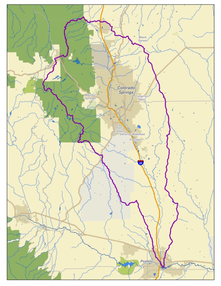
In one pond, the toxic mine water seeps down vertically 2.5 feet through sediment, where chemical reactions help break out the manganese, zinc and cadmium. Native sedge and rush grasses are starting to grow atop that sediment layer. In other ponds, water is pushed through wetlands created using stones and grasses that grow naturally in the San Juan Mountain to filter out and chemically extract toxic metals.

Once contractors figure out which method or combination works best, they say they’ll seek EPA approval and then fully install engineered wetlands, eventually removing fences and roads.

Dolores River watershed

Gilcrest: The town scores dough from @CWCB_DNR, DOLA, South Platte Roundtable

HB12-1278 study area via Colorado State University

From The Greeley Tribune (Tyler Silvy):

Peterson is just happy the town is getting help, hundreds of thousands of dollars worth from the Colorado Water Conservation Board, the Colorado Department of Local Affairs and the South Platte Basin Roundtable Groundwater Technical Committee. Some members of those organizations have come out against allowing more well pumping around Gilcrest, so it puts the town in a tricky spot.

Money from those groups has covered emergency dewatering east of U.S. 85, a dewatering study and the drilling of a dewatering well at the sewage treatment plant.

Dewatering involves pumping water out of the ground and getting it directly to the river. Workers began drilling the well at the sewage treatment plant Friday.

The plan now is to pump water out of the ground and stick it in an old, 6-inch pipeline that will take the water to the South Platte. The pipeline is probably too small, state officials agree, because it’s also used to drain stormwater and sewage effluent. So the state may provide even more money to replace the pipeline.

But the town needs more money if it’s going to address flooding in residents’ basements. A study by JVA, a civil engineering consulting firm, was released this past fall, and it showed a couple options involving adding more dewatering wells — one for $7 million and one for $11 million. Add in hundreds of thousands of dollars in operating costs for the wells each year, and Peterson said she has no idea how the town will pay for that. Gilcrest is able to salt away only $75,000-$80,000 toward capital expenditures each year.

@EPA: Bonita Peak Mining District among Superfund sites targeted for intense and immediate attention. (Hope for funding.)

On April 7, 2016, the Environmental Protection Agency proposed adding the “Bonita Peak Mining District” to the National Priorities List, making it eligible for Superfund. Forty-eight mine portals and tailings piles are “under consideration” to be included. The Gold King Mine will almost certainly be on the final list, as will the nearby American Tunnel. The Mayflower Mill #4 tailings repository, just outside Silverton, is another likely candidate, given that it appears to be leaching large quantities of metals into the Animas River. What Superfund will entail for the area beyond that, and when the actual cleanup will begin, remains unclear.
Eric Baker

Here’s the release from the Environmental Protection Agency (Andrew Mutter/Lisa McClain-Vanderpool):

EPA announces elevation of 21 sites nationwide

Today, the U.S. Environmental Protection Agency released the list of Superfund sites that Administrator Pruitt has targeted for immediate and intense attention. The 21 sites on the list – from across the United States – are in direct response to the Superfund Task Force Recommendations, issued this summer, calling for this list.

“By elevating these sites we are sending a message that EPA is, in fact, restoring its Superfund program to its rightful place at the center of the Agency’s mission,” said EPA Administrator Scott Pruitt. “Getting toxic land sites cleaned up and revitalized is of the utmost importance to the communities across the country that are affected by these sites. I have charged the Superfund Task Force staff to immediately and intently develop plans for each of these sites to ensure they are thoughtfully addressed with urgency. By getting these sites cleaned up, EPA will continue to focus on ways we can directly improve public health and the environment for people across America.”

In Colorado, the Bonita Peak Mining District (BPMD) site is on the Administrator’s Superfund list for emphasis. EPA is currently working with the State of Colorado as well as its federal partners, the U.S. Forest Service and the Bureau of Land Management, to develop a Five-Year Plan that outlines cleanup activities and remediation objectives for the site. EPA is working closely with the local government and community stakeholders to ensure the interests of the community are met.

“We are heavily invested in achieving tangible water quality improvements in the Upper Animas watershed,” said EPA Regional Administrator Doug Benevento. “EPA has a unique responsibility at this site and by placing it on this list we are recognizing that responsibility and ensuring the community that it is going to be a priority.”

While long-term planning continues, EPA is using an adaptive management approach at the site that supports early actions to improve water quality, stabilize mine features and address priority areas that pose a risk to human health. Through his hands-on engagement at the BPMD site, Administrator Pruitt will advance progress on site cleanup without expending additional taxpayer dollars.

“Today’s announcement to include the Bonita Peak Mining District site to the EPA’s Superfund “Emphasis List” is an important step forward,” said Governor John Hickenlooper. “We visited the site with EPA Administrator Pruitt in August and are encouraged by his follow through with resources and support to the agency’s cleanup efforts. This is in addition to other national priority list sites like the Colorado Smelter site in Pueblo, where important EPA cleanup actions also are underway. We look forward to working closely with the EPA, our communities and our Congressional delegation to remediate these sites.”

“Secretary Pruitt assured me when I met with him before his confirmation and when we visited the site in August that the EPA would make the right decision for the people of Southwest Colorado, and I appreciate his agency following through on their promise,” said Senator Cory Gardner. “The Gold King mine spill has had a significant impact on our state and there will continue to be a lot of work done by our elected officials and community. This latest commitment to the Bonita Peak Mining District along with continued attention to Colorado Smelter cleanup actions in Pueblo are important steps in the progress that needs to be made by the EPA at both locations.”

“We applaud the EPA’s decision to prioritize the Bonita Peak Mining District site, and we encourage them to keep working with state officials to secure funding for a local community liaison based in Silverton to improve coordination for the BPMD site among local, state, and federal governments,” said Senator Michael Bennet. “The administration and Congress should also work together to ensure all Superfund sites, including important clean-up efforts underway in Pueblo, have the resources and support they need.”

The Bonita Peak Mining District (BPMD) became a Superfund site on Sept. 9, 2016, when it was added to the National Priorities List. The site consists of historic and ongoing releases from mining operations in three drainages: Mineral Creek, Cement Creek and Upper Animas, which converge into the Animas River near Silverton, Colorado. The site includes 35 mines, seven tunnels, four tailings impoundments and two study areas where additional information is needed to evaluate environmental concerns.

In developing this initial list, EPA considered sites that can benefit from Administrator Pruitt’s direct engagement and have identifiable actions to protect human health and the environment. These are sites requiring timely resolution of specific issues to expedite cleanup and redevelopment efforts. The list is designed to spur action at sites where opportunities exist to act quickly and comprehensively. The Administrator will receive regular updates on each of these sites.

The list is intended to be dynamic. Sites will move on and off the list as appropriate. At times, there may be more or fewer sites based on where the Administrator’s attention and focus is most needed. There is no commitment of additional funding associated with a site’s inclusion on the list.

EPA remains dedicated to addressing risks at all Superfund sites, not just those on the list. The Task Force Recommendations are aimed at expediting cleanup at all Superfund sites and Administrator Pruitt has set the expectation that there will be a renewed focus on accelerating work and progress at all Superfund sites across the country.

The Task Force, whose work is ongoing, has five overarching goals:

  • Expediting cleanup and remediation;
  • Reinvigorating cleanup and reuse efforts by potentially responsible parties;
  • Encouraging private investment to facilitate cleanup and reuse;
  • Promoting redevelopment and community revitalization; and
  • Engaging with partners and stakeholders.
  • The Task Force will provide the public with regular updates as it makes progress on the Administrator’s Emphasis list and other Task Force activities.
    The list of sites can be found here: https://www.epa.gov/superfund/superfund-sites-targeted-immediate-intense-action.

    From The Durango Herald (Mary Shinn):

    Many local and national officials saw the listing as the agency fulfilling commitments it made after the EPA in June 2015 released acid mine drainage into the Animas River watershed.

    “That is exactly what was promised to us when we signed up for the National Priority List,” San Juan County Commissioner Pete McKay said of the recent announcement.

    Sens. Cory Gardner, R-Colorado, and Michael Bennet, D-Colorado, and Gov. John Hickenlooper also supported the announcement.

    While the list is expected to be dynamic, Benevento said the announcement signified a long-term commitment to the area.

    Inclusion on the list is not a commitment of additional funding, according to a news release. But it does place an obligation on the regional administrator to make sure the project manager has the resources that she needs, Benevento said.

    The EPA is working with Colorado, the U.S. Forest Service and the Bureau of Land Management to develop a five-year plan for the Bonita Peak area that outlines cleanup activities and remediation objectives, the release said.

    The site includes 35 mines, seven tunnels, four tailings impoundments and two study areas where additional information is needed to evaluate environmental concerns.

    Project Manager Rebecca Thomas expects human health and aquatic risk assessments to be finished in the spring and some cleanup work to start in the summer.

    San Juan County commissioners McCay and Scott Fetchenhier also said some sites could be cleaned up in the short-term.

    “There are a couple sites with tailings that could be cleaned up pretty quickly,” Fetchenhier said.

    McCay said understanding the flows of polluted water in the Gladstone area and how best to mitigate those is an immediate priority.

    From The Washington Post (Brady Dennis):

    The push is part of Administrator Scott Pruitt’s promise to prioritize the decades-old cleanup program, even as the Trump administration shrinks the size and reach of the EPA. The 21 sites highlighted by the agency span the country, from a former tannery site in New Hampshire to a contaminated landfill from the World War II-era Manhattan Project in St. Louis to an abandoned copper mine in Nevada…

    David Konisky, a political scientist at Indiana University’s School of Public and Environmental Affairs, questioned how EPA put together the list of sites it released Friday.

    “I do find the rationale for inclusion on the list to be strange,” Konisky, who has written extensively about the Superfund program, said in an email. “The EPA selected sites based on the ability of the Administrator to help achieve an upcoming milestone or site-specific action. This strikes me as mostly about creating a credit-claiming opportunity for Pruitt, rather than prioritizing additional resources to sites where communities face the most significant health risks.”

    There are more than 1,300 Superfund sites nationwide, some of which have lingered for years on the EPA’s “national priorities list.” While Pruitt has repeatedly spoken about his focus on the program, calling it “vital” and a “cornerstone” of the EPA’s mission, critics have noted that the Trump administration has proposed slashing the Superfund budget by 30 percent. They also worry that a single-minded focus on speeding up the process at particular sites could result in inadequate cleanups…

    “It’s happy talk,” Nancy Loeb, director of the Environmental Advocacy Center at Northwestern University’s Pritzker School of Law, told The Washington Post in the summer, noting how funding for the program has shrunk over time. “We have Superfund sites, but we don’t have a super fund.”

    Cement Creek aerial photo — Jonathan Thompson via Twitter

    Widefield aquifer: Perfluorinated compounds shut down operations at Venetucci Farm

    Widefield aquifer via the Colorado Water Institute.

    From KRDO.com (Colleen Sikora):

    A majority of the Venetucci Farm revenue came from leasing wells on the property to Security Water Sanitation District.

    But that lease has ended, because of perfluorinated compounds have contaminated the water in Security-Widefield.

    “There’s a water remediation plan that needs to come together and we’ve decided we can be part of that solution because the wells to provide drinking water for those communities,” Sam Clark with Pikes Peak Community Foundation, which owns Venetucci Farms, said. “This is essentially kind of an agreement to row together over the next couple of years working on a solution… The consequence of that is we have to make some staff changes and change some of our operations in 2018 and until the remediation plan for the water is implemented.”

    […]

    “This farm is one of the many casualties of this water contamination,” [Susan] Gordon said.

    @EPA to drop self-bonding requirements for mining clean ups

    Bonita Mine acid mine drainage. Photo via the Animas River Stakeholders Group.

    From the Associated Press (Matthew Brown) via The Durango Herald:

    President Donald Trump’s administration announced Friday that it won’t require mining companies to prove they have the financial wherewithal to clean up their pollution, despite an industry legacy of abandoned mines that have fouled waterways across the U.S.

    The move came after mining groups and Western-state Republicans pushed back against a proposal under former President Barack Obama to make companies set aside money for future cleanup costs.

    U.S. Environmental Protection Agency Administrator Scott Pruitt said modern mining practices and state and federal rules already in place adequately address the risks from mines that are still operating.

    Requiring more from mining companies was unnecessary, Pruitt said, and “would impose an undue burden on this important sector of the American economy and rural America, where most of these jobs are based.”

    The U.S. mining industry has a long history of abandoning contaminated sites and leaving taxpayers to foot the bill for cleanups. Thousands of shuttered mines leak contaminated water into rivers, streams and other waterways, including hundreds of cases in which the EPA has intervened, sometimes at huge expense.

    The EPA spent $1.1 billion on cleanup work at abandoned hard-rock mining and processing sites across the U.S. from 2010 to 2014.

    Since 1980, at least 52 mines and mine processing sites using modern techniques had spills or other releases of pollution, according to documents released by the EPA last year…

    The Obama-era rule was issued last December under court order after environmental groups sued the government to enforce a long-ignored provision in the 1980 federal Superfund law…

    The proposal applied to hard-rock mining, which includes precious metals, copper, iron, lead and other ores. Coal mines already were required to provide assurances that they’ll pay for cleanups under a 1977 federal law.

    Hard-rock mining companies would have faced a combined $7.1 billion financial obligation under the dropped rule, costing them up to $171 million annually to set aside sufficient funds to pay for future cleanups, according to an EPA analysis.

    Gilcrest: High groundwater levels affect residents

    HB12-1278 study area via Colorado State University

    From The Greeley Tribune (Tyler Silvy):

    More than three years after water began seeping into Gilcrest and surrounding residents’ basements — the result of record high groundwater levels — the problem is spreading, impacting new homes.

    Joanne Maes, a former Gilcrest town trustee, is one such resident. She doesn’t have more than a dozen sump pumps installed in her basement like a resident in 2014. She has one, and she and her husband did the work themselves, spending about $1,000 on materials.

    Maes first noticed the problem a month ago. After 12 hours of continuous shop vac use, the family installed a sump pump, which runs automatically as water seeps in. Every 20 minutes or so, a PVC pipe in the backyard of Maes’ 12th Street house gurgles out water.

    The same is true for a number of homes in Gilcrest, and Maes led the way around the quiet Weld County town Tuesday, pointing out more PVC pipes, connected to more sump pumps, dotting the front yards of more residents. An extra green patch of grass is another tell-tale sign.

    Maes and her neighbors now, as residents did in 2014, blame the fact that farmers aren’t allowed to pump groundwater to water crops. She even testified before the Colorado Water Conservation Board, along with others from the area a couple weeks ago.

    Residents here have largely given up hope anything will be done. And so, the sump pumps drone on, the water gurgles out of PVC pipes and residents hope things don’t get any worse.

    Mined-out gravel pits re-purposed as storage and urban waterscapes

    Quarries, such as this pit in Tamil Nadu, India, can be suitable storage places for city water supplies. Photo credit QuarryMagazine.com.

    From Quarry Magazine (Bill Langer):

    Water law is a serious issue in the arid to semi-arid west of the United States. Colorado and Nebraska have an agreement that Colorado will allow no less than a specified amount of water to flow along the South Platte River from Colorado to Nebraska.

    The problem is most of the flow of the South Platte comes in the spring from the melting of the snowpack. Millions of gallons of water flow into Nebraska, far exceeding the amount required under the Colorado/Nebraska compact.

    To remedy this, the Two Forks Dam was proposed to be built on the South Platte River, near Deckers, Colorado.

    However, the permit to build the dam, which would have held enough to meet the annual needs of 400,000 people, was denied.

    Now, fast-forward to the start of the 21st century. At about the time Two Forks was dying, state mining engineers decided mined-out gravel pits could be used as storage reservoirs. That decision changed the way aggregate companies and local municipalities looked at the pits. Not only could aggregate companies get the economic benefit from the gravel, but also they could turn the mined-out land into a water storage facility for the nearby communities.

    Municipalities along the South Platte scrambled to permit new gravel operations, as long as they could purchase the hole. Gravel operators were happy to oblige because frequently the holes in the ground were worth more than the gravel that came out of them.

    Some rock quarries also became suitable storage places for municipal water supplies.

    One such pit is in Tamil Nadu, India. It is one of 22 inactive quarries storing rainwater reserves that are pumped via a 2.5km pipeline to the Indian city of Chennai. Another pit, in Glen Innes, New South Wales, has been enormously successful for the local council and residents, boosting the city’s water supply.

    With the decline in the construction of new dams, this phenomenon has spread across the United States (and is also occurring in Australia).

    Pagosa Springs: Geothermal Greenhouse Partnership scores dough for two geothermal greenhouses

    Graphic via Geothermal Greenhouse Partnership.

    From the Geothermal Greenhouse Partnership via the The Pagosa Daily Post (Sally High):

    The Geothermal Greenhouse Partnership (GGP) will begin construction of two more growing dome greenhouses — the Community Garden Dome and the Innovation Dome — in spring 2018. These two domes will be installed next to the existing Education Dome in Pagosa Springs’ Centennial Park on a parcel leased from the Town of Pagosa Springs.

    The Colorado Water Plan (CWP) Engagement and Innovation Fund granted Geothermal Greenhouse Partnership $174,500 for the construction of the nonprofit organization’s second and third growing domes. The Colorado Water Conservation Board approved the CWP grant earlier in November. These funds, coupled with a $34,000 matching grant from Colorado Garden Foundation awarded last February, allow the GGP to fulfill its agreement to build three geothermal greenhouses.

    Geothermal Greenhouse Partnership is a volunteer-driven 501c3 educational organization, building a Pagosa-scale botanic park within Centennial Park on the San Juan River Walk. Its mission is “to educate the community in sustainable agricultural practices by producing food year-round using local renewable energy.” Demonstrating the value of Pagosa’s geothermal resource remains an organizational priority.

    The October 2017 Smart Growth America Report listed the GGP as an important amenity for the community. Both the Archuleta County Community Economic Development Action Plan and Downtown Colorado Inc. identified the GGP as a priority for downtown economic revitalization. With the Education Dome completed in 2016, the GGP began fulfilling its mission in 2017.

    In GGP’s first year of operations, the Education Dome and Amphitheater became busy gathering places. GGP hosted its 5th Colorado Environmental Film Festival Caravan in downtown Pagosa. Five Lifelong Learning Workshops explored various environmental issues and celebrated the biodiversity of the San Juan River Walk. Two well-attended special events included the first San Juan Sounds live concert and the 2nd Colorfest Breakfast with Balloons. Pagosa’s youth began horticultural activities and GGP’s volunteers nurtured an abundant garden for the community.

    2018 promises more classes, educational workshops and special events in Centennial Park. Children from 4-H, public and charter school classrooms, and home schools are already learning each week in the Education Dome. The 6th Environmental Film Festival is planned for mid-April. Lifelong Learning Workshops will include in-depth education about the wise use of Colorado’s water. Live music and performance are planned for the GGP Amphitheater, as well as the 3rd Colorfest Breakfast with Balloons.

    The Geothermal Greenhouse Partnership operates through a professional Board of Directors, numerous volunteers, five strategic committees and an enthusiastic membership base. GGP committees include (1) Soil, Seeds and Water; (2) Site; (3) Fundraising and Special Events; (4) Landscaping; and (5) Programming. An informational question and answer session for the community is planned for January 2018.

    Learn more at the GGP website at pagosagreen.org.

    Sally High is the Geothermal Greenhouse Partnership Board President.

    The San Juan Basin Public Health Board of Health adopts new 2018 regulations governing on-site wastewater treatment systems

    Septic system

    From The Pagosa Sun (Claire Ninde):

    On Thursday, Nov. 16, the San Juan Basin Public Health (SJBPH) Board of Health adopted new regu- lations governing on-site wastewa- ter treatment systems (OWTS) in Archuleta, La Plata and San Juan counties following a long stake- holder outreach process. These regulations will go into effect on Jan. 1, 2018.

    On June 30, new statewide regu- lations went into effect for OWTS in Colorado. These regulations required all local public health agencies in the state, including SJBPH, to revise their local OWTS regulations to meet or exceed the minimum statewide standard. SJBPH conducted outreach beginning in the fall of 2016 with wastewater industry professionals, county planning commissioners, state regulators, the real estate community and many others to write a regulation that protects public health and water quality while providing certainty to the industry and to homeowners.

    The 2018 regulations include three major changes toward these goals:

    • Direct adoption of statewide design and construction standards to reduce confusion and provide consistency with neighboring counties;

    • Allowing more design options, including smaller active treatment systems, which may reduce costs for some homeowners and allow for septic systems to be more easily installed on dif cult sites;

    • Beginning in 2019, requiring that most properties served by an OWTS be inspected prior to sale, to identify and quickly repair fail- ing or hazardous systems, and to protect buyers from unforeseen and costly repairs. This require- ment is delayed to allow more time for property owners, real estate professionals and the wastewater industry to prepare for the new requirements.

    US Supremes turn down appeal of Agua Caliente Band of Cahuilla Indians’ case

    Aqua Caliente Reservation in 1928. Photo credit Wikipedia.

    From The Palm Springs Desert Sun (Ian James):

    The U.S. Supreme Court announced Monday that it will not hear an appeal by water agencies in the Agua Caliente Band of Cahuilla Indians’ landmark lawsuit asserting rights to groundwater beneath the tribe’s reservation.

    The Desert Water Agency and the Coachella Valley Water Disitrict appealed to the Supreme Court in July, challenging a decision by the Ninth Circuit Court of Appeals, which ruled the tribe has a right to groundwater dating back to the federal government’s creation of the reservation in the 1870s.

    The high court’s denial of the agencies’ petition means that the tribe has prevailed in winning legal backing for its claim to groundwater rights, and the next phase of the case in federal court focuses on whether the tribe owns storage space within the desert aquifer in Palm Springs and surrounding areas.

    The case is likely to have far-reaching effects for Indian water rights throughout the West and across the country. By ruling that the tribe holds special federally reserved rights to groundwater, the court decisions so far in the case are expected to strengthen other tribes’ positions in negotiations or lawsuits over water disputes.

    The case is being closely watched by tribes and water suppliers across the West.

    In August, 10 states from Nevada to Texas weighed in to support the California water agencies. They said in a “friend-of-the-court” brief that every state “has an obvious stake in the preservation, maintenance and allocation of their most precious natural resource.”

    If the Supreme Court had agreed to hear the case, it would have had a rare opportunity to settle the question of whether tribes hold special federal “reserved rights” to groundwater as well as surface water, and to define more clearly the boundaries between state-administered water rights and federal water rights. Now that the Supreme Court has let the lower court’s ruling stand, it will be up to lower courts – at least for now – to decide on lingering ambiguities in the established law.

    Donald Rosier is taking over at Sterling Ranch

    Photo via the Colorado Independent

    From Sterling Ranch via The Wheat Ridge Transcript:

    A fifth-generation Coloradan has been named general manager of the Community Authority Board in Sterling Ranch, 3,400-acre mixed-use master-planned walkable community in Douglas County projected to have 12,000 residences and approximately 33,000 residents once the community is fully built out in 20 years.

    Donald Rosier, who grew up in Arvada, now serves as a Jefferson County commissioner. He was elected in 2010 and again in 2014. His term ends in 2018, but Rosier will resign as commissioner to begin his general manager post in January.

    Rosier graduated from Colorado State University with a degree in civil engineering, and he brings cross functional and cross industry experience to his new position.

    “I am both excited and humbled to have been offered this amazing opportunity. Throughout my career, I have accomplished a track record of success in managing complex design projects, acquisitions, entitlements, land development and construction projects,” Rosier said. “Accepting the position of general manager for the Sterling Ranch Community Authority Board equates to a city manager’s position in a medium-sized town with all of the oversight that goes with it, but much more forward-facing to our residents, which is the most important asset we have.”

    Rosier serves or has served on 15 boards and coalitions in a variety of capacities while a commissioner including being involved with the planning, design and ultimate completion of the Jefferson County Parkway. He is probably best known for forming and chairing the WestConnect Coalition, bringing former adversaries together for the completion of the western beltway, which has been fought over for almost 25 years.

    “Don’s ability to approach issues in a manner of respect for all parties and with professionalism while listening to the concerns and creating new strategies to solving problems was a key trait we looked for in our new general manager,” said Diane Smethills, principal of Sterling Ranch and community authority board member.

    In his position, Rosier will work with contractors, homebuilders, home buyers, residents and staff.

    Rosier’s 25 years of private sector experience includes civil engineering design, project management, acquisition, entitlement, land development, construction and management with companies such as Metropolitan Homes, Neumann Homes, Sunrise Colony Company, Alliance Commercial Partners, Davis Partnership and Mueller Engineering.

    He also oversaw the largest multi-use infill development executed on a former 2,000-acre Air Force Base in Colorado, including the design of an entirely new water system, sanitary sewer system, storm water drainage system and drainage plan.

    “Don understands the hydrology of water and land planning design to execute and will execute the communities’ rainwater-harvesting plan and maximize the efficiency of the Sterling Ranch robust water system,” said Harold Smethills, managing director of Sterling Ranch and a pioneer in the way of development utilized water. “As chairman of both the Colorado Clean Water Coalition and the Chatfield Watershed Authority, he brings with him policy experience and the respect of the water community.”

    Farmington: #GoldKingMine advisory group meeting Monday, November 27, 2017 #ColoradoRiver #COriver

    This image was taken during the peak outflow from the Gold King Mine spill at 10:57 a.m. Aug. 5. The waste-rock dump can be seen eroding on the right. Federal investigators placed blame for the blowout squarely on engineering errors made by the Environmental Protection Agency’s-contracted company in a 132-page report released Thursday [October 22, 2015]

    From The New Mexico Political Report (Laura Paskus):

    The New Mexico Gold King Mine Spill Citizens’ Advisory Committee will meet Monday evening in Farmington.

    According to the New Mexico Environment Department, the committee includes 11 citizen volunteers from northern New Mexico, including the Navajo Nation, and works with New Mexico’s Long-Term Impact Review Team to monitor and understand the long-term impacts of the 2015 Gold King Mine accident…

    Monday’s meeting will include a presentation on the area’s hydrogeology and geochemistry and provide an opportunity for public comment.

    In May, the team released a long-term monitoring plan for the Animas River.

    In addition to monitoring the impacts of the Gold King Mine spill, the work scientists are doing will help people understand how waste runoff from other mines affects surface and groundwater resources in the area. The work will also help identify how any future releases from abandoned mines might affect the Animas watershed.

    To read the plan click here. You can also find an associated, peer-reviewed study from the New Mexico Bureau of Geology and Mineral Resources here.

    Monday’s meeting will begin at 5:30 and be held in the SUNS Room at San Juan Community College in Farmington. For more information: http://www.NMEDriverwatersafety.org or http://NMENV-Outreach@state.nm.us

    The orange plume flows through the Animas across the Colorado/New Mexico state line the afternoon of Aug. 7, 2015. (Photo by Melissa May, San Juan Soil and Conservation District)

    Lincoln Park/Cotter Mill Superfund site cleanup update

    Lincoln Park/Cotter Mill superfund site via The Denver Post

    From The Canoñ City Daily Record (Sara Knuth):

    The Denver-based Colorado Legacy Land, which has been in negotiations with Cotter since July, received a conditional approval from the Colorado Department of Public Health and Environment on Nov. 8 to take over the defunct uranium mill’s radioactive materials license.

    But the company still has a few more obstacles to cross before the deal is final.

    During a Community Advisory Group meeting Thursday, Paul Newman of Colorado Legacy Land said the company is waiting for approvals from the state.

    Colorado Legacy Land, which is part of environmental cleanup companies Legacy Land Stewardship and Alexco, also is seeking to take over Cotter’s

    Schwartzwalder Mine via Division of Reclamation and MIning
    Mine near Golden. The project, included in the same transaction as the Cañon City site, still needs a mine permit transfer from the Colorado Division of Reclamation, Mining and Safety.

    “The DRMS is taking a bit more time in their evaluation and approval of that transfer,” Newman said. “Hopefully, we can get that resolved and that one transferred here shortly.”

    The company also met with the Colorado Attorney General’s Office and Environmental Protection Agency attorneys to get assigned an administrative order on consent. That process also is still pending.

    But if all goes according to plan, Newman said, Colorado Legacy Land hopes to close the deal by the middle of December. From there, the company would “come in where Cotter left off,” Newman said. “So, we have the whole clean-up process in front of us.”

    The first major step toward cleanup, he said, would be working through a remedial investigation, a deep look into how far the contamination goes.

    Cotter, which opened the Cañon City site in 1958 to process uranium for weapons and fuel, was found in the 1980s to have contaminated nearby wells. It was placed on the U.S. list of Superfund sites, putting Cotter in charge of cleanup efforts. In 2011, Cotter decided to put a halt to uranium production altogether.

    Newman, the executive vice president of Legacy Land Stewardship, said Cotter approached Alexco — a company that has been working on the Schwartzwalder Mine for four years — to step in. Colorado Legacy Land was formed by Alexco and Legacy Land Stewardship specifically to take over the cleanup process.

    If the state approves the final requirements, the company will own the land. Additionally, Newman said, Colorado Legacy Land is planning to open offices in Cañon City.

    As part of requirements outlined in the CDPHE’s conditional license approval, Colorado Legacy Land will need to inform the department of the closing date in writing.

    #Texas v. #NewMexico and #Colorado lawsuit update

    Elephant Butte Reservoir back in the day nearly full

    From the Associated Press (Susan Montoya Bryan) via The Torrington Register-Citizen:

    Farmers in southern New Mexico, water policy experts, lawyers and others are all working behind the scenes to craft possible solutions that could help to end a lengthy battle with Texas over management of the Rio Grande.

    The case is pending before the U.S. Supreme Court and all sides say the stakes are high given uncertainty about the future sustainability of water supplies throughout the Rio Grande Valley.

    The New Mexico Attorney General’s Office, Las Cruces city officials and agricultural interests provided state lawmakers with an update Tuesday.
    Lawyers involved in the case say the court could schedule arguments early next year, but New Mexico is still open to settlement talks. Separately, the farmers, municipalities and commercial users that would be affected by a ruling have been meeting regularly to build a framework for a possible settlement.

    Details of what that might look like are under wraps because of a court-issued confidentiality order.

    Samantha Barncastle, an attorney representing the irrigation district that serves farmers from Elephant Butte south to the U.S.-Mexico border, said there’s no question groundwater will continue to be relied upon into the future to protect everyone’s access.

    She said the parties are looking at managing the aquifer in ways New Mexico has never seen before. That could include more flexibility and policies aimed at avoiding the permanent fallowing of farmland…

    Texas took its case to the Supreme Court in 2013, asking that New Mexico stop pumping groundwater along the border so that more of the river could flow south to farmers and residents in El Paso.

    In dry years when there’s not enough water in the river, chile and onion farmers and pecan growers in southern New Mexico are forced to rely on wells to keep their crops and trees alive. Critics contend the well-pumping depletes the aquifer that would otherwise drain back into the river and flow to Texas.

    New Mexico has argued in court documents that it’s meeting delivery obligations to Texas.

    The Rio Grande is one of North America’s longest rivers, stretching from southern Colorado to Mexico and irrigating more than 3,100 square miles (8,000 square kilometers) of farmland along the way. Several major cities also rely on the river’s water supply.

    Depending on the outcome of the case, New Mexico could be forced to pay millions of dollars in damages. The New Mexico attorney general’s office plans to ask the Legislature for $1.5 million to handle the Rio Grande litigation for the next year.

    Tania Maestas with the attorney general’s office said the willingness of New Mexico water users to work together could lead to a “dream settlement.”

    Center: Colorado Rural Water Association presentation recap

    Center in winter via Wikimedia.com.

    From The Town of Center via The Center Post-Dispatch:

    Center trustees, town manager Brian Lujan and mayor Herman Sisneros attended the fourth in a series of several workshops presented Tuesday by water specialist Colleen Williams with the Colorado Rural Water Association.

    The presentation was part of a program that helps the town earn points for a $5,000 grant from the Colorado Department of Public Health and Environment (CDPHE) to eventually develop a water protection plan for the town. The program is funded by the U.S. Department of Agriculture.

    The town has already earned $4,230 in funding points for developing its water protection plan, Williams said.

    The Lazy KV Homeowners Association, the town of Saguache and Valley View Hot springs have already implemented plans with the program. Williams also has worked with Salida and Crestone.

    Williams now has completed the draft plan for the town to review and says the plan provides a lot of information about the water and aquifers.

    She emphasized that although potential dangers to the town’s water supply have been identified, currently there is no problem; the program simply encourages prevention. Williams noted that even in its risk assessments, the town had no “very highs.”

    She encouraged the town to develop partnerships with business and industry and to bring community members together to share information. Williams also asked board members to look over the draft and make suggestions and corrections.

    Once completed, the plan will be submitted to the Colorado Department of Health and Environment, (CDPHE). A copy of the plan also will be forwarded to Saguache County Commissioners.

    Chris Sittler with Stone’s Farm Supply told trustees concerned about fertilizer and pesticide storage in town that the Farm Service stores ammonia nitrate (not the explosive type) in a marked container on its property and the Monte Vista Co-op keeps anhydrous ammonia on its site, but this container also is marked.

    “We built this [pesticide] facility at Nine Mile so it’s clear out of town and not near to anyone,” Sittler said. Trustee Pedro Segura said town residents don’t know what is in rail cars passing through the town or whether or not they are unloading dangerous materials.

    Sittler said the information about where the materials are stored is on CDPHE’s website or can be obtained through an open records request. Williams advised trustees to access the information themselves and stay informed on water monitoring issues.

    She advised the board to “take all kinds or precautions to protect the community” and reminded them they need to cap wells in the town that are not currently sealed. The town should make a list of what to spend the grant money on and then meet again in mid-December, she concluded.

    Widefield Aquifer: USAF responds to Fountain City Council concerns

    Widefield aquifer via the Colorado Water Institute.

    From The Colorado Springs Gazette (Tom Roeder and Jakob Rodgers):

    Peterson Air Force Base bosses worked Tuesday to soothe the Fountain City Council’s frustrations over the base’s role in polluting drinking water for thousands of residents in southern El Paso County…

    “We have two objectives: One is to be as transparent as humanly possible,” Col. Eric Dorminey, vice commander of Peterson’s 21st Space Wing, told the council. “Two is to foster the partnership we have with the city of Fountain.”

    The Air Force wants the pollution cleaned up as badly as local residents do, Dorminey told the council.

    “We are committed to finding a means to mitigate these concerns,” he said.

    Fountain Mayor Gabriel Ortega said the council knows better than to shoot the messengers from Peterson.

    “While Peterson is where this potentially is coming from, they are not the ones who pull the strings,” Ortega said. “The leaders in Washington, D.C., are the ones we need to poke and prod.”

    Monday, local officials twisted arms in Washington to prod the Air Force into faster action on the issue.

    Officials from Fountain, Security and Widefield met with Air Force leaders at the Pentagon.

    Locals are frustrated that they’re left with a substantial bill to install filters or bring in other water sources to get perfluorinated compounds out of their drinking water.

    While the Air Force provided filters as part of an initial $4.3 million effort to provide clean water, the service didn’t come up with cash for buildings to house them, nor did it budget for pipelines to connect water users to other sources.

    Water districts and utilities in Security, Widefield and Fountain have paid $6 million in checks responding to the water crisis, and they expect that tap to hit $12.7 million by the end of 2018.

    The Air Force has said it won’t reimburse water districts for most of those expenses.

    U.S. Rep. Doug Lamborn, a Colorado Springs Republican who arranged the Pentagon confab, called the gathering productive…

    Lamborn said it remains unclear, though, whether the Air Force will pay up.

    The congressman said he’s frustrated by the military’s slow response to the contamination…

    The City Council meeting also comes a day after an open house held by the Colorado Department of Public Health and Environment on a proposed site-specific groundwater standard in central and southern El Paso County for the toxic chemicals.

    The standard would limit two well-known types of perfluorinated compounds in the area’s groundwater to 70 parts per trillion (ppt), or a shot glass of the chemical in 107 million gallons of water.

    It also would create the state’s first legally enforceable means to make polluters clean up contaminated areas. The likely boundaries extend across a wide swath of the county, including central and eastern Colorado Springs, Peterson Air Force Base and southern portions of Fort Carson.

    State officials plan to release their draft of the rules in December, and a hearing is slated for April 9.

    While Fountain now relies on clean water from Colorado Springs Utilities, the city could be forced to pull water from the aquifer in a drought.

    At the council meeting, leaders said they have been frustrated by the lack of communication from the Air Force. They had been asking to meet with Peterson bosses for months.

    #AnimasRiver: Lead pollution at Bonita Peak Mining District superfund site

    On April 7, 2016, the Environmental Protection Agency proposed adding the “Bonita Peak Mining District” to the National Priorities List, making it eligible for Superfund. Forty-eight mine portals and tailings piles are “under consideration” to be included. The Gold King Mine will almost certainly be on the final list, as will the nearby American Tunnel. The Mayflower Mill #4 tailings repository, just outside Silverton, is another likely candidate, given that it appears to be leaching large quantities of metals into the Animas River. What Superfund will entail for the area beyond that, and when the actual cleanup will begin, remains unclear.
    Eric Baker

    From The Denver Post (Bruce Finley):

    This lead and dozens of other contaminants are spreading beyond waste-rock piles into surrounding “halos” where they are absorbed by plants and then can be ingested by bugs and transferred from the insects to birds to, ultimately, mammals. EPA officials said tissue samples from deer will be tested to assess ecological harm.

    “You start to understand the scope of the environmental problem and how long this is going to take,” EPA Superfund project chief Rebecca Thomas said after a town hall meeting this week in Silverton. “It is pretty overwhelming.

    “We don’t really have an active mining industry in this state anymore. Yet we still see so many impacts. And we’re just looking at the Bonita Peak Mining District in the San Juan Mountains. Think how much more widespread it is across the Rocky Mountain West. It’s a big problem. It’s going to take many years to solve it — and a lot of money.”

    The lead, measured at concentrations up to 5,000 parts per million, surfaced in the latest round of sampling and study that were spurred by a federal declaration last year of a Superfund environmental disaster linked to the 2015 Gold King Mine spill that turned the Animas River mustard-yellow through three states.

    EPA Administrator Scott Pruitt has said Superfund cleanups will be the EPA’s priority, even as he and other Republicans push to trim the agency’s $8 billion budget, because Americans deserve to have environmental harm fixed as required by law.

    From The Durango Herald (Jonathan Romeo):

    A recent Denver Post article is being called misleading and inaccurate for overstating the risks to wildlife from mine contamination around a Superfund site near Silverton.

    “The statement that EPA crews found that lead is threatening birds and animals is not accurate,” Environmental Protection Agency project manager Rebecca Thomas wrote in an email Friday. “The terrestrial risk assessment is ongoing and no conclusions have been reached.”

    Around 7 p.m. Thursday, The Denver Post sent a “Breaking News Alert” for a story titled “EPA crews working on Gold King cleanup find elevated lead threatening birds, animals and, potentially, people.”

    In the story, the Post draws the conclusion based on a presentation the EPA gave Monday, in which the agency said preliminary sampling of soils around the Superfund site found levels of lead at some locations at 5,000 parts per million.

    The Post said these levels are 100 times higher than “danger thresholds for wildlife.”

    However, EPA had said this data had not been validated.

    “The statement regarding ‘danger thresholds’ for wildlife in The Denver Post story is misleading,” Thomas said. “At this point, we are looking at very conservative screening values in assessing potential risk.”

    San Juan County Commissioner Scott Fetchenheir, a former miner and geologist who is quoted in the Post article, also took issue with the story.

    “I tried to explain that to (the reporter) and he just didn’t get it,” Fetchenheir said. “He had his mind made up there’s going to be lead problems.”

    @EPA and the State of Colorado release plans to protect water quality, enable land reuse at the Eagle Mine Superfund Site

    Eagle Mine

    Here’s the release from the Environmental Protection Agency (Richard Mylott):

    Actions build upon prior cleanup efforts

    The U.S. Environmental Protection Agency (EPA) and the Colorado Department of Public Health and Environment (CDPHE) have released two final Records of Decision for environmental remediation at the Eagle Mine Superfund Site in Eagle County, Colorado, following the consideration of input received through a public comment process. Both documents, specifying measures to protect water quality and facilitate site reuse, focus on further reducing exposure to heavy metal contamination created by nearly one-hundred years of mining activity at the site.

    “These actions reflect both EPA’s and CDPHE’s commitment to efficiently evaluate conditions and protect human health and the environment at the Eagle Mine Superfund Site,” said EPA Assistant Regional Administrator Betsy Smidinger. “Together, we are strengthening the water quality improvements we have achieved in the Eagle River and providing opportunities to bring lands back into safe, productive reuse. EPA remains committed to improving environmental conditions and human health for Americans that live and work near Superfund sites.”

    The amended Record of Decision finalized for Operable Unit 1 (OU1) at the Eagle Mine Superfund Site adopts site-specific arsenic remedial goals and modifies surface water cleanup levels for cadmium, copper and zinc to meet more recent standards established for the site by the Colorado Water Quality Control Commission in 2008. Water quality monitoring in the Eagle River indicates that these standards for cadmium, copper and zinc are not attained in March and April of most years. The OU1 Record of Decision requires institutional controls to protect existing remedial features and expands the current groundwater collection system in Belden and at the mouth of Rock Creek to further reduce metals loading to the Eagle River.

    EPA and CDPHE have also finalized a separate Record of Decision for Operable Unit 3 (OU3) focused on soil remediation necessary to protect human health should future residential development occur. EPA created OU3 after a developer purchased a large portion of the Eagle Mine Superfund Site in 2004 with plans to develop the property into a private, residential community. The Record of Decision for OU3 includes a combination of the following elements for areas proposed for development: excavating soil; placing a soil exposure barrier; grading the site; placing institutional controls and conducting monitoring; and/or demolishing structures.

    The Eagle Mine Superfund Site is located in Eagle County, Colorado. The site is defined as the area impacted by past mining activity along and including the Eagle River between the towns of Red Cliff and Minturn. Mining activities at the Eagle Mine began in 1879 and continued until 1984. EPA listed the site on the National Priorities List (NPL), commonly known as the list of Superfund Sites, in 1986 because of the mine metals discharge, uncontrolled mine waste piles and the close proximity of the population to the mine and associated features. To better manage the site, EPA divided it into operable units.

    EPA and CDPHE issued a final Record of Decision for the Eagle Mine Superfund Site in 1993. Over the years, all required environmental cleanup work has occurred at the site under a number of state and federal directives. EPA declared all cleanup construction activities complete at the site in 2001. Remediation conducted to-date has resulted in significant improvement in water quality and reduction in risk to human health and the environment. Continued operation of the existing remedy, including drawdown from the mine pool and treatment at the water treatment plant, is required to maintain this condition. Contaminant concentrations in surface water and groundwater have decreased significantly, and the aquatic ecosystem continues to show signs of recovery.

    For more information about the Eagle Mine Superfund Site, please contact: Ms. Wendy Naugle, On-Site Coordinator, Colorado Department of Public Health and Environment, 4300 Cherry Creek Drive South, Denver, CO 80246, Wendy.naugle@co.state.co.us, or Ms. Jamie Miller, Project Manager, U.S. Environmental Protection Agency, 1595 Wynkoop Street, Denver, CO 80202, miller.jamie@epa.gov

    You can also visit one of the following Websites: https://www.colorado.gov/pacific/cdphe/eagle-mine, https://www.epa.gov/superfund/eagle-mine

    @EPA awards Colorado $1.3M to improve and protect Arkansas River water quality

    Lower Arkansas River near Bent

    Here’s the release from the Environmental Protection Agency (Richard Mylott):

    The U.S. Environmental Protection Agency (EPA) has awarded $1,293,010 to the Colorado Department of Public Health and Environment (CDPHE) to help protect human health and the environment through a Nonpoint Source Program Clean Water Act Section 319 cooperative agreement. This grant is given to states to implement environmental programs that address nonpoint source pollution in surface water and groundwater in order to improve and protect water quality.

    “EPA is partnering with states to protect and restore watersheds, streams and groundwater,” said EPA Administrator Scott Pruitt. “Investments like this grant allow states to support local watershed projects, improving water quality and supporting communities that depend on clean and healthy water resources.”

    Under CDPHE’s Nonpoint Source Program, a targeted basin approach is used to provide funding for projects across the state. Three projects that will address water quality in the lower half of the Arkansas River in Colorado will be funded in 2017. The projects will support the continued voluntary efforts by landowners, local stakeholders, and local governments to address excess selenium pollution in the Arkansas River. Selenium is naturally occurring, but agriculture practices often increase the natural levels in rivers to levels that can harm human health and the environment.

    “Our local partners in the Arkansas, Colorado and South Platte River basins will use these funds to plan and implement priority ​water quality improvement ​ projects​,” said​ ​Patrick Pfaltzgraff, Director of CDPHE’s Water Quality Control Division. ​ “Perhaps most importantly, the funds will allow us to continue creating and strengthening our partnerships which is so crucial for sustaining quality waters throughout our state. We value and appreciate this EPA funding.”

    EPA’s grant will also provide funds to support local watershed planning for two additional river basins and for water quality outreach and education activities. The basic goal for all the projects is to improve water quality and restore the beneficial uses of waters impacted by nonpoint source pollution. The program works through a set of overarching principles that emphasize voluntary and incentive-based participation, locally-led projects, partnerships, measurable water quality improvement, and effective and efficient program administration.

    Nonpoint source pollution encompasses a wide range of sources that are not always subject to federal or state regulation. These sources include agricultural runoff, unpermitted urban runoff, abandoned mine drainage, failing onsite disposal systems, and pollution caused by changes to natural stream channels. Congress enacted Section 319 of the Clean Water Act in 1987and established a national program to control nonpoint sources of water pollution. Through Section 319, the EPA provides states, territories, and tribes with guidance and grant funding to implement their nonpoint source programs and to support local watershed projects to improve water quality. Collectively, this work has restored over 6,000 miles of streams and over 164,000 acres of lakes since 2006. Hundreds of additional projects are underway across the country.

    You can learn more about successful nonpoint source projects at https://www.epa.gov/nps/nonpoint-source-success-stories

    For more information on the state of Colorado’s efforts to address nonpoint source pollution, visit: https://www.colorado.gov/pacific/cdphe/nonpoint-source-pollution-management

    @NSF: How much water flows into agricultural irrigation? New study provides 18-year water use record

    Here’s the release from the National Science Foundation (Cheryl Dybas/Val Ostrowski):

    Irrigation for agriculture is the largest use of fresh water around the globe, but precise records and maps of when and where water is applied by farmers are difficult to locate. Now a team of researchers has discovered how to track water used in agriculture.

    In a paper published in the journal Geophysical Research Letters, the researchers detail their use of satellite images to produce annual maps of irrigation. The findings, the scientists said, will help farmers, water resource managers and others understand agricultural irrigation choices and make better water management decisions.

    “We want to know how human activities are having an impact on the environment,” said hydrogeologist David Hyndman of Michigan State University (MSU), principal investigator of the project. “Irrigation nearly doubles crop yields and increases farmer incomes, but unsustainable water use for irrigation is resulting in depletion of groundwater aquifers around the world. The question is: ‘How can we best use water?'”

    The paper highlights the need to know when and where irrigation is occurring to effectively manage water resources.

    The project focuses on an economically important agricultural region of the central U.S.–the Republican River Basin–that overlies portions of Colorado, Nebraska and Kansas, and provides surface water and groundwater to the High Plains Aquifer. The team found that irrigation in this area roughly doubled between 2002 and 2016.

    Water use in this region can be complicated because it is regulated to preserve stream flow into Kansas in accordance with the Republican River Compact of 1942.

    “Previously, we knew what farms were equipped to irrigate, but not which fields were actually irrigated in any particular year,” said Jillian Deines, also of MSU and the paper’s lead author. “Our irrigation maps provide this information over 18 years and can be used to understand the factors that contribute to irrigation decisions.”

    The researchers used Google Earth Engine, a cloud-computing platform that makes large-scale satellite and environmental data analyses available to the public, to quantify changes in irrigation from year to year–an important finding for farmers, crop consultants and policymakers working to improve the efficiency of irrigation.

    Google Earth Engine has been an asset for computing the large number of satellite images needed, the scientists said. “It allows researchers to use consistent methods to examine large regions through time,” Deines said.

    The project, which also involves MSU research associate Anthony Kendall, is supported by the joint National Science Foundation (NSF)-USDA National Institute of Food and Agriculture (NIFA) Water, Sustainability and Climate (WSC) program and the joint NSF-NIFA Innovations at the Nexus of Food, Energy and Water Systems (INFEWS) program.

    “Knowing what to plant, how much land to plant, and how much irrigation water is necessary to support a crop through harvest has been a challenge for farmers throughout time,” said Tom Torgersen, NSF program officer for WSC and INFEWS. “Farmers can now envision a future where models will provide options to help guide decisions for greater efficiency and crop productivity.”

    Program managers at USDA-NIFA said that demand for agricultural products will likely increase in the future, while water for irrigation may decrease due to water quality issues and competitive uses.

    The Republican River Basin researchers “leveraged new computing power to handle the ‘Big Data’ of all available Landsat satellite scenes, and developed irrigation maps that help explain human decisions about irrigation water use,” said Jim Dobrowolski, program officer in NIFA’s Division of Environmental Systems. The maps hold the promise, he said, of the ability to make future water use predictions.

    A NASA graduate fellowship program award also funded the research.

    Peru Basin acid mine drainage cleanup update

    Jumbo Mine Cabin in-front of Adit September 25, 2017. Photo credit Environmental Protection Agency.

    From the Environmental Protection Agency via Summit County (Brian Lorch):

    The U.S. Environmental Protection Agency (EPA) is taking immediate action to perform mine cleanup activities at the Jumbo Mine in Summit County’s Peru Creek Basin, approximately seven miles east of Keystone Resort.

    The Jumbo Mine, which produced gold, copper, lead and silver, operated from 1915 to 1918. Historic mine operations also generated significant volumes of waste rock and tailings piles. Inactive and abandoned for a century, the mine site was identified in the early 1990s by EPA and the Colorado Department of Public Health & Environment (CDPHE), as well as in the Snake River Watershed Plan, as a significant point-source contributor of metal-contaminated flows into Peru Creek and the downstream Snake River.

    Historic hard-rock mining in the Peru Creek Basin left a legacy of contaminated and abandoned mine sites, whose acid mine drainage significantly degrades water quality. Much has been done to study the problems in the Snake River watershed, beginning in the early 1970s. Most studies have focused on the Peru Creek drainage, which is home to the Pennsylvania Mine, the largest, longest-operating mine in the watershed. In coordination with Summit County and the Colorado Division of Reclamation, Mining and Safety (DRMS), EPA completed cleanup actions at the Pennsylvania Mine in 2016.

    The Jumbo Mine is another high-priority abandoned mine site in the Peru Creek Basin identified by the Snake River Watershed Coalition as a remediation project site capable of significantly improving water quality in the Snake River watershed.

    Summit County purchased the land surrounding the abandoned Jumbo Mine in early 2016 for public open space. A restrictive covenant placed on the adjacent property containing the abandoned mine site allows for EPA’s cleanup actions to occur, but also limits the County’s liability for the existing environmental issues and associated cleanup actions.

    “We had been looking to acquire this piece of property for a long time, recognizing that it has many open space values,” said Brian Lorch, Summit County Open Space and Trails director. “But before we could take steps to purchase the property, we needed to ensure that it could be cleaned up in an economical manner.”

    EPA is implementing the cleanup work as a time-critical removal action under the Comprehensive Environmental Response, Compensation and Liability Act (CERCLA). Last week, the agency began the work, which it plans to complete in about three weeks.

    Cleanup activities involve diverting water draining from a mine adit around or over adjacent tailings piles in a limestone and membrane-lined ditch. According to EPA studies, water quality of the adit drainage degrades as it crosses the mine tailings, contributing high levels of suspended and dissolved lead, zinc and other metals into the stream. Diverting drainage around the tailings into a lined ditch should greatly improve water quality.

    “The overall approach will help reduce the discharge of metals into Peru Creek,” Lorch said. “A passive treatment approach at the Jumbo Mine site is quite similar to numerous mine cleanups performed elsewhere by the County.”

    Since 2001, Summit County has worked with EPA to identify and prioritize mine sites in need of cleanup in the Peru Creek Basin. The County’s proactive coordination with EPA facilitated recent cleanup efforts at the Pennsylvania Mine and numerous other sites in the area.

    “We are really happy and grateful to see EPA continue its mine cleanup efforts in the Peru Creek Basin,” Summit County Commissioner Karn Stiegelmeier said. “The Summit County community is very supportive of our efforts to clean up abandoned mine sites on County property, voting in 2015 for a mill levy that provides funding for cleaning up mine-impacted sites.”

    Jumbo Mine looking up at channel liner installation from lower middle section of waste rock pile. Photo credit Environmental Protection Agency.

    Sneffels Creek water quality concerns delaying Ouray County mine

    Mount Sneffels

    From The Colorado Springs Gazette (Marianne Goodland):

    Ouray Silver Mines wants to reopen a mine that produces silver, gold, lead and copper and would bring 152 jobs to Ouray County, along with, its proponents say, a 10 to 20 percent boost to the county’s tax base.

    But that mine is on hold, due to issues with water quality at a nearby creek tied to the mine that the mine owners say they have worked on for 18 months without any concerns raised by CDPHE until now.

    Sneffels Creek, the surface water source near the mine, is about halfway between Ouray and Telluride, as the crow flies. The creek has a long history with mining, going back 140 years.

    The mine dates back to 1876 and ran until its mill burned down in 1912. During its early operations, the mine produced 25 million ounces of silver.

    Sneffels Creek joins up with another creek and then into Canyon Creek downstream, and then into the Uncompahgre River. Briana Greer, an environmental consultant with Ouray Silver Mines, said when the water originating in Sneffels Creek reaches the Uncompahgre, water quality in that river improves by 50 percent. It’s better water quality than area drinking water, she told the committee.

    The idea of starting the mine back up for its silver, gold, zinc and copper began in the 1980s. The mine passed through numerous hands until 2014, when Fortune Minerals of Canada bought it hoping to mine its silver veins. But the company couldn’t sustain production and defaulted on its loans. The chief investor, Lascaux Resource Capital of New York, took over the mine and renamed it Ouray Silver Mines.

    Mine CEO Brian Briggs told the General Assembly’s interim Water Resources Review Committee Wednesday that the company has invested $70.5 million to get the mine up and running, and it will take another $36 million to get up to full production. The payoff? Fourteen million ounces of silver, which costs $7.89 per ounce to mine and can bring in about $17 per ounce on the market. The mine also has rich veins of gold, lead and zinc, and the company expects a net a profit of around $76 million, along with 152 well-paying jobs for experienced miners, according to Briggs.

    A fifth-generation Ouray native, Briggs has several decades experience in mining, called Ouray “a very, very good mine, the best I’ve every worked on for economic results.”

    Ouray County could benefit more than just how the mine will improve its tax base. Briggs explained that Ouray has no gravel pits or other sources for road base. So mine tailings and waste rock, which metallurgical tests show are “benign,” are ground up by the company and provided to the county for road base.

    Starting up an old mine has not been without its problems. According to a chart from the company, lead, zinc and cadmium discharges briefly exceeded state standards in 2014, leading to a violation notice last year from CDPHE. Lead discharges exceeded the standards again this past summer due to the failure of a lining in a mine tunnel that is being replaced.

    Then there’s the water quality issue, and that’s delaying the mine’s startup.

    The mine’s previous owner had a permit to discharge water to Sneffels Creek. The new owners set up a passive water system that could discharge either to surface or to groundwater (underground) water sources.

    Briggs explained to the committee that the passive system is not only one for today’s mining but for 50 or 60 years from now. Briggs said the system, which has been piloted in Wyoming, for example, should prevent the kinds of problems that happened at the old Gold King Mine near Durango two years ago, when contractors for the Environmental Protection Agency accidentally released more than a million gallons of toxic mine waste into the Animas River.

    In the mine’s passive system, used mining water is passed through a clay liner that contains fabric with peat moss to absorb metals and then a layer of topsoil. “It makes a tremendous impact on the three metals we’re concerned about: cadmium, lead and zinc,” Briggs said.

    The hangup has been just who’s in charge of making sure the system is in compliance at the CDPHE. Briggs said the mine had provided quarterly updates, explaining the passive system, to CDPHE’s enforcement division. In November 2016, the mine owners applied for a termination of its surface water discharge permit, believing it was no longer necessary since the passive system was discharging its water into underground water sources.

    In July, CDPHE denied the request, stating the surface water interacts with groundwater sources. “We can’t confirm” whether that’s true, Briggs said.

    That left the owners in a pickle – tear up the previous system? Install a new one? “If they want us to discharge into surface water we’ll do that,” Briggs said. But he also appeared to be frustrated that after 18 months of telling CDPHE what they were doing that the agency came back and said that system doesn’t work.

    Installing another system will take another year, Briggs said.

    The story from CDPHE is a tad different. In a September 3 letter to Sen. Don Coram, R-Montrose, CDPHE’s Karin McGowan said the mine had an active permit for a surface water discharge. “They are not waiting for a new permit, but may be frustrated because they have not been able to successfully modify their permit because they have not provided the necessary information needed to execute a modification. We are currently working with them to get the necessary information needed,” McGowan wrote.

    McGowan further added that the mine changed its manner of discharge, from surface to groundwater, without notifying the division.

    The September, 2016 notice of violation was for discharging to a new location without a permit, effluent violations, and administrative violations, McGowan pointed out. “The facility has consistently failed whole effluent toxicity testing permit requirements,” she wrote. The 2016 notice pertains to a 2014 discharge, when the mine was owned by Fortune Minerals, in which water contaminated with lead, cadmium and zinc was dumped at a rate of 400 gallons per minute into Sneffels Creek for about 18 hours.

    Briggs told the committee CDPHE has never even visited the site, despite numerous requests by the mine owners…

    In a statement, CDPHE spokesman Mark Salley told Colorado Politics that most enforcement is completed through evaluations of self-reported data. “Resource limitations makes it impossible to visit every site on an annual basis and hence permittees are put on a schedule for inspection,” he said.