2018 #COleg: Two bills come out of Water Resources Review Committee

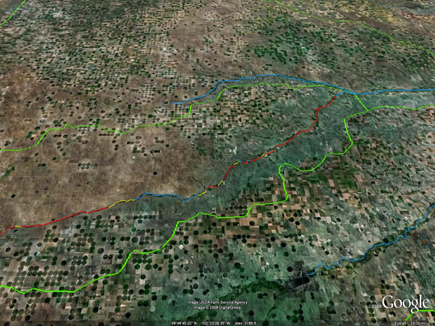
HB12-1278 study area via Colorado State University

From The Sterling Journal-Advocate (Jeff Rice):

…when Lower South Platte Water Conservancy District Manager Joe Frank reviewed them for his board of directors at the board’s October meeting, there was much shaking of heads and rolling of eyes.

The first draft document, identified only as Bill 9, would attempt to address rising water tables in a couple of places on the South Platte River, and in at least one area that would mean allowing un-augmented irrigation pumping to lower the artificially high water table.

The draft legislation was triggered by a series of reports by the Colorado Department of Natural Resources on high water tables in the town of Gilcrest, south of Greeley on U.S. 85, and the Sterling area subdivision of Pawnee Ridge…

the Colorado Legislature’s Water Resources Review Committee was not. In September the WRRC drafted a bill, tentatively labeled Bill 9, that requires owners of “artificial recharge facilities” (ie. augmentation ponds) in District 2 of Water Division 1 to install monitoring wells; if their groundwater comes up within 10 feet of the surface, they have to stop augmenting, notify the state engineer’s office, and continue pumping until the water table goes down.

Water Division 1 is simply the South Platte River watershed; District 2 is an area directly north of Denver that includes Gilcrest.

Here on the lower reaches of the river, in District 64, there are two reasons that bill could cause a whole lot of trouble.

First, and most obviously, there isn’t sufficient data yet to make such a sweeping requirement of every irrigator in District 2. Bob Mari, a member of the LSPWCD, said during the board’s meeting on Tuesday that it’s a typical one-size-fits-all solution that doesn’t need to be applied so broadly.

“You’ve got just a few sections of land where there’s a high water problem, but (legislators) want a statewide law to address the problem in that one spot,” Mari said. There was almost unanimous head nodding around the table when Mari made his remarks.

The second problem, according to Frank, is that allowing un-augmented pumping is simply not legal and would almost certainly harm downstream water users.

“Don’t get me wrong, we are very sympathetic to the problem, and we know it has to be addressed,” Frank said. “But it has been proven in the past that any pumping that goes un-replaced does cause harm. Even legislation that allows (un-augmented pumping) goes against legally binding water decrees. Taking water out (of the river aquifer) and putting it on crops without replacing it and putting it on crops is taking water that would have ended up back in the stream. Since they’re upstream from us, that creates a domino effect that affects us.”

State Sen. Jerry Sonnenberg, who chairs the WRRC, said the committee wanted to address the situation legislatively because, frankly, the $11 million solution just doesn’t make sense. He pointed out that the draft bill, which still needs some work, applies only in the district where the most severe problem exists. He said the committee believed the augmentation forgiveness shows promise, but needs some improvement.

“The idea was to try to figure out how to deal with high groundwater rather than pumping the water into the river from a dewatering well,” he said. “I don’t think it makes sense to dewater when they’re augmenting. Let’s consolidate the augmentation, move it closer to the river so we can control it better.”

Thus, the second document Frank shared with his board at that meeting, a bill draft tentatively called “Bill 10,” which directs the CWCB to engage “a qualified engineering consultant” to answer those questions and others. The bill tentatively directs that a report on the scope and goals of the study be delivered to the CWCB by Aug. 31, 2018, that a five-year pilot project be designed and begun by April 2019, and that the pilot project end by June 30, 2024.

Frank is hopeful that the study will identify ways other than un-augmented pumping, and he ticked off a list of ideas including improving surface drainage, cleaning out barrow ditches, finding new supplies for augmentation sources, tile drains in the area that move the water to the river, and moisture monitoring to avoid over-irrigating.

“Unfortunately, everyone points to that one solution, which is pumping un-augmented,” he said. “For us, that’s just not a solution.”
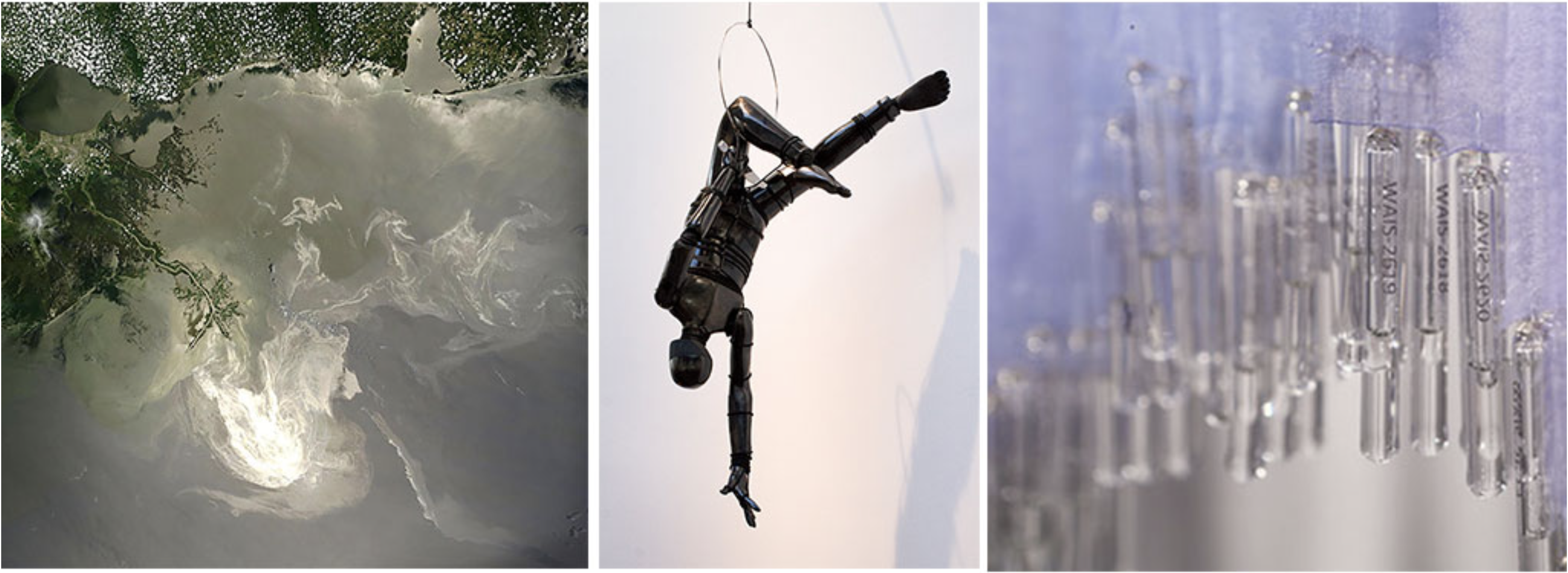
Water Line: A Creative Exchange August 4 – October 21, 2017

Images: Natascha Seideneck, Uncanny Territory, 2017; Cannupa Hanska Luger, We Have Agency VII, 2016; Anna McKee, WAIS Reliquary: 68,000 Years (detail), 2016, image by Joe Rudko.

I had the time today to tour Water Line: A Creative Exchange at the Metropolitan State University of Denver Center for Visual Art. Make some time to go see the artwork if you haven’t already. The exhibit closes next Saturday.

Colorado College professor proposes to study Widefield aquifer pollution effects

Widefield aquifer via the Colorado Water Institute.

From KOAA.com (Lena Howland):

Dr. John Adgate, the professor leading the potential study, told dozens of concerned homeowners at the meeting here on Thursday that he wants to know what the health effects are from the firefighting foam that’s said to have caused the widespread contamination across the area.

He has submitted a fast track proposal seeking the funding for this study from the National Institutes of Health back in August and says he hopes to hear back within the next few months, with the goal of starting the study next summer.

Adgate says he would be looking for a pool of 200 volunteers spread out from all three affected water districts.

Their blood would each be tested once and 50 of them would be tested again the following year.

This is to find out the levels of these compounds found in their blood and to see if these levels are going up and down over time.

He says the compounds coming from the firefighting foam haven’t been studied enough to prove certain health effects, which is why he hopes his study will lead to more definitive answers.

@SCOTUS agrees to take up #TX v. #NM and #Colorado

Map of the Rio Grande watershed, showing the Rio Chama joining the Rio Grande near Santa Fe. Graphic credit WikiMedia.

From The Courthouse News (Kevin Lessmiller):

The nation’s high court also agreed to take on Texas’ lawsuit against New Mexico and Colorado over the nearly 80-year-old Rio Grande Compact.

The Lone Star State claims New Mexico’s increasing use of water from the Elephant Butte Reservoir deprives it of water apportioned to it under the 1938 deal, which governs the distribution of Rio Grande water among Texas, New Mexico and Colorado.

Dates for oral arguments have not been set in either case, both of which are original-jurisdiction cases, meaning the lawsuits were filed directly with the Supreme Court.

High Plains Aquifer pumping is impacting surface water and native fish

High Plains Aquifer via Colorado State University.

From The Denver Post (Bruce Finley):

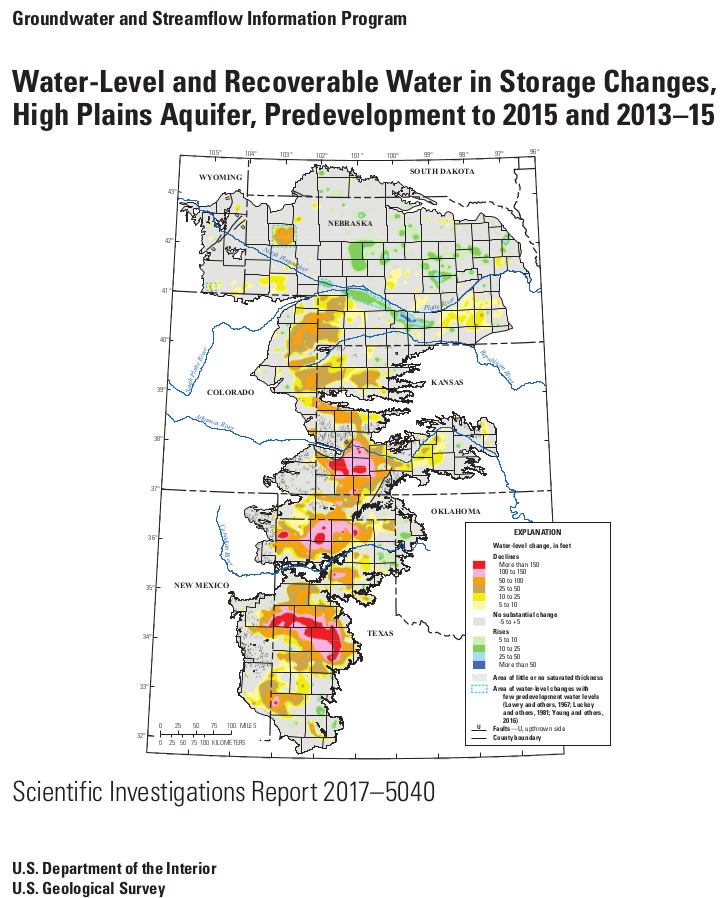
The agricultural overpumping from thousands of wells continues despite decades of warnings from researchers that the aquifer — also known as the Ogallala, the world’s largest underground body of fresh water — is shrinking.

Even if farmers radically reduced pumping, the latest research finds, the aquifer wouldn’t refill for centuries. Farmers say they cannot handle this on their own.

But there is no agreement among the eight affected states (Colorado, Kansas, Nebraska, New Mexico, Texas, Oklahoma, Wyoming, South Dakota) to try to save the aquifer. And state rules allow total depletion.

Republican River Basin by District

In fact, Colorado officials faced with legal challenges from Kansas over dwindling surface water in the Republican River have found that their best option to comply with a 1942 compact is to take more water out of the aquifer. The state bought wells from farmers during the past decade and has been pumping out 11,500 acre-feet of water a year, enough to satisfy a small city, delivering it through a $60 million, 12-mile pipeline northeast of Wray to artificially resuscitate the river.

The overpumping reflects a pattern, seen worldwide, where people with knowledge that they’re exceeding nature’s limits nevertheless cling to destructive practices that hasten an environmental backlash.

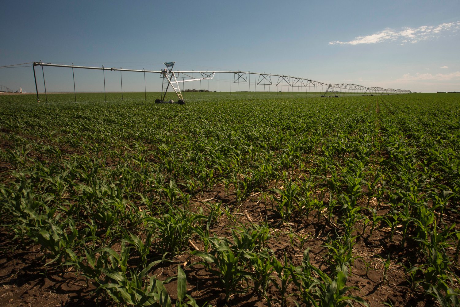
The depletion of the High Plains Aquifer has been happening for decades, according to bulletins U.S. Geological Survey has put out since 1988. Colorado farmers this year pumped groundwater out of 4,000 wells, state records show, siphoning as much as 500 gallons a minute from each well to irrigate roughly 580,000 acres — mostly to grow corn, a water-intensive crop.

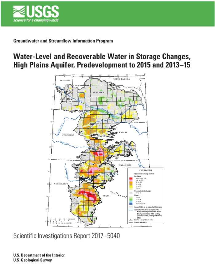
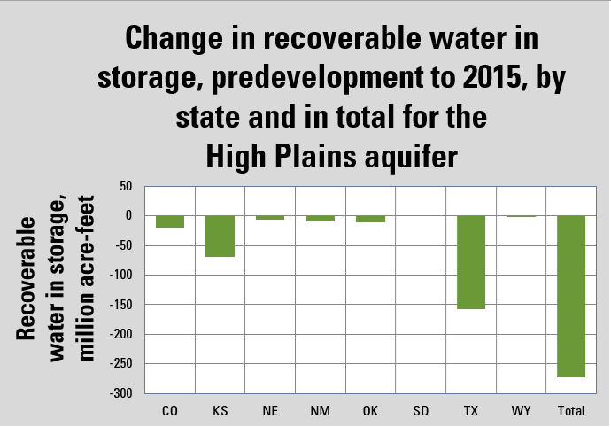
The depth where groundwater can be tapped has fallen by as much as 100 feet in eastern Colorado, USGS data show. That means pump motors must work harder to pull up the same amount of water, using more energy — raising costs for farmers. The amount of water siphoned from the aquifer since 1950 to irrigate farm fields across the eight states tops 273 million acre-feet (89 trillion gallons) — about 70 percent of the water in Lake Erie.

On one hand, the industrial center-pivot irrigation techniques perfected after World War II have brought consistency to farming by tapping the “sponge” of saturated sediment that links the aquifer to surface water in streams and rivers. America’s breadbasket produces $35 billion of crops a year. On the other hand, intense irrigation is breaking ecosystems apart.

Overpumping has dried up 358 miles of surface rivers and streams across a 200-square-mile area covering eastern Colorado, western Kansas and Nebraska, according to U.S. Fish and Wildlife-backed researchers from Colorado State University and Kansas State University who published a peer-reviewed report in the Proceedings of the National Academy of Sciences. The researchers also determined that, if farmers keep pumping water at the current pace, another 177 miles of rivers and streams will be lost before 2060…

Disappearing fish species — minnows, suckers, catfish that had evolved to endure periodic droughts — signal to biologists that ecological effects may be reaching a tipping point.

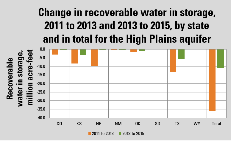
The amount of water held in the aquifer under eastern Colorado decreased by 19.6 million acre-feet — 6.4 trillion gallons — from 1950 until 2015, USGS records show. That’s an average loss of 300,000 acre-feet a year. Between 2011 and 2015, records show, the water available under Colorado in the aquifer decreased by 3.2 million acre-feet — an annual average shrinkage of 800,000 acre-feet. Climate change factors, including rainfall, play into the rate of the drawdown…

They say they’re trying. They’ve reduced the land irrigated in eastern Colorado by 30,000 acres since 2006. They plan to retire another 25,000 acres over the next decade, said Rod Lenz, president of the Republican River Water Conservation District, who for years has advocated use of technology to grow more crops with less water…

Farmer and cattleman Robert Boyd, a leader of the Arikaree Groundwater Management District, said the federal government should intervene to ensure survival of High Plains agriculture…

Kansas Aqueduct route via Circle of Blue

He pointed to proposals to divert water from the Missouri River Basin and move it westward through pipelines across the Great Plains…

But drawing down the aquifer does not violate any law in Colorado. The state engineer’s office monitors well levels and requires permits for wells, limiting the number of acres a farmer can irrigate. But there’s no hard limit on how much water can be pumped…

[Mike] Sullivan and state engineer Kevin Rein emphasized that thousands of acres no longer are irrigated. “And there need to be some more retirements of land to get us into a more balanced situation,” Sullivan said.

They defended Colorado’s practice of pumping more groundwater out of the aquifer, saying this is necessary to comply with the Republican River Compact. Disputes over river flows have risen as far as the U.S. Supreme Court and Colorado’s legal obligations to deliver water to Nebraska and Kansas are clear.

Study: Dry #groundwater wells in the western United States — @IOPscience #CA

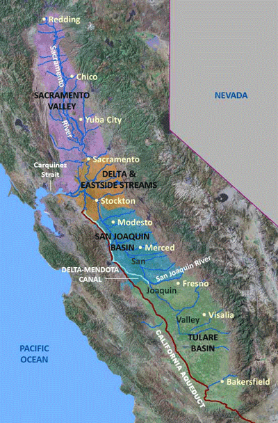
California Central Valley graphic credit USGS.

Click here to read the paper. Here’s the abstract (D Perrone1 and S Jasechko):

Declining groundwater levels are common in parts of the western US, but their impact on the ability of wells to pump groundwater is not known. Here we collate groundwater well records for the western United States and present the recorded locations, depths, and purposes of more than two million groundwater wells constructed between 1950 and 2015. We then use the well records to estimate the percentage of wells that were dry during the years 2013–2015. During the two year period, dry wells were concentrated in rural areas with high agricultural productivity, such as parts of the California Central Valley and the High Plains. Our results support anecdotal evidence that wells used for domestic purposes are more susceptible to drying than wells used for agricultural purposes throughout California’s Central Valley because the former tend to be shallower. However, this is not the case in all regions. Our findings suggest that declining groundwater levels are threatening drinking water reliability and agricultural productivity, and consequently, have key implications for both domestic and agricultural water security. Ongoing reductions to groundwater storage are drying groundwater wells in the western US, and this manifestation of water scarcity warrants innovative groundwater management transcending status quos.

#TX v. #NM and #CO update

Elephant Butte Reservoir back in the day nearly full

Here’s a report Laura Paskus writing for The NM Political Report. Click through and read the whole article. Here’s an excerpt:

In 2013, Texas sued New Mexico and Colorado in the U.S. Supreme Court, alleging that New Mexico was taking water that legally should flow to Texas under the terms of the 1938 Rio Grande Compact by allowing farmers to pump groundwater connected to the river.

Were the Supreme Court to side with Texas, it could force some southern New Mexico chile, pecan and cotton farmers to stop pumping groundwater. Or, the state could even wind up paying Texas up to $1 billion in damages. For perspective’s sake, the state’s operating budget for 2017 was $6.1 billion, and the Land Grant Permanent Fund currently has $16 billion.

But New Mexico State Engineer Tom Blaine, the state’s top water official, painted an optimistic picture for LFC last week, saying settlement discussions are moving forward.

Blaine said he and Texas’s Rio Grande Compact Commissioner, Patrick Gordon, “talk about issues that would have to be considered for settlement.”

He also told the 18 members present and LFC director David Abbey that one of the “most noteworthy accomplishments” of his office in recent years has been building relationships in and outside the state. “Previous engineers have referred to the Lower Rio Grande as ‘Compact Texas,’ meaning ‘We don’t really represent you in New Mexico,’” Blaine said of southern New Mexico farmers who irrigate below Elephant Butte dam. “I am trying to change that paradigm, trying to build a coalition where everybody south of Elephant Butte and north of Texas, you’re in New Mexico.”

Blaine said he’s made “deliberate efforts to build relationships” with the Elephant Butte Irrigation District, or EBID.

That’s the irrigation district stuck smack dab in the middle of the lawsuit.

Map of the Rio Grande watershed. Graphic credit WikiMedia.

DU Water Law Review: Ninth Circuit — Winters Rights do indeed apply to groundwater

Aqua Caliente Reservation in 1928. Photo credit Wikipedia.

Here’s an in-depth look at the decision from Gia Austin writing for the University of Denver Water Law Review. Click through and read the whole article. Here’s an excerpt:

The parties divided the litigation into three phases. With respect to Phase I, the only phase relevant for this case, the district court held that “the reserved rights doctrine applied to groundwater and that the United States reserved appurtenant groundwater when it established the Tribe’s reservation.” Subsequently, the district court certified its order for interlocutory appeal and the water agencies petitioned the Ninth Circuit Court of Appeals for permission to hear the appeal. The court, on de novo review, addressed the only issue on appeal: whether the Tribe had a federal reserved right to the groundwater underlying its reservation. In so doing, the court approached its analysis in three steps.

First, the court determined whether the United States impliedly reserved water when establishing the Agua Caliente Reservation. This question is two-pronged: (1) whether water is reserved if a reservation’s primary purpose anticipates water use; and (2) if so, whether the Agua Caliente Reservation’s primary purpose contemplated water use.

The court began its analysis by examining the Winters doctrine, and found that it established that “federal reserved water rights are directly applicable ‘to Indian reservations and other federal enclaves, encompassing water rights in navigable and nonnavigable streams.’” However, the Winters doctrine is limited to certain situations; it reserves water necessary to accomplish the purported means of the reservation and reserves water if it is appurtenant to the withdrawn land. Following that understanding, the court differentiated the parties’ and the district court’s application of the Winters doctrine that specifically addressed whether the Tribe’s reserved right extended to groundwater from the more overarching issue concerning whether the mere existence of a federal reserved right depended on the Agua Caliente Reservation maintaining an implicit right to use water.

The court then evaluated the first prong when addressing the Tribe’s implied reserved right to water. The court invoked United States v. New Mexico and reasoned, “the federal purpose for which land was reserved is the driving force behind the reserved rights doctrine.” Further, that the New Mexico Court patterned a consistent conclusion whenever the reserved water rights doctrine is raised—an insufficient water supply defeats the purposes of the reservation. Therefore, the court adopted New Mexico’s holding that water is reserved when the reservation’s primary purpose foresees water use. The court then evaluated the second prong, whether the Tribe’s primary purpose contemplated water use. To answer this question, the court synthesized the Executive Orders establishing the Agua Caliente Reservation and Supreme Court precedent to conclude that “the primary purpose underlying the establishment of the reservation was to create a home for the Tribe, and water was necessarily implicated in that purpose.” Therefore, the United States impliedly reserved water for the Tribe.

Second, the court addressed whether the Tribe’s implied reserved water right extended to the Agua Caliente Reservation’s underlying groundwater. The court reiterated the Winters doctrine requirements and determined that although the Tribe met the first requirement that the reservation’s purported means necessitated water use, the second requirement that unappropriated water must be appurtenant to the reservation remained. To find a resolution, the court reasoned that appurtenance is not limited to surface water and extrapolated from Supreme Court precedent that the United States can protect groundwater and, along that vein, impliedly reserved water may include appurtenant groundwater. Further, the court considered the Tribe’s reliance on groundwater when reasoning that the minimal surface water availability conditions the Tribe’s survival on groundwater access. From this line of reasoning, the court clarified that the Winters doctrine purported to provide sustainable livelihoods to Tribes inhabiting reservations in arid areas, like the Agua Caliente Reservation, and included access to both appurtenant surface water and groundwater. Therefore, the Tribe’s implied reserved water right included groundwater.

Third, the court addressed whether the above two holdings withstood the water agencies’ arguments that: (1) the Tribe received water pursuant to California’s correlative rights doctrine; (2) the Tribe did not need a federal reserved right to groundwater in light of its allotted surface water from the Whitewater River Decree; and (3) the Tribe never drilled for groundwater on its reservation. The court rejected each in turn. First, federal water rights, such as the implied federal reserved water right, preempt state water rights. Second, New Mexico did not inquire into the current necessity of water, it focused on whether the reservation’s inception purported such a necessity. Third, lacking historical access to groundwater on the reservation did not foreclose the Tribe’s current access to groundwater. Therefore, compounded with the federal primacy of reserved water rights, the Tribe’s implied federal water right to groundwater remained intact.

Accordingly, the court affirmed the district court holding that the United States impliedly reserved appurtenant groundwater when creating the Agua Caliente Reservation.

Genesis of an effort to recharge groundwater in the San Luis Valley

San Luis Valley Groundwater

Here’s a report from Luke Runyon writing for KUNC. Click through and read the whole article. Here’s an excerpt:

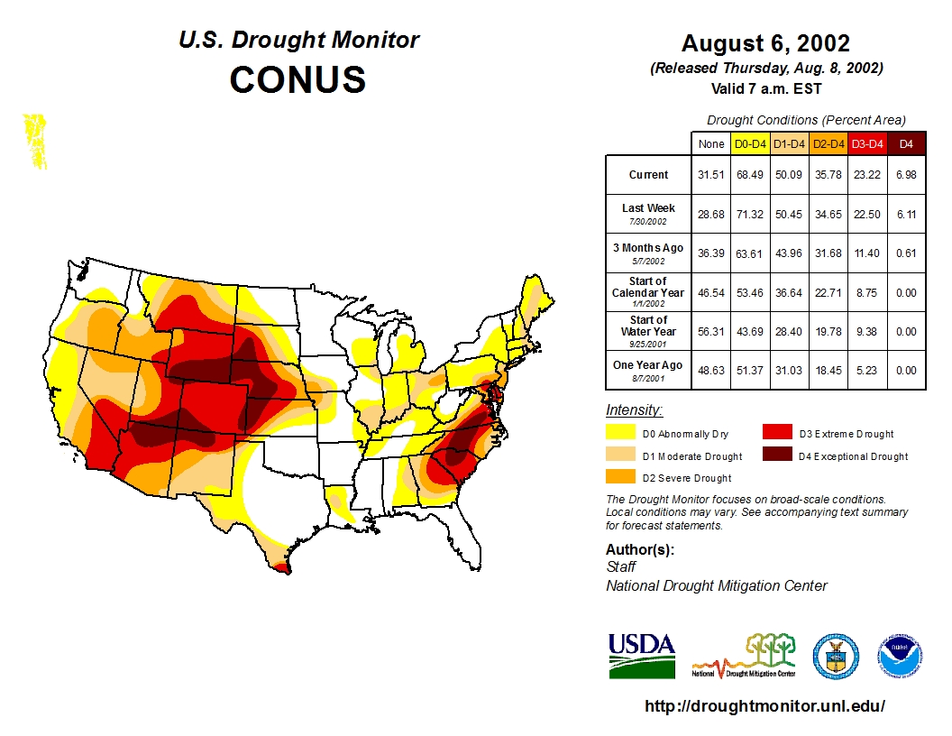
[In the drought year of 2002] streams that flow from the nearby San Juan and Sangre de Cristo Mountains slowed to a trickle, some of them before the normal irrigation season had even begun. Rushing water created by snow from the previous winter failed to materialize. That left the ditches, creeks and rivers that recharge the valley’s aquifers dry. The precious groundwater had plenty of demands, and no supply.

“The aquifer was declining,” Messick says. “But nobody really started noticing until they started sucking air instead of water.”

Farmers began to cast blame as to who caused the problem. Fingers pointed at the state, water managers, Mother Nature, and among the farmers themselves, divided into camps depending on where they got their water. All the while, many farmers kept pumping whatever water they could find and the aquifer continued its unprecedented decline.

Instead of giving in to the divisions that could have so easily fractured the rural valley of about 47,000 residents, a group of farmers decided to embark on a risky experiment — the first of its kind in the United States. They agreed to pay more money for the water they pump out of the ground by imposing fees, a kind of tax, per acre-foot of water. To get to that point, family farmers had to put aside old grudges and recognize their shared fate in the aquifer under their feet.

Seeing hope in the farmers’ efforts, researchers are studying the risky gambit to see if it is working…

US Drought Monitor August 6, 2002

Community At A Crossroads

By the end of 2002, it was clear the valley’s farmers were fast approaching a crossroads. Colorado’s top water enforcer, the state engineer, made clear that if the farmers continued to pump from the underground aquifer he would be forced to shut them down.

They were running afoul of the state’s [prior appropriation doctrine] water laws, which prioritize water rights based on their effective date. Some farmers who held rights to divert water from streams dating back to the late 1800s were seeing their supplies drop, partially thanks to water wells dug decades later in the 1950s and ‘60s. In Colorado, when a younger water right is curtailing an older one, it is a serious problem.

In the years that followed the 2002 drought, scientists did enough research and monitoring to link the reduction of the aquifer to the limited availability of surface streams.

For the farmers that depend on the aquifer, the choice was simple: keep pumping until everyone’s supplies ran out and risk the ire of state water officials; or, find a way to curb their pumping.

“It was really the first effort here in a recognition that if they didn’t do something that the consequences would be pretty grave,” says Cleave Simpson, director of the Rio Grande Water Conservation District, the valley’s main water management authority.

After years of litigation, court cases and a round of state legislation, the farmers formed a plan. A majority made a painful decision. They agreed that it was in everyone’s best interest to pay more money for water, hoping that the higher cost would cause them to think twice when turning on their pump…

Communities formed a network of subdistricts that could levy fees on water use, self-governed by the farmers themselves. Subdistrict one, the largest and most heavily irrigated in the valley, was the first.

“This is kind of a classic ‘tragedy of the commons’ situation,” says Kelsey Cody, a doctoral student at the University of Colorado-Boulder who is part of a research team that studies groundwater pumping in the valley. “As an individual, I have no incentive to leave any water in the ground because any water I leave in the ground I know my neighbor is going to take out. And he knows the same thing.”

Today, farmers in subdistrict one pay $75 for each acre-foot of water they pump and another $8 for every acre of crops where that water is used. An acre-foot is the standard unit of measurement when talking about vast amounts of water, and easy enough to visualize. It’s the amount of water spread out over an acre at a depth of one foot.

If those same farmers are recharging the aquifer by applying surface water to their crops, they’re given a credit for that added water. Some farmers who pump end up paying nothing at all if their water use finds a balance between the amounts pumped and recharged.

For some bigger farms without surface water rights, that is not the case. Their annual water use fees can total tens of thousands, sometimes hundreds of thousands, of dollars. That money is then invested in a fallowing program that pays farmers not to plant or to purchase farmland outright. While the fees have been tough for some farmers to swallow, at least a majority have internalized the goal.

Take a trip back through the Coyote Gulch archives San Luis Valley Groundwater category.

Groundwater testing perimeter around Rulison site reduced

From The Grand Junction Daily Sentinel (Dennis Webb):

The area subject to testing has been reduced from 25 square miles, encompassing a circular area extending three miles in all directions from what’s known as the Project Rulison blast site, to an oval area of just under 6.3 square miles, and ranging from 1.5 to two miles away from the site.

The revised plan also gets rid of a limit on the number of drilling rigs concurrently operating in the monitoring zone “because this has not been an administrative problem in recent years,” it says.

Project Rulison involved the explosion of a nuclear bomb more than 8,000 feet underground in the mountains south of Rulison in a federal/private experiment to try to boost natural gas production in the Williams Fork sandstone formation. The project succeeded in producing gas, but it was radioactive and was flared off as part of the experiment.

More recently, energy companies have extensively produced gas in the Williams Fork formation through the use of hydraulic fracturing to crack open the sandstone and foster gas flow.

The federal government restricts drilling deeper than 6,000 feet in a 40-acre area at the blast site. Currently there are no wells within a half-mile of Project Rulison, and any applications to drill that close would be subject to a Colorado Oil and Gas Conservation Commission hearing process.

The state also subjects companies to two levels of sampling and testing requirements for radioactivity when it comes to things such drilling cuttings, produced gas and produced water. One level has applied to wells within a mile of the blast site, and it continues to apply under the new plan.

The second level had applied to an arbitrary circular testing area having a three-mile radius, but the revised plan says it now applies to a smaller ellipse aligned with the pattern for fractures in the Williams Fork formation in the area of the blast site.

The plan also eliminates an environmental monitoring program for ground and surface water, stating that “there is no credible mechanism to transport Rulison-related activity to the surface except through natural gas production,” which the sampling plan already covers.

The plan says numerous monitoring studies conducted by federal agencies and oil and gas companies show that “no known release of radionuclides has occurred from Project Rulison,” except during natural gas flaring and production tests immediately following the blast.

The monitoring program is intended to protect workers, the public and the environment during oil and gas operations, the plan says.

Fountain Creek: @EPA and CDPHE lawsuit prep. to continue until April 2018

Fountain Creek

From The Pueblo Chieftain (Robert Boczkiewicz):

Senior U.S. District Judge Richard Matsch, who is presiding over the lawsuit, stated Thursday that pre-trial preparation will continue until April. Matsch, in a written order, said he will set a trial date after that.

In pre-trial work so far, Colorado Springs has turned over 1,275 boxes of documents to the EPA and the state environment department to examine for possible evidence. That is part of the legal process known as “discovery.”

Matsch earlier this year granted requests from the Board of Pueblo County Commissioners and the Lower Arkansas Valley Water Conservancy District to intervene in the case, on the side of the environmental agencies. Intervention allows the commissioners and the conservancy district to have a direct voice in the litigation in order to protect their interests.

The district encompasses Bent, Crowley, Otero, Prowers and Pueblo counties, where considerable produce is grown. District officials told Matsch they want to ensure the quality of the river water.

Colorado Springs has denied it is violating the laws. Mayor John Suthers has pointed to its commitment of money and manpower to improve its stormwater system.

The lawsuit seeks a court order requiring the city “to develop, implement and enforce” its storm management program, as required by permits issued by the environmental agencies.

@HighCountryNews: Judge tells BLM to redo plans for compensating for wildlife habitat that would be lost to massive groundwater project

Proposed pipeline from the Snake Valley to Las Vegas.

From The High Country News (Jodi Petersen):

In late August, a federal court ruled on a lawsuit filed by environmentalists, tribes and local governments over the BLM’s granting of a right-of-way for the 250-plus-mile pipeline. The judge said the agency had fulfilled its duties “for the most part,” but needed to provide better plans for mitigating wildlife habitat lost to pipeline construction. A separate lawsuit challenges the amount of groundwater involved; those hearings will be held later in September.

From The Las Vegas Review-Journal (Henry Brean):

Starting at 8:30 a.m. Monday, State Engineer Jason King is slated to hear two weeks of testimony for and against the controversial, multibillion-dollar project.

The hearing on 25 groundwater applications could decide how much the authority would be allowed to pump from Cave, Dry Lake and Delamar valleys in Lincoln County and Spring Valley in White Pine County.

Water authority spokesman Bronson Mack called it “a significant stage in the permitting process.”

Simeon Herskovits, attorney for some opponents of the project, put it another way: “I guess you could say everything is at stake,” he said.

Just don’t expect a ruling anytime soon.

“It will be months,” said Susan Joseph-Taylor, deputy administrator for the Nevada Division of Water Resources. “These things take a while to put together. They’re complicated.”

Study: Aurora and Castle Rock pony up $50,000 each to study the potential of designated groundwater basin storage

Colorado designated groundwater basins.

From The Aurora Sentinel (Kara Mason):

Essentially, the facility would operate like an underground reservoir, and the city says it has its benefits. Permitting an underground storage facility isn’t as expensive as an above ground reservoir and capital costs are lower, according to city water officials. There are also fewer environmental impacts, and because the storage is underground the water supply doesn’t evaporate like it would aboveground.

The big challenge of underground facilities, such as the one Aurora and Castle Rock are looking into, called the Lost Creek Underground Storage Pilot Project, is engineering, said State Engineer Kevin Rein.

In the case of Lost Creek, there is already groundwater in the area. It’s in an “almost transient state,” Rein said. That means the water would eventually make its way to a river. Keeping stored water from also escaping to a river requires careful planning.

“It takes a lot of engineering and calculation,” Rein said.

But the project is completely doable, officials said. There is one underground storage facility that benefits the metro area, Centennial Water uses a system similar to what Aurora and Castle Rock are considering. That project serves Highland Ranch. For Denver, the city recharges aquifers. Rein said the rules that apply to those sites may look similar to the rules his agency is being charged with writing for underground storage facilities.

Aurora has ventured into similar storage projects before, but those facilities are used less for storage and more as a natural filter. The three underground facilities Aurora currently operates are part of the Prairie Waters project. Each is around 50-feet deep and as large as a football field.

Aurora City Council has approved an agreement to pay $50,000 to partially fund the Lost Creek Underground Storage Pilot Project, located northeast of the city in the Lost Creek basin. Castle Rock will pay $50,000 for the study too — which will survey the area, drilling bore holes to reaffirm the area is suitable for an underground storage facility.

The first phase of the Lost Creek project will look at data gathering. If all is successful in establishing a location for the facility, phase II will encompass feasibility, according to Alex Davis, Deputy Director for Water Resources in Aurora.

The feasibility side of project would address how obtainable the land is, what other data might be needed and who to collaborate on the project with.

This year the Colorado Legislature granted $200,000 for underground storage pilot studies. The joint effort between Aurora and Castle Rock is expected to cost $150,000, with the Colorado Water Conservation Board picking up a portion of the tab.

The pilot project’s first phase is expected to start this fall and take no longer than one year to complete. Aurora is working alongside Castle Rock, as the two have partnered on other water projects. Davis said the two have proven to be successful partners on water issues in the past, making this venture a no-brainer.

The 2016 State Water Plan identified 400,000 acre feet of water that needs storage by 2050. So it’s possible that underground storage facilities may become even more popular, Rein said.

@SenBennetCO, et al., introduce Hardrock Mining and Reclamation Act of 2017

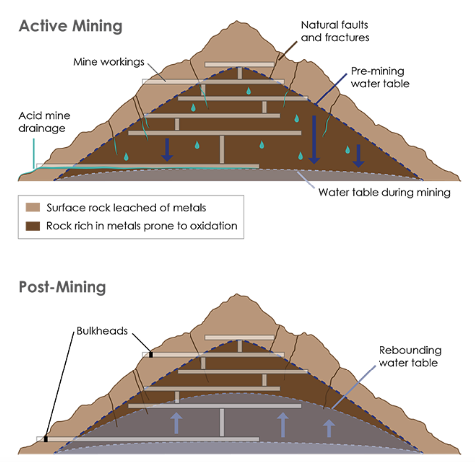
During mining (top), the water table is often lowered to access ore, exposing the rock to oxygen and creating acid mine drainage. Sealing off a mine can return the water table to pre-mining levels (bottom), creating anoxic conditions inside the mine and preventing further acidification. Credit: K. Cantner, AGI.

From The Durango Herald (Mia Rupani):

Colorado Sen. Michael Bennet, along with Sens. Tom Udall, D-N.M., Martin Heinrich, D-N.M., Ron Wyden, D-Ore., and Edward Markey, D-Mass., introduced the Hardrock Mining and Reclamation Act of 2017 on Tuesday to update the nation’s antiquated hard-rock mining laws.

The bill would reform the General Mining [Act] of 1872 that allows companies to extract minerals such as gold and silver on federal public lands without paying royalties, and while avoiding liability for any environmental damage.

The proposed legislation would help pay for abandoned mine cleanup and prevent future disasters.

Bennet referenced the 2015 Gold King Mine spill that sent an estimated 3 million gallons of heavy-metals laced mine wastewater into the Animas and San Juan rivers in a news release on Tuesday…

If passed, the legislation would make seven primary changes to the General Mining Law of 1872:

  • Require hard-rock mining companies to pay an annual rental payment for claimed public land, similar to other users.
  • Set a royalty rate for new operations of 2 to 5 percent based on the gross income of new production on federal land.
  • Create a Hardrock Minerals Reclamation Fund for abandoned mine cleanup through an abandoned mine reclamation fee of 0.6 percent to 2 percent.
  • Give the secretary of the Interior the authority to grant royalty relief to mining operations based on economic factors.
  • Require an exploration permit and mining operations permit for noncasual mining operations on federal land.
  • Permit states, political subdivisions and Indian tribes to petition the secretary of the Interior to have lands withdrawn from mining.
  • Require an expedited review of areas that may be inappropriate for mining.
  • The bill is supported by leaders throughout Southwest Colorado, including La Plata County Commissioner Julie Westendorff, Durango City Councilor Dean Brookie, San Juan County Commissioner Pete McKay and Trout Unlimited’s Ty Churchwell.

    #AnimasRiver: #GoldKingMine update

    On April 7, 2016, the Environmental Protection Agency proposed adding the “Bonita Peak Mining District” to the National Priorities List, making it eligible for Superfund. Forty-eight mine portals and tailings piles are “under consideration” to be included. The Gold King Mine will almost certainly be on the final list, as will the nearby American Tunnel. The Mayflower Mill #4 tailings repository, just outside Silverton, is another likely candidate, given that it appears to be leaching large quantities of metals into the Animas River. What Superfund will entail for the area beyond that, and when the actual cleanup will begin, remains unclear.
    Eric Baker

    From The Associated Press (Dan Elliott):

    The 12-inch (30-centimeter) valve will regulate wastewater pouring from the Gold King Mine in the San Juan Mountains of southwestern Colorado, where the EPA inadvertently triggered a wastewater spill while excavating at the mine entrance in August 2015…

    The valve will be mounted in a steel-and concrete barrier about 70 feet (20 meters) inside the mine. The barrier will have water-tight access doors so workers and equipment can get deeper into the mine for cleanup and investigation.

    The EPA is also drilling a 170-foot (50-meter) horizontal well into another part of the Gold King to drain any water building up there. That water would be routed through a temporary treatment plant below the mine where wastewater draining from the main entrance is cleaned up.

    The EPA said it can control the flow of wastewater from the new drain to avoid another blowout.

    The documents did not say say how much the work will cost and the EPA did not immediately respond to emails and a phone call Wednesday seeking comment.

    The work is expected to be completed next month.

    Peter Butler, a leader of the volunteer Animas River Stakeholders Group, which works to improve water quality in the area, said he agreed with the EPA’s decision to install the barrier and drainage well.

    “It’s probably a good idea,” he said. “They are showing an abundance of caution.”

    Wastewater has flowed from the Gold King for years, and since the 2015 blowout, it has poured out at a rate of about 500 gallons (1,900 liters) a minute.

    Mine waste flows are unpredictable In the San Juan Mountains, where underground water flows through an interconnected warren of mine tunnels and natural faults.

    Precautions such as the barrier, valve and horizontal drain will make it safer for investigators to enter the mines and try to figure out the water flows, Butler said.

    The Gold King and dozens of other mining-related sites in the region were designated a Superfund district in 2016.

    Solving the problem of the declining Ogallala aquifer: “It’s for the generation that’s not here” — Dwane Roth

    The High Plains Aquifer provides 30 percent of the water used in the nation’s irrigated agriculture. The aquifer runs under South Dakota, Wyoming, Nebraska, Colorado, Kansas, Oklahoma, New Mexico and Texas.

    From The Hutchinson News (Amy Bickel):

    Because of technology, [Dwane] Roth is working to embrace what might seem like an unfathomable concept in these parts – especially when you can’t see what is happening underground.

    Sometimes the crop isn’t thirsty.

    “It’s difficult to shut off,” Roth said. “But I called my soil moisture probe guy. He said the whole profile was full and it was only the top 2 inches that was actually dry. So there was no need to turn that irrigation engine on and pump from the Ogallala.”

    Now he is hoping to change the mindset of his peers across a landscape where corn is king and the Ogallala Aquifer – the ocean underneath the High Plains – has been keeping the decades-old farm economy going on the semi-arid Plains.

    At least it is for now.

    Underlying eight states across the Great Plains, the Ogallala provides water to about one-fifth of the wheat, corn, cotton and cattle production in the United States. It’s also a primary drinking water supply for residents throughout the High Plains.

    But the aquifer that gives life to these fields is declining. It took 6,000 years to fill the Ogallala Aquifer from glacier melt. It has taken just 70 years of irrigation to put the western Kansas landscape into a water crisis.

    An economy centered on water is drying up.

    With his own water levels declining, Roth wants to make sure there is water for the next generation, including his nephews who recently returned to the farm.

    On this hot, summer day, water seeped out of a high-tech irrigation system he is testing on his Finney County farm. Soil probes are scattered about, telling him what is happening below the surface.

    Roth also has pledged to the state to cut back his usage by 15 percent through changing farming practices and implementing new technology.

    He wants to make a difference, but, he stressed, he can’t slow the decline alone.

    For the past two years, Roth’s fields have been part of a closely watched demonstration project aimed at showing farmers how to use less irrigation water on their crops. Now he he is taking it a step further.

    With some areas in northern Finney County declining by more than 70 feet since 2005, Roth is helping spearhead a regional effort to curtail pumping through a Local Enhanced Management Area. LEMAs were implemented five years ago as a tool to extend the life of the state’s water resources.

    He’s not the only one looking toward the future. A small but growing group of irrigators are considering different tools to cutback water use. Some are implementing technology. Some are looking at LEMAs. Others are forming their own, farm-wide plans for mandatory cutbacks.

    “It’s for the kids you don’t see yet,” Roth said of why he’s doing this. “It’s for the generation that’s not here.”

    Ogallala aquifer via USGS

    A quick look at Ogallala Aquifer water rights governance

    Ogallala aquifer boundaries

    From High Plains Public Radio (Susan Stover):

    Texas manages groundwater with the Rule of Capture. The groundwater belongs to the landowner without a defined limit. It’s sometimes known as the Law of the Biggest Pump.

    Colorado and Kansas water law is based on prior appropriation, known as First in Time, First in Right. A water right owner can pump their permitted amount if it doesn’t impair a more senior right – a water right that was established earlier in time. When there isn’t enough water to meet all needs, the owners of senior water rights have priority. The priority system works well for streams. When stream flow is low, it is generally clear which upstream, junior users must be cut off to protect the more senior water rights.

    For groundwater, it is more complex to identify which water wells are impairing a more senior water well. Groundwater often provides a baseflow to streams; when heavy groundwater pumping lowers the water table so there is no longer a connection to the stream and stream flow declines, is that impairment?

    Colorado state law dealt with such concerns by defining “designated groundwater basins,” those in which groundwater contributes little to stream flow. The Ogallala aquifer lies in designated groundwater basins. This allows more groundwater to be pumped, which lowers the water table, but with less risk of impairing surface water rights.

    In Kansas, action is taken when a junior water right well’s pumping directly impairs a senior water right well, whether it uses groundwater or surface water. However, no action is taken if problems are due to regional groundwater declines. Like Colorado, Kansas allows the decline of the Ogallala aquifer to get the economic benefit from the water.

    Management of the Ogallala aquifer is a balance between protecting existing water right holders and conserving water for the future. Attitudes change over time on what is a proper balance. Much water law encouraged development of the aquifer and protects current users. Is that balance shifting more toward conserving and extending this resource further into the future?

    #CDPHE is considering limits for PFCs

    Widefield aquifer via the Colorado Water Institute.

    From The Denver Post (Bruce Finley):

    Colorado health officials grappling with groundwater contamination from firefighting foam — containing a toxic chemical the federal government allows — have proposed to set a state limit to prevent more problems.

    A Colorado Department of Public Health and Environment limit for the perfluorinated chemicals (PFCs) also could give leverage in compelling cleanup by the Air Force, which has confirmed high levels of PFCs spreading from a military air base east of Colorado Springs. More than 65,000 residents who relied on the underground Widefield Aquifer as a water source have had to find alternative supplies or install new water-cleaning systems as a plume of PFCs contamination moves south through the Fountain Valley watershed.

    “We need to be able to have not just a carrot, but a stick,” CDPHE environmental toxicologist Kristy Richardson said last week, discussing the effort to set a state limit.

    The proposed maximum allowable level of 70 parts per trillion in groundwater — matching a health advisory level the Environmental Protection Agency declared in May 2016 for two types of PFCs — wouldn’t be finalized until April, Richardson said. A boundary has yet to be drawn for where the limit would apply.

    But such regulatory action could help state officials navigate a complex environmental problem. Other states have set PFC limits as scientists raise concerns about PFCs, which have been linked to health harm, including low birth weights and kidney and testicular cancers. Few public health studies have been done, even though people south of Colorado Springs apparently have ingested PFCs for years in public drinking water.

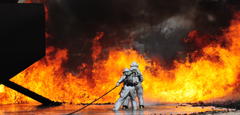
    An Air Force investigation confirmed contamination of groundwater by PFCs used in the aqueous film-forming foam that fire departments widely use to put out fuel fires, such as those caused by airplane crashes. PFCs also are found widely in consumer products, including stain-proof carpet, microwave popcorn bags and grease-resistant fast-food wrappers.

    The chemical properties that make make PFCs useful keep them from breaking down once spilled, especially in water. Scientists say people and wildlife worldwide have been exposed at low levels.

    At the Peterson Air Force Base, PFCs contamination of groundwater has been measured at levels up to 88,000 ppt with soil contamination levels as high as 240,000 ppt. And Richardson said PFC levels in groundwater south of Colorado Springs — communities including Security, Widefield, Fountain, Stratmoor Hills, Garden Valley and the Security Mobile Home Park — were measured at a median level of 120 ppt — well above the EPA health advisory limit.

    Richardson favored a broad area for the groundwater limit — “so that maybe we can begin to look at other sources. … My biggest concern is the extent” of the plume, she said.

    @USBR Launches New Basin Studies in #NewMexico and #Arizona

    Here’s the release from the US Bureau of Reclamation (Peter Soeth):

    Bureau of Reclamation Acting Commissioner Alan Mikkelsen announced that Reclamation is launching two new basin studies. The Rio Grande Basin Study in New Mexico and Eloy and Maricopa-Stanfield Basin Study in Arizona will help inform water managers within their respective basins.

    “Growing imbalances between supply and demand are impacting many basins throughout the West,” Mikkelsen said. “Through collaboration and using the latest science and data we can develop solutions that will help ensure a sustainable water supply.”

    The Rio Grande Basin Study in New Mexico is focused on the Middle Rio Grande from the Colorado-New Mexico border to Elephant Butte Reservoir. The basin has been fully allocated since 1907 and future potential conditions in the basin could result in decreased water supply and quality. Reclamation is partnering with the Middle Rio Grande Conservancy District on this study.

    The basin study will enhance existing models and data to evaluate infrastructure and operations. It will also develop strategies to improve water supply reliability and improve stakeholder collaboration and water management in an area of competing needs. Reclamation is providing $498,000 and the non-federal partners are contributing $517,000 for a total study cost of $1.12 million.

    The Eloy and Maricopa-Stanfield groundwater basins in Southern Arizona encompass most of the corridor between Phoenix and Tucson. The area receives about 340,000 acre-feet of water annually through the Central Arizona Project, which is used in conjunction with more than 435,000 acre-feet of groundwater for agricultural, municipal and industrial uses. The basins also provide aquifer storage of CAP water to increase regional supply reliability. The groundwater is being overdrafted by about 230,000 acre-feet per year and is causing severe subsidence in the basins, putting critical infrastructure at risk.

    The study will help water managers in the basins update existing models, bring together diverse stakeholders and the public, and develop adaptation strategies to better manage groundwater supplies with future uncertainties in Colorado River supplies. Reclamation and the non-federal partners will each contribute $680,000 for a total study cost of $1.36 million.

    Reclamation is partnering with the Central Arizona Project, Arizona Department of Water Resources, Pinal County, Pinal County Water Augmentation Authority, Global Water Resources, Arizona Water Company, City of Casa Grande, City of Eloy, Maricopa Stanfield Irrigation and Drainage District on this basin study.

    The Basin Study Program is part of WaterSMART. WaterSMART is the Department of the Interior’s sustainable water initiative that uses the best available science to improve water conservation and help water resource managers identify strategies to narrow the gap between supply and demand. For more information on the WaterSMART program, visit http://www.usbr.gov/WaterSMART. To learn more about the Basin Study Program or the projects announced today, please visit http://www.usbr.gov/WaterSMART/bsp.

    Albuquerque is embarking on a $6 million ASR project

    Map of the Rio Grande watershed, showing the Rio Chama joining the Rio Grande near Santa Fe. Graphic credit WikiMedia.

    From The Albuquerque Journal (Olivier Uyttebrouck):

    The Albuquerque Bernalillo County Water Utility Authority recently began drilling a pair of injection wells that will allow it to build up a water “account” that it can draw from when the Rio Grande is running at a low ebb.

    “This project is designed to address those times when we don’t have that flow in the river,” said Katherine Yuhas, the utility’s water resources manager.

    When the utility begins banking water in October 2018, the $6 million demonstration project will allow the utility each year to store up to 5,000 acre-feet, or about 1.6 billion gallons. Over a period of 20 years, that will amount to enough water to meet the demand of customers for about a year, Yuhas said.

    El Paso County inks deal with Forsgren Associates, Inc for water master plan

    From The Colorado Springs Gazette (Rachel Riley):

    Last week, county commissioners approved a roughly $272,000 contract with Englewood-based engineering firm Forsgren Associates, Inc., to develop a water master plan. The document, expected to be finished by the end of 2018, will map providers’ water sources and infrastructure, clear the way for water to be considered earlier in the county’s development review process and make forward-thinking recommendations, Dossey said.

    As the region’s population increases, so does the demand for water, a dwindling resource in the arid high desert of Colorado’s Front Range and plains. Small, rural districts can’t rely indefinitely on overdrawn aquifers. Nor can they afford massively expensive pipeline projects, such as Utilities’ $825 million Southern Delivery System, or to buy rights to water west of the Continental Divide, where most of the state’s supply is found.

    “We’re talking 50 to 100 years out that we’re going to see issues, potentially, with water supply,” Dossey said. “It’s important that the county take the lead and work with each of the providers to work on a plan for the future.”

    If water providers in the Colorado Springs vicinity don’t replace existing groundwater sources with more reliable water supplies by 2030, it could result in an annual regional shortfall of up to 25,000 acre-feet, or more than 8 billion gallons, according to Utilities’ Integrated Water Resource Plan, which was approved in February.

    “There’s a huge gap to fill if we’re going to continue to grow,” said Dave Doran, a director for the Upper Black Squirrel Creek Ground Water Management District in eastern El Paso County. “There’s just so many more straws in the ground. Inevitably, these aquifers are dropping rapidly.”

    Tens of thousands of residents rely on groundwater drawn from the depleting aquifers of the Denver Basin, according to local water officials.

    How fast water levels within the Denver Basin aquifers are falling is up for debate. Kip Petersen, general manager for the Donala Water and Sanitation District, believes the aquifers could dwindle to a point where it would no longer be cost-effective for providers to pump water from them within the next 50 years.

    “The water that we’re pulling out has been there for millions and millions of years. Once that water’s out, it’s out,” said Petersen, whose district services about 2,800 homes in the Gleneagle area. “That’s the big search right now – how do we offset a declining aquifer like the Denver basin with a renewable source?”

    Petersen’s district is one of the few in the county that’s secured renewable water sources, including water rights to a Leadville ranch and Fountain Creek, to serve about a third of its customers, he said.

    Utilities’ water resource plan, a roughly $2 million project, explores options for how the agency might help smaller providers fill a supply gap. One possibility would allow the providers to use Utilities’ delivery infrastructure during wetter years when demand falls in Colorado Springs. Another potential solution would involve Utilities selling other entities water to supplement existing resources. But with so-called “regionalization” comes a host of technical and legal challenges. The Utilities Policy Advisory Committee is researching the risks and benefits of working with smaller providers in the Pikes Peak region, said Steve Berry, a Utilities spokesman.

    #COleg: HB16-1256 South Platte Water Storage Study to debut soon

    South Platte River alluvial aquifer

    From Colorado Politics (Marianne Goodland):

    Almost 8 million acre-feet of water has left Colorado in the past 20 years that the state could have kept, according to preliminary data from a legislative-commissioned study expected later this year…

    That takes us to what happened to that 8 million acre-feet of water on the South Platte. It went to Nebraska. There’s a compact, like a contract, between Colorado and Nebraska, dating from 1923, that dictates that a certain amount of water from the South Platte goes to Nebraska, which preserves the river’s downstream environment and aquatic wildlife.

    The 8 million acre-feet exceeds what Colorado was legally required to send to Nebraska. But the problem for Colorado is that there’s no place to put that water.

    Lawmakers and water experts have been jawing about the lost water problem for years. In 2016, Rep. J. Paul Brown of Ignacio sponsored a bill to put some teeth into the conversations, by asking how much water is being lost to Nebraska and where it can be stored.

    The final answer won’t be known until the end of this year, but earlier this month, an interim water committee at the state Capitol took a first look at the data and some of the sites where storage might happen.

    It’s not an easy conversation. Building new reservoirs takes decades and often has to survive lawsuits and complicated federal and state permitting processes.. Look at the Northern Integrated Supply Project near Fort Collins, which could lead to a new reservoir and expansion of a second. The project is in its 14th year and will likely take another five or six years to get through all the permitting. In the life of a reservoir, that’s short. Compare that to the Animas-La Plata reservoir in southwestern Colorado, where construction was declared finished in 2013. The project began construction in 1968.

    While new storage is definitely possible for that South Platte water, other storage ideas are being considered in the study. According to Andy Moore, a senior water resources specialist with the Colorado Water Conservation Board, the state’s primary water agency, 147 sites were identified on first blush for water storage.

    Those sites fall into three categories: new reservoirs, rehabilitating and/or expanding existing reservoirs, or refilling underground storage. That’s water that would be pumped into aquifers, which are underground rock formations that hold water. Colorado has four major aquifers, with the three largest all along the Eastern Slope. In 2000, the South Platte aquifer, according to the Colorado Foundation for Water Education, served about 70 percent of the Front Range population.

    The site list has been pared down several times, to eliminate sites too far from the main body of the South Platte or for sites that were too small to be useful. That leaves 16 sites, mostly in northeastern Colorado. Over the next several months, those sites will be evaluated for cost, benefits and other factors.

    The first look at possible storage along the South Platte was welcomed by Chris Treese, external affairs manager for the Colorado River Water Conservancy District, the water agency in charge of the Colorado. “The Western Slope has long thought that as Coloradans we’re in the water world together, but every basin should look to own resources and capabilities first before looking for outside resources,” he said.

    Treese wasn’t surprised by the numbers. “This is what Brown and others in the South Platte have been saying – that it’s a problem with a suitable storage location.” He added that the study will identify whether storage is “one silver bullet or a lot of smaller opportunities.”

    Rep. Jeni Arndt of Fort Collins, a Democrat who chairs the House Agriculture, Livestock and Natural Resources Committee, favors refilling aquifers first and looking at other possibilities next. Arndt sponsored a bill, signed into law this year by the governor, that allows the state engineer to set up rules for the use of water that is pumped into nontributary aquifers. Those are aquifers not connected to surface water, like rivers.

    Refilling aquifers, Arndt told Colorado Politics, is environmentally friendly, with less evaporation and less permitting. It is also practical from a political standpoint, she said, meaning that there should be less opposition to refilling aquifers than to building new reservoirs.

    Refilling is “appealing, makes sense, it’s cost effective and it’s politically doable,” she said.

    Brown was pleased with the study’s first data.

    “This is the kind of information needed to make good decisions about what to do on the South Platte,” he said this week. He pointed out that the Arkansas, Rio Grande and Colorado rivers all have instream storage, and the only place without it is the South Platte.

    For years, “the low-hanging fruit has been West Slope water,” Brown explained. And while Colorado has always delivered its Colorado River water as it should under the compact, the supply is just not there anymore. “It’s not just a West Slope issue – it’s an issue for the entire state. People who know water are very interested in making sure we don’t waste any and don’t send any more water to Nebraska than what they’re entitled to.”

    NGWA Seeks Volunteers To Review Water Well Construction Standard

    Typical water well

    From PublicWorks.com:

    The National Ground Water Association is seeking volunteers to assist in reviewing and updating the ANSI/NGWA-01-14 Water Well Construction Standard, which was last approved in 2014. This process is being initiated according to the American National Standards Institute’s requirement that all standards be routinely revised, reaffirmed, or withdrawn to ensure content remains relevant.

    The Water Well Construction Standard is a performance standard encompassing municipal, residential, agricultural, monitoring, and industrial water production wells. Sections include well site selection; casing and casing installation; screens, filter pack, and formation stabilizer; grouting; plumbness and alignment; well development; testing for performance; data recording; disinfection with chlorine; water sampling and analysis; and permanent well and test-hole decommissioning.

    Volunteers will assist NGWA’s Standard Development Oversight Task Group by reviewing the entire standard using NGWA’s standard development process briefly outlined below:

  • Review each section of the standard to determine if revisions are necessary
  • Revise sections requiring further consideration
  • Publish the revised standard for public review and comment
  • Respond to and resolve all public comments
  • Vote to approve the revised standard
  • Submit the standard to ANSI for review and action once consensus has been achieved (i.e., affirmative votes from the Standard Development Oversight Task Group, all comments responded to and resolved, no outstanding negative votes with comment).
  • Throughout the process, NGWA’s Standard Development Oversight Task Group will include representation from three interest categories: contractors—those who complete the physical groundwater work, manufacturers/suppliers—those who make the equipment to install the materials to retrieve the groundwater or provide the contractors with this equipment or these materials, and other—those who have a demonstrable material interest in the standard that do not identify with the other interest categories listed. The group will be composed to achieve a balance of interests, without dominance from any specific interest category, individual, or organization.

    The group is specifically seeking those identifying with the manufacturer/supplier and other interest categories to help with this process. Membership with NGWA or any other organization is not required to participate.

    The Standard Development Oversight Task Group will meet via conference calls and an in-person meeting scheduled during NGWA’s 2017 Groundwater Week in Nashville, Tennessee.

    #Utah #GoldKingMine lawsuit lacks details

    This image was taken during the peak outflow from the Gold King Mine spill at 10:57 a.m. Aug. 5. The waste-rock dump can be seen eroding on the right. Federal investigators placed blame for the blowout squarely on engineering errors made by the Environmental Protection Agency’s-contracted company in a 132-page report released Thursday [October 22, 2015]

    From the Associated Press (Dan Elliot):

    Utah’s $1.9 billion claim against the Environmental Protection Agency for a multi-state mine waste spill says Utah’s water, soil and wildlife were damaged, but it offers no specifics.

    The Utah Attorney General’s Office provided a copy of the claim to The Associated Press Wednesday…

    Utah’s claim from the spill is believed to be the largest of 144 filed under the Federal Tort Claims Act, which allows people to seek government compensation without a lawsuit. The claims seek payment for lost crops, livestock, wages and income and other damages.

    The Navajo Nation filed a claim for $162 million and the state of New Mexico for $130 million. Both have also filed lawsuits against the federal government.

    Utah also filed suit, but it named mine owners and EPA contractors as defendants, not the government.

    The EPA said January it was prevented by law from paying any of the damages under the Tort Claims Act, angering many. EPA Administrator Scott Pruitt, who took over after President Donald Trump assumed office, has said the agency will reconsider at least some of the claims.

    Utah’s claim cites damage to the San Juan River and Lake Powell, a vast reservoir on the Colorado River which the San Juan feeds into. It also cites damage to other waterways, underground water, soil, sediment, wildlife and other, unspecified natural resources.

    It does not say how state officials arrived at the $1.9 billion figure.

    Dan Burton, a spokesman for Attorney General Sean Reyes, said the state’s lawyers came up with the number after consulting with Utah Department of Environmental Quality scientists and others.

    10 states file lawsuit to overturn 9th district appeals court decision for Agua Caliente Band of Cahuilla Indians groundwater rights under Winters Doctrine

    From The Palm Springs Desert Sun (Ian James) via USA Today:

    Ten states from Nevada to Texas have weighed in to support two water agencies in their fight with an Indian tribe over control of groundwater in the California desert.

    The states filed a brief Monday before the U.S. Supreme Court, which will soon decide whether to take up an appeal by the Desert Water Agency and the Coachella Valley Water District.

    The water agencies are challenging a decision by the Ninth Circuit Court of Appeals, which ruled the Agua Caliente Band of Cahuilla Indians has a federally established right to groundwater dating to the creation of its reservation in the 1870s.

    If the Supreme Court agrees to hear the case, it would have a rare opportunity to settle the question of whether tribes hold special federal “reserved rights” to groundwater as well as surface water, and to define more clearly the boundaries between state-administered water rights and federal water rights.

    The 10 states joined the case in a “friend-of-the-court” brief, saying every state “has an obvious stake in the preservation, maintenance and allocation of their most precious natural resource.”

    The states argued the appeals court’s ruling that the tribe has a priority right to groundwater “is literally a watershed opinion washing away the authority and control that states have traditionally exercised over groundwater resources.”

    Nevada Attorney General Adam Laxalt led the coalition of 10 states, saying the case is about defending state governments’ authority over the regulation of groundwater…

    Other states that signed on in support of the water agencies included Arizona, Arkansas, Idaho, Nebraska, North Dakota, South Dakota, Texas, Wisconsin and Wyoming. California was not among them and has not formally taken a position on the case.

    The Agua Caliente tribe sued the water agencies in 2013, seeking to assert rights to groundwater beneath its reservation in Palm Springs and surrounding areas.

    The tribe accuses the agencies of imperiling the aquifer by allowing its levels to decline over the years and by using saltier, less pure Colorado River water to replenish the aquifer. The agencies defend their efforts to combat groundwater overdraft and insist that Colorado River water meets all drinking water standards.

    Managers of the water agencies argue groundwater is a public resource and the tribe has the same rights under California law as all other landowners to use water pumped from the aquifer.

    The Supreme Court hears a small percentage of the cases that are petitioned for review, and the court is expected to announce in the fall whether it will take up the case.

    The states’ involvement in the case, and their stance that it presents an important unresolved legal issue, could increase the odds of the court hearing the case.

    If the Agua Caliente tribe prevails, the lawsuit would set a powerful precedent for other tribes across the country, strengthening their claims to groundwater.

    The U.S. Department of Justice joined the suit in support of the tribe in 2014, saying the federal government has an interest in ensuring water rights for the tribe.

    The Supreme Court has never ruled on the question of whether tribes have a federally established right to groundwater.

    Groundwater and surface water have long fallen under separate, different water-rights systems.

    The case is pushing the courts to sort out how groundwater fits into laws drawn up more than a century ago, before the widespread use of mechanical pumps that enabled people to easily tap underground water supplies.

    One of the central legal questions in the case centers on state and federal courts’ varying interpretations of a 1908 Supreme Court decision, Winters v. United States, which affirmed that Indian tribes are entitled to sufficient water supplies for their reservations.

    The Ninth Circuit Court of Appeals said the so-called Winters doctrine applies to both surface water and groundwater on federally reserved land – including Indian reservations as well as other lands set aside by the government, such as national forests, national parks and military bases.

    The states’ attorneys general pointed out in their legal brief that “as a general matter, water rights must be acquired under state law, even for federal lands.”

    They argued that if a reservation created by the federal government “can assert absolute preemption over state groundwater allocation laws and regulations, a state’s effort to effectively manage those limited water resources will be thrown out of balance.”

    In a state like Nevada – which has more of its land under federal ownership or control than any other state – the states’ attorneys said the appeals court’s ruling would have “potentially devastating consequences” if it stands. They said claims of priority federal rights would lead to over-allocation of the limited water supplies in western states.

    The attorneys said the Ninth Circuit’s decision leaves states “facing a possible tide of federal reserved water right claims,” which they argued creates great uncertainty.

    In explaining Nevada’s stance, Laxalt said he has shown throughout his tenure as attorney general that “my office stands ready to defend our state from unlawful federal overreach regardless of the source.”

    That position resonates with conservatives in other states. All of the 10 states that sided with the water agencies are led by Republican governors.

    Four organizations also submitted briefs supporting the water districts. One of them, the Pacific Legal Foundation, advocates “limited government and the strong protection of private property rights.” It said the Ninth Circuit’s decision could have harmful effects for landowners’ water rights.

    The other organizations include the National Water Resources Association, which represents water agencies; the Western Coalition of Arid States, which is comprised of municipal entities; and the Irrigation and Electrical Districts’ Association of Arizona, whose members supply water and power to much of Arizona, including cities as well as most of the state’s farmland.

    Those organizations echoed the California water agencies’ concerns, saying if it the appeals court’s decision isn’t overturned, it will threaten established water rights throughout the West, create widespread uncertainty in a region where water is scarce and “force water users to engage in unnecessary litigation.”

    The Agua Caliente tribe has until Sept. 6 to submit its argument to the court.

    If the tribe wins, the case would continue with other phases to determine whether the Agua Caliente own storage space in the aquifer, whether their rights include a water-quality component and how much groundwater they would be entitled to.

    The tribe has about 485 members. Its reservation spreads across more than 31,000 acres in a checkerboard pattern that includes parts of Palm Springs, Cathedral City, Rancho Mirage and surrounding areas.

    The tribe owns two golf courses, the Spa Resort Casino in Palm Springs and the Agua Caliente Casino Resort Spa in Rancho Mirage, and has plans to build new subdivisions and another casino. Thousands of homes stand on leased tribal land.

    The tribe buys its water from the local water agencies, which operate wells across the Coachella Valley.

    Tribal Chairman Jeff Grubbe has said the case is about securing a “seat at the table” for the tribe to have a formal say in decisions about how the aquifer is managed.

    “Having a right to govern that water and decide what to do with that water is a right that every tribe should have,” Grubbe told The Desert Sun in an interview last week. He said if the tribe wins, one of the first priorities would be to start treating the Colorado River water that flows to the Coachella Valley and is used to replenish the aquifer.

    He said the tribe’s leaders are concerned about the quality of the water and the aquifer’s long-term sustainability, and would be willing to help pay for building treatment facilities to remove dissolved solids and contaminants from the imported water.

    The agencies’ managers say the water they get from the Colorado River meets all state and federal drinking water standards. They say treating the water would be expensive and unnecessary. They worry that if the tribe prevails, its privileged rights could drive up water costs for customers and complicate efforts to manage groundwater.

    “Our groundwater has been a shared local resource that the public and the tribe can access equally,” said James Cioffi, president of the Desert Water Agency board. He said in a statement that with the tribe now trying to secure special rights, “frankly, we don’t know what exactly they want or how much that could impact our community.”

    Leaders of other Native American tribes across the West are closely watching the case.

    A list of 35 tribes and five tribal organizations filed a brief in support of the Agua Caliente tribe last year. They included the Spokane Tribe of Indians in Washington and the Pyramid Lake Paiute Tribe in Nevada, as well as other tribes in California.

    @LREwater: Advancements in ASR well construction and operations

    From Leonard Rice Engineering:

    A Three-Part Blog Series

    To paraphrase Brad Pitt, the first rule of Water Club is that “there is never enough water”. OK, maybe not everywhere, but in the Western United States, there isn’t a truer statement to be had. The states in this region constantly struggle to find balance between an ever-growing population and an ever-dwindling water supply for that population. Municipalities are continually seeking ways to maximize the usage of accessible supplies, which has spawned alternative water resource management solutions like Aquifer Storage and Recovery (ASR). ASR can be achieved through recharge basins, vadose zone wells, or dual purpose wells (Figures 1-3). One of the benefits in storing directly into aquifers is the ability to preserve supplies from evaporating, which typically occurs behind surface reservoirs. ASR is still an evolving science, and there are currently several ASR methods being utilized within the industry, each with benefits and drawbacks.

    In this three-part series, we will review ASR as a viable water resources management strategy and how new technologies are improving well efficiencies in recharge and pumping performance. These newer recharge well systems have also become manager/operator friendly, which results in efficient reporting to State Agencies, reducing the labor force, reducing operational and maintenance costs, and provide quick performance data.

    Part One: Reverse Siphon Method

    Before we dive into the different kinds of recharge methods, let’s take a look at some pitfalls that are common to all ASR wells. We start with the number one issue – clogging. Reading the term clogging and the first word you think of might be an artery, like your heart. Actually, well clogging is a lot like artery clogging and the end result is the same – the equipment stops working, which is not good in either case!

    Figure 1: Vadose zone well with down-gradient recovery well, Credit Leonard Rice Engineering.

    Well clogging typically occurs in three locations: proximal to the well, intermediate (interface between filter pack and aquifer) and distal (exceeding 100 feet beyond the well). Depending on where the well clogs, it can take different forms. Abrasion between grains, air binding, biofilm, cementation and dissolution are all types of clogs found in ASR wells, and all require slightly different solutions to resolve the issue.

    The conventional method in reducing air binding/air entrainment clogging in ASR wells is by the installation of a down-hole flow control valve. This valve is attached to the pump assembly and prevents air from the column pipe from binding onto the filter pack and unconsolidated sediments in the aquifer.

    An alternative recharge method was developed at the City of Phoenix to reduce air entrainment into the aquifer, ensure easy maintenance, lower operations and maintenance costs, provide an easy operator interface, have the ability to unclog the well with the permanent pump, and increase recharge utilization. This alternative method is called “reverse siphon”. Instead of a valve connected at the bottom of the pump assembly, the controlling valves are positioned at the wellhead infrastructure for system hydraulic balancing, removing air from the column pipe, and for easy maintenance for the operator. This method requires an understanding system hydraulics, programming, and reverse flow testing through line-shaft turbine impellors.

    Figure 2: Recharge basin with down-gradient recovery well.

    The reverse siphon method entails the following steps:

  • Pump the well to waste (e.g., sanitary sewer) to expel out particulates accumulated in the well and to remove air from the column pipe.
  • Slowly transition and open the recharge globe valve to deliver the source water to the well and pump to waste system. All purged particulates in the recharge source will go to the pump to waste line.
  • Once the programmed flow rate is achieved on the recharge line, the pump to waste valve will slowly close and the line-shaft turbine pump will shut off and lock into place with the use of a non-reverse ratchet.
  • The recharge source line will flow resources down the well (via system pressure and gravity) and to the pump to waste line.
  • Once the pump to waste line is fully closed, the well is transitioned into recharge mode. This reverse siphon method typically takes 5 to 7 minutes to transition from pump to waste to recharge mode and all valves are automated to open and close with programming developed at the Operator Interface Terminal.
  • Figure 3: Dual purpose well that can recharge and recovery supplies within the same well.

    In Part Two: we will continue examining new technologies linked to the “reverse siphon” method. These technologies/advancements build upon better and sustainable well injection performance.

    Navajo and #NM lawsuits preclude @EPA review says agency #GoldKingMine

    The orange plume flows through the Animas across the Colorado/New Mexico state line the afternoon of Aug. 7, 2015. (Photo by Melissa May, San Juan Soil and Conservation District)

    From the Associated Press (Dan Elliott) via The Durango Herald:

    In a written statement, the EPA said the law prevents it from reconsidering claims from anyone who has filed suit.

    That could rule out a review of the two largest claims from the 2015 spill in southwestern Colorado, which the EPA inadvertently triggered…

    More than 70 governments, businesses and individuals sought about $420 million in damages under the Federal Tort Claims Act, which is a way to settle without a lawsuit. The Navajos filed claims for $162 million and New Mexico for $130 million.

    New Mexico and the Navajos sued the EPA for damages in federal court…

    President Donald Trump’s appointee to head the agency, Scott Pruitt, pledged during his confirmation hearing he would review that decision. On Friday, the second anniversary of the spill, he announced a new course.

    “A new review is paramount to ensure that those who have, in fact, suffered losses have a fair opportunity to have their claims heard,” he said.

    Monday’s EPA statement appeared to narrow the scope of the review considerably.

    “EPA won’t be able to reconsider a claim once the claimant has sued the U.S. in court, which the state of New Mexico and the Navajo Nation have done,” it said.

    The EPA designated the Gold King and 47 other mining sites in the area a Superfund district and is reviewing options for a cleanup.

    On April 7, 2016, the Environmental Protection Agency proposed adding the “Bonita Peak Mining District” to the National Priorities List, making it eligible for Superfund. Forty-eight mine portals and tailings piles are “under consideration” to be included. The Gold King Mine will almost certainly be on the final list, as will the nearby American Tunnel. The Mayflower Mill #4 tailings repository, just outside Silverton, is another likely candidate, given that it appears to be leaching large quantities of metals into the Animas River. What Superfund will entail for the area beyond that, and when the actual cleanup will begin, remains unclear.
    Eric Baker

    @EPAScottPruitt tours the #GoldKingMine

    On April 7, 2016, the Environmental Protection Agency proposed adding the “Bonita Peak Mining District” to the National Priorities List, making it eligible for Superfund. Forty-eight mine portals and tailings piles are “under consideration” to be included. The Gold King Mine will almost certainly be on the final list, as will the nearby American Tunnel. The Mayflower Mill #4 tailings repository, just outside Silverton, is another likely candidate, given that it appears to be leaching large quantities of metals into the Animas River. What Superfund will entail for the area beyond that, and when the actual cleanup will begin, remains unclear.
    Eric Baker

    From The Denver Post (Jesse Paul):

    Environmental Protection Agency chief Scott Pruitt says his agency “walked away” from Colorado after the Gold King Mine spill under the Obama administration, vowing Friday to make a federal cleanup of the Gold King and other abandoned mines around Silverton a priority…

    Pruitt visited the site Friday with a delegation of Colorado’s top politicians on the eve of the two-year anniversary of the EPA-triggered disaster. He said that he planned to meet with private citizens impacted by the spill, as well as local leaders, to get first-hand information on his agency’s response.

    “I’ve already sent out a letter to all the claimants who have filed claims asking them to resubmit,” Pruitt told The Denver Post in a phone interview ahead of his visit to the Gold King. “Some of those folks I’m sure I’ll meet today, and I’m looking forward to speaking with them directly. Farmers and ranchers, business owners, the recreational activities that occur on the Animas River — all were impacted, and from my perspective it was a wrong that we need to make right.”

    Remediation will take place at the scores of sites that have leeched millions of gallons of heavy metal-laden water from the Gold King and surrounding mines, Pruitt said, despite President Donald Trump’s proposed funding cuts to the EPA’s Superfund cleanup program. Silverton’s leaders have expressed concern about the EPA’s efforts taking too long or being delayed indefinitely.

    “I can absolutely commit that this will be a priority,” Pruitt said. “I’ve shared with Congress that if money is a concern about fulfilling our responsibilities under Superfund, I will advise them.”

    Pruitt said he is working to create a list of 10 Superfund sites — of the more than 1,300 nationwide — for the EPA to focus on.

    “I don’t know yet (if the Gold King and surrounding mines will be on that list),” he said. “We are evaluating all of the sites right now. Either way, it is going to be a priority.”

    From the Associated Press via The Fort Collins Coloradoan:

    The Environmental Protection Agency will reconsider whether to pay farmers, business owners and others in three states for economic losses caused by a mine waste spill that government crews accidentally triggered in 2015, the agency’s leader said Friday during a visit to the site.

    EPA Administrator Scott Pruitt, who toured Gold King Mine with Colorado lawmakers on the eve of the disaster’s second anniversary, said he told people to resubmit claims rejected under the Obama administration. It’s not clear if the agency could pay on its own or how much of the potential payouts would need to be approved by Congress…

    The EPA has designated the area a Superfund site to pay for a broad cleanup…

    Pruitt, who had promised to visit the mine during his confirmation hearing earlier this year, said he has sent letters to people whose claims were rejected by former President Barack Obama’s EPA.

    In January, the agency said federal law prevented it from paying claims because of sovereign immunity, which prohibits most lawsuits against the government…

    It’s uncertain whether the White House and Congress, both controlled by Republicans, are willing to pay for any of the economic losses, although the GOP has been most vocal in demanding the EPA make good.

    It’s not clear how much money would be at stake in a new round of claims.

    Claims for $1.2 billion in lost income, property damage and personal injuries were initially filed with the EPA, but attorneys for some of the larger claimants later reduced the amounts they were seeking. A review by The Associated Press estimated the damages sought at $420 million.

    The EPA has spent more than $31.3 million on the spill, including remediation work, water testing and payments to state, local and tribal agencies.

    The agency said last year it would pay $4.5 million to state, local and tribal governments to cover the cost of their emergency response to the spill, but it rejected $20.4 million in other requests for past and future expenses, again citing federal law.

    From CBS Denver (Rick Sallinger):

    In an interview with CBS4’s Matt Kroeshel, [U.S. Senator Michael] Bennet said, “Having designation as Superfund site is only one step in the process. We need to make sure the resources are put into there to do the remediation that’s required at the site.”

    The environmental mess that flowed from the Gold King Mine could happen again. Its owner Hennis says an adjacent mine is filled with even more toxic liquids.

    When asked, “Could we have another disaster?” Hennis replied, “Absolutely and it would be a thousand times worse than Gold King.”

    […]

    Sen. Gardner echoed that this is not a one time only problem, “Not just Gold King, we are talking about a handful of mines around the West that pose a threat to our environment and our community.”

    Stabilizing water levels in [High Plains Aquifer] possible, survey shows — @KUnews

    Graphic via the Kansas Geological Survey.

    Here’s the release from the University of Kansas:

    For at least the next one to two decades, irrigators in western Kansas may not have to cut groundwater use nearly as drastically as once thought to stem declines in the High Plains aquifer, according to water experts at the Kansas Geological Survey based at the University of Kansas.

    Most water in western Kansas is drawn from the expansive High Plains aquifer, an underground network of water-bearing sediments whose main component is the Ogallala aquifer. Underlying portions of eight states, the High Plains aquifer is the primary source of irrigation, municipal, industrial and domestic water for western and central Kansas.

    As groundwater pumping from the aquifer increased significantly over the last 70 years, groundwater levels have fallen precipitously in some parts of the aquifer compared with pre-pumping levels. Such declines will continue unless pumping is reduced.

    The critical question is how much should pumping be reduced to make a significant impact on the decline rate. To help irrigators with that question, KGS scientists developed a method to determine how much of a reduction in water use would be needed to achieve a specific decline rate or even stabilize water levels in the aquifer.

    “We came up with a new approach for estimating the impact pumping reductions have on the rate of water-level declines,” said Jim Butler, KGS senior scientist and geohydrology section chief. “It’s tailor-made for the High Plains aquifer in Kansas, where groundwater is pumped mainly during the growing season, and exploits the great groundwater data we have in the state.”

    Scientists originally predicted groundwater use might have to be reduced 75 percent or more to maintain the aquifer in western Kansas at or near current water levels. Based on their new analyses, Butler and his colleagues assert that can be achieved with just 25 percent to 45 percent reductions in most areas. Promising results for irrigators who reduced pumping at those lower levels have already been seen in one area of northwestern Kansas.

    In mid-July, Kansas Gov. Sam Brownback asked Butler to accompany him to present the KGS findings to a group in Hoxie in Sheridan County, where local irrigators had initiated a Local Enhanced Management Area, or LEMA, to reduce usage on a voluntary basis. Water users within the LEMA’s boundaries created a plan to reduce pumping in a way that would not hinder crop production.

    Actions that can be taken to achieve reductions include shutting off irrigation pivots when it rains, growing more drought-resistant crops and growing a greater variety of crops. Technologies such as soil-moisture probes that indicate when irrigation is or isn’t needed and high-efficiency irrigation systems that lose less water to evaporation have made reduction efforts easier.

    Although members of the Sheridan County, or SD-6, LEMA were aiming to reduce pumping by 20 percent, in actuality they achieved a 35 percent reduction over four years.

    “The result is that the decline rate there has gone from about 2 feet per year to about 5 inches per year without affecting the bottom line of producers in the area,” Butler said. “That’s a big deal.”

    However, water levels, which have dropped as much as 80 feet in southwest Kansas since just 1996, will never be restored to pre-pumping levels.

    “Realistically, we are talking about reducing the rate of decline or stabilizing water levels,” Butler said. “Replenishment of the aquifer is really not in the cards.”

    Even if pumping were stopped completely, it would take hundreds of years to recharge the aquifer.

    “The hope is that the success of the SD-6 LEMA will inspire others to follow suit,” Butler said.

    The SD-6 LEMA is the only one implemented in the state so far, although LEMAs are under consideration elsewhere. On the trip to western Kansas with the governor, Butler also presented the KGS findings to an interested group of irrigators north of Garden City. KGS analysis shows that a 28 percent reduction in pumping in their area would stabilize water levels.

    Besides encompassing the Ogallala aquifer, the High Plains aquifer includes the smaller Equus Beds aquifer around Wichita and Hutchinson and Great Bend Prairie aquifer in the vicinity of Great Bend, Kinsley, Greensburg and Pratt. Because the central part of the state generally receives more annual precipitation than far-western Kansas, stable water levels appear to be attainable in the Equus Beds and Great Bend Prairie with pumping reductions of less than 10 percent.

    The KGS researchers’ new approach to estimating pumping reductions was inspired by groundwater flow patterns observed in the real-time data from several wells they monitor continuously. Results found with the approach are based on pumping data recorded by flow meters that the state of Kansas requires on all nondomestic wells as well as water-level data collected annually by the KGS and the Kansas Department of Agriculture’s Division of Water Resources (DWR) from more than 1,400 wells in western and central Kansas.

    USAF identifies sources of groundwater contamination for Widefield aquifer

    Widefield aquifer via the Colorado Water Institute.

    From The Colorado Springs Gazette (Tom Roeder and Jakob Rodgers):

    The Air Force on Tuesday acknowledged potential guilt in fouling the drinking water of thousands of its neighbors but offered no apology and said work on a federal remediation plan likely would not begin until sometime in the 2020s.

    In a first-of-its-kind admission for the service, Air Force investigators confirmed that toxic firefighting foam chemicals used at Peterson Air Force Base had leached into the surrounding groundwater. To fix the problem, Air Force officials are proceeding under a process similar to the federal Superfund program – a yearslong procedure for cleaning up complex environmental contamination. No Superfund designation, however, has been made.

    The findings were outlined in a report unveiled Tuesday that examined dozens of soil and water tests over the last year at the east Colorado Springs base.

    Over and over, investigators for the report issued the same warning: “There is the potential for a complete groundwater pathway for human receptors.”

    At a news conference later Tuesday, Air Force Col. Todd Moore gave no apology but framed the report as an attempt to be transparent about what had transpired in decades of training with the foam. He vowed to cooperate with the community in finding a solution.

    “There’s still more to learn,” Moore said.

    A final determination about what needs to be done probably won’t come until the completion of another study, which won’t begin until 2019 and still needs congressional approval for funding, said Cornell Long, of the Air Force Civil Engineering Center in San Antonio.

    Federal remediation work will push into the next decade, he added, though some help may arrive before then.

    “There could be points where you take interim measures,” he said.

    Several local elected and water officials expressed disappointment Tuesday at the prospect of a years-long wait for help…

    A Gazette investigation last fall revealed a string of Air Force studies and other military research dating to the late 1970s that warned that the chemicals – known as perfluorinated compounds – were linked to ailments in laboratory animals including cancer, liver disease and low infant birth weight, a leading cause of infant mortality.

    Tuesday’s report detailed several sites where Peterson firefighters sprayed the toxic foam directly on the ground since the 1970s.

    The contamination appeared worst in the base’s current firefighting training pit, which had a plastic liner designed to guard against leaching.

    The cause: “Overspray” from firefighters, investigators said.

    The chemicals there measured at about 88,000 parts per trillion – several thousand times the Environmental Protection Agency’s lifetime health advisory of 70 parts per trillion.

    But the report gave only passing mention to a central path for such chemicals to reach the aquifer.

    Investigators admitted pumping contaminated waste into Colorado Springs sewers, but they downplayed that as a contributor to toxic drinking water.

    “The holding tank is occasionally drained into the sanitary sewer system, but such events are rare,” the report said, adding each release totaled 10,000 to 20,000 gallons of chemical-laden wastewater.

    That admission was in stark contrast to previous statements by Peterson officials.

    Last year, base leaders acknowledged pumping foam-tainted water from the lined fire pit, storing it in a nearby tank and dumping it about three times a year into Colorado Springs sewers.

    The years-long practice likely made it easy for the chemicals to flood the nearby Widefield Aquifer.

    That’s because the chemicals are not removed while passing through the Colorado Springs Utilities’ treatment plant. From there, the plant feeds into Fountain Creek – the aquifer’s primary water source.

    The last such publicly acknowledged wastewater release from the base happened last August, and Air Force officials said Tuesday they capped the route leading to the city’s sewer system.

    Colorado Springs Utilities has no records of ever authorizing the Air Force to release the chemical-laden wastewater into its sewer system, and its leaders have told Peterson officials not to do so, said Steve Berry, a Utilities spokesman.

    Berry said it is “possible” that Utilities permitted such releases years ago, when the science surrounding these chemicals was “incomplete or unknown.”

    The releases weren’t included in Tuesday’s study, because the investigation only planned to look at on-base contamination sites, Long said. Instead, the wastewater discharges will be in the follow-up investigation slated to begin in 2019.

    The latest report also failed to mention the toxic firefighting foam’s use inside a half-dozen hangars at Peterson.

    An earlier report said investigation wasn’t required for the hangars because the toxic foam was routed into city sewers.

    Ratepayers may be on hook

    The report comes more than a year into a water crisis that sent thousands of people rushing to buy bottled water in 2016 while their water districts spent millions of dollars to rid their drinking water of the chemicals.

    Local water officials since have turned to new water sources or have installed new treatment systems to remove the toxic chemicals from the Widefield Aquifer water. But some water district leaders have criticized the Air Force’s plodding response, and millions of dollars in help pledged by the Air Force has yet to arrive in the coffers of local water districts. Ratepayers also may be on the hook for many of those fixes, because remediation costs have far outpaced military aid.

    Many residents teed off on the Air Force at a community open house accompanying the report’s release Tuesday – deriding the years-long timeline for aid.

    From The Denver Post (Bruce Finley):

    Military engineers still aren’t sure how far and wide PFC pollution has spread

    Air Force officials pledged to conduct further investigations that, sometime after 2019, may include analysis of human health risks. This initial investigation focused on contamination at the base. The spread of contaminants to where tens of thousands of people live remains a mystery, the officials said.

    Colorado Department of Public Health and Environment leaders have said the state was waiting on the Air Force for information on how far and how fast PFCs have moved. El Paso County and CDPHE officials at a public meeting here Tuesday night said their agencies lack money to track the PFCs moving in groundwater at unknown concentrations south toward Pueblo…

    Security Water and Sanitation District manager Roy Heald said his agency spent $3.6 million on pipelines and purchases of alternative clean water supplies after municipal wells were contaminated but has yet to receive a promised $800,000 in reimbursements from the Air Force…

    Air Force engineers found PFC contamination of groundwater at the Peterson base east of Colorado Springs reached levels up to 88,000 parts per trillion, and that soil contamination reached as high as 240,000 ppt, based on testing of 23 water samples and 33 soil samples at seven sites on the base. They confirmed that the use of aqueous film-forming foam, or AFFF, which helps put out fuel fires, led to runoff of the PFCs into water tapped by tens of thousands of residents south of Colorado Springs but said they do not know to what extent it has spread or how long it will last.

    The Air Force investigation report — more than 600 pages — also blamed other unspecified sources of PFC contamination, reiterating the stance military officials have taken in the year since news organizations revealed that PFCs had contaminated municipal drinking water supplies.

    “PFCs are found widely in the environment today, and there are likely other contributors to the contamination,” the report summary says. “As we continue our work with the public water suppliers in the Fountain, Widefield and Security area, we will study remediation steps, as other potential contributors are investigated.”

    […]

    Air Force engineers in October began investigating to determine sources of the PFCs that state and local water tests had shown to be spreading from the base, including an area where firefighters trained. PFCs have been linked to health harm — low birth weights and kidney and testicular cancers — but public health epidemiological work in Colorado has not been done. A senior Pentagon official announced that the Air Force would spend $2 billion on PFC cleanups nationwide.

    From KRDO.com (Colleen Sikora):

    Some water samples collected for the study were more than 200 times the EPA’s standard of 70 parts per trillion.

    The base said it has taken steps to replace the foam with a synthetic foam and are working to top the spread of PFCs to other areas.

    “Making sure that the community is aware that within the bounds that we’ve been able to eliminate this contaminate, we’ve taken that action and then likewise as we learn more and move forward with that,” 21st Space Wing Commander Col. Todd R. Moore said.

    From the Associated Press via US News & World Report:

    Base leaders have previously acknowledged dumping wastewater contaminated with foam into Colorado Springs’ sewers three times a year, which likely made it easy for the chemicals to flow into the nearby Widefield Aquifer, a key source of water for the city of Fountain.

    But while the report acknowledged the releases, it downplayed that as a contributor to toxic drinking water.

    In May, state health officials said they had yet to find any other possible source of the contamination of the aquifer other than the foam, which airmen have used for firefighting training since the 1970s.

    On Tuesday, Air Force officials met privately with local officials, including key staffers of Colorado’s congressional delegation, El Paso County commissioners, city staffers, state and county environmental agency officials and representatives of Pikes Peak region water districts.

    Fountain Mayor Gabriel Ortega said he left the meeting frustrated that the investigation was not more all-encompassing…

    The mayor added that Air Force officials did not say when they would send the $4.3 million in aid promised last year, or if they would more fully reimburse communities burdened with treating the tainted water.

    A Gazette investigation last fall revealed a string of Air Force studies and other military research dating to the late 1970s warning of the foam’s danger. The chemicals have been linked to ailments including cancer, liver disease and low infant birth weight.

    Tuesday’s report comes more than a year into a water crisis that sent residents rushing to buy bottled water in 2016 while their water districts spent millions of dollars to rid their drinking water of the chemicals, known as perfluorinated compounds.

    Local water officials have since turned to new water sources or installed new treatment systems to remove the toxic chemicals from the Widefield Aquifer water.

    Photo via USAF Air Combat Command

    @ColoradoStateU: Groundwater pumping drying up Great Plains streams, driving fish extinctions

    A Google Earth image of the crop circles in the lower Arikaree River watershed, highlighting the river reaches that were dry (red), disconnected pools (yellow), and flowing (blue) at the lowest water in late summer 2007. Only one segment of 9 miles of flowing river remained as habitat for fish. The river flows from left to right. Image created by Jeff Falke, University of Alaska Fairbanks.

    Here’s the release from Colorado State University:

    Farmers in the Great Plains of Nebraska, Colorado, Kansas and the panhandle of Texas produce about one-sixth of the world’s grain, and water for these crops comes from the High Plains Aquifer — often known as the Ogallala Aquifer — the single greatest source of groundwater in North America. A team of researchers, including Colorado State University Professor Kurt Fausch and Jeff Falke, a CSU alumnus and an assistant professor at the University of Alaska Fairbanks, have discovered that more than half a century of groundwater pumping from the aquifer has led to long segments of rivers drying up and the collapse of large-stream fishes.

    If pumping practices are not modified, scientists warn that these habitats will continue to shrink, and the fish populations along with them.

    The research team combined modeling from the past and future to assess changes in Great Plains streams and their fish populations associated with groundwater pumping from the High Plains Aquifer. The findings have implications for watersheds around the world, because irrigation accounts for 90 percent of human water use globally, and local and regional aquifers are drying up.

    A ‘train wreck’

    The Arikaree River in 2000 in early summer, when water is near its maximum extent. Photo: Kurt Fausch

    Fausch said the study results are sobering. Based on earlier observations and modeling by Falke and a team of graduate students and faculty at CSU, the Arikaree River in eastern Colorado, which is fed by the aquifer and used to flow about 70 miles, will dry up to about one-half mile by 2045.

    “You have this train wreck where we’re drying up streams to feed a growing human population of more than 7 billion people,” Fausch said.

    Fausch described the situation as a “wicked problem,” one with no good solution. “More water is pumped out every year than trickles back down into the aquifer from rain and snow,” he said. “We are basically drying out the Great Plains.”

    Pumping has dried up streams, small rivers

    Since the 1950s, pumping has extracted nearly as much water as what exists in Lake Erie — about 100 trillion gallons — and almost none of it trickles back into the aquifer.

    “This pumping has dried up long segments of many streams and small rivers in the region,” Fausch said. From 1950 to 2010, a total of 350 miles of stream dried up in the large area the team studied in eastern Colorado, southwestern Nebraska and northwestern Kansas. “Our models project that another 180 miles of stream will dry up by 2060,” Fausch said.

    An orangethroat darter, one of the nine remaining native fish species in the Arikaree River. Photo: Jeremy Monroe, Freshwaters Illustrated.

    The loss of fish in the area is also a concern. “What we’re losing are the fishes that require habitat found only in the rivers and large streams of the region, and replacing them with those that can survive in the small streams that are left,” Fausch said. “We are losing whole populations of species from rivers in that region because there’s no habitat for them.”

    As an example, seven of the 16 native fish species that were once found in the Arikaree River have disappeared since the first surveys were done in the 1940s. These fish include small minnows, suckers and catfish, species that the CSU scientist said are not among those that are currently federally endangered or threatened, so there’s little regulatory authority to preserve the habitats.

    “We’re losing fish that people really don’t know about,” said Fausch. “They are cool and very beautiful, but not charismatic.”

    Losing a river means losing more than fishes

    Effects from the groundwater pumping will extend beyond the fishes and streams, too. Farmers in that area hope to conserve enough water so that future generations can continue to work on the land. And the everyday places that benefit from water could also disappear.

    “If they lose the river, they’ll not only lose fishes, but they’ll also lose water for their cattle, and cottonwoods that provide shade,” Fausch explained. “They also lose the grass that grows in the riparian zone, which is critical forage for cattle in summer. Some of that’s your livelihood, but it’s also the place you go for picnics, and to hunt deer and turkeys. If you lose the river, you lose a major feature of what that landscape is.”

    Center pivot sprinklers in the Arikaree River basin to irrigate corn. Each sprinkler is supplied by deep wells drilled into the High Plains aquifer.

    Fausch said that there are some signs of progress, despite the grim findings. Local officials have put meters on wells to ensure that farmers pump only the amount of water allowed under their permits. And farmers are always experimenting with new technology that will allow them to optimize the amount of water they use to achieve the highest crop yields, since it takes electricity to pump the water from deep underground and this is an important cost to them. This doesn’t mean that the groundwater levels that feed streams are not declining, but instead are declining at a slower rate than in the past, he said.

    Growing dryland crops an option

    One additional option, though it might be a hard sell, is for farmers to grow dryland crops, meaning that they rely only on rainfall each year, instead of pumping water. The problem is the crop yields then vary widely from year to year, depending on the rain.

    “Every farmer understands that eventually they will no longer be able to afford to pump as much water,” said Fausch. “Farmers are amazing economists. New options such as economical drip irrigation are being discussed, and farmers will likely switch to these options when they become available.”

    Fausch, who has studied rivers throughout his entire career, grows wistful when talking about the research. “When we lose these rivers, we will lose them for our lifetime, our children’s lifetime, and our grandchildren’s lifetime,” he said.

    Even if all pumping were stopped tomorrow, the aquifer would refill very slowly, over the next 100 years or more, said Fausch. As the groundwater table rose, rivers would start to flow again.

    “Groundwater declines are linked to changes in Great Plains stream fish assemblages” was published in Proceedings of the National Academy of Sciences.

    Falke received his doctorate in fisheries biology from CSU in 2009. The research team includes scientists from Kansas State University, Tennessee Technological University, U.S. Geological Survey, Colorado Parks and Wildlife, Westar Energy and The Nature Conservancy.

    @USGS: High Plains Aquifer Groundwater Levels Continue to Decline

    High Plains aquifer water-level changes, predevelopment (about 1950) to 2015. Figure 1 from USGS SIR 2017-5040.(Public domain.)

    Here’s the release from the USGS:

    The U.S. Geological Survey has released a new report detailing changes of groundwater levels in the High Plains aquifer. The report presents water-level change data in the aquifer for two separate periods: from 1950 – the time prior to significant groundwater irrigation development – to 2015, and from 2013 to 2015.

    “Change in storage for the 2013 to 2015 comparison period was a decline of 10.7 million acre-feet, which is about 30 percent of the change in recoverable water in storage calculated for the 2011 to 2013 comparison period,” said Virginia McGuire, USGS scientist and lead author of the study. “The smaller decline for the 2013 to 2015 comparison period is likely related to reduced groundwater pumping.”

    In 2015, total recoverable water in storage in the aquifer was about 2.91 billion acre-feet, which is an overall decline of about 273.2 million acre-feet, or 9 percent, since predevelopment. Average area-weighted water-level change in the aquifer was a decline of 15.8 feet from predevelopment to 2015 and a decline of 0.6 feet from 2013 to 2015.

    The USGS study used water-level measurements from 3,164 wells for predevelopment to 2015 and 7,524 wells for the 2013 to 2015 study period.

    The High Plains aquifer, also known as the Ogallala aquifer, underlies about 112 million acres, or 175,000 square miles, in parts of eight states, including: Colorado, Kansas, Nebraska, New Mexico, Oklahoma, South Dakota, Texas and Wyoming. The USGS, at the request of the U.S. Congress and in cooperation with numerous state, local, and federal entities, has published reports on water-level changes in the High Plains aquifer since 1988 in response to substantial water-level declines in large areas of the aquifer.

    “This multi-state, groundwater-level monitoring study tracks water-level changes in wells screened in the High Plains aquifer and located in all eight states that overlie the aquifer. The study has provided data critical to evaluating different options for groundwater management,” said McGuire. “This level of coordinated groundwater-level monitoring is unique among major, multi-state regional aquifers in the country.”

    High Plains aquifer water-level changes, predevelopment (about 1950) to 2015. Figure 1 from USGS SIR 2017-5040.(Public domain.)
    Bar graph showing change in water-in-storage, predevelopment to 2015, by state and in total for the High Plains aquifer. States in region include Colorado, Kansas, Nebraska, New Mexico, Oklahoma, South Dakota, Texas and Wyoming. (Public domain.)
    Bar graph showing change in recoverable water in storage, 2011 to 2013 (orange) and 2013 to 2015 (green), in million acre-feet by state and in total for the High Plains aquifer. Recoverable water in storage from 2013 to 2015 for the aquifer declined 10.7 million acre-feet, which is about 30 percent of the recoverable water in storage change from 2011 to 2013. This difference is likely related to reduced groundwater pumpage during the 2013 and 2014 irrigation seasons as compared to the 2011 and 2012 irrigation seasons. (Public domain.)

    The #California #drought isn’t over, it just went underground — @HighCountry News

    Typical water well

    From News Deeply (Mark Grossi) via the High Country News:

    The race to dig deeper wells is a losing game for small rural communities.

    Evelyn Rios wept in 2014 when the well went dry at her home of 46 years – the home where she and husband Joe raised five children on farm-worker wages. They cannot afford another well, so they do without. Her angst only grew as California’s five-year drought dragged on.

    Finally, after one of the wettest winters on record, Gov. Jerry Brown announced in April that the drought had ended. But situation remains grim, says Rios, 80, who lives in rural Madera County in California’s San Joaquin Valley. She thought she was being hooked up to the city of Madera’s water system. Now the emergency money for such projects has dried up.

    “So, the drought is over?” she asks. “What about us? What about the plans to hook up to Madera’s water? How long will we have to wait now? The drought might be over for you, but it isn’t over for me.”

    Full reservoirs and swollen rivers don’t mean that much to people living in rural San Joaquin Valley, where about 1,000 people still have dry wells. Their water sits underground in the nation’s second-largest groundwater aquifer, which was mined and dramatically drawn down by farmers protecting the valley’s $40 billion-a-year agriculture industry.

    Legislation passed in 2014 will help regulate groundwater pumping, but it will be at least two decades before the law is fully implemented, leaving communities vulnerable to further groundwater shortages and having to compete with big farms digging deeper wells. In addition, many of those people live in small, unincorporated communities, which often lack the resources to properly maintain community water systems.

    Waiting years for safe drinking water has now become a way of life in the valley. It’s one more stress for people who live in California’s most vulnerable social and environmental conditions. They face contaminated water, dirty air, lack of healthcare and language barriers, according to a state environmental screening tool called CalEnivroScreen.

    People of color in this farm country die up to 15 years sooner than people who live in more affluent areas of Fresno, according to the Central Valley Health Policy Institute at Fresno State.

    Many of these rural residents will still be without reliable water this year while the rest of California debates landscape watering rules.

    The state is trying not to abandon people with dry wells. Starting July 1, an additional year of free water will be delivered to massive tanks that were placed at many dwellings with dry wells, including the Rios’ home.

    Which only raises more questions, say water advocates in Central California. One year won’t be enough time to fix all the problems out there. What will happen afterward? Will the state continue to buy water?

    Two water agencies petition U.S. Supremes to rule on tribal groundwater rights

    Coachella Valley photo credit the Water Education Foundation.

    From The Palm Springs Desert Sun (Ian James and Jay Calderon):

    The U.S. Supreme Court has never ruled on whether Indian tribes hold special rights to the groundwater beneath their reservations, and the court will now have a chance to settle the question in a case that could redraw the lines in water disputes across the country.

    The case revolves around whether the Agua Caliente Band of Cahuilla Indians has a federally established “reserved right” to groundwater on its reservation in Palm Springs and surrounding areas in the desert.

    Two water districts have been fighting the tribe in court for four years, and on Wednesday the districts filed petitions to appeal to the Supreme Court. The Desert Water Agency and the Coachella Valley Water District are challenging a decision by the Ninth Circuit Court of Appeals, which ruled the tribe has a right to groundwater that was established when the federal government created the reservation in the 1870s.

    Managers of the water agencies argue the aquifer is a public resource and the tribe has the same rights under California law as all other landowners to use water pumped from the aquifer.

    “This case is important because it’s about the shared resource,” said James Cioffi, president of DWA’s board of directors. “We think it’s our duty to maintain the ownership of the water for everyone.”

    Cioffi pointed out that the agency has long provided water to the Agua Caliente tribe for its hotels, casinos and golf courses. He said the motivations behind the tribe’s lawsuit remain unclear.

    “Certainly it’s not about access to the water because they along with everyone else in this community has access to all the water they want,” Cioffi said. “We have been partners with the tribe on a lot of their projects and will continue to do so.”

    He and other board members at the water agencies say they worry that if the tribe prevails, its privileged rights could drive up water costs for customers and complicate efforts to manage groundwater.

    The Coachella Valley Water District’s legal team said in their 47-page petition to the Supreme Court that water scarcity is one of the most pressing problems facing the western U.S. and that if the appeals court’s ruling is allowed to stand, Indian reservations “would have preemptive federal rights that override the vigorous and ongoing state and local efforts to ensure the future availability of groundwater in the West.”

    The Supreme Court hears a small number of the cases that are petitioned for review, and the court is expected to announce in the fall whether it will take up the Agua Caliente case.

    Groundwater movement via the USGS

    The path to a new @EPA #CleanWaterRule will be through the courts

    Photo via Greag Hobbs March 29, 2015.

    Scott Pruitt now faces an uncertain outcome in the courts. Here’s a report from Patrick Parenteau (Vermont Law School) writing for The Conversation. Here’s an excerpt:

    EPA developed the Clean Water Rule in an attempt to resolve uncertainty created by a fractured 2006 Supreme Court decision, Rapanos v. United States. The Rapanos ruling caused widespread confusion about which waters were covered [Click through for the Reagan Waskom and David J. Cooper explainer about Ag and the rule], creating uncertainty for farmers, developers and conservation groups. Efforts to clarify it through informal guidance or congressional action had failed, and EPA acted under mounting pressure from various quarters, including some members of the court.

    As Oklahoma’s attorney general, Pruitt unsuccessfully sued to kill the rule, which he has called “the greatest blow to private property rights the modern era has seen.” Now he is seeking to accomplish by administrative fiat what he failed to achieve in court. However, he faces a stiff challenge from supporters of the rule, and the courts may not buy his arguments for wiping a rule off the books.

    Under the Administrative Procedure Act, federal agencies must follow specific steps when they seek to establish or repeal a regulation. These procedures are meant to establish efficiency, consistency and accountability. To promote fairness and transparency, the law requires that the public must have meaningful opportunity to comment on proposed rules before they take effect.

    The Clean Water Rule emerged from an extensive rule-making process that featured over 400 meetings with state, tribal and local officials and numerous stakeholders representing business, environmental and public health organizations. It generated over one million comments, the bulk of which supported the rule.

    This process was preceded by a comprehensive peer-reviewed scientific assessment that synthesized over a thousand studies documenting the importance of small streams and wetlands to the health of large rivers, lakes and estuaries. According to a 2015 fact sheet, which has been scrubbed from EPA’s website but is archived here, the rule protects streams that roughly one in three Americans depend upon for their drinking water.

    To undo the Clean Water Rule, EPA will have to go through the same notice-and-comment process. Pruitt’s proposal to rescind the rule will be published in the Federal Register sometime in the near future. From that date, the public will have just 30 days to file written comments electronically. (Normally public comment periods last for 60 days, and the Clean Water Rule was open for comment for 120 days.)

    […]

    EPA must then review and respond to the comments, make any changes it deems necessary and publish a final rule. Parties with standing can then challenge the final rule, although there is a question as to which court will have jurisdiction to hear them. The Supreme Court is scheduled to hear arguments on this issue in the fall. In weighing challenges, the key question the court must address is whether EPA’s action is “arbitrary and capricious,” meaning that the agency has failed to consider important aspects of the problem or explain its reasoning.

    In a seminal 1983 decision, the Supreme Court ruled that an agency must supply a “reasoned analysis” when it rescinds a rule adopted by a previous administration. The court acknowledged that agencies have some discretion to change direction in response to changing circumstances. However, it noted that “the forces of change do not always or necessarily point in the direction of deregulation.” Further, the court said that a decision to rescind a rule would be arbitrary and capricious if it offers an explanation “that runs counter to the evidence before the agency.”
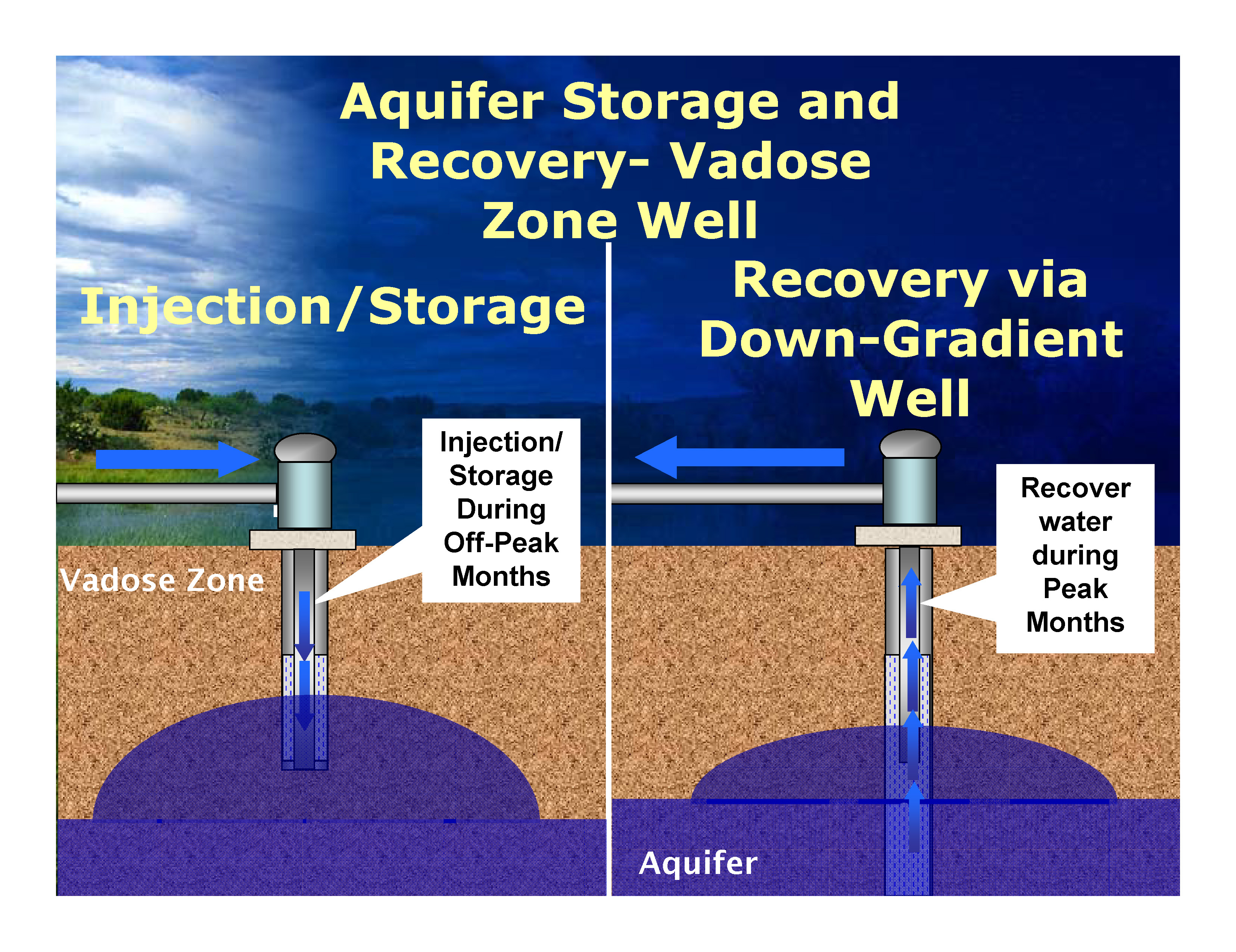
    Pruitt asserts that his repeal “need not be based upon a change of facts or circumstances,” citing a 2009 opinion by Justice Antonin Scalia. But in my view, Pruitt reads too much into that decision, which simply held that an agency did not face “heightened scrutiny” – that is, an extra-high bar – when changing policy, but must still “show that there are good reasons for the new policy.” As Justice Breyer observed, dissenting in the same case, “Where does, and why would, the Administrative Procedure Act grant agencies the freedom to change major policies on the basis of nothing more than political considerations or even personal whim?”

    Drinking water at risk with new @EPA proposals #WOTUS

    Middle Dutch Creek near the Grand River Ditch. Photo credit Greg Hobbs.

    From The Colorado Connection (Josephine Peterson) via The Durango Herald:

    The American public will have 30 days to comment on the Trump administration’s plan to repeal and replace the 2015 Clean Water Rule, once it’s published in the Federal Register.

    Jan Goldman-Carter, wetlands and water resources director for the National Wildlife Federation, said the move would remove pollution limits from streams and wetlands that supply a third of the nation’s drinking water and which also are home to countless fish and wildlife species.

    “The American public has long thought – since the 1972 act – that their water is protected, their wetlands are protected, their streams are protected from pollution,” she said. “None of us can really take that for granted anymore.”

    The Clean Water Rule restored protections under the Clean Water Act for headwaters, streams and wetland habitat that had been left uncertain because of convoluted U.S. Supreme Court rulings. Current Environmental Protection Agency Administrator Scott Pruitt has argued that rolling back the measure will provide certainty to farmers and other businesses by returning regulatory authority to states.

    Carter said western states rely on clean water to fuel their multi-billion-dollar outdoor recreation industries. She pointed to polls that show nearly 80 percent of hunters and anglers favor Clean Water Act protections. Dozens of craft brewers also have come out in support of the 2015 measure. Carter said a majority of the nation’s stream miles and wetland acres are at stake…

    But some Colorado legislators see the beginning of the process to rollback this rule as a victory for private water rights.

    Sen. Cory Gardner, R-Colo., called the withdraw of this rule as “a victory for agriculture, rural communities, and all Coloradans.”

    […]

    Gardner has been a consistent opponent of the administrative rule from the beginning.

    Rep. Scott Tipton, R-Cortez, said he also welcomed the news and that the rule was a threat to private water rights…

    Samantha Slater, a spokeswoman for Sen. Michael Bennet, D-Colo., said the senator is opposed to the rule’s full appeal, and wants only what is best for the state.

    According to the Environment America Research and Policy Center, the Clean Water Rule, supported by more than 80 percent of small-business owners, was expected to generate more than $400 million annually in economic benefits. Public comments can be submitted at http://www.regulations.gov.

    The EPA plan is online at epa.gov/wotus-rule, and the Environment America brief is at environmentamericacenter.org.

    City of Aspen eyes storing water under golf course in lieu of dams, reservoirs

    A view of the Aspen municipal golf course from Red Butte. A consulting engineer for the city of Aspen has found that an 'in-situ' reservoir could likely be built to store water under the golf course, which sits on about 75 feet of glacially-deposited rock and gravel. A trench filled in with a clay-like material could be dug around the perimeter of the golf course and water could be poured into the open space in the remaining gravel, and pumped back out as necessary.

    ASPEN – In their ongoing search for alternatives to building dams and reservoirs on Maroon and Castle creeks, Aspen officials continue to explore other options, including an underground reservoir that would store water below the city’s golf course.

    Aspen City Council reacted favorably to a presentation in May about an “in-situ” or underground reservoir beneath the Aspen Golf Club, with one council member saying it was a “great introductory lesson.”

    Aspen City Manager Steve Barwick said last week there is plenty more work to be done.

    “City Council had a lot of questions regarding the viability, impact and cost of in-situ storage,” Barwick said, “and they have not yet even begun their review of the storage needs.”
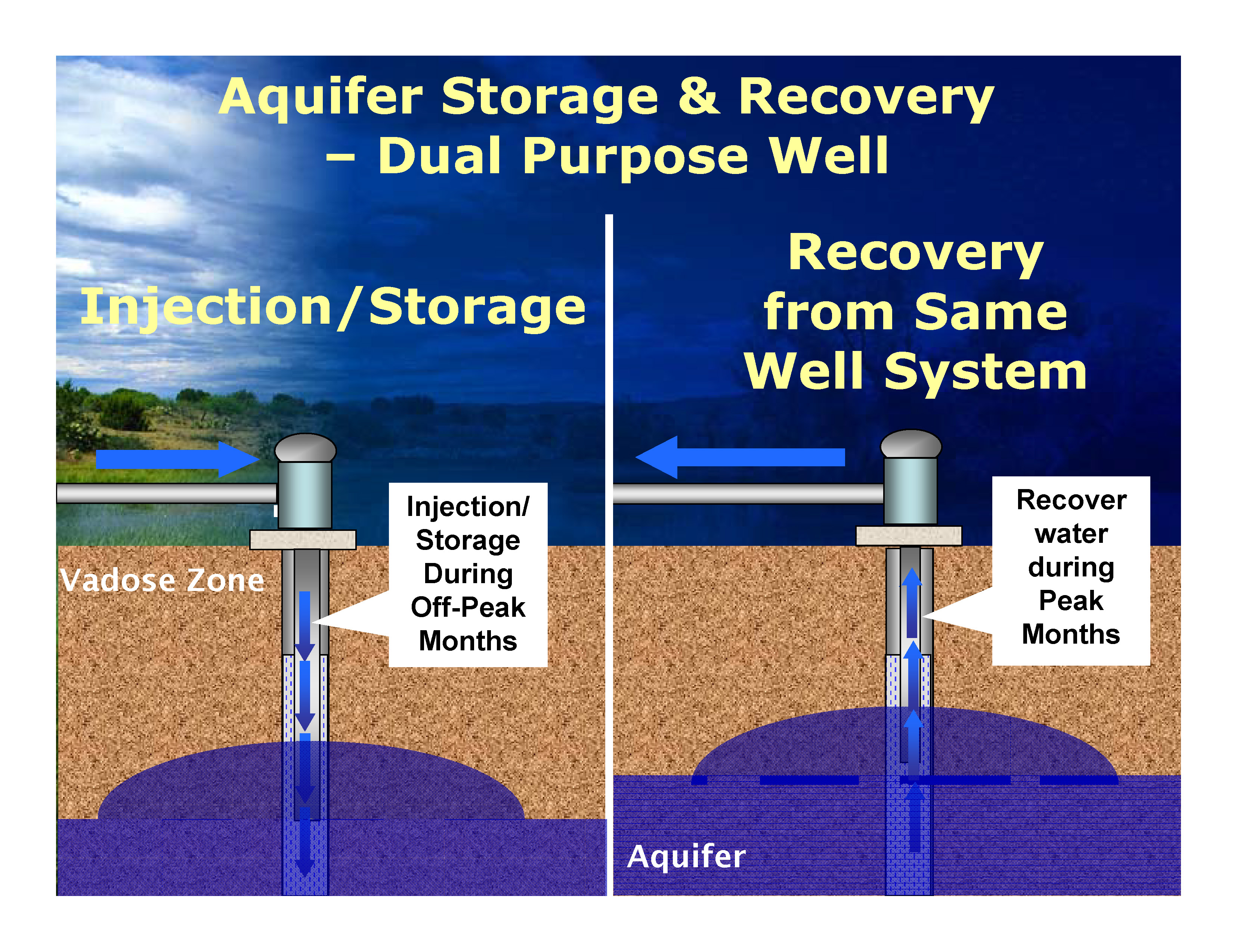
    Barwick also said recently that the city does not know exactly how much water it needs to store to meet future needs, but the council is set to hear a presentation on the subject at a July 11 work session.

    “All of this, this whole notion of how much water do we need and how much water do we need to store, and all of that, has been based upon very preliminary analysis,” Barwick told the Pitkin County Healthy Rivers and Streams Board on March 16. “And now it’s time to tighten up the whole analysis and do a rational set of studies so we can have a rational discussion with the entire valley about what are we going to do here. How much storage do we need, and where do we want to put it?”
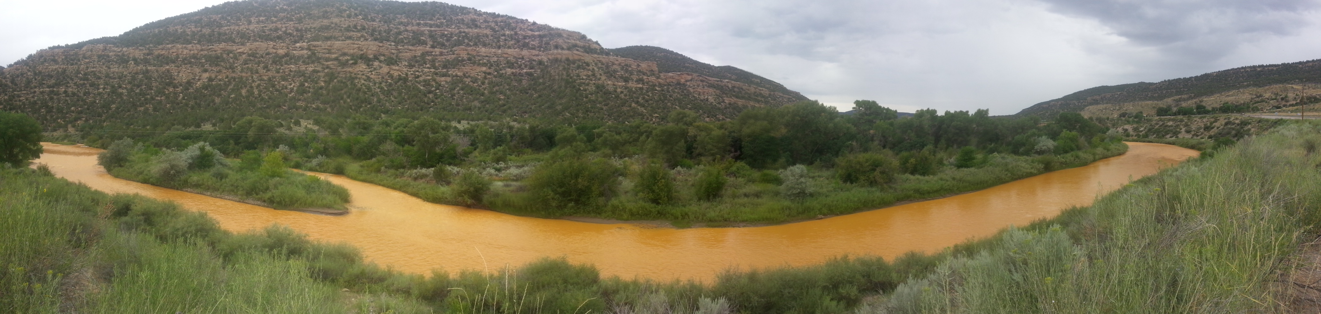
    Loose rock and gravel on the edge of the Aspen golf course, showing a glimpse of what might lie below the surface of the course.

    Feasible

    Don Deere, a geotechnical engineer who has worked on a long list of water storage projects in Colorado, said during his presentation to the council in May that the city’s golf course has the right combination of bedrock and “terraced gravels” required for an in-situ reservoir, in which claylike walls are built in trenches around a rock-filled area to hold water.

    “Engineering-wise, it’s feasible,” Deere confirmed this week in a phone interview. “You’ve got to drill it to know for sure if the site’s going to work, but there are some favorable aspects to that site, for sure.”

    The 148-acre public golf course is located between lower Castle and Maroon creeks and sits on top of about 75 feet of gravel and river rock left by retreating Ice Age glaciers, said Deere, who is chairman of the civil engineering firm Deere and Ault Consultants, Inc. in Longmont.

    An in-situ reservoir under the golf course could hold about 1,200 acre-feet of water, Deere said, which the city could then pump back up to its water-treatment plant if needed.

    By comparison, the city has a 10 acre-foot reservoir at its water-treatment plant, which it says amounts to about a day’s use of water for the city’s water system. For comparison, Ruedi Reservoir holds about 100,000 acre-feet of water. Deere called a 1,200 acre-foot reservoir “a small reservoir.”

    A potential 170-foot tall dam near Ashcroft on Castle Creek would create a reservoir that holds 9,062 acre-feet of water; a 155-foot dam on Maroon Creek near the Bells would hold 4,567 acre-feet.

    The city applied to Division 5 water court in October to maintain its conditional water rights for the two reservoirs on Maroon and Castle creeks, and is facing opposition from 10 parties, including the U.S. Forest Service and Pitkin County.

    Much of the opposition is because of the locations of the potential dams and reservoirs, both of which would inundate portions of the Maroon Bells-Snowmass Wilderness. Some opposers also are questioning whether the city really needs to store nearly 14,000 acre-feet of water.

    And as the city tries to answer the “how much” question, they’ve also been looking at the “where” and “how” questions.

    A graphic from Wilderness Workshop that shows how the potential Maroon Creek Reservoir would behind a 155-foot-tall dam just below the confluence of East and West Maroon creeks.

    Exploring options

    A study of the idea of storing water in old silver mines around Aspen was also presented at the May 15 work session by another Deere and Ault engineer, Victor deWolfe III.

    He said it likely would be expensive and complicated for the city to use the old mines, especially as it would be difficult to maintain control of the water in the complex maze of old shafts and tunnels.

    The in-situ option, by comparison, sounded more feasible.

    Deere looked at two potential locations for an in-situ reservoir, both on city-owned property, the golf course and the city’s Cozy Point Ranch property at the intersection of Brush Creek Road and Highway 82.

    The Cozy Point has a better combination of gravel and bedrock for an in-situ reservoir than the golf course, Deere said, but most of the focus at the work session was on the golf course site, in part because the city currently delivers water from Castle and Maroon creeks to irrigate the golf course.

    A graphic from a paper authored by Don Deere shows how the walls of an in-situ reservoir are formed. The paper is called 'Gravel Pit Reservoirs, Colorado's Water Storage Solution.'

    A trench, filled in

    Deere told the council a reservoir under the golf course could be built by using a long-armed excavator to dig a 3-foot-wide trench around the course through the estimated 75 feet of gravel and river rock down to a solid layer of bedrock.

    The trench, which would encircle the golf course, would be filled in with a claylike substance (a soil-bentonite mix) that would hold water. Deere said under the right conditions, such a deep trench, sometimes called a slurry wall, can be dug and filled back in with the claylike material at the rate of about 100 feet a day.

    “In a couple of months, on a typical site, I can have a completely lined vessel,” he said.

    City-owned water from Castle and Maroon creeks could then be delivered to new and existing ponds on the golf course and allowed to slowly infiltrate into the spaces between the loose rock left in the vessel.

    If the city needed to during a drought, it could then pump the water from the new underground reservoir to its water treatment-plant located on a hill behind Aspen Valley Hospital. It’s about a mile from the center of the golf course to the treatment plant.

    Water hazards

    Councilwoman Anne Mullins asked Deere if the golf course would look the same after an in-situ reservoir was installed.

    “I think we’d need to add some ponds, so there would be more water hazards when we’re done,” Deere said, but other than that, “it’s out of sight, out of mind.” And he said this week that after revegetation, no one would even know the in-situ reservoir was there.

    As a general rule, Deere said it costs about $10,000 per acre-foot-of water stored to build an in-situ reservoir ­— if favorable soil conditions allow for the standard use of an excavator. But if conditions such as deeper gravel or harder bedrock require a crane and a platform to be used instead, the cost can go up by a multiple of five or six, he said.

    Conceptually then, the construction costs of a 1,200 acre-foot in-situ reservoir could range from $12 million to $72 million, according to Deere.

    “But we haven’t done a site specific cost estimate for the golf course,” Deere said this week.

    He said it would require drilling test holes to know more about the feasibility and potential cost, as it would reveal the true depth of the gravel and the condition of the underlying bedrock.

    In May, city officials told the parties in the water court cases that it expected to finish its study of in-situ storage by July. The next settlement conference in the cases is set for the first week of August.

    Editor’s note: Aspen Journalism is collaborating with The Aspen Times, the Glenwood Springs Post Independent, the Vail Daily and the Summit Daily on the coverage of water and rivers. The Times published this story on Monday, July 3, 2017.

    USAF delivers new carbon filter to Fountain

    Widefield aquifer via the Colorado Water Institute.

    From The Denver Post (Bruce Finley):

    U.S. Air Force contractors on Thursday delivered the first of two $400,000 carbon filters designed to strip away two perfluorinated chemicals contaminating city water supply wells…

    “We’re a public water system making sure we meet the regulations, even the health-advisory level. Our community — this is a priority for them. We’re going to deal with this,” Fountain utilities director Curtis Mitchell said, watching as a crane lowered two 19-foot-tall filtration tanks near a public library.

    “This is a huge step forward,” he said, “because it will give us access to some of our groundwater again.”

    But farmer Susan Gordon and other residents of the Fountain Creek watershed still are raising questions about the human-health impact of exposure through drinking water.

    Gordon for years drank contaminated water from domestic wells and recently received results from a workers comp blood test showing a PFC called PFHxS in her blood at more than 100 times normal level. Three family members and some people who work on the farm with her also had elevated perfluorinated chemicals in their blood.

    While she’s healthy now, “who knows what it could mean 10 years from now?” Gordon said. “Not just me, but lots of people living in these communities have been exposed.”

    […]

    Fountain shifted city supplies to surface water sources after contamination was detected last year at levels above the EPA limit of 70 parts per trillion. But nearly 80,000 people in Fountain, Security and Widefield, as well as other communities south of Colorado Springs, long have relied on groundwater as a primary source of drinking water.

    Water providers in Security have shifted to surface water delivered from a reservoir west of Pueblo along the Arkansas River, and those in Widefield and Stratmoor Hills have put in water-cleaning systems…

    It was unclear whether Fountain’s filters would remove PFHxS. Karl Kuching, business development for the Air Force contractor TIGG, said the filters have proved successful removing some of the PFHxS at a site in Washington state.

    Removing short-chain PFCs may require more frequent changing of the carbon, which is injected into the tops of tanks in a slurry and, when exhausted, drained out the bottoms, he said. Two tanks are used. When system operators detect a contaminant “breakthrough,” one tank still filters out contaminants while carbon in the first tank is replaced…

    Water restrictions last summer reduced water use so that surface water sources met most of the demand. The restrictions might be imposed again after Tuesday, Mitchell said, so untreated well water isn’t tapped.

    The latest newsletter from the CCWCD is hot off the presses

    Crop circles — irrigated agriculture

    Click here to read the newsletter. Here’s an excerpt:

    109 Wells Added to WAS Plan

    In 2004 and 2005 many WAS contract holders had multiple irrigation wells included in a Substitute Water Supply Plan operated by the Well Augmentation Subdistrict while the Subdistrict worked to obtain a permanent augmentation plan. The permanent plan of augmentation was granted by the Water Court in 2006, however Subdistrict members were notified that WAS was unable to allow them to include more than one well per contract in the decreed plan for augmentation. The deleted wells were placed on a waiting list with every intention to incorporate those back into the decreed augmentation plan as the Subdistrict worked to secure additional augmentation supplies.

    June 21, 2016 , after ten years of development of water supplies the CCWCD Board of Directors voted to direct staff to proceed with the incorporation of the waiting list wells into the WAS augmentation decree. February 28, 2017, the Water Court application to formally add these 109 wells was filed. Statements of opposition to the application were received from City of Sterling, City of Boulder, Centennial Water & Sanitation District, Public Service, The Irrigationists (lower South Platte River water users), Farmers Reservoir & Irrigation Company, South Adams Water & Sanitation District, and Northern Colorado Water Conservancy District.

    In order to allow operation of these wells during the 2017 irrigation season, WAS filed an application seeking temporary approval from the Water Court on March 16, 2017. A few months later on June 29, 2017 the Substitute Water Supply Plan (SWSP) was approved by the State and Division Engineers which authorizes pumping from June 29, 2017 through June 28, 2018. The Central Board and Staff anticipated a more rapid approval for the SWSP, however the City of Sterling provided comments in lieu of the request sought by WAS. Fortunately the State and Division Engineer granted the approval and processed the request with fair reasoning and timely consideration. No additional pumping will be added to the contract holder’s allocation, but they now have the flexibility of pumping from either of their wells on the WAS Contract.

    @AuroraWaterCO Prairie Waters Project wins national award

    From the U.S. Water Alliance website:

    At the US Water Alliance, we bring together public, private, and community leaders to advance One Water solutions—holistic and integrated water management strategies that improve economic, environmental, and community outcomes. While the challenges facing our water future are great, our capacity for innovation and problem-solving is even greater. There are inspiring examples across the country of sustainable and integrated water resource management. That is why we annually award the US Water Prize to organizations that are leading the way with creative One Water solutions…

    Aurora Water
    Prairie Waters

    Aurora, Colorado is facing the water supply problems of many cities and regions in the arid west—a changing climate alongside a growing population. To combat these issues and secure the area’s water stability, Aurora Water worked with regional partners to create the Prairie Waters system, a innovative system that recapturing and recycling water to provide drinking water and drought insurance for the region. Using a multi barrier treatment process that includes both naturally-existing systems and state-of-the-art purification systems, Prairie Waters provides an additional twelve million gallons of clean, safe and dependable water each day. The Prairie Water program will help meet Aurora’s complex water needs for decades to come and can be a model for other regions experiencing changes in their water supply needs.

    From KDVR.com (Sarah Schueler):

    Aurora’s Prairie Waters system has won the U.S. Water Prize from the U.S. Water Alliance.

    The system was given the honor for its environmentally friendly and sustainable approach to water development.

    The aware panel also said the Prairie Waters system can be a model for other regions experiencing changes in water supply needs.

    Accepting the award at a ceremony in New Orleans on Tuesday night was Marshall Brown, the director of Aurora Water.

    Sterling water wins First Runner Up from #Colorado Rural Water Association

    Reverse Osmosis Water Plant

    From The Sterling Journal-Advocate (Sara Waite):

    Association, an organization that provides training and resources for small Colorado communities.

    The city was one of seven entries in the organization’s water taste test and received first runner up.

    Tuesday night, Sterling Mayor Dan Torres officially presented the award to the employees at the water treatment plant. He noted that the recognition comes from an outside agency that is unbiased. “To me that means more than anything else,” he said.

    City Manager Don Saling also lauded the water division workers, saying the award “says something about the great quality of product that they produce.”

    He added that those who complain about the taste of Sterling’s water likely live in homes with old pipes that affect the water quality. “I think they (the employees) do a great job,” he said.

    @EPA and the State of #Colorado release proposed plans for environmental cleanup at the Eagle Mine Superfund site

    Here’s the release from the Environmental Protection Agency (Jennifer Chergo):

    The U.S. Environmental Protection Agency (EPA) and the Colorado Department of Public Health and Environment (CDPHE) today released two Proposed Plans for environmental remediation at the Eagle Mine Superfund Site. Both Proposed Plans focus on further reducing heavy metal contamination created by nearly one hundred years of mining activity at the site.

    “The cleanup proposals represent both EPA and CDPHE’s commitment to protect human health and the environment at the Eagle Mine Superfund Site,” said Acting Regional Administrator Deb Thomas. “These plans also highlight EPA’s commitment to bringing contaminated lands back to health and reuse.”

    The Eagle Mine Superfund Site is located in Eagle County, Colorado. The site is defined as the area impacted by past mining activity along and including the Eagle River between the towns of Red Cliff and Minturn. Mining activities at the Eagle Mine began in 1879 and continued until 1984. EPA listed the site on the National Priorities List (NPL), commonly known as the list of Superfund Sites, in 1986 because of the mine metals discharge, uncontrolled mine waste piles and the close proximity of the population to the mine and associated features. To better manage the site, EPA divided it into operable units (OUs). OU1 focuses on protecting surface water by reducing metals loading from the site to the Eagle River. OU2 focuses on potential human health risks from contaminated soils in the abandoned company town of Gilman. OU3 focuses on soil remediation necessary to protect human health due to planned future development by the current landowner.

    EPA issued a final Record of Decision (ROD) for OU1 in 1993 and a final ROD for OU2 in 1998. Over the years, all required environmental cleanup work has occurred at the Eagle Mine Superfund Site under a number of state and federal directives. Response actions at the site addressed the major sources of metals contamination to the Eagle River, including the old and new tailings pile, rex flats and various roaster waste piles near Belden. In 2001, EPA declared all cleanup construction activities complete at the Eagle Mine Superfund Site, except for ongoing operation and maintenance of remedial features like the water treatment plant. Remediation conducted to-date resulted in significant improvement in water quality and reduction in risk to human health and the environment. Continued operation of the existing remedy, including drawdown from the mine pool and treatment at the water treatment plant, is required to maintain this condition. Contaminant concentrations in surface water and groundwater have decreased, and the aquatic ecosystem continues to show signs of recovery.

    In 2009, water quality standards established by the Colorado Water Quality Control Commission specifically for the Eagle Mine site became effective. Water quality monitoring in the Eagle River revealed that the water quality standards for cadmium, copper and zinc are not attained in March and April of most years. In response, the Proposed Plan released today for OU1 describes a number of alternatives designed to further reduce metals loading to the Eagle River. The preferred OU1 alternative includes the collection and treatment of groundwater from Belden and at the mouth of Rock Creek.

    The Proposed Plan for OU3 presents cleanup alternatives focusing on soil remediation necessary to protect human health should future development occur. EPA created OU3, after a developer purchased a large portion of the Eagle Mine Superfund Site in 2004 with plans to develop the property into a private, residential community. The preferred alternative includes a combination of the following elements for areas at OU3 proposed for development: placing a soil exposure barrier; grading the site; placing institutional controls and conducting monitoring; and/or demolishing structures.

    U.S. Supremes pass on #NM #GoldKingMine lawsuit against #Colorado #AnimasRiver

    The orange plume flows through the Animas across the Colorado/New Mexico state line the afternoon of Aug. 7, 2015. (Photo by Melissa May, San Juan Soil and Conservation District)

    From The Albuquerque Journal (Dan Boyd):

    While Colorado’s attorney general cited the ruling as proof the lawsuit should not have been filed, New Mexico Attorney General Hector Balderas indicated the legal fight may not be over yet.

    “The Supreme Court’s ruling only limited the venue in which the state of Colorado can be sued for the harm done to New Mexico children, families and businesses,” AG’s office spokesman James Hallinan said.

    The lawsuit, filed roughly a year ago, alleged Colorado was too lax in its oversight of groundwater contaminated by decades of mining and should be held responsible for the fallout of the Gold King Mine spill.

    The U.S. Supreme Court, on an 8-1 vote, denied a motion to hear the case. The nation’s highest court did not provide a reason for its decision, but has also opted not to intervene in other recent interstate disputes, including a 2016 lawsuit filed by Nebraska and Oklahoma against Colorado’s legal marijuana laws…

    In addition to the lawsuit against Colorado, New Mexico has also filed a lawsuit in federal court against the EPA and the owners of the Gold King Mine that seeks more than $136 million in damages. That amount would include money to pay for economic losses the state attributes to the mine spill, specifically in the tourism, recreation and agriculture sectors.

    From ColoradoPolitics.com (Peter Marcus):

    The New Mexico Attorney General’s Office and the state Environment Department announced last year that it filed a complaint against Colorado with the U.S. Supreme Court. It sought damages and demands that Colorado address problems at draining mines in southwest Colorado.

    Former New Mexico Environment Department Secretary Ryan Flynn alleged that his water quality researchers rejected assertions from Colorado Gov. John Hickenlooper and Colorado environment officials that the Animas River quickly returned to safe pre-event conditions after the August 2015 spill of toxic heavy metals.

    Flynn and attorneys for his department at the time suggested that Colorado is liable for the incident, which spilled 3 million gallons of sludge into the Animas in Durango, turning it a mustard yellow color. The spill fouled rivers in three Western states with arsenic, lead and other heavy metals.

    The EPA acknowledged fault in the spill, in which sludge flowed into creeks and rivers during restoration work at Gold King. The flow headed into the San Juan River in New Mexico and Utah…

    The Supreme Court was an appropriate venue for the case against Colorado, as it involved two states suing each other. But the high court declined to hear arguments in the case, though it did not issue an opinion explaining the decision. Justices Clarence Thomas and Samuel Alito said they would let the lawsuit move forward.

    From The Durango Herald (Jonathan Romeo):

    New Mexico’s petition to hold Colorado responsible for the Gold King Mine spill nearly two years ago was denied Monday by the U.S. Supreme Court.

    “Because it was the EPA and not Colorado that caused the Gold King Mine disaster, I have said from the beginning that New Mexico should not have sued Colorado in the Supreme Court,” Colorado Attorney General Cynthia Coffman said in a prepared statement.

    “Now that my office has won the Supreme Court case, I hope the conversation can focus on the EPA and its promise to take full responsibility for its actions.”

    […]

    In its lawsuit, New Mexico claimed the Gold King spill was the “coup de grâce of two decades of disastrous environmental decision-making by Colorado, for which New Mexico and its citizens are now paying the price.”

    The complaint specifically called out a decision reached by the state of Colorado and Sunnyside Gold Corp. to shut down a water treatment plant in favor of placing bulkheads at the entrance of the American Tunnel, Sunnyside’s drainage point.

    It’s believed among most researchers familiar with the Animas watershed that the bulkheads caused the mine pool of the Sunnyside Mine to back up and cause other mines to discharge acidic water, namely the Gold King.

    Regardless, Coffman, in response to the filed complaint, said she tried to resolve the matter without litigation, calling New Mexico’s lawsuit against the state “unfortunate.”

    “It’s unclear to me how suing Colorado furthers the states’ mutual goal of holding the EPA to its promise to ‘take full responsibility’ for turning our rivers yellow,” she said…

    “The Supreme Court’s ruling only limited the venue in which the State of Colorado can be sued for the harm done to New Mexico children, families and businesses,” James Hallinan, spokesman for New Mexico Attorney General Hector Balderas, said in an emailed statement.

    “Attorney General Balderas will continue to fight for economic, social and environmental justice until New Mexico is compensated appropriately by all parties responsible for the horrific impacts of the Gold King Mine Spill.”

    The Supreme Court’s decision to dismiss New Mexico’s petition is the latest lawsuit to fail in the long line of litigation in the wake of the spill.

    On Jan. 13, the EPA rejected $1.2 billion in claims of damages from private businesses and individuals, citing federal law that encourages “government agencies to take action without the fear of paying damages in the event something went wrong while taking the action.”

    To date, the EPA has spent more than $29 million in response to the Gold King Mine spill, with most of those funds used to stabilize the mine adit and mitigate ongoing acid mine drainage through a temporary water treatment plant, Amy Graham, an agency spokeswoman said Monday.

    A total of $3.7 million has been awarded to state, tribal and local governments for emergency response costs, and another $2 million was provided to states and tribes for water quality monitoring, Graham said.

    From the New Mexico Political Report (Laura Paskus):

    The problem of toxic waste from abandoned mines flowing into rivers isn’t limited to just the Gold King Mine.

    In Colorado alone, more than 200 abandoned mines collectively leak over a million gallons of wastewater every day. The pollution includes things like heavy metals, arsenic and sulfuric acid.

    Last week, the Denver Post reported that EPA officials are trying to stop contamination of the Animas River from the abandoned Red and Bonita Mine, which currently discharges 300-gallons per minute of wastewater into the Animas River…

    There are more than 15,000 abandoned mines across New Mexico, according to the New Mexico Energy, Minerals and Natural Resources Department.

    According to that agency’s website, “The numbers of abandoned mines in the state are so numerous that one can only guess at the quantity. Some of them are small and not considered dangerous. Others are extremely dangerous.”

    James Hallinan, spokesman for New Mexico Attorney General Hector Balderas, emailed a statement:

    “The Supreme Court’s ruling only limited the venue in which the State of Colorado can be sued for the harm done to New Mexico children, families and businesses. Attorney General Balderas will continue to fight for economic, social and environmental justice until New Mexico is compensated appropriately by all parties responsible for the horrific impacts of the Gold King Mine Spill.”

    When farmers must pay for groundwater, they cut use by a third — @CUBoulderNews

    Every March, thousands of Sandhill cranes stop in #GreatSandDunes National Park & Preserve on their way to their northern breeding grounds. The fields and wetlands of #Colorado’s San Luis Valley provide excellent habitat for these majestic #birds. With the dunes and mountains nearby, they dance and call to each other. It’s one of nature’s great spectacles. Photo @greatsanddunesnps by #NationalPark Service.

    From the University of Colorado — Boulder (Lisa Marshall):

    With record high temperatures scorching the Southwest this week, farmers were quickly reminded of the severe droughts that threatened their crops and livelihood in recent years. How will they manage increasingly scarce water when drought comes again?

    A new CU Boulder-led study suggests that self-imposed well-pumping fees can play an important role, incentivizing farmers to slash use by a third, plant less thirsty crops and water more efficiently.

    “When we talk about groundwater crises arising all over the world, the knee-jerk reaction among policymakers is often to ask, ‘What can government do?’ not ‘What can farmers do?’,” said Krister Andersson, director of the Center for the Governance of Natural Resources at CU and co-author of the paper in the Journal of the Association of Environmental and Resource Economists. “This study shows that there exists a good alternative to top-down regulations—that self-organized efforts can have a huge impact on how much water farmers use.”

    The study centered around a novel initiative in Colorado’s San Luis Valley, where several hundred farmers voted to self-impose a fee on groundwater—which is typically free and largely unregulated—beginning in 2011. The move came after a historic drought in 2002 and subsequent dryer-than-average years left the region’s aquifer depleted and some farmers worried that the state might begin shutting down wells, as it had in other areas.

    Historically, farmers have relied primarily on surface water from streams and run-off, but as population growth and climate change have strained supplies, agriculture has grown increasingly reliant on water pumped from underground.

    The new fee, now at $75 per acre foot of water, is among the first in the nation. About 700 farmers who manage 170,000 acres are subject to the fee. Proceeds are used to help local irrigators buy supplemental surface water or to pay them to let their acreage go fallow, or unused, in dry years.

    As part of a National Science Foundation grant aimed at assessing self-organized water conservation programs, CU Boulder researchers have spent years in the San Luis Valley Basin meeting with stakeholders and collecting data.

    “With this study, we have been able to offer validation that what they are doing is working,” said co-author Kelsey Cody, a graduate research assistant in CU Boulder’s environmental studies program.

    The study drew upon five years of data from farmers inside and outside the fee district before and after it was implemented. It found that farmers subjected to the fee pumped 32 percent less water per year on average. Some switched to less water intensive crops. Others upgraded to more water-efficient irrigation equipment. Notably, some did not reduce their water use at all and instead opted to pay extra.

    “This is because a fee does not prescribe what one can and cannot do; it just forces the irrigator to consider the cost of the water itself,” notes lead author Steven Smith, who did the research as a doctoral student at CU Boulder and who is now an assistant professor of economics at Colorado School of Mines.

    The authors stress that while the study confirms that irrigators are using less water and changing their farming practices, more research is necessary to determine how the fee has impacted them financially and whether the fee has caused the aquifer to recharge. Another study is in the works.

    Despite wetter weather in the past year, the participating irrigators intend to keep the fee in place, and other nearby districts are moving to implement a similar one, said Cleave Simpson, general manager of the Rio Grande Water Conservation District, which helps facilitate the fee.

    “We are cautiously optimistic about it.”

    As lawmakers in California, Texas, and other states ponder ways to regulate groundwater use, the researchers hope what’s happening in the San Luis Valley can serve as a lesson. The authors stress that a self-imposed groundwater fee may not be appropriate for all agricultural areas, but as the state looks for ways to conserve groundwater, it could be one effective tool.

    “The punchline here is that irrigators are far more responsive to these price mechanisms than was previously believed,” said Smith. “Through their adoption, they may be able to induce a lot of conservation.”

    #AnimasRiver: Bonita Peak Mining District Superfund site update

    From The Durango Herald (Jonathan Romeo):

    This summer will be the first full work season since the Bonita Peak Mining District Superfund site was declared last September, and the Environmental Protection Agency is wasting no time trying to figure out one of the biggest mysteries in the watershed: The American Tunnel.

    EPA hydrologist Ian Bowen said this week the agency plans to drill 500 feet into the San Juan Mountains to install a monitoring well between the second and third bulkheads on the tunnel…

    The American Tunnel, which travels about 11,000 feet, served as a transportation route for ore, as well as a deep drainage, from the vast Sunnyside Mine workings to facilities at Gladstone, north of Silverton.

    When Sunnyside Mine closed for good in 1991, attention turned to what to do with acidic discharges out of the American Tunnel. Sunnyside initially pulled the water into a treatment plant, but ultimately decided with the state of Colorado to install three bulkheads to stem the flow of acid drainage.

    But in recent years, researchers believe the Sunnyside mine pool behind the American Tunnel reached capacity and the water is spilling into other mine networks, such as the Gold King and Red & Bonita…

    The Animas River headwaters are broken into three drainages: Mineral Creek, Cement Creek and the Upper Animas.

    Rebecca Thomas, project manager for the Bonita Peak Mining District Superfund site, has previously said each drainage accounts for about a third of heavy metal loading in the Animas, causing a dead zone of aquatic life on the river from just below Silverton to the Bakers Bridge.

    But many people familiar with the basin say the EPA, which could see massive budget cuts under the Trump administration, should focus on the high-metal content waters of Cement Creek, where 13 of the 48 sites are located…

    Treatment options for the American Tunnel are a great unknown, Bowen said.

    Some have called for a complete draining of the tunnel, which could take decades and cost a lot of money to treat discharges. Others have suggested placing bulkheads on all the mines in the area.

    Bowen said the EPA first needs to understand the hydrology of the area. The new monitoring well that is expected to be installed by August will be a key tool in that effort because it will provide insight on how much water is behind the bulkheads, he said.

    “There’s strong indications that these systems are related, but there’s not enough evidence to say it’s immediately connected,” Bowen said.

    Sunnyside Gold Corp. has long contended there is no connection between the American Tunnel and any other mine networks in the area.

    The American Tunnel drains about 100 gallons of acid mine waste water a minute, which flows right by the EPA’s temporary treatment plant into Cement Creek.

    The temporary treatment plant only takes discharges from the Gold King Mine, which is now at about 620 gallons a minute. The EPA said it may consider treating other mine discharges upon further evaluation.

    From The Farmington Daily Times (Hannah Grover):

    The second annual Conference on Environmental Conditions of the Animas and San Juan Watersheds with Emphasis on the Gold King Mine and Other Mine Waste Issues today at San Juan College also featured other people who have been monitoring conditions in the rivers.

    One challenge for scientists is identifying to what degree metals are naturally occurring in the river and which metals are coming from mines in Colorado.

    Kathleen Sullivan, a U.S. Environmental Protection Agency scientist, said heavy metals released into the river during the Gold King Mine spill likely are no longer in the sediments in the rivers.

    Sullivan said there are naturally high levels of aluminum and iron in the river because of the composition of the bedrock. She said the EPA looked at the ratio of arsenic and lead to aluminum or iron in the river to identify the plume released by the Gold King Mine spill.

    The ratio peaked while the plume was passing through the area…

    She said only a small fraction of the heavy metals released into the river during the spill reached Lake Powell in Utah and Arizona during the immediate aftermath of the spill in August 2015. The rest of the metal was deposited as sediment, but Sullivan said the EPA believes the metals from the Gold King Mine spill are no longer present in the sediment and now have been deposited in Lake Powell.

    Sullivan said the EPA believes the Gold King Mine metals deposited in sediments passed through New Mexico in low levels over three to four weeks during the spring runoff in 2016.

    To test that hypothesis, Sullivan said the EPA took samples during the spring runoff this year. She said the EPA expects to see lower ratios of lead to aluminum in this year’s samples.

    Sullivan said the metals in the plume of acid mine drainage were mainly picked up after the water left the Gold King Mine. She said the water exiting the mine picked up a large amount of metal from a waste pile outside the mine. Sullivan said the EPA is currently in the process of testing that pile.

    During a panel presentation, Bonnie Hopkins, an extension agent for New Mexico State University, said one of the biggest issues still facing the area is the public stigma associated with the spill.

    When Farmington’s Growers Market opened for the 2016 season following the Gold King Mine spill, only three vendors showed up to sell their products. She attributed the small number of farmers selling their products to the stigma surrounding crops grown using water from the Animas River.

    This year, the Growers Market saw improvement. Hopkins said 11 vendors brought crops to the first market of the season earlier this month.

    During a panel discussion, Sullivan said the acid mine drainage from the Gold King Mine is effectively being treated, although drainage from other mines needs to be addressed. She said samples from Cement Creek — which feeds the Animas River — show the water quality is improving.

    Steve Austin, a hydrologist with the Navajo Nation EPA, said community outreach is still needed to communicate that the river water is safe.

    From The Denver Post (Bruce Finley):

    EPA Superfund officials trying to stop toxic mine contamination of the Animas River headwaters are preparing to close an underground dam, aiming to block a 300 gallon-per-minute discharge equal to a Gold King Mine disaster every week.

    Shutting this Red and Bonita Mine bulkhead has emerged as a huge test on mountains here, where miners who penetrated fissures and groundwater pathways left behind the geologic equivalent of Swiss cheese…

    But turning a valve and closing that bulkhead could trigger toxic leaks elsewhere, potentially spreading harm along already-contaminated headwaters. The EPA’s latest water data show widespread aluminum, cadmium, copper, iron and zinc contamination from mining and natural sources at levels too high for fish to survive.

    EPA officials this week told The Denver Post — and assured local leaders — that the agency will use caution at the bulkhead, installed in 2004, and close it gradually next year while monitoring mountainsides for any new leaks. They’ve launched a data-gathering blitz, harnessing the local Mountain Studies Institute, to measure flows from dozens of mine tunnels and more than 97 mountainside seeps and springs.

    “As soon as we feel we have a good handle on what the baseline is, then we’ll close the Red and Bonita bulkhead,” EPA project chief Rebecca Thomas said. “We would do it as a test initially and build up water behind the bulkhead.

    “If we see a change we’re not comfortable with, if it is going to cause any further degradation of water quality, we’ll open up the bulkhead and drain it and treat it,” Thomas said in an interview.

    “We need to understand how water flows before we close it. There are a lot of underground connections. Some are man-made. Some are natural,” she said. “We want to test whether or not closure of the bulkhead would help us improve water quality by stopping continued flow from the Red and Bonita.”

    EPA hydrologist Ian Bowen said environmental gains could be big but emphasized unknowns. For example, the acid-metals muck draining from the Gold King, which is filtered before it mixes into the Animas, increased last year, reaching to 710 gallons per minute. The EPA can treat 1,200 gallons per minute at a plant below that mine.

    Bulkheads also were installed inside Kinross Corp.’s Sunnyside Mine and American Tunnel. EPA crews plan to drill behind those bulkheads to test the pressure of pent-up mine wastewater — to make sure they will hold. American Tunnel bulkheads still leak 100 gallons a minute, and the Mogul Mine, where a bulkhead was installed in 2003, leaks 150 gallons a minute more unfiltered muck into headwaters.

    Stopping the untreated Red and Bonita discharge would mark a first big fix in a Superfund cleanup following the Aug. 5, 2015, Gold King disaster, where an EPA crew accidentally triggered a 3 million gallon spill that turned the Animas mustard-yellow as it moved down the river and eventually reached the Grand Canyon of the Colorado River.

    Installing more bulkheads to trap toxic mine muck inside mountains could mean taxpayers pay less for water cleaning at treatment plants built along headwaters.

    Colorado “agrees with EPA’s plan,” state health department spokesman Warren Smith said.

    Yet challenges loom. Mapping tunnels, fissures, seeps and springs increasingly occupies a legion of researchers and Deere & Ault engineering consultants tapped by the EPA. They anticipated in an April report that closing the Red and Bonita bulkhead would cause toxic overflows elsewhere. And EPA bureaucracy combined with uncertain funding from Congress has delayed a dozen or so other toxic mine Superfund cleanups around Colorado — let alone the tens of thousands of inactive mines contaminating water around the West.

    East of Silverton, above Creede, the EPA’s Superfund cleanup of the Nelson Tunnel and various old mines — declared a national-priority disaster in 2008 — has yet to move beyond studies of tunnels and groundwater.

    EPA officials on Wednesday said the agency “is evaluating the focused feasibility study for the (Creede) site and considering a range of alternatives for the proposed remedy” but that, because the EPA has not picked “a preferred alternative,” funds for cleanup aren’t available…

    EPA crews seem to be working at sampling water and investigating hydrology before closure of the Red and Bonita bulkhead, said Fetchenhier, who is a geologist. “We said: ‘Before you close it, we want the data gathered on every spring, every seep, every tunnel so that you have a baseline. Anytime you put in a bulkhead, there is a chance something could come out someplace else.’ ”

    EPA officials this week convened a forum in Silverton, an in-depth hydrology session with a brain trust of local scientists, mining engineers and others whose collective knowhow, federal officials said, exceeds the agency’s expertise.

    Downriver in Durango, La Plata County leaders acknowledged a strong interest in stopping contamination after decades of enduring the toxic legacy of mining — because clean water is crucial for residents of Colorado and other western states.

    #Utah continues monitoring of the San Juan River #GoldKingMine #AnimasRiver

    On April 7, 2016, the Environmental Protection Agency proposed adding the “Bonita Peak Mining District” to the National Priorities List, making it eligible for Superfund. Forty-eight mine portals and tailings piles are “under consideration” to be included. The Gold King Mine will almost certainly be on the final list, as will the nearby American Tunnel. The Mayflower Mill #4 tailings repository, just outside Silverton, is another likely candidate, given that it appears to be leaching large quantities of metals into the Animas River. What Superfund will entail for the area beyond that, and when the actual cleanup will begin, remains unclear.
    Eric Baker

    From KSL.com (Amy Joi O’Donoghue):

    Erica Gaddis, the newly appointed director of the Utah Division of Water Quality, briefed a committee of lawmakers on the situation during a Tuesday hearing, detailing that 540 tons of heavy metals now rest at the bottom of Lake Powell.

    Testing by the U.S. Environmental Protection Agency revealed that the heavy metal concentrations had all been flushed to Lake Powell by last July, carried along by the currents in the San Juan River.

    Gaddis, who assumes her new role next Monday, said metals such as copper, zinc and aluminum tested above federal standards in 2015 in aquatic life in more than 150 samples. By 2016, only aluminum remained — with counts that exceeded the standard in 126 samples…

    Gaddis told members of the Legislature’s Natural Resources, Agriculture and Environment Appropriations Subcommittee that Utah, the three other states impacted and Native American tribes are working together to monitor long-term impacts.

    That task is complicated given the extent of legacy mining operations in the Bonita Peak Mining District in Colorado, where there are 48 historic mines near Silverton.

    Gaddis pointed out that over the last decade, it’s estimated there have been 877 million gallons of water released, with 8.6 million tons of tailings generated from the life of those mines.

    The Utah Department of Environmental Quality has been reimbursed by the EPA for nearly $464,000 in costs in the initial response and another $212,000 in costs have received preliminary approval by the federal government.

    Gaddis said about $20 million has been appropriated by a congressional act to help Utah, Colorado, New Mexico, Arizona and Native American tribes with long-term monitoring.

    Utah is also keeping its options open for any potential litigation against the EPA regarding the spill, she added.

    Cement Creek aerial photo — Jonathan Thompson via Twitter

    @USGS: Water-level and recoverable water in storage changes, High Plains aquifer, predevelopment to 2015 and 2013–15

    Click here to read the report. Here’s the release from the US Geological Survey:

    The U.S. Geological Survey has released a new report detailing changes of groundwater levels in the High Plains aquifer. The report presents water-level change data in the aquifer for two separate periods: from 1950 – the time prior to significant groundwater irrigation development – to 2015, and from 2013 to 2015.

    “Change in storage for the 2013 to 2015 comparison period was a decline of 10.7 million acre-feet, which is about 30 percent of the change in recoverable water in storage calculated for the 2011 to 2013 comparison period,” said Virginia McGuire, USGS scientist and lead author of the study. “The smaller decline for the 2013 to 2015 comparison period is likely related to reduced groundwater pumping.”

    In 2015, total recoverable water in storage in the aquifer was about 2.91 billion acre-feet, which is an overall decline of about 273.2 million acre-feet, or 9 percent, since predevelopment. Average area-weighted water-level change in the aquifer was a decline of 15.8 feet from predevelopment to 2015 and a decline of 0.6 feet from 2013 to 2015.

    The USGS study used water-level measurements from 3,164 wells for predevelopment to 2015 and 7,524 wells for the 2013 to 2015 study period.

    The High Plains aquifer, also known as the Ogallala aquifer, underlies about 112 million acres, or 175,000 square miles, in parts of eight states, including: Colorado, Kansas, Nebraska, New Mexico, Oklahoma, South Dakota, Texas and Wyoming. The USGS, at the request of the U.S. Congress and in cooperation with numerous state, local, and federal entities, has published reports on water-level changes in the High Plains aquifer since 1988 in response to substantial water-level declines in large areas of the aquifer.

    “This multi-state, groundwater-level monitoring study tracks water-level changes in wells screened in the High Plains aquifer and located in all eight states that overlie the aquifer. The study has provided data critical to evaluating different options for groundwater management,” said McGuire. “This level of coordinated groundwater-level monitoring is unique among major, multi-state regional aquifers in the country.”

    Fountain Creek: CDPHE has stopped testing of Widefield aquifer plume

    Widefield aquifer via the Colorado Water Institute.

    From The Denver Post (Bruce Finley):

    “Pueblo County has not been notified by the Colorado Department of Public Health and Environment (CDPHE), Environmental Protection Agency or the Air Force that they have stopped monitoring, testing or sampling groundwater to track the plume,” county commissioner Terry Hart said. “If they have indeed stopped, we would most definitely be interested in learning why they stopped.

    “Pueblo County is concerned about any and all groundwater contaminants. We are working aggressively to ensure that any waterway, but particularly Fountain Creek, is clean so they can be assets to our community instead of being a problem.”

    State tests for PFCs in drinking water have not been done since November 2016, Colorado Department of Public Health and Environment records show. And CDPHE hasn’t measured PFCs in groundwater since February, the records show.

    It’s unclear how far the PFCs contamination has moved in groundwater. Back in April 2016, groundwater samples taken south of Fountain, along Hanover Road north of Pueblo, showed PFC contamination higher than 100 parts per trillion — well above the federal EPA health advisory limit of 70 ppt.

    CDPHE officials on Thursday confirmed they stopped sampling water and told The Denver Post that’s because EPA funding that enabled the tests ran out. They could not say whether the agency is still monitoring other contaminated groundwater plumes, such as those spreading PCE from dry cleaning.

    “The Water Quality Control Division is not conducting any further PFC sampling. ​We expended the funds from the EPA to complete sampling,” CDPHE spokeswoman Jan Stapleman said.

    EPA officials in Denver said state water sampling stopped but that the U.S. Air Force still is monitoring PFCs contamination as part of a military investigation at Peterson Air Force Base. That base is strongly suspected as a source of PFCs, a family of chemicals found in aqueous film-forming foams that firefighters use to douse fuel fires.

    Lincoln Park/Cotter Mill superfund site update

    Lincoln Park/Cotter Mill superfund site

    From KOAA.com:

    The uranium mill was declared a Superfund environmental disaster more than 20 years ago after contamination was discovered in both well water and soil in Cañon City.

    We weren’t allowed to film or take pictures on the tour but we did get to ask some questions.

    The site manager says they’re trying to determine the usability of the mill in the future and are waiting on a quality assurance plan. Next, they’ll have to draft what’s called a remedial investigation report.

    Before they’re able to recommend a clean-up plan which would be in 2020 at the earliest.

    Newly identified chemicals in fire-fighting foam pose filtration challenge

    Photo via USAF Air Combat Command

    From The Colorado Springs Gazette (Jakob Rodgers):

    An Air Force-supplied filter being given to Fountain to strain out toxic chemicals from drinking water appears susceptible to a host of newly discovered compounds, a new study shows.

    That type of device – called a granular activated carbon filter – wasn’t too effective at removing more than two dozen chemicals derived from a toxic firefighting foam used for decades at Peterson Air Force Base.

    That means cities relying on those kinds of filters – in this case, Fountain – must replace them more often if they choose to account for the growing list of perfluorinated chemicals, some of which have only been discovered in the last year, said Christopher Higgins, a Colorado School of Mines researcher and the study’s author.

    And that could mean higher costs for ratepayers.

    “The carbon filters will work – you just have to change them more frequently,” Higgins said.

    At issue is the danger posed by a military-grade firefighting foam that is suspected of fouling the Widefield aquifer – a key source of drinking water for the Security, Widefield and Fountain areas…

    None of the area’s three largest districts still use untreated water from the aquifer.

    But Higgins and other researchers across the nation have identified more than two dozen other similar chemicals derived from the firefighting foam – 13 of them in last six months.

    And granular activated carbon filters are quickly overwhelmed by those other chemicals, according to Higgins’ study published Tuesday in the journal Environmental Science & Technology.

    “This study basically is a way of confirming what we suspected,” Higgins said. “Which was that some of those compounds, if they get out into the environment, will likely come through carbon filters much more quickly than PFOA and PFOS do.”

    The danger posed to residents by these additional chemicals remains unclear, said Jamie DeWitt, a toxicologist at East Carolina University. They include similar chemicals to those touted by the Air Force as safe for replacing its decades-old toxic foam.

    “I think the first question anybody should ask is: ‘Are these truly safe for me to drink at these concentrations?’ ” DeWitt said. “And honestly, I don’t think anybody at this point can really answer that.”

    After-hours calls by The Gazette to Peterson and Air Force Civil Engineer Center spokespeople were not returned.

    Higgins’ study comes as Fountain leaders work to install two Air Force-supplied granular activated carbon filters this summer.

    The research hasn’t changed those plans, said Curtis Mitchell, Fountain’s utilities director.

    “We’ll certainly work with him (Higgins) on how long the filter run times will be, and just look at what his data is showing,” Mitchell said.

    Mitchell downplayed concerns about moving forward with installation, because the Air Force’s filters can be easily substituted for a different type of treatment system – such as ion-exchange devices.

    Widefield Water and Sanitation District recently became the first water district in the nation to use an ion-exchange system to treat water for perfluorinated compounds.

    A six-month pilot program showed promise over the winter, and recent test results on the system after it began servicing houses in May showed no trace of six types of perfluorinated compounds, said Brandon Bernard, the Widefield district’s general manager.

    “This stuff’s pretty effective,” Bernard said.

    Higgins, however stopped short of endorsing such devices. They have yet to undergo the same tests as those Higgins just finished on granular activated carbon filters.

    “I don’t know how well they work at removing all of these other chemicals,” he said.