Aspinall Unit update: Reclamation is ramping down the high-flow regime for Black Canyon, the target is to reduce to 3,100 cfs by next week

A picture named aspinallunit.jpg

From email from Reclamation (Dan Crabtree):

Releases from the Aspinall Unit have begun to decrease this afternoon. Provisional data from the USGS shows the Black Canyon 24 hour peak target flow of 6,793 cfs is expected to be completed by about 7:00 p.m. this evening. Current Black Canyon flow is 7,040 cfs. The Unit will continue to be ramped down over the next several days until reaching a flow of about 3,100 cfs next week. The instantaneous flows at Delta, Colorado reached a maximum of 13,700 cfs this morning inundating small lower portions of agricultural fields west of Delta. The instantaneous flow at Whitewater reached a maximum of 14,900 cfs this afternoon.

More Aspinall Unit coverage here.

Aspinall Unit update: 11,000 cfs in the Gunnison at Delta

A picture named gunnisonriver.jpg

From email from Reclamation (Dan Crabtree):

Gunnison River flows in the Black Canyon and Gunnison Gorge are currently at 5,100 cfs and continuing to climb. We are still anticipating a peak flow of around 6,900 cfs in this reach tomorrow, June 7th or the following day. Flows at Delta are nearly 11,000 cfs and should peak at about 13,000 cfs late June 7th or early June 8th. We still anticipate slowly ramping down releases from the Aspinall Unit beginning June 9th and stabilizing at around 3,100 cfs in the Canyon and Gorge around June 14th.

More Aspinall Unit coverage here.

Aspinall Unit update: Estimated target of 6,800 cfs high flow regime in the Gunnison Gorge and Black Canyon

A picture named coloradoriverbasincgs.jpg

Here’s the high-flow regime planned for the Black Canyon and Gunnison Gorge this week from email from Reclamation (Dan Crabtree):

Reclamation will be operating the Aspinall Unit to allow the one day Black Canyon water right peak target flow of 6,800 cfs to be met during the next two weeks. Releases from Crystal Reservoir will ramp up from the current release of 3,500 cfs beginning Friday, June 3rd. Crystal Reservoir should begin to spill sometime Saturday June 4th. While spilling, natural fluctuations will be seen in the river system making it difficult to predict and control downstream flows. However, below is a table showing estimated flows in the Black Canyon and Gunnison Gorge below the Gunnison Tunnel. These flows should reach a peak of about 6,800 cfs on June 8th and return to about 3,200 cfs around June 13th. During this operation, combined flows of the mainstem Gunnison, North Fork and other tributaries may result in flows of around 13,000 cfs in the Delta area. Again, this schedule is an estimate and may be modified due to changing hydrologic conditions in the Gunnison basin. Further updates will be conveyed as changes occur…

Estimated
Date: Flow below Gunnison Tunnel (cfs)
June 3: 3,000
June 4: 3,500
June 5: 4,500
June 6: 5,500
June 7: 6,900
June 8: 6,900
June 9: 5,900
June 10: 5,000
June 11: 4,300
June 12: 3,750
June 13: 3,150

Here’s an article from a couple of years ago explaining the high flow regime, from Mark Jaffe writing for The Denver Post. From the article:

The stronger flow is intended to mimic natural spring runoff, removing sediment and algae and helping to break down riffles and whisk away vegetation encroaching on the riverbank, Dale said…

“This has been one of the longest, most complex water-right battles in Colorado,” said Drew Peternell, an attorney for the sportsmen’s group Trout Unlimited. To win that right, the concerns of hydropower agencies, ranchers and farmers — and downstream towns fearful of flooding — had to be addressed.

More Aspinall Unit coverage here and here.

Energy policy — hydroelectric: Small hydro installations are popping up around the U.S.

A picture named microhydroelectricplant.jpg

From American City and County (Todd Briggeman, David Egger, Bruce Duncan and Pat Sullivan):

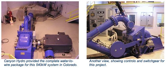
Often hydropower is associated with large-scale projects such as dams and reservoirs or major river diversions. However, small conduit hydropower can be installed potentially anywhere pressure must be reduced in a conveyance system, such as at the headworks of water treatment plants, wastewater treatment plant outfalls or at any pressure-reducing station. Small hydropower projects do not need to be located near a river or dam.

Several communities recently have begun creating energy at existing water facilities. They are locating hydropower turbines at pressure-control facilities to take advantage of energy that would otherwise be lost and channel it to power the facilities or sell it back to the grid. The projects are saving money and improving energy efficiency at water facilities…

The Project 7 Water Authority wholesales potable water to municipalities and rural areas in Colorado’s Uncompahgre River Valley. The authority owns and operates a raw water reservoir, raw water pipeline, water treatment plant, and 30 miles of potable water transmission piping.

For a decade, authority officials knew that they had several potential hydropower opportunities at locations with existing pressure-reducing valves. However, hydraulic constraints and complications with delivering the potential power back to an active grid kept them from creating a renewable energy project until 2007. That was when the authority decided to update its water treatment facilities, and plans called for increasing the raw water-delivery capacity. Additional pressure would be needed for delivery and to meet future plant peak demands, but it would be necessary to dissipate the additional pressure during normal flows, which created the possibility to capture the excess hydraulic energy.

To tap that energy, the system had to be optimized for turbines of two sizes: 60 and 110 kilowatts (kW). The turbine generator units were designed to fit within the new flow-control facility that increases the raw water capacity to the plant. Power generated from the new units is connected and consumed through a net metering agreement with the Delta-Montrose Electric Association (DMEA), a rural electric cooperative in Montrose, Colo., which allowed Project 7 to consume the energy within its own facilities. That allowed Project 7 to bypass a complicated connection to the nearby grid while maximizing the value of the recovered energy.

Colorado municipal electric utilities, such as the DMEA, are required to use renewable energy, including hydroelectric power, and energy recycling to account for 10 percent of retail sales by the year 2020. The incentives to comply with that standard, as well as advances in small turbine manufacturing, have made it more feasible to capture energy in raw water delivery networks. Project 7 placed the new turbine-generator units online in November 2009.

Project 7’s renewable energy facility produces approximately 1,400 kilowatt-hours (kWh) per day of energy. Although the authority does not receive any revenue directly from the energy generation, it is saving approximately $4,000 per month on its electricity bill — 85 percent of total plant-wide electricity costs. Locating the renewable energy project on the existing water treatment plant site allowed the project to become financially viable, not only because there was adequate space for the new turbine-generator units, but also because the power delivery method was greatly simplified. Authority officials expect to fully recover the investment in hydropower within seven to 10 years.

Project 7 Assistant Manager Adam Turner credits some of the project’s success to flexibility and support from the region’s electric utility. “We have some high power demands, especially during the summer months,” he says. “We can run the smaller unit to generate up to 60 kW much of the year and run the larger unit to generate 110 kW in the summer. We got a killer deal by getting credit at the same high rate we’d pay for it, so ours is probably rosier than the average small hydro project picture.”

More hydroelectric coverage here and here.

Uncompahgre Watershed Partnership and the Mountain Studies Institute ‘Abandoned Mines and Water Quality Conference’ recap

A picture named uncompahgrewatershed.jpg

From The Telluride Watch:

The conference, attended by over 50 community members, regional county commissioners and state and federal agency managers, and by AmeriCorps VISTA volunteers, examined varying perspectives regarding the future of mining in the county and its potential effects on water quality and on local and neighboring watersheds. Rob Runkel, of the US Geological Survey, discussed what is happening above Ouray in the historic Red Mountain Creek mining district, and Camille Price, project manager for the Colorado Department of Public Health and the Environment, discussed the history and remediation of the Idarado mine. MSI’s Chris Peltz gave a presentation on possible remediation solutions, one of them Biochar, a product made from beetle-kill lodgepole pine that is used to add carbon to damaged soil systems.

Colorado Trout Unlimited’s Snake River Project Manager Elizabeth Russell discussed Navigating Liability in Watershed Restoration, followed by a panel discussion moderated by Pat Willits of the Trust for Land Restoration. In that discussion, representatives from The Lake Fork Valley Conservancy, Animas River Stakeholders Group, Willow Creek Reclamation Committee, Kerber Creek Restoration Project, and the Coal Creek Watershed Coalition gave histories of their group’s formation, and reported on their organizations’ progress in recent years…

Interested parties can visit www.uncompahgrewatershed.org, for a Power Point Presentation, and to find out more about the organization, and to be kept apprised of upcoming meetings the UWP is organizing, concerning Total Daily Maximum Loads and about Non-Point Source Discharge Permits and how they work. The UWP and MSI would like to thank MOSAIC Community Project, Alpine Bank, Colorado Trout Unlimited and Colorado Non-Point Source Pollution Program for their financial support.

More Uncompahgre River watershed coverage here.

Energy policy — hydroelectric: Small scale hydroelectric installations are growing in popularity in Montrose County

A picture named canyonhydrosmallhydroelectricplantbouldercanyon.jpg

From the Montrose Daily Press (Dick Kamp):

from Montrose to Ridgway, and from Ouray to Telluride, the number of hydro projects are growing. Mike Berry, general manager of Tri County Water, hopes to build a hydro-project on Ridgway Dam. And he’s not alone; the area’s hydro-proponents also include renewable energy engineer Jim Heneghan of Delta Montrose Electric Association (DMEA); Kurt Johnson of Telluride Energy, and Eric Jacobson of Telluride’s Hydrowest power.

Jacobson owns the century-old Ouray and Telluride hydro-generating stations as well as the defunct Montrose Bullock power plant. He worked with Kurt Johnson to recently build the Ouray City hot springs hydro plant with used equipment.

Johnson is working with Tri-County in designing and promoting the Ridgway dam project. Johnson and Jacobson often work with Ouray attorney and Friend of the River activist Ben Tisdel of Ouray on hydro issues.

More hydroelectric coverage here and here.

Energy policy — hydroelectric: Public Scoping Begins on Proposed Hydropower Project at Ridgway Dam

A picture named ridgwayreservoir.jpg

Here’s the release from Reclamation (Steve McCall/Justyn Hock):

Reclamation announced today that it will hold a public scoping meeting to provide information and answer questions about a proposed hydropower project at Ridgway Dam in Ouray County, Colo. The project, proposed by the Tri-County Water Conservancy District, would generate electricity using the existing water releases from Ridgway Dam throughout the year.

Ridgway Dam is a feature of the Dallas Creek Project, which is a federal Reclamation project designed to provide irrigation and drinking water to Montrose, Delta, and Ouray counties in western Colorado.

The public meeting will be on April 26, 2011 at 5:30 p.m. at the 4H Event Center located at 22739 Highway 550 in Ridgway.

Reclamation is also seeking comments for preparation of a draft environmental assessment on the proposed project. Comments can include: questions or concerns you have with the proposal; significant issues to be addressed; and any information or data that could help in review of the proposal. Comments can be provided at the meeting or submitted by May 27, 2011 by email or mail to Steve McCall at smccall@usbr.gov or Bureau of Reclamation, 2764 Compass Drive, Suite 106, Grand Junction, CO 81506.

Meanwhile Orchard City is weighing their options with low head hydroelectric generation. Here’s a report from Hank Lohmeyer writing for the Delta County Independent. From the article:

Town administrator David Varley reported during a trustee work session last week that an engineer would begin assessing the project sometime soon…There is a lot of hope for low-head hydro generating projects now because of government grant money available for them.

More hydroelectric coverage here and here. More Uncompahgre River watershed coverage here and here.

Aspinall Unit update: The Uncompahgre Valley Water Users Association is calling for water, an additional 100cfs will be diverted at the Gunnison Tunnel

A picture named gunnisontunnelnps.jpg

From email from Reclamation (Dan Crabtree):

The Uncompahgre Valley Water Users Association (Water Users) continue to fill canals for the irrigation season and are in immediate need of additional water from the Gunnison River. The only operating powerplant at Blue Mesa Dam is operating at full capacity and the bypass tubes will not be operational until next week. Therefore the Water Users will divert another 100 cfs at the Gunnison Tunnel which will reduce flows in the river by a corresponding amount. The result will be a flow of about 1,300 cfs in the Black Canyon and Gunnison Gorge.

More Aspinall Unit coverage here.

The Uncompahgre Watershed Partnership will hold its next stakeholders meeting to discuss the findings from the Rapid River Habit Assessment of October 2010 April 21

A picture named uncompahgrewatershed.jpg

From the Montrose Daily Press:

The meeting will be Thursday, April 21, from 3:30 to 5:30 p.m., at the Ridgway Community Center. A potluck dinner will follow. The [Uncompahgre Watershed Partnership] is dedicated to understanding the health of the Uncompahgre River, according to Rachel Boothby of the UWP. It was created in 2007 when regional groups and citizens applied for a consensus-based watershed plan that details how the land, people, and water interact in the Uncompahgre Watershed…

In October 2010, 20 volunteers joined the UWP in a full day of visiting sites along the Uncompahgre River from Ouray to Delta to assess the health of the riparian habitat. At the April 2011 meeting, analyzed data will be ready to present in a “report card” of the river’s physical health.

More Uncompahgre River watershed coverage here and here.

Aspinall Unit update: Flows in the Gunnison Gorge and Black Canyon should remain at 1,400 cfs for a while yet

A picture named aspinallunitdescription.jpg

From email from Reclamation (Dan Crabtree):

The Uncompahgre Valley Water Users are beginning to increase diversions from the Gunnison River. Consequently releases from the Aspinall Unit are increasing a corresponding amount. Today, releases from Crystal were increased by 200 cfs to 1,800 cfs, to match the Water Users’ diversion increase. Flows in the Gunnison Gorge and Black Canyon should remain at 1,400 cfs for the time being. This is significantly higher than last year at this time (550 cfs) due to the above average hydrologic conditions.

We are beginning to plan for spring runoff operations, including operations related to the Crystal Exciter Realignment. The Crystal work will take place the week of April 18th and will require flow through the powerplant to vary on an hourly basis on April 20th and possibly the 21st. However, any increases or decreases in flow from the unit during calibration will be compensated through bypasses, thus fluctuations in the river will be minimal. Due to the current runoff forecast, we anticipate releases during the Realignment to be at or near the powerplant capacity of 2,150 cfs.

Speaking of the forecast, throughout the snowfall season, the Colorado Basin River Forecast Center (CBRFC) has been providing a fairly consistent April through July forecast of 800,000 af runoff into Blue Mesa Reservoir. If the May 1st forecast remains at 800kaf, the one day peak target for the Black Canyon water right is 6,369 cfs, which will likely require a total release from Crystal in excess of 7,000 cfs (combined Crystal powerplant and bypass is about 4,300 cfs; expect a Crystal spill of over 2,700 cfs). Reclamation plans to operate the Aspinall Unit to allow this peak target to be met sometime between mid-May and early June.

We will be discussing this in more detail at the April Aspinall Operations meeting on April 21st starting at 1:00 p.m. in Reclamation’s Western Colorado Area Office, Grand Junction. If you have any questions or concerns, please contact Dan Crabtree or Erik Knight by replying to this email or call 970-248-0600.

More Aspinall Unit coverage here.

Longtime manager of the Uncompahgre Water Users Association, Mark Caitlin, resigns

A picture named gunnisontunnelnps.jpg

From The Telluride Watch (Peter Shelton):

Montrose native and long-time manager of the Uncompahgre Valley Water Users Association Marc Catlin has resigned. His resignation was tendered Feb. 22 and announced March 14. The parting was not something Catlin had sought…

UVWUA announced Catlin’s resignation in a brief release. A call in to new acting manager Stephen L Fletcher had not been returned by press time.

The Water Users was created by an act of Congress in 1902 in the same legislation that also created the Bureau of Reclamation and authorized the digging of the Gunnison tunnel. That single event, Catlin told audiences celebrating at the 100th anniversary of the tunnel’s opening in 2009, made Montrose and its agricultural bounty possible.

Since that diversion of Gunnison River water, the Water Users Association has built and managed over 575 miles of canals and lateral ditches, which supply irrigation water to over 80,000 acres of cropland. UVWUA, through Project 7, also supplies water to the three municipalities of Montrose, Delta and Olathe, as well as to Tri-County Water District for its rural pipelines.

More Uncompahgre River watershed coverage here and here.

Energy policy — hydroelectric: Delta Montrose Electrical Association and Uncompahgre Valley Water Users Association’s power lease application scoping meeting March 9

A picture named microhydroelectricplant.jpg

From the Montrose Daily Press:

The hydropower project would generate electricity by using existing irrigation flows in the South Canal, and generate revenue for the water users association, as well as help DMEA meet legislatively mandated requirements for renewable energy sources. Wednesday’s meeting includes project description and a chance to ask questions. Input can be provided at the meeting, or by e-mail or letter after it. Input can include questions regarding the proposal, significant issues, and information that could help in review of the proposal.

More hydroelectric coverage here and here.

Aspinall Unit update

A picture named aspinallunitdescription.jpg

From email from Reclamation (Dan Crabtree):

The Colorado River Basin Forecast Center has just issued the February mid-month April through July runoff forecast. The forecast for Blue Mesa Reservoir remained at 775,000 acre-feet or 108 percent of average. In order to assure space in Blue Mesa Reservoir to manage the runoff, Reclamation will again increase reservoir releases. To accomplish this, we plan to increase Crystal releases by 300 cfs, from 800 cfs to a total release of 1100 cfs, on Friday, February 18th. If you have any questions, please reply to this email or call 970-248-0600 and ask for Erik Knight or Dan Crabtree.

More Aspinall Unit coverage here.

BLM Uncompahgre Field Office Wild and Scenic review update

A picture named bigdominguezcreek.jpg

From the Delta County Independent (Hank Lohmeyer):

There was unanimous agreement that Deep Creek and West Fork Terror Creek segments in the BLM’s North Fork Gunnison River Unit were unsuitable for BLM management as wild and scenic waters. The stakeholder group’s recommendation will be forwarded to the Uncompahgre Field Office (UFO) for consideration when BLM managers evaluate 11 stream segments in Delta County for “suitability,” the next stage in the wild and scenic evaluation process. Five other stream segments under consideration at the Jan. 10 meeting also received near unanimous agreement to be excluded from the BLM’s wild and scenic inventory. However, four individuals representing various environmental groups including The Wilderness Society and North Fork Valley-based WSERC did not want the five stream segments removed at this time. The five are Potter Creek, Monitor Creek, Roubideau Creek segments 1 and 2, and Gunnison River segment 2. The five will be looked at in more detail by a subcommittee of the full stakeholders group scheduled to meet this month, and then presented for reconsideration at an upcoming stakeholders meeting. A total of seven eligible stream segments were being evaluated on Jan 10. All of them are located outside of the new Dominguez-Escalante National Conservation Area. The stakeholders group is trying to meet a Feb. 15 deadline for submitting its recommendations on the seven. In addition to the seven non-NCA stream segments, six other stream segments located within the NCA boundaries must have a stakeholders recommendation by April 15.

More Wild and Scenic coverage here.

Ridgway: The town council is wrestling with the right mix of fees to accommodate future growth

A picture named ridgwayreservoir.jpg

From The Telluride Watch (Peter Shelton):

The town currently requires that new development contribute either water rights or money in lieu of water rights, before it can be annexed into the town limits. The idea when the policy was adopted in 2000 (and amended in 2009), [Town Engineer Joanne Fagan] said, was to protect the town’s access to municipal water, even as population grows, and even in the event of a call on Ridgway’s water by more senior water users. One option was to use the up-front money to purchase Ridgway Reservoir water from Tri-County Water Conservancy District…

The two systems Fagan described for calculating how much a new development should pay were complicated by, among other things, the escalating value of water. The policy refers to purchases of reservoir water at “present values.” But present value in 2000 was about $350/acre foot, Fagan said, and is now at $850/acre foot. The cost to a potential developer has soared. “Council folks,” she asked, “is this what you think we should be doing? And is this impact what you had in mind?”

Mayor Pat Willits responded. “My recollection is that when we first started talking about this, back 10 years ago when River Park was financing, we didn’t anticipate this much of an impact [on the developer]…

Fagan then said that she and staff were working on a “Plan B.” “For somewhere in the neighborhood of $1 million,” she said, the town could improve its storage of Beaver Creek water at Lake Otonawanda and avoid the purchase of Tri-County water. Lake Otonawanda is on Miller Mesa south of town. The town owns it but has no way to get water out of the lake into the town ditch. Fagan’s Plan B would properly plumb the lake and then “We could be in a position to fill it in the winter when the water would not be subject to a call” by ranchers and others who might override the town’s priority during irrigating season. Fagan said her rough calculations for payment in lieu of water rights using the “Lake O” plan came to about $66,000 per 10-acre development, or about $1,100 per unit, far less than $100,000 to $300,000 a developer would have to pay under the current plan. “We’re reviewing a draft plan now,” she told council. But, she said, “We don’t think this fits with the policy and might require amending the policy we have.”

More Uncompahgre River watershed coverage here and here.

Bureau of Land Management’s Southwest Colorado Resource Advisory Council meeting January 28

A picture named uncompahgrewatershed.jpg

From the Montrose Daily Press:

The open meeting will be from 9 a.m. to noon ,” with a public comment period at 11 a.m. ,” on Jan. 28 at the Holiday Inn Express Jordan Room, 1391 S. Townsend Ave. The Southwest Colorado RAC subgroup is composed of area residents representing diverse interests within the Uncompahgre Field Office. The seven-member subgroup will provide recommendations to the BLM Southwest Colorado RAC regarding development and implementation of the public lands within the field office.

More Uncompahgre River watershed coverage here.

Uncompahgre Planning Area Wild and Scenic River study update

A picture named sanmiguelriver.jpg

From The Telluride Watch (Karen James):

Following an exhaustive process in which the BLM inventoried every known river with a perennial or intermittent flow within the 675,000-acre Uncompahgre Planning Area, it determined that more than 30 segments of 22 rivers possessed the qualities necessary for eligibility. That is, they must be free-flowing as defined by the Wild and Scenic Rivers Act of 1968, and also contain one or more “outstandingly remarkable values.”

Those values must be river related and may be scenic, recreational, geologic, cultural or historic in nature, or result from large quantities or rare species of fish, wildlife or vegetation, or similar values. The river evaluation was required as the agency revises its Resource Management Plan for the planning area. “We’re not doing because we think it’s a good time to do it, or because we want to get involved in some river controversy,” laughed BLM Water Rights and Instream Flow Coordinator Roy Smith at an introductory meeting held a few weeks ago. “Under the [WRSA] we are required to whenever we do land use planning.”[…]

Wild segments are essentially undeveloped, while recreational areas can have extensive development along their shorelines. Scenic areas fall in between the two. Eligible river segments are given interim protection until the suitability analysis is completed and a Record of Decision is issued, with the intent of protecting the values for which a section was determined eligible. While the BLM makes recommendations on the suitability of the segments, ultimately only the U.S. Congress or the Secretary of the Interior can make the final designation. “Federal designation is a huge process that goes through a massive amount of input,” said Hilary White, Executive Director of local environmental organization Sheep Mountain Alliance, who is following the process closely. Ultimately, “It most likely will not happen for five to 10 years.”[…]

“The designation is meant to ensure that the river runs freely and that future development doesn’t deplete the river to the point of killing the values that live within it, explained Peter Mueller, a member of the BLM Southwest Colorado Regional Advisory Committee and, with Naturita’s John Reams, one of two local members of the Southwest Colorado RAC subgroup composed of area residents representing diverse interests within the Uncompahgre Field Office. The eight-member subgroup is responsible for forwarding consensus-based recommendations regarding Wild and Scenic River suitability by February 2011 to the Southwest Colorado RAC…

The Southwest Regional Advisory Committee will hold public meetings concerning private property impacts and the remaining sections of the San Miguel River at the Wilkinson Public Library on Tuesday, Jan. 4, 5:30-7:30 p.m., and the Norwood Community Center on Wednesday, Jan. 5, 6:30-8:30 p.m. The following week open discussions will take place at the Placerville Fire Department on Tuesday, Jan. 11, 6:30-8:30 p.m. and the Naturita Community Center on Wednesday, Jan. 12, 6:30-8:30 p.m.

More San Miguel River watershed coverage here and here.

The Colorado River District is kicking off a grant program for water resources projects

A picture named coloradorivergjwik.jpg

From email from the Colorado River Water Conservation District (Martha Moore):

The Colorado River District is accepting grant applications for projects that protect, enhance or develop water resources within the 15-county area covered by the District. This includes all watersheds in north- and central- western Colorado, except the San Juan River basin.

Eligible projects must achieve one or more of the following:

– develop a new water supply

– improve an existing system

– improve instream water quality

– increase water use efficiency

– reduce sediment loading

– implement watershed management actions

– control tamarisk

– protect pre-1922 Colorado River Compact water rights

Past projects have included the construction of new water storage, the enlargement of existing water storage or diversion facilities, rehabilitation of non-functioning or restricted water resource structures and implementation of water efficiency measures and other watershed improvements. Such projects that utilize pre-1922 water rights will be given additional ranking priority over similar projects that do not. Each project will be ranked based upon its own merits in accordance with published ranking criteria.

Eligible applicants can receive up to a maximum of $150,000 ((or approximately 25% of the total project cost whichever is less, in the case of smaller projects this percentage may be slightly higher) for their project. The total grant pool for 2011 is $250,000. Application deadline is Jan. 31, 2011.

More Colorado River basin coverage here.

New whitewater park for Montrose?

A picture named kayaker.jpg

From The Telluride Watch (Peter Shelton):

Now retired from competition and fresh from the opening of the 2012 Olympic kayaking venue in London, which was built by his firm, S2O Design of Boulder, [Scott] Shipley made a pitch for a family-oriented whitewater park on the Uncompahgre River at Upper Cerise (Riverbottom) Park.

City Park Planner Dennis Erickson hosted the event at the Pavilion, which also included a presentation by lead planner Ann Christensen of DHM Design in Durango, who introduced the draft plan. Also on hand was Gabe Preston of CPI Consulting, who led the group in a keypad polling exercise on priorities within the draft plan.

Participants indicated their preferences – high priority, medium or low – for a number of goals being considered in the plan, including: developing new city-owned parks on the northern third of the 10-mile-long river corridor, building more pedestrian bridges across the river, connecting downtown Main Street more directly to the river, building tails to link existing and future parks, acquiring private property for river improvements, and preservation/enhancement of the river ecosystem.

A whitewater park scored high on the list. But the highest priority for the public on this night was clearly trails, bicycle/pedestrian trails, to connect parks and link existing segments of river trail, thereby providing alternate-transportation routes, not just for recreation, but for commuting and shopping as well.

More whitewater coverage <a href="

Umcompahgre Valley Water Users forum recap

A picture named uncompahgrewatershed.jpg

From The Telluride Watch (Peter Shelton):

Mike Berry controls the valves to a lot of the drinking water in the Uncompahgre Valley. He’s the general manager of the Tri-County Water Conservation District. He’s a numbers guy. “We’re a local government entity, not a utility,” Berry told the crowd at the Holiday Inn Express conference room. TCW has a 15-member, state court-appointed board, and taxes property at 1.502 mils, generating $1.3 million annually. “We were born in 1957 to sponsor the Dallas Creek Project. Congress authorized us in 1968; 1978 was the groundbreaking for the [Ridgway] dam. In 1990 the reservoir was full, and Tri-County took over. “The lake receives 100,000 acre-feet of water every year. We exchange a 28,000 AF ‘pool’ of water in the reservoir one-for-one for Gunnison canal water, which goes into our distribution system. “The distribution system currently has 7500 taps, 610 miles of pipeline, 43 pumps and 21 tanks over a service area of 350 square miles. We sell 800 million gallons of water per year.”[…]

“We’re water rich,” he said. But he did talk about limits. We’re using only about half of the water available in the reservoir. But the population of the three downstream counties, Ouray, Montrose and Delta, is expected to double to about 150,000 by 2035. “And climate change, if that means hotter and dryer, can’t be a good thing on a water supply,” Berry said. But, he concluded, “Unlike Las Vegas, or anywhere south and west of us, I don’t think many people here go to sleep worrying about their water.”

Maybe they should, said State Senator Bruce Whitehead, himself a water engineer for 25 years with the Colorado Division of Water Resources. Whitehead wanted to talk about a bigger, more complex picture, the Colorado River Compact, and how increasing demand might change a lot of things. This year for the first time Colorado River water consumed (by agriculture, industry, and by 30 million people in seven states) exceeded the annual flow. The Southwest has been in a protracted drought – 11 years and counting. Lake Mead has shrunk to 40 percent capacity, an all-time low. Bad news, yes, for Nevada and California. But how does this affect Colorado, at the top of the water chain? Colorado’s share of the compact is 3.88 million acre-feet of water. We have, Whitehead said, perhaps half a million AF unused now. That’s enough to supply at least a couple million more people in the state. But here’s the problem: Colorado is linked to the water levels in Lake Mead and Lake Powell. If the Lower Basin states of California, Arizona and Nevada cannot get their allocated water from the reservoirs, the Upper Basin states of Colorado, Utah, Wyoming and New Mexico are obligated to curtail use until the Lower Basin allocation is met. This was the deal struck in 1922. This is the potential “call” on Colorado’s water. This, Whitehead said, is the dreaded “compact curtailment.”

More Uncompahgre River watershed coverage here and here.

Uncompahgre ‘River Assessment’ September 18

A picture named uncompahgreriver.jpg

From The Telluride Watch:

The Uncompahgre Watershed Partnership is looking for volunteers to assist in a fact-finding mission on Sept. 18 to evaluate the health of the river corridor. “This is a quick and dirty look at the River,” says Coordinator Sarah Sauter, stressing that no prior experience is required to participate. The Uncompahgre Rapid River Assessment will be a perfect pairing with water quality reports because it will show what key areas look like…

A mandatory training session will be held on Friday, Sept. 17 from 4:30-6:30 p.m. at Rollins Park in Ridgway to prepare for Saturday’s fieldwork. After a full day following a GPS with a digital camera and field data scorecards, the group will meet at Ridgway Town Park for a barbecue finale.

 Anyone interested should email with any questions and please RSVP by Sept. 11 to Rachel at UWPVista@gmail.com. The Uncompahgre Watershed Partnership meets monthly, and will hold its next stakeholder meeting on Sept.23 from 5-7 p.m. at the Delta Library. Visit its website for more events and information, uncompahgrewatershed.org.

More Uncompahgre River watershed coverage here and here.

Restoration: Agriculture Secretary Vilsack announces programs in nine states for reforestation and watershed improvment

A picture named uncompahgreplateau.jpg

From the Telluride Watch:

“This is welcomed money and will be put to very good use,” says Ron Henderson, chairman of the Montrose County Board of County Commissioners, of the [$446,000] grant. “The goal is to keep our forests healthy by reducing the risk of large wildfires, maintaining and improving water quality, preventing the spread of invasive noxious weeds and enhancing fish and wildlife habitats…

The restoration project is expected to create close to 750 part-time or seasonal jobs, supporting the enlargement of biomass markets for renewable energy and maintaining the viability of regional timber mills, the last remaining large sawmills in Colorado, for which a local and sustainable supply of wood is critical. Work, job-skill training and educational opportunities will be available for local youth and adults…

The restoration projects will focus on 555,300 acres of Forest Service land within a one-million acre landscape. Active restoration projects on 160,000 acres will include controlled burns; timber harvests; native plant establishment; trail and road relocations (to reduce sediment); riparian restoration and improvements for Colorado River cutthroat trout. Multi-party monitoring efforts are proposed for 68,000 acres. The grant provides money for the implementation of restorative work, and for monitoring, as well.

More restoration coverage here.

Restoration: Agriculture Secretary Vilsack announces programs in nine states for reforestation and watershed improvment

A picture named mountainpinebeetles.jpg

Update: More coverage from The Telluride Watch:

The Uncompahgre Plateau Project will receive $446,000 this year and $9.6 million total over the next 10 years to fund a comprehensive effort to treat 160,000 acres of land at various locations. Projects include prescribed burns, mechanical treatments, timber harvests, invasive species treatments, native plant establishment, trail and road relocations to reduce sediment, riparian restoration, and improvements for Colorado River cutthroat trout. The intent of the project is to enhance the resilience, diversity and productivity of the Uncompahgre Plateau landscape, according to Lee Ann Loupe, communications staff officer for GMUG headquarters in Delta. Multi-party monitoring efforts are proposed for 68,000 acres. Approximately 750 part-time/seasonal jobs are anticipated to be created as a result of project implementation and will hopefully provide local youth with work opportunities, job skill training and educational opportunities.

Here’s the release from the USDA:

Agriculture Secretary Tom Vilsack today announced the selection of Collaborative Forest Landscape Restoration projects in nine states that promote healthier, safer and more productive public lands. The projects include partnership efforts on forest restoration treatments that reduce wildfire risk, enhance fish and wildlife habitats, and maintain and improve water quality.

“Working collaboratively with partners at the state, local and private level is an important part of the all-lands approach to improving the health our nation’s forests,” said Vilsack. “These projects will address forest restoration across landscapes, irrespective of ownership boundaries and helping create not only healthy forests and waterways and create green jobs and economic opportunity in rural communities.”

The projects, funded at $10 million, were selected based on the recommendations of a 15-member Advisory Committee. Advisory committee members were selected based on their technical expertise, the points-of-view represented, which geographic region of the country they represent and diverse backgrounds.

“With the announcement of these selections, this valuable restoration work can begin to promote healthier, resilient, and more productive forested landscapes,” said Forest Service Chief Tom Tidwell. “We look forward to working with our community partners to achieve this vitally important work.”

Additional information about the program can be found at: http://www.fs.fed.us/restoration/CFLR/index.shtml.

Project List:

4 Forest Restoration Initiative – $2 million Arizona

This initiative, located on the Apache-Sitgraeves, Kaibab, Coconino and Tonto National forests, focuses on the restoration of the southwestern ponderosa pine ecosystem and will treat up to 50,000 acres per year. The work will include prescribed fire and management of natural fires for restoration objectives. Mechanical thinning will also engage new industry to insure that nearly all of the cost of removal of the thinning byproducts is covered by the value of the products.

Colorado Front Range – $1 million Colorado

The Colorado Front Range Landscape Restoration Initiative, located in the Arapaho, Roosevelt, Pike and San Isabel National forests, seeks to increase resilience and lower wildfire risk in a ponderosa pine forest ecosystem. Prescribed burns will result in lower severity of future wildland fires, increased resistance to insects and disease, reduced threats to communities and watersheds, and improved habitat for fish and wildlife species. These more resilient forests will also have increased capacity to adapt to the impacts of a changing climate.

Uncompahgre Plateau – $446,000 Colorado

The Uncompahgre Plateau includes restoration of seven plant types on 160,000 treatment acres and includes key watersheds that feed the Colorado River. Three separate weed management plans use multiple techniques to control the spread of invasive noxious weeds, including chemical and biological control measures critical to restoration and preventive measures to control invasive species.

Selway-Middle Fork Clearwater – $1 million Idaho

The Selway-Middle Fork Clearwater Project is a joint effort between the Clearwater Basin Collaborative and the Nez Perce and Clearwater National Forests. The restoration project will protect communities from wildfire and restore land and water ecosystems. The basin is renowned for pristine waters, fisheries, big game species and scenic vistas. The project work includes: 2,600 acres of commercial harvest and prescribed burning, application of prescribed fire to approximately 10,000 acres, replacement of a culvert to restore fish passage, and the decommissioning of 75 miles of road.

Accelerating Longleaf Pine Restoration -$1.171 million Florida

This project in Northeast Florida is comprised of 234,995 acres in the Osceola National Forest. The proposal seeks to restore forest ecosystems that have been significantly altered by fire exclusion and hydrologic alteration. The work includes: increasing prescribed fire acreage, reducing hazardous fuel loads while harvesting the woody biomass, thinning small diameter trees, restoring historic groundcover, and decommissioning trails and roads.

Southwestern Crown of the Continent $1.029 million Montana

The Southwestern Crown covers 1,449,670 acres, 70 percent of which is public land. It is one of the most biologically diverse and intact landscapes in the western U.S. It supports 250 bird species, 63 species of mammals, five species of amphibians, and six species of reptile. Restoration will focus on stream and forest habitats using prescribed fire and natural ignitions as tools to restore species composition and structure. Removal of exotic species followed by planting of native species will be used to restore the landscape. Bridge and culvert replacements and upgrades, road restoration and upgrades, removal of fish barriers, and stream channel manipulation are also included.

Southwest Jemez Mountains – $392,000 New Mexico

The Southwest Jemez Mountains area is 210,000 acres, 93 percent of which is divided between the Santa Fe National Forest and the Valles Caldera Trust-Valles National Preserve. The project will improve the resilience of ecosystems to recover from wildfires and other natural disturbance and sustain healthy forests and watersheds. This will be accomplished by thinning and prescribed burning to restore more natural fire regimes. Additional project components include streambank stabilization, invasive plant control, road and trail decommissioning, riparian and wildlife habitat improvement, conservation education, and rehabilitation, closure, and improvement of roads.

Deschutes Skyline – $500,000 Oregon

This project is located on 97,000 acres in the Deschutes National Forest. The majority of the landscape is ponderosa pine and dry mixed conifer forest types. The goal of the project is to restore forest ecosystems to be resilient to natural processes. This will also help to achieve a variety of community goals such as job creation, reduced risk of high-severity fire in Wildland Urban Interface residential areas, protection of drinking water source watersheds, preservation of the scenic and environmental quality of extremely high use recreational areas, and wood fiber for local economic benefit.

The Dinkey Landscape Restoration Project $829,900 California

The Project includes 130,000 acres on the Sierra National Forest and 20,000 acres of private land. Targeted ecosystems include coniferous forest, foothill hardwood and chaparral vegetation, montane meadows and riparian forests. The project aims to create resilient ecosystems and enhance the ability to adapt to wildfire. It will promote fire resilience, public and firefighter safety, key habitat for sensitive species, proper watershed function, healthy ecosystem processes, and landscape diversity.

Tapash – $1.63 million Washington

The Tapash Sustainable Forest Collaborative aims to enhance the resilience and sustainability of forests by treating 168,617 acres over ten years. This project is a joint effort between the Okanogan-Wenatchee National Forest, the Yakama nation, the Washington State Department of Natural Resources and the Washington State Department of Fish and Wildlife. The restoration strategy uses a diverse array of treatment methods including pre-commercial and commercial thinning (including biomass removal), prescribed fire of natural and activity fuels, and trail management activities.

The mission of the USDA Forest Service is to sustain the health, diversity, and productivity of the Nation’s forests and grasslands to meet the needs of present and future generations. The Agency manages 193 million acres of public land, provides assistance to State and private landowners, and maintains the largest forestry research organization in the world.

Thanks to the Ag Journal for the heads up.

More restoration coverage here.

Uncompahgre Watershed Partnership meeting August 25

A picture named uncompahgrewatershed.jpg

From the Montrose Daily Press (Katie O’Hare):

The Uncompahgre Watershed Partnership (UWP) will begin to take shape at a meeting next week open to agricultural, mining, recreational, community and any other entities with an interest in the river. That meeting will be from 5 to 7 p.m. Aug. 25 at DMEA headquarters in Montrose.

Those who attend can review a new water-quality report on the entire river, funded by the Colorado Nonpoint Source Pollution Program of the state Department of Public Health and Environment. “From my knowledge, this is the first report that has looked at the whole of the river, from metals to e-coli,” said Sarah Sauter, project coordinator for the UWP. She wants to review the report with the stakeholders to ensure its accuracy before releasing it to the public. The new group will monitor not only water quality, but also “the thoughts and priorities of the agricultural and mining communities and the bigger water players,” Sauter said.

More Uncompahgre watershed coverage here.

Montrose: Uncompahgre River Corridor Master plan ‘vision workshop’ Monday

A picture named uncompahgreriver

From the Montrose Daily Press (Kati O’Hare):

At a “vision workshop” from 5:30 to 8 p.m. Monday at the Montrose Pavilion, citizens can help direct the future of 10 miles of river corridor through the city of Montrose. Options include boat ramps, a water park, a dog park, trails, fishing access and commercial development.

The team has recorded everything from habitat and bank conditions to land use and water quality. They also have sketched possible public amenities, identified potential land acquisitions and trail connectivity, and have outlined a public process to move forward. But the community’s wants and needs are a critical part of the process, said Ann Abel Christensen of DHM Design…

The consulting team has broken the 10-mile corridor into 18 sections, each of which will be addressed separately. Maps and details of each section will be displayed at Monday’s meeting, as will conceptual drawings for community input.

More Uncompahgre River watershed coverage here.

Aspinall Unit update

A picture named curecantibluemesa

From email from Reclamation (Dan Crabtree):

The most recent Colorado Basin River Forecast Center April through July runoff forecast is 495,000 ac-ft., down 25,000 ac-ft from the July 1st forecast. As dry as things have been, the final number is more likely to end up around 487,000 ac-ft. (Remember, the May 1st forecast was 560,000 ac-ft). In order to maintain storage and extend decent flows through the summer, releases from the Aspinall Unit will be reduced by 50 cfs tomorrow, July 22nd. Flows in the Black Canyon and Gunnison Gorge will then be about 600 cfs and, depending on hydrology, will be maintained through September. Flows will be further reduced to 500 cfs sometime in October and carry through December. At this time, Reclamation projects an end of December Blue Mesa elevation of 7488.6, which is 1.4 feet below the normal December target. Please contact Dan Crabtree at 970-248-0652 or reply to this email with questions.

As a reminder, the next Aspinall Operations Meeting will be held on Thursday, September 2nd in the Elk Creek Visitor Center on Blue Mesa Reservoir, starting at 1:00 p.m. We will be discussing past and future operations, as well as other activities within the Gunnison Basin.

More Aspinall Unit coverage here.

Energy policy — hydroelectric: Ridgway Dam hydroelectric retrofit

A picture named ridgwayreservoir

From The Telluride Watch (Gus Jarvis):

“We hope to have a permit in our hands inside 15 months,” Tri-County General Manager Mike Berry said at Monday’s Ouray Board of County Commissioner meeting in Ouray. “At that point in time, we will start designing this project.”

According to Berry, two weeks ago the federal Bureau of Reclamation issued a federal register announcement calling for applications, which are due by December. The process is open to anyone and is intended to be an open and competitive process. After the deadline, it could take the Bureau of Reclamation anywhere from three to six months to select an applicant and then complete negotiations for a permit…

“The size of the plant will be somewhere between 1.8 and 2.5 megawatts, depending on how we can configure the construction of it,” Berry said, adding that the cost of the hydroelectric plant could be anywhere from $9 million to $15 million. “We are still talking about exactly what we [would] build.”

If Tri-County is ultimately awarded a permit, Berry said it is the utility’s intent to run the plant on historical flows to “minimize the environmental impact” and to continue to maintain the Uncompahgre River’s water flow in similar form as it has in the past. “We are primarily responsible to provide water and irrigation down stream,” Tri-County Boardmember Frank Starr said. “So we will not alter the release of water in order to create power.”

Ridgway River Festival June 26

A picture named uncompahgrewatershed

From The Telluride Watch:

Registration for the 2010 River Festival will begin with registration in Rollins Park from 9-11 a.m. A safety briefing will follow at 11:10 a.m. with racing vessels beginning at 11:20 a.m. (LeMans-style start: run to vessels then get in). The hard shell kayaks/biathlon will start at 11:30 a.m., inflatables/biathlon at 11:40 a.m., paddle boards at 11:50 a.m. and the white water rodeo at 1:30 p.m. The popular Junk of the Unc race will begin at 2 p.m. with the awards ceremony following at 3 p.m. Put-ins for all events will be at the foot bridge in Rollins Park. Take-outs for the down river races will be at Ridgway State Park, approximately 3.5 miles downstream of Rollins Park (except for the Junk of the Unc race which takes out at an eddy just south of the railroad bridge).

Registration for each boat is $20, plus $5 for each non-ACA member competing (please bring ACA card). Discounts are available for those who would like to enter multiple events. All participants must have a coast guard–approved life jacket and helmet to participate.

This year, the festival has added two new river events, a stand up paddleboard race and a biathlon…

Also new to this year’s festival is the incorporation of a LeMans-style start to the river races. Rather than sitting in the river suited up and ready to go, competitors will begin in a footrace to the river, carrying their vessels, before launching towards the finish line.

More Uncompahre River watershed coverage here.

Energy policy — hydroelectric: Free micro-hydro workshop in Ouray June 18-20

A picture named microhydroelectricplant

From The Telluride Watch:

The City of Ouray will host a free micro-hydro workshop Friday, June 18 from 1-5 p.m. at Wright Opera House in Ouray. The workshop is part of the Colorado Renewable Energy Society’s annual conference taking place June 18-20. The conference will feature seminars, workshops and tours of local renewable energy facilities…

Topics to be covered at the free workshop will include:

• Current status of micro-hydro in Colorado;

• Federal, state and local incentives available to support micro-hydro construction;

• Case studies of recently built micro-hydro projects in Colorado.

The workshop will include a tour of Ouray micro-hydro installations, including the historic Ouray power plant, one of the nation’s oldest micro-hydro generation plants. The new micro-hydro installation currently being built by the City of Ouray, with grant support from the Colorado Governor’s Energy Office, will also be featured.

Workshop speakers will include the following: Colorado State Senator Bruce Whitehead; Joani Matranga (Colorado Governor’s Energy Office); Jim Heneghan (Delta-Montrose Electric Association); Kurt Johnson (Telluride Energy); Eric Jacobson (Hydrowest); Bob Risch (City of Ouray); Jack Nickerson (City of Cortez): Ruthie Brown (Humphreys Hydro); Trevor LaBorde (Coal Creek Hydro); Beverly Rich (San Juan County Historical Society); and Phil Overeynder (City of Aspen).

More hydroelectric coverage here and here.

Aspinall Unit update

A picture named gunnisontunnelnps

From email from Reclamation (Dan Crabtree):

The Uncompahgre Valley Water Users will be changing diversions at the Gunnison Tunnel tomorrow morning, June 2nd and Crystal releases will be adjusted accordingly. This operation may cause the Gunnison River to “bounce” slightly. Flows should be stabile again by afternoon at 650 cfs. If you have any questions please contact Dan Crabtree at 970-248-0652.

More Aspinall Unit coverage here.

CWCB: Instream flow appropriation for Little Dominguez Creek and Big Dominguez Creek

A picture named bigdominguezcreek

From email from the Colorado Water Conservation Board (Rob Viehl):

At its May 18-19, 2010 regular meeting, the Colorado Water Conservation Board (CWCB) declared its intent to appropriate instream flow water rights for Big Dominguez Creek and Little Dominguez Creek. The attached list contains a description of the Instream Flow (ISF) Recommendations including stream name, water division, watershed, county, upper terminus, lower terminus, length, USGS quad sheet names and recommended flow amounts. Copies of the Instream Flow Recommendation Summary Reports and Appendices submitted into the Official CWCB Record are available for review during regular business hours (8:00 a.m. – 5:00 p.m.) at the Colorado Water Conservation Board’s Office, located at 1313 Sherman Street, Room 721, Denver, Colorado, 80203. Copies of the Instream Flow and Natural Lake Level Recommendation Summary Reports are also available on the CWCB website.

More CWCB coverage here.

Montrose: Annual ‘State of the Gunnison River’ meeting May 3

A picture named gunnisonriver.jpg

From the Ouray County Talk:

Andy Mueller of Ridgway, president of the Colorado River District Board of Directors, is the keynote speaker at the annual “Gunnison State of the River” meeting at 7 p.m. Monday, May 3, at the Holiday Inn Express in Montrose. The annual event provided by the Colorado River District as an opportunity for the public to learn why water is the number one issue for western Colorado.

More Gunnison River Basin coverage here.

Third annual Ridgway River Festival June 26

A picture named uncompahgreriver.jpg

From The Telluride Watch:

One of the festival’s most popular events is the whimsical Junk of the Unc race. Sure to inspire shoreline laughter, this competition invites novice and experienced boaters alike to launch homemade vessels into the water and demonstrate their river-worthiness. Boaters will attempt to successfully float one quarter of a mile from the Rollans Park foot bridge to the eddy just south of the railroad bridge. Most any vessel is acceptable and awards are given for creativity. Start designing and building your vessels now…

A variety of river events will round out the rest of the River Festival, including boat races in three categories (racing kayaks, inflatable crafts and whitewater kayaks), as well as a whitewater rodeo. Registration for all events will take place at the event, at a well-marked picnic bench in Rollans Park from 9 to 11 a.m. Participants can also register before the festival by downloading the River Event Form online at http://www.ridgwayriverfestival.org. Contestants are encouraged to bring their American Canoe Association card with them to receive discounts on registration fees.

For more information or to volunteer, visit the official Ridgway River Festival website, ridgwayriverfestival.org.

Gunnison Tunnel update

A picture named gunnisontunnelnps.jpg

From email from Reclamation (Dan Crabtree):

Spring is officially here. The East Portal Road was officially opened for public access today, April 19th.

More Gunnison River Basin coverage here. More Uncompahgre River watershed coverage here.

Ridgway State Park open for boating

A picture named ridgwayreservoir.jpg

From The Grand Junction Daily Press (Dave Buchanan):

To prevent the spread of aquatic nuisance species, all trailered vessels entering and leaving the park are required to be inspected. The inspection station is open from 8 a.m. through 4:30 p.m. seven days a week through May 3. After then to May 15, hours will be 8 a.m. until 6 p.m. After May 15, the summer inspection hours will go into effect: 7 a.m. to 8 p.m. Sunday through Thursday and 7 a.m. to 10 p.m. on Fridays and Saturdays through Labor Day.

More Uncompahgre River watershed coverage here.

Uncompahgre Watershed Partnership meeting Wednesday

A picture named uncompahgrewatershed

From the Montrose Daily Press:

The new Uncompahgre Watershed Partnership will meet from 4 to 6 p.m. Wednesday at DMEA in Montrose. The meeting is open to the public. Partners will review more than 50 years worth of water quality data on the Uncompahgre River, from its source at Lake Como to the mouth at Delta. This will provide water resource specialists, city planners, agency experts and citizen groups a scientific foundation from which to establish watershed goals…

For more information, e-mail sarah@coloradowater.org or call 303-408-1312.

More Uncompahgre River watershed coverage here and here.

Ridgway: Spotted knapweed or herbicides on Uncompahgre River riparian areas through town?

A picture named spottedknapweed.jpg

From The Telluride Watch (Gus Jarvis):

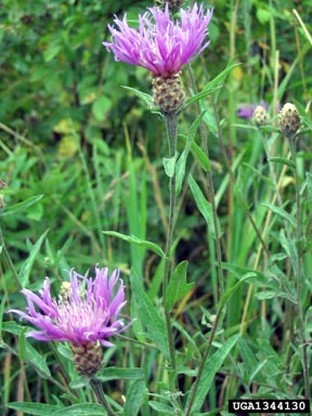
Majority opinion in Ridgway has forbidden the use of herbicides within town limits in the battle to eradicate weeds to the point where Town Council has passed a resolution that states that no chemical herbicides may be used. The problem, according to Mabry, is that the spotted knapweed (Centaurea maculosa), a non-native species, is spreading like wildfire along the banks of the river and something needs to be done about it. Spotted knapweed is designated as a “List B” species on the Colorado Noxious Weed Act and it is required to be either eradicated, contained, ore suppressed depending on the infestation. “My biggest concern is the spotted knapweed down along the river,” Mabry declared at council’s March 17 work session, showing pictures from last summer proving the weed has a stranglehold on the riverbanks. “As you can see, it is forming a monoculture by forcing out all the native species down there. I see this as a critical problem.”

More invasive species coverage here and here.

BLM proposes that the CWCB file for instream water rights on two Dominguez-Escalante Conservation Area creeks

A picture named sosidepikespeak.jpg

From The Grand Junction Daily Sentinel editorial staff:

The BLM has proposed an unusal plan for resolving the issue, under which the state may file for instream water rights for the two streams that run through a wilderness area in the [Dominguez-Escalante National Conservation Area]. The concept is one the Colorado Water Conservation Board should accept when it takes up the question in May. At the heart of the proposed solution is an agreement written into the federal legislation that created the NCA: If the state files for adequate instream water rights for the two wilderness creeks, the Interior Department won’t assert a federal water right…

The BLM has asked the state to seek a variable instream water right that recognizes streamflow can change dramatically. That’s not how Colorado instream flow rights have traditionally been appropriated in the past. A set minimum amount has been the typical filing. But a variable rights have been filed for a handful of other streams in the state.

Private water rights are also an issue. Even though the headwaters of both Big and Little Dominguez Creeks are both high up on the Uncompahgre Plateau in the Uncompahgre National Forest, there is private land within the national forest that depends on water from the two creeks. The BLM proposal recognizes that, and acknowledges rights will be senior to the state’s instream flow filings, and there will be some modest amount of water for additional future development of those rights.

More CWCB coverage here.

Aspinall Unit update

A picture named aspinallunit.jpg

From email from Reclamation (Dan Crabtree):

Current releases from Crystal Reservoir are about 600 cfs with corresponding flows in the Black Canyon and Gunnison Gorge. Periodically, 100 cfs is diverted through the Gunnison Tunnel to fill Fairview Reservoir reducing flows to 500 cfs for 36 – 48 hrs. The preliminary March runoff forecast from the Colorado Basin River Forecast Center shows an April through July inflow to Blue Mesa Reservoir of 570,000 ac-ft. If this forecast holds through May 1st, the Black Canyon Water Right would call for a one day peak flow of 4035 cfs. At this time Reclamation plans to continue to operate the Unit to allow the water right to be met.

As a reminder, the April Aspinall Operations meeting is scheduled for 1:00 p.m. on April 22nd at Reclamation’s Western Colorado Area Office in Grand Junction. The public is welcome. If you have possible agenda topics or questions please contact Dan Crabtree [dcrabtree@usbr.gov or 970-248-0652].

More Aspinall Unit coverage here and here.

Montrose: Prescription drug drop off at health fair March 13

A picture named genderbendingpollution.jpg

From the Telluride Watch:

Think of it as an annual physical for your medicine cabinet. The public is invited to drop off expired prescription drugs and medicines at the Montrose Memorial Hospital Health Fair on Saturday, March 13 at the Montrose Pavilion.

To help encourage proper disposal of prescription drugs, the Montrose Underage Drinking/Drug Task Force (UDDTF) will host the drug take back as its final public event. The UDDTF has served the Montrose region for seven years and closes its offices in February. MMH staff will provide a pharmacist on site to receive the expired medications and proper disposal will take place thereafter…

The March 13 Montrose Health Fair is open to the public from 6:30 a.m. to noon, offering a multitude of health screenings and blood testing. For more information about the Health Fair, contact the MMH Marketing Department at 970/240-7344.

More water pollution coverage here.

Mesa County Water Association to offer ‘The Water Course’ January 19, 27 and February 2

A picture named orchardmesa1911

From the Grand Junction Free Press (Sharon Sullivan):

What: “The Water Course” covering water law, water quality and balancing competing demands, sponsored by the Mesa County Water Association
When: Jan. 19 and 27, Feb. 2, 6-9 p.m. Registration due Monday, Jan. 11.
Where: GG City Hall Auditorium, 250 N. Fifth St.
Cost for entire series: $35 MCWA members; $45 nonmembers; Single session: $15 MCWA members; $20 nonmembers. Some scholarships..
Info: hannah@mesacountywater.org, or 683-1133, or http://www.mesacountywater.org

More from the article:

Studies estimate a 600,000 million-acre-feet shortage [ed. in the Grand Valley] by 2050, said Grand Junction Utility and Street System Director Greg Trainor, and a board member of the Mesa County Water Association.

The MCWA was first formed 25 years ago by the late Ruth Hutchins, a Fruita farmer concerned about a proposal that would pump water from the Western Slope to the Front Range. Citizens, irrigators and government leaders held “Water 101” courses on controversial water topics for many years. After several years of inactivity, the MCWA was resurrected a year ago by Trainor and Hannah Holm to resume educating people on water issues affecting the Western Slope. The association is governed by a seven-member board of directors. “Current water laws serve the valley well, but it really behooves people to appreciate the resource and protect it as the water situation gets tighter,” said Holm, MCWA coordinator. “We can’t stay in our bubble forever.”[…]

A three-part water course series starts Tuesday, Jan. 19, at Grand Junction City Hall Auditorium. The first course will address water law; how the valley’s water rights relate to the water rights of California and Denver; and who is responsible for irrigation water once it leaves a canal…

The Jan. 27 course will cover laws and programs that seek to protect and clean up Colorado waterways, the condition of Grand Valley rivers and streams, and how drinking water is protected and treated. The February course will explore threats to irrigated agriculture as cities grow; environment and recreation water needs; and how the Grand Valley could change with drought and increasing competition for water.

More Colorado River Basin coverage here.

Montrose scores $75,000 grant from GOCo for ‘Montrose Comprehensive Uncompahgre Riverway Master Plan’

A picture named uncompahgreriver.jpg

From The Telluride Watch (Beverly Corbell):

The grant, written by City Park Planner and Project Manager Dennis Erickson, will be used to develop “the first-ever Montrose Comprehensive Uncompahgre Riverway Master Plan,” according to the city’s website.

With a plan in place, the city will have “a valuable tool for directing its long-term efforts toward maintaining the beauty of the Uncompahgre River for generations to come.” But there’s more than beauty to be preserved, Erickson said, and the plan could look at possible development of water sports like kayaking. “It will be multi-objective with numerous interests and stakeholders taking part,” he said. “We want different perspectives on what should happen with the river.” The Montrose City Council must first adopt a resolution to sign the GOCO grant, which Erickson said he hopes will happen at the Jan. 7 meeting.

More Uncompahgre River watershed coverage here and here.

Energy policy — hydroelectric: Projects in Silverton and Ouray score dough for micro hydroelectric

A picture named microhydroelectricplant.jpg

From the Telluride Daily Planet (Katie Klingsporn):

Telluride Energy was awarded a $20,000 grant from the USDA Rural Development Renewable Energy for America Program this fall to install an 8-kilowatt micro-hydro turbine at the Mayflower Mill in Silverton. The company will be working with the San Juan County Historical Society to tap into water that flows through an existing pipeline in the Arrastra Gulch a couple miles east of the town. Once completed, the project will reduce carbon dioxide emissions by roughly 80,000 pounds annually, Johnson said.

In Ouray, meanwhile, the city was last week awarded a $30,000 grant from the Colorado Governor’s Energy Office to install a 20-kilowatt micro-hydro unit at the city-owned hot springs pool. Telluride Energy will be managing the project, which will again entail using an existing pipeline. The electrical output produced will offset the electric use at the pool, and over the 30-year life of the project it will save the city an estimated $370,000 while cutting approximately 224,000 pounds of annual carbon dioxide emissions.

More hydroelectric coverage here.

Ouray: Stimulus dough to help with funding 20 kilowatt micro hydroelectric generation plant

A picture named microhydroelectricplant.jpg

From The Telluride Watch:

The City of Ouray has been awarded a $30,000 grant from the Colorado Governors Energy Office to install a 20 kilowatt micro-hydro generating unit to be located at the Ouray Hot Springs Pool…

The project will take advantage of an existing, currently underutilized pipeline adjacent to the pool site. The electrical output from the system will be net-metered to offset the electricity use of the pool complex, saving the city approximately $12,000 in annual electricity expenditures. The powerhouse for the project will be constructed by a shop class from Ouray High School. Once completed, the project will provide an added tourist attraction to visitors to Ouray Hot Springs. Over the 30 year life of the project, the city will save approximately $370,000 – not accounting for expected electricity price increases. The project will also provide an opportunity for local students to participate in development of a clean energy project, and will avoid approximately 224,000 pounds of annual carbon dioxide emissions.

More hydroelectric coverage here and here.

Uncompahgre River: ‘Examining Abandoned Mine Lands in the Uncompahgre Watershed’ December 11

A picture named big5tunnel.jpg

From The Telluride Watch (Gus Jarvis):

The Uncompahgre Watershed Planning Partnership will be hosting a daylong workshop titled “Examining Abandoned Mine Lands in the Uncompahgre Watershed” on Friday, Dec. 11 from 9:30 a.m. to 3:30 p.m. at the Ouray Community Center. Various representatives from state and local organizations will be attending the workshop, which will focus on reclamation activities and abandoned mine lands in the upper Uncompahgre watershed. The workshop’s organizer, Andrew Madison, who is an AmeriCorps VISTA (Volunteers in Service to America) volunteer working in Ridgway to develop a mine reclamation strategy for abandoned mine lands in the watershed, said that while there has already been a lot of mine reclamation work completed in the area, the work has just begun…

The Uncompahgre Watershed Planning Partnership is a volunteer group seeking to involve citizens and organizations in the Uncompahgre watershed. Its mission is to protect and restore water quality in the Uncompahgre River through coordinated community and agency efforts. “I am really looking forward to the workshop,” Madison said. “I have had a great response so far and I am looking forward to getting people to talk to each other on these issues.” For more information about “Examining Abandoned Mine Lands in the Uncompahgre Watershed” contact Madison at 413/297-7232 or at ridgway.vista@gmail.com.

More Uncompahgre River watershed coverage here and here.

The Uncompahgre Watershed Planning Partnership to host workshop focusing on reclamation activities and abandoned mine lands issues in the upper Uncompahgre Watershed December 11

A picture named uncompahgrewatershed.jpg

Here’s the release from the UWPP via the Delta County Independent:

The Uncompahgre Watershed Planning Partnership will be hosting a day long workshop focusing on reclamation activities and abandoned mine lands issues in the upper Uncompahgre Watershed. The program, titled: “Examining Abandoned Mine Lands in the Uncompahgre Watershed” will be held on Friday, Dec. 11, from 9:30-3:30 at the Ouray Community Center.

According to the workshop’s organizer, Andrew Madison, this event will bring together representatives from state, local and federal agencies, as well as local organizations and industry representatives to discuss how different agencies are handling AML issues as well as future strategies for remediating and safeguarding abandoned mine sites. The workshop will involve short presentations as well as a roundtable discussion focusing on data sharing and prioritizing abandoned mine sites for future reclamation. Participants will include the U.S. Forest Service, Bureau of Land Management, Division of Reclamation and Mining Safety, Trust for Land Restoration, Trout Unlimited, the Red Mountain Project and many others.

Abandoned mines can pose many hazards both to people and environment through un-safe mine openings and structures as well as soils and surface water contamination from acid mine drainage and abandoned mine waste. However these sites are an important part of the culture and heritage of Ouray County and provide a unique glimpse into the past for tourists and younger generations. Through proper management, reclamation and safeguarding, the hazards of these sites can be remediated while preserving cultural aspects.

The Uncompahgre Watershed Planning Partnership is a volunteer group seeking to involve citizens and organizations in the Uncompahgre Watershed. Its mission is to protect and restore water quality in the Uncompahgre River through coordinated community and agency efforts.

For more information about “Examining Abandoned Mine Lands in the Uncompahgre Watershed” contact Andrew Madison at 413-297-7232 or Ridgway.vista@gmail.com

More Uncompahgre River watershed coverage here and here.

Uncompahgre River: Montrose River Corridor Work Group reaches consensus on recommendations for the riparian environmnent

A picture named uncompahgreriver.jpg

From the Montrose Daily Press (Katie O’Hare):

Thursday — after five, two-hour meetings spanning over the past few months – the work group presented their recommendations to Montrose City Council during its work session. “It was a balance between property rights and protecting the river,” said group member Shawn Lund, a local boater and teacher. The group was able to reach a major agreement, being that a river buffer was needed in Montrose to preserve the river and riparian environment, protect water quality and wildlife habitat, preserve the view shed and to provide clarity and guidance to future development, said group member Ben Tisdel, local developer and member of Friends of the River Uncompahgre (FORU)…

The group agreed that there should be an overall buffer of 100 feet from the average yearly high water mark (HWM), and within that 100-foot buffer, there’s to be two different zones, a “no-go zone” and “slow-go zone.” (Disagreements arose on the width of the no-go zone.) The no-go zone would be 40 feet from the HWM. Within this area, there would be no buildings, linear trials or disturbance of native riparian vegetation allowed. However, short-distance, soft surface trails and usual, customary uses, such as a boat ramp, would be allowed. The slow-go zone would be the area between 40 feet and 100 feet. To develop within this zone, a person would need to obtain city permission, such as a special use permit. The method would be decided by city staff, Tisdel said, and could be processed through the planning commission similar to other permits. Any development within the slow-go zone must enhance the river corridor, such as a business that faces the river with a patio. Those that to not enhance the river corridor, such as a warehouse, would need to be screened. The group recommended that there be stricter “performance standard” as one gets closer to the 40-foot zone and that city staff work out such details, like requiring a building to sit as far back on the lot as possible. Residential single-family homes are exempt from the screening requirement.

More Uncompahgre River watershed coverage here and here.

CWCB: Montrose County instream flow water rights public meeting

A picture named uncompahgreriver.jpg

From email from the Colorado Water Conservation Board (Rob Viehl):

The Stream and Lake Protection Section of the Colorado Water Conservation Board is holding a public meeting to discuss the potential appropriation by the Board of new instream flow water rights in 2010 in Montrose County, and the current status of the Board’s acquisition of the UMETCO water rights.

The following stream segments in Montrose County are being considered for instream flow protection at this time: North Fork Tabeguache Creek, Red Canyon Creek, San Miguel River, and Tabeguache Creek.

Additional streams that are being considered for appropriation in 2010 in Water Division 4 include: Alpine Gulch, Big Dominguez Creek, Blue Creek (Increase), Cebolla Creek, Cochetopa Creek, East Beaver Creek, Little Dominguez Creek, Spring Creek, and Willow Creek.

Detailed information concerning these proposed instream flow water rights can be found at: http://cwcb.state.co.us/StreamAndLake/NewAppropriations/ISFAppropriationNotices/2010ProposedAppropriations/

The meeting will take place at 7:00 p.m. on November 5, 2009, and will be held in the Norwood Town Hall/Community Room, 1670 Naturita Street, Norwood, Colorado. Questions may be directed to Jeff Baessler at 303-866-3441.

More San Miguel watershed coverage here and here.

Black Canyon of the Gunnison National Park turns ten

A picture named blackcanyoninnercanyonnps.jpg

From the Montrose Daily Press (Kati O’Hare):

“The national park status is very special,” current park Superintendent Connie Rudd said. “What’s important is that the canyon is still the same and that means we’ve done our job.”[…]

Former legislators, along with Bureau of Land Management and Forest Service leaders, discussed their decades-long endeavor involving perseverance and public involvement that gave the canyon its new name.

More Gunnison River Basin coverage here.

Delta-Montrose Electric Association hopes to provide 5% of maximum annual demand with small hydroelectric generation plants

A picture named microhydroelectricplant.jpg

From the Telluride Watch (Alan Best):

The co-operative announced [recently] that it will apply to the U.S. Bureau of Reclamation, which administers the Gunnison Tunnel, to develop enough electricity to equal 5 percent of the co-op’s maximum annual demand. As the energy landscape changes, other jurisdictions across Colorado and the West have similarly been re-examining their assets. Small hydro-projects produce far less electricity than most coal-fired power plants, or the giant dams on the Colorado River. But they can do so without generating carbon dioxide emissions and often without increasing other environmental impacts…

The projects, says Joani Matranga, Western Slope representative for the Governor’s Energy Office, would use primarily existing infrastructure and diversions, resulting in minimal environmental impacts. “We’re not building any new dams,” she says. “We think there is still plenty of potential to go after.”[…]

The effort to harness the irrigation canal east of Montrose is part of a broad effort to reverse this decades-old trend toward centralized generation of electricity using fossil fuels. Delta-Montrose Electric Assn. officials say that local power generation produces local jobs, and will insulate electrical customers from rising costs for coal. Those costs will almost certainly rise even more if the federal government adopts a cap-and-trade regime on carbon dioxide emissions, as proposed in the Waxman-Markey bill.

“If this project moves forward through the federal permitting process – and I am confident it will – DMEA’s membership will benefit in many ways, “ said DMEA General Manager Dan McClendon. “Money we would have otherwise exported out of our community for wholesale electricity will be retained in our own community,” he said. He went on to explain that even without grants or other financial assistance, the cost – about $25 million to $30 million – will deliver electricity comparable to the existing wholesale rate…

Unlike some proposals of the past, DMEA has no plans to harness the full power of the falling water. Water from the Gunnison drops 372 feet in as series of churning, roiling steps as the irrigation ditch, called the South Canal, winds around the dun-colored adobe hills east of Montrose. DMEA plans to yoke power from just 120 feet in that fall…

Some small towns – including Hotchkiss and Cortez – have installed small hydro components into their existing water delivery systems, to harness the power of falling water. Aspen does the same, and Hines, that city’s utility engineer, points out that even towns in the Midwest with water towers could tap the power of falling water. Elsewhere in southwestern Colorado, Eric Jacobson has refurbished several small hydro-power plants, such as a 500-kilowatt plant at Bridal Veil Falls in Telluride and a 150-kilowatt plant in Ouray. A variety of other small hydro projects are also scattered across mountainous areas of Colorado.

More coverage from The Telluride Watch (Beverly Corbell):

Both President Teddy Roosevelt and President Howard Taft spoke at Saturday’s 100th anniversary celebration of the opening of the Gunnison Tunnel, but the biggest news of the day came from President Dan McClendon. McClendon, president of the board of directors of the Delta-Montrose Electric Association, announced that his cooperative and the Uncompahgre Valley Water Users Association, sponsors of the event, would collaborate to build a hydroelectric plant on South Canal as it leaves the Gunnison Tunnel. “This will bring clean, renewable energy into DMEA’s system and will be one of the largest renewable electric facilities in western Colorado,” McClendon said. “It will keep money in our community and keep millions of dollars here in our area.”

More hydroelectric coverage here and here.