Simple strategies to save water at home: From faulty flappers to shorter showers, every drop counts during #drought — Jay Adams (DenverWater.org)

March 24, 2026

Colorado is in a severe drought, and simple indoor water conservation measures can lead to big savings when everyone pitches in.

Free and easy

  • Turn the water off while brushing your teeth or washing your face.
  • Limit showers to 5 minutes (or try to shorten them by 1-2 minutes).
  • Only run your dishwasher and washing machine with a full load.
  • Turn off the kitchen faucet when handwashing dishes.

“A drought is a great time to teach kids, or anyone, about the importance of conserving water,” said Greg Fisher, Denver Water’s manager of demand planning. “Simple lifestyle changes can become lifelong habits.”

Fixing leaks

Across the U.S., Americans waste about 1 trillion gallons of water every year through water leaks and spend about 10% of their water bill on wasted water, according to the EPA.

The biggest water waster in the home is the toilet. The EPA reports that an average leaking toilet can waste about 200 gallons of water every day.

Learn more about finding and fixing toilet leaks.

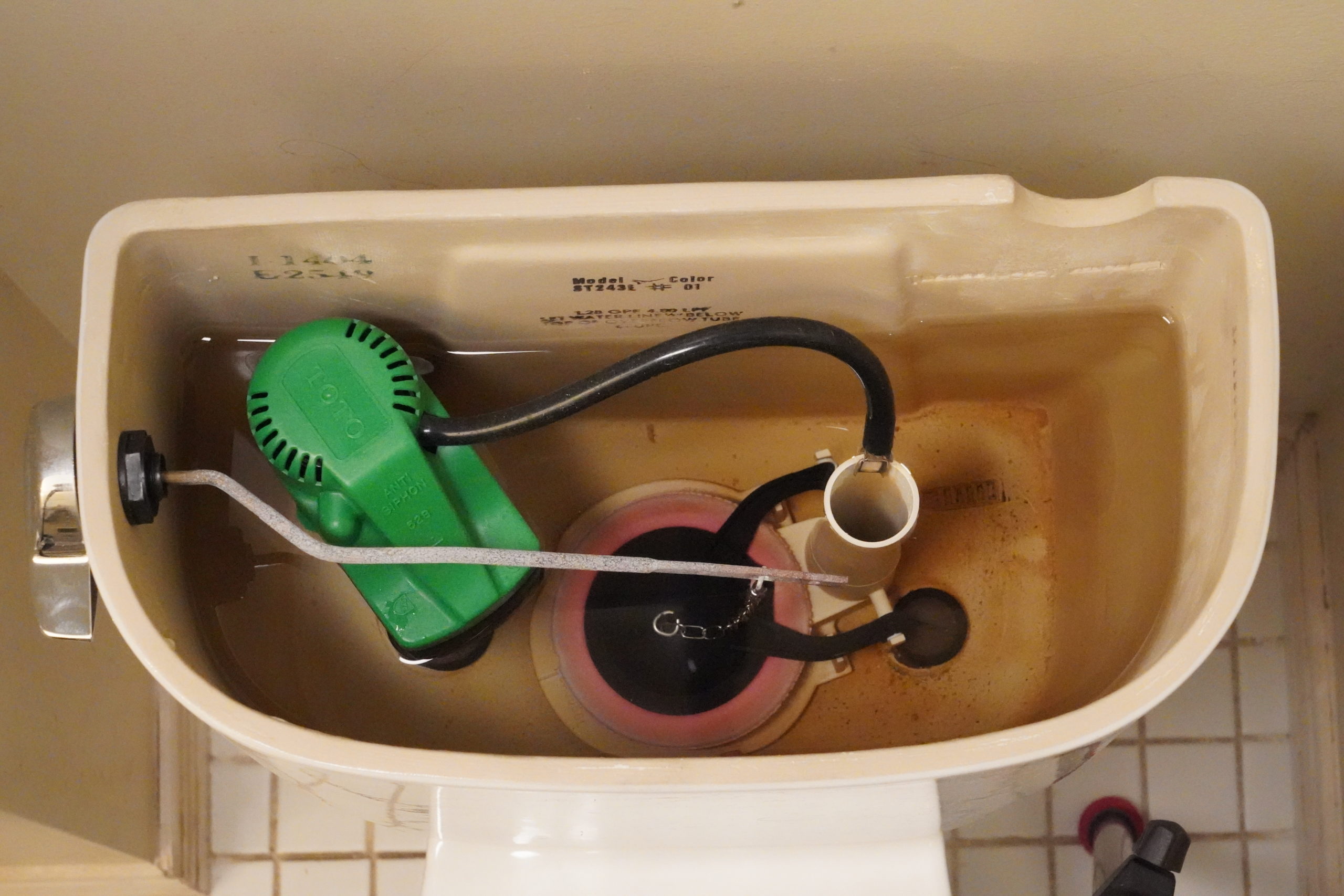
This toilet has a small, almost undetectable leak through its pink, circular flapper on the bottom of the tank. Some leaks can be detected by listening to hear if water is coming into the tank after it’s done filling. Faulty flappers are a leading cause of toilet leaks. Photo credit: Denver Water. Photo credit: Denver Water.

In addition to checking for toilet leaks, inspect all water sources in your home, including faucets, showers, water supply lines for dishwashers, washing machines, swamp coolers and ice machines.

Small leaks can add up over days and weeks. A small leak of 10 drops per minute can waste 300 gallons of water per year. Not only can these leaks add to your water bill, but they can also damage your home.

Find out how to do a self-audit of your home’s plumbing to help find and fix leaks.

Denver Water also encourages customers to review their monthly water bills. Unusually high water usage could indicate you have a leak.

Toilet rebates for low-flush toilets

Older toilets are another big water waster.

Some older toilets can use anywhere from 3.5 gallons to 7 gallons per flush, while newer toilets on the market use as little as 0.6 gallons per flush.

A family of four using 3.5 gallons per flush can use 26,000 gallons of water per year, compared to 11,000 with a newer, efficient model.

If you are interested in replacing an older toilet with a more efficient one, check out Denver Water’s toilet rebate program.

Denver Water offers rebates to help customers replace old toilets with newer, more efficient models that can save thousands of gallons of water every year. Image credit: Denver Water.

Replace old fixtures and appliances

While many water-saving fixes are free or relatively inexpensive to do, the EPA says the average family can save 13,000 gallons of water by updating older washing machinesdishwashersshowerheadsfaucets, and aerators with more efficient models.

When buying new appliances and fixtures, purchase products that carry an Energy Star or WaterSense label, an indication that the product uses less energy or water compared to products that don’t carry those labels.

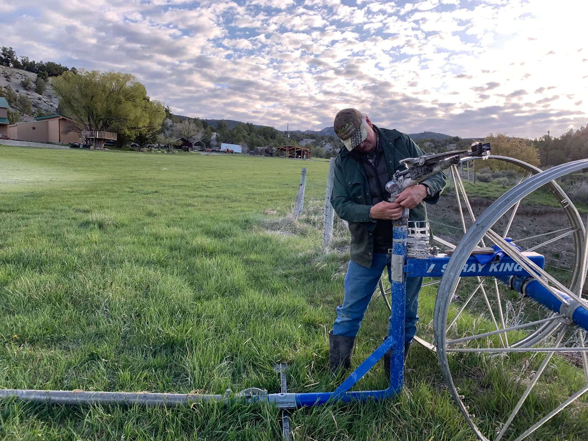
Replacing faucet aerators is an easy way to save water. New aerators slightly reduce the flow of water without impacting the performance of the faucet. Photo credit: Denver Water.

#Denver Water, Xcel enact plan to ease shortages: Shoshone call relaxation allows Front Range water provider to divert more until May 20 — Heather Sackett (AspenJournalism.org) #ColoradoRiver #COriver #aridification

An Xcel truck outside the Shoshone hydropower plant in Glenwood Canyon. Denver Water has enacted with water rights owner Xcel to implement a call reduction agreement, which lets the Front Range water provider divert more water for a limited time. CREDIT: BRENT GARDNER-SMITH/ASPEN JOURNALISM

Click the link to read the article on the Aspen Journalism website (Heather Sackett):

March 31, 2026

Facing an abysmal snowpack and spring runoff, the state’s largest Front Range water provider has enacted an agreement that lets it take more water from the Western Slope for a limited time.

On March 18, Denver Water put the Shoshone call reduction agreement into effect with water rights owner Xcel Energy, which allows Denver Water to divert more water from the headwaters of the Colorado River in an attempt to alleviate shortages. The agreement reduces the call at the Shoshone hydroelectric plant in Glenwood Canyon by half, from 1,408 cfs to 704 cfs. 

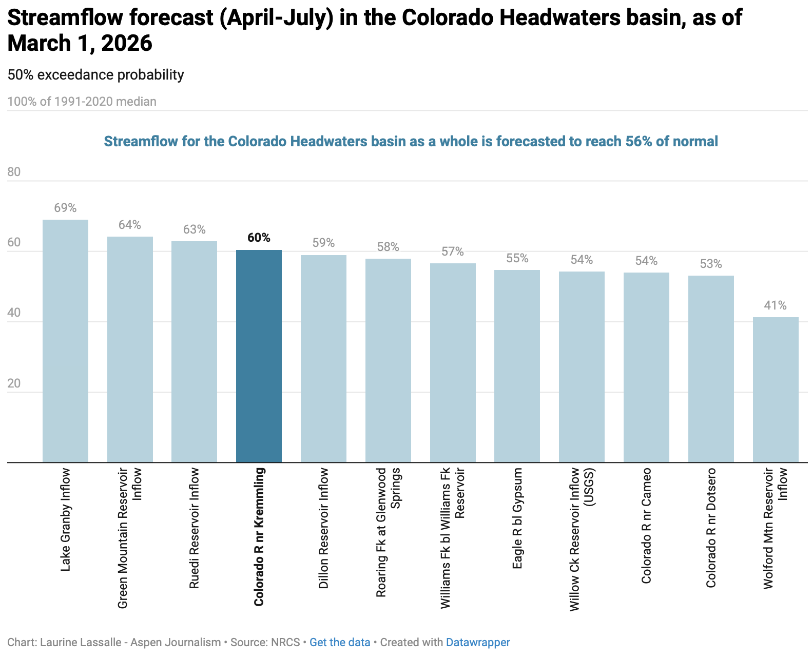
The call reduction can only be implemented when two drought conditions are met: an April to July streamflow forecast for the Colorado River measured at the Kremmling stream gauge must be at 85% or less than average and the forecasted storage for the 10 largest Denver Water reservoirs for July 1 must be at or below 80% full.  

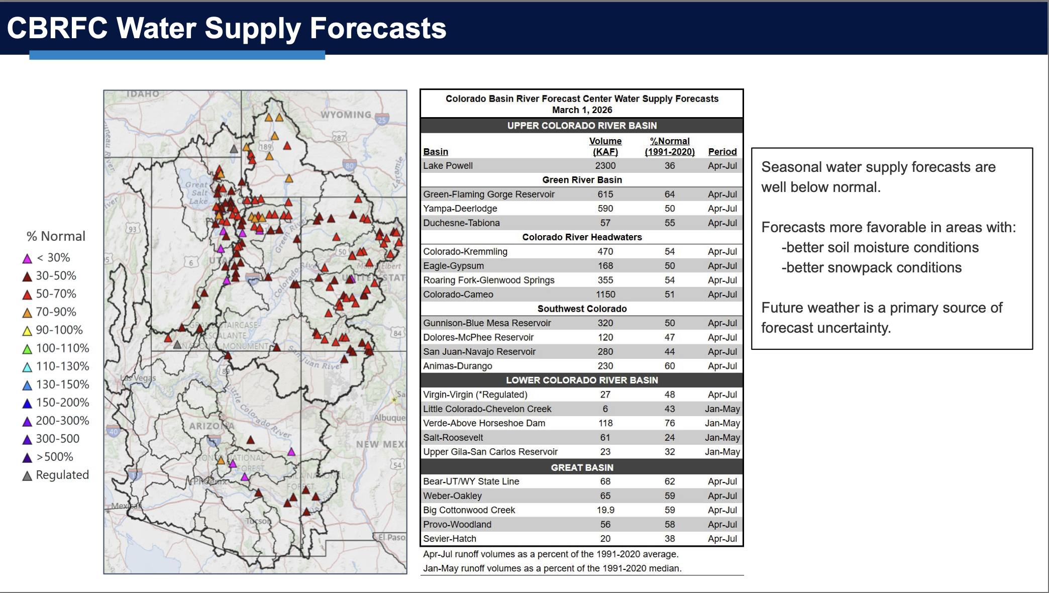
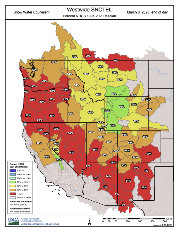
The March water supply outlook from the National Resources Conservation Service for the Colorado headwaters from Kremmling to Glenwood Springs was 56% of normal. Experts expect conditions to have worsened when the April forecast comes out next week.

This winter is shaping up to be one of the worst on record and since water supplies depend on snowmelt, municipal water providers have been quick to implement cutbacks this spring. Last week, Denver Water declared a Stage 1 Drought and will impose two-day-a-week outdoor watering restrictions this summer.

“In the wake of the worst snowpack conditions in some 50 years of records at Denver Water, we began exercising the Shoshone Relaxation Agreement with Xcel Energy starting March 18,” Denver Water’s Media Relations Coordinator Todd Hartman said in an email. “We have taken this step only one other time under the 2007 agreement with Xcel (2013) and we don’t do so lightly.” 

According to the agreement, Denver Water will be able to divert additional water until May 20.

The water provider, which serves about 1.5 million people on the Front Range, gets roughly 50% of its supply from the Colorado River basin and brings it across the Continental Divide through a highly engineered system of tunnels and reservoirs that facilitate the so-called transmountain diversions. 

The Shoshone water rights, which date to 1902, are some of the largest and most powerful on the mainstem of the Colorado River in the state. They can command the river’s flows all the way to its headwaters, ensuring water keeps flowing downstream on the Western Slope. 

When the plant’s turbines are spinning, it can “call” for its full water right, effectively forcing upstream water users with junior rights – like Denver Water – to cut back. And because the water is returned to the river after it runs through the plant’s turbines, Shoshone benefits downstream cities, irrigators, recreators and the environment on the Western Slope.

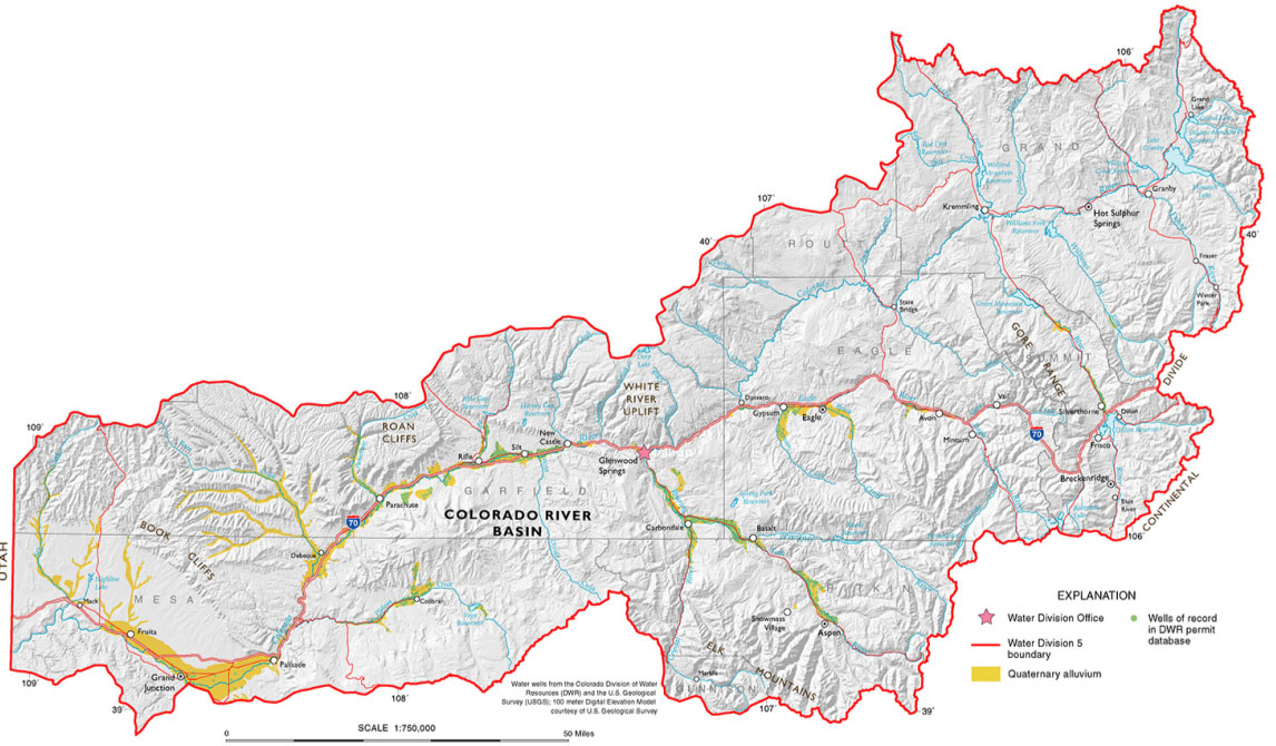
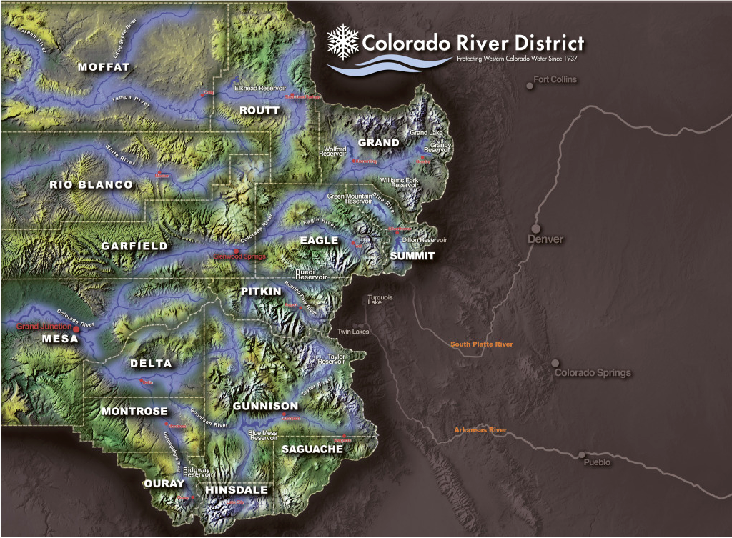
Colorado River Basin in Colorado via the Colorado Geological Survey

‘There is no good news’: Water users warned of dire irrigation season, the worst on record — The #Montrose Press #snowpack #runoff #UncompahgreRiver

Click the link to read the article on the Montrose Press website (Katharhynn Heidelberg). Here’s an excerpt:

March 28, 2026

With far less snowpack in the high country this year and an anemic runoff forecast, the Uncompahgre Valley is positioned for a terrible irrigation season. Water users association Manager Steve Pope did not mince words.

“This is the worst year on record so far for snowpack. Looking at the fact that it’s pushing 90 degrees outside in March, we aren’t going to be able to expect much of a runoff,” Pope said on Wednesday, one week before water deliveries begin on April 1, ” … There is no good news.”

The Uncompahgre Valley Water Users Association will only be delivering allocations to shareholders of 50% to start, and, if water models remain consistent, will cut delivery to 40%. No pump contracts can be filled this year, although there will be credits for next year for paid accounts. Shareholders who pump directly from an association canal or lateral must register pumps and install meters and regulating valves for the deliveries. As well, people are being asked to reconsider lawns and large-scale landscaping to conserve every drop possible for agriculture…

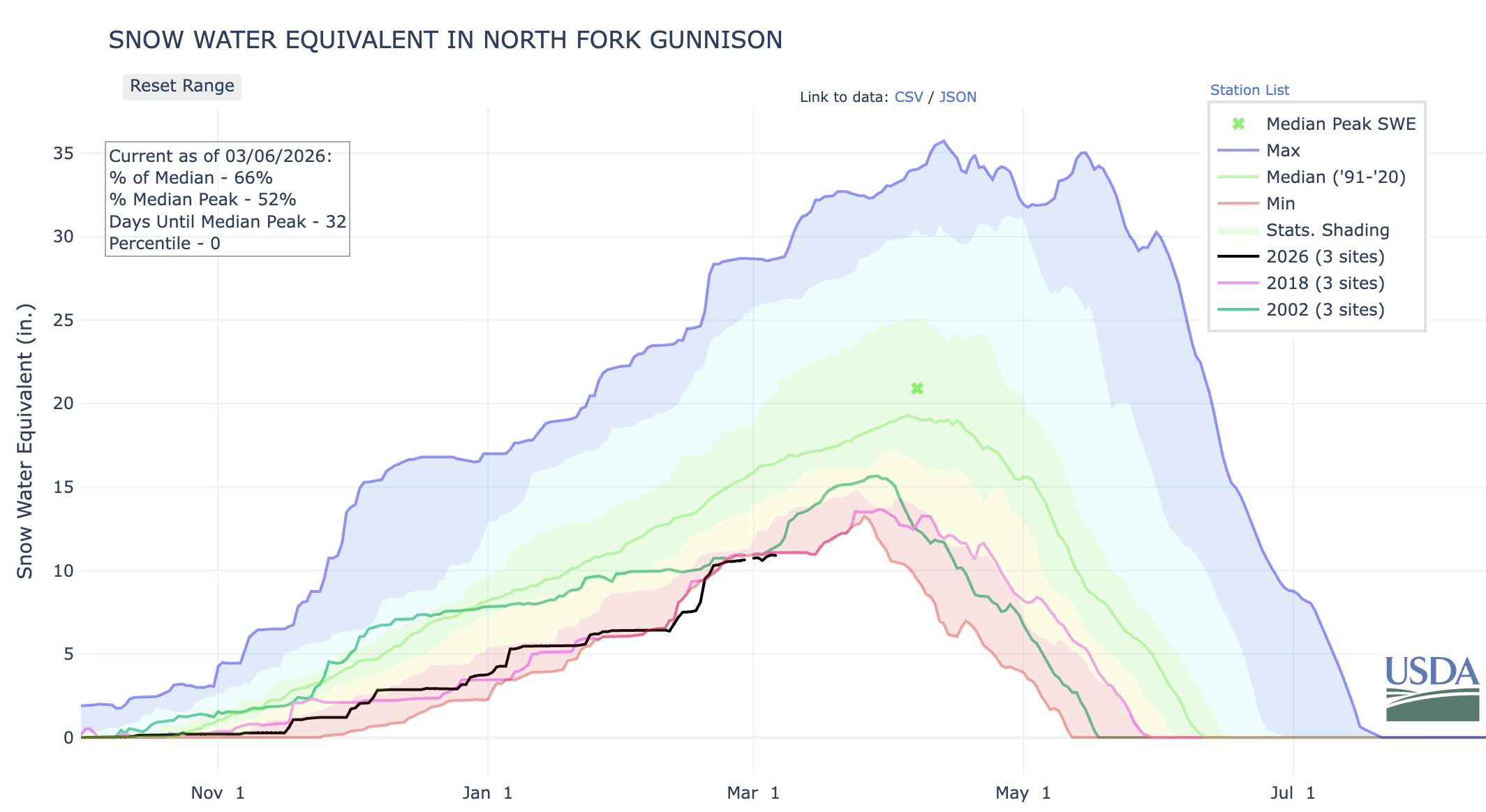
Runoff projections within the Uncompahgre Basin are worrying. The Colorado River Basin Forecast Center operates SNOTEL sites that measure snowpack and snow water equivalent, the amount of water the snow holds. Ideally, there would be robust snowpack and SWE, as well as weather conditions conducive to slower melt, leading to prolonged runoff. That isn’t the case this year…2026 is on track to turn out even worse than 2002, the leanest water year this century — but even 2002 was bookended with decent water years before and after…Pope said the Colorado River Basin Forecast Center is projecting a 50% chance of the local watershed seeing about 53,000 acre feet of runoff…The water users association can’t really rely on natural flow from the Uncompahgre River this year, Pope said, but he does anticipate enough to fill Ridgway Reservoir. Beyond that, however, “it’s not very promising.” Overall weather conditions compound the problem of so-so snowfall during the winter: it’s been warmer far up in the high country, too. Pope said that at the 12,200-foot elevation Swamp Angel study site maintained by the Silverton-based Center for Snow and Avalanche Studies, it’s only been getting down to a few degrees below freezing at night. (This site had a measured snow water equivalent of 13.4 inches as of March 15.)

“If it’s not freezing at night, there’s nothing to slow the runoff down. They said the dust isn’t as bad this year. That is somewhat of a silver lining. We haven’t had the wind, so the dust isn’t quite as bad,” said Pope. Dust accelerates snowmelt.

Map of the Gunnison River drainage basin in Colorado, USA. Made using public domain USGS data. By Shannon1 – Own work, CC BY-SA 4.0, https://commons.wikimedia.org/w/index.php?curid=69257550

Spring runoff flows reaching levels usually seen a month later: Tighter water-conservation rules, recreational river closures looming for summer — #SteamboatSprings Pilot & Today #YampaRiver

Click the link to read the article on the Steamboat Pilot & Today website (Suzie Romig). Here’s an excerpt:

March 26, 2026

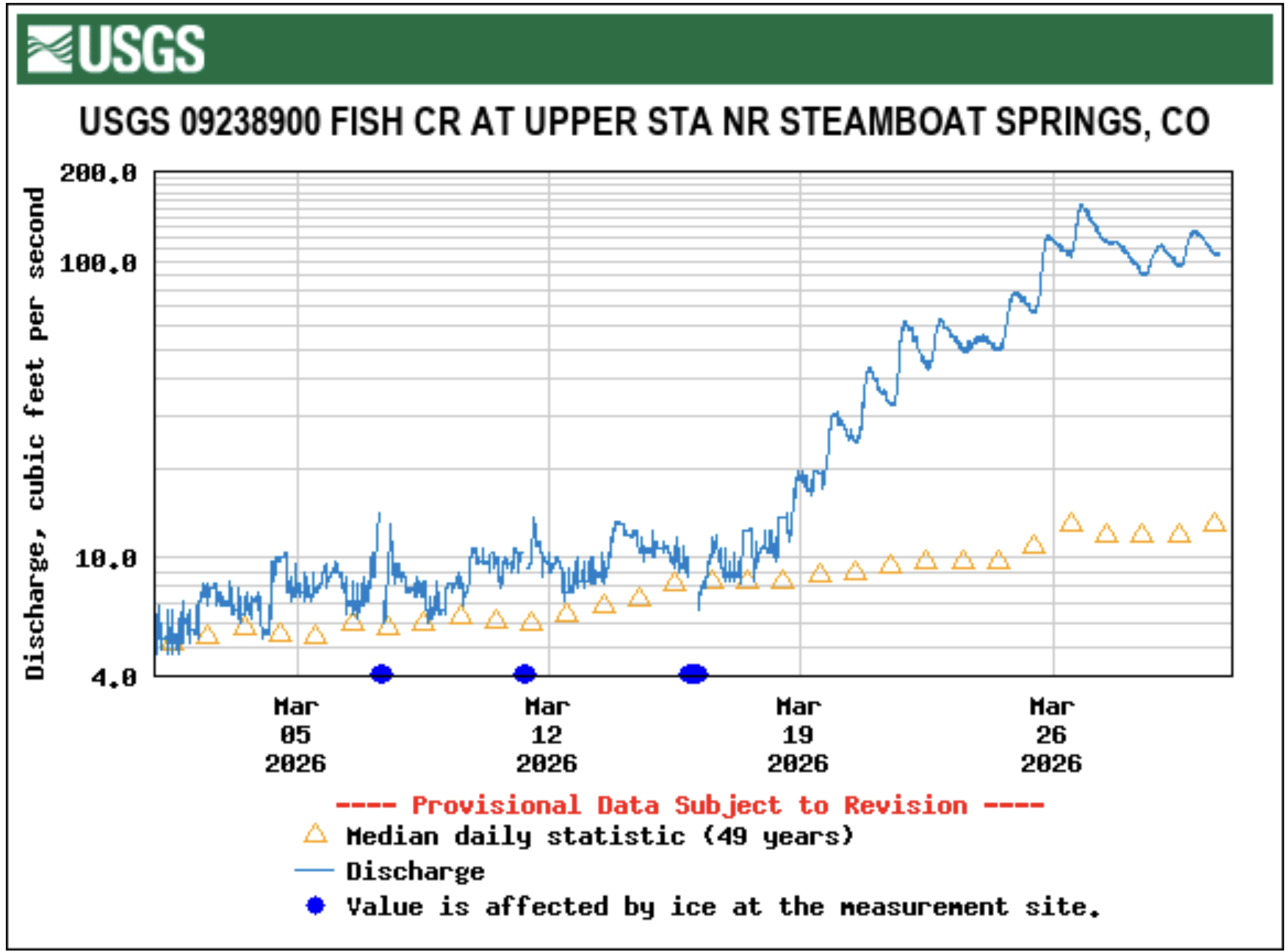
With the quicker snowmelt and earlier drying out of pasturelands, runoff volumes in creeks are hitting levels now that usually occur a month later in the spring, leading area ranchers to activate irrigation ditches weeks earlier than usual. Runoff flowing down Fish Creek, the primary water source for the city of Steamboat Springs, is almost one month ahead of the historical average. At 9 p.m. March 21, the flow displayed by the U.S. Geological Survey gauge on Fish Creek near the Fish Creek Water Plant east of Steamboat Springs showed 62 cubic feet per second. That volumetric flow rate is usually seen on April 18, according to gauge records from 1966 to 2025…“Over the last two years, it’s definitely running sooner than average,” said Frank Alfone, general manager at Mount Werner Water and Sanitation District. “It just means the possibility of having to release from Fish Creek Reservoir earlier in the season because there is less water in the creek.” The water gauge on Fish Creek historically records a peak seasonal flow of 464 cfs on June 8, but this summer the peak will occur much sooner than average. For waterfall fans, that also means highly visited Fish Creek Falls figures to be at peak flow three to four weeks sooner than its average early June date, Alfone noted…Fish Creek Reservoir on Tuesday was sitting at 47% of fill capacity, a normal level for this time of year, and that percentage continues to increase, Alfone noted. As a major year-round water source for the community, Fish Creek Reservoir water managers do not want that level to drop below 30%, Alfone said.

Yampa River Basin via Wikimedia.

The water footprint of #Arizona’s copper mines: Agriculture guzzles more water, but mines are drying up springs and streams nonetheless — Jonathan P. Thompson (LandDesk.org)

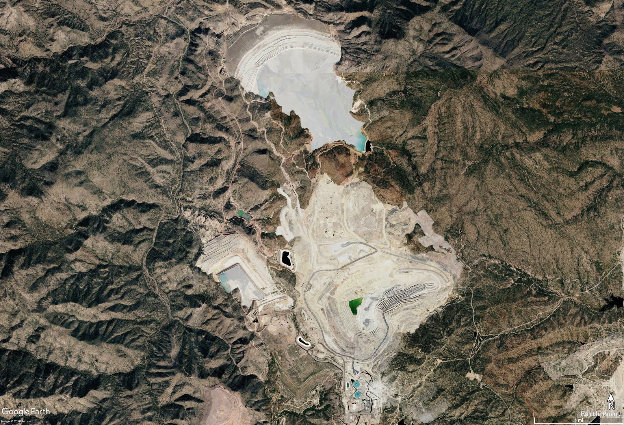
The Pinto Valley Mine, processing area, and tailings depositories in the Globe-Miami mining district. Pinto Creek is to the viewer’s left. Source: Google Earth. 

Click the link to read the article on The Land Desk website (Jonathan P. Thompson):

March 24, 2026

⛏️ Mining Monitor ⛏️

Pinto Creek used to run year-round. Bubbling up from springs and occasional snowmelt in the Pinal Mountains of central Arizona, it nourished a riparian ribbon of green through the rocky, arid landscape, shaded by sycamores, willows, and alders, until it empties into Theodore Roosevelt Reservoir. Gila topminnow, longfin dace, and roundtail chub plied its waters. Even during drought years it reliably delivered at least 1,000 acre-feet of water at its Magma Weir gauge, and in wet times as much as 39,000 acre-feet annually might flow along its bed.

Then, a little over a decade ago, something odd happened. The flow volume plummeted from 4,147 acre-feet in 2013 to just 482 acre-feet in 2014, and ever since the once year-round stream has run only intermittently and at similarly diminished levels. Towering trees along its banks have died and toppled, and the green swath has lost much of its color. It’s possible that long-term aridification simply caught up with the little stream, as 2013 was a dry year. But there’s a more likely culprit: In October 2013 Capstone Copper Corporation acquired the nearby Pinto Valley Mine, a massive, open pit copper and molybdenum operation that had just emerged from several years of dormancy, and resumed heavy groundwater pumping from its Peak Well field.

While correlation is not causation, the Tonto National Forest saw enough evidence of a link to ask the Arizona Department of Water Resources to put the brakes on the mine’s groundwater pumping. Failing to do so would harm the Forest Service’s instream Pinto Creek water right — along with the downstream riparian ecosystem it supports. The state did nothing and the Forest Service dropped the complaint and approved the mine’s expansion in 2021.

The Land Desk has often looked at mining’s effects on water quality.1 But the Pinto Valley case highlights the fact that mines can also affect water quantity — and vice versa, as water scarcity can limit mining operations. It warrants a closer look during these water-constrained times, when water consumption by everything from data centers to golf courses to alfalfa farms has attracted more scrutiny.

A mining operation goes through water in two ways. First, the mine itself, whether underground or open pit, can act like a well. Dig a hole into the earth, and groundwater will flow into it. While gravity can drain this flow in underground mines burrowed into the sides of mountains, the water must be pumped from open pit and underground shaft mines, a practice known as dewatering, which can take large amounts of water out of the aquifer. Capstone says it pumps about 400 gallons per minute from its pit.

Berkeley Pit and Yankee Doodle tailings pond: Butte, Montana. By NASA – http://www.nasa.gov/multimedia/imagegallery/image_feature_697.html, Public Domain, https://commons.wikimedia.org/w/index.php?curid=20856275

This draws down groundwater wells and can dry up springs and diminish streamflows. Without dewatering, you end up with something like the Berkeley Pit, which is now a 50-billion-gallon, acidic and contaminated lake that’s about 900 feet deep. Because this water is usually contaminated by acid mine drainage, it often can’t be reused without some treatment, and dumping it into a stream or back into the aquifer is also problematic.

A mining operation also requires significant amounts of water for dust control, mineral processing, slurrying, and other uses. Capstone’s 2024 sustainability report says its Pinto Valley Mine withdrew a total of 8,932 acre-feet — or 2.9 billion gallons — of groundwater and surface water.

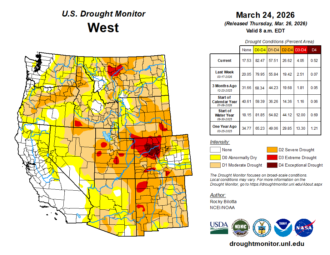
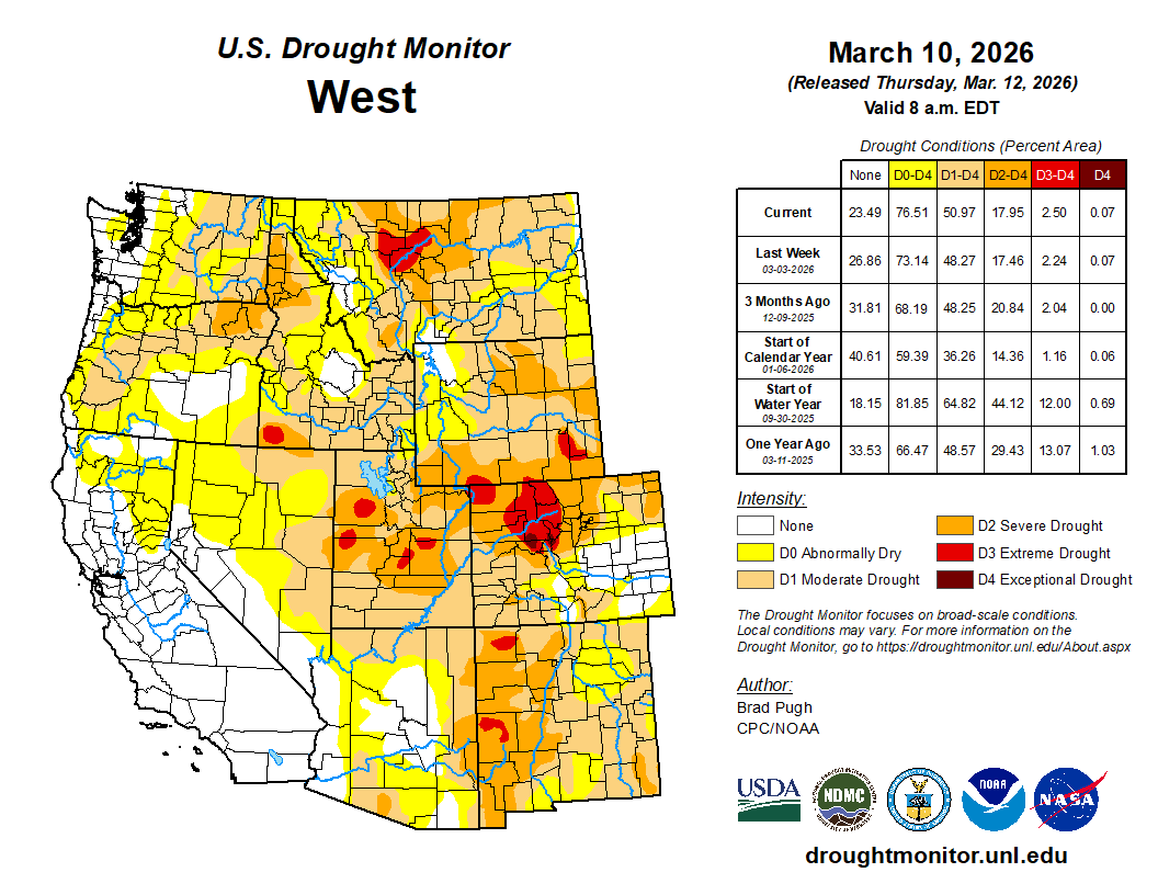
West Drought Monitor map March 24, 2026.

The company has not released its 2025 data yet, but in financial filings reported that the Pinto Valley Mine had to slash mine production and mill throughput by about 37% in 2025 due to “unplanned downtime driven by water constraints due to the drought conditions in central Arizona.” The company is trying to address this by reducing per-ton water usage by 20%, but that may not be enough given the extreme drought conditions spreading across the Southwest.

A central clearing house or database of mine water use in Arizona does not exist, but various sources can help paint a picture of how much water the mining industry in the state uses (I’ll look at other states in a future dispatch).

  • Safford Mine Complex: Consumptive water use increased from 3,624 acre-feet per year to 6,099 af/yr following a 2020 expansion, according to the Arizona Department of Water Resources 2025 Safford supply and demand report. Municipal uses in the Safford Basin use about 6,000 acre-feet per year, while agriculture — primarily for cotton, pecans, pistachios, and alfalfa — consumes about 138,301 acre-feet annually.
  • Freeport-McMoran reported to the AZDWR that in 2023 it withdrew 22,490 acre-feet of groundwater for its Sierrita Mine south of Tucson. The cost? $3.50 per acre-foot. That’s about one penny for 1,000 gallons of water. 
  • Freeport-McMoran’s Morenci Mine, one of the nation’s largest copper operations, uses about 14,000 acre-feet per year on average, according to the AZDWR. The mine imports much of its water from the Black River, a tributary to the Salt River, under a lease with the San Carlos Apache Tribe for a portion of its Central Arizona Project allocation.
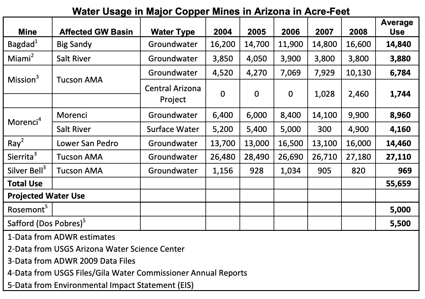
  • The following chart is from an Arizona Department of Mines & Mineral Resources report from 2010 by Dr. Madan M. Singh. It’s a nice, comprehensive look at how much water the state’s major mines used in the preceding years. Current use is likely about the same, except that now there are additional mines (the Pinto Valley Mine was not operational in 2010, which is why it’s missing).
Source: Water Consumption at Copper Mines in Arizona, by Dr. Madan M. Singh, 2010.

So, according to Singh’s report, Arizona’s largest mines used a total of 55,659 acre-feet per year during the 2000s. Add the Pinto Valley Mine (8,932 af) and Safford Mine (6,099 af) and you get about 70,600 acre-feet per year, or 23 billion gallons annually.

That’s a lot of water, but it pales in comparison to many other uses. Arizona alfalfa, alone, probably uses more than 1.5 million acre-feet (based on 6 af water/acre over 280,000 planted acres, according to the USDA). “Turf facilities” guzzled some 157,000 af in 2024, according to the AZDWR, while power generation used 86,053 acre-feet. TSMC’s north Phoenix chip manufacturing facility is projected initially to use about 19,000 acre-feet of water annually. 

In other words, when Arizona’s water cops come looking for the big water users, the mines probably won’t be at the top of their list. Since most mines rely on groundwater, Colorado River water shortages may not affect them too much, at least in the near future.

Still, some mines, including ASARCO’s Mission Mine, do pull some water from the Central Arizona Project, which could be hit hard by the Colorado River crisis as early as next year. And, as the Pinto Valley Mine situation last year demonstrated, continued aridification and relentless pumping could lead to groundwater shortages at the mines, forcing them to reduce production even as they work to become more water-efficient.

Prospective mines could face serious challenges, as well. Resolution Copper estimates its contentious Oak Flat mine would use between 15,700 acre-feet and 20,000 acre-feet per year. Others, however, say this is too low; one study says it would likely be closer to 50,000 acre-feet annually, based on the per-ton water consumption for copper at other Arizona mines. Resolution has said it would rely at least partly on Central Arizona Project water, the security of which grows shakier with each passing year. It’s hard to imagine that there will be any water available for new users by the time that mine is up and running if current climatic trends continue.

That may be what Faraday Copper had in mind when it signed a letter of intent to acquire the San Manuel copper mine in southern Arizona. While Faraday said it would be reopening the long-shuttered operation and combining it with its proposed Copper Creek venture nearby, it may also be eying the substantial water rights BHP Copper holds for the San Manuel Mine. Those could come in handy if and when the Copper Creek facility is developed.

Regardless, however, one thing is clear: Any new mine is going to rob the springs, the streams, and the wildlife and communities that rely on them of at least some of their precious water. [ed. emphasis mine]


1 In 1993, when the Pinto Valley Mine was operated by Magma Copper, a large rain event “overwhelmed the mine’s water management capabilities,” causing the reservoir to overflow the tailings pile, tear out a levee, and carry hundreds of tons of tailings and millions of gallons of contaminated water into Pinto Creek. The creek was found to have low pH (high acidity) and high concentrations of cadmium, copper, lead, mercury, and zinc, resulting in significant fish die off, specifically of desert or Gila Mountain suckers.

Arizona Rivers Map via Geology.com.

Reclamation needs 1.7 million acre-feet to save #LakePowell this year — The #Aspen Daily News

Click the link to read the article on The Aspen Daily News website (Austin Corona). Here’s an excerpt:

March 25, 2026

River managers need to conserve around 1.7 million acre-feet in Lake Powell to keep the reservoir from dropping below hydropower turbines this year, according to federal government projections. The Bureau of Reclamation, a federal agency that manages dams on the Colorado River, has estimated that reservoir levels could fall below required elevations for hydropower production before August as record-low snowpack turns into pitiful flows in streams and rivers. 

“The situation is dire, the stakes have never been higher, and the reservoirs have never been drier,” Estevan Lopez, New Mexico’s negotiator on interstate Colorado River matters, said during a meeting of the Upper Colorado River Commission on Tuesday [March 24, 2026].

The back of Glen Canyon Dam circa 1964, not long after the reservoir had begun filling up. Here the water level is above dead pool, meaning water can be released via the river outlets, but it is below minimum power pool, so water cannot yet enter the penstocks to generate electricity. Bureau of Reclamation photo. Annotations: Jonathan P. Thompson

If water levels fall below required levels for hydropower production, dam managers will be forced to release water through bypass tubes, which are not designed for sustained, high-volume flows. With too much use, the bypasses could fail, turning the dam into a massive plug in the river and shutting off downstream flows. To keep Powell above those critical levels, federal officials can either fill it with water from upstream reservoirs, including some in Colorado, or they can reduce the water it drains from Powell and sends to the Lower Basin (California, Arizona and New Mexico). States are already expressing their views on how those operations should work.  Upper Colorado River basin states, including Colorado, want the federal government to achieve the conservation requirement by reducing water releases to downstream states, at least in part. Upper Basin states say upstream reservoirs aren’t enough to save Powell without cuts to Lower Basin water deliveries. Draining the upstream reservoirs could also leave the system without backup supplies in the event of another dry year…The three primary reservoirs that could prop up Powell are Flaming Gorge in Wyoming, Navajo Reservoir in New Mexico, and Blue Mesa Reservoir near Gunnison, Colorado. Of the three, only Flaming Gorge is large enough to contribute the entire 1.7 million acre-feet on its own, and that would require draining the reservoir to halfway full.  Blue Mesa and Navajo already stand at around halfway full, and the two reservoirs likely could not provide the water to save Lake Powell even if both were entirely drained.

Colorado River “Beginnings”. Photo: Brent Gardner-Smith/Aspen Journalism

#ColoradoRiver Remains in Crisis with Continued Uncertainty on Water Supply and Operations — Jennifer Pitt (Audubon.org) #COriver #aridification

American White Pelican and Double-crested Cormorant at Bill Williams Wildlife Refuge along the Colorado River, Arizona. Photo: Gary Moore/Audubon Photography Awards

Click the link to read the article on the Audubon website (Jennifer Pitt):

March 20, 2026

Audubon and partners cut through the conflict with a unique, basinwide perspective, championing the river’s health for the people and birds that rely on it.

The winter of 2025-2026 has not been kind to the Colorado River. Record-warm temperatures day after day across the mountains that feed the river have led to record-low snow levels. All indications are that spring snowmelt feeding the river will be scant.

That is a huge problem, because Colorado River reservoirs, which historically held vast water reserves, are already depleted, with Lake Powell at 25% and Lake Mead at 34% of capacity. This is bad news for people and birds relying on water from the Colorado River. The U.S. Bureau of Reclamation (Reclamation), the federal agency managing the dams, projects that Lake Powell’s water levels could fall low enough to threaten Glen Canyon Dam’s infrastructure, downstream water delivery, hydropower, and native wildlife in the Grand Canyon including the California Condor and the Western Yellow-billed Cuckoo,  among others.

As this crisis plays out, Reclamation has the difficult job of re-tooling systemwide, long-term dam operations on the Colorado River (often referred to as the “Post-2026 Guidelines”). Existing rules, first set nearly two decades ago and tweaked repeatedly to keep up with the declining Colorado River (the result of a warmer and drier climate), expire at the end of this year. As anticipated under this timeline, Reclamation issued a Draft Environmental Impact Statement (Draft EIS) in late January which laid out potential alternatives for federal management and solicited comments from stakeholders. This Draft EIS embraced uncertainty as a central planning condition as they tested different approaches under a broad range of hydrologic conditions. For a long time, the expectation was that the seven U.S. states sharing the river (Arizona, California, Colorado, New Mexico, Nevada, Utah and Wyoming) would develop a consensus-based proposal for Reclamation, but that hasn’t happened and talk of litigation has increased.

Southwestern Willow flycatcher

Reclamation must now figure out next steps. The agency does have legal authorities, but those legal authorities were crafted long ago and do not necessarily spell out how to take meaningful action in this historic crisis. That threatens the water supply for more than 35 million people including the major cities of the American Southwest, Tribes, millions of acres of irrigated farms and ranches, as well as the Colorado River itself and every living thing that depends on its habitats, including hundreds of bird species like the Southwestern Willow Flycatcher, Yuma Ridgway’s Rail, and Summer Tanager.

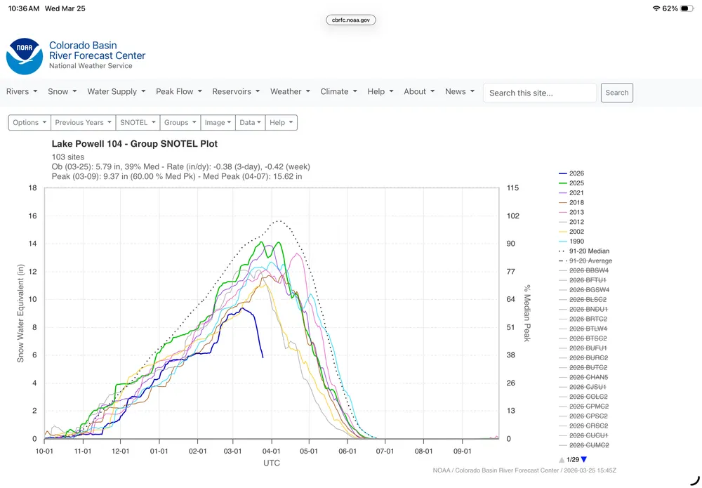
This is a graph of snowpack above LakePowell using 104 snow measuring stations. It was 9 inches of water on March 7, now 6 inches. Other dry years shown.There is no historical analog to this — Brad Udall

Audubon submitted formal comments in response to the Draft EIS, joining conservation partners to weigh in on what comes next for Reclamation’s consideration (read our comment letter here). Dozens of comments were submitted by the Colorado River Basin states, water users, and other stakeholders making their case with Reclamation that their water uses need to be protected at the expense of others. In its comments Audubon emphasized the need to stabilize the Colorado River system from its headwaters to its delta—a unique, basinwide perspective that urges Reclamation to manage risks for people and nature rather than deferring hard decisions until emergency conditions force action. Our comment letter focused on constructive engagement noting the Draft EIS’s strengths in its analytical foundation while identifying and describing targeted refinements that would help ensure the Final EIS fully informs decision-makers about risks and real-world consequences. Specifically, Audubon calls for:

  • Clarity and predictability
  • Flexible, adaptive tools for conserving, storing, and managing water
  • Environmental stewardship embedded into operations
  • Meaningful and voluntary Tribal participation
  • Pathways for advancing in-basin mitigation and resilience-building opportunities
  • Pathways for advancing binational cooperation with Mexico

Over the next few months, Reclamation still has an opportunity to persuade the Colorado River Basin states into consensus. Whether or not they are successful (and we hope they are), sometime this summer we expect Reclamation to issue a Final EIS that includes refinements to the Draft as well as an indication of their preferred alternative for Colorado River operations. In the meantime, it is urgent Reclamation also prepare for the water supply emergency that is unfolding in 2026.

For much of the last century, Reclamation was a leader in developing the southwestern United States by harnessing the Colorado River and delivering its water across the land. Today, Reclamation must lead in a new way, helping everyone and everything that depends on the Colorado River live with the river we have in a warmer, drier world.


DOWNLOADABLE RESOURCES

CoalitionComment ColoradoRiverDraft EIS.pdf

Coalition Technical Comment Letter Responsive to Colorado River Draft EIS

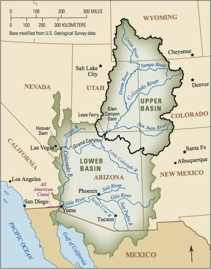
Map of the Colorado River drainage basin, created using USGS data. By Shannon1 Creative Commons Attribution-Share Alike 4.0

Coyote Gulch’s excellent EV adventure: #RioGrande State of the Basin Symposium March 28, 2026 — Salazar Rio Grande del Norte Center

I’m heading out to Alamosa today for the Rio Grande State of the Basin Symposium organized by the Salazar Rio Grande del Norte Center.

Navajo Dam Operations Meeting [Virtual] – April 21, 2026 1-3pm — Reclamation #SanJuanRiver #ColoradoRiver #COriver #aridification

The San Juan River near Navajo Dam, New Mexico, Aug. 23, 2015. Photo credit: Phil Slattery Wikimedia Commons

From email from Reclamation:

March 20, 2026

Reclamation conducts Public Operations Meetings three times per year to gather input for determining upcoming operations for Navajo Reservoir. Input from individuals, organizations, and agencies along with other factors such as weather, water rights, endangered species requirements, flood control, hydro power, recreation, fish and wildlife management, and reservoir levels, will be considered in the development of these reservoir operation plans. In addition, the meetings are used to coordinate activities and exchange information among agencies, water users, and other interested parties concerning the San Juan River and Navajo Reservoir. The next meeting will be held virtually on April 21st


Microsoft Teams

Join the meeting now

Meeting ID: 247 128 548 928 44

Passcode: Yn6ih2Q6


Dial in by phone

+1 202-640-1187,,923961898# United States, Washington

(833) 436-1163,,923961898# United States (Toll-free)

Find a local number

Phone conference ID: 923 961 898#

Join on a video conferencing device

Tenant key: teams@conferencing.doi.gov

Video ID: 114 427 248 3

More info

#Arizona hires high-powered law firm, setting the stage for a legal battle over #ColoradoRiver water — Caitlin Sievers (AZMirror.com)

The sun rises over Lake Powell in Glen Canyon National Recreation Area, in Page, Arizona. Lake Powell, a critical Colorado River reservoir, is only at a third of its capacity as drought conditions in the Southwest worsen. CREDIT: ECOFLIGHT

Click the link to read the article on the AZMirror website (Caitlin Sievers):

March 23, 2026

Arizona is preparing for a legal battle over its rights to Colorado River water.

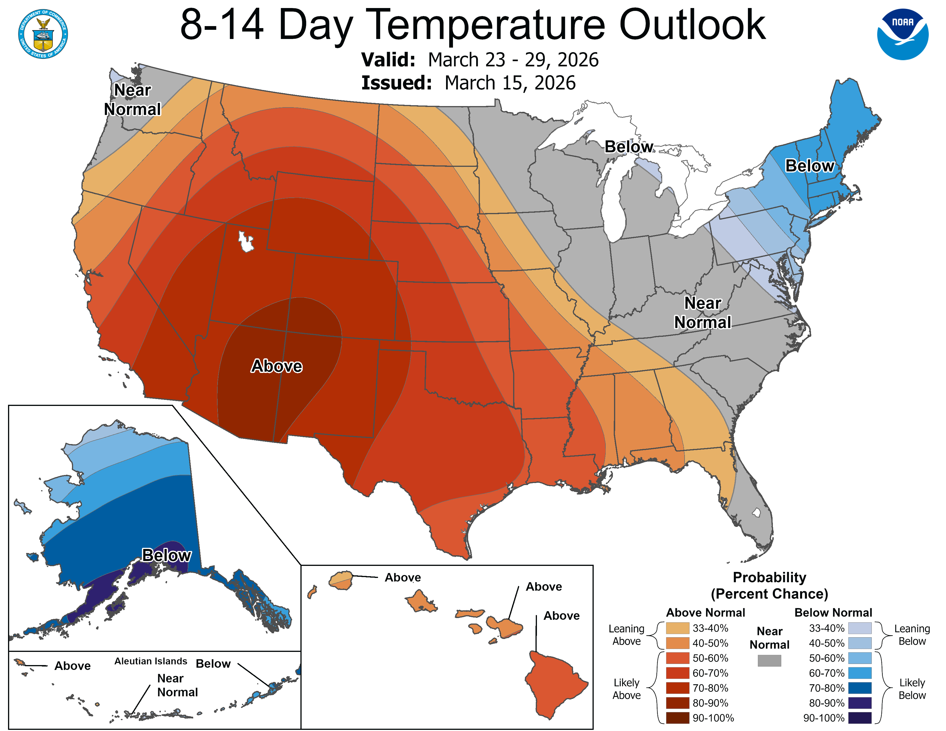
Following an extraordinarily dry winter along the river basin and what’s expected to be an exceptionally hot and dry spring across the West, where high temperatures in March have already blown past records, the pressure to maintain access to the state’s fair share of river water is growing. 

The Colorado River is a vital source of drinking water for 40 million people in the seven basin states, Mexico and 30 Native American tribes, and provides water for farming operations and hydroelectricity. 

Reaching a water usage agreement is imperative to the basin states as the river’s water supply continues to decline, as it has done for the past 25 years due to a persistent drought spurred on by climate change. 

On Monday, the Arizona Governor’s Office announced that it had retained the law firm Sullivan & Cromwell to represent the state in possible litigation among the Colorado River Basin states and the federal government. 

Sullivan & Cromwell is an international firm based in New York City that has represented big names like Microsoft, BP, Goldman Sachs and JPMorgan Chase. The state is using some of the $3 million it put into its Colorado River legal defense fund last year to retain the law firm.

The Governor’s Office doesn’t expect to take any legal action until June at the earliest, but wants to be prepared for the possibility, especially if the dispute ends up before the U.S. Supreme Court. 

The Lower Basin states — Arizona, Nevada and California — and the Upper Basin states — Colorado, New Mexico, Utah, and Wyoming — have been negotiating an updated water usage agreement for more than two years.

But so far the states have blown past two deadlines to do so — one in November and one in February — and are quickly approaching October, when the existing usage agreement expires. 

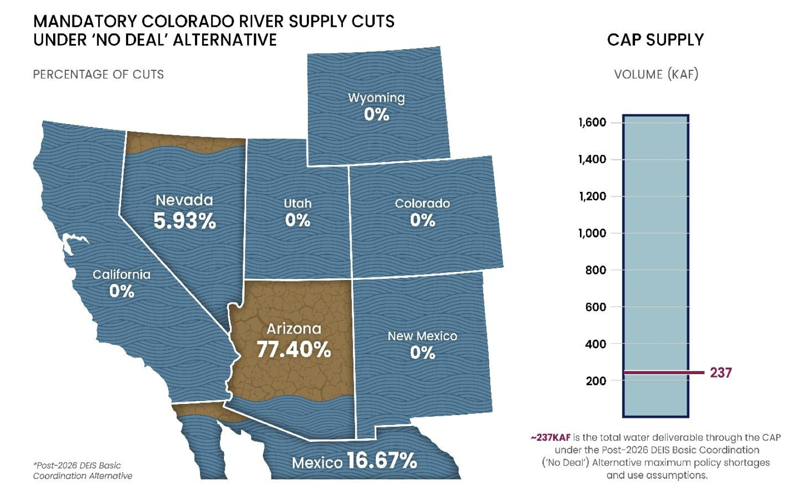
If the states can’t reach an agreement before that, the federal government will implement one of its draft plans, all of which would place an outsized burden on the Grand Canyon State.

That’s because the Central Arizona Project, a series of canals that supplies Colorado River water to the Valley and the Tucson area, is one of the newest users of the river water, making it legally one of the first to be cut. 

But so far, the Upper Basin states have refused to agree to any water usage cuts of their own, while the Lower Basin states insist that every state take their fair share.

Arizona has offered to reduce its Colorado River allocation by 27%, California by 10%, and Nevada by nearly 17%. 

Negotiators for Arizona also insist that the Upper Basin states be held to the original 1922 Colorado River Compact that requires them to release a 10-year rolling average of at least 75 million acre-feet of water to the Lower Basin, in addition to one-half of the annual allotment owed to Mexico, for a total of about 80.2 million acre-feet. 

An acre-foot of water represents enough to cover an acre of land to a depth of one foot, or about 325,851 gallons. That’s enough to provide three homes in Arizona a year of water, on average.

So far, the Upper Basin states have held to the original release agreement. But as water levels in the two major reservoirs on the river, Lake Mead and Lake Powell, continue to decline, it’s expected that the Upper Basin states will be unable to meet that requirement as early as 2027. 

When the states entered into the original Colorado River Compact in 1922, they allocated 7.5 million acre-feet of water each year to be shared by the Upper Basin states and another 7.5 million to be used among the Lower Basin states. 

Since then, the states have updated their water usage guidelines several times, even though the apportionments remain the same. But Lower Basin states face mandatory cuts during times of drought and Upper Basin states do not. In 2025, for the fifth year in a row, the federal government imposed drought-based cuts, and Arizona’s amounted to a loss of 512,000 acre-feet of water for the year.

Under current allocations, Arizona has rights to 2.8 million acre feet of water per year, and has implemented 800,000 acre feet in reductions per year. In contrast, Colorado has rights to 3.8 million acre feet a year, although it uses an average of 1.9 million acre feet, annually. 

The amount of water that Colorado has access to can be unpredictable because it relies mostly on melted snowpack for its water, which varies from year to year. This year’s snowpack levels are historically low.

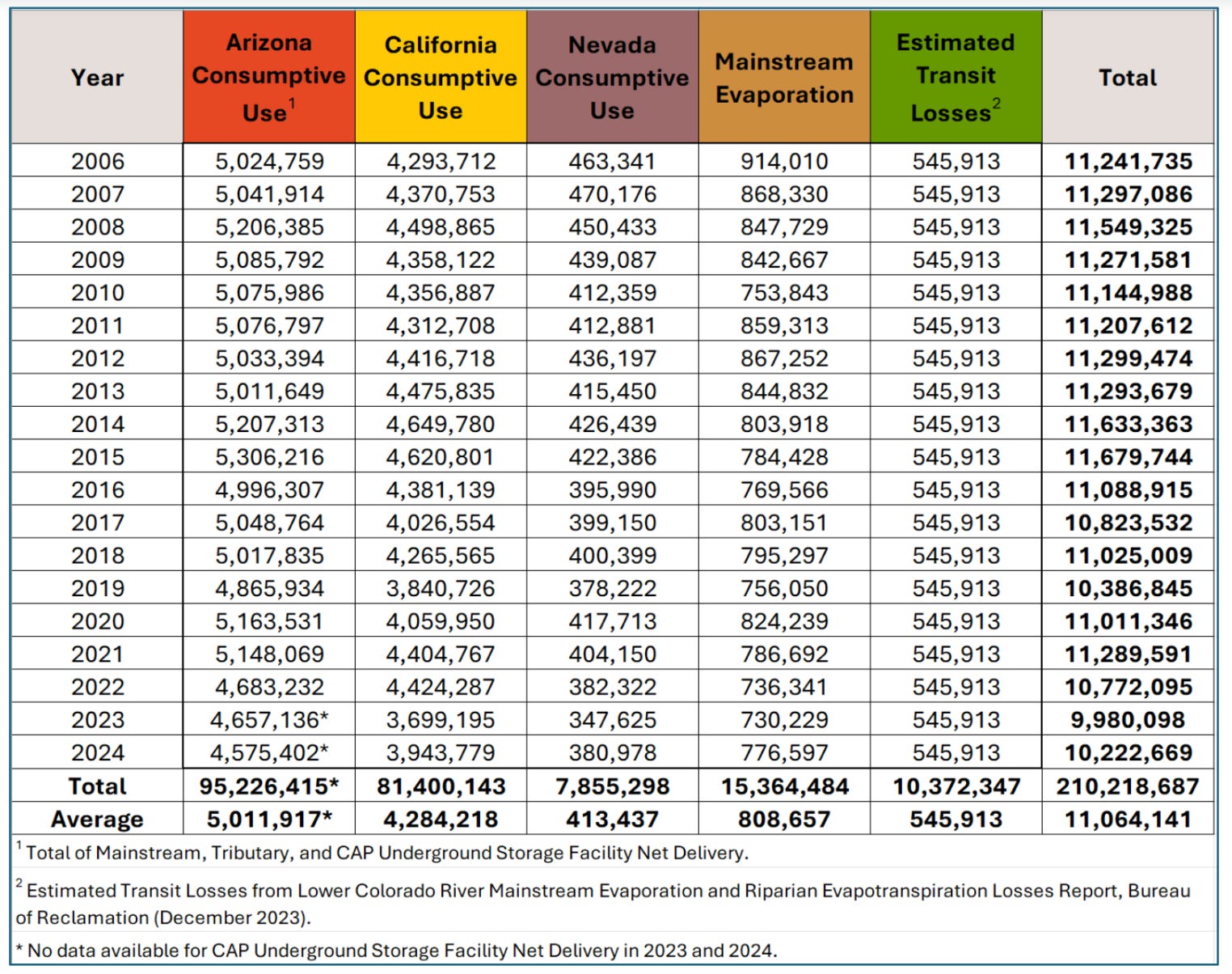
The Lower Basin states have undertaken significant conservation efforts for Colorado River water since 2014 and have reduced their consumption from 7.4 million acre-feet in 2015 to just over 6 million in 2024.

The Upper Basin states have increased their usage in the past five years, from 3.9 million acre-feet in 2021 to 4.4 million in 2024. The federal government’s draft plans allow for the Upper Basin states to use even more water.

Gov. Katie Hobbs’s proposed budget for this year would put another $1 million toward the Colorado River Legal Defense fund, and lawmakers earlier this month gave preliminary approval to doing just that.

Even as Arizona prepares for a legal battle, the state plans to continue attempting to reach an agreement with the other river basin states, according to the Governor’s Office. 

“Governor Hobbs is committed to working with the federal government and other Colorado River states to deliver a negotiated settlement that protects Arizona’s fair share of water and stabilizes the system,” spokesman for Hobbs Christian Slater said. “However, it’s critical that Arizona be prepared to defend ourselves in court if an agreement cannot be reached or the Law of the River is violated.”

The #ColoradoRiver and the Tragedy of the Anti-Commons — John Fleck (InkStain.net) #COriver #aridification

Click the link to read the article on the InkStain website (John Fleck):

March 18, 2026

Some notes on the current state of the Colorado River…

I’m preparing for a panel discussion this evening in Albuquerque. I promised – three-finger promise, Scout’s honor, which still means something to me – that I wouldn’t use any swear words., either in the blog post or the panel discussion.

The state of the water

  • Per the latest numbers from my colleague/collaborator/friend Jack Schmidt, Lake Powell currently holds 1.57 million acre feet of water above the protect-the-infrastructure no-go line of elevation 3,500.
  • Storage at this point in the year is similar to 2022, when we began a hair-about-to-be-on-fire drill as Interior raced to figure out how to protect Glen Canyon Dam because of newly understood (or newly publicly understood) risks of dropping below minimum power pool and using the dam’s outlook works. That constraint still holds.
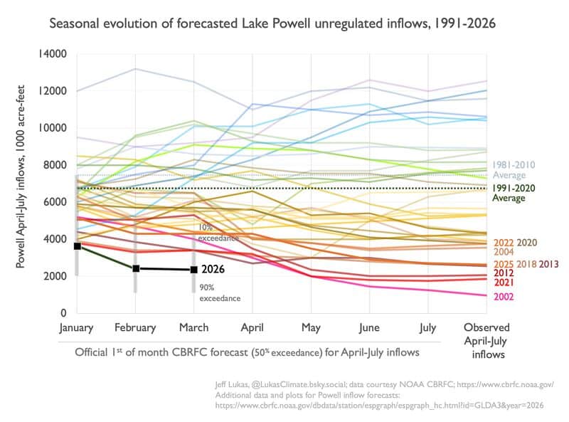
  • The forecast this year is a catastrophe compared to 2022: 1.75 million acre feet for the 2026 runoff season, compared to 3.8 maf in the 2022 runoff season. [ed. emphasis mine]
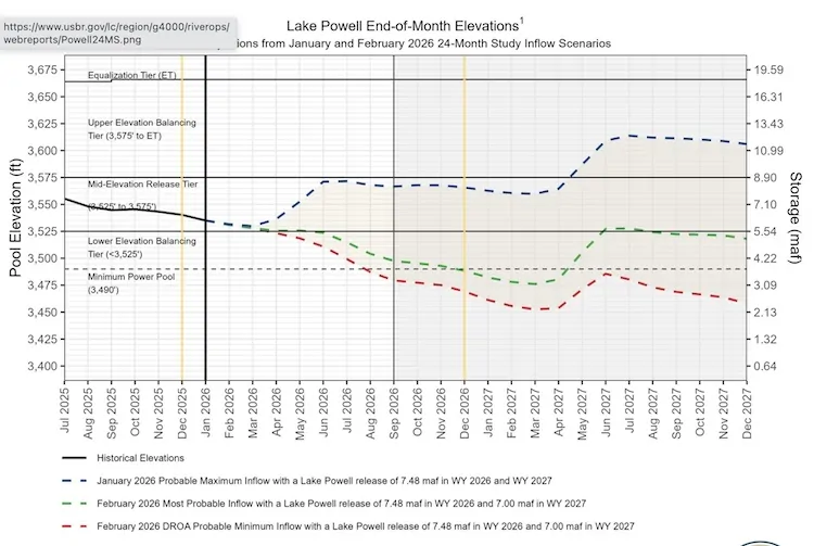
  • The result, according to the most probable forecast from Reclamation, is that absent some sort of action (see governance below) Powell will drop below 3,500 in September, and stay that way until the spring runoff in 2027.
  • According to the min probable forecast, which is realistic given the looming heat-pocalypse, we hit 3,500 by July and stay there forever (by which I mean as far as the current 24-month forecast runs – as the late Jim Morison wrote, the future’s uncertain and the end is always near).

The state of the governance

The state of the governance nests two separate by closely linked problems: near term actions and long term rules.

Near term actions

Protecting Glen Canyon Dam from that 3,500 no-go line requires coming up with a least 2 million acre feet of water over the next two years – to get us past that spring 2027 problem described above. There are two ways to do this. The first is to release a bunch of water from upstream, primarily Flaming Gorge Reservoir. How much? Dunno. The second is to cut releases from Glen Canyon Dam, reducing flows through the Grand Canyon and into Lake Mead. How much? Dunno, though we may find out soon.

The current rules, adopted in response to the challenges of 2022-23, allows releases from Glen Canyon Dam to drop this year to 6 million acre feet, which effectively gets 1.5 million of the needed 2 million feet from Lake Mead by reducing releases thereto. Another 500,000 in releases from upstream reservoir gets you 2 million acre feet, with room to do more if the hydrology gets even worse – which it might.

Longer term actions

The longer term stuff is where, as a student of governance, this gets really interesting for me. As a citizen of the basin, I am inclined to swear words at the dysfunction that has left us with no long term plan beyond the end of this year. But I Scout’s honor promised, so shifting to the “student of governance” schtick gives me a view from nowhereway to approach this dispassionately, without the, y’know, words that would have made Mr. Vinatieri, my Scoutmaster, disappointed in me.

Others have chronicled the failure of the seven U.S. Colorado River Basin states to come to a consensus agreement on a set of river operating rules, we need not repeat that here, other than to note that what we have here is a classic case of what has been called the tragedy of the anticommons. This is a situation where many people or entities – in this case the states of the Colorado River Basin – each have the power to block a solution that might be to the benefit of the community as a whole. In this case, each of the seven states of the Colorado River Basin have blocking power over solutions that would prevent the reservoirs from crashing.

See above: the reservoirs are crashing and we have no plan to prevent it because any proposal that might prevent it has been blocked by one or more states that object.

The reason behind this is a set of rules written beginning in the 1920s governing the river – the Colorado River Compact and a series of ad hoc additions that followed – that attempted to lay out rules for managing the river but failed to include functional processes for modifying the rules when they proved inadequate to changing the situation. We’re now stuck with a system under which each of the seven basin states has blocking power over any attempt to change the rules.

This violates one of the fundamental institutional design principles identified by the late Elinor Ostrom, who taught us so much about how we succeed or fail in overcoming the tragedy of the commons: “How will the rules … be changed over time with changes in the performance of the resource system, the strategies of participants, and external opportunities and constraints?” We have to have rules about how we rewrite the rules. We lack that.

Despite this, we have succeeded in the past, in a series of rule-writing exercises that began in the late 1990s, by depending on principled actors at the state level recognizing that they needed to balance their need to protect their own community’s water supplies against the need to solve problems at the scale of the basin as a whole.

My personal values on this question are both instrumental (things that I think are in the best interests of myself and my community) and deontological (things that I think are fundamental moral principles). The second first: I think we have ethical obligations to those upstream and downstream of us in shared river basins. This is, for me, fundamental. The second is instrumental – I think compromise is in the best interests of my community’s water supply and therefore its future, because if we end up in litigation and the system crashes, we stand to lose a lot more than if we compromise, are willing to act on our obligations to our downstream neighbors by using less ourselves.

The last two years of increasingly hostile negotiations among the states make clear that behavior that recognizes those principles is gone, replaced by interpersonal bickering and a game of chicken driving the basin toward litigation (effectively hoping to manage the basin by convincing a judge of our preferred interpretation of ambiguous rules written a century ago) and reservoir collapse.

Thar be dragons.

Map of the Colorado River drainage basin, created using USGS data. By Shannon1 Creative Commons Attribution-Share Alike 4.0

#ColoradoRiver negotiations resume with focus on stopgap measure in face of worsening hydrology — Scott Franz (KUNC.org) #COriver #aridification

Sunlight glimmers on the Colorado River near Page, Arizona on Nov. 2, 2022. Alex Hager/KUNC

Click the link to read the article on the KUNC website (Scott Franz):

March 20, 2026

This story is part of ongoing coverage of the Colorado River, produced by KUNC in Colorado and supported by the Walton Family Foundation. KUNC is solely responsible for its editorial coverage.

Critical negotiations about the future of the Colorado River took a two week hiatus last month after the seven states in the basin missed a key Valentine’s Day deadline for striking a deal, New Mexico’s water negotiator said Thursday.

Estevan López said talks resumed March 2, and the upper and lower basin states are using a short-term pitch from Nevada as a starting point.

“Right now, we’re in discussions with the lower basin about a potential short-term agreement,” Lopez told New Mexico’s Interstate Stream Commission. 

Nevada is proposing to increase water releases from upper basin reservoirs like Flaming Gorge by at least 500,000 acre feet to help prevent Lake Powell from dropping too low.

The latest forecasts predict that Powell could drop enough to stop producing hydropower by December.

In return, lower basin states would agree to cut their water use by 1.25 million acre feet “until system conditions have meaningfully improved.”

López said upper basin states had a counter proposal and talks about it were scheduled on Thursday afternoon.

“The hydrology right now is incredibly dire,” López said. “So we’re beginning for this year, for the remainder of this water year, we’re suggesting that there needs to be a release from the upper initial units, most likely Flaming Gorge, since that’s the reservoir that’s largest and has the most water. And we are anticipating that there will be a release of half a million acre feet from Flaming Gorge to prop up Lake Powell.”

Meanwhile, the Interior Department is reviewing thousands of comments it received on a range of options for how to manage the vital waterway.

The alternatives were published in January and could result in a variety of scenarios, ranging from significant water reductions in lower basin states to creating new incentives for states to conserve water.

And after the states missed two deadlines to reach an agreement, it’s becoming increasingly likely the federal government will try to piece together its own plan before the current guidelines expire in the fall.

Water negotiators are also facing a worsening water supply forecast with record low snowpack across the West.

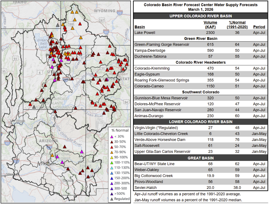
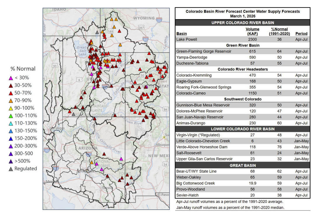
A map shows how much water is predicted to arrive at certain locations in the Colorado River basin as of a March 1 forecast.

Cody Moser with the federal Colorado Basin River Forecast Center said last week just 2.3 million acre feet of Colorado River water is expected to reach Lake Powell through July. That’s about a third of what’s considered normal.

“You’ll notice it’s not a pretty picture here with lots of reds,” he said as he presented a color coded map of how much water is expected to reach certain locations in the river basin. “That’s 50 to 70% of normal April through July runoff. Those maroon colors are 30 to 50% and we even have some of those pinks, which indicates less than 30% normal seasonal spring runoff.”

An attorney for New Mexico’s Interstate Stream Commission said Thursday the state expects the Interior Department to identify a preferred option for managing the dwindling river by July. The current operating guidelines for Lake Powell and Lake Mead expire in the fall. 

Map credit: AGU

#Montrose #wastewater treatment plant begins $40 million upgrade — KJCT.com

Uncompahgre River Valley looking south

Click the link to read the article on the KJCT website (Spence Breed). Here’s an excerpt:

March 17, 2026

The city of Montrose held a groundbreaking Monday marking the start of a major upgradereaking Monday marking the start of a major upgrade to its wastewater treatment plant, a facility that has operated with much of its original equipment since it was built in the 1980s.  The project will replace outdated equipment and install new infrastructure to meet current and future water quality standards set by state and federal regulators. Mayor Dave Frank said the plant’s equipment has become difficult to maintain. 

“The equipment in our wastewater treatment plant is original to the building of the wastewater treatment plant,” Frank said. “So when something breaks, they’re having to find parts in museums and junkyards in order to repair the equipment that we currently have.”

[…]

The plant treats sanitary sewage in accordance with federal and state standards, releasing treated water back into the Uncompahgre River. The project will replace existing equipment with newer versions and install a tank for biological phosphorus removal. Wastewater Treatment Plant Superintendent Hyrum Webb said the phosphorus removal addition is a proactive step. 

“We want to get ahead of the curve on removing phosphorus out of the water before we’re required to by the state,” Webb said. “It gives us some incentive points to help out with future permitting, and it’ll be cheaper now than when the state mandates us to do so.” 

Frank said water quality going back into the river is a priority…The project is expected to take approximately 18 months to complete. The total cost is estimated at $40 million, which will be funded through bonds and reserve funds.

Map of the Gunnison River drainage basin in Colorado, USA. Made using public domain USGS data. By Shannon1 – Own work, CC BY-SA 4.0, https://commons.wikimedia.org/w/index.php?curid=69257550

Why Colorado River negotiations stalled, and how they could resume with the possibility of agreement — Karen Schlatter and Sharon B. Megdal (TheConversation.com)

The reservoir behind the Glen Canyon Dam is extremely low. Jim West/UCG/Universal Images Group via Getty Images

Karen Schlatter, Colorado State University and Sharon B. Megdal, University of Arizona

The seven U.S. states that make up the Colorado River basin are struggling to agree on how best to manage the river’s water as its supply dwindles due to climate change and a period of prolonged drought. Their negotiations, which are not open to the public, missed a Feb. 14, 2026, deadline the federal government had established, after which federal officials said they would impose their own plan.

The federal government has not yet done so, but the prospect of such an action is not good news for the nearly 40 million people who depend on the Colorado River for water, energy, agriculture and recreation, nor for the estimated US$1.4 trillion in economic activity the river supports.

We have led or participated in complex water management discussions from the river’s headwaters in Colorado to its delta in Mexico and elsewhere in the arid Southwest and around the world. Even on less contentious issues, the keys to success involve learning together, understanding one another’s interests, working through conflict and developing inclusive solutions for diverse participants. And that works best with an outside facilitator.

The five most common sources of conflict between people are values, data, relationships, interests and structure. The current Colorado River negotiations include all five. We believe a process designed and facilitated by negotiation experts could help break the logjam.

We recognize it can be very hard to reach an agreement when what’s at stake are countless lives, massive amounts of money, enormous quantities of hydroelectric power and not nearly enough water.

But compromise on Colorado River management is possible and, in fact, was achieved to curb California’s water use in the 2000s, to negotiate an interim agreement to coordinate operations at the Lake Mead and Lake Powell reservoirs in 2007, and to enact contingency plans to manage drought in 2019. But this time around, circumstances are different.

Previous negotiations

The negotiations leading up to those agreements were often facilitated by officials from the U.S. Bureau of Reclamation who focused on reaching broad agreements on general principles and concepts before delving into details. Federal staff also actively guided key agreements and provided the science and computer models to make well-informed decisions. And the states’ negotiators knew the Department of Interior would act unilaterally to make damaging cuts to water supply if states couldn’t come to their own agreement.

The negotiators for the states had long-standing relationships and built trust by frequently communicating outside formal meetings and seeking to listen to and understand other states’ perspectives, even if they didn’t agree.

The states also agreed to use the bureau’s computer model for analyzing scenarios of climate change and management decisions. That meant all the negotiators were looking at the same data when delving into possible options. And the political and social environment was less polarized than today.

The current situation

In this round of negotiations, federal leadership has been lagging. The Department of the Interior has not made clear what the consequences might be for the states if they fail to agree. The U.S. Bureau of Reclamation has been without a permanent commissioner since President Donald Trump retook office in January 2025.

And federal staff have only recently begun helping to facilitate the discussions.

The states are fractured into subgroups, according to whether they are in the river’s Upper Basin – Colorado, Wyoming, Utah and New Mexico – or the Lower Basin, which includes Arizona, Nevada and California. Each basin group holds strong positions and has generally been unwilling to shift.

Each basin group is using a different set of assumptions for the bureau’s computer model to explore options. And the discussion often gets stuck on details, which prevents progress toward broader agreements.

In addition, the political context has shifted significantly, with increased polarization and politicization of the issues, creating barriers to effective dialogue and deliberation. Today, compromise can seem unattainable.

But those relatively new challenges to Colorado River compromise are not an excuse for failure.

A group of people sit around a table in a formal meeting room.
Interior Secretary Doug Burgum, center between flags, meets with governors and representatives of the seven Colorado River basin states in January 2026. U.S. Department of the Interior via X

A way forward?

The current negotiations have all been done behind closed doors. From talking with people involved in the negotiations, we understand the negotiators have been left to set their own agendas and meeting plans and conduct their own communications and follow-up, with no formal facilitators.

It’s reasonable to expect the negotiators to be ready to represent their states’ interests, working through an incredibly complicated landscape of hydrology, climate and management scenario modeling, water law and administration, and politics. But we believe it’s unreasonable – and unrealistic and unfair – to expect them to also be experts at designing and facilitating an effective process for sorting out their differences.

Federal officials are not necessarily the best people to run the process either. And if the agency that ultimately needs to approve any deal is the one leading the process, real or perceived biases about the states or key issues in the agreement could further complicate the discussions.

We believe that agreement between the seven states is still possible. It may be less effective to bring in a third-party facilitator at this stage in the negotiation process, though, because of the degraded trust, hardened positions and shortage of time.

One possible outcome is that the Bureau of Reclamation will select and enforce one of the five management alternatives it outlined in January 2026. But that could lead to decades of litigation going up to the Supreme Court. No one wins in this scenario.

A more hopeful possibility is that the bureau adopts short-term rules that would give the states another chance to negotiate a longer-term deal – ideally with an unbiased third-party facilitator for support.

A collaborative and consensus-based planning process in the Yakima River Basin in Washington state in the early 2010s is evidence that while nobody gets everything they want in a negotiated agreement, “if they can (all) get something, that’s really the basis of the plan,” as a Washington state official told The New York Times.

Karen Schlatter, Director, Colorado Water Center, Colorado State University and Sharon B. Megdal, Professor of Environmental Science and Director, Water Resources Research Center, University of Arizona

This article is republished from The Conversation under a Creative Commons license. Read the original article.

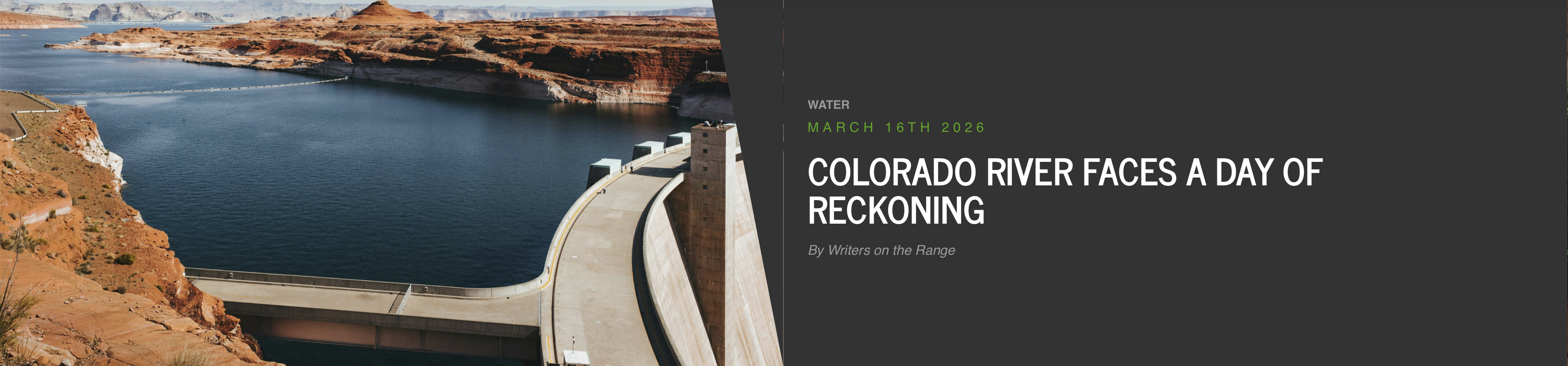
#ColoradoRiver faces a day of reckoning — Jonathan P. Thompson (WritersOnTheRange.org) #COriver #aridification

Glen Canyon Dam, Photo by Luca Bravo, courtesy Unsplash

Click the link to read the article on the Writers on the Range website (Jonathan P. Thompson):

March 16, 2026

We are two and a half decades into the Southwest’s most severe drought of the last 1,200 years, and this winter’s snow dearth is one of the most extreme on record.

Without an April-May miracle, human-caused climate change likely will finally catch up with the Colorado River—and the 40 million people who rely on it—in the form of a full-blown crisis later this year.

“Drought” may be too hopeful a word, since it implies an eventual end. Most climate scientists refer to the phenomenon as “long-term aridification,” caused by a lack of rain and snow and warming temperatures.

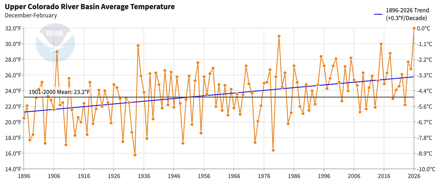
The West has just experienced its warmest winter since record-keeping began in 1895. The average October-through-December temperature in some parts of the region has been more than 8° F warmer than the 20th-century mean. This is a huge anomaly.

In Gunnison County, Colorado, one of the colder places in the nation, the average minimum temperature for that four-month stretch was about 19° F. That doesn’t seem so bad until you realize that back in 1990, another dry, warm winter, the corresponding measure was 13.6° F. For the Upper Colorado River Basin, the average minimum temperature for that four-month stretch was about 26° F, the warmest on record.

The warmer temperatures tinker with the health of the watershed.

This water year, which began Oct. 1, started out with record-high precipitation in some areas, most of which fell as rain. That helped fend off severe drought conditions. But what really counts is the mountain snowpack, which serves as a giant natural reservoir that supplies at least 70% of the Colorado River’s water each year. Warm temperatures have left some areas snow-free even in parts of Wyoming, where the white stuff normally would be piled high in March.

The diminishing snow has, in turn, shrunk the Colorado River. The “natural” flow—or an estimate of how much water the river would carry without upstream diversions or human consumption—has been below 15 million acre-feet (MAF) at Lees Ferry during 20 of the last 26 years, with an average flow of 12.25 MAF during that time.

This matters, because when the Colorado River Compact of 1922 parceled out the river’s waters, the river was assumed to carry an average annual flow of at least 16.5 MAF. Demand has significantly exceeded supply for the last 26 years, forcing the drawdown of the watershed’s big savings accounts, Lake Powell and Lake Mead, to about one-third of their capacity.

Meanwhile, to comply with the Colorado River Compact of 1922—the document that serves as the Ten Commandments for the management of the river’s waters—the Upper Basin States must release, on average, at least 7.5 MAF from Glen Canyon Dam each year.

Given that the Upper Basin states need a bunch of water to keep their cities and farms from drying up, and that an additional 800,000 acre-feet evaporates or seeps into the underlying rocks at Lake Powell each year, you can see how the warming climate wreaks havoc on the math of the Colorado River.

The entire river system now teeters on the brink, and this year’s snow drought may be what pushes it over the edge.

The back of Glen Canyon Dam circa 1964, not long after the reservoir had begun filling up. Here the water level is above dead pool, meaning water can be released via the river outlets, but it is below minimum power pool, so water cannot yet enter the penstocks to generate electricity. Bureau of Reclamation photo. Annotations: Jonathan P. Thompson

The Bureau of Reclamation’s latest forecast says Lake Powell’s surface level is likely to drop below the minimum level needed for power production later this year. This so-called “deadpool” would not only mean the end of hydropower production, it would also force all of the dam’s releases to go through the river’s 8-foot-wide, steel outlet tubes, which were not made for sustained use. This could compromise the tubes and the dam itself.

It’s possible that the dam would even be shifted to a run-of-the-river operation, in which releases equal the amount of water flowing into the reservoir, minus evaporation and seepage. That would almost certainly result in water shortages downstream, at the very least for the Central Arizona Project, which serves the Phoenix metro area.

This quandary didn’t sneak up on us.

The seven Colorado River states and the federal water managers can’t agree on who should make what cuts in consumption. The feds, meanwhile, haven’t gotten around to re-engineering Glen Canyon Dam or creating a bypass around it that would enable the water to keep flowing. It’s almost as if they’ve been paralyzed by the belief that dry winters were just a minor glitch.

Now, as the spring runoff gets underway, it has become clear that nature won’t save us: We have no choice but to live within increasingly meager limits.

Jonathan Thompson is a contributor to Writers on the Range, writersontherange.org, an independent nonprofit dedicated to spurring lively conversation about the West. He is a longtime journalist and author about the West.

#ColoradoRiver Upper Basin states test methods to fill #LakePowell pool: States say automatically turning to agriculture isn’t always reliable — Heather Sackett (AspenJournalism.org) #COriver #aridification

Lake Powell, on the Colorado River, is seen from the air in 2019. The Upper Basin states are planning how to potentially fill a dedicated pool in the nation’s second largest reservoir. CREDIT: ECOFLIGHT

Click the link to read the article on the Aspen Journalism website (Heather Sackett):

March 19, 2026

With a Lake Powell conservation pool nearly guaranteed for the future of Colorado River management, the four Upper Basin states are exploring and refining the ways they could fill it.

Conservation by those states (Colorado, New Mexico, Utah and Wyoming) could be one of the keys to reaching a deal among the seven states that share the Colorado River and an important part of the framework for managing the drought-stricken river after this year. The water saved by the Upper Basin states could be stored in Lake Powell as a means of maintaining higher water levels and as an insurance policy against drastic cuts.

This type of pool isn’t yet being used in Lake Powell; it would have to be established by an agreement among the seven states. An agreement in the 2019 Drought Contingency Plan allowed for a 500,000 acre-foot Upper Basin storage pool in Lake Powell, but so far, the states have not utilized this and the agreement expires this year.

The Upper Basin and Lower Basin (California, Arizona and Nevada) have been at an impasse for more than two years about how the nation’s two largest reservoirs — Lake Powell and Lake Mead — will be managed and shortages shared in the future. The situation has never been more dire: The current guidelines for river management expire at the end of the year, while record-low snowpack is expected to push reservoir levels below critical thresholds. The seven states have blown past two deadlines to come up with a plan, and the federal government is gearing up for emergency actions to manage reservoirs.

The crux of the disagreement between the two basins has been over who should take shortages in drought years. The Lower Basin has committed to 1.5 million acre-feet of reductions annually and wants cuts beyond that to be shared by the Upper Basin. The Upper Basin says its water users already take cuts in some years because streams run dry by midsummer and any contributions they make must be voluntary.

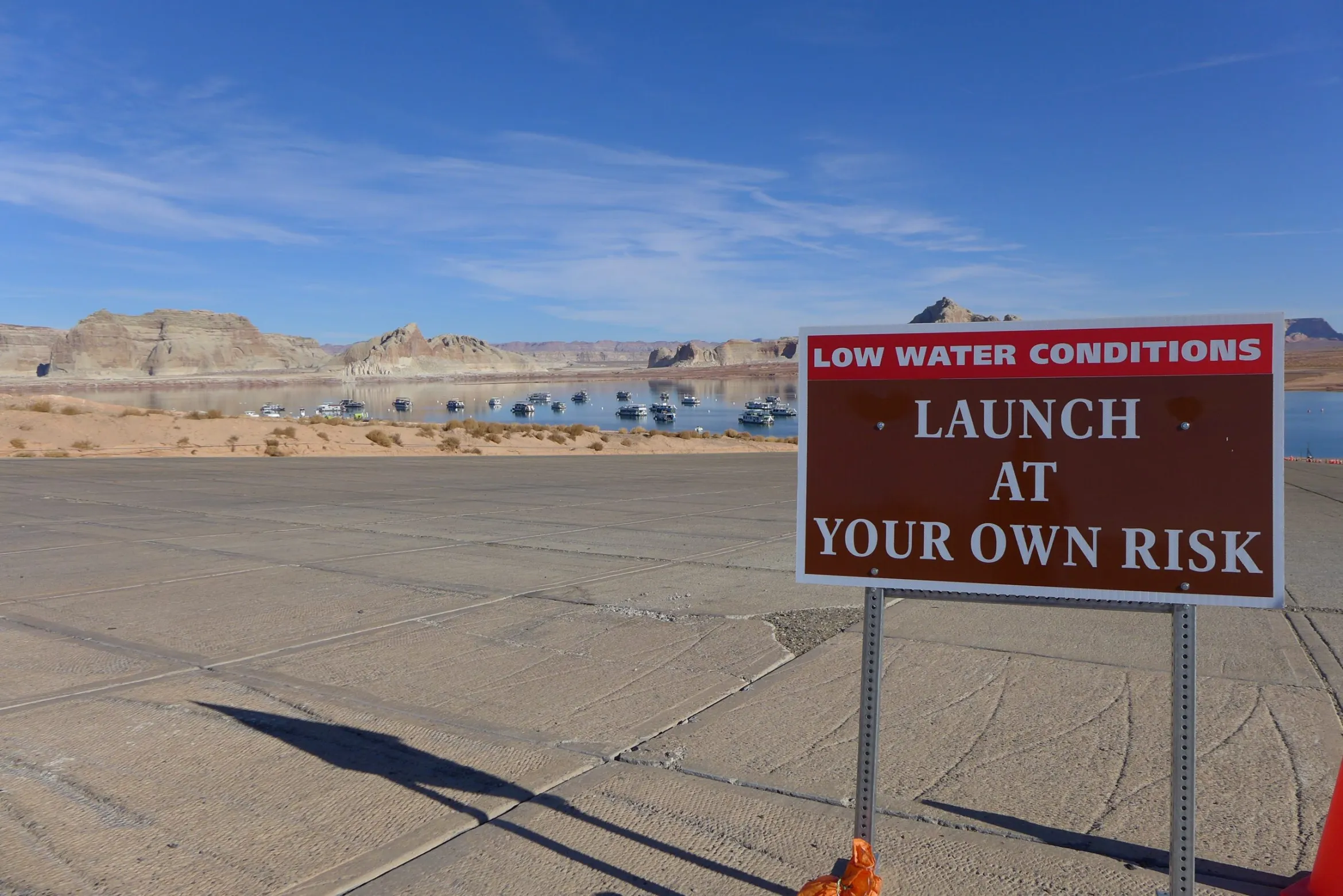
TThe main boat ramp at Wahweap Marina was unusable due to low water levels in Lake Powell in December 2021. The U.S. Bureau of Reclamation is projecting that the reservoir will fall below critical thresholds later this year. CREDIT: HEATHER SACKETT/ASPEN JOURNALISM CREDIT: HEATHER SACKETT/ASPEN JOURNALISM

Contribution not conservation

Some Upper Basin officials have made a slight shift in the way they now talk about a pool in Lake Powell. No longer referred to as a conservation pool, it is called a “contribution” pool, reflecting the different methods — not only conservation of agricultural water — of contributing water to a Lake Powell pool.

Traditionally, the Colorado River basin states have turned to programs that pay irrigators to voluntarily leave fields dry for a season or two as the primary way to cut water use. With agriculture representing the majority of water use in the Upper Basin, it’s often the low-hanging fruit when it comes to water savings. 

But at least two Upper Basin states are turning to other methods to contribute water to a Lake Powell pool. 

For example, New Mexico can contribute water from Navajo Reservoir that it leases from a tribe. In Colorado, the method is less straightforward, but officials say the state is prioritizing and expanding existing programs and projects that save water. 

“When you talk about things like turf removal, water-loss prevention, watershed restoration, forest-health efforts that are happening on the ground, those are benefits not only to Colorado but to the entire system,” said Becky Mitchell, Colorado’s lead negotiator in talks among the seven states that share the Colorado River. “So we’re trying to figure out: How do we acknowledge all of that work?”

Raymond Langstaff, a rancher and president of the Bookcliff Conservation District, irrigates a parcel north of Rifle. The state of Colorado explored the feasibility of a demand management program that would pay irrigators to cut back, but did not implement one. CREDIT: HEATHER SACKETT/ASPEN JOURNALISM

Utah touts pragmatic approach

Over its run in 2023 and 2024, the federally funded System Conservation Pilot Programdoled out $45 million to Upper Basin irrigators to cut their use by about 100,000 acre-feet. Utah water users received about $15 million of that in exchange for temporarily forgoing about 37,000 acre-feet of Colorado River water. The state put lessons learned with SCPP to use and is now in the second year of its own demand management pilot program, funded by $5 million from the state legislature and run by the Colorado River Authority of Utah. 

The pilot program lets water users temporarily participate in a conservation program, and pays them $390 an acre-foot of water to do it. In 2025, Utah sent about 8,000 acre-feet downstream to Lake Powell under this pilot program, according to Marc Stilson, deputy director and principal engineer of the authority. There are a couple industrial water users and one municipal water user among the participants, but the majority are agricultural, he said.

“The pilot program is trying to iron out all these issues so that if we end up with some type of post-2026 commitment to do these types of voluntary conservation programs, we’re ready to do it,” Stilson said. “There is a very pragmatic approach in Utah looking at the big picture, and I think generally there is a sense that we have to adapt to changing conditions.”

Whether the program will continue after this year is unclear and could depend on whether the states reach a deal.

“We were anticipating that we’d have an agreement and that these types of programs would be part of that agreement,” Stilson said. “I think we just have to take a wait-and-see approach.”

Wyoming is also looking to traditional programs: State lawmakers are establishing a voluntary water conservation program. Wyoming state engineer and lead negotiator Brandon Gebhart did not respond to phone calls, emails or a list of questions from Aspen Journalism.

Boater on the San Juan River in May 2023. New Mexico officials say they can contribute water to a pool in Lake Powell through releasing water they lease in Navajo Reservoir. CREDIT: HEATHER SACKETT/ASPEN JOURNALISM

New Mexico seeks ‘more diverse’ ways to contribute water

The state of New Mexico plans to contribute to a Powell pool mostly through 20,000 acre-feet of Navajo Reservoir water, which it leases from the Jicarilla Apache Nation and can be released down the San Juan River. Along the way to Lake Powell, it boosts flows for endangered fish. Officials say because they can control when they release the water, it can be tracked with certainty to the reservoir. 

“We all need to focus on more diverse ways of contributions, not just the classic conserved consumptive use,” said Ali Effati, Colorado River basin bureau chief for the New Mexico Interstate Stream Commission. 

Water managers say that automatically turning to agricultural water isn’t always reliable because as climate change continues to rob rivers of flows, even if senior water users want to participate in these types of conservation programs, they may not have any water to spare in dry years.

“That doesn’t mean that we have shied away from those sorts of activities, but to the extent that we can do our part without having to ask our agricultural community to cut water where they already take significant cuts almost annually, that’s just a preferable perspective,” said Estevan Lopez, lead negotiator for New Mexico.

Lopez said the likelihood of seeing a future Upper Basin contribution pool in Lake Powell is nearly 100% and that New Mexico will be ready, willing and able to contribute its share of water when the time comes.

“We have our percentage easily covered, plus a significant amount more,” he said.“We have our percentage easily covered, plus a significant amount more,” he said.

TThese hay bales stand ready to be collected on a ranch outside of Carbondale in July 2024.  Upper Basin states have traditionally looked to agricultural to conserve water, but some are now turning to other ways to contribute water. CREDIT: HEATHER SACKETT/ASPEN JOURNALISM

Colorado points to programs already in place

Colorado water users participated in both years of SCPP, but the state has been reluctant to take the leap into setting up its own program, despite being an early leader of the conservation conversation among the Upper Basin states.

In 2019, Colorado convened nine workgroups to explore the feasibility of a demand management program. The process included Colorado River water users from across the state and in multiple water-use sectors, who looked at how to set up a temporary, voluntary, compensated state program. But in 2022, the state water board shelved the studies without implementing a program, in favor of focusing on drought-resiliency initiatives. 

Mitchell said the demand management feasibility investigation was an incredibly valuable exercise, but that there are still a number of open questions. Inaction on a demand management program doesn’t mean inaction on conservation overall, she said.

“The CWCB board voted to pause that investigation until there was clarity about whether any such program would be achievable, worthwhile and advisable and until there’s evidence that a demand management-esque program would benefit Colorado,” Mitchell said.

In 2023, Colorado lawmakers created a task force to again examine how the state could implement demand reduction and conservation programs. Water managers punted the issue again, failing to make recommendations to lawmakers on this topic, with some members saying conservation programs were “premature.” 

The state still does not seem to have the policies in place to implement a large-scale, traditional conservation program in the near future. Mitchell said Colorado’s plan to contribute water to a Lake Powell pool is through the programs and projects already in place, many of which are funded through the state’s Water Plan grants.

At its March meeting, the CWCB approved more than $13 million for 38 projects across the state, according to a press release. They include things like urban turf replacement, creek and wetland restoration, outdoor water budgeting and wildfire ready action plans.

“Our strategy is to continue on with the programs that are already in existence, continue to fund conservation efforts that benefit all Coloradans as well as the entire system, continue to live within the means of the river and adapt our uses to align with available supply,” Mitchell said. “Because of all those programs already set up, we believe we have the majority of the structure in place.”

But Mitchell would not put a number on the amount of water that Colorado could contribute.

“We want to be a part of the solution when and how we are able to, but no, I’m not going to say we can do 100,000 acre-feet in a year like this,” she said.

Colorado River watchers may soon get some clarity around exactly how — and how much — Upper Basin states plan to contribute to a Lake Powell pool. On March 24, the Upper Colorado River Commission plans to consider projects to include in a “provisional accounting” memorandum of understanding (MOU) with the U.S. Bureau of Reclamation, according to UCRC Director Chuck Cullom. 

Some Upper Basin projects that are not traditional agricultural conservation programs may be counted under the MOU, allowing the states to “get credit” for the water they save through unconventional means. Cullom said the UCRC and Bureau of Reclamation will also soon have an accounting report of water-saving activities undertaken in 2025. 

Mitchell said Colorado is still committed to a seven-state consensus agreement and wants to avoid litigation. But acknowledgement of what the Upper Basin is already doing to cut back on water use will be important.

“The MOU is one component where we would like to see some sort of real acknowledgement of what is occurring in terms of the way that we live within the means of the river and what our strict administration is doing,” Mitchell said. “As long as we are not acknowledged in what’s happening on the ground, I think we’re going to have struggles.”

Map of the Colorado River drainage basin, created using USGS data. By Shannon1 Creative Commons Attribution-Share Alike 4.0

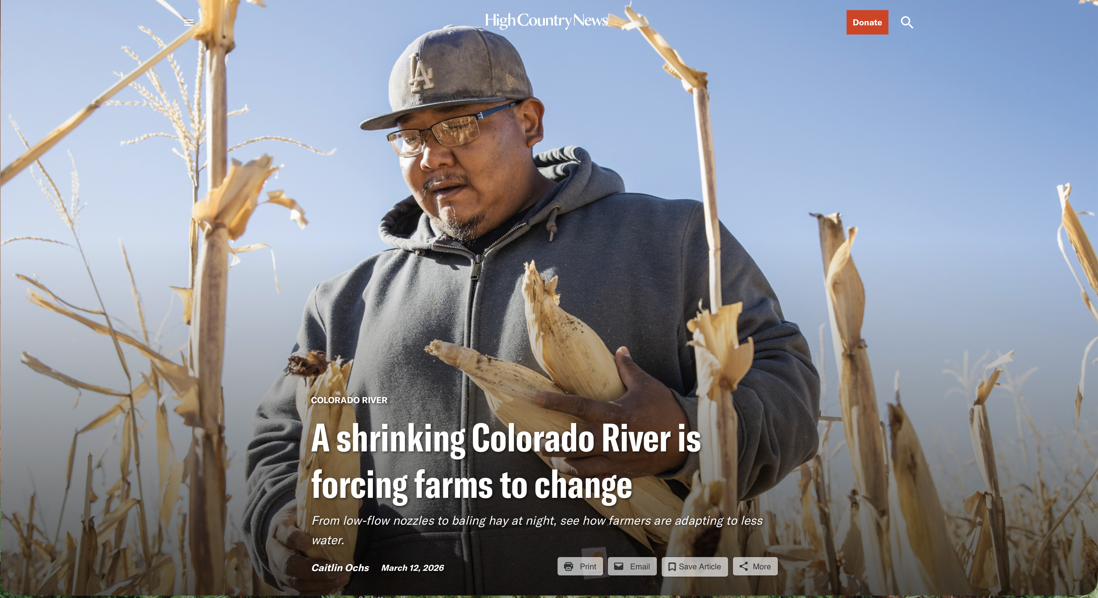
A shrinking #ColoradoRiver is forcing farms to change: From low-flow nozzles to baling hay at night, see how farmers are adapting to less water — Caitlin Ochs (High Country News) #COriver #aridification

Lamar Fields, a tribal member, gathers blue corn to sample. With increasingly unreliable access to water, flexible crops like corn have become integral to the farm’s survival. To increase revenue, the farm built a mill to process crops like blue corn. Caitlin Ochs

Click the link to read the article on the High Country News website (Caitlin Ochs):

March 12, 2026

For a century, the Colorado River has been managed in pieces. Legally and politically, it’s divided into two basins, with each state and community focused on securing its respective water supply. But that is not how a river functions. The Colorado River is an interconnected system, sustained by Rocky Mountain snowpack, rainfall and groundwater.

It is fragile, and under increasing stress. Two and a half decades into this century, the river that built the modern West has 20% less water flowing through it than it did on average in the last century. As heat and drought intensify, so do the stakes: Failure to recognize the severity of changing conditions, managing the river in parts without considering needs of the whole and inadequate planning for long-term shortages put the future of all the basin at risk.

For the last five years, I have documented how the Colorado River Basin’s farmers are navigating water shortages and uncertainty amid deep political divisions about the river’s future. This project, called American Adaptation, examines three agricultural communities whose survival is threatened by a shrinking river, examining what happens to people when policies and water management struggle to keep pace with a changing climate. 

In one of the river’s northern watersheds, the Ute Mountain Farm and Ranch Enterprise is adapting its management as the water it relies on becomes less dependable. In central Arizona, farmers have returned to well water after becoming the first communities to have their supply cut off completely due to the basin-wide shortage. And in California’s Imperial Valley, the farms that receive the river’s largest water allocation are under growing pressure to share the burden of shortage. 

Together, their stories illustrate the stakes — and rising tensions — of the  current negotiations over the river’s future management. States, tribal nations and the federal government are reckoning with 100 years of developing water infrastructure based on assumptions of continuing abundance and expansion. These ideas — and the legal frameworks built around them — are colliding with the reality of a river with much less water than expected, raising complex questions about what the Colorado can sustain, how its water should be used and who will shoulder the necessary cuts.

The Dolores Project, located in the Dolores and San Juan River Basins in southwestern Colorado, develops water from the Dolores River for irrigation, municipal and industrial users, recreation, fish and wildlife, and hydroelectric power. It also provides vital water to the Dove Creek area, central Montezuma Valley area, and to the Towaoc area on the Ute Mountain Ute Indian Reservation. McPhee Dam and Reservoir is the principle storage feature of the Dolores Project which includes a system of canals, tunnels, and laterals to deliver water to over 61,000 acres of land. Photo credit: Kenny Browning/Flickr

When Water is Uncertain

On 7,600 acres painstakingly carved out of desert brush, the Ute Mountain Farm and Ranch, a tribally run enterprise of the Ute Mountain Ute nation, produces cattle, alfalfa, corn and wheat. Its operations are led by Simon Martinez, Eric Whyte and Michael Vicente, who have deep personal connections to the enterprise. Martinez helped build the dam for the reservoir that provides the farm’s water, while Whyte cleared desert brush and mapped where the fields would go. Vicente, as the lead irrigator, can account for every drop of water that’s used.

In good years, the farm’s circular fields flourish in brilliant green bursts. But the past decade has brought increasingly erratic access to water. Each spring, the local irrigation district announces potential cuts after assessing snowpack runoff and the available water stored in nearby McPhee Reservoir. In 2021, the farm received just 10% of its water allocation and was forced to leave 6,000 acres unplanted. In 2022, 30% of the water came in, and last year, 34%, which the farm was able to increase to 50% after leasing shares from other water users.  

To survive, they adapted. Every year, the farm’s leadership creates numerous plans for different water scenarios. They have applied for grants, implemented low-flow nozzles in the irrigation system, installed small-scale hydropower generators. They joined a Land Institute pilot program to test crops that use less water. 

On a day in late May [2022] when wildfire smoke obscured the throat of an ancient volcano called Shiprock in the distance, I visited the Ute Mountain Ute farming and ranching operation in the southwestern corner of Colorado. Photo credit: Allen Best/Big Pivots

“We still haven’t thrown the towel in,” said Simon Martinez. “Nobody ever thought, when the reservoir was built, that there wouldn’t be enough water to supply the farms that have been put out here. It’s not only us; it’s happening all through southwestern Colorado.”

Low-water years leave their mark. Brush and scrub quickly reclaim unplanted fields. Employees laid off during dry years are hard to replace. During consecutive years of heat and drought, farms that rely on the basin’s many smaller reservoirs become even more vulnerable. As the number of dry years grows, it is increasingly uncertain how much shortage the Ute Mountain Farm and Ranch Enterprise can sustain in the long term, despite the farmers’ determination to adapt. 

“We still haven’t thrown the towel in,” said Simon Martinez. “Nobody ever thought, when the reservoir was built, that there wouldn’t be enough water to supply the farms that have been put out here. It’s not only us; it’s happening all through southwestern Colorado.”

Low-water years leave their mark. Brush and scrub quickly reclaim unplanted fields. Employees laid off during dry years are hard to replace. During consecutive years of heat and drought, farms that rely on the basin’s many smaller reservoirs become even more vulnerable. As the number of dry years grows, it is increasingly uncertain how much shortage the Ute Mountain Farm and Ranch Enterprise can sustain in the long term, despite the farmers’ determination to adapt. 

Arizona Rivers Map via Geology.com.

When Water Disappears

Hundreds of miles south, Will Clemens manages his uncle’s 2,100-acre farm, cultivating cotton, alfalfa and Bermuda grass. Farmers in this region operate with a year-round growing season punctuated by dust storms and summer monsoons. 

In this intense environment, wells were the only water source before Colorado River water became available. Until the 1980s, farmers drew their water from deep underground, contributing to fissures, land subsidence and drying wells. The completion of the Central Arizona Project alleviated the pressure, delivering farmers cheap imported river water that was classified as lower priority and the first to be cut during shortages. Deliveries continued until 2022, when low water levels at Lake Mead triggered federal cuts, and central Arizona farms lost access. In response, Clemens’ local irrigation district drilled a dozen new wells. 

Without the river, Clemens and his neighbors have seen the canals’ water drop. At times, their irrigation district will cut off water before a field is fully irrigated, or struggle to keep up with the farmers’ water orders. More pressure on groundwater raises questions about what is sustainable in the future. Large parts of Arizona have no legal limits on pumping water from the ground. Even areas with legally protected groundwater have failed to meet a safe yield goal set in the 1980s to balance groundwater taken each year with naturally replenished water by 2025.

Some central Arizona farmers are selling or leasing their farmland to solar developers, as water dwindles and energy demands grow. Miles up the road from where Clemens farms, sleek black grids of solar panels gleam next to green alfalfa. For years, Arnold Burruel, Clemens’ uncle, has been in talks with a solar developer about selling the land. 

“I’ve been asking myself: Does America really need to be in the agriculture industry?” Burruel said. “America is not totally enamored with agriculture when it comes to pesticides, herbicides, groundwater, GMOs — all of the above. We are at a crossroads. Are we going to continue to farm the way we are farming and heavily subsidize growers that can’t make ends meet? Society has to come up with an answer.”

California uses the most water of any state in the Colorado River Basin, partly for its cities along the Pacific Coast but a substantial amount for agriculture in the Imperial Valley. Photo December 2015/Allen Best

When Water is Abundant

From above, the All American Canal forms a stark blue line, slicing through the Algodones Dunes. One of the world’s largest canals, it is fed by the Imperial Dam, which diverts up to 6.8 million gallons of water each minute from the Colorado River.

This is the only water source for 500,000 acres of Imperial Valley farmland. Farms here are protected by senior rights at low risk of cuts and receive regular releases from Lake Mead, the largest reservoir in the United States. During summer months, the sun looms over the valley’s dusty, flat horizon, and temperatures often climb above 100 degrees. Despite decades of drought and growing water shortage, water has flowed uninterrupted to the Imperial Valley. 

Fourth-generation family farmer Jack Vessey, who oversees a 10,000-acre produce operation, knows the canal system well. Growing up, he searched for places to swim on hot summer days.

“We take water seriously,” said Vessey, who added sprinkler systems, which are more efficient than flood irrigation. In recent years, the Imperial Irrigation District joined other communities throughout the basin in voluntarily cutting water through 2026 in exchange for federal funds. The district’s compensation was several hundred dollars more per acre-foot than other participants. But as funding set aside for Western water by the Biden administration is drawn down, it is unclear how much will be available to pay for future voluntary cuts.

Vessey is aware of the growing pressure on the river and the valley’s farms, but he emphasizes that the community has helped with shortages and is protective of its water.

“I have a responsibility for the people who work here to make sure we survive,” he said. “I have to be a little selfish at some point and say, ‘Keep giving us the water we need.’ I know we’ve got to do our part, but I can look in the mirror and say we are not wasting water, we are growing food people need. 

“If it wasn’t for that canal coming off the Colorado River, this would just turn to desert.”

This project was supported by the National Geographic Society’s World Freshwater Initiative.

We welcome reader letters. Email High Country News at editor@hcn.org or submit a letter to the editor. See our letters to the editor policy.

This article appeared in the March 2026 print edition of the magazine with the headline “The Shrinking River.”

Colorado River “Beginnings”. Photo: Brent Gardner-Smith/Aspen Journalism

#Colorado Water Conservation Board Invests in Critical Water Projects as Demand for Funding Remains High

Colorado Drought Monitor map March 17, 2026.

Click the link to read the release on the CWCB website:

March 19, 2026

Yesterday, at its March Board Meeting, the Colorado Water Conservation Board (CWCB) approved more than $13 million in funding for 48 water projects across the state through its Water Plan Grant and Water Supply Reserve Fund programs, bringing the totals for the fiscal year to more than $40 million for 136 locally-driven projects across the state. These advance critical efforts to help communities be more prepared for drought and wildfires, improve water resilience, and secure Colorado’s water future.

“Organizations across the state are implementing these projects to do their part in moving Colorado’s Water Plan Partner Actions forward,” said CWCB Director Lauren Ris. “These locally driven efforts—from agricultural producers to municipalities to watershed groups—demonstrate a collective commitment to building a resilient, and water-wise future. The importance of this work is underscored by worsening drought conditions. We are putting efforts to protect water resources front and center.”

The funding reflects both the urgency of Colorado’s current water challenges and the overwhelming demand for resources. Funding requests far exceeded available dollars, highlighting the volume of high-impact projects ready for implementation across the state.

These investments are made possible through sports betting taxes in Colorado, a funding stream that continues to play a critical role in advancing Colorado’s water priorities.

“This level of demand for our Water Plan Grants shows just how much water users across Colorado rely on these investments,” said Colorado Department of Natural Resources Executive Director Dan Gibbs. “It also speaks to the incredible work happening on the ground to conserve water and build more resilient systems that will serve communities and our water resources  for generations to come.”

Funded projects reflect key priorities of the Colorado Water Plan, including water conservation, wildfire resilience, and water storage. This includes projects focused on conserving water and improving efficiency, such as funding for new Water Efficiency Plans—an essential tool for long-term water supply planning—as well as initiatives like urban turf replacementresilient school landscapes with smart irrigation, and comprehensive outdoor water budgeting.

The CWCB also continues to invest in projects that help communities prepare for wildfire impacts through watershed restoration and implementation of Wildfire Ready Action Plans, helping protect critical water resources from post-fire risks.

And in Colorado’s current warm, low-snowpack water year, investments in water storage are critical. Funding this grant cycle supports projects that increase or evaluate storage capacity—an essential strategy for capturing and managing water when supplies are limited. These efforts include feasibility studies and improvements to reservoirs and dams in communities across the state.

Finally, the Water Supply Reserve Fund grant investments this grant cycle includes projects such as post-fire diversion infrastructure improvements in Rio Blanco County and enhanced groundwater monitoring efforts in the South Platte Basin—both of which strengthen local water resilience and inform long-term water management.

Romancing the River: The Era of Conquest Part 2 — George Sibley (SibleysRivers.com) #ColoradoRiver #COriver #aridification #ClimateChange

Click the link to read the article on the Sibley’s Rivers website (George Sibley):

March 18, 2026

The hard news about the Colorado River since my last post here is not good; we had a storm that dropped around two feet of snow above the 8,000-foot elevation – well, maybe the 9,000-foot elevation. But that was followed by a couple weeks of ridiculously warm weather for February and early March, with more 50-degree weather forecast into the near future, and overnight lows often in the 20s, rather than down around zero. Forecasts for the runoff this year range around a third of the ‘historic normal,’ which is an increasingly meaningless number – and dangerous too, MAGA-thinking, keeping alive the hope that eventually the Colorado River will be great again if we just wait it out, or close our eyes and wish real hard, with real violence toward realists….

The Bureau bases its ‘averages’ on the recent 30-year average going by decades – so now the ‘long-term average’ is based on 1991-2020. Back as recently as 2019, it was based on the average from 1981-2010, which was more than a million acre-feet per year higher than the current 30-year average. God help us when we’re figuring in the decade of the 2020s into a 2001-2030 average – the new average would probably make this years runoff look better than it looks by the 1991-2020 average, but there’s certainly an element of delusion in that.

The ‘soft news’ about the Colorado River recently has been a declaration of ‘personhood’ for the river by the Colorado River Indian Tribes (CRIT). This is a lovely gesture by people who have been struggling for ‘personhood’ themselves for 150 years in the river’s region, and still are not quite at the table in negotiating over the river’s future, even though they have ‘used’ the river, often in fairly ‘civilized’ ways, for many hundreds if not thousands of years more than the white masters of the river.

But it seemed naive (or maybe just cynical) for the ‘lamestream media’ to ask if this declaration of personhood was going to ‘help save the river.’ We probably need to face the fact that, until we get serious about slowing down the warming of the planet, we can do nothing by way of nomenclatter to ‘help save the river’ – and even then, the best we could do would be to maintain the river where it is now, or at least not a whole lot worse – which is what’s going to happen if every year we continue to put more new greenhouse gases into the atmosphere than we did the year before. I do not see how considering the river a ‘person’ is going to change that much.

I think we should also consider that granting ‘personhood’ to another set of  living ecosystems might be kind of anthropocentric. I can barely contemplate what goes into ‘riverhood,’ for example, but watching a stream one sees a system very much engaged in interaction with its whole neighborhood – giving water to the surrounding land when the land’s water table is low, and taking on water the land can’t hold when it is wet. ‘Riverhood,’ I infer, has aspects of sharing, giving and receiving, that might have things to teach us about improving ‘personhood,’ rather than operating on the assumption that all life on the planet would love to be reduced to ‘personhood’…. Just thinking out loud, sorry.

ten tribes
Graphic via Holly McClelland/High Country News.

Our real question today is whether we can ‘save the river system’ – the structure for storage and distribution we have laid over the river – a question with which we need to actually spend some constructive time. And that kind of leads into the second part of my second ‘era’ in updating Fred Dellenbaugh’s 1903 Romance of the Colorado River: the ‘Era of Conquest.’ (First, remember, was the ‘Era of Exploration and Discovery.’)

World War II, where I left the story last post, is a natural break in the Era of Conquering the Colorado River. Prior to World War II, we saw the Bureau do its greatest work: overseeing the construction of Hoover Dam, Imperial Dam and the All-American Canal under the Boulder Canyon Project, as well as Parker Dam to back up water for the 250-mile Colorado River Aqueduct to the West Coast cities. It is hard not to call it a masterpiece of regional urban-industrial development. In our six or eight thousand-year history of humans trying to create ‘civilizations’ to constructively deal with exploding populations, the Boulder Canyon Act stands tall as a public work, fitting for a state struggling to become a mass-society democracy (possible?) rather than putting people to work on massive tombs for the self-proclaimed ‘God of the Sun’ or maybe ‘The Son of God.’

Advocates for private-sector industry will be quick to say it could not have been done without the private contractors, ‘the Six Companies’ and most notably Henry J. Kaiser. Critics of private-sector industry will be as quick to say that the private sector has not produced very many large-scale industrial organizers like Henry J – who demonstrated than you can do big work and also take good care of the people doing it. He did not rest on his laurels but capitalized on that regional system with his Fontana steel and aluminum plants and Liberty Shipyards up the West Coast.

Green Mountain Reservoir, on the Blue River between Kremmling and and Silverthorne, was built for Western Slope interests. Photo/Northern Colorado Water Conservancy District via The Mountain Town News.

The war effort cut off most domestic development – but the Bureau of Reclamation did complete two dams on the Colorado River during the war years. One was the Green Mountain Dam and Powerplant on the Blue River high in the river’s headwaters, part of the equally massive Colorado-Big Thompson Project. More about this in the next post.

The other was a modest diversion dam below Parker Dam on the Lower Colorado: Headgate Rock Dam – for the Colorado River Indian Tribes! With all the tribes in the Colorado Basin feeling – righteously – left out of river development, one might think the Bureau would make a bit of a big deal about the fact that their first Colorado River project completed after the Boulder Canyon Project was a diversion dam for irrigating Indian agriculture. Yet I can find none of the usual historical and statistic evidence in the Bureau websites about the Headgate Rock Dam, like they have for all of the other Colorado River projects, each getting its own website. Possibly this is because the operation of the dam was turned over to the Bureau of Indian Affairs Office after construction was finished.

It is, however, an interesting story. The tribes along the river were farming like Nile Valley Egyptians, planting in the new layer of silt laid down annually by the snowmelt floods, crops that needed little further irrigation. That worked until the federal Indian agents started moving Hopi and Navajo bands onto their reservation in the 1860s – the reservations truly were ‘concentration camps,’ forcing the move to ‘civilized’ agriculture. This had moved the Indian agents to acquire some pumps round the turn of the century, to water land beyond the riparian floodplain. But when the gates on Hoover Dam were closed in the mid-1930s, that ended the annual snowmelt floods, also ending the traditional agricultural economy.

So the Bureau plotted out a gravity-flow diversion dam and canal in 1938, and began construction. But construction did not really accelerate until 1941, when in one of America’s most shamefully hysteric events 17,000 Japanese-Americans were ‘relocated’ to the Colorado River Indian Tribes (CRIT) reservation – undeniably a concentration camp at that point, if only for the concentration of people. But that added not just a lot of hungry mouths, but a proven workforce that joined the First People in working on the Headgate Rock Diversion Dam and the canal works to carry the water.

It would be both insensitive and naive to speak of a ‘happy ending,’ but as the interred Japanese did in many of the desert places they were sent to, their concentration camp became a very livable village system; some stayed on after the war, and today there is a memorial monument and periodic celebration commemorating the positive relationship that developed between two ‘unwanted peoples’ – the uprooted Japanese and the Indians who forcibly shared their homeland. A story that, for some reason, the Bureau is not interested in telling….

Meanwhile, however, the Bureau was not lying dormant. Immediately after the war’s end, the Bureau released what amounted to a smorgasbord of opportunities, under the title The Colorado River: A Natural Menace Becomes a National Resource. This proposed 134 possible projects for the development of the entire river basin for human uses – cautioning that there was not enough water in the river to build them all, thereby intruding the good old all-American element of interstate competition. Fifty-eight of those proposed projects were for the Lower Basin states, but the other 88 were for the Upper Basin states. If the pre-war Colorado River development had all been about the Compact’s Lower Basin states, the post-war development would begin with controlling the ‘natural menace’ in the Upper Basin states and putting the water to work.

The 1946 Bureau report divided the Upper Basin into three different divisions, based on the River’s three main tributaries above the canyons: there were 33 projects for the Green River Division out of Wyoming and Colorado but flowing mostly (but not entirely) through eastern Utah; 35 projects for the ‘Grand Division’ (the Upper Colorado-Gunnison Rivers, originating in Colorado but flowing into Utah (using the older name for the Upper Colorado); and 20 projects for the San Juan Division, most of whose tributary waters flowed out of Colorado’s San Juan Mountains but the river itself flowed mostly through northern New Mexico and southern Utah.

The Little Snake River is about to join the Yampa River on Oct. 8, 2020. Photo credit: Allen Best/Big Pivots

An obvious challenge lay in the absence of any coordination between those natural divisions of the Upper Basin and the geographically-irrelevant state boundaries. Every major tributary except for the Gunnison River crossed at least one state boundary. The Little Snake River in the Yampa River Basin is the extreme example, crossing the Colorado-Wyoming border seven times.

Grand River Ditch in Rocky Mountain National Park. Photo credit: Greg Hobbs

Nonetheless, the first task for the Upper Basin, before the Bureau could go to work, was to divide the use of the waters among the states in an Upper Colorado River Basin Compact. This task was made the more difficult because the state boundaries bundled the relatively water-rich Upper Colorado River Basin with other drier river basins – the Platte, Arkansas and Rio Grande rivers in Colorado, Wyoming and New Mexico; and the Great Basin in Utah. And water law – plus fervent belief in big-project technology – accommodated the notion of moving water from one river basin to another. The Grand Ditch from high on Colorado’s West Slope to the Poudre River on the East Slope was already being dug by the turn of the century. Unlike water for either agricultural or municipal uses within a basin, nothing flows back into the basin of origin from a transmountain diversion – a total depletion.

The task of dividing the use of the Upper Basin waters was also complicated by vague writing in the Colorado River Compact – Article III(d), stating that ‘the States of the Upper Division will note (sic) cause the flow of the river at Lee Ferry to be depleted below an aggregate of 75,000,000 acre feet for any period of ten consecutive years.’ Was this a caution to the Upper Basin states to make sure their uses did not start cutting into the Lower Basin’s shares? Or was it a mandate to those states to deliver that much water even if it meant cutting their own uses – essentially turning the Compact into a ‘senior water right’ to the Lower Basin?

This was not really foreseen as an issue in 1922, with a river that early 20th-century optimism assumed would run at around 18 million acre-feet (maf) forever. But after the drought of the 1930s and the middling flows of early 40s, plus the mid-war treaty with Mexico to deliver 1.5 maf across that border every year, it was evident to the Upper Basin state negotiators, who gathered in 1946 to work on an Upper Basin Compact, that the river might not always produce the 7.5 maf the Compact promised to them. Their preferred interpretation of the Compact’s Article III(d) would obviously be the ‘cautionary’ interpretation – don’t be the cause of the river flow declining. But they also knew that California and Arizona would interpret it as a ‘mandate’ – and since Congress would have to ratify their Compact, they chose to not ‘waken the bear,’ as California’s current governor would put it.

So rather than dividing the use of the Upper River’s hoped-for allotment of 7.5 maf in four set figures, like the Lower Basin has, they chose to divide it into percentages: 51.75% for Colorado (which provides around 70% of the river’s water), 23% for Utah, 13% for Wyoming, and 11.25% for New Mexico. They also chose to calculate their usage by their depletions of a stream’s flow rather than adding up consumptive uses, as the Lower Basin does. I will not pretend to know exactly how this works – except to note that a measure of depletions by users also includes evaporation and transpiration, while the Lower Basin’s measures allows such considerations to get lost in their calculations of usage. (The Bureau calculates Lower Basin evaporation and transpiration on a separate spreadsheet from recorded uses.)

Meanwhile, however -…  Don’t you just love it when a writer intrudes ‘Meanwhile, however’ into an already complicated mess?  This is my secondmeanwhile in this post, so it is probably time to give you a break, with only a teaser about the next step in this growing ganglia of complexity.

While the still somewhat beloved Bureau of Reclamation, creator of Hoover Dam and the New West, was just cranking up the mill for the development of the rest of the Colorado River Basin waters, the Upper Basin states had already been working out their separate peace over the transmountain diversion issue between the wet Colorado River basins of origin with low populations, and drier basins of destination with large populations across the mountains. This is a story that goes back to the 1930s, with the ‘New Deal’ federal government putting out large amounts of funding for public projects in all the states – but with the caveat that for any state to tap into that funding, the whole state had to want the project…. Stay tuned for the next thrilling episode in The West’s Romance with Conquest.

Colorado transmountain diversions via the State Engineer’s office

Record heat could put #ColoradoRiver closer to crisis — Tucson.com #COriver #aridification

Udall/Overpeck 4-panel Figure Colorado River temperature/precipitation/natural flows with trend. Lake Mead and Lake Powell storage. Updated through Water Year 2025. Note the tiny points on the annual data so that you can flyspeck the individual years. Credit: Brad Udall

Click the link to read the article on the Tucson.com website (Tony Davis). Here’s an excerpt:

March 14, 2026

The record-breaking heat in this month’s forecast is likely to help push the Colorado River Basin to the edge of “disaster,” in which drastic cuts in water use will be necessary next year, experts say.  The heat is almost certain to slash river flows even more than already expected after the snowpack in key sites above Lake Powell hit record lows this winter. The upshot: Lake Powell is likely to get less than one-third the water from the river that it would in an average April to July. The unusually low flows won’t be bad enough to push the basin into immediate disaster this year. But several experts said it is virtually inevitable that major cuts in river water use will be needed next year in Arizona and other Western states — unless the winter of 2026-27 is far cooler and wetter than the current one.

“We can survive this year, no problem. What’ll be interesting to see is if this year puts enough scare into the states to begin real serious rethinking about how we manage water,” said David Wegner, a retired U.S. Bureau of Reclamation planner and congressional staffer who now sits on a National Academy of Sciences board that reviews water issues.

The Bureau of Reclamation already projected, in February, that Lake Powell is likely to fall below the level at which the turbines at adjoining Glen Canyon Dam can generate electricity — 3,490 feet — by December 2026. Given the trend toward lower snowpack, higher temperatures and less runoff of water into the river, it’s very possible if not likely, that future forecasts will show the lake falling below 3,490 feet sooner than December. But most observers, including Kuhn and Wegner expect the bureau to try to forestall that possibility in advance by releasing extra water from reservoirs upstream of Lake Powell, led by Flaming Gorge reservoir at the Utah-Wyoming border. Powell is at the Arizona-Utah border.

Not looking good at all — Allen Best (BigPivots.com) #snowpack #runoff

Click the link to read the article on the Big Pivots website (Allen Best):

March 6, 2026

Might the Colorado River runoff be as bad as 2002? March could bring snow and rain. Almost certainly it will bring warm temperatures.

What if March brings temperatures suitable for flip flops in places like Steamboat, Vail and Telluride? And what if the snow that does fall on the headwaters of the Colorado River is average or less?

Things could get much more grim in the Colorado River Basin this year, conceivably as bad as 2002. That year was memorable for the pitiful runoff, the peak barely discernible in Glenwood Canyon in April and May. Worse came in June when three fires erupted at very nearly the same time.

The Hayman Fire (2002) was the state’s largest recorded wildfire. Smoke from the massive blaze could be seen and smelled across the state. Photo credit to Nathan Bobbin, Flickr Creative Commons.

Bill Owens, who was then Colorado’s governor, toured the state by plane, visiting the Hayman fire that started near Colorado Springs, the Coal Seam Fire at Glenwood Springs, and the Missionary Ridge Fire north of Durango. “All of Colorado is on fire,” he said, a remark that some, concerned about impacts to tourism, derided as an overstatement. But within that statement was a certain truth.

This week, NOAA’s Colorado River Basin Forecast Center released its projected flows into Lake Powell. It doesn’t look pretty. Jeff Lukas, the principle at Lukas Climate Research and Consulting, assembled this graphic that shows how the projections visually compare to other years since 1991.

“Despite better snowfall in February, the most probable forecast remains bleak at 36% of average,” he said on LinkedIn. That, he added, would put runoff in the observed flows into Powell in 2012, 2013, 2018, 2021, and 2025. “In other words, a bad neighborhood,” he said.

An unusually wet and cool March through May would only get the inflow to 65% of average. On the other hand, it could go in the other direction. A warm and dry March could eviscerate the existing snowpack.

James Eklund, a water attorney and former director of the Colorado Water Conservation Board, pointed out that the long-term average has been 6.7 million acre-feet. The March forecast projected runoff of around 2.3 million ace-feet.

Colorado transmountain diversions via the State Engineer’s office

“The river cares not about our legal arguments,” he said in a LinkedIn post, a reference to the intense squabbling about how to share a river that has been rapidly diminishing in average volume in the 21st century. Even in places like Arvada, people who don’t realize that they are watering their lawns and taking their showers with water imported from a Colorado River tributary do realize the Colorado River has problems.

The runoff could conceivably be worse than 2002. There’s a big difference, though. In 2002, the reservoirs held a great deal of water. Not completely full, but within a good water year of being full. Total runoff that year was 25% of average. Most years since then have been below average, leaving water levels of Powell within striking distance of deadpool.

From his post in the Glenwood Springs area, Eric Kuhn sees March storms having potential to bump up the runoff numbers. “This is one of those years where March could make a big difference. But when I look at the outlook for three or four weeks, it looks like March will definitely be above average in temperatures, which is not good news. I think it’s too soon to tell whether we will have average or below average precipitation. But warm temperatures will not be good to the snowpack.” [ed. emphasis mine]

This year’s runoff will add tension to the already fraught situation in the Colorado River Basin. Kuhn, a former manager of the Colorado River Water Conservation District, said he wouldn’t be surprised if the Bureau of Reclamation — an agency within the Department of Interior that oversees operation of the federal dams — finds it must release one million acre-feet less than the base 7.5 million acre-feet release.

This could trigger a legal fight. The Colorado River Compact imposes a requirement upon the upper Colorado River Basin states to deliver 75 million acre-feet on a rolling 10-year average. This would take the upper-basin states below that threshold.

That provision in the compact has been debated almost since Congress approved it in 1929. But, under the most aggressive interpretation by lower-basin states, this could put the upper-basin out of compliance. As such, this could be the year that puts the basin states on long road to a U.S. Supreme Court review.

A meager runoff this year will also put the Department of Interior into an uncomfortable position of having to make decisions. Kuhn says the federal agency’s water officials have traditionally tried to mediate disputes among the seven basin states. This year the agency might have to make decisions that leave people upstream and down unhappy.

“They could sit back (in former days) and say we are not going to take a position because we don’t want to upset either side. We have to work with both sides. Those days have come to an end, unfortunately.”

Map of the Colorado River drainage basin, created using USGS data. By Shannon1 Creative Commons Attribution-Share Alike 4.0

The Alfalfa Fallacy: There are no “obvious” solutions to the #ColoradoRiver crisis — Jonathan P. Thompson #COriver #aridification

Idle sprinkler system in southwestern Colorado. Jonathan P. Thompson photo.

Click the link to read the article on The Land Desk website (Jonathan P. Thompson):

March 10, 2026

🥵 Aridification Watch 🐫

Oh dear. You’d best get your skiing in now, because it looks like the spring melt will hit a lot earlier than usual. A big heat wave is on its way to the West, with the most unseasonably warm temperatures occurring in the Southwest and Four Corners regions, further dimming hopes for a spring snowpack-bolstering miracle. This could mean that mountain snowpack in the Colorado River Basin has already peaked, which would be dire for streamflows. 

My apologies for bringing you more doom and gloom climate news. At least it’s cold in Alaska, though.

And that’s topping off the warmest winter on record in the Upper Colorado River Basin.


☘️ Annals of Alfalfa 🍀

As the Colorado River shrinks, the “simple” and “obvious” solutions to the crisis seem to multiply.

You know, it’s a lot of: “Whatchya gotta do is …. “

  • “… stop watering them golf courses.
  • “… stop population growth.”
  • “… keep people from moving to deserts.”
  • “… shut down dem data centers!”

And then, the most common one: “ … stop raising cattle and hay in the desert.”

Kenny Torrella, who writes for Vox, brought up that last one on the social media platform Blue Sky recently:

While this fix holds more water (so to speak) than the preceding ones, it is not actually a solution — at least not a workable one.

There is only one obvious remedy for the Colorado River crisis, and that is for its collective users to consume less of the river’s water. Since irrigating alfalfa takes up a larger share of the river’s water than any other single use, it seems to follow that growing less of the crop would leave more water in the river. But this does not account for the way water law works.

Let’s imagine that California could designate alfalfa as an illicit crop and ban cultivation of it and other livestock forage crops. That would force a bunch of big farmers in the Imperial Valley — home of the largest single water user on the entire river — to tear up about 200,000 acres of water-guzzling alfalfa.

Problem solved? Not quite.

The Salton Sea (pictured above ) straddles the Imperial and Coachella valleys. (Source: Water Education Foundation)

The Imperial Irrigation District has senior rights to use a buttload of Colorado River water for “beneficial use,” which in this case means agriculture. Specific farmers may decide that without alfalfa, they’ll simply throw in the towel and stop irrigating altogether. But there’s no way the irrigation district as a whole is going to stop diverting that water without some sort of compensation, because while farmers pay the irrigation district a negligible amount for water, the irrigation district gets it virtually for free. That means the district is incentivized to continue using all of the water to which it has rights, and rather than leaving it in the river, they would most likely sell it to another farmer growing another crop. The result: No net reduction in water consumption.

Torrella’s claim that alfalfa’s water use gets “almost no air time” is a little off. I’ve written about it at least a zillion times at the Land Desk and at High Country News, but many a mainstream news outlet has done the same. Even the Paris Review had a pieceon it. The reason “growing less alfalfa” doesn’t show up in talks about negotiations over the Colorado River, or as an alternative in the feds’ proposed operating plan, is not because of “agricultural exceptionalism,” but because these aren’t crop-level negotiations.


Data Dump: The alfalfa question — Jonathan P. Thompson


The two Colorado River basins and the feds are currently looking at the macro level, and trying to hash out which basin will take what level of cuts, how those cuts will be determined, and what if anything will be done to fend off dead pool at Glen Canyon Dam. Only when all of that is settled can the individual states in each basin duke it out over respective consumption cuts, followed by the biggest users within each state. Finally, those users can make decisions about how to use their now smaller share of water, and really just about anything goes so long as it fits the definition of “beneficial use.” 

Maybe they’ll continue to grow alfalfa using less water via deficit irrigation, maybe they’ll opt for a higher-value, less water-intensive crop like broccoli, maybe they’ll use it to grow cacti, but what counts is that they’ll be taking less water out of the Colorado River, regardless.

It’s not that the alfalfaphobes are wrong; it probably is a good idea to grow less alfalfa and fewer cows in the desert. For that matter, we should fallow golf courses, restrict urban growth, and take other steps to live within our means. But what’s needed now is an agreement on drastic and immediate cuts in water consumption. What that means for alfalfa or golf courses or Arizona suburbs will be dealt with later. 

Now for a little data dump re alfalfa and other irrigated crops in Imperial County, California1:

  • $238,752,000: Gross value of alfalfa hay harvested in Imperial County, California, in 2024.
  • 183,252: Harvested acres of alfalfa hay in 2024.
  • $1,300/acre: Per-acre value of alfalfa hay harvested in 2024. 
  • 6 acre-feet: Approximate amount of water required to irrigate one acre of alfalfa in the Imperial Valley for a year.
  • $20/acre-foot: Amount Imperial Valley farmers pay for water.
  • $134,822,000: Gross value of broccoli harvested in Imperial County in 2024.
  • $12,136/acre: Per-acre value of broccoli harvested in 2024.
  • 3 acre-feet: Approximate amount of water required to irrigate one acre of broccoli in the Imperial Valley.
  • $259,861,000: Gross value of head and leaf lettuce harvested in 2024.
  • $9,012/acre: Per-acre value of head and leaf lettuce harvested in 2024. 
  • 2-3 acre-feet: Approximate amount of water required to irrigate one acre of lettuce in the Imperial Valley.

🐟 Colorado River Chronicles 💧

Today’s vocabulary term is: Present Perfected Rights, a term you may be hearing a lot more of in coming months. 

Article VIII of the Colorado River Compact states:

Later, the Boulder Canyon Project Act of 1928 decreed that the “dam and reservoir” of the title (which would become Hoover Dam and Lake Mead) shall be used for the “satisfaction of present perfected rights … .”

That’s fine and good, but what are present perfected rights, or PPRs? The Compact never says what that term means. In fact, it wasn’t clearly defined until the Supreme Court laid it out in its 1964 Arizona v. California decision, a key document in the Law of the River:

Clear as mud, right?

Generally speaking, PPRs are the most senior rights on the Colorado River, they predate the Colorado River Compact, and are the last rights subject to curtailment in times of shortage. They are the “first” in the “first in time, first in right” summation of the prior appropriation doctrine, which is the foundation of Western water law.

Arizona v. California goes on to say that “in any year where there is fewer than 7.5 million acre-feet available for use in California, Nevada, and Arizona, the Secretary of the Interior must first supply water to the PPRs in order of priority, regardless of state lines.” Similarly, the Upper Basin’s PPRs will be the last to be cut if curtailments are necessary to meet its non-depletion/minimum-delivery obligation to the Lower Basin. 

The Supreme Court required the Lower Basin to submit a list of its PPRs, and here they are from the document itself as submitted in 1967. Some of these, especially the tribal rights, were updated and added to later on. 

The first set is for tribal nations in the Lower Basin only:

These are the top six non-tribal PPRs in the Lower Basin by order of size of diversion. There are many more smaller PPRs that are not listed here:


🗺️ Messing with Maps 🧭

I’m not sure if I’ve featured this one before, but if so, it’s worth re-upping due to its heightened relevance this year. It’s the Open ET mapping tool, with ET standing for evapotranspiration. It uses satellite imagery to calculate evapotranspiration from individual fields, which is an indicator of how much irrigation is being used and what crop is being grown. Hovering over a field will bring up a chart showing ET for each month, the acreage, and the crop type. 

The screenshot below is of the Montezuma Valley between Dolores and Cortez. The fields, a vast majority of which are planted with alfalfa or other hay crops, are irrigated from the Dolores River and McPhee Reservoir. Try it out here: https://etdata.org/


1 Source: Imperial County Agricultural Commissioner

Navajo Dam operations update March 13, 2026: Bumping down to 250 CFS Monday #SanJuanRiver #ColoradoRiver #COriver #aridification

Navajo Lake

From email from Reclamation (Conor Felletter):

Due to the increasing severity of the ongoing drought, and in an effort to conserve as much water as possible, the Bureau of Reclamation will decrease the release from Navajo Dam to 250 cubic feet per second (cfs) on Monday, March 16, at 8:00 AM.

West Drought Monitor map March 10, 2026.

This change provides an opportunity to conserve approximately 1,500 acre-feet of stored water during the remainder of March while downstream targets are being met by side inflows.

Releases from Navajo Dam are made for the authorized purposes of the Navajo Unit and to support base flows through the endangered fish critical habitat reach of the San Juan River (Farmington to Lake Powell). The San Juan River Basin Recovery Implementation Program recommends a target base flow of between 500 cfs and 1,000 cfs through the critical habitat area. The target base flow is calculated as the weekly average of gaged flows throughout the critical habitat reach from Farmington to Lake Powell.

This scheduled release change is subject to adjustment based on river flows and weather conditions.

If you have any questions, please contact Conor Felletter (cfelletter@usbr.gov or 970-637-1985), or visit Reclamation’s Navajo Dam website at https://www.usbr.gov/uc/water/crsp/cs/nvd.html

Map of the San Juan River, a tributary of the Colorado River, in Arizona, Colorado, New Mexico and Utah, USA. Made using USGS National Map data. By Shannon1 – Own work, CC BY-SA 4.0, https://commons.wikimedia.org/w/index.php?curid=47456307

One year after landmark $100M #PoudreRiver settlement, work faces delays — Jerd Smith (Fresh Water News) #NISP #SouthPlatteRiver

Fly fishing on the Poudre River west of Fort Collins. Photo credit: Colorado Water Trust

Click the link to read the article on the Water Education Colorado website (Jerd Smith):

March 12, 2026

More than a year after a landmark $100 million environmental settlement designed to improve the Poudre River was OK’d, little progress has been made to put the agreement into action.

The settlement, signed last February, came after Save The Poudre sued to stop the $2.7 billion Northern Integrated Supply Project (NISP). The deal was crafted to allow NISP to move forward while paying to improve the Poudre and protect it from any harm the project could cause.

The Northern Integrated Supply Project, currently estimated at $2 billion, would create two new reservoirs and a system of pipelines to capture more drinking water for 15 community water suppliers. An environmental group is now suing the Army Corps of Engineers over a key permit for Northern Water’s proposal. (Save the Poudre lawsuit, from Northern Water project pages)

NISP is designed to serve roughly one dozen fast-growing cities along the Northern Front Range and will include two reservoirs and a pipeline.

The Community Foundation of Northern Colorado is leading the effort to implement the settlement, which includes projects that will make the river healthier for fish and aquatic habitat, improve water flows and water quality, and increase recreational opportunities.

The foundation is overseeing a six-member committee that began meeting last August. The committee will decide how to implement the ambitious environmental projects outlined in the settlement.

“We are taking time to be intentional,” said Jodie Riesenberger, the foundation’s vice president for community impact. 

But work has also been slow because key payments from NISP participants to the foundation are tied to benchmarks in building the massive reservoir and pipeline system. The committee received its first $5 million payment last year when the settlement was signed and is supposed to get its next $5 million payment when construction begins, something that could have happened later this year but has since been delayed. The full $100 million is to be paid out over a 20-year period, Riesenberger said.

Since the settlement was approved, though, the project’s largest customer, the Fort Collins-Loveland Water District, has dropped out of NISP. A handful of other cities, including Evans, have also dropped out, citing concerns about soaring design and construction costs, as well as the cost of the environmental settlement.

In response, Northern Water, which is overseeing project construction, temporarily halted design work as it re-examined NISP’s size.

Now, construction isn’t likely to begin until 2027 or later, according to Northern Water spokesman Jeff Stahla.

“We did slow things down,” Stahla said, “but there is still a chance we can start in mid-2027.”

Save The Poudre River President Gary Wockner said the delays aren’t surprising.

The committee has “been moving slow because there is a lot to learn. If you want to fix problems on the river, you have to understand the river and know what the problems are,” he said. 

Since the river committee began meeting in August, Riesenberger said work has focused on analyzing what the issues are and trying to figure out how and whether to spend the money they have on hand now.

The delays “don’t impact what we’re doing yet, but it could if it drags on longer. The dream is that these dollars could do transformational things for the river,” Riesenberger said.

More by Jerd Smith

The South Platte River Basin is shaded in yellow. Source: Tom Cech, One World One Water Center, Metropolitan State University of Denver.

#Arizona tribal leaders testify in support of Northeastern Arizona Indian Water Rights Settlement — KJZZ #ColoradoRiver #COriver #aridification

The Colorado River flows beneath Navajo Bridge in Arizona on Dec. 27, 2019. Three tribes in Arizona are pushing for a settlement that would solidify their access to the River’s water and provide billions of dollars for water infrastructure. Photo credit: Mitch Tobin/The Water Desk

Click the link to read the article on the KJZZ website (Alex Hager). Here’s an excerpt:

March 11, 2026

Coverage of tribal natural resources is supported in part by Catena Foundation

Tribal leaders and U.S. senators spoke out in support of a measure that would solidify access to water for three tribes with land in Arizona during a Wednesday [March 11, 2026] hearing at the Senate Indian Affairs Committee.  The Northeastern Arizona Indian Water Rights Settlement, or NAIWRSA, would settle claims to water by the Navajo, Hopi and San Juan Southern Paiute tribes, and provide $5 billion to build new water delivery systems and help the tribes access their water. The settlement would need to be authorized by congress to go into effect. At Wednesday’s Senate committee hearing, impassioned pleas to bring water to tribal communities ran up against federal concerns about the cost of a settlement, and talks of hesitation from some states that use the Colorado River.

“This settlement is more than a legal agreement,” said Lamar Keevama, chairman of the Hopi Tribe. “It is a path forward. It allows the Hopi tribe to remain and protect our homeland, supports economic development and ensures that our communities have the basic resources necessary to thrive.”

An official with the Interior Department said he was supportive of the settlement’s aims, but was concerned with the cost.

“$5 billion is a lot of money,” said Scott Cameron, Interior’s principal deputy assistant secretary for water and science. “We look forward to working with the committee and with the three tribes and the other interested parties, of which there are quite a few, to see if we can’t creatively come up with some ideas to still satisfy the purposes of the bill at somewhat less cost.”

Lamar Keevama, chairman of the Hopi Tribe, testifies in front of a U.S. Senate Committee on March 11, 2026. “This settlement is more than a legal agreement,” he said. “It is a path forward.” Photo credit: U.S. Senate Committee On Indian Affairs

NAIWRSA has partially been hung up by a unique geographical challenge and longstanding tensions between states that share the Colorado River. The river, which is at the heart of settlement talks, is divided into two regions — the Upper Basin and the Lower Basin. Its water is managed by the seven states that use it, and they have been deeply split about new policies to share water. They generally fall into two camps — the Upper Basin states of Colorado, Utah, Wyoming and New Mexico, and the Lower Basin states of Arizona, California and Nevada. The Navajo Nation straddles both basins, with land in Arizona, New Mexico and Utah. Some of its land falls within a portion of Arizona that is technically part of the Upper Basin. Some Upper Basin states worry that the settlement would allow the Navajo Nation to take water from the Upper Basin and lease it for use in the Lower Basin, creating a precedent that could open the door to more transfers out of the Upper Basin. Buu Nygren, president of the Navajo Nation, pushed back on that suggestion.

“It is hard to imagine that any Upper Basin state would object to my people being able to use water that they have used for decades simply because of the fear of a potential precedent,” he said.

From the 2018 Tribal Water Study, this graphic shows the location of the 29 federally-recognized tribes in the Colorado River Basin. Map credit: USBR

#Utah Senator Mike Lee and Representative Celeste Maloy look to Congressional Review Act to crush Grand Staircase Escalante National Monument, plan: Plus: Another #ColoradoRiver wonkfest; more public lands and #aridification news — Jonathan P. Thompson (LandDesk.org) #COriver

Glen Canyon Dam, January 2022. Jonathan P. Thompson photo.

Click the link to read the article on The Land Desk website (Jonathan P. Thompson):

March 6, 2026

🌵 Public Lands 🌲

Sen. Mike Lee and Rep. Celeste Maloy, both MAGA Republicans from Utah, have formally introduced legislation to use the Congressional Review Act to revoke the Biden-era management plan for Grand Staircase-Escalante National Monument. If successful, the move would also bar the feds from developing a new management plan that resembles the current one.

The current management plan is not draconian by any means. It was fashioned over years, with oodles of input and compromise, and is far less restrictive than the preservation-oriented alternatives It allowed for motorized vehicle use on designated routes and added almost no new restrictions for livestock grazing. Revoking it is not the same as rescinding the national monument or shrinking its boundaries, and will not open up any of the monument to new mining claims or oil and gas leases.

So it’s not clear what Lee and Maloy hope to achieve, except to strike a blow to a national monument that they don’t like and to throw oversight of 1.9 million acres of public land into disarray. Or maybe they’re just trying to build up their anti-public-land credentials to head off challenges from even more extreme candidates such as, say, Phil Lyman, who just challenged Maloy for her 3rd District congressional seat.

You still have time to let your representatives in Congress know how you feel.


Ugggg.

While well-intentioned greens are parsing BLM director nominee Steve Pearce’s words for indications he might be inclined to sell off public land, the Trump administration is orchestrating a massive de facto transfer of public lands to oil and gas companies.

I’m talking about oil and gas leasing. And no, it’s not an actual transfer of public land; the lessee does not take title to the land, nor can they block public access, but they do get the rights to drill that land and preclude other uses on it. And, once it is drilled, the land is scraped of all vegetation, covered with heavy equipment, poked with a massive drill, hydraulically fractured, and becomes an industrial-scale, methane-, hydrogen sulfide-, and VOC-oozing hydrocarbon factory for many decades to come.

On the auction block this June is a good chunk of slickrock-studded landscape northwest of Moab, between Hwy. 191 and the Green River, along with some parcels in the Lisbon Valley. All in all, the BLM proposes selling off 39 parcels covering some 71,600 acres. You have until March 30 to give your two cents. https://eplanning.blm.gov/Project-Home/?id=6fad61fa-a7f2-f011-8407-001dd80bcf93

***

Of course, sometimes the BLM holds an oil and gas auction and no one comes. That was the case with the Big Beautiful Cook Inlet Oil and Gas Lease Sale (yes, that is the official name) held March 4 in Alaska, in which more than 1 million acres of offshore leases were put on the block. There were zero bids. Zilch. Nada. Someday, maybe every oil and gas lease sale will be like that.

***

A federal judge has halted construction of the Northern Corridor Highway through the Red Cliffs National Conservation Area near St. George, Utah, while an advocates’ lawsuit proceeds.

The BLM approved the contested project earlier this year. The Utah Department of Transportation, apparently wanting to get started before a legal challenge could take hold, began erecting fencing along the project, even though their development plan hadn’t been approved. This activity would have disturbed desert tortoise habitat.

The court did not approve, blocking further work until the lawsuit is resolved.

***

In other Utah road news, Garfield County began chip-sealing the first ten miles of the Hole-in-the-Rock Road in Grand Staircase-Escalante National Monument, drawing protest and a lawsuit from environmental groups.

The county has been aching to pave the gravel road, which often becomes riddled with potholes and washboards, for years, but failed to gain BLM approval. Environmental groups have resisted, saying that improving the road could lead to more paving or widening of primitive byways in the area, and would increase the number of people and their impacts on the fragile landscape.

The county has also wielded RS-2477 — an 1866 statute — in an attempt to wrest control over the byway, which leads to the famed Colorado River crossing of the 1879 Latter Day Saint expedition to Bluff. Last July, a federal court granted Garfield County quiet title to the section of the road within the county.

Garfield County interpreted that as a green light to chip seal the road.

That triggered a lawsuit from the Southern Utah Wilderness Alliance, pointing out that because the road crosses BLM land, the county must still get the agency’s go-ahead for major improvements. It didn’t, but the BLM has done nothing to stop the action, which SUWA says violates federal environmental laws.


🥵 Aridification Watch 🐫

I was accused recently of being all “doom and gloom” when it comes to this year’s snow levels, so I set out to find some good news to report. It didn’t go so well, but I did uncover a few tiny nuggets, including:

  1. After the February storms, the Center for Snow and Avalanche Studies reported: “This is rare, but currently we do not have any dust on the snowpack.” That’s good news because dust on the snow decreases albedo (reflectivity), leading to faster snowmelt. We need what little we have to stick around as long as possible. Buzzkill: The really big dust events tend to come in the springtime.
  2. I tend to rely on a handful of high-elevation SNOTEL sites as indicators of how the mountain snowpack is doing. One of them is in Columbus Basin in the La Plata Mountains. Like everywhere else, the snow water equivalent there is way below normal. However, it’s still above 2002 levels for early March, so that’s kind of heartening. I guess?
  3. Hope lies in 1990: That year, snowpack levels in the Animas River watershed were lower on March 6 than they are today. But beginning in mid-March, storms pummeled the region, resulting in a May 3, 1990, snowpack peak that was 94% of normal and bringing runoff up to decent levels. We could see a repeat of that March-April-May miracle!
  4. And … oh. I’ve just been informed that there is no more good news.
As grim as this may be, it also offers a glimmer of hope: The snowpack could still recover like it did in 1990. Source: NRCS.

Now back to our regularly scheduled doom and gloom, bullet style.

  • The late February-early March heat wave across most of the West shattered thousands of daily high temperature records and dozens of monthly ones, topping off the West’s warmest winter on record. Monthly records (121 tied or broken nationwide during the last week of Feb.) include:
    • Dinosaur National Monument in Utah hit 68° F on 2/26;
    • Imperial County, California’s airport reached 97° on 2/28;
    • Albuquerque airport, 77° on 2/25;
    • Hovenweep National Monument in Utah, 70° on 2/28;
    • Havasu, Arizona, and Malibu Hills, California, were both 93° on 2/27;
  • Sampling of daily records (845 broken or tied during the last week of Feb) include:
    • Mancos, Colorado, hit 50° F on 2/28; the aforementioned Columbus Basin (elev. 10,784 feet) reached 48° and Mineral Creek, Colorado, hit 51° that same day;
    • McClure Pass, Colorado, reached 49° on 2/28;
    • Needles, California, and Phoenix both hit 92° on 2/28;
    • South Lake Tahoe airport, 60° on 2/28.

Those kinds of temperatures melt the snow, even on north faces, causing this year’s snow water equivalent graph lines to uncharacteristically dip during a time of year when they normally would be shooting upward. They also heighten risk of wildfires in the low country. On the last day of February, a blaze broke out in Chautauqua Park in Boulder, forcing some evacuations before it was contained. Another one was sparked west of Boulder on March 4.

The North Fork of the Gunnison, which feeds the ditches in and around Paonia and Hotchkiss and the orchards, vineyards, and farms there, is in trouble. This year’s snowpack so far is in the same boat as it was on this date in 2002 and 2018, two very dry years when irrigation ditches were shut off early in the growing season.

Aside from the entire Upper Colorado River watershed, I’m also especially concerned about the North Fork of the Gunnison. Snowpack levels are at a record low for this date, or about the same as they were in 2018, and Paonia Reservoir is currently utilizing just 22% of its storage capacity (note the record high temp on McClure Pass above, at the headwaters of Muddy Creek, which feeds the reservoir). This does not bode well for the many small farmers who rely on the river for irrigation. In 2018, downstream senior rights holders made a call on the river in June, forcing junior irrigators in the North Fork to lose water perilously early in the season.

This bad situation could be exacerbated if the feds were to decide to release water from Paonia Reservoir in an attempt to buoy Lake Powell water levels. While this is hypothetical, it is not beyond the realm of possibility by any means.

And, saving for some sort of April-May miracle, the Colorado River runoff will be extraordinarily scant this spring and summer, almost certainly pushing Lake Powell to critically low levels.

***

That demands a plan, and the Bureau of Reclamation came up with several alternatives last month. Most of the major players have commented on the alternatives, and it’s safe to say that almost no one is satisfied with any of them — albeit for different reasons.

One of the more universal critiques is that none of the alternatives adequately address dry and critically dry scenarios on the river, like the one that is likely to occur this summer. The draft environmental impact statement itself states, “In critically dry periods, all alternatives have unacceptable performance.” That leaves many wondering what, exactly, the Bureau of Reclamation plans to do to keep the system from collapsing over the next nine months.

There is a lot here, and it gets pretty darned deep in the wonk weeds. Still, what I’ve included is a mere sampling of some of the comments from just a few of the commenters in the hope that it will give readers a better idea of where different stakeholders stand, and how complicated and difficult this situation really is.

For those who don’t like weeds, here’s the short version: It’s a tangled mess with a bunch of moving pieces and stakeholders who are digging in their heels to ensure that their constituents get the water they need to drink, irrigate crops, run industries, or whatever. And they’re all butting up against the reality that there simply isn’t enough water in the river to go around.

Ian James has a slightly less crunchy version for the Los Angeles Times.

Here are the comments and commenters:

Four Democratic members of Arizona’s congressional delegation feel that the Lower Basin is getting the dry end of the stick (their comments are similar to those of the Arizona Department of Water Resources):

  • Arizona is understandably displeased because they would take the greatest hit under any alternative. This is not because they are somehow inferior, but because the water rights to the Central Arizona Project, which delivers Colorado River water to Phoenix and Tucson, are junior to most other big users in the Lower Basin. “… each alternative, though broad in scope, will translate in practice specifically as drastic reductions to Arizona’s water supply.”
  • “We are deeply troubled that Reclamation all but abandons its increasingly critical role in ensuring the Upper Basin States fulfill their delivery obligations under the Colorado River Compact of 1922 (Compact).” This refers to the non-depletion or minimum-delivery obligation that I’ve written about before.
  • “The DEIS itself acknowledges that ‘widespread impacts on social and economic conditions may also be possible,’ including circumstances in which municipalities may need to pursue alternative or even hauled water sources to maintain basic services. Drastic cuts could have cascading consequences for human health and safety and destabilize the lives and livelihoods of Arizonans, tribal communities, and critical industries that rely on Colorado River supplies.”
  • They say the cuts will damage the state’s agriculture, manufacturing, and aerospace industries and that it will put at risk: “… the largest concentration of advanced semiconductor manufacturing investment in the country, representing roughly $200 billion in announced projects since 2020.” Semiconductor production is extremely water-intensive, with the average factory consuming up to 10 million gallons of ultra-pure water daily.
  • They call on any plans to “include verifiable Upper Basin conservation measures commensurate with Lower Basin conservation measures, including identifying tangible metrics that demonstrate Upper Basin water conservation.”

The Colorado River District, which represents water users on Colorado’s Western Slope, wasn’t so psyched about the alternatives, either:

  • “We believe that Reclamation must institute bold and meaningful changes but that those changes must be implemented in a manner that is consistent with the 1922 Colorado River Compact, the 1944 binational treaty with Mexico, the 1948 Upper Basin Compact, and the other foundational elements of the Law of the River.”
  • “Reclamation must prioritize hydrologic reality over predictability for Lower Basin users. The Draft EIS places undue emphasis on predictability1 for water users, a goal that is unattainable under future climate conditions unless system storage is replenished and overall demands are permanently reduced to match the supply.”
  • “… several alternatives include Upper Basin water conservation ranging from zero to 500,000 acre-feet annually … <but> … fails to analyze the environmental or socioeconomic impacts associated with these conservation volumes.” It adds that a 200,000 acre-feet reduction in the Upper Basin would require fallowing 52,000 acres on the Western Slope.
  • “Lower Basin water use must be reduced by 1.5 million acre-feet at all times, regardless of the alternative. This amount represents system losses (i.e., transit losses and reservoir evaporation) and should not be classified as shortage.” This is a longstanding issue. Reservoir evaporation and other such losses are counted against the Upper Basin’s consumptive use, in part because of the non-depletion obligation. The same is not true for the Lower Basin; when they say they use 7.5 million acre-feet, that does not include evaporation or seepage or other system losses, only what they pull out of the river.
  • “The range of alternatives must include option(s) that perform under critically dry hydrology. Currently, none of the alternatives in the Draft EIS perform under critically dry hydrology. At least one alternative must protect critical infrastructure and respond effectively to significantly lower river flows than historically observed.” We are approaching a critically dry situation this summer, when the feds will have to decide whether and how to keep Lake Powell from dropping below minimum power pool. So far there is no plan for this.
  • “Hydrology must drive Post-2026 operations. Operating guidelines based upon comparative reservoir elevations which do not factor in real time hydrology have been disastrous for protecting storage in Lake Powell and thus, have failed to provide the water supply certainty for the Upper Basin intended by the Law of the River …”
  • “Interbasin transactions must not be allowed in the proposed action.” That is, Upper Basin users with senior rights should not be able to sell their water to Lower Basin users.

The team of Anne Castle, John Fleck, Eric Kuhn, Jack Schmidt, Katherine Tara, and Kathryn Soren, river experts and academics who aren’t representing any specific water user, state, or basin, also weighed in. Their comments, as Fleck put it in his Inkstain blog, could be summed up as: “Tell us what you’re going to do.” And, also:

  • The group calls on Interior to “primarily focus on the Dry and Critically Dry scenarios. … We think it important to be mindful of the underlying year-to-year hydrology of the 21st century as we look to the future. … we are struck by the fact that 50% of the individual years of the 21st century have been Dry or Critically Dry, and only 27% of the years (including 2017, 2019, 2023) have been Moderately Wet or Wet.”
  • “We suggest that the DEIS include a description of an alternative that performs sufficiently well during Dry scenarios and an alternative that performs sufficiently well during Critically Dry scenarios.”
  • “ … it is imperative that Reclamation provide a clear picture of what actions will be implemented in the near term (i.e., next year, next 3 years, next 5 years) to protect critical infrastructure, and to protect public health and safety.”
  • Noting that lawsuits are inevitable regardless of which alternative the feds choose, they urge them to avoid “safe” options and go with a plan with “… the broadest possible interpretation of Reclamation’s and Interior’s authority to provide a predictable and resilient Colorado River so that the system can continue to operate in a reasonable manner while the lawsuits proceed.”
  • Call on the feds to “… explore these areas for possible inclusion in the preferred alternative:
    • Reduction of deliveries in the Lower Basin in excess of 1.48 MAF when insufficient water is available for release.
    • Provision for releases of water from the Colorado River Storage Project initial units as necessary to protect critical elevations in Lake Powell and ensure continued Upper Basin Compact compliance.
    • Operation of federal projects in the Upper Basin to store or use less water during critical periods.
    • Continuation, expansion, and modification of Assigned Water programs (such as Intentionally Created Surplus and Mexican Water Reserve) with improvements to ensure operational neutrality and minimize adverse impact to priority water.
    • Establishing a conservation pool in Lake Powell for storing Upper Basin conserved water to be utilized for Compact compliance purposes. For more on conservation pools, check out the Shannon Mulane’s explainer in the Colorado Sun.
  • The group finds fault with the plan for not addressing “the need for enforceable reductions in the Upper Basin.” They go with the Lower Basin’s interpretation of the non-depletion/minimum-delivery obligation, saying that the Colorado River Compact does not guarantee that the Upper Basin gets half of the water in the river. Plus, they point out that the plan’s demand forecasts for the Upper Basin are unrealistically high, putting more of the burden for cuts on the Lower Basin.

The Southern Nevada Water Authority and Colorado River Commission of Nevadaare especially critical, writing:

  • “Since the onset of drought in 2002, <Nevada water users> have reduced their overall Colorado River water consumption by more than 40 percent even as our population grew by more than 875,000 people. And they, unlike so many others, have not ignored the reality facing the basin by making the flimsy argument that our economy cannot prosper while water consumption decreases.”
  • Like Arizona, they bring up the minimum-delivery/non-depletion clause of the Colorado River Compact and call on the Upper Basin to comply with it.
  • Interior’s “… approach to protecting the Glen Canyon Dam river outlet works by reducing releases from Lake Powell—rather than making infrastructure repairs and improvements—is shortsighted and harms Nevada and the Lower Basin States.”

The Upper Colorado River Commission emphasizes the Lower Basin’s history of exceeding its Colorado River Compact allocation and failing to account for evaporation and other system losses. Colorado’s Upper Colorado River CommissionerBecky Mitchell submitted similar, very detailed comments that emphasized the Colorado River Compact’s equitable division of the river between the Upper Basin and Lower Basin. She points out that the Lower Basin’s interpretation of the minimum-delivery/non-depletion clause contradicts and even negates that division.

📖 Reading (and watching) Room 🧐

Must read: Teal Lehto’s and Len Necefer’s speculative fiction take on what might happen on the Colorado River, and to the people who rely on it, in 2030 if current climatic trends continue. It’s dramatic and sensational and catastrophic, but it’s also very well informed, smart, and not at all far-fetched, in my humble opinion.

In a tiny #Colorado town, infighting dissolved the government. Now the water’s running out: State officials are scrambling to help #Hartman, a town of 30 near the #Kansas border — The #Denver Post

Welcome sign and water tower (2013) in Hartman. By Jeffrey Beall – Own work, CC BY 3.0, https://commons.wikimedia.org/w/index.php?curid=28063112

Click the link to read the article on The Denver Post website (Seth Klamann and Sam Tabachinik). Here’s an excerpt:

March 8, 2026

The mayor had quit and three active trustees resigned, too. They locked up the town’s sole public building and dropped boxes of records off with the county. The town government had ceased to exist. There was no clerk to hold an election to replace the trustees, and there were no trustees to hire a clerk…More than a century after its founding, division among Hartman’s few dozen residents has led to the dissolution of their government, dropping the town into a bitter legal limbo with few analogs in Colorado’s recent history, all while its water supply stands on the brink of collapse. A tangled web of interpersonal feuds, played out in letters to the local newspaper, in social media posts and via legal filings in county court, has left the town with no clear path out of a situation that’s not covered by state law. The imbroglio has even reached the state Capitol, where Gov. Jared Polis directed state officials to visit the area and lawmakers are scrambling to devise possible solutions…

…unlike many other small towns, Hartman has its own water supply, and one of the trustees’ responsibilities was paying for and overseeing it.

After years of limping along, Hartman’s troubled water system is on the brink of failure. The money to keep its pump running — paid in advance before the trustees quit — will lapse in the coming months. The water will be unusable before it runs dry: The chlorine that cleans it will be exhausted as soon as next month. Without elected representatives, no one can hire a new operator to test the water, nor is there anyone to pay the local power company to keep the pump running. The town has been on a boil order since September. What’s more, the town’s combative reputation has made nearby authorities wary of stepping in to help.

“It’s a bad situation,” said Ty Harmon, a Prowers County commissioner whose district includes Hartman. “It’s a very bad situation.”

[…]

State officials and lawmakers are now scrabbling to find a way to help a town with no money, no government, a dwindling water supply and a wariness of outsiders. That effort may ultimately include rewriting state law, redirecting grant money to a water authority willing to help, and charting a future for a town whose democracy has collapsed under the weight of its residents’ mutual distrust. Some have argued that Hartman has already tried to work together, without success.

“We shouldn’t be a sovereign town,” said Glenn Packer, a town resident who’s married to one of the recently resigned trustees. “It’s obvious it doesn’t work here.”

Arkansas River Basin — Graphic via the Colorado Geological Survey

Report: Big Central #Arizona Project supply cuts would trigger huge economic hits, major job losses in Arizona — Tucson.com #ColoradoRiver #COriver #aridification

A screenshot from a new Central Arizona Project video, which says if water deliveries to the canal system are cut too much it will “cripple our state, flatten our economy and weaken our national defense.” Provided by Central Arizona Project

Click the link to read the article the Tucson.com website (Tony Davis). Here’s an excerpt:

March 9, 2026

Arizona will take nearly a $3 trillion total economic hit and lose millions of jobs that would have come to the state by 2060 if Central Arizona Project deliveries are halted by the federal government, a new report from the project’s governing agency says. A CAP consultant’s report said the state’s total economic output would by 2060 be 11% to 14% lower than it otherwise would have been, under two proposed federal alternatives for managing the Colorado River. At worst, the state’s total jobs would shrink by 7.9% if the project’s supplies were eliminated, the report said.  In addition, the state would see substantial declines in population and housing growth by then with massive CAP cuts, compared to what would have happened without them, said the report.

The three-county agency that runs the CAP’s canal system, stretching from Lake Havasu on the Colorado River to just south of Tucson, commissioned this report from the consulting firm WestWater Research, based in Boise, Idaho. The agency, known as the Central Arizona Water Conservation District, has managed daily operations for CAP since it was under construction in the 1970s. CAP submitted this report as part of its comments sharply criticizing the U.S. Bureau of Reclamation’s draft environmental impact statement on proposed alternatives aimed at curbing excessive water use by cities and farms in the seven-state Colorado River Basin. It comes out shortly after project officials released a video warning that such cuts would “flatten” Arizona’s economy. At the time the video came out, some outside water experts said it oversimplified and overestimated the impacts of CAP cuts, in part because the state and local governments have already stored huge amounts of CAP water underground to prepare for such emergencies. But the new report says those supplies will eventually be exhausted, forcing many cities to return to groundwater pumping, and that some shortages of groundwater supplies themselves also could begin in some regions as soon as the early 2030s.

Map of the Colorado River drainage basin, created using USGS data. By Shannon1 Creative Commons Attribution-Share Alike 4.0

A record warm winter could send #LakePowell to a historic low. Flaming Gorge may be its lifeline — The Salt Lake Tribune #GreenRiver #ColoradoRiver #COriver #aridification

A chart from the Colorado Basin River Forecast Center shows projected water supplies for the Colorado River basin compared to normal in 2026. (Provided by Colorado Basin River Forecast Center)

Click the link to read the article on The Salt Lake Tribune website (Brooke Larsen). Here’s an excerpt:

March 7, 2026

“Right now the hydrology that we have in front of us puts us in a very, very precarious situation,” said Gene Shawcroft, Utah’s Colorado River negotiator. Utah just wrapped up its warmest winter on record. Salt Lake City broke its previous maximum average winter temperature by 2 degrees Fahrenheit — a significant increase, according to the Colorado Basin River Forecast Center. While the state received similar precipitation compared to last year, much of that fell as rain, leading to the worst snowpack since 1981 in parts of the state. Now, the water supply outlook is “well below normal,” according to the center.  The Bureau of Reclamation’s latest most probable forecast for Lake Powell shows it sinking below “power pool” — 3,490 feet — by December. At that level, water can’t make it through the turbines at Glen Canyon Dam that generate hydropower and keep the lights on across Utah and six other states. Powell could hit that dangerous low even sooner, though. The bureau’s most recent forecast was based on the Colorado Basin River Forecast Center’s February report. Since then, the center’s projection for water flows into Powell has dropped by 100,000 acre-feet. The bureau’s most probable forecast can also be optimistic. The agency’s minimum probable forecast, which shows a dry scenario that would statistically happen only 10% of the time, sometimes aligns more with reality. Last year, the April 2025 minimum probable study forecasted Lake Powell to hit 3,535 feet in elevation by the end of February 2026. The lake currently sits at 3,530 feet. The bureau’s latest minimum probable forecast shows the lake dropping below 3,490 by the end of August. 

“It’s safe for us to assume that, unless Mother Nature is uncharacteristically generous, that Lake Powell elevations are going to fluctuate at elevations that we’re not comfortable with,” Wayne Pullan, Upper Colorado regional director for the bureau, said at a Glen Canyon Dam meeting last week…

To prop up Powell, the bureau will likely rely on another popular Utah reservoir: Flaming Gorge. The reservoir that straddles the border of Utah and Wyoming has the best water outlook in the basin, at 64% of normal, according to the forecast center. The Upper Green River, which flows into Flaming Gorge, is the “lone bright spot” for snow water equivalent — the amount of water snow holds…Under a 2019 plan, the bureau may form an agreement with Utah and the other states in the Upper Colorado River Basin — Colorado, New Mexico and Wyoming — to release water from Flaming Gorge and a few other reservoirs, such as Blue Mesa in Colorado, to maintain hydropower at Glen Canyon Dam.  That’s what happened the last time forecasts showed Powell dropping to a dangerous low level in 2022. A record wet winter followed that dry year, though, boosting the reservoirs.

States blast USBR draft EIS of potential #ColoradoRiver options — Scott Franz (KUNC.org) #COriver #aridification

Lake Mead and the big “bathtub ring” as seen from next to Hoover Dam. Jonathan P. Thompson photo.

Click the link to read the article on the KUNC website (Scott Franz):

March 6, 2026

The sluggish Colorado River negotiations have entered a new phase: Long and fiery letter writing.

Politicians, water negotiators and environmental groups recently submitted hundreds of pages of comments on the Interior Department’s playbook for how to manage the waterway. There are currently five possible options to deal with the river in the absence of a deal between the seven states in the basin.

The alternatives were published in January and could result in a variety of scenarios, ranging from significant water reductions in lower basin states to creating new incentives for states to conserve water. 

And after the states missed two deadlines for reaching an agreement themselves on how to share and conserve the water, it’s becoming increasingly likely the federal government will piece together its own plan before the current guidelines expire in August. 

Public comment on the Interior Department’s menu of alternatives ended Monday. And leaders from both the upper and lower basins are blasting them.

In a 45-page letter, Colorado’s water negotiator said the federal government lacks the legal standing to enact the alternatives it’s put on the table. 

The state is generally calling for a plan that forces states in the lower basin to cut back more of their water use in the face of drought.

Udall/Overpeck 4-panel Figure Colorado River temperature/precipitation/natural flows with trend. Lake Mead and Lake Powell storage. Updated through Water Year 2025. Note the tiny points on the annual data so that you can flyspeck the individual years. Credit: Brad Udall

“The Colorado River has changed dramatically over the last two decades, and our operating rules need to change with it,” Colorado River Commissioner Becky Mitchell said in a statement. “The current rules have not done enough to protect Lake Powell and Lake Mead, and it’s clear that a future management framework must better respond to today’s reality.” 

Mitchell said the river is nearing a crisis point. She wrote that under current operating guidelines for the two reservoirs, which have been in place since 2007, Interior has been releasing water to the lower basin “based on demand, largely ignoring worsening hydrology and dropping reservoir levels.”

Downriver in Arizona, leaders are also blasting the Interior’s list of proposals, saying they would result in disproportional and severe water cuts to the lower basin states. 

The state’s Democratic congressional delegation said the cuts could hurt national security.

“Arizona’s agriculture, semiconductor and advanced manufacturing, aerospace and defense industries rely on the Colorado River,” the delegation wrote. “Reductions of the magnitude contemplated in the (feds playbook) would reverberate across rural communities and throughout the domestic food supply chain.”

The lower basin states of California, Arizona and Nevada are calling for mandatory water cuts in the upper basin states of Colorado, New Mexico, Wyoming and Utah. 

Leaders in those states have countered that they already enact water conservation measures during times of drought. 

A coalition of conservation groups, including The Nature Conservancy and Trout Unlimited, also weighed in on Interior’s draft proposals. They wrote that stabilizing the Colorado River in the face of drought “depends on early, proactive management; flexible and coordinated use of storage; meaningful Tribal participation; and integration of ecological integrity and mitigation into operational considerations.”

“Frameworks that delay action, rely on rigid rules, or institutionalize emergency operations consistently perform worse under the hydrologic conditions the Basin is most likely to face.

The Interior Department plans to review the public comments and identify which option it prefers to manage the reservoirs sometime this spring. 

Environmental groups have warned negotiators in the seven states against taking their fight to court, saying that path could hold up conservation plans that are needed to protect places like the ecosystem of the Grand Canyon.

#ColoradoRiver district head: Deal between states still possible, necessary — The #GrandJunction Daily Sentinel #COriver #aridification

General Manager of the Colorado River Water Conservation District Andy Mueller speaks at the district’s annual seminar in 2018. Photo credit: Brent Gardner-Smith/Aspen Journalism

Click the link to read the article on the Grand Junction Daily Sentinel website (Dennis Webb). Here’s an excerpt:

The general manager of the Colorado River District says that despite blown deadlines, a deal between states is still possible and needed to deal with the crisis regarding the river’s management. But Andy Mueller says time is running short to do so with an existing agreement due to expire later this year and drought and Lower Basin overuse of the river putting water levels in Lake Powell at perilously low levels.

“The best alternative from our perspective is still to have the seven states find an agreement that provides certainty. It’s really hard to do that in the middle of a really terrible drought. It’s a multi-decadal drought,” Mueller said…

Udall/Overpeck 4-panel Figure Colorado River temperature/precipitation/natural flows with trend. Lake Mead and Lake Powell storage. Updated through Water Year 2025. Note the tiny points on the annual data so that you can flyspeck the individual years. Credit: Brad Udall

Mueller said everyone has been good at pushing off the crises in the Colorado River. But the buffer at Powell and Mead in terms of stored water has disappeared due to the Lower Basin’s overuse and failure to account for system loss, and a changing river hydrology coming amidst warming temperatures, and as a result “we don’t have that buffer anymore, so it truly is hitting a crisis,” he said. The river has been beset by long-term drought for much of this century, reflecting what some refer to as aridification resulting from a warming climate…While Mueller remains hopeful that the states will continue to talk and keep the federal government from having to act on its own, the government needs to be prepared to move forward, he said. He said the next-worst alternative it is analyzing, which is called the basic coordination alternative but he considers to be the federal authorities’ alternative, imposes cuts first on Arizona, and specifically its Central Arizona Project as a junior water right in the Lower Basin. Mueller said that alternative also says the goal will be to deliver at least 7.5 million acre feet a year from Powell. He said that under most reasonably foreseeable hydrologies, that will put Powell’s infrastructure at risk. The water level would be in danger of falling below the intake tubes used to make power, which would leave the dam’s bypass tubes as the only way of getting water out of Powell and down into Grand Canyon. Those tubes have proven structurally problematic, subject to what is known as cavitation when a lot of water is moving through them, which has resulted in damage to them. Mueller said Reclamation has done a lot of work to try to repair them but no one he has talked to wants to rely on those tubes to get water below the dam..,Mueller said the federal alternative says that, to keep levels in Powell high enough to keep producing power and delivering water to the Lower Basin, it might have to take unspecified actions in the Upper Basin.

“Everybody in the Upper Basin, everybody in western Colorado should be very concerned about that statement because the question is, what do they mean by that?” he said.

He said that if the environmental impact statement is going to refer to contemplated actions, by law it needs to identify them and analyze their environmental and socioeconomic impacts. Because it doesn’t, the entire EIS process is legally flawed when it comes to the alternative most likely to be adopted by the federal government, and if it goes that route it could get sued not just by Arizona, which is facing the biggest cuts, but by the Upper Basin, Mueller said. He said the unspecified actions probably would start with massive releases of water from primarily Flaming Gorge Reservoir but also Blue Mesa and Navajo reservoirs.

Map of the Colorado River drainage basin, created using USGS data. By Shannon1 Creative Commons Attribution-Share Alike 4.0

#ColoradoRiver outlook ‘not a pretty picture’ after warm, dry winter — AZCentral.com

Westwide SNOTEL basin-filled map March 8, 2026.

Click the link to read the article on the AZCentral website (Brandon Loomis). Here’s an excerpt:

March 7, 2026

Key Points

  • A warm, dry winter has resulted in a disappointing snowpack across the intermountain West, affecting the Colorado River’s water supply.
  • Projected inflow to Lake Powell is at a near-historic low, complicating efforts to manage water shortages among states.
  • Arizona’s local water supplies, on the Salt and Verde rivers, are in better condition than last year, though still below average.

The federal government’s Colorado Basin River Forecast Center’s March report noted much of the drainage, especially in the mountains of Colorado and Utah, had experienced their worst snowpack since at least 1981. When meteorological winter ended on March 1, both Phoenix and Salt Lake City had broken records for maximum mean winter temperatures by 2 degrees Fahrenheit. The warmth that pervaded the West had melted much of the existing snowpack or caused it to fall as rain instead, encouraging evaporation and plant uptake and reducing the amount that will reach reservoirs this spring and summer.

“It’s not a pretty picture here,” forecast center hydrologist Cody Moser said while reviewing a color-coded watershed map emblazoned with red to indicate vast areas projected to deliver relatively little runoff.

The result, as of early March, was a projected Colorado River inflow to the critical storage pool in Lake Powell of just 2.3 million acre-feet, or 36% of the 1991-2020 average. If that projection holds up, it would be the lowest April-July boost for Lake Powell since the disastrous year of 2002 firmly entrenched this age of megadrought...This profound snow drought comes at an especially awkward time, compounding a quarter-century of regional aridification that has drained the nation’s two largest reservoirs to precarious depths. Lake Powell started March at just 24% of capacity, with much of that water functionally unavailable to flow downstream to Lake Mead and the Southwest because it’s below Glen Canyon Dam’s hydropower and bypass intakes. Lake Mead began the month at 34% of capacity. Both began this century essentially full. The lack of storage complicates the U.S. Bureau of Reclamation’s efforts to adopt new dam-operating and shortage-sharing guidelines without triggering a lawsuit from states and water users. Unless they do that by October, the current rules imposing cutbacks on Arizona and others will lapse, potentially worsening the shortage. Yet Arizona has panned the options that the agency initially studied because, officials say, they unfairly target the state for bigger losses while not enforcing the Colorado River Compact’s call for upstream states to let a minimum amount of water pass through.

#Colorado, upper basin entities call for ‘durable,’ supply-driven management of #ColoradoRiver in federal comment period — Sky-Hi News #COriver #aridification

Coyote Gulch’s Leaf in Byers Canyon, cut by the Colorado River, on the way to Steamboat Springs August 21, 2017.

Click the link to read the article on the Sky-Hi News website (Ali Longwell). Here’s an excerpt:

March 8, 2026

The state of Colorado, Upper Colorado River Commission, the Colorado River Water Conservation District, the Southwestern Water Conservation District and several Front Range water providers were among those that submitted comments, asking for the Bureau to finalize an agreement that legally fulfills all water rights while making bold and sustainable changes that align with the hydrologic reality of the river. 

“The Colorado River has changed dramatically over the last two decades, and our operating rules need to change with it,” said Becky Mitchell, Colorado’s water commissioner and lead negotiator in the post-2026 operations, in a statement. “The current rules have not done enough to protect Lake Powell and Lake Mead, and it’s clear that a future management framework must better respond to today’s reality. Colorado’s comments provide constructive, legally grounded recommendations to bring the system into balance.” 

[…]

Since the reservoirs’ current operational guidelines were set in 2007, the Colorado River Basin has experienced deepening drought conditions, declining inflows to the reservoirs and shrinking storage in Powell and Mead. As of March 1, Lake Powell and Lake Mead were 25% and 34% full, respectively.  As the upper and lower basin states sought to reach a consensus on the post-2026 guidelines for the reservoirs, disagreements were rooted in where cuts needed to be made to deal with these worsening conditions. Through the deadline for consensus, the Lower Basin states offered up some cuts and pushed for basin-wide water use reductions. The Upper Basin states, however, have pushed back, claiming they already face natural water shortages driven primarily by the ups and downs of snowpack. In February, the upper division said this winter’s critically low snowpack will result in natural reductions “greater than 40% of the proven water rights” across the four states.  In the draft, the Bureau recognizes that with “critically low storage in Lake Powell and Lake Mead, significant hydrologic variability and the anticipation of drier future conditions,” an agreement must strike a balance between “potentially profound impacts of water-delivery reductions” and “the need to maintain reservoir storage.”

The latest Upper Colorado River Commission and Colorado comments to the Bureau of Reclamation called on the federal agency to root the post-2026 guidelines on what the river actually supplies.  In its comment, the state of Colorado said that the “failures of the current set of guidelines developed in 2007 have driven the current crisis on the Colorado River.”

“We can no longer rely on the management strategies of the past to solve the challenges of the present and future,” said Lauren Ris, director of Colorado’s Water Conservation Board. 

Udall/Overpeck 4-panel Figure Colorado River temperature/precipitation/natural flows with trend. Lake Mead and Lake Powell storage. Updated through Water Year 2025. Note the tiny points on the annual data so that you can flyspeck the individual years. Credit: Brad Udall

#PagosaSprings looks at engaging in engineering contract for new #wastewater treatment facility: To explore declaring state of emergency for sewer — The Pagosa Springs Sun

Wastewater Treatment Process

Click the link to read the article on the Pagosa Springs Sun website (Derek Kutzer)

On March 3, 2026, the Pagosa Springs Town Council, which also sits as the board of the Pagosa Springs Sanitation General Improvement District (PSSGID), gave town staff direction to continue in its current relationship with Roaring Fork Engineering, while also engaging in a new separate contract to design and build a new wastewater treatment facility plant downtown. The council also gave town staff direction to explore the possibility of declaring its sewer system “a state of emergency.”

[…]

Roaring Fork has identified four major project goals for the downtown treatment facility:

  • Design a wastewater treatment facility which can serve the entire town population, including the ability for future expansion for either acceptance of a larger service area or PAWSD sewage.
  • The wastewater treatment facility should be a community-centric facility, which includes the ability for students and community members, to interact with the site safely and learn more about wastewater treatment and operations.
  • The building should be LEED (Leadership in Energy and Environmental Design) certified, integrate into the natural landscape (green roof ), include renewable energy when possible and be designed by a local architect who understands the community’s infrastructure.
  • The treatment processes should be progressive, forward-thinking and regulatory resilient, energy-efficient, and long-term sustainable for a small community to operate. This shall include the ability to treat wastewater to nonpotable reuse standards for localized irrigation on properties nearby.

Could Colorado River “conservation pools” provide a path out of deadlock? — Shannon Mullane (Fresh Water News) #COriver #aridification

A high desert thunderstorm lights up the sky behind Glen Canyon Dam — Photo USBR

Click the link to read the article on the Water Education Colorado website (Shannon Mullane):

March 5, 2026

With little progress in the Colorado River negotiations, some water experts are looking to a conservation program — featuring pools of invisible water and some accounting magic — as a possible path forward.

The seven Colorado River states, including Colorado, remain deeply divided over how to manage the nation’s largest reservoirs, lakes Mead and Powell, after the current management rules expire this fall. But other water users have put forward several innovative ideas for how to manage the water supply for 40 million people after 2026 as the basin’s two-decade drought continues.

One idea, known as a conservation pool, is generating a lot of conversation. Some water experts say it’s the wave of the future. A path toward, finally, some agreement among basin states.

Others say it’s a flawed concept that could hurt economies, especially in rural, agricultural areas.

“They hold great promise. They do incentivize conservation. They do create tremendous operational flexibility,” said Kathryn Sorensen, director of research at Arizona State University’s Kyl Center for Water Policy. “I think people want to see them go forward. They just also know that there’s some things that need to be fixed.”

Under a conservation pool program, water users in Colorado River states would cut back on water use, track the saved water, store it in Lake Powell on the Utah-Arizona border and/or Lake Mead on the Arizona-Nevada border, and use it to help create a more secure water supply in the river basin.

Colorado River officials are worried about the state of the basin. The river’s average flow has declined, and scientists have attributed 10 trillion gallons in water loss to higher temperatures and climate change. Lakes Mead and Powell, which together make up about 92% of the reservoir storage capacity for the entire basin, are each around one-third full.

A pool of conserved water in Lake Mead and Lake Powell could help maintain higher water levels in the reservoirs and defer drastic cuts, Stephen Roe Lewis, governor of the Gila River Indian Community in Arizona, said during an early February meeting.

It could help bring the two subbasins — the Upper Basin and the Lower Basin — closer together in their negotiations, he said.

“In our view, it offers really the only path forward that we can see that addresses the core challenge of risk each basin is facing, and provides a shared tool to manage uncertainty … in the years ahead,” Lewis said.

So how would it work?

There are lingering questions around who can participate in such a program, who would control the pool, how (and whether) people would be paid to conserve, and how the water would be used.

In Colorado, the conservation pool idea would likely start with a water user, say, for example, a farmer who grows hay near Kremmling on the Western Slope.

Colorado River water users, like farmers and ranchers, have legal rights to use water for specific purposes, at certain times and from certain places. The legal water-sharing system, called prior appropriation, gives older, more senior, rights priority. In dry years, these senior rights get water first, while more recent, or junior, rights holders might get cut off earlier than usual.

This system, however, doesn’t incentivize conservation, Sorensen said. But conservation pools would change that.

The Kremmling farmer might normally divert 5 acre-feet of water each summer, sending it through rotating sprinklers to saturate soils and grow crops.

One acre-foot is enough to cover an acre of cropland a foot deep, or roughly the annual water use of two to three urban households.

Colorado River Basin. Credit: USGS

When that farmer joins a conservation program, he or she might decide to cut their use down to 3 acre-feet one summer by not growing crops on certain fields.

The difference, 2 acre-feet, would be “conserved” water, but where does it go? Under the current water-sharing system, it would simply flow downstream, and any downstream farmer could use it on their fields.

This was one of the inherent problems in the Upper Basin’s recent pilot conservation program. In 2023, Colorado farmers and ranchers received almost $1 million to cut their use by about 2,000 acre-feet. In 2024, the estimated cuts totaled about 14,200 acre-feet and the cost was about $7 million.

Under a conservation pool program, Colorado farmers could rest assured that their conserved water would actually end up in Lake Powell.

The problem is that Upper Basin states don’t actually have ways to track that water — yet.

To reach Lake Powell, Colorado and its sister states would need to be able to shepherd conserved water past headgate after headgate, through different water districts and divisions — each with their own systems for managing water — and across state lines before it would reach Lake Powell.

“There are challenges for sure,” said John Berggren, regional policy manager for the healthy rivers department at Western Resource Advocates. “But you can overcome those challenges, and there’s a broader need to, which is to actually stay out of the courts and have an agreement.”

Once water reaches Powell, different groups want it to be used for different purposes. The Colorado River District, for example, says they will only support the idea if the water protects Upper Basin states from forced water cuts that could happen under water law if the basin’s supply falls to extreme lows.

“We do think a conservation program in the Upper Basin could be part of the solution and part of our future, but these programs should be designed and implemented in a thoughtful manner that minimizes and mitigates negative impacts,” said Raquel Flinker, the district’s director of interstate and regional water resources.

Berggren and other environmental groups are pushing for conservation pool water to be used to help Colorado River ecosystems in the Grand Canyon. The dam impacts sediment flow and water temperatures downstream from Lake Powell, which helps non-native fish species thrive and outcompete native fish.

The Bureau of Reclamation could take to their computers and “move” conserved water between Lake Mead and Lake Powell in the accounting books to make more of those releases, he said.

The art of invisible water

Many of the conservation pool ideas aim to keep the water “invisible” when the Bureau of Reclamation decides how much water to release from each massive reservoir.

The conserved water would physically be in a reservoir to keep the water levels from falling too low. At certain elevations, the dams can’t generate electricity or release water for millions of people across the West.

But when Reclamation officials look at the water accounting records, they would ignore the conserved water when calculating how much water to release and what kind of water shortages the basin states could face in dry years.

This approach would address one of the critical flaws in a similar program that has been happening in the Lower Basin since 2007, experts said.

That Intentionally Created Surplus program allows water users in Arizona, California and Nevada to cut their use and keep the water in Lake Mead to be used at a later date. In some cases, they can even divert water from other watersheds and import it into the reservoir, Sorensen said.

One of the biggest flaws of the Lower Basin program was that it artificially kept the physical water levels at Lake Mead higher than they would have otherwise been. Water levels have dictated Lower Basin shortages for the past 20 years, and the higher levels insulated the states from deeper water cutbacks, which delayed steps to adapt to the overstressed water supply in the basin.

The new conservation pools would try to correct this and expand the effort. Upper Basin, Lower Basin and tribal water users could also conserve water and use that water to help flows in rivers, protect infrastructure, and many other uses, Berggren said.

“That’s new. We didn’t have that ability before. That’s why it’s innovative,” he said.

The wave of the future?

The Department of the Interior in January laid out five options for managing the river. Three included some form of a conservation pool.

“Conservation pools are the way of the future for the Colorado River Basin,” Berggren said. “They allow for so much more flexibility in managing our reservoirs, managing our water. You’re able to respond to changing conditions quicker.”

Not everyone agrees. The Colorado River District said conserving up to 500,000 acre-feet of water in Colorado and other Upper Basin states, which is proposed in the federal options, would shrink agricultural land use and require water cuts in cities and towns.

“Conservation at this scale would have significant and potentially permanent adverse consequences, including economic impacts to communities,” Flinker of the Colorado River District said.

But — and this is a big caveat — the conservation pool concept cannot move forward without support from all of the basin states.

To set up a conservation pool program, states would need to launch new water-tracking systems. Someone would have to compensate the people conserving water. The way federal officials track, store and release water in the immense reservoirs would change.

And under its current legal authority, the federal government cannot move forward with conservation pools without risking expensive lawsuits that would tie up water management for years. But with a seven-state agreement, the feds could take action.

Arizona and Colorado, which often find themselves on opposite sides of Colorado River discussions, are open to the conservation pool idea.

The concept has merit, Tom Buschatzke, Arizona’s top water negotiator, said during an Arizona Reconsultation Committee meeting Feb. 2.

It is “something we should continue to pursue because I do believe that just formulaic attempts to deal with how you split up the water have been failing us so far,” he said.

Colorado and its sister states in the Upper Basin — New Mexico, Utah and Wyoming — have been consistently willing to do a conservation program that involves saving water in a pool within Lake Powell and potentially other upstream reservoirs, Becky Mitchell, Colorado’s top negotiator said.

“The particulars of the program and potential pool would depend upon the operational framework and/or other components of a seven-state consensus,” she said.

More by Shannon Mullane

Mining Monitor: Trump uranium mine? Or trolling? Also: A guest post on Glen Canyon Dam — Jonathan P. Thompson #ColoradoRiver #COriver #aridification

The Henry Mountains, which are surrounded by and covered with mining claims, including the Trump 1-4 properties. Jonathan P. Thompson photo.

Click the link to read the article on The Land Desk website (Jonathan P. Thompson):

March 3, 2026

The Bureau of Land Management’s Mineral & Land Records System seems like a strange place to get trolled. But I think it just happened. I was looking through the MLRS to try to get an idea of whether insanely high gold and silver prices, and relatively strong uranium prices, had inspired companies or speculators to stake new mining claims n southwestern Colorado and southeastern Utah, when I came across something that seemed almost satirical.

Late last year, Kimmerle Mining Company staked four 20.66-acre lode claims in Garfield County, Utah, on the east slope of the Henry Mountains (just east of Mt. Pennell). The claim’s names? Trump I, Trump 2, Trump 3, and Trump 4.

The Kimmerle family, of Moab, control hundreds of mining claims across southeastern Utah. But they generally don’t mine them, except, it seems, to make a point.
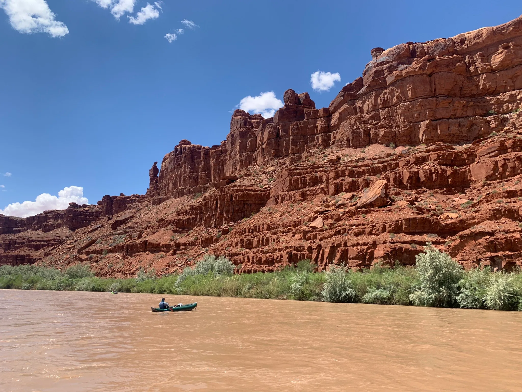
The Kimmerles are the ones who staked mining claims on a mesa just east of Hideout Canyon inside Bears Ears National Monument just months just before the Obama administration withdrew the area from new mining claims. After Trump shrunk the monument to exclude the White Canyon area in 2017, and just before Biden restored the boundaries in 2021, Kimmerle Mining staked five new claims in the area and acquired additional claims from another mining company. Kimmerle Mining promptly filed for a permit to do exploration work there, but the BLM said they had to demonstrate the claims “validity,” or show that they contained “valuable minerals.” The process for doing so would cost up to $100,000.

Shortly thereafter, Kimmerle joined the state of Utah’s lawsuit seeking to eviscerate the national monument, claiming that its establishment had caused him to lose out on mining profits.

No word on whether the firm plans on drilling or mining its Trump claims, but at least we know these folks’ political leaning. 

There have been a handful of other notable mining claim locations in the area in the past six months, including:

  • Platoro West Inc., located in Durango, staked twelve 20.66-acre lode claims southeast of Ouray, Colorado, in the Bear Creek drainage near Darley and Engineer Mountains. The company is registered under the name of William Sheriff, who was recently named executive chairman of Verdera Energy, which has interests in in-situ uranium mining in New Mexico.
  • CCKC Inc., of Philadelphia, located three 20-acre placer claims in Dolores County along the Dolores River upstream of Rico.
  • Roughead Resources of Moab (but which has also been associated with a Houston address) staked fifteen 20.66-acre lode claims in the Lisbon Valley of southeastern Utah near the Mi Vida Mine and the Lisbon Valley Copper Mine. At the same time, the company also staked dozens of claims in Beaver County, Utah.
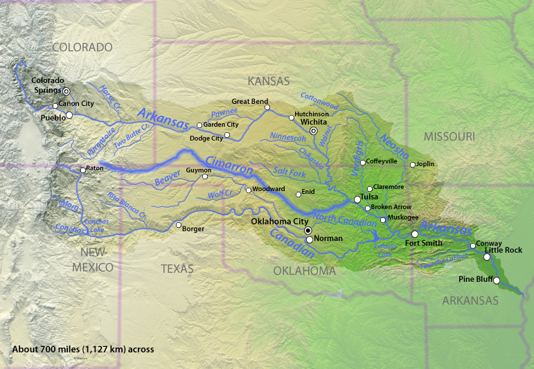
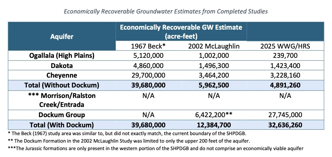
  • Fermi Metals of Cocolalla, Idaho, staked twenty-three 20.66-acre claims on the southern slope of the La Sal Mountains, just north of the settlement of La Sal. This is near Energy Fuels’ La Sal Complex uranium mines.
  • Geobrines International, of Littleton, Colorado, staked twenty-five 20-acre placer claims in Grand County, Utah, along I-70 between Green River and Cisco. This adds to a cluster of previously filed claims in the same area. They are probably looking to do lithium extraction.
  • Utah Brine Corporation, of Omaha, Nebraska, staked seventy 20-acre claims southwest of the community of La Sal in the Lisbon Valley. UBC appears to be a subsidiary of Omaha Value Inc., which has partnered with an Australian critical materials firm Neometals on its Utah Brine Project, which aims to extract lithium and potash.
  • Antimony Canyon Sovereign Reserve Inc, a division of Australia firm American Tungsten & Antimony, staked nineteen 20.66-acre lode claims near Antimony, Utah, in Garfield County. The plan is to develop an antimony mine here.

In other mining news:

  • Metallic Minerals has been eyeing and drilling into a copper deposit in the La Plata Mountains of southwestern Colorado. While actual mining may be a long ways off, concerned locals are already coming together to keep an eye on the project and push back, if necessary. The La Plata Mountains and Public Lands Coalition now has about 225 members from the region, according to Dan King, the coalition’s administrator. Metallic Minerals’ proposal was just one of the catalysts for the coalition, and its mission is much broader and more regional in scope.

Gold and silver prices have shot up tremendously over the last year, probably due to the Trump-effect on the economy and the U.S. dollar, which is stuck at a ridiculously low exchange rate. Gold is now around $5,000/oz, while silver is hovering around $100/oz., compared to just $30 when Trump took office. Uranium’s doing well, too, sitting consistently in the $80/lb to $90/lb range. 

Which is to say, mining companies suddenly have a lot more incentive to invest in reopening existing, idle mines or even building new ones (assuming they have faith that the high prices will endure). So far, however, it doesn’t seem to have sparked a surge in new mining activity. Even the Revenue-Virginius silver mine near Ouray, which is purportedly ready to produce ore, remains idle. 

The uranium sector does appear to be emerging from its long slumber, but mostly in the form of exploratory drilling, smaller companies selling claims to bigger ones, and staking mining claims on the increasingly sparse sections of public land that aren’t already claimed. Anfield continues work on constructing its Velvet-Wood mine in the Lisbon Valley, but it’s still a ways away from production (and its Shootaring mill is still mothballed and unlicensed). 

Energy Fuels is about the only firm actually producing conventional ore. According to their SEC filings, they pulled about 1.5 million pounds of uranium from the Pinyon Plain mine near the Grand Canyon and 155,000 pounds from their La Sal Complex in 2025. Their White Mesa Mill recovered 1 million pounds of uranium, which is a heck of a lot more than in the past, but still is far short of the facility’s 8-million-pound annual capacity. Despite all of this, the company still lost $86 million in 2025.

Meanwhile, the silver and gold mining corporations raked in massive profits, including:

  • Canadian corporation Barrick, which owns major gold mines in Nevada (Fourmile and Nevada Gold Mines) reported an attributable EBITDA of $8.16 billion last year, the “highest shareholder returns” in the company’s history.
  • Newmont (which jointly owns Nevada Gold Mines with Barrick) reported an adjusted EBITDA of $13.5 billion.
  • Kinross, owner of Bald Mountain and Round Mountain in Nevada, Fort Knox and Manh Choh in Alaska, and Kettle River-Curew Project in Washington, reported adjusted net earnings of $2.2 billion
  • Rio Tinto’s “profit after tax attributable to owners of Rio Tinto (net earnings)” $10 billion. 
  • SSR Mining, which owns a big mine in Nevada, only had a net income of $362 million; but that compares to 2024’s loss of $350 million.

Speaking of commodity prices and profits: American oil and gas companies are poised to make out like bandits thanks to the Trump-Netanyahu war on Iran. 

Iran produces some oil and gas. But more importantly, it borders the Strait of Hormuz and has threatened any oil and gas tankers that try to pass through it, effectively closing the passage. That could stanch the flow of oil and gas to the global market, causing prices to rise. The West Texas Intermediate, or WTI, crude oil price has shot up to about $76, the highest it’s been since before Trump took office. This will cause gasoline prices to climb, but also make drilling in the U.S. more profitable, and could spur companies to start using the stockpile of public land drilling permits they’ve amassed over the last year or so. 

Liquefied natural gas tankers also are unable to get through the Strait to European markets, which will cause prices of the fuel to skyrocket. It could also force European countries to turn to U.S. LNG exporters, which could echo back to natural gas producing states like New Mexico and Wyoming (and also may increase U.S. natural gas prices if the conflict drags on).


Glen Canyon Dam Must Be Modified to Avoid Draconian Water Supply Disruptions

A guest post by Ron Rudolph

Glen Canyon Dam with the river outlets in use as part of the high-flow experimental release. The outlets are only used occasionally and are not engineered for sustained use. Usually, all of the releases go through the penstocks and the hydroelectric turbines. But that won’t be possible if the lake drops below the level known as minimum power pool. Jonathan P. Thompson photo.

Glen Canyon Dam, which impounds the Colorado River to form Lake Powell, is a single point of failure that poses an unacceptable risk to the functioning of the entire river system. Modifying the dam to allow more water to pass through or around it is an essential component of any plan for allocating the river’s dwindling supply. 

The dam’s structural flaw limits the amount of water that can pass from Lake Powell downstream to Lake Mead. Lake Mead, the nation’s largest reservoir, is the primary repository of water for the Colorado River’s so-called Lower Basin states: California, Arizona, and Nevada. A paucity of water released from Lake Powell would eventually force reductions in the amount of water extracted from Lake Mead, diminish drinking water supplies for millions, harm agricultural productivity throughout the southwest, and embroil the federal government, seven states, more than two dozen Tribal Nations, Mexico, and others that share the river’s water in a cascade of costly court cases. 

The back of Glen Canyon Dam circa 1964, not long after the reservoir had begun filling up. Here the water level is above dead pool, meaning water can be released via the river outlets, but it is below minimum power pool, so water cannot yet enter the penstocks to generate electricity. Bureau of Reclamation photo. Annotations: Jonathan P. Thompson

Due to Glen Canyon Dam’s physical limitations, when the elevation of Lake Powell reaches “minimum power pool” or lower, the only way to release water from the dam is through its river outlet works.1 The persistent drought in the southwest, and continued demand for the river’s reduced water supply, makes it highly likely Lake Powell will fall to minimum power pool this year. The U.S. Bureau of Reclamation estimated this month that Lake Powell could fall to minimum power pool by late July, and remain there or lower through 2027.2

The Bureau of Reclamation’s latest forecast for the Colorado River predicts Lake Powell will “most probably” drop below the critical minimum power pool level before the end of this year, jeopardizing Glen Canyon Dam’s structural integrity. In the worst-case scenario, it would do so before summer’s end. This could force the feds to operate the dam as a “run-of-the-river” operation to preserve the dam’s infrastructure and hydropower output, which would significantly diminish downstream flows and threaten Lower Basin water supplies.

In addition, the agency’s February forecast estimates that under “most probable inflow” conditions, Lake Mead would drop below elevation 1,040 in June. If conditions do not improve by the agency’s August forecast, mandatory reductions in water use would be required in Arizona, California, Nevada, and Mexico.3 If the annual amount of water let out from Lake Powell is restricted to the dam’s outlet works, it would result in less water reaching Lake Mead than any year this century, and could trigger even larger reductions in Lower Basin water consumption.4 Releasing water from reservoirs upstream from Lake Powell could forestall the reservoir reaching minimum power pool, however, that is a non-sustainable solution, that fails to address Glen Canyon Dam’s fundamental plumbing problem. 

In January, the Bureau of Reclamation’s draft environmental impact statement — Post-2026 Operational Guidelines and Strategies for Lake Powell and Lake Mead —proposed several options for managing the Colorado River for the next 20 years. None of the alternatives includes remedying Glen Canyon Dam’s structural flaws. 

The Bureau’s proposals have been criticized by some of the largest consumers of Colorado River water who have signaled a willingness to challenge the agency in court. For example, the Metropolitan Water District of Southern California, which serves nearly 19 million people, noted the Bureau’s proposed alternatives “would likely lead to lengthy litigation.”5 The Central Arizona Project, the second largest consumer of Colorado River water, has identified several “legal deficiencies,” including non-compliance with the Colorado River Compact, and failure to adequately disclose and analyze the environmental, economic and socioeconomic impacts.6

Depending exclusively on the river outlet works to release sufficient water through Glen Canyon Dam is bound to fail, like relying on rainfall to grow crops in Arizona or southern California. The Bureau has warned relying on the outlet works would risk water supply disruptions to those who depend on Lake Powell and Lake Mead.7 The Director of the Bureau’s Technical Service Center has advised against using the outlet works as the sole means for releasing water from the dam,8 as previous high-capacity use of them for only 72 hours caused structural damage, which required nine months to repair. Despite the remedial effort, the Bureau concluded the repairs will not prevent future damage.9 The dam’s design flaw led the Arizona Department of Water Resources to conclude the structural limitations of Glen Canyon Dam must be alleviated.10

The calculus for equitably apportioning the diminishing water in the Colorado River is extremely complicated. But one variable in the equation is as obvious as the bathtub ring surrounding Lake Powell: a new system for conveying water sustainably through or around Glen Canyon Dam must be built. Without it, risks to the Colorado River system, and the communities, agriculture and ecosystems reliant on it, will escalate, as will pressure to impose compulsory reductions in consumptive uses throughout the basin. 

Ron Rudolph, a former assistant executive director of Friends of the Earth, spent 35 years in various engineering companies, including MWH Global, CH2M Hill, Jacobs Engineering, and Cardno with a career focused on infrastructure development and environmental remediation.


1 U.S.Bureau of Reclamation, Technical Decision Memorandum, Establishment of Interim Operating Guidance for Glen Canyon Dam During Low Reservoir Levels at Lake Powell, March 26, 2024, page 9

2 https://www.usbr.gov/lc/region/g4000/riverops/24ms-projections.html

3 When Lake Mead drops below elevation 1,040, a “Level 2 Shortage Condition,” mandatory reductions in water use by Arizona, California, Nevada, and Mexico are required by the 2007 Interim Guidelines for managing Lake Powell and Lake Mead, and the 2019 Lower Basin Drought Contingency Plan

4 The Bureau’s guidance for maximum release of water from each river outlet work (ROW) at minimum power pool elevation is 3,185 cubic feet/second (cfs). The agency has determined only three ROWs would be available simultaneously. If three ROWs operate at full capacity, they would release 9,555 cfs. 1 cfs sustained for a year = 724.acre-feet/year. 9,555 x 724.45 = 6,922,000 acre-feet/year. The maximum releases are specified in USBR, Technical Decision Memorandum, Establishment of Interim Operating Guidance for Glen Canyon Dam During Low Reservoir Levels at Lake Powell, March 26, 2024, page 2. The determination that only three ROWs would be available simultaneously in based on USBR, Near-term Colorado River Operations, Final Supplemental Impact Statement, March 2024, page 2-3. The least amount of water released this century was 7 million acre-feet in 2022, based on data from U.S. Bureau of Reclamation, Colorado River Accounting and Water Use Report: Arizona, California and Nevada, 2000-2024

5 Statement of Metropolitan Water District’s General Manager, Shivaji Deshmukh, January 9, 2026

6 Patrick Dent, Assistant General Manager, Water Policy, Central Arizona Project, Report on Post-2026 Draft Environmental Impact Statement, February 5, 2026 

7 U.S. Bureau of Reclamation, Near-term Colorado River Operations, Final Supplemental Impact Statement, March 2024, page 1-9, footnote 10

8 USBR, Technical Decision Memorandum, Establishment of Interim Operating Guidance for Glen Canyon Dam During Low Reservoir Levels at Lake Powell, March 26, 2024, page 9

9 USBR, Reclamation completes recoating of outlet tubes at Glen Canyon Dam ahead of schedule, June 18, 2025; https://www.usbr.gov/newsroom/news-release/5184 

10 Email from Trent Blomberg on behalf of Tom Buschatzke, Director, Arizona Department of Water Resources, February 4, 2026

Central Arizona Project: Letter to Secretary Burgum about the Draft Environmental Impact Statement for Post-2026 Operational Guidelines and Strategies for #LakePowell and #LakeMead — Terry Goddard and Brenda Burman #ColoradoRiver #COriver #aridification

Central Arizona Project map via Mountain Town News

Click the link to go to the Central Arizona Project website Colorado River Operations where you can find links to the relevant documents with respect to the DEIS.

Click the link to read the letter on the Central Arizona Project website (Terry Goddard and Brenda Burman):

Secretary Burgum:

On behalf of the Central Arizona Project and twenty-two Arizona Participating Entities that rely on the Colorado River, I am submitting the attached comments that express our deep concerns regarding the Draft Environmental Impact Statement (DEIS) for the Post-2026 Operational Guidelines and Strategies for Lake Powell and Lake Mead and the devastating impacts the alternatives therein would impose on Arizona.

All the alternatives proposed in the DEIS disproportionately harm Arizona and are unacceptable. Specifically, the Basic Coordination alternative proposed in the DEIS that Reclamation claims could be imposed without Arizona’s consent all but severs much of Central and Southern Arizona from Colorado River supplies that have been relied upon on for four decades, betraying the promise of sustainable water supplies that underly Arizona’s economy and potentially causing “widespread impacts on social and economic conditions. . . . that may force cities and towns to haul water . . . as an alternative to support continued services.”1 Arizona will not tolerate devastation and destabilization, particularly when the DEIS allows other Basin States to increase their water use.

The waters of the Colorado River are foundational to the economy and people of Central and Southern Arizona, supporting 6 million Arizonans, many tribal communities, a thriving advanced microchip manufacturing industry, and critical mineral and agricultural production. Arizona has cultivated a flourishing desert society over the past 40 years through careful and prudent use of Colorado River water supplied by the Central Arizona Project—more than doubling the State’s population while managing at the same time to use less water. The DEIS alternatives threaten to tear apart a generation of careful water management and topple the architecture supporting Arizona’s economy which is home to the heart of the American semi-conductor manufacturing and AI infrastructure industries.

The DEIS alternatives are not just a failure of policy but also include fatal legal deficiencies, and we respectfully request that the Department of the Interior withdraw the document. The United States must implement a decision that is consistent with the Colorado River Compact of 1922 (Compact), the Law of the River, and wise water policy—the DEIS fails on all counts. The enclosed comments highlight several critical flaws in the DEIS, including but not limited to:

  • Inconsistency with the Compact and the Law of the River: Absent agreement by the Basin States, the operating criteria for the Colorado River must comply with the foundational authority on the Colorado River: the Compact. All subsequent statutes, regulations, contracts, and other agreements are subject to compliance with the Compact and the DEIS ignores this foundational issue by proposing alternatives that would result in a breach thereof.
  • Failure to Analyze Upper Basin Delivery Obligations: The DEIS fails to consider or model the impacts of Upper Basin delivery obligations due to a Compact deficiency, including required releases from Colorado River Storage Project Act Upper Initial Units and curtailment in the Upper Basin necessary to prevent a breach of the Compact. This analysis is particularly important at this time, as a breach of the Upper Basin’s Compact delivery obligations could occur within the next 12 months.
  • Failure to Analyze the Devastating Socioeconomic Impacts to Arizona: The DEIS fails to analyze the widespread destabilizing social and economic impacts on Arizona that would be caused by the deep cuts to Arizona’s Colorado River supplies proposed in the document and could cause Arizona’s economy to lose over $2.7 trillion.
  • Failure to Evaluate Reasonable Alternatives: The range of alternatives is too narrow and neglects to evaluate the reasonable and feasible Lower Basin Alternative which would equitably share cuts needed to stabilize the Colorado River System among all seven Basin States and Mexico.
  • Illegal Implementation of the so-called “Junior Priority” on the Central Arizona Project: Arizona never agreed and the law does not make the Central Arizona Project a junior user to the Upper Basin. The DEIS fails by proposing deep cuts to Arizona’s water supplies without Compact compliance or required reductions to the Upper Basin. Further, the “junior priority” described in the Colorado River Basin Project Act and used to distribute the DEIS cuts to the Lower Basin is a facially unconstitutional imposition on Arizona’s sovereignty and illegally attempts to make Arizona a second-class citizen among the other Lower Basin States.

For these reasons and others described in the attached comments, the current DEIS does not provide the “hard look” at environmental consequences required by law. Proceeding with this document is highly likely to lead to legal challenges and long-term environmental damage that has not been analyzed.

We welcome the opportunity to work with the Department of the Interior to ensure the revised DEIS is robust and legally durable. Arizona has been a willing partner in attempting to negotiate a consensus solution to the management challenges facing Colorado River operations and continues to stand ready to find a compromise with the Secretary, the other Basin States, and additional Colorado River stakeholders based on shared sacrifice and a recognition that everyone must reduce their uses to stabilize the system. A revised DEIS is essential to comply with NEPA and properly inform the public and decision-makers and to avoid protracted litigation.

Map of the Colorado River drainage basin, created using USGS data. By Shannon1 Creative Commons Attribution-Share Alike 4.0

Federal Water Tap, March 2, 2026: Reclamation Outlines Options to Prop Up Shrinking #LakePowell — Brett Walton (circleofblue.org) #ColoradoRiver #COriver #aridification

Click the link to read the article on the Circle of Blue website (Brett Walton):

The Rundown

  • Interior Department overhauls its environmental review procedures.
  • GAO says NOAA, which has oversight authority, should do a better job of tracking cloud seeding and other weather modification.
  • Senate passes a bill to allow southern Nevada’s water authority to build a water-supply pipeline beneath a national conservation area.
  • EPA staff decreased 7 percent in the nine months through June 2025, GAO found.
  • Army Corps directive aims to speed up infrastructure work, prioritize projects.
  • House Democrats from the D.C. region ask Congress to fund the repair of a major sewer pipe break.

And lastly, Bureau of Reclamation officials outline options for propping up a shrinking Lake Powell.

“I think it’s safe for us to assume that unless Mother Nature is uncharacteristically generous, that Lake Powell elevations are going to fluctuate at elevations that we’re not comfortable with.” – Wayne Pullan, Bureau of Reclamation Upper Colorado regional director, speaking about the possibility that Lake Powell drops low enough later this year that Glen Canyon Dam cannot generate hydropower.

In context: Two-Decade Hydropower Plunge at Big Colorado River Dams

By the Numbers

7 Percent: Decrease in EPA staff between September 2024 and June 2025, according to a Government Accountability Office audit.

10: States that have weather modification programs, typically cloud seeding to induce rainfall, according to a GAO report.

News Briefs

Interior NEPA Changes
The Interior Department overhauled its environmental review procedures, aligning them with recent court decisions, congressional action, and Trump administration priorities.

The final rule sets page limits (150 pages in most cases, up to 300 for actions of “extraordinary complexity”) and time limits (generally two years) on environmental impact statements.

The new rules do not require public comment on draft environmental impact statements. The only mandatory opportunity for public comment is after the department issues a notice that it intends to prepare an EIS.

Reviews already in progress, those with “applications that are sufficiently advanced,” will be held to the previous standard.

Illustration from the report, “Antique Plumbing & Leadership Postponed” from the Utah Rivers Council,
Glen Canyon Institute and the Great Basin Water Network. Courtesy of Utah Rivers Council

Lake Powell Options
Officials at the Bureau of Reclamation, the federal agency that manages Colorado River dams, outlined several actions they are considering in the coming months to boost water levels in a rapidly shrinking Lake Powell, which could drop to a record low later this year that would halt hydropower production from Glen Canyon Dam for the first time.

The Colorado River’s second-largest reservoir behind Lake Mead is entering one of the most difficult periods in its six-decade history. The basin is drying due to a warming climate. Powell is just a quarter full, and projected to drop lower this year. Winter has been a dud, with warm temperatures and a historically bad snowpack in the Colorado mountains that feed into the reservoir.

Reclamation officials discussed their options during a meeting last week of the Glen Canyon Dam Adaptive Management Work Group, an expert committee that advises on the dam’s ecological impacts.

2024 decision allows Reclamation to “consider all tools that are available” to keep Powell from dropping below 3,500 feet, an elevation that provides a little wiggle room for maintaining hydropower production. Powell today sits at 3,531 feet.

The tool from the 2024 decision is Section 6(E), which grants Reclamation the authority to restrict water releases from Powell to as low as 6 million acre-feet. The planned release this year is 7.48 million acre-feet, so the Section 6(E) authority represents a potential 20 percent reduction.

A cut of that magnitude might not be necessary because Reclamation has another tool it can use in tandem.

That option is releasing more water from Flaming Gorge and other smaller reservoirs located higher in the watershed. This is called a DROA release after its authorizing document. Pullan said this action, which states in the lower basin are advocating for, is being discussed and the volume of those releases would be determined in the spring, around April or May.

In context: Big Decisions Loom for a Rapidly Shrinking Lake Powell

Southern Nevada Water Pipeline
The Senate passed a bill that allows southern Nevada’s water provider to tunnel beneath Sloan Canyon National Conservation Area in order to build a pipeline to increase the water-supply system’s reliability. The bill now goes to the president’s desk.

Studies and Reports

‘Army Mode’ for the Army Corps
Adam Telle, head of the Army Corps of Engineers, issued a collection of directives aimed at reducing paperwork and speeding up water infrastructure construction.

In one memo, Telle called for an “Army Mode” mobilization. He ordered a bottom-up approach whereby officials will select at least 20 projects nationally to prioritize. The list is due March 20.

A separate memo lists seven focus areas for infrastructure work. In descending order of importance: human life and safety, economically or strategically important infrastructure, efficient navigation and supply chains, human property, aquatic ecosystems, state-level infrastructure, and municipal infrastructure.

In yet another memo, he said that project investigations – part of the planning phase – should take no more than three years and $3 million.

Cost of Natural Hazards for the Defense Department
The Defense Department lacks data to understand fully the costs of natural hazards to its installations, according to a Government Accountability Office report.

The GAO made five recommendations, including resilience planning, data collection standards, guidance, and procedures. The Defense Department agreed with all of them.

Weather Modification
The GAO also looked into NOAA’s tracking of activities to induce rainfall or otherwise change the weather.

Thanks to a 1972 law, NOAA has oversight authority over weather modification and any entity that shoots silver iodide into clouds to make it rain is required to file a report with the agency. Solar geoengineering, which attempts to reduce air temperatures, is far less common but also covered under this authority.

The GAO found that NOAA’s database is incomplete, inconsistent, and unreliable. One fifth of interim and final reports had at least one error, the GAO estimates.

“Consequently, NOAA is not fully aware of the extent of weather modification activities that have occurred and are occurring within the U.S., how they are being conducted, or potential effects,” the GAO concluded.

On the Radar

How to Sue the EPA
The EPA is proposing to change the process for filing citizen lawsuits, moving from mail delivery to electronic submissions.

Public comments are due March 26. Submit them via http://www.regulations.gov using docket number EPA-HQ-OGC-2024-0557.

Water Infrastructure Funding
In the wake of a large-diameter sewer line rupture along the Potomac River, House Democrats from Maryland, Virginia, and the District of Columbia wrote to leaders of the House Transportation and Infrastructure Committee asking for funding for repairs.

The letter also asked for the Army Corps of Engineers to prioritize a study of a backup drinking water source for the capital region, which relies on the Potomac.

“Unlike other major metropolitan areas, the region lacks a secondary water supply, which would provide critical redundancy in the event of a future crisis.”

Federal Water Tap is a weekly digest spotting trends in U.S. government water policy. To get more water news, follow Circle of Blue on Twitter and sign up for our newsletter.

Map of the Colorado River drainage basin, created using USGS data. By Shannon1 Creative Commons Attribution-Share Alike 4.0

How much water remains in aquifers of SE #Colorado? — Allen Best (BigPivots.com)

Corn in Baca County. Photo credit: Allen Best/Big Pivots

Click the link to read the article on the Big Pivots website (Allen Best):

February 28, 2026

Study being completed will help guide decisions about continued mining of groundwater in the Springfield area. Ogallala will be gone within 20 years, but deepest formation could last a century.

Before center-pivot sprinklers powered by rural electrification in the mid-20th century, farmers in Colorado’s southeastern corner necessarily relied upon what came from the sky for water. HIgh-capacity pumps, first used in the Springfield area during the late 1940s allowed the farmers to go underground, to more lucratively plumb a series of aquifers and deliver far-higher crop yields.

The Ogallala — also called the High Plains — is the water-bearing geologic formation nearest the surface, followed by the more water-rich Dakota and Cheyenne formations. Underlying both is a far larger reservoir yet called the Dockum Group.

How long will that water last? A new report commissioned by Colorado, still in rough draft stage, finds that a little more than 2,000 wells mine these formations in Baca County and a portion of adjoining Prowers County. The vast majority of the water, 97%, irrigates alfalfa, corn and other crops. Remaining water goes to hog farms, stock ponds, and domestic wells for farmhouses as well as municipal supplies in Springfield and several even smaller towns.

An average 157,000 acre-feet were mined annually from these subterranean deposits from 2020 through 2024. To put that into perspective Denver Water delivers an average 232,000 acre-feet to the 1.5 million residents in Denver and adjoining jurisdictions.

The answer to the question about how long the water will last has not been fully answered. At current rates of pumping, the Ogallala will be gone by 2045, according to this draft study. The next two deeper formations, Dakota and Cheyenne, have been depleted more rapidly but have more water.

The deepest water, in the Dockum, could last a century or more. It depends partly on the quality of water extracted at greater depths. There seem to be some unknowns about this. Cost of extraction is also a factor. Deeper wells cost more money to drill. It also takes more electricity to pump water to the surface. Would crop prices justify the added expenses?

Pueblo can be seen in the upper left-hand corner of this map, and the southern high plains district is designated by lavender.

With those asterisks in mind, the study estimates nearly 33 million acre-feet of water can be economically recovered from the four water-bearing geologic formations in that southern high plains groundwater district.

On average, Colorado consumes 5.3 million acre-feet of water per year, although some of that water gets reused. Think of runoff from farm fields or treated sewage that reenters streams and rivers. When that is added up, Colorado’s total diversions hit 15.3 million acre-feet. This southern plains basin bordering Kansas and Oklahoma is just a small part of Colorado.

Unlike Colorado’s rivers, which are mostly derived from snowmelt and rainfall, the groundwater recharges but much more slowly than the extraction. This study estimates an annual recharge of 32,000 acre-feet compared to the 157,000 acre-feet withdrawn.

Apart from the river valleys, dryland areas of southeastern Colorado were among the last places homesteaded in Colorado. First came the settlements of Denver, Colorado Springs, and Boulder with their access to water from the mountain streams and rivers and proximity to the mountain mining camps. Very quickly, water was diverted to create farms.

Homesteading of the high plains began about 30 years later. By then, the buffalo were gone, and the last battle with Native Americas had occurred in 1869 at Summit Springs. Settlement near Springfield, Walsh and other Baca County towns continued through the 1920s. Peak settlement occurred in about 1930, before the weather turned hotter and drier and the skies filled with dust. Baca County during the decade of the Dust Bowl and the Great Depression lost more than a third of its population.

Baca County since then has continued to lose population as farm sizes have grown. While groundwater extraction has provided a modicum of prosperity, the county ranked 57th among Colorado’s 64 counties in per-capita income as of 2022.

The hydrogeology that is believed to exist in this basin can be seen in this west-east profile. Some formations, including the Graneros and Kiowa shales, contain no water and act as barriers.

The Colorado Ground Water Commission — created in 1965, before groundwater became a common word — has legal purview over extraction. The commission can set limits on the allowable rate of depletion.

The southern high plains district limits new wells within a half-mile of existing high-capacity wells. But it is still possible to get a permit for a new well. That is in dispute. Some think the basin needs to be “closed,” to bar future wells and hence prolong the life of the aquifers.

Cimarron River Basin. By Shannon1 – Drawn by myself; shaded relief data from NASA SRTM North America imagery here, CC BY-SA 4.0, https://commons.wikimedia.org/w/index.php?curid=12115861

This groundwater basin in southeastern Colorado is very different from the Republican River Basin of northeastern Colorado in one crucial way. The aquifers do not deliver water to a river subject to a multi-state compact. The Cimarron River nicks the extreme corner of Colorado, but testimony to the poverty of water in this “river” is provided by those traveling to Santa Fe in the 19th century. Nearly all followed the Arkansas River, not the Cimarron, despite the latter route being much shorter.

In contrast, a compact struck in 1943 governs flows in the Republican River. It arises far from Colorado’s mountains and is instead nourished by water seeping out of the Ogallala in places like Holyoke and Yuma and Burlington. Mining of groundwater in the basin to grow crops reduced flows to the extent that Kansas sued Nebraska, which in turn sued Colorado. Now, farmers in the basin are trying to reduce their withdrawals by voluntary retirement of 25,000 acres from active irrigation. The 19,000-plus acres retired so far have been induced by financial incentives that tap federal but also state funds.

Without a compact to force reduced pumping in southeastern Colorado, the state can adopt its own rules.

Residents of southeastern Colorado appear to be somewhat conflicted about whether new rules governing withdrawal are needed and what they should look like. Baca County’s Herald Plainsman in March 2023 reported on a “highly charged” meeting in Springfield called by the state’s Division of Water Resources. Tracy Kosloff, the deputy state engineer, explained that a group from the community had requested a rule change in the previous year.

Their intent was to block the issuance of new permits for high-capacity wells. Kosloff asked for the community to come to a consensus, if possible.

No consensus was evident at that meeting. at least according to the Plainsman Herald report. One speaker said that “without high-capacity wells, there will be no people left in the county.” Tim Hume, who is the region’s representative on the Colorado Ground Water Commission, said that without irrigation, two thirds of the people in the room would not be there. He also noted that one of the 67 monitoring wells had actually shown higher levels in the previous 20 years. But another speaker, Jack Dawson, said to keep irrigation going for quite some time, there was a real need to start conserving water.

With aid of a special $250,000 appropriation by state legislators, the Division of Water Resources commissioned a study by Wilson Water Group and HRS Water Consultants to provide new estimates of how much water remains that can be recovered economically. These consultants are also creating a planning tool to allow groundwater basin users to evaluate future groundwater use scenarios.

At a meeting scheduled for March 16 in Springfield, the consultants hope to glean insight from farmers about what constitutes economically viable extraction. How deep into the Dockum can they go and hope to be able to make money? How much water treatment is required and feasible? The big question is whether new rules will be needed to limit extraction.

Also to be determined are the goals under future conditions. How fast should the groundwater be mined? Or should there be limits beyond those few already in place?  The consultants are to submit a final report before the end of 2026.

What comes of this new knowledge? It’s possible — maybe even likely — that some residents of southeastern Colorado will then file a petition with the Colorado Ground Water Commission to adopt new rules restricting extraction. This study sets up the facts for helping make that decision of whether to do so, and if so, how.

The draft study says a range of viewpoints can be expected. Some stakeholders will favor the status quo. Others might favor restricted pumping from specific aquifers or even from new wells, conceivably all wells. Expansion of irrigated acreage cold be curbed — although in some cases land has been taken out of irrigated production already.

Also relevant is the shifting climate. The study mentions climate change just once, noting that hotter or drier conditions may occur in 50 years, affecting crop irrigation requirements. Already, however, the hotter temperatures of southeastern Colorado cause crops to need a third more water than those grown 200 miles north.

The most direct parallel to a ban on new wells in southeastern Colorado would be a similar ban on new wells in the upper Crow Creek drainage northeast of Greeley near the Wyoming border. The alluvial, Fan and White River aquifers within the designated basin were declared over-appropriated effective April 14, 2017.

Hydrogeology of Colorado’s southeastern corner has been studied several times. First was a studyby the U.S. Geological Survey in conjunction with the Colorado Water Conservation Board completed in 1954. It recorded springs and creeks and pumping from wells for house and towns and stock ponds, with some of the records gleaned by New Deal workers in the 1930s. It made no attempt to quantify groundwater storage volume. Aquifer mining was non-existent in that area as high-capacity pumps had been created less than a decade before.

1967 study by R.W. Beck and Associates did attempt to quantify the groundwater resources. It estimated that groundwater extraction of 13,200 acre-feet in 1950 had grown by 1964 to 118,700 acre-feet.

The study projected that groundwater extraction in the basin would grow to 276,000 acre-feet by 2017. It is somewhat less. That study also projected that population of Baca County would grow to 4,700 by 2017. Actually, it declined to 3,500.

That study made no mention of the Dockum, the formation now believed to have the most water, based on well logs and other lines of evidence.

That study also recommended creation of a groundwater management district to assist in “development” of the extraction. That district was created.

Southeastern Colorado’s groundwater was also part of a six-state study of the Ogallala Aquifer in 1983.

Most recent were two related reports in 2002 by McLaughlin Water Engineers. This new study differs in a substantial way in that it uses data deeper than the 200 feet of the Dockum and hence increases the volume of water that may potentially be extracted. It also employs newer tools to figure out what exactly is going on down there in the dark, although exactly how much sharper insight this report delivers is not yet clear.

The Division of Water Resources also has conducted three studies in this century that define a steady but not dramatic decline of the aquifers in southeastern Colorado.

See Updated Southern High Plains Groundwater Study Draft Report and Planning Tool at the High Plains Study website.

Colorado River District Responds to the Bureau of Reclamation’s Proposals for Post-2026 #LakePowell and #LakeMead Operations #ColoradoRiver #COriver #aridification

Colorado River District land area.

Click the link to read the release on the Colorado River District website (Lindsay DeFrates):

March 2, 2026

Last week, the Colorado River District submitted comments and specific recommendations to the Bureau of Reclamation on the recently released Post-2026 Operational Guidelines and Strategies for Lake Powell and Lake Mead Draft Environmental Impact Statement (DEIS). In its comments, the River District calls for future operational decisions that reflect hydrologic realities, address Lower Basin overuse, and move the Colorado River System beyond constant crisis management.

“A core part of our mission is safeguarding, for all Coloradans, the waters of the Colorado River to which our state is entitled under the various laws, agreements and compacts that govern the river,” said Raquel Flinker, Director of Interstate and Regional Water Resources at the Colorado River District. “Our water users have adapted to the reality of variable hydrology. We are living with a river that has 20% less water and this trend is expected to continue. It is past time that our neighbors in the Lower Basin learn how to live within the means provided by the river.”

“What is very clear in these proposals is that we still have a basic math problem,” said Colorado River District General Manager Andy Mueller. “Every year, around 1.5 million acre feet of Colorado River water disappears due to evaporation and transit loss in the Lower Basin, yet this amount is unaccounted for in the Bureau’s water deliveries. If we want to move out of crisis response mode, every proposal must begin by reducing consumptive use in the Lower Basin by this amount every single year before discussing shortages. If we had fixed the math to align with the laws of nature twenty-five years ago, we would have almost 30-million-acre feet of storage still available in the system today.”

The River District’s letter includes 13 specific recommendations organized around several key themes. First, it calls for post-2026 operations that align demand with available supply and put hydrologic reality, not predictability for the Lower Basin, at the center of decision-making. The River District urges Reclamation to evaluate alternatives that perform under critically dry hydrology, provide a fair, transparent analysis of actions and impacts, and clearly disclose Upper Basin shortage risks in the main body of the analysis.

The letter also stresses that Lower Basin use must be reduced by roughly 1.5 million acre-feet at all times, defined as system losses rather than “shortage,” and that Upper Basin conservation assumptions and scale must be re-evaluated. In addition, the River District calls for clear, durable guidelines and definitions, including fully defining and analyzing “gap water” and “additional Upper Basin actions,” and for CRSP initial unit water to remain in Lake Powell. Finally, it raises Law of the River concerns, including that inter-basin transactions must not be allowed.

The River District’s full comment letter is available here:

Reclamation formally published the DEIS on January 16, 2026, opening a 45-day public comment period. The Bureau of Reclamation must consider public feedback when developing a preferred alternative for management of the system, and the basin states will continue their negotiations alongside this process with the hope of reaching a seven-state consensus. The current guidelines expire at the end of September 2026.

It’s getting hot in here … and it ain’t just the January Thaw: Plus: #ColoradoRiver Chronicles; Big Bend Border Wall boondoggle — Jonathan P. Thompson (LandDesk.org) #COriver #aridification

Click the link to read the article on The Land Desk website (Jonathan P. Thompson):

February 27, 2026

🥵 Aridification Watch 🐫

Back in the late 1990s and early 2000s, when I lived in Silverton, Colorado, elevation 9,318 feet, we often experienced a “January thaw.” It was a period of a few sunny, warm days between storms that usually fell in January but could also occur in February. If you could find a south-facing deck that was protected from the wind and free of dangling, skull-piercing icicles, you could sit out in shirtsleeves, soak up some vitamin D, and maybe even get a little bit of a suntan. Then winter, below zero temperatures, and super snowy San Juaners would return, finally and grudgingly departing sometime in late May.

A pretty big swath of the Southwest is about to experience a February thaw of its own, according to National Weather Service forecasts, including in these hot spots:

  • Phoenix’s mercury could climb into the low- to mid-90s this weekend [February 28 – March 1, 2026], with overnight lows in the 60s.
  • Durango, Colorado, is expecting to hit 66° F on Sunday (with lows staying above freezing).
  • It will be prime bike-riding weather in Moab, where the highs could climb into the low 70s.
  • And even Silverton will get up into the 50s, with the overnight lows dipping only a few degrees below freezing — bad news for the snow.
  • Denver is under a red flag warning for fire danger today, and will see temperatures in the high 60s.

During a “normal” winter, this wouldn’t be alarming in the slightest. In fact, it would be a welcome respite from winter. Now it threatens to wipe out any indication that it even is winter by potentially erasing the snowpack gained during last week’s storms. The Upper Colorado River Basin’s snowpack is exactly at the same level as it was on this date in 2002. Ohhh boy, if those March storms don’t arrive it’s going to be a long, dry summer.


The trouble with normal … — Jonathan P. Thompson


💧 Colorado River Chronicles 🐟

As a deal between the seven Colorado states for how to divvy up massive consumption cuts seems less and less likely, Arizona is getting a bit more aggressive.This week the Protecting Arizona’s Lifeline Coalition launched a PR campaign, complete with videos, attempting to pressure the Upper Basin states to let more water flow downstream to its Lower Basin neighbors. 

Arizona is understandably worried: The Central Arizona Project’s water rights are junior to most of the other large users in the Lower Basin, meaning they would be among the first to take cuts if there were a shortage. The window for a dramatic improvement in Upper Basin snowpack is rapidly closing, thereby increasing the likelihood of a shortage later this year. 

The campaign includes a series of videos with various officials making their case. There are also a few educational ones that do a nice job of explaining the Colorado River Compact, and are really worth a watch. However, I should warn you that they are coming from a Lower Basin perspective, meaning they interpret one clause of the Compact, Article III(d), significantly differently than the Upper Basin states. And yet, that’s what their entire argument relies on. 

That clause states that the Upper Basin must “not cause the flow of the river at Lee Ferry to be depleted below an aggregate of 75 million acre-feet” for any 10-year period. 

The Upper Basin sees this as a “non-depletion obligation,” meaning it blocks them from exceeding their 7.5 MAF/year allocation if it causes the Lee Ferry flow to fall below a 7.5 MAF/year average. The Lower Basin sees it as a “minimum delivery obligation,” meaning that the Upper Basin is obliged to send an average of 7.5 MAF past Lee Ferry no matter what, even if that means draining all of its reservoirs and drying out its fields and cities.

Keeping that in mind, check out the video:


A Colorado River glossary and primer — Jonathan P. Thompson

The Colorado River Crisis is Here — Jonathan P. Thompson


🤯 Oh, the Humans! 😱

In a comment on Tuesday’s dispatch, reader Steve Harris suggested a story on the U.S. Customs and Border Protection fast-tracking a 200-mile segment of border wall through Big Bend National Park.

This is a super important issue. And it’s not only in Big Bend: The entire border wall is an environmental disaster, slashing through biologically diverse, beautiful country and cutting off migratory routes and movement for mountain lions, javelina, coyotes, ocelot, deer, desert bighorns, and even jaguars. Keep in mind that it’s not just a fence, it’s a giant piece of infrastructure that requires bulldozing all the vegetation and even blasting through the landscape. Besides that, we taxpayers are forking out billions of dollars for something that isn’t all that great at doing what it’s supposed to do.

For me it’s especially heartbreaking to see the wall cut through the borderlands south of Tucson, down in the Patagonia Mountains. Many years ago my dad took my brother and I along some little road through there right up against the border, which at the time was just a barbed wire fence. It was incredible country, so quiet and mostly humanity-free.

The stakes are equally as high in the Big Bend area, where both ecological and cultural treasures are at risk. Unfortunately I’ve never been to Big Bend, and it’s a little ways outside the region I normally cover, so I’m not going to try to pretend to know what’s going on there. But a lot of other smart folks have written about it and are trying to block the new stretch of wall, so I’ll share some of that here:

🌵 Public Lands 🌲

Environmental groups and environmentally-oriented media outlets are making a pretty big stink over the confirmation hearings for Steve Pearce, Trump’s pick to lead the Bureau of Land Management. There’s a good reason for this: Pearce is well known for his hostility toward the BLM and the public lands it oversees, and he has also indicated a desire to sell off public land — a stance he failed to renounce during this week’s hearings.

Pearce is a bad choice for this job. But is it worth spending a lot of resources to get him ousted? Probably not.

If the Senate does not confirm Pearce, then the administration will just find some other bozo to do the job, which in this case is basically a middle manager tasked with carrying out the agenda of Interior Secretary Doug Burgum. Burgum, in turn, is merely executing the Trump administration’s, i.e. Project 2025, policies.

Which I have to say is disappointing and sad. Before he was a cabinet member, Burgum seemed like a reasonable enough guy. Sure he has ties to oil and gas interests, but he also appeared to be a Teddy Roosevelt Republican — an old school conservative and conservationist who valued public lands. He even managed to garner the endorsement of outdoor retailer REI’s board along with that of the hook and bullet crowd.

Instead, he has prostrated himself to the extractive industries, embraced coal mining and oil and gas drilling, and shattered environmental protections for public lands left and right. His distinguishing features as a cabinet member have been his unwavering sneer-like grin and his tendency to fawn over Trump — and coal.

***

Your energy and outrage might be better spent on convincing Congress to shoot down Sen. Mike Lee’s, R-Utah, attempt to use the Congressional Review Act to revoke the Grand Staircase-Escalante National Monument management plan. If the “resolution of disapproval” passes both chambers of Congress with a simple majority vote, it would erase the plan and bar the Bureau of Land Management from issuing another plan that is “substantially the same” in the future.

Republicans in the current Congress used the CRA — which allows Congress to revoke recently implemented administrative rules — to do away with resource management plans in Alaska, Montana, and North Dakota. That’s in spite of the fact that RMPs are not considered “rules,” according to a January 2025 opinion by the Interior Department’s Solicitor. National monument management plans aren’t rules, either, but that’s not a hindrance for Lee.

This wouldn’t change the boundaries of the monument, but would likely cause management of the area to revert back to the 2020, Trump I-era plan. That plan was not only less protective than the newer one, but only applied to a much smaller area, since in 2017 Trump had significantly shrunk the national monument. Revoking the current management plan, then, would leave vast areas of the monument in a sort of management limbo.

It would also open the door to revoking other national monument management plans (e.g. Bears Ears), allowing the GOP to carry out Project 2025’s goal of shrinking or eliminating national monuments in a less visible, more underhanded manner.


Just a couple reminders from a few years ago that it does snow, and it will snow again — just maybe not this spring. Jonathan P. Thompson photos.

Utility-scale battery energy storage facility planned in Hayden — Steamboat Pilot & Today

The estimated 30- to 40-acre utility-scale battery energy storage facility planned by Jupiter Power to be built in 2027 southwest of the Hayden Power Station would look similar to this facility completed in 2024 in Houston. Jupiter Power/Courtesy photo

Click the link to read the article on the Steamboat Pilot & Today website (Suzie Romig). Here’s an excerpt:

February 26, 2026

A utility-scale battery energy storage facility was approved last week by the Colorado Public Utilities Commission with the project planned for construction southwest of the Hayden Power Station within the town limits of Hayden. Megan Castle, communications director for the Public Utilities Commission, said the 400 MW project was approved as part of 10 total bid projects accepted by the state commission. The project in Hayden will be led by Jupiter Power, a developer and operator of utility-scale battery energy storage systems with corporate offices in Austin, Houston and Chicago. The proposed energy storage facility would be located on a 72-acre site on Routt County Road 51 near the Hayden power plant and Yampa Valley Regional Airport and would connect by a new transmission line to the Mount Harris substation southeast of the main Hayden station. The stored energy would be sold to Xcel Energy through a Power Purchase Agreement, said Michelle Aguayo, senior media relations representative at Xcel.

“This project is a Power Purchase Agreement, where another company builds and maintains the project, and we purchase the power produced,” Aguayo said Tuesday.

Hayden Town Manager Mathew Mendisco said municipal leaders are excited about the forthcoming facility, and that Jupiter Power staff already has worked through the preliminary application process with the town and is expected to submit a formal application later this year. Mendisco said the town leadership is happy to have more light industrial development to continue to boost the local tax base.

“Development like this is always good,” Mendisco said. “The energy sector has been part of our economy for many years, and this fits right in. We are excited to have land near the airport developed, and we think this seems to be a good fit.”

#Durango City Council approves feasibility study for #AnimasRiver surf wave — The Durango Herald

Animas River

Click the link to read the article on The Durango Herald website (Christian Burney). Here’s an excerpt:

February 28, 2026

City Council approved a $44,000 feasibility study last week that will explore where a new surf wave could be optimally built along the Animas River in Durango. The nonprofit Animas River Surfers proposed the feasibility study and a partnership with the city to get it done. It raised $13,000 to contribute to the study. The city budgeted $40,000 plus a 10% contingency from the 2015 sales tax fund for the study, which City Council approved last week along with budget appropriations for a wide scope of other projects. Parks and Recreation Director Scott McClain said it has received proposals for the study, and the chosen consultant will identify possible locations for a surf wave and narrow them down to one. The consultant will engage with commercial organizations and Animas River users during the study…City spokesman Tom Sluis told The Durango Herald the city hasn’t yet hired a consultant to conduct the feasibility study and it will be another week or so before a consultant is selected.

#Colorado is debating whether to incentivize data centers. Western Slope leaders ask: What about water? — The #GlenwoodSprings Post Independent

State Highway 133 crosses the Crystal River several times as it flows downstream to its confluence with the Roaring Fork River in Carbondale. Some proponents of a federal Wild & Scenic designation are pushing for a quick timeline while others want a more cautious approach. CREDIT: HEATHER SACKETT/ASPEN JOURNALISM

Click the link to read the article on the Glenwood Springs Post Independent website (Robert Tann). Here’s an excerpt:

February 27, 2026

Colorado lawmakers are asking themselves: Can they bring more data centers to the state while ensuring the power-hungry facilities don’t burden ratepayers and the environment? Dueling bills in the legislature both claim to have the answer. One would push Colorado to join the ranks of many other states that offer tax breaks to incentivize data centers — the backbone of today’s technology landscape. The other would impose more stringent regulations on the industry to protect consumers and the environment from potential harm.  As the debate unfolds, some Western Slope leaders are raising concerns over what the push for data centers could mean for their communities’ most valuable resource — water…

Researchers say a large-scale data center can use up to 5 million gallons of water per day to cool down its systems. That’s enough water to serve a town of between 10,000 and 50,000 people daily, according to reporting by the Washington Post.  If Colorado chooses to entice more of the thirsty facilities to set up shop, largely in metro areas, Western Slope leaders say that could mean more water being diverted from mountain communities in an era of severe drought…“We’ve struggled for a couple generations with the water of the Western Slope, which is where the water is in Colorado, moving eastward,” said Eagle County Commissioner Matt Scherr. “This is setting up even more fights with our Front Range friends than I think is necessary.” 

This year’s record-low snowpackgrowing drought concerns and unresolved Colorado River negotiations further punctuate that point, said Kristin Green, a water policy adviser for the Northwest Colorado Council of Governments Water Quality/Quantity Committee.

“Any kind of water use needs to be heavily scrutinized because of the dire straits we are in,” Green said. 

In which my colleagues and I share thoughts on the future of #ColoradoRiver governance — John Fleck (InkStain.net) #COriver #aridification

Colorado River “Beginnings” where the snow accumulates. Photo: Brent Gardner-Smith/Aspen Journalism

Click the link to read the article on the InkStain website (John Fleck):

February 27, 2026

It is hard to know where to begin. The Department of the Interior’s Post-2026 Colorado River draft environmental impact statement, and the deep questions it raises, is an “everything including the kitchen sink” sort of process.

But at its root, the question it raises is simple: Tell us what you’re going to do.

It is easiest to quote the Draft EIS itself on the central question: “In critically dry periods, all alternatives have unacceptable performance.” Roger that. Tell us what you’re going to do.

In the short run, with a meager snowpack and no clear explanation of how federal and state managers are going to operate the reservoir system, the basin’s dams and diversions now, we have no clear picture of what will happen in 2026. Tell us what you’re going to do.

Some specifics

The ad-hoc collective that Allen Best dubbed “the Traveling Wilburys of the Colorado River” – Anne Castle, Eric Kuhn, Jack Schmidt, Kathryn Sorensen, Rin Tara, and me – took yet another stab at offering our suggestions in comments we submitted yesterday to Interior’s P26 EIS process.

I’ve been mentally largely elsewhere lately, finishing up the book and managing my health (I’m doing great! Thanks for asking!), so I mostly show up at the last minute on these things to dub my vocals, but my friends are very kind and inclusive, and they do good work. In particular, stuff like this full of both useful NEPA-speak and also substance:

As I said: Tell us what you’re going to do.

As I said: Tell us what you’re going to do.

This one’s on you, Secretary Burgum. We do offer suggestions, but if you don’t like ours, then tell us your alternative: Tell us what you’re going to do.

This one has seemed for a long time like a no-brainer to me:

Really?

This one’s on my Upper Basin leaders: Really?

Again, Secretary Burgum: Tell us what you’re going to do.

The colossal failure of the Colorado River Basin leadership is on display in this simple sentence from the draft EIS: “In critically dry periods, all alternatives have unacceptable performance.” [ed. emphasis mine]

You’ve spent the last few years telling us what you can’t do. It’s on you now: Tell us what you’re going to do.

(Lots more in the full comments, it’s a useful primer on the current state of play.)

Map of the Colorado River drainage basin, created using USGS data. By Shannon1 Creative Commons Attribution-Share Alike 4.0

Desperate in failing #ColoradoRiver negotiations, #Wyoming water officials pitch conservation bill at home: Historically bad snow and water conditions raise stakes for ColoradoRiver basin states as feds prepare to intervene — Dustin Bleizeffer (WyoFile.com) #COriver #aridification #GreenRiver #NorthPlatteRiver

Evening light hits the bluffs above the Green River at Fontenelle Reservoir in June 2021. (Ryan Dorgan/WyoFile)

Click the link to read the article on the WyoFile website (Dustin Bleizeffer):

February 18, 2026

Historically bad snow and water conditions raise stakes for Colorado River basin states as feds prepare to intervene.

Wyoming water officials are desperately hoping to avoid a federal intervention into the high-stakes deadlock among Colorado River stakeholders seeking a compromise on shared water appropriation cuts.

Wyoming and the six other Colorado River basin states blew through another deadline Saturday to come to an agreement, raising the possibility that the U.S. Bureau of Reclamation will dictate a new drought response plan — a situation that could dash cooperation and spawn intense legal entanglements, observers say.

Making matters worse is an intense “snow drought” so far this winter that’s compounding a “mega drought” across much of the seven-state basin region that’s lingered for more than two decades. It’s so dry that federal water managers warn Lake Powell — for the first time in 63 years — could drop 50 feet, low enough to no longer produce hydroelectric power at the Glen Canyon dam, according to the Bureau’s latest projections

The intense situation was a topic of discussion Tuesday as a legislative committee considered a bill — Senate File 84, “Voluntary water conservation program.” The Wyoming State Engineer’s Office hopes it will give the state some negotiating leverage and protection over the state’s share of Colorado River-bound water.

Jim Magagna, the executive vice president of the Wyoming Stock Growers Association, speaks at a September 2025 Wyoming Game and Fish Commission meeting in Lander. (Mike Koshmrl/WyoFile)

“Our governor traveled back and met with other governors in D.C. and gave a somewhat favorable report,” Wyoming Stock Growers Association Executive Vice President Jim Magagna told the Senate Agriculture, State and Public Lands and Water Resources Committee. “The day after that, the state engineer in Arizona announced that they’re willing to go to court and fight to the death to get the water they think they’re entitled to from the upper basin, [which includes Wyoming].

“I would love to be able to sit here and tell you this is totally unnecessary,” Magagna said, adding he’s in favor of the bill. “Unfortunately, the scenario we’re facing in the Colorado River today is that we do believe that the state needs to show some good faith in attempting to address some of those water issues.”

The committee also heard from representatives of Wyoming’s prolific trona and soda ash producers, who rely on water that is subject to the Colorado River Compact

“We have 2,300 employees at risk in southwest Wyoming if we don’t find a solution,” Jody Levin told the committee, speaking on behalf of the trona industry and the Wyoming Mining Association.

Divvying up shrinking water

Water forecasts were already so dire in January that the Wyoming State Engineer’s Office warned that Colorado River water managers will likely call for a significant drawdown of Flaming Gorge Reservoir this spring. The reservoir, straddling the Wyoming-Utah border, is one of the primary backups in the upper Colorado River system to ensure operational water levels at Lake Powell.

Flaming Gorge’s function as a backup is merely one piece of a complex Drought Response Operations Agreement among Colorado River stakeholders, and it expires later this year. Renewing the DROA, along with other binding agreements that dictate appropriations throughout the river system, requires determining how to share a shrinking water resource that serves 40 million people from the Cowboy State to Mexico. Though Wyoming and other Colorado River stakeholders say they prefer their own compromise over a federal one, they have yet to strike a deal — despite years of negotiations.

The Bureau of Reclamation in January published its own draft environmental impact statement for a new plan, and last week the agency hinted that time is running out for a compromise among states.

The Blacks Fork, a tributary to the Green River, near its confluence at Flaming Gorge Reservoir in May 2018. (Ryan Dorgan/WyoFile)

“The basin’s poor hydrologic outlook highlights the necessity for collaboration as the Basin States, in collaboration with Reclamation, work on developing the next set of operating guidelines for the Colorado River system,” Acting Bureau of Reclamation Commissioner Scott Cameron said in a prepared statement Friday. 

Gov. Mark Gordon, along with fellow Colorado River upper basin states’ Govs. Jared Polis, Michelle Lujan Grisham and Spencer Cox, issued a joint statement Friday ahead of the unmet deadline. 

“Upper basin water users live within the means of the river by adapting our uses every year based on available supplies,” the governors said. “We continue pursuing a seven-state consensus, which would provide greater opportunity to pursue federal funding supporting conservation efforts and innovative water-saving technologies across the basin.”

The Platte River is formed in western Nebraska east of the city of North Platte, Nebraska by the confluence of the North Platte and the South Platte Rivers, which both arise from snowmelt in the eastern Rockies east of the Continental Divide. Map via Wikimedia.

Though not part of the Colorado River system, the North Platte River,  stretching from south-central to eastern Wyoming, is also parched. The State Engineer’s Office issued a “priority administration” order earlier this month, requiring junior rights water holders along the river system to immediately cease diverting water. The order could remain in effect through April.

Water conservation bill

Senate File 84 cleared the Senate Agriculture Committee Tuesday [February 17, 2026] unanimously, with strong support from stakeholders beholden to the Colorado River Compact and some doubters.

It would enshrine a water conservation strategy that’s already been tested for several years in the state. It would allow ranchers and other Colorado River system users in Wyoming to voluntarily use less water without losing their appropriation rights, according to the bill. 

“It helps avoid mandatory and uncompensated water use reductions, whether by court order or curtailment, to satisfy compact obligations,” State Engineer Brandon Gebhart said. “It provides a tool for Wyoming to be part of a compromise to address historic drought that has plagued the Colorado River Basin for the last 25 years.”

Kemmerer Republican Sen. Laura Pearson said she has doubts about the practical water conservation claims related to the strategy. For instance, if an irrigator foregoes flooding a field and allows their water to stay in the stream, that means less recharge for aquifers.

“That means there’s less groundwater,” she said.

Wyoming rivers map via Geology.com

The #ColoradoRiver rift abides: States’ stalemate persists as #LakePowell races toward de facto deadpool — Jonathan P. Thompson (High Country News) #COriver #aridification

Welcome to the Landline, a monthly newsletter from High Country News about land, water, wildlife, climate and conservation in the Western United States. Screenshot from the High Country News website.

Click the link to read the article on the High Country News website (Jonathan P. Thompson):

February 26, 2026

This is an installment of the Landline, a monthly newsletter from High Country News about land, water, wildlife, climate and conservation in the Western United States. Sign up to get it in your inbox.

When I was growing up in southwestern Colorado along the banks of a tributary to a Colorado River tributary, I was immersed not only in the quirks of water law, but also in Western water culture — the peculiar mores and customs that come from constantly looming scarcity. One oft-repeated maxim, usually used to justify building a new dam or encouraging inefficient irrigation practices, was: If we don’t use the water, it will just flow downstream to California — where it would presumably be used to water golf courses, fill LA’s swimming pools and serve other nefarious West Coast purposes.

I’m sure the idea arose partly from the animosity — and envy — the Interior West has long harbored toward its largest and wealthiest coastal neighbor. But I also think it comes from our idiosyncratic laws governing water use and the way they pit the headwaters communities against their downstream neighbors.

Whatever its origin, the sentiment endures and in fact has only grown stronger as the river and its reservoirs reach critically diminished levels, while the seven states that rely on them fail to agree on how to manage the issue going forward. Maybe the maxim needs an update. The big question today is: How much of the Colorado River’s water should be allowed to flow downstream to California, Arizona and Nevada?

How did we get here?

Western water law is based on the prior appropriation doctrine, which gives the first entity to make “beneficial use” of water the right to keep on using that amount, even if that means that upstream “junior” users’ spigots will get shut off. By the early 1900s, a rapidly growing California was enthusiastically diverting the Colorado River, with huge irrigation districts gobbling up the senior water rights. Less-populous Colorado, Wyoming and Utah were forced to watch in increasing dismay as downstream users gained control over larger and larger shares of “their” river.

Upper Basin States vs. Lower Basin circa 1925 via CSU Water Resources Archives

To appease these headwaters states — and to garner their support for huge dams and other water projects on the lower river — the seven Colorado River Basin states hammered out the Colorado River Compact of 1922. It divided the states into an Upper Basin (Colorado, Wyoming, Utah and New Mexico) and a Lower Basin (Arizona, California and Nevada), with the dividing line at Lees Ferry, Arizona. It aimed to share the river’s water equally between them, giving each basin the exclusive use of 7.5 million acre-feet (MAF) of water per year.

Climate change causes turbulence

The compact was far from perfect, but the concept of dividing the water equally generally held up, even if the reality didn’t always follow suit: The Upper Basin states have always used far less than their allotted amount (around 4 MAF), while the Lower Basin for years has consumed far more than its share (as much as 11 million MAF). That wasn’t a problem as long as the river had enough water to go around. But for the last 26 years, it hasn’t.

Udall/Overpeck 4-panel Figure Colorado River temperature/precipitation/natural flows with trend. Lake Mead and Lake Powell storage. Updated through Water Year 2025. Note the tiny points on the annual data so that you can flyspeck the individual years. Credit: Brad Udall

Since around the turn of the century, warming temperatures and abnormally dry years have severely diminished the headwaters states’ snowpack, thereby shrinking the river. The annual “natural flow” at Lees Ferry, or the estimated amount of water the river would hold without any upstream diversions or human consumption, has been about 12 MAF on average since 2000, dropping below 6 MAF in 2002, or just over half of what the Lower Basin alone consumed at the time.

The meager flows simply do not jibe with the numbers in the compact. And that makes it virtually impossible for the Upper Basin to comply with the compact’s “non-depletion clause,” which dictates that the Upper Basin “will not cause the flow of the river at Lee Ferry to be depleted below an aggregate of 75,000,000 acre feet for any period of ten consecutive years.” There are different interpretations of this provision, but it appears to say the Upper Basin states has no option but to allow the water to flow down to California — even if it means they come up short themselves.

The back of Glen Canyon Dam circa 1964, not long after the reservoir had begun filling up. Here the water level is above dead pool, meaning water can be released via the river outlets, but it is below minimum power pool, so water cannot yet enter the penstocks to generate electricity. Bureau of Reclamation photo. Annotations: Jonathan P. Thompson

Glen Canyon Dam and Lake Powell were supposed to make things easier by acting as an Upper Basin savings account that could be drawn from during dry years. But withdrawals have greatly exceeded deposits more often than not in recent decades, leaving Lake Powell at about one-third of its full storage capacity and bringing its surface level critically close to hitting minimum power pool, the point at which water can no longer be released through the hydroelectric turbines.

When this happens — possibly as early as this fall, according to current federal forecasts — the dam will stop generating hydropower for Southwestern utilities. It will also force all releases to go through the outlets lower in the dam, which were not engineered for such sustained use. This would compromise the outlets and possibly the dam itself, and Bureau of Reclamation engineers have strongly warned against it, meaning that minimum power pool becomes the de facto deadpool.

If current climate trends continue, the only way to avoid reaching minimum power pool — aside from re-engineering the dam on a very short timeframe — is either to substantially increase flows into Lake Powell by curtailing Upper Basin water use and draining upstream reservoirs, or else significantly reduce releases from Glen Canyon Dam, forcing the Lower Basin — and the river through the Grand Canyon and its endangered native fish — to take major cuts.

On a day in late May [2022] when wildfire smoke obscured the throat of an ancient volcano called Shiprock in the distance, I visited the Ute Mountain Ute farming and ranching operation in the southwestern corner of Colorado. Photo credit: Allen Best/Big Pivots

The solution is simple; consensus is not

In 2022, the Interior Department told the seven states to broker a plan to balance demand with diminishing supplies by cutting overall consumptive use by 2 million to 4 million acre-feet per year. So far, however, the states have failed to reach consensus.

The Lower Basin states, which have maxed out their allotment and then some, have taken some cuts already and have agreed to accept more, if the Upper Basin agrees to mandatory, verifiable cuts of its own. Meanwhile, the Lower Basin wants to see some version of the non-depletion provision remain in place.

Upper Basin negotiators argue that they haven’t even come close to using all of the water they’re entitled to, and besides, they don’t use nearly as much as the Lower Basin does anyway. So why should they be forced to reduce even more? Furthermore, Upper Basin water users, especially those with junior water rights, are already struggling with drastic reductions during dry years because the region lacks large reservoirs for storing water, meaning their water use is dictated by the rivers’ flows. In 2021, for example, many southwestern Colorado farms had their ditches cut off as early as June, forcing them to sit the season out, while the Ute Mountain Ute Tribe received only about 10% of its allocation. 

It’s also simpler logistically to reduce consumption in the Lower Basin, where huge water users are served by a handful of very large diversions, such as the Central Arizona Project canal, which carries water to Phoenix and Tucson; the All-American Canal, which serves the Imperial Irrigation District (and its gigantic alfalfa fields)  — the largest single water user on the entire river — and the California Aqueduct,  which serves Los Angeles and other cities, all of which are fed by Lake Mead and other reservoirs. The Upper Basin, on the other hand, pulls water from the river and its tributaries via hundreds of much smaller diversions. Achieving meaningful cuts would require shutting off thousands of irrigation ditches to thousands of small water users under uncertain authority.

The Upper Basin negotiators have suggested a “supply driven” plan that would base releases from Lake Powell on the amount of water in the river and the reservoir, thereby honoring the spirit — if not the actual figures — of the Colorado River Compact. While Lower Basin negotiators have expressed interest in the idea, the two sides have yet to agree on details, such as the percentage of flows that would be released or whether a non-depletion minimum-flow requirement would remain in place.

Deadpool doesn’t care about deals or deadlines

In the end, the river basin’s climate and hydrology are likely to decide the issue. As Lake Powell inevitably sinks this summer, the BuRec will probably drain upstream reservoirs — Flaming Gorge, Blue Mesa and Navajo — to delay its decline. But when the reservoir drops to minimum power pool, dam operators must decide whether to release water through the river outlets and hope they don’t fail, or else shift Glen Canyon Dam to a “run-of-the-river” operation, which would keep the reservoir level from falling further by making releases equal to reservoir inflows minus evaporation and seepage. The relatively scant outflows from the dam would cause Lake Mead’s levels to plummet, forcing the Lower Basin states to accept potentially calamitous cuts. The Central Arizona Project, one of the basin’s most junior rights holders, would almost certainly lose some of its water, imperiling all the cities and farms that rely on it.

If the diminished releases were to persist for several months or more, it would likely put the Upper Basin in violation of the non-depletion clause, triggering litigation from downstream users, and throwing the entire watershed back in time to the anxious and combative pre-compact days.

The end of a boat ramp in Antelope Canyon was high above the water of Lake Powell in May 2022, Photo/Allen Best

I used to wonder why folks worried so about Colorado’s water running downstream to California, as if letting it go were some sort of sin. I can understand not wanting to lose the water that originates in your state, but to prefer wasting it or locking it up in reservoirs to sharing it didn’t seem right. After all, every drop that Colorado sends to California and Arizona is another drop that stays in the river for that much longer, benefiting fish and the other critters and boaters that rely on its waters.

I suspect that the most egregious flaw of the Colorado River Compact wasn’t that it overestimated the amount of water in the river, but that it pitted one group of states, tribes and other water users against another, rather than creating a framework in which they could all work together for the benefit of the entire watershed. Maybe it’s time to scrap the compact altogether and, while we’re at it, do away with the whole prior appropriations doctrine on the Colorado River — starting over again from scratch, in other words.

After all, as the climate keeps getting warmer and drier, there will be less and less water to argue about. If there’s nothing left to send downstream, the Colorado River Compact will soon be worth less than the paper it’s printed on.

The Colorado River Compact, signed in 1922. Public domain

Big Decisions Loom for a Rapidly Shrinking #LakePowell: Reclamation considers actions to prop up the #ColoradoRiver’s second-largest reservoir — Brett Walton (circleofblue.org) #COriver #aridification

Glen Canyon Dam. Photo credit: Circle of Blues

Click the link to read the article on the Circle of Blue website (Brett Walton):

February 26, 2026

Officials at the Bureau of Reclamation, the federal agency that manages Colorado River dams, outlined several actions they are considering in the coming months to boost water levels in a rapidly shrinking Lake Powell, which could drop to a record low later this year that would halt hydropower production from Glen Canyon Dam for the first time.

The Colorado River’s second-largest reservoir behind Lake Mead is entering one of the most difficult periods in its six-decade history. The basin is drying due to a warming climate. Powell is just a quarter full, and projected to drop lower this year. Winter has been a dud, with warm temperatures and a historically bad snowpack in the Colorado mountains that feed into the reservoir.

Decisions in the next three months about how much water to release from Powell and how much to hold back will reverberate across the basin, affecting hydropower production, legal obligations, watershed ecology, threatened species, and millions of people who use its water and energy.

“Things are happening in parallel and not in sequence,” said Wayne Pullan, Reclamation’s Upper Colorado Basin regional director. “We’re going to be doing everything all at once.”

Pullan and other Reclamation officials discussed their options during a meeting Wednesday of the Glen Canyon Dam Adaptive Management Work Group, an expert committee that advises on the dam’s ecological impacts.

The back of Glen Canyon Dam circa 1964, not long after the reservoir had begun filling up. Here the water level is above dead pool, meaning water can be released via the river outlets, but it is below minimum power pool, so water cannot yet enter the penstocks to generate electricity. Bureau of Reclamation photo. Annotations: Jonathan P. Thompson

The number that federal officials are paying attention to is 3,490 feet. Below that point, Glen Canyon Dam cannot produce hydropower. Powell would be too low for water to flow through the power-generating turbines.

2024 decision allows Reclamation to “consider all tools that are available” to keep Powell from dropping below 3,500 feet, an elevation that provides a little wiggle room for maintaining hydropower production. Powell today sits at 3,531 feet.

“I think it’s safe for us to assume that unless Mother Nature is uncharacteristically generous, that Lake Powell elevations are going to fluctuate at elevations that we’re not comfortable with,” Pullan said.

The tool from the 2024 decision is Section 6(E), which grants Reclamation the authority to restrict water releases from Powell to as low as 6 million acre-feet. The planned released this year is 7.48 million acre-feet, so the Section 6(E) authority represents a potential 20 percent reduction.

A cut of that magnitude might not be necessary because Reclamation has another tool it can use in tandem.

That option is releasing more water from Flaming Gorge and other smaller reservoirs located higher in the watershed. This is called a DROA release after its authorizing document. Pullan said this action, which states in the lower basin are advocating for, is being discussed and the volume of those releases would be determined in the spring, around April or May.

“It’s important to remember that this is all in flux,” Pullan said. “This cake is being mixed and isn’t baked in any way yet.”

A previous DROA release in 2022-23 moved 463,000 acre-feet from Flaming Gorge into Lake Powell. Flaming Gorge today is 82 percent full, holding almost 3 million acre-feet.

Note the dotted red line. If says that it’s possible that power production at Glen Canyon Dam could end by August.

Reclamation’s current projections show Powell dropping below hydropower production level by December, in an average water supply scenario. If snowpack and runoff continue to run below average, then that threshold could be breached, barring interventions, in August.

Katrina Grantz, Reclamation’s deputy regional director, said that in the most probable water supply scenario the agency has the tools to be able to keep Powell above 3,500 feet over the next 12 months. But it is still analyzing how and when to deploy them.

“Reclamation is working on various scenarios of how this could play out,” Grantz said.

There are other considerations in the mix. Powell is the source of cold-water releases to help native fish. The water this year could be record warm. Powell is also the source of high-volume flows to move sediment that rebuilds Grand Canyon beaches and steadier flows that assist aquatic insects. Releases have implications for boating and recreation, too.

A shrinking Lake Powell has implications for water supply, recreation, fisheries, hydropower generation, watershed ecology, and legal requirements. Photo J. Carl Ganter/Circle of Blue

The basin’s abysmal hydrology coincides with deep political and legal uncertainty. Current reservoir management guidelines expire at the end of the year, and the seven basin states have not been able to agree on their replacement. Reclamation instead is forging its own path, aiming to finalize a decision this summer.

Reduced releases from Powell could also cause the four upper basin states – Colorado, New Mexico, Utah, and Wyoming – to violate the Colorado River Compact, which requires a certain volume of water to move downstream. This requirement and its legal ramifications are not clear and could be litigated.

It all amounts to an unsettling time for those working in the basin.

“We have to work with the resources we have,” Pullan said. “Wishing will not make things so.”

Map of the Colorado River drainage basin, created using USGS data. By Shannon1 Creative Commons Attribution-Share Alike 4.0

Multi-year project, draining of Juniata Reservoir required to fix cracked pipe — The #GrandJunction Daily Sentinel

Juniata Reservoir, located near Grand Mesa, is where the city of Grand Junction stores water coming off Grand Mesa in the Kannah Creek watershed. That water flows down Kannah Creek and eventually into the taps of Grand Junction residents. Photo courtesy of City of Grand Junction

Click the link to read the article on the Grand Junction Daily Sentinel website (Dan West). Here’s an excerpt:

February 22, 2026

The City of Grand Junction is planning to fully drain Juniata Reservoir, one of two reservoirs that store the city’s water coming off Grand Mesa, later this year, after a leak was discovered during a routine inspection that will require a multi-year effort to fix. During an inspection, a crack in the outlet structure pipe that allows water to leak into the pipe going through the dam was discovered, according to the City of Grand Junction. Grand Junction Utilities Director Randi Kim said the crack and the slow seepage of water was discovered over the last few years and has been monitored by the city. The most recent inspection happened over the summer, she said.

“There’s a crack in the outlet pipe on the interior of the dam, and then that’s leaking along the pipeline, to the exterior,” Kim said. “Right now, there’s no concern about dam safety at present.”

Kim said the project is budgeted in the city’s long-term capital plan for just under $1.6 million. Construction will take place in 2027 and fully replace and upgrade the outlet pipe.

“We’re going to be replacing that whole outlet structure and providing a new valve system and all of the apparatuses that go along with that outlet structure,” Kim said.

The city has worked with an engineer to determine if the cracked pipe could be replaced without draining the reservoir, Kim said. However, the State of Colorado is requiring the city to fully drain the reservoir to “ensure the structural integrity of the dam can be properly addressed.”

Water inflow to Juniata Reservoir will be shut off beginning this November and is expected to be fully drained by September 2027, according to the city. Kim said the city is working with Clifton Water to provide it with raw water during the draw down to still utilize the water. Clifton will be able to help backfill the reservoir as it refills after the project is completed, she said…Kim said the city is also looking into potentially leasing some of the water during the reservoir’s draw down to agricultural users who may also be able to utilize it. Any un-utilized water from Juniata will be stored at the Purdy Mesa Reservoir, she said. During the drawdown and construction, Kim said the city will still be able to utilize Kannah Creek for its water needs. The city has 17 reservoirs on the Grand Mesa, which flow down Kannah Creek and provide water to the city.

“We have direct flow rights off of Kannah Creek,” Kim said. “So we can continue to divert our direct flow rights from the Kannah Creek to our water treatment plant.”

Grand Junction back in the day with the Grand Mesa in background

Federal Water Tap, February 23, 2026: In Separate Lawsuits EPA Upholds, Rejects Biden-Era Drinking Water Rules — Brett Walton (circleofblue.org)

The San Juan River has peaked above 8,000 cfs twice in October 2025, reaching the highest levels seen since the 1927 flood. Source: USGS.

Click the link to read the article on the Circle of Blue website (Brett Walton):

The Rundown

  • EPA asks federal court to pause part of its regulations for PFAS in drinking water.
  • EPA also says it will uphold Biden-era lead pipe replacement requirements.
  • DOE once again orders a Michigan coal plant to continue operating.
  • Congress will hold hearings this week on safe drinking water, water-related legislation, and an Army Corps authorization bill.
  • U.S. Supreme Court will hold oral arguments this week for the Line 5 oil pipeline case.
  • EPA seeks comments on ways to reduce regulatory burden for hazardous substance spill response plans.
  • FEMA continues to be slow in approving disaster declarations in Democratic-led states.

And lastly, the White House promotes domestic phosphorus mining and glyphosate production by conferring “immunity” under the Defense Production Act.

“Consistent with these findings, I find that ensuring robust domestic elemental phosphorus mining and United States-based production of glyphosate-based herbicides is central to American economic and national security. Without immediate Federal action, the United States remains inadequately equipped and vulnerable.” – President Trump’s executive order that grants these activities (phosphorus mining and glyphosate production) immunity from “damages or penalties” for any activity related to the order. The underlying law is the Defense Production Act. Phosphorus and glyphosate are foundational elements of modern American agribusiness. They are in fertilizer and the weedkiller Roundup. But they are also primary water pollutants that contribute to harmful algal blooms or are linked to cancer and other illnesses.

In context: Toxic Terrain

News Briefs

EPA PFAS Lawsuit
The EPA is continuing to make its case in court that the agency’s Biden-era regulation of four PFAS in drinking water should be paused while it works on a new regulation that would officially rescind them, Bloomberg Law reports.

Two of the regulated chemicals – PFOA and PFOS – have standard numerical limits. The four others – PFNA, PFHxS, PFBS, and GenX – would also be regulated as a group, using what’s known as a “hazard index.” This is the first time the agency has used such an approach for drinking water regulation.

The court in January rejected the EPA’s request to vacate the hazard index component. The agency now wants to separate the hazard index from the rest of the litigation.

Two water utility groups – the American Water Works Association and Association of Metropolitan Water Agencies – filed the lawsuit in June 2024 in the U.S. Court of Appeals for the D.C. Circuit.

In the court filing, the agency says that it has drafted a notice of rulemaking to rescind the hazard index and plans to “commence the rulemaking process imminently.”

Lead Pipe Replacement
In a separate lawsuit, the EPA said it would uphold the Biden administration’s 10-year timeline for most cities to replace lead drinking water pipes, the Associated Press reports.

The lawsuit challenging the timeline was also brought by the American Water Works Association, which argued that it was not feasible.

Michigan Coal Plant Operating Order Extended
The Department of Energy once again extended the life of a Michigan coal-fired power plant.

This is the fourth 90-day order to keep the J.H. Campbell Generating Plant operating. The DOE argues that closing the plant is a threat to grid reliability. It is also costing Consumers Energy, the plant owner, a lot of money – at least $80 million through last September. The company will likely recover costs through customer rate increases or surcharges.

Consumers intended to shut down the plant in May 2025.

In context: The Energy Boom Is Coming for Great Lakes Water

Hazardous Spill Response Plans

The EPA, at the prompting of regulated facilities, is considering changing federal requirements for hazardous substance spill plans, which are authorized under the Clean Water Act to guide emergency response in case a large volume of toxic chemicals is released into waterways.

The requirements in questions were established in 2024 during the Biden administration and apply to onshore non-transportation facilities – things like chemical manufacturers, oil and gas operators, gas stations, hospitals.

The agency is seeking comment on whether it should simplify the rules for determining which facilities are required to file response plans. Public comments are due March 20 and can be submitted via www.regulations.gov using docket number EPA-HQ-OLEM-2025-1707.

Studies and Reports

Disaster Declarations and Approvals
FEMA approved a disaster declaration for Louisiana, which the state requested on February 5 following a late-January storm. And it approved a declaration for a Washington, D.C. sewer line that collapsed on January 19.

The federal disaster agency, meanwhile, has rejected or has been slow to approve requests from Democratic-run states. FEMA has not acted on Washington state’s January 21 request.

Arizona and Illinois are appealing requests from last fall that were rejected. Colorado is appealing two requests from January 16 that were denied.

Chinook Salmon Decision
The National Marine Fisheries Service decided against listing the Washington coast segment of Chinook salmon as endangered or threatened, saying the population faces low extinction risk.

This is the result of the agency’s 12-month review, an in-depth assessment of the threats to a species. In response to a petition from the Center for Biological Diversity, the agency had made a preliminary, 90-day decision during the Biden administration that listing the species may be necessary.

Washington coast Chinook salmon spawn north of the Columbia River and west of the Elwha River, a geography that includes the Olympic peninsula.

On the Radar

Line 5 in the U.S. Supreme Court
On February 24, the nation’s high court will hear oral arguments in a case involving the controversial Line 5 oil pipeline that crosses the Straits of Mackinac between lakes Huron and Michigan.

The case centers on a jurisdictional matter: should the lawsuit seeking to shut down the 73-year-old pipeline be heard in state or federal court?

Dana Nessel, the Michigan attorney general, filed the case in state court in 2019 alleging that Enbridge’s continued operation of the pipeline violated state law.

In context: Federal Judge: Michigan Has No Authority to Shut Down Line 5

Colorado River DEIS Comments Due
The Bureau of Reclamation is accepting public comments through March 2 on its draft plan for managing the Colorado River reservoirs after current rules expire at the end of the year.

Submit comments via crbpost2026@usbr.gov.

Congressional Hearings
On February 24, a House Energy and Commerce subcommittee will hold a hearing on safe drinking water in the United States.

Also on February 24, a Senate Energy and Natural Resources subcommittee will discuss 18 water-related bills, including rural water supply systems, snow water forecasting, and water recycling.

There are two hearings this week on the next Water Resources Development Act, the legislation that authorizes Army Corps projects for dams, levees, ports, and ecosystem restoration.

The action starts on February 24 with a House Transportation and Infrastructure subcommittee. The head of the Army Corps will testify, as will the chief of engineers.

Then on February 25, the Senate Committee on Environment and Public Works holds its own hearing.

Federal Water Tap is a weekly digest spotting trends in U.S. government water policy. To get more water news, follow Circle of Blue on Twitter and sign up for our newsletter.