A look at the state of the whitewater business along the Arkansas River

raftingarkriver

From The Pueblo Chieftain (Tracy Harmon):

A nearly 7 percent increase in Arkansas River rafting business last summer bodes well for a further rebound in the industry, yet some fear the river is slowly losing its share of the market. The Arkansas River reported 191,307 boaters last summer, up 6.6 percent from 2013, according to a report issued this week by the Colorado River Outfitters Association.

While the Arkansas River remains the most rafted river in the state by a large margin, it has lost about 3 percent of its market share to other rivers, according to the rafters group.

Clear Creek watershed map via the Clear Creek Watershed Foundation

One river showing big gains is Clear Creek west of Denver. Clear Creek reported 72,224 rafters last summer, up from 61,172 in 2013 and 35,422 in 2012.

“Clear Creek has been drawing substantially because of its convenience to Denver,” said the outfitter association’s Joe Greiner of Wilderness Aware Rafting in Buena Vista. “They are taking more (of the) people who used to come to the Arkansas River from Denver.”

The main staging area for Clear Creek rafting is Idaho Springs on Interstate 70.

Greiner said rafting on the Arkansas remains “well off its peak” of just over 252,000 customers in 2001. That peak was followed by an all-time low of 139,178 boaters during the drought year of 2002.

It was a plunge that the local industry hasn’t fully rebounded from. In 2007, the river came close with 239,887 boaters. Then came the Great Recession and a string of summers marred by drought and wildfires.

Rafting is big business.

The $23.7 million in direct 2014 expenditures on Arkansas River rafting multiplies to an overall economic impact of $60.7 million when spending for items like lodging, gas and food is factored into the equation.

Greiner credits strong water flows and the absence of major wildfires as big contributors to the increased business last summer. Last summer’s river-related deaths totaled 11 — three of which were attributed to commercial rafting accidents — but were not seen as scaring away business.

“The public is more educated and not reacting to headlines like they used to. People are taking responsibility for which section of the river they choose based on their physical limitations, river conditions and experience,” Greiner said.

If the Arkansas River is to get back to its past peak season of 250,000 customers, Greiner thinks the Browns Canyon national monument status designation would do the trick. The canyon, located between Salida and Buena Vista, is being considered for the federal status. [ed. President Obama signed the executive order designating Browns Canyon as a nation monument on February 19, 2015.]

“It would put a star on the map and people would plan their trip around that. If they find out the best way to see the national monument is by raft I think it would improve the status of the river,” Greiner said.

Friends of Browns Canyon have lobbied in Washington, D.C. and gotten positive feedback.

“There is a good chance of it,” Greiner said.

Another positive sign for this year’s rafting season is the snowpack.

“It is in pretty good shape although it has been warm and we’ve lost some (snow), if you look at the three critical gauges, they are all above average,” Greiner said.

Browns Canyon via BrownsCanyon.org

Yampa River is one of the top 10 threatened paddling classics according to @CanoeKayakMag

Two kayakers got close to breaking Kenton Grua, et al., speed record thru the Grand Canyon #ColoradoRiver

Map of Grand Canyon National Park via the NPS

From the Spokane Spokesman-Review (Rich Landers):

Ben Orkin of Portland and Harrison Rea of Georgia, paddling separately, launched on the Colorado River on Jan. 7 for an attempt at setting a record: The seasoned Colorado River guides wanted to be the fastest non-motorized boaters to traverse the Grand Canyon 277 miles from Lee’s Ferry to the Grand Wash Cliffs.

The record was set by a dory in 1983 during much faster flood-stage flows, but January was the only time the pair could score a coveted permit. They’d hoped to make up for slower river flows with their high-performance — but fragile — kayaks.

The time to beat was 36 hours and 38 minutes. Orkin and Rea were on track to finish in about 36 hours, until notorious Crystal Rapid had its way with Rea’s boat.

Crystal Rapid via HPS.com

They self-rescued after Rea’s collision with a rock and subsequent capsize, repaired the boat, continued paddling — and still nearly broke the overall record.

Orkin arrived exhausted at Grand Wash Cliffs in 37 hours and 48 minutes after launching, one hour and 10 minutes slower than The Emerald Mile’s flood-assisted run.

A wrap-up story by Canoe & Kayak online says that despite failing to beat the non-motorized record, Orkin, who paddled ahead of Rea after the boat repair, became the fastest kayaker to complete the canyon, “taking the lead in a category legendary whitewater pioneer Fletcher Anderson started in the late ‘70s when he completed a solo kayak descent of the canyon in 49 hours.”

Colorado River to get new whitewater play park at Pumphouse — Steamboat Pilot & Today

Pumphouse, Radium campgrounds via the Bureau of Land Management

From the Steamboat Pilot & Today (Eugene Buchanan):

While kayaking play parks have sprouted up across the West in recent decades — including the C and D Holes on the Yampa River in downtown Steamboat Springs — the region’s biggest waterway, the Colorado River, only has one engineered kayaking (and board surfing) park: the remarkably popular “wave” in Glenwood Springs.

That’s slated to change this spring, however, with construction of the Colorado’s second river park near the Pumphouse put-in just downstream of Kremmling and Class V Gore Canyon, an hour’s drive away from Steamboat.

In late November, officials from Bureau of Land Management, the Colorado Water Conservation Board, Grand County, local landowners and paddlers gathered to announce the construction of the Gore Canyon Whitewater Park right where the Colorado emerges from the Gore Canyon and enters the meandering flats of the Pumphouse Recreation Area.

The park will be located between the top two already established put-in zones.

With the stretch boasting year-round flows, the new site will create a park-and-play venue usable from early spring through fall for Colorado paddlers.

The park also is integral to protecting future flows on the heavily diverted Colorado River.

Since 2010, river conservation group American Whitewater has worked with Grand County on the park’s concept and design as well as helped secure political and financial support for the project. With input from hundreds of volunteers, American Whitewater also has defined flow ranges that sustain good paddling opportunities along that section of the Colorado River.

“The project provides important benefits to river recreation and river health, in Grand County and for many miles downstream,” American Whitewater’s Colorado Director Nathan Fey said. “This project provides certainty for downstream water users, creates new opportunities for paddlers and anglers and complements many other river management actions currently being developed across the Colorado River Basin.”

The Gore Canyon Whitewater Park is being built in association with Grand County’s Recreational In-Channel Diversion water right.

The RICD, which was filed in 2010, will protect 2,500 cubic feet per second from being taken out of the river, consistent with Colorado Water Law. Similar to the RICD obtained by the city of Steamboat Springs for the Charlie’s Hole structure downtown on the Yampa River, the new RICD for Grand County consists of a new in-channel “feature” that is required by state statute to control and measure the flow in the Colorado River at Pumphouse.

The control feature was designed by Jason Carey, of River Restoration Engineers, which also built the wave in Glenwood Springs downstream.

Consisting of engineer-designed boulders placed across the stream channel that will not be visible at normal flows and will allow for fish passage at all flow rates, the feature is being built just upstream of the second Pumphouse boat ramp.

“By building this project and securing important water rights, our communities can enjoy long-term protections for our river and for its many uses,” Fey said.

The park will enhance river-based recreational opportunities in the region; help grow the sport by providing a location for people to develop new skills; and strengthen the local economies. The groundbreaking ceremony kicked off the construction phase of the project, which is scheduled to be complete by April 2015.

More whitewater coverage here.

Proposed Glenwood Springs whitewater parks under scrutiny

City of Glenwood Springs proposed whitewater parks via Aspen Journalism

From Aspen Journalism (Brent Gardner-Smith) via The Aspen Times:

A consulting engineer and whitewater park designer has raised concerns that three whitewater parks proposed by the City of Glenwood Springs between Grizzly Creek and Two Rivers Park on the Colorado River could make the popular stretch of river too gnarly for some boaters and floaters.

“Changing the nature of the reach by creating a recreational in-channel diversion (RICD) to entice expert recreational experiences would be inappropriate and would likely have deleterious effects on existing recreational experiences … ,” concluded Jason Carey, an engineer with River Restoration of Carbondale, in a Sept. 9 report.

Carey designed the popular surf wave on the Colorado River in West Glenwood Springs, as well as a whitewater park now under construction on the Colorado at Pumphouse, which is below Gore Canyon and above State Bridge.

The Glenwood Springs Hot Springs Lodge & Pool is concerned about potential damage to its source of hot water by the installation of wave-producing “control structures” in one of the parks, and so it hired Carey to study a preliminary engineering report prepared in January for the city by another whitewater park designer, Scott Shipley of S2O Design & Engineering.

On Friday, Shipley responded to Carey’s independent technical review of his design with a supplemental engineering report of his own.

“It is the intent of the city of Glenwood Springs to create whitewater parks at the proposed sites that will produce a surfing and boating attraction for all types of visitors while protecting the existing floating and rafting experiences through this reach,” Shipley wrote in his Dec. 5 report.

The key, Shipley says, is to provide a way for boaters to get around the two man-made waves in each of the three parks, if they want to.

“The proposed RICD control structures will utilize clearly marked bypass chutes that are designed to provide a route that is easily recognizable and navigable with low to medium size waves, which provides for a concurrent ‘less difficult’ recreational experience,” Shipley wrote, adding that “the proposed structures will not change the difficulty rating of the reach.”

But Carey’s review of Shipley’s design suggested that a wave big enough to attract expert kayakers may also produce river carnage amongst casual boaters, even with a bypass channel.

“A recently completed RICD in Durango is notorious for flipping rafts, even with the bypass boat chute’s obvious routes of navigation designed into the structures,” Carey wrote. “One user commented how they just got off of the Grand Canyon and never flipped. First run down the Durango RICD and they flipped in their raft and lost equipment.”

While Carey does not say so, Shipley of S20 designed the new whitewater park that opened this spring in Durango on Smelter Rapid in the Animas River.

“This type of experience may be acceptable as Durango was a Class III reach modified into a Class III+ RICD and people know there is a risk of flipping and self rescue in these rapids,” Carey wrote. “However flipping rafts may be unacceptable in Class II rapids when children, elderly or otherwise risk adverse persons are aboard.”

The section of the Colorado between Grizzly Creek and Two Rivers is considered Class III during bigger water, but for most of the summer the stretch is rated Class II, as the river typically runs at a consistent 1,250 cfs due to the senior water rights tied to the Shoshone hydropower plant upstream.

The surf wave in West Glenwood, which was designed by Carey, has a bypass channel, but it also has flipped rafts. Carey notes, however, that the big wave is located on a run – Two Rivers through South Canyon – that was already a consistent Class III stretch and so the “Glenwood wave” did not change the nature of the run.

The city is seeking a new water right in Div. 5 Water Court for the whitewater parks, which are proposed for three locations along 3.5 river miles of the Colorado River.

The parks, each with two wave-producing structures, are proposed at No Name and Horseshoe Bend, which are both upstream of downtown Glenwood, and at upper Two Rivers Park, which is just above the confluence with the Roaring Fork River.

The city wants the right to call for 1,250 cfs of water from April 1 to Sept. 30, for 2,500 cfs for up to 46 days between April 30 and July 23, and for 4,000 cfs for up to five days between May 11 and July 6.

Additional comments on the city’s proposal are due in to water court by March.

Aspen Journalism and The Aspen Times are collaborating on coverage of rivers and water. More at http://www.aspenjournalism.org.

More whitewater coverage here.

High flow test shows reconstruction of the Silver Bullet Rapid may have smoothed things out

Silver Bullet Rapid via The Mountain Mail

From The Mountain Mail (Maisie Ramsay):

The problematic Buena Vista-area rapid that disrupted commercial rafting last summer is showing improvement. A pulse of high water used to assess changes at the Silver Bullet Rapid last week indicates an overpowering hydraulic has been smoothed out.

“It looks like we took a step in the right direction,” said Rob White, park manager for Arkansas Headwaters Recreation Area. “Hopefully, it will continue to perform well when water comes up in the spring.”
Flows reached 1,200 cubic feet per second during the Nov. 26 evaluation. The real test won’t come until spring runoff, when dramatically higher flows will create more powerful currents.

“We still need to see how it performs at 1,500 cfs, 3,500 cfs,” White said.

The Silver Bullet Rapid was reworked last winter to have three drops instead of one drop. Those changes proved troublesome last May when they created a “massive recirculating wave that’s tending to hold boats and potentially cause a flip,” White said at the time.

The hydraulic was so dangerous AHRA closed Silver Bullet Rapid to rafters for 3 weeks.

The early-season closure created logistical headaches for local outfitters, who had to disrupt, shorten and revise trips.

“It hurt quality and cost money,” Wilderness Aware Rafting co-owner Joe Greiner said.
Even after the closure was lifted, AHRA still required all rafts to portage around the Silver Bullet Rapid and the adjacent Helena Diversion structure.

The issue prompted AHRA to embark on a reconstruction project in fall, splitting the cost with the engineering firm responsible for last winter’s redesign of the Silver Bullet Rapid boat chute, Recreation Engineering and Planning of Boulder.

The final cost of the most recent redesign has not been determined. Last year’s work cost roughly $400,000.
The most recent work included filling a hole in the riverbed with concrete, extending the rapid’s third drop about 20 feet and installing “reflectors … to create a flushing ‘V’ versus a standing wave,” White said.
The mid-river island was lowered to lessen the force of water in the boat chute, and the portage trail was extended to better avoid a downstream eddy. Additional rock will be added to the portage trail in spring so it won’t wash out at high water, White said.

At Wilderness Aware Rafting, Greiner is skeptical that a complete fix has been achieved for Silver Bullet Rapid.

“It’s still channeled into pretty much all one spot,” Greiner said. “I’m not a hydrologist, but my gut feeling is there’s going to be a pretty big wave at high flows.”

How the rapid pans out won’t be known until spring, but Greiner is braced for possible problems at high flows.

“I hope the powers that be are on standby if it does cause a problem and are prepared to keep going until we get it right,” Greiner said. “I think we’ll be okay for most of the year, might just be a couple weeks where it causes a problem.”

Wilderness Aware Rafting was one of many Arkansas River rafting outfitters affected by the Silver Bullet Rapid closure and subsequent portage requirement.

“It affected us greatly,” said Mike Kissack, president of the Arkansas River Outfitters Association. “It’s an excellent stretch of river from the Numbers into Buena Vista to Johnson Village. It’s important that everyone have access to that – having that rapid function properly is important to all of us.”

More whitewater coverage here.

Colorado’s river economy worth $9 billion — High Country News #COWaterPlan #ColoradoRiver


From the High Country News (Sarah Tory):

When Governor Hickenlooper issued his executive order last year to create a state Water Plan, he charged the Colorado Water Conservation Board with the task and they, in turn, looked to the Basin Roundtables for their ideas about what the overall plan should include. The goal said, James Eklund, the Board’s Director, was to tackle Colorado’s water problems “as one unit.”

That’s the theory at least. But with the Roundtables dominated by municipal and agricultural interests, other groups are struggling to make their voices heard.

On September 10, a group of Colorado business leaders made their case for the “river-based economy” at the Colorado Water Conservation Board meeting in Glenwood Springs, where members of the public could comment on draft sections of the plan.

The setting was fitting: nearby, the rugged Glenwood Canyon runs alongside the busy I-70 corridor. A good portion of the town’s economy revolves around people coming to fish and raft on the Colorado River which carves through the canyon walls, but that river, like so many on the West Slope – where the majority of Colorado’s water lies – is shrinking. Every year, 180 billion gallons of water are sucked from rivers flowing west of the Continental Divide through a vast system of tunnels and pipes to thirsty farms and cities along the dry Front Range.

Now, faced with a growing gap between water supply and demand, they need more. In their draft plans, released in July, East Slope Basins like the South Platte emphasize the need “to consider new Colorado River supply options to meet future water demands” – which means keeping open the possibility of pulling more water from west to east through new transmountain diversions. But those plans, say members of Colorado’s outdoor recreation, real estate, and tourism industries, jeopardize a $9 billion dollar economy that hinges on healthy rivers – and supports more than 80,000 jobs in the state.

Graphic via the High Country News

A report commissioned by Protect The Flows found that if the Colorado River was a company, it would rank 155th on the 2011 Fortune 500 list (those numbers are based just off of the revenue and jobs provided by the outdoor recreation industry), ahead of General Mills and US airways. It would also be the 19th biggest employer on the list.

“It’s really pure economics for us,” says Dennis Saffell, a realtor from Grand County. Factoring in all the indirect beneficiaries of Colorado’s rivers means the true economic value is likely much greater, he added, citing a recent report that found declining river flows across the Southwest could significantly hurt home prices…

Protect Our Flows wants the statewide plan to place more emphasis on smart water management and remove the option of building new transmountain diversions. The group is pressing the Colorado Water Conservation Board to set concrete statewide conservation goals in the Water Plan, especially for towns and cities – something most other Western states have, but Colorado is lacking.

Both Mackey and Saffell noted that although most of the Basin Roundtables recognize the economic value of healthy rivers, far fewer have actually quantified those benefits – or included specific language to protect stream flows. Since each Basin’s recommendations lay the foundation for the statewide plan, it’s essential that all of them include concrete standards.

But the river advocates are up against some strong, well-entrenched political forces. They pointed to the big agriculture and municipal interests that drive a large chunk of Colorado’s economy – and hold much of the power at the Basin Roundtables.

In comparison, the recreation economy is “the new kid on the block,”, says Mackey, who grew up skiing on wood skis and cable bindings. “I’m a sixty year old man and Patagonia, The North Face, the Vail Ski Resort – these companies grew up in my lifetime,” he added. “So we really need to push our way into the conversation.”

And there’s another challenge: Colorado’s water laws. Most were written in the late 1800’s and though a few modifications have occurred over the years, the laws still reinforce a “use it or lose it” mentality, which makes it difficult to implement conservation strategies. Thanks to those laws, says Saffell, farmers and cities have a legal right to keep using more water.

Think of it this way, he added: if we had the same traffic laws as we did 150 years ago when the water laws were written, it would be utter chaos. Most laws change to accommodate new realities, says Saffell, “but for some reason our water laws are untouchable.”

Instead, “we need to get away from this concept that any water left in the river is wasted water because it’s not being put to beneficial use,” he said.

More Colorado Water Plan coverage here.

Glenwood Springs: #COWaterPlan update planned for afternoon session at today’s CWCB board meeting

From the Glenwood Springs Post Independent (John Stroud):

River recreation business owners and enthusiasts are expected to be out in force today as the Colorado Water Conservation Board meets in Glenwood Springs at the Hotel Colorado.

The afternoon session will include conversation about the upcoming draft statewide water plan, which is due out later this year at the direction of Gov. John Hickenlooper.

The water plan is the main agenda item from 1-5 p.m. Starting at 3:45 p.m., the board will hear an update on public input received to date from the state’s nine river basins, including from the Colorado River Basin Roundtable. The meeting is open to the public and will include a time for comments.

Meanwhile, boaters, rafters, anglers and other outdoor enthusiasts are gathering in conjunction with the meeting to highlight the economic value of Colorado’s rivers, and to try to ensure river flows are protected from new large trans-mountain water diversions.

The Colorado and other western basin roundtables are urging against including any new Front Range diversion projects in the water plan.

A coalition of business and conservation groups said in a Wednesday press release that they will emphasize the economic importance of Colorado’s river-based economy, which they say is greater than $9 billion annually and supports more than 80,000 jobs in the state…

Geoff Olson, co-owner and operator of Blue Sky Adventures in Glenwood Springs, said in the release that commercial river rafting alone in Colorado last year was worth about $150 million.

“We want the governor and the state water board to make smart, long-term decisions to protect our rivers and our livelihoods, and this huge part of Colorado’s economy,” said Olson, who employs 35 people during the height of the summer whitewater season…

“Colorado’s cities can easily conserve more water, and that will preserve flows for the river-based recreation that is so important to so many Coloradans,” said Annie Henderson, co-founder of the Upper Colorado Private Boaters Association, an American Whitewater affiliate.

Whitewater businesses have also emphasized the need to secure recreational in-stream flows, which is also included in the draft Colorado River Basin Implementation Plan.

The CWCB will continue its meetings Friday, and this morning is scheduled to meet with the Colorado Parks and Wildlife Commission, also at the Hotel Colorado.

Hayfield message to President Obama 2011 via Protect the Flows

Here’s the release from Protect the flows (Belinda Griswold):

Businesses in Colorado, including boaters, rafters, anglers and other outdoor enthusiasts, will be in Glenwood Springs tomorrow to highlight the economic value of Colorado’s rivers and to ensure river flows are protected from new large trans-mountain water diversions. The river supporters will share their experiences with the Colorado Water Conservation Board (CWCB), which is holding a public board meeting Thursday and Friday at The Hotel Colorado.

At the executive order of Gov. John Hickenlooper, the CWCB is currently preparing the first-ever statewide water plan, which will determine how water is managed across Colorado now and for decades to come. Western Slope businesses – retailers, recreational outfitters and other outdoor-related companies – will emphasize the vast economic importance of Colorado’s river-based economy, which is greater than $9 billion annually and supports more than 80,000 jobs in the state. Water diversions, which are being debated during the CWCB board meeting, would significantly jeopardize this river economy.

“The economic impact of commercial river rafting in Colorado last year was about $150 million, and the Colorado River-based recreation industry as a whole added $9 billion to our state’s economy. For Blue Sky Adventures, we employ 35 people, all of whom depend on healthy rivers,” said Geoff Olson, co-owner and operator of Blue Sky Adventures in Glenwood Springs. “We want the governor and the state water board to make smart, long term decisions to protect our rivers and our livelihoods, and this huge part of Colorado’s economy.”

To protect Colorado’s $9 billion river economy, Colorado’s recreation-based leaders are encouraging the CWCB to ensure smart water management is included in the plan. In lieu of large, new trans-mountain diversions, these business want the CWCB to keep river flows at healthy levels by setting a statewide water conservation goal for the state’s cities and towns, something most other Western states have but Colorado is lacking.

“Colorado’s cities can easily conserve more water, and that will preserve flows for the river-based recreation that is so important to so many Coloradans,” said Annie Henderson, co-founder of the Upper Colorado Private Boaters Association, an American Whitewater affiliate. “If it’s going to be a Colorado water plan, it has to reflect Colorado values.”

Another way the CWCB can ensure ample water and support Colorado’s $9 billion river economy supply is by integrating the best recommendations for recreational flow, such as that proposed by the Colorado River Basin Implementation Plan, which called for a goal to protect water for recreational boating purposes.

“Our state’s recreation economy depends on healthy stream flows today,” said Nathan Fey, director of Colorado River Stewardship Program for American Whitewater. “These flows support existing businesses, jobs and local economies that rely on active outdoor recreation and tourism. Trans-mountain diversions are being proposed as a way to meet a future need – an unknown and speculative demand. The conversation about water supply at the state and local levels must be about the trade-offs between our needs today, and what our needs might be in the future.”

Adding to the direct economic boost rivers provide, Coloradans cherish their natural landscape including the rivers that provide opportunities for boating, rafting and fishing. Surveys of Colorado voters show that outdoor recreation is among the top values for residents. In addition, Front Range businesses report that outdoor recreation opportunities are key for attracting and retaining talented employees.

The supporters of healthy rivers plan to hold a press conference at Blue Sky Adventures’ offices (319 6th St, Glenwood Springs, CO 81601, at the Hotel Colorado) starting at approximately 12:00 p.m. on Thursday, Sept. 11. In addition, several supporters are scheduled to speak later in the day at the CWCB board meeting including:

Speakers at the event will include representatives from outdoor recreation businesses, Protect the Flows, American Whitewater, and many more.

To learn more about Colorado’s statewide water plan, please visit http://wwww.waterforcolorado.org.

doloresriveraspens

From the Northwest Council of Governments:

Leaves are starting to change and work on the Water Plan is gearing up around the State. The Colorado Water Conservation Board (CWCB) will be visiting the Colorado Basin this week, holding their board meeting in Glenwood Springs on Sept. 11-12. Part of their discussion will be a review of many draft sections of the Water Plan, released to the public by way of their board meeting agenda. We are anxious to jump into a review of those draft sections—we are encouraged and impressed with the amount of data the CWCB staff have already sifted through to complete these draft sections! We will keep you posted as well learn more.

Meanwhile, QQ has been reviewing the Basin Implementation Plans submitting from Basins around the State over the past month. As one might expect, many Basins agree with some foundational QQ Principles for the Water Plan, while others conflict with some of our primary points. We’ll keep working on a summary document that can help guide those who don’t have time to read the 1000s of pages of information!

Over the next several months, the CWCB will wrap up the first complete draft of Colorado’s Water Plan! This fall marks a crucial time for public input on the draft sections released already, as once this draft is completed the Plan will move to revisions in the Governor’s office and away from the hands of the CWCB. As always, you can provide comment at http://www.coloradowaterplan.org.

More CWCB coverage here.

Clear Creek: A river runs though it — The Clear Creek Courant

Clear Creek watershed map via the Clear Creek Watershed Foundation

Here’s part II of the series on Clear Creek from the Clear Creek Courant (Ian Neligh). Here’s an excerpt:

Editor’s note: This is the second installment of a three-part series examining the past, present and future of Clear Creek.

Through the mountains and down to the plains, Clear Creek has rushed along its jagged banks long before civilization ever found it and the gold hidden within. Its discovery led to industry, economy and community. The tie binding the stream to the people living along its banks will not be broken easily.

A commitment

Several thousand mines are estimated to crisscross the county. Lasting repercussions of the mining industry led to more than 100 efforts to clean up the stream and mitigate the mining pollution in the last decade.

According to David Holm, the Clear Creek Watershed Foundation’s executive director, stream mitigation is a “forever commitment.”

“Once you’re going down that road, you’ve really made a forever commitment for maintenance,” Holm said. “So mine drainage is like that. It is a forever problem.”

Mine waste removal and restoration of stream banks are projects that, once completed, are ultimately removed from the Clear Creek remediation radar screen, Holm said.

Clear Creek always had a “metal footprint” because of the natural mineralization in the mineral belt, which the stream cuts across, Holm said.

“So there’s no question that there would have been iron, manganese, aluminum in elevated levels, and probably a little bit of a diminished pH,” Holm said. “The tremendous increase in exposure to the weather and elements of the mineral zone, brought about by mining, definitely has increased that footprint, and we will never eliminate that additional increased footprint.”

However, the stream is cleaner today than in recent memory, thanks to efforts by the Watershed Foundation, the U.S. Forest Service, and the Division of Reclamation, Mining and Safety.

A new industry

The mining industry, once so reliant on the stream, has dwindled to nearly nothing. In its place, a recreational industry has grown by leaps and bounds.

Since 1991, rafting companies using Clear Creek have experienced more than a 7,000 percent increase in customers. This increase comes at an ideal time, when the county is looking to transition to a recreation-based economy, with Clear Creek considered the area’s crown jewel.
The increase in visitors to the county had nearly a $19 million economic impact in 2013, according to the Colorado River Outfitters Association.

Association executive director David Costlow said the meteoric rise in recreation over the years is in large part due to the stream’s close proximity to Denver and to the relatively relaxed regulations for outfitters launching in Clear Creek.

Costlow said a lot of companies based on other rivers, such as the Arkansas, now bring customers to Clear Creek.

Last year, 61,000 “user days” were reported on the stream. A user day is how the rafting industry tracks customers and equates to one customer spending time on the river during one day. In 1991, the Colorado River Outfitters Association noted, Clear Creek had just 800 user days. Today the area has 15 rafting outfitters, with several owning locations in the area and putting in additional features such as zip-lines.

“You can see the growth on Clear Creek pretty rapidly. It was just 30,000 (user days) not too long ago, and now it is around 60,000,” Costlow said. “It’s a fun river, a lot of rapids per mile.”

‘Mining recreation opportunities’

County officials see the stream as a large piece in the area’s economic puzzle. In 2010, Clear Creek Open Space, with the help of funding from a Federal Highway Administration grant, created the Lawson Whitewater Park. The park includes boulders that create specialty chutes and waves for kayakers and other boaters along the 450-foot stretch of Clear Creek just upstream from Mile Hi Rafting. The park also has parking and a changing station with environmentally friendly toilets.

County Commissioner Tim Mauck said Clear Creek saw little to no rafting 15 years ago, and now it is the second busiest river in Colorado. The county is working on a Greenway Project, which it hopes one day will create an uninterrupted recreational space following the stream from one end of the county to the other.

Earlier this year, officials met for a groundbreaking ceremony for a $13.9 million project that will link Clear Creek and Jefferson counties with a 10-foot-wide concrete trail for 6 miles, improve stream access, and link the Oxbow parcel with Mayhem Gulch.

“Looking for recreational opportunities is really something we need to position ourselves to take advantage of,” Mauck said. “The stream is the lifeblood in so many ways, not just physically to the necessities of life, but we’re drawn to it in ways that just make obvious sense.”

Mauck said Clear Creek offers a diversity of recreational opportunities such as rafting, kayaking, angling and gold panning, and the county needs to continue to transform itself and take advantage of the creek, but now in a different way.

“It’s (now about) mining the recreation opportunities,” Mauck said.

More Clear Creek watershed coverage here.

BLM okays Gore Canyon whitewater park

Colorado River in Gore Canyon

From The Denver Post (Scott Willoughby):

From above and below, it’s easy to imagine how the rapids known as “Fisherman’s Nightmare” got their nickname. The chaotic jumble of rocks and water (also known as “Applesauce”) that serves as sentinel to the Colorado River’s Gore Canyon drops precipitously from the placid, pastoral flats surrounding the Blue River confluence at Kremmling and marks the start of the steepest and most technically challenging whitewater of the entire Colorado River. An unwary angler drifting into the Class V canyon can expect a frightening wake-up call.

Beneath soaring cliffs up to 1,000 feet tall, the river’s gradient shifts radically from a flatwater nature float to an adrenaline-soaked plummet of some 115 feet per mile over the next 4 miles.

It’s a little-known secret that the remote ravine shrouds some of finest fishing along the Upper Colorado, since access is largely limited to the region’s most skilled whitewater boaters. But those in the know will occasionally make their way upstream along a rugged foot path that begins at the Bureau of Land Management’s Pumphouse Recreation Site at the southern edge of Gore Canyon and eventually fades away entirely.

The popular fishing and floating stretch downstream from the Pumphouse boat ramp is known to boast some of the highest fish statistics throughout the river originating in Rocky Mountain National Park, measuring more than 3,500 trout per mile between Pumphouse and the Radium boat ramp 4 miles downstream. While the wild character of the upstream canyon doesn’t lend itself to scientific fish counts, anecdotal evidence suggests that the fish lurking in deep pools below Gore’s steep drops have grown larger and face far less angling pressure than their downstream counterparts.

“I’ve got a photo of the mythological beast that lives below Tunnel Falls (the biggest drop in the canyon) we named ‘General Sherman’ hanging in my garage. He’s just a big, thick, brown trout,” said Ken Hoeve, a Reddington team angler and former pro kayaker who fishes Gore Canyon regularly. “There really are some brutes that live in there, and they’re not very smart because nobody ever fishes for them.”

That’s not to say the fish are entirely devoid of pressures, however.

For two years running now, the Upper Colorado River Basin has earned prominent rankings among the annual ” America’s Most Endangered Rivers” report published by the conservation organization American Rivers. Due to the combined effects of drought, overallocation and transmountain water diversions to meet growing Front Range demand, the Upper Colorado was named the nation’s most endangered river in 2013 and was second only to California’s San Joaquin River this year.

“The America’s Most Endangered Rivers report is a call to action to save rivers that are at a critical tipping point,” said Carbondale resident Ken Neubecker of American Rivers. “We cannot afford more outdated, expensive and harmful water development schemes that drain and divert rivers and streams across the Upper Colorado Basin. If we want these rivers to continue to support fish, wildlife, agriculture and a multibillion-dollar tourism industry, we must ensure the rivers have enough water.”

A basin-wide drought now measuring 14 years has been exacerbated by increasing municipal, agricultural and industrial demands, all of which has led to the lowest 14-year inflow to Lake Powell since the downstream reservoir began filling in 1963.

American Rivers has seen support from conservation groups including Trout Unlimited, Western Resource Advocates, the Sierra Club and Conservation Colorado, among others, attempting to implement measures to maintain critical river flows for fish, wildlife and recreation in the upper basin. Denver Water and Northern Colorado Water Conservancy District are proposing significant increases in the amount of water pumped from Colorado River headwaters across the Continental Divide through Moffat Tunnel and the Colorado-Big Thompson Project at Windy Gap.

Denver Water’s Moffat collection system expansion ultimately spawned the 2012 Colorado River Cooperative Agreement, heralded as a new vision for cooperative water management between stakeholders on both sides of the Divide. Denver Water also entered into an agreement last spring with Trout Unlimited and Grand County known as the Mitigation and Enhancement Coordination Plan (MECP) for the proposed Moffat expansion that stakeholders believe can balance municipal needs and environmental health of Colorado River headwaters should it be included in the final federal permit issued by the U.S. Army Corps of Engineers.

More recently, the Upper Colorado benefited from another layer of protection when the BLM signed a Decision Record on Aug. 15 authorizing the proposed Gore Canyon Whitewater Park at Pumphouse Recreation Site. Grand County applied to build a riverwide wave feature for recreational use near the boat launch area and was awarded historic water rights for constructing the water park. Construction is scheduled to begin in November.

“The project will provide a unique recreational experience for the 60,000 to 70,000 people that visit the area each year,” said BLM Kremmling field manager Stephanie Odell. “It will also provide permanent protection for water flows supporting fishing and recreational float-boating.”

“This area has the potential to be ‘loved to death.’ We are close,” said Thomas Schneider, the owner of Sunrise Anglers fishing guide service in Littleton. “My clients love the remoteness at Pumphouse. It’s such a unique place. Will the added pressure from folks be a detriment to the environs?”

Others see it as a dream come true.

“These whitewater parks work. Not only do they create the best habitat for kayakers and paddlers, but also for the fish that benefit from aerated water and big pools,” Hoeve said. “It’s not like we’re diverting the water. It’s like, ‘Hey, while it runs through here, we’re going to do something good with it that encourages people to come here and fish and paddle.’ It’s another reason to keep water in the river.”

More whitewater coverage here.

Uncompahgre River: Float Highlights River Improvements, Future Visions — The Watch

From The Watch (William Woody):

Last Sunday [August 17, 2014], under beautiful sunny skies, members of the Friends of the River Uncompahgre (FORU) hosted a tour of the river from boats launched at an access point behind Chipeta Lake to a take-out near Taviwach Park on the city’s north side.

The tour was developed to give local officials and residents a first-hand experience of the river since improvements were made along its banks earlier this year; the improvements will continue in 2015 as part of the city’s continuing Uncompahgre River Master Plan, completed in 2011.

Along with local boaters, officials from the city, county, Bureau of Land Management, Parks and Wildlife and the Montrose Recreation District clambered into rafts and kayaks for the three-hour float.

Along the way, wooden markers on the river’s banks highlighted both public and private property boundaries bordering the water. Officials and residents are continuing to brainstorm ideas for possible public-property development. With a trained eye, one could see the next phases of the river master plan, which includes the addition of a whitewater park set for construction next year.

The whitewater park will be located between the pedestrian bridge in Baldridge Park and the West Main Street Bridge.

Due to the rising popularity of river sports, the trend in adding whitewater parks has continued in recent years in sites across the country as a way to draw more visitors.

“We wanted to get some ideas on how we make the river safe for families,” said Montrose City Manager Bill Bell. “We’re really trying to give locals who like the fishing or the outdoor recreation a chance to come and do that in a family friendly environment. But we also want to attract visitors and tourists.”[…]

Durango added its “watermark” years ago, incorporating its downtown with the Animas River through boardwalks and a variety of businesses. Unlike Durango, the Uncompahgre River is fed with water from the Ridgway Reservoir and the Gunnison Tunnel. This means water levels can be more sustainable throughout the year, whereas the Animas runs very low later in the summer.

The sustainable water flow offers the potential for Montrose to become a destination for whitewater companies and guides, allowing them to teach and float later in the season.

Another reason for the whitewater park is to give boaters a safer place to have fun in the rapids. With local knowledge, boaters can learn to ride the famed “M-Wave,” a large, continuous whitewater wave located on the south canal, east of Montrose. Using the park – at least at first – and avoiding the M-Wave will reduce the risk of injury, lawsuits and fatalities, according to officials…

In February, heavy equipment and surveyors with Evergreen-based Ecological Resources Consultants, Inc., spent weeks digging out a 1,500-foot stretch of the river to improve fishing habitat. The work took place directly south of the fishing bridge in Baldridge Park behind the park’s softball fields.

Re-shaping the river’s channel will not only improve the fishing habitat but also riparian wildlife areas along with entire river corridor, according to Renzo DelPiccolo of Colorado Parks and Wildlife in Montrose…

Through grants, lottery funds and city contributions, the cost of renovating the river corridor has amounted to about $900,000 so far, according to Bell.

More Uncompahgre River watershed coverage here.

BLM signs decision approving whitewater park at Pumphouse #ColoradoRiver

Pumphouse, Radium campgrounds via the Bureau of Land Management

From the Bureau of Land Management:

The Bureau of Land Management signed a Decision Record Aug. 15 authorizing the proposed Gore Canyon Whitewater Park at the Pumphouse Recreation Site on the upper Colorado River.

Grand County submitted a right-of-way application to build the feature across the full width of the river upstream of the Pumphouse boat launch 2. The county was recently awarded historic water rights for constructing this waterpark.

The feature consists of engineer-designed boulders and block-like concrete objects placed across the stream channel that would not be visible at normal flows and would allow for fish passage at all flow rates. Construction is scheduled to begin in November.

“The project will provide a unique recreational experience for the 60,000-70,000 people that visit the area each year,” said BLM Kremmling Field Manager Stephanie Odell. “It will also provide permanent protection for water flows supporting fishing and recreational floatboating.”

Developing a recreational in-channel diversion below Gore Canyon implements part of the Colorado River Cooperative Agreement among Denver Water and more than 30 Western Slope entities.

The Decision Record, Finding of No Significant Impact and Environmental Assessment are available on-line at: http://www.blm.gov/co/kfo.

More whitewater coverage here.

BLM okays new Colorado River whitewater park #ColoradoRiver

Water court case for Glenwood whitewater parks gets two new players — Aspen Journalism #ColoradoRiver

City of Glenwood Springs proposed whitewater parks via Aspen Journalism

Click through for the graphics. From Aspen Journalism (Brent Gardner-Smith):

American Whitewater and Western Resource Advocates have joined a long list of other parties in state water court now scrutinizing an application from Glenwood Springs to create water rights for three new whitewater parks on the Colorado River.

The two conservation groups were allowed on June 6 by water court judge James Boyd to intervene in the case, even though they had missed the original deadline to do so.

Glenwood Springs applied for a new water right on Dec. 31, 2013. The 60-day deadline to file a “statement of opposition” in the case was Feb. 28.

The court received 13 such statements, which despite their name, also can be a way for other parties to conveniently monitor a case or actually be in support of an application.

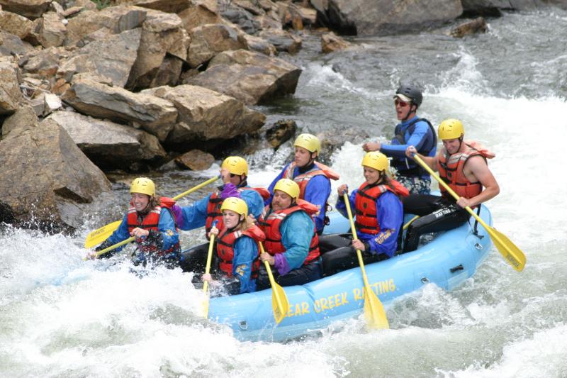
Both American Whitewater and Western Resource Advocates support Glenwood’s application, which would secure a right to a “recreational in-channel diversion,” or RICD, in which river water is diverted through concrete structures embedded in a river channel, but otherwise not diverted or consumed.

The conservation groups said they should be allowed to join the case because they were concerned, in part, about Glenwood’s resolve in water court “to pursue a full suite of flows” after seeing statements of opposition come in from Aurora, Colorado Springs and other powerful water interests.

“We were a little surprised by how much opposition there was, especially from some of the heavy hitters on the Front Range,” said Rob Harris, a staff attorney with Colorado Resource Advocates who was the lead attorney for both his organization and American Whitewater. “We just wanted to make sure that the city had some allies and that voices in support of recreation were heard.”

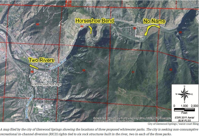
Three parks, six waves

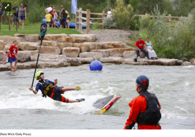
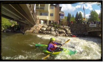
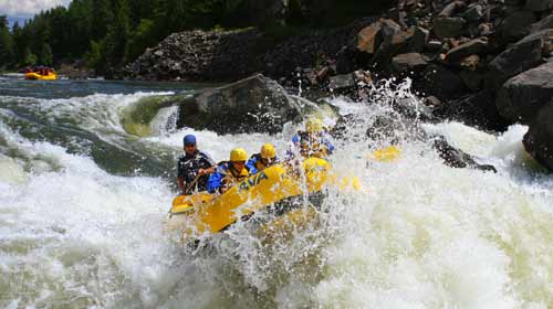
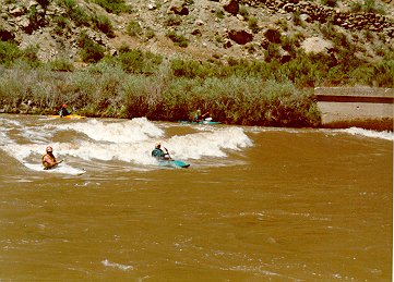
Each of the three whitewater parks Glenwood Springs is proposing to build on the Colorado River would have two concrete control structures embedded into the river to create ridable waves — as well as clear passage — for everything from commercial rafts to pool toys.

The uppermost park on the river would be at the No Name rest stop on I-70, at exit 121. The rest stop area includes both CDOT property and private land along the river.

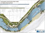
The next spot downstream is at Horseshoe Bend, where I-70 goes into a short tunnel. The location can be accessed off of exit 118 at No Name, or from the bike path that runs along the river.

“The city of Glenwood Springs owns the land along both banks of, and under, the river where the RICD control structures would be constructed,” says a report by S2o Design & Engineering about the Horseshoe Bend site. “Immediately upstream, the Bureau of Land Management manages the property and has developed a covered picnic area and boulder weir to produce a large river eddy.”

Expressions of concern

The concerns of the parties in the case that had filed statements of opposition were shared in a case management conference in late April. The water court referee, Holly Kirsner Strablizky, filed minutes from the conference call with the court on April 24.

The attorney for the Homestake Steering Committee, which is an entity jointly controlled by the Front Range cities of Aurora and Colorado Springs, “stated that it is an upstream water rights owner,” according to Strablizky’s minutes. “It is [involved in case] to ensure that there are appropriate terms and conditions to address impacts on compact and compact carve-outs.”

Such “carve-outs” allow for flexibility in the face of a “compact call” or a demand from downriver states for more water, while another type of “carve-out” allows for some future level of new water development by upstream parties outside of any new restrictions created by a proposed RICD. Such carve-outs were agreed to in the decrees for recently completed RICDs in Basalt, Carbondale and Grand County.

“It was an approach to settle those cases short of litigation,” said Chris Thorne, an attorney with Holland and Hart, which is representing Glenwood Springs in the water court application and also represented Carbondale in its RICD case. “The carve-outs preserve the ability for some reasonable additional water development upstream of the proposed boating parks. And to address concerns of upstream municipal water suppliers about protection of future water supply.”

Thorne added that he wasn’t suggesting that such a carve-out would be necessary or appropriate in the case of the Glenwood RICD.

On April 30, American Whitewater and Western Resource advocates filed a joint statement of opposition and a motion to intervene.

The two nonprofits, referring to themselves as “the conservation groups,” told the court they “should be afforded the opportunity to defend this important proposed RICD.”

Under state law, only certain governmental entities, such as cities and counties, can apply for a RICD, which means that conservation groups cannot do so on their own.

The two groups told the court they “cannot rely on the city of Glenwood Springs to adequately represent their interests in this litigation” and that it “is feasible that changes in policy or administration may cause the city of Glenwood Springs to shift away from a zealous defense of the full suite of flows.”

Harris, the attorney for the conservation groups, said it was important in the motion to draw a distinction between the interests of the city and the conservation groups, but that he currently doesn’t doubt Glenwood’s resolve in the case.

All the other parties in the case consented to the effort by American Whitewater and Western Resource Advocates to join the case. However, in consenting, Aurora and Colorado Springs also went on record stating legal reasons why the motion to intervene should be denied.

The two Front Range cities said the conservation groups role in the case should be “limited accordingly” and that they would “monitor the participation” of the conservation groups to make sure they didn’t “take over” the case.
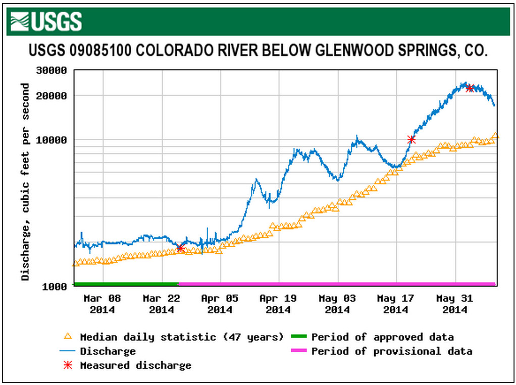
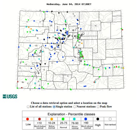
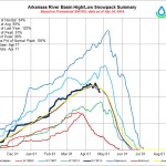
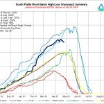
Over 1,250 cfs

Denver Water, another powerful Front Range water entity, also consented to the groups joining the case, but it did so without formal comment.

At the April 24 case management conference, an attorney for Denver Water “stated that it is OK with 1,250 cubic feet per second (cfs) and it is not sure about the larger flow claims,” the referee wrote in her minutes.

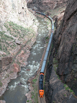
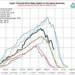
The reference to 1,250 cfs is a reference to the proposed base flow of the three whitewater parks, and, not coincidentally, also to the 1,250 cfs water right that has been exercised by the Shoshone hydropower plant, six miles up river of the proposed parks, since 1907.

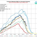
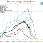
A base-level instream flow right of 1,250 cfs is proposed for all three of the whitewater parks, and that flow would be in effect from April 1 to Sept. 30.

A secondary flow right of 2,500 cfs would be in place for 46 days, between April 30 and July 23. And a flow of 4,000 cfs would be in place for five days between May 11 and July 6.

“Based upon interviews with the boating community, the response was a desire to maintain a flow of 2,500 cfs as long as possible and to have a late season event around the Fourth of July when other whitewater parks do not have reliable flows,” says a report from Wright Water Engineers.

The proposed 183-day water-right season includes 46 days at levels above the base flow of 1,250 cfs, and it’s not clear if that will be acceptable to Denver Water, which agreed to the 1,250 cfs level for a new Glenwood RICD in the recently signed Colorado River Cooperative Agreement, but not to new water rights above that level.

No threat to water developers

The report also concluded that “there are numerous existing transmountain diversion projects upstream of the Glenwood Spring’s RICD that are senior to 2013. Ongoing efforts to firm up the yield of these projects would not be adversely affected by the city’s RCID claims.”

And it concluded that the RICD “has no effect on the ability to develop additional water supplies on the lower Colorado River, including the Roaring Fork River, the White River, the Yampa River, or the Gunnison River.”

In the April 24 case management conference, an attorney for CDOT said “it needs to ensure that proper channels are pursued in obtaining right to access,” according to the water referee.

An updated report on the design and engineering of the parks, submitted to the court by S2o Design & Engineering on May 30, noted that “a collaborative process with CDOT has been initiated to identify cooperative management opportunities at the rest area to provide for parking, access and site facilities use.”

There is another agency that is concerned about the Horseshoe Bend proposal.

An attorney representing the Bureau of Land Management said “it is [involved in] the case to ensure that the applicant obtains access properly,” according to the water referee.

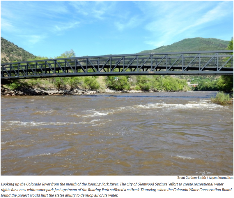
The location of the third whitewater park is at the upper end of Two Rivers Park, just above the confluence with the Roaring Fork River, which flows into the Colorado a few blocks west of downtown Glenwood.

In all, the three parks are located across 3.25 miles of the Colorado River. The “Glenwood wave,” an existing whitewater park in West Glenwood, is downstream of the three proposed parks.

The parties in the water court case now have until Sept. 12 to provide comments to Glenwood Springs on the new reports about the proposed parks. The Colorado Water Conservation Board has been granted until Feb. 2015 to submit its required findings on the city’s application.

And, perhaps optimistically, the water referee’s April 24 minutes state that “all parties believe the case can remain in front of the referee” and not require the involvement of James Boyd, the water court judge in Division 5.

“We’re optimistic that when folks sit down at the table, they can see that they can protect their own interests with little impact on the application,” said Harris of Western Resource Advocates. “And we’re certainly open to hearing any good faith concerns the opposers might have.”

More whitewater coverage here.

Allen Best on the evolution of FIBArk

Hooligan Race 2009
Hooligan Race 2009

Click through for Allen’s photos. From The Mountain Town News (Allen Best):

FIBArk, which calls itself America’s oldest and boldest whitewater festival, was held in mid-June in the central-Colorado river town of Salida. The festival name consists of the acronym, first in boating, as well as the short-hand name for the river: the Arkansas.

It was launched in 1949 as a contest to see who among the 23 entrants could boat the runoff-swollen Arkansas from Salida through the frothy, sharp-edged Royal Gorge. Just two entrants, both from Switzerland, completed the 50-mile journey.

Since then, much has changed. FIBArk has grown to include 10 different river events, including one to test the retrieving abilities of dogs in water. There are also land events, including a parade. It calls itself America’s oldest and boldest whitewater festival.

Equipment and skills have changed. In 2004, a Salida boater named Brad Goettemoeller explained the changes in kayaks and competition for Colorado Central Magazine. Despite increasing competition from other whitewater festivals, he noted, FIBArk at that time was still rated No. 2 among the nation’s boating festivals by Kayak Magazine.

The river has changed, too. It has more water, courtesy of diversions from the Aspen area delivered via tunnels from under the Continental Divide.

The bed of the river has also been altered. In 1966, a bulldozer pushed boulders around to create a more difficult slalom course. In 1988, more tinkering yielded a kayak playhole near downtown Salida. There is also a standing wave used to much merriment by stand-up surfers and stand-up paddleboarders.

A railroad town, streets were predicated not on an east-west grid, but instead a perpendicular layout from the depot. The depot is gone now, and trains stopped running over the transcontinental route through Salida, Leadville, and Avon in 1997.

Instead, like so many of the old mining towns of the Rockies, Salida is a place for Tevas, GoPro, and Patagonia. You might be able to buy steel-toed work boots at the Wal-Mart, but don’t count on it. This is no longer a blue-collar town. If you like organic food, it’s a good place to be.

More whitewater coverage here.

FIBArk good for business

Hooligan Race 2009
Hooligan Race 2009

From The Mountain Mail (Allison Dyer Bluemel):

While downtown business owners saw increased foot traffic during FIBArk and said the festival went well overall, FIBArk board members said attendance was relatively steady and see room for improvements for next year. Festival attendance increased for Friday night’s music and throughout the weekend at the carnival, FIBArk Board President Christopher Kolomitz said.

“Part of the increased traffic (Friday) was due to the draw of The (Infamous) Stringdusters’ performance and great weather,” he said.

The popularity of the carnival was partly due to sales of more than 500 presale tickets before the festival and the vendor’s knowledge of the space available to him this year, which enabled him to feature two new rides, Kolomitz said.

Locals and parents seemed to really appreciate being able to get the carnival tickets ahead of time, said Lori Roberts, Heart of the Rockies Chamber of Commerce executive director.
She said festival programs were distributed earlier than usual, which enabled the chamber to convince visitors who came to town early to stay through the festival and extend their time in town.

“I think it’s important that we send people downtown,” Roberts said.

Additionally, Chaffee County’s information line, operated by the chamber, began to get heavy call volumes about 3 weeks before FIBArk from visitors looking for suggestions on what to do in the area, Roberts said.

Kolomitz said exact attendance numbers are hard to compare to previous years because FIBArk is a free, nonticketed event, but “all 4 days were jam-packed with something for everyone.”
FIBArk volunteers kept track of the number of competition participants throughout the weekend, which showed participation in land events increased while the freestyle river events decreased from previous years, Kolomitz said.

Though Kolomitz said no one event stood out from the rest, he was particularly impressed with Andy Corra’s 10th win of the Downriver Classic Sunday.

“It’s really a testament to his strength, athleticism and commitment to the sport. We’re really proud he came this year,” he said.

While most events were a success, Kolomotiz said the board and volunteers recognized that some elements of the festival could be improved upon.

“We had some issues with the timing of river events,” he said, “They were not as smooth as we would have liked.”

Next year, the board hopes to develop a better system for recording the race times and results in order to get the competitors their awards more efficiently, particularly for the downriver races, he said.

“The board member who put the results together for the Downriver has been receiving undeserved ridicule. It’s important to remember that we’re all volunteers here,” Kolomitz said.

The festival also saw a slight increase in the number of food and retail vendors, both in the park and on the Coors Boat Ramp. This year, the board decided to separate the whitewater sports booths from the others and place them closer to the boat ramp, he said.

“Overall, the music lineup was great, the vendors were tasteful, and the people at the parade seemed safe,” Roberts said.

Community members and attendees can fill out a 10-question survey to give feedback to the FIBArk board about the quality of events, music, vendors and carnival during the festival at surveymonkey.com/s/FIBArk.

Downtown retail business owners said they saw heavy traffic during FIBArk and immediately following the festival. Ruby Blues owner Michael Almeida said the store saw about a 20-percent increase in sales compared to last year. Businesses that sold merchandise catering to vacationing tourists, such as Salida Mountain Sports, Fat-Tees T-Shirt Shop and the F Street Five & Dime, saw foot traffic increase as well during the festival.

“A lot of people came in to buy things they forgot for vacation or just can’t live without,” Salida Mountain Sports employee Jen Walters said.

Colorado-specific T-shirts and anything with the Colorado flag were also big sellers, said Fat-Tees owner Duke Sheppard, who had a record-setting FIBArk this year.

However, Su Casa Furniture, Accents & Gifts co-owner Jim Balaun said business picked up following FIBArk since the store is more popular with locals and homeowners.

Downtown restaurant owners also reported increased traffic during the festival.

For Shallots, Saturday evening and Sunday brunch were particularly busy. However, the town seemed abnormally empty on Friday, co-owner Amy Potts said.

Despite the draw of music in the park, Currents co-owner Chris Tracy said the bands Current booked throughout the weekend drew in a full house of about half locals and half tourists.

“Overall, the feel from the community was that things were up and things were going well,” Kolomitz said.

More whitewater coverage here.

FIBArk recap: Andy Corra wins his 10th Downriver Classic

Tom Lawson runs through Cottonwood Rapid Sunday during the Downriver Classic, a 26-mile whitewater race from Coors Boat Ramp in Salida to Cotopaxi. Lawson placed third in the men’s classic with a time of 2 hours, 17 minutes, 3 seconds.

From The Mountain Mail (Nick Jurney):

Andy Corra, Durango, captured his milestone 10th FIBArk Downriver Classic Sunday after making the 26-mile run from Salida to Cotopaxi in 2 hours, 9 minutes, 18 seconds.

“It doesn’t get any easier,” Corra said after winning his fourth consecutive FIBArk Downriver Race and 10th overall. His first victory came in 1985, 2 years after his first time participating in the historic competition.

Corra said some of the challenges in this year’s race included an upstream wind and cold water, though the flows near 3,000 cubic feet per second were an advantage to boats.

“It was windy, which was pretty cold and brutal on the hands,” Corra said. “But the water and flow were really good, up on the high side of medium levels.”

Corra’s 10th win came on Father’s Day, and he said he may look to pass the torch on to his 11-year-old son, Wiley, in the coming years.

“He said he was going to try and win as many as he can so I couldn’t catch him,” Wiley said with a smile after the race.

Second place in the downriver was captured by Jeff Parker, Concord, Mass., finishing in 2:16:28. Parker said he won the race in 1998, and his runner-up finish Sunday was his best finish since then.

“This was my 25th race, and I think it will be my last,” Parker said. “I want to go out with a second-place finish.”

Tim Lawson finished third in the downriver with a time of 2:17:03, while multi-sport competitor Natalie Anderson was the first female finisher at 2:30:06.

Team Blaze was the first team of rafters to come across the downriver finish line in Cotopaxi, finishing in 2:58:35.

“We had great water and great rafters,” said team captain Mark Mattson after paddling in his 30th race. “I like the high water; we don’t have to battle the rocks as much.”

Other members of Team Blaze included Matthew Petty, Joshua Mentzer, Tom Rice, Chadd Drott, Logan Myers and Jeff Flora.

The oldest participant in the downriver was Lynn Koester of Woodland Park, who said he is turning 77 today, while the youngest was Andy’s Corra’s son Wiley, who participated in the novice 10-mile downriver.

FIBArk board member Tom Barry said an issue with the spreadsheets used to tally results prevented race officials from getting full results and times put together by press time Sunday.

From The Mountain Mail (J.D. Thomas):

The Business After Hours Kickoff to the 66th FIBArk Whitewater Festival featured crashes of lightning, a scattering of hail and more than $1,000 raised at the event Wednesday at Salida SteamPlant. The annual kickoff, hosted by the Vaqueros of Heart of the Rockies Chamber of Commerce, was moved inside the SteamPlant because of the inclement weather.

“Welcome to the kickoff of the oldest whitewater rafting festival,” Salida Mayor Jim Dickson said to lead off the event.

After Dickson’s introduction, 2014 FIBArk Commodore Greg Felt welcomed people to the event and thanked them on behalf of the city for attending. “Thank you and welcome,” he said. “I hope you all have an unbelievable weekend.”

Following Felt’s speech, FIBArk Board President Christopher Kolomitz began an auction for a painting created for FIBArk by local artist Carl Ortman, depicting the “kayak wall” downtown.

Charlie Forster, CEO of Collegiate Peaks Bank, bought the painting to add to the bank’s art display.

“The painting really represents Salida, and the color and the quality make it a great piece,” he said. “Knowing that it will help out FIBArk is one reason (I bought it); the other is because this year’s commodore is Greg Felt. He’s a great guy.”

The money raised will go into the FIBArk general fund, Kolomitz said. Some of the money in the fund will go to the FIBArk youth paddling program, he said.

Along with local business people and guests, a visitor from South Korea took part in the festivities. Yun Ho Ra from Gunsan was riding his bike from Los Angeles to New York when he stopped in town. He said he would like to stay in Salida for a couple days to enjoy the festivities before he continues his travels.

The food, pulled pork sandwiches and baked beans, was prepared and served by the Vaqueros, and beer was provided by Eddyline Brewing, sponsor for the whitewater festival.

The first pour of Eddyline beer at the festival will be at 4 p.m. today in Riverside Park, said Kolomitz.

More whitewater coverage here.

Sixth annual Royal Gorge Whitewater Festival June 20-21

Royal Gorge
Royal Gorge

From The Pueblo Chieftain (Tracy Harmon):

Big water and a bountiful batch of boating events will mark the Royal Gorge Whitewater Festival as it boasts a blue-collar celebration for the “Average Joe” boater. Planners are touting plenty of “Boats, bands and beer,” for the sixth annual celebration June 20-21. Festivities are held at Centennial Park, known to locals as Duck Park, at Fourth and Griffin streets. With 20 events, a roaring Arkansas River and an increase in vendors, the festival will be the biggest to date.

“There are plenty of events for professional and expert level paddlers, but there are not a lot of events for the Average Joe weekend paddler, so we are creating our own niche,” said Kyle Horne, an event organizer. “It is something you can come in and compete in, have a good time and enjoy without competing with the big dogs.”

The pinnacle event will be the Build Your Own Boat Race slated for 5:15 p.m. June 21, but that is just one of the thrilling boating events which include stand up paddling, a duckie (inflatable kayak) dash, a kayak big air event, a Hyside Raft competition and even an inner tube race. Equipment from stand-up paddle boats and inner tubes to safety gear will be supplied to those who need it thanks to donations from local rafting companies, Horne said.

The only serious event for professional boaters and experienced long-distance paddlers, is the 6:15 p.m. June 20 kayak and raft race from Parkdale to Canon City. River flows which have been fluctuating between 4,500 and 3,400 cubic feet per second recently, will have to be at 4,000 cfs or less in order for the race to run, Horne said.

The event also features a fly casting competition for anglers, running races, a Whitewater Adventure Race featuring a run, obstacles and a muddy “slip and slide” finish as well as bicycling events for participants of all ages.

A 4:30 p.m. June 21, Rotary Rubber Duck Fundraiser hosted by Canon City and Florence Rotary Clubs will feature hundreds of little bathtub-sized rubber ducks racing along the river for a chance to win their “owners” prizes. In addition, a Kids’ Fun Zone and a trampoline jump will be set up at the park.

For those who would prefer to sit in the shade and relax, there will be live bands on two stages such as Pueblo’s Atomic Fireballs, local favorite The Highside Command, as well as James and the Devil, Wrestle with Jimmy and others. In addition, a wide variety of food and craft vendors will be set up at the park.

The festival was formed to help establish a Whitewater Park in Canon City and with the help of the Canon City Recreation District, the Whitewater Kayak and Recreation Park committee and the Fremont Community Foundation, the park became a reality in 2009 and is the center of the festival’s boating events. Fremont Adventure Recreation joined as a fourth partner and has added several entertaining competitions.

A fundraising live auction is slated for 8:15 p.m. June 21 and will include items such as a stand-up paddle boat from Jackson Kayak, a wooden canoe made by inmates working in Colorado Correctional Industries, a fly fishing package from Royal Gorge Anglers, and more. All funds raised during the festival go back into the community.

“A hundred percent of proceeds go toward community projects such as expansion and improvements to the whitewater park, recreation district programing, charitable projects and recreation projects,” Horne said.

For a complete list of activities, log on to http://royalgorgewhitewaterfestival.com.

More whitewater coverage here.

2014 marks the 66th anniversary of FIBArk, the nation’s oldest whitewater festival! — June 12 – 15

fibarkospreypacks

Click here to go to the FIBArk website for all the inside skinny.

From The Mountain Mail (James Redmond):

This year the FIBArk Whitewater Festival will induct Salida natives Teddy and Dannie Makris into the FIBArk Hall of Fame.

“It’s an honor” for him and his brother to be inducted into the FIBArk Hall of Fame, Dannie Makris, who now lives in Woodland Park, said May 28. Teddy Makris died in 2004 in Pueblo.

Dannie Makris said he is “thrilled and tickled” to be inducted into the FIBArk Hall of Fame, “and I am sure my brother would be too.”

Dannie Makris said he started kayaking in 1958 when he got his first boat. Growing up in Salida, he had watched the downriver race every year since it started. Watching the race each year, “I always wanted to boat,” he said.

The two brothers would practice together in the Arkansas River near the F Street bridge, and the first part of the river they ran together was Cottonwood Rapid. Makris said he remembers on the first run down Cottonwood, his brother turned over and told him to “paddle like hell” and that he would meet him at the end.

The brothers were selected for the Hall of Fame because of their “exceptional athletic accomplishments, contributions toward the advancement of FIBArk and for their pioneering spirit within the kayaking community,” FIBArk Board President Christopher Kolomitz said.

The FIBArk Hall of Fame recognizes individuals who have made significant contributions to FIBArk and whitewater paddling.

In 1963 Dannie became the FIBArk downriver champion and the national slalom champ, Kolomitz said. That same year Teddy placed third in the downriver race. In summer 1963, both Teddy and Dannie represented the U.S. at the world championship events in Spittal, Austria. The U.S. team placed seventh.

Dannie won the national whitewater championships in 1961 on the Colorado River and in 1962 on the Feather River in California. He placed first in the FIBArk slalom, earning a national title in 1965, Kolomitz said. That same year he took third in the FIBArk downriver race behind two foreign boaters. In 1967 he was FIBArk commodore, and in 1969 Dannie won the FIBArk sportsmanship award, which was given by the past commodores’ club to a boater who contributes most to boating and good sportsmanship.

Back when he and his brother competed in the races, the European kayakers were talented and increased the level of competition because the countries “would send their best (boaters),” Makris said. In the races back then, 30,000 people would crowd the sides of the Arkansas River to watch the downriver race. Salida would empty out as people moved down river to watch the race.

The railroad also used to run a train following the race, so the passengers could watch. Makris said he and his brother could usually tell how well they were doing in the race by watching the train, “because the train would follow the leaders.”

Since the ’60s, both FIBArk and kayaking have changed, Makris said. Now much of the FIBArk festivities stay in Salida instead of spilling down the sides of the river. He said he misses the international racers the event would bring, and how big the parade was. FIBArk had good times in Salida in the ’60s with people coming from around the state, country and world to watch and race, he said.

Makris said he will visit Salida for this year’s FIBArk, now sponsored by Eddyline Brewing, and looks forward to seeing people in the area and watching the races.

More whitewater coverage here.

Snowpack/runoff news: 16,000 cfs in the Shoshone reach

coloradoriverbelowglenwoodsprings05092014

From KUNC (Marci Krinoven):

This time of year the commercial rafting company Whitewater Rafting, LLC takes between 25 to 50 people out on the river each weekday. As the summer progresses, that number increases to up to 300 people in July. Normally, the Glenwood Springs company runs a stretch of the Colorado River through Glenwood Canyon but, because the river’s so swollen, owner Erik Larsson says they’ve changed their route.

“We’re going from as far up as Carbondale all the way down to New Castle for full day trips and that’s quite a bit of mileage and way more than we usually do.”

Because of high water, the company is choosing safer routes that are longer. Still, Larsson says the big water makes some people nervous.

“Some of our rafting guests are little scared about it, for sure. We’ve had a few calls asking whether its safe. And, if anything, right now our trips are a little more mild than they will be in July and August. The river’s bigger, the waves are bigger but it’s not very technical paddling.”

The flows may cause rafter anxiety but overall, they’re a good thing for an industry that typically brings well over $100 million to the state each year. David Costlow is Executive Director of the Colorado River Outfitters Association.

“This year, I think many people anticipate the rafting will be great, and it will be. That’s because of all the snowpack, and we’ve had sufficient rains on the prairie to wet the soils, etc. so less gets absorbed into the ground so less gets absorbed into the ground and more comes down and through rivers,” he says.

He says the heavy spring runoff happening now is earlier than normal, which is good because tourism season hasn’t fully ramped up.

“So, we’d like to take the highs off the river and get down to exciting flows and have those maybe by June 10th, so when the tourism season kicks in, we’re ready to go.”

A slow, steady runoff is preferred by rafters because it ensures good flows late in the summer.

Arkansas River Headwaters Recreation Area — a linear recreation area that follows the Arkansas River for 150 miles

Arkansas River Basin -- Graphic via the Colorado Geological Survey
Arkansas River Basin — Graphic via the Colorado Geological Survey

Here’s an in-depth look at the Arkansas River Headwaters Recreation Area from Tracy Harmon writing for The Pueblo Chieftain:

It seems warring is a history that repeats itself in the Upper Arkansas River Valley.

In 1879 railroad companies were going to battle over who would be the first to lay track through the Royal Gorge canyon. It became so heated that shots were exchanged among the opposing camps.

Later, it would be the rafters and the fishermen who would butt heads like bighorn rams vying for dominance. At issue in the early 1990s was the flow of water in the Arkansas River.

Rafters wanted to have extra water for the late-season boating and fishermen felt the higher water flow was a detriment for the fish just when trout needed to catch a break from fighting the summer waves.

Eventually, the feud was settled. Rafters get their extra water until Aug. 15 each year and anglers get water releases in the winter months should the level drop to dangerous lows endangering fish.

At the tenuous center of the boat and hook controversy was an unlikely group of government regulators who dreamed it was possible that someday everyone would get along. After all, rafting can bring a neat $60 million chunk of change to the valley coffers and anglers spend plenty as well.

When the Arkansas Headwaters Recreation Area was officially formed 25 years ago this coming October, work was just beginning. Countless public meetings and lawsuits pushed patience on both sides, yet the recreation area endures as one of the few federal and state partnerships in existence nationwide.

The partners have made the first 150-mile stretch of the Arkansas River corridor not only the most rafted river in the nation, but a gold medal fishing ground.

Besides the breathtaking views and some of Mother Nature’s finest canyon rock wall work, the recreation area has grown to include the kind of amenities that make people want to stop and take it all in.

From Leadville to Lake Pueblo, the recreation area spans four counties. Colorado Parks and Wildlife has teamed up with the U.S. Bureau of Land Management and Forest Service to offer a boatload of improvements from campgrounds and boating ramps to restrooms and picnic grounds.

All totaled there are 42 sites along the corridor, according to Rob White, Arkansas Headwaters manager for CPW.

“One of the greatest accomplishments to date regarding the creation of the Arkansas Headwaters Recreation Area has been the acquisition and development of recreation sites along the Arkansas River corridor that provide invaluable public access for both whitewater boating and angling,” White said. “We try to strike a balance in the development of our recreation sites and with the management of the natural resources, including water, so that whitewater boaters, anglers and all of our visitors can enjoy the recreation area.”

The balance between man and nature is evident. Each recreation site is so well cared for a visitor would be hard pressed to find a gum wrapper littering the ground.

“We continue to work on improvements to the natural resources found throughout the river corridor and the riparian areas are in better condition then they have been in a long time,” said John Nahomenuk, River Manager for the BLM. “We are an integral tie that brings together and helps strengthen the communities in the river valley.”

White and Nahomenuk work together, often identifying potential land acquisitions with willing sellers and then find the money to buy the land.

The Colorado Lottery has been instrumental in making many of the improvements a reality by awarding grants that have helped convert private property parcels into public playgrounds.

Boaters and anglers are not the park’s only users.

Gold panning, riverside picnics and climbing are among the reasons people make it a destination.

Many visitors come to the Bighorn Sheep Canyon between Salida and Canon City in hopes of spotting the state animal. The sheep are so expertly camouflaged it takes movement or a flash of their white rear ends to actually spot them.

White and Nahomenuk often run ideas by the citizen’s task force to get input from a variety of the park’s stewards from boaters and anglers to ranchers and environmentalists.

It’s nice when everyone can agree. Just don’t bring up New York artist Christo’s Over the River artwork planned for a two-week display along the stretch of river between Salida and Canon City or you could see the warring start to brew all over again.

More Arkansas River Basin coverage here.

Animas River Days Saturday recap

Design for the whitewater park at Smelter Rapids via the City of Durango

From The Durango Herald (Brandon Mathis):

“That’s our goal, to make it bigger,” festival coordinator Kasey Ford said Saturday.

She said between 1,500 and 2,000 spectators came to Whitewater Park at Santa Rita Park to check out everything from dual-slalom kayak races and boatercross races to stand-up paddle boards and river boards. A beer garden and food are being offered all weekend, along with live music from a stage on the water’s edge.

Ford said the plan next year is to have an official grand opening for the whitewater park after the waterfront landscaping is complete.

She hopes the new park with help expand the festival.

“We want to get more people involved and keep growing,” she said. “It used to be huge, and then it tapered off. We’re trying to get it back.”

Ford said there’s an overhead between $10,000 and $15,000. Organizers network and gain support from donations and sponsors.

“We scrape it all together,” she said. “We want more people to get interested in the river and conservation of the river.”[…]

Longtime festival organizer and competitor John Brennan called the rapids among the best in the West.

“It’s like jumping on a freight train going by at 50 mph,” he said. “Right now, the top wave at Smelter is probably one of he best waves in the western U.S.”

He said the same about River Days, which is in its 32nd year. Brennan has been there since Day 1. He called it the best water festival in Colorado.

“I’ve been to all of them, and this blows them all away,” he said.

While you would expect to see rafts bending over walls of water and kayakers darting through foam, Anna Fischer of Surf the San Juans baffled the crowd as she navigated the entire whitewater park on a stand-up paddle board.

“Rafts are having a hard time staying upright,” Fischer said, “so it’s definitely challenging on a board.”

Mike Wegoyn of Bayfield was getting some odd looks as he walked the river banks in flippers, gloves and a full-body wet suit, hood helmet and all. He doesn’t raft or kayak. He river boards. He surfs the waves head first, lying on a board two-thirds as tall as he is.

“This is the only river sport I do,” he said before entering the water. “When it was over (5,000 cubic feet per second) it was pretty rough, now it just feels like the ocean.”

More whitewater coverage here.

Durango whitewater park is open for business after recent improvements

Design for the whitewater park at Smelter Rapids via the City of Durango

From The Durango Herald (Taylor Ferraro):

Change is full of peril and opportunity and a little bit of fun as kayakers and rafters discovered this weekend as they attempted to negotiate the newly redesigned Whitewater Park. Smelter Rapid, as many discovered, has sharpened fangs, and more than a few river runners were bitten.

“We are seeing more rafts flip at higher flows,” said Andy Corra, one of the owners of 4Corners Riversports. “It just takes time to figure out the new rapids.”

This is an exciting prospect for all boaters, both commercial and private, said Jesse Mueller, a raft guide for Mountain Waters.

Devoted paddlers and rafters now have 12 new rapid features to maneuver in Whitewater Park at Santa Rita Park, which is now open for runs after completion of in-stream features.

Changes made to the Whitewater Park can alter the rating of the rapids depending on the river levels, Corra said. At its lowest point, Smelter Rapid is considered a Class 3 rapid. At its highest point, it is considered a Class 4, a big-water rapid.

With current river levels surpassing 5,080 cfs, some of the holes, especially for rafters are more challenging.
These changes have modernized the Whitewater Park, said Scott Shipley, Olympic paddler and designer of Durango’s Whitewater Park…

In 2003, [Scott Shipley] returned to Durango to help create a design to revamp the play features of the Whitewater Park, making it more enjoyable for boaters. After creating conceptual and preliminary designs, Shipley helped the city file for a recreational in-channel diversion water right for the Animas River. In order to officially claim the water right, the water had to be captured in a structure, [Andy Corra] said…

Before the changes were implemented, the Whitewater Park was more of a slalom course with flat waves. Now, it’s more freestyle-oriented, and that likely will draw in more boaters, said Kyle Stewart, a raft guide at Mild to Wild.

These changes will make the rapids more consistent throughout the year, said Drew Kensinger, avid boater and Mild to Wild raft guide.

“The idea was to turn Durango back into the whitewater mecca that it used to be,” [Jesse Mueller] said. “That was pretty well achieved. All of the kayakers and rafters really appreciate it and are quite excited about it.”

More whitewater coverage here.

Runoff/snowpack news: “It’s [Wellsville gage] been flat as a string” — Steve Witte

Colorado Water Watch (USGS) statewide streamflow map June 4, 2014

Click on the map above to peruse the USGS’ Water Watch interactive map for Colorado. The dark dots represent higher flows.

From The Pueblo Chieftain (Chris Woodka):

There’s some debate about whether the Arkansas River has seen its peak runoff yet. The river has been running very high after gaining momentum over the weekend and has been dangerous in places. All along the river, from Pueblo to Leadville, flows are twice average for this time of year as spiking temperatures and heavy snowpack have led to a heavy runoff.

Temperatures Tuesday reached 97 degrees, about 3 degrees shy of the record 100 degrees in 2006.

Apparently there is more to come.

“It is kind of surprising for this time of year,” said Steve Witte, Water Division 2 engineer. “I suppose what we’re seeing is the result of a cool May.”

Snowpack above the timberline is still ample, based on observations by Division of Water Resources staff, and more hot weather’s on the way. A fast, early runoff was forecast at the end of April, but more precipitation and cooler weather set the stage for a June peak.

The Arkansas River gauge at Wellsville has been at 4,000-4,200 cubic feet per second for days.

“It’s been flat as a string,” Witte said.

There are advisories for rafters through the Arkansas River canyon on certain stretches of the river.

Levels below Pueblo Dam topped out at 4,800 cfs on Monday, and were falling Tuesday after releases from the dam were cut back slightly.

Meanwhile, about 23,000 acre-feet of Fryingpan-Arkansas Project water has been imported through the Boustead Tunnel into Twin Lakes. More than 60,000 acre-feet is projected this year.

“It’s been about what we would expect at this point,” said Roy Vaughan, Fry-Ark manager for the Bureau of Reclamation.

So far, nothing is at flood stage and the river has been higher on this day in history — June 3, 1921, was the date of the deadliest flood recorded here.

From the Associated Press via the Fort Collins Coloradoan:

Some streets and fields remain flooded in Greeley as the spring runoff continued to push the Poudre River over its banks on Tuesday.

The water reached 9.16 feet, more than a foot above flood stage, around midday. That’s just above the previous crest record for the river set in 2010, the National Weather Service said.

The flooding was making it harder to drive around the city, although some drivers disregarded warnings to stay off closed roads.

Two homes were flooded this week, forcing those residents to evacuate, Greeley street superintendent Jerry Pickett said. Across the flooded street, other residents sat on the porch of a home surrounded by sandbags.

Nearby, Tony Stansbury and Robert Villa waded through waist-deep water with a canoe to recover records from DBE Manufacturing & Supply.

The Greeley Tribune reported Greeley City Councilman Charlie Archibeque caught a 10-pound carp in the driveway of his home, which was surrounded by water.

The water has been high along the Poudre for a week and levels of waterways around the state are expected to remain high for another two weeks or so as the plentiful mountain snowpack melts and fills reservoirs.

“The good news is there’s water to be had, but it could be a nuisance for another few weeks,” National Weather Service forecaster Kyle Fredin said.

The South Platte Basin, which includes the Poudre, was listed as being nearly 300 percent of its average level as of last week.

In western Colorado, the spring runoff was creating a wave known as “Big Sur” in the Colorado River, drawing kayakers and paddle boarders to DeBeque Canyon.

The Daily Sentinel reported that the wave develops when water flows over a submerged bridge reach at least 20,000 cubic feet per second. The last time the wave appeared was in 2011.

Things are much drier in the state’s southeastern and southwestern corners, where fire and blowing dust warnings were posted Tuesday.

From the Vail Daily (Raymond A. Bleesz):

John Comer, of McCoy, knows about calamity regarding his beloved water wheel at his Wagon Wheel Ranch. Last month, the high waters of the Colorado River partially destroyed his water wheel for the third time in its 92 years of history.

The Brooks-Dixson water wheel was initially constructed in 1922 by the two entrepreneurial ranchers, Earl Brooks and Wyman Dixson, as they needed water to irrigate their pasture — water, hay and cattle are the focal cornerstone elements for a successful livelihood in ranching. The water wheel was put together with no plans other than using their imagination. The engineering feat, the material and lumber the two ranchers mustered for themselves was a significant feat using approximately 3,570 board feet of lumber. It showed determination and a frontier can-do attitude. The purpose of the wheel was to raise water from the river bottom to the top of the wheel in constructed wooden buckets, as the wheel rotated on its axle to the height of approximately 46 feet and for the water to then flow into a catching wooden flume and into the irrigation ditches of the pasture land. This ingenious device was perhaps the largest one in the state of Colorado and certainly in Eagle County.

From KWGN.com (Sara Morris):

Portions of southeast Greeley remain under water Tuesday night and Greeley’s Emergency Manager believes the flooding isn’t over yet. That concerns many like Erica Nevarez and her family who are trying everything to keep the high water away from their home. So far they have installed four pumps to get the water out of their back yard and horse stalls, funneling it into a nearby ditch. They also had to evacuate all of their animals.

“We had to take all of our horses we put them up here down the street,” said Erica Nevarez.

Building a giant dirt barrier around her property wasn’t enough, so she started making sandbags.

“More than a hundred that’s for sure,” Nevarez said.

And so far their efforts seem to be working because at one point the water was several feet deep.

With two kids and a neice and nephew to watch, Erica said it’s been a stressful couple of days.

“We haven’t slept at all. Just to be watching this water,” said Nevarez.

Unfortunately this may be just the beginning of the flooding in Greeley.

“I think the biggest concern is the longevity of the event. How long will it last and that’s difficult to predict,” said Pete Morgan, the City of Greeley Emergency Manager.

In the meantime voluntary evacuations continue to be in effect in portions of southeast Greeley.

Many including the Nevarez’s are opting to stay because they want to protect their home from future flooding.

Big Sur wave near DeBeque

From KJCT8.com (Lindsey Pallares):

A water phenomenon of the Grand Valley has made its appearance once again, but it’s not here for long.

Big Sur returns to give rivergoers the adventure of a lifetime.

It’s unlike anything most surfers and kayakers have seen on the river.

“In the ocean, the water moves, or stays the same and the wave stays the same, on the river the wave stays put and the water moves past you,” says Pete Atkinson of Whitewater West.

It’s become one of the most sought after standing waves in the West, emerging from the depths of the Colorado River only when river conditions are just right.

“Big Sur is kind of like a novelty wave, it only comes in upwards at like 20,000 or so CFS is when it starts getting good, which we haven’t had for like three years,” says surfer, Brittany Parker.

If you’ve got good balance and stamina you can ride this wave for hours on a kayak, paddle boat, or surfboard.
Last time the wave came to De Beque in 2011 it was here for nearly three weeks, one of its longest recorded stays in river history.

Continued spring runoff determines how long the wave will be around before it subsides.

At this time, experts don’t have a clear of estimate of just how long water enthusiasts will be able to ride the wave.

The wave is rarely here and oftentimes hard to find.

From the Estes Park Trail-Gazette (David Persons):

According to information published by the Colorado Division of Water Resources, the weekend’s top inflow into Lake Estes was at 3 a.m. Saturday when 1,370 cubic feet of water was flowing into Lake Estes. Likewise, the top outflow into the Big Thompson River below Olympus Dam was 1,020 cubic feet per second. An additional 500-550 cfs was also diverted into the Olympus Tunnel.

“That’s right, the peak on the Big Thompson may have been Friday night,” said Kara Lamb, the public information officer for the Bureau of Reclamation’s Eastern Colorado Office in Loveland. The bureau owns both Lake Estes and Olympus Dam.

Lamb pointed out that the water levels have been so high the past week that it’s been necessary to release between 500-550 cfs through Olympus Tunnel. That water generally has been going to Horsetooth Reservoir. However, that reservoir reached capacity at times. When that happened, it was necessary to re-release that water back into the Big Thompson River at the mouth of the canyon.

Lamb said while no one is exactly sure if the spring runoff peak has occurred, it is certain that the Big Thompson River – and others along the Front Range – will run high in the coming weeks as snowpack in the mountains continues to melt.

Despite the fact that the remaining snowpack in the mountains to the west is about 200 percent of average, Lamb said residents shouldn’t be too concerned about that.

“There’s really not a connection between feet of snow on the ground and the amount of snowpack on this day in history,” Lamb said. “But, if it rains up there and the snow melts quickly, then we could have some problems.”

From The Denver Post (Noelle Phillips):

Six roads in Weld County were closed Monday as two rivers reached flood stage.

County officials were keeping a close watch on the Cache la Poudre and South Platte rivers as waters rose from heavy snowmelt and recent rain.

The National Weather Service reported the Poudre was at 9.15 feet Monday afternoon. Flood stage is 8 feet.

The water was expected to recede by Tuesday, the Weather Service reported.

“It’s holding steady right now,” said Joel Hemesath, the county public works director. “They’re not rising, but they’re not receding like we’d like.”

With 59th Avenue, Eighth Avenue and U.S. 85 the only north-south roads coming into Greeley, the city warned motorists to expect congestion and delays.

Two voluntary evacuation notices were issued for Greeley neighborhoods.

Residents in at least one Greeley subdivision were filling sandbags, said Sgt. Sean Standridge of the Weld County Sheriff’s Office. The Spanish Colony neighborhood along 25th Avenue and O Street is along the Poudre River, he said.

A couple of residents in Greeley reported water inside their homes, Hemesath said.

The county’s public works department had employees monitoring bridges across the county. There are concerns about the rising rivers splitting the county in half and cutting the north and south sides off from each other, Standridge said.

Deputies also were watching flooded roads and warning residents not to get too close to rising water, he said. They will issue tickets to anyone trying to cross high water.

“We’ve got a lot of ‘Lookie Lous,’ ” Standridge said. “We are reminding people for their safety to stay out of the water.”

Runoff/snowpack news: Wyoming bracing for flooding along the Laramie River

Click on a thumbnail graphic for a gallery of snowpack data from the Natural Resources Conservation Service.

From the Laramie Boomerang (Chilton Tippin):

The Laramie River reached 6.3 feet Tuesday in Laramie, entering “moderate-flood” stage. With warming temperatures and rain in the forecast, it could reach 6.7 feet by June 1, according to the National Weather Service. The “major-flooding” threshold is 7 feet.

Nearly 200 volunteers checked in at Woods Landing and Big Laramie Valley Volunteer Fire Department stations Tuesday to pile thousands of sandbags near the rising river…

The Snowy and Sierra Madre ranges got between 3 and 4 feet of snow on Mother’s Day, followed by temperatures warming to above 70 degrees and rainstorms over the weekend, Binning said.

From The Denver Post (Scott Willoughby):

Even in land-locked Colorado, Memorial Day served as a day at the beach for folks across the state.

High water in rivers statewide brought out the adventurous and encouraged others to take a more cautious approach and enjoy the views from dry land as the potential hazards of swift and surging currents began to reveal themselves at the start of what is expected to be a banner year for snowmelt runoff.

“It’s a blessing in that our overall season ends up being really, really good,” said Antony McCoy, head boatman and operations manager for Vail-based Timberline Tours whitewater rafting company. “But during the early season in a year like this, we often have to reroute and run trips differently than normal in the name of safety. Out decisions are always based on safety first and fun second, and we make those decisions day by day.”

With warm temperatures and weekend precipitation boosting flows, Timberline Tours and other established commercial rafting companies were forced to make reroute Memorial Day trips away from the raucous Dowd Chute section of the Eagle River between Minturn and EagleVail. The company institutes a cutoff for commercial trips through the Class IV-plus run when the river broaches 4½ feet on the gauge installed atop Dowd Chute, launching just below the most severe whitewater rapids instead.

“That’s a fun level for expert kayakers, but it gets tricky in a raft,” McCoy said. “And with water this high, most clients don’t really notice the difference. They still love it.”

Ironically, it’s just about the time that many commercial rafting companies begin to take more extreme precautions when many of the most daring decide that conditions are optimal.

A few miles below the Eagle River’s confluence with the Colorado River, the state’s growing cadre of river surfers arrived en masse at the increasingly renowned Glenwood Springs Whitewater Park on Monday. There they were greeted by river flows unseen on the Colorado since the high-water year of 2011, measuring in the neighborhood of 16,000 cubic feet per second below the confluence with the Roaring Fork River.

“I drive up here from Boulder just about every weekend this time of year,” said Ben Smith, a stand-up paddle (SUP) surfer of two years who had never ridden the river at flows above 5,000 cfs before this spring. “This season, I’m going to surf it as much as I can, and every weekend is like a new experience for me. It’s a different wave each time. Better and better.”

Surfers on Monday’s unofficial launch of summer were lined up as many as 10 deep on both sides of the Colorado River at West Glenwood, some with paddles and others with traditional surfboards diving headlong into the raging currents before popping to their feet for rides lasting several minutes. They alternated with — and largely outnumbered — skilled whitewater kayakers performing tricks in the frothy whitewater as spectators on the banks took in the show. One photographer launched a drone above the surfers to capture the action on video.

“This wave is by far my favorite,” Smith added. “A lot of kayak play holes have a big foam pile that’s designed to hold the kayaks in the play spot, whereas this wave is so steep that it’s gravity that’s pulling you down the face of it, which is what an ocean wave does. Plus it’s so clean. You can make these nice big turns on a clean, green wave. It’s the closest thing to ocean surfing I think that you are going to get in Colorado.”

In a state renowned for its paddlesports offerings and participation, it comes as no surprise that Smith and several others have adapted a paddle to the surfing equation. Credit for SUP’s origin goes back to Honolulu, where it was known as “beach boy” surfing by the Hawaiians who used paddles while standing to photograph tourists taking surfing lessons more than 50 years ago. The sport’s recent resurgence on the ocean has rapidly crept inland during the past decade, where it has established a home on and around the beaches of Colorado.

From the Colorado Daily (Sarah Kuta):

The heavy rains and scattered thunderstorms in Boulder County over the weekend gave emergency officials a taste of what may be coming during flash flood season this summer. With the ground still heavily saturated from September’s floods, the rain that fell off and on for multiple days last week pooled in underpasses, streets and drainage areas, and it gave residents of the area burned in the Fourmile Fire of 2010 a short-lived scare. Ultimately, emergency officials said the storms didn’t cause any significant destruction and allowed them to test their plans ahead of what’s sure to be another busy flash flood season in Colorado…

Flash flood season officially began April 1 and ends Sept. 1, though it’s not just local rains and thunderstorms that can cause flooding, Chard said.

Thunderstorms high up in the mountains can cause the snow to melt quickly, prompting spring runoff to accelerate and fill the creeks within the county. Chard added that extra runoff may also occur because the ground is still saturated with water from September’s floods. The water table can stay elevated for a year to 18 months after such a major rain event, Chard said.

All of those factors have led emergency officials to ask residents to be extra vigilant this flash flood season.

“Make sure you’re signed up for emergency warnings, have a plan, have a weather radio,” Chard said. “Pay attention to the skies; pay attention to the forecast.”

From Steamboat Today (Tom Ross):

With 20 inches of water still stacked up in the snow on Rabbit Ears Pass and forecasts of daily high temperatures pushing into the low 80s Wednesday before tapering off to the mid-70s later in the week, the Yampa River in Steamboat Springs has a chance to reach the bank-full stage at the Fifth Street Bridge June 4 to 5. But the current outlook does not foresee it exceeding flood stage of 7.5 feet in the next 11 days.

The Yampa was flowing harmlessly over its banks and bypassing its meanders in the vicinity of Rotary Park as of late Sunday afternoon.

The Elk River at its confluence with the Yampa west of Steamboat is another story. The Colorado Basin River Forecast Center in Salt Lake City, Utah, updated its projected streamflows for the Elk Tuesday morning and reported that the river shot beyond bank-full over the holiday weekend and could nudge flood stage overnight Wednesday and Thursday before dipping just under flood stage again during the daylight hours. A tentative forecast for the Elk, which is weather dependent, anticipates the river will go higher June 1 to 3 but continue to bounce above and below flood stage during its diurnal cycle, which sees peak flows at night…The Elk was flowing at 4,090 cubic feet per second at 4 p.m. Tuesday, and to put that in perspective, it peaked at 6,860 cfs on June 6, 2011. The Yampa, which was flowing at 3,360 cfs Tuesday afternoon, peaked at 5,200 on June 7, 2011.

The snowpack on Rabbit Ears is 175 percent of the median for the date, and some of that snowmelt will inevitably flow down Walton Creek, which passes through the city’s southern suburbs near Whistler Park before running beneath U.S. Highway 40 and quickly into the Yampa.

Soda Creek is another tributary of the Yampa that can create minor flooding in Old Town Steamboat. #City of Steamboat Springs Public Works Department Streets and Fleet Superintendent Ron Berig said Tuesday the creeks become a problem when the Yampa gets so high it backs up its tributaries.

From the Sky-Hi Daily News (Hank Shell):

With rivers already running high and temperatures expected to rise, the National Weather Service has extended a small-stream flood advisory for Grand County until 9:30 p.m. on Thursday, May 29. Nowell Curran with Grand County’s Office of Emergency Management said her office gave the go ahead to extend the advisory due to a possible increase of runoff into the already swollen Upper Colorado River and its tributaries…

Snowpack in the Upper Colorado River Basin was over 140 percent of its normal level in April, according to a Natural Resources Conservation Service snow survey. Officials said earlier this year that they were preparing for a run-off season comparable to 2011, but Curran said that the worst case scenario could now surpass the destructive flooding Grand County saw that year.

From KUNC (Jackie Fortier):

Northern Colorado’s water storage is nearing capacity headed into the peak season for farm and residential users due to mountain snow melt and rains. Horsetooth Reservoir and Carter Lake are already full.

“We haven’t been this full for a couple years at the two reservoirs,” said Brian Werner, spokesman for Northern Colorado Water Conservancy District.

“We’re anticipating that we’re going to fill our west slope storage as well. Lake Granby the second largest reservoir in the state, we anticipate, that if we don’t fill it up completely we’re going to get very close,” Werner said…

High mountain snow melt and recent rains caused the Big Thompson River to peak at 11 hundred cubic feet per second over the weekend, well above its usual peak of 900 cubic feet per second. The Cache La Poudre peaked at 4700 cubic feet per second over the Memorial Day weekend, it’s normal peak is 3,000 cubic feet per second…

“What it means is we can’t capture much of that water. And most of the local storage, the reservoirs, that people see when they drive around Northern Colorado are full for the most part, so what’s going to happen unless ditches are opened and are ready to take as much of that water as they can, we’re going to see a lot of that water just pass downstream into Nebraska,” he said.

From The Denver Post (Tom McGhee) via the Loveland Reporter-Herald:

The National Weather Service has placed the Cache La Poudre River near Greeley under a flood warning and numerous roads are closed in the area.

“For the most part, the flooding today is snowmelt in the high country,” Evan Kalina, a meteorologist with the National Weather Service in Boulder, said Tuesday afternoon.

The river was overflowing its banks, with water rising 8.9 feet from the riverbed at 10:30 a.m. Tuesday. It is expected to reach 9 feet by Tuesday evening.

“Once you reach 8 feet, you start to see the water spilling into low-lying areas,” Kalina said.

By 9 a.m. Thursday, water is expected to fall below flood level and the flood warning is expected to be lifted, Kalina said.

Flood advisories — which signal that stream and river levels are higher than normal, but not at flood level — were in effect along the Cache La Poudre, Big Thompson and St. Vrain Rivers in Larimer and Weld counties until 7:15 p.m. Tuesday evening.

Jackson and Grand counties are under flood advisories until 9:30 a.m. Thursday. The area has been hit by thunder and hail storms, and even tornadoes, during the past week or so.

But the chance of rain in the next few days is low, at about 20 percent, Kalina said. Heavier moisture will move in during the weekend, but “at this point it is unlikely that the weather will be as active as it was last week,” Kalina said.

Temperatures are expected to hover in the low to mid-80s for the rest of the week, Kalina said.

From email from Wyoming Governor Matt Mead:

Governor Matt Mead is sending three more Wyoming National Guard teams to Carbon County today. The North Platte River in Saratoga is expected to rise to record levels this week. In total there will be 150 National Guard personnel in Carbon County today. They have been assisting local efforts since this weekend by filling thousands of sandbags.

“This is a tense time for Saratoga and several other communities in Wyoming. I know the local officials, the Wyoming National Guard, the Office of Homeland Security, the Smokebusters and volunteers are working very hard to protect the people and homes. It is a team effort,” Governor Mead said.

There will be 150 National Guard soldiers and airmen, more than 80 volunteers and 24 members of the Smokebusters team, which assists with forest fire fighting and flooding, in Carbon and Albany Counties today. The Wyoming Office of Homeland Security also has personnel across Wyoming working with emergency managers from counties and municipalities.

“This is a comprehensive state response,” said Guy Cameron, Wyoming Office of Homeland Security Director. “Governor Mead has told us to protect Wyoming communities from flooding and we are doing everything possible to make that happen.”

Governor Mead increased the numbers of Guard personnel deployed to Saratoga today due to warmer temperatures and increased rainfall.

“It’s an important mission for us to keep Wyoming residents safe during flood season and to support local prevention efforts,” said Maj. Gen. Luke Reiner, Wyoming’s Adjutant General.

Photos of Guard operations can be found at http://www.flickr.com/photos/wyoguard.

Runoff news: Rainfall/snowmelt swell Cache la Poudre River

Statewide snow water equivalent as a percent of normal May 27, 2014 via the NRCS

From the Associated Press via The Columbus Republic:

Flooding from the Poudre (POO’-dur) River has closed several streets in Greeley. A section of a hiking and bicycling trail that runs along the river was also closed Tuesday because of the high water.

Melting snow has caused the river to rise to 8.9 feet, nearly a foot above flood stage. The river isn’t expected to drop below flood stage until Thursday morning.

From the Cañon City Daily Record (Brandon Hopper):

Friday afternoon, the water levels were flowing at 1,770 cubic feet per second at Parkdale on the Arkansas River. With the way it had been trending Friday, passing 1,800 through the night seemed like a sure thing with the possibility of even hitting 1,900 today [May 25].

The mean average for May 23 over the past 59 years is 1,440, but last year on the same day it was only about 525. After May 23, 2013, the water levels quickly rose before peeking for the 10-day stretch at about 1,550 on May 28, 2013.

“It is incredibly encouraging,” said Will Colon, who owns Raft Masters, a company that’s been rafting this year since mid-March. “It looks like it’s going to be … an average (water level) year, and that equates to be great (rafting). … It’s shaping up to be the perfect season.

“From everything we have right now as far as information, it’s looking like we couldn’t ask for anything better.”

The key, Colon said, is to have the snow pack gradually melt, feeding a steady amount of water into the Arkansas River. He said the cool weather during the last couple days has been great for that reason. If the snow melts too quickly, boaters will see a surge of water but it won’t last until Labor Day in September, which, for the most part, typically marks the end of the commercial rafting season.

The Voluntary Flow Management Program also helps keep steady waters for rafters to enjoy.

From The Colorado Springs Gazette (Andrea Sinclair):

The Cache la Poudre River in northern Colorado threatened to spill over its banks on Sunday, reaching 7.9 feet – just shy of the 8-foot flood stage, the National Weather Service in Boulder said. Greeley police closed 71st Avenue at the river because of some flooding, and parks and trails near the river also were closed, the City of Greeley said in a release.

The weather service said the river could rise to nearly 8.5 feet by early Tuesday, but is expected fall below flood stage by Wednesday. Other creeks and rivers also were running high, but flooding was not expected.

But what happens all depends on whether there’s more rain, and how fast snowmelt runoff flows into the river.

The rise in river levels is common during May, Colorado’s wettest month, according to weather service meteorologist Kyle Fredin in Boulder.

“Snowmelt runoff during begins in May like clockwork around here,” Fredin said. “We haven’t observed any overflowing of river banks at this time, but we’re paying close attention to any areas where the river levels may be higher than normal to keep the public informed.”

The weather service is also watching areas that got a significant amount of rain, because saturated ground plus additional excess rain could prompt flood warnings, Fredin said. In west Loveland, for example, up to 4 inches of rain fell Friday night and although flooding was reported only at some intersections, meteorologists will watch the area closely if another storm hits, Fredin explained.

From The Greeley Tribune (Eric Brown):

The Cache La Poudre River height near Greeley reached 8.85 feet at 9:30 a.m. today, topping its flood stage of 8 feet, according to the National Weather Service.

The National Weather Service forecasts are calling for the river to peak at 9 feet this afternoon or this evening, and then gradually fall to below the 8-foot flood stage by late Wednesday or early Thursday morning.

In addition to having high levels, the river is also moving fast.

Flows at the Greeley gauge at 10:30 a.m. were at about 2,800 cubic feet per second. The historic average is at that measuring point is about 300 cfs.

The recent high waters on the Poudre River have already taken two lives.

Authorities recovered two bodies, believed to be a 14-year-oold Greeley boy and his 38-year-old uncle, from the Poudre River on Monday after witnesses said the boy fell into the river while fishing and his uncle jumped in after him. They’d been fishing in the Poudre Canyon, about 12 miles west of Ted’s Place.

The sheriff’s office hasn’t released the names.

Due to high water and debris on the Poudre River, city of Greeley officials announced that 6th Avenue from the Poudre bridge to 3rd Street is closed this morning.

Other closures that remain in place include:

• 83rd Avenue at the Poudre River

• 95th Avenue at the Poudre River

• 71st Avenue at the Poudre River

Trail and open space closures include:

• Poudre Trail from Rover Run Dog Park east to 35th Avenue. The Trail is now closed from 35th Avenue west to Windsor.

• The Poudre Trail parking lot, trail head and open space at 71st Avenue are closed.

City of Greeley officials also urge using caution when traveling along the Larson Ditch and Sheep Draw Trail corridors, including the McCloskey Natural Area, Pumpkin Ridge Natural Area and Hunters Cove West Natural Area.

Additionally, Greeley officials are asking that residents stay clear of all river banks, as the banks can become unstable as water levels rise. If motorists see water over roads, they are advised to not drive through that water.

In addition to the high waters on the Poudre River, flows in other rivers in the Greeley area — the Big Thompson, St. Vrain and others — have been above average as well.

That being the case, the height of the South Platte River at Kersey — at which point all tributary rivers to the South Platte, including the Poudre, Big Thompson and St Vrain, among others, have dumped into the river — had climbed to 8.8 feet this morning, inching toward its flood stage of 10 feet.

However, National Weather Service forecasts called for the river to gradually fall from its current height of 8.8 feet all the way through Friday, but hadn’t predicted river levels beyond that.

Runoff news: Pretty much every river on the map is indeed stomping down the side of a mountain at the moment — Scott Willoughby

Arkansas River at Salida gage water  year 2014 year to date via the Division of Water Resources
Arkansas River at Salida gage water year 2014 year to date via the Division of Water Resources

From The Denver Post (Scott Willoughby):

The head shaking and head scratching and ice cream headaches will arrive soon enough as well. That tends to be the typical reaction, anyway, from those who have decided that whitewater rafting, kayaking and river swimming are not for them. Except for the ice cream headaches, that is. Those belong to the Eskimo rollers and, of course the swimmers.

For the record, no one in their right mind swims a cold Colorado creek or river on purpose during a Memorial Day weekend with conditions like this. Pretty much every river on the map is indeed stomping down the side of a mountain at the moment, and swims from rafts and kayaks are both unwelcome and unintended.

That’s where the head shaking comes in, as dismayed passersby stare at boaters riding rivers resembling fire hoses and wonder, “What in the Sam Hill is wrong with you people?”

It’s a loaded question. And the only way to answer it accurately is to encourage the askers to experience it for themselves.

Despite a tendency toward wild mountain weather, Memorial Day weekend serves as the kickoff to Colorado’s whitewater celebration season, as a string of river festivals make like Creedence Clearwater Revival and start rolling from now through the summer solstice.

They’re not just for card-carrying river rats. Events like the CKS PaddleFest, which continues in Buena Vista through Monday, offer on-water educational courses and pool sessions for budding kayakers taught by Rocky Mountain Outdoors Center. Clinics offer pointers for Stand-Up Paddlers (SUP) looking to transition from flat water to the rivers and introduce kids to both kayaking and SUP in the friendly confines of the Town Pond. They’ll even show you what to wear.

There’s invariably a competitive component as well, be it a freestyle kayak rodeo, downriver race or SUP surfing contest. Typically the action spills out into other adventure sports like mountain biking, rock climbing, trail running and maybe slack-lining too. Spectating is equally encouraged, and there’s always a live music soundtrack.

Here’s a general rundown of river festivals chooglin’ through the state in the coming weeks:

CKS Paddlefest, Buena Vista (Sunday-Monday): A family-friendly, hands-on paddling and adventure sports experience spread between the Arkansas River and the nearby Town Pond in McPhelemy Park. Info: http://ckspaddlefest.com or 719-395-8653.

Lyons Outdoor Games, Lyons (Saturday):Sports ranging from obstacle courses, BMX/MTB riding, slack line and, of course, kayaking. Info: http://Lyonsoutdoors.com.

Yampa River Fest, Steamboat Springs (Friday-Saturday): Slalom and downriver races, freestyle competition, SUP events, river dog contests, kids’ games and more. Info: http://Friendsoftheyampa.com.

GoPro Mountain Games, Vail (June 5-8): The nation’s largest celebration of adventure sports, art and music. Info: http://Mountaingames.com.

66th annual FIBArk Festival, Salida (June 12-15): The nation’s oldest whitewater festival may just be the top outdoor family festival in Colorado. Info: http://fibark.com.

Royal Gorge Whitewater Festival, Cañon City (June 20-21): Two days of kayak, raft and inner tube races, SUP sprints, fly-casting contests, triathlon, disc golf, live music, kids Fun Zone and more. Info: http://royalgorgewhitewaterfestival.com or 719-275-1578.

Gunnison River Festival, Gunnison (June 20-22): Boat tours of the Curecanti National Recreation Area, whitewater contests for all ages (and dogs), fly-fishing and art. Info: http://Gunnisonriverfestival.com.

More whitewater coverage here.

From email from Reclamation (Kara Lamb):

The large rain storm up in Estes Park tonight has created additional rain and snowmelt runoff into Lake Estes. As a result, we shut down the Adams Tunnel (the West Slope diversion for the C-BT) a day earlier than planned so we can take more Big Thompson River runoff water through the Olympus Tunnel . We are now diverting a full 550 cfs of Big Thompson River runoff over to Horsetooth Reservoir.

However, 550 cfs is the maximum capacity of the Olympus Tunnel, so we are sending the rest of the river’s runoff inflows on through Olympus Dam to the Big Thompson Canyon. This raised the outflow through the dam by 100 cfs.

Olympus Dam outflow to the canyon is now 300 cfs. Although the gage does not yet reflect the change from 200 to 300 cfs, you can track Oly’s outflow at the State’s gage webpage.

It is worth noting that other tributaries to the main stem of the Big Thompson River through the canyon have also gone up. The gage below where the North Fork enters the canyon has been up closer to 400 cfs tonight, meaning below the dam, but before the Narrows section, the canyon is picking up an additional 200 cfs–or there-about. This gage can also be tracked on the State’s webpage.

Salida: CKS PaddleFest starts Friday

Salida whitewater park

Click here to go to the website. Click here for the schedule of events from The Mountain Mail.

Snowpack/runoff news: The melt-out is underway, Upper Rio Grande Basin = 60% of normal

Click on a thumbnail graphic to view a gallery of snowpack data from the Natural Resources Conservation Service.

From the Valley Courier (Ruth Heide):

In light of the most recent snowpack report, the Rio Grande Basin is no longer at the bottom of the list in the state but it’s close.

Colorado Division of Water Resources Division 3 Engineer Craig Cotten reported to the Rio Grande Water Conservation District board yesterday the Rio Grande Basin was 73 percent of average as of Monday morning, April 14. The basin, which encompasses the San Luis Valley, had been the lowest in the state for snowpack but is now barely above the Durango area, which sits at 71-72 percent of average, Cotten said.

“Most of the other basins in the state are above 100 percent,” he added.

This will be the sixth year in a row the Rio Grande Basin has registered a belowaverage snowpack, which will result in a below-average run off, Cotten explained. The basin had risen to a point slightly higher than the previous three years until about a week ago, Cotten said, when warmer temperatures hit and the snowpack dropped.

SNOTEL sites within the basin vary greatly, Cotten added, with snow measurements in the northern part of the Valley reflecting higher numbers than the southern part.

“Here in the basin, similar to the state as a whole, the northern streams are a little better than the southern streams,” he said.

The best, at 103 percent of average as of April 3, was Saguache Creek and the worst, at 35 percent of average, was the San Antonio River at Ortiz. On the same date, the Rio Grande at Del Norte stood at 80 percent of average , based on information from the USDA Natural Resources Conservation Services (NRCS), which operates the SNOTEL measurement sites. Cotten said NRCS has encountered budget crunches the last few years and has had difficulty maintaining their SNOTEL sites, with a move made to eliminate the manual snow measurement courses, but for the time being those are still in place. He said NRCS is looking for cooperators to help with funding the SNOTEL and snow course sites. Cotten added although NRCS has had trouble maintaining its SNOTEL sites, the data from the sites is “in the ballpark.” He said his office has nothing to prove them wrong but feels the data may not always be exactly correct. NRCS claims its data is good, he said.

Based on the NRCS forecast for April, the Rio Grande is predicted to run 505,000 acre feet this year, with 128,700 obligated to downstream states as part of the Rio Grande Compact. Since Colorado has already sent water downstream in January, February and March and will send more water downstream in November December, the amount calculated to be delivered during the irrigation season itself, April-October , is 42,000 acre feet, Cotten explained. To make that commitment, the water division will have to curtail irrigators by about 10 percent, he added. That is the current curtailment on the Rio Grande. The current curtailment on the Conejos River system is 6 percent, Cotten added. The April NRCS forecast for the annual flow on the Conejos system, which includes the Conejos River, San Antonio and Los Pinos Rivers, is 200,000 acre feet, with 45,000 acre feet obligated to New Mexico and Texas to meet the Rio Grande Compact . A great deal of that has been or will be sent downriver during wintertime, but the amount required to be sent downriver during the irrigation season is 11,000 acre feet. That accounts for the 6 percent curtailment.

While Colorado’s Rio Grande Basin may reflect below-average numbers, New Mexico is in much worse shape with snowpack in places well under 50 percent of average and even less than 10 percent of average.

The reservoirs used to store Rio Grande Compact water are located in New Mexico, with the main reservoir storage at Elephant Butte Reservoir. Currently that reservoir has about 302,000 acre feet of compact usable water but is only seeing inflow of about 123 cubic feet per second (cfs), compared to the average inflow of more than 1,000 cfs, “so they don’t have much flow at all into the reservoir,” Cotten said. He added that once the irrigation season begins below the reservoir the water will diminish even more. New Mexico irrigators will begin irrigating below Elephant Butte in May. Cotten reminded the group that as long as Elephant Butte is below 400,000 acre feet which will be the case all year Colorado cannot store water in reservoirs built after the Rio Grande Compact was ratified. Those post-compact reservoirs include Platoro.

Regarding weather forecasts for the next three months May, June, July the Valley is showing equal chances of having average precipitation. That is better news than the last three years when the summer months reflected below-average precipitation forecasts for this area, Cotten said.

From the Aspen Daily News (Nelson Harvey):

As this winter’s banner snowfall helps refill mountain reservoirs drained by the historic drought of 2012, it’s also allowing administrators of at least two major trans-mountain diversion water projects in the Roaring Fork watershed to plan for larger-than-normal diversions to the Front Range this year.

The Fryingpan-Arkansas Project is expected to divert 73,000 acre-feet of water in 2014 from the headwaters of the Fryingpan River above Ruedi Reservoir to the Arkansas River basin on the East Slope. One acre-foot is equivalent to 325,851 gallons, and over the last 12 years, the project has diverted an average of 54,000 acre-feet, making this year’s projected diversion 35 percent larger than average.

The Twin Lakes Reservoir and Canal Company, which manages a four-mile-long tunnel piping water from the headwaters of the Roaring Fork River on Independence Pass to the Arkansas River basin, is also tentatively planning to divert between 53,000 and 55,000 acre-feet of water this year. According to Kevin Lusk, the president of the company’s board of directors, that’s as much as 20 percent more water than the project’s average annual diversion of about 46,000 acre-feet, most of it destined for the cities of Colorado Springs and Pueblo.

But at least one other trans-mountain diverter — the Pueblo Board of Water Works — is actually planning to pipe less water to the East Slope this year through the Busk-Ivanhoe tunnel above the Fryingpan than usual, since above-average snowpack in the Arkansas River basin should help the city meet its water needs…

Although peak runoff is likely weeks away, all three of the trans-mountain diversion projects in the Roaring Fork watershed are already piping water to the East Slope. On Sunday, a gauge at the Twin Lakes Tunnel’s entrance registered a flow of 22.3 cubic feet per second, or roughly 10,000 gallons per minute, heading into the tunnel. Similar gauges at the Boustead Tunnel (part of the Fryingpan-Arkansas project) and the Busk-Ivanhoe Tunnel registered flows on Sunday of 2.49 cfs and 1.43 cfs, respectively…

The ample water supplies that make historically large diversions possible also are aiding local reservoirs this year. Storage in the Colorado River basin’s reservoirs hovered around 93 percent of average on April 1, up from just 65 percent of average on the same date in 2013.

The storage picture is likely to improve even further in the coming months. Mage Hultstrand, a hydrologist for the National Resources Conservation Service, told a meeting of the Governor’s Water Availability Task Force in Denver this past Wednesday that snowpack in the Colorado River basin stood at 130 percent of average as of April 1. That early surplus means that the basin could still have an average water year even if it received just 83 percent of normal precipitation for the rest of 2014, Hultstrand said.

At last week’s task force meeting, officials charged with securing water for Front Range cities like Denver, Fort Collins and Colorado Springs said their own reservoirs already are between 80 and 90 percent full, even though peak spring runoff is likely more than a month away. The healthy storage numbers make it less likely — though not impossible — that Front Range cities will have to institute mandatory watering restrictions this summer like they did during the drought of 2012…

As residents of southern Colorado contemplate a high-risk fire season, people along the Front Range have another sort of natural disaster on their minds this spring: floods. Last September, flash flooding destroyed and damaged homes, roads, bridges and other infrastructure in 20 Front Range counties. Now, concern is running high that when runoff courses down through stream and riverbeds that were rerouted by last year’s floods, a second round of flooding could result.

Many Front Range communities are racing to get ahead of the threat by stabilizing stream banks, shoring up roads and putting other watershed protections in place before spring runoff kicks into high gear next month.

Robert Glancy, a meteorologist with the National Weather Service, told last week’s task force meeting that recent bouts of warm weather in the central mountains have helped jump start the spring melting process, drawing down the snowpack and reducing the likely strength of future floods.

“I’m glad that we’re melting now, because it’s wearing down the snowpack,” Glancy said.

From The Colorado Springs Gazette (Lance Benzel):

The snow that pounded Colorado’s high country all winter – delighting skiers with an extended season – looks poised to bring thrills to the state’s whitewater enthusiasts. Not to mention the businesses that put them in the water…

Cumulatively, the Arkansas River Valley is at 102 percent of the mean snowpack, or about average, according to the Natural Resources Conservation Service, which measures snowpack across the state. Hidden among those numbers is a much-better-than-average snowpack in waterways near the river’s headwaters, Hamel said, calling them a key indicator for good rafting. He said a high moisture content in the soil also will help generate runoff into the area’s waterways, bolstering water from snow melt.

While the numbers are worth cheering, they’re nothing compared with the Laramie and North Platte river basins, which are at 139 percent of mean. The Yampa and White River basins are at 121 percent, the Upper Colorado River Basin is at 123 percent, and the South Platte River Basin is at 132 percent.

But heavy snowpacks are hardly universal. Missing out on the trend are basins in southern and southwestern Colorado, which suffered an anemic winter.

The Upper Rio Grande Basin is at only 67 percent of the mean, and the San Miguel, Dolores, Animas and San Juan river basins are at 73 percent.

Predictions about the health of the rafting season rest on hopes for mild temperatures early in the season. A rapid melt could mean bad news for rafting companies, which look for a stable, long runoff to keep flows moving into the peak tourist period, generally from mid-June to mid-August.

Dust picked up by storms in Utah, Arizona and New Mexico and then dumped on Colorado’s high country also can enter the mix, leading to quicker melts.

While the Colorado River Water Conservation District recorded at least eight large dust storms this winter, the state’s snow packs might be deep enough to weather effects of the dust, general manager Eric Kuhn said.

In some areas, including the Colorado River Basin, the deep snow might be a double-edged sword, sending outfitters on a hunt for waterways that aren’t dangerously high.

From CBSLocal.com:

Denver Water has been regulating its outflow at the Dillon Reservoir dam to get ready for all the snow to melt. Right now the output is around 700 cubic feet per second and there’s already one rafting companytaking advantage of all the water.

“Today is the start of our 2014 rafting season,” Campy Campton with Kodi Rafting said on Thursday.
It’s come about a week or two earlier than normal. The above average snowpack is starting to melt, and that means rivers are already moving…

“This is really early, especially for the Blue River, but we had some folks that are interested in boating today and we were coming out anyway, so we brought them along for the fun,” Campton said. “This is one of the few rivers in the state of Colorado that’s solely dependent upon dam release for the river to flow.
“We boated the Blue the last time in 2011. We saw enough water to come down here commercially and boat and have fun.”[…]

The River Outfitter’s Association said there are other places like the Animas River around Durango, the Colorado River near Glenwood and the Arkansas River around the Royal Gorge that are also seeing companies get an early jump on the season.

Has Durango sold its river, and its soul, to recreation? — High Country News

Design for the whitewater park at Smelter Rapids via the City of Durango

From the High Country News (Jonathan Thompson):

The City is building a park. On the river. With a boat ramp…

As upsetting to opponents as the development itself is what it will bring: More of the inner-tubing, paddle-boarding, river-rafting, beach-partying masses that have already colonized large swaths of the river during the warmer months of the year. But it’s also what the development represents. In its quest to be an amenity-rich, recreation-based town rather than the extraction based one it once was, critics say, Durango has finally gone too far.

The problem park — its name is Oxbow Preserve — consists of 44 acres of land just north of this town of 15,000 people. The City acquired the land from private owners back in 2012 with the help of $400,000 in statewide lottery funds that are doled out for such things. Generally speaking, the land acquisition itself wasn’t controversial: It would preserve a nice stretch of the river as open space with public access, benefit wildlife and allow the City to stretch the riverside bike path further afield.

After acquiring the land, the City announced that it would keep its hands off 38 acres, leaving it as open space and wildlife habitat. No worries there. Yet the remaining six acres would be developed as a park, with not only the bike path going through, but also a driveway, parking lot, restrooms and a boat ramp, accessible to commercial outfitters. This development — the ramp in particular — is what’s fueling the fight.

The Animas River has always been critical to this southwest Colorado town. Its cold waters come crashing violently out of the narrow, v-shaped gorge that slices through the San Juan Mountains. When it hits the flat-as-glass bottom of the glacially-carved Animas Valley, it slows suddenly, and its path becomes a lazy meander, almost twisting around and meeting itself at times. The sandy banks here are so soft that ranchers used to line them with crushed, old cars to prevent erosion…

Commercial river rafting got going here in the early 1980s, and has since grown into a decent-sized chunk of the local tourism trade. Back in 1990, commercial outfitters ferried some 10,000 folks down the town run. By 2005, the peak year so far, that had jumped to 52,000. In 2012 — a low water year — 38,000 paid to raft the river, making a $12 million economic impact on the community, according to a Colorado Rivers Outfitters Association Report…

At least as many people float the river without guides, including private rafters, kayakers, paddle boarders and inner-tubers. Drought actually draws more of these users, since the river is safer at low levels.

Around the river access points, cars crowd the streets on summer days and inner-tube- and Pabst Blue Ribbon-hefting, scantily-clad youngsters wander around lackadaisically among the exhaust-belching rafting company buses, crammed to the gills with tourists getting the safety talk while wearing oversized, bright-orange life jackets. Downriver, a nice slow-moving section morphs into a party zone, replete with blaring sound systems.

A large chunk of opposition to the Oxbow park plans — particularly the commercial boat ramp and developed parking lot — comes from nearby property owners, worried that the in-town riverside zoo will simply migrate upstream to their backyards. But the resistance is not all rooted in NIMBYism. Also of concern are the impacts the floating and beach-going masses will have on wildlife — the park is near a pair of great blue heron rookeries, elk habitat and bald eagle fishing areas. Still others see the inclusion of a commercial boat ramp as a subsidy for private enterprise, and as a violation of the terms of the state funds that paid for the parcel of land. The developed park has its supporters, too: Commercial river rafters would be able to stretch out their town run, as well as the rafting season (the sandy upper reaches of the river are navigable even in very low water). And they contribute to the economy — many of my friends paid their way through college and beyond as river guides.

More Animas River watershed coverage here.

Durango’s new whitewater park opened Friday for the season

Design for the whitewater park at Smelter Rapids via the City of Durango

From The Durango Herald:

Boaters and kayakers take their first runs through Durango’s new Whitewater Park on Friday. The $1 million project created a number of in-river features next to Santa Rita Park. The contractor is continuing to do work along the shoreline, which is not accessible adjacent to the wastewater-treatment plant.

More Animas River watershed coverage here.

The Grand Foundation’s 2014 Annual Grant Cycle deadline is Thursday, May 1 #ColoradoRiver

Gore Canyon rafting via Blogspot.com

From the Sky-Hi Daily News:

The Grand Foundation announces its 2014 Annual Grant Cycle deadline as Thursday, May 1. Applications are available on the Grand Foundation’s website at http://www.grandfoundation.com. All 2013 grant recipients must have their 2013 Final Grant Reports submitted in order to be eligible for 2014 funding.

If you have any questions or would like to become more involved with the Grand Foundation, contact Megan Ledin, Executive Director, at megan@grandfoundation.com or by calling 970-887-3111.

The Pitkin County Healthy Rivers board approves development of whitewater park in Basalt

Proposed Basalt whitewater park via the Aspen Daily News

From the Aspen Daily News (Brent Gardner-Smith):

The Pitkin County Healthy Rivers and Streams Board on Thursday voted to seek approvals for, and build, a whitewater park in the Roaring Fork River across from the entrance to the Elk Run subdivision in Basalt.

The board agreed to develop a detailed proposal, gain approval from Pitkin County commissioners and the town of Basalt, and to fund the project.

It will cost about $750,000 to install two wave-producing concrete structures in the river and make improvements to a steep riverbank above the structures to allow for river access and viewing, according to whitewater park designer Jason Carey of River Restoration, Inc. A stripped-down version of the park, without amenities, could cost $550,000.

The five-year-old county river board is funded by a sales tax that brings in about $800,000 a year and it currently has $1.4 million set aside for future expenditures.

The county river board previously endorsed the project in 2010, but now that a water right for the whitewater park is nearly in hand, Pitkin County Attorney John Ely encouraged the board on Thursday to commit to actually getting the project built…

Carey, who designed the popular surf wave in the Colorado River in West Glenwood Springs, has been working on the “Pitkin County Whitewater Park” design since 2009…

Carey said the two concrete and rock structures would be placed in the river along a steep bank next to Two Rivers Road that had been eaten away by high water in 1995 and then crudely restored by CDOT…

The location has other good attributes, he said, including that the river is relatively deep in this reach, compared to the rocky and shallow stretches above and below it…

Most years, though, there will be plenty of water in the river to create surf waves in the park, and the county won’t have to exercise its water right and call for water, according to Lee Rozakalis, a consulting hydrologist with AMEC, who has been working on the park for the county.

More whitewater coverage here.

Buena Vista: Colorado Parks and Wildlife grant serves redesign of Silver Bullet Rapid

Silver Bullet Rapid via the Chaffee County Times

From The Mountain Mail (Kim Marquis):

If a redesign of the Silver Bullet rapid on the Arkansas River near Buena Vista works as planned, both boaters and fishermen could benefit. The rapid, known as the Dam, Boat Chute and Silver Bullet in boating circles, had previously been a Class IV rapid at certain water levels, which prevented some boaters and kayakers from making the run. The rapid is south of town and due east of the Buena Vista Correctional Center.

Wilderness Aware owner Joe Greiner, a longtime commercial rafting outfitter, called the former rapid “spicy” for its steep drop and consistent waves downstream. The rapid caused some private boaters to skip the section, starting trips at Greiner’s river put-in at his property in Johnson Village, instead of using the Buena Vista River Park in town.

The redesign completed in February changes the rapid into three smaller drops instead of one, possibly reducing its rating to Class II or Class III, Arkansas Headwaters Recreation Area Park Manager Rob White said.

AHRA managed the $400,000 project, which was paid for by a grant from the Colorado Water Conservation Board and contributions from Colorado Parks and Wildlife, the Upper Arkansas Water Conservancy District, the Arkansas River Outfitters Association and individual river outfitters.

The new design adds a drop both upstream and downstream of the original rapid, making the overall experience more gradual, White said. Construction included a fish ladder built into the smaller drops so that trout can conceivably travel upstream to spawn. The former 8-foot drop was likely too high for fish to navigate, creating a barrier to their movement upstream.
The rapid is located within a 102-mile stretch that was designated Gold Medal trout waters by Colorado Parks and Wildlife in January.

The Silver Bullet is a 1970s-era dam built to divert water for agriculture. A boat chute allowing rafters passage was changed several times, and a portage added on the right side of the river to enhance the experience. The new project could help more boaters stay on the water, rather than choosing the portage.

While the level of technical difficulty for boaters might drop due to the changes, the nature of the rest of the run from Buena Vista south to Johnson Village will remain the same. The section includes Beaver Falls, which grows to a Class III rapid at certain water levels, as well as significant drops created by the town’s river play park.

“It’ll still be too scary for rank amateurs,” Greiner said of the river section. “There will be a certain segment choosing it that was not able to do the boat chute in the past, but that’s not going to be a large number of people.”

River runners doing an afternoon run typically choose Fisherman’s Bridge or Ruby Mountain, both near Nathrop, to end their trips. Commercial trips and private boaters on an all-day excursion get off the river past Browns Canyon.

Outfitters have traditionally run the section including the Silver Bullet, so Greiner said he did not anticipate changes in commercial use because of the redesigned rapid.

The project included broader changes at the dam, also called the Helena diversion structure. Work that began in November included a replacement of the ditch’s concrete head gate, a larger concrete canal and a new bypass gate.

Both White and Greiner cautioned boaters that the Silver Bullet’s new rating will be unknown until higher flows can be observed on the river this spring and summer…

River Ratings

These ratings are published by Colorado River Outfitters Association, in accordance with the International Scale of River Difficulty.

Class I: Fast-moving water with riffles and small waves. Few obstructions, all obvious and easily missed with little training. Risk to swimmers is slight.

Class II: Straightforward rapids with wide, clear channels that are evident without scouting. Occasional maneuvering may be required, but rocks and medium-sized waves are easily missed by trained paddlers.

Class III: Rapids with moderate, irregular waves that may be difficult to avoid. Complex maneuvers in fast current and good boat control in tight passages or around ledges are often required; large waves or strainers may be present but are easily avoided. Strong eddies and powerful current effects can be found, particularly on large-volume rivers. Scouting is advisable for inexperienced parties.

Class IV: Intense, powerful but predictable rapids requiring precise boat handling in turbulent water. Depending on the character of the river, it may feature large, unavoidable waves and holes or constricted passages demanding fast maneuvers under pressure. A fast, reliable eddy turn may be needed to initiate maneuvers, scout rapids or rest. Rapids may require “must” moves above dangerous hazards. Scouting may be necessary the first time down.

Class V: Extremely long, obstructed or very violent rapids that expose a paddler to added risk. Drops may contain large, unavoidable waves and holes or steep, congested chutes with complex, demanding routes. Rapids may continue for long distances between pools, demanding a high level of fitness. What eddies exist may be small, turbulent or difficult to reach. At the high end of the scale, several of these factors may be combined. Scouting is recommended but may be difficult.

Class VI: These runs have almost never been attempted and often exemplify the extremes of difficulty, unpredictability and danger. The consequences of errors are very severe and rescue may be impossible. For teams of experts only.

More whitewater coverage here.

Here’s hoping that deep snow and short memories don’t add up to problems for Colorado’s water future — Scott Willoughby #COWaterPlan

Colorado Water Plan website screen shot November 1, 2013

From The Denver Post (Scott Willoughby):

Here’s hoping that deep snow and short memories don’t add up to problems for Colorado’s water future. With the March 1 mountain snowpack measuring at 116 percent of average and 161 percent compared with last year, it’s easy to take the lifeblood of the state’s outdoor recreation industry for granted.

Hopefully that won’t be the case between now and March 19, when the Colorado Water Conservation Board (CWCB) is scheduled to report on the public’s expectations for the Colorado Water Plan initiated by Gov. John Hickenlooper last year in an attempt to address the anticipated gap between statewide water supply and demand. With a directive from the governor that “Colorado’s water plan must reflect what our water values are,” time is running short for Coloradans to define those values through public input.

Just don’t forget the two-year drought the state has been dealing with up until now.

With a gloomy forecast predicting water demands outpacing available supplies as soon as 2022, everything from agriculture to angling could be threatened even in a normal water year, along with several other aspects of Colorado’s multibillion-dollar recreation industry that relies on water from healthy rivers and streams. But it’s not just food prices and fishing that hang in the balance, it’s our very identity, the unique traits that define Colorado and many Coloradans.

Above and beyond the basic necessities, water has long defined Colorado’s character, be it an Arkansas River rafting trip or the icy snowmelt portrayed in a Coors beer commercial. Our streams support wildlife for watching, hunting and fishing, entice campers and kayakers and provide the landscapes that inspire hikers and bikers. They provide the water for snowmaking at ski areas and built the halfpipe that hosted the U.S. Open snowboarding championships at Vail this weekend.

Those are just a few examples of what the world has come to think of when it hears the name Colorado. And coupled with the executive order that the Colorado Water Plan needs to focus on “a strong environment that includes healthy watersheds, rivers and streams, and wildlife,” they should provide incentive enough to ensure measures are included in the plan that protect and restore flowing rivers and the tourism and recreation opportunities they provide.

Just in case they don’t, though, Colorado’s outdoors community of boaters, fishermen, hunters, skiers, campers, backpackers, bikers, bird-watchers and the rest should take this opportunity to further the incentive by making their collective voice heard.

The CWCB has established a process for receiving formal input to Colorado’s Water Plan, including a process for specific stakeholder groups such as those vested in “Environment and Recreation.” Information can be found at http://coloradowaterplan.com and e-mails sent to cowaterplan@state.co.us.

The most effective route may be through submitting input to specific “basin roundtables” established to present perspectives and values of citizens living in each of the state’s eight major river basins and the Denver metropolitan area. The nine roundtables are in the process of developing Basin Implementation Plans that will identify solutions to meet water needs inside the various basins and statewide. A specific page dedicated to the roundtable process has been established on the CWCB website, cwcb.state.co.us, under the “Water Management” tab.

The final Colorado Water Plan incorporating the individual basin plans will be completed by December 2015.

From The Durango Herald (Joe Hanel):

Hickenlooper and former Gov. Bill Owens gave a pep talk to water experts at a statewide summit Thursday to advance work on the state water plan, which is supposed to lay out a strategy for preserving the environment, promoting agriculture and allowing the population to double.

During Owens’ tenure, the state created roundtables in each major river basin to begin thinking about a statewide consensus on water. Since then, the groups have had some 780 meetings around the state, Hickenlooper said.

“This really is the right way to go about things, to go down in the grass roots and make sure everyone’s voice is heard,” he said…

…Hickenlooper said Colorado’s water plan, and similar plans in other Western states, could form the basis of a regional plan for the country’s dry Western states. He and other governors promoted the idea to Obama and Agriculture Secretary Tom Vilsack in a meeting at the White House two weeks ago, he said.

Obama and Vilsack said they liked the idea, and they would pay for the logistics around developing the plan, but they would let states take the lead.

“There were several senior Washington officials in that room, and they said it was the first time they’d seen the governors come in organized enough that we could hold our own against the federal agencies,” Hickenlooper said…

Weld County Commissioner Sean Conway reminded Hickenlooper that Republican presidential candidate John McCain of Arizona caused a ruckus during the 2008 campaign when he suggested the Colorado River Compact needed to be renegotiated.

“We obviously would fight that tooth and nail,” Hickenlooper said. “But the best way to avoid that … is to have a relationship with the other states, and we can put ourselves in their shoes and have them put themselves in our shoes.”

[Sen. Ellen Roberts] said she is worried about Colorado’s negotiating strength if the Western states start working on a regional water agreement.

“I’m not sure I’m on board with that. I think it’s a very ambitious task just to get a state water plan,” Roberts said.

More Colorado Water Plan coverage here.

Colorado River Outfitters Association: Commercial rafting on the Arkansas River = $55 million

raftingarkriver

From The Mountain Mail (Nick Jumey):

Commercial rafting on the Arkansas River brought an economic impact of more than $55 million from 179,535 user days in 2013, according to an end-of-year report by Colorado River Outfitters Association.

The association defines a “user day” as “a paying guest on a river for any part of a day.”

To calculate economic impact, the association multiplies user days by “direct expenditures” and the “economic multiplier.”

Direct expenditures are the total cash outlay for rafting, food, lodging, etc., spent in the local area by one river rafting customer in one day. The economic multiplier is the number of times a dollar is spent in the local area before being spent outside that area – 2.56 times, according to the Colorado Tourism Board.

Overall, the report showed rivers in Colorado had an economic impact of more than $145 million in 2013, an increase of 13.5 percent from 2012’s $127 million. In addition, rafters spent nearly 50,000 more user days on Colorado rivers in 2013, including an increase of 10,000 user days on the Arkansas River alone.

The Arkansas River accounted for 38.89 percent of the market share of river rafting impact in 2013, the largest share by a wide margin. The next closest rivers in terms of market shares were the Colorado River (23 percent combined) and Clear Creek River (13.2 percent), according to the report.

Sen. Michael Bennet (D-Colo.) recently cited the association report as a reason to cosponsor S. 1794, also known as the Browns Canyon National Monument and Wilderness Act of 2013.

In a press release, Bennet cited the report’s findings, including the $55 million economic impact, and noted that the Arkansas River is particularly popular for whitewater rafters.

The bill, introduced by Sen. Mark Udall (D-Colo.), aims to protect the Browns Canyon region as “an invaluable economic and natural resource for Chaffee County and the state” and would preserve 22,000 acres along the Arkansas River as a national monument.

“The rugged and unique beauty of Browns Canyon attracts outdoor enthusiasts from around the world who come to hike, camp, climb and raft,” Bennet said in a press release. “This generates millions of dollars of revenue for our local economies.
“Designating Browns Canyon as a national monument will not only allow future generations to enjoy the whitewater rapids in the heart of the Rockies, but it will also ensure that the area remains an economic driver and job creator for the region.”
Keith Baker, Buena Vista, executive director of Friends of Browns Canyon and a retired Navy commander, said he was pleased to hear Bennet’s decision to cosponsor the bill.

“We’re pleased and honored to have Sen. Bennet on board with this important legislation, which not only protects one of Colorado’s world-class recreational destinations, but was built from the ground up by local people who do business, recreate and make their homes in this part of the state,” Baker said.

More whitewater coverage here.

Glenwood Springs RICD application draws 13 statements of opposition #ColoradoRiver

City of Glenwood Springs proposed whitewater parks via Aspen Journalism

From the Glenwood Springs Post Independent (John Stroud):

One of the 13 formal “statements of opposition” filed in the case as of Thursday comes from another of Glenwood Springs’ major recreational attractions, the Glenwood Hot Springs Pool.

The Hot Springs, in a Feb. 27 water court filing, renewed its long-standing concerns that any whitewater park features constructed in and along the river near the springs’ aquifer could potentially harm the springs.

“Operation of the [proposed] Two Rivers Whitewater Park facilities may inundate and damage portions of the Colorado River riverbed and adjacent river banks,” which could in turn damage the Hot Springs Pool facilities, according to the filing by Hot Springs attorney Scott Balcomb.

At issue would be a proposed location for a potential new whitewater park at the east end of Two Rivers Park, just above the confluence with the Roaring Fork River. It’s one of three possible locations identified in the city of Glenwood Springs’ request filed late last year for a recreational in-channel diversion, or RICD. The others are near the No Name rest area on I-70 in Glenwood Canyon, and in the Horseshoe Bend section of the river just east of town, by the No Name Tunnels…

The city now hopes to build on the economic success of the whitewater sports boom by building a second play park. To accomplish that, however, it will have to negotiate with the various entities that have filed as opposers to make sure their concerns are satisfied. That could take several years, said Mark Hamilton, a water attorney who is representing the city of Glenwood Springs in ushering the case through Colorado’s water court.

“For a case like this, that’s not unexpected,” he said of the number of entities that have taken the formal step of opposing the city’s RICD request.

Just because an entity files a statement of opposition doesn’t necessarily mean that they will ultimately object to the request, Hamilton explained. It just means that they want to be party to the negotiations so that any current or future concerns are heard as the plans take shape, he said.

Hamilton said he believes the proposed Two Rivers Park location would be far enough downstream from the hot springs that it should not be a concern.

“Obviously, everybody acknowledges that the Hot Springs Pool is and will continue to be an important part of Glenwood Springs’ economy, and their concerns are something that will have to be a part of this discussion,” Hamilton said…

Other heavy hitters that have filed to be part of the discussions include the Denver Water Board, the state’s largest water utility which owns significant water rights on the Colorado River, plus the city of Colorado Springs, the Colorado River Water Conservation District, the Colorado Water Conservation Board and several upstream and downstream water users.

Denver Water would not have been able to oppose the request by Glenwood Springs under the recent new Colorado River Cooperative Agreement it signed with Western Slope water interests, except that the request is for more water during certain times of the year than Denver had agreed to in that deal, Hamilton also said.

The city’s request seeks a “shoulder season” base flow of 1,250 cubic feet per second during the month of April each year and again from July 24 through Sept. 30. That is less than the 1,280 cfs Denver Water agreed it would not object to. However, Glenwood also requests a maximum flow rate not to exceed 4,000 cfs for up to five days between May 11 and July 6 each year, and 2,500 cfs for as many as 46 days between April 30 and May 10 and July 7-23.

The extra amount during those times could impair Denver Water’s ability to divert water under the separate Shoshone relaxation agreement, according to the utility’s statement of opposition filed Feb. 28. Further, the request could also affect Denver Water’s ability to implement its agreement with Grand County for municipal, snowmaking and environmental purposes, the utility claims.

Grand County, which recently had its own RICD request OK’d, filed a formal statement of support for the Glenwood Springs request.

“Grand County has been actively involved in efforts to preserve, protect, restore, and improve streams in the headwaters of the Colorado River and its tributaries and resolve various controversies with Denver Water,” the county stated in support of Glenwood’s application. “The [RICD] that this application seeks is consistent with Grand County’s efforts.”

Hamilton said the case has been assigned to a water referee in Glenwood Springs to oversee the initial negotiations. There will also be an administrative hearing before the Colorado Water Conservation Board, which will make a recommendation on the request.

He noted that the Grand County case is nearing completion after about 3-1/2 years, while a similar request recently granted to the town of Carbondale for a RICD on the Roaring Fork River took multiple years to process as well.

From the Aspen Daily News (Brent Gardner-Smith):

Three of the objectors are municipal water providers on the Front Range — Denver Water, Aurora Water, and Colorado Springs Utilities. They depend on water from the Colorado River basin and are concerned about new recreational water rights limiting their future water management options.

Three entities — the Colorado Department of Transportation (CDOT), the BLM and the Glenwood Hot Springs Lodge and Pool — are concerned about the proposed locations of the whitewater parks.

The Colorado River District, which represents 15 counties on the Western Slope, is generally supportive of Glenwood’s application, according to the district’s attorney Peter Fleming, but like the Front Range entities, it also has concerns about limiting the amount of water available for future junior water rights upstream of the proposed whitewater parks.

The West Divide Water Conservancy District, based in Rifle, simply told the court it “is the owner of vested water rights that may be injured by the granting of this application.”

Another four entities say they just want to monitor the case: the town of Gypsum; the Orchard Mesa Irrigation District in Palisade; the Ute Water Conservancy District and the Grand Valley Water Users Association, both in Grand Junction.

The Colorado Water Conservation Board (CWCB) also filed a statement, as it routinely does for applications of a new “recreational in-channel diversion right,” or RICD. The state agency is charged with reviewing such proposals and sending findings to water court.

And Grand County has filed a document perhaps unique to water court — a “statement in opposition in support of application.” This means Grand County supports Glenwood’s applications, but wants to be involved in the case via the filing of a required statement of opposition…

Technically, there were 13 statements of opposition filed in the case. The three Grand Valley water users, however, filed a joint application, so there are a total of 15 objecting entities. And Aurora and Colorado Springs, in addition to each filing a statement, also filed together as the Homestake Steering Committee. The two cities are partners in the Homestake Reservoir on the headwaters of the Eagle River, which flows into the Colorado River at Dotsero, which is located above the three proposed whitewater parks…

He said he expected that Denver Water would file an objection, as Glenwood has asked for the rights to more than 1,250 cubic feet per second (cfs) of water. That rate of flow is the same as the senior water right held by Xcel Energy for the Shoshone hydro plant, which also is above the three proposed whitewater parks…

And that’s the amount of water for a Glenwood whitewater park that Denver Water said it could support in the recently finalized Colorado River Cooperative Agreement, which was signed by Denver Water and 17 other entities.

“One of the provisions for support was that the recreational in-channel diversion wouldn’t exceed 1,250 cfs at the Dotsero gage,” said Travis Thompson, a media coordinator with Denver Water. “This is the amount of water needed to mimic the senior Shoshone call.”[…]

Hamilton, Glenwood’s water attorney, said the requested water rights sought above 1,250 cfs are “purely based on kayakers and boaters saying it sure would be great to have that much flow.”

He said he’s in discussions with Denver Water about Glenwood’s application and will soon be talking with all the objectors in the case…

And the Glenwood Hot Springs Lodge and Pool is concerned that wave-creating structures built in the river near the hot springs pool could harm the underground aquifer that supplies hot water to the pool. Kjell Mitchell, the president and CEO of the Hot Springs Lodge and Pool, said engineering studies have shown the boundary of the underground aquifer extends from above the pool to below Two Rivers Park. The city has proposed that one of its whitewater parks be built just above Two Rivers Park.

“The primary issue of our concern is the potential scouring of the river which could create a hole in the bottom of the river and damage the aquifer,” Mitchell said.

More whitewater coverage here.

Glewood Springs: RICD application will draw many opposers #ColoradoRiver

City of Glenwood Springs proposed whitewater parks via Aspen Journalism

From The Grand Junction Daily Sentinel (Dennis Webb):

The city of Glenwood Springs is looking to build on the popularity of its whitewater attractions, both natural and man-made. In doing so, it may have to navigate potential obstacles including another popular local attraction, the Glenwood Hot Springs, not to mention the state’s largest water utility, Denver Water.

A new agreement between Denver Water and Western Slope entities doesn’t prevent the state’s largest water utility from opposing Glenwood Springs’ proposed new recreational in-channel diversion, or RICD, water right on the Colorado River. That’s because Glenwood is seeking more water under its proposal than Denver Water agreed to go along with under the new water deal.

Meanwhile, Glenwood also has revived the idea of a downtown whitewater park, which has revived the hot springs’ concerns about potential impacts on the springs’ aquifer.

City officials are hopeful of being able to deal with any concerns from either Denver Water or the hot springs, and building on the success of the park already constructed on the Colorado River near the Interstate 70 interchange on the western edge of town.

“My perception is it has been very successful,” said City Manager Jeff Hecksel.

The big wave that forms at the park during spring runoff draws whitewater enthusiasts from all over the country, he notes.

“It has its own following,” Hecksel said.

Whitewater boating is a major part of the city’s tourism industry, with several outfitters offering guided trips in Glenwood Canyon. The city has identified several proposed locations for a new whitewater park, including the downtown location just upstream of the Roaring Fork River, the Horseshoe Bend area just west of the No Name Tunnels of I-70, and at the No Name I-70 rest area east of Glenwood Springs.

“This is already a very actively used (river) corridor,” said Mark Hamilton, a water attorney representing the city. “I think additional whitewater features will just enhance that.”

The city’s current park has no associated water rights. Flow there is aided year-round because it’s downstream of the Roaring Fork River and benefits from the senior water right of the Shoshone hydroelectric power plant in Glenwood Canyon.

The city is requesting a base flow of 1,250 cubic feet per second for the warmer months of the year. That’s consistent with the Shoshone right, and is an amount Denver Water specifically agreed not to oppose as part of the new water deal with the Western Slope.

That deal was announced in 2011 and took effect last fall after resolution of some final issues. It involves more than 30 Western Slope entities, and includes provisions including the Western Slope assenting to certain Denver Water projects involving Colorado River water, and Denver Water committing to develop any further such projects only with Western Slope approval, and also committing more than $25 million to Western Slope projects.

What complicates Glenwood Springs’ water application is that it also is seeking a higher flow of 2,500 cfs during 46 days coinciding with spring runoff, with flows of 4,000 cfs for five days within that period.

“I think some folks may see it as not contemplated by the cooperative agreement but it doesn’t run counter to the letter of the agreement,” said Peter Fleming, who as an attorney with the Colorado River Water Conservation District was involved in negotiating that agreement. Rather, he said, it simply means Denver Water can oppose the RICD filing. He said it just will come down to negotiations, which also will entail convincing the Colorado Water Conservation Board it’s a reasonable request and won’t interfere with things such as water compact requirements.

“I don’t think it’s going to be an enormous problem. I think there’s going to be some negotiations and some restrictions on the exercise of the RICD but there normally are,” he said.

Consultation process

Importantly, Fleming doesn’t consider Glenwood’s request a violation of the deal with Denver Water that could jeopardize terms such as the monetary commitment Denver Water has made to the Western Slope. That deal didn’t limit how much water the city could seek, but simply set a limit to the size of a diversion Denver Water would consent to without being able to object in water court.

“I don’t think it imperils the cooperative agreement at all,” he said.

Denver Water spokesman Travis Thompson confirmed that view Friday.

“The filing of the RICD is not a violation of the (agreement). Because the filing does not meet the provisions in the (agreement), Denver Water is not required to support it as filed,” he said.

As part of the agreement, the city agreed to consult with Denver Water regarding its application, “and through our discussions, they are aware that we will file a statement of opposition,” Thompson said.

But he said the utility is committed to working with the city on the issue.

Opposition statements aren’t uncommon in water cases, and aren’t necessarily intended to outright prevent approval of a water right. Rather, they can represent an attempt by an entity to be able to have a say as an application is considered in court.

Said Thompson, “This RICD is not uncommon, as these filings often involve multiple parties who object, and then these issues are resolved during the court process.”

The river district itself has decided to file an opposition statement.

“From the river district’s perspective we look at the RICD both with a concern to make sure they don’t imperil water usage in the river district but also as a legitimate use,” Fleming said. “We want to make sure the Western Slope recreational economy is supported so it’s sort of a tug and pull there.”

Hamilton said the city engaged in discussions with Denver Water for the water rights filing and those conversations continue.

“This was not an intent to surprise anyone,” he said.

He said the total claims are intended not to exceed half the volume of water typically available in that part of the river.

“Presumably that leaves quite a bit of additional water in the river that could be appropriated for other purposes,” he said.

He said most if not all of Denver’s water rights would be senior to the rights being sought.

“If Denver already has water rights, they’re unaffected,” he said.

Hot Springs’ aquifers

Communities are increasingly seeking such rights in order to create whitewater parks as added recreational and tourism amenities. Carbondale recently was granted such a right and Pitkin County is seeking one. Grand County is seeking Bureau of Land Management approval related to a proposed park on the upper Colorado River in Gore Canyon, after obtaining water rights for it.

Glenwood’s efforts over the years have been a bit more complicated by the Glenwood Hot Springs’ interests. Proponents wanted to build the first park downtown but were thwarted by the concerns raised by the springs, the city’s central tourism attraction. Kjell Mitchell, the attraction’s president and chief executive officer, said the concern is that a park could cause river-bottom scouring that could puncture shallow aquifers and affect the springs. Another concern is that a park could contribute to flooding and harm the springs. He believes the first park site turned out to be a great location for the city, and hopes it will look to the possible locations being considered farther east rather than downtown.

“I hope if the city wants to do something that they would hopefully see the big picture and it would be a win-win situation,” he said.

The pool sent a letter to the city outlining its concerns last year. Asked about the potential of the issue ending up in court if the city pursues the downtown location, Mitchell said, “I hope it doesn’t get to that point.”

Hamilton and Hecksel said the proposed location is downstream of the hot springs.

Said Hecksel, “I think it’s a matter of perception. I don’t think anybody’s going to dismiss what the concerns of the pool are, but (the proposed location) is farther downstream.”

He said the city continues to discuss the matter with the pool.

“The city acknowledges their concerns,” he said.

More whitewater coverage here.

Say hello to High Desert Dories: ‘Dories are the inverse of rafts’ — Andy Hutchinson

Photo via High Desert Dories

From the Cortez Journal (Jim Mimiaga):

An eclectic gang of river runners, Grand Canyon guides, and boating purists take refuge in Dolores during the winter off-season.The amicable group never strays too far from their coveted rivers, skiing backcountry powder that will soon transform into whitewater rapids, and then quaffing pints of craft beer made from the same water at the Dolores River Brewery.

In between, they gather for thousands of hours to talk rivers, play bluegrass, and build custom boats in the shop of local legend Andy Hutchinson, owner of High Desert Dories.

A master craftsman and Grand Canyon guide, Hutchinson’s humble and casual demeanor masks his enthusiastic life passion for building custom dories and piloting them through river country.

“In 1982, I was on a beach at Nankoweap Canyon when I first saw a flotilla of these classic boats coming down the Colorado River,” Hutchinson, 57, recalls. “It was like the heavens called down to me, and I’ve been obsessed ever since.”

Dories are wooden oar boats originally used on the great rivers of the West by pioneers including Civil war veteran John Wesley Powell, who completed the first-ever trip down the rapid-choked Grand Canyon rowing a dory in 1869.

Replaced by less aesthetic plastic and rubber rafts that are more forgiving against river rocks, but also more cumbersome, dories fell out of mainstream favor in the 1970s.

But the dory’s classic rocker shape, turn-on-a-dime maneuverability, and ample waterproof storage compartments always stayed popular for the old-school crowd, and today they are attracting more converts.

“Dories are the inverse of rafts, so they turn easily with a stroke of the oar, but they do not bounce of rocks very well, so you carry a good-size repair kit, or better yet miss the rocks!” Hutchinson said. “What’s nice too is that they’re like giant coolers with lots of compartments to take everything along.”

More whitewater coverage here.

Glenwood Springs proposed RICD application is drawing the attention of other #ColoradoRiver users

City of Glenwood Springs proposed whitewater parks via Aspen Journalism

From the Aspen Journalism (Brent Gardner-Smith):

The West Divide Water Conservancy District of Rifle filed a “statement of opposition” with District Court, Water Division No. 5 on Jan. 27.

West Divide said it is “the owner of vested water rights that may be injured by the granting of this application” to Glenwood Springs.

Other such filings are expected from Denver Water, the Colorado River District and the Colorado Water Conservation Board.

A “statement of opposition” is typically formulaic and opaque. The filer’s true intent can be hard to discern. It may be genuine opposition, curiosity, or an easy way to monitor a case.

In most cases, parties eventually agree to limits on the proposed water right, which are ultimately reflected in a decree from the water court.

“It’s a long process,” attorney Mark Hamilton of Holland and Hart in Aspen told the Glenwood Springs City Council on Dec. 19. “It can be a slow process. There’s a lot of opportunities for issues to be raised and resolved.”

On Dec. 31, Glenwood Springs applied to secure a steady flow of water in its proposed whitewater parks. It is seeking a base flow of 1,250 cubic feet per second (cfs), from April 1 to Sept. 30. It is also claiming the right to 2,500 cfs of water for 46 days between April 30 and July 23.

And it wants the right to 4,000 cfs of water for five days of big-water boating during peak flows between May 11 and July 6.

The rights would be dependent upon rock structures being anchored in the river to create play waves at No Name, Horseshoe Bend and on the stretch of river between the Grand Avenue Bridge and Two Rivers Park, just below downtown Glenwood.

Given the size of the water rights being requested, and because they are on the heavily managed Colorado River, Glenwood’s application is likely to draw interest…

Glenwood’s “non-consumptive” rights would be legally tied to the eventual building of six rock structures in the river, creating two play waves in each of the three parks.

The water would stay in the river, but would run over boulders secured in the riverbed to form waves at high, medium and low flows…

The whitewater park at No Name, about two miles upriver from downtown Glenwood, would use the existing parking lot and restrooms at the CDOT rest stop on Interstate 70. The structures would be just upriver of the rest stop and Glenwood Canyon Resort.

Horseshoe Bend is about a mile above Glenwood, where the existing bike path crosses over the highway and runs by a picnic shelter on BLM land, in a narrow and deep part of Glenwood Canyon.

The third park would be on a wide stretch of river below the Grand Avenue Bridge, but above the confluence of the Colorado and the Roaring Fork rivers, where a pedestrian bridge crosses the Colorado at Two Rivers Park.

The three new parks would be upriver of the existing “Glenwood Wave” in the Glenwood Springs Whitewater Park, in West Glenwood…

The River District board voted in January to file a statement in the case, citing protection of its water rights and interstate water agreements.

It also wants to maintain the recently approved Colorado River Cooperative Agreement, which speaks to managing the upper Colorado River…

A January memo from Peter Fleming, the general counsel of the River District, said Denver Water “might assert that the claimed flow rates do not follow the strict language of the Colorado River Cooperative Agreement.”

As such, Fleming said, Denver Water “likely will oppose” Glenwood’s application.

More Colorado River Basin coverage here and here.

The BLM is accepting comments for the the proposed Gore Canyon Whitewater Park

Gore Canyon rafting via Blogspot.com

From the Glenwood Springs Independent:

The Bureau of Land Management is seeking public comment on its environmental assessment of the proposed Gore Canyon Whitewater Park at the Pumphouse Recreation Site on the upper Colorado River.

Grand County was recently awarded historic water rights for constructing this water park. The county has submitted a right of way application with the BLM to build the feature across the full width of the river upstream of the Pumphouse boat launch 2.

The feature consists of engineered boulders and block-like concrete objects placed across the stream channel that are not visible at normal flows and allow for fish passage at all flow rates. Construction is scheduled to begin this fall.

“The project would provide a unique recreational experience for the 60,000-70,000 people that visit the area each year,” said BLM Kremmling Field Manager Stephanie Odell. “It would also provide permanent protection for water flows supporting recreational floatboating.”

Developing a recreational in-channel diversion below Gore Canyon implements part of the Colorado River Cooperative Agreement among Denver Water and more than 30 Western Slope entities.

The BLM is writing an environmental assessment of the proposal that addresses multiple alternatives for the waterpark’s location and construction.

A copy of the preliminary environmental assessment, including maps, is available at http://www.blm.gov/CO/KFO. BLM will accept written public comments through Feb. 28.

Comments should be addressed to Annie Sperandio, Realty Specialist, Kremmling Field Office, P.O. Box 68, Kremmling, CO 80459.

More whitewater coverage here.

Water court approves new RICD for Carbondale

Roaring Fork River in winter

From the Aspen Daily News (Nelson Harvey):

Colorado District Five Water Court Judge James Boyd signed a decree on Feb. 3 granting Carbondale the recreational, in-channel water right necessary to built a whitewater park consisting of five obstructions — rocks or concrete barriers that would create waves of varying sizes — placed in the river over a 1,425-foot span between the Highway 133 bridge and the confluence of the Roaring Fork and Crystal Rivers.

The new water right is non-consumptive, meaning Carbondale can use the water for its kayak park so long as it leaves that water in the river and doesn’t divert it for irrigation, municipal use or other purposes.

Judge Boyd’s decree entitles Carbondale to varying amounts of water throughout the year, which would translate into waves that changed with the seasons.

Between March 15 and April 14, Carbondale could run 230 cubic feet per second (cfs) through its kayak park between the hours of 8 a.m. and 8 p.m. That same rate would apply in the late fall, between Nov. 1 and Nov. 30.

During periods of historically high runoff, such as between May 15 and July 14, the flow rate would be boosted to 1,000 cfs. Carbondale would also have the right to as much as 1,600 cfs for two special events such as kayak competitions lasting up to four days apiece in June, and to as much as 1,160 cfs for another special event between May 15 and May 31. During the June events, water could be used until midnight to facilitate the possibility of nighttime competition.

Although Carbondale has long contemplated building a kayak park to boost recreational opportunities for locals and tourists alike, there are no active plans to do so at this point. Placing obstructions in the river to create the park would require permits from other government agencies, including the U.S. Army Corps of Engineers and perhaps Colorado Parks and Wildlife.

Still, the recent water decree provides the town with the legal foundation necessary to proceed with the project sometime over the next six years if desired…

Over the last eight years, Hamilton has been negotiating to placate several local and Front Range water interests who registered objections to Carbondale’s application for the new water right, including the Colorado Water Conservation Board, the State and Division Engineers, Colorado Springs Utilities, the Southeastern Water Conservancy District, the Basalt Water Conservancy District, the Colorado River Water Conservation District, and Stanley and Valerie Koziel, who used to own Gateway Park near the intersection of Highway 82 and Highway 133.

More whitewater coverage here.

CWCB finds that Pitkin County’s proposed RICD meets requirements to go forward

Roaring Fork River in winter

From the Aspen Daily News (Brent Gardner-Smith):

The CWCB is required by state law to determine if a proposed recreational in-channel diversion, or “RICD,” meets certain requirements. Having found that the county’s proposed water right for the Basalt kayak park passes the test, its written finding will now be sent to District 5 water court, which is reviewing the county’s water right application.

If the water court ultimately issues a decree for the new in-channel water right, it will form the basis of what will be known as the “Pitkin County River Park.”

The kayak park will include two surf waves created by placing two rock structures in the Roaring Fork River. The waves are designed to be accessible for beginner and intermediate kayakers, and would be rated at “green” and “blue” levels of difficulty, akin to the rating of ski trails.

The section of river is just below the Basalt bypass bridge on Highway 82 and above the confluence of the Roaring Fork and the Fryingpan rivers near downtown Basalt…

If the water right is decreed as presently configured, it would allow the county to call for differing levels of water to be sent down the Roaring Fork River to the Basalt kayak park.

From April 15 to May 17, the county could call for 240 cubic feet per second (cfs) of water to flow through the park. By comparison, the Roaring Fork River below Maroon Creek has been flowing at about 100 cfs in January.

Then, from May 18 to June 10, the county could call for 380 cfs. And during peak runoff, from June 11 to June 25, it could call for 1,350 cfs of water to flow through the kayak park and create the biggest surf waves of the season.

After June 25, the water right steps back down to 380 cfs until Aug. 20, and then back to 240 cfs until Labor Day…

The new water right would be “non-consumptive,” meaning the water would stay in the river and not be diverted for a “consumptive” use, such as irrigation.

The county applied for the new water right in water court in December 2010. If it is approved, the water right would have an appropriation date of 2010, making it a “junior” water right, compared to “senior” water rights dating back to the early 1900s or late 1880s, as many water rights in the region do.

As part of the water court process, the county has negotiated settlement agreements with over a dozen other water rights holders in the Roaring Fork River basin. As such, the scope of the county’s proposed water right has been narrowed.

For example, the length of the season when the new water right would be in effect was reduced by 25 days to a period between April 15 and Labor Day, and the county can only call for water from upstream junior water rights holders to flow through the park during daylight hours.

And the county agreed to a “carve out” provision that allows up to 3,000 acre-feet of new water rights to be developed upstream of the kayak park over the next 15 years, without being subject to the local government’s new water right.

Those provisions, and others, were enough to convince the CWCB board on Monday to rule in favor of the in-channel diversion water right.

There is, however, still one party objecting to the water right in state water court, the Twin Lakes Reservoir and Canal Co.

Twin Lakes diverts about 50,000 acre-feet of water each year off the top of the Roaring Fork river basin, primarily for municipal use in Colorado Springs, Pueblo, Pueblo West and Aurora.

Twin Lakes is concerned the water right for the kayak park will limit its ability to develop other new water rights in the Roaring Fork River basin in the future.

However, at the CWCB meeting, the water attorney for Twin Lakes sounded OK with new language approved by the board that was designed to address Twin Lakes’ concerns.

“It sounded positive,” [Pitkin County Attorney John Ely] said of Twin Lakes’ evolving position. “They have to go back to their board, and so, we’ll see.”

More whitewater coverage here.

Colorado River Gains Recreational Flow Rights for Whitewater Parks

kayaker

From email from White & Jankowski, L.L.P. (Melanie Cabral):

The Grand County Board of County Commissioners was awarded historic water rights for two whitewater parks on the Colorado River in a recent water decree entered by Judge Boyd in Division 5 Water Court. The Hot Sulphur Springs Whitewater Park was granted water rights for flows ranging from 250 to 850 cfs. The Gore Canyon Whitewater Park was granted water rights for flows ranging from 860 to 1500 cfs. Uniquely, the decree also protects deliveries of water up to 2,500 cfs to the Gore Canyon Whitewater Park.

“This decree represents a significant investment by Grand County to gain water rights for recreational use by river rafters and kayakers, which is a huge economic driver in the area,” Commissioner Gary Bumgarner said. These water rights were part of an agreement reached in the Colorado River Cooperative Agreement with Denver Water and the Windy Gap Firming Project Intergovernmental Agreement with the Municipal Subdistrict of the Northern Colorado Water Conservancy District. “Although there was a lot of pushing and shoving to get these water rights through water court, the decree represents a good balance of the multiple uses that are made of water in our state” said Commissioner Merrit Linke. “We had 25 objectors in our case, but were able to reach a settlement with everyone,” Commissioner James Newberry said.

Recreational in-channel diversions (RICDs) have had a controversial history due to concerns that RICDs “tie-up” stream systems and impede more traditional, consumptive uses of water. As a result, the Colorado General Assembly substantially revamped the law in 2006 to require the Colorado Water Conservation Board (CWCB) provide findings that RICDs: 1) will not impair Colorado’s ability to develop water under its compacts: 2) will promote maximum utilization of waters of the State; and 3) will not injure CWCB’s instream flow water rights. The CWCB made favorable findings on the Grand County RICDs in March 2012.

“This is the first RICD decree entered under the new statutes,” noted David Taussig, an attorney with White & Jankowski, LLP in Denver who represents Grand County on water matters. “It is the largest RICD water right decreed in Colorado and the only one on the Colorado River mainstem to date,” he said. “The beauty of Colorado water law is its ability to accommodate new uses of water and to fit them into the prior appropriation system,” Taussig said.

Grand County is presently planning construction of the Gore Canyon Whitewater Park, with hopes to begin construction as early as this fall. Grand County has secured a grant from the CWCB for $500,000. Eagle County has pledged to contribute $340,000, and the County is raising the remainder of funds for the $1.2M project. Contributions to complete the project may be made to the Grand Foundation at http://www.grandfoundation.com/page/49/gore-canyon-whitewater-park/.

For more information, contact Lurline Underbrink Curran (970) 725-3347, or David Taussig or Mitra Pemberton (303) 595-9441.

More whitewater coverage here and here.

Glenwood Springs city councilors green light RICD application

The Glenwood Wave
The Glenwood Wave

From the Glenwood Springs Post Independent (Hannah Holm):

Creating the whitewater park would involve placing structures in the river to create flow patterns to make the area more fun for kayaking and other whitewater recreation craft. The exact location of the planned park has not yet been determined. The city already has one whitewater “wave” park in West Glenwood.

According to the article, the city’s application seeks a maximum flow rate of 4,000 cubic feet per second (cfs) for up to five days between May 11 and July 6, and 2,500 cfs for up to 46 days in the periods from April 30 to May 10 and July 7-23. In addition, the application seeks “shoulder season” flow rates of 1,250 cfs between April 1-29 and from July 24 – Sept. 30. The right would be limited to between 6-9 p.m., except for special events when it could be extended to midnight.

This demonstrates both how detailed and focused a water right can be, and the recognition that keeping water in the river for recreational boaters can be a “beneficial use” that brings tourism revenues to riverside communities. Demonstrating a “beneficial use” is necessary to obtain a water right under Colorado water law.

The Colorado Legislature established a procedure for the adjudication of water rights for recreational purposes in 2001, which was amended in 2006. The legislation limited the circumstances under which such a water right, formally called a “Recreational In-Channel Diversion” (RICD), can be granted. A key condition is that the proposed right must not impair the state’s ability to develop the full amount of water the state is entitled to under interstate water compacts.

Cities that obtained decrees for RICDs prior to the 2001 legislation were not subject to these conditions. Aspen, Breckenridge, Fort Collins, Golden, Littleton and Vail obtained their rights before 2001. Avon, Chaffee County, Durango, Longmont, Pueblo, Silverthorne, Steamboat Springs, and the Upper Gunnison River Water Conservancy District have all received water-rights decrees for RICDs since the legislation was passed.

The Colorado Water Conservation Board website on RICDs lists applications from the following entities as “pending:” Grand County, for whitewater parks at Hot Sulphur Springs and Gore Canyon; Pitkin County; and the Town of Carbondale. It can take several years for an RICD to obtain final approval.

To learn more about these water rights and how RICDs are decreed, go to the Colorado Water Conservation Board’s RICD page: http://cwcb.state.co.us/ENVIRONMENT/RECREATIONAL-IN-CHANNEL-DIVERSIONS/Pages/PendingandDecreedRICDs.aspx.

More whitewater coverage here.

Glenwood Springs: The city council green lights RICD application for the #ColoradoRiver

The Glenwood Wave
The Glenwood Wave

From the Glenwood Spring Post Independent (John Stroud):

A unanimous City Council, at its Dec. 19 meeting, supported filing an application in Colorado Water Court to secure what’s known as a Recreational In-Channel Diversion (RICD) surface right on the Colorado during peak spring and summer months for a second whitewater park. The application seeks a protected junior water right to be granted under the same priority system as other types of water rights, attorney Mark Hamilton explained…

If successful, the new park would be in addition to the city’s existing West Glenwood whitewater “wave” park.

Consultants narrowed down potential sites to a stretch of river upstream from the No Name Rest Area at the west end of Glenwood Canyon, another at west side of Horseshoe Bend downstream from No Name, and a third just upstream from the confluence with the Roaring Fork River. Each location provides direct access from bike paths, and exhibit in-stream features that would make them ideal for developing a whitewater park for kayaks, stand-up boards and other types of recreational water craft, according to the consultants.

Glenwood Springs is unique compared to other parts of the state, Hamilton said, because the Colorado River has flows that could accommodate a whitewater event after the usual mid-June peak runoff, into early July.

The application requests a maximum flow rate not to exceed 4,000 cubic feet per second (cfs) for up to five days between May 11 and July 6 each year, and 2,500 cfs for as many as 46 days between April 30 and May 10 and July 7-23. “Shoulder season” flow rates of 1,250 cfs are sought between April 1-29 and from July 24 through Sept. 30. The in-stream claim would be limited to the hours of 6 a.m. to 9 p.m. each day, “except during competitive events when these hours may be extended to midnight each day,” according to the application.

Hamilton cautioned that it can be a long, drawn-out process to secure a legal RICD, including opportunities for other affected water users to comment on the request. Recent efforts by Pitkin and Grand counties to secure an RICD have taken about three years, he said…

As a conditional water right, the city would need to have whitewater park structures in place in order to enforce the right, he said…

Glenwood Springs resident Lori Chase cautioned against the Horseshoe Bend location for a future whitewater park.

“I don’t believe that is a viable location, mainly because the bighorn sheep access the water there,” she said of the sheep herd that lives in that area of the canyon. “And, to put more and more stress on our natural features might not be a good idea.”

Councilman Dave Sturges said the RICD is an opportunity for the city to build on the success of the existing whitewater park to attract more recreation tourism.

More whitewater coverage here.

Colorado Foundation for Water Education: An Epic Ride Through the Grand Canyon: Reception and Lecture by Author Kevin Fedarko

More education coverage here.

Funding Opportunity Available to Increase Water Conservation or Improve Water Supply Sustainability

Upper Colorado River Endangered Fish Recovery Program

Here’s the release from the Bureau of Reclamation (Peter Soeth):

The Bureau of Reclamation is making funding available through its WaterSMART program to support new Water and Energy Efficiency Grant projects. Proposals are being sought from states, Indian tribes, irrigation districts, water districts and other organizations with water or power delivery authority to partner with Reclamation on projects that increase water conservation or result in other improvements that address water supply sustainability in the West.

The funding opportunity announcement is available at http://www.grants.gov using funding opportunity number R14AS00001.

Applications may be submitted to one of two funding groups:

  • Funding Group I: Up to $300,000 will be available for smaller projects that may take up to two years to complete. It is expected that a majority of awards will be made in this funding group.
  • Funding Group II: Up to $1,000,000 will be available for larger, phased projects that will take up to three years to complete. No more than $500,000 in federal funds will be provided within a given fiscal year to complete each phase. This will provide an opportunity for larger, multiple-year projects to receive some funding in the first year without having to compete for funding in the second and third years.
  • Proposals must seek to conserve and use water more efficiently, increase the use of renewable energy, improve energy efficiency, benefit endangered and threatened species, facilitate water markets, carry out activities to address climate-related impacts on water or prevent any water-related crisis or conflict. To view examples of previous successful applications, including projects with a wide-range of eligible activities, please visit http://www.usbr.gov/watersmart/weeg.

    In 2013, Reclamation awarded more than $20 million for 44 Water and Energy Efficiency Grants. These projects were estimated to save about 100,000 acre-feet of water per year — enough water to serve a population of about 400,000 people.

    The WaterSMART Program focuses on improving water conservation, sustainability and helping water resource managers make sound decisions about water use. It identifies strategies to ensure that this and future generations will have sufficient supplies of clean water for drinking, economic activities, recreation and ecosystem health. The program also identifies adaptive measures to address climate change and its impact on future water demands.

    Proposals must be submitted as indicated on http://www.grants.gov by 4 p.m., Mountain Standard Time, Jan. 23, 2014. It is anticipated that awards will be made this spring.

    To learn more about WaterSMART please visit http://www.usbr.gov/WaterSMART.

    More Bureau of Reclamation coverage here.

    Text of the Colorado Basin Roundtable white paper for the IBCC and Colorado Water Plan

    New supply development concepts via the Front Range roundtables
    New supply development concepts via the Front Range roundtables

    Here’s the text from the recently approved draft of the white paper:

    Introduction
    The Colorado River Basin is the “heart” of Colorado. The basin holds the headwaters of the Colorado River that form the mainstem of the river, some of the state’s most significant agriculture, the largest West Slope city and a large, expanding energy industry. The Colorado Basin is home to the most-visited national forest and much of Colorado’s recreation-based economy, including significant river-based recreation.

    Colorado’s population is projected by the State Demographer’s Office to nearly double by 2050, from the five million people we have today to nearly ten million. Most of the growth is expected to be along the Front Range urban corridor; however the fastest growth is expected to occur along the I-70 corridor within the Colorado Basin.

    Continue reading “Text of the Colorado Basin Roundtable white paper for the IBCC and Colorado Water Plan”

    ‘Don’t goddamn come here [#ColoradoRiver Basin] any more’ — Lurline Curran

    Colorado transmountain diversions via the State Engineer's office
    Colorado transmountain diversions via the State Engineer’s office

    Here’s an article about the white paper approved last week by the Colorado Basin Roundtable, from Brent Gardner-Smith writing for Aspen Journalism. Click through and read the whole article. Here’s an excerpt:

    “Don’t goddamn come here any more,” was the way Lurline Curran, county manager of Grand County, summed up the roundtable’s position just before the group voted to approve a white paper it has been working on for months.

    “We’re trying to tell you, Front Range: Don’t count on us,” Curran said. “Don’t be counting on us to make up all the shortages.”

    The actual paper crafted by the Colorado roundtable states its case in a more diplomatic fashion, but it is still blunt.

    “The notion that increasing demands on the Front Range can always be met with a new supply from the Colorado River, or any other river, (is) no longer valid,” the position paper states…

    “There is going to have to be a discussion and plan for developing a new West Slope water supply,” the South Platte roundtable stated in a June memo directed to Committee.

    Together, the South Platte, Metro and Arkansas roundtables are pushing that discussion. They’re asking the state to preserve the option to build “several” 100,000 to 250,000 acre-foot projects on the Green River at Flaming Gorge Reservoir, the lower Yampa River, and/or the Gunnison River at Blue Mesa Reservoir…

    On Nov. 25, the members of the Colorado River roundtable clearly wanted to inform the Committee that they don’t support the idea of new Western Slope projects.

    Jim Pokrandt, a communications executive at the Colorado River District who chairs the Colorado roundtable, said the group’s paper, directed to the Committee, was “an answer to position statements put out by other basin roundtables.”

    The Committee’s eventual analysis is expected to shape a draft statewide Colorado Water Plan, which is supposed to be on the governor’s desk via the Committee and the Colorado Water Conservation Board in 12 months.

    And while there has been a decades-long discussion in Colorado about the merits of moving water from the Western Slope to the Front Range, the language in the position papers, and the roundtable meetings, is getting sharper as the state water plan now takes shape.

    “It’s not ‘don’t take one more drop,’ but it is as close as we can get,” said Ken Neubecker, the environmental representative on the Colorado roundtable, about the group’s current position.

    The paper itself advises, “the scenic nature and recreational uses of our rivers are as important to the West Slope as suburban development and service industry businesses are to the Front Range. They are not and should not be seen as second-class water rights, which Colorado can preserve the option of removing at the behest of Front Range indulgences.”

    That’s certainly in contrast to the vision of the South Platte, Metro and Arkansas basin roundtables, which in a draft joint statement in July said that the way to meet the “east slope municipal supply gap” is to develop “state water projects using Colorado River water for municipal uses on the East and West slopes.”[…]

    The white paper from the Colorado roundtable states that “new supply” is a euphemism for “a new transmountain diversion from the Colorado River system.”

    “This option must be the last option,” the paper notes.

    Instead of new expensive Western Slope water projects, the paper calls for more water conservation and “intelligent land use” on the Front Range.

    It goes on to note that Front Range interests are actively pursuing the expansion of existing transmountain diversions — many of which are likely to be blessed by the Committee because they are already in the works.

    It says the Western Slope has its own water gap, as the growing demands of agriculture, energy development, population growth and river ecosystems are coming together in the face of climate change.

    It calls for reform to the state’s water laws, so it is easier to leave water in Western Slope rivers for environmental reasons, and it rejects the Front Range’s call to streamline the review process for new water projects.

    “Streamlining as a means of forcing West Slope acquiescence to any new supply project ‘for the good of the state’ is unacceptable,” the paper states.

    Finally, the document advises the state not to endorse or get behind a Western Slope water project unless it “has been agreed to by the impacted counties, conservancy districts and conservation districts from which water would be diverted.”

    More IBCC — basin roundtables coverage here. More Colorado Water Plan coverage here.