Assessing the U.S. #Climate in April 2024 — NOAA

Click the link to read the article on the NOAA website:

Key Points:

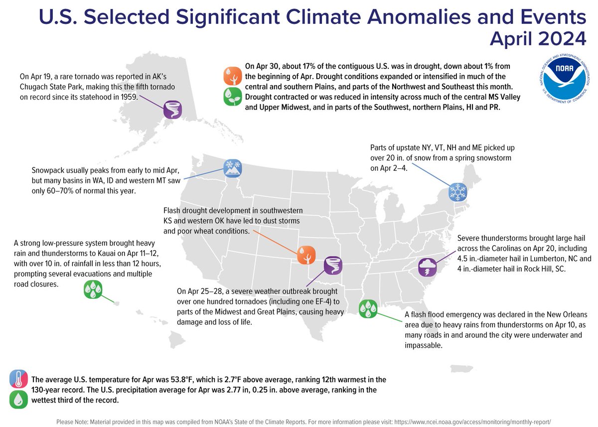
  • A severe weather outbreak generated more than one hundred tornadoes, including one EF-4, across the Midwest and Great Plains on April 25–28, causing significant damage and loss of life and becoming the worst tornado outbreak to date for the year.
  • During early April, a spring snowstorm brought heavy snow and powerful winds to much of New England, downing trees and knocking out power to hundreds of thousands in the region.
  • January to April 2024 was the fifth-warmest such four-month period on record for the nation and precipitation ranked in the wettest third of the historical record for the month of April 2024.

Other Highlights:

Temperature

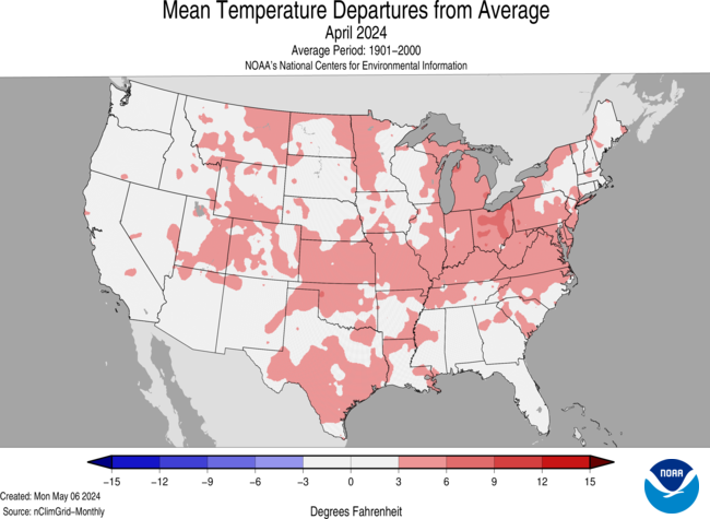
The average temperature of the contiguous U.S. in April was 53.8°F, 2.7°F above average, ranking 12th warmest in the 130-year record. April temperatures were above average across much of the contiguous U.S., while near- to below-average temperatures were observed in parts of the West, northern Plains, Upper Midwest, Southeast and in small pockets of the Northeast. Virginia and West Virginia each had their fifth-warmest April on record.

The Alaska statewide April temperature was 27.2°F, 3.9°F above the long-term average, ranking in the warmest third of the 100-year period of record for the state. Above-average temperatures were observed across most of the state with near- to below-normal temperatures in parts of the Southwest and in parts of the Panhandle. 

For January–April, the average contiguous U.S. temperature was 43.0°F, 3.8°F above average, ranking fifth warmest on record for this period. Temperatures were above average across nearly all of the contiguous U.S., while record-warm temperatures were observed in parts of the Northeast and Great Lakes. Wisconsin, Michigan, New York, Vermont, New Hampshire and Maine each ranked second warmest for the January–April period.

The Alaska January–April temperature was 13.9°F, 3.6°F above the long-term average, ranking in the warmest third of the historical record for the state. Much of the state was above normal for this four-month period while temperatures were near average across parts of the East, Southeast and parts of the Panhandle.

Precipitation

April precipitation for the contiguous U.S. was 2.77 inches, 0.25 inch above average, ranking in the wettest third of the historical record. Precipitation was below average across much of the West, Southeast, and parts of the central and southern Plains. Conversely, precipitation was above normal from portions of the Plains to the Northeast, and in parts of the Southwest. Indiana and Pennsylvania each had their fifth-wettest April on record.

Alaska’s average monthly precipitation ranked in the driest third of the historical record. Precipitation was above average in parts of the North Slope and West Coast, while below-normal precipitation was observed in parts of the Southeast Interior and Panhandle during the month.

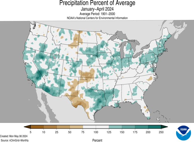
The January–April precipitation total for the contiguous U.S. was 10.95 inches, 1.48 inches above average, ranking 11th wettest in the 130-year record. Precipitation was above average across much of the contiguous U.S., with Pennsylvania having its second-wettest year-to-date period on record. Conversely, precipitation was below average across parts of the Northern Tier and western and southern Plains, and in a small portion of the Southeast during the January–April period.

The January–April precipitation for Alaska ranked in the middle third of the 100-year record, with above-average precipitation observed across much of the state, while near-normal precipitation was observed in parts of the northeast Interior and along parts of the Gulf of Alaska coast. Below-average precipitation were observed in portions of Interior and south-central Alaska and parts of the southern Panhandle during this period.

Billion-Dollar Disasters

Five new billion-dollar weather and climate disasters were confirmed in April 2024, including three severe storm events that impacted the central, southern and eastern U.S. in mid-February and early April. There were also two winter storms that impacted the northwest and central U.S. in mid-January.

There have been seven confirmed weather and climate disaster events this year, each with losses exceeding $1 billion. These disasters consisted of five severe storm events and two winter storms.

The U.S. has sustained 383 separate weather and climate disasters since 1980 where overall damages/costs reached or exceeded $1 billion (including CPI adjustment to 2024). The total cost of these 383 events exceeds $2.720 trillion.

Other Notable Events

A spring storm brought rain, heavy snow, damaging winds and thunderstorms across much of the Great Lakes on April 2, knocking out power to over 100,000 people across the region during the height of the storm.

Severe weather across the Southeast produced a hailstorm that caused over $5 million in damages in Rock Hill, SC on April 20.

On April 26, severe weather across the central Plains resulted in the National Weather Service in Omaha, Nebraska issuing 48 tornado warnings—the most the office has ever issued in a single day.

US Drought Monitor map May 7, 2024.

Drought

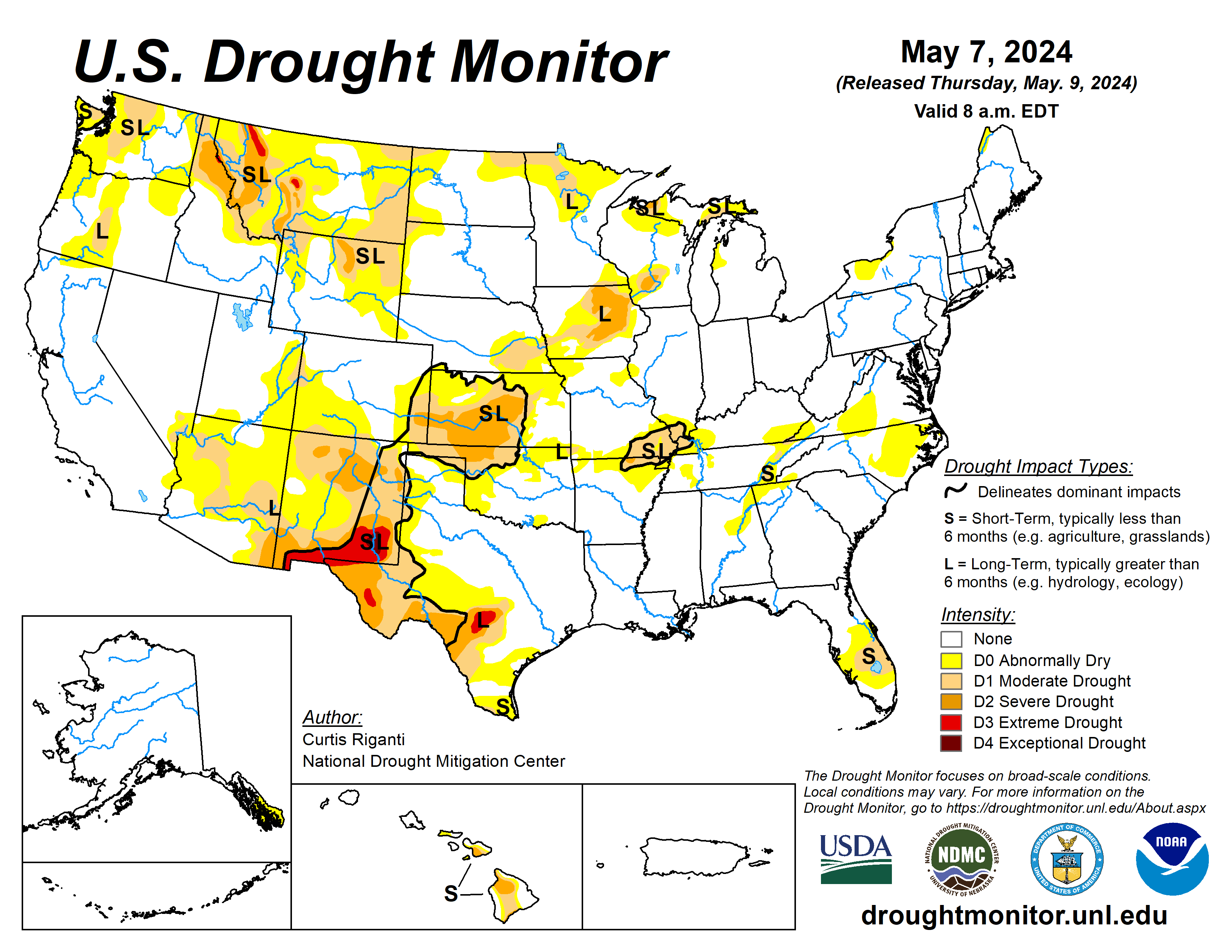
According to the April 30 U.S. Drought Monitor report, about 17% of the contiguous U.S. was in drought, down about 1% from the beginning of April. Drought conditions expanded or intensified in much of the central and southern Plains, and parts of the Northwest and Southeast this month. Drought contracted or was reduced in intensity across much of the central Mississippi Valley and Upper Midwest, and in parts of the Southwest, northern Plains, Hawaii and Puerto Rico.

Monthly Outlook

Above-average temperatures are favored to impact areas from the southern Plains to the East Coast in May while above-average precipitation is likely to occur from much of the central Plains to the Mid-Atlantic and parts of the Upper Midwest. Drought is likely to persist along portions of the Northern Tier, the Southwest and Hawaii. Visit the Climate Prediction Center’s Official 30-Day Forecasts and U.S. Monthly Drought Outlook website for more details.

Significant wildland fire potential for May is above normal across the Hawaiian Islands and in portions of the Southwest and Florida Peninsula. For additional information on wildland fire potential, visit the National Interagency Fire Center’s One-Month Wildland Fire Outlook

The latest #ElNiño/Southern Oscillation #ENSO diagnostic discussion is hot off the presses from the #Climate Prediction Center

Click the link to read the discussion on the CPC website:

May 9, 2024

ENSO Alert System Status: El Niño Advisory / La Niña Watch

Synopsis: A transition from El Niño to ENSO-neutral is likely in the next month. La Niña may develop in June-August (49% chance) or July-September (69% chance).

During April 2024, below-average equatorial sea surface temperatures (SSTs) emerged in small regions of the eastern Pacific Ocean. However, above-average SSTs prevailed across the rest of the equatorial Pacific. The latest weekly Niño index values remained between +0.5°C and +0.8°C in all regions, except for Niño-3 which was +0.3°C. Below-average subsurface temperatures held steady during the month with negative anomalies extending from the Date Line to the eastern Pacific Ocean. Low-level wind anomalies were easterly over the western equatorial Pacific, while upper-level winds were near average. Convection was near average overall across the equatorial Pacific Ocean and Indonesia. Collectively, the coupled ocean-atmosphere system reflected the continued weakening of El Niño and transition toward ENSO-neutral.

The most recent IRI plume favors an imminent transition to ENSO-neutral, with La Niña developing during July-September 2024 and then persisting through the Northern Hemisphere winter. The forecast team continues to favor the dynamical model guidance, which suggests La Niña could form as early as June-August 2024, with higher confidence of La Niña during the following seasons. La Niña generally tends to follow strong El Niño events, which also provides added confidence in the model guidance favoring La Niña. In summary, a transition from El Niño to ENSO-neutral is likely in the next month. La Niña may develop in June-August (49% chance) or July-September.

#Wyoming Files Two Lawsuits Challenging Biden Administration’s EPA Rules that Target Wyoming’s #Coal Industry #ActOnClimate #KeepItInTheGround

This graph shows the globally averaged monthly mean carbon dioxide abundance measured at the Global Monitoring Laboratory’s global network of air sampling sites since 1980. Data are still preliminary, pending recalibrations of reference gases and other quality control checks. Credit: NOAA GML

Click the link to read the release on Governor Gordon’s website:

May 9, 2024

CHEYENNE, Wyo. – Governor Mark Gordon announced that Wyoming has filed two lawsuits challenging new rules from the Environmental Protection Agency (EPA) that target Wyoming’s coal and natural-gas fired power plants. 

Today, Wyoming joined a coalition of 24 states challenging the Biden Administration’s recently released power plant regulations. The states argue that the new rule exceeds EPA’s authority and ignores the United States Supreme Court’s 2022 decision vacating Obama-era greenhouse gas limits for power plants. The suit asks the U.S. Court of Appeals for the District of Columbia Circuit to review and declare the regulations unlawful.

On May 8, Wyoming and 22 other states filed a lawsuit challenging another EPA rule that would require certain air emissions from coal-fired plants to be reduced drastically, with no corresponding health benefits and with great costs to Wyoming and its industries.

“The Biden Administration’s EPA seems determined to use unlawful rulemaking to continue its attacks on Wyoming’s core industries,” Governor Gordon said. “The only goal appears to be destroying Wyoming’s fossil fuel industry by further burdening our power plants, increasing costs to consumers, and threatening the stability of our nation’s electrical grid.”

The Environmental Protection Agency rejects plan to pump Moneta oilfield waste into potential drinking water — @WyoFile #ActOnClimate #KeepItInTheGround

On the Wind River Indian Reservation, Fort Washakie is home to nearly 1,800 people. (Matthew Copeland/WyoFile)

Click the link to read the article on the WyoFile website (Angus M. Thuermer Jr.):

April 24, 2024

Federal environmental officials have rejected a request by Aethon Energy to pump Moneta Divide oilfield wastewater into the Madison aquifer, saying the deep reservoir could be used for drinking water, especially by tribal nations on the Wind River Indian Reservation.

The Wyoming Oil and Gas Conservation Commission in November 2020 approved wastewater disposal into the 15,000-foot deep well, but the U.S. Environmental Protection Agency said last week the state’s decision did not align with federal rules.

Aethon’s plan does not support a finding “that the aquifer cannot now and will not in the future serve as a source of drinking water,” the EPA wrote in a 20-page record of decision. Aethon argued, and the Wyoming commission agreed 4-1, that the underground Madison formation was too deep and remote to be used for drinking water.

The EPA relied on the Safe Drinking Water Act as the authority under which to protect the aquifer. It also cited climate, environmental justice and tribal interests in its decision, pointing to the nearby Wind River Indian Reservation as a community that could use the water.

“The significance of that is the EPA finally didn’t wimp out on us,” said Wes Martel, a member of the Wind River Water Resources Control Board. “We’re just glad they now have some people in place following up on their Indian policy.”

The Eastern Shoshone and Northern Arapaho Tribes “foresee increased reliance on groundwater for drinking water purposes and anticipate needing to access deeper aquifers, such as the Madison aquifer, as the climate changes and water resources grow scarcer,” the EPA wrote in a 94-page analysis of tribal interests. The agency cited historic cultural and spiritual ties to the land and water and tribes’ status as sovereign nations in its decision.

“We have to make sure our future generations have a reliable source of clean water,” Martel said. “Our reservation, this is all we have left. We’ve got to do our best to protect it.”

The Powder River Basin Resource Council, along with the Wyoming Outdoor Council and others, has spent years monitoring discharge reports and industry permits and was vital in challenging pollution threats, Martel said.

The EPA understood that science, and the law did not support Aethon’s request, said Shannon Anderson, organizing director and staff attorney with the resource council. “They recognized the value of our groundwater resources and the need to protect those into the future,” she said, hailing the decision.

Vast quantities of water

Aethon must find a way to dispose of produced water — a brine pumped from energy wells to release gas and oil — as it expands the Moneta Divide field by 4,500 wells. The U.S. Bureau of Land Management authorized that expansion in 2020, leaving the question of water disposal to Wyoming, which has authority over surface and underground water quality under overarching federal standards.

Aethon must find a way to dispose of the equivalent of 120 Olympic-sized swimming pools full of produced water a day to expand the field. Aethon and Burlington Resources, a co-producer at Moneta, could generate $182 million a year in federal royalties, $87.5 million a year in Wyoming severance taxes and $106 million annually in County Ad Valorem taxes from the expansion.

An elk skull adorns a fencepost near the Eastern Shoshone’s buffalo management land on the Wind River Indian Reservation. (Katie Klingsporn/WyoFile)

But Aethon has violated state permits that allow it to pump some produced water into Alkali and Badwater creeks that flow into Boysen Reservoir, a drinking water source for the town of Thermopolis. Wyoming’s Department of Environmental Quality has notified the Dallas-based investment company of its infraction and has required Aethon to reduce the salinity of surface discharges this year.

The DEQ this year listed the two creeks as “impaired” and unable to sustain aquatic life. Underground injection of wastewater into the Madison was to be a new component of the disposal program.

The EPA cited climate change, drought, increasing temperatures and use of reservation surface water by others as some of the reasons to preserve the Madison aquifer.

“Removing the existing statutory and regulatory protections for a potential source of high-quality drinking water for the rural and overburdened communities in Fremont County and on the WRIR would further exacerbate existing inequities particularly with respect to historic and ongoing adverse and cumulative impacts to water resources and community health,” the EPA wrote.

“Thus, equity and environmental justice considerations, which include Tribal interest considerations, support maintaining the existing [Safe Drinking Water Act] protections that apply to the aquifers consistent with Congressional intent to protect both current and potential future sources of drinking water,” EPA documents state.

Neither Aethon nor a representative of the Oil and Gas Conservation Commission responded immediately to a request for comment Wednesday. But WyoFile received this response from Tom Kropatsch, oil and gas supervisor for the Wyoming Oil and Gas Conservation Commission, shortly after publication:

“We do not agree with EPA’s decision on this application. We are still reviewing their decision and the information utilized by EPA in support of their decision. Much of this information was not part of the original application or a part of the record. EPA did not follow the standard procedure of allowing the WOGCC and the applicant to review and respond to the additional information they had available prior to making their final decision. EPA evaluated data that differs in its geographic, geologic, engineering, and other technical information. EPA also inappropriately related the proposed injection location to other areas of the state. Since the data EPA reviewed does not accurately reflect the conditions at the location of the proposed disposal well it is not appropriate to rely on it for a decision on this application. The WOGCC is reviewing EPA’s decision and weighing its options for further action.”

Wyoming rivers map via Geology.com

#Thornton gets green light from Larimer County for long-sought water pipeline segment: City’s proposal faced widespread pushback from county residents who urged Thornton to keep its water in the #PoudreRiver — The #Denver Post #SouthPlatteRiver

Graphic credit: ThorntonWaterProject.com

Click the link to read the article on The Denver Post website (John Aguilar). Here’s an excerpt:

May 9, 2023

Thornton will be able to build a critical segment of a 70-mile pipe to bring water from the Cache la Poudre River to the fast-growing suburb north of Denver, after elected leaders in Larimer County unanimously — if begrudgingly — approved a permit for the northern segment of the pipe on Wednesday night…But a procession of county residents has spoken out against the proposed project at a series of public hearings held over the past couple of weeks, insisting that Thornton simply could allow its shares in the Poudre River — equaling 14,700 acre-feet a year — to flow through Fort Collins before taking the water out for municipal use. Doing so, they say, would increase flows and improve the river’s health. But just hours before Wednesday’s meeting, one of the opposition groups to the project — No Pipe Dream — said it sensed momentum had turned the city’s way, issuing a public statement that said “we’ll skip the torture of tonight’s hearing on our ‘good neighbor’ Thornton’s plans to win the water tap lottery and appease hungry developers.”

[…]

Before casting her yes vote Wednesday, Larimer County Commissioner Kristin Stephens said she wished Thornton would send its water down the Poudre “because that’s what the community wants.”

[…]

“We can’t do that,” she said, referring to a 2022 Court of Appeals decision that ruled that Larimer County cannot force Thornton to use the river as a conveyance…

The fight over Thornton’s water pipe has been going on for years, and a denial of a permit for the project by Larimer County’s commissioners more than five years ago set off a flurry of unsuccessful court challenges that ultimately prompted the city this year to resubmit its application — this time with a different route and 17 fewer miles of pipe within the county’s boundaries. The city also relocated a pump house from the original plan to a site that is not near any houses, and it agreed to 83 county land use conditions to move the project forward.

Click the link to read “Larimer County commissioners approve city of Thornton’s water pipeline application” on the Fort Collins Coloradoan website (Rebecca Powell). Here’s an excerpt:

May 9, 2024

Commissioners Kristin Stephens, Jody Shadduck-McNally and John Kefalas all said they believed the permit application, now with 83 conditions, met the criteria set by the county’s 1041 regulations that govern the permit process…[John Kefalas] said while advocates have suggested that Thornton’s 2023 application is no different than the one submitted a few years ago, “I must respectfully disagree, as the pipeline proposal and process have been different.”

[…]

Kefalas said the county legal counsel’s “prudent” interpretation of a 2002 Colorado Court of Appeals ruling, which sided with commissioners in their decision to reject but also said the county couldn’t require the water to be run through the Poudre, indicates what could be decided if the matter returns to the courts…

Thornton representatives have said that the water they are conveying is already being taken out of the river at a diversion point to the Larimer County canal. No additional diversions will be made after the project is complete, they’ve said. Shadduck-McNally said she looked thoroughly and critically at the 3,000-page application to make sure it complied with the criteria and believes the county’s higher standards did lead to a stronger application from Thornton.

“This is the system that we have in Colorado — the Colorado water system and the Colorado water court system — and I wish it was different, but it’s the system that I can’t change today. Water court and water decrees are serious business.”

See Article 7.

2024 #COleg: Colorado Bill Protects Wetlands & Streams — Getches-Wilkinson Center

Blanca Wetlands, Colorado BLM-managed ACEC Blanca Wetlands is a network of lakes, ponds, marshes and wet meadows designated for its recreation and wetland values. The BLM Colorado and its partners have made strides in preserving, restoring and managing the area to provide rich and diverse habitats for wildlife and the public. To visit or get more information, see: http://www.blm.gov/co/st/en/fo/slvfo/blanca_wetlands.html. By Bureau of Land Management – Blanca Wetlands Area of Critical Environmental Concern, Colorado, Public Domain, https://commons.wikimedia.org/w/index.php?curid=42089248

Click the link to read the article on the Getches-Wilkinson Center website (Andrew Teegarden):

May 8, 2024

On May 6th, 2024 the Colorado Legislature passed HB24-1379 – a bill designed to protect the wetlands and streams at risk after the U.S. Supreme Court’s ruling in Sackett v. EPA (Environmental Protection Agency). The passage of the house bill saw overwhelming support from the regulated community, environmentalists, and concerned citizens.

HB24-1379 would not have been passed if not for the hard work and dedication of the bill sponsors; Speaker Julie McCluskie, Senator Dylan Roberts, Representative Karen McCormick, and Senator Barbara Kirkmeyer. These sponsors worked tirelessly to advocate for our state waters by compromising with and listening to stakeholders throughout the session.

Colorado is one of the first states in the country to pass legislation to restore protections to wetlands and streams from development activities. Other states will be able to model the stakeholder engagement process utilized by the bill sponsors to provide protections from unmitigated development.

The Protect Colorado Waters Coalition was the primary driver behind the campaign which helped HB24-1379 cross the finish line. Both Kristine Oblock, Campaign Manager with Clean Water for All and Josh Kuhn, Senior Water Campaign Manager with Conservation Colorado, upheld the coalition and worked behind the scenes to have foundational elements included in the legislation. For example, the coalition was successful in keeping the current definition of state waters. The bill sponsor went a step further to directly include wetlands within that definition to permanently expand the scope of covered waters. As we detailed in previous posts, the more comprehensive definition of state waters removes the need to quibble over jurisdiction and streamlines the permit process for applicants. Additionally, the coalition advocated for the federal 404(b)(1) guidelines to act as the floor rather than the ceiling for environmental review of permit decisions.

We, here at the Getches-Wilkinson Center, are ecstatic to see the coalition’s efforts result in meaningful legislation designed to protect our aquatic ecosystems for generations to come. Our mission is to promote the sustainability of the lands, air, and water in the Western United States and HB24-1379 aligns with that mission. We look forward to the rulemaking process where the Water Quality Control Commission within the Colorado Department of Public Health and the Environment will promulgate rules to establish how permits are issued, and the requirements applicants must follow.

Ephemeral streams are streams that do not always flow. They are above the groundwater reservoir and appear after precipitation in the area. Via Socratic.org