Click on a thumbnail graphic to view a gallery of drought data from the US Drought Monitor website.
Click the link to go to the US Drought Monitor website. Here’s an excerpt:
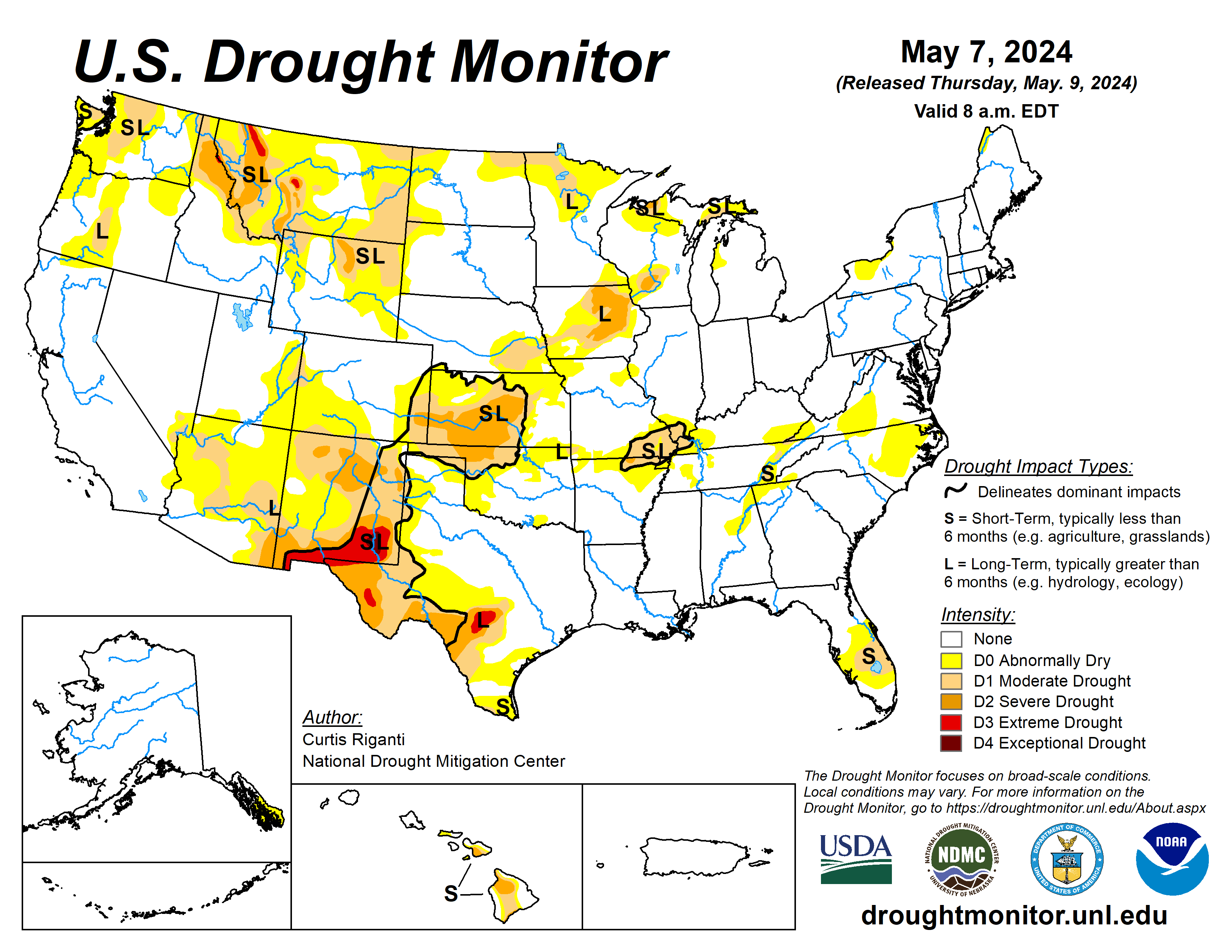
This Week’s Drought Summary
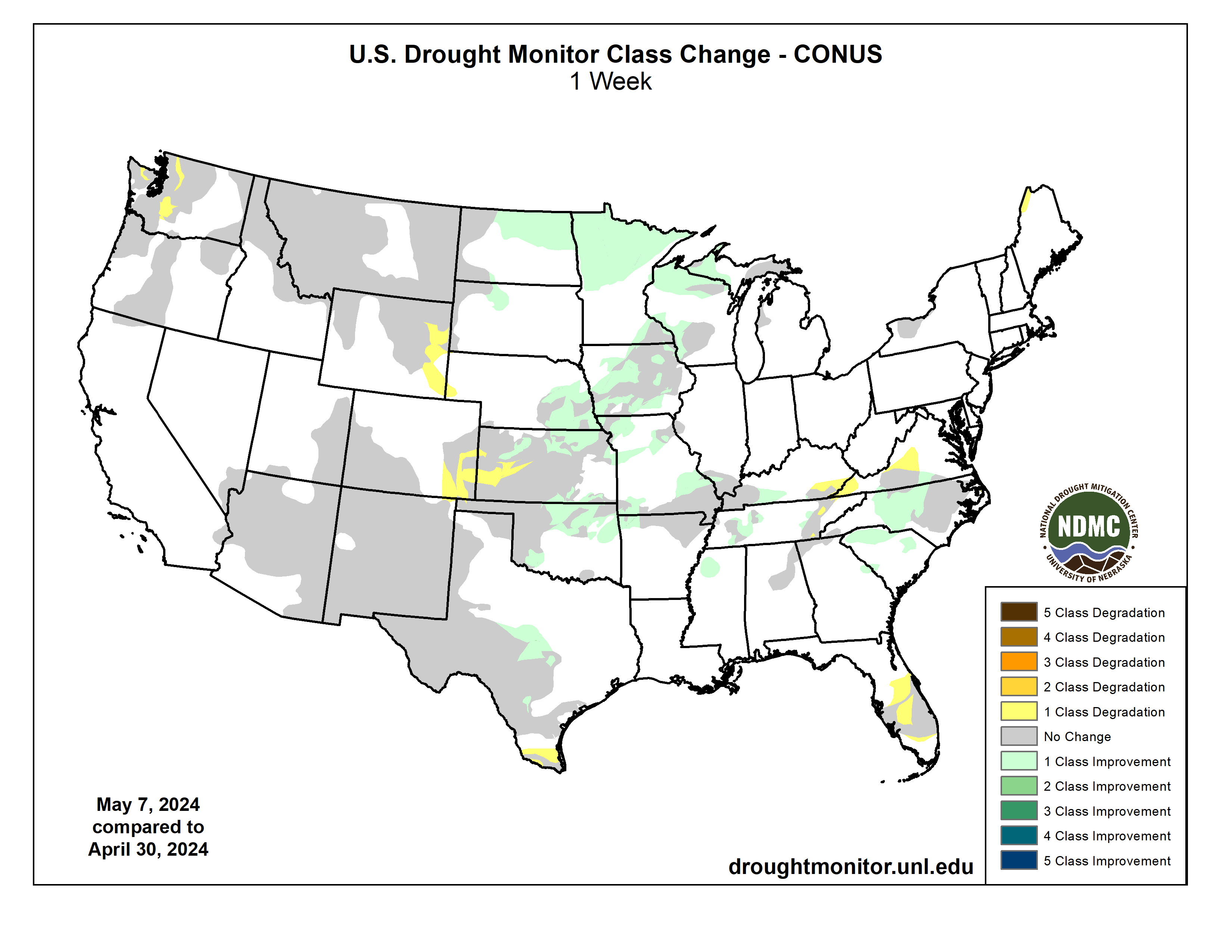
Heavy precipitation fell in western Oregon and adjacent southwest Washington and northwest California this week, and across large portions of the central U.S., as a series of storm systems caused continued bouts of severe thunderstorms and unfortunately included more significant tornadoes. The wet weather across portions of the Great Plains and Midwest led to either scattered or widespread improvements to ongoing drought or abnormal dryness, dependent on precipitation amounts, improvements to soil moisture and streamflow, and the degree of long-term dryness remaining in different locations. In Virginia, the Carolinas, and eastern Tennessee and Kentucky, heavy rains or lack thereof this week led to localized improvements or degradations in areas of short-term moderate drought or abnormal dryness. Very dry weather for the past few months led to increased fire danger in parts of the Florida Peninsula, and short-term moderate drought and abnormal dryness expanded in coverage. In southwest Kansas and adjacent eastern Colorado, mostly to the west of where this week’s showers and thunderstorms occurred, flash drought conditions continued and severe and moderate drought expanded in coverage. In Hawaii, wet weather continued on the windward sides of the islands, and some improvement to conditions occurred in Lanai and western Maui. Another wet week in Puerto Rico allowed for the removal of abnormal dryness from the northwest corner of the island…
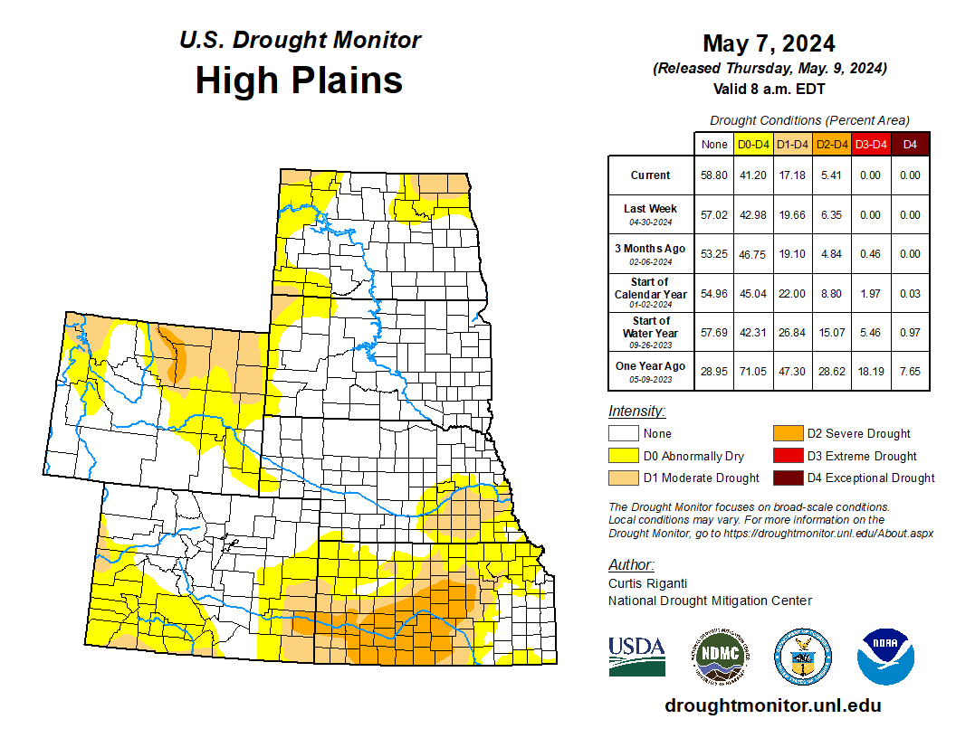
High Plains
Moderate to heavy rain amounts fell in eastern portions of the High Plains region, especially in central and eastern Nebraska, northern and eastern Kansas and eastern North Dakota. Temperature anomalies varied across the region, with temperatures coming in 3-6 degrees above normal in southern Kansas, while northwest Colorado and Wyoming finished the week at 3-9 degrees colder than normal. In eastern Kansas and Nebraska and in eastern North Dakota, heavy rains continued the recent wet pattern, leading to improvements in ongoing drought and abnormal dryness. In parts of eastern Nebraska, improvements were somewhat tempered by remaining long-term precipitation deficits and hydrologic impacts from those deficits. In southwest Kansas and adjacent southeast Colorado, many areas mostly or completely missed out on recent rains, continuing the very dry weather from the last few months, during which Dodge City tied its record for the driest April on record there (with just 0.02 inches of precipitation). In these areas, flash drought conditions continued, and severe and moderate short-term drought expanded. Given the time of year during which this drought began, severe impacts to the wheat crop in portions of Kansas have occurred. Recent dryness led to some expansion of drought and abnormal dryness in portions of eastern Wyoming as well…

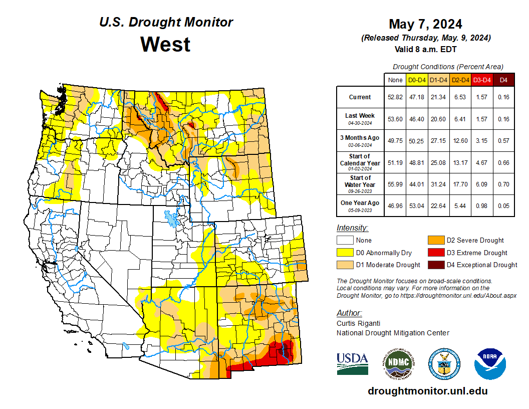
West
The West region this week saw heavy precipitation (locally exceeding 2 inches) fall in eastern Montana, while portions of northern California, northeast Oregon, and western Oregon and southwest Washington also saw heavy precipitation amounts (locally exceeding 5 inches in northwest California and western Oregon). Streamflows improved amid the wet weather in northwest Oregon. Farther north in Washington, short-term dryness continued, especially in parts of the Cascade and Olympic ranges, where snow-water content and streamflow remained low, and moderate drought and abnormal dryness expanded. The heavy rains in eastern Montana ended a recent stretch of dry weather there, preventing any degradation to ongoing drought. The effects of these rains across the eastern plains will be evaluated further next week. Except for eastern New Mexico and parts of Arizona, most of the West region was colder than normal this week. Parts of Oregon, southern Idaho, northern Utah and northern Nevada saw temperature readings 6-12 degrees below normal…
South
Widespread heavy rains fell across portions of the South region, especially in western Arkansas, central and eastern Oklahoma, and central and eastern Texas. Heavier rain also occurred in a few spots in northern Mississippi and Tennessee. Most of the region had warmer-than-normal temperatures this week, with departures of 6-9 degrees above normal being common in northern Mississippi and Tennessee, while 3-6 degrees above normal was common elsewhere. In areas of improvements to drought and abnormal dryness in central and eastern Oklahoma and Arkansas, recent showers and thunderstorms continued to improve precipitation deficits, streamflow and soil moisture. In central Texas, a tight gradient in long-term drought conditions has developed, as heavier rains have recently fallen along the northern edge of moderate to extreme long-term drought conditions. Some reservoirs have seen some recent improvement in levels in the area, though significant deficits remain. In deep south Texas, dry weather over the last month or two has led to significant short-term precipitation deficits, and a small area of short-term moderate drought developed. Heavier rains (or lack thereof) in Tennessee led to small-scale improvements and degradations in areas of moderate drought and abnormal dryness…
Looking Ahead
As of time of writing (the afternoon of May 8), precipitation forecasts from the National Weather Service Weather Prediction Center show mostly dry weather west of the Continental Divide within the contiguous U.S. through the evening of Monday, May 13. East of the Continental Divide, 0.5-1 inch of rain, with locally higher amounts, is forecast for portions of central and eastern Colorado, western Kansas, the Texas and Oklahoma panhandles, western Oklahoma and northeast New Mexico. Heavier rain amounts (locally exceeding 2 inches) are forecast from eastern Texas eastward across Louisiana, southern portions of Mississippi, Alabama and Georgia, and in Tennessee. Separate areas of forecasted rainfall above an inch are in north-central Iowa and from south-central New York to south-central Pennsylvania.
For May 14-18, the National Weather Service Climate Prediction Center forecast favors warmer-than-normal temperatures across most of the contiguous U.S., with the exceptions of portions of the south-central U.S. from Oklahoma to Tennessee and in the northwest half of Washington. Except for far northeast Alaska, the forecast favors colder-than-normal weather in most of Alaska, especially southwest, south-central and southeast Alaska. Near-normal temperatures are most likely in Hawaii. Precipitation forecasts in the contiguous U.S. favor near- or above-normal precipitation across most areas, except for the Pacific Northwest and a small part of southwest Texas. The highest confidence for wetter-than-normal weather is in the Southeast region. Wetter-than-normal weather is favored in most of Hawaii, with the highest confidence for above-normal precipitation in Niihau and Kauai. Above-normal precipitation is also favored in Alaska.