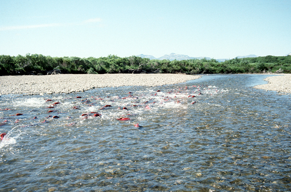
Spawning Salmon in Becharof Stream within the Becharof Wilderness in southern Alaska, USA. By U.S. Fish and Wildlife Service – US Fish & Wildlife Service – [1], Public Domain, https://commons.wikimedia.org/w/index.php?curid=3525119
Click the link to read the article on the NOAA website:
May 22, 2024
NOAA is recommending nearly $240 million in funding for 46 fish passage projects this year, as well as an additional $38 million in funding in future years. The projects are funded under the Biden-Harris Administration’s Bipartisan Infrastructure Law and Inflation Reduction Act. With this historic level of funding, our partners will reopen migratory pathways and restore access to healthy habitat for fish across the country.
Twenty-one of these projects—more than $112 million in funding—will be led by tribes and tribal organizations. This will include projects for fish passage and for building tribal organizational capacity. In addition to projects led by tribes, more than half of the remaining projects will directly involve tribes and are aligned with tribal priorities. Across these projects, tribes will:
Play key roles in decision-making,
Build capacity to help recover tribally-important migratory fish
Provide community and economic benefits such as jobs and training opportunities
These projects will help recover endangered migratory fish and support the sustainability of commercial, recreational, and tribal fisheries. They will also support coastal communities by:
Removing derelict and unsafe dams
Removing contaminated sediments
Improving opportunities for recreation
Adapting to climate change by reducing flooding and improving threatened infrastructure
This funding builds on the more than $166 million awarded for 36 projects through our first round of fish passage awards, which will provide significant benefits to endangered migratory fish and sustainable fisheries.
Tribal Priority Fish Passage Projects Recommended for Funding
These projects will support tribes in their role as managers and stewards of tribal trust resources for cultural, spiritual, economic, subsistence, and recreational purposes. They will support tribally important fish passage barrier removal projects and help to increase tribal capacity to participate in developing current and future fish passage projects.
These projects will help restore access to healthy habitat for migratory fish across the country through efforts, including:
On-the-ground fish passage restoration
Engineering and design
Future project development
Building the capacity of new and existing partners to design projects and manage multi-faceted restoration efforts
Fish Passage and NOAA
Every year, millions of fish migrate to their spawning and rearing habitats to reproduce. Some fish need to swim thousands of miles through oceans and rivers to reach their destinations. They are often blocked from completing their journey by barriers like dams and culverts. When fish can’t reach their habitat, they can’t reproduce and maintain or grow their populations. As a result, many fish populations have declined. NOAA works to reopen these migratory pathways, restoring access to healthy habitat for fish.
NOAA’s Office of Habitat Conservation has a long history conducting habitat restoration efforts, including fish passage, with large-scale competitive funding opportunities and expert technical assistance through our Community-based Restoration Program. The Bipartisan Infrastructure Law and Inflation Reduction Act provide a historic opportunity for us to continue supporting fisheries, protected resources, and coastal communities. In our first round of funding opportunities, we awarded more than $480 million for 109 projects across the country through this funding.
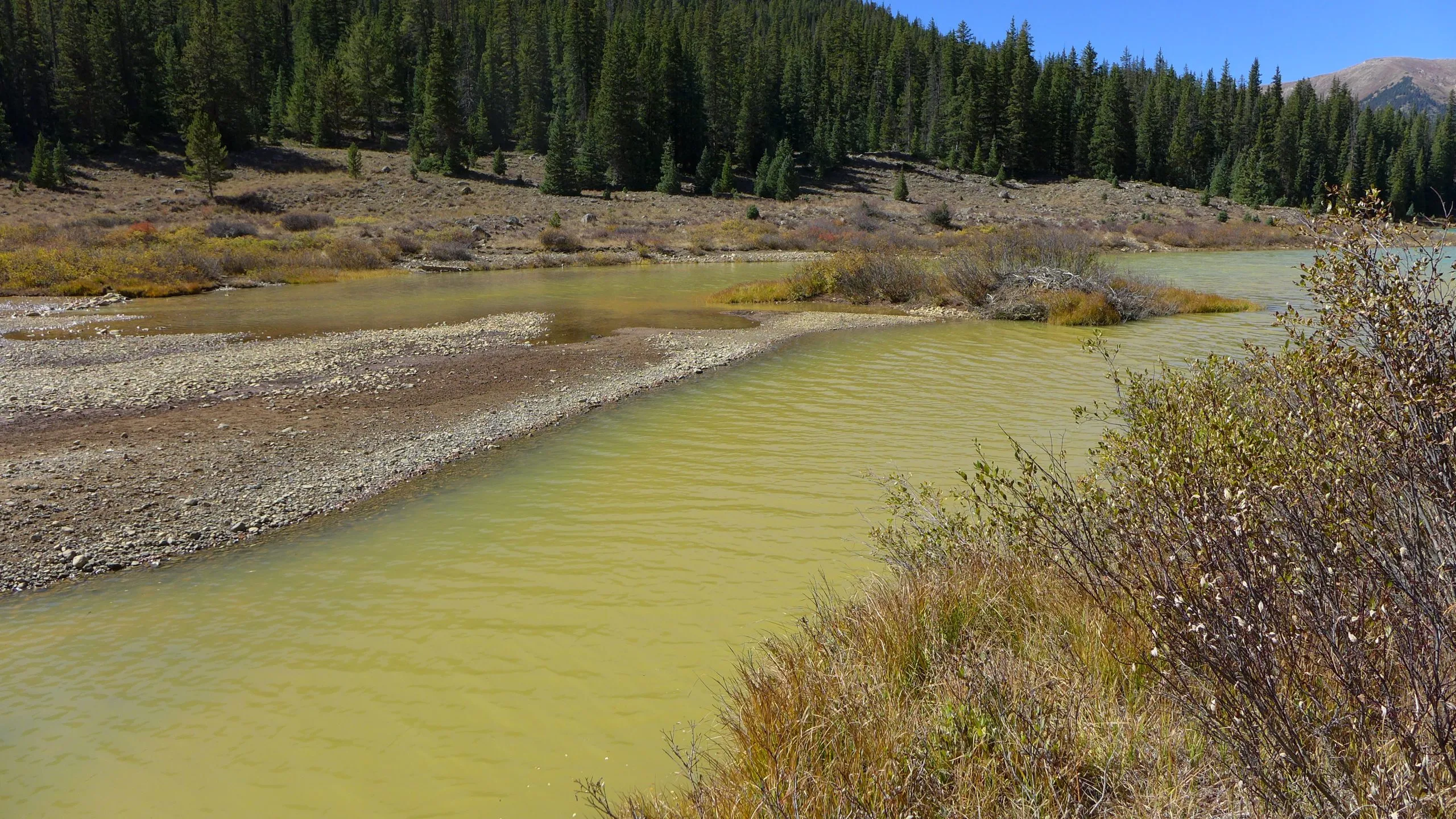
Lincoln Creek flows into Grizzly Reservoir and is a source of drinking water for Colorado Springs. Experts say mineral concentrations are increasing in streams across Colorado due to climate change. CREDIT: HEATHER SACKETT/ASPEN JOURNALISM
Colorado’s mountains are pockmarked with orange tailings piles, adits, tunnels and rusted tramways, the remnants of a historic mining industry often blamed for fouling the state’s waterways.
But a recent study points the finger at a different culprit as the cause of increasing metals concentrations in Colorado’s high mountain streams: climate change. And these findings have implications for local ecosystems and the water supplies of mountain communities.
Scientists from the U.S. Geological Survey and the University of Colorado Boulder analyzed water chemistry data over the past 40 years for 22 stream sites throughout Colorado’s mountains. They found that concentrations of zinc and copper have doubled over the past 30 years, with melting of previously frozen ground being a likely major cause.
“These trends are concerning because, even at low concentrations, dissolved metals can negatively affect downstream ecosystem health and the quality of water resources,” reads the paper, which was published in Water Resources Research in late April.
Tanya Petach, a climate scientist at the Aspen Global Change Institute, worked on the study. She said the trend of increasing metals concentrations is relatively steep and widespread across Colorado’s mountains.
“There’s this theory that those increases in metal concentrations in these streams are really driven by a climate change signal,” Petach said. “We are really used to tying increases in metals to mining activities, but in this case, we’re only seeing a climate response.”
The process that causes metals leaching into streams can be both naturally occurring and caused by mining activities. In both cases, sulfide minerals in rock come in contact with oxygen and water, producing sulfuric acid. The acid can then leach the metals out of the rock and into a stream, a process known as acid rock drainage. As temperatures warm, rock that has long been encased in ice becomes exposed to weathering.
“These high-elevation streams, some of them have mean annual air temperatures right around freezing,” Petach said. “So you go from having permafrost to melting that permafrost. Once you lose the ice, you’ve created a phenomenal conduit for new water and oxygen to come into contact with sulfide minerals that have been blocked for centuries, if not millennia.”
Diane McKnight, an environmental engineering professor at CU Boulder’s Institute of Arctic and Alpine Research, has been measuring the pH levels of the upper Snake River in Summit County for decades. On a recent trip with students, a stream that usually had a pH level of about 4 measured 2.75, meaning the acidity had greatly increased.
“I said: Wait, the probe must be wrong, the probe must be broken,” McKnight said. “Guess what, the probe was not broken. … The public should be aware the world is changing and there are surprises.” [ed. emphasis mine]
The study says declining streamflows are also contributing to increasing metals concentrations, but not as much as the increase in acid rock drainage caused by climate change.
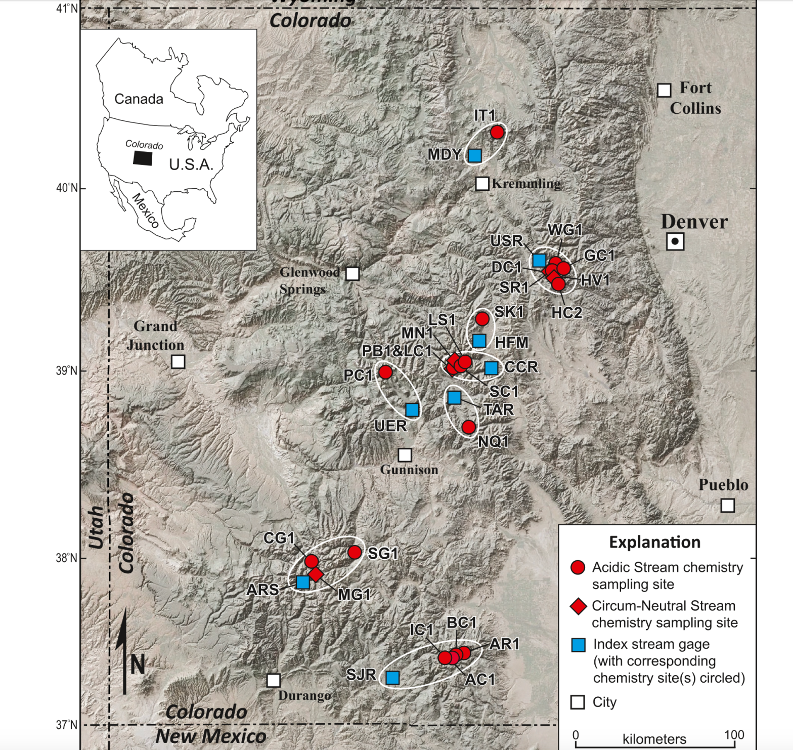
This map shows 22 stream sites throughout Colorado’s mountains where scientists from the U.S. Geological Survey and the University of Colorado Boulder analyzed water chemistry data over the past 40 years.
Lincoln Creek similarities
These findings on the Snake River and other sites in Colorado are important for the members of a workgroup trying to figure out how to address increasing metals concentrations in Lincoln Creek above Aspen. Although Lincoln Creek wasn’t one of the sites included in the study, the conditions in Lincoln Creek mirror many of the headwaters study sites.
“Lincoln Creek is very intriguing because it matches a similar pattern,” Petach said. “The Lincoln Creek system seems fairly similar to a lot of these other high-elevation headwaters catchments where this occurs.”
Water quality issues in Lincoln Creek have been a concern for years and have been getting worse. A November report by the U.S. Environmental Protection Agency showed that metals concentrations in Lincoln Creek are high enough to be toxic to fish and aquatic life. The creek above Grizzly Reservoir exceeds state water quality standards for aluminum, cadmium, copper, iron, lead, manganese and zinc, and aluminum and copper concentrations were higher than standards set by the Colorado Department of Public Health and Environment (CDPHE) in multiple locations.
The report found that the vast majority of the contamination was coming from a “mineralized tributary” to Lincoln Creek and not from the nearby Ruby Mine, where prospectors in the early 1900s dug for gold, silver and lead.
A workgroup dedicated to Lincoln Creek and composed of officials from state, local and federal agencies, nonprofit environmental groups and others has been meeting often since the EPA report was released. Since the EPA is authorized to address elevated metals concentrations only from human-caused activities like mining, it’s unclear how the contamination would be cleaned up or what agency is responsible for it.
But the workgroup is making headway on the issue, said member Karin Teague, executive director of the nonprofit environmental group Independence Pass Foundation.
“It could be a model for how a community might respond to contamination in its watershed,” Teague said. “We are really getting our arms around the problem, the extent of it, the nature of it, and then, of course, the million-dollar question being: What, if anything, can be done about it?”
Pitkin County Environmental Health Manager Kurt Dahl and Pitkin County Healthy Rivers Administrator Lisa Tasker gave an update on the group’s progress to county commissioners at a work session Tuesday. There are plans for four different water quality projects this summer: the U.S. Forest Service plans to collect water quantity and flow data; Colorado Parks and Wildlife will monitor metals concentrations in Lincoln Creek and the Roaring Fork River; the Roaring Fork Conservancy will take samples below Grizzly Reservoir to look for impacts related to a Grizzly Dam rehabilitation project; and scientists and students from CU’s INSTAAR program will look for rare earth metals in the water, sediment and bugs of Lincoln Creek. Pitkin County has approved grants for three of the four projects so far.
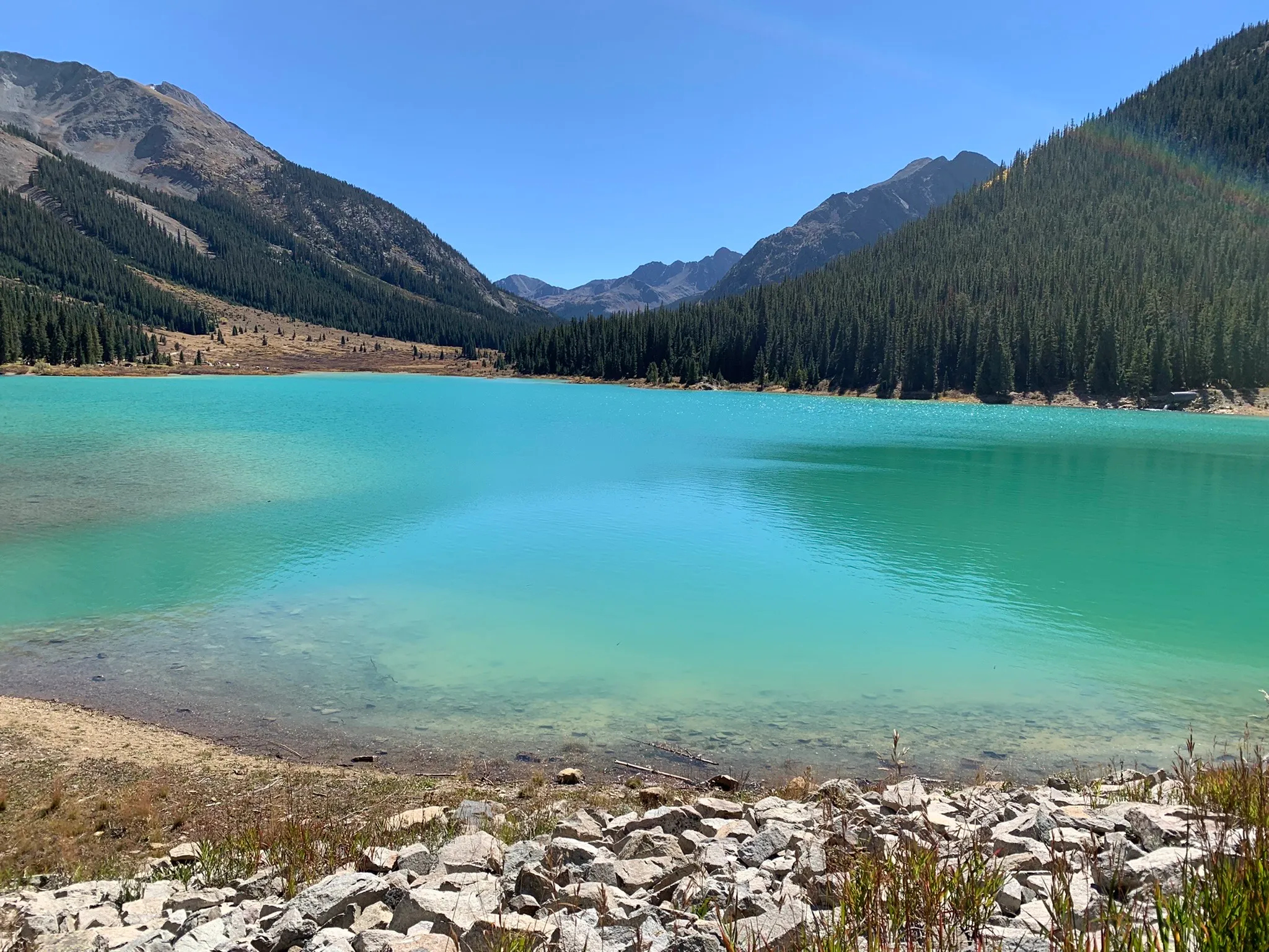
Grizzly Reservoir was a bright shade of turquoise in September 2022. The man-made alpine lake has high concentrations of metals that are toxic to fish, according to a report from the Environmental Protection Agency.
CREDIT: HEATHER SACKETT/ASPEN JOURNALISM
What about the water supply?
Lincoln Creek is one of seven streams in the Roaring Fork basin’s headwaters that feed the Twin Lakes Reservoir and Canal Co.’s Independence Pass transmountain diversion system, which provides drinking water sources for Front Ranges cities, including Colorado Springs, which owns a majority of the system’s water. Grizzly Reservoir, on Lincoln Creek below the contamination source, is used as a collection pool for water collected from the creeks, which is sent through the Twin Lakes Tunnel to the Arkansas River basin and eventually to the Front Range. The Snake River system where McKnight has conducted research flows into Dillon Reservoir, Denver Water’s biggest storage bucket.
A map of the Independence Pass Transmountain Diversion System, as submitted to Div. 5 Water Court by Twin Lakes Reservoir and Canal Co.
The EPA report said that in the case of Lincoln Creek, the dilution, the distance the water travels and the water-treatment process limit the impacts to drinking water. But since the issue is widespread across Colorado’s mountains, communities that get their drinking water from high-elevation streams could be impacted.
“These metal concentrations tend to be diluted when the small tributaries confluence with larger, cleaner streams, so we don’t tend to think of these as being a huge problem for large municipal water supplies,” Petach said. “But the place where it could impact the drinking water supply is in high-elevation mountain communities that are receiving waters from smaller tributaries.”
The city of Aspen gets the majority of its drinking water from Castle Creek, a mountainous tributary of the Roaring Fork River. Aspen’s Utilities Resource Manager Steve Hunter said that source water protection is a key concern for the city.
“After talking with our water treatment staff, they are not seeing a rise in these metals at the treatment plant and all treated water meets or exceeds CDPHE/EPA requirements,” Hunter said in a prepared statement. He added that the city has not done source water sampling for these compounds in either Castle or Maroon Creek watersheds as CDPHE/EPA does not require testing Aspen’s source water for these compounds.
It wasn’t exactly the news anyone wanted to hear, but the West’s two-year snowpack party looks like it may be coming to an end for a while.
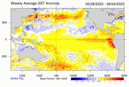
According to a report from the National Weather Service’s lead forecaster, the Southwest is in line for the effects of a strong “La Nina” condition in the eastern Pacific Ocean, indicating drier-than-normal months to come.
“We’re seeing the first vestiges of a La Nina effect now,” said Mark O’Malley of the National Weather Service at a meeting of the Drought Interagency Coordinating Group on Tuesday. “It’s going to be the largest climate driver of the next 12 months.”
The Interagency Coordinating Group (ICG) is an advisory body to the Governor on Arizona drought issues, co-chaired by the ADWR Director.
It’s comprised of state, federal and non-governmental organizations, and meets twice a year to evaluate drought conditions in Arizona and across the West and to consider recommendations to the governor.
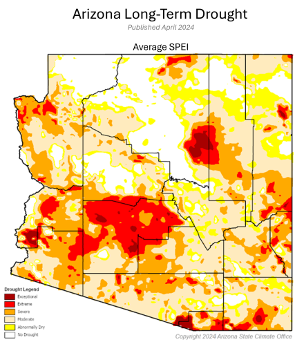
To exactly no one’s surprise, the ICG panelists chose to recommend to Governor Hobbs that the state’s Drought Emergency Declaration be continued for at least until the next meeting of the panel six months from now.
“My viewpoint is that we’ll be recommending to the Governor to continue the Drought Declaration,” said ADWR Director Tom Buschatzke at the meeting’s end as he watched panelists nod in agreement.
The U.S. Southwest has experienced two consecutive healthy seasons of moisture, including a near-record setting 2022-2023 winter snowpack season, as well as coastal storms that brought dozens of “atmospheric rivers.” Now, the forecasters say that we could be facing a dry spell. How likely is it? Alas, their computer modelling projections are telling them that it is looking pretty certain.
“We’re seeing fairly good agreement in models,” observed O’Malley. “Normally we see uncertainty. We see that July, August and September will be dipping into La Nina and in the fall we’ll be falling into a full La Nina state.”
The region is looking at a “better than 80 percent chance of a full La Nina in 2024-2025 Winter,” he said, with the odds tilted in favor of above normal temperatures.
The Phoenix area is looking at a 60 percent chance of above normal temperatures this summer, a trend the south-central part of the state has been experiencing for a long time.
“Last summer was quite warm and there is no sign of this slowing down anytime soon,” he said.
North American Monsoon graphic via Hunter College.
On the plus side, O’Malley said Arizona can anticipate “a fairly average monsoon” in terms of rainfall, but that, overall, a La Nina winter produces below average water years and warmer temperatures.