McPhee Reservoir managers have announced that rafting flows on the Dolores River below the dam will start up again for at least a few days next week.
On Monday, June 5, flows will begin ramping up by 100 cubic feet per second every three hours. By Tuesday noon, flows will be 800 cfs and continue until Thursday or Friday, possibly longer…
Record winter snowpack easily filled the reservoir and provided for a 52-day rafting season that ended May 25 so the reservoir could be topped off. But lingering high-mountain snows continue to provide ample runoff that is more than the reservoir can hold, so another release is necessary.
Curtis said the three-day release could extend to five or longer depending on inflows and weather. Managers will be giving daily updates beginning Monday on the release schedule.
The Colorado Basin River Forecast Center is predicting an increase of inflows into McPhee this weekend. Depending on actual volume, the latest rafting release could be up to a week or 10 days, officials said.
To accommodate boaters on multiday trips, ramp-downs for this release will be slower than usual, dropping 100 cfs per day to allow time for boaters to get off the river.
By midnight May 23, flows will ramp down to 600 cubic feet per second, hold for 24 hours, then drop to 400 cfs after midnight on May 24. From there the river will drop to 200 cfs, then 75 cfs by Sunday May 28.
“Spring runoff forecasts have steadily dropped with the drier-than-normal weather,” said Ken Curtis, an engineer with the Dolores Water Conservancy District. “It is time to fill the reservoir.”
Curtis said there is a chance that early hot June weather could bring down the remaining snowpack very quickly, which could force a mini whitewater spill of boatable flows for four to six days in June…
A solid winter snowpack allowed for the reservoir to fill for farmers and provide for 52 days of whitewater boating below the dam. In mid-May, 4,000 cfs of flushing flows were released for 72 hours to benefit river ecology, including sediment clearing and channel scouring, which improves native fish habitat. There were seven days of optimal flow releases of around 2,000 cfs.
A year-in-review meeting is being planned by reservoir managers, boaters, and environmental groups to evaluate the season.
Bass flush
A plan by Colorado Parks and Wildlife to flush out small-mouth bass opens up a slight window for kayakable flows later in the summer.
In mid July, biologists want to use part of their reserved fish pool in McPhee reservoir to release 400 cfs for 3-4 days and disrupt the bass spawn. The bass are a threat to the flannelmouth and bluehead suckers and roundtail chub, preying on their young and competing for food sources.
“We’re definitely looking at high water this year,” said Dennis Wied, the owner of Raft Masters.
Wied said he has high expectations for this season.
“This is going to be one of those epic kind of years where the real high water enthusiasts will be out in numbers,” Wied said.
Water flows are about 1,200 cubic feet per second in the Arkansas River right now, but rafting officials say they’re expecting that to grow three times as the snow continues to melt.
Arkansas River Basin High/Low graph May 22, 2017 via the NRCS.
From the Arkansas River Outfitters Association via PR Newswire:
This is the third year in a row that Colorado snowstorms preluded a strong boating season. Snowpack piled up this year to 120% of average in parts of the state…
Peak flows on Colorado’s rivers begin in late May and last until the third week of June. Difficult sections of whitewater during this time attract active and adventurous paddlers willing to get wet and paddle hard.
With more than 150 miles of Colorado’s best whitewater, the Arkansas River from above Buena Vista through Salida to Cañon City offers trips suitable for most people any time of the season.
Rafting during high water in Browns Canyon National Monument delivers faster-moving water and big waves as rocks become covered and create hydraulic river features…
For information about current water levels and booking a Colorado whitewater rafting adventure, contact an Arkansas River outfitter at http://www.ArkansasRiverOutfitters.org.
FIBArk organizers are encouraging volunteers, athletes and parade entrants to register for the 69th annual whitewater festival at FIBArk.com.
FIBArk will take place June 15-18 in downtown Salida.
According to a press release, several hundred volunteers are needed to assist in many capacities, helping with everything from beer tent duties to merchandise sales and athlete registration. Volunteers with river-related experience are especially needed.
Shifts are usually a couple of hours and provide a way for businesses, clubs, organizations or individuals to see friends and neighbors and greet out-of-town guests, FIBArk organizers said in the release.
All volunteers will receive a FIBArk volunteer T-shirt.
Athletes and parade entries also may register at FIBArk.com. Each year almost 800 athletes participate in FIBArk events, and organizers said registering in advance online will cut down on congestion and wait times at the boathouse.
Each year since 1949 the festival has included a parade. Sponsored by Moltz Construction, this year’s parade will begin at 10 a.m. June 17 with its traditional route along F Street. All Hooligan Race participants receive free entry into the parade.
“We will remember 2017,” said [Steve] Harris, who from his porch on Friday could see willow trees bending in the fast-moving, brown current. “It’s been 10 years since we’ve seen this kind of water.”
The Rio Grande and other rivers in Northern New Mexico are surging. Experts say the heavy winter snowpack in New Mexico and Colorado mountains, coupled with recent cold snaps and a boost from spring precipitation, mean New Mexico will have more runoff than in past years, and it will last further into the summer season. And that is good news for irrigators, recreational users, municipal water systems and wildlife that depend on the rivers.
“We’ve had, particularly on the Rio Grande, a very good snowpack year,” said Royce Fontenot, senior service hydrologist for the National Weather Service in Albuquerque. “The positive impacts are going to be that agriculture and water users on the Rio Grande and San Juan are going to have more water than they’ve had in recent years.”
The Rio Grande currently has twice as much water flowing through it than is typical for this time of year. On Friday, the river gauge at the village of Embudo recorded 4,020 cubic feet per second, which is more than double the 85-year average for the same date.
The Upper Rio Grande snowpack, which feeds the headwaters in Southern Colorado, was at 122 percent of its historical median Friday, according to a map published by the U.S. Bureau of Reclamation. Snowpack in New Mexico’s Sangre de Cristo Mountains, which shed water into the river south of the state line, measured at 150 percent.
The Rio Chama snowpack, which supplies important reservoirs and the river for which it is named, had a snowpack Friday that was 266 percent of the historical median.
Mary Carlson, public affairs specialist for the Bureau of Reclamation’s Albuquerque office, says the snowmelt is strong enough that, for the first time in a few years, Heron Reservoir will be able to fully allocate the water promised to contractors, and El Vado Reservoir is again allowed to store water, which isn’t allowed when reservoirs downstream are at a critical level. Water forecasts from the Natural Resources Conservation Service estimate that El Vado inflow from March through July will be 171 percent of normal.
“We have been in extreme drought for many years here in New Mexico. All of our reservoirs are now really low. This above average snowpack is a really big deal at this point,” Carlson said. “It’s looking like it’s overall going to be a really good year for water.”
At the Santa Cruz Reservoir, water is cascading down the dam’s overflow spillways, said Kenny Salazar, water manager for the Santa Cruz Irrigation District He expects to see chile crops and kitchen gardens flourish along the eight miles of irrigation ditches in the district. He just hopes warm nighttime temperatures don’t make the Santa Cruz River jump its banks.
Garrett VeneKlasen, executive director of the New Mexico Wildlife Federation, has a similarly optimistic outlook for New Mexico wildlife. More water and more plants means more turkey, elk, bighorns and songbirds, and next year, maybe even bears with two cubs…
Santa Fe stands to benefit, too. Snows in the canyon east of the city feed the McClure and Nichols reservoirs, a significant source of water supply for the community water, which, like Albuquerque, also diverts water from the Rio Grande. On Friday, flows in the Santa Fe River before it reaches McClure were at 22 cubic feet per second, which is above the 17-year average of 17 cfs.
As of 5:30 a.m. Friday, the river stage was at 11.6 feet. If the water rises to 12 feet, water will start approaching Highway 194. At 13 feet, nearby structures will be threatened. According to the National Weather Service, the water could reach 12.2 feet as early as Friday.
The Beulah area received anywhere from 2 to 6 inches of precipitation from Wednesday afternoon through late Thursday morning, according to the National Weather Service’s Pueblo office…
Pueblo Mountain Park in Beulah received 4.48 inches of precipitation from Wednesday to Thursday, the NWS said, and has received 5.82 inches in the past three days. Since March 23 there has been 16.04 inches of precipitation at the park.
The rain began pelting the town late Wednesday afternoon before turning into hail for a while. The hail then became rain again and fell consistently through the night and into early Thursday morning before tapering off by late morning.
Statewide snowpack Basin High/Low graph May 14, 2017 via the NRCS.
The Dolores River Monitoring and Recommendation team recently agreed on a plan to release water from the dam, which involved input from water managers, boaters, scientists, environmental groups, federal lands agencies, and local governments.
Surplus water is expected to spill from the McPhee Dam from April 13 until mid-June, with 45 to 60 days of flow planned at 2,000 cubic feet per second. Water managers plan to release an even larger burst of water, expected at 4,000 cfs, during three days in late May (May 19-22). Scientists say the extra water will flush extra sediment downstream and create better habitat for native fish.
“That’s a great flow level, something we haven’t seen in years,” says local rafter Sean McNamara. “Bring on Snaggletooth!”
Despite the extra water, water managers say all water allocations will be met, including those for agricultural use.
Here’s the release from the Bureau of Land Management:
The Bureau of Land Management seeks public input as it begins updating a management plan for about 40 miles of the Upper Colorado River between Parshall and State Bridge.
The Recreation Area Management Plan update will guide the specific management of the Upper Colorado River Special Recreation Management Area (SRMA) within the Kremmling Field Office, an extremely popular area for commercial and private float-boating and fishing. More than 90,000 people visit the area each year.
“The original management plan for the area dates back to 2000, and a lot has changed since then,” said BLM Kremmling Field Manager Stephanie Odell. “We want to hear what the public would like us to address – things like ways to reduce crowding and user conflicts, potentially improving facilities, balancing use with conserving the natural resources of the area, or any other issues.”
The BLM is hosting three public open house meetings to answer questions and accept written comments:
• April 18 from 4-6 p.m. in Silverthorne at the Summit County Library, 651 Center Circle
• April 20 from 4-6 p.m. in Kremmling at the CSU Extension Hall, 210 11th St.
• April 21 from 6-8 p.m. in Denver at the REI Flagship Store, 1416 Platte St.
The BLM Kremmling Field Office collected more than $220,000 in commercial and recreation fees from the Upper Colorado River SRMA last year. These funds are used to manage the SRMA. Recreation on BLM lands in the Kremmling Field Office supports an estimated 280 jobs generating $8.4 million in labor income annually.
More information about the management plan update is available at: http://bit.ly/2obaSen
Comments must be received by May 15 and may be e-mailed to blm_co_kr_webmail@blm.gov or mailed to Bureau of Land Management, Attn: Shane Dittlinger, P.O. Box 68, Kremmling, CO 80459.
Before including your address, phone number, e-mail address, or other personal identifying information in your comment, you should be aware that your entire comment—including your personal identifying information—may be made publicly available at any time. While you can ask us in your comment to withhold your personal identifying information from public review, we cannot guarantee that we will be able to do so.
This year’s spill from McPhee Reservoir will be lengthy. Snowfall was particularly good this year. But a steady release is not what appeals to boaters. Better to vary the flow from high to medium levels to give river runners different experiences in the canyon…
A big Dolores spill does not occur often (the most recent of any size was in 2008), thus there are good reasons for making the most of it this year. Expect the river, ecology and terrain to be subjected to its dynamism.
Sediment movement with different flows is important as the river adjusts its pools and eddies while refreshing itself. And to what degree an underground aquifer will replenish depends on higher flows.
While Southwest Colorado will enjoy making the most of the Dolores, there are plenty of uncertainties about how to fund other water projects needed for a state population expected to double by 2050 (requiring an estimated 560,000 acre feet of water).
Both conservation and more efficient water uses are in the equation, but project funding is elusive. Severance taxes provide the bulk of the funding for the Department of Natural Resources, but energy extraction is not providing a predictable revenue source.
Flows on the Yampa River this week more closely resembled conditions typical of mid-July than mid-April, and federal scientists who keep an eye on the entire Colorado River Basin are now predicting that flows in the river, which runs through the heart of downtown Steamboat Springs, will trend below average through mid-summer.
“The headwaters of the Colorado River main stem and the San Juan Basin are currently forecast to receive near average runoff volumes, while the Yampa and White river basins now have forecasts for below average April-July runoff volumes,” hydrologists at the Colorado Basin River Forecast in Salt Lake City predict.
The Yampa was flowing at 309 cubic feet per second (cfs) at the Fifth Street Bridge in downtown Steamboat Springs at midday on April 13. That’s below the median for the date of 440 cfs. But this isn’t likely to be a replay of 2012 when the river peaked unusually early for the season at 1,570 cfs on April 27.
There is still 38 inches of snow on the West Summit of Rabbit Ears Pass, according to the Natural Resources Conservation Service.
Based on weather forecasts, the River Forecast Center expects the Yampa in Steamboat to spike to just over 400 cfs Friday, April 14 in the wake of temperatures pushing 70 degrees on Thursday, then retreat to below 230 cfs by April 21.
It’s a different story on the Elk River, which flows into the Yampa west of Steamboat. Contrary to the trend on the Yampa, the Elk was flowing well above average Thursday at 1,080 cfs, compared to the median 641 cfs…
The historic average peak flow for the Yampa is 3,070 cfs at the Fifth Street Bridge. The river peaked at 3,550 cfs on May 5, 2015, and at 3,430 cfs on June 9, 2016.
One of the heaviest runoffs this decade was in 2011, when the river peaked at 5,200 cfs on June 7. The highest recorded peak flow was 6,820 cfs on June 14, 1921, in an era when there were fewer dams upstream from Steamboat.
Construction is complete on the new whitewater park on the Roaring Fork River in Basalt. Now, just add water.
Two features that create a wave effect were added about one-quarter mile upstream from the confluence with the Fryingpan River.
The water level is still a bit too low in that stretch of the river for the features to be used. They will likely start drawing enthusiasts as the flow rises later this month, according to Jason Carey, an engineer with River Restoration of Carbondale, which designed the project…
There will be a lower volume of water flowing on the Roaring Fork River than on the Colorado, so Basalt’s whitewater park might appeal to users with a wider range of skills.
The two features were installed on a stretch of the river between Fishermen’s Park on the east and a string of riverside commercial development to the west. The features are across Two River Road from the entrance to the Elk Run subdivision.
Two concrete pilings were driven into the riverbed and capped with material that looks like rock. They are separated by about 150 feet.
Each of the structures creates a wave that water enthusiasts can play on. Each has a calmer pool just downstream. When construction started in September, officials said the upper feature will be more “radical” while the lower one would be gentler and accommodate more users with a broader range of skills.
MacArthur said kayakers will find both features alluring. The gentler feature also will attract stand-up paddlers, he said.
He anticipates use to start later this month and stretch into early fall.
Carey said a track hoe and other heavy machinery needed to build the project were out of the river by March 15, as required by a U.S. Army Corps of Engineers permit. A temporary dam was dismantled last month and water restored to the main channel. Water was diverted into a side channel for six months — when the flow was at its lowest.
Pitkin County Healthy Rivers and Streams budgeted $770,000 for the project. The project also gives Pitkin County the ability to call for water in that stretch of river in certain circumstances. That will benefit a stretch of the river that usually has low flows during dry summers, county officials said during public meetings about the project.
FromThe Glenwood Springs Post Independent (John Stroud):
City Council, at its Thursday meeting, put the brakes on a plan to combine the city’s separate Parks and Recreation and River commissions, following pleas from river advocates for the city to maintain an advisory panel focused on cleaning up, restoring, protecting and preserving the city’s waterways and riparian zones.
Recently, at the suggestion of some council members and city staff, the city put together a proposal to combine the two advisory commissions, partly because of some overlapping duties related to recreation trails planning, construction and maintenance. Waning participation by some of the appointed commission members also weighed into the thinking.
It was that decision several years after the River Commission was formed, essentially putting the river stewards in charge of carrying out the city’s river trails master plan, that pulled the commission away from its original mission, said Steve Smith, who sat on the commission for several years after it was formed in the early 1990s.
Click here to read the newsletter from the Eagle River Watershed Council. Here’s an excerpt:
“There is a religious experience in coming over top of a huge rapid and burying your bowman’s face down until you maybe can’t see him,” Claude Terry describes of our 39th president, Jimmy Carter—then Georgia Governor—completing the first tandem descent of the wild Chattooga River in 1974.
President Carter grew up near rivers under the guidance of his father, an avid fisherman, which built the foundation of his admiration and respect for wild waters. Under the tutelage of Claude Terry, the co-founder of American Rivers, he learned all he could about kayaking and canoeing, and the pair became the first to run the Class IV+ rated Bull Sluice rapid in an open canoe. The experience through the beautiful, rugged, and wild rapids on the Georgia-South Carolina border led him to advocate for the listing of the Chattooga River through the Wild & Scenic Rivers Act.
The Wild & Scenic Rivers Act, signed into law in 1968 by President Lyndon B. Johnson, is one of the earliest pieces of environmental regulations surrounding water. The Act’s aim is to protect the natural and healthy flow of certain rivers that exhibit “outstandingly remarkable” scenic, cultural, historical, recreational, geologic, and other similar values worthy of preservation for future generations. Essentially, it ensures the river will remain in its current free-flowing form and defends against future damming or development that would harm the river and its surrounding ecosystem.
Typically, a quarter-mile buffer surrounds designated Wild & Scenic Rivers. Included with the designation of each river is a management plan specific to that stream to ensure the conservation of the “Outstanding Remarkable Values” (ORVs) for which the wild river was identified. The management plan is developed through a process that promotes participation across political boundaries and from the public. Existing water rights, private property rights, and interstate compacts are not affected by a listing or designation.
While there are about 3.6 million miles of rivers and streams in the U.S., only about 12,709 miles are protected under the Wild & Scenic Rivers Act—about 0.35%. And while there is only one river in Colorado, the Cache la Poudre, currently protected by the Wild & Scenic Rivers Act, Deep Creek in our own Eagle County was found “suitable” for Wild & Scenic designation in 2014. American Rivers and Eagle River Watershed Council are currently working with the Bureau of Land Management (BLM) and the U.S. Forest Service (USFS) to designate this pristine river as such.
Flowing from the Flat Tops and Deep Lake to its confluence with the Colorado River just before Dotsero, the river passes through a deep and narrow canyon of limestone rock that hosts one of the biggest and most complex cave systems in Colorado. Deep Creek is also home to rare species from riparian plants to bats, all of which will fall under the umbrella of protection with a Wild & Scenic designation. Sheep and cattle ranchers graze their livestock in the area as well. The Watershed Council and American Rivers have been working with these ranchers to ensure that their grazing rights are protected as they have used this land without impacts on the wild and scenic values of the creek for generations.
President Carter continued his legacy of environmentalism throughout his presidency, blocking numerous dam projects throughout the U.S. that would have negatively and permanently altered rivers and their ecosystems. A film by American Rivers, entitled “The Wild President” explores the groundbreaking first descent, and will be one of 10 inspiring and adventurous films shown at the Wild & Scenic Film Festival on April 12th at the Riverwalk Theatre in Edwards. The film festival was created by Patagonia and is hosted locally by Eagle River Watershed Council in an effort to increase community awareness of our relationship with the planet, particularly our waterways, and to inspire action. For more information and to buy tickets, visit http://www.erwc.org/events/calendar.
Lizzie Schoder is the Education and Outreach Coordinator for Eagle River Watershed Council. The Watershed Council has a mission to advocate for the health and conservation of the Upper Colorado and Eagle River basins through research, education, and projects. Contact the Watershed Council at (970) 827-5406 or visit http://www.erwc.org.
Flows on the upper Dolores River above McPhee Reservoir were at 1,000 cubic feet per second (cfs) as of Sunday.
Below McPhee Dam, a 60-day whitewater release is planned, with initial ramp-up of 400 cfs per day starting on April 11. By April 16, rafting flows will reach 2,000 cfs, and stay there for 30 days.
In the third week of May, managers will release flushing flows of 4,000 cfs for several days to provide ecological benefits to the river. The high flows mimic a natural spring hydrograph, and benefit the river by scouring the channel, redistributing cobbles for fish spawning and improving pool habitat for native fish species. Flood-plain inundation also helps generate native vegetation growth by spreading seeds beyond the main channel.
After the spike in flows, the river will return to 2,000 cfs for the Memorial Day weekend, with ramp-down of 400 cfs per day expected in early June…
Natural flows at Slick Rock Canyon
Even without the dam release, low-elevation snowmelt has already boosted river flows on the Slick Rock to Bedrock section to 600 cfs and higher, enough for a canoe, kayak or small raft. The popular 50-mile section features Class II and III rapids in remote red-rock canyon country…
The main Lower Dolores River boating run stretches for 100 miles through winding, red-rock canyons interspersed with rapids ranging from Class I to Class IV, including the famed Snaggletooth Rapid at mile marker 27. The Lower Dolores River is considered one of the premiere multiday boat trips in the nation when it has enough water to run. No permit is required.
In the past, when there was a whitewater release, McPhee Reservoir managers targeted 800 cfs for as long as possible below McPhee Dam. But after hearing from boaters in the past few years, the release level was adjusted to the preferred 2,000 cfs flow whenever possible.
“The water managers have made a huge effort to listen to the boating community,” said Sam Carter, of the Dolores River Boating Advocates.
For updates on the whitewater release schedule, go to http://doloreswater.com/releases/ The next update will be April 5. Once the spill begins, regular updates will occur on Mondays and Thursdays.
Dolores River Canyon near Paradox
Meanwhile, the higher flows are an opportunity for scientists to study river ecology. Here’s a report from Jim Mimiaga writing for The Cortez Journal. Here’s an excerpt:
Biologists with Colorado Parks and Wildlife will do fish counts on native and non-native populations, and conduct habitat improvement measures.
The Nature Conservancy, Fort Lewis College and American Whitewater will be studying geomorphology, benefits of flushing flows and recreational boating conditions…
“We have a lot of opportunity this year for fish sampling and monitoring,” said Jim White, a fish biologist for Parks and Wildlife, during a presentation Thursday at the Dolores Water Conservancy office.
His team will be studying population health of three native fish in the Lower Dolores: the roundtail chub, flannelmouth sucker and bluehead sucker.
One of their objectives is to measure the non-native small-mouth bass population, then work toward reducing them. Small-mouth bass are a threat to native fish, preying on their young and competing for food sources.
“We want to find out how widespread small-mouth bass are, especially if they are established in Slick Rock Canyon,” White said.
The bass have developed a stronghold upstream from Slick Rock Canyon to Snaggletooth Rapid. But the high runoff year has opened up an opportunity to try and take out small-mouth bass, White said. In mid-July, Parks and Wildlife plans a flush of 400 cubic feet per second (cfs) for 3-4 days from its fish pool reserves within McPhee Reservoir to disrupt the small-mouth bass spawn…
Parks and Wildlife manages a 32,000 acre feet “fish pool” in McPhee Reservoir for minimum base flows releases below the dam.
During a whitewater release, the fish pool is not debited, White said, giving fish biologists more flexibility in how to use it. They will tap into 2,600 acre feet of the reserve for the bass-removal flush.
Channel scour
The Nature Conservancy is sending a team of researchers to the Lower Dolores for 10-15 days, said Colorado chapter representative Celine Hawkins.
Their work plan includes studying sediment transport and flood-plain inundation, which is needed to widely distribute native seeds. They are especially interested in the impact 4,000 cfs peak flows will have on scouring the river channel…
The Nature Conservancy will be using drones to take aerial photos of the Lower Dolores before and after peak flows to track changes and compare them to past years.
They are focusing monitoring efforts at Disappointment Creek, Dove Creek Pumps, Big Gypsum Valley and Bedrock.
Students at Fort Lewis College will be conducting ecological monitoring on the river as well, including on the alluvial groundwater aquifer…
2016 study results on Lower Dolores
Colorado Parks and Wildlife shared results of a 2016 fish study on the Dolores River.
A cold-water fishery sampling below the dam showed two-thirds brown trout and 16 percent rainbow trout.
Algae due to infrequent flushing flows is abundant in the 12 miles of stream immediately below the dam. There is a concern it could have a negative impact on fish.
In June, the 20-mile Ponderosa Gorge section (Bradfield Bridge to Dove Creek pump house) was surveyed. Of the 180 fish caught, 73 percent were brown trout, and roundtail chub was the second-most abundant. No small-mouth bass were found in the gorge.
Sampling at the Dove Creek pump station showed roundtail chub were holding steady, in part because they are an adapted pool species. Bluehead and flannelmouth suckers were in relative low abundance, and depend more on a ripple environment. In 1992, fish sampling showed much higher numbers of native fish species, the study noted.
“The impact of flushing flows in (2016) was evident, and backwaters looked cleaner,” according to study results.
The past two years, Parks and Wildlife has been stocking bluehead suckers in the Lower Dolores. The fish historically relied on Plateau, Beaver and House creeks for spawning areas, but the dam and reservoir altered the river so suckers cannot reach those ephemeral streams. In 2016, 4316 bluehead fingerlings were released downstream of the Dove Creek Pump house. In 2013, a pit-tag array recorded one flannelmouth traveled 264 miles.
The most probable runoff forecast shows inflow of 440,000 acre-feet for April through July, enough to fill McPhee Reservoir and provide more than a three-month rafting release below the dam.
“Operations this spring are lining up to be exciting,” said Ken Curtis, an engineer with the Dolores Water Conservancy District. “The March forecast is typically not as accurate as the forecast that will come later, but it is good as a planning tool.”
The predicted runoff will fill the reservoir for farmers, with 270,000 acre feet potentially available for whitewater release below the dam. That is enough for an estimated 116-day boating season for approximately 100 miles between the Bradfield Bridge and Bedrock.
By comparison, in 2016, only about 30,000 acre-feet was available for a whitewater release below McPhee Dam, which generated about 10 days of boating flows.
Should the current forecast hold, operators will be able to provide releases of 800 cubic feet per second (cfs) and greater for about 67 days, with flows greater than 2,000 cfs for 45 days, and peak flows of 4,000 cfs for four days. Several ecological benefits also will be realized from a release of that magnitude.
The data in the March 1 operating plan is provisional and subject to change because of Dolores River inflow, future precipitation, weather patterns, managed release criteria and use.
The Dolores Water Conservancy District will be the primary source of information pertaining to release schedules and updates this spring. It will have a newly remodeled website at doloreswater.com.
Last year, the whitewater release lasted about 10 days and only peaked at 1,000 cfs. Before that, there had not been a release since 2011 because of drought conditions and low snowpack.
The main Lower Dolores River boating run stretches for 100 miles through winding, red-rock canyons interspersed with rapids ranging from Class I to Class IV. It is considered one of the premiere multiday boat trips in the nation when it has enough water to run. No permit is required.
The livestock association held its annual meeting at the Cortez Elks Lodge. Local, state and federal officials also spoke at the event, including U.S. Rep. Scott Tipton.
[Ken Curtis] said there is about 300,000 acre-feet of water in the snowpack for the McPhee Reservoir basin. However, but the reservoir will only be able to store about 90,000 additional acre-feet, he said.
“We’re going to get a chance to do a lot of active management,” Curtis said.
With water levels looking good, a recreation spill downriver is likely, but it’s still early, he said. Water officials will have to work hard to manage the above-average snowpack levels this season, he said.
Curtis also discussed the issue of mussels in waterways. The invasive quagga and zebra mussels have infiltrated the Great Lakes and are slowly making their way across the West, he said. Colorado has avoided an infestation, but they have appeared as close as Lake Powell, he said.
If mussels get into waterways on the Western Slope, they could cause costly damage to water infrastructure, such as dams and irrigation equipment, Curtis said.
Recreational boat inspections have been taking place on McPhee Reservoir and House Creek, but funding has decreased for inspections in recent years, he said. Hopefully funding will stabilize soon for the inspections, Curtis said, but in the meantime, access may be limited to recreational areas in 2017.
“We need to raise the insurance one level higher,” Curtis said. “We’re going to close lake access when the inspections aren’t happening.”
McPhee should be open seven days a week, but House Creek will probably only be open four days a week, he said.
Montezuma Valley Irrigation Co., which owns Narraguinnep and Groundhog reservoirs, has also considered closing boat access to both those lakes because of the mussel risk.
The U.S. Forest Service, Bureau of Land Management, Bureau of Reclamation and Dolores Water Conservancy District are raising money to continue boat inspections at McPhee and House Creek, he said.
The boat inspection program costs about $95,000 per year, and the Forest Service previously covered that cost, Curtis said.
No mussels have been found on boats during inspections at McPhee, but they have been found as close as Blue Mesa and Navajo reservoirs, Curtis said.
Board President John Porter and Vice President Steve Fearn, representatives of Montezuma and San Juan counties, respectively, were voted off the board by commissioners in their respective counties.
Fearn, a prominent longtime coordinator of the Animas River Stakeholders Group, has represented San Juan County on the water conservation board since 1990 and served as vice president since 2007.
But San Juan County commissioners said Fearn’s representation no longer reflects county values, which have changed significantly since Silverton’s mining days to include more recreational interests with respect to water, county attorney Paul Sunderland said…
Commissioners voted to appoint Charlie Smith, part-time Silverton resident and eight-year general manager of the Lake Durango Water Authority, as Fearn’s replacement.
“Commissioners thought Charlie Smith would better represent San Juan County,” Sunderland said. “He has a lot of water expertise, and he’s probably more in tune with the wants of the current board. Historically, San Juan County has been largely dominated by mining interests, and Steve Fearn is very much associated with those interests, but the board’s interests have shifted more toward recreation.”
The fact that the state of New Mexico named Fearn in a lawsuit as a “potentially responsible party” for mine pollution in the Gladstone area was noted in the county’s decision, Sunderland said.
“It’s definitely something we’re aware of, given his ownership interests around Gladstone,” he said…
The board consists of nine members representing Archuleta, Dolores, Hinsdale, La Plata, Mineral, Montezuma, Montrose, San Juan and San Miguel counties. Board directors can serve an unlimited number of three-year terms.
“I want to make sure the county’s views are represented,” Smith told The Durango Herald. “I have an understanding of their water rights, and a lot of work needs to be done to secure those rights and make sure the uses align with what the county envisions.”
Montezuma County commissioners selected Don Schwindt to replace Porter, who was general manager of the Dolores Water Conservancy District for 22 years and a Southwestern board director for 26.
Schwindt is a director on the Dolores Water Conservancy District board and a critic of the Dolores National Conservation Area, a controversial proposal in Montezuma County to congressionally protect land and water along the lower Dolores…
Porter thinks the proposal, criticized by Montezuma County commissioners, influenced his removal. Under Porter’s leadership, Southwestern Water Conservation District contributed funds to hire a water attorney to rewrite draft National Conservation Area legislation, which Porter thinks was perceived as support for the bill.
“I perceived the funding as an effort so everyone involved knew all the problems, the facts on both sides and could intelligently make a decision,” Porter said. “I think Southwestern’s involvement was perceived by others that we were very much in favor of the NCA legislation. That had something to do with it, and the fact that I’m 80-plus, and my 26 years on the board.”
Montezuma County Commissioner Larry Suckla said the commission chose Schwindt because of his water knowledge, and the conservation area proposal did not play a part in the decision.
“Don has shown ways that he would save water and retain water for farmers and ranchers,” Suckla said. “John Porter is an icon for Montezuma County. He was involved in the management of the lake (McPhee Reservoir), and all the benefits the county has received from that is because of the work he did, but it felt like it was time for new eyes.”
When Porter joined the board in 1990, he said water storage and dam construction were the district’s primary focus, including such projects as Lake Nighthorse. But gradually, the focus broadened to consider recreational water use and water quality.
Porter refers to his tenure as a career highlight, and said the importance of inter-basin relations and dialogue will only increase as time goes on, water supply dwindles and population grows.
“You’re asking someone who’s biased, but I’ve always felt that the Southwestern board tried its very best to represent all interests,” Porter said. “True, the majority of the members, including myself, were and still are agriculture-oriented. Yet to me, as Colorado’s population grows, it’s inevitable that our water supply will be drying up agriculture. And that’s not in our best interest, but I don’t see a way of satisfying municipal needs that we’re going to have without drying up some ag use. Irrigation takes a lot of water, and just that amount converted to municipal use will take care of a lot of families in an urban situation.”
Click here to read the report. Here’s an excerpt (Christine G. Rasmussen and Patrick B. Shafroth):
Strategic planning is increasingly recognized as necessary for providing the greatest possible conservation benefits for restoration efforts. Rigorous, science-based resource assessment, combined with acknowledgement of broader basin trends, provides a solid foundation for determining effective projects. It is equally important that methods used to prioritize conservation investments are simple and practical enough that they can be implemented in a timely manner and by a variety of resource managers. With the help of local and regional natural resource professionals, we have developed a broad-scale, spatially-explicit assessment of 146 miles (~20,000 acres) of the Colorado River mainstem in Grand and San Juan Counties, Utah that will function as the basis for a systematic, practical approach to conservation planning and riparian restoration prioritization. For the assessment we have:
1) acquired, modified or created spatial datasets of Colorado River bottomland conditions; 2) synthesized those datasets into habitat suitability models and estimates of natural recovery potential, fire risk and relative cost; 3) investigated and described dominant ecosystem trends and human uses; and 4) suggested site selection and prioritization approaches. Partner organizations (The Nature Conservancy, National Park Service, Bureau of Land Management and Utah Forestry Fire and State Lands) are using the assessment and datasets to identify and prioritize a suite of restoration actions to increase ecosystem resilience and improve habitat for bottomland species. Primary datasets include maps of bottomland cover types, bottomland extent, maps of areas inundated during high and low flow events, as well as locations of campgrounds, roads, fires, invasive vegetation treatment areas and other features.
Assessment of conditions and trends in the project area entailed: 1) assemblage of existing data on geology, changes in stream flow, and predictions of future conditions; 2) identification of fish and wildlife species present and grouping species into Conservation Elements (CEs) based on habitat needs; and 3) acquisition, review and creation of spatial datasets characterizing vegetation, fluvial geomorphic and human features within the bottomland. Interpretation of aerial imagery and assimilation of pre-existing spatial data were central to our efforts in characterizing resource conditions. Detailed maps of vegetation and channel habitat features in the project area were generated from true color, high resolution (0.3 m) imagery flown September 16, 2010. We also mapped channel habitat features at high flow on 1.0-m resolution, publicly available, true color imagery. We obtained additional layers such as land ownership, roads, fire history, non-native vegetation treatment areas, and recreational use features from public sources and project partners.
FromThe Grand Junction Daily Sentinel (Dennis Webb):
A new report published by Colorado Mesa University aims to help in planning and prioritizing river restoration projects along 146 miles of the Colorado River from the Colorado-Utah border to the upper reaches of Lake Powell.
“Conservation Planning for the Colorado River in Utah” is the third in a series of scientific and technical reports issued through CMU’s Ruth Powell Hutchins Water Center.
The river restoration report was written by Patrick Shafroth of the USGS and Christine Rasmussen of EcoMainstream Contracting in Durango.
It’s expected that federal and state agencies, conservation groups and others will be able to use the assessment and datasets to identify and prioritize projects to improve wildlife habitat and make the river’s ecosystems more resilient. Already, such entities have been involved in an effort called the Colorado River Conservation Planning Project…
The datasets include maps of existing habitats, areas inundated during high and low flows, and locations of campgrounds, roads, invasive vegetation treatment areas and other features.
The report says that “detailed resource maps can be used in project planning to help maximize the benefits of restoration dollars and minimize overlap of restoration efforts.” The report can identify where conservation efforts could address multiple habitat needs and prioritize projects with the potential to recover without intervention.
The U.S. Whitewater Rafting Team trains on its custom-built raft in December on the Colorado River. The team was on pace for a record descent of the 277-mile canyon [January 14-15, 2017] when a wave broke the frame and punctured a tube. Photo Special to The Denver Post by Forest Woodward.
In the pitch black of night on the Colorado River’s burly Lava Falls rapid, an aluminum bar had snapped and punctured a 4-inch hole in the inflatable beam of the custom-built craft. The air hissing from the punctured tube wasn’t just the sound of trouble. It signaled the dissipation of a dream to paddle the 277-mile length of the Colorado River’s Grand Canyon in record time…
In the roiling eddy below Lava, the sleep-deprived paddlers — they had been rowing non-stop for more than 20 hours — boiled water to heat a patch. It was dark and raining. The patches weren’t sticking. The tube wouldn’t inflate to the hard pressure needed for speed…
The six members of the U.S. Whitewater Rafting Team — the Eagle River Valley’s Jeremiah Williams, John Mark Seelig, Robbie Prechtl and Kurt Kincel, Seth Mason of Carbondale and Matt Norfleet of Breckenridge — spent more than a year building this mission. The team before them — the world champion Behind the 8-Ball rafting team — had set a 24-hour record in a similar vessel in 2006, paddling from the Upper Colorado below Gore Canyon to Moab.
Work begins [November 21, 2016] on a new whitewater feature on the Yampa River adjacent to Little Toots Park.
The new Toots Hole will be similar to the A-Wave upstream, which was reconstructed in December 2015.
“There is going to be a drop feature on the right-hand side and then a passage on the left for fish,” said Kent Vertrees, board member for Friends of the Yampa, which is carrying out the project in collaboration with the city of Steamboat Springs Parks and Community Services Department. “It will create a good, fun wave for tubers and also create some fish habitat.”
The project will include river bank stabilization, riparian habitat restoration and other improvements.
In December 2015, the river’s A-Wave was reconstructed, as the drop-off had become troublesome for tubers who could hurt themselves or become stuck in the wave.
“At low water, it was keeping tubers in the hole, or tubers were flipping in and getting stuck,” Vertrees said. “Now, it flushes.”
Both the A-Wave and Toots Hole projects are being funded by Friends of the Yampa, thanks to grants the organization received from the Colorado Water Conservancy board’s Yampa White Green Basin Roundtable and the Yampa Valley Community Foundation.
Friends of the Yampa also organizes additional fundraisers, including its annual Big Snow Dance, which took place Saturday. The event raised more than $12,000 through an auction, money that will also support the Toots Hole project.
“That money goes directly into the river for this project,” Vertrees said. “The community of river people and Friends of the Yampa folks have really supported this project.”
The improvements to the river were identified in the 2008 Yampa River Structural Plan, and the two projects together are expected to cost about $130,000.
Vertrees said Toots Hole is the last component of what he calls the Yampa River Boating Park, a series of river features through downtown.
“We’ve created this interesting little urban river canyon, and we’re just adding to it,” he said. “We’re really excited about the conclusion of this project.”
Vertrees thanked Rick Mewborn, of Nordic Excavating, for his work on the projects, including donations of time and rock.
“Without him as a partner, this wouldn’t have been as successful,” he said.
Work on the project is expected to last about two weeks, and periodic closures of the Yampa River Core Trail might occur while work is taking place.
Roaring Fork River, Grottos, on Monday morning June 13, 2016, looking downstream, with diversions into the Twin Lakes Tunnel at over 600 cfs. While impressive at this level, the whitewater frenzy that resulted after the tunnels were closed was far more intense. Photo Brent Gardner-Smith Aspen Journalism.
FromAspen Public Radio (Elizabeth Stewart-Severy):
Healthy Rivers and Streams board members recently took a field trip to the construction zone on the Roaring Fork River, where backhoes are digging up the riverbed. By February, this should be a man-made whitewater park with two waves for boaters to surf.
Board chair Lisa Tasker said the ultimate goal of this project is to keep water in the river during low flow years, using a water right designated for recreation.
“When you get a recreational in-channel diversion water right, you have to put structures in, and then you have to prove that people are recreating in there,” Tasker said.
With a price-tag of nearly $800,000, the whitewater park is the biggest project the Healthy Rivers and Streams fund has tackled…
Now it is turning its attention to the City of Aspen, which wants to reserve the right to build reservoirs on Castle and Maroon creeks. The municipality filed last month with the state to keep its conditional water storage right.
“We’re a healthy rivers board, and we’re going to respond in favor of a healthy river and a healthy ecosystem,” Tasker said. “So, we’re going to come out probably fairly strongly, because that is our mission.”
At a meeting in late October, the river board agreed to urge Pitkin County Commissioners to formally file in opposition to the City of Aspen in water court. Commissioner Rachel Richards is not warm to the idea.
“Just forcing the city to relinquish those water rights actually does nothing to protect the long-term health of the Castle Creek or the Maroon Creek,” Richards said.
Richards said she’d like to see the city maintain the rights while researching alternatives, like digging into a deeper aquifer or working to change Colorado water law entirely.
If nothing else, Richards and Tasker agree, the issue has opened a new conversation and interest in local water issues.
“I think it’s going to cause people to become a lot more creative and a lot more imaginative as to how they’re going to handle a shortage of water in the future,” Tasker said.
The county has until Dec. 31 to file in opposition to the city.
It’s been almost a century since the Colorado River Compact was created, divvying up the resources of this mighty waterway between seven states and Mexico. That means almost 40 million people are dependent on the river in some way. Traditionally, the economic value of the river was based on what the water could be used for when extracted—things like agriculture, mining, and industry. Now, more people are pointing to the economic value of keeping water in the river itself.
The Fraser River in Grand County is a tributary of the Colorado River, which starts in Rocky Mountain National Park. It runs through the heart of the town of Fraser and neighboring Winter Park. These towns attract skiers in winter and fly fishers and outdoor enthusiasts the rest of the year.
“The recreation is all based around the river… it’s the absolute base of the recreational system,” says Dennis Saffell, a real estate broker in the mountain communities of Grand and Summit Counties. Saffell says there’s a direct connection to property values and proximity to the river…
Saffell says a loss of flow in the river would likely decrease the values for all properties in these mountain communities that are dependant on the river for a tourism economy.
That’s something that others in western slope communities are well aware of, including Jim Pokrandt with the Colorado River District, the principal water policy and planning agency for the Colorado River Basin within the state.
“We understand that water left in the river is important to the economy,” says Pokdradt, “and if we have dried up rivers then we’d have degradation to our western slope economy.”
Pokrandt says the fortunes of many western slope towns hinge on understanding that the strength of local economies is beginning to shift from taking water out of the river to leaving it in.
“Rafting, that’s a big deal, skiing that’s a big deal now, hunting, fishing… this is our economy here on the west slope,” says Pokrandt. “Yes, ag is still big, and yes there’s still some mining, but our new economy is based on water in the rivers in western Colorado.”
Historically, most Colorado water rights have involved uses that divert water from the streams, but back in the early 1970s lawmakers began to recognize the need to create rights allowing water to remain in the river, to help protect ecology. But that was just a first step. Now 43 years later, a lot of water is still being taken out of the Colorado River basin and diverted to the east. There are 13 major trans mountain diversions and many other smaller ones.
It’s a concern for advocates like Craig Mackey, co-director of the non-profit Protect the Flows.
“In the 21st century we have an economic reason to have the river itself, the recreation economy, the tourism economy and I think the hardest one to quantify is a quality of life economy,” says Mackey.
Protect the Flows advocates for conservation of the Colorado River Basin, pointing to the connection between a healthy river and healthy economies.
“People want to live here, they want to locate here, they want to grow businesses here, they want to raise their families here,” says Mackey. “And water and our snow in our mountains, which becomes the water in our rivers, is a huge driver in that quality of life economy that we’re so lucky to have here in the state of Colorado.”
Protect the Flows worked with Arizona State University in 2014 on the first study on the economic impact of the Colorado River. It found that the major waterway generates $1.4 trillion in economic benefits annually throughout the entire seven state river basin. In Colorado, the tourism and outdoor recreation economy tied to the river brings in more than $9 billion annually.
The Colorado Water Plan acknowledges the need to keep water in streams, but it also acknowledges the water needs of growing cities.
Realtor Dennis Seffell says even more needs to be done.
“Now it’s time to take a new fresh look as to why it’s important to keep rivers full of water,” Saffell says.
A prolonged drought in the south west, paired with over allocation, has left the Colorado River in a sorry state. Front Range communities, largely dependent on that western water, are having some success with conservation. But with an additional 2 million people expected to move to the Denver metro area over the next 25 years, demand will only increase.
Connecting the Drops is a collaboration between Rocky Mountain Community Radio stations and the Colorado Foundation for Water Education, with support from CoBank.
About 125 invited guests gathered for the Aug. 25 official River Run Recreational Project opening, while perhaps proof of the project’s success was the fact that there were dozens of children on the playground and dozens of enthusiasts surfing the South Platte River.
The river amenities that made surfing possible drew a lot of attention…
Nancy Doty, Arapahoe County commissioner, said during the River Run opening ceremonies the project is an example of great unified cooperation.
She said the project became a reality through the efforts of the South Platte River Working Group. The group membership is made up of individuals representing Englewood, Sheridan, Littleton, Arapahoe County, South Suburban Parks and Recreation District, the Colorado Water Conservation Board, Urban Drainage and Flood Control District and the Army Corps of Engineers.
The group’s proposals are aimed at creating more recreational opportunities along the seven miles of the South Platte River that run through Englewood, Littleton and Sheridan. River Run is the first major project undertaken and includes a playground, pavilion, trailhead and restrooms set along the eastern bank of the river. Crews have transformed and beautified both banks of the river, and paved trails provide ADA access to the banks of the river, where the chutes create whitewater for tubers, boaters and surfers.
Grants from Arapahoe County Open Space fund as well as money Englewood received from the open space fund and from lottery funds provided the roughly $800,000 needed to construct the trailhead.
Another trailhead amenity was funded recently when Great Outdoors Colorado approved Sheridan’s grant request for $350,000 to construct and equip the playground adjacent to the river…
Other river amenity projects are planned or under construction. For example, South Suburban Parks and Recreation District applied for a Great Outdoors Colorado grant to construct a walking and running trail along the east bank of the river from Union to Oxford avenues. The estimated cost of the east-side trail is about $3.3 million.
There are plans for bank enhancements along much of the seven-mile stretch as well as creation of a whitewater tubing and boating channel between West Union and West Oxford avenues. Smaller trailheads are planned at Union and Belleview avenues.
The first phase of the new park at the South Platte River near the Broken Tee Golf Course in Sheridan off of West Oxford Avenue officially opens Thursday.
It is crunch time for construction crews as they put the finishing touches on the new park with its beaches, sprawling landscape, event venue and two man-made surf spots.
The $14 million project is part of a one-mile revamp of the river with the goal of turning the unused urban waterway into something special. The publicly-funded project is being paid for through a partnership with the Urban Drainage and Flood Control District, Arapahoe County, City of Englewood, City of Sheridan, South Suburban Parks and Recreation and the Colorado Water Conservation Board.
Besides the new open space and recreation area, flood control structures were replaced and the river banks stabilized.
If you’ve never rafted Gore Canyon it’s unlike any other river trip in Colorado. Gore is no float trip and should be run by experienced boaters if you are not going through a guide service. This adrenaline packed stretch of whitewater offers continuous class IV and V rapids. There are many outstanding guide services offered to run Gore Canyon, and it is well worth the money. The raft outfitters that run Gore use their top guides who know the canyon well and have the most experience on the water.
Gore is not for the faint of heart. It is recommended that anyone rafting this stretch be in good physical condition. Many companies that run Gore commercially have requirements that participants must meet in order to take the trip. As a guideline for fitness, it is recommended that you are able to run a mile and able to swim ten laps, as many companies suggest. You will most likely be required to swim a class III rapid that is encountered before entering into the IV’s and V’s. You will also have to practice pulling yourself back into the raft if you happen to find yourself on the “swim team,” and participate in a raft flip-drill so you will know what to do if the raft turns over, which is a strong possibility on a Gore trip.
Depending on water levels, Gore usually runs from mid August through the beginning of September which makes it perfect for those who were not able to raft mid summer. It is not recommended that Gore Canyon be your first ever rafting experience, because of the intensity of the stretch. If you have been rafting before and are comfortable paddling through class III-V then Gore is probably the best trip Colorado has to offer.
The Colorado River drops about 120 feet a mile through Gore Canyon and it is a very remote area. The isolation of the area must be taken into consideration, especially if you are running it privately, as recues and road access may be difficult to attain.
As of Thursday, August 4 the Colorado River was running at 1000 cubic feet per second (cfs), according to the USGS website. 1000 cfs is a great level for Gore. To check river flows throughout the state visit http://waterdata.usgs.gov/co/nwis/rt.
A sporadic 12-day boating release from McPhee dam into the Dolores River in June was hampered by uncertain runoff forecasts after a late-season snowfall, reservoir managers said at community meeting Tuesday in Dolores.
Boaters faced on-again, off-again announcements of whitewater releases from the dam, which complicated their plans for trips down the river. It was the dam’s first whitewater release since 2011.
A 22-day rafting season was forecast as possible in March when snowpack registered at 130 percent of its median normal. A two-month dry spell erased the advantage, and the release was adjusted to five to 10 days of boating for late May. The forecast then dropped to a three-day release in early June, and after it was confirmed days later, hundreds of boaters flocked to the Dolores as it filled below the dam.
“Small spills are the most difficult and tricky to manage,” said Mike Preston, general manager of the Dolores Water Conservancy District, which manages the reservoir.
But on the fourth day, managers said they realized the volume of river inflow was more than the reservoir could handle, and the dam release was extended nine additional days.
“The second spill was highly under-utilized,” said boater Kent Ford, who added that the lack of notice “killed a lot of multi-day trips.”
Vern Harrell, of the Bureau of Reclamation’s office in Cortez, attributed the uncertainty to the narrow margin of runoff expected to exceed reservoir capacity.
The runoff forecast has a margin of error of 10 percent, “and this year, the spill was within that 10 percent,” Harrell said.
Decisions about dam releases rely on forecasts from the Colorado River Basin Forecast Center, which depends on Snotels that measure snowpack in the Dolores Basin.
When there is possibility for a small spill, managers don’t have the tools to give a lot of notice, Harrell said, so decisions are made day-to-day based on river inflow and reservoir levels.
“By May, all the Snotels are melted out, and we are in the blind,” he said.
In small spill years, managers said they err on the side of caution when announcing the number of days available for boaters. They want to ensure that the reservoir remains full, but they don’t want to end a dam release prematurely.
“We have to be careful we don’t leave boaters stranded on the river,” Harrell said.
Ken Curtis, an engineer with Dolores Water Conservancy District, said the priority is to fill the reservoir, and if there is excess water, it is managed for a boating release.
It was especially difficult to forecast runoff into the reservoir this year, he said, because much of the late-season precipitation came as rainfall.
“In May, we called off the spill because we were not reaching our reservoir elevation,” he said. “Then the forecasters bumped us up by 30,000 acre-feet,” enough for a small spill.
At the end of a five-day release, the forecast center showed a dip in river inflow, “so we started to shut the gates, but the river inflow was hanging in there,” and the spill was extended several days.
Managers acknowledged that they were rusty managing the release. They’d faced many dry winters that hadn’t filled the reservoir, and the unusual winter of 2015-16 complicated the matter.
Sam Carter, president of the Dolores River Boating Advocates, said boaters and the reservoir managers cooperate on potential spills, and this year was a learning experience.
In May 2005, Pueblo Whitewater Park — a half-mile section of the Arkansas between the Fourth Street and Union Avenue bridges — was unveiled. The park featured eight drops primarily for kayakers.
It didn’t take long, though, to discover that the river park’s third and fourth waves were ideal for surfing -— be aboard a boogie board, surfboard or paddle boating — and an old ocean sport was born in landlocked Pueblo…
[Bob Walker] also began spreading the word on social media via Facebook and surfers came, traveling from Denver, Crested Butte, Glenwood Springs and other areas around the state to ride Pueblo’s waves.
Walker now teams with the Colorado Association of River Surfers to host a surfing contest in conjunction with International Surfing Day observed each June.
Gogarty finds river surfing “much more fun,”
“In the ocean you spend a lot of time paddling for hours. Catching a wave is challenging and then you usually ride for a few seconds,” he said.
“In the river, the wave is not going anywhere, it’s always there. You get to ride as long as you can. It can last minutes.”
The river waves range 2-3 feet in height.
The Pueblo course is rated No. 1 in Colorado and among the top 10 across the U.S., Gogarty boasts.
Looking up the Roaring Fork River where Pitkin County intends to build a whitewater park with two wave features. Two Rivers Road is to the left in the photo, taken the first week of July, 2016.
BASALT – Pitkin County has awarded a construction contract worth $770,000 to a company in Durango to build a whitewater park in the Roaring Fork River near Basalt’s Elk Run subdivision.
The in-channel work, to be completed by next February, includes extensive rock work in the channel and on the riverbank and the installation of two wave-producing concrete structures anchored into the riverbed.
The upstream wave is designed to appeal to kayakers, while the downstream wave should also be suitable for stand-up paddlers at some water levels.
After a recent bid process, the county awarded the contract to build the in-channel features of the whitewater park last week to Diggin’ It River Works Inc. of Durango, according to Laura Makar, an attorney with Pitkin County who is overseeing the project. The whitewater park is being managed by the county attorney’s office, as it started as a water-rights effort.
The company has recently built whitewater parks in West Glenwood and Durango. River Restoration of Carbondale, which designed the West Glenwood wave, has designed the Basalt project and its two wave-producing features.
The in-channel work for the Basalt project includes:
constructing temporary coffer dams to channel the flow of the river into a 60-inch bypass pipe to expose the riverbed for construction;
the placement of boulders in the river to form five grade-control structures above the features;
the anchoring of the two wave structures themselves; and
installation of stabilizing boulders along the toe of a steep section of riverbank.
Looking down the Roaring Fork River at the location where Pitkin County intends to build a whitewater park. Two Rivers Road is to the right. The county is planning to build a ramp, a set of stairs and a pedestrian corral between the river and the road.
To the river
The county plans to build a modest level of access features and public amenities as part of the project, consistent with approvals for the project granted by the town of Basalt in 2015.
(See “Exhibit A” from town of Basalt ordinance number 18-2015).
The amenities, for example, do not include viewing platforms on the riverbank as shown in some conceptual renderings by the county during public meetings on the project last year.
The riverside improvements, to be completed by May 1, 2017, include a new ramp, or path, down the riverbank from Two Rivers Road to the downstream end of the whitewater park and a metal stairway down the riverbank across from the entrance to the Elk Run subdivision, at the upper end of the whitewater park.
The downstream ramp is to serve as both a public access path and as an emergency ramp big enough to drive an ATV down if necessary.
The stairway, to be built on the riverbank across from the entrance to Elk Run, may or may not be open to the public and might be used for emergency access only, according to James Lindt, a planner with the town.
The county’s plans also include the creation of five or six parallel parking spaces just downvalley of the whitewater park, on town land on the south side of Two Rivers Road, and the addition of four more parking spaces at Fisherman’s Park, which today can hold about eight vehicles in a small dirt lot next to a picnic pavilion and a bathroom.
The town has also required that the county delineate parking spaces for two or three vehicles with trailers near Fisherman’s Park and resurface the small boat ramp across Two Rivers Road from the park. The county also plans to add boulders in the river to enlarge the eddy at the bottom of the modest boat ramp.
In an effort to make it safer for kayakers and spectators heading to and from the whitewater park, the roadside improvements include a path on the south side of Two Rivers Road, just above the whitewater park, to be formed by two sections of split-rail fence running parallel to the road and the river.
The “pedestrian corral” is designed to safely guide people from the downstream end of the whitewater park back up Two Rivers Road toward Fisherman’s Park, which the county is viewing as the primary put-in for boaters to access the two play waves.
It’s a short float around the corner from Fisherman’s Park to the whitewater park location, but it’s a difficult paddle back up the river, especially in higher water, from the whitewater park location to Fisherman’s Park.
So if a boater parks at Fisherman’s Park and floats down to the park, they will likely need to walk back up through the “corral” when they get out of the river, cross the road at the Elk Run intersection, and then walk on the sidewalk on the north side of the road back to the parking lot at Fisherman’s Park.
Looking up Two Rivers Road as a truck turns into the Elk Run subdivision. The whitewater park is to be built to the right of the view. Fisherman’s Park is beyond the entrance to Elk Run, on the left.
Flashing lights
In an effort to increase pedestrian safety along the busy roadway, the county is also required to install three crosswalks across Two Rivers Road, each with flashing cautionary signs to warn and stop motorists.
The crosswalks are to be located at Fisherman’s Park, at the entrance to the tree farm property about a block down the road, and on the downvalley side of the entrance to Elk Run, at the upstream end of the walking corral. There are currently no marked crosswalks on Two Rivers Road in those locations.
The town intends to discourage accessing the whitewater park from the other side of the river, at the end of Emma Road, past Subway and Stubbies, although there is technically public access to the river from that location on town property. Emma Road is a private road, but it does have a public access easement on it, according to Lindt.
It’s also possible to access the whitewater park from Ponderosa Park, on the south side of the bridge by the 7-Eleven store, where there is public parking and a riverside trail leading up to the whitewater park location.
“The main access to be encouraged is off of Two Rivers Road,” Lindt said.
Construction staging for the project is slated to take place on the Emma Road side of the river, however, and the county is required to leave a dirt roadway for emergency vehicles to use to access the whitewater park when it’s finished.
Exhibit A to the Town of Basalt’s ordinance approving Pitkin County’s whitewater park.
Still Planning
The location for the Basalt whitewater park is not ideal, either in terms of the roadside access or its place on the river, just below a low highway bridge and hard against a steep bank on river-right.
But the choice of location, just above the confluence of the Roaring Fork and Fryingpan rivers and the Pitkin County line, has been driven more by a water rights consideration than the location in the river itself or in Basalt, where the town is working on a riverfront park downstream of the county’s whitewater park location.
Pitkin County officials have consistently stressed that their primary motivation in pursuing the whitewater park is to establish the water rights associated with the park’s wave-producing features, but they also think it will be a good recreational amenity.
“I think that this is going to be a water park that people will use, people will enjoy, and people will be safe while using,” Makar said.
The county is eager to move forward with construction of the in-channel work associated with the whitewater park, and is doing so before a “river recreation plan” and a master plan for Two Rivers Road have been completed by the town. Both plans are cited in the town’s approvals of the whitewater park, but there is not a requirement that they be complete before the county moves ahead.
“Pitkin County doesn’t have control over those planning processes, or control over when those planning processes are complete,” Makar said. “That’s why Pitkin County has gone forward with the instream work and the minimal improvements out of stream. If there were recommendations and changes made by the town of Basalt pursuant to those planning processes, certainly the park could adjust in the future to work with recommendations made by those planning processes.”
For example, there has been discussion of moving Two Rivers Road to the north to create more space to access the river. Lindt said a third public meeting on the river recreation plan will likely be held in August.
A graphic presented at a county meeting held on February 6, 2016, at Basalt Town Hall. Three variations of the proposed Basalt whitewater park were shown that night. This is the Keep It Simple version that shows the access trail/ramp but no other streamside improvements.This is the Middle of the Road variation of the whitewater park and shows a split-rail fence, but not in a parallel configuration showing a pedestrian corral. (A drawing of the corral has not yet been made public.)The most elaborate of the three variations, this is called the Events Space variation and shows viewing stands hanging over the riverbank next to Two Rivers Road.
Final plans coming
The county still has to submit a final site plan for the project, which will provide additional details to the parking and pedestrian aspects of the plan, which are being worked on by Loris, a planning firm in Denver. The county must also obtain a construction management plan and a floodplain development permit from the town before construction begins.
Gregory Knott, the chief of police in Basalt, expressed concerns last year during the review process about public access and safety, given the location of the whitewater park along Two Rivers Road.
“Two Rivers Road is not suited to provide parking for individuals utilizing the whitewater park,” Knott said in a referral-comment letter dated Aug. 27, 2015, emphasizing that “parking along Two Rivers Road is not a safe or viable option.”
On Friday, Knott said he is comfortable that the safety measures ultimately included in the town’s October 2015 approval of the park will address his concerns, but also said he still needs to review the final site plan from the county.
The Army Corps of Engineers, which regulates changes to rivers and waterways, issued a 404 permit for the county’s work in the river in 2010, but the initial deadline to complete the work under the permit has expired and the county is currently seeking an extension until February 2018.
Funding for the project has come from the county’s Healthy Rivers and Streams board and was approved by the county commissioners. The $770,000 worth of work awarded last week does not include the cost of roadside amenities. Makar said an estimate for the final project is forthcoming as design work continues.
The steep riverbank on the Roaring Fork River where Pitkin County intends to build a whitewater kayak park. Looking upstream, early July, 2016.
Flow rights
After an expensive water court process the county obtained a conditional water right for the whitewater park and it carries a 2010 priority date.
The right is known as a “recreational in-channel diversion,” or RICD, and county officials see the water right as a way to keep water in the river in the face of future potential transmountain diversions from the upper Roaring Fork.
From April 15 to May 17, the county could call for 240 cubic feet per second (cfs) of water to flow through the park.
Then, from May 18 to June 10, the county could call for 380 cfs.
And during peak runoff, from June 11 to June 25, it could call for 1,350 cfs of water to flow through the kayak park and create the biggest surf waves of the season.
After June 25, the water right steps back down to 380 cfs until Aug. 20, and then back to 240 cfs until Labor Day.
Editor’s note: Aspen Journalism, the Aspen Daily News, and Coyote Gulch are collaborating on coverage of rivers and water. The Daily News published this story on Monday, July 4, 2016.
Dorothy Hargrove, Englewood’s director of library, parks and recreation, told officials at the June 29 tri-cities meeting that the project called River Run includes a trailhead and amenities including a wave generator so visitors can surf the South Platte River.
She said it has been a project involving a number of agencies including Englewood, Sheridan and Arapahoe County — plus the agreement from the Army Corps of Engineers — for all the work on the river channel.
“The project includes a pavilion, restrooms and easy ADA accessible from the parking lot to the river,” she said. “River Run is just one part of the effort to revitalize the South Platte River through Littleton, Englewood and Sheridan.”
The effort is being spearheaded by the South Platte River Working Group. The group is made up of representatives of Englewood Sheridan, Littleton, Arapahoe County, South Suburban Parks and Recreation District, the Colorado Water Conservation Board, Urban Drainage and Flood Control District and the Army Corps of Engineers.
Grants from Arapahoe County Open Space funds as well as money Englewood received from the open space fund and from lottery funds provided the roughly $800,000 needed to construct the trailhead.
Another trailhead amenity was funded when Greater Outdoors Colorado approved Sheridan’s grant request for $350,000 to construct and equip the playground adjacent to the river.
Plans are for the money to be used to build a nature-themed playground, seating overlooking the river, pedestrian paths and to install landscaping around the playground.
Other river amenity projects are planned or under construction. For example, South Suburban Parks and Recreation District applied for a Great Outdoors Colorado grant to construct a walking and running trail along the east bank of the river from Union to Oxford avenues. The estimated cost of the east-side trail is about $3.3 million.
Hargrove and members of the South Platte Working Group talked about some of the other efforts, including the work at Reynolds Landing and Carson Nature Center in Littleton. There are plans for bank enhancements along much of the seven-mile stretch as well as creation of a whitewater tubing and boating channel between West Union and West Oxford avenues. Smaller trailheads are planned at Union and Belleview avenues.
For years, the railroad has offered to haul boaters and their gear up to one of the four “put-ins” at Silverton, Needleton, Tacoma Power Plant and Rockwood Gorge.
Aside from embarking on a grueling hike – carrying rafts, kayaks, food and, of course, the celebratory beer, the train is about the only way to access the roaring rapids of the Upper Animas.
Then, after taking in the dramatic scenery of the train’s slow ride into the San Juan Mountains, rafters are faced with up to 30 miles of Class IV/V continuous rapids, known for their bitterly cold water, punishing flows and rocky river bottom.
Hundreds of visitors from all over the world each year pay for the experience. Over the years, commercial rafting companies have fine-tuned how they offer trips, slowly edging toward a more cautious approach.
As Mountain Waters founder Casey Lynch explained a few years ago, the Upper Animas is the only two-day, Class V run in the Southwestern United States, with the highest commercial launch in the U.S. at 9,000 feet, which requires travel in an 1880s steam train along the edge of the largest wilderness in Colorado.
Boat races, bounce houses, live music and plenty of refreshments are all in the lineup for this year’s Royal Gorge Whitewater Festival slated for Friday and Saturday.
Competitors will take on the waves of the Arkansas River to try everything from freestyle and downriver kayak, raft and paddle board races to inner tube and Build Your Own Boat races. For those who want to stay on dry land, competitions held in the Whitewater Kayak and Recreation Park section of the river are visible from Centennial Park and the Fourth Street pedestrian bridge.
Throughout the two-day event, live music will run on two stages. Performances are slated to kick off at 3 p.m. Friday at Centennial Park with the Polynesian- influenced alternative rock performer Kai’mi Hanano’eau of Hawaii.
In addition to dozens of water-related events, the festival will feature the Whitewater Adventure Race, or WAR, where runners get obstacles like a mud pit, ice bath, pipe crawl and other challenges thrown at them. A fun zone full of bounce houses for children, merchant and food vendors, a beer garden, yoga and a fly-casting competition will round out offerings.
Other stage performers will include the Eric Tessmer rock and blues band, the Judd Hoos country rock band, Colorado based reggae band Irie Still, country musicians Adam Ashley and Kinsey Sadler and Colorado Springs rock band Wrestle With Jimmy.
The festival favorite, the BYOB (Build Your Own Boat) Race, is slated for 5:15 p.m. Saturday and gives spectators the thrill of watching amateur watercraft builders and their crews take to the river in an all-out sprint for buoyant glory.
Admission to the festival is $5 per person. Cost for a fun zone wristband and all-day access to bounce houses is $10 per child.
“As long as we stay hairy side up, no problem,” went [Jake Schalamon’s] rapid-fire narrative through a portion of river during which the bearded guide led the boat over a swift drop, then directed passengers to rock their raft vigorously in order to free it from a jutting rock.
“Peak season” looms over the Arkansas River Valley. The summer heat in coming weeks will melt the mountain snow, sending water rushing into the country’s top whitewater rafting destination and creating the fast, choppy waters that thrill-seekers crave. And judging by the above-average snowpack that remained firm through the cool spring, Stew Pappenfort predicts the Arkansas’ runoff will be especially strong.
“I think we’ll see high, if not very high, flows this year,” said the head ranger of the Arkansas Headwaters Recreation Area, which monitors a 152-mile stretch of the river between Leadville and Lake Pueblo State Park.
Pappenfort said last year’s peak season carried water flows above 6,000 cubic feet per second in some sections; Colorado Parks and Wildlife issues advisories for areas reading above 1,250 cfs. With such conditions pending, now is when Pappenfort offers advice to the public: Boaters should know the water they plan to take on and, most important, they should know themselves…
Traffic was up 3 percent on the Arkansas last year, according to a report released last month by the Colorado River Outfitters Association, and business owners along the river anticipate a similar increase this year…
Rafting in the state is rising with the waters – the 508,728 commercial user days logged in 2015 by the Colorado River Outfitters Association represents a 22 percent increase from only three years prior. The growth has brought $162 million to local economies in each of the past two years, according to CROA.
The growth also has brought more attention to rafting’s inherent risk. In 2014, a record-tying 14 people died boating Colorado’s rivers. Last year, that number was 13, above the state’s yearly average of 10 boating fatalities. Last month, the season had its first two deaths, the most recent being a 60-year-old woman who fell into the Arkansas rapids west of Cañon City. She was rafting with her husband and grandson.
Over the weekend, hundreds of boaters took advantage of a three-day whitewater release on the Dolores River below McPhee dam, the first in four years.
Reservoir managers said Sunday, the minimum rafting flows will continue until at least Tuesday, June 7.
The weekend whitewater release was announced last week on short notice, and within hours, the boat ramps at Bradfield Bridge and Dove Creek Pumphouse began filling up local boaters and their brightly colored rafts, kayaks, canoes and dories…
Friday morning, a parade of boats disappeared into the sunny Ponderosa Gorge, the first leg of 97-mile stretch to Slick Rock that features rapids, camp spots, remote hiking and spectacular scenery.
Bears roamed the shorelines and campsites, and were startled by the sudden presence of humans. River otters swam among boaters, and desert big horn sheep looked on from above.
A new rock fall in the river at mile-marker 17.2 can be skirted river left.
FromThe Cortez Journal (Jim Mimiaga) via The Durango Herald:
A whitewater boating release below McPhee Dam will begin at 1 a.m. Friday and last at least three days.
Flows will be ramped up to at least 800 cubic feet per second by early Friday morning, and will remain at that level through Sunday, June 5.
Reservoir managers said the recreational release could lengthen, and flows may go higher as the reservoir fills and water is sent downriver.
The spill was delayed until warm weather brought the runoff forecast into focus.
A peak is expected in June on the Upper Dolores River as mountain snowpack melts.
It takes a few hours for release to reach the Bradfield Bridge put-in and other boat ramps.
The release will taper off late Sunday, ramping down from 800 cfs to 600 cfs over two days. From there, the river will drop down to 400 cfs over two days, then 200 cfs and finally 65 cfs. Minimum boatable flows for rafts is 800 cfs to 600 cfs; minimum for kayaks flow is 300 cfs to 400 cfs.
Smaller rafts and kayaks could enjoy five to seven days of boating run in the 100-mile canyon below McPhee.
After Sunday, decisions about releases will be posted on the McPhee Reservoir website.
Documentary filmmaker Rig to Flip has been monitoring the Lower Dolores and has identified and photographed a new boulder field and rapid upstream of the Dove Creek pump house and boat ramp.
Last week, 20 or so river enthusiasts began Mountain Waters Rafting & Adventure guide training, eager to take on the six-day course that would bring them down the Animas River in a seemingly endless succession.
“We all run the same stretch of river, with the same old boats and the same old-school buses,” said Mountain Waters’ co-owner James Wilkes. “The only thing that separates one from the other is that person at the back of the boat.”
Kicking into gearThe scene at Mountain Water’s boat yard behind the Jiffy Lube on U.S. Highway 160 before classes start at 8 a.m. is a serene blend between a Dust Bowl refugee camp and a college dorm.
Campers fill the parking lot as breakfast boils over a portable stove. Trainees wedge into their wetsuits and splash gear. A lone 20-something in a bathrobe rolls a cigarette as Creedence Clearwater Revival asks in the background its eternal question: Who will stop the rain?
But once trip leader Doug Ponce calls for people to load up, the day kicks into gear.
“Being a guide really depends on your hunger and drive,” Ponce said.
Twice a year, before the rafting season gets in full swing, Mountain Waters hosts two guide training courses, which provide beginning boaters with the state-required 50 hours of experience on the river. Other companies in town offer a similar session.
And though anyone can take the course for whatever reasons, Wilkes said the training is an essential part of restaffing for the busy summer season.
“Durango people come and go,” Wilkes said. “A lot of kids do summer jobs, and then they move on. So it’s imperative we offer this training.”
Wilkes said Mountain Waters needs around 30 to 40 guides to handle the workload during peak season. Yet each year, only about 20 return, which is actually a good retention rate relative to Durango, Wilkes said.
It’s tough to gauge the town’s porous population of river guides. Wilkes estimated that with eight rafting companies around Durango, it’s likely there are about 100 full-timers, and another couple hundred on call.
A tough jobThe life of a river guide is not easy, Wilkes said. Pay can be erratic, landing trips can be competitive, and workers usually need a second job – and on top of all that, it only lasts about 10 weeks.
“It can be feast or famine,” Wilkes said.
Despite all that, there is no shortage of people who want to spend long summer days on the river.
“A lot or people see this job with a seasonal mentality, and it can be difficult,” said Ponce, who is entering his seventh year as a guide. “But if it got boring, I would have stopped by now.”
One trainee, Russ Penasa, graduated from Fort Lewis College in May, and with the flexibility of the post-graduate summer, signed up for the course hoping to land a job as a guide.
“I just figured, why not?” Penasa said. “I’ll try to get a job here, or if not, with another company in town.”
Flipping happensIndeed, the pursuit to become a guide is a labor of love. On Monday, just three days into training, Ponce gave the order to intentionally flip a raft in the precarious Corner Pocket Rapid in the Durango Whitewater Park.
“With the new whitewater park, unfortunately, flipping is something that happens,” Ponce said. “And the only way to prepare someone for that is to put them in it.”
Madison Smith, also a recent FLC grad, was one of the unlucky few jettisoned off the 16-foot raft and into the turbulent, murky waters of the Animas, running at around 3,000 cubic feet per second.
“You feel pretty vulnerable even with the life jacket,” Smith said. “But we’re learning how to have composure during chaos. People totally freak out, and it’s contagious.”
For the rest of the week, instructors, little by little, wean themselves out of the situation, allowing trainees to take over and make split-second decisions on the river.
Some will take jobs; others will take their newly acquired skills elsewhere.
Regardless, all leave with a better understanding of how to read the subtle signs in the water.
“And that’s really the most challenging part,” said Roger Dale, an instructor. “But you don’t learn how to read the river in a week or a month. It takes years.”
Colorado rafting companies excited about the summer season and they’re hoping for big crowds.
Nearly 100,000 people rafted just a stretch Clear Creek last year, but there are some safety precautions rafters need to take before they think about heading out.
“We expect to have a great year this year,” Clear Creek Rafting Company Manager Dale Drake told CBS4’s Matt Kroschel.
Dozens of commercial companies raft the waters in Clear Creek, and many more tackle other sections across Colorado.
Authorities remained on alert after about a third of the water in the pond at the top of the West Salt Creek landslide burst out early Friday morning, ripping a deep gorge down the middle of the 3-mile-long slide.
About 120 acre-feet of water rushed out of the pond about 2:30 a.m. after a snowstorm brewed up suddenly, according to authorities who sent out a plane at first light to survey the pond and assess any damages…
The pulse of water from the so-called “sag pond” ran down West Salt Creek toward Plateau Creek and then into the Colorado River several days at least before Vega Reservoir was expected to top into its spillway into Plateau Creek, authorities said.
No shifting of the slide block accompanied the sudden rush of water, alleviating fears that a water release might trigger another landslide.
“This is what we were hoping for, in all honesty,” said Pete Baier, Mesa County’s deputy administrator for operations…
Rather than flow over the dam and then cut downward, it appears that the water found a pathway out of the pond well below the top, said Garrett Jackson, a dam-safety engineer for the state Division of Water Resources.
As the water escaped, it undercut the top of the block, collapsing it and sweeping it downstream in the sudden surge.
Photos of the rushing stream show it white as it falls steeply, only turning turbid as it slows.
That shows, “It’s not a new landslide,” Jackson said.
Tenmile Creek is the polar opposite of Water World.
Down on Pecos Street in Denver, the largest water park in Colorado is gearing up for the summer season with water slides, wave pools and everything else you’d expect at a manmade water playground. There are dangers to be sure, but everything at Water World is overseen by well-trained lifeguards and managed by tons upon tons of machinery, all designed to keep guests as safe as possible. All you need is sunscreen and a decent breaststroke.
In Summit County, the early-summer scene is entirely different. On Tenmile Creek — the waterway found just outside of Frisco on the shoulder of Interstate 70 — whitewater rafting seems just as enticing as Cowabunga Beach and Turtle Bay in suburban Denver. The river is flowing at 247 cubic feet per second, which is relatively low compared to the May 27 average of 407 cfs. In other words, Tenmile is lower and friendlier than usual, at least on paper, and experienced kayakers are anxious for the true start of a stellar whitewater season.
Reservoir managers have announced a 10-day spill at an approximate rate of 1,000 cubic feet per second. However the plan is to begin the release the first weekend of June instead of over Memorial Day as forecasted last week.
“There will be a spill, and by pushing it forward we’re setting up the boaters for a longer season with improved rafting flows,” said Mike Preston, manager for the Dolores Water Conservancy District.
Warmer weather beyond the current five-day forecast could accelerate the start of the spill by a few days.
McPhee will fill and provide full farmer allocations, with an estimated left-over water for rafting.
Cooler, stormy weather and significant snowpack holding in the mountains forced managers to adjust the timing of the spill until the first weekend of June.
Reservoir managers are waiting on a second peak runoff from remaining snowpack.
Preston said the decision for the delay is to avoid the possibility two small spills and their associated ramp-up and ramp-down water needs. For safety, spills are gradually increased 200 cfs at a time, then reversed at the end of the controlled spill.
Releasing rafting flows for Memorial Day weekend was not seen as ideal for boaters because managers would have to stop it to allow the reservoir to fill. Then a second spill would likely be required to avoid overfilling the reservoir as the second peak finishes coming down.
“Delaying for one release saves ramping water to extend the season,” Preston said.
The benefits of a single combined spill of rafting flows allows for longer trips and less down-river congestion of boaters.
The district worked closely with the Dolores River Boating Advocates on the early June release decision.
“There has been definite improvement in communication between the reservoir managers and the boating community,” said DRBA board member Wade Hanson. “DWCD and the Bureau of Reclamation have been on the ball with timely public notice about a release.”
Boaters should be aware of some new changes on the Lower Dolores River.
The usual private land available for a public take-out/put-in at Slickrock is closed.
However, another landowner is negotiating with the DRBA to open public access point on land just downstream of the bridge at Slick Rock near the old store.
Farther down river, the BLM’s Big Gypsum Valley river access remains open.
Boaters should be especially alert this season on the Lower Dolores because it has not been floated for many years.
A large boulder fall has been reported in Ponderosa Gorge upstream of the Dove Creek pump house at mile 17, and debris flows and log jams are a real possibility.
Also expect campsites throughout the 100-mile section to Bedrock to be overgrown.
“It’s exciting to get on the Lower Dolores after all these years,” said Hanson said. “We will be taking a lot of pictures and GPS coordinates of the campsites to inform the public.”
The Dolores Water Conservancy District announced on its website on Monday that recent heavy precipitation, including what’s in the forecast for this week, would likely fill McPhee Reservoir and allow for a boating release. If it happens, it would be the first since 2011.
The water district said that the precipitation combined with a cool, slow start to irrigation season has left the reservoir just 12 feet below full.
“A boating release will likely cover the Memorial Day weekend and last 5-10 days at 1,000 +/- CFS (cubic feet per second),” the website says.
The district says it will continue to keep boaters updated through the week.
The Dolores River was dammed in the late 1980s, which created McPhee Reservoir to ensure domestic water supply for Cortez and the Ute Mountain Ute Tribe, and irrigation for more than 70,000 acres of otherwise arid land.
Arkansas River rafting companies are expecting another busy spring and summer as turnout continues to rebound from the Great Recession and the damaging 2012 and 2013 wildfire seasons.
Last year, commercial rafters provided trips to 196,998 thrill seekers, the fourth straight year of increased ridership on the state’s most rafted river, according to recently released Colorado River Outfitters Association statistics for the 2015 season.
The overall economic impact of last year’s Arkansas River rafting season was estimated at $62 million, including $24.4 million on direct spending on rafting and $37.6 million on lodging, gas and food and other related expenses, the industry group said.
Among the factors that contributed to the busier season was the late spring snowpack that grew to above average levels and created a high water season for most of Colorado.
Also, no major wildfires broke out, which contributed to stable use patterns, said Joe Greiner, who compiles the use report for the Colorado River Outfitters Association.
“Part of the increase use on the Arkansas River is due to recovery from the Royal Gorge fire that burned much of the infrastructure of the Royal Gorge Bridge & Park in 2013. The park was open the entire 2015 season, contributing to solid increases in rafting use,” Greiner said.
This year’s rafting season begins with “a lot of positive elements” that point to another great year for outfitters, Greiner said.
“I think everything is now in line. The Royal Gorge Bridge has been reopened a full year. The Brown’s Canyon National Monument has now been designated for a year and is starting to show up in guidebooks and on state maps. Plus the snowpack is perfect,” Greiner said.
Snowpack levels are a little above normal, which is right where rafting outfitters like to see them: not so high that they cause flooding and not so low that the river is flat.
“We should have excellent flows all the way through the summer,” he said.
Other favorable indicators are a more stable stock market and increased housing prices, factors that help people feel they have more money to spend on vacation.
“The gas prices are certainly affordable, too. Our bookings are now a little bit up, but we are finding that as people get more and more comfortable with computer booking, there are more last minute bookers,” Greiner explained.
A new music festival set for early August in Buena Vista, the Vertex Music Fest, should lead to more rafting business with 20,000 people expected to visit the region..
“So all the elements are there for an awesome season,” Greiner said.
The face of rafting is changing as the number of rafting companies diminishes — “very slowly,” Greiner said — and may eventually dwindle down to 25 outfitters.
“In the early ’80s, when I started (his company, Wilderness Aware Rafting), there were over 80 companies and today we have 47 permit holders. I would say 25 is about the most any river in the country has and through attrition we should get there,” he said.
The Arkansas River remains the most rafted in Colorado with a statewide market share of 39 percent last year.
The river’s biggest year ever was 2001 when 252,213 boaters floated its waters.
Gore Canyon rafting via Blogspot.com FromThe Denver Post (Jason Blevins):
Commercial rafting remained a strong economic driver in Colorado’s high country last year with the state’s outfitters logging more than a half million user days for the sixth time in a decade.
The 508,728 commercial raft trips on 29 stretches of Colorado rivers generated $162.6 million in economic impact in 2015, setting a new record just above the economic benefit estimated for the 2014 season.
Rafting outfitters are thinking the coming season will be about the same, thanks largely to the snowy April that bolstered alpine snowpacks and the recent cool weather keeping that snow from melting too early.
The Arkansas River from above Buena Vista through Salida to Cañon City remains the state’s powerhouse. Traffic was up 3 percent on the most-rafted stretch of river in the country, with 197,000 user days in 2015. This created an overall economic impact of $62.5 million in Chaffee and Fremont counties.
Southwestern Colorado’s Animas River saw an 8 percent decline in both rafters and spending last year — blamed largely on the catastrophic Gold King mine blowout that fouled the river in August and abruptly deflated that river’s rafting season. Traffic on the Animas River dropped to 34,000 user days from 37,000 in 2014, triggering a nearly million-dollar decline in economic activity, which decreased to $10.8 million in 2015.
For the last decade or so, Colorado’s commercial rafting days have hovered around 500,000, with the exception of the wildfire-plagued 2012 and 2013 seasons when annual visits fell to the lowest points since 2005.
In the business world, that kind of stagnant growth translates into declining stock prices, fired CEOs and new strategies. Not in the realm of rubber riders. Flat is fine in Colorado, where river quotas and caps keep the number of users on several stretches of river at sustainable levels. It’s not likely rafting visits will ever climb much beyond 500,000, Costlow said.
“There’s not enough room on the river to have tremendous growth. It’s protecting the resource,” Costlow said. “We are fine with it. It’s the reality of the resource.”
[…]
Rafters directly spent a record $63.5 million in 2015, or about $125 per person, up from $116 per person in 2010.
“A lot more people do multiple activities when they come to visit,” said Alex Mickel, whose Mild 2 Wild Rafting in Durango offers whitewater and Jeep adventures around southwest Colorado. “Reservations are trending strongly this season and we are hopeful. We looking at a good runoff and I think economically, people are looking to travel this summer.”
In some ways, 2016 is mimicking last year which was marked by a moisture-laden spring that allowed for an extended, and prosperous, season for outfitters.
In 2015, Colorado’s whitewater rafting industry hit 508,728 user days, which was considered a “healthy season,” according to the Colorado River Outfitters Association, a group that represents between 80 and 85 percent of the state’s commercial operators.
While that total was about 5 percent off of the statewide record year of 2007, when 533,166 rafters paid to float, local companies would be happy for a repeat of 2015.
“We had a fantastic rafting season last year,” Ingram said. One measure of that was the ability to run the Slaughterhouse section of the Roaring Fork, known for its Class IV waterfall, deep into July…
The Arkansas River…remains the state’s most popular rafting river, hogging about 39 percent of the total market share, according to CROA. Last year there was a 3 percent increase, or almost 5,700 more people who used the “Ark,” as compared to the prior year. Because it is heavily regulated, there’s little room for growth on some of the season’s “bumper days,” according to CROA executive director David Costlow.
Commercial user days on the upper Roaring Fork (above Basalt), at 5,038, represented only a fraction of the busy Arkansas in 2015, according to CROA data.
Slow going, for now
A slow warm-up rather than a rapid meltdown is highly preferable for flooding concerns and also to better serve tourists, who are in short supply right now. So far, the snowpack has cooperated by remaining stubbornly high in the hills.
On May 12, the Roaring Fork Conservancy’s snowpack and stream flow report summarized that “snowpack in the Roaring Fork watershed is 102 percent of normal. We are poised for spring runoff with plenty of moisture still stored in the snowpack.”
The report continued: “Several sunny days and warmer overnight temperatures would significantly increase the rate of snowmelt, and cause river levels to rise.”
That was evident this past week on the Colorado River, where flows in Glenwood Springs “nearly doubled,” according to the conservancy’s report. It noted that the measuring gauge near the confluence of the Roaring Fork showed the Colorado River was running at 5,660 cubic feet per second (CFS).
Here in the upper valley, the Roaring Fork River is just now awakening from its seasonal slumber. The May 12 measurement at a Snowtel site on Independence Pass showed snowpack at 124 percent of median or providing 14.4 inches of “snow water equivalent.”
“There’s a lot of snow up there. And right now we’re doing way better than last year. We haven’t really started dumping any water,” said AWR’s Ingram. Both Aspen Whitewater and Blazing Adventures are offering early season specials on river trips.
On May 11, Ingram checked a gauge near the confluence of Maroon Creek and the Roaring Fork River about 100 yards below Slaughterhouse falls. It hovered around 270 cfs; Ingram said the company would like levels to rise to at least 500 cfs before sending a commercial trip through there, though he believes optimum range is 800-2,000 cfs. Anything higher than 2,000 cfs can be a little scary, he surmised…
River users may have fond recollections of flooding at North Star Preserve during the summer of 2015. While not a section that rafts use, the surplus of water allowed those with kayaks, paddleboards and tubes to explore channels and nooks and crannies that are usually dry.
A confluence of several factors led to last year’s North Star flooding, according to Medved. Those included a Twin Lakes reservoir at capacity, and latent demand by Front Range users that kept water from being diverted to the eastern side of the Twin Lakes tunnels. Plentiful water statewide helped keep water closer to its origin by reducing the “calls” or demands…
RFC will host its 12th annual river float on Saturday, June 4, beginning at 8 a.m. Tickets are $20 for what is touted as an “informative, fun float down the lower Roaring Fork River.” Lunch at the Coryell Ranch following the trip is included as are “educational river conversation,” gear demos and more. Go to roaringfork.org for more information.
Map of the Roaring Fork River watershed via the Roaring Fork Conservancy
Courtesy | Tim Gaylord The Natural Resources Conservation Service has completed reconstruction of the century-old Tusher Dam across the Green River, upstream from the river’s Utah namesake town. The $7.7 million project includes fish ladders and a safe boat passage that river-running community has sought for years.
To the delight of river runners, federal authorities agreed to include a boat passage, as well as fish ladders, on the new Tusher Diversion, which becomes operational this week. Recreation advocates hope the project will enable more boaters to float the dozen miles upstream from the river’s namesake town and increase take-out traffic at Green River State Park.
However, the state Department of Natural Resources has concerns about the passage’s safety and wants to study how it performs before encouraging the boating public to run it, particularly at high water.
But melon growers and endangered fish don’t have to wait to benefit from the rebuilt dam, the fruit of a multi-agency collaboration covered mostly by federal dollars.
In a public ceremony Wednesday, the state and federal agencies behind the $7.7 million project will remove the coffers and dedicate the dam. The event is at 11 a.m. on the river’s west bank, accessed from Long Street, north of town.
“This dam will provide a secure supply of irrigation water for the many farmers, ranchers and secondary-water users in this area well into the future,” said Utah agriculture commissioner LuAnn Adams. “Water in the West can make or break a community, and this dam literally keeps the green in Green River, Utah.”
It will also keep the green in farmers’ wallets, since the river supports Grand and Emery counties’ $20 million agricultural industry. The Tusher Diversion waters 5,300 acres that produce many of the cantaloupes, casabas, honeydews, canary and other melons for which the Green River is known.
Settlers built the U-shaped rock-and-crib weir more than a century ago to divert some of the Green’s flow onto fields. But the low structure also obstructed the movement of boats and various fish species that have since come under federal protection. Most boaters had to portage the dam or take out at Swasey’s Beach, a few miles upstream. Intrepid boaters could run over the weir at certain water levels, but such a move was perilous, as the right side of the channel is littered with rebar-studded concrete and the left side is strewn with boulders disgorged from Tusher Wash.
High waters following the wet winter of 2011 hammered the aging dam, putting it a risk of a failure that would have dewatered the three canals exiting the river. The Natural Resources Conservation Service, an agency of the U.S. Department of Agriculture, targeted it for reconstruction under its Emergency Watershed Protection program, which has committed $93 million in recent years to fix and build dams and catch basins damaged in the wake of Utah’s wildfires, floods and other disasters.
The initial Tusher plan did not call for a boat passage and river runners quickly mobilized, lobbying for features that would enable boaters to replicate the Green River portion of the 1869 expedition led by John Wesley Powell.
Officials agreed a boat passage was warranted and the Utah Division of Forestry, Fire and State Lands (FFSL) put up the $153,000 to help cover increased costs. As a result of such investments, the replacement diversion is far superior to the historic structure.
“That shows the benefit of taking time. It was over two years. Some might look at it as a downside, but the positive is it allows partners, community and interest groups to express their interests and allows us to incorporate it into our design,” said Dave Brown, the Utah conservationist for the Natural Resources Conservation Service.
“We showed up and participated in the discussion,” said Nathan Fey of American Whitewater. “The state advocated for boater safety. It was no longer an issue of fish versus boaters.”
An archaeologist monitored the historic dam’s demolition in an effort to document its construction and design for an exhibit proposed for Green River’s John Wesley Powell River History Museum.
The new design also features screens to keep fish out of the diversion canals, as well as three fish passages — one for upstream swimmers and two for downstreamers — equipped with readers to count fish that have been injected with tiny electronic tags. This aspect of the project was funded and designed by state and federal wildlife agencies hoping to recover native humpback chub, Colorado pike minnow, razorback sucker and bonytail.
The state secured water rights that should ensure that water passes through the 25-foot gap at a rate of at least 147 cubic feet per second.
Now that the project is complete, however, the passage does not appear to be functioning as hoped, according Jason Curry, spokesman for the Utah Division of Forestry, Fire and State Lands.
“Something about the dam looks a little more treacherous than intended,” Curry said. “It doesn’t look like it’s 100 percent safe for all boats. We would like it to be negotiable for all traffic. The main thing was to make it safe. We will do test runs to see how the hydraulics work. … It might need some modifications.”
Upper Colorado River Endangered Fish Recovery Program
Local officials are anticipating the summer opening of a park along the South Platte River that will provide some fresh opportunities for a cooldown.
River Run at Oxford will be a multifaceted park and trailhead offering access to the metro area’s river, improved riparian habitat and unique recreational and educational opportunities officials hope will make it a regional draw.
The site is just west of Broken Tee Golf Course, along West Oxford Avenue on the Sheridan-Englewood border. When the first phase of the estimated $14 million project opens this summer, it will bring a rocky beach, in-water recreation features and a picnic pavilion with flush-toilet bathrooms to the east bank of the Platte, as well as improvements to ensure safer flood flow passage and a state-of-the-art sand filter for water running into the river.
“The point of this project was to engage the river for recreation but also from an ecological and function standpoint, as well as education,” said Laura Kroeger, an engineer with Urban Drainage and Flood Control Districtand manager of the River Run project.
Last week, earth movers shuffled boulders along the river bank as crews with contractor Naranjo Civil Constructors worked on a pair of drop structures that will create features for kayaking, paddleboards or inner tubes. One of the structures includes an adjustable concrete plate that can create a standing wave, a feature that Kroeger said exists only in one other place in the country, to her knowledge.
“Right now, if you want to kayak or play in the river , you would need a flow of about 1,000 (cubic feet per second) and that might only happen a few days a year,” she said of water flows required for river recreation. “With this, we can adjust the drop structure based on the release from Chatfield Reservoir to get more use. It’s designed for 200 cfs.”
River Run is about half a mile from the Oxford Avenue light-rail station and a short walk from the Englewood Recreation Center. The golf course is nearby and its parking lot has grown by 70 spaces to accommodate future River Run visitors.
Englewood has publicly accessible water at the lake at Centennial Park, but city open space manager Dave Lee said, “I think river access is the big thing we’ve never had before.”
“That’s one of the reasons people want to live in Colorado — for these unique opportunities,” added Dorothy Hargrove, Englewood’s director of parks, recreation and library.
The project continues to evolve. Kroeger said partners are pursuing funding to add safety signs as well as educational information to help teachers from area schools who could bring students to River Run to learn about riparian habitat.
River Run has two future phases: completion of a trail along the east side of the Platte, connecting it to the Big Dry Creek Trail near Union Avenue; and additional upstream flow improvements. It should conclude in 2018, Kroeger said.
Kroeger and others applauded the collaboration that went into the large-scale project. Aside from the cities and Urban Drainage, the South Suburban Parks and Recreation District, the Colorado Water Conservation Board and Arapahoe County Parks and Open Space are partners.
Arapahoe County Open Spaces grants and acquisitions manager, Josh Tenneson, said that collaboration dates to 2006 when the 21-member South Platte Working Group was convened. The group has allocated more than $25 million to various projects, including recent work at Littleton’s South Platte Park and the upcoming Reynold’s Landing Park project. All told, the county has dedicated around $5 million to River Run, he said.
Sheridan recently secured a $350,000 Great Outdoors Colorado grant to build a playground at the River Run trailhead. Sheridan City Manager Devin Granbery said he could see the park delighting city residents and boosting business at the city’s marquee shopping area, nearby River Point at Sheridan.
“I think it will serve as a regional draw similar to the way that (Denver’s) Confluence Parkdraws users into that area,” Granbery said. “Hopefully, after people use the amenities there, they’ll eat at a Sheridan restaurant or do some shopping.”
Eagle residents overwhelmingly approved a sales tax increase to fund a river park project in a record-turnout election for the town.
The 20-year, half-percent sales tax increase to 4.5 percent will spark development of a $12 million riverpark project designed to transform a dirt parking lot used by truckers into a gateway for the growing town.
In a record turnout election for Eagle — spurred in part by an abundance of yard signs urging support for Ballot Question 1 — voters approved the measure 962 to 589. The project includes a whitewater park for kayakers and stand-up paddlers and terraced fields designed to lure passersby off Interstate 70 and into town. The hope is the project spurs mixed-use development on private land between the park and Eagle’s historic downtown.
“This is total validation for what’s going on right now in Eagle,” said Mayor Yuri Kostick, noting the proliferation of mountain bike trails that has elevated his town as a biking destination.
Kostick was heading over to the Bonfire Brewery, which served as an informal headquarters for river park supporters.
For more than 130 years, the Rio Grande as it flows through this town on the west side of the San Luis Valley has been a working river.
It’s here, where the San Juan Mountain foothills meet the San Luis Valley floor, that irrigation canals begin pulling off the river to water the barley, potatoes and alfalfa that drive the region’s agricultural economy.
But a coalition of groups is looking to add a little play to that equation by making a roughly half-mile stretch of the river more accessible to the public for fishing, some boating and a little water play.
“It’s an iconic river in the history of the U.S. and yet people don’t spend time there,” said Marty Asplin, co-director of Upper Rio Grande Economic Development.
And while there is hope the Del Norte Riverfront Project will bolster tourism for local businesses, its thrust will be drawing the town’s roughly 1,600 residents to the river.
At a recent fundraiser for the project, organizers found that sentiment while gathering input for a vision statement.
“Some people just wrote, very simply, ‘I want a place to take my kids,’ “ said Heather Dutton of the Rio Grande Headwaters Restoration Project.
Improving access to the river will take place on top of two basic building blocks.
The town government, which is a partner in the project, already owns riverfront property, and a roughly quarter-mile cement trail runs along the river from the nearby town park.
Second, Colorado Parks and Wildlife installed a fishing pier 20 years ago near the park, carved out a fishing hole along the pier and installed a rock structure just upstream in an effort to improve fish habitat.
Kevin Terry of Trout Unlimited said project planners and CPW will take another look at the “W” rock feature, and possibly replace it with a more modern one that could both improve fish habitat and serve as a play feature for small rafts, paddle boards and inner-tubers, depending on the level of stream flows.
“Right from the beginning on this project we want to work with them to get the best of both worlds,” Terry said.
A boat ramp, installed just downstream of the Colorado 112 bridge, would be a second element of the project.
And Terry said that site could also be home to a beach area.
It would be perfect for kids in the low flow conditions of late summer and early fall because it sits at the end of long, slow-moving pool, he said.
The project would also look at adding smaller, hardened access points upstream from the boat ramp.
“If you build it, they will come,” said [Ben Nielsen], an engineer at Denver’s McLaughlin Whitewater Design Group, a subsidiary Merrick & Co. “I think these projects make a market for activities like stand-up paddle boarding, kayaking, really anything having to do with any kind of watercraft. I don’t think it’s a huge leap of faith to say that this park will help make a surfing market in Denver.”
Nielsen and his team plan to redevelop a half-mile stretch of the South Platte River, just north of Union Avenue, into a park with a jungle gym, trail system and underwater ramps for river surfing. The $14 million complex, called “River Run Park,” aims to add six surfable waves to the Platte once it’s complete in spring 2017.
The first phase, which is under construction and set to open this year, will feature ramps on the bottom of the riverbed that create waves by diverting the water’s flow. One of the ramps, called a “waveshaper,” has hydraulic pumps that can change its angle in order to alter the size of the waves.
The second phase, which will include a trailhead, fish habitat and four more wave features, will begin construction this year and is slated for completion in 2017.
The project is being funded through grants from Arapahoe County, the City of Englewood and the State of Colorado, Nielsen said. Get Outdoors Colorado (GoCO), a public institution that uses proceeds from lottery sales to fund outdoor projects, will vote on a resolution to fund the project next month.
Surfing rivers is different from riding the massive waves off the coast of Hawaii or California. For one, river surfers don’t actually move down the river while they ride. The waves from the underwater ramps push surfers in the opposite direction of the river’s flow, keeping them essentially in the same spot.
And river surfboards differ in design from their ocean counterparts. River boards generally use more fiberglass in their construction because they have to stand up to rocky riverbeds.
Oxford Reach Whitewater Park Looking Upstream Toward Oxford Avenue via Arapahoe County.
McPhee Reservoir managers announced Friday that the forecast calls for a whitewater release below McPhee Dam.
“The forecast shows a 22-day whitewater season,” said Bureau of Reclamation engineer Vern Harrell. “But it is a 50-50 probability, so it is not guaranteed it will materialize.”
Based on this year’s impressive snowpack in the mountains, runoff forecasts show the reservoir will fill, and there will be 68,000 acre-feet available for a spill into the lower Dolores River.
Here is the plan if the snowpack holds:
On May 17, flows below the dam would be increased to 500 cubic feet per second. It would ramp up to 900 on May 18, then 1,300 cfs on May 19, and 1,500 cfs on May 20.
From May 21-25, the plan is to max out the flows at 2,000 cfs, then they will drop slightly to 1,800 cfs from May 26 to June 1 for the Memorial Day weekend.
On June 2 flows will be reduced to 1,400, cfs, drop 1,000 cfs on June 3, to 800 cfs on June 4 and 5, to 600 cfs on June 6 and 7, to 400 cfs for June 8 and 9, then 200 cfs for June 10 and 11.
Minimal rafting flows is 600-800 cfs, and for kayaks it is 300-400 cfs. Tubing could be done at 200 cfs.The boating community is excited, but cautious, said Josh Munson, vice president of the Dolores River Boating Advocates…
There has not been a whitewater release below the dam since 2011.
The surge of water into the lower canyon will benefit the natural environment, Munson said, and create an economic boon to the area as recreational boaters descend to the various launch sites.
As Eagle contemplates a plan to develop a water park — complete with in-stream features, beaches, trails and green space at what is currently the truck parking area west of Chambers Park and east of the Eagle County Fairgrounds — the town organized a panel discussion featuring representatives from Colorado towns that have completed their own park projects. This week, a large crowd of Eagle residents gathered to hear about Colorado communities that were transformed by their river park developments. Representatives from Salida, Buena Vista and Golden shared their respective experiences, offered advice as Eagle looks at its own river project and generally shared the notion that great river spaces make great towns even better.
Salida businessman and Arkansas River Trust member Mike Harvey noted that the community is historically a railroad town, and while boat races on the river date back to the 1940s, the waterway was not truly integrated into the community. However, once the trust was formed in the late 1990s, Salida was able to attract grant money for river park projects.
“What has really happened over the past 15 years is the Arkansas River has become a focal point for our community,” said Harvey.
Businesses have sprung up along the river corridor, community events are planned along the riverbanks and the Arkansas has transformed into a community-defining amenity.
“The economic value of the river is significant. It has become the economic attraction for Chafee County,” said Kitson. “It’s not unusual to see 10 tubers, 20 fisherman and 40 rafts on the river on any given day.”
LOOKING FOR BEAUTY
In neighboring Buena Vista, developer Jed Selby saw the Arkansas River as the focus of his South Main development. The multi-use project features housing, retail and restaurant uses and has a strong focus on riverfront space.
“Our town had turned its back on the river,” said Selby.
The first part of his project was a river park, and Selby said he has learned a lot of lessons from his attempts to build perfect in-stream features to attract water sports enthusiasts.
“It’s one thing to have a wave. It’s another thing to have a spectacular wave,” he said. “We have kept at it year after year after year.”
OCCUPY CLEAR CREEK
Rod Tarullo, director of parks and recreation for the city of Golden, noted Clear Creek “has become the heart and soul of Golden.”
Tarullo noted for the past 18 years, the Clear Creek Park has become an integral part of the community, but when 2012 brought an exceptionally hot summer, the park proved almost too popular.
“We called it Occupy Clear Creek,” said Tarullo, while he shared a picture of an average day on the river that year which showed the waterway crowded with inner-tubes and the riverbanks teeming with people.
After that year, Golden undertook a massive master planning process for its popular amenity to make sure is was not loved to death. “We didn’t want to screw it up. We knew that it is something really good,” said Tarullo…
No one argued the potential of the plan, but some residents questioned the cost. The Eagle Town Board is contemplating a sales tax question for the April 5 municipal election that would increase the local tax by 0.5 percent to generate money for the initial phase of development. That tax is estimated to generate around $4 million over a 20-year period and the total park plan is estimated to cost around $10 million. Eagle hopes to attract grants and funding partners to complete the overall vision.
Dara MacDonald, city administrator for Salida, noted that river park development is expensive, but said it can also be the catalyst for broader economic development.
“Private investment follows public dollars,” she said. “There is so much more vitality in our downtown (since the river park development).”
“These river parks are more than water parks. They are magnets for people,” said Harvey.
Join us Friday, January 15 for our 3rd Annual Permit Party and the film premiere of “River of Sorrow” by Rig to Flip. Doors open at 6PM and the film starts at 7. Live music by Last Nickel begins at 8. A silent auction with incredible gear and adventures (like a trip for 2 down the Yampa River!) will be held from 6 to 8:30. Tasty vittles from Absolute Bakery and beer from Dolores River Brewery will be available for purchase. Childcare and children’s activities will be provided so bring the whole family! Tickets are $10 at the door, $5 for students, and kids 12 and under are free! Don’t miss this incredible annual celebration of the Dolores River!
Just so you are aware, the meeting on Wednesday night is intended to be an opportunity for the engineering firm (S20 Design) that the Town has hired to gather public input on the design of in-stream and riverbank improvements for the Eagle River Park. S20 is not working on the design of the riverside park area. Unfortunately the Vail Daily article didn’t do a great job of explaining the intent of Wednesday’s meeting so I have feeling there might be some confusion about the purpose of Wednesday’s meeting. I have attached a poster that was prepared for the upcoming meeting. Feel free to distribute this poster if you’d like.
The town of Eagle will host a public information meeting regarding the recently adopted Eagle River Corridor Plan on Wednesday.
The session is planned at 6 p.m. at Eagle Town Hall.
The Eagle River Corridor Plan was officially adopted by the Eagle Planning and Zoning Commission Dec. 1. Adoption of the plan establishes the document as the town’s guide for future growth and development along the Eagle River.
“The Eagle River is a tremendous asset of the town of Eagle, and this plan will enable the community to take better advantage of this natural resource,” said Eagle Town Board member Andy Jessen. “The community has made it clear that they want to connect the town with the river, while preserving it for future generations.”
The planning process for the Eagle River Corridor Plan began in September 2014. The plan was prepared in partnership with Community Builders (formerly the Sonoran Institute) and under the guidance and direction of a steering committee that was comprised of interested citizens, landowners, elected and appointed public officials of Eagle and Eagle County staff. There were several opportunities for public input regarding the plan and a total of five drafts were prepared throughout the course of the planning commission’s review.
“We heard loud and clear through our river corridor planning process that the community wants improved access to the river. The Chambers Park boat ramp improvements are a great start. These improvements are something that the town can build off of as the Eagle River Corridor Plan is implemented over the coming years.” — Matt FarrarAssistant planner, town of Eagle
HIGHLIGHTS OF THE PLAN
The planning area encompasses approximately 3.4 miles of the Eagle River and more than 300 acres. Design and construction of the Eagle River Park, much of which is located at the current truck parking site on the eastern side of the Eagle County Fairgrounds, was identified as a priority. The town has hired an engineering firm, S20 Design, to work on the design of in-stream and riverbank improvements and is negotiating with a landscape architect firm, studioINSITE, to create a conceptual landscape plan of the Eagle River Park that will be used to guide future discussion with the public on what the park should include.
The park plan includes a variety of amenities such as a riverside park, beaches, river viewing areas, trails and in-stream features to create a river park.
Eagle officials say the park plan reflects six major themes:
• Conservation: Protect water quality of the Eagle River and create a network of open space along the river to preserve important wetlands, riparian areas and wildlife habitat while allowing for active recreation in select areas.
• Economic development: Increase public and private sector investment within the river corridor that results in economic growth.
• Recreation: Provide high quality, river oriented recreation amenities that allow for a wide variety of user groups to enjoy the Eagle River and its immediate environs.
• Place making: Create authentic and memorable places along the Eagle River for both residents and visitors.
• Transportation and access: Provide safe and convenient public access from Eagle’s neighborhoods to the Eagle River.
• Education and awareness: Use elements of the Eagle River and adjacent land to promote understanding of the river ecosystem and other qualities of the river corridor.
“The Eagle River is probably our most under utilized natural resource,” Jessen said. “We’ve seen success with our trail building efforts; the town of Eagle River Corridor Plan allows for additional recreation opportunities in Eagle, as we continue to establish ourselves as a premier outdoor recreation destination in Colorado and provide a high quality of life for our residents and guests.”
S20 DESIGN
Last fall, the town of Eagle worked with S20 Design to improve the Chambers Park boat ramp. S20 enlarged the take-out eddy for the boat ramp and did some boulder terracing work along the edge of the eddy. The improvements to the eddy should make it easier for boaters to catch the eddy for the Chambers Park boat ramp and avoid the Rodeo Rapids down river. The boulder terracing will reduce erosion and impacts from boaters walking the bank. The boulder terracing also creates convenient access for visitors to relax and hang out next to the river.
S20 Design’s work also entailed repositioning the boulders in the weirs located upstream and downstream of the boat ramp. Upstream and downstream boulders were reconfigured to improve the function of the eddy at higher river flows to discourage people from climbing out onto the boulders at higher flows.
“The improvements made at the Chambers Park boat ramp this fall create better access to the takeout eddy and the boat ramp, improve safety and create a unique place in Eagle for people to hang out along the river,” said Matt Farrar, town of Eagle assistant planner. “We heard loud and clear through our river corridor planning process that the community wants improved access to the river. The Chambers Park boat ramp improvements are a great start. These improvements are something that the town can build off of as the Eagle River Corridor Plan is implemented over the coming years.”
For more information about the Town of Eagle River Corridor Plan, contact Matt Farrar at 970-328-9651 or matt.farrar@townofeagle.org.


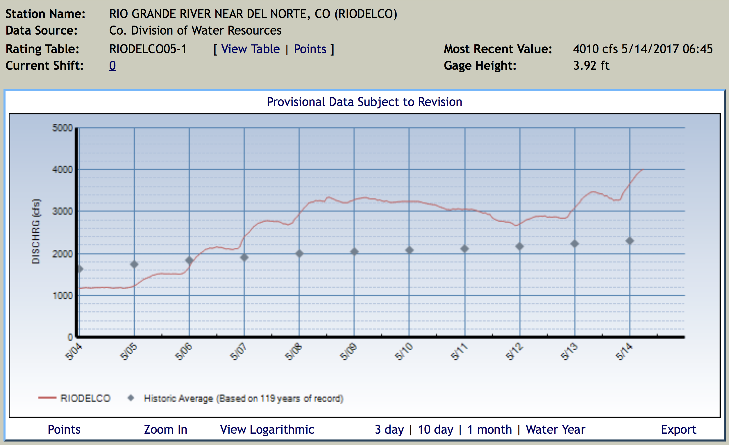
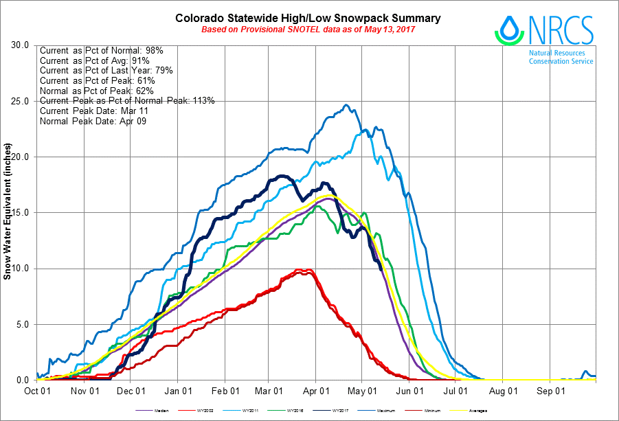

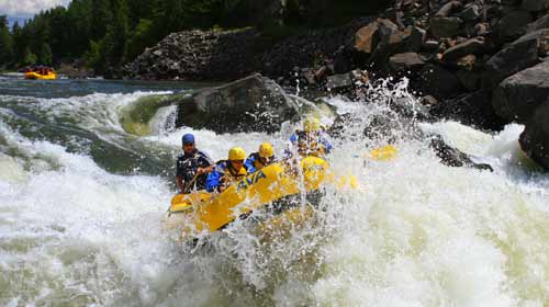


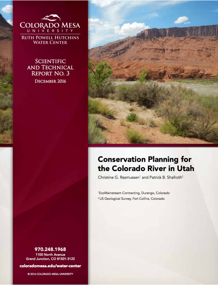
![The U.S. Whitewater Rafting Team trains on its custom-built raft in December on the Colorado River. The team was on pace for a record descent of the 277-mile canyon [January 14-15, 2017] when a wave broke the frame and punctured a tube. Photo Special to The Denver Post by Forest Woodward.](http://www.denverpost.com/wp-content/uploads/2017/01/bzxxgrandcanyon3.jpg?w=525)

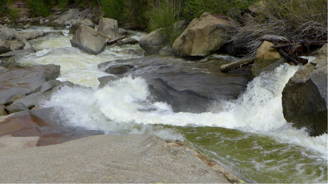

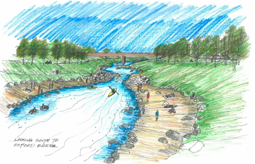
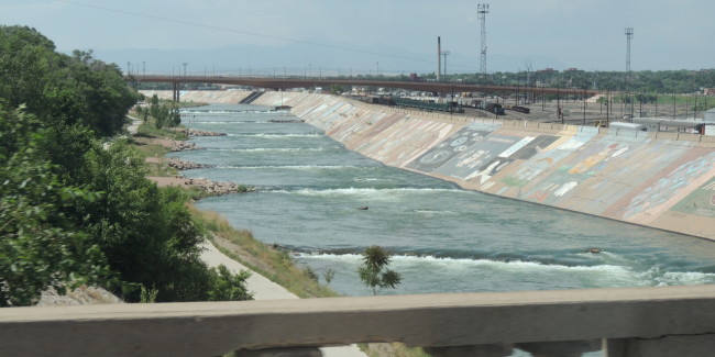


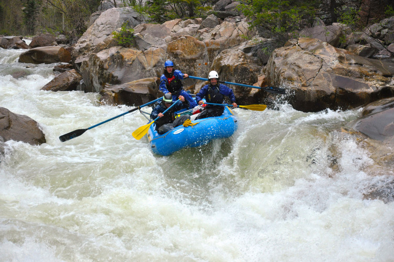
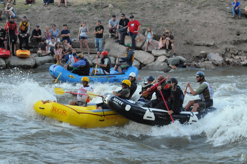
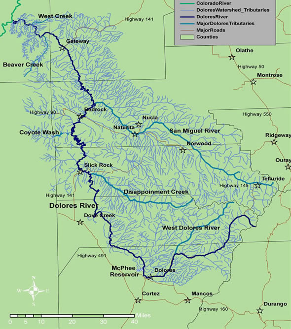


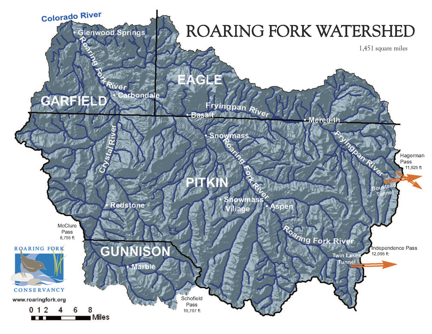
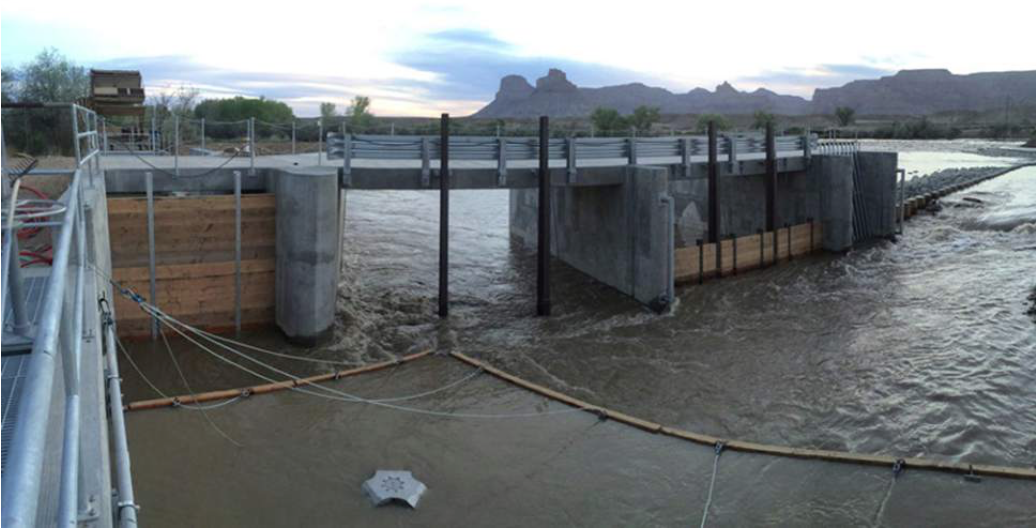

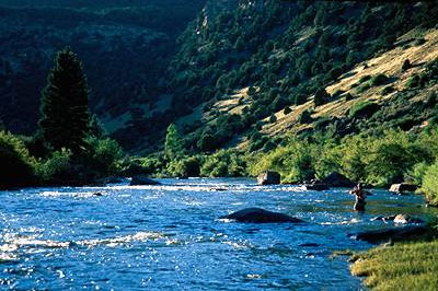


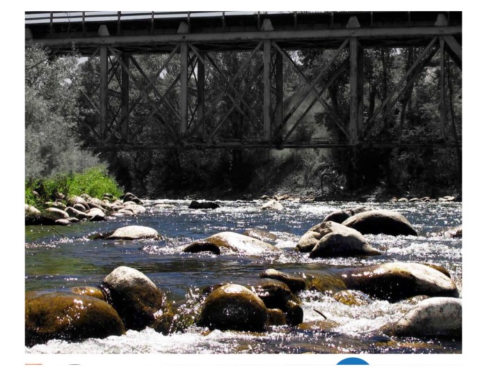