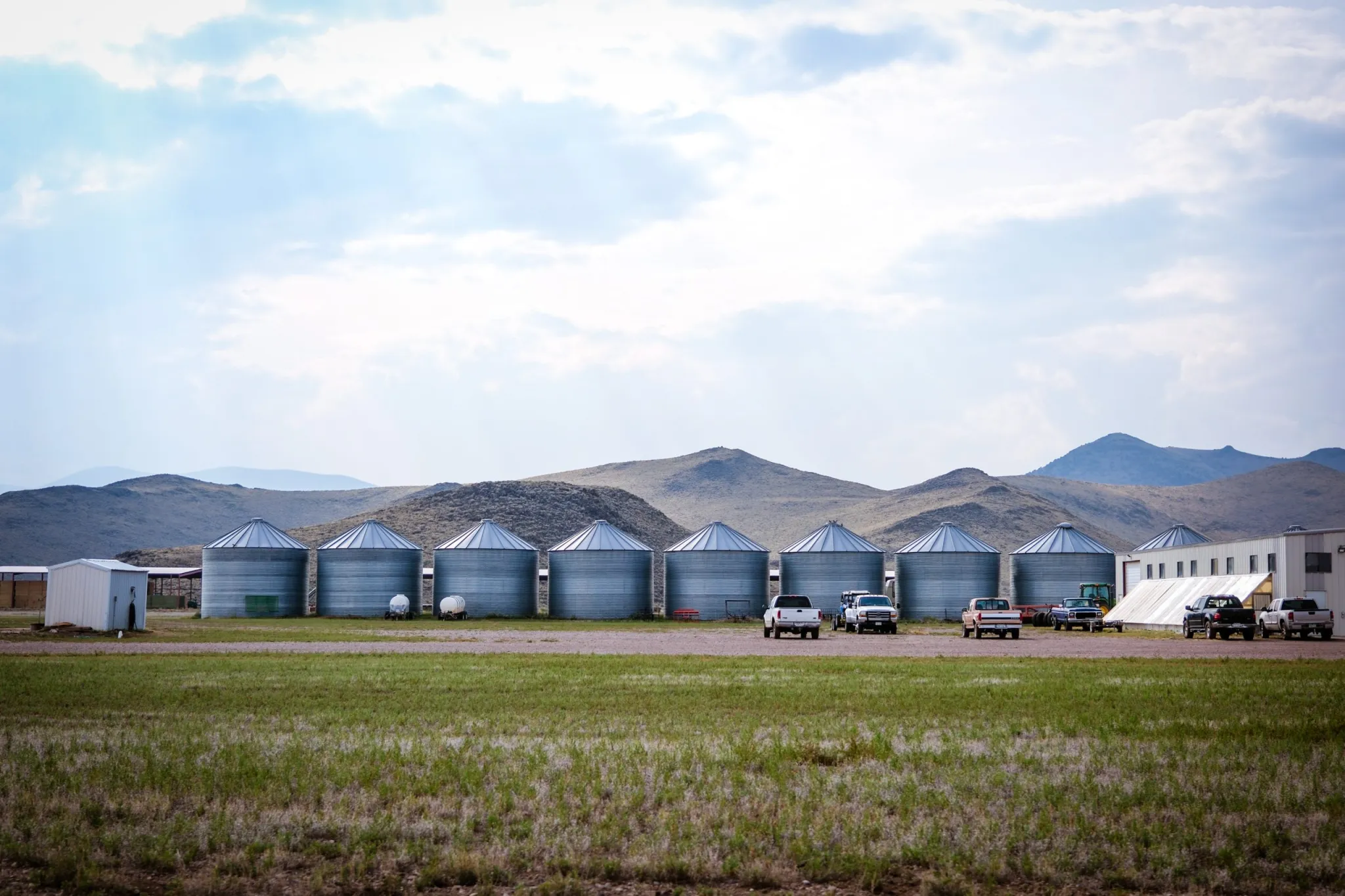
Last week, Jeff Brigger, an executive with NV Energy, Nevada’s largest utility — and a Berkshire Hathaway subsidiary — told a gathering in Las Vegas that tech firms are asking the utility to supply up to 22,000 megawatts of electricity to support planned data centers.
That is an insanely enormous amount of generation capacity. It’s about two-and-a-half times NV Energy’s current peak demand of 9,000 MW, according to a Las Vegas Review-Journal story. It’s enough to power about 11 million homes. And it’s equivalent to the generating capacity of five Palo Verde generating stations, the nation’s largest nuclear power plant.
Brigger noted, correctly, that these are “unprecedented times” before going on to say that the utility is “excited to serve this load.” I bet they are. Not only does it mean selling a hell of a lot more of their product, but it will also require investing in new infrastructure in a massive way, for which they can then recover the costs, with a profit, from all of their ratepayers. Warren Buffet’s about to get even richer — so long as power line-sparked wildfires don’t drain his utilities of all their cash.
To its credit, NV Energy has largely moved away from coal generation, shutting down its heavily polluting Reid Gardner plant near Moapa and replacing it with battery storage and solar. It is in the process of shutting down its North Valmy coal plant, too, but instead of tearing it down, the utility will convert it to run on natural gas, adding to its already substantial fleet of the fossil fuel-burning facilities. It’s likely that a portion of that requested 22,000 MW will come from new methane-fired plants.
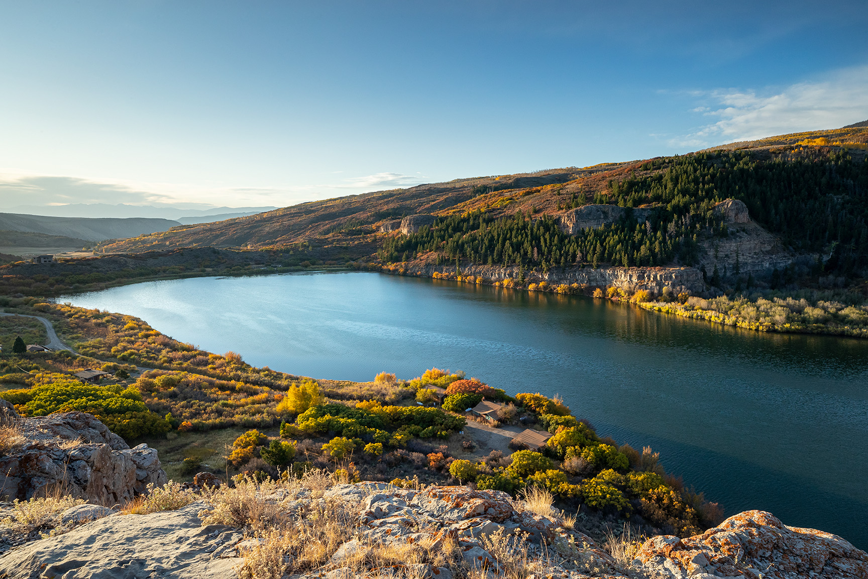
But a great deal of the new capacity will also come from solar power. NV Energy is currently constructing the $4.2-billion Greenlink West transmission line between Las Vegas and Reno. And it is seeking Bureau of Land Management approval for its Greenlink North line that will run along Highway 50, also known as the Loneliest Road in America. These lines will open up hundreds of square miles of public land to utility-scale solar development, with most or all of the power going to data centers in the Reno and Las Vegas areas.
Proposed path of the Greenlink North transmission project. Credit: BLM
Look, I’d much rather see a solar or wind facility than a coal or natural gas plant. No matter how you figure it, the environmental and human health toll from burning fossil fuels is far greater than solar or wind power. A solar plant doesn’t spew sulfur dioxide and mercury and arsenic into the air (and bodies of those nearby); nor will it explode catastrophically, as a natural gas pipeline did this week in southern Wyoming, damaging a freight train and sending up flames visible from Colorado. Coal mining and natural gas extraction often occurs on public lands, damaging the ecosystem, fragmenting wildlife habitat, and polluting the water.
So it’s one thing when a new giant solar installation leads to a fossil fuel generator being retired. Yet the Big Data Center Buildup’s energy needs are so high that utilities end up deferring coal and gas plant retirements, building more gas plants, and carpeting public lands with solar. As the Center for Biological Diversity’s Patrick Donnelly put it in an email: “Turns out the destruction of the desert for renewable energy isn’t about displacing fossil fuels, it’s about feeding the big tech machine.”
Of course, at this point it’s anyone’s guess whether those solar and wind installations are ultimately built. While some are already under development in Nevada along the Greenlink West line, the Greenlink North line has yet to garner BLM approval. And since it is intended to carry primarily solar-generated electrons, it could face added scrutiny from the Trump administration. Meanwhile, Trump’s “Big Beautiful Bill” wiped out federal tax credits for solar and wind, making new developments less feasible.
It’s somewhat surprising that data centers continue to flock to the Las Vegas area given the water constraints. Nevada has butted up against the limits of its 300,000 acre-feet (down to 279,000 under current restrictions) Colorado River allotment for years. That has forced the Southern Nevada Water Authority to crack down on water consumption by banning new lawns, limiting pool sizes, and putting a moratorium on commercial and industrial evaporative cooling systems like those used by many data centers in arid regions.
As long as the moratorium stays in place — a Nevada lawmaker unsuccessfully tried to ban the ban this year — it will force new data centers in the Vegas-area to use less water-intensive, but more energy-intensive, cooling methods1. Still, the Las Vegas data centers that began operating prior to the 2023 ban use a lot of water: more than 716 million gallons, or about 2,200 acre-feet2, in 2024, according to Las Vegas Valley Water data obtained and reported by the Review-Journal.
It’s a bit overwhelming, especially since it all came on so fast. I looked back through the news and noticed that just five years ago talk about data centers’ energy and water use was confined to a few cryptocurrency miners setting up shop in rural Washington to take advantage of cheap hydropower. While the impact was big locally, it wasn’t yet throwing utilities’ long-term plans into disarray. But here we are.
In other data center news, the Doña Ana County commissioners voted 4-1 to approve tax incentives for Project Jupiter, a proposed $165 billion data center campus in Santa Teresa in the southeastern corner of New Mexico. Once again it’s a situation in which the community and region need the economic benefits and diversity the campus offered, but which is also short on water. As such, it sparked both opposition and support.
You may wonder why a place would try to lure, welcome, or even allow data centers into their communities, given their hefty resource consumption.
Sometimes they don’t: Tucson’s city council recently rejected a proposed data center after local residents raised concerns about water and power use and a lack of transparency. (The developers re-upped their proposal for a site outside the city, but opponents aren’t backing down).
The answer, as is often the case, is for the economic shot in the arm they offer. These sprawling facilities each create hundreds of construction jobs, which offer relatively high wages (even if they are short lived). Then they need employees to operate the centers (although not nearly as many). And they pay property taxes.
Right now, Las Vegas and Nevada as a whole seem to need a little help, given that they are one of the nation’s biggest victims of Trumponomics. Visitor volume to Las Vegas was down 11% in June and 12% in July compared to the same months in 2024, with hotel occupancy rates also taking a big hit. The state has lost 600 federal government jobs since Trump took office. And it has shed a whopping 7,300 construction jobs since January. Ouch.
On a similar note, Wyoming’s mining and logging sector shed about 1,000 jobs since January, a 6% drop. That’s surprising, given that this includes coal and uranium miners and oil and gas workers, who are supposed to be the main beneficiaries of Trump’s “energy dominance” agenda. Go figure.
🗺️ Messing with Maps 🧭
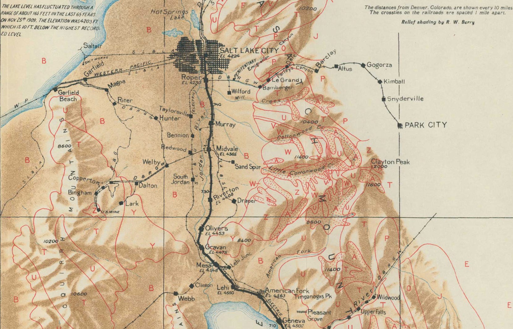
Here’s one more from the USGS’s Guidebook of the western United States: Part E – The Denver & Rio Grande Western route, published in 1922. This map shows a segment of the Wasatch Front in Utah. I’ve also included a Google Earth image of the same area now. It’s remarkable to me because back then Salt Lake City was a small city that stood on its own; now it’s surrounded by a sea of sprawl. Salt Lake was a bit bigger then (or rather, the lake level was higher than it was when the Google Earth image was made; when the map was made in 1909 it was 4,203 feet, now it’s about 13 feet lower). And Bingham Canyon still was a canyon, with little towns in it, rather than the gaping hole known as the Bingham Canyon copper mine.
The Bureau of Land Management is naming winners of the 2025 Rangeland Stewardship and Rangeland Innovations awards, which recognize exemplary management and outstanding accomplishments in restoring and maintaining the health of public rangelands.
The bureau will present the awards on Sept. 17, at a ceremony hosted by the Public Lands Council during its 57th Annual Meeting, held this year in Flagstaff, Ariz., and via Zoom from 12-1:30 p.m. Mountain Standard Time (please join 5-10 minutes early).
The BLM and Public Lands Council continue a 20-year partnership to honor BLM livestock grazing permittees and lessees who demonstrate exceptional management, collaboration, and communication that restores, conserves, or enhances our public lands, and to recognize their accomplishments at a gathering of their peers.
“The BLM partners with 18,000 permittees to manage livestock grazing on about 21,000 allotments covering 155 million acres of public lands; supporting about 36,000 jobs and generating $2.87 billion in annual economic output,” said Acting BLM Director Bill Groffy. “These awardees represent collaborative, locally-led efforts to apply new technologies and grazing practices that will provide more flexibility to producers and improve rangeland health and public lands ecosystems.”
“As federal lands ranchers, we all are partners with BLM in maintaining western landscapes and raising our livestock with the best available methods. Livestock grazing creates robust habitat, prevents catastrophic wildfires, and produces wholesome consumer products, the benefits are numerous, but it takes a tremendous amount of hard work,” said Public Lands Council President and Colorado permittee Tim Canterbury. “This is not an easy job, and it only gets tougher every year – but these award recipients have proven their ranching and conservation prowess beyond any doubt. PLC congratulates these award winners, and I am personally honored to share this profession and our traditions with them.”
The Rangeland Stewardship Awards recognize the demonstrated use of beneficial management practices to restore, protect, or enhance rangeland resources while working with the BLM and other partners.
The 2025 Rangeland Stewardship Award – Permittee Category winner is the Molsbee family of Cottonwood Ranch in Wells, Nev., nominated by the Wells Field Office, BLM Nevada
This sixth-generation beef and horse ranch includes 36,000 acres of federal grazing permits in northeast Nevada. It has been a cornerstone of the local community and economy for over 60 years and is currently home to four generations. Family patriarch Agee Smith has served in local, county, and state conservation district and commission leadership roles since the 1980s. His daughter and son in law, McKenzie and Jason Molsbee, are incorporating new technologies as they raise their sons to apply sustainable ranching operations.
In partnership with the University of Nevada Reno, BLM, and U.S. Fish and Wildlife Service, they have spent five years refining virtual fencing technology and are now using their fifth-generation collar design. The ranch has significantly improved ecosystem health, restored riparian areas, expanded redband trout habitat, and boosted beaver and moose activity while more than doubling cattle stocking rates.
The Rangeland Innovations Awards recognize outstanding examples of demonstrated creativity, willingness to embrace change, and/or a modified perspective or approach to persistent rangeland stewardship challenges in addition to the accomplishments meriting the Rangeland Stewardship Award.
The 2025 Rangeland Innovations Award – Permittee Category winner is the Sanders and Davies families of Roaring Springs Ranch in Frenchglen, Ore., nominated by the Burns and Lakeview district offices, BLM Oregon/Washington.
Roaring Springs Ranch is a beef operation on over a million acres of deeded land and BLM grazing allotments between 4.5-8 thousand feet in elevation of high desert in southeast Oregon. The ranch has participated in the BLM’s outcome-based grazing authorization initiative since 2016. Their approach blends long-standing land stewardship with modern science and technology, improving outcomes for both livestock and natural resources.
The 2025 Rangeland Innovations Award – Collaborative Team Category winner is the Massey Ranch Precision Ranching and Virtual Fencing Project of Animas, N.M., nominated by the Las Cruces District Office, BLM New Mexico.
The project applies emerging technologies to manage grazing while minimizing environmental impact to public lands. Ranchers use virtual fencing to direct livestock movement more effectively and target grazing to promote pasture recovery and enhance native vegetation. The project uses a custom real-time overview dashboard with remote and local sensor systems to monitor livestock, water, and weather across 30,000 acres of arid rangeland in southwest New Mexico.
The Public Lands Council represents the cattle and sheep producers who hold approximately 22,000 public lands grazing permits. Federal grazing permit holders provide essential food and fiber resources to the nation, as well as important land management services like the eradication of invasive species, mitigation of wildfire risk, and conservation of vital wildlife habitat. The Public Lands Council works in active partnership with the BLM, the U.S. Forest Service, the National Park Service, the U.S. Fish and Wildlife Service, and local land management offices to make landscapes more resilient across the West.
Schematic on how virtual fencing works (collars, base station, grazing areas). Graphic credit: Colorado State University AgNext
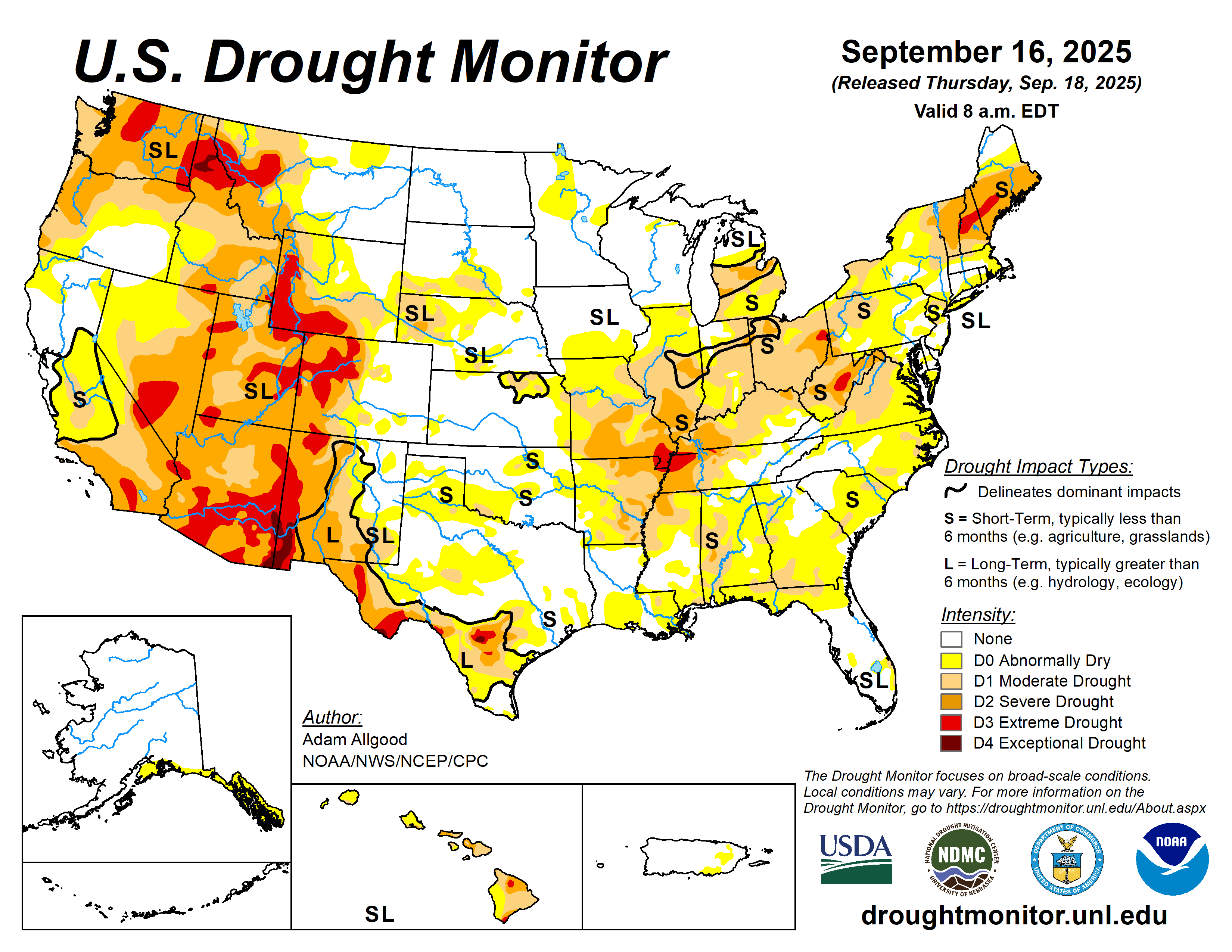
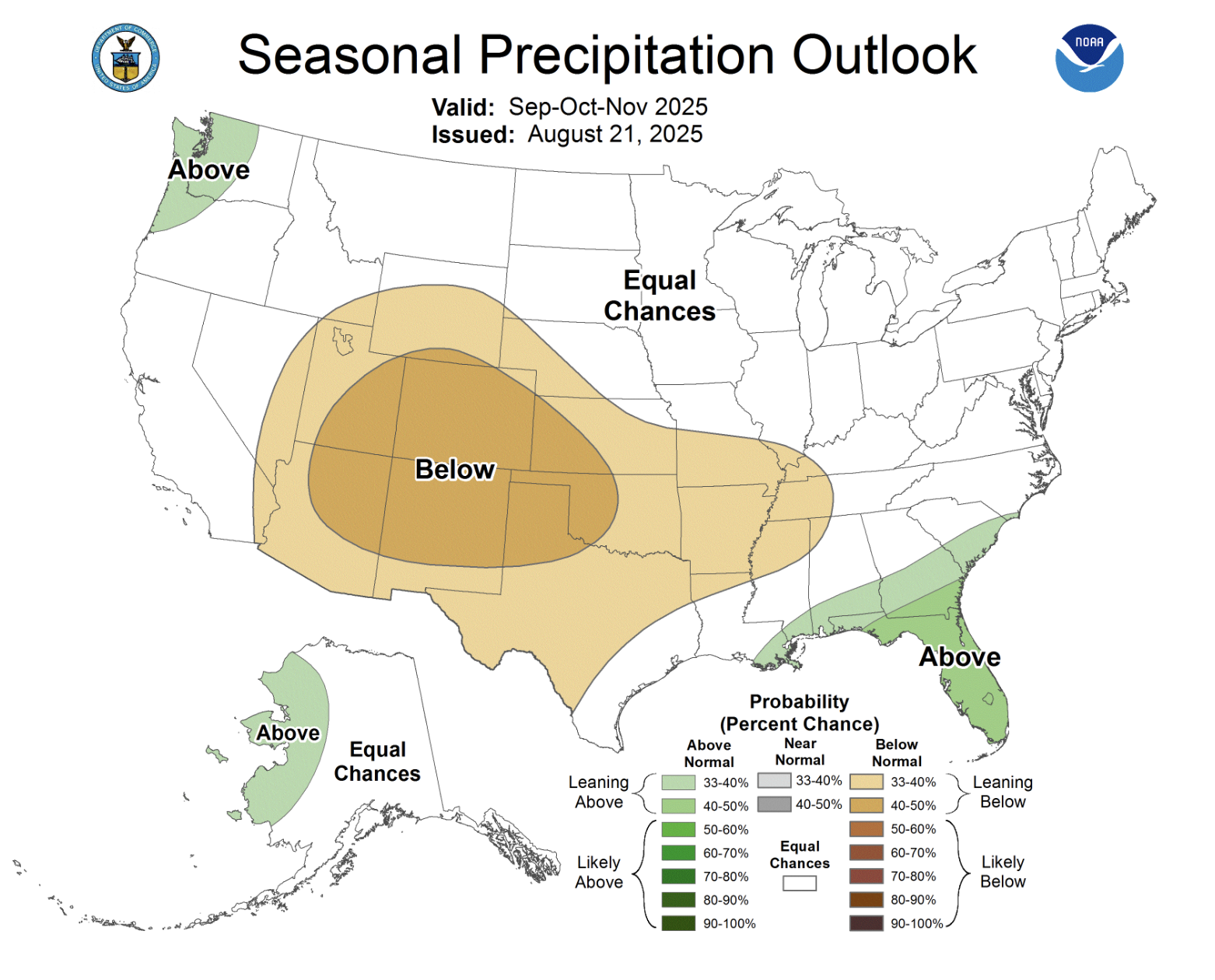
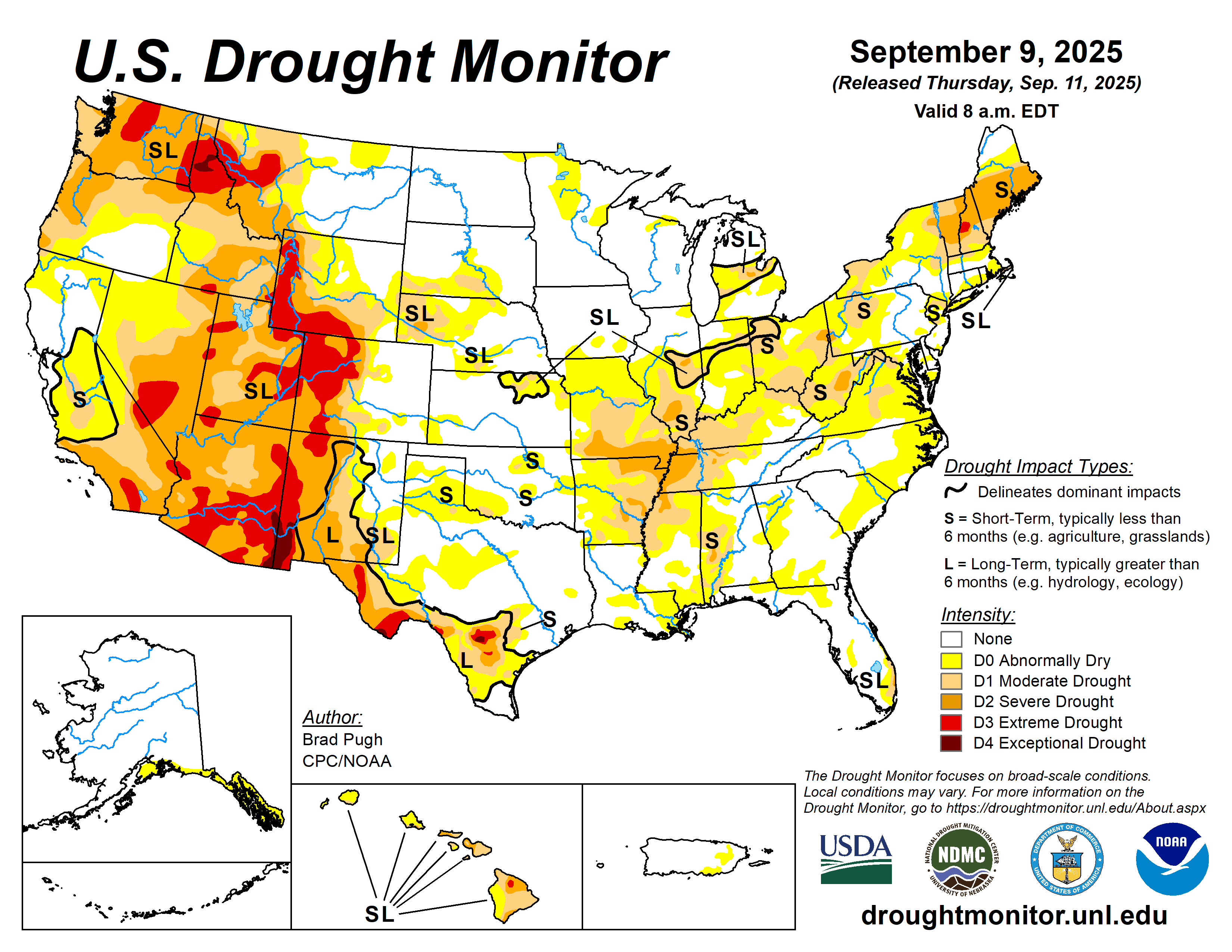
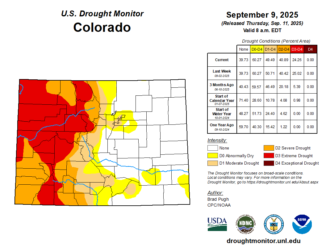
: It was a challenging period for drought monitoring, with a broad mix of improvement and deterioration. Additionally, a significant rainfall event was underway in parts of the central, eastern, and southern U.S. when the drought-monitoring period ended early Tuesday. Any precipitation that fell after the Tuesday cutoff will be considered for next week’s map. Broadly, precipitation fell across the Plains, Midwest, and mid-South, mostly from the central Rockies to the western slopes of the Appalachians. Locally significant showers also dotted the Southwest, providing limited drought relief but triggering flash flooding. In contrast, mostly dry weather prevailed in the Northwest, Intermountain West, Deep South, and along much of the Atlantic Coast…
Most of the region is free of drought or received drought-easing precipitation, including some high-elevation snow in the central Rockies. Although rain slowed fieldwork, including summer crop harvesting and winter wheat planting, moisture should benefit rangeland, pastures, and fall-sown crops…
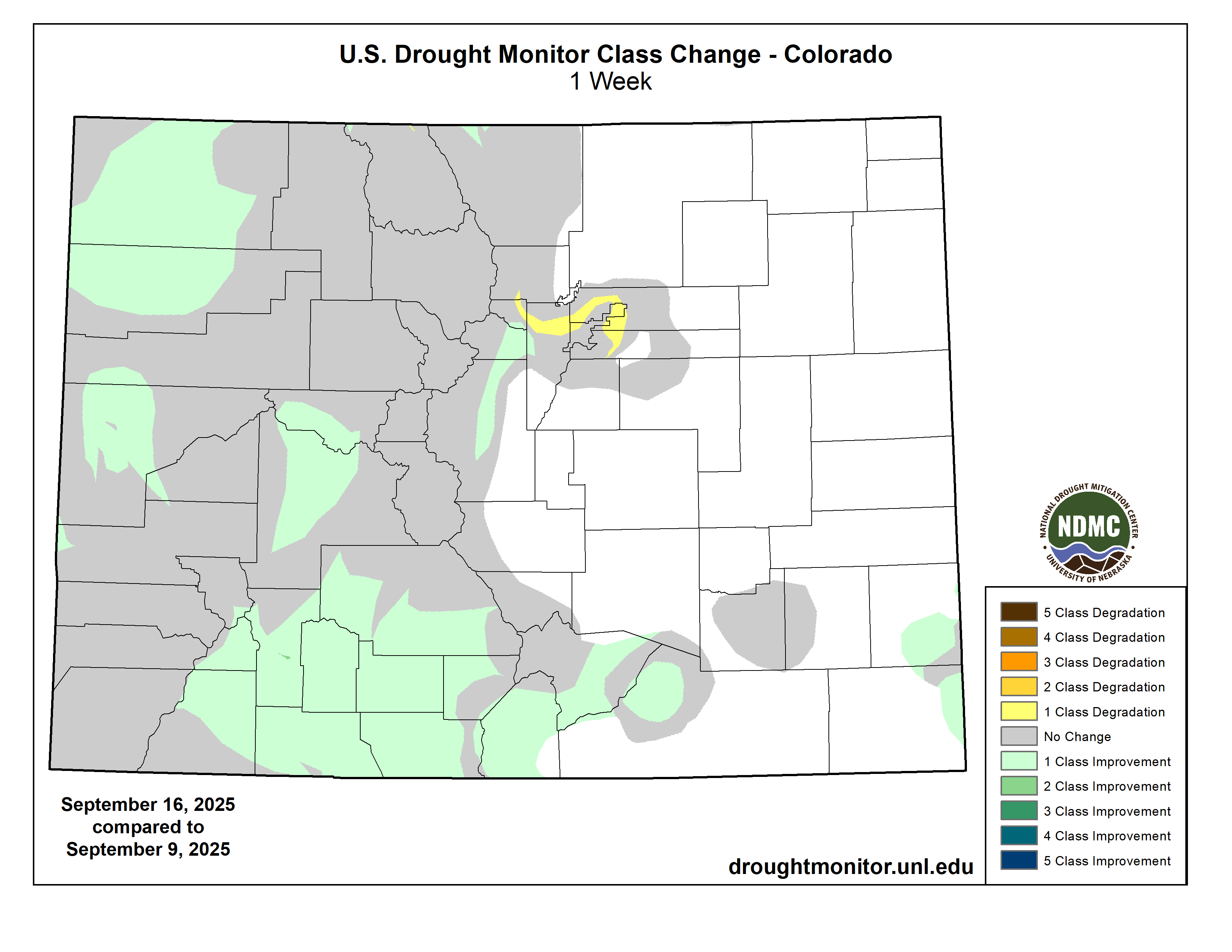
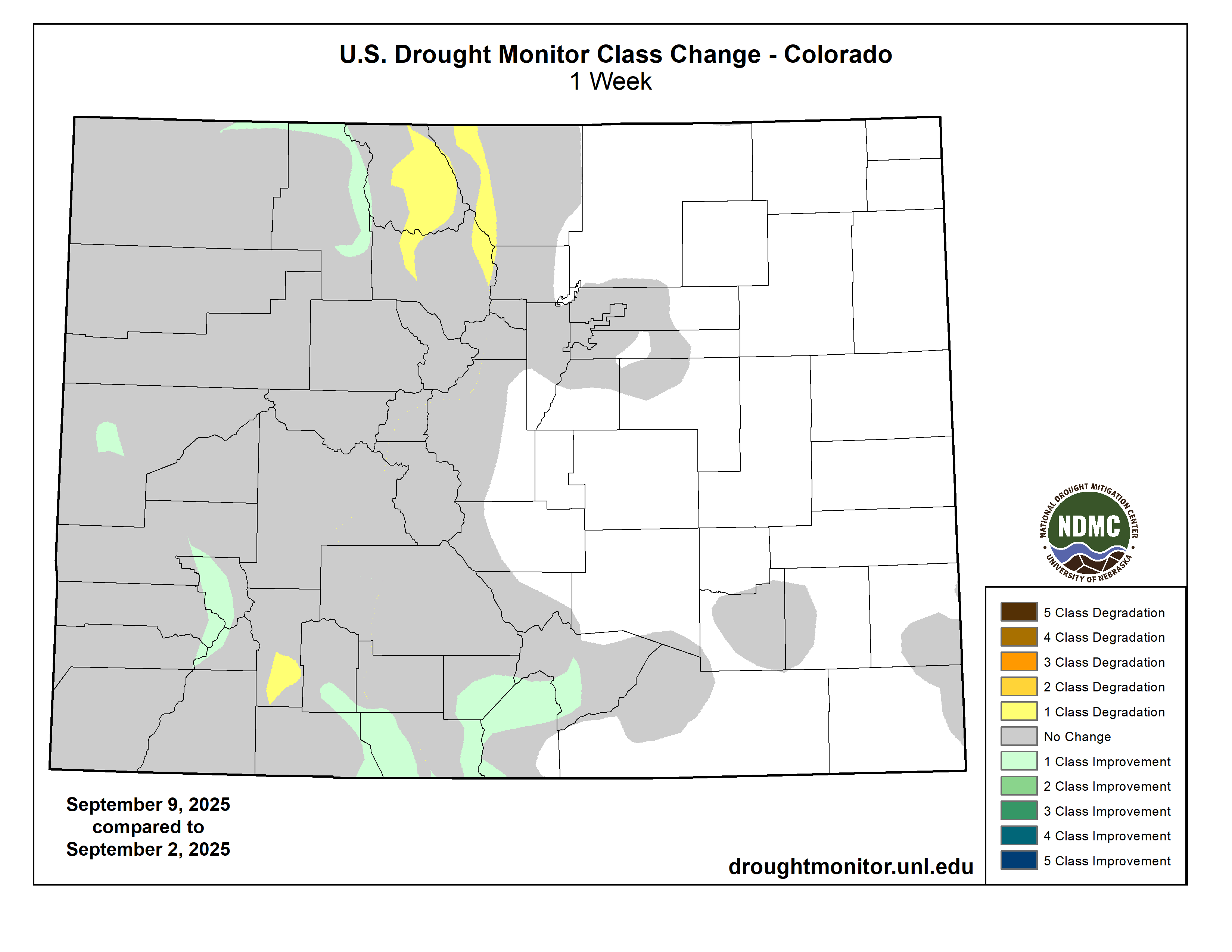
Colorado Drought Monitor one week change map ending September 23, 2025.
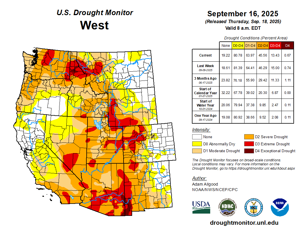
Worsening drought in parts of the Northwest contrasted with locally heavy showers farther south. In the Southwest, those showers led to targeted drought improvement, but also resulted in spotty flash flooding in some of the nation’s driest locations, including Death Valley, California. Farther north, the U.S. Department of Agriculture reported that statewide topsoil moisture (on September 21) was rated 92% very short to short in Washington, along with 80% in Oregon. Winter wheat planting has been advancing quickly in Washington and was 58% complete by September 21. Any fall-sown Northwestern crops will soon need moisture for proper autumn establishment. Currently, at least 45% of the rangeland and pastures in all Northwestern States were rated very poor to poor, led by Montana (61%)…
Looking Ahead
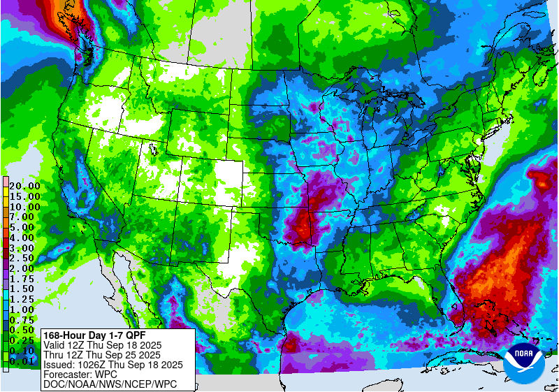
Rainfall will continue to shift southward and eastward, resulting in a boost in soil moisture in many areas experiencing short-term drought. Five-day rainfall should reach 1 to 3 inches or more across much of the eastern U.S., as well as portions of the Gulf Coast States. Once rain ends across the Plains and Midwest, dry weather will prevail for the next several days. Dry weather should extend into the Northwest until late in the weekend, when showers will arrive along the northern Pacific Coast. Elsewhere, a late-season monsoon surge will result in unusually heavy showers for this time of year in parts of the Southwest, leading to another round of possible flash flooding.
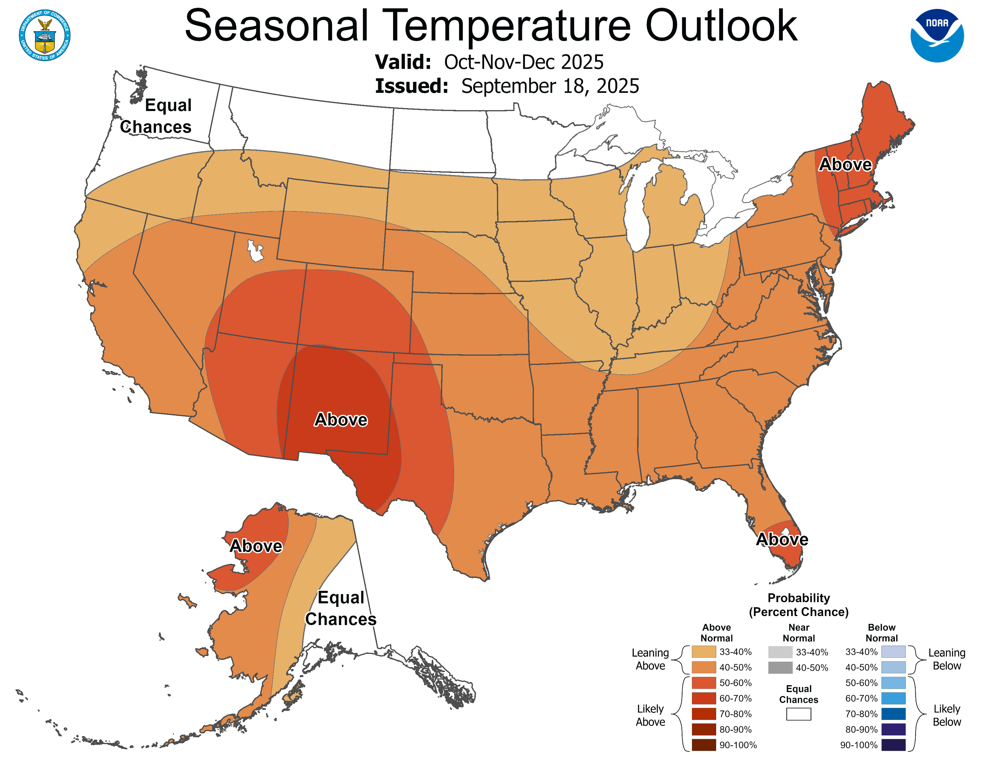
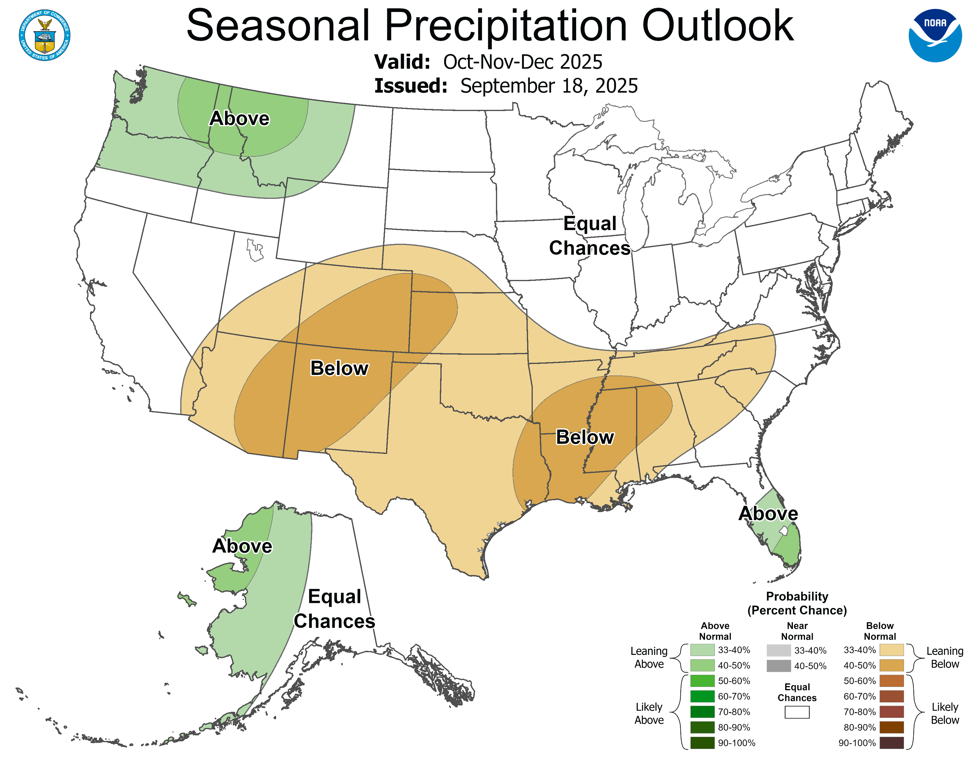
The NWS 6- to 10-day outlook for September 30 – October 4 calls for near- or above-normal temperatures nationwide, with the north-central U.S. having the greatest likelihood of experiencing warmer-than-normal weather. Meanwhile, near- or above-normal precipitation across most of the country should contrast with drier-than-normal weather in a band stretching from the southern Plains into the Great Lakes region and the Northeast.
US Drought Monitor one week change map ending September 23, 2025.
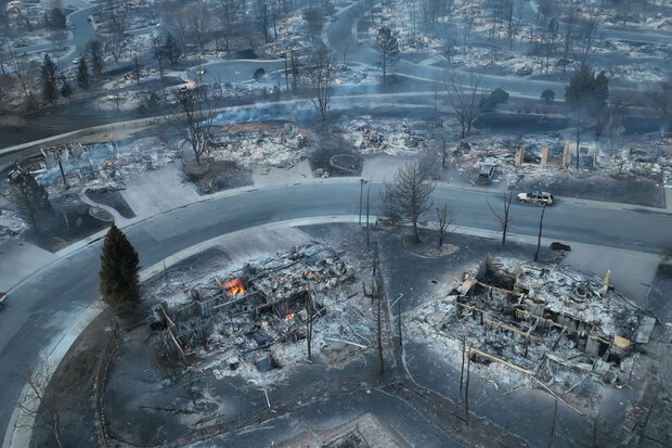
Marshall Fire December 30, 2021. Photo credit: Boulder County
Click the link to read the article on the Big Pivots website (Allen Best):
September 24, 2025
Xcel Energy, Qwest Corporation, and Teleport Communications America have reached agreements in principle to settle all claims asserted by subrogation insurers, the public entity plaintiffs, and individual plaintiffs.
Xcel Energy, through its subsidiary, Public Service Company of Colorado, expects to pay $640 million related to these settlements. Of that, $350 million is to come from insurance coverage and none from its customers.
The agreements in principle remain subject to final documentation and individual plaintiffs opting in to the agreement negotiated and recommended by their counsel.
Xcel Energy does not admit any fault, wrongdoing, or negligence in connection with this resolution.
“Despite our conviction that PSCo equipment did not cause the Marshall Fire or plaintiffs’ damages, we have always been open to a resolution that properly accounts for the strong defenses we have to these claims. In resolving all liability from the claims, this settlement reinforces our longstanding commitment to supporting the communities we serve,” said Bob Frenzel, chairman, president and CEO of Xcel Energy, in a statement released by Xcel.
“We recognize that the fire and its aftermath have been difficult and painful for many, and we hope that our and the telecom defendants’ contributions in today’s settlement can bring some closure for the community.”
The Marshall Fire left smoldering ruins in a Louisville, Colorado, neighborhood, at the end of December 2021. Photo courtesy WXChasing. Used with permission.
Xcel has developed a comprehensive strategy to reduce wildfire risk and improve grid resilience. See more about that plan here. The 2025-27 Wildfire Mitigation Plan includes investments in system resilience, improved situational awareness of high-risk fire scenarios, enhanced operations and maintenance practices to mitigate fire risk and increased engagement with state and local agencies.
This plan, which is informed by inputs from local communities and governments, includes specific improvements for Boulder County, including undergrounding certain power lines and modernizing energy delivery infrastructure.
The Marshall Fire started December 30, 2021, from an ignition on the Twelve Tribes property in Boulder County, when embers from an earlier debris burn reignited. The fire, fueled by high winds, spread quickly to the towns of Louisville and Superior. A second ignition occurred nearby approximately 80 minutes later.
The plaintiffs filed lawsuits seeking billions of dollars in damages against Xcel Energy and the telecom defendants in connection with the second ignition. Xcel Energy disputes that its equipment was involved in the second ignition.
For the most part, President Donald Trump has done everything we feared the candidate would do and then some: following Project 2025 to a T, gutting environmental and public health protections, shredding the First Amendment (to the point of even losing Tucker Carlson), threatening political opponents, and generally embracing authoritarianism.
But when it comes to public lands, there is actually one act we expected the administration to do shortly after the inauguration, but that it hasn’t yet attempted: Shrinking or eliminating national monuments, especially those designated during the Clinton, Obama, and Biden administrations. Even after Trump’s Justice Department opined (wrongly, I’d say) that the Antiquities Act authorizes a president to shrink or revoke national monuments, the administration didn’t actually do it.
I suspect this is because they realize how deeply unpopular that would be. Sure, Trump’s first-term shrinkage of Grand Staircase-Escalante and Bears Ears national monuments may have garnered some support from a handful of Utah right-wingers, but they’d be behind him regardless. Meanwhile, it pissed off a lot of Americans who value public lands but might otherwise support Trump’s policies.
That’s not to say the national monuments are safe. It’s just that the administration seems to be intent, for now, to outsource their destruction to their friends in Congress. The House Republicans’ proposed budget, for example, would zero out funding for GSENM’s new management plan — a de facto shrinkage.
And now, Rep. Paul Gosar, a MAGA Republican from Arizona, has introduced bills that would nullify Baaj Nwaavjo I’tah Kukveni – Ancestral Footprints of the Grand Canyon National Monument and the Ironwood Forest National Monument northwest of Tucson. The former blocks new mining claims in an area that has been targeted for uranium extraction. And the latter, established by Bill Clinton in 2000, covers a 189,713-acre swath of ecologically rich Sonoran Desert near the gaping wound known as the Asarco Silver Bell copper mine. The national monument designation blocked new mining claims.
Interestingly enough, neither of the national monuments are in Gosar’s district, which covers the heavily Republican western edge of the state, so he won’t suffer from voter blowback if the legislation succeeds.
⛏️ Mining Monitor ⛏️
Congressional Republicans, with some Democratic support, are again trying to pass legislation that would allow mining companies to dump their waste on public lands.
The Mining Regulatory Clarity Act of 2025, introduced by Rep. Mark Amodei, R-Nevada, made it through the House Natural Resources Committee this week on a 25-17 vote. It would tweak the 1872 Mining Law to ensure that mining companies can store tailings and other mining-related waste on public land mining claims that aren’t valid, meaning the claimant has not proven that the parcels contain valuable minerals. This was actually the norm for decades until 2022, when a federal judge ruled that the proposed Rosemont copper mine in Arizona could not store its tailings and waste rock on public land. That ruling was followed by a similar one in 2023, leading mining state politicians from both parties to try to restore the pre-Rosemont Decision rules.
The bill would supplement Trump’s executive order from March invoking the Defense Production Act to expedite mining on public lands, and his “emergency” order that fast-tracks mining and energy permitting on public lands.
***
Photo credit: Jonathan P. Thompson/The Land Desk
IsoEnergy, the company that owns the controversial Daneros Mine just outside Bears Ears National Monument and the Tony M Mine,plans to begin exploratory drilling at its Flatiron claims in Utah’s Henry Mountain uranium district. Last year, the Canada-based company staked a whopping 370 lode claims on federal land. Along with two Utah state leases, this adds up to about 8,800 acres south-southwest of Mt. Hillers.
🛢️ Hydrocarbon Hoedown
A peer-reviewed study out of UCLA recently found that pregnant women living near the Aliso Canyon natural gas storage facility in Los Angeles during the sustained blowout of 2015 experienced more adverse birth outcomes than expected. Specifically, the prevalence of low birthweight was 45% to 100% higher than those living outside the affected area. This should concern not only folks living near Aliso Canyon (which is still operational), but also anyone who lives near an oil and gas well or other facility.
Aliso Canyon is a depleted oil field in the hills of the Santa Susana Mountains in northern LA. Southern California Gas pipes in natural gas, pumps it into the oil field, and stores up to 84 billion cubic feet of the fuel there. In October 2015, one of the wells blew out and for the next 112 days spewed a total of about 109,000 metric tons of methane, a potent greenhouse gas and the main ingredient of natural gas.
That’s bad. But also mixed into the toxic soup that erupted from the field were other compounds such as mercaptans including tetrahydrothiophene and t-butyl mercaptan, sulfides, n-hexane, styrene, toluene, and benzene. All really nasty stuff that you don’t want in your air, and that is often emitted by oil and gas wells. The authors write:
“The emissions of BTEX and other HAP compounds are of particular concern as even at levels below health benchmarks they have been linked to health effects, including neurological, respiratory, and developmental effects.”
That appears to have been the case with the Aliso Canyon blowout, where “low birth weight and term low birth weight was higher than expected among women living in the affected area whose late pregnancy overlapped with the disaster.”
It’s simply more confirmation that fossil fuel development and consumption can take a big toll on the environment, the climate, and the people who live in or near the oil and gas patch or associated infrastructure. And that limits on methane emissions are important, even if you don’t care about climate change.
***
Long-time Land Desk readers might remember my story about the Horseshoe Gallup oil and gas field and sacrifice zone in northwestern New Mexico. I wrote about how the area had been ravaged by years of drilling and largely unfettered development, how the wells had been sold or handed off to increasingly irresponsible and slipshod companies as they were depleted, and how that had left dozens of abandoned facilities, oozing and seeping nasty stuff, but were not cleaned up because state and federal regulators still considered them to be “active.”
The field is still there, along with most of the abandoned wells. But Capital & Main’s Jerry Redfern reports that some of the worst sites, including the NE Hogback 53, are being cleaned up. Well, sort of. The extensive reclamation of the well and the tank battery was started, only to be halted in May at the end of the state’s fiscal year. It resumed in July, and is expected to cost about $650,000.
This highlights the need for stronger enforcement and, most importantly, adequate reclamation bond requirements. At prices like that, cleaning up just the Horseshoe Gallup could cost tens of millions of dollars, and the taxpayer will be left to shoulder most of the bill.
🥵 Aridification Watch 🐫
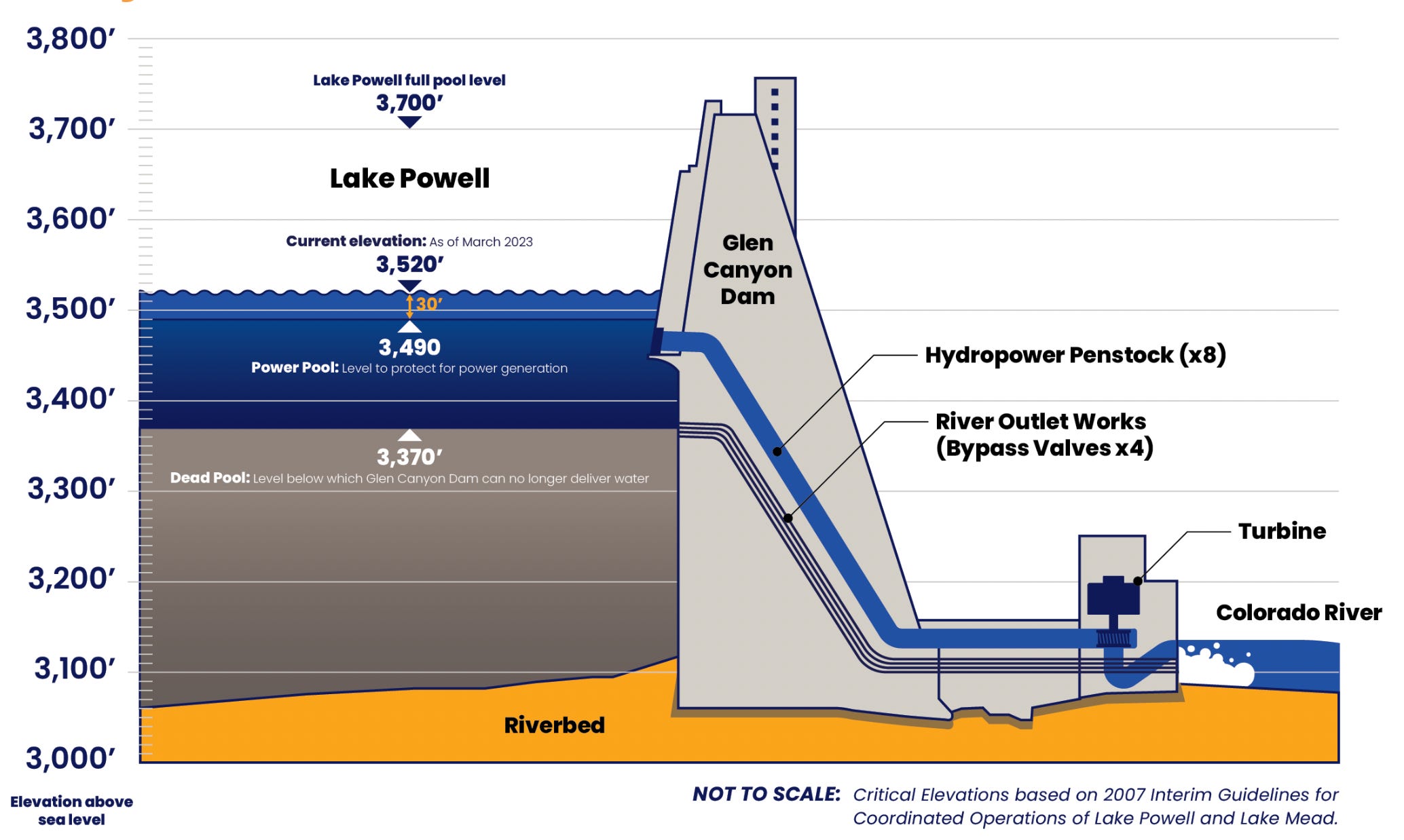
Clarification: In Tuesday’s dispatch on the Colorado River and Lake Powell, I wrote that another dry winter would put “… the elevation of Lake Powell at 3,500 feet by this time next year. And, due to the infrastructure’s limitations, Glen Canyon Dam would have to be operated as a ‘run of the river’ facility.” That probably needs a bit more explanation.
One smart reader pointed out that even after the surface level of Lake Powell drops below minimum power pool, or 3,490 feet in elevation, the dam can still release up to 15,000 cfs from its river outlets. Technically, managers would not be forced to go to run of the river until the surface level dropped below 3,370 feet, which is known as “dead pool.”
However, the Bureau of Reclamation is very wary of relying on the river outlets, because they weren’t designed for long-term use and could fail under those circumstances. So, BoR is intent on keeping the water levels above minimum power pool so that all releases can go through the penstocks and the hydroelectric turbines. “In effect,” the authors of the paper wrote, “at least for the short term, the engineering and safety issues associated with the ability to release water through Glen Canyon Dam mean that the amount of water actually available for release from Lake Powell is only that which exists above elevation 3500 feet.”
So, as long as this is the case, the BoR will need to go to run of the river as soon as the elevation drops to 3,500 feet. I hope that helps clear things up!
🗺️ Messing with Maps 🧭
Today’s map is less about the map than it is about the publication it comes from, the USGS’s Guidebook of the Western United States Part E. the Denver & Rio Grande Western Route, published in 1922. This thing is super cool, and super detailed (it’s 384 pages long). It’s got some great photos and maps, like this one (click on the image to see it in larger size on the website).
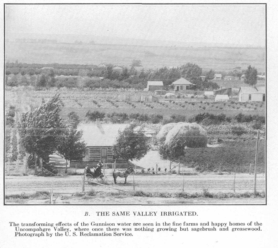
Besides having a cool, hand drawn style, this map struck me because it was made prior to the reservoirs on the Gunnison River. And it shows how the railroad tracks used to go into the Black Canyon at Cimarron and continue along the river all the way to Gunnison (most of that section is now under water). I suppose I should have known that was where the tracks went, but it never really occurred to me before. Credit: USGS
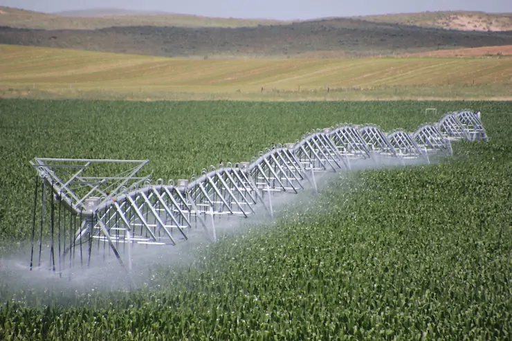
Related to that map were these two photos illustrating the miracle of irrigation.
Click the link to read the article on the Aspen Times website (Ali Longwell). Here’s an excerpt:
September 23, 2025
La Nina prepares to make a brief appearance in Colorado this fall before winter forecasts turn even more unpredictable than usual
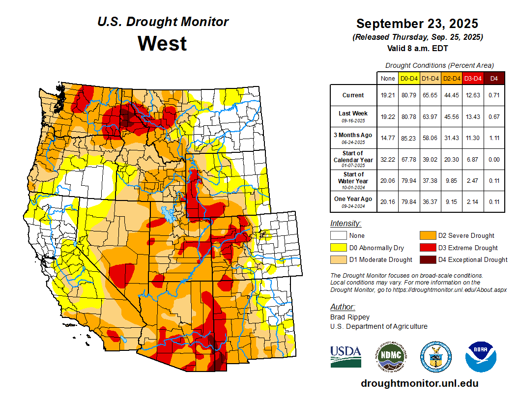
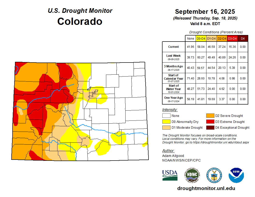
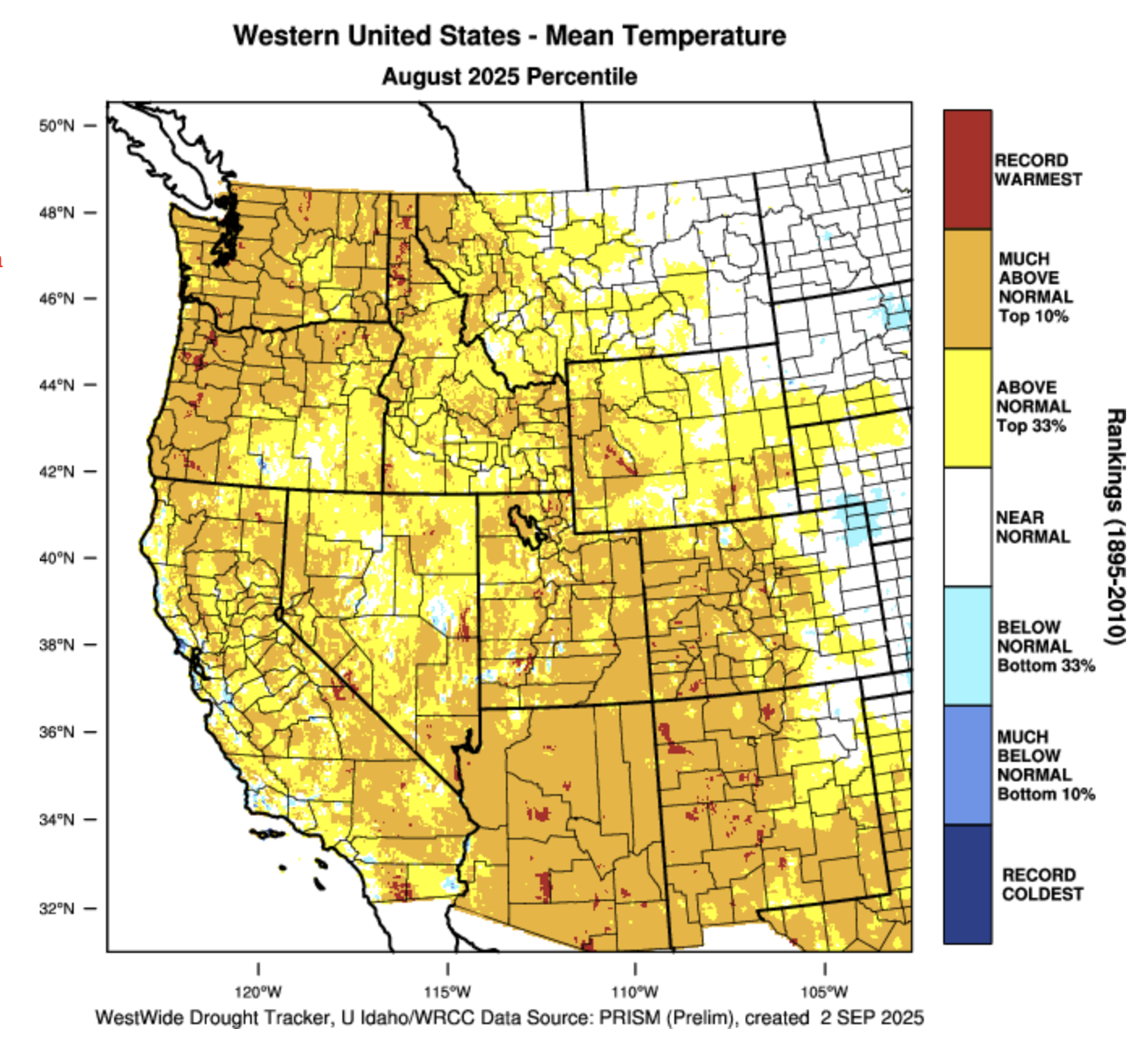
Following an extremely warm, dry summer on the Western Slope, recent rainfall is beginning to chip away at the worst of Colorado’s drought conditions. In mid-August, “exceptional” drought conditions — the most severe among the national drought monitor rankings — developed across nearly 7% of the state in northwest Colorado for the first time since May 2023. The exceptional rating hit portions of Moffat, Routt, Rio Blanco, Garfield, Eagle, Pitkin, Gunnison, Delta, and Mesa counties following one of the hottest, driest summers on record for the region.
“Fortunately, the exceptional drought that we had in early to mid-August is over in western Colorado with the persistent rains of the last few weeks,” said Russ Schumacher, Colorado’s state climatologist, at September’s Colorado Water Conditions Monitoring Committee meeting on Tuesday.
Comparing the Aug. 20 Colorado Drought Monitor to the most recent Sept. 16 map, Schumacher said, “you can see big improvements in a lot of places, but still long-term drought — severe to extreme drought — across much of western Colorado.” During the last month, only portions of North Park, Grand County and the Denver metro area saw worsening drought conditions as they missed out on recent storms, Schumacher noted…“It’s not that all the drought concerns are over in that part of the state, but it’s not these extreme conditions that we had a month ago, where wildfires were starting and growing every day and things like that,” Schumacher said. “Fortunately, that period is over for now. But then the flip side of that, we’ve seen flash flooding and debris flows, especially on the burn scars.”
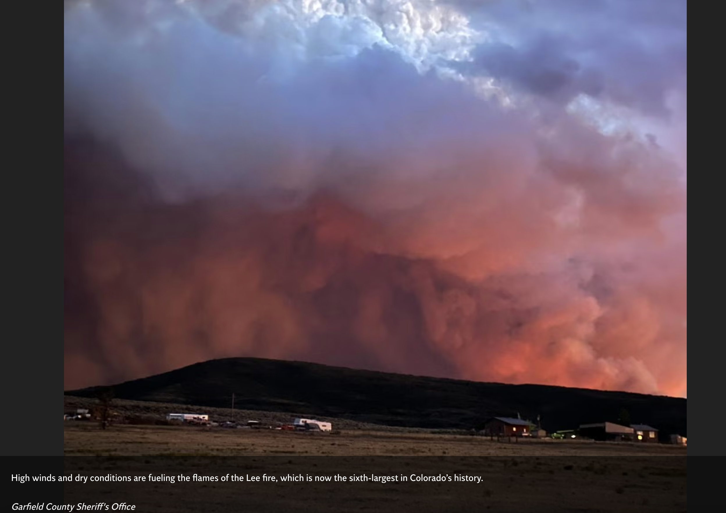
A flume and ditch is covered with silt, mud, rocks and debris along the White River following run-off damage from rains after the Lee Fire in Rio Blanco County.
Colorado Division of Water Resources/Courtesy photo
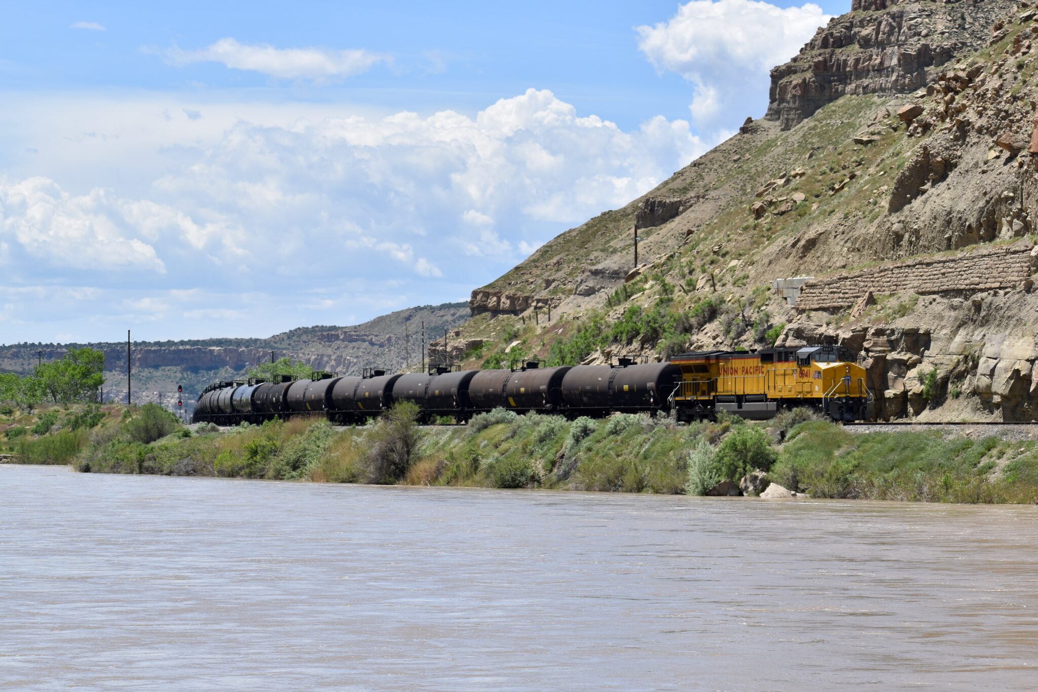
Projects in Utah’s Uinta Basin could significantly increase hazardous oil shipments through Colorado
Colorado, along with 15 other states, is poised to sue the federal government for ignoring endangered species regulations in a wide range of infrastructure projects on public lands. One of those projects, a controversial proposal to expand an oil shipping facility in Utah, would significantly increase hazardous rail shipments through Colorado.
Phil Weiser, Colorado’s attorney general, and the attorneys general of the other states provided in a July 18 letter to Trump administration officials a 60-day notice of their intent to sue. The notice expired last week.
The letter cites violations of the Endangered Species Act it says have occurred in pursuit of an executive order, called “Declaring a National Energy Emergency,” which President Donald Trump signed on his first day in office in January.
“The ESA and implementing regulations do not allow agencies to routinely avoid and delay implementation of the ESA’s protections of endangered species and their critical habitats in the manner you have directed and which your agencies are carrying out,” the letter says.
The letter was addressed to Trump, Secretary of the Interior Doug Burgum, Commerce Secretary Howard Lutnick and the directors of the U.S. Fish and Wildlife Service, U.S. Army Corps of Engineers and the National Marine Fisheries Service.
The letter lists pipeline, cable and mining projects in states from Washington to Illinois — including the Wildcat Loadout Facility Right-of-Way Amendment on U.S. Bureau of Land Management land near Price, Utah — that it says pose risks to listed endangered species or critical habitat for fish and aquatic mammals from rainbow trout to salmon to sturgeon to whales.
“The notice of intent to sue to enforce the ESA could be a basis for joining the lawsuit challenging the White House energy emergency executive order,” Weiser spokesman Lawrence Pacheco wrote in an email this month. “The attorney general, however, has not made a decision on joining the EO lawsuit.”
Pacheco did not provide additional information on when the endangered species litigation will be filed or how it will be announced.
“We announce all lawsuits that we join or file ourselves,” Pacheco said. “I don’t have any idea on timing.”
Sued by environmental groups
The Wildcat Loadout expansion, as first reported by Newsline in 2023, has been plagued by air quality violations and other matters related to Native American antiquities. It would allow crude oil producers in the Uinta Basin to vastly expand drilling and transportation, including by rail through Colorado. Another proposed project in the basin, the bitterly opposed Uinta Basin Railway, would allow for even greater oil shipments. When the U.S. Supreme Court in late May cleared the way for the 88-mile rail link project, proponents said their next step was “completion of the Endangered Species Act (ESA) process.“
The BLM in early July invoked Trump’s emergency declaration to complete an accelerated environmental review of the permit for the Wildcat facility, which could increase oil capacity on the main rail line through Colorado by up to 80,000 barrels a day. Combined with the expansion of other nearby facilities, it will allow for the trucking and transfer to rail of up to 75% of the oil proposed for the Uinta Basin Railway project.
The railway project, estimated to cost at least $2.4 billion to build, would allow for up to 350,000 barrels of oil per day — more than doubling U.S. oil-by-rail transport — to move in heated oil tankers for 100 miles along the headwaters of the Colorado River, under the Continental Divide at Winter Park and through Denver on their way to refineries along the Gulf Coast. Backers of the project are seeking low-interest U.S. Department of Transportation private activity bonds.
Eagle County and five environmental groups sued to overturn U.S. Surface Transportation Board approval of the railway in 2022. They were initially successfully, but the U.S. Supreme Court overturned a favorable 2023 federal appellate court decision. Eagle County has long sought more direct state involvement in litigation opposing the project.
In a press release following the Supreme Court ruling, Keith Heaton, director of Utah’s Seven County Infrastructure Coalition, which has been using taxpayer dollars to pursue the railway project, said, “It represents a turning point for rural Utah — bringing safer, sustainable, more efficient transportation options, and opening new doors for investment and economic stability. We look forward to continuing our work with all stakeholders to deliver this transformative project.”
The coalition is not a sponsor of the Wildcat Loadout project.
Asked for project updates and comment on the pending endangered species litigation, Melissa Cano, director of communications for the Uinta Basin Railway and the Seven County Infrastructure Coalition, replied in an email: “At this time, the coalition does not have additional information or updates to provide beyond what has already been made publicly available. What I do wish to stress is that the Uinta Basin Railway Project is moving forward.”
View of Shoshone Hydroelectric Plant construction in Glenwood Canyon (Garfield County) Colorado; shows the Colorado River, the dam, sheds, a footbridge, and the workmen’s camp. Creator: McClure, Louis Charles, 1867-1957. Credit: Denver Public Library Digital Collections
Click the link to read the article on the Aspen Times website (Ali Longwell). Here’s an excerpt:
September 20, 2025
The battle over one of the Colorado River’s oldest, non-consumptive water rights continued this week during a 14-hour Colorado Water Conservation Board hearing over whether the rights could be used for the environment. The Colorado River District is seeking to acquire the Shoshone water rights — tied to a hydropower plant on the Colorado River in Glenwood Canyon — from Xcel Energy for $99 million. The River District, a governmental entity representing 15 Western Slope counties, is proposing to add an instream flow agreement to the acquisition, which would allow a certain amount of water to remain in the river for environmental benefits. While the state’s water board — the only entity that can hold an instream flow water right in Colorado — was set to decide on the proposal this week, this was pushed to November after the parties agreed to take more time to reach a consensus on the proposal.
“The exercise of the Shoshone water rights impacts almost every Coloradan,”said Davis Wert, an attorney speaking on behalf of Northern Water.
Northern Water is contesting the instream flow agreement alongside Denver Water, Aurora Water, and Colorado SpringsUtilities. These providers rely on transmountain diversions from the Colorado River basin to supply water to their customers…While the hearing did include some back and forth, the entities west and east of the Continental Divide agreed on a few things during the hearing. First, adding an instream flow agreement to the Shoshone right will preserve and improve the natural environment. Second, they want to maintain the status quo on the Colorado River…Michael Gustafson, in-house counsel for Colorado Springs Utilities, said the provider did not oppose the change of the senior Shoshone water right for instream flow purposes “to provide for permanency of the historic Shoshone call and maintenance of the historical Colorado River flow regime…
With that, however, there were a few sticking points during the hearing: who should manage the instream flow agreement — and have the authority to make decisions on Shoshone calls — and how much water has historically been granted as part of the right. The historic flow regime has been highly contested between the parties but will ultimately be determined in the Colorado Water Court proceedings that will conclude the River District’s acquisition. Wert acknowledged this as the Front Range entities presented a historic use analysis that contrasted the preliminary analysis obtained by the River District…The Colorado River District’s proposed instream flow agreement includes a “co-management strategy,” while the contesting Front Range providers want the sole management authority to reside with the Colorado Water Conservation Board.
In 2020, the Land and Water Conservation Fund provided a critical $8.5 million to help transfer ownership of Sweetwater Lake to the White River National Forest. Photo credit: Todd Winslow Pierce with permission
Click the link to read the article on the Summit Daily website (Ali Longwell). Here’s an excerpt:
September 16, 2025
The U.S. Department of the Interior is shifting priorities within a federal conservation and land access program in a way that some conservation groups say is antithetical to its purpose of preserving public lands. Interior Secretary Doug Burgrum issued a secretarial order on Sept. 4 that adds guardrails for how the Land and Water Conservation Fund is implemented within the department. Specifically, the order places a priority on land acquisitions by the U.S. Fish and Wildlife Service and National Park Service over those by the Bureau of Land Management. Opposing groups are concerned that it will essentially preclude Bureau of Land Management acquisitions.
“Basically, all of the BLM projects we’ve seen in the last several years would not qualify,” said Amy Lindholm is the director of federal affairs for the LWCF Coalition, an advocacy organization that connects group stakeholders, including nonprofits, ranchers, local governments and land trusts.
It also requires projects to receive approval from the governors and local municipalities, grants states the ability to use the funds to purchase “surplus” federal property and limits how nonprofits can participate in the program. The department said in a news release that the actions are meant to align with President Donald Trump’s “commitment to expanding outdoor recreation, reducing red tape and ensuring that America’s public lands serve the American people.” Some environmental, hunting and recreation groups have expressed concerns over the impact the order will have, claiming that it will unnecessarily narrow eligibility, politicize the process and open up the door for the disposal of public lands.
The San Juan River near Navajo Dam, New Mexico, Aug. 23, 2015. Photo credit: Phil Slattery Wikimedia Commons
From email from Reclamation (Conor Felletter):
The Bureau of Reclamation has scheduled an increase in the release from Navajo Dam to 650 cubic feet per second (cfs) from the current release of 500 cfs for Tuesday September 23, at 4:00 AM.
Releases are made for the authorized purposes of the Navajo Unit, and to attempt to maintain a target base flow through the endangered fish critical habitat reach of the San Juan River (Farmington to Lake Powell). The San Juan River Basin Recovery Implementation Program recommends a target base flow of between 500 cfs and 1,000 cfs through the critical habitat area. The target base flow is calculated as the weekly average of gaged flows throughout the critical habitat area from Farmington to Lake Powell.
This scheduled release change is subject to changes in river flows and weather conditions. If you have any questions, please contact Conor Felletter (cfelletter@usbr.gov or 970-637-1985), or visit Reclamation’s Navajo Dam website athttps://www.usbr.gov/uc/water/crsp/cs/nvd.html
Oil and gas production on Bureau of Land Management land in Wyoming. The Trump Administration’s move to repeal a Biden-era conservation rule aligns with a greater push for energy production on public lands. Photo credit: Bureau Of Land Management
Click the link to read the article on the KUNC website (Rachel Cohen). Here’s an excerpt:
September 11, 2025
[President Trump’s] Administration is moving to repeal a major Biden-era rule that elevated conservation in federal land use decisions, paving the way for expanded energy production on public lands. The Public Lands Rule was among the Biden Administration’s signature efforts to protect and restore Bureau of Land Management (BLM) land in the face of climate change and increasing land fragmentation. The BLM is legally required to manage public lands for “multiple use” and “sustained yield” under the 1976 Federal Land Policy and Management Act, and also to maintain natural, cultural and historic resources for future generations. But critics say the agency prioritized extractive uses. The Public Lands Rule clarified that conservation could be an official use of the land, alongside grazing, oil and gas drilling, mining and logging. Among other things, it created a framework for leases focused on restoring or maintaining landscapes. In a press release Wednesday, Interior Secretary Doug Burgum announced the agency’s proposal to repeal the rule, saying promoting conservation in this way threatened to curtail traditional land uses.
“The previous administration’s Public Lands Rule had the potential to block access to hundreds of thousands of acres of multiple-use land – preventing energy and mineral production, timber management, grazing and recreation across the West,” said Secretary Burgum. “The most effective caretakers of our federal lands are those whose livelihoods rely on its well-being. Overturning this rule protects our American way of life and gives our communities a voice in the land that they depend on.”
The deadline is rapidly approaching for the Colorado River Basin states to come up with a plan for divvying up the river’s waters and operating its reservoirs and other plumbing infrastructure after 2026. But a team of experts1 warns that even if the states do make the November deadline — and it’s looking more and more likely they won’t — it won’t be soon enough to avert a crisis in the coming 12 months if the region experiences another dry winter.
Their analysis found that a repeat of the 2025 water year, which ends at the end of this month, will result in consumptive water use in the basin exceeding the Colorado River’s natural flow by at least 3.6 million acre-feet. That would potentially use up the remainder of the “realistically accessible storage” in Lake Mead and Lake Powell, constraining reservoir operations as early as next summer.
“Given the existing limitations of the river’s infrastructure,” they write, “avoiding this possible outcome requires immediate and substantial reductions in consumptive use across the Basin.”
The authors of the paper acknowledge that, despite a plethora of available data, it can be “difficult to see the water forest amid all the data trees.” Interpreting the data is rife with complexity, and translating snow water equivalents at hundreds of SNOTEL sites into streamflow forecasts is an uncertain science. However, it is abundantly clear that for the last quarter century, the collective users of the Colorado River have consumed more than the river offered, leading to a deep drawdown of the basin’s “saving accounts,” i.e. Lake Powell, Lake Mead, and a dozen smaller federal reservoirs.
As of Sept. 14, Lake Powell contained about 6.85 million acre-feet of water2, which is less than one-third of what was in the reservoir on the same date in 1999 (23.23 MAF). Lake Mead held about 8 MAF, or 32% of capacity. Equally striking is that in just the last year, Lake Powell has lost about 2.4 MAF of its water — or about 30 feet of surface elevation — to downstream releases and evaporation. The savings account is rapidly draining.
The authors assume that next year’s natural flow on the Colorado River will be the same as in 2025, or 9.3 MAF3, which they describe as a “realistic and conservative, but not overly alarmist, projection” based on the Bureau of Reclamation’s own forecasts. And, also based on Reclamation reports, they assume total Colorado River consumptive use in the U.S. and Mexico will be 12.9 MAF.
That makes for a deficit of 3.6 MAF that will have to come from the reservoirs’ dwindling storage, potentially putting the elevation of Lake Powell at 3,500 feet by this time next year. And, due to the infrastructure’s limitations and the Bureau of Reclamation’s desire to keep the reservoir from dropping below minimum power pool, Glen Canyon Dam would have to be operated as a “run of the river” (ROR) facility. That means it couldn’t release more water than is coming into the reservoir at any given time, severely reducing downstream flows in the Grand Canyon and causing an even more rapid drawdown of Lake Mead.
Crystal Rapid via HPS.com
Lava Falls: “This, I was told, is the biggest drop on the river in the GC. It’s 35 feet from top to bottom of the falls,” John Fowler. The photo was taken from the Toroweap overlook, 7 June 2010, via Wikimedia.
Lake Powell inflows this August totaled about 268,000 acre-feet, while releases were 761,000 acre-feet, meaning under the ROR scenario the monthly release volume would be cut by nearly 500,000 acre-feet. Even more alarming is that instead of sending between 9,000 and 12,000 cubic feet of water per second into the Grand Canyon, late summer streamflows below the dam could fall as low as 2,000 cfs, affecting aquatic life and making river running significantly less predictable (and more like the pre-dam days4, save for the amount of sediment in the water). I’d be curious to see Crystal rapid or Lava Falls at 2,000 cfs. Any insight on that one would be appreciated.
While this scenario could be delayed by essentially draining upstream reservoirs such as Flaming Gorge in Utah and Wyoming or Blue Mesa in Colorado, it would only offer a temporary reprieve. Two consecutive dry years would certainly render Glen Canyon Dam essentially useless, and leave Lower Basin users high and dry. Which leaves the folks relying on the river with a couple of choices: They can pray for a lot of snow and hope someone’s listening, or they can slash consumption significantly and rapidly.
Not just one, but two tornadoes hit San Juan County, Utah, over the weekend, and when I say tornadoes, I mean honest-to-god twisters of the kind you normally see in the Midwest, not in the Four Corners region. In fact, one of them wrecked three houses and damaged others in the Montezuma Creek area, according to a Navajo Timesreport, while another touched down south of Blanding and destroyed or damaged homes, trailers, and a hay barn. While there were no reports of human injuries, but an unknown number of pets and livestock went missing during the event.
The tornadoes were part of a series of late-season monsoonal storms that hit the region, bringing downpours, increasing streamflow, and leaving some mountain peaks white with a dusting of snow. The storms’ effects varied across the region. Flows in the San Juan River in Pagosa, for example, shot up from around 100 cfs to over 1,000 cfs in a matter of hours before falling back down again almost as rapidly, whereas the Animas River in Durango jumped up to almost 600 cfs and plateaued for a few days. It’s the latter, more sustained increase that could give Lake Powell a much-needed bump, although it won’t mean much without a lot of snow this coming winter.
It looks like AI generated this. It did not. That’s real life, as surreal as it may appear. Source: San Juan County Sheriff Facebook page.
***
Well this is a bummer: There’s no fruit in the Fruita Historic District orchards in Capitol Reef National Park this year.
The Gifford Homestead in Capitol Reef National Park. Jonathan P. Thompson photo.
The orchards sit in the lush valley of the Fremont River under the watch of desert varnished Wingate sandstone cliffs, and typically the trees produce cherries, plums, peaches, almonds, pears, apples, quince, walnuts, mulberries, nectarines, and apricotsthat are free for the picking. The folks at the Gifford Homestead store even make and sell outrageously good pies using said fruit (I think I may have eaten more than one pie last time I was there).
But this spring “an unusual warm spell began the bloom at the earliest time in 20 years,” according to Capitol Reef National Park’s climate webpage. “The warmth was interrupted twice by nights that plummeted below freezing. This temperature whiplash froze even the hardier blossoms, causing a loss of over 80% of the year’s fruit harvest. Climate change threatens this bountiful, interactive, and historical treasure.”
That sucks, but I have to say I’m pleasantly surprised that the National Park Service still has this sort of climate-related information on its website, and that it is even allowed to use the word “climate” these days.
😀 Good News Corner 😎
Yes, there are some bright spots in these dark times. One of them is shining out of California’s Central Valley, where the Turlock Irrigation District’s solar-over-canal installation is now online. The project is exactly what it sounds like: An array of photovoltaic panels spanning an irrigation canal. One portion is 20 feet wide, the other 110 feet, and the system has a capacity of 1.6 megawatts, which isn’t huge, but it’s enough to power pumps and other equipment.
A map of the Aqueduct route from the Colorado River to the Coastal Plain of Southern California and the thirteen cities via the Metropolitan Water District of Southern California.
The California installation follows a similar installation built by the Gila River Indian Community in Arizona last year. Both are scene as test cases that could open the door to much larger, utility-scale arrays.
The arrays not only generate power, but also shade the canals, reducing evaporation. Best of all, the canals are a low-conflict site for solar, and don’t require scraping any deserts of vegetation or messing up neighbors’ views, though it could restrict fishing — if looking to land a catfish or something from a cement-lined waterway is your sort of thing.
There’s really no reason all of the canals in California and Arizona couldn’t be covered with solar. Yes, there are transmission constraints, and some areas would have to remain uncovered for access and maintenance, but still. And while we’re at it, why not put the panels over parking lots and on top of big box stores and reclaimed coal mines and, well, you get the picture.
***
Also in the cool news department: Navajo entrepreneur Celesta Littleman’s Sunbeam Tours and Railway is working to convert the old electric railway that hauled coal from Black Mesa to the Navajo Generating Station into a track for zero-emissions electric rail vehicles for tourists, sightseers, and anyone else that wants to travel the scenic route.
1Analysis of Colorado River Basin Storage Suggests Need For Immediate Action, by: Jack Schmidt, Director of the Center for Colorado River Studies at Utah State University; Anne Castle of the Getches-Wilkinson Center at CU Boulder and former U.S. Commissioner of the Upper Colorado River Commission; John Fleck, Writer in Residence at the Utton Transboundary Resources Center at the University of New Mexico; Eric Kuhn, Retired General Manager of the Colorado River Water Conservation District; Kathryn Sorenson, of the Kyl Center for Water Policy at Arizona State University and former Director of the Phoenix Water Services; and Katherine Tara of the Utton Transboundary Resources Center.
2 This is the total amount of water backed up behind Glen Canyon Dam. But this is not all available for use due to the dam’s infrastructure and the need to keep the water level above minimum power pool so that water can continue to be released via the penstocks and hydroelectric turbines. There’s actually only about 2.7 million acre-feet of “realistically accessible storage” in Lake Powell and 3.6 MAF in Lake Mead (as of 9/1/2025).
3 This includes 8.5 MAF natural flow at Lees Ferry, plus about .8 MAF from springs and tributaries running into the river between Lees Ferry and Hoover Dam.
4 For months after the dam was first completed, managers released a relative trickle at times, with daily flows at Lees Ferry dropping as low as 700 cfs in 1963 and lower than 1,000 cfs on many occasions in the sixties. And prior to the Grand Canyon Protection Act of 1992, when minimum daily releases were implemented, managers sometimes released as little as 1,300 cfs from the dam at times to try to maintain reservoir levels.
The Farwell Ditch in North Routt County has been added to the U.S. National Register of Historic Places as of Sept. 1 after Historic Routt County applied for its distinction, according to a news release from the nonprofit organization. “When you’re looking at historic places, you’re looking not only at buildings, but also landscapes,” said Kristen Rockford, executive director of Historic Routt County. “There are 100-year-old crabapple trees and lilac bushes and cottonwood trees … All of that together creates the character.” The application process to add the Farwell Ditch to the National Register of Historic Places began in December 2024 after two brothers, Rod and Nolan Farwell, were visiting North Routt County and wondered if the name was a family connection. The brothers, hailing from the Midwest, noticed a map of the area included Farwell Mountain near Hahns Peak — spelled the same way as their last name. After researching the ditch, the brothers found that one of the contractors, John V. Farwell of Chicago, was a distant relative…
The Farwell Ditch, which extends 18 miles in North Routt County, was constructed between 1876 and 1878. (Historic Routt County/Courtesy photo) Historic Routt County / Courtesy photo
Construction of the ditch, which spans 18 miles in North Routt County, began before Colorado became a state in 1876 and was completed about two years later. Around 100-200 people worked on the project, providing some of the first wage-paying jobs in the county. Men used picks, shovels and dynamite to complete construction. No fatalities occurred during the dangerous project, according to Historic Routt County.
From left, Hollie Velasquez Horvath, regional vice president for state affairs and community relations for Xcel, Kathy Chandler-Henry, president of the Colorado River Water Conservation District and Eagle County commissioner and Andy Mueller, general manager of the River District, at the kickoff event Tuesday [December 19, 2023] for the Shoshone Water Right Preservation Campaign in Glenwood Springs. The River District has inked a nearly-$100-million deal to acquire the water rights tied to the Shoshone hydropower plant in Glenwood Canyon. CREDIT: HEATHER SACKETT/ASPEN JOURNALISM
Over two days of hearings, Colorado water managers laid out their arguments related to one of the most powerful water rights on the Colorado River and who should have the authority to control it.
The Colorado River Water Conservation District plans to buy the water rights associated with the Shoshone hydropower plant in Glenwood Canyon from Xcel Energy and use the water for environmental purposes. To do so, it must secure the support of the Colorado Water Conservation Board. The CWCB is the only entity allowed to own instream-flow water rights, which are designed to keep a minimum amount of water in rivers to benefit the environment.
The CWCB heard more than 14 hours of testimony Wednesday and Thursday from the River District and its supporters, as well as the four big Front Range water providers — Northern Water, Denver Water, Aurora Water and Colorado Springs Utilities. All the parties agree that the water rights would benefit the environment.
But the Front Range parties object to certain aspects of the River District’s proposal that they say could harm their interests. They said this is not a water grab for more; their goal is to protect what they already have.
“Colorado Springs Utilities is not looking to gain additional water by the conversion of the Shoshone water rights for use as an instream flow,” said Tyler Benton, a senior water resource engineer with CSU. “Quite simply, Colorado Springs Utilities cannot afford to lose existing water supplies as our city continues to grow.”
The CWCB was supposed to have voted Thursday on whether to accept the senior water rights, which are for 1,408 cubic feet per second and date to 1902, for instream-flow purposes, but the River District on Tuesday granted a last-minute 60-day extension. The board is now scheduled to decide at its regular meeting in November.
Adding this instream-flow right would ensure that water keeps flowing west even when the 116-year-old plant — which is often down for repairs and is vulnerable to wildfire and mudslides in the steep canyon — is not operating, an occurrence that has become more frequent in recent years.
Critically, because the plant’s water rights are senior to many other water users, Shoshone has the ability to command the flows of the Colorado River and its tributaries upstream all the way to the headwaters. This means it can “call out” junior Front Range water providers with younger water rights who take water across the Continental Divide via transmountain diversions and force them to cut back. And because the water is returned to the river after it runs through the plant’s turbines, downstream cities, irrigators, recreators and the environment on the Western Slope all benefit.
Over two days of debate in a meeting room on the campus of Fort Lewis College, the parties went deep into the weeds of complicated technical aspects of the River District’s proposal, including the historic use of the water rights, the interplay of upstream reservoirs, detailed external agreements among the parties, state Senate documents and hydrologic modeling.
But these were all proxy arguments for the underlying implicit questions posed to the state water board: Who is most deserving of the state’s dwindling water supply and who should control it: the Western Slope or the Front Range?
The River District is pushing for co-management of the water rights with the CWCB. It would be a departure from the norm, as the CWCB has never shared management of an instream-flow water right this large or this important with another entity.
“Choosing not to accept these rights now or choosing to impose a condition that involves the lack of co-management of these rights with us means that you have chosen the opposers over the West Slope,” River District General Manager Andy Mueller told board members Wednesday. “It actually is a decision to side with one side of the divide.”
That Front Range water providers take about 500,000 acre-feet annually from the headwaters of the Colorado River is a sore spot for many on the Western Slope, who feel the growth of Front Range cities has come at their expense. These transmountain diversions can leave Western Slope streams depleted.
The board heard from a wide coalition of Western Slope supporters, including irrigators, water providers, elected officials, environmental advocates and recreation groups about how the Shoshone flows are critical to their rural communities, economies and culture. They also heard from Front Range water providers who reminded the board that their cities are an economic engine and home to some of the state’s best hospitals, institutions of higher education, biggest employers and important industries.
The Shoshone hydropower plant in Glenwood Canyon has one of the biggest and oldest nonconsumptive water rights on the Colorado River. The River District plans to buy it from Xcel Energy and add an instream flow water right, but it needs the cooperation of the state water board. CREDIT: HEATHER SACKETT/ASPEN JOURNALISM
Call authority
One of the most contentious issues that remains unresolved between the Western Slope and Front Range is who gets to control the Shoshone call and when the call is “relaxed.” Under existing but rarely used agreements, the Shoshone call can be reduced during times of severe drought, allowing the Front Range to continue taking water. According to the River District’s proposed draft instream flow agreement, the CWCB and River District would have to jointly agree in writing to reduce the call.
The River District and members of the coalition drew a line in the sand on this issue: The Western Slope must have some authority over the exercise of the Shoshone water rights. If control rests solely with the CWCB — meaning the Denver-based staff could control the call without input from the Western Slope which would be purchasing the rights at great expense — it would be a deal-breaker.
“That is the one sword that the West Slope is prepared to fall on,” Mueller said. “It would be a clearly undesirable outcome, from our perspective, not to have that partnership with the CWCB. I think we would be forced to walk away from the instream-flow process.”
Mueller added that if the deal falls apart, the River District would find another way to secure the Shoshone water rights for the Western Slope.
“Do I have other ideas? Do we have other mechanisms that we would then pursue to guarantee the perpetual Shoshone rights?” he said. “Yes, we do. None of them are as collaborative. None of them are as beneficial to the state as a whole.”
The parties also disagree on another major point: precisely how much water is associated with the water rights. But the issue is outside the purview of the CWCB and will be hashed out in a later water court process if the state agrees to move forward with the proposal.
The Front Range parties believe the River District’s preliminary estimate of the hydro plant’s historic water use is inflated and would be an expansion of the water right. Past use of the water right is important because it helps set a limit for future use. The amount pulled from and returned to the river must stay the same as it historically has been because that is what downstream water users have come to rely on.
Kyle Whitaker, water rights manager for Northern Water, said that if the River District insists on co-management of the call, it could make for an ugly water court process that has a chilling effect on cooperation among the parties.
“The most important issue for Northern Water is for the CWCB to retain the full discretion of the exercise of the Shoshone water rights for instream-flow purposes,” Whitaker said. “I can assure you that if any level of discretion on the exercise of the rights is not retained by the CWCB, it will force all the entities involved to drive towards a significantly lower historic-use quantification. We have to protect our systems.”
Board members implored the River District and Front Range parties to use the 60-day extension to come to an agreement over the call authority issue. CWCB Chair Lorelei Cloud asked Mueller if he could bring everybody from both sides together for a win-win agreement that protects the entire state.
“We can’t have another divide within the state of Colorado,” Cloud said. “And so I’m asking: Are you capable and willing to do that by November?”
Mueller promised the River District and Western Slope coalition would do everything in their power to reach an agreement. The River District granted the two-month extension, in part, so that the parties could attempt to negotiate a resolution. But ultimately, Mueller said, it’s not up to him.
“We have been engaged in very good faith efforts, and we have been putting offers on the table and listening to the needs of the Front Range and trying to create solutions for them,” he said. “But can I guarantee you that we will be responsible for getting all of those parties to agree? I can’t say that because I have no actual control or ability over the Front Range to make that happen.”
After the largest and most competitive Water Plan Grant cycle to date, the Colorado Water Conservation Board has voted to recommend nearly $25 million in funding to support 56 projects across the state. These investments will strengthen water infrastructure, enhance watershed resilience and empower communities across Colorado to collaboratively plan for a more sustainable water future.
“This was by far the most competitive Water Plan Grant cycle we’ve ever had,” said Lauren Ris, CWCB Director. “We received more than double the number of applications compared to the last grant cycle and were amazed by the inpouring of incredible proposals. Our grants team worked tirelessly to narrow it down to the most impactful projects that will make a real difference for Colorado.
The projects, approved during the September Board meeting in Durango, reflect some of the most urgent water challenges facing Colorado today— from supporting robust agriculture amid persistent drought conditions, to protecting water systems and communities from post-wildfire impacts, to advancing needed water storage.
For example, in the Agriculture category, the Frozen Assets project led by American Rivers explores an innovative winter sheet ice strategy in the Rio Grande Basin to recharge groundwater, support farming, and enhance wildlife habitat. Irrigators spread water across fields in winter, mimicking natural freeze-thaw cycles that sustain aquifers to boost early-season soil moisture and create habitat for migratory birds. The grant supports efforts to better quantify and understand the impacts and benefits of this practice.
And in the Watershed Health and Recreation category, the Bear Creek Wildfire Ready Action Plan will develop a proactive strategy to protect water infrastructure and communities from post-fire hazards. Through hazard mapping, stakeholder collaboration and community outreach, the plan will identify priority mitigation projects and improve pre- and post-wildfire preparedness.
Grants also spanned the remaining Water Plan Grant categories: Water Storage & Supply, Conservation & Land Use, and Engagement & Innovation. The projects funded are diverse and impactful—from building new water storage to support long-term water sustainability in Weld County, to improving water efficiency and climate resilience across school campuses, to inspiring water stewardship through an interactive, tree-ring-inspired Colorado River exhibit in Mesa County.
These grants are made possible thanks to funds raised from Colorado sports betting, a unique model for community investment. In 2019, Coloradans prioritized water security by approving Proposition DD, which allocated sports betting revenue to the Water Plan Implementation Cash Fund. In 2024, voters doubled down by passing Proposition JJ, unlocking more funds for Colorado’s critical water work. This collaboration with the Division of Gaming is a win-win, turning recreational dollars into long-term water solutions.
“The overwhelming demand for Water Plan Grants this year clearly shows how critical this program is for Colorado,” said Dan Gibbs, Executive Director, Department of Natural Resources. “These grants are helping communities across the state take action towards addressing Colorado’s water challenges. I can’t wait to see how these projects benefit our environment, watersheds and agricultural communities.
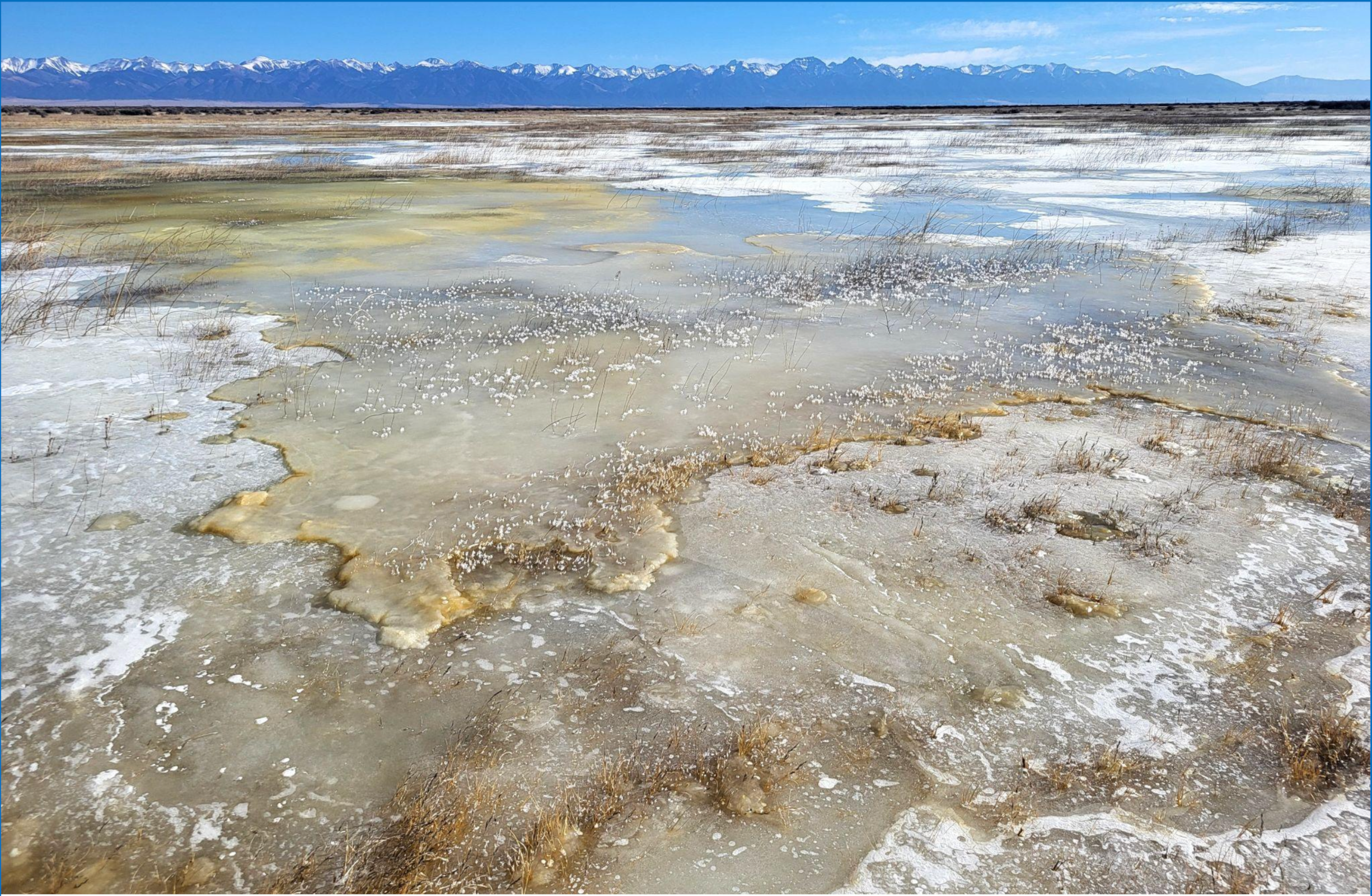
SALT LAKE CITY — Researchers at Utah State University just completed a joint study with the Utah Division of Water Rights to better understand surface water movement and measurement near Great Salt Lake.
The critical study comes as efforts are underway by the Great Salt Lake Watershed Enhancement Trust, Office of the Great Salt Lake Commissioner and other agencies to increase flows to benefit the lake’s diverse objectives including lake level, habitat and salinity.
By speaking with local water managers, USU researchers were able to gather key information about how surface water moves throughout the Great Salt Lake ecosystem, inclusive of Great Salt Lake’s peripheral wetlands and its water body, as well as document existing measurement infrastructure, which was previously unavailable in one location.
“This information was not included in the first report because we realized we needed extra time to understand the important nuances of the whole lake ecosystem connectivity,” said Eileen Lukens, a Utah Water Research Laboratory researcher on the project.
Measurement of the water flowing to the Great Salt Lake commonly relies on four gages upstream of Great Salt Lake’s peripheral wetland complexes with little measurement below those points prior to 2024, according to USU researcher Eryn Turney. This unique study involved a three-season field campaign in which the USU team visited sites at the last measurable points of inflow to Great Salt Lake.
“We realized that there was a gap in our understanding of how water moves not only to Great Salt Lake’s ecosystem as a whole, but also between distinctive portions of the ecosystem like the wetlands and water body,” Turney said. “We wanted to understand the interconnection of these areas and how increased measurement could facilitate future water delivery.”
With this in mind, USU researchers were able to identify locations where additional measurement infrastructure is needed to aid in lake-oriented objectives as well as develop diagrams to identify potential pathways for water delivery to areas of Great Salt Lake’s ecosystem.
“This study is an important step forward in understanding how water moves through the Great Salt Lake ecosystem,” said Division of Water Rights Deputy State Engineer Blake Bingham. “By identifying where additional measurement is needed, we can make better-informed decisions that support management objectives of the lake and water distribution across the basin. Collaboration like this between state agencies and our research partners strengthens our ability to administer and distribute water rights with greater confidence and transparency.”
Lukens added that their work is a part of a larger whole made up of many lake stakeholders with projects underway that contribute to tracking and managing water.
“The United States Geological Survey, Division of Water Rights and other agencies made huge efforts this past year while our study was underway to address some of the measurement gaps around the lake.” Lukens said. “Although there are still more gaps to address, we are a lot closer to understanding inflow to Great Salt Lake now.”
Sunset from the western shore of Antelope Island State Park, Great Salt Lake, Utah, United States.. Sunset viewed from White Rock Bay, on the western shore of Antelope Island. Carrington Island is visible in the distance. By Ccmdav – Own work, Public Domain, https://commons.wikimedia.org/w/index.php?curid=2032320
Distortion of the water cycle, particularly of its extremes (droughts and pluvials), will be among the most conspicuous consequences of climate change. Here we applied a novel approach with terrestrial water storage observations from the GRACE and GRACE-FO satellites to delineate and characterize 1,056 extreme events during 2002–2021. Dwarfing all other events was an ongoing pluvial that began in 2019 and engulfed central Africa. Total intensity of extreme events was strongly correlated with global mean temperature, more so than with the El Niño Southern Oscillation or other climate indicators, suggesting that continued warming of the planet will cause more frequent, more severe, longer and/or larger droughts and pluvials. In three regions, including a vast swath extending from southern Europe to south-western China, the ratio of wet to dry extreme events decreased substantially over the study period, while the opposite was true in two regions, including sub-Saharan Africa from 5° N to 20° N.
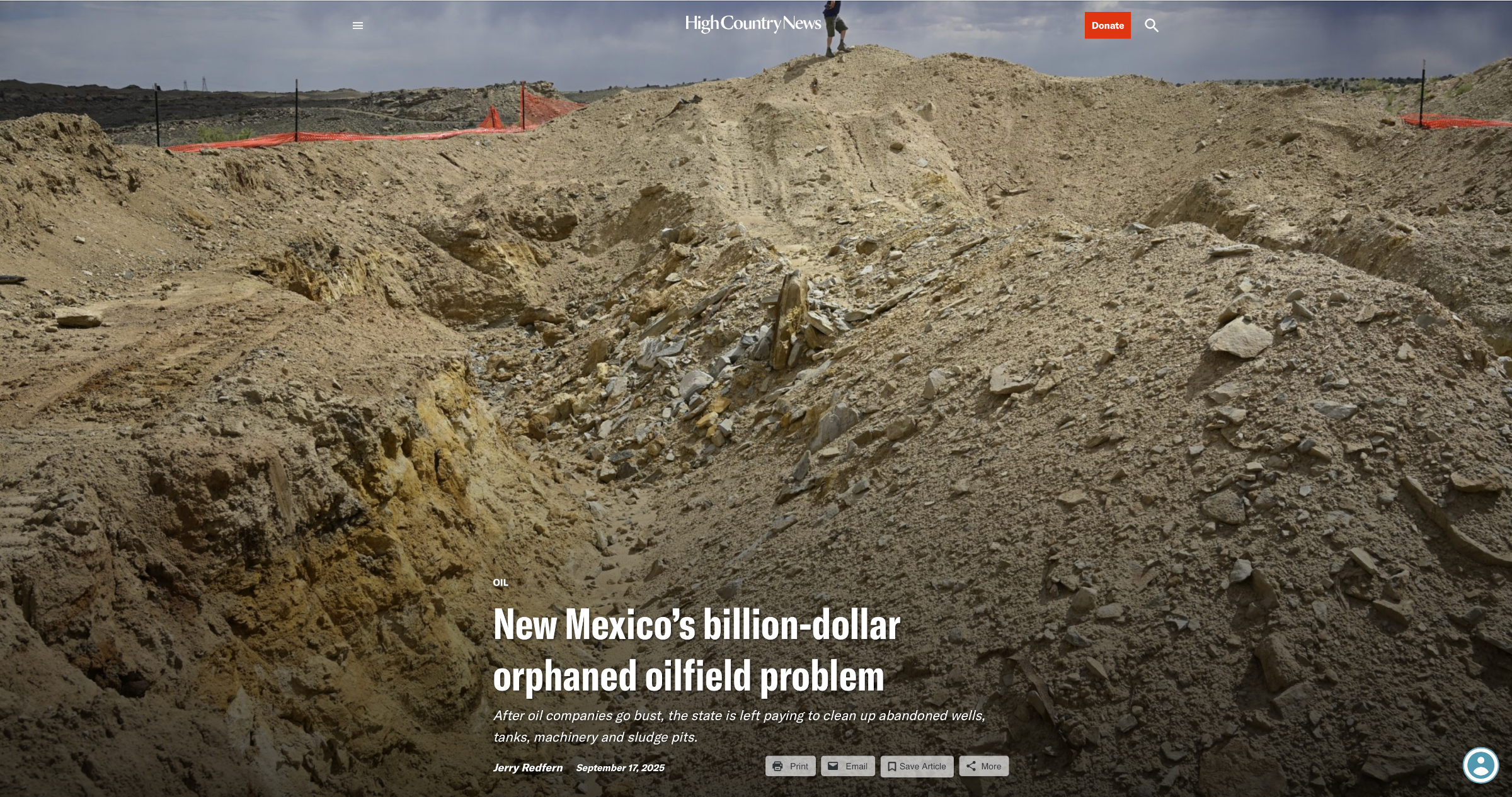
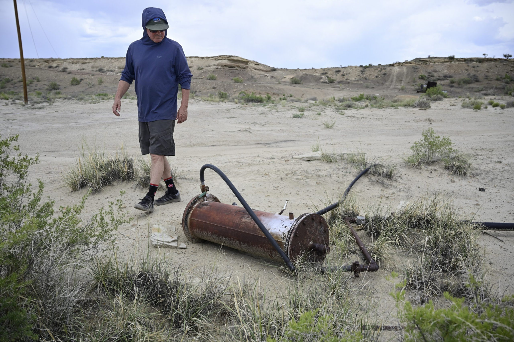
Dave Fosdeck climbs a hill of dirt surrounding an excavation at the site of a Chuza tank battery outside Farmington, New Mexico, in June. The orange staining in the hole is the result of years of leaking oil waste from the tanks and equipment that once sat here. Jerry Redfern
This story was originally published by Capital & Main and is republished here by permission.
Dave Fosdeck crested a dirt berm on the Hogback, a ridge of hills west of Farmington, New Mexico, when the scent hit him. “Whoa! It stinks!” he yelped. It was June, and he was there with two others to look at the cleanup operations around a battery of massive oil tanks that sat abandoned for years in this rolling, high-desert corner of New Mexico.
The berm surrounds a hole where a semi-buried tank the size of a backyard swimming pool once sat, collecting and leaking waste sludge from surrounding oil wells. Nearby is an even bigger but much newer hole where a cleanup crew had removed contaminated soil. The void wasn’t fully excavated but already was big enough to drop a small house in. The pit’s sides were stained orange and an even stronger petroleum smell rose from it.
For years, a separator, a semi-trailer-sized machine that split valuable oil from wastewater and other contaminants, sat here. And for years, that separator leaked those toxic compounds onto the ground, where they soaked in, leading to the orange, contaminated soil and foul air.
The two holes, the stink and a few massive piles of dirt were about all that remained of a facility — known as a tank battery — that treated oil from 30 nearby wells for decades. In addition to the separator and sludge pit, the site was home to seven cylindrical green tanks the size of small grain silos, a decades-old tanker truck with flat tires, several plastic barrels and dozens of ruptured, unlabeled, cube-shaped tanks leaking mystery chemicals. That’s mostly gone now, except for the white and yellow chemical staining on the ground where those cubical tanks leaked.
“I can’t believe they didn’t dig that all out,” Fosdeck said.
For a few years, all of this belonged to Chuza Oil, which went bust in 2018, leaving the wells, tank battery and other equipment to bake in the high desert sun. In 2022, Fosdeck, Mike Eisenfeld of the San Juan Citizens Alliance and local rancher Don Schreiber identified the remote site covered in abandoned wells and leaking equipment and began nagging federal and state officials to do something about it.
A view of the Chuza tank battery in 2023. It had been abandoned for years at this point and several unmarked plastic containers were clearly leaking. Jerry Redfern
This spot in the Hogback exemplifies a worrying, expensive trend in New Mexico’s changing oilfield remediation landscape, where well operators declare bankruptcy and abandon highly contaminated and dilapidated facilities for state and federal agencies to clean up. It’s a national trend that sweeps from the country’s first oilfields in Pennsylvania to the California coast.
Currently, New Mexico pays contractors as much as $165,000 to plug an old oil well, according to the Oil Conservation Division, the state’s primary oil and gas regulator. That’s $65,000 more than the Division reported paying just three years ago. A recent report by the state’s Legislative Finance Committee warns that New Mexico could be on the hook for up to $1.6 billion in cleanup costs in coming years from bankrupt oil and gas companies and rising plugging costs. (The report also gave the Oil Conservation Division a tongue lashing over “inconsistent cost control” in its oilfield remediation contracts.)
And while the report does talk about cleaning up tank batteries — and describes three very expensive examples — it doesn’t mention how many more may be lurking in the state’s oilfields, or what they could cost the state in the future.
Well plugging involves pulling old equipment out of the ground and scraping and flushing the wellbore before sealing it. So when a contractor arrives on site, often, “Nobody knows what they’re dealing with because it’s subsurface,” said Jason Sandel, the president of Aztec Well Servicing. Pipes rust. Pipes break. Wells might be shallower or deeper than recorded. After the pipe comes out, the contractor injects a series of cement plugs underground to keep oil, gas and other contaminants from migrating to water-bearing formations.
A tank battery has none of that, so at first glance cleaning one up looks like the easier task. But that’s not necessarily the case. The Chuza Oil tank battery site covers only about half an acre, and according to the Oil Conservation Division, the cleanup operation is on track to cost more than $650,000, much of that incurred because it was necessary to dig out and truck away the contaminated soil where the separator leaked at the remote location.
In mid-June, the cleanup clearly wasn’t finished. Orange barrier netting flapped in the wind around the pits, and the orange staining and gassy reek indicated more contaminated soil awaited removal. (Sidney Hill, public information officer for the New Mexico Energy, Minerals and Natural Resources Department, said that work stopped in May due to the end of the state’s 2025 fiscal year and resumed in July with the new fiscal year.)
Fosdeck, Eisenfeld and Schreiber have spent years tracking and highlighting problems in the oilfields around Farmington. Fosdeck, on his own, follows the paper trails of abandoned wells and other fossil fuel ventures. Schreiber and Eisenfeld rattle the cages of state and federal government officials to get oil, gas and coal sites cleaned up.
“This whole part of the equation — the cleanup part — has been neglected,” Eisenfeld said. That’s one of many reasons why he thinks digging for oil, gas and coal shouldn’t be done in the first place.
Randy Pacheco retired recently from a company that plugs and cleans up old well sites like Chuza’s, and before that he was dean of the School of Energy at San Juan College in Farmington, the state’s oilfield trade school. He visited the Hogback field with Fosdeck, Eisenfeld and Schreiber before the cleanup began. It wasn’t the worst thing he had ever seen, but, still, it was a mess.
“I think there’s people who have big aspirations to make a lot of money in the oil and gas industry and they end up purchasing these assets and then they don’t know what to do,” he said.
Even so, the site confounded him. “How would you get yourself in this kind of a mess?” he wondered about the abandoned equipment and dilapidated tank battery he saw. “Who’s selling them those dreams?”
Mike Eisenfeld, the energy and climate program manager at the San Juan Citizens Alliance, checks out a piece of abandoned equipment in the remains of the Chuza oilfield in June. Jerry Redfern
SOMETIMES THE DREAM sells itself.
Bobby Goldstein is best known for producing Cheaters, a COPS-style reality TV show of hidden cameras, secret lovers, slapped faces and shattered dreams.
“I’ve got a thousand episodes that run wild all over the world, every day, all day,” Goldstein said. Those episodes made him wealthy. In July, over a long, free-wheeling phone call, Goldstein explained in his smooth Texas patter how he, a Dallas lawyer and TV impresario, followed a dream to become an oil man and how that venture completely collapsed.
“I’ll never forget all this shit,” he said.
In 2010, Goldstein persuaded a couple of acquaintances to go into the oil business with him. They formed Chuza Oil — the name behind the Hogback mess — and, for a little less than $3 million, they bought Parowan Oil, a small company with some old wells and a tank battery near Farmington.
“[I] grew up around a bunch of rich brats whose families were big oil people,” he said. “They made the earth shake and I always thought, ‘Man, I wish I had some sense to do that.’ That opportunity came about, and I went on it.”
He continued, “I never was an oil man. I was a speculator, and for a minute there I looked real smart. … You see, I bought the land cheap, [and] oil rose and rose and rose.”
Goldstein said Chuza spent about $2 million redeveloping the oilfield infrastructure. “We made a vast improvement to the field so that it would be more efficient and more likely to be operational. So, over time, most all of those wells were working … I even moved to Santa Fe where I could be closer,” he said. “Shit, I bought a jet so I could fly out there direct in an hour and a half and be on that field. I was out there a lot.”
What happened next set the stage for the collapse of Chuza Oil and what became of the Hogback Field.
Goldstein said the company spent millions drilling two fracked wells, which involved ramming huge amounts of water, sand and chemicals into long, horizontal branches of a main wellbore to fracture the surrounding rock and loosen oil and gas trapped within.
Those wells produced for two months, but the oil was laden with paraffin. The naturally occurring, waxy hydrocarbon can slowly clog wells, in much the same way that cholesterol blocks arteries. In addition, the fracking loosened paraffin in Chuza’s other wells, fouling them as well, Goldstein said.
Then, a financial catastrophe: “The son of a bitch [partner] that was supposed to pay for the wells left us a $3 million unpaid bill with various creditors,” Goldstein said. “So not only did we have a fiscal issue going on, but we also had production issues and the company wound up into a Chapter 11,” he said.
“If everybody had listened to me on that field, we’d probably already sold it for $200 or $300 million. But people that have a little money think they know something, especially when they inherited it and never worked for it,” Goldstein said. “Those are the worst kind of idiots to have to deal with.”
After spending around $15 million to buy and expand the operation, Goldstein said Chuza Oil collapsed into years of bankruptcy litigation, foreclosure, 30 abandoned, paraffin-clogged wells and one messy tank battery.
“It was my Tom Sawyer experience,” Goldstein said. “I did something that I never had any background in, training for, education. And it was just a Wild West venture capital gamble.”
And if he made a show about the experience? “I would call it ‘Pricks and Jackasses Gone Wild,’” he said.
As for his former oilfield in New Mexico, Goldstein said, “I don’t really know what’s going on.” He was unaware that the wells had been plugged and the tank battery removed. In part, that’s because he’s no longer responsible.
One reason to set up a corporation is to protect its principals from fiscal fallout should the company fail. And in that, Chuza Oil succeeded: Bankruptcy protected Goldstein and the other partners from paying for the cleanup.
Chuza’s assets were on Navajo tribal trust land, managed by the U.S. government for the benefit of the tribe. The Bureau of Land Management managed those operations, making it responsible for the overall cleanup that began late last year.
Fosdeck, left, and Schreiber talk while standing next to an abandoned Chuza oil well west of Farmington, New Mexico, in 2023. The site is on tribal trust land and the warning sign is written in Navajo. Jerry Redfern
Federal regulations give the Bureau the ability to go after earlier but still extant owners to clean up well sites abandoned by recent owners. In this case, Chuza Oil was the last in a string of owners stretching back to the 1940s for some of the oldest wells. In the end, a Bureau spokesperson said Marathon Petroleum, BP America, Woodside Energy/BHP and Enerdyne plugged 23 Chuza wells they sold years ago. BLM asked the New Mexico Oil Conservation Division to plug five wells and deal with the tank battery — none of which had extant previous owners. The Bureau plugged the remaining two wells. The cost of the cleanup bypassed Goldstein and the bankrupt Chuza Oil entirely.
Goldstein wasn’t too wistful about his wells getting torn out and smoothed over. “I’m sure the Navajo are glad that all that shit’s gone. I don’t think they ever liked all that going on there and it’s a beautiful piece of land. It was really nice to be out there,” he said.
“Special experience for me,” he concluded.
THE CLEANUP OF Chuza Oil’s wells and tanks represents a nominal victory after years of work by Fosdeck, Eisenfeld, Schreiber and others to expunge the legacy of neglect from the northwest corner of the state. But the victory is small.
According to Oil Conservation Division numbers from the beginning of September, New Mexico has 70,000 oil and gas wells and 6,717 registered tank batteries. About 100 new wells are drilled each month. Eventually, all of those will have to be plugged, and the land returned to something resembling its natural state.
The Legislative Finance Committee report notes that over the past 20 years, operators themselves plugged 95% of nonproducing wells in New Mexico, as the law requires. The remaining 5% were declared orphaned wells and plugged by the Oil Conservation Division.
The report says there are around 700 orphan wells awaiting state plugging with another 3,400 inactive or low-producing wells that could be added to the list in the near future. Extrapolating forward, the report suggests New Mexico could be on the hook for up to $1.6 billion in cleanup costs over the coming years as more small companies declare bankruptcy before fulfilling their obligations to plug their wells and remove equipment.
New Mexico’s Oil and Gas Reclamation Fund — filled by a fraction of a tax paid by oil and gas producers — covers the costs of implementing the Oil and Gas Act, which defines how the industry can operate in the state. The fund also pays for plugging and reclamation costs of abandoned wells and facilities. Earlier this year, the fund had $66 million, its highest balance ever. The state has kept that much in the fund by paying for plugging operations with $55.5 million in recent federal grants, as well as forfeited financial assurances that well owners are required to carry but rarely cover the actual costs of cleanup. The Finance Committee report says that the state is eligible for another $111 million from the feds.
All told, it’s a long way from $1.6 billion.
“That is why the Reclamation Fund is not a substitute for adequate bonding and financial assurance from operators,” state Rep. Matthew McQueen (D – Galisteo) said. He thinks that the report’s $1.6 billion estimate is “scary enough,” but could be low. He said the report seems to expect a stable future for an industry with a notorious boom-and-bust cycle. “In a significant downturn, the State’s liability could skyrocket rapidly” as weak companies fold and abandon wells, he said.
Smaller companies are often the first to feel economic shocks, and the state has a lot of smaller oil and gas producers. In 2024, 326 companies reported producing 740 million barrels of oil to New Mexico’s Oil Conservation Division. Just 25 companies produced 92% of that total. The numbers are similar for natural gas production.
Fosdeck holds a methane detector as it lights up from a leak at an abandoned Chuza oil well in 2023. Schreiber shields the detector from the wind with his hat. Jerry Redfern
In the last legislative session, McQueen proposed a bill that would have kept well owners on the hook for remediation costs into the future if they sell wells to owners that go bankrupt — similar to what the federal government does. “It would cause the industry to self-police and make sure that any future operators had the wherewithal to properly remediate well sites,” he said. It didn’t pass.
McQueen also proposed legislation to weed out potential buyers without the money or know-how to run an oil production business, as well as so-called bad actors with histories of negligence or bankruptcy. That, too, didn’t pass.
The Finance Committee report recommends several procedural and definition changes, as well as creating a law allowing the Oil Conservation Division to disallow well sales if “the purchaser is unlikely to be able to fulfill its asset retirement obligations” — much like McQueen proposed. It also called for increasing the required financial assurances paid by oilfield operators for cleanup costs on low-producing wells, which are more likely to be orphaned.
However, the Chuza Oil assets wouldn’t have been subject to these proposed laws, because the wells and tank battery were on federal land not subject to state jurisdiction, despite the fact that the state ended up paying for the cleanup.
Ben Shelton, deputy cabinet secretary of the New Mexico Energy, Minerals and Natural Resources Department — the mothership to the Oil Conservation Division — said, “The report got a lot right, including identifying a need for [the Division] to be able to scrutinize transfers more closely in order to reduce the likely incidences of orphaned wells.”
Shelton said that the Division didn’t have an estimate for either the number of orphaned tank batteries or their average cleanup costs, but the oilfield cleanups of a trio of tank batteries were some of the most expensive the state paid for in the last couple of years, at $623,000, $5.1 million and $7.6 million. The estimated $650,000 Chuza Oil tank battery cleanup will eventually join the list.
As of publication, that months-long process wasn’t finished. And in the end, the cleanup around the Chuza Oil tank battery, while expensive and time-consuming, isn’t necessarily uncommon, according to Sandel at Aztec Well Servicing, which is cleaning up the site.
“There were many more yards of contaminated soil than expected. … But I don’t think that’s abnormal,” Sandel said. “I wouldn’t characterize it as outside the bounds at all.”
It’s not a surprise, but it’s a bit disappointing and maddening nonetheless: Trump and Interior Secretary Doug Burgum have officially moved to rescind the Biden-era Public Lands rule that aimed to put conservation on a par with other uses on federal land, such as energy development, grazing, mining, and recreation.
For a quick review, the main provisions of the rule are:
It directs the agency to prioritize landscape health in all decision making;
It creates a mechanism for outside entities (tribes, states, nonprofits) to lease public land for restoration projects, and allows firms to lease land for mitigation work to offset impacts from development elsewhere;
It clarifies the process for designating areas of critical environmental concern, or ACECs, where land managers can add extra regulations to protect cultural or natural resources.
And it directs the agency to incorporate Indigenous knowledge into decision-making, particularly when considering ACECs.
The rule was hailed by some conservationists as a “generation-defining shift” in public land management, and lambasted by Sagebrush Rebel-wannabes as a “misguided land grab meant to prevent oil and gas production … <and> … an attack on our ranchers and farmers that will end grazing on federal lands and will also prevent Coloradans from accessing their public lands.”
I would say it is neither of those things, and did and would do little if anything to block drilling or grazing, and certainly hasn’t stopped anyone from accessing public lands. After all, it’s been in effect for over a year, and I certainly haven’t heard of anyone taking any significant actions under it, and I bet Burgum hasn’t either. In the end, the rule is essentially a reminder to the BLM that their job is not just to bend over for corporate and extractive interests, but to actually care for the land that belongs to all Americans. It is simply reinforcing the multiple-use charge Congress set forth when it passed the Federal Lands Policy and Management Act back in 1976.
But Burgum’s and the Trump administration’s entire raison d’etre a la public land policy is to bend over for corporate and extractive interests, so I guess they’ve got to throw this rule out along with all of the other environmental protections.
📈 Data Dump 📊
By this time of year most hay farmers have had multiple cuttings, have scrambled to get the hay baled and bucked and under cover before the monsoon hits, and maybe sold a bunch. So I figured it was a good time to check in and see how hay exports are doing this year. The answer: Not so hot, at least compared to other years.
There are various reasons for this — exports from Colorado River Basin states, especially California, have been falling for the last couple of years, perhaps in part because some farmers are being paid to stop irrigating, which cuts into overall production. But Trump’s tariffs — and the retaliatory tariffs our trading partners hit back with — are certainly having an effect.
If you’ve wondered where your state’s hay is going and how much it’s worth, we’ve got the answer in this series of charts. I just included Colorado River states, and left out New Mexico, Colorado, and Wyoming because exports were negligible. Keep in mind that these figures are thousands of U.S. dollars, meaning that in 2022, for example, California exported just over $200 million worth of hay to China, alone. Also, this is for all types of hay, including alfalfa. But most exported hay goes to dairy cattle, and so is mostly alfalfa. And, finally, the scales are different for each state. California exports far more hay than anyone else.
On the tragic occasion of the tragic assassination of Charlie Kirk, the right-wing commentator, I point you to a piece I wrote last year after the attempt on then-candidate Donald Trump’s life. (Kirk was killed in Utah and lived in Arizona, making this a sort of Western story). The situation, the rhetoric, the players, and the reaction are so similar that to write about it again would be just to repeat myself. So here it is, removed from behind the paywall so even you free-riders can take a gander (but maybe you’ll consider upgrading to paid so you can see ALL the archives all the time!).
This historical photo shows the penstocks of the Shoshone power plant above the Colorado River. A coalition led by the Colorado River District is seeking to purchase the water rights associated with the plant. Credit: Library of Congress photo
State water officials debated a controversial proposal to use two powerful Colorado River water rights to help the environment, weighing competing interests from Front Range and Western Slope water managers.
Almost 100 water professionals gathered in Durango this week for a 14-hour hearing focused on the water rights tied to the Shoshone Power Plant, owned by an Xcel Energy subsidiary. Members of the Colorado Water Conservation Board were originally set to make their final decision on the proposal this week, but an eleventh-hour extension pushed their deadline to November.
Board members peppered presenters with questions during the hearing, weighing thorny issues like who has final authority to manage the environmental water right and how much water is involved.
Their decision could make a historic contribution to the state’s environmental water rights program and impact how Colorado River water will flow around the state long into the future.
“It’s pretty hard to anticipate all of the ways that ‘in perpetuity’ may play out,” said Greg Felt, who represents the Arkansas River on the board. “Building in representation for flexibility … is not a bad idea for an acquisition like this.”
The Shoshone Power Plant, next to Interstate 70 east of Glenwood Springs, has used Colorado River water to generate electricity for over a century.
Graphic credit: Laurine Lassalle/Aspen Journalism
In May, the Colorado River District, representing 15 counties on the Western Slope, shared a proposal to add another use to the water rights: keeping water in the Colorado River channel to help the aquatic environment.
The change requires approval from the Colorado Water Conservation Board, which runs the state’s environmental water rights program, and other entities like water court and the state’s Public Utilities Commission.
The Colorado River District wants to add the environmental use as part of a larger plan to maintain the “status quo” flow of water past the power plant, regardless of how long the power plant remains in operation.
Western Slope communities, farms, ranches, endangered species programs and recreational industries have become dependent on those flows over the decades.
“What we’re presenting here today is an offer of a historic partnership,” Andy Mueller, Colorado River District general manager, said. “We believe that this sets the state up for a truly collaborative future on the Colorado River.”
But any change to Shoshone’s water rights could have ripple effects that would affect over 10,000 upstream water rights, including those held by Front Range water groups, like Denver Water, Northern Water, Colorado Springs Utilities and Aurora Water.
These water managers and providers are responsible for delivering reliable water to millions of people, businesses, farms and ranches across the Front Range.
They raised concerns in the hearings about how their water supply could be impacted by the Western Slope’s proposal.
For board member John McClow, who represents the Gunnison-Uncompahgre River, one key question came down to authority.
“I just want to make sure we have adequate legal justification for doing what you suggest we should do,” McClow told CWCB staff during the hearing.
When the Colorado River is too low to meet Shoshone’s needs, its owner, Public Service of Colorado, a subsidiary of Xcel Energy, can call on upstream water users with lower priority water rights to cut back on using their water so that Shoshone has enough.
Whoever manages this “call” impacts thousands of upstream users, including Front Range providers.
Under the proposal, the Colorado River District will own the water rights. The district has an agreement with Xcel to buy the rights for about $99 million.
Generally, the Colorado Water Conservation Board is supposed to be the sole manager of environmental water rights under state law.
The Colorado River District says it should have a say, giving examples of other agreements with similar arrangements between the water board and water rights owners.
Northern Water said the state should have exclusive authority. This is the most important issue for the conservation district, Kyle Whitaker, water rights manager for Northern Water, said Thursday.
If the state agency hands over any amount of control, then the district would push for the water court to approve a smaller amount of water available to Shoshone. That would send less water to Western Slope communities.
If the River District controlled the environmental right, they could conceivably max out the amount of water passing by the power plant year-round, which would impact upstream water rights.
“We have to protect our systems under all future potentialities,” Whitaker said. “This will have a chilling effect on collaboration and cooperation amongst all involved and is likely to result in an outcome that is not only less desirable but also less beneficial to the Colorado River.”
The River District has said it plans to maintain these flows without changing how other water users are impacted.
For board members, this question of authority is just one of many sticky legal and management issues they have to weigh as they make a decision about the Shoshone water rights while tasked with representing the interests of the entire state.
“As far as I’ve been able to understand it, I agree with you about what the statute and the rules say we may do,” Felt told CWCB staff. “I believe we’re here to determine what we should do.”
Center pivot south of Holyoke. Photo credit: Allen Best/Big Pivots
Click the link to read the article on the Big Pivots website (Allen Best):
September 18, 2025
Cumulus clouds towering over the Great Plains on Tuesday afternoon inspired visions of Greek gods casting bolts. In McCook, Neb., the storm dumped five inches of rain accompanied by hail that ranged from the size of golf balls to baseballs.
McCook is located along the Republican River, which originates on the eastern plains of Colorado far distant from mountain snows. Despite summer thunderstorms, it’s a dry area with an average annual precipitation of about 17 inches. The water in the river that flows into Nebraska comes almost entirely from the Ogallala Aquifer, much of that water deposited millions of years ago.
In Colorado, the North Fork of the Republican River flows through Yuma. It stormed there on Tuesday night, too, lightning flashing occasionally through the windows. But the storm inside a room at the Yuma County Fairgrounds was of an entirely different sort.
The simple question was how did those farmers who pump water from the underlying Ogallala aquifer wish to tax themselves? For Colorado to honor its compact commitments to Nebraska and hence Kansas, both of them downstream, it has to make changes.
Those who spoke loudest said they did not want to be taxed based on the volumes of water they use. Some questioned the need for any fees. Some questions suggested a denial that any problem exists. Just let us keep pumping the aquifer as we have!
The meeting was the finale of six meetings held across the Republican River Basin in recent weeks. Like the others, it was well attended. At least 75 people showed up, many wearing the cap and blue jeans they had worn earlier in the day while working in their fields of corn and other crops.
In November, directors of the Republican River Water Conservation District must decide exactly how they want to move forward. To stay in compact compliance, the district wants to expand a well field that has allowed them to do so, if sometimes with narrow margins.
A 1942 compact among Colorado, Nebraska and Kansas specified how much water the upstream states must allow to flow downstream. That wasn’t an issue until the massive application of high-capacity pumps and then center-pivot sprinklers in the 1960 and 1970s allowed farmers to mine the aquifer in the Republican River Basin. In Colorado, more than a million acre-feet of water were pumped in peak years.
This has had the effect of reducing flows in downstream states. Kansas sued Nebraska, and then Nebraska sued Colorado. The case went to the U.S. Supreme Court, as all interstate compacts must.
The upshot is that Colorado agreed to toe the line. The Republican River Water Conservation District was created in 2004 with the principal function of keeping Colorado in compact compliance.
That’s a tall order. Rod Lenz, the president of the board of directors, said that farmers in the district need to figure out how to reduce their pumping to extract an average of 600,000 acre-feet a year. They have averaged 700,000 acre-feet in recent years.
The warming climate has not helped. Drought most definitely does not. In 2022, a hot and dry year, farmers pumped 940,000 acre-feet.
By reducing pumping to 600,000 acre-feet, farmers in the basin will have a longer glide path as they figure out more sustainable ways to farm.
Pumping at current rates will cause some areas to lose water in 25 years, although other areas will have water for many more decades. Yuma lies in one of the more water-flush areas.
“We’re not here to regulate,” said Lenz at a meeting in Joes the prior week. “We’re here to stay in compact compliance.”
That’s a thin distinction but one suggestive of the tricky line being negotiated by directors. Change must occur, but change is rarely welcomed except by babies with soiled diapers.
The district’s directors have adopted a two-pronged strategy for keeping Colorado out of the courtroom with Nebraska. One strategy, which was initiated in 2016, involving taking land out of irrigated production. By early 2025, more than 17,000 acres had been removed from irrigation, almost entirely within the river’s south fork area. The Ogallala in that area around Cheyenne Wells, Burlington, and Idalia never was as thick, the reservoir of water amid the underground rocks never as plentiful. In many places, the aquifer has been drained.
The second strategy to ensure compact compliance has been to mine water from north of Wray, where the aquifer has greater quantities of water, to deliver at the Nebraska border to ensure compact compliance. Those wells have produced 98,519 acre-feet in the first 10 years.
All of this has not come cheaply. More than $123 million has been spent by the district so far, a combination of federal and state funds along with assessments by the Republican River district of irrigated lands. Those assessments began at $5 an acre but have elevated to $30 an acre.
At the meeting in Yuma, as they had the week before in Joes, Lenz and other directors outlined their thoughts and choices. Foremost in their current strategy is to continue to pay landowners enough money to take land out of production to achieve the goal of 25,000 acres before the end of 2029. The district has about 8,000 acres to go. Landowners are paid for full or partial retirement of land from cultivated agriculture.
More controversially, they also want to expand the well field that allows water to be pumped and then delivered to Nebraska. They plan eight more wells at an estimated cost of $11 million.
Beyond that, they envision even more wells, elevating the total cost to more than $165 million to keep in compliance. That would allow the farmers now mining the Ogallala to continue to mine it without drastic alteration.
The immediate question is whether to stay with the existing assessment of $30 per acre of land. Another approach would be to adopt a fee, half of it to be based on amounts of land being irrigated and half on the amount of water pumped. The third option is the amount of land being irrigated and a tiered rate based on amount of water used, with those using more water paying more.
These latter two proposals would have the effect of encouraging conservation. Directors say they would keep the district’s budget at $15 million annually. However, it’s not clear what impact expanding the well field will have on that budget.
A show of hands at the Yuma meeting showed little appetite for changes in the fee structure. Some questions from audience members suggested rejection of the need for change. Do you really need this money? And is this expensive expansion of the well field needed? Might just two wells, not eight, suffice?
One speaker even challenged whether Colorado had to comply with the compact.
The short answer is that yes, it must. It’s that or agree to spend considerable money in litigation that would go directly to the U.S. Supreme Court, as it has already twice.
The question beyond that question is what would be the stance of Colorado’s governor and attorney general in 2030 if Colorado were to choose to violate the compact? The state water engineer — an appointee of the governor — has authority to shut down all wells in the basin as necessary to comply. Would the state water engineer do so?
That strategy would be risky, responded Randy Hendrix, the river district’s engineering consultant. Wells could be shut down for multiple years.
A few audience members, however, did acknowledge the difficult challenge. “I want to thank all you guys for the hard work. This is a hard job, hard subject,” said one audience member.
What can be said with certainty is that directors of the district who fielded questions managed to keep their cool in the face of the sometimes hard questions and statements.
At their quarterly meeting in November, directors must figure out how to move forward. Or, as some suggested, just ignoring Nebraska and the state engineer and letting those chips fall where they may.
9/18 Drought Update 🌵: We saw more beneficial precipitation last week, which prompted widespread improvements in western and southern Colorado in this week's US Drought Monitor. Good news for now, but we'll need additional moisture to continue chipping away at those longer-term deficits.
Water from the Colorado River flows into the Central Arizona Project on August 5, 2025. Ted Cooke spent much of his career at the agency, and some water leaders worried that he would bring bias from that job into a new federal role. Alex Hager/KUNC
Click the link to read the article on the KUNC.org website (Alex Hager):
September 18, 2025
This story is part of ongoing coverage of the Colorado River, produced by KUNC in Colorado and supported by the Walton Family Foundation. KUNC is solely responsible for its editorial coverage.
The Trump Administration’s nominee to run the Bureau of Reclamation is withdrawing from the process. Ted Cooke, a longtime water manager in Arizona, said he was asked to step back by the White House.
Cooke had been nominated to serve as commissioner of the federal agency that oversees the Colorado River. He faced pushback from some politicians and water officials who worried that he might bring bias into the position.
“I was a political casualty,” Cooke told KUNC on Wednesday.
The seven states that use the Colorado River are stuck in tense talks about how to share its water in the future. They are split into two camps: the Upper Basin states of Colorado, Utah, Wyoming and New Mexico, and the Lower Basin states of Arizona, California and Nevada.
Negotiations ahead of a 2026 deadline appear to be making little progress, and federal water officials can help push states towards agreement. If they can’t reach a deal in time, the federal government can step in and make those decisions itself. After Cooke’s nomination in June, some policymakers in the Upper Basin quietly expressed concern that he might favor the Lower Basin during that process.
Top water officials in the Upper Basin were tight-lipped in their opposition, but multiple sources with knowledge of the situation told KUNC that Cooke would face a difficult path to confirmation.
In a June meeting, Utah’s top Colorado River negotiator, Gene Shawcroft, briefly touched on the Trump Administration’s pick to run Reclamation.
“I hesitate to use the word disturbing, but it is a little disturbing,” Shawcroft said. “That is concerning to us for a variety of reasons, and I’ll probably leave it at that.”
Water levels sit low in Lake Powell near Bullfrog, Utah on September 15, 2025. Negotiations to manage the shrinking reservoir and the rest of the Colorado River system may be more difficult without federal leadership. Alex Hager/KUNC
Cooke spent more than two decades working for the Central Arizona Project, which brings Colorado River water to the Phoenix and Tucson areas. Any new plan for managing the Colorado River is likely to include cuts to demand, and Cooke’s former employer is generally among the first entities to lose water under any plan for cutbacks.
Water experts around the region said he was a qualified expert, and Cooke himself denied that he would bring a bias to his new position.
A panel of officials from the lower basin states at the Colorado River Water Users Association in Las Vegas, on Dec. 13, 2018. From left, Thomas Buschatzke, director of the Arizona Department of Water Resources; Ted Cooke, General Manager, Central Arizona Project; Peter Nelson, chairman, Colorado River Board of California; and John Entsminger, General Manager, Southern Nevada Water Authority.
“I don’t really appreciate being pre-judged by folks saying, ‘oh he’s just going to be a Lower Basin or an Arizona partisan,’” Cooke told KUNC in June, shortly after his nomination. “I call that projection. If this is what someone else would do in my shoes, then I feel sorry for them. But it’s not necessarily where I’d be coming from.”
Cooke said he was recently contacted by a White House staffer who asked him to withdraw from the nomination process for a certain reason, but Cooke declined to share that reason.
“I’ve since learned from other folks that I know, and I know lots of people, that that reason was pretty much a BS reason to basically get me out of the running,” Cooke said. “Because there were certain objections that had been raised from some of the states with which I would be dealing.”
Cooke’s withdrawal means that the top federal Colorado River agency will remain without a permanent leader. The seat has already been vacant for eight months. That may make seven-state negotiations more challenging. State water leaders have saidthat the threat of federal action can make it easier to find agreement.
While the top Reclamation role goes unfilled, other federal water officials appear to be filling the gap. Scott Cameron, a longtime federal official who currently serves as the Department of the Interior’s acting Assistant Secretary for Water and Science, told a room of water experts in June that he was intimately involved with those seven-state talks.
As for Cooke, he said he plans to stay in the Colorado River space.
“If this door is shut, there’s lots of other open doors,” he said. “It’s disappointing, don’t get me wrong, but I’m not going to sulk or be mad or develop a resentment about it. Whatever happened, happened.”
San Luis Valley center pivot August 14, 2022. Photo credit: Allen Best/Big Pivots
Click the link to read the article on the Big Pivots website (Allen Best):
September 12, 2025
Woes of the Colorado River have justifiably commanded broad attention. The slipping water levels in Lake Powell and other reservoirs provide a compelling argument for changes. How close to the cliff’s edge are we? Very close, says a new report by the Center for Colorado River Studies.
But another cogent — and somewhat related — story lies underfoot in northeastern Colorado. That’s the story of groundwater depletion. There, groundwater in the Republican River Basin has been mined at a furious pace for the last 50 to 60 years.
Much of this water in the Ogallala aquifer that was deposited during several million years will be gone within several generations. In some places it already is. Farmers once supplied by water from underground must now rely upon what falls from the sky.
In the San Luis Valley, unlike the Republican River Basin, aquifers can be replenished somewhat by water that originates from mountain snow via canals from the Rio Grande. The river has been delivering less water, though. It has problems paralleling those of the Colorado River. Changes in the valley’s farming practices have been made, but more will be needed.
In a story commissioned by Headwaters magazine (and republished in serial form at Big Pivots), I also probed mining of Denver Basin aquifers by Parker, Castle Rock and other south-suburban communities.
Those Denver Basin aquifers, like the Ogallala, get little replenishment from mountain snows. Instead of growing corn or potatoes, the water goes to urban needs in one of America’s wealthier areas.
Parker and Castle Rock believe they can tap groundwater far into the future, but to diversify their sources, they have joined hands with farmers in the Sterling area with plans to pump water from the South Platte River before it flows into Nebraska. This pumping will require 2,000 feet of vertical lift across 125 miles, an extraordinary statement of need in its own way.
Like greenhouse gases accumulating in the atmosphere, these underground depletions occur out of sight. Gauges at wellheads tell the local stories, just like the carbon dioxide detector atop Hawaii’s Mauna Loa has told the global story since 1958.
Colorado’s declining groundwater can be seen within a global context. Researchers from institutions in Arizona, California, and elsewhere recently used data from satellites collected during the last two decades. The satellites track water held in glaciers, lakes, and aquifers across the globe. In their study published recently in Science Advances, they report that water originating from groundwater mining now causes more sea level rise than the melting of ice.
“In many places where groundwater is being depleted, it will not be replenished on human timescales,” they wrote. “It is an intergenerational resource that is being poorly managed, if managed at all, by recent generations, at tremendous and exceptionally undervalued cost to future generations. Protecting the world’s groundwater supply is paramount in a warming world and on continents that we now know are drying.”
This global perspective cited several areas of the United States, most prominently California’s Central Valley but also the Ogallala of the Great Plains.
In Colorado, the Ogallala underlies the state’s southeastern corner, but the main component lies in the Republican River Basin. The river was named by French fur trappers in the 1700s, long before the Republican Party was organized. The area within Colorado, if unknown to most of Colorado’s mountain-gawking residents, is only slightly smaller than New Jersey.
A 1943 compact with Nebraska and Kansas has driven Colorado’s recent efforts to slow groundwater mining. The aquifer feeds the Republican River and its tributaries. As such, the depletions reduce flows into down-river states.
Farmers are being paid to remove land from irrigation with a goal of 25,000 acres by 2030 to keep Colorado in compliance. So far, it’s all carrots, no sticks. Colorado is also deliberately mining water north of Wray to send to Nebraska during winter months. This helps keep Colorado in compact compliance. So far, these efforts have cost more than $100 million. The money comes from self-assessments and also state and federal grants and programs.
In some recent years, more than 700,000 acre-feet of water have been drafted from the Ogallala in the Republican River Basin. To put that into perspective, Denver Water distributes an average annual 232,000 acre-feet to a population of 1.5 million.
Hard conversations are underway in the Republican River Basin and in the San Luis Valley, too. They will get harder yet. Sixteen percent of all of Colorado’s water comes from underground.
The Colorado River has big troubles. It’s not alone.
Part II: South Metro cities starting to diversify water sources: Castle Rock and Parker 25 years ago were almost entirely dependent upon groundwater. They are diversifying, and one plan is to import water from far down the South Platte River Valley.
The Republican River basin. The North Fork, South Fork and Arikaree all flow through Yuma County before crossing state lines. Credit: USBR/DOIRio Grande and Pecos River basins. Map credit: By Kmusser – Own work, Elevation data from SRTM, drainage basin from GTOPO [1], U.S. stream from the National Atlas [2], all other features from Vector Map., CC BY-SA 3.0, https://commons.wikimedia.org/w/index.php?curid=11218868Water stored in Colorado’s Denver Basin aquifers, which extend from Greeley to Colorado Springs, and from Golden to the Eastern Plains near Limon, does not naturally recharge from rain and snow and is therefore carefully regulated. Courtesy U.S. Geological Survey.The South Platte River Basin is shaded in yellow. Source: Tom Cech, One World One Water Center, Metropolitan State University of Denver.Map of the Colorado River drainage basin, created using USGS data. By Shannon1 Creative Commons Attribution-Share Alike 4.0
Another week of scant rainfall led to widespread expansion of abnormal dryness (D0) and moderate (D1) to severe (D2) drought across the Midwest, Southeast, and Northeast regions. Extreme (D3) drought was introduced near the confluence of the Mississippi and Ohio Rivers, as well as eastern Ohio and portions of West Virginia. Some expansion of drought and abnormal dryness also occurred across portions of Texas, Oklahoma, and the eastern Plains, while moderate to heavy precipitation brought 1-category improvements to localized areas in western Texas, northward through western Nebraska. Along the Rockies, above-average precipitation yielded fairly widespread 1-category improvements. Above-normal rainfall for the time of year fell across northern California and the Intermountain West, resulting in modest 1-category improvements ahead of the new water year. Enhanced monsoonal moisture was focused across New Mexico and southeastern Arizona, sparking a 1-category reduction from exceptional (D4) drought conditions in the area. 7-day temperature anomalies were above-normal across the Northern Tier and Midwest, exacerbating the rapid onset of impacts, while below-normal temperatures across the east helped to slow the deterioration somewhat. Widespread drought conditions continued for Hawaii, with a 1-category deterioration to extreme (D3) drought on the southern Big Island. Alaska and Puerto Rico remain drought free…
Widespread rainfall overspread western Kansas, Nebraska, western South Dakota, and North Dakota during the past week, resulting in modest reductions of abnormal dryness (D0) and moderate drought (D1) across western Kansas and central Nebraska. The highest rainfall totals fell across the Dakotas in regions that are currently drought-free. Drier conditions and warm temperatures prevailed across portions of eastern Kansas and northeastern Nebraska, with declining SPI values warranting some expansion of abnormal dryness (D0). Across Colorado and Wyoming, widespread precipitation fell across the mountainous regions, prompting some drought relief across northwestern Wyoming and much of western Colorado, including reductions in coverage of extreme to severe (D3 to D2) drought conditions…
Colorado Drought Monitor one week change map ending September 16, 2025.
Fairly widespread early season precipitation prompted modest reductions to drought coverage across the Northwest, where widespread severe to extreme (D2 to D3) drought conditions remain entrenched. While much above normal for the time of year, accumulations were fairly modest compared to amounts that can occur during the core weeks of the wet season during the winter. Across the Southwest, robust monsoonal moisture warranted a small reduction in coverage of exceptional drought (D4) across southeastern Arizona and southwestern New Mexico. Further west, improving conditions due to early season precipitation across southern California warranted a reduction of abnormal dryness (D0) across Imperial County. Elsewhere, the drought depiction remained largely unchanged…
Spotty convection late in the week brought localized rainfall to portions of Arkansas, northern Mississippi, and Louisiana, but accumulations were generally insufficient to change existing drought conditions. Where rain did not fall, expansion of abnormal dryness (D0) and moderate to severe drought (D1 to D2) occurred across the lower Mississippi Valley and the Tennessee Valley. More widespread rainfall, some locally heavy, overspread western and northern Texas, western Oklahoma, and far southern Texas. Most of this precipitation accumulated outside of existing areas of abnormal dryness or drought, though small 1-category improvements occurred across portions of western Texas, and the rainfall helped prevent further degradations. Drier conditions and seasonably warm temperatures warranted some degradations across central, southern, and eastern Texas, as well as the eastern two thirds of Oklahoma…
Looking Ahead
A frontal system is forecast to help generate widespread precipitation across the Plains states and portions of the Midwest along and west of the Mississippi River during the upcoming week. This rainfall has a potential to bring much needed relief to regions that have experienced rapidly worsening drought conditions. In contrast, lighter rainfall is forecast for the Ohio Valley and East, which, coupled with warmer temperatures, may further exacerbate conditions in areas that have been experiencing rapid drought onset. Another week of heavy rainfall is favored for southern Florida, with drier conditions favored across the Piedmont region of the Southeast. Wet conditions early in the week across the Southwest will give way to a drier pattern overall through the end of the week, though chances of rain will increase by the end of the week across the Northwest.
The Climate Prediction Center’s 6-10 day outlook valid for September 23 – 27 favors above-normal temperatures across the entire contiguous United States, with the highest probabilities extending across the north-central states. Above-normal precipitation is favored across the West Coast and Intermountain West, and across much of Texas and the lower Mississippi Valley and lower Ohio Valley. In contrast, below-normal precipitation is favored along the Rockies and eastward across much of the Great Plains, upper-Midwest, and the western Great Lakes region. Across Alaska, below-normal temperatures are favored for the western half of the state, with above-normal favored for the Panhandle. Near to below-normal precipitation is forecast. For Hawaii, both above-average temperatures and above-average precipitation are favored.
US Drought Monitor one week change map ending September 16, 2025.
Ted Cooke and Tom Buschatzke: Photo credit: Arizona Department of Water Resources
Click the link to read the article on the EENews.net website (Jennifer Yachnin). Here’s an excerpt:
September 17, 2025
The White House plans to pull back its nomination of a former a veteran Arizona water official to lead the Bureau of Reclamation, leaving the agency without permanent leadership nine months into President Donald Trump’s second term. Ted Cooke, a former top official at the Central Arizona Project, told POLITICO’s E&E News on Wednesday that he has been informed his nomination will be rescinded.
“This is not the outcome I sought, and I’ll leave it at that,” said Cooke in a message.
[President] Trump tapped Cooke to lead the agency in June, and the selection drew praise from both environmental advocates and some state officials who pointed to Cooke’s knowledge of the Colorado River Basin. The Senate Energy and Natural Resources had not yet considered Cooke’s nomination. Interior and Reclamation have been involved in negotiations for a new long-term operating plan among the seven states that share the Colorado River…Although it is not unusual for Reclamation to be without permanent leadership until late in the first year of a new president term, the Colorado River negotiations put more pressure on the White House to fill the post.
Cooke spent more than two decades at the Central Arizona Project before stepping down as its general manager in early 2023, which distributes Colorado River water to Maricopa, Pinal and Pima counties.
A new report finds that Lakes Mead and Powell, the nation’s largest reservoirs, could store just 9 percent of their combined capacity by the end of next summer.
Consumption of Colorado River water is outpacing nature’s ability to replenish it, with the basin’s reservoirs on the verge of being depleted to the point of exhaustion without urgent federal action to cut use, according to a new analysis from leading experts of the river.
The analysis, published Thursday [September 11, 2025], found that if the river’s water continues to be used at the same rate and the Southwest sees another winter as dry as the last one, Lakes Mead and Powell—the nation’s two largest reservoirs—would collectively hold 9 percent of the water they can store by the end of next summer. After enduring decades of overconsumption of the river’s water, the lakes would have just under 4 million acre feet of water in storage for emergencies and drier years when demand can’t be met. Every year, roughly 13 million acre feet is taken from the river for drinking water and human development across the region, with conservative forecasts estimating roughly 9.3 million acre feet of inflow next year.
The report is stark in its assessment of the situation: Current Colorado River levels require “immediate and substantial reductions in consumptive use across the Basin” or Lake Powell by 2027 would have no storage left and “would have to be operated as a ‘run of river” facility” in which only the inflow from the river could be released downstream.
“The River recognizes no human laws or governance structures and follows only physical ones,” the report’s authors wrote. “There is a declining amount of water available in the Colorado River system, primarily caused by the effects of a warming climate—longer growing seasons, drier soils, and less efficient conversion of the winter snowpack into stream flow. Although American society has developed infrastructure to store the spring snowmelt and make that water available in other seasons to more completely utilize the variable runoff, the Colorado River watershed produces only a finite volume of water, regardless of how many dams exist.”
The lifeblood of the American Southwest, the Colorado River’s water flows from Wyoming to Mexico, enabling the region’s population and economies to develop. The damming of the river has diverted water to booming metropolises like Los Angeles and Phoenix while also supporting the U.S.’s most productive agricultural areas and powering some of the its largest hydroelectric dams. In total, the river supplies seven states, 30 tribes and 40 million people with water.
The compact that divvied up the river’s water a century ago overestimated how much actually flowed through it, and climate change has diminished the supply even further. The melting snowpack that runs off mountains in the spring to feed the river has declined, shrinking the river and its storage reservoirs during decades of drought. The seven states that take Colorado River water are divided into two factions engaged in tense conversations about its future and how cutbacks should be distributed. Current guidelines for managing the river in times of drought are set to expire at the end of next year, and new ones are legally required to take their place, but negotiations between states, tribes and other stakeholders over the sharing of the necessary cuts in water usage are at an impasse.
But if current conditions persist, further cutbacks on the river won’t be able to wait until those negotiations are finished, the report’s authors find, and they urged the Department of the Interior “to take immediate action.”
“Let’s hope that we are all wrong and that it snows like hell all winter and runoff is wonderful and we buy ourselves some time and additional buffer,” said Kathryn Sorensen, director of research for Arizona State University’s Kyl Center for Water Policy and one of the report’s co-authors. “But of course, it never makes sense to plan as if it’s going to snow, and we have to deal with what is a realistic but not worst-case scenario and take responsible actions.”
Adding to the issue is the status of the infrastructure that enables the river to be diverted and stored for use. For example, the researchers write, it was thought that anything above what’s known as “dead pool”—a water level below the reservoirs’ lowest outlets that can pass water through the dams—was “active storage.” But testing last year from the Bureau of Reclamation, the federal agency overseeing the river and its dams, found that those outlets can only be safely used at water levels higher than previously thought and cannot be used for long durations.
Margaret Garcia, an associate professor at ASU’s School of Sustainable Engineering and the Built Environment, who was not a part of the study, said the analyses makes clear the “reality of dead pool is within sight” for the basin’s reservoirs, even without considering the possibility of having an extremely dry year.
She likened the reservoirs to having a savings account with a bank. “When you have a savings account, you have some time to scramble and figure things out,” Garcia said. “But if you’ve already drawn down your savings account and then [you’re laid off] and you never filled it back up at least a little bit, you’re in for a really tough situation.”
And just like a savings account, Garcia said, a reservoir isn’t much good if it can’t generate hydropower or store water.
Sorensen said the secretary of the Interior, Doug Burgum, has broad authority to act to protect critical infrastructure in both of the river’s basins. The question is what those actions should be.
“The solutions are there,” she said. “The solutions are known. They’re just extraordinarily painful to implement. “
State negotiators have worked this year to determine how to manage the river after 2026, Sorensen said, but the buffer of water stored in reservoirs “that we’re relying on to kind of get us through the negotiations and these difficult times is potentially much smaller than maybe was commonly understood.”
From left, Western States Ranches Agricultural Operations Manager Mike Higuera, Conscience Bay Research Program Officer Dan Waldvogle and Colorado State University researcher Perry Cabot. The three held a field day and ranch tour in August for other local ranchers to learn about water conservation and deficit irrigation. CREDIT: HEATHER SACKETT/ASPEN JOURNALISM
As reservoir levels continue to plummet at the end of another dismal water year, some agricultural water users are asking Colorado lawmakers to consider a bill next session that would make it easier for them to get credit for conserving water.
It would be the next step in creating a conservation pool in Lake Powell that the Upper Basin states could use to protect against water scarcity.
Over the past decade, Colorado, New Mexico, Utah and Wyoming have dabbled in programs that pay willing participants to use less water on a temporary basis. But so far, that saved water has flowed downstream unaccounted for. Changes to state laws would be needed to allow state officials to shepherd conserved water into a Lake Powell pool.
“Our message is simple: Protect Colorado agriculture by enabling voluntary, compensated water conservation without causing injury to other water users,” Dan Waldvogle told state legislators at an August meeting of the Water and Natural Resources Committee in Steamboat Springs. “Give us credit for the water we save and guarantee that conserved consumptive use is fairly and fully compensated … . The 2026 legislative session is our last best chance to take action and control our future.”
Waldvogle was speaking on behalf of the Colorado Farm Bureau and Rocky Mountain Farmers Union. He also works for Conscience Bay Co., a Boulder-based real estate investment firm that owns a cattle-ranching operation in Delta County known as Western States Ranches.
But allowing the state to shepherd conserved water resurrects old concerns for some on the Western Slope. They say it could open the state to speculators and interstate water markets, with Colorado water users selling their water to the highest bidder in the Lower Basin, which includes California, Arizona and Nevada.
“We’re saying you should not pass a standalone shepherding law or conserved consumptive use law that would allow and enable the state engineer to do that without having a thorough discussion with all stakeholders and encoding in legislation important sideboards and protections for our agricultural industry and our community,” Colorado River Water Conservation District General Manager Andy Mueller told lawmakers at the August meeting.
State Engineer Jason Ullmann said in an email that he does “not have authority to require water conserved through voluntary programs to bypass other Colorado water users’ headgates unless it is necessary to meet Colorado’s compact obligations.” The bypassing of other users’ headgate to deliver water to a point downstream is more commonly known as shepherding.
The General Assembly would need to pass legislation in order to give him that authority, many stakeholders believe.
Western States Ranches near Eckert enrolled some of its fields in the 2024 System Conservation Pilot Program. The ranch was paid about $278,000 to save about 550 acre-feet of water. CREDIT: HEATHER SACKETT/ASPEN JOURNALISM
The conservation conversation comes at a pivotal time for water users on the Colorado River, which remains wracked by drought and climate change. The most recent projections from the U.S. Bureau of Reclamation show water levels at Lake Powell potentially falling below the threshold needed to make hydropower by November 2026. The reservoir is currently about 28% full.
State Sen. Dylan Roberts, a Democrat who represents several Western Slope counties including Eagle, Garfield, Grand, Moffat, Rio Blanco, Routt and Summit and is the chair of the Water and Natural Resources Committee, told Aspen Journalism that as of now, no bill to address shepherding or future conservation programs is in the works in Colorado. But that may be because the seven states that share the Colorado River are still hashing out how reservoirs will be operated and how cuts will be shared when the current guidelines expire next year.
The potential path forward.
At the beginning of this summer, negotiators from the seven basin states agreed to a concept that would share water based on flows in the river and not on demands, but talks have since stalled. Federal officials have given the states a Nov. 11 deadline to come up with the outline of a deal.
“I remain fully committed to reaching consensus, but I want to be candid, especially with you all,” Becky Mitchell, Colorado’s lead negotiator, told lawmakers. “The discussions with my counterparts have been and continue to be challenging. I understand why this discussion is so challenging for our Lower Basin counterparts. They have developed a reliance on water that is above their apportionment that is simply not there.”
Colorado and the other Upper Basin states have been tiptoeing into voluntary conservation pilot programs since 2015, and the 2019 Drought Contingency Plan allowed for a 500,000-acre-foot conservation pool in Lake Powell. Late last year, Upper Basin officials offered up a 200,000-acre-foot pool in Powell as part of negotiations, and some type of future voluntary conservation program for the Upper Basin appears increasingly likely.
The System Conservation Pilot Program, which first ran from 2015 to 2018, was rebooted in 2023 and paid water users in the Upper Basin to cut back in 2023 and 2024. Over two years, the program doled out about $45 million to conserve just over 100,000 acre-feet of water across the four states.
A main criticism of the SCPP was that the conserved water was not tracked to Lake Powell, even though one of the program’s stated intents was to boost levels in the nation’s second-largest reservoir. In some cases, the water was probably picked up by a downstream water user, with no net gain to Lake Powell. This is the issue that new state legislation could remedy. Until now, the experimental conservation programs were allowed with temporary approvals from state officials.
“We want action,” Waldvogle said. “And I think the way I define action is for [lawmakers] to move forward in developing a program in order to really catalyze our communities into these discussions. To really develop all the sideboards necessary to have a program is going to take a longer time frame.”
Western States Ranches
Conscience Bay owns about 3,800 acres on parcels scattered throughout Delta County, 3,000 of which the company says are irrigated. About 3,200 of these total acres are clustered in Harts Basin near Eckert, making up the headquarters of the company’s reaching operation known as Western States Ranches. The ranch participated in the SCPP in 2024, with water to some fields shut off June 1 and others July 1. The ranch saved about 550 acre-feet, or 7% of its water, according to ranch managers.
Ranch representatives see participation in these early voluntary conservation programs as a way to have some control over their operations should water cuts become mandatory in the future. They say they are interested in innovative ways to adapt to water scarcity, and they partnered with Colorado State University scientists to study the effects on forage crops of taking irrigation off their fields that were enrolled in SCPP in 2024.
“We wanted to figure out how this is going to affect us, and if we are required to do this in the future, we want to have the knowledge to make good decisions,” said Mike Higuera, agricultural operations manager of Western States Ranches. “We assume that we are going to have to conserve water in this game.”
Western States Ranches in Delta County participated in the 2024 System Conservation Pilot Program. The ranch is working with Colorado State University researchers to learn what happens when water is removed from fields. CREDIT: HEATHER SACKETT/ASPEN JOURNALISM
Western States Ranches hosted an August field day in Eckert with the Western Landowners Alliance for other local farmers and ranchers to learn about drought-resilient ranching and share the findings from CSU researchers.
The ranch’s participation in SCPP has resurrected fears that the owners, who began purchasing the Delta County properties in 2017, are speculating — buying up land for its senior water rights and hoarding them for a future profit. With a water-conservation program in the Upper Basin all but guaranteed, some worry that Western States Ranches could be looking to profit off sending their water downstream.
The question came up at the August field day when a Paonia-area rancher said he had heard the ranch owners were speculators. Conscience Bay representatives have always denied that accusation.
“I can tell you there are a lot better ways to make money,” Higuera replied.
According to SCPP documents, the ranch was paid $278,372 for their water in 2024. Higuera said that amounted to about 10% of their revenue last year, with cattle sales making up the other 90%.
Colorado in recent years has tried to tackle the thorny issues of how to fairly roll out a conservation program while prohibiting speculation. Defining what speculation is and who is a speculator is slippery and hinges on determining the water rights purchaser’s intent — a nearly impossible thing to know or police with 100% certainty. The bottom line of the state’s existing anti-speculation policy is that water-rights owners must put that water to beneficial use.
Ultimately, a 2021 workgroup failed to find consensus about ways to strengthen protections against speculation and a drought task force failed to provide recommendations about conserved consumptive programs for lawmakers, underscoring the difficulty of protecting the state’s water without infringing on private property rights. Some agricultural producers balked at laws that could restrict their ability to make money by selling their land and associated water rights.
At the heart of speculation concerns is the fear of large-scale, permanent dry-up of agricultural lands. Mueller has long cautioned that conservation programs, if not done carefully, could disproportionately impact rural agricultural communities. Although SCPP was open to all water-use sectors, all of Colorado’s participants in SCPP in 2023 and 2024 were from Western Slope agriculture.
“Any program that we have must be designed for our state’s best ability to support the longevity of agriculture and the vitality of our communities, and we’ve got to be thoughtful and precise,” Mueller said.
This equipment in a field on Western States Ranches helps figure out how much water crops use. The ranch partnered with Colorado State University researchers to track what happens to a forage crop when water is removed mid-way through the irrigation season. CREDIT: HEATHER SACKETT/ASPEN JOURNALISM
Paying for programs
Another big question about Upper Basin conservation remains: How will it be paid for?
SCPP in 2023 and 2024 was funded with money from the federal Inflation Reduction Act. The bill that could have authorized SCPP again in 2025 is still stalled in the House. Over 2023 and 2024, the program doled out about $45 million to water users in the Upper Basin and saved about 101,000 acre-feet.
Without overhauling the West’s system of water rights, voluntary, temporary and compensated conservation programs are one of the only carrots to entice agricultural water users — who account for the majority of water use in the Colorado River Basin — to cut back. But they are expensive, and it’s unclear how future long-term conservation programs would be funded.
Colorado’s entire congressional delegation in early August sent a bipartisan letter to federal water managers, in an effort to shake loose $140 million in funding that was promised for projects addressing drought on the Western Slope in the final days of the Biden administration and then frozen by the Trump administration.
U.S. Sen. Michael Bennet, D-Colo., addressed the question at a Colorado Water Congress meeting in Steamboat Springs in August.
“We’re now not going to have a great federal partner for a while, I’m afraid, and we’re going to have to figure out how to rely on each other and do it in more imaginative ways than maybe we have in the past,” Bennet said.
Map of the Colorado River drainage basin, created using USGS data. By Shannon1 Creative Commons Attribution-Share Alike 4.0
Navajo Bridge spans the Colorado River downstream from Lake Powell near Lee Ferry, the dividing line between the upper and lower basin. Upper Basin officials have proposed up to 200,000 acre-feet of water conservation a year in Lake Powell. Photo credit: Aspen Journalism
Click the link to read the article on the Colorado Politics website (Marianne Goodland). Here’s an excerpt:
September 11, 2025
With a critical Nov. 11 deadline fast approaching, negotiators from the seven Colorado River basin states remain at odds over how to manage a river that serves 40 million people — and which, experts long agree, is overallocated. Negotiations are moving so slowly that some basin leaders are questioning whether that agreement will happen before the deadline or whether the Bureau of Reclamation, which still doesn’t have a permanent commissioner, will have to step in. Negotiations over the “divorce,” as some are calling it, or a “conscious uncoupling,” which is how Colorado negotiator Becky Mitchell describes it, began over the year-long stalemate between the upper and lower basin states. And then came the bureau’s 24-month study of hydrology, adding a wrinkle that nobody wanted.
Projected Lake Mead end-of-month physical elevations from the latest 24-Month Study inflow scenarios.
Projected Lake Powell end-of-month physical elevations from the latest 24-Month Study inflow scenarios.
The deadline for implementing the post-2026 operating guidelines agreement is Oct. 1, 2026, although the bureau wants everything ready to go by June 2026. The hydrology report pointed out a near-crisis level at Lake Powell by next year, just as negotiators are trying to come up with a long-term deal that will guide the river’s operations into the future…Current operating guidelines that were put into place in 2007 will expire next year. However, it has become a much more challenging job to manage the river over the past two decades. This river supplies water for agriculture and supports 40 million people across seven states. Experts said that’s due to a 25-year drought that has reduced the river’s historic flow by millions of acre-feet of water per year.
Udall/Overpeck 4-panel Figure Colorado River temperature/precipitation/natural flows with trend. Lake Mead and Lake Powell storage. Updated through Water Year 2024. Credit: Brad Udall
Members of the House Committee on Natural Resources convene a hearing on public land funding at Jenny Lake Plaza in Grand Teton National Park on Sept. 5, 2025. Representatives pictured are Troy Downing, Doug LaMalfa, Harriet Hageman, Chairman Bruce Westerman and Teresa Leger Fernandez. (Angus M. Thuermer Jr./WyoFile)
Click the link to read the article on the WyoFile.com website (Angus M. Thuermer Jr.):
September 15, 2025
Four initiatives among federal agencies and in Congress would harm the Western landscape owned by all Americans, conservationists contend.
As Congress conducted a high-profile hearing in Grand Teton National Park 10 days ago to support parks funding, President Donald Trump’s administration and supporters were busy elsewhere eliminating public land protections across the West.
The Grand Teton hearing conducted by the House Committee on Natural Resources on Sept. 5 heard widespread support for resolving a backlog of maintenance at national parks, along with calls to restore DOGE staffing cuts.
But the committee meeting at the spectacular Jenny Lake Plaza came amidst a flurry of attacks against rules protecting wildlife, its habitat and preservation funds, conservationists said.
Those attacks include Agriculture Secretary Brooke Rollins’ move to rescind the Forest Service roadless rule that protects 59 million roadless acres considered vital to wildlife. Also, Interior Secretary Doug Burgum issued an order restricting use of the Land and Water Conservation Fund, which was created in 1964 to buy and preserve recreation lands.
Meantime, the U.S. House on Sept. 3 put on the chopping block a Bureau of Land Management plan in Montana that restricted coal leasing. If agreed to by the Senate, the bill would open the door to “legal and regulatory chaos” across the West, the Center for Western Priorities warned.
And on Thursday, the BLM opened comment on the plan to roll back its Public Lands Rule that gave conservation an equal footing with industrial uses of property owned by all Americans.
All that happened in 15 days — about one week on either side of the congressional Teton hearing. But while witnesses were supporting parks in the open air of the Teton Mountains, Trump allies were undercutting conservation with less visible methods, one public lands advocate said.
The rule changes, secretarial orders and legislation are complex and sometimes opaque, said Amy Lindholm, an Appalachian Mountain Club director and spokesperson for the Land and Water Conservation Fund Coalition.
“It’s not easy to understand what’s going on here,” she said, using Burgum’s order curtailing the LWCF as an example. “It flies under the radar [but] could be as serious as selling off pieces of federal public land.”
The MAGA messages
The administration and its supporters characterized the changes as necessary to help reduce the federal deficit, rectify allegedly unlawful policies and increase energy production, among other things.
“I am so baffled and mortified that for four years our government intentionally tried to impose energy poverty on the American people, all to please the vocal but minority climate lobby,” U.S. Rep Harriet Hageman said on the House floor when voting Sept. 3 for Joint House Resolution 104.
That bill states that the BLM’s Montana management plan restricting coal leasing in the Powder River Basin “shall have no force or effect.”
Designated roadless areas, like these timber stands on the Shoshone National Forest near South Pass, would be eliminated under rescission of the 2001 Roadless Rule that’s been announced by U.S. Department of Agriculture Secretary Brooke Rollins. (Mike Koshmrl/WyoFile/EcoFlight)
Hageman’s vote was one of three in the 211-208 tally that helped Republicans use the Congressional Review Act to move the bill through the House.
On another front, Agriculture Secretary Rollins’ roadless-rule rollback will allow loggers “to access our abundant timer [sic] resources,” U.S. Sen. Cynthia Lummis wrote to a constituent on Sept. 2. The roadless rule “has done nothing to advance our national interest or strengthen our communities,” Lummis wrote.
The rollback “will give state and local leaders, not distant federal agencies, the authority to manage forests responsibly, improve forest health, and implement real wildfire prevention strategies,” Lummis’ letter reads. “I will push back on any policies that endangers [sic] Wyoming families, communities or businesses.”
In ordering revisions to the Land and Water Conservation Fund, Interior Secretary Burgum wrote that changes will ensure funds “are managed efficiently and aligned with the goals of the Trump administration.” The account was used to buy and protect the 640-acre Kelly Parcel in Grand Teton National Park. While touting the revisions, Burgum said the Trump administration has “prioritized access to Federal lands and outdoor recreation.”
At the BLM, meanwhile, conservation should not be on equal footing with mining, drilling and grazing, according to a notice seeking public comment on the expurgation of the Public Lands Rule. Also known as the Conservation and Landscape Health Rule, the measure is “unnecessary and violates existing statutory requirements,” the notice reads.
Conservation doesn’t rise to a “principal or major use” of BLM land, the Western Energy Alliance said in a statement supporting rollback of the Public Lands Rule. Those principal uses are “mineral exploration and production, livestock grazing, rights‐of‐way, fish and wildlife development, recreation, and timber,” the statement said.
Greens see an assault
Conservationists and others are challenging those MAGA positions. Using the Congressional Review Act to undo the BLM’s Montana plan for the Powder River Basin coal — a move Hageman voted for — risks unleashing “legal and regulatory chaos across the West,” the Center for Western Priorities said.
“If courts interpret this action broadly, every management plan written since 1996 could be challenged in court — potentially invalidating oil and gas leases, grazing permits, and threatening public access to trails and campgrounds,” the Center’s Deputy Director Aaron Weiss said in a statement.
Without BLM resource management plans, operations would revert to “outdated frameworks … written before today’s recreation economy took off,” he said. “Outfitters, guides and businesses that depend on reliable access for rafting, off-roading, and other outdoor activities could face years of uncertainty, permit delays, and costly litigation.”
Road densities are especially high in Wyoming outside of wilderness areas and wilderness study areas, marked in blue in this map. Roads depicted are from the U.S. Geological Survey National Transportation Dataset. (Wyoming Wilderness Association)
On the roadless front, Lummis’ contention that roads can help prevent wildfires contradicts a 2007 study that found “current road systems increase risk of human-caused fire.” Authored by the Pacific Biodiversity Institute, the 40-page paper found that “[a]reas that are very close to roads have many times more wildfire occurrences than areas distant from roads.”
Roadless areas are critical to outfitter Meredith Taylor, who has worked successfully in them for decades, she told WyoFile. Industrializing them could endanger her family, community and business, she suggested.
“Unnecessary road development would ruin the value of these public lands for people and wildlife who appreciate them as they are,” Taylor said. The Jackson Hole Wildlife Foundation and others urged the public to comment before Sept. 19.
Conservation should be equal
Conservationists also decried the pending revocation of the BLM’s Public Lands Rule/Conservation and Landscape Health Rule. “The administration is saying that public lands should be managed primarily for the good of powerful drilling, mining and development interests,” Alison Flint, senior legal director at The Wilderness Society, said in a statement.
“They’re saying that public lands’ role in providing Americans the freedom to enjoy the outdoors, and conserve beloved places … is a second-class consideration,” Flint said. The rule “has solid grounding in a nearly 50-year-old directive from Congress,” she said.
Defenders of Wildlife said the existing rule “requires science-based decision-making and consideration of conservation.” The rule is “foolishly being yanked away in service of the ‘Drill, baby, drill’ agenda,” Vera Smith, national forests and public lands director at Defenders, said in a statement.
Addressing changes to the Land and Water Conservation Fund, which receives $900 million a year from oil and gas leasing, LWCF Coalition spokesperson Lindholm warned of dangers in Burgum’s order.
“There’s a provision encouraging states to use their state grant dollars [from the federal fund] to buy surplus federal land,” she said. “We don’t want states to use the funds to buy back federal land that’s already been protected, to pay for continued access to places they already have access to,” she said.
Given Burgum’s advocacy for developing federal land for housing, the changes create “a dangerous potential pathway for the selloff of federal lands,” she said.
The agency already has a process for the sale of property that works, Lindholm said. Burgum’s order will reexamine that process “with the intent of increasing the discretion of the secretary.”
Without Burgum’s stated selloff advocacy, “it’s not something we would have necessarily red-flagged,” she said.
Soul of Wyoming
Healthy landscapes and wildlife are the soul of northwestern Wyoming, state Rep. Liz Storer, a Democrat from Jackson, said. Her district covers Grand Teton and parts of Yellowstone national parks, the National Elk Refuge, parts of the Bridger-Teton National Forest and BLM property.
Those lands and the wildlife on them “define who we are,” she said at a Keep Parks Public rally in Jackson on Sept. 4.
Others at the forum chimed in. “These threats to public lands are very much alive,” Lauren Bogard, senior director of advocacy at the Center for Western Priorities, said after outlining DOGE cuts and threats to conservation.EcoTour Adventures founder and wildlife guide Taylor Phillips told the Teton congressional panel that scientists are scared. “In the next five to 10 years, the wildlife as we see it now will not exist unless drastic measures are taken,” Phillips testified of his talks with scientists.
They warn that humanity is just three years from overshooting the Paris Agreement’s 1.5°C target, with seas rising faster than ever. But the report also contains a little bit of good news.
The amount of heat trapped by climate-warming pollution in our atmosphere is continuing to increase, the planet’s sea levels are rising at an accelerating rate, and the Paris agreement’s ambitious 1.5°C target is on the verge of being breached, according to a recent report by the world’s top climate scientists.
“The news is grim,” said study co-author Zeke Hausfather, a former Yale Climate Connections contributor, on Bluesky.
A team of over 60 international scientists published the latest edition of an annual report updating key metrics that are used in reports of the Intergovernmental Panel on Climate Change, the leading international scientific authority on climate change.
Earth out of balance
Climate change is caused by variations in Earth’s energy balance – the difference between the planet’s incoming and outgoing energy. Nearly all incoming energy originates from the sun. The Earth absorbs that sunlight and sends it back out toward space in the form of infrared light, or heat. Greenhouse gases such as carbon dioxide absorb infrared light, and so increased levels in those gases trap more heat in the atmosphere, warming the planet’s surface and oceans.
The new report finds that as a result of this increasing greenhouse effect, Earth’s energy imbalance has been consistently rising every decade. In fact, the global imbalance has more than doubled just since the 1980s. And from 2020 to 2024, humans exacerbated the problem by adding about 200 billion more tons of carbon dioxide-equivalent greenhouse gases to the atmosphere.
This increase in trapped energy has continued to warm Earth’s surface temperatures. The new study estimated that at current rates, humans will burn enough fossil fuels and release enough climate pollution to commit the planet to over 1.5°C of global warming above preindustrial temperatures within about three more years, in 2028.
The most recent report from the Intergovernmental Panel on Climate Change, published in 2021, concluded that average temperatures had increased 1.09°C since the late 1800s. The new study updates this number to 1.24°C, driven largely by the record-shattering hot years of 2023 and 2024.
The paper also finds that global surface temperatures are warming at a rate of about 0.27°C per decade. That’s nearly 50% faster than the close to 0.2°C-per-decade warming rate of the 1990s and 2000s, indicating an acceleration of global warming.
Human-caused and total observed average global surface temperature increase since the Industrial Revolution. Created by Dana Nuccitelli with data by https://climatechangetracker.org/igcc from June 17, 2025.
That warming causes the water in the ocean to expand and land-based ice to melt, both of which contribute to rising sea levels. Since 1900, global sea levels have risen by nine inches, at an average rate of 1.85 millimeters per year. But the rate of sea level rise since 2000 has been twice as fast, at 3.7 millimeters per year. And over the past decade it’s risen faster yet, at 4.5 millimeters per year. In other words, sea level rise is also accelerating.
“Unfortunately, the unprecedented rates of global warming and accelerating sea-level rise are as expected from greenhouse emissions being at an all-time high,” University of Leeds climate scientist and the study’s lead author Piers Forster wrote by email.
Global mean sea level rise since the early 20th century, accelerating since the start of the 21st century. Created by Dana Nuccitelli with data by https://climatechangetracker.org/igcc from June 17, 2025.
A thin silver lining
Most, but not all, of the findings in the new paper are grim. For example, although humanity will almost certainly miss the more ambitious 1.5°C target in the Paris agreement, the study finds that its primary target of limiting global warming to 2°C remains within reach. At current emissions rates, 2°C global warming will be breached around midcentury, but that still leaves several decades to bring emissions down.
“Future emissions control future warming,” Forster said. “And if the world were to rapidly act on carbon dioxide and methane emissions, we could halve the rate of warming.”
The study identifies glimmers of hope that climate policies and solutions around the world could soon begin to move emissions in this direction.
“I think there is not much silver lining in the report per se given the apparent acceleration of warming,” Hausfather said in an email to Yale Climate Connections. “But I would note that global CO2 emissions have slowed notably over the past 15 years or so, and the cost of clean energy continues to fall. We are clearly moving away from the worst-case emissions scenarios, even if we are still heading toward potentially catastrophic warming of 3°C by 2100.”
China will be a key player in determining the future evolution of Earth’s climate. Because of its large population and rapid economic growth, China is responsible for nearly one-third of global climate pollution. But as the result of a rapid deployment of clean technologies, China’s emissions have begun to slightly decline over the past year.
“This is also the decade when global [greenhouse gas] emissions could be expected to peak and begin to substantially decline,” the report’s authors conclude. “Depending on the societal choices made in this critical decade, a continued series of these annual updates could track an improving trend.”
It took decades, stacks of legal paperwork and countless phone calls, but, in the spring of 2025, a California Chuckchansi Native American woman and her daughter walked onto a 5-acre parcel of land, shaded by oaks and pines, for the first time.
This land near the foothills of the Sierra National Forest is part of an unusual category of land that has been largely left alone for more than a century. The parcel, like roughly 400 other parcels across the state totaling 16,000 acres in area, is held in trust by the federal government for the benefit of specific Indigenous people – such as a family member of the woman visiting the land with her daughter.
Largely inaccessible for more than a century, and therefore so far of little actual benefit to those it is meant for, this land provides an opportunity for Indigenous people to not only have recognized land rights but also to care for their land in traditional ways that could help reduce the threat of intensifying wildfires as part of a changing climate.
In collaboration with families who have long been connected to this land, our research team at the University of California, Davis is working to clarify ownership records, document ecological conditions and share information to help allottees access and use their allotments.
California’s unique historical situation
As European nations colonized the area that became the United States, they entered into treaties with Native nations. These treaties established tribal reservations and secured some Indigenous rights to resources and land.
Just after California became a state in 1850, the federal government negotiated 18 treaties with 134 tribes, reserving about 7.5 million acres, roughly 7.5% of the state, for tribes’ exclusive use.
Then, in 1887, Congress passed the Dawes Act, which allowed Native people across the U.S. to be assigned or apply for land individually. Though it called the seized land – their former tribal homelands – the “public domain,” the Dawes Act presented a significant opportunity for the landless Native people in California to secure land rights that would be recognized by the government.
Allotments are in a wide range of ecosystems, though more are in blue oak woodlands than any other single type of habitat. Images created by James Thorne, Ryan Boynton, Allan Hollander and Dave Waetjan.
Many of these allotments were remote – ecologically rich, yet hard to access. They were carved out of ancestral territories but often lacked access to infrastructure like roads, water or electricity. In some cases, allotments were separated from traditional village sites, ceremonial areas or vital water resources, cutting them off from broader ecosystems and community networks.
Federal officials often drew rough or incorrect maps and even lost track of which parcels had been allotted and to whom, especially as original allottees passed away. As a result, many allotments were claimed and occupied by others, coming into private hands without the full knowledge or consent of the Native families they were held in trust for.
There were once 2,522 public domain allotments in California totaling 336,409 acres. In 2025, approximately 400 of these allotments remain, encompassing just over 16,000 acres. They are some of the only remaining, legally recognized tracts of land where California Native American families can maintain ties to place, which make them uniquely significant for cultural survival, sovereignty and ecological stewardship.
The allotments today
Because of their remoteness, many of these lands remained relatively undisturbed by human activity and are home to diverse habitats, native plants and traditional gathering places. And because they are held in trust for Native people, they present an opportunity to exercise Indigenous practices of land and resource management, which have sustained people and ecosystems through millennia of climate shifts.
We and our UC Davis research team partner with allottee families; legal advocates including California Indian Legal Services, a Native-led legal nonprofit; and California Public Domain Allottee Association, an allottee-led nonprofit that supports allottees to access and care for their lands. Together, we are studying various aspects of the remaining allotments, including seeking to understand how vulnerable they are to wildfire and drought, and identifying options for managing the land to reduce those vulnerabilities.
Allotments have a range of fire risk, though many are in very-high-risk areas. Images created by James Thorne, Ryan Boynton, Allan Hollander and Dave Waetjan.
Many of these parcels are located in remote, less-developed foothills or steep terrain where they have remained relatively intact, retaining more native species and diverse habitats than surrounding lands. Many of these parcels have elements like oak woodlands, meadows, brooks and rivers that create cooler, wetter areas that help plants and animals endure wildfires or periods of extreme heat or drought.
Allotment lands also offer the potential for the return of stewardship methods that – before European colonization – sustained and improved these lands for generations. For example, Indigenous communities have long used fire to tend plants, reduce overgrowth, restore water tables and generally keep ecosystems healthy.
Guided by Indigenous knowledge and rooted in the specific cultures and ecologies of place, this practice, often called cultural burning, reduces dry materials that could fuel future wildfires, making landscapes more fire-resilient and lowering both ecological and economic damage when wildfires occur. At the same time, it brings back plants for food, medicine, fiber and basketry for California Native communities.
Challenges on allotments
The Chuckchansi family who reached their land for the first time in the spring of 2025 would like to move onto the land. However, the parcel is surrounded by private property, and they need to seek permission from neighboring landowners to even walk onto their own parcel.
In addition, a small number of employees at the Bureau of Indian Affairs are responsible for allotments, and they must also deal with issues on larger reservations and other tribal lands.
Further, because the lands are held in federal trust, allottees’ ability to engage in traditional management practices like cultural burning often face more stringent federal permitting processes than state or private landowners – including restrictions under the Clean Air Act and the National Environmental Policy Act.
To our knowledge, no fire management plans have been approved by the Bureau of Indian Affairs on California Native American public domain allotments. Nonetheless, many families are interested in following traditional practices to manage their land. These efforts were a key topic at the most recent California Public Domain Allottees Conference, which included about 100 participants, including many allottee families.
People gather at the second annual California Public Domain Allottees Conference in May 2025. Nina Fontana, CC BY-NC-ND
One option could be to shift some of the regulatory authority from the Bureau of Indian Affairs to the allottees themselves. Shifting authority to Indigenous peoples has improved forest health elsewhere, as found in a collaborative study between University of California Extension foresters and Hoopa Tribal Forestry. That research found that when the Hoopa Tribe gained control of forestry on their reservation along the Klamath River basin in northern California, tribal leaders moved toward more restorative forestry practices. They decreased allowable logging amounts, created buffers around streams and protected species that were culturally important, while still reducing the buildup of downed or dead wood that can fuel wildfires.
At a time when California faces record-breaking wildfires and intensifying climate extremes, allotments offer rare pockets of intact habitat with the potential to be managed with cultural knowledge and ecological care. They show that adapting to change is not just about infrastructure or technology, but also about relationships – between people and place, culture and ecology, past and future.
GRAND JUNCTION, Colo. — Through ongoing increased sampling efforts on the Colorado River and nearby bodies of water, Colorado Parks and Wildlife (CPW) Aquatic Nuisance Species (ANS) staff have detected adult zebra mussels in the Colorado River and a nearby lake in Grand Junction.
“While this is news we never wanted to hear, we knew this was a possibility since we began finding veligers in the river,” said CPW Director Jeff Davis. “I can’t reiterate this enough. It was because we have a group of individuals dedicated to protecting Colorado’s water resources that these detections were made. It is because of these same dedicated individuals and our partners that we will continue our efforts to understand the extent of zebra mussels in western Colorado. ”
On Thursday, Aug. 28, the Aquatic Animal Health Lab (AAHL) notified Robert Walters, CPW Invasive Species Program Manager, that suspect veligers (the microscopic larval stage of zebra mussels) collected from West and East Lake, west of 31 Road within the Wildlife Area section of James M. Robb-Colorado River State Park, had tested positive for zebra mussel DNA. During a follow-up survey on Tuesday, Sept. 2, staff discovered suspected adult zebra mussels in the lake.
Surveys were also conducted in the side channel, where water from the lake is released before flowing into the Colorado River. During these subsequent surveys, additional suspect adult zebra mussels were found in the side channel and in the Colorado River where the side channel meets the mainstem of the river.
Visual identification of the samples from the lake, channel, and river was performed by ANS staff. Samples were then sent to the AAHL for DNA confirmation. On Monday, Sept. 8, the AAHL confirmed the samples collected are adult zebra mussels.
With this discovery, the Colorado River is now considered an “infested” body of water from the 32 Road bridge downstream to the Colorado-Utah border. This is the first time adult zebra mussels have been detected in the Colorado River.
A body of water is considered “infested” when a water body has an established (recruiting or reproducing) population of invasive species; in this instance, multiple zebra mussel life stages have been found in that body of water.
The following bodies of water have the designation of an “infested” body of water:
Highline Lake at Highline Lake State Park (2022)
Mack Mesa Lake at Highline Lake State Park (2025)
West and East Lake at the Wildlife Area Section of James M. Robb – Colorado River State Park (2025)
Colorado River from 32 Road bridge downstream to the Colorado-Utah border (2025)
Private body of water in Eagle County (2025)
The Colorado River remains “positive” for zebra mussels from the confluence of the Roaring Fork River to the 32 Road bridge.
No detections of zebra mussels have occurred between the headwaters of the Colorado River and the confluence of the Roaring Fork River.
CPW, in collaboration with our partners at the local, state and federal levels, will continue our increased sampling and monitoring efforts from the headwaters of the Colorado River in Grand County to the Colorado-Utah border.
“We won’t give up,” said CPW Invasive Species Program Manager Robert Walters. “Our priority remains utilizing containment, population management and education to protect the uninfested waters of the state.”
CPW will continue to evaluate options for the future containment and mitigation of Highline Lake, Mack Mesa Lake, and West and East Lake. CPW does not intend to treat the mainstem of the Colorado River due to multiple factors, including risk to native fish populations and critical habitat, length of the potential treatment area, and complexity of canals and ditches that are fed by the Colorado River.
Since sampling efforts began in mid-April, CPW has collected 427 water samples from various locations in the Colorado River. Of those samples, CPW has confirmed six samples to contain zebra mussel veligers. ANS staff has also collected 41 samples from the Eagle River and 42 samples from the Roaring Fork River. There have been no detections of zebra mussel veligers in the samples from the Eagle and Roaring Fork rivers.
Private Body of Water in Eagle County treatment During the week of August 25, CPW ANS staff treated a privately owned body of water in western Eagle County using EarthTec QZ, an EPA-registered copper-based molluscicide. In follow-up surveys conducted during the weeks of Sept. 1 and Sept. 8, staff observed positive initial results, having found dead adult zebra mussels in multiple areas around the body of water. CPW staff will continue to routinely monitor the water to evaluate its effectiveness.
Oh, Shell No! The Colorado Parks and Wildlife Aquatic Nuisance Species team is asking for your help. If you own a pond or lake that utilizes water from the Colorado River or Grand Junction area canal systems, CPW would like to inspect your body of water. You can request sampling of your body of water by CPW staff at Invasive.Species@state.co.us.
“Despite these additional detections, it remains critical for the continued protection of Colorado’s aquatic resources and infrastructure to fully understand the distribution of zebra mussels in western Colorado,” said Walters. “We can only achieve this with the assistance and participation of the public.”
In addition to privately owned ponds and lakes, CPW also encourages those who use water pulled from the Colorado River and find any evidence of mussels or clams to send photos to the above email for identification. It is extremely important to accurately report the location in these reports for follow-up surveying.
Prevent the spread: Be a Pain in the ANS With the additional discoveries of adult zebra mussels, it is even more important for everyone to play their part in protecting Colorado’s bodies of water and preventing the spread of invasive species. Simple actions like cleaning, draining and drying your motorized and hand-launched vessels — including paddleboards and kayaks — and angling gear after you leave the water can make a big difference to protect Colorado’s waters.
Learn more about how you can prevent the spread of aquatic nuisance species and tips to properly clean, drain and dry your boating and fishing gear by visiting our website. Tips for anglers and a map of CPW’s new gear and watercraft cleaning stations are available here.
EPA intends to retract a Biden-era regulation for four PFAS in drinking water.
Report on children’s health highlights MAHA concern with fluoride in drinking water.
GAO finds that the outcomes from Biden-era environmental justice focus are unknown.
Defense spending and harmful algal bloom bills move through Congress.
And lastly, Reclamation will do more analysis on an ag-to-urban Colorado River water transfer in Arizona.
“Following the completion of studies on fluoride, CDC and USDA will educate Americans on the appropriate levels of fluoride, clarify the role of EPA in drinking water standards for fluoride under the Safe Drinking Water Act, and increase awareness of the ability to obtain fluoride topically through toothpaste.” – Excerpt from the MAHA Commission strategy for improving children’s health.
By the Numbers
$1 Billion: Federal aid to livestock producers who were affected by wildfire and flooding in 2023 and 2024. The funds, announced by USDA, are intended to offset higher feed costs.
News Briefs
PFAS Regulation…And Others The EPA says it will attempt to retract its regulation of four PFAS in drinking water, a rule that was established during the Biden administration.
The agency will keep federal drinking water limits on two forever chemicals: PFOA and PFOS. But it wants to drop federal regulation of four others: PFHxS, PFNA, PFBS, and Gen X.
The EPA is also not defending the rule in court, asking judges to invalidate it, Bloomberg Law reports.
Utilities are challenging the rule on procedural grounds as well as objecting to its cost for small systems. Public health groups point out that federal law has “anti-backsliding” provisions to prevent existing drinking water limits from being weakened.
The agency signaled its intention to scrap limits on the four PFAS in the Unified Agenda, a semiannual listing of the federal government’s regulatory plans.
Other water-related regulatory actions mentioned in the agenda: perchlorate in drinking water, a definition of the “waters of the United States” that are subject to Clean Water Act permitting, and expanding the area in which oil and gas wastewater (a.k.a “produced water”) can be reused.
It instructs the department to provide clean drinking water from an alternative source to any household on a private well that is contaminated with PFAS due to military activities.
The bill also directs the military secretaries to assess water-supply risk at their bases. Each secretary will identify the three most at-risk bases under their command and develop a strategy to reduce water-supply risk.
The Senate, meanwhile, passed a bill that reauthorizes a federal program for harmful algal bloom research and monitoring.
Arizona Injection Well Management The EPA granted Arizona’s application to oversee permitting for wells that inject fluids and waste underground in the state.
Studies and Reports
Water and Children’s Health The Make America Healthy Again Commission released its strategy for improving children’s health.
The 20-page document refers to drinking water as a pathway for contaminants. But it provides vague direction on solutions. Federal agencies “will assess ongoing evaluations of water contaminants and update guidance and prioritizations of certain contaminants appropriately,” it states.
Several contaminants are called out. Fluoride, a favored enemy for the MAHA movement, is one. Others are pharmaceuticals and PFAS. Farm chemicals are indirectly cited, in a sentence that asks the USDA to research water quality and farm conservation practices. At the same time, EPA is directed to reduce permitting requirements to “strengthen regional meat infrastructure.”
The report is undermined by actions other federal agencies are taking – approving new chemicals for commercial use, cutting research and enforcement budgets, not defending PFAS regulations.
Evaluating Environmental Justice Push To help poor and disadvantaged communities overcome histories of pollution, racism, and poverty, the Biden administration ordered that they receive 40 percent of the benefits of certain federal spending. Donald Trump ended this Justice40 initiative in his first month in office.
What did the program achieve?
That’s hard to say, according to an audit by the Government Accountability Office.
Looking at three agencies that were key players in the program – EPA, Interior, and USDA – the audit concluded that, though they modified grant programs, provided assistance, and began to track outcomes, “overall results of agency actions are unknown.”
On the Radar
Arizona Water Transfer Following a court order for a more-thorough analysis, the Bureau of Reclamation will conduct an environmental impact assessment of an ag-to-urban transfer of Colorado River water that it already approved.
Queen Creek, a fast-growing Phoenix exurb, purchased water from GSC Farm, in La Paz County, on the opposite side of the state. The assessment will also consider the effects of moving the water to Queen Creek via the Central Arizona Project canal.
Cities and counties in western Arizona sued to block the water transfer.
Two virtual public meetings will be held on October 1 to gather comments. Log-in details are found here.
Senate Hearing On September 17, the Environmental and Public Works Committee will hold an oversight hearing on the Army Corps of Engineers.
House Hearings On September 16, an Oversight and Government Reform subcommittee will hold a hearing on weather modification. The subcommittee is led by Rep. Marjorie Taylor Greene, who incorrectly blamed Hurricane Helene on a “they” who control the weather. She introduced a bill in July to ban geoengineering, cloud seeding, aerosol injection, and other methods of altering the weather. Carbon emissions, however, are not explicitly mentioned.
Also on September 16, an Energy and Commerce subcommittee will hold a hearing on appliance efficiency standards, which Republicans and the president have criticized as limiting customer choice, even though they reduce water and energy consumption.
Federal Water Tap is a weekly digest spotting trends in U.S. government water policy. To get more water news, follow Circle of Blue on Twitter and sign up for our newsletter.
Udall/Overpeck 4-panel Figure Colorado River temperature/precipitation/natural flows with trend. Lake Mead and Lake Powell storage. Updated through Water Year 2024. Credit: Brad Udall
This year’s seminar on October 3rd will explore the spaces where perspectives don’t always align in the world of western water, and how we still have to find our way forward together. Sometimes, these perspectives are split between upstream and downstream, sometimes between the data and the real-world experience, between science and policy, and between East Slope and West. As we face mounting challenges across the Colorado River Basin, this year’s event will bring together diverse voices to confront those divides, question assumptions, and work toward shared understanding with a focus on what it all means for water users on the Western Slope.
Through candid conversations and solution-focused dialogue, we’ll examine what’s missing, what’s misunderstood, and what bridges we can build. From political disconnects to on-the-ground impacts, we’ll shine a light on the gaps and highlight the innovations, partnerships, and leadership working to close them.
Event Summary:
On October 3rd, the Colorado River District’s will host its Annual Water Seminar from 8:30 am 3:15 pm at Colorado Mesa University in Grand Junction. Speakers will cover topics ranging from interstate negotiations and current hydrology, to innovations in agriculture, water policy, and funding strategies.
Doors will open at 8:00 a.m. Be sure to stick around after the program for a happy hour networking event on the terrace from 3:35 – 5:00 p.m. A complimentary drink ticket is included with all registrations.
The San Juan River’s Navajo Dam and reservoir. Photo credit: U.S. Bureau of Reclamation
From email from Reclamation (Conor Felletter):
The Bureau of Reclamation has scheduled a decrease in the release from Navajo Dam to 500 cubic feet per second (cfs) from the current release of 650 cfs for Tuesday September 16, at 4:00 AM.
Releases are made for the authorized purposes of the Navajo Unit, and to attempt to maintain a target base flow through the endangered fish critical habitat reach of the San Juan River (Farmington to Lake Powell). The San Juan River Basin Recovery Implementation Program recommends a target base flow of between 500 cfs and 1,000 cfs through the critical habitat area. The target base flow is calculated as the weekly average of gaged flows throughout the critical habitat area from Farmington to Lake Powell.
This scheduled release change is subject to changes in river flows and weather conditions. If you have any questions, please contact Conor Felletter (cfelletter@usbr.gov or 970-637-1985), or visit Reclamation’s Navajo Dam website athttps://www.usbr.gov/uc/water/crsp/cs/nvd.html
Regional drought conditions expanded and worsened, especially near the Colorado-Utah border and western Wyoming, where extreme (D3) drought conditions now cover 23% of the region. The development of exceptional (D4) drought conditions contributed to the ignition and explosive growth of the 138,844-acre Lee Fire near Meeker, Colorado. Despite the degradation of drought conditions, portions of northern Utah, eastern Colorado and Wyoming received near to much above average August precipitation, and regional temperatures were generally above average with only a few isolated locations of record heat.
After an extremely dry July, August was somewhat wetter with monthly precipitation near to above average for many regional locations. Portions of eastern Colorado and northern Utah received greater than 150% of average August precipitation while portions of Wyoming received up to 150% of average August rainfall. The Four Corners region of Colorado and Utah remained dry with August precipitation at less than 75% of average.
August temperatures were generally warmer than average with large parts of the region observing temperatures up to two degrees (F) above average. Southwestern Colorado and southern and eastern Utah experienced temperatures that were up to four degrees above average. Isolated locations in western Colorado and southern Utah observed the hottest August temperatures on record. Scattered locations across all three states observed slightly cooler than average August temperatures.
Monthly streamflow conditions were below to much below normal across large parts of the region during August. Most river basins in Colorado and Utah experienced below to much below average streamflow for August, with record-low monthly streamflow observed in the Piedra River and at four streamflow gauges on the White River. Streamflow conditions were slightly better in Wyoming, but record-low monthly streamflow was also recorded along the Gardiner, Upper Green, and Wind Rivers
Drought conditions worsened in Colorado, Utah and Wyoming west of the Continental Divide while drought is mostly absent east of the Divide. Overall coverage of drought expanded to cover 67% of the region (up from 62% on 7/29); the entirety of Utah remains in drought, and drought coverage expanded in both Colorado and Wyoming. The headline drought story during August was the expansion of extreme (D3) drought conditions in western Colorado, eastern Utah and western Wyoming, and the emergence of exceptional (D4) drought in western Colorado. Portions of western Colorado and western Wyoming observed a two-category degradation of drought conditions during August.
Current eastern Pacific Ocean temperatures are near average, and ENSO remains in a neutral condition. ENSO-neutral conditions are the most likely outcome for the beginning of the 2026 water year and through winter 2026. The probability of La Niña conditions increases to 40% in late fall to early winter, but the probability of La Niña decreases for the remainder of winter 2026. The NOAA Monthly Precipitation Outlook suggests equal chances for above or below average precipitation for September except in southeastern Colorado where there is an increased probability of above average precipitation. The NOAA Seasonal Outlooks for September-November suggest and increased probability of below average precipitation and above average temperatures for the entire region.
Significant weather event: Extreme wet and dry conditions straddle the Continental Divide in Colorado. On the west side of the Divide, the emergence of exceptional drought conditions fueled the rapid growth of the 139,000-acre Lee Fire near Meeker, Colorado while extreme rainfall in Denver broke a daily record on August 10 with nearly 1.5” of rain and dropped nearly 3” in Limon. The Lee Fire ignited on August 2 from a lightning strike, experienced explosive growth and grew to 138,844 acres, making it the fifth largest wildfire in state history and the largest since the record-breaking 2020 fire season. As of September 3, the fire was 99% contained after burning three homes and 12 outbuildings. On the west side of the Divide, thunderstorms on August 10 brought extreme rainfall to the Denver area with 1.43” of rain at the Denver International Airport, breaking a 32-year-old record. A long-standing rainfall record was also broken in Limon with 1.34” and another site in Limon reported 2.95” of precipitation.
The San Luis Valley is running out of water and there’s no way around it.
In Saguache County specifically, the amount of water in Saguache Creek has consistently been going down, while the amount needed to irrigate remains the same. This lack of water due to climate change, drought and overuse affects every aspect of life. Impacts on water access and streamflow are making irrigation more complicated and unpredictable, and for a community that has been built around, and economically relies on, agriculture, this is concerning. Millions of dollars are being spent to try to find solutions and mitigate the impacts, but as these challenges persist, a broader discussion is opening up about the future of agriculture in the Valley.
The question at the heart of the issue: how do communities around the San Luis Valley, like Saguache, not only manage and survive this crisis, but sustainably adapt to a landscape with less water?
The answer is complicated.
Saguache Creek in September, 2025. Credit: Ryan Michelle Scavo
Since 2002, the entire American southwest has been experiencing a severe drought. The San Luis Valley is at the center of this crisis, warming faster than any other region. Increased temperatures, inconsistent precipitation, and decreasing snowpack – alongside overpumping and overuse – has created a dire situation in which the amount of water available for use in Saguache County is rapidly decreasing.
There are two ways to access water in the Valley: pulling directly from surface water sources like creeks, rivers, and lakes, or pumping from wells that pull from the aquifer below. The water system is all connected, and the water level of the aquifer contributes to the streamflow of creeks and surface water through groundwater discharge and baseflow.
Currently, the unconfined aquifer is down over a million acre-feet of water, an amount equal to the size of the Blue Mesa Reservoir in Gunnison. The San Luis Valley has both an unconfined and confined aquifer, but the part that is under Saguache in the north end of the Valley is the confined artesian aquifer. With the structure of a confined aquifer, the loss of water, though concerning, does not prevent well users from accessing water.
It does, however, impact surface water. Unlike the aquifer, where there is still water to pull from even with losses, for surface water, significant losses to the water system mean lower streamflow and sometimes a nonexistent water source.
“If the water table drops 3 to 5 feet, suddenly it becomes disconnected from the creek and doesn’t support the streamflows. The streams just start sinking into the ground,” said Tom McCracken, a farmer and former Saguache creek surface water user. “Streamflows are down across the board. It’s really really getting bad, and it’s exacerbated by the fact that the aquifer is so low. The water is just soaking into the ground instead of running out into the Valley like it used to.”
San Luis Valley Groundwater
This means that when the wells are pumping from the aquifer, if the water level drops low enough, they’re inadvertently depleting the flow of the creek, which is water somebody has a right to divert. While this pumping impacts the aquifer as a whole, and is not localized specifically to Saguache County, streamflow of surface water around the Valley feels the impacts. These losses are considered injurious depletions, and they have been disproportionately impacting surface water rights holders, who rely on streamflow to irrigate.
This is especially problematic because water rights in the Valley operate on the concept of prior appropriation, where the longer a water right has existed, the more seniority it gets. In times of water shortage, older water rights have priority over newer water rights.
Saguache rancher George Whitten, owner of Blue Range Ranch and San Juan Ranch. Credit: Ryan Michelle Scavo
“On a creek system like this, there’s a longstanding history of struggles between one ranch and the other because the doctrine of prior appropriation kind of sets up a struggle for water rights right from the very beginning,” said George Whitten, a lifelong rancher in Saguache, who owns Blue Range Ranch and San Juan Ranch. “It’s not a system of sharing but a system of allocation. You have all the water until there’s enough for the next guy and on down. And that changes daily depending on the flow of the stream.”
Generally, in Saguache County, surface water rights are older, and considered senior, often holding numbers that rank priority within surface rights, and well water rights are newer and considered junior.
This has created a unique and challenging problem, spurring tensions in the community, as surface water users, used to having senior water rights, are finding themselves with decreasing water access because of low streamflow, while well water users are able to continue pumping from the aquifer.
“People with surface water rights that are from the 1870s are never happy with the idea that a well that was drilled in 1970 could be flowing when their water right is not there anymore,” said Whitten. “As the Valley starts to dry up, with climate change and a lack of snow fall, surface rights are less and less dependable. We’re set up in this epic struggle for how to deal with that.”
The solution to this problem might seem simple: people just need to pump less water. And while that is true to a degree, addressing this problem is a lot more complicated than that.
“Most people want to restore the aquifer, really, in their heart,” said McCracken. “But it’s like ‘I’m not going to do it if my neighbor’s not going to do it. Why should I be the one to suffer?’”
Under the current state Division of Water Resources model, established with the passing of Senate Bill 04-222, the state provides subdistricts with a maximum amount of predicted depletions for the area annually. Subdistricts then must find enough water to repair those depletions before the growing season starts, mapping it out in an annual replacement plan, which is approved by the state.
That means that for wells to continue operation, the injurious depletions must be remedied, by putting an amount equal to the amount of depletions back into the creek, so that surface water users also have access.
If enough water isn’t located and the plan isn’t approved, users won’t be granted access until it can be figured out. This means water shut off during the growing season. In 2021, Subdistrict 5’s replacement plan was rejected, resulting in about 230 wells being shut off from April 1 through the end of June, when a challenge to the rejection was finally approved, granting water access. Nearly half of the growing season was lost, yielding serious economic consequences.
In order to meet these goals, the Rio Grande Water Conservation District (RGWCD) has been leasing and buying properties and water rights around Saguache County, retiring them from agricultural production, and redirecting the water to repair depletions.
In early 2022, Subdistrict 5 was looking to be in a similar spot as 2021: without enough water to counter the depletions and unable to agree on how to get that water. The RGWCD bought its first big property, the Hazard Ranch, in May of 2022. The purchase consisted of 110 acres of property and 143 acres of water rights from the Hazard family, who had been ranching in the Valley since the 1870s. The water from the Hazard sale was enough to replenish the remaining depletions and got the annual replacement plan approved, allowing other water users to stay in operation. This last-minute purchase ultimately saved Subdistrict 5’s water from being shut down for a second year in a row.
The way the process works is that the subdistricts can purchase water rights and sometimes also the property that those water rights sit on, retiring the land from agricultural use. But finding the right properties and water rights can be tricky. There are limited water rights that are available to be used by the subdistricts, because existing conservation easements along the creek and other factors restrict the locations of potential surface water rights purchases. Each subdistrict also has its own criteria and valuations for what water rights are valuable, and only certain properties meet those criteria.
Currently, Subdistrict 5 is funding projects using loans from the Colorado Water Conservation Board. Right now it has two loans worth about $12 million.
Once purchases have been made, the subdistrict files a change of use form that switches the water’s usage designation from irrigation to augmentation. Because this process is usually happening quickly in order to meet depletion needs, this form is often filed as a temporary change of use. A permanent change requires a lengthy court process that can take up to 20 years. As long as the subdistrict has started the court process to get the designation changed, it can continue to operate under the new, temporarily changed designation, until that is officially changed, which allows for more immediate action.
After the change of use, using augmentation wells that pump water to the creek, the water that was previously irrigation and consumptive use (the amount being consumed by the crops) can be redirected and returned, offsetting depletions.
For Subdistrict 5, when it makes this switch to augmentation, it isn’t actually retiring the water rights. The water remains available to be pumped if the subdistrict needs more water to meet requirements in years with large depletions. It is still conserving water because it usually isn’t pumping, and when it is, it isn’t getting anywhere near the historical levels that were pumped when pumping was used for agriculture.
“We all need to pump significantly less or else everybody is going to be shut down. So if we shut down these quarters here, it will allow the other quarters to continue to operate versus everyone being shut down,” said Chris Ivers, program manager for Subdistrict 5. “It’s not that we want to retire productive agricultural land, it’s just that the rules limit how much we can sustainably pump – the rules of nature, I mean.”
Subdistricts must meet both sustainability mandates and injurious depletion mandates from the state. Currently, to meet sustainability goals, Subdistrict 5 must remain within the limits of the historical pumping that took place between 1978-2000 for a 10-year period. Because the district is well within this sustainable range, it has been able to focus on buying water rights without having to prioritize full retirement for sustainability reasons, which is the main focus of some other subdistricts.
“What we’re seeing in the state’s annual measurement under the groundwater rules is that the Saguache response area, the aquifer, is actually recovering in that area at a greater rate than anywhere else in the confined aquifer in the Valley,” said Amber Pacheco, deputy general manager of the Rio Grande Water Conservation District.
The district’s next big purchase will likely be more of North Star Farm, from whom it has been leasing and buying property for years. North Star, one of the largest water users in the Valley, runs around 30 circles in Subdistrict 5, growing alfalfa for large dairy operations in California. North Star only holds junior, groundwater rights, and its operation consists of a system that pumps water from wells and irrigates using water pivots at the center of every circle.
Farm land in Saguache. Credit: Ryan Michelle Scavo
For surface water users, this purchase is a step in the right direction, as North Star’s water usage has been a point of contention for many years.
“It’s a difficult thing to see a sprinkler running on North Star Farm when the number 10 water right is off in Saguache Creek,”said Whitten, who is vice president of the Subdistrict 5 board of managers. “Seeing them able to pump a full supply of water without any surface rights whatsoever, when the people on the creek, due to the lack of inflows, are sitting there drying up and watching that go on – it’s a hard spot in this community for sure,” said Whitten. “I totally get it. I have a lot of land that is not usable anymore because of North Star.”
This situation acts as a prime example of the cultural clash that exists in the Valley, not only between surface and well water rights holders, but also between a large corporate entity in a sea of family-owned and operated businesses.
But even though North Star is an out-of-state corporation, the situation is complicated because the locals who are employed by North Star are a part of the community as well.
“You know the people who work there, who manage that farm, they live in Sanford, but they have kids in school and they’re part of the community too. If you get too focused on Saguache Creek you lose your perspective,” Whitten said.
Drying up North Star has been a longtime goal of the RGWCD and other community members. They have embarked on several endeavors over the years with the goal of purchasing the whole property and all of its water rights, but the price has always been just out of reach. Ultimately people want the land dried up and revegetated, with all of that water being put back into the creek.
Today, the goal remains the same, but instead of all at once, it’s starting to happen in small pieces. Starting in 2021, Subdistrict 5 was leasing one to three groundwater irrigated sprinkler quarter sections from North Star, negotiating those leases annually. Each quarter contains about 120 acres of irrigated ground. In 2024, Subdistrict 5 purchased the water rights to those three leased quarters, and Subdistrict 2 purchased two quarters as well. Subdistrict 5 is planning to purchase four additional quarters in the upcoming year, using funding from a loan approved in January of this year.
Having recently made big purchases like the Hazard Ranch and parts of the North Star property, Subdistrict 5 has a large quantity of water available to be redirected.
Some wells that already exist work as augmentation wells, but sometimes new augmentation wells need to be built in more optimal locations in order to connect certain groundwater areas to the creek. This is a priority for the subdistrict right now.
“Our current problem isn’t the amount of water. [With recent purchases], we have enough water, but we don’t have enough ability to deliver that water,” said Ivers. “We’re really focused on finding locations for augmentation wells on Saguache Creek.”
While things are moving in a positive direction, the situation will likely only intensify in the upcoming years. When the state model gets updated, predicted depletions change based on the water situation from the prior decade. The new calculations that have come out, which would go into effect in 2026, show a drastic jump in the amount of depletions Subdistrict 5 will have to remedy.
“It’s a pretty significant increase for the subdistrict, which means it’s going to have a significant and kind of an immediate impact on those subdistrict members to try to recover enough groundwater that they can pay for these increased depletions,” said Pacheco. “It’s going to be a big, big challenge for Subdistrict 5 especially, to try to be able to meet those with the limited availability of what they can use in the area. They’re working on it already and I have faith that we’ll be able to do that successfully, but it will be a challenge for sure.”
While the subdistricts operate individually, 1, 4, and 5 all owe depletions to Saguache Creek, and are combining efforts and sharing resources when they can to make sure depletions and goals get met.
“Subdistricts 1, 4, and 5 have agreed to work together as best they can to solve the problem as one. It’s kind of a good opportunity for a more collaborative effort for Saguache Creek,” said Ivers.
While the purchasing and retirement of agricultural land has been regarded as one of the only sustainable solutions to the problem, the strategy has been met with some questions and concerns – both economic and environmental.
The establishment of the state model was controversial in some circles because it created an irrigation season and seasonal restrictions on water access for all water rights holders. It was met with backlash from certain parts of the community, particularly surface water users, who were used to irrigating when they felt it was necessary, even if it was outside of the usual growing season. Many still don’t love it, and a consistent point of frustration has been centered around the impacts of climate change, which is causing fluctuations in the timing of runoff and snowpack melt. Earlier flows, coming down before the start of the state’s irrigation season, means farmers have to watch water go by in the river that can’t be diverted, while struggling with a lack of water later in the season.
How the property retirement and dry-up will impact taxes is another area of concern.
“Saguache County’s tax base could be drastically affected by all this dry-up. The property tax base is based on agriculture mainly, and if we lose that, we gotta find alternative ways to finance the county’s operations. It really should be part of the negotiations to dry up a circle to maintain that tax base, but it’s not at the moment. So I’m really concerned about it,” said McCracken, who serves on the Saguache County Board of Commissioners.
Property taxes are calculated based on how productive the land is, so when it gets dried up and stops, it loses that productivity and therefore also the tax classification. Losing large properties to dry-up, while good for water, could mean a huge loss to county coffers. The Rio Grande Water Conservation District says that this is something it takes into consideration.
“If the RGWCD buys the land and actually controls the land, we do work with the counties to try to continue the tax base for that property, even though it’s now gone to a different taxable classification,” said Pacheco. “We try to keep their budgets as whole as we can when we buy properties, so we pay Alamosa County, we get bills from Saguache County, all to try to minimize the impact on those government services.”
Retiring agricultural land also creates a few environmental concerns. First, putting surface water back into the ground, while sustainable, endangers riparian zones on the creeks going up into the canyons, which are critical wildlife habitats and for regional tourism.
Diverting a property’s water without the proper plan, especially with a persistent drought, can also create the optimal conditions for a dust bowl. Changing weather, with decreasing precipitation and strong, unpredictable winds, alongside the removal of water and crops, causes the topsoil to dry up. With no roots or vegetation to hold the soil in place, the potential for it to blow away increases.
“You potentially have these huge dust storms where you lose an inch of top soil in the storm, and there’s traffic pile ups on Highway 17 and there’s drifts of soil up to the top of the fencelines. I mean it’s just out of control,” said McCracken. “Those circles, if they’re dried up, have to be revegetated. It’s just an absolute necessity.”
The RGWCD, along with other groups in the Valley, is working to make revegetation a priority. Whitten is part of a group, along with Patrick O’Neill and Madeline Wilson from CSU Extension, that has been discussing the best ways to go about revegetation in the area. The goal would be to improve soil health and restore nutrients that have been stripped during prior agricultural use, by bringing in native plant cover and potentially grazing livestock as well. Different plans allow for a few inches of water to be left on retired land to support revegetation efforts in the first few years.
Enforcing revegetation is a problem the RGWCD and county officials are still working to address. If the RGWCD doesn’t control the land, either because it only owns water rights, or because landowners had to dry up land they couldn’t afford to farm, but aren’t connected to a program, the RGWCD can’t force them to revegetate. These situations are complicated, because while people may want those properties to be revegetated for environmental and aesthetic reasons, it’s unclear who has the authority, and whose responsibility it is, to make those decisions or enforce rules.
Many also question whether or not the millions of dollars being spent buying properties could be better allocated toward other sustainability and conservation efforts that impact water. Instead of so much money being used to buy properties, a portion could be going to farmers to help them start practicing more sustainable methods, like sequestering carbon and improving soil health, which naturally help reduce water usage while also restoring the ecosystem.
A view of silos in Saguache. Credit: Ryan Michelle Scavo
This concern is rooted in the idea that, if industrial agriculture practices are going to continue running through water and harming the soil, eventually requiring more and more land to be bought up and retired – which some call a “Band-aid solution” – it might be productive to look into reworking the agricultural system into a more sustainable model.
“We have farmers in the Valley using sustainable farming methods that have reduced their water usage by like 40 to 50 percent. Why aren’t we doing that? Why aren’t we taking the resources we have and spending at least some of them to try to change, not just take land out of agriculture permanently,” said McCracken. “Change their way of farming and maybe change some of the crops and the number of rotations that they do. Maybe we can get that water back if we do this right. Maybe we can keep more people in business. Maybe it doesn’t have to be only the corporations that survive all of this.”
The efforts being made around the Valley by Rio Grande Water Conservation District and other organizations are an important part of the search for a solution to what could be considered an impossible problem, one that communities around the southwest continue to grapple with.
“I’m really proud of the San Luis Valley and the RGWCD and the people here who have tried to figure out a way to mitigate those impacts on surface rights by well pumping,” said Whitten. “I’ve spent most of my life involved in this struggle and we’re way ahead of most people in the West, I think, in dealing with these issues.”
It will likely only continue to get more complex, as climate change, drought, and water availability become more unpredictable. But, it is a Valley-wide and basin-wide issue that affects everyone, and it seems as though, despite certain disagreement points, the community can agree that attempting to adapt and find sustainable paths forward is the only solution.
“What we endeavored to do back in the day was to control the collapse of the agricultural empire that we’ve built here. We’re running out of water and there’s just no way around that,” said Whitten. “So do you let everybody just pump until the last guy who can drill the deepest well is the last one left? Or do you somehow try to control this collapse of our economy and somehow salvage it? The natural world is going to prevail in the end. How do we control this and try to become sustainable and resilient?”
These questions remain at the center of conversations in Saguache County.
1869 Map of San Luis Parc of Colorado and Northern New Mexico. “Sawatch Lake” at the east of the San Luis Valley is in the closed basin. The Blanca Wetlands are at the south end of the lake.
This November, voters in the Town of Pagosa Springs will decide if they want to raise the sales tax within town limits to fund critical sewer repairs and a wastewater treatment plant. On Aug. 19, the Pagosa Springs Town Council approved the second reading of an ordinance calling for the coordinated election and setting the language appearing on the ballot…
The town’s Public Works Department, in conjunction with an assessment by Roaring Fork engineering, has concluded that the overall system is rated as “poor” to “fair,” with the challenges including an aging pipe system (50 years of age on average) with one-third of the total system rated as needing “critical repairs or failing.” Most of the challenges stem from the 500-foot elevation gain the sewage must travel before it arrives for treatment at PAWSD’s Vista plant, the website indicates. The town has estimated that it will cost between $80 million and $100 million to make the system healthy and efficient, with $15 million needed “immediately” to repair the aging pipes just to keep the current system operational. After considering other options to fund the needed repairs and upgrades, such as raising rates on wastewater customers or raising property taxes, both town staff and the council determined that the sales tax option was “the most efficient” way to obtain the funding needed. Town Manager David Harris has stated that a 1 percent sales tax increase within the town would generate an estimated $3.6 million in the first year and take an estimated 25 years to generate all the funds necessary to complete the project, if the town decides to build its own treatment plant.
The Colorado River District is working to buy the water rights to the Shoshone hydroelectric power plant for $99 million from Xcel Energy to ensure they exist in perpetuity, due to their importance in helping assure a sizable amount of Colorado River water continues flowing downstream at times of low water levels rather than being diverted. It is pursuing an instream flow right to protect the flows associated with the rights at times when the plant isn’t operating, and so the flows will continue should the plant ever close.Heather Sackett/Aspen Journalism
Front Range utility giant Denver Water has thrown its support behind the effort by Colorado’s entire congressional delegation to get the Bureau of Reclamation to release previously announced drought-mitigation funding for 15 Colorado water projects, including $40 million to help acquire the Shoshone hydroelectric plant water rights on the Colorado River. In a Sept. 5 letter to the bureau’s acting commissioner, David Palumbo, and Scott Cameron, acting assistant Interior secretary for water and science, Denver Water CEO/Manager Alan Salazar voiced the utility’s support for the funding for 15 Colorado projects selected for the bureau’s Upper Colorado River Basin Environmental Drought Mitigation funding opportunity. The money is part of a category of funding also known as “Bucket 2” or “B2E.”
[…]
In the waning days of the Biden administration, the Bureau of Reclamation announced the Shoshone funding and tens of millions of dollars of funding for other water projects in the state. Among the other projects are about $25.6 million for drought mitigation in southwest Colorado, about $24.3 million for the Grand Mesa and Upper Gunnison watershed resiliency and aquatic connectivity project, $4.6 million for the Mesa Conservation District and Colorado West Land Trust to work on drought resiliency on local conserved lands, and $2.8 million for the Fruita Reservoir Dam removal project on Piñon Mesa. Most of that funding has been frozen under the Trump administration, although it did eventually agree to release nearly $12 million to the Orchard Mesa Irrigation District for water projects that were among the projects previously announced for funding…
Of particular interest particularly for West Slope water interests is the Shoshone funding. The Colorado River District is trying to close a $99 million deal with Xcel Energy to buy what are large and senior water rights associated with the plant in Glenwood Canyon. Those rights, due to their seniority, have helped protect flows into the canyon and downstream, and the river district wants to protect those water rights and their associated flows in cases when the plant isn’t operating, and should it eventually shut down. The federal funding is key to the fundraising effort to buy the water rights. The river district has proposed dedicating the Shoshone water rights to the Colorado Water Conservation Board for instream flow use, Salazar noted in his letter.
Lincoln Creek, just above its confluence with the Roaring Fork River, on June 14, 2017. Passersby had left rock piles in the clear, warm, and shallow stream.
About 200 fish were found dead on Aug. 18 on the banks of Grizzly Reservoir, a popular fishing and camping site near Aspen. Colorado Parks and Wildlife officials determined that naturally occurring metals had become toxic for rainbow trout the agency had stocked in the reservoir. Kendall Bakich, an aquatic biologist with CPW, is part of a team measuring the concentration of metals in the reservoir. She said this new metal toxicity is part of a growing trend.
“I would probably say across the world, but certainly across North America, there’s rivers that are becoming more impacted by heavy metals from natural sources, due to climate change,” Bakich said.
Human-caused climate change has led to warming temperatures and drought, increasing the concentration of naturally occurring metals in bodies of water and creating deadly conditions for fish. Bakich said the main culprit in this case was copper, to which fish are especially sensitive. That copper comes from a body of heavy metals at the top of Lincoln Creek, which feeds into Grizzly Reservoir and eventually into the Roaring Fork River.
Please forgive me for being confused about the state of our nation, about the actions of our president, and about the reaction to it.
See, a decade ago, Western state politicians — particularly conservative Republicans and, if you will, Sagebrush Rebels — were up in arms, sometimes literally, about something they called “federal overreach.” In most cases, it referred to actions by the Bureau of Land Management and U.S. Forest Service that ranged from closing roads or prohibiting motorized vehicles in sensitive areas to attempting to round up cattle that had been grazing illegally on public land to arresting suspected pothunters to enforcing laws on federal land.
When a herd of assault-weapon toting self-proclaimed militia showed up at Cliven Bundy’s Bunkerville ranch in 2014, they were resisting federal overreach; when Phil Lyman led a flock of ATV riders down Recapture Canyon in Utah, he was protesting federal overreach; when Ammon and Ryan Bundy led the siege of the Malheur Wildlife Refuge in Oregon, they were protesting federal overreach.
In 2014, congressional Republicans even held a hearing on what they called “Threats, Intimidation, and Bullying by Federal Land Managing Agencies.” In this case, according to witnesses, “bullying” included enforcing the Endangered Species Act and failing to coordinate with the local sheriff.
Indeed, in 2011 Dennis Spruell, then-sheriff of Montezuma County, Colorado, threatened to arrest land management officials who dared to close roads across federal lands. He continued: “The sheriff is the ultimate law enforcement authority. I have an obligation to protect my county from enemies, both foreign and domestic. So if the federal government comes in and violates the law, it’s my responsibility to make sure it stops.”
A couple of years later, 28 Utah sheriffs wrote a letter to President Obama threatening violent revolt if he were to enact gun control. “No federal official will be permitted to descend upon our constituents and take from them what the Bill of Rights — in particular Amendment II — has given them,” they wrote. “We, like you, swore a solemn oath to protect and defend the Constitution of the United States, and we are prepared to trade our lives for the preservation of its traditional interpretation.”
All of which is a very wordy lead in to a question: Where the hell is the concern about federal overreach now?
The Trump administration is figuratively shredding the U.S. Constitution on an almost daily basis; masked federal ICE agents are terrorizing immigrants and citizens, alike; the administration is forcing utilities to keep operating coal plants; and not only has it sent the National Guard and even the Marines into Democratic-led cities unbidden in clear violation of states rights, but Trump himself declared “war” on an American city in a social media post. This makes a bit of BLM “overreach” look like child’s play.
If anything would warrant a response from the so-called militia, or the folks who oppose gun control because it would hamper their ability to resist tyranny, it would be this. Or so it seems. After all, sending the Marines to Los Angeles appears to have violated the Posse Comitatus Act, which makes it illegal “to employ any part of the Army of the United States, as a posse comitatus, or otherwise, for the purpose of executing the laws.” This Reconstruction-era law is often used by “constitutional” sheriffs and federal overreach crowd to bolster their positions.
So where’s Ryan Bundy and his pocket Constitution? Where are Richard Mack and the “constitutional sheriffs” and the folks that used to rail about posse comitatus? Where’s Phil Lyman, who repeatedly called the Obama administration and the BLM “despotic” for daring to increase protections on public lands and for sending in law enforcement officers to arrest folks who violated the Antiquities Act?
They are, it turns out, nowhere to be found. The reason is obvious: All of the “federal overreach” grievance was performative. An act based not on principle, but on false victimhood, on a sense of entitlement, on a selfish desire the liberty to do what they please, not for Liberty as a principle or creed. So long as ICE doesn’t come after them, their cattle, their guns, they don’t have any beef with federal overreach, no matter how egregious or harmful — especially if it’s done in the name of retribution and “owning the libs.”
But there is an exception, and a surprising one to me. Ammon Bundy, who led the armed takeover of the wildlife refuge in Oregon, told Mother Jones’ Stephanie Mencimer that he actually finds the military occupation of cities “very concerning.” I’ll admit I didn’t catch Mencimer’s story, which was published a month ago, until I was writing this piece, and was looking for possible Bundy reactions. Ammon told her he has been relatively subdued (he hasn’t occupied any federal facilities yet) in response to Trump because he’s got enough legal troubles as it is 1.
While I’m no supporter of Ammon Bundy, you got to hand it to him for his consistency. He rightly considers the ICE raids as an affront to the founding principles of the United States. And he points out — apparently referring to his one-time allies — “It has been my sad experience that most people will set principles, justice, and good aside to spite those whom they despise.” You got that one right. [ed. emphasis mine]
Sage Brush Rebellion folks, Recapture Canyon, Utah Photo credit: Jonathan P. Thompson
Like millions of people from around the globe, I watched the images of coup-pawns invading the U.S. Capitol on Jan. 6 with shock, rage, and sadness. But, like many others, I wasn’t surprised. After all, almost exactly five years earlier we had been transfixed and alarmed by another violent attack on an American institution, the occupation of the Malheur…
1 *Ammon Bundy was one of the few people to speak out against the Trump administration and FBI head Kash Patel for honoring the FBI agents who shot and killed LaVoy Finicum amid the Malheur occupation, and for fabricating the circumstances surrounding the incident.
As part of the sale, a new company is being formed by combining shares in two irrigation companies the Las Animas Consolidated Canal System and the Las Animas Consolidated Extension Canal, both in in Bent County. (Western Water Partnerships map)
Under the preliminary terms of the proposal, valued at more than $44 million, Xcel will sell 12,500 acre-feet of water to a newly formed irrigation company, 70% of which will be owned by farmers and 30% of which will be owned by Colorado Springs Utilities.
An acre-foot of water equals 326,000 gallons, enough to serve two to four urban households for one year, or enough to cover an acre of farmland with a foot of water.
The news comes as tensions continue to rise between farm interests in the Lower Arkansas River Basin and cities, such as Colorado Springs and Aurora, that continue to tap its water to supply growth.
Advocates say this new project may be an important new method for reducing those tensions by keeping farm water in the communities where it has historically been used.
The water sale is backed by a coalition that includes Xcel Energy, the Palmer Land Conservancy, farmers, and Colorado Springs Utilities. The planning work is funded by a $245,000 grant from the Colorado Water Conservation Board and additional support from Colorado Springs and Palmer.
“The new company means farmers will become owners,” said Jennifer Jordan, a spokesperson for Colorado Springs Utilities. “It also means the water will remain in the Arkansas Basin.”
Xcel bought the water back in the 1980s as part of a new coal-fired power plant project that never materialized. Since then, the power company has leased the water to farmers in the region under year-to-year contracts.
The decision to sell the water to farmers is an effort by Xcel to aid the community, according to Todd Doherty, a principal with Western Water Partnerships, which is coordinating the sale.
“Xcel is really wanting to leave this community as good as, or better off, than they found it,” Doherty said. “They could have sold the water to the highest bidder and walked away.”
Closing coal-fired power plants frees up water
Xcel officials did not respond to a request for comment. The power company is also involved in another, larger water sale on the Western Slope, where it has agreed to sell several hundred thousand acre-feet of water it owns on the Colorado River to local water districts and cities.
An appraisal placed the value of the water rights at $9,000 an acre-foot for municipal use and $1,250 an acre-foot for agricultural use, Doherty said. At those prices, the deal would be valued at $44.6 million.
Rebecca Jewett, president of the Palmer Land Conservancy, said the Las Animas project has the potential to create new tools to protect irrigated farm lands in Colorado. During the past 30 years, those lands have shrunk by 30% due to chronic drought, climate-related reductions in streamflows and municipal water purchases.
The state has tried for decades to find ways to keep farm communities whole and to protect their water supplies and economies. To do so, it has spent millions of dollars and crafted new laws that made it easier for farmers and cities to share water, largely through leasing deals. But farm economies have continued to suffer and farmers have called for better tools to protect their water.
Through the new company, farmers will control their water supplies and will be able to use their water each year. But some dry up of farmland will occur to provide 30% of the water to Colorado Springs, Doherty said.
Originally, some 6,500 acres were served by the irrigation systems that will now become part of a new consolidated ditch company. But because hundreds of acres of irrigated land on the system are no longer being used as farmers have left the system, the sale will likely require a dry up of just 100 new acres, once Colorado Springs Utilities begins taking its water out of the system. That will leave 4,100 acres still in production.
Farmer and rancher Glen Brown, president of the new company, said the intent of the sale agreement and the new company “is to keep the water in the valley. We’ve protected 70% of this water better than it has ever been protected before.”
But other growers in the valley remain concerned that this deal doesn’t provide enough long-term protection.
“If there is no perpetual tying of 70% of the water to the land, that would be a major concern of ours,” said Jack Goble, general manager of the Lower Arkansas Valley Water Conservancy District. “Who knows, when enough money is laid on the table 10 or 20 years down the road, unless it’s a perpetual agreement, what will happen.”
Doherty and Jewett acknowledge that the legal mechanism in place right now, which gives farmers majority control of the new company, might not prevent a future sale of the water if the farmers decided to do so themselves, but they say it would be extremely difficult to pull off.
“At Palmer, our ultimate goal is an unbreakable long-term tying of the water to the land,” Jewitt said, and she said more protections may be added before the final papers are signed early next year.
For now, Brown said, growers are ready to move forward with the purchase.
“Getting the water back on the ground is an opportunity that can’t be passed up,” he said.
From email from the Center for Colorado River Studies:
September 11, 2025
While Colorado River Basin attention is focused on negotiating post-2026 operating rules, a near term crisis is unfolding before our eyes. If no immediate action is taken to reduce water use, our already-thin buffer of storage in Lake Powell and Lake Mead could drop to just 9 percent of the levels with which we started the 21st century.
Water consumption in the Basin continues to outpace the natural supply, further drawing down reservoir levels. While Basin State representatives pursue the elusive goal of a workable and mutually acceptable set of post-2026 operating rules, our review of the latest Bureau of Reclamation data shows that the gap between ongoing water use and the reality of how much water actually flows in the Colorado River poses a serious near term threat. Another year like the one we just had on the Colorado River would nearly exhaust our dwindling reserves.
In a report issued today, we look at total mass balance in the system – reservoir storage, inflow, and water use – to help clarify how much water the Basin actually has to work with if next year’s snowmelt runoff is similar to 2025, and the risks if we do not take near term action to reduce our use. The findings are stark.
Jack Schmidt, Director, Center for Colorado River Studies, Utah State University, former Chief, Grand Canyon Monitoring and Research Center
Anne Castle, Getches-Wilkinson Center for Natural Resources, Energy and the Environment, University of Colorado Law School, former US Commissioner, Upper Colorado River Commission, former Assistant Secretary for Water and Science, US Dept. of the Interior
John Fleck, Writer in Residence, Utton Transboundary Resources Center, University of New Mexico
Eric Kuhn, Retired General Manager, Colorado River Water Conservation District
Kathryn Sorensen, Kyl Center for Water Policy, Arizona State University, former Director, Phoenix Water Services
Katherine Tara, Staff Attorney, Utton Transboundary Resources Center, University of New Mexico
The morning of 9/11 I was working at the computer. My son barged into the computer room and said, “Papa a plane hit the the World Trade Center building!”
I will always remember the people that died that day.
The best coverage of the event turned out to come from the bloggers. The talking heads on TV kept interviewing the same people and showing the same footage over and over. Meanwhile the bloggers reported what was going on from the point of view of those most affected by the losses of loved ones and what they observed on the street.
From my post on the first anniversary of the event:
The events of that day led me into the world of weblogging. I started reading Dave Winer’s Scripting News regularly. At the time he was pointing to people writing about the tragedy, in real time, in their own voices, and I was stunned by the effectiveness and quality of the reporting and opinion being published. Here’s the 9/11/2001… Scripting News. No one got much work done that day. A couple of TV’s were on in the building but people mostly sat around talking, working through the events, getting comfort from human conversation and interaction.
Abnormal dryness (D0) and short-term moderate (D1) to severe (D2) drought continued to expand across the Lower to Middle Mississippi Valley, Ohio Valley, Central Appalachians, Northeast, and Southeast. However, heavy precipitation (2 inches or more) resulted in a 1-category improvement to central and eastern portions of Kentucky and Tennessee. Enhanced moisture, associated with Hurricane Lorena in the East Pacific, led to locally heavy precipitation and drought improvements to parts of the Desert Southwest. Following a relatively wet week for this time of year, minor improvements were made to parts of Oregon. Elsewhere, little to no changes were warranted for the Pacific Northwest and California. A strong cold front for early September triggered heavy precipitation and drought improvements across New Mexico and the Rio Grande Valley of Texas. Much of the Central to Northern Great Plains and Upper Mississippi Valley remained drought-free. 7-day temperatures (September 2-8) averaged below-normal across most of the central and eastern U.S. with above-normal temperatures limited to the Pacific Northwest, Northern Intermountain West, Great Basin, and California. Widespread drought of varying intensity continued for Hawaii, while Alaska and Puerto Rico remained drought-free…
Heavy precipitation (more than 2 inches) occurred in D-nada areas of central Kansas, but significant precipitation (1.5 to inches) led to a minor decrease in abnormal dryness (D0) in southwestern Kansas. Conversely, a slight increase in D0 and moderate drought (D1) was made to eastern Kansas. Significant precipitation (more than 0.5” and locally 2-3”) supported improvements across southern Colorado, while worsening SPIs led to a slight expansion of severe (D2) to extreme (D3) drought for northern Colorado. A majority of the Dakotas, Nebraska, and eastern Wyoming remain drought-free…
Colorado Drought Monitor one week change map ending September 9, 2025.
Heavy precipitation (1 to 2.5 inches) supported a decrease in severe (D2) to extreme (D3) drought around the Albuquerque, Santa Fe, and Las Cruces areas of New Mexico. In addition, NDMC’s long-term drought blend was used as guidance. Locally heavy precipitation led to improvements across portions of southeastern Nevada, southwestern Utah, and western to southern Arizona. Conversely, the continued drier-than-normal Monsoon (60-day precipitation averaged 50 percent below normal) supported an expansion of extreme drought (D3) for eastern Arizona. A favorable response to heavy precipitation (2 to 2.5 inches) two weeks ago led to the removal of extreme drought (D3) in southwestern Montana. Farther to the north, a 1-category degradation was made in northwestern Montana after a reassessment of longer term metrics including the NDMC blend. A small increase in extreme drought (D3) in eastern Washington was made to match up better with 6-month SPI. An unusually wet start to September resulted in small areas of improvement to Oregon. Elsewhere across the Pacific Northwest and California, no changes were needed…
Heavy precipitation (1.5 to 2 inches or more) supported a 1-category improvement to central and eastern Tennessee, while 30 to 60-day SPI along with soil moisture indicators resulted in the expansion of severe drought (D2) across western Tennessee, northern Mississippi, and northeastern Arkansas. Increasing 30 to 60-day precipitation deficits supported extending abnormal dryness (D0) south to the Mississippi Gulf Coast. For the long-term drought areas designated in Texas, a round of heavy precipitation (more than 1.5 inches) this past week resulted in 1-category improvements. Based on the 120-day SPI and NASA SPoRT soil moisture, D0 was expanded across southwestern Oklahoma with the addition of a small moderate drought (D1) area. 30 to 60-day SPIs along with declining soil moisture supported an increasing coverage of D0 across the Texas Panhandle and Edwards Plateau…
Looking Ahead
The drier pattern is likely to persist across much of the eastern and central U.S. through September 15. Along with the continued dryness dating back to August, a transition to warmer-than-normal temperatures is underway throughout the central U.S. and summerlike heat is forecast to expand east across the Mississippi and Ohio Valleys. From September 13 to 15, maximum temperatures are expected to reach the upper 90s to near 100 degrees F from St Louis south to Memphis. Another week of heavy rainfall is forecast to affect the southern third of the Florida Peninsula and portions of New Mexico. Showers and thundershowers will shift eastward from Oregon and the Northern Intermountain West to the Northern Great Plains.
The Climate Prediction Center’s 6-10 day outlook (valid September 16-20, 2025) favors above-normal temperatures for the nearly the entire lower 48 states, southeastern Alaska, and Hawaii. The largest above-normal temperature probabilities (70-80 percent) are forecast across the Mississippi Valley. The outlook leans towards the drier side across most of the Northeast, Mid-Atlantic, Ohio and Tennessee Valleys, and Lower Mississippi Valley. Above-normal precipitation is more likely for the Upper Mississippi Valley, Northern to Central Great Plains, Rockies, and Southwest. The outlook also favors above-normal precipitation for most of Alaska and Hawaii.
US Drought Monitor one week change map ending September 9, 2025.
As drought conditions continue to challenge Colorado’s water systems, the Colorado Drought Coordination Group (CDCG) is working to ensure that communities are better prepared, connected and informed.
In 2023, recognizing the need for more focused guidance on public communication within the water provider community, CDCG members established a voluntary Drought Communications Work Group. This collaborative effort aimed to build transparency, trust and consistency among communities involved in drought and water shortage communications.
This subcommittee identified and compiled successful communication practices from across Colorado, resulting in a new, practical resource for water providers of all sizes. The document, 2025 Colorado Drought Communications Current Practices and Resources, offers comprehensive overview of communication strategies that have proven effective in communicating drought and water shortages. The guide includes recommended outreach programs, helpful tools and lessons learned.
The free guidebook is now available through Colorado Water Wise. The full list of survey results taken to assist with the Drought Communications Document is also available for your review.
Consider how this guidebook might support your community’s drought communication efforts. As part of this initiative, new drought-focused materials are also being developed for the Colorado WaterWise Live Like You Love It® Toolkit, expanding public outreach tools available to water providers statewide.
Disclaimer: I am one of the authors of the guidebook.
Click the link to read the article on the Source NM website (Patrick Lohman):
September 9, 2025
Members of New Mexico’s congressional delegation are urging Republican leaders to prioritize the funding of tribal water settlements, even as President Donald Trump is proposing little to no funding to honor the nation’s longstanding treaty obligations.
In a letter to House and Senate leaders last week, New Mexico’s delegation — all Democrats — and their Republican colleagues in Montana called on House and Senate leadership to prioritize the passage of 10 water settlements, six of which are in New Mexico.
“Completion of these settlements will save taxpayers millions of dollars, provide water access and certainty to Tribal and non-Tribal water users across the West, avoid years of protracted and costly litigation, and support the United States’ trust responsibility to Tribes,” the members of Congress wrote in the Sept. 4 letter.
The letter notes that the settlements have “robust support” and have passed a Senate Committee and received a hearing in a House committee. But Congress has otherwise taken little action on them since members introduced the settlements in February, according to a congressional bill tracker.
New Mexico entered into five settlement agreements in 2022 with the Pueblos of Acoma, Laguna, Jemez and Zia, the Navajo Nation, Zuni Tribe and Ohkay Owingeh.
The New Mexico delegation subsequently introduced legislation to approve the deals, including approximately $3 billion to establish funds and build infrastructure. The settlements, which have required years and sometimes decades of costly negotiations, would settle tribal rights for the San José, Jemez, Chama and Zuni rivers.
Two other bills would correct technical errors in established Tribal water settlements and add an extension of both time and money to complete the long-delayed Navajo-Gallup water project. Federal funding granted the project a short reprieve, but it faces an upcoming deadline only Congress can delay.
The Navajo-Gallup project is the most expensive of the projects, with additional pending costs that Congress will need to approve.
However, President Donald Trump’s budget proposal does not include the roughly $175 million needed for the Navajo-Gallup project. U.S. Sen. Ben Ray Luján recently chastised a federal Interior Department official over the lack of funding, saying failure to pay for the pipeline would be the nation’s first-ever violation of a tribal water treaty.
The Interior Department’s budget request for the fiscal year beginning in October seeks Congressional approval of just $4 million for the Navajo-Gallup project, and it’s one of only two tribal water rights settlements to get any proposed funding, according to the budget request.
The letter calls on House and Senate leaders to extend the use of Customs User Fees, which the U.S. Customs and Border Patrol collects from international arrivals, to fund the settlements. Congress in 2010 funded four tribal settlements with the use of those fees, the letter notes, adding, “We urge you to consider prior precedent to offset the cost of these proposed settlements and appreciate your consideration.”
Native land loss 1776 to 1930. Credit: Alvin Chang/Ranjani Chakraborty