
Click on a thumbnail graphic to view a gallery of drought data from the US Drought Monitor website.



Click the link to go to the US Drought Monitor website. Here’s an excerpt:
This Week’s Drought Summary
: It was a challenging period for drought monitoring, with a broad mix of improvement and deterioration. Additionally, a significant rainfall event was underway in parts of the central, eastern, and southern U.S. when the drought-monitoring period ended early Tuesday. Any precipitation that fell after the Tuesday cutoff will be considered for next week’s map. Broadly, precipitation fell across the Plains, Midwest, and mid-South, mostly from the central Rockies to the western slopes of the Appalachians. Locally significant showers also dotted the Southwest, providing limited drought relief but triggering flash flooding. In contrast, mostly dry weather prevailed in the Northwest, Intermountain West, Deep South, and along much of the Atlantic Coast…
High Plains
Most of the region is free of drought or received drought-easing precipitation, including some high-elevation snow in the central Rockies. Although rain slowed fieldwork, including summer crop harvesting and winter wheat planting, moisture should benefit rangeland, pastures, and fall-sown crops…

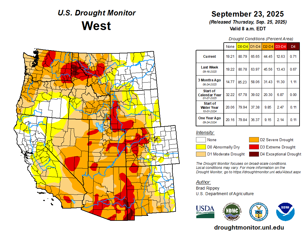
West
Worsening drought in parts of the Northwest contrasted with locally heavy showers farther south. In the Southwest, those showers led to targeted drought improvement, but also resulted in spotty flash flooding in some of the nation’s driest locations, including Death Valley, California. Farther north, the U.S. Department of Agriculture reported that statewide topsoil moisture (on September 21) was rated 92% very short to short in Washington, along with 80% in Oregon. Winter wheat planting has been advancing quickly in Washington and was 58% complete by September 21. Any fall-sown Northwestern crops will soon need moisture for proper autumn establishment. Currently, at least 45% of the rangeland and pastures in all Northwestern States were rated very poor to poor, led by Montana (61%)…

Looking Ahead
Rainfall will continue to shift southward and eastward, resulting in a boost in soil moisture in many areas experiencing short-term drought. Five-day rainfall should reach 1 to 3 inches or more across much of the eastern U.S., as well as portions of the Gulf Coast States. Once rain ends across the Plains and Midwest, dry weather will prevail for the next several days. Dry weather should extend into the Northwest until late in the weekend, when showers will arrive along the northern Pacific Coast. Elsewhere, a late-season monsoon surge will result in unusually heavy showers for this time of year in parts of the Southwest, leading to another round of possible flash flooding.
The NWS 6- to 10-day outlook for September 30 – October 4 calls for near- or above-normal temperatures nationwide, with the north-central U.S. having the greatest likelihood of experiencing warmer-than-normal weather. Meanwhile, near- or above-normal precipitation across most of the country should contrast with drier-than-normal weather in a band stretching from the southern Plains into the Great Lakes region and the Northeast.
