#Drought news September 18, 2025: Across #Colorado and #Wyoming, widespread precipitation fell across the mountainous regions, prompting some drought relief across N.W. Wyoming and much of W. Colorado

Click on a thumbnail graphic to view a gallery of drought data from the US Drought Monitor website.

Click the link to go to the US Drought Monitor website. Here’s an excerpt:

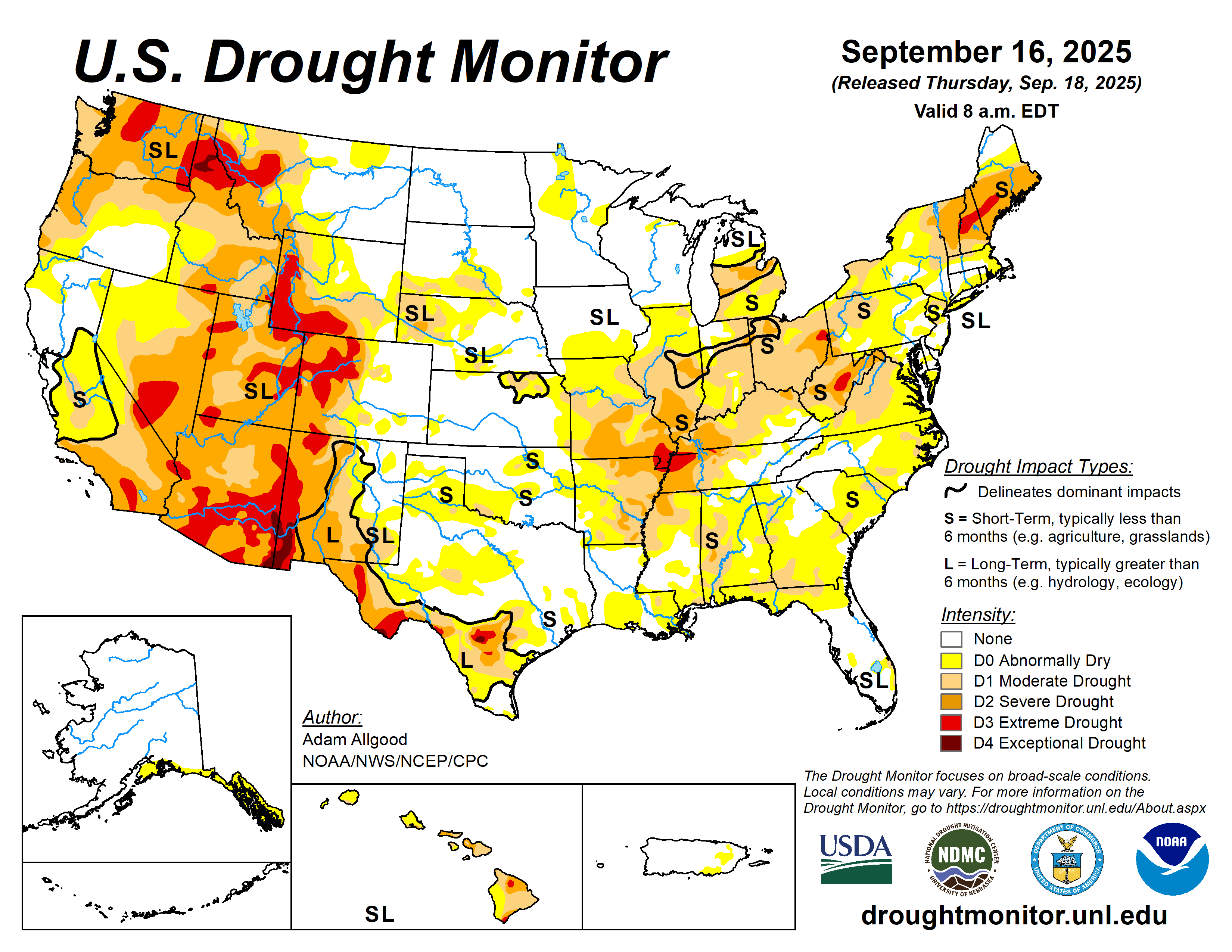
This Week’s Drought Summary

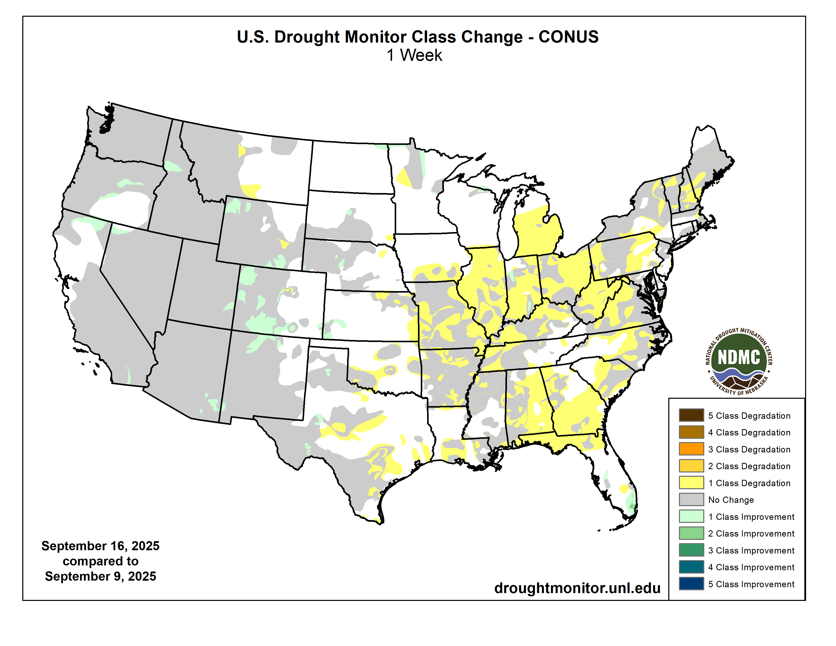
Another week of scant rainfall led to widespread expansion of abnormal dryness (D0) and moderate (D1) to severe (D2) drought across the Midwest, Southeast, and Northeast regions. Extreme (D3) drought was introduced near the confluence of the Mississippi and Ohio Rivers, as well as eastern Ohio and portions of West Virginia. Some expansion of drought and abnormal dryness also occurred across portions of Texas, Oklahoma, and the eastern Plains, while moderate to heavy precipitation brought 1-category improvements to localized areas in western Texas, northward through western Nebraska. Along the Rockies, above-average precipitation yielded fairly widespread 1-category improvements. Above-normal rainfall for the time of year fell across northern California and the Intermountain West, resulting in modest 1-category improvements ahead of the new water year. Enhanced monsoonal moisture was focused across New Mexico and southeastern Arizona, sparking a 1-category reduction from exceptional (D4) drought conditions in the area. 7-day temperature anomalies were above-normal across the Northern Tier and Midwest, exacerbating the rapid onset of impacts, while below-normal temperatures across the east helped to slow the deterioration somewhat. Widespread drought conditions continued for Hawaii, with a 1-category deterioration to extreme (D3) drought on the southern Big Island. Alaska and Puerto Rico remain drought free…
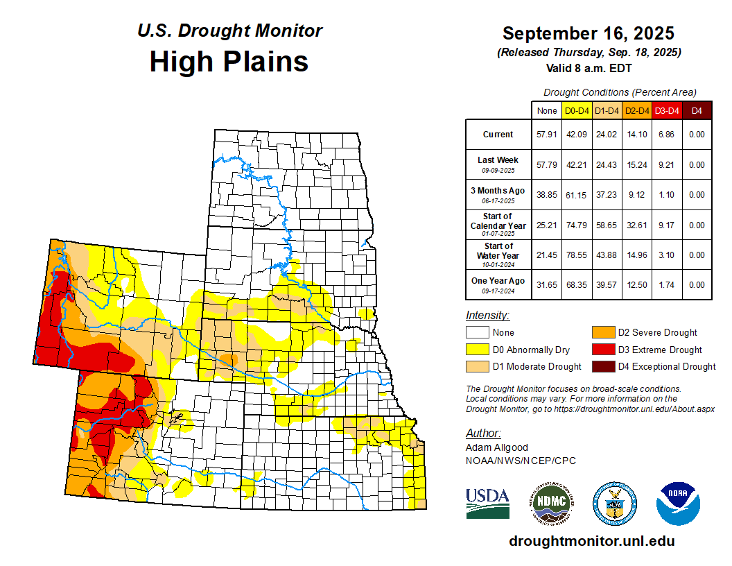
High Plains

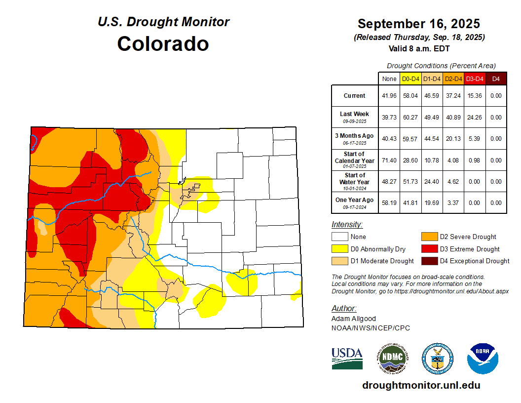
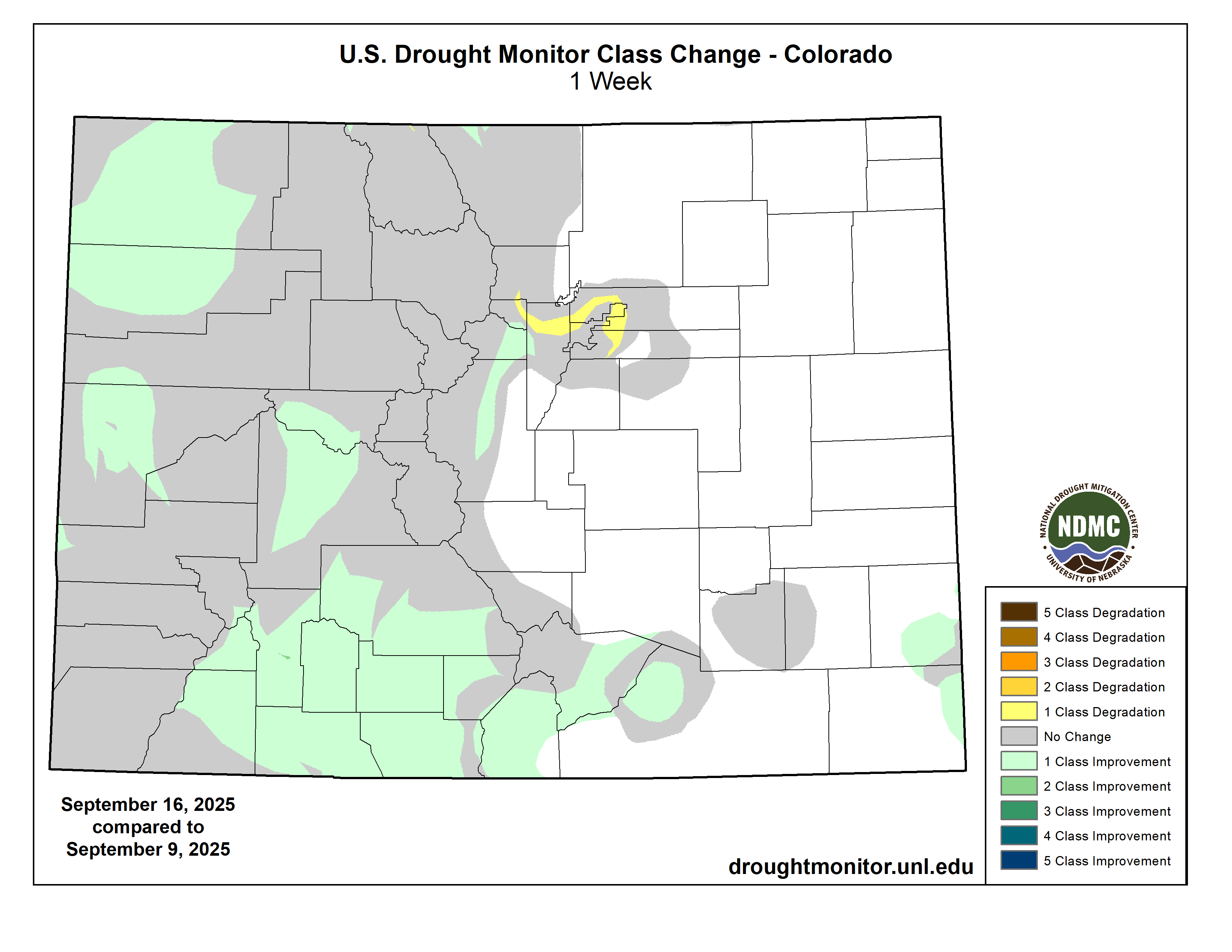
Widespread rainfall overspread western Kansas, Nebraska, western South Dakota, and North Dakota during the past week, resulting in modest reductions of abnormal dryness (D0) and moderate drought (D1) across western Kansas and central Nebraska. The highest rainfall totals fell across the Dakotas in regions that are currently drought-free. Drier conditions and warm temperatures prevailed across portions of eastern Kansas and northeastern Nebraska, with declining SPI values warranting some expansion of abnormal dryness (D0). Across Colorado and Wyoming, widespread precipitation fell across the mountainous regions, prompting some drought relief across northwestern Wyoming and much of western Colorado, including reductions in coverage of extreme to severe (D3 to D2) drought conditions…
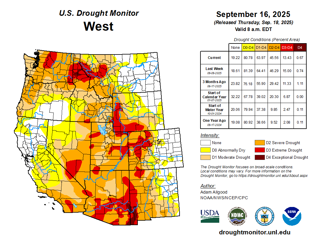
Colorado Drought Monitor one week change map ending September 16, 2025.

West

Fairly widespread early season precipitation prompted modest reductions to drought coverage across the Northwest, where widespread severe to extreme (D2 to D3) drought conditions remain entrenched. While much above normal for the time of year, accumulations were fairly modest compared to amounts that can occur during the core weeks of the wet season during the winter. Across the Southwest, robust monsoonal moisture warranted a small reduction in coverage of exceptional drought (D4) across southeastern Arizona and southwestern New Mexico. Further west, improving conditions due to early season precipitation across southern California warranted a reduction of abnormal dryness (D0) across Imperial County. Elsewhere, the drought depiction remained largely unchanged…

South

Spotty convection late in the week brought localized rainfall to portions of Arkansas, northern Mississippi, and Louisiana, but accumulations were generally insufficient to change existing drought conditions. Where rain did not fall, expansion of abnormal dryness (D0) and moderate to severe drought (D1 to D2) occurred across the lower Mississippi Valley and the Tennessee Valley. More widespread rainfall, some locally heavy, overspread western and northern Texas, western Oklahoma, and far southern Texas. Most of this precipitation accumulated outside of existing areas of abnormal dryness or drought, though small 1-category improvements occurred across portions of western Texas, and the rainfall helped prevent further degradations. Drier conditions and seasonably warm temperatures warranted some degradations across central, southern, and eastern Texas, as well as the eastern two thirds of Oklahoma…

Looking Ahead

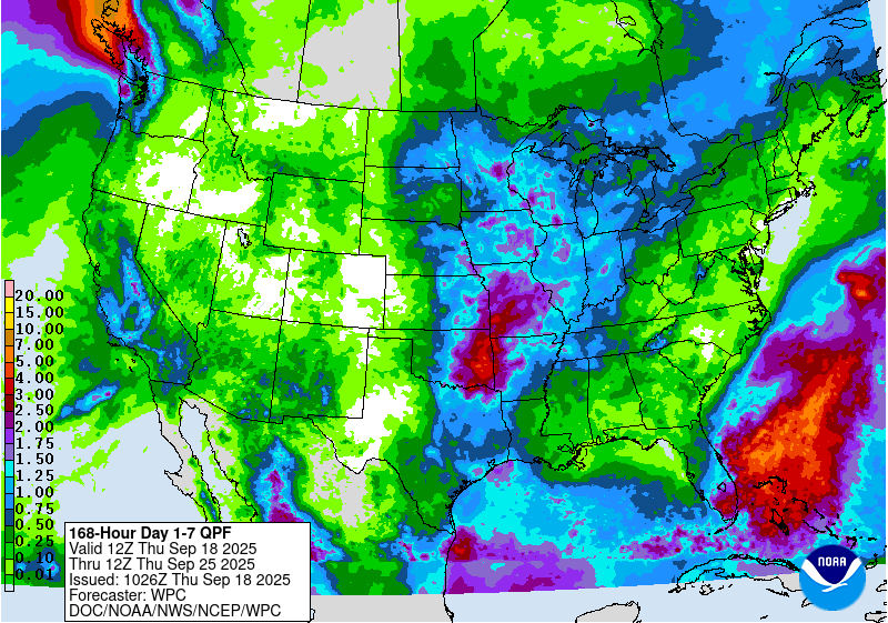
A frontal system is forecast to help generate widespread precipitation across the Plains states and portions of the Midwest along and west of the Mississippi River during the upcoming week. This rainfall has a potential to bring much needed relief to regions that have experienced rapidly worsening drought conditions. In contrast, lighter rainfall is forecast for the Ohio Valley and East, which, coupled with warmer temperatures, may further exacerbate conditions in areas that have been experiencing rapid drought onset. Another week of heavy rainfall is favored for southern Florida, with drier conditions favored across the Piedmont region of the Southeast. Wet conditions early in the week across the Southwest will give way to a drier pattern overall through the end of the week, though chances of rain will increase by the end of the week across the Northwest.

The Climate Prediction Center’s 6-10 day outlook valid for September 23 – 27 favors above-normal temperatures across the entire contiguous United States, with the highest probabilities extending across the north-central states. Above-normal precipitation is favored across the West Coast and Intermountain West, and across much of Texas and the lower Mississippi Valley and lower Ohio Valley. In contrast, below-normal precipitation is favored along the Rockies and eastward across much of the Great Plains, upper-Midwest, and the western Great Lakes region. Across Alaska, below-normal temperatures are favored for the western half of the state, with above-normal favored for the Panhandle. Near to below-normal precipitation is forecast. For Hawaii, both above-average temperatures and above-average precipitation are favored.

US Drought Monitor one week change map ending September 16, 2025.

White House to pull back Bureau of Reclamation nomination: Ted Cooke, a longtime #Arizona water official, said he’d been told his nomination will be rescinded — EENews.net #ColoradoRiver #COriver #Aridification

Ted Cooke and Tom Buschatzke: Photo credit: Arizona Department of Water Resources

Click the link to read the article on the EENews.net website (Jennifer Yachnin). Here’s an excerpt:

September 17, 2025

The White House plans to pull back its nomination of a former a veteran Arizona water official to lead the Bureau of Reclamation, leaving the agency without permanent leadership nine months into President Donald Trump’s second term. Ted Cooke, a former top official at the Central Arizona Project, told POLITICO’s E&E News on Wednesday that he has been informed his nomination will be rescinded.

ā€œThis is not the outcome I sought, and I’ll leave it at that,ā€ said Cooke in a message.

[President] TrumpĀ tapped CookeĀ to lead the agency in June, and the selection drew praise from both environmental advocates and some state officials who pointed to Cooke’s knowledge of the Colorado River Basin. The Senate Energy and Natural Resources had not yet considered Cooke’s nomination. Interior and Reclamation have been involved in negotiations for a new long-term operating plan among the seven states that share the Colorado River…Although it is not unusual for Reclamation to be without permanent leadershipĀ until late in the first yearĀ of a new president term, the Colorado River negotiations put more pressure on the White House to fill the post.Ā 

Cooke spent more than two decades at the Central Arizona Project before stepping down as its general manager in early 2023, which distributes Colorado River water to Maricopa, Pinal and Pima counties.

ā€˜No One Comes Out of This Unscathed’: Experts Warn That #ColoradoRiver Use Needs Cutting Immediately — Wyatt Myskow (InsideClimateNews.org) #COriver #aridification

Glen Canyon Dam creates water storage on the Colorado River in Lake Powell. Credit: U.S. Bureau of Reclamation

Click the link to read the article on the Inside Climate News website (Wyatt Miskow):

September 15, 2025

A new report finds that Lakes Mead and Powell, the nation’s largest reservoirs, could store just 9 percent of their combined capacity by the end of next summer.

Consumption of Colorado River water is outpacing nature’s ability to replenish it, with the basin’s reservoirs on the verge of being depleted to the point of exhaustion without urgent federal action to cut use, according to a new analysis from leading experts of the river.

TheĀ analysis, published Thursday [September 11, 2025], found that if the river’s water continues to be used at the same rate and the Southwest sees another winter as dry as the last one, Lakes Mead and Powell—the nation’s two largest reservoirs—would collectively hold 9 percent of the water they can store by the end of next summer. After enduring decades of overconsumption of the river’s water, the lakes would have just under 4 million acre feet of water in storage for emergencies and drier years when demand can’t be met. Every year, roughly 13 million acre feet is taken from the river for drinking water and human development across the region, with conservative forecasts estimating roughly 9.3 million acre feet of inflow next year.Ā 

The report is stark in its assessment of the situation: Current Colorado River levels require ā€œimmediate and substantial reductions in consumptive use across the Basinā€ or Lake Powell by 2027 would have no storage left and ā€œwould have to be operated as a ā€˜run of riverā€ facilityā€ in which only the inflow from the river could be released downstream.Ā 

ā€œThe River recognizes no human laws or governance structures and follows only physical ones,ā€ the report’s authors wrote. ā€œThere is a declining amount of water available in the Colorado River system, primarily caused by the effects of a warming climate—longer growing seasons, drier soils, and less efficient conversion of the winter snowpack into stream flow. Although American society has developed infrastructure to store the spring snowmelt and make that water available in other seasons to more completely utilize the variable runoff, the Colorado River watershed produces only a finite volume of water, regardless of how many dams exist.ā€

The lifeblood of the American Southwest, the Colorado River’s water flows from Wyoming to Mexico, enabling the region’s population and economies to develop. The damming of the river has diverted water to booming metropolises like Los Angeles and Phoenix while also supporting the U.S.’s most productive agricultural areas and powering some of the its largest hydroelectric dams. In total, the river supplies seven states, 30 tribes and 40 million people with water.

The compact that divvied up the river’s water a century ago overestimated how much actually flowed through it, and climate change has diminished the supply even further. The melting snowpack that runs off mountains in the spring to feed the river has declined, shrinking the river and its storage reservoirs during decades of drought. The seven states that take Colorado River water are divided into two factions engaged in tense conversations about its future and how cutbacks should be distributed. Current guidelines for managing the river in times of drought are set to expire at the end of next year, and new ones are legally required to take their place, but negotiations between states, tribes and other stakeholders over the sharing of the necessary cuts in water usage are at an impasse. 

But if current conditions persist, further cutbacks on the river won’t be able to wait until those negotiations are finished, the report’s authors find, and they urged the Department of the Interior ā€œto take immediate action.ā€

ā€œLet’s hope that we are all wrong and that it snows like hell all winter and runoff is wonderful and we buy ourselves some time and additional buffer,ā€ said Kathryn Sorensen, director of research for Arizona State University’s Kyl Center for Water Policy and one of the report’s co-authors. ā€œBut of course, it never makes sense to plan as if it’s going to snow, and we have to deal with what is a realistic but not worst-case scenario and take responsible actions.ā€

Adding to the issue is the status of the infrastructure that enables the river to be diverted and stored for use. For example, the researchers write, it was thought that anything above what’s known as ā€œdead poolā€ā€”a water level below the reservoirs’ lowest outlets that can pass water through the dams—was ā€œactive storage.ā€ But testing last year from the Bureau of Reclamation, the federal agency overseeing the river and its dams, found that those outlets can only be safely used at water levels higher than previously thought and cannot be used for long durations.

Margaret Garcia, an associate professor at ASU’s School of Sustainable Engineering and the Built Environment, who was not a part of the study, said the analyses makes clear the ā€œreality of dead pool is within sightā€ for the basin’s reservoirs, even without considering the possibility of having an extremely dry year.

She likened the reservoirs to having a savings account with a bank. ā€œWhen you have a savings account, you have some time to scramble and figure things out,ā€ Garcia said. ā€œBut if you’ve already drawn down your savings account and then  [you’re laid off] and you never filled it back up at least a little bit, you’re in for a really tough situation.ā€

And just like a savings account, Garcia said, a reservoir isn’t much good if it can’t generate hydropower or store water. 

Sorensen said the secretary of the Interior, Doug Burgum, has broad authority to act to protect critical infrastructure in both of the river’s basins. The question is what those actions should be.

ā€œThe solutions are there,ā€ she said. ā€œThe solutions are known. They’re just extraordinarily painful to implement. ā€œ

State negotiators have worked this year to determine how to manage the river after 2026, Sorensen said, but the buffer of water stored in reservoirs ā€œthat we’re relying on to kind of get us through the negotiations and these difficult times is potentially much smaller than maybe was commonly understood.ā€

ā€œNo one comes out of this unscathed,ā€ she said. 

Map credit: AGU