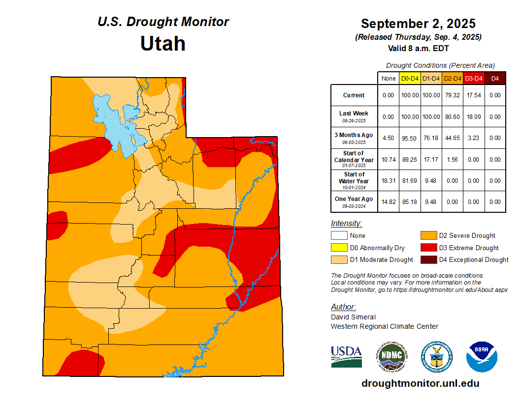
It’s common for summer to be Utah’s dry season. But 2025 took things to another level. The main culprit was the missing monsoon — or as assistant state climatologist Jon Meyer designated it, a “non-soon”…Salt Lake City received just 0.35 inches of rain from June 1 to Aug. 24 — putting it on pace for the city’s fourth driest summer on record. That included 48 straight days with zero precipitation at the airport during the peak of summer heat from early July to mid-August. That’s the city’s longest such streak since 1963, and its sixth longest on record. Other Utah communities fared even worse. By Aug. 24, Bountiful, Provo and Logan were all on track for their driest summers on record. Meteorological summer runs from June through August…
Some monsoon moisture finally broke through in the last week of August. Communities from Salt Lake City to St. George to Logan got more rain in that one week than they’d received the entire summer up to that point. Still, it wasn’t nearly enough to claw Utah out of its summer deficit…Salt Lake City ended up with 1.1 inches of rainfall from June to August. That’s around half of its historical average from 1991-2020 and low enough to make it the city’s 29th driest summer in records that date back to 1874. Elsewhere, the late monsoon offered even less of a boost. Provo ended the season with less than a half-inch of rain, its third driest summer on record. Alta Ski Area in Little Cottonwood Canyon also ended up having its third driest summer, with just 1.29 inches of rain. And despite more than quadrupling its summer rainfall total in the final days of the month, Bountiful still ended the season with just under an inch of rain, making 2025 the city’s sixth driest summer on record. Ultimately, the late rains merely moved Utah from extremely dry to very dry, said National Weather Service senior meteorologist Monica Traphagan…Even in southern Utah, where the monsoon was a bit stronger, St. George ended up with only 0.66 inches of rain for the season — far below its historical average of 1.73 inches. And more than half of the summer rain St. George received came in the final days of August…
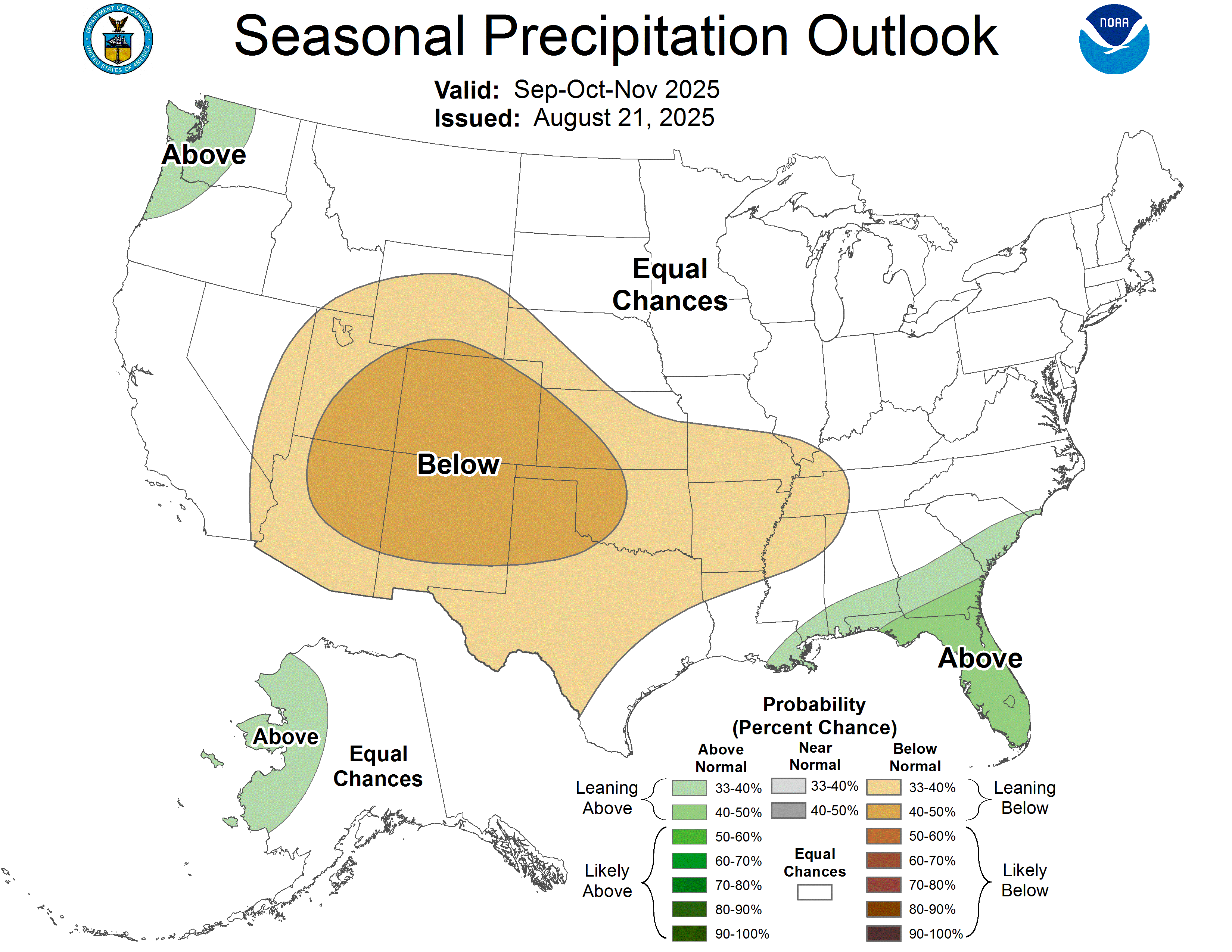
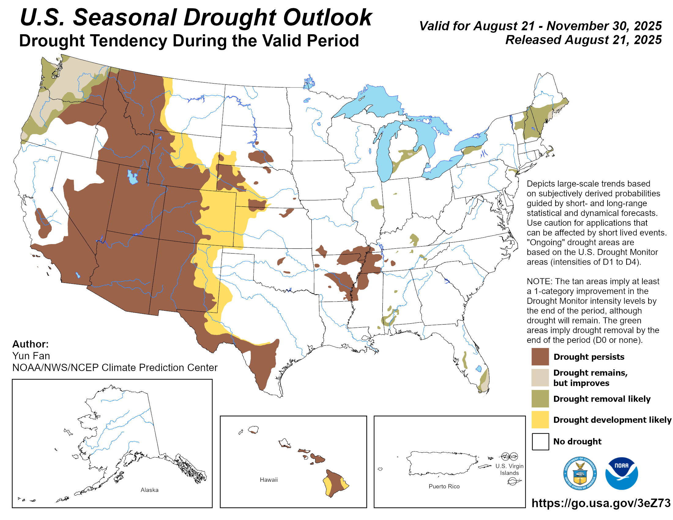
The seasonal forecast for fall doesn’t offer much optimism, either. The National Oceanic and Atmospheric Administration’s outlook calls for above-average temperatures and below-average precipitation across the state through November.
Funding for water in Colorado is seeing a surge, despite the state budget crisis, with cash from sports betting hitting a new high this year.
The gaming initiative brought in $37 million for the fiscal year that ended June 30, according to the Colorado Division of Gaming. That represents a nearly 21% increase from last year, when tax revenue came in at $30.4 million. But water projects statewide still are at risk as the legislature gears up for a special session next week to close a new $1 billion gap in Colorado’s budget.
Approved by voters in 2019, the sports betting tax is used to fund Colorado’s Water Plan.
Back then, early legislative forecasts for revenues that might flow from the program topped out at $29 million.
But the program has grown in popularity and lawmakers have, in recent years, expanded the amount of revenue from the gaming tax that can flow to water programs and also removed a tax break for free bets.
The Colorado Water Plan is run by the Colorado Water Conservation Board, the state’s lead water planning agency.
In addition to sports betting cash, the CWCB is financed using income derived from severance taxes, the state’s general fund, and other sources.
The agency sends millions of dollars across the state each year to help pay for water-saving programs for cities and farms, habitat restoration programs, storage projects, land use planning, irrigation system repairs and the purchase of environmental water supplies for water-short streams.
On Aug. 21, Gov. Jared Polis will convene a special session during which lawmakers will look for ways to fill a roughly $1 billion budget shortfall triggered by new federal tax cuts, which have an impact on Colorado’s tax collections as well.
The sports betting tax program, by law, can’t be tapped by lawmakers next week to fill budget holes. But how the CWCB and water programs financed through other unprotected funds will fare as budgets are trimmed isn’t clear.
Millions of dollars for water projects have already been committed this year, including $20 million in cash the CWCB set aside to help pay for the purchase of the historic Shoshone water rights on the Colorado River.
The CWCB did not respond to an interview request to discuss potential impacts on water projects due to the budget crisis. It said via email that it did not anticipate any impacts to its fiscal year 2026 budget. The fiscal year began July 1.
House Speaker Julie McCluskie, a Democrat from Dillon, said the financial outlook is bleak for all state agencies, including the CWCB.
“We are still too early in the process to determine exactly what water-related funding is at risk. However, this GOP-caused $1 billion hole in our budget will require some tough decisions, and nearly everything is on the table,” McCluskie said via email.
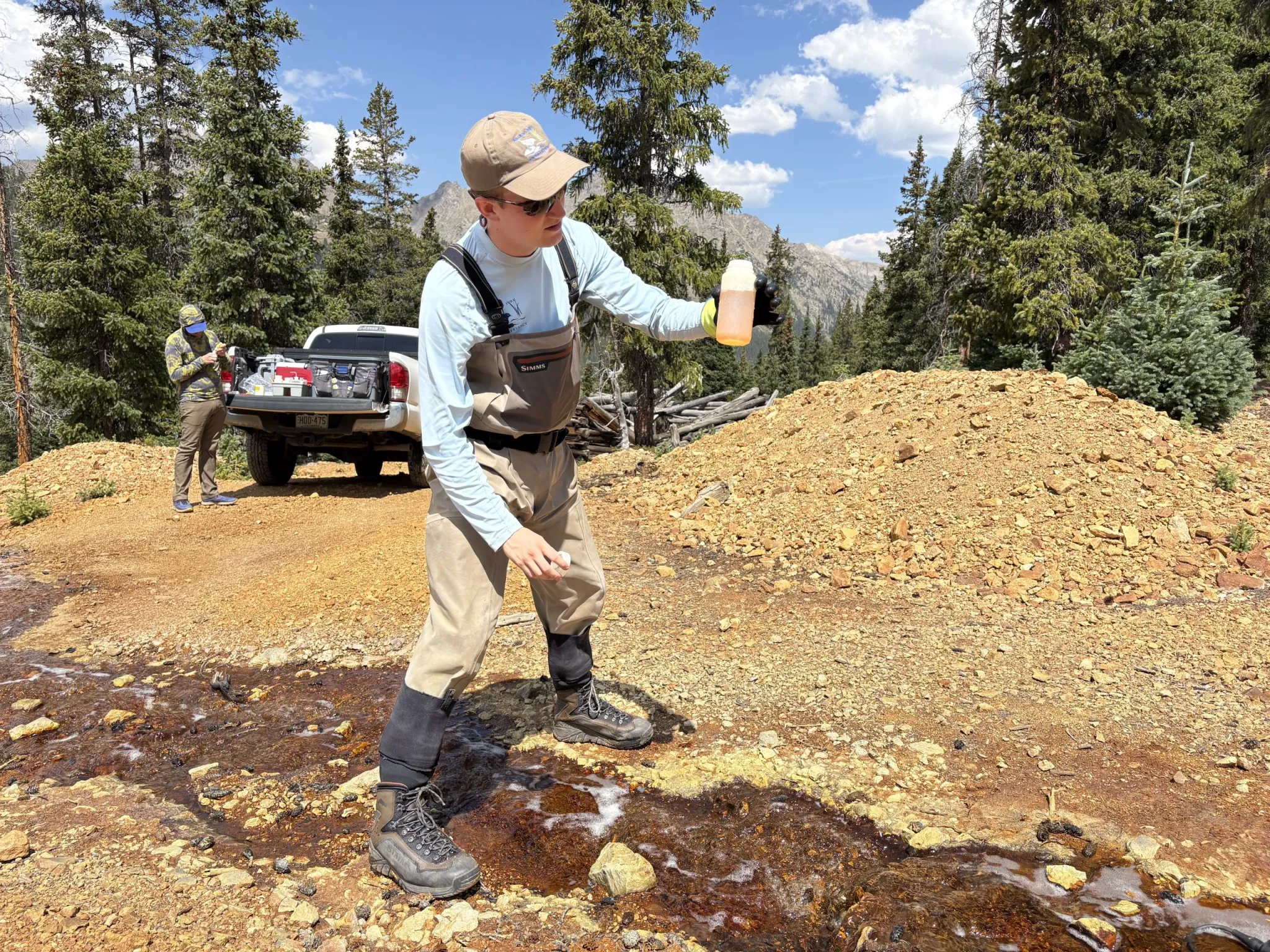
From left, Bryan Daugherty with Pitkin County Environmental Health, Matthew Anderson and Chad Rudow, both with the Roaring Fork Conservancy. The three spent Wednesday, Aug. 13 taking water quality samples at 14 sites from Lincoln Creek, the Ruby Mine outflow and the mineralized tributary. CREDIT: HEATHER SACKETT/ASPEN JOURNALISM
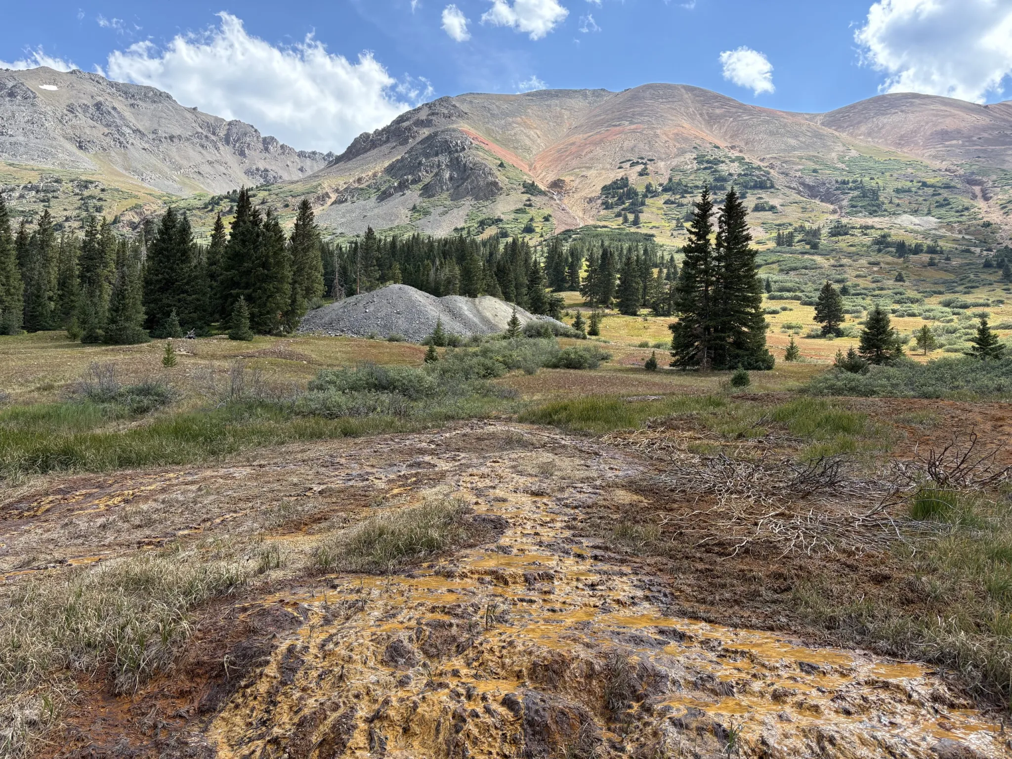
High above Aspen at 11,400 feet, past the ghost town of Ruby, at the end of a rough dirt road surrounded by willows and ramshackle cabins, Lincoln Creek runs clean and clear.
The mountain stream is barely more than a trickle at its headwaters, but it still supports fish that dart and hide in the cool shadows. But just a few hundred yards downstream, the creek begins to turn foul.
First by what appears to be a small tributary or groundwater that flows into the creek and leaves a white residue on the rocks, an indication of aluminum. Then comes the runoff from the abandoned Ruby Mine, which leaves a hardened orange crust on the ground where it joins the creek. Just downstream of the mine is the site where experts say the majority of the aluminum, copper, zinc and iron contamination is entering Lincoln Creek: the “mineralized tributary.”
Although it’s hard to pinpoint the exact source — the entire mountainside above the creek on the east side is stained orange, suggesting the widespread presence of metals — a group of scientists, government officials and local nonprofits are ramping up efforts to better understand the workings of the Lincoln Creek watershed and what can be done to improve its water quality.
On Wednesday [August 13, 2025], a team from the Roaring Fork Conservancy and Pitkin County spent the day collecting water quality samples from Lincoln Creek, the Ruby Mine discharge, the mineralized tributary and points downstream. It was the third time this summer scientists have collected water samples from the creek, and it is part of an overall effort with Colorado Parks and Wildlife and University of Colorado Boulder to test and monitor the area.
“I think one of our big goals is really to continue to fill in the data,” said Chad Rudow, water quality program manager with the Roaring Fork Conservancy. “As I like to tell people, science takes time. To even apply statistical analysis to it, you need to have a fair bit of data.”
Matthew Anderson, left, a water quality technician with the Roaring Fork Conservancy, and Bryan Daugherty with Pitkin County Environmental Health take samples from Lincoln Creek on Aug. 13, 2025. The creek has such high concentrations of some metals that it is toxic to aquatic life. CREDIT: HEATHER SACKETT/ASPEN JOURNALISM
Local residents, government agencies and environmental groups have long been concerned about Lincoln Creek, which, according to a report from the Environmental Protection Agency, is toxic to aquatic life. The tributary of the Roaring Fork River has been under increased scrutiny in recent years as fish kills and discoloration of the water downstream of Grizzly Reservoir have become more frequent.
“We’re worried about the aquatic health of the river,” said Bryan Daugherty, environmental health specialist with Pitkin County. “There certainly could be human impacts if it got really bad, but at this point it’s really the aquatic life that we’re concerned with.”
Since early 2024, the ad hoc Lincoln Creek Workgroup has been meeting to figure out what to do about the contaminated creek. Bolstered by a state grant of $100,000, the group is increasing water quality testing. The team of scientists has grown the number of testing sites this year from seven to 14 and are focusing current efforts on what’s happening above Grizzly Reservoir.
Pitkin County Healthy Rivers, whose mission is to maintain and improve water quality and quantity in the Roaring Fork River basin, is playing a crucial role by securing grant money and working with consultant LRE Water on phase II of the data collection and modeling project, which will cost $207,000. Colorado Parks and Wildlife staff have also set up conductivity loggers, which measure how well water conducts electricity, and trail cameras to take photos of Lincoln Creek.
“It’s definitely a team effort with a lot of different groups playing an important role in adding different pieces to the overall puzzle,” Rudow said.
The uppermost reaches of Lincoln Creek run clean and clear, and support aquatic life. Just a few hundred yards downstream, metals contamination begins to enter the creek. CREDIT: HEATHER SACKETT/ASPEN JOURNALISM
The outflow from the Ruby Mine produces an orange crust on the ground. The mine drainage flows into Lincoln Creek. CREDIT: HEATHER SACKETT/ASPEN JOURNALISM
Highly acidic concentrations
The process of metals leaching into streams can be both naturally occurring and caused by mining activities. In both cases, sulfide minerals in rock come into contact with oxygen and water, producing sulfuric acid. The acid can then leach the metals out of the rock and into a stream, a process known as acid rock drainage, which is happening in other mountainous regions of Colorado and around the West.
Prior to mining, snowmelt and rain seep into natural cracks and fractures, eventually emerging as a freshwater spring (usually). Graphic credit: Jonathan Thompson
The metals concentrations from acid rock drainage seems to be increasing in recent years and may be exacerbated by climate change as temperatures rise. But because the vast majority — 98.5% of the copper, according to the EPA report — of the contamination is from natural sources and not related to the Ruby Mine, the EPA is not authorized to clean it up. That leaves local and state agencies, and nonprofit organizations to fill the gap.
Wednesday’s testing revealed a pH of 7.29 on the upper reaches of Lincoln Creek (7 is considered neutral); 6.4 below the Ruby Mine and 3.2 below the confluence of the mineralized tributary. The pH scale is logarithmic, meaning a decrease of one whole number equals a 10-fold increase in acidity.
“The highly acidic concentrations that we’re seeing up here is part of the process that’s speeding up mobilizing the metals from the rock into the stream system,” Rudow said.
Scientists also collected data about dissolved oxygen, water temperature and salinity. The water samples are then shipped to a lab in Fort Collins, which tests for metals concentrations.
Rudow and others also used Wednesday’s trip to the high alpine as a chance to scout spots for an upcoming synoptic survey. At the request of LRE, scientists will pick a day this fall to take water quality samples and flow measurements at points along the entire length of the creek to better understand the sources of contamination. But only year-round tributaries — not seasonal snow-fed seeps — will be included.
“We’re pushing that into September because what we really want to focus on for that project is those year-round streams that are coming into Lincoln Creek,” Rudow said. “(LRE) is going to take all of this data and ultimately build a model to show what’s going on in the creek and how these different inputs are influencing the creek.”
Water quality sampling in 2024 focused on Grizzly Reservoir and points downstream to better understand the impacts of a dam repair project. Last summer the reservoir was drained for work on the dam, and a slug of sediment-laden, orange-colored water was released downstream, alarming Aspen residents.
Matthew Anderson, a water quality technician with the Roaring Fork Conservancy, takes a sample of water from the mineralized tributary on Aug. 13, 2025. Experts have determined this is a major source of the metals contamination on Lincoln Creek. CREDIT: HEATHER SACKETT/ASPEN JOURNALISM
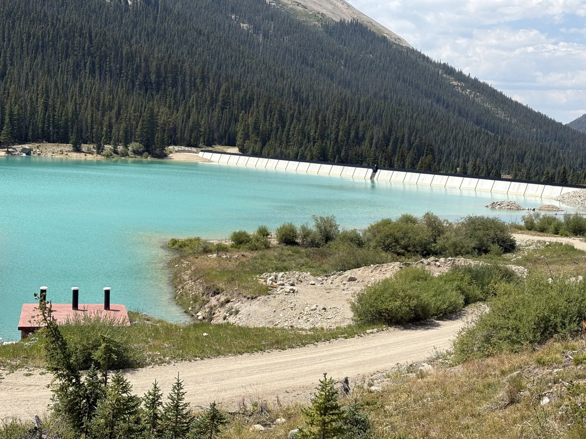
Grizzly Reservoir, a forebay that collects water to send through the Twin Lakes Tunnel to the Front Range, sits in the middle of the Lincoln Creek watershed and connects water users on both sides of the Continental Divide. The reservoir was drained during the summer of 2024 so the dam could get a new face. CREDIT: HEATHER SACKETT/ASPEN JOURNALISM
Both sides of the divide
The water quality issues on Lincoln Creek bind together water users on both sides of the Continental Divide. Lincoln Creek feeds into the Twin Lakes Reservoir and Canal Company’s transmountain diversion system, in which Grizzly Reservoir is used as a collection pond before sending water through the Twin Lakes Tunnel to the Front Range, where it is used primarily in cities, including for drinking water. Colorado Springs Utilities owns about 55% of the water in the Twin Lakes system, while about 35% goes to the Pueblo area.
A map of the Independence Pass Transmountain Diversion System, as submitted to Div. 5 Water Court by Twin Lakes Reservoir and Canal Co.
Twin Lakes President Alan Ward, who also works as a water resources manager for Pueblo Water, is a member of the Lincoln Creek workgroup. Each organization contributed $5,000 toward the LRE Phase II work.
Ward said next summer Grizzly Reservoir will be drained again so Twin Lakes can work on the damaged outlet works that release water downstream to Lincoln Creek. To avoid another sediment release, the company will create a small basin with cofferdams where the last 10-12 acre-feet at the bottom of the reservoir can settle out before sending it downstream or through the Twin Lakes Tunnel.
Ward said impacts to drinking water aren’t much of a concern for the east side of the divide because the water from Lincoln Creek is diluted by the 141,000-acre-foot Twin Lakes Reservoir, which stores water from multiple sources.
“I think for us the concerns are more on Lincoln Creek itself because Grizzly Reservoir is right in the middle of it,” Ward said. “We just want to stay really engaged on this to figure out the water quality issues and how they impact Grizzly Reservoir itself and if there are ways to mitigate the problem.”
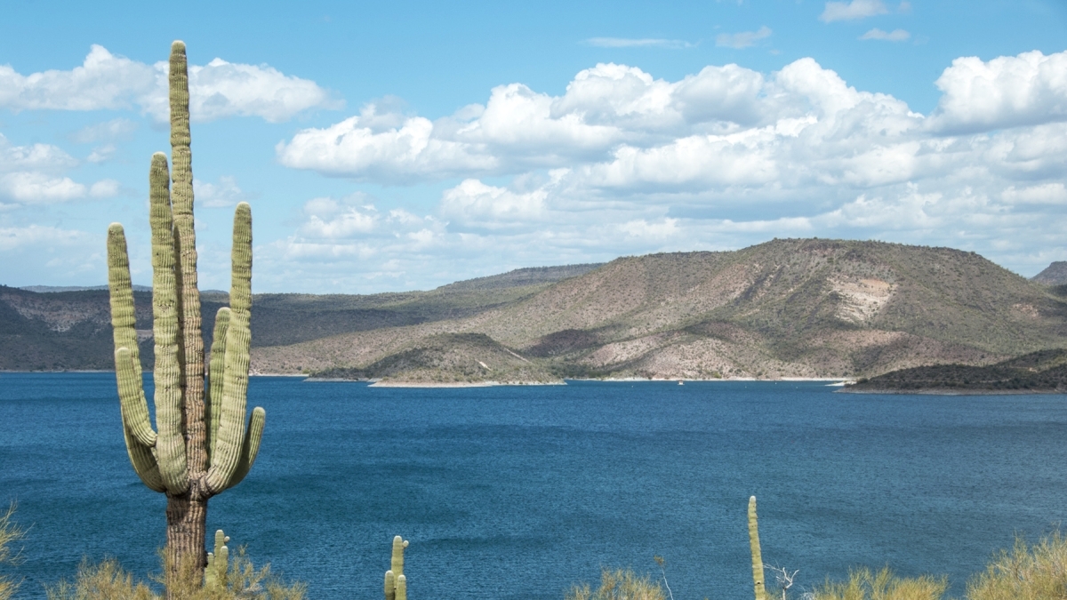
Lake Pleasant (pictured), located north of Phoenix, serves as the Central Arizona Project’s water storage reservoir, as well as being a popular recreational amenity. Water shortages are impacting Colorado River basin reservoirs such as Lake Mead in Nevada and Lake Powell, which stretches across northern Arizona and southern Utah. Environmental changes throughout the Southwest are presenting challenges to maintaining flows. Photo courtesy of Central Arizona Project
Arizona cities are joining together under one banner to advocate for Arizona in ongoing Colorado River talks…At a discussion on Wednesday, Phoenix Mayor Kate Gallego emphasized the need to get these negotiations right for the sake of Arizona’s future.
“For political reasons as well as drought, it [the river] is under threat, and we have to come together and tell the story of the really important work that we as the cities in the Central Arizona Project service territory are doing to protect our water,” Gallego said.
She is one of 23 Arizona mayors in the bipartisan coalition so far…The goal of the new Arizona coalition is to unite Colorado River water users and showcase the state’s ongoing water conservation efforts. Brenda Burman is the executive director of the CAP.
“I think when people have looked into our state from the outside, they haven’t seen us standing together. They’ve seen us making our own announcements, and that’s not how we feel, so we wanted to have a chance to be able to show it,” Burman said.
Burman said the coalition is only in its first phase and will expand to include other Arizona water users, like farms.
Extensive farmland receives irrigation water and 80 percent of the Arizona population receives municipal water through the Central Arizona Project, a massive distribution system in the state that Brad Udall’s father and uncle worked to establish. Accelerating evaporation in diversion systems such as this is a top concern resulting from climate change. Credit: Colorado State University