sSeptember 26, 2023 – Small cubes of the PolyEster Covalently Adaptable Network (PECAN) resin used to understand their depolymerization kinetics. (Photo by Werner Slocum / NREL)
Click the link to read the release on the NREL website:
August 22, 2024
Researchers at the U.S. Department of Energy’s National Renewable Energy Laboratory (NREL) see a realistic path forward to the manufacture of bio-derivable wind blades that can be chemically recycled and the components reused, ending the practice of old blades winding up in landfills at the end of their useful life.
The findings are published in the new issue of the journal Science. The new resin, which is made of materials produced using bio-derivable resources, performs on par with the current industry standard of blades made from a thermoset resin and outperforms certain thermoplastic resins intended to be recyclable.
The researchers built a prototype 9-meter blade to demonstrate the manufacturability of an NREL-developed biomass-derivable resin nicknamed PECAN. The acronym stands for PolyEster Covalently Adaptable Network, and the manufacturing process dovetails with current methods. Under existing technology, wind blades last about 20 years, and afterward they can be mechanically recycled such as shredded for use as concrete filler. PECAN marks a leap forward because of the ability to recycle the blades using mild chemical processes.
The chemical recycling process allows the components of the blades to be recaptured and reused again and again, allowing the remanufacture of the same product, according to Ryan Clarke, a postdoctoral researcher at NREL and first author of the new paper. “It is truly a limitless approach if it’s done right.”
He said the chemical process was able to completely break down the prototype blade in six hours.
The paper, “Manufacture and testing of biomass-derivable thermosets for wind blade recycling,” involved work from investigators at five NREL research hubs, including the National Wind Technology Center and the BOTTLE Consortium. The researchers demonstrated an end-of-life strategy for the PECAN blades and proposed recovery and reuse strategies for each component.
“The PECAN method for developing recyclable wind turbine blades is a critically important step in our efforts to foster a circular economy for energy materials,” said Johney Green, NREL’s associate laboratory director for Mechanical and Thermal Engineering Sciences.
The research into the PECAN resin began with the end. The scientists wanted to make a wind blade that could be recyclable and began experimenting with what feedstock they could use to achieve that goal. The resin they developed using bio-derivable sugars provided a counterpoint to the conventional notion that a blade designed to be recyclable will not perform as well.
“Just because something is bio-derivable or recyclable does not mean it’s going to be worse,” said Nic Rorrer, one of the two corresponding authors of the Science paper. He said one concern others have had about these types of materials is that the blade would be subject to greater “creep,” which is when the blade loses its shape and deforms over time. “It really challenges this evolving notion in the field of polymer science, that you can’t use recyclable materials because they will underperform or creep too much.”
Composites made from the PECAN resin held their shape, withstood accelerated weatherization validation, and could be made within a timeframe similar to the existing cure cycle for how wind turbine blades are currently manufactured.
While wind blades can measure the length of a football field, the size of the prototype provided proof of the process.
“Nine meters is a scale that we were able to demonstrate all of the same manufacturing processes that would be used at the 60-, 80-, 100-meter blade scale,” said Robynne Murray, the second corresponding author.
The other coauthors, all from NREL, are Erik Rognerud, Allen Puente-Urbina, David Barnes, Paul Murdy, Michael McGraw, Jimmy Newkirk, Ryan Beach, Jacob Wrubel, Levi Hamernik, Katherine Chism, Andrea Baer, and Gregg Beckham.
The U.S. Department of Energy jointly funded the research through its Advanced Materials and Manufacturing Technologies Office and Bioenergy Technologies Office and their support of the BOTTLE Consortium. Additional research and funding will allow the investigators to build larger blades and to explore more bio-derived formulations.
NREL is the U.S. Department of Energy’s primary national laboratory for renewable energy and energy efficiency research and development. NREL is operated for DOE by the Alliance for Sustainable Energy LLC.
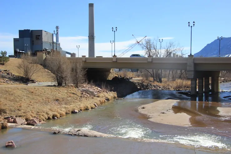
The Crossing Trails Wind Farm between Kit Carson and Seibert, about 150 miles east of Denver, has an installed capacity of 104 megawatts, which goes to Tri-State Generation and Transmission. Photo/Allen Best
Captain Kirk Hamilton snapped the above photo in the early morning hours of Feb. 3, 2021 on one of his aerial cloud seeding missions in the North Platte River Basin as part of the Jackson County pilot program over the Never Summer mountain range. (Kirk Hamilton, Weather Modification International)
An experiment to use a potentially more effective form of cloud-seeding in the North Platte Basin has been postponed indefinitely due to a shortage of planes and funding.
Cloud-seeding from airplanes is able to target specific storms, increasing the technology’s ability to generate more water, but it’s expensive and can cost up to three times more than ground-based programs, according to Andrew Rickert, weather modification program manager with the Colorado Water Conservation Board.
According to Barbara Vasquez, representative from the North Platte Basin to the Colorado Water Conservation Board, the North Platte is the only basin in Colorado where aerial cloud seeding has been conducted so far. Aerial cloud seeding has taken place in the Medicine Bow Range and the Sierra Madre mountains in Wyoming and Colorado, and in Colorado’s Never Summer range.
Rickert said such programs, despite their funding difficulties, are important in building a range of tools to increase water supplies. “With where the state is heading with climate change and drought, it is important for Colorado to do everything we can to bolster our snowpack. You can do as much storage and conservation as possible, but cloud seeding is the only way to physically add water to a system which is something we need to constantly be focused on.”
Cloud-seeding graphic via Science Matters
Cloud seeding involves dispersing a small amount of silver iodide into the atmosphere. The chemical acts as a “dust” particle allowing for water droplets or ice crystals to form in clouds and increase precipitation. Silver iodide is a naturally occurring compound that proponents of cloud seeding claim has no known harmful environmental effects.
The Jackson County Water Conservancy District partnered with the State of Wyoming and Colorado to take on a pilot project in the Never Summer Mountain Range from Cameron Pass to Willow Creek Pass in 2019.
The decision to suspend the North Platte aerial cloud-seeding program is partly due to limited availability of the aircraft from Wyoming, which supplied the plane for Colorado.
“We were working with the Wyoming [Water] Development Office which was paying to house the plane in Wyoming, so one of the problems we ran into was when there were seedable storms in both states, Wyoming always got preference,” Rickert said. “We were OK with that because we weren’t paying as much as them, but we were always playing second fiddle.”
Barry Lawrence, deputy director of planning with the Wyoming Water Development Office, said it was important for Wyoming to have first shot at airplane use. “It was written into our contract that the second priority was to go into Colorado if conditions were right.”
But Lawrence also said there are important benefits to the collaboration between the two states. “It’s important to start thinking watershed wide and not to bar political boundaries/state lines, but to think about the watersheds and what we can do to make the system whole.”
An additional reason for ending the pilot program is funding. In 2018, the Colorado Water Conservation Board approved a three-year, $150,000 grant for the aerial cloud seeding. It was renewed in 2021 for $225,000.
But that’s not much money when it comes to aerial cloud-seeding.
In 2022-2023, Wyoming spent $873,353.00. The Jackson County Water Conservancy District provided an additional $84,000.00 for operations conducted in Colorado’s Never Summer Mountains.
Jimmer Baller, president of the Jackson County water district, says that the program is just too costly right now for the county to take on without future funding from the state, but a revival of the program is not out of the question.
The CWCB’s Rickert said he is already working on increasing cloud seeding operations in the state and is considering how to support aerial seeding.
At the same time, the CWCB has seven permitted ground-based cloud seeding programs in the state from Vail to Grand Mesa, Rickert said.
The News:Agenda 47 — the Trump campaign’s platform — promises to develop 10 “Freedom Cities” on “empty” public lands in the Western United States if he is elected president.
Context: After Trump lost the 2020 election, the ultra-right-wing Heritage Foundation, along with help from dozens of former Trump administration staffers, set about to create Project 2025, a “playbook” for Trump just in case he managed to win this November’s presidential election.
Suffice it to say, Project 2025 is downright terrifying, as this excellent analysis by Michelle Nijhuis and Erin X. Wong reveals. In fact, it’s so weird — and so unpopular — that Trump has scrambled to distance himself from the whole endeavor, even claiming he doesn’t know anything about it or the people pushing it. That’s despite having praised the plan during a speech to the Heritage Foundation in 2022, despite the fact that many of the plan’s architects were in his administration, and despite the fact that his VP candidate J.D. Vance wrote the foreword to Heritage Foundation President Kevin Roberts’ new book.
But it doesn’t really matter, because Trump has his own authoritarian plan. It’s called Agenda 47, and serves as a template for the only slightly less creepy sounding Republican Party Platform. Agenda 47 is a bit shorter and less detailed than the 900-page Project 2025, which maybe makes it slightly more palatable to certain voters, but is equally nuts and just as scary. It vows to protect freedom of speech and cut funding for any school that teaches “inappropriate racial, sexual, or political content.” If elected, Trump and company would also “deport pro-Hamas radicals and make our college campuses safe and patriotic again.” Nothing fascist about that!
When it comes to public lands and the environment, Trump plans to do more of what he did last time he was in the White House — which is to say eviscerate environmental, health, safety, and worker protections in the name of “energy dominance” and corporate profit. The GOP platform also calls for using federal land for housing development. In theory this would bolster supplies of housing, thereby reducing prices and alleviating the housing crisis. The theory is deeply flawed, however, and though it may sound well-intentioned, ultimately it is just another ploy to privatize public land.
On this and other initiatives both Agenda 47 and the GOP platform (which are near-mirrors of each other) are scant on details. Hoping to learn more, I delved into Trump’s Agenda 47 archives and … holy crapoli! I had to wonder if Trump’s running for president or for the mayor of Crazytown — he’s the hands-down favorite for the latter.
Last March the Trump campaign unveiled its Agenda 47. Apparently it wanted to modernize the old “make America great again” slogan, so it went instead with:
Agenda47: A New Quantum Leap to Revolutionize the American Standard of Living.
Despite making no sense, you gotta give them credit for having a forward-looking slogan rather than the backward-looking one (which they have since reverted to, by the way). Indeed, it’s so forward-looking that they would “create a new American future.” Silly ol’ me thought that the future was always new on account of being, you know, the future and all.
And what will this new future look like? Freedom Cities!
You’re probably thinking: Why the hell would anyone want to build ten new cities in the drought-stricken West when there’s not enough water to go around now? What’s the point anyway? To make a few real estate developers incredibly rich? To realize a megalomaniac demagogue’s dream of building new cities to match some bizarre ideological vision? Will Trump resurrect Albert Speer to design the new cities?
Apart from the big picture flaws, this whole thing is riddled with wrong from start to finish. Let’s break it down:
“… open up the American frontier.” Are you friggin’ kidding me? Is this from the Trump campaign or the Andrew Jackson’s Corpse campaign? Referring to the Western U.S. as the “frontier” was racist and ignorant in the 19th century. It was intended to portray the region — and the Indigenous people who live there — as a wild and savage place that needed to be tamed and/or killed by EuroAmerican invaders so they could steal the land and put it into the public domain so some dumbass could come along and build some Freedom Cities there a couple centuries later so they could create a new American future. Using the term now is still ignorant and racist and just downright stupid.
“Hundreds of millions of these acres are empty.” Oh, really? Well, let’s see, the Bureau of Land Management oversees about 248 million acres and the Forest Service another 193 million acres. So, basically, Trump’s saying that at least half of America’s public lands are “empty.” This is age old code (also see “underutilized”) for describing landscapes that haven’t been industrialized, drilled, mined, grazed to death, or otherwise ruined. Of course, none of the public lands are actually empty, but I think y’all know that.
Trump assures us these cities won’t be built on “national parks or other natural treasures.” Thing is, if Trump and his ilk get their way, there will be precious few natural parks or monuments or ‘natural treasures’ remaining. Certainly you remember how the Trump administration eviscerated Bears Ears and Grand Staircase-Escalante National Monuments. There’s zero reason to expect him not to do the same if he were elected again — only to a further degree.
If this whole Freedom Cities thing sounds like something a couple sixteen year olds would dream up while getting stoned while sitting on some desert butte (Free Doritos for everyone, brah!), then just read on. Trump would also “modernize transportation,” not by building trains and buses or even electric cars, but by bolstering efforts to develop “vertical-takeoff-and-landing vehicles for families and individuals.” And to help make these and all of America’s cities “beautiful,” they’ll build “towering monuments to our true American heroes.” Does anyone else catch a whiff of Nicolae Ceausescu or even Albert Speer while reading this?
So these brand new cities, built on public land, would be swarming with people-carrying quad-copters swerving to miss one another and the monumental statues of Donald Trump and Andrew Jackson and Tucker Carlson. And how will they people these cities after carrying out the “largest deportation in American history”? They’ll offer “‘Baby Bonuses’ for young parents to help launch a new baby boom.”
If that seems zany, now imagine having one of these metropolises plopped down smack dab in one of your favorite swaths of “empty” public lands. Eek! Sounds like fodder for a dystopian horror film, working title: Agenda 47.
⛏️Mining Monitor ⛏️
Sign in the Lisbon Valley of southeastern Utah. Jonathan P. Thompson photo.
When two trucks hauling uranium ore rumbled out of Energy Fuel’s Pinyon Plain Mine near the Grand Canyon Tuesday on their way to the White Mesa Mill in Utah, Navajo Nation President Buu Nygren sent law enforcement officers to stop them. The trucks managed to get off tribal land before the police could catch them, but the next shipments are likely to be stopped. It’s the latest episode in a long-simmering battle between the tribe and the uranium industry — and a test case for tribal sovereignty.
Whether the U.S. uranium mining industry is experiencing a full-on renaissance or is merely having zombie-dream twitches isn’t yet clear. But the ore shipments represent the clearest sign of life, yet, since it is the first time freshly mined ore will be processed in years. Tribal nations, advocates, and lawmakers have pushed back against both the mine and the mill for years due to the potential for contaminating groundwater aquifers.
In 2012, the Navajo Nation banned uranium shipments across tribal lands. But it is not clear whether it applies to the federal and state highways used by Energy Fuels’ trucks.
Energy Fuels had previously agreed to give the Navajo Nation and other stakeholders a two-week notice before shipping any ore; they actually didn’t notify anyone until after the trucks left the mine. Arizona Attorney General Kris Mayes got involved, and issued a statement reading: “Hauling radioactive materials through rural Arizona, including across the Navajo Nation, without providing notice or transparency and without providing an emergency plan is unacceptable.”
And now Arizona Gov. Katie Hobbs has helped broker a pause in shipments to give the Navajo Nation and Energy Fuels a chance to work things out.
***
The Pinyon Plain Mine and White Mesa Mill get all of the attention, but the mining industry — uranium and otherwise — is also stirring elsewhere. Some quick hits:
Energy Fuels is also doing work at its Whirlwind Mine right on the Colorado-Utah border above Gateway and on its La Sal Complex, which sits less than a mile away from the community of the same name — and a school. Energy Fuels is also looking to develop the Roca Honda Project on Forest Service land near Mt. Taylor in New Mexico.
Utah regulators have accepted Anfield Energy’s application to restart its Shootaring Canyon mill near Ticaboo, Utah, which means the state can now begin its review. Anfield hasn’t had as much luck with its operating plan for its Velvet-Wood Mine in the Lisbon Valley: The BLM’s Monticello Field Office deemed it incomplete, and wouldn’t even consider it until Anfield filled in numerous blanks.
Egad! The BLM is actually raising mining claim maintenance fees. That’s the amount one has to pay when staking, or locating, a claim and once every year after that. It was $165. Next month it will shoot up to $200 per claim (plus a $25 processing fee and $49 location fee tacked onto the initial payment). That’s a whopping 20% increase, but still seems to be a pretty darned good bargain and is unlikely to dissuade speculators.
The Energy Permitting Reform Act, a bill making its way through Congress, would codify mining companies’ ability to stake mining claims on public lands to use as waste dumps and for other ancillary purposes. It’s just one of the ways the legislation, which is being pushed as a way to speed up clean energy projects, would benefit the extractive and fossil fuel industries. Originally pushed by Sens. Joe Manchin and John Barrasso, some Democrats, including Sen. Martin Heinrich of New Mexico, have signed on in support.
The outflow at the bottom of Navajo Dam in New Mexico. Photo: Brent Gardner-Smith/Aspen Journalism
From email from Reclamation (Susan Novak Behery):
Due to sufficient flows in the critical habitat reach, the Bureau of Reclamation has scheduled a decrease in the release from Navajo Dam from 700 cubic feet per second (cfs) to 600 cfs for Friday, August 23rd, at 4:00 AM.
Releases are made for the authorized purposes of the Navajo Unit, and to attempt to maintain a target base flow through the endangered fish critical habitat reach of the San Juan River (Farmington to Lake Powell). The San Juan River Basin Recovery Implementation Program recommends a target base flow of between 500 cfs and 1,000 cfs through the critical habitat area. The target base flow is calculated as the weekly average of gaged flows throughout the critical habitat area from Farmington to Lake Powell.
This scheduled release change is subject to changes in river flows and weather conditions. If you have any questions, please contact Susan Behery (sbehery@usbr.gov or 970-385-6560), or visit Reclamation’s Navajo Dam website athttps://www.usbr.gov/uc/water/crsp/cs/nvd.html
Doug Kemper was surrounded by previous Wayne N. Aspinall recipients at the CWC Summer Conference, where he received the award.
Here’s the release from the Colorado Water Congress:
August 20, 2024
Douglas Kemper awarded prestigious 2024 Aspinall Award
Presented by the Colorado Water Congress
Colorado Springs – Aug. 20, 2024– The Colorado Water Congress awarded Douglas Kemper, a life-long advocate of Colorado water issues, the 2024 Wayne N. Aspinall “Water Leader of the Year’ Award.
The Aspinall Award is given annually in recognition of a career of service and contribution to Colorado’s water community. It is awarded to a person who has dedicated a significant part of his or her career to the advancement of the state and its programs to protect, develop and preserve the state’s water resources.
It is tradition for the Aspinall Award to be presented at CWC’s annual event. This year, the previous Aspinall Award winners decided to honor Mr. Kemper with this award at his last CWC conference preceding his upcoming retirement this fall.
About Douglas Kemper Doug Kemper is the longtime Executive Director of the Colorado Water Congress, where he has worked tirelessly to convene the Colorado water community to find shared solutions since 2005. Active involvement with the CWC spans most of his career, including leadership positions on the CWC Board of Directors.
Prior to leading at CWC, he spent nearly 20 years directly planning, developing, and operating the raw water supply system at Aurora Water. His proficiencies include water policy development, surface and ground water resources management, and collaborative negotiations. Doug has used his extensive skillset to create ripple effects in the Colorado water community that will reverberate long after his upcoming retirement this fall.
Through his position as Executive Director of the Colorado Water Congress, Doug has also supported Colorado’s strong involvement in the National Water Resources Association. In his recent years, Doug has served as the State Executive’s Chair for 4 years and served as the Vice Chair for many years before that. He has increased the State Executives’ activity and their working relationships with one another.
Doug has a Bachelor’s and Master’s degrees in Civil/Water Resources Engineering. His Master’s work focused on agricultural irrigation efficiency and water quality studies. His is a Colorado registered Professional Engineer.
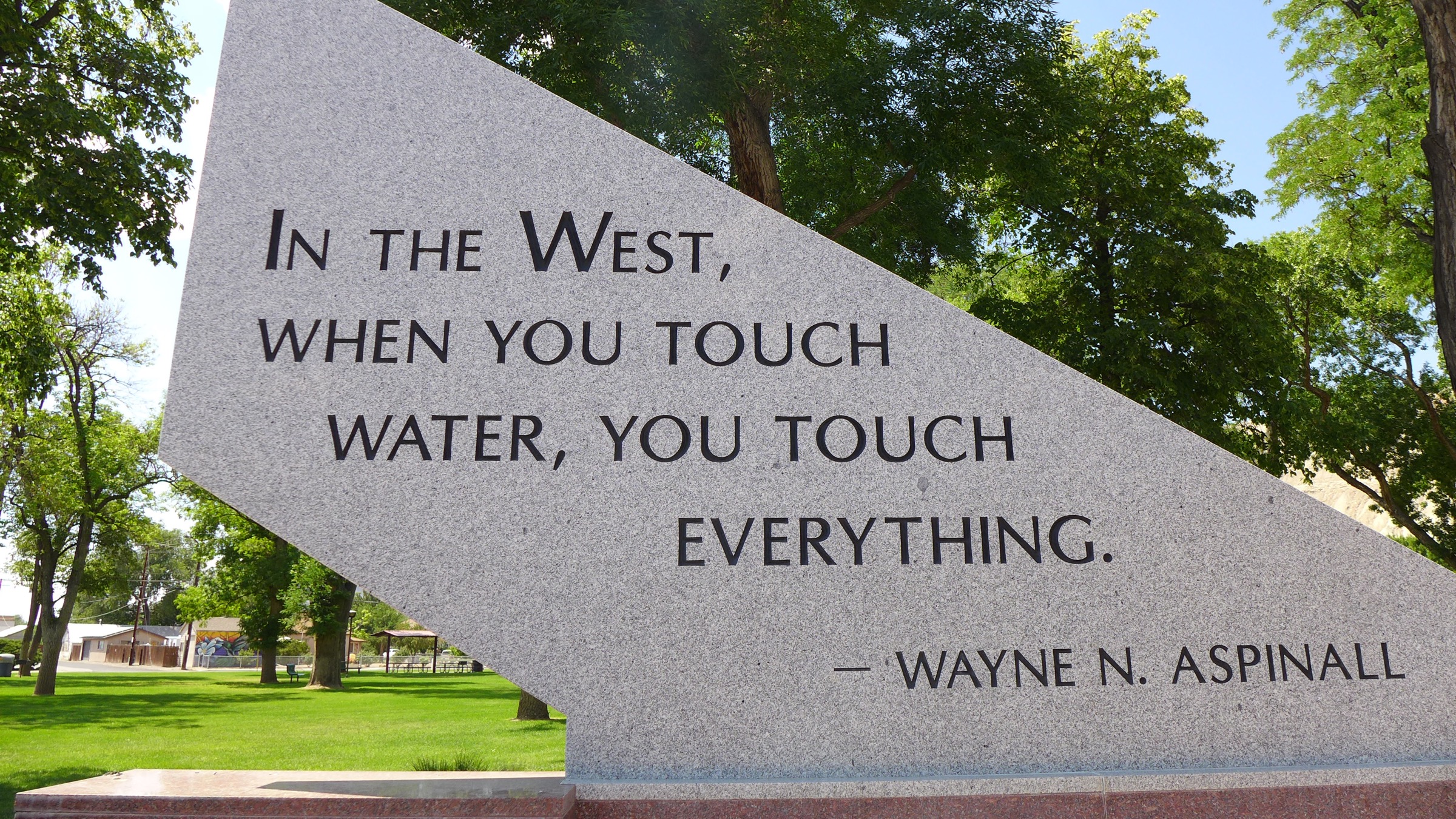
About the Wayne N. Aspinall Award The Colorado Water Congress presents the prestigious Wayne N. Aspinall Award annually to a Coloradan who has long demonstrated courage, dedication, knowledge and leadership in the development, protection and preservation of Colorado water – those attributes possessed by Mr. Aspinall. The late Wayne Aspinall, a lawyer and former member of the U.S. House of Representatives, remains one of the most influential water leaders in Colorado history.
Part of the memorial to Wayne Aspinall in Palisade. Aspinall, a Democrat, is a legend in the water sector, and is the namesake of the annual award given by the Colorado Water Congress. Photo: Brent Gardner-Smith/Aspen Journalism
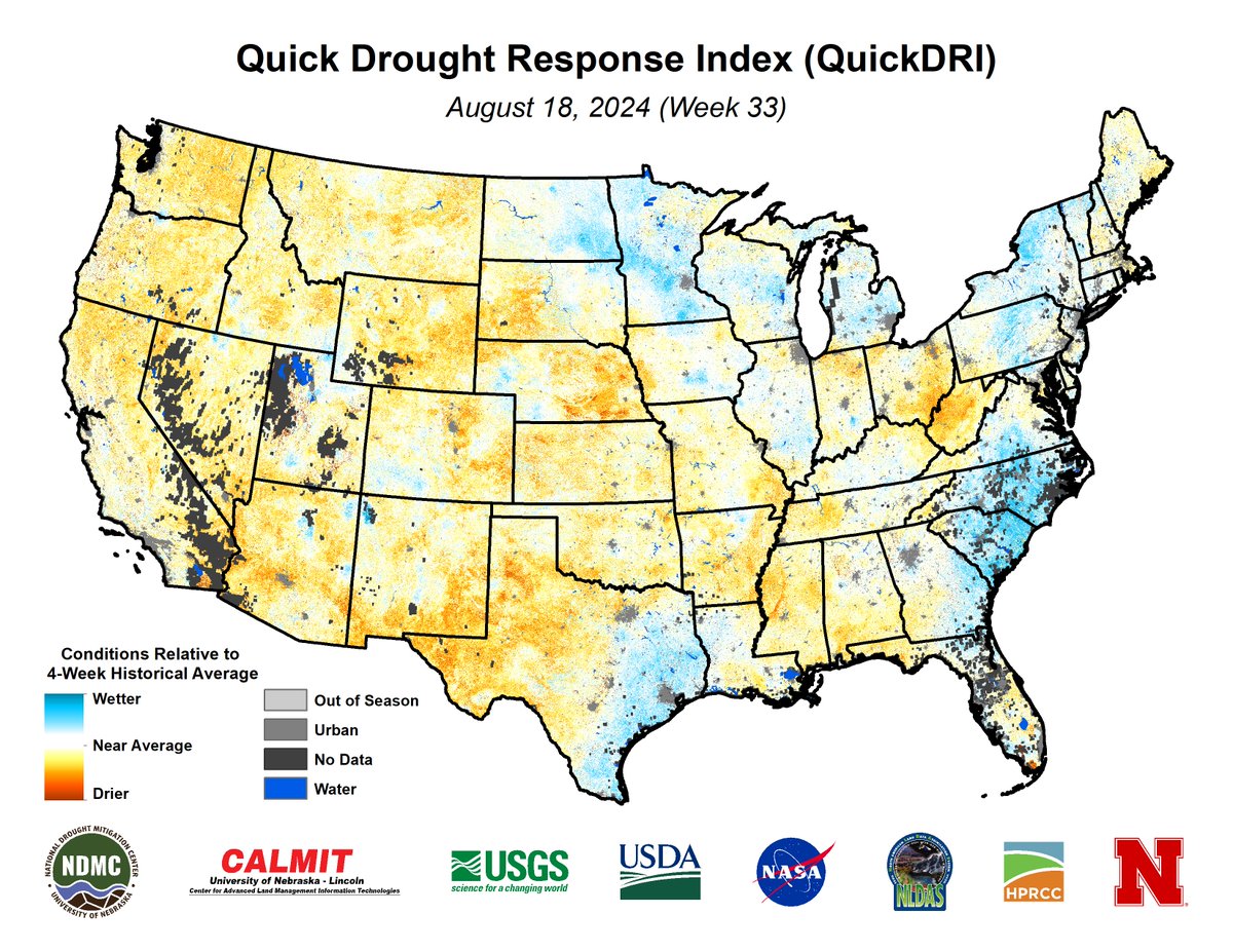
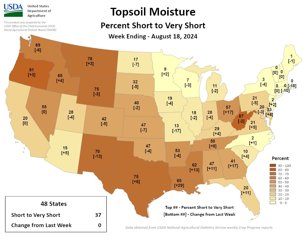
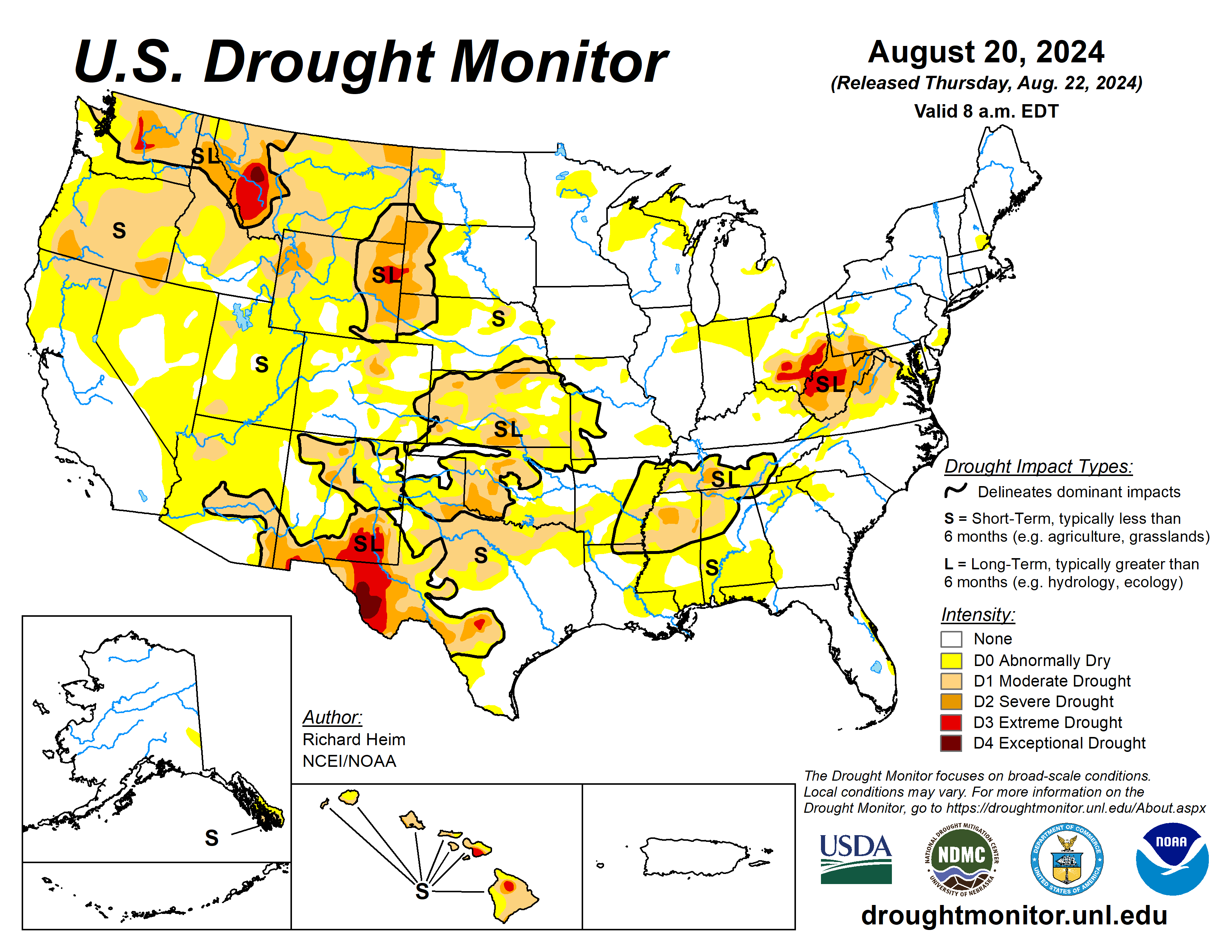
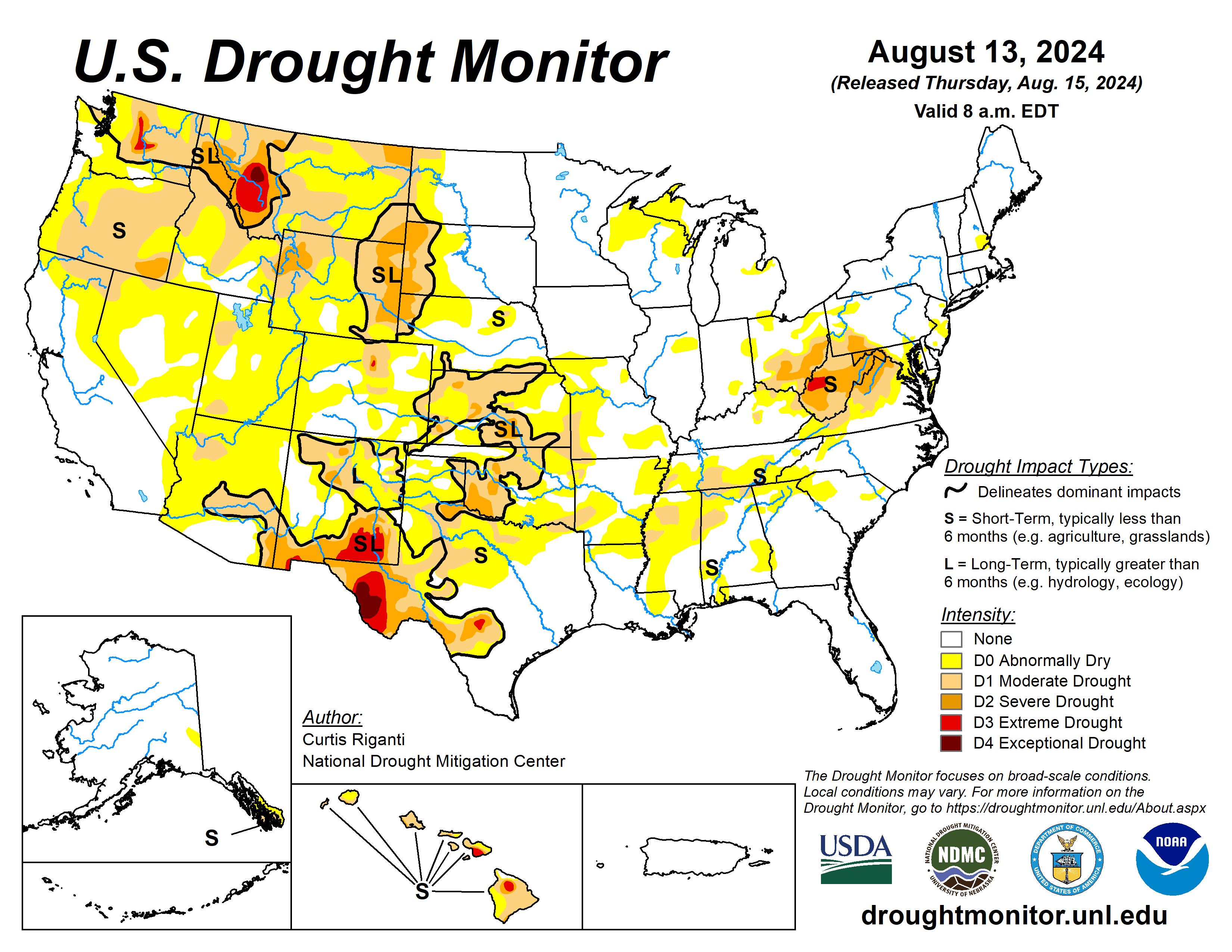
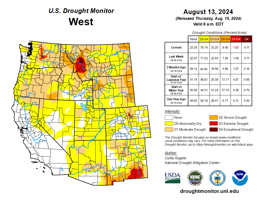
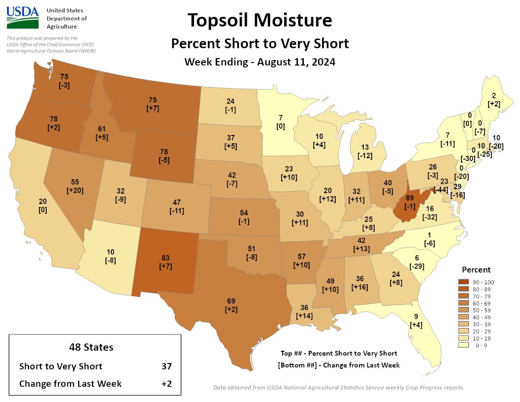
37% of the Lower 48 is short/very short, same as last week. Soils dried out in the Southeast, TX, and OH. Much of the North & Midwest improved. NM, WV, & the Northwest remain the driest areas, in terms of topsoil moisture.
A high-pressure ridge continued across the southern Plains during this U.S. Drought Monitor (USDM) week (August 14-20), bringing dry and very hot weather, especially to Texas. Pacific weather systems moving in the jet-stream flow brought above-normal precipitation to parts of the West Coast, the northern to central Rockies, and parts of the central to northern Plains, the Midwest, and Northeast. The rain was frequently hit-or-miss, with large parts of the Pacific Northwest to Plains, and Midwest to Northeast, receiving little to no precipitation. In addition, much of the Southwest, and southern Plains to Southeast, were drier than normal this week. An upper-level trough kept the Far West cooler than normal, while a large cold front brought cooler-than-normal temperatures to much of the Midwest to East Coast. The rain contracted drought and abnormal dryness in parts of the Rockies to central Plains, and a few parts of the Midwest and East Coast. But drought or abnormal dryness expanded or intensified in parts of the West that missed out on the precipitation, parts of the Great Plains, from the Tennessee Valley to central Gulf of Mexico coast, and parts of the Midwest to central Appalachians. The lack of rain continued to dry out soils across large parts of the West (especially the Pacific Northwest), in the southern Plains, the Lower Mississippi Valley, and central Appalachians. Numerous wildfires were burning across the West with some sparking up in the southern Plains and western High Plains. The most severe drought areas included the central Appalachians to Upper Ohio River Valley, the Rio Grande River Valley, eastern Wyoming, western Montana, and central Washington…
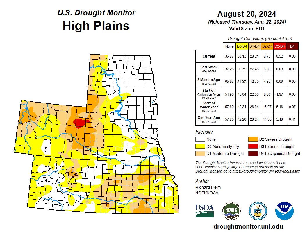
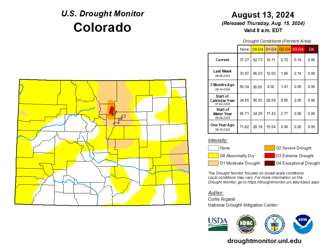
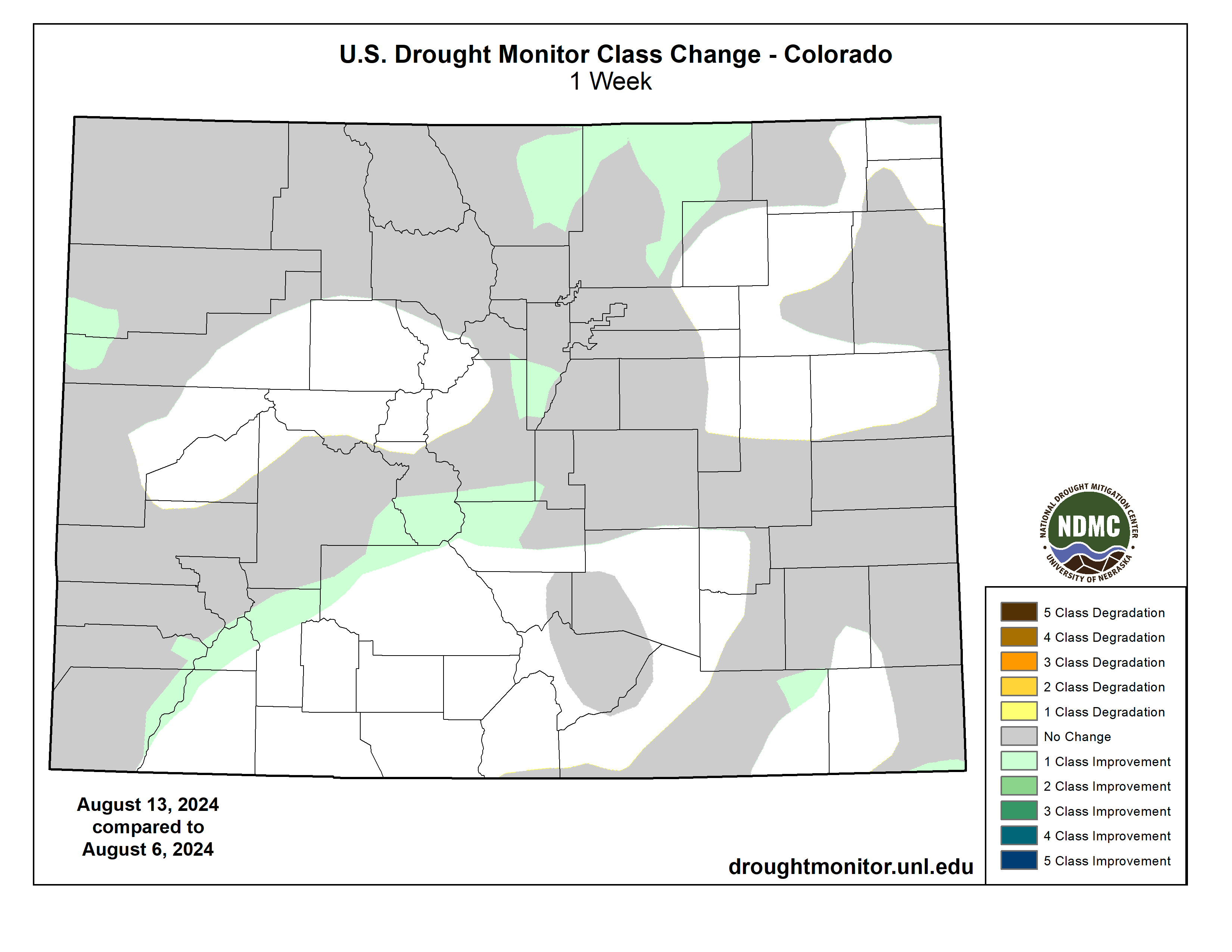
Like other parts of the country, there were wet areas and dry areas this week in the High Plains region. Weekly rainfall totals ranged from zero in parts of Wyoming to locally over 2 inches in the Dakotas, Nebraska, and Kansas. Eastern parts of the Dakotas and Nebraska averaged near to cooler than normal for the week, but areas to the west and south were warmer than normal, with some areas 2 to 4 degrees above normal. There was expansion of drought and abnormal dryness in most states in the region, more in the north, and contraction in mostly southern states. The more notable changes were expansion of moderate to severe drought in Kansas and Wyoming with extreme drought being introduced in Wyoming and adjacent South Dakota, and contraction of abnormal dryness and drought in Colorado and Kansas, especially southeast Kansas where locally up to 5 inches of rain fell. Reports of significant hay loss and early cattle sales in South Dakota may be due to a combination of drought and a June 19 freeze event; other drought impacts include surface water shortage and poor water quality for livestock. According to USDA reports, in Wyoming, 75% of the topsoil moisture and 81% of the subsoil moisture are short or very short and 66% of the pasture and rangeland was rated in poor or very poor condition. More than 40% of the topsoil moisture was short or very short in Nebraska, Colorado, and Kansas, with 55% of the subsoil moisture so rated in Kansas…
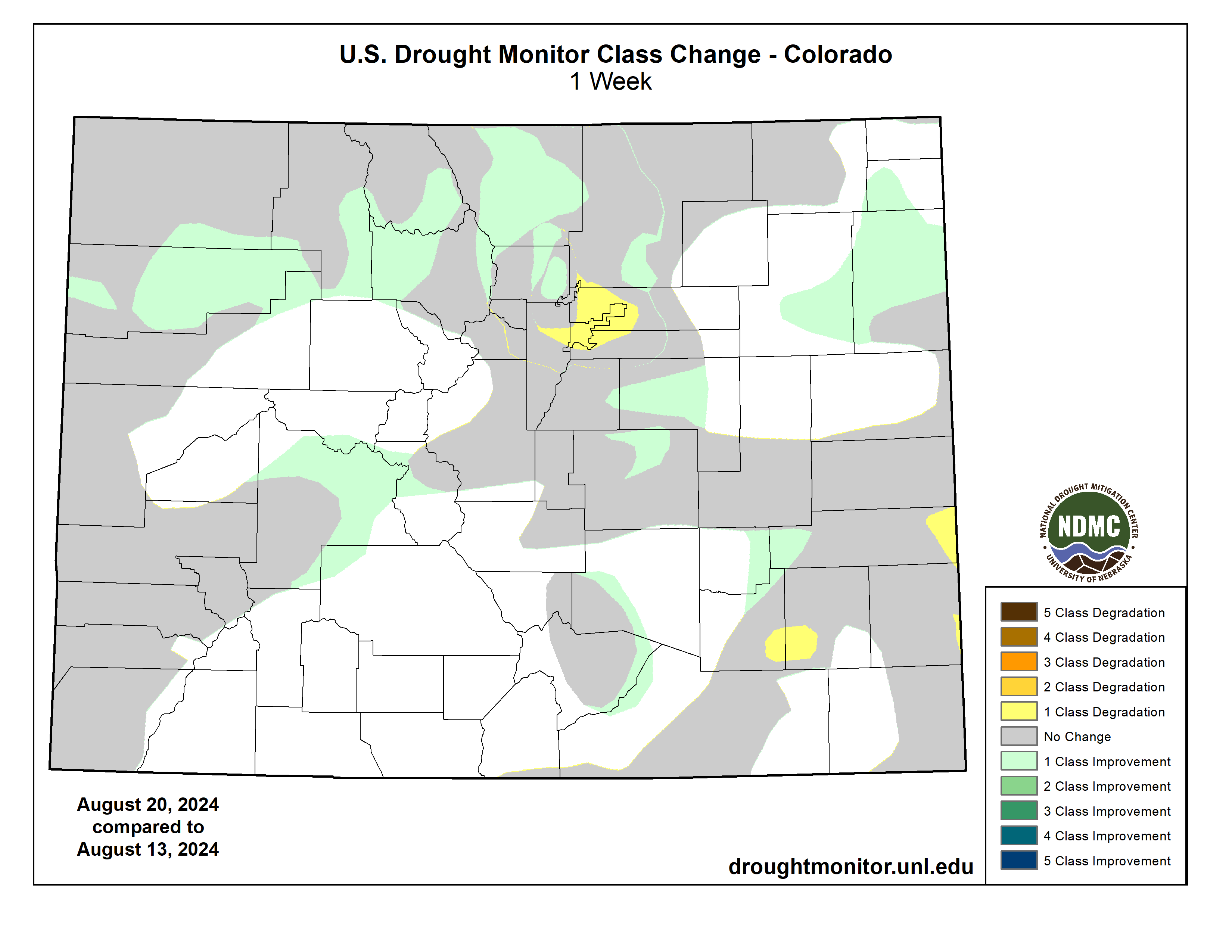
Colorado Drought Monitor one week change map ending August 20, 2024.
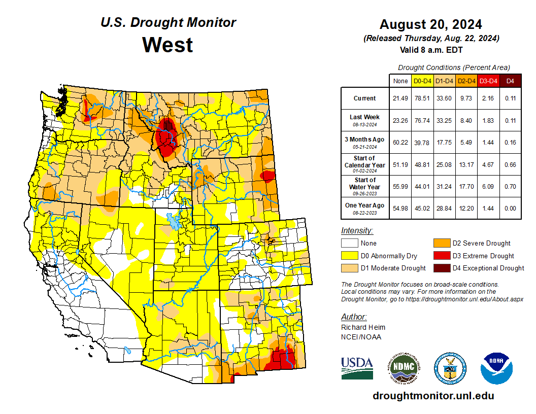
Half an inch of rain or more fell this week along the Washington and Oregon coast, in the Rockies, and parts of the Southwest (Four Corners States), with little to no rain falling across most of California, Nevada, and interior portions of the Pacific Northwest. Temperatures were cooler than normal in the Far West to Great Basin, averaging as low as 4 to 6 degrees below normal, but warmer than normal in southern and eastern areas, averaging 2 to locally 8 degrees above normal in Arizona, New Mexico, and Montana. Contraction of abnormal dryness or drought occurred in a few parts of New Mexico, Utah, and Montana, but drought or abnormal dryness expanded in the Pacific Northwest, California, and Nevada. The most notable changes occurred in Washington and Oregon, where moderate to severe drought expanded. More than 60% of the topsoil/subsoil moisture was rated short or very short in Oregon (81%/75%), Washington (69%/65%), Idaho (65%/62%), Montana (78%/79%), and New Mexico (70%/70%). Almost two-thirds of the pasture and rangeland was rated in poor to very poor condition in Oregon (62%) and Washington (63%)…
The keywords for the South region are hot and dry. Most of the region was warmer than normal, with only eastern Tennessee near normal. Parts of northern Texas had weekly temperatures 6 to 10 degrees above normal, with daily high temperatures over 100 degrees F all week and exceeding 110 on some days. Parts of Arkansas and eastern Oklahoma received over 2 inches of rain this week, with locally over 5 inches, and there was a smattering of showers in Louisiana, Mississippi, and Tennessee, with rainfall mostly half an inch or less. All of Texas and most of Oklahoma received little to no rain this week. With dry soils, high evaporation, and deficient rainfall, abnormal dryness expanded in parts of most of the South region states. Moderate drought expanded in Texas, especially in north central Texas where the fire danger was high and several large wildfires were burning; extreme drought expanded in the Texas Trans Pecos. Moderate to severe drought expanded in Oklahoma, Mississippi, and Tennessee. Abnormal dryness and moderate drought were trimmed where the heaviest rains fell in eastern Oklahoma and western Arkansas. Soils were very dry: USDA topsoil/subsoil percentages short or very short include 75%/65% for Texas, 65%/50% for Louisiana, 62%/59% for Mississippi, 53%/49% for Arkansas, 50%/52% for Tennessee, and 47%/49% for Oklahoma. Mississippi experienced a 70% loss of field corn in the east-central portion of the state during the mid-June through early July dry period. Extension agents are reporting a likely significant loss of cotton and soybeans in this region as well. Cotton plants are dying, and soybeans in many locations set pods without beans. According to the USDA Crop progress report for Mississippi, pasture land, soybeans, and cotton are currently worse than 2023 levels. In Tennessee, there were reports of a pond drying up, lack of forage growth (in June and July), and tree stress (early browning and dropping of leaves). The USDA reported 46% of the pasture and rangeland in Texas was in poor to very poor condition…
Looking Ahead
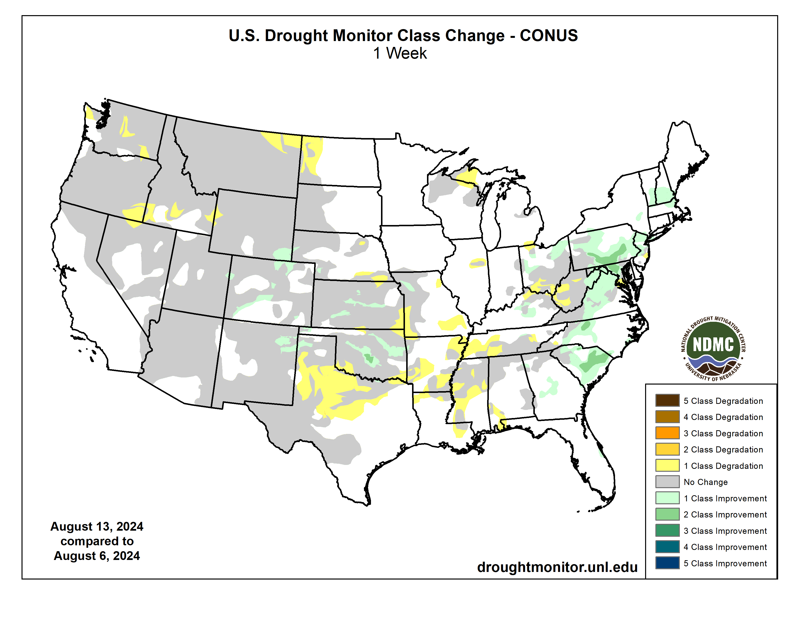
In the two days since the Tuesday valid time of this USDM, scattered showers and thunderstorms brought areas of rain to parts of the Southwest, Pacific Northwest, and Plains, but the rest of the contiguous U.S. (CONUS) was mostly dry. For August 22-27, the upper-level ridge will slowly shift east, bringing warmer-than-normal temperatures to much of the CONUS between the Plains and Appalachians, while an upper-level trough will move into the West, bringing cooler-than-normal temperatures. An inch or more of rain is predicted for the Cascades, much of the Southwest (Four Corners States), and parts of the northern Rockies and central Plains. A stalled frontal boundary will bring an inch to locally 3 inches or more of rain to the Florida peninsula. Half an inch of precipitation is forecast for areas in the central to northern Plains, Middle to Upper Mississippi Valley, parts of New England, and northern parts of the West. Large parts of California and Nevada, the southern Plains, and Lower Mississippi Valley to Mid-Atlantic coast can expect little to no precipitation.
For much of the next 2 weeks, the ridge and trough pattern will continue to slowly move east. The Climate Prediction Center’s (CPC) 6-10 Day Outlook (valid August 27-31) and 8-14 Day Outlook (valid August 29-September 4) favor warmer-than-normal temperatures across the CONUS east of the Rockies, shifting to the East Coast as the ridge moves east. Odds favor below-normal temperatures over the Pacific Northwest and northern Rockies at first, then over the northern Plains as the trough moves east. The West Coast and southern tier states are likely to be warmer than normal through the period. Alaska may see cooler-than-normal temperatures in the southwest to warmer-than-normal temperatures in the northeast. Odds favor below-normal precipitation across parts of the Pacific Northwest and a large area centered over the Mid-Mississippi and Ohio Valleys, while above-normal precipitation is favored from the Southwest to northern Plains and parts of the Gulf Coast states, in the northern Rockies early in the period, and along the extreme East Coast late in the period. Most of Alaska could see wetter-than-normal conditions.
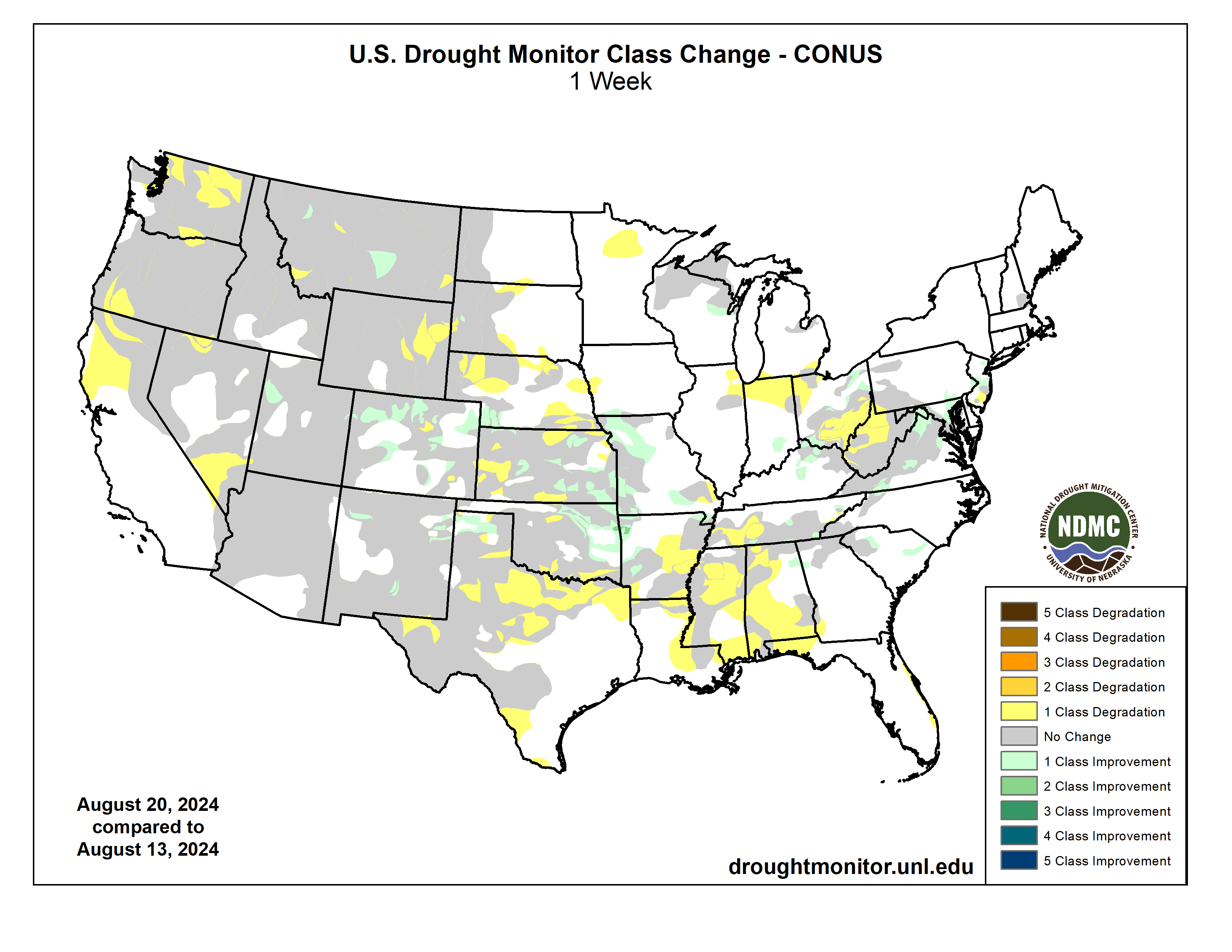
US Drought Monitor one week change map ending August 20, 2024.
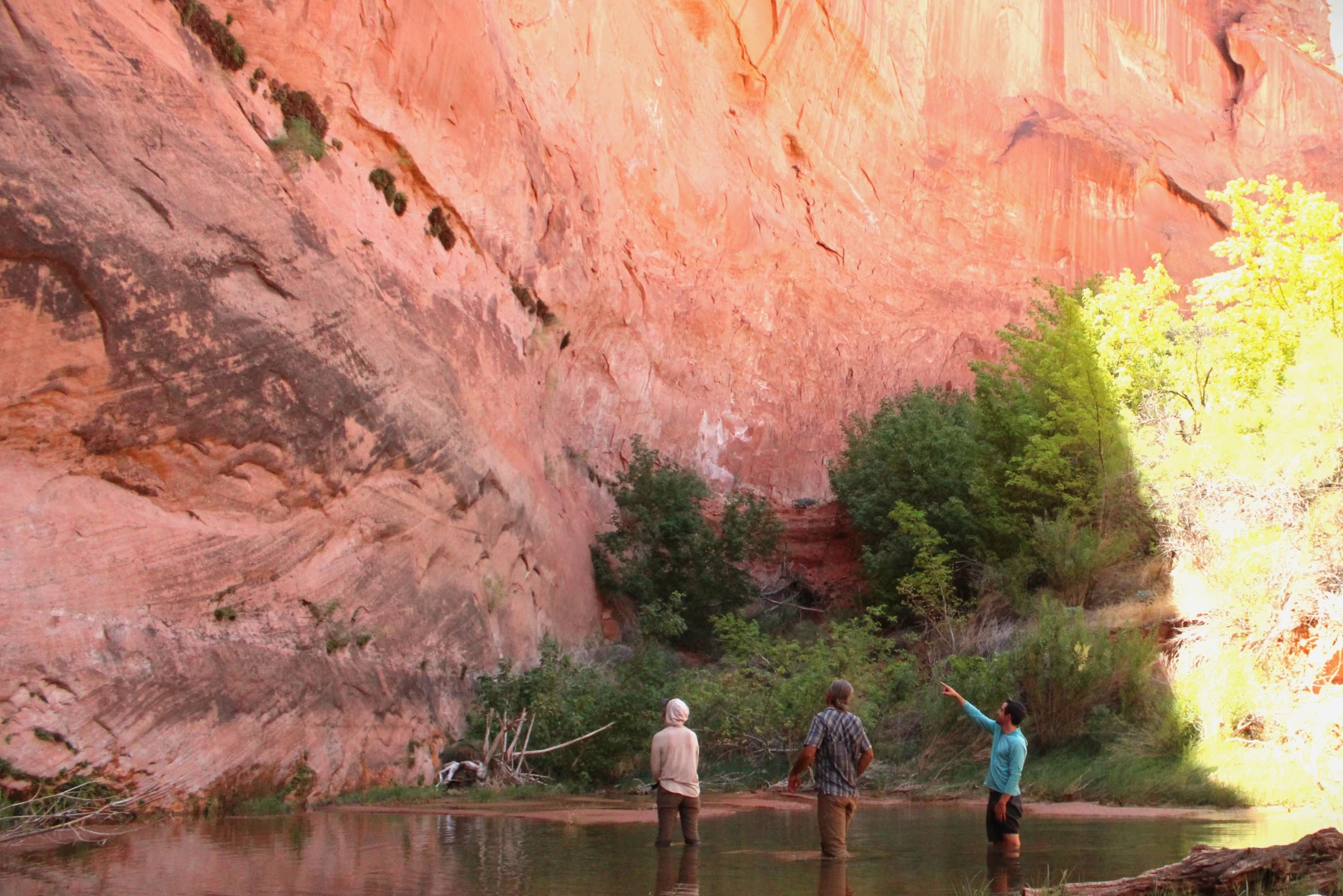
Researcher Seth Arens prepares to count plants in Glen Canyon on July 16, 2024. His study shows that many plants in areas once submerged by Lake Powell are the kind of native species that lived in the area before the reservoir. Alex Hager/KUNC
Click the link to read the article on the KUNC website (Alex Hager):
August 20, 2024
This story is part of ongoing coverage of the Colorado River, produced by KUNC and supported by the Walton Family Foundation. KUNC is solely responsible for its editorial coverage.
Seth Arens has all the adventurous swagger of Indiana Jones. His long hair is tied up in a bun, tucked neatly under a wide brimmed hat. His skin bears the leathery tan of someone who has spent the whole summer under the desert sun.
But as Arens pushed his way through a taller-than-your-head thicket of unforgivingly dense grasses, he explained why he doesn’t carry a machete, betraying his differences from the whip-cracking tomb raider.
“I guess, as an ecologist, I can’t quite bring myself to just hack down vegetation,” Arens said.
Arens is a scientist with Western Water Assessment and the Cooperative Institute for Research in Environmental Sciences, both environmental research groups headquartered at the University of Colorado Boulder.
He has spent weeks traversing the smooth, twisting red rock narrows of Glen Canyon in search of his own kind of treasure: never-before-collected data about plants.
Glen Canyon is perhaps best known for the reservoir that fills it. Lake Powell, the nation’s second-largest reservoir, has kept much of the canyon underwater since the 1960s and 70s. The 21st Century has changed that. Climate change and steady demand have brought its water levels to record lows, putting once-submerged reaches of the canyon above water for the first time in decades.
Katie Woodward, Seth Arens and Eric Balken stand in a stream-fed pool in Glen Canyon on July 16, 2024. This area was once completely submerged by Lake Powell, but now thrives with native plants. Alex Hager/KUNC
What happens next is still up in the air. Some environmental advocates want to see the reservoir drained so plants, animals, and geologic features can come back. Boaters and other recreators want to maintain the status quo – keep storing water in Lake Powell and sustain a tourism site that brings in millions of visitors each year.
In the snaking side canyons that were once under Lake Powell, Arens is methodically counting plants at different sites over the course of multiple years. He is creating a record of which species are taking root, and what might be lost if the reservoir were to rise again.
“Nature has given us a second chance to reevaluate how we’re going to manage this place,” Arens said.
While the study is still underway, Arens said native species dominate the landscape alongside the area’s creeks. The same kinds of plants that lived in Glen Canyon before Lake Powell have taken root again — even after their habitats were drowned — filled in with towering piles of sediment deposits, and then shown the light of day once more.
“It turns out nature is doing a pretty good job by itself,” Arens said, “Of coming back and establishing thriving ecosystems.”
‘Old assumptions’ and new policies
The data produced by this study is going public during a pivotal time for the Colorado River and its major reservoirs.
Decisions made over the next two years will shape who gets how much water from the shrinking river, which supplies roughly 40 million people. Cities and farms from Wyoming to Mexico are all trying to make sure they get their fair shares, and environmental advocates are trying to make sure the region’s plants and animals aren’t an afterthought.
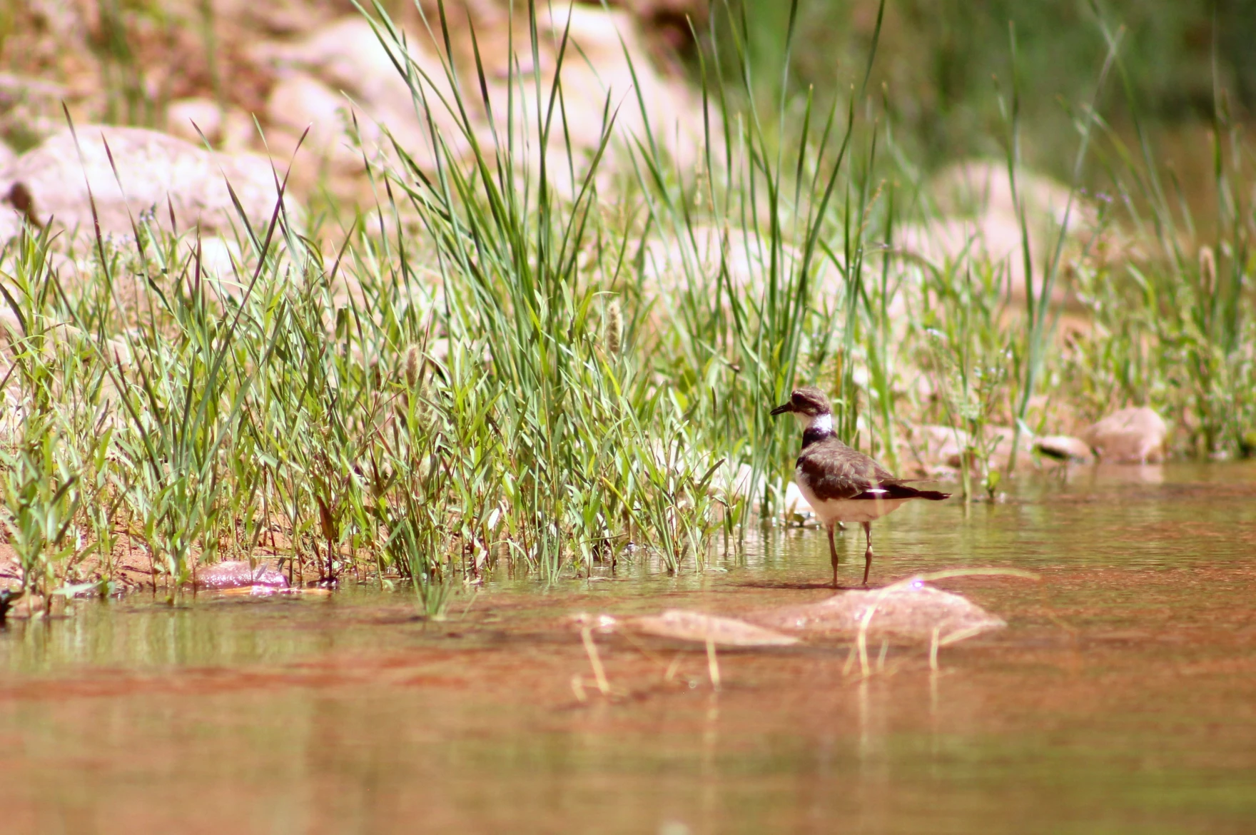
A killdeer stands in a spring-fed stream in Glen Canyon on July 17, 2024. The native plants alongside the canyon’s streams are host to a variety of birds and other animals such as beavers, toads, lizards and insects. Alex Hager/KUNC
The current guidelines for managing the river expire in 2026. Right now, policymakers are working on a set of replacements. Eric Balken, director of the nonprofit Glen Canyon Institute, wants those new rules to factor in the wellbeing of plants around Lake Powell.
“If the old assumption was that we can store water in Glen Canyon because there’s nothing there, that assumption is wrong,” he said. “There is a lot here. There is a serious ecological consequence to putting water in this reservoir, and we cannot ignore that anymore.”
Balken’s group, which advocates for draining Lake Powell and storing its water elsewhere, provided some funding for the plant study being conducted by Seth Arens. Glen Canyon Institute is hoping it will provide data that proves the value of the canyon’s plant ecosystems to policymakers.
That’s extra important, Balken said, because federal water managers aren’t doing enough for Glen Canyon’s plants right now.
The Bureau of Reclamation, the federal agency that manages the West’s reservoirs, outlined its current strategy for river management in an October 2023 document called the “Draft Supplemental Environmental Impact Statement.” Balken called that document’s assessment of Glen Canyon plants “demonstrably false.”
In short, Reclamation describes an environment dominated by invasive plants that only stand to cause problems.
“When I read that,” Balken said, sitting near a patch of native willow plants feet from Lake Powell’s edge. “I just thought, ‘Had these people even been to Glen Canyon?’” This place is a vibrant, burgeoning ecosystem.”
Reclamation’s report mentions some native species that form “unique ecosystems within the desert,” but appears to conclude that rising reservoir levels – which are partially the result of the agency’s own management decisions – would ultimately be good for plant life around Lake Powell.
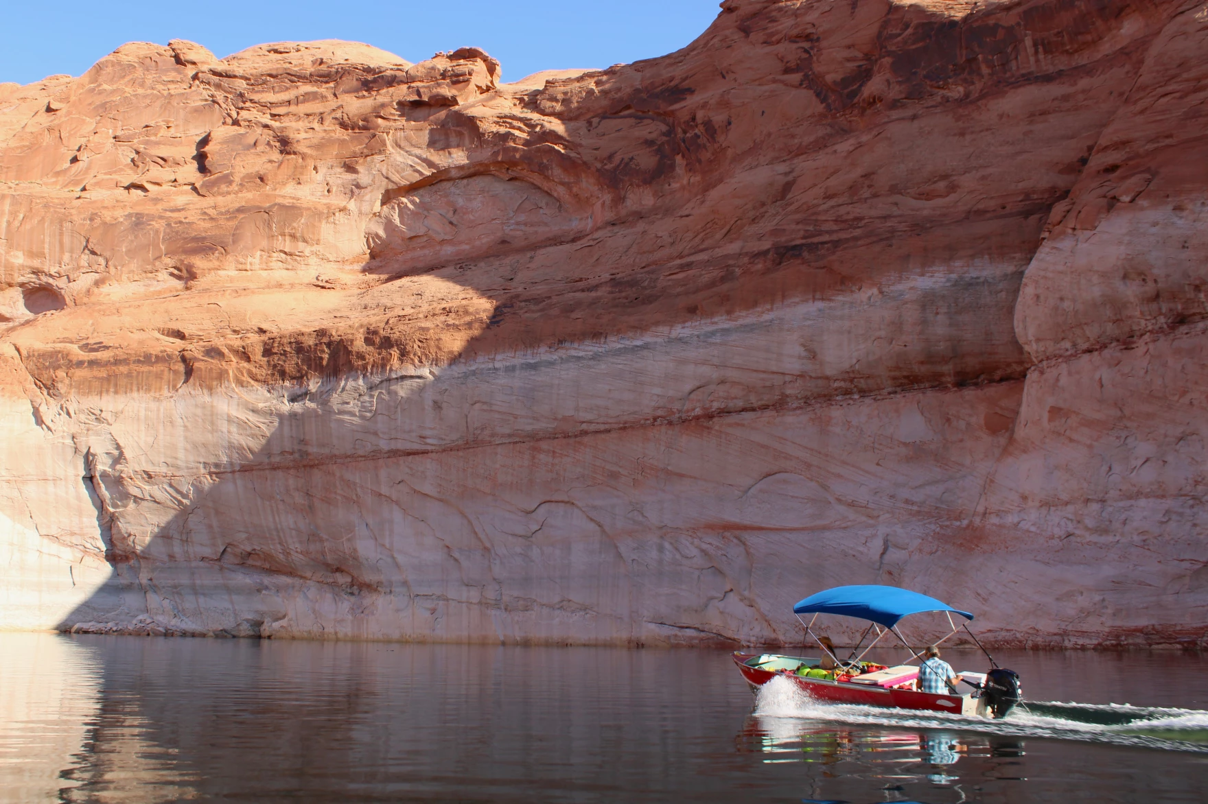
Seth Arens pilots a boat across Lake Powell between research sites on July 17, 2024. Some environmental advocates want to see the reservoir drained and its water stored elsewhere, while proponents of Lake Powell hail its value as a recreation area. Alex Hager/KUNC
It highlights the presence of invasive plant species and says “any additional acreage of exposed shoreline around Lake Powell has the potential to be invaded by invasive plant species such as tamarisk and Russian thistle.”
Balken and Arens argue the opposite, pointing to early survey findings that include widespread native plant life in areas that have been exposed by declining reservoir levels.
Reclamation declined to be interviewed for this story, but a spokeswoman for the agency wrote in an email to KUNC, “Reclamation’s consideration of impacts to vegetation are primarily for resources downstream of Glen Canyon Dam that are affected by dam releases.”
The spokeswoman wrote that “most of the releases, even on the annual time scale, have negligible effects on lake levels and vegetation,” and pointed to inflows, such as annual snowmelt, as having a bigger impact on water levels in the reservoir than Reclamation’s releases of water from Glen Canyon Dam.
Balken suspects that Reclamation lacks data about Glen Canyon’s plants and hopes that the ongoing study will fill in those gaps and help shape management plans going forward.
The National Parks Service, which manages recreation on Lake Powell and gathers some data about the surrounding environment, was not able to provide comment for this story in time for publication.
‘A chance for survival’ around Lake Powell
While Arens’ study hasn’t produced any hard data yet, he is taking a mental tally of plants every time he trudges through the lush, winding creekbeds that channel spring-fed streams into Lake Powell.
These riverside ecosystems were shaped by their years spent underneath the reservoir, and little signs of that reality are everywhere.
Seth Arens looks at plants growing from crevices in a rock wall in Glen Canyon on July 16, 2024. These “hanging gardens” thrive in shady canyon bends where water seeps from the wall. Alex Hager/KUNC
Standing in the baking desert sun, Arens poked at a digital map on his phone screen while trying to find his next research site, and the map showed that he was standing underwater. Much of the canyon is lined with banks of sediment, sometimes more than a dozen feet tall, that were left behind by the still waters of Lake Powell. Those banks now provide heaps of soil for the roots of native plants.
Now that some of those areas have been left to grow for more than two decades, in some cases, they abound with life.
In one canyon, frogs and toads hop along the clear trickle just downstream of a beaver pond while birds flit in and out of tall, shady cottonwoods. In another, ferns sprout from crevices where water seeps onto a damp rock wall.
It’s a veritable oasis in the desert – the kind of cool, spring-fed Eden that populated the heat-induced daydreams of thirsty cowboys traversing the expanses of the Old West.
Katie Woodward, Arens’ research assistant, is finding inspiration in these canyons, too.
“It’s very obvious that nature can take care of its own and turn a highly disturbed landscape, a landscape that was disturbed because of the follies of man, and change that into something that is diverse and productive,” she said. “I would have never believed how possible that was until I came down here.”
The researchers hope their findings about that recovering landscape end up in front of policymakers, whose decisions could shape the future of Glen Canyon’s native ecosystems.
Katie Woodward takes notes on plant species in Glen Canyon on June 16, 2024. She and researcher Seth Arens trek through remote desert canyons to tally the plants within, and have found mostly native vegetation in the canyon’s riparian ecosystems. Alex Hager/KUNC
“As Glen Canyon resurfaces, there’s an incredible moment for species that are feeling the pressures of both human-induced and naturally driven change on water resources in riparian areas in the west, to have a chance for survival in a future that feels really unknown and kind of scary.”
Some of those unknowns might get settled soon, as the next rules for Colorado River management are likely to include new plans for storing water in Lake Powell. State water negotiators have projected optimism that policy meetings will result in a new agreement for water management before the 2026 deadline.
Less than 12 hours after the Biden Administration and the Imperial Irrigation District approved an unprecedented deal to conserve 700,000 acre feet of Colorado River water through 2026, the flow of river water to the rural valley three hours south of Los Angeles slowed. District personnel moved out before sunrise to install more than 1,600 locks on gates to canals supplying hundreds of farm fields, cutting off water deliveries for up to 60 days this year. The process will be repeated over the next two summers.
In exchange, the powerful agency and farmers who volunteer to not receive the water and hold off on growing hay in hot summer months will be paid nearly $700 million in federal funds — by far the largest of numerous agreements struck with water agencies and tribes to prop up the overused, drought-ravaged river and its reservoirs. For irrigation district officials, the agreement, which will conserve a huge amount of water, about as much as the state of Nevada uses annually, caps years of arduous negotiations and multiple federal reviews…
But the way the deal was finalized and its potential impacts on the also rapidly dwindling Salton Sea and local public health angered numerous environmental justice and policy groups. They said the U.S. Bureau of Reclamation and the powerful water agency rushed through cursory approvals and ignored much of their lengthy comments, including ideas on how to monitor and reduce air quality and wildlife impacts that they say will occur from holding back such a huge amount of water.
The irrigation district board on Sunday hastily scheduled a special meeting for Monday night to approve the agreement, before reclamation staff had even released their final determination that cutting so much agricultural runoff into the sea would have “no significant environmental impacts.” Five hours before the meeting on Monday afternoon, the feds released their final determination and posted 150 pages of responses to the lenghty comments submitted by more than half a dozen groups and several individuals who have studied the Salton Sea for decades, including a major annual transfer of water to suburban San Diego that is rapidly depleting the water body, California’s largest.
In an email headed “IID’s quickie action,” Joan Taylor, chairperson of the Sierra Club’s California/Nevada Desert Committee wrote, “It’s commendable that IID recognized a responsibility to cut down on water use to help protect the water supply for the West, but what they’re doing is akin to doubling the water transfer to San Diego. We know that already has profound impacts. So this is a very big deal … and will suddenly increase dusty lakebed exposure around the Salton Sea by 13,000 acres.”
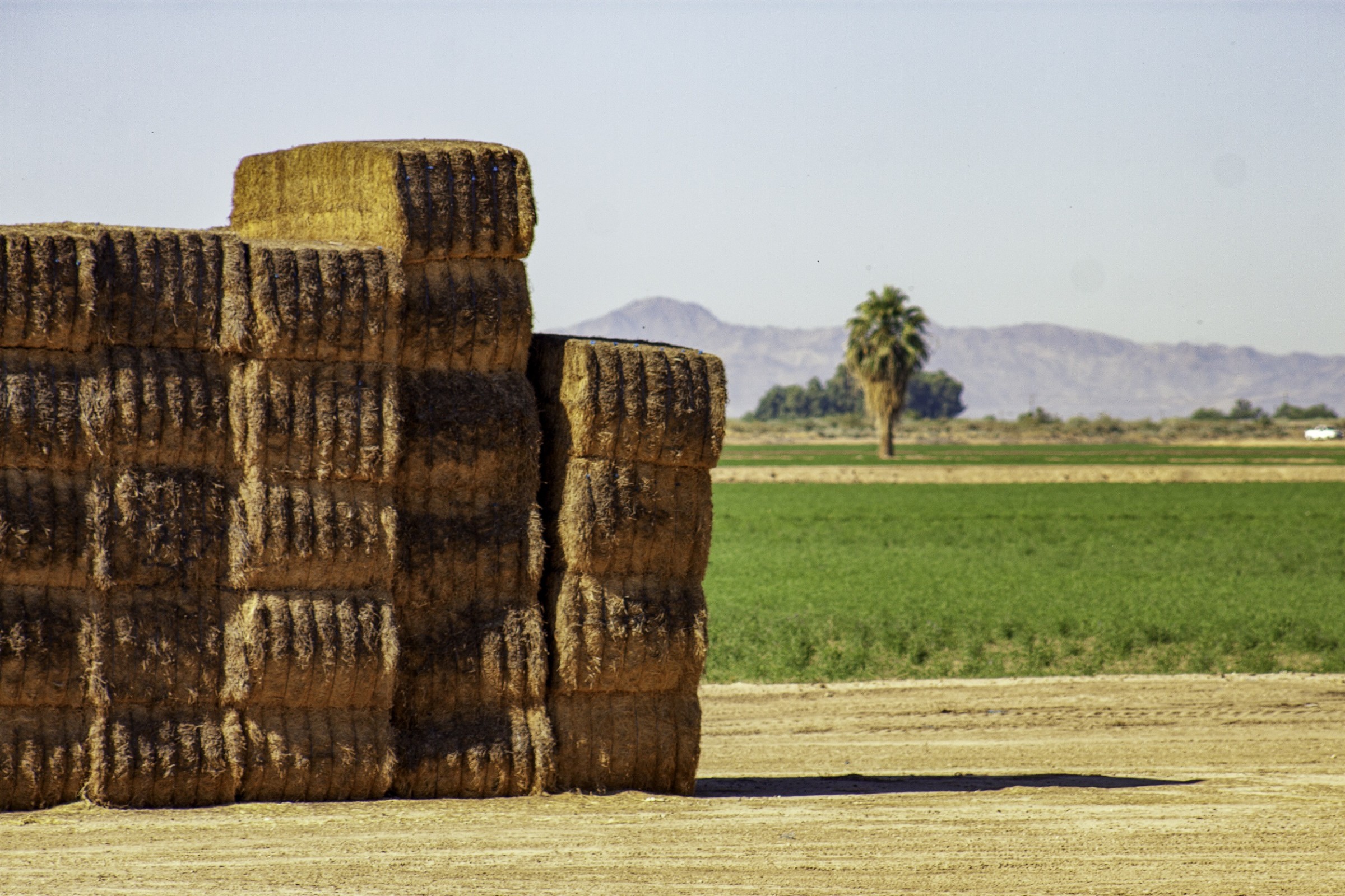
These hay bales stand ready to be collected on a ranch outside of Carbondale. Upper Colorado River Basin officials are working on a memorandum of understanding with the U.S. Bureau of Reclamation so water saved as part of conservation programs can be tracked and stored in Lake Powell. Credit: Heather Sackett/Aspen Journalism
Colorado River water managers are moving forward with a plan to track and get credit for conserved water.
The Upper Colorado River Commission on Monday voted unanimously to move ahead with the creation of a memorandum of understanding with the U.S. Bureau of Reclamation that would provide accounting and credit to the Upper Basin states (Colorado, New Mexico, Utah and Wyoming) for water saved through conservation programs. It would also identify qualifying criteria for water conservation projects. A draft of the MOU is expected by the end of September.
The states and the bureau would conduct this provisional accounting of water saved in Lake Powell and other Upper Basin reservoirs through 2026.
“The provisional accounting is exactly that,” said UCRC Executive Director Chuck Cullom. “It is not an operational guide for Reclamation; it is a means for folks to understand how much water would be available in that account upon the implementation of a formal agreement or credit program.”
Credit for the stored water could be formalized in one of two ways: as part of the post-2026 guidelines for reservoir operations, which the seven Colorado River basin states are in the midst of negotiating, or by implementing the demand management storage agreement, which was part of the 2019 Drought Contingency Plan.
For the past two years, some Upper Basin water users have been participating in a federally funded program known as the System Conservation Pilot Program, where they are paid to voluntarily use less water. The program is projected to save about 101,000 acre-feet of water at a cost of $45 million.
Despite one of the stated intentions of SCPP being to protect critical reservoir levels, the program does not track the conserved water to see how much of it ultimately ended up in Lake Powell. This lack of accounting has been one of the criticisms of the program, with some water users saying water conserved in the Upper Basin was simply being sent downstream to enable what they say is overuse by the Lower Basin states (Arizona, California and Nevada). The MOU would be a step toward remedying that.
“If we’re reducing demand and using taxpayer money to do it, then we have to make sure that it’s meaningful,” said Anne Castle, UCRC chair and the body’s federal representative. “It needs to provide benefit to the states that created that conserved water. That’s particularly important right now when the basin states are in difficult discussions about how to allocate the reductions in use that we all know are needed in the future.”
Upper Basin states are interested in “getting credit” for stored water because it could protect them in the event of a compact call. As the effects of demand, drought and climate change push the Upper Basin closer to not being able to deliver the required amount of water to the Lower Basin under the terms of the 1922 Colorado River Compact, water managers have been grappling with the idea of an insurance pool in Lake Powell. From 2019 to 2022, the state of Colorado explored the contentious concept of demand management, which would pay water users to temporarily cut back and store the conserved water in Lake Powell. Water could be released from this pool instead of shutting off cities and irrigators.
There is urgency to figure out how the Upper Basin states can track, measure and get credit for conserved water because there will soon be more opportunities for water conservation programs. This fall, the Bureau of Reclamation plans to announce funding for what officials are calling “Bucket 2 Water Conservation” projects. These are projects that would achieve verifiable, multiyear reductions in use or demand for water supplies.
The Colorado River near the state line in western Colorado. Representatives from the seven basin states that use the river are negotiating how future cuts will be shared in dry years. Credit: Heather Sackett/Aspen Journalism
Seven-state negotiations
Commissioners also gave an update on those difficult discussions with the seven basin states on how the river will be managed after 2026. Representatives from the UCRC, as well as from California, Nevada and Arizona, are in the midst of figuring out how the nation’s two largest reservoirs will be operated after 2026 and which water users will be cut by how much in dry years.
In their proposal to the Bureau of Reclamation, the Lower Basin states demanded that the Upper Basin share in future cuts when reservoir levels dip. But Upper Basin commissioners stood by the counterproposal they offered in March, called the Upper Basin Alternative, which does not include mandatory cuts for Upper Basin water users.
“The upper division states continue to stand behind the alternative that we submitted and know that it provides a reasonable alternative for sustainable operations of Lake Powell and Lake Mead,” said Colorado Commissioner Becky Mitchell.
Although the Upper Basin’s proposal does not commit to sharing in cuts when reservoir levels fall, it does offer “parallel activities,” which would include voluntary, temporary and compensated reductions in use (as the SCPP does), which are separate from the post-2026 guidelines process.
“We’re moving forward with our parallel actions like we have committed to do,” said Utah Commissioner Gene Shawcroft. “I think that’s significant.”
Although the Upper Basin and Lower Basin states have competing proposals, Upper Basin commissioners said Monday they are still committed to finding a consensus with their Lower Basin counterparts.
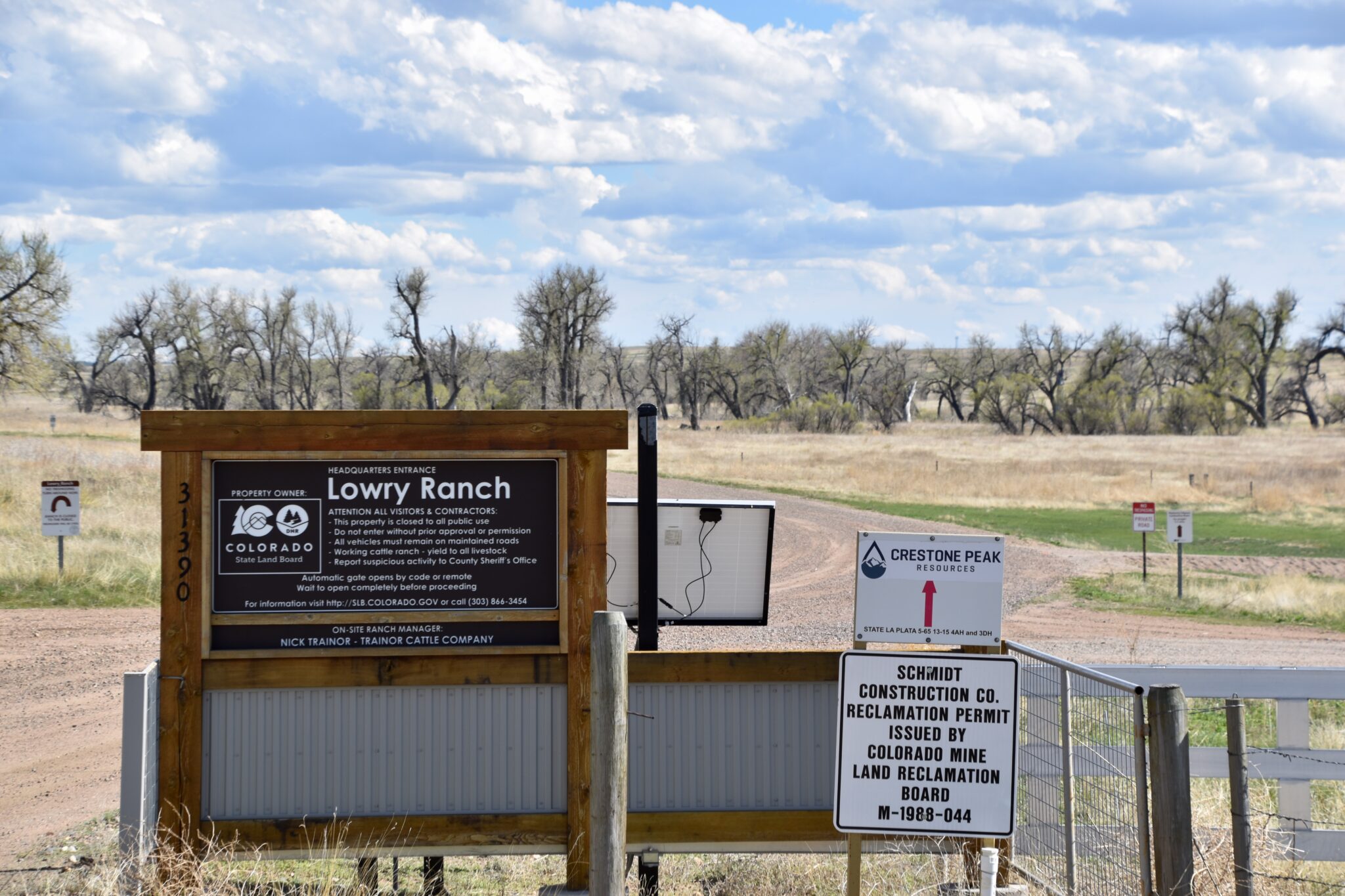
The entrance to the Colorado State Land Board’s Lowry Ranch property in Arapahoe County is pictured on May 16, 2024. (Chase Woodruff/Colorado Newsline)
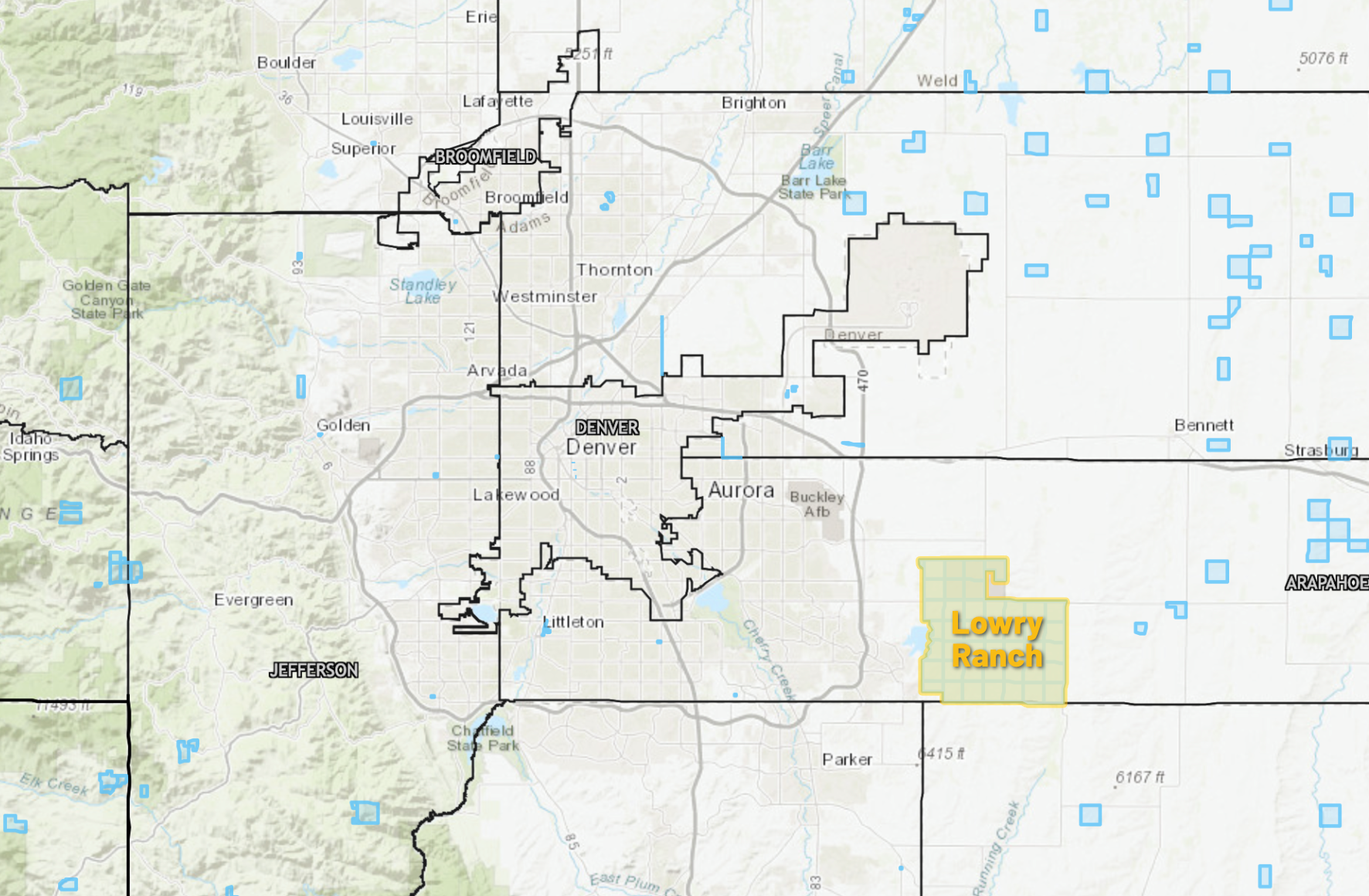
Colorado regulators on Wednesday gave the go-ahead to a sweeping oil and gas drilling plan on a large tract of state-owned land east of Aurora, with several conditions aimed at addressing concerns from nearby residents opposed to the project.
On a 3-1 vote, members of the Colorado Energy and Carbon Management Commission approved the 32,000-acre “comprehensive area plan” proposed by Denver-based Civitas Resources, which aims to streamline permitting for 156 new oil and gas wells at seven drilling locations in Arapahoe County. But they moved to require that Civitas use emissions-reducing electric drilling equipment, and left the door open to denying permits for proposed well pads nearest to several southeast Aurora subdivisions.
“I do see concerns with the CAP, and I do think there’s additional work that could have and probably should have been done,” said ECMC Commissioner Mike Cross. “But I still do think that it does meet our rules, and is approvable.”
Most of the area in Civitas’ CAP proposal consists of the sprawling Lowry Ranch property, a former U.S. Air Force missile launch site and gunnery range acquired by the Colorado State Land Board in the 1960s. Limited drilling has taken place on the property since the Land Board first issued a lease for oil and gas development in 2012, but the CAP’s approval could fast-track drilling in the area for the next six years.
Save the Aurora Reservoir, a community activist group formed to oppose the project, made their case against its approval in a two-day hearing last week, citing concerns about increased noise, truck traffic, air pollution and wildfire risk. They also worry about the proximity of the Lowry Landfill Superfund Site, on the northwest corner of the project area. Civitas agreed not to drill under the Superfund site at the Environmental Protection Agency’s request.
“We are devastated by the Commission’s decision,” Marsha Goldsmith Kamin, STAR’s president, said in a press release. “This is without doubt the wrong decision for the health, safety, and environment of our community.”
The approval also drew condemnations from state and national environmental groups, including the Sierra Club, which called the plan “reckless.”
“The grassroots efforts in Aurora have been powerful, passionate and persistent,” Ben Jealous, the Sierra Club’s executive director, said in a statement. “Members of this community deserve access to healthy air and clean water, and shouldn’t have to live in fear of fracked gas operations beneath their homes and schools.”
The 26,500-acre Lowry Ranch, a former U.S. Air Force missile site and bombing range, was acquired by the Colorado State Land Board in the 1960s. (Colorado Newsline illustration/State Land Board map)
Two-year process
Civitas first submitted its CAP application in 2022. Jamie Jost, an attorney representing Civitas, told commissioners Wednesday that the company’s proposal had “evolved for the better” over the course of two years of community outreach and feedback, “including input and influence from STAR.”
“It’s a comprehensive area plan that’s the result of thousands of hours of consultation, cooperation and collaboration with multiple federal, state and local governmental stakeholders, oil and gas operators, mineral owners, community groups and citizens,” Jost said of the proposal.
But Jost also criticized the testimony from STAR and its expert witnesses during last week’s hearings, accusing the group of spreading “misinformation intended to incite fear.” Civitas was particularly adamant throughout the proceedings that STAR’s fears about induced seismic activity — a phenomenon that has been documented elsewhere but is considered a low risk in the geological formations drilled in northeast Colorado — are unfounded.
In a statement, Kait Schwarz, director of the Colorado branch of the American Petroleum Institute, called it “disappointing and revelatory” that environmental groups continue to offer “significant resistance” to drilling proposals following the passage of stricter laws and regulations in recent years.
“Our operators are proud to produce in Colorado, yet it is disheartening to encounter such opposition even when the regulations and requirements are strictly adhered to,” Schwartz said. “This application and decision should serve as a model for addressing future projects.”
None of the drilling sites proposed in the Lowry Ranch CAP would be closer than 3,000 feet from the nearest subdivision — satisfying the 2,000-foot setback requirement adopted by the ECMC in 2020 — but the plan’s opponents say it’s still far too close to neighborhoods, schools, recreation areas like the Aurora Reservoir and environmentally hazardous sites like the Lowry Landfill.
The Lowry Landfill superfund site east of Aurora in Arapahoe County is pictured on May 16, 2024. (Chase Woodruff/Colorado Newsline)
Commissioner John Messner was the lone vote against the plan’s approval. Trisha Oeth, the commission’s newest member, did not take part in the proceedings because they began prior to her appointment to the panel by Gov. Jared Polis in June.
Messner objected to the “vague and noncommittal efforts” made in the proposal to minimize the project’s cumulative impacts on public health and the environment.
“The CAP application as a whole, as presented, does not meet the intent and requirements of our rules, and has not shown that it is protective,” Messner said.
ECMC staff recommended the Lowry Ranch plan’s approval earlier this year. It’s the fourth CAP considered by the commission since its 2020 rules overhaul, and Wednesday’s vote marks the fourth consecutive approval. But Commissioner Brett Ackerman said prior to the vote that “this one felt close.” Commissioners debated whether to delay a decision on the plan, but ultimately moved forward with an approval with the attached conditions.
“Like Commissioner Cross, I do not believe it’s perfect,” Ackerman said. “Like Commissioner Messner, I do have some concerns that it can more closely comply with the intent and specificity of our regulations with a little more work.”
Civitas will still be required to seek ECMC approval for each proposed drilling location in the plan through a process known as an “oil and gas development plan,” or OGDP. That process could include revisions to the proposed sites as a result of a required “alternative locations analysis,” commissioners said Wednesday.
“In order of the things that cause me the most concern, first and foremost would be the proximity of the primary line of well pads to the line of residential developments,” said Ackerman. “They feel a little deaf to some of the concerns of the nearby residents, as opposed to promoting maybe a couple of opportunities for working together with those residents to minimize impacts.”
Releases from the Aspinall Unit will be decreased from 1550 cfs to 1500 cfs on Wednesday, August 21st. Releases are being decreased as flows on the lower Gunnison River are well above the baseflow target of 1050 cfs. Another reduction in the release at Crystal is expected to occur next week if river levels remain above the target.
Flows in the lower Gunnison River are currently above the baseflow target of 1050 cfs. River flows are expected to remain above the baseflow target for the foreseeable future.
Pursuant to the Aspinall Unit Operations Record of Decision (ROD), the baseflow target in the lower Gunnison River, as measured at the Whitewater gage, is 1050 cfs for August through December.
Currently, Gunnison Tunnel diversions are 1050 cfs and flows in the Gunnison River through the Black Canyon are around 500 cfs. After this release change Gunnison Tunnel diversions will still be 1050 cfs and flows in the Gunnison River through the Black Canyon will be around 450 cfs. Current flow information is obtained from provisional data that may undergo revision subsequent to review.
This scheduled release change is subject to changes in river flows and weather conditions. For questions or concerns regarding these operations contact:
“New plot using the nClimGrid data, which is a better source than PRISM for long-term trends. Of course, the combined reservoir contents increase from last year, but the increase is less than 2011 and looks puny compared to the ‘hole’ in the reservoirs. The blue Loess lines subtly change. Last year those lines ended pointing downwards. This year they end flat-ish. 2023 temps were still above the 20th century average, although close. Another interesting aspect is that the 20C Mean and 21C Mean lines on the individual plots really don’t change much. Finally, the 2023 Natural Flows are almost exactly equal to 2019. (17.678 maf vs 17.672 maf). For all the hoopla about how this was record-setting year, the fact is that this year was significantly less than 2011 (20.159 maf) and no different than 2019” — Brad Udall
A plan from water officials in Arizona, Nevada and California to cut back on the amount of water those states use from the Colorado River in exchange for money with hopes of saving 3 million acre-feet of water over three years is meeting conservation goals, a top water official said Wednesday. The 2023 agreement has already seen 1.7 million acres of improvement less than one year into the effort, Bureau of Reclamation Commissioner Camille Touton said. She says she believes the states are on pace to reach their original goal.
“There is proof here that we can take on these hard moments, but we have to do it together,” said Touton, who spoke during a summit hosted by U.S. Rep. Susie Lee, D-Nev., at Springs Preserve. “We’ve been able to stabilize the system in the short term, and now we are focused on what this river looks like for the future.”
[…]
The $1.2 billion plan in 2023 called for half of the cuts to be made by the end of 2024 — a benchmark that has already been hit. The agreement runs through 2026, when the 100-year legal document about how Colorado River water is shared will expire, and negotiations could bring deeper cuts in water usage based on climate modeling and future warming in the West.
“We really were on the brink of catastrophe in this basin if we got another dry year,” said Colby Pellegrino, Southern Nevada Water Authority’s deputy general manager of resources, of the Colorado River prior to the agreement. “Mother Nature was kind to us, and Congress was very kind to us. And those two things together are what enabled us to get there voluntarily.”
Atmospheric rivers (ARs) reaching high-latitudes in summer contribute to the majority of climatological poleward water vapor transport into the Arctic. This transport has exhibited long term changes over the past decades, which cannot be entirely explained by anthropogenic forcing according to ensemble model responses. Here, through observational analyses and model experiments in which winds are adjusted to match observations, we demonstrate that low-frequency, large-scale circulation changes in the Arctic play a decisive role in regulating AR activity and thus inducing the recent upsurge of this activity in the region. It is estimated that the trend in summertime AR activity may contribute to 36% of the increasing trend of atmospheric summer moisture over the entire Arctic since 1979 and account for over half of the humidity trends in certain areas experiencing significant recent warming, such as western Greenland, northern Europe, and eastern Siberia. This indicates that AR activity, mostly driven by strong synoptic weather systems often regarded as stochastic, may serve as a vital mechanism in regulating long term moisture variability in the Arctic.
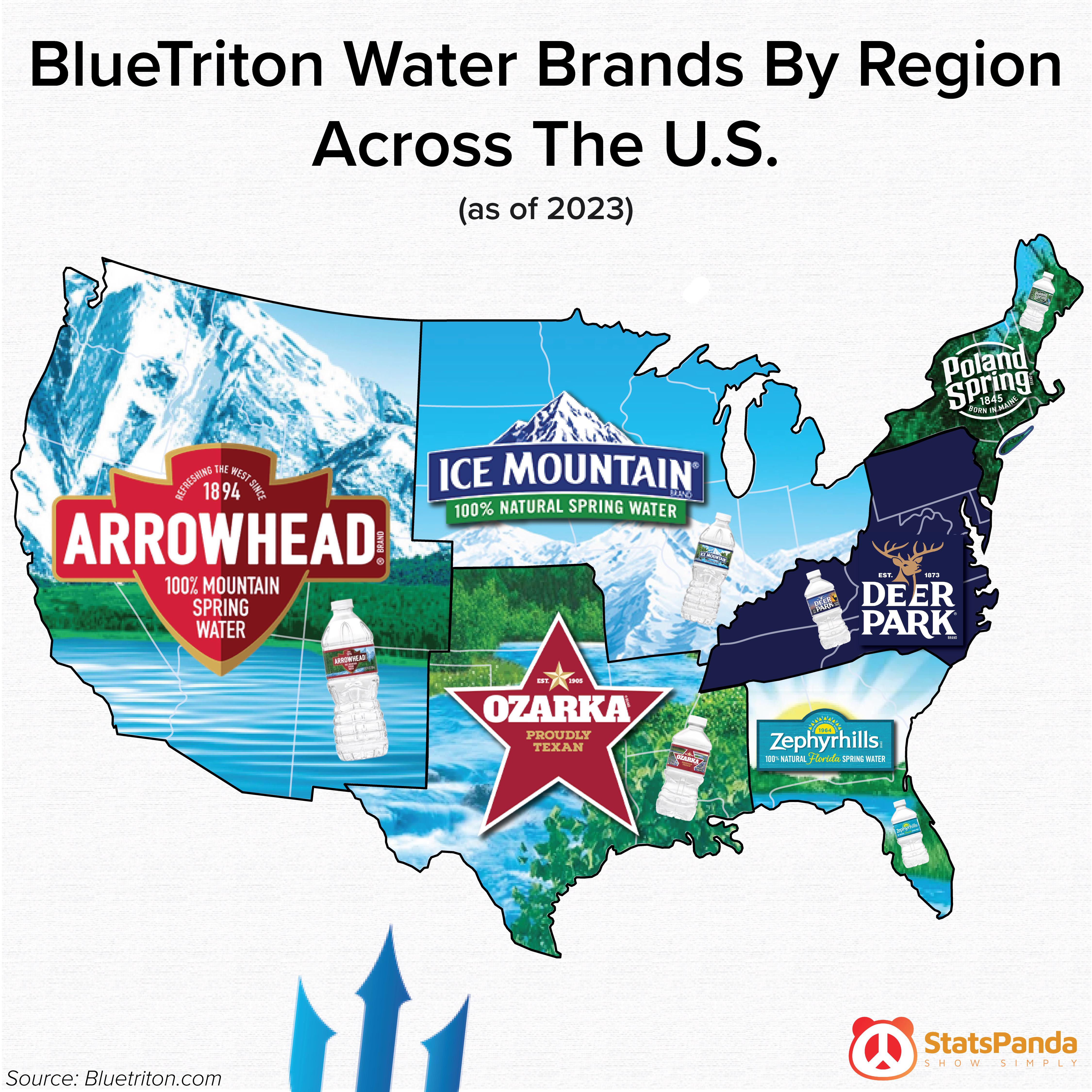
In a decision that could end a years-long battle over commercial extraction of water from public lands, the U.S. Forest Service has ordered the company that sells Arrowhead bottled water to shut down a pipeline and other infrastructure it uses to collect and transport water from springs in the San Bernardino Mountains. The Forest Service notified BlueTriton Brands in a letter last month, saying its application for a new permit has been denied. District Ranger Michael Nobles wrote in the July 26 letter that the company “must cease operations” in the San Bernardino National Forest and submit a plan for removing all its pipes and equipment from federal land. The company has challenged the denial in court.
Environmental activists praised the decision.
“It’s a huge victory after 10 years,” said Amanda Frye, an activist who has campaigned against the taking of water from the forest. “I’m hoping that we can restore Strawberry Creek, have its springs flowing again, and get the habitat back.”
She and other opponents say BlueTriton’s operation has dramatically reduced creek flow and is causing significant environmental harm. The Forest Service announced the decision one month after a local environmental group, Save Our Forest Assn., filed a lawsuit that alleged agency was illegally allowing the company to continue operating under a permit that had expired.
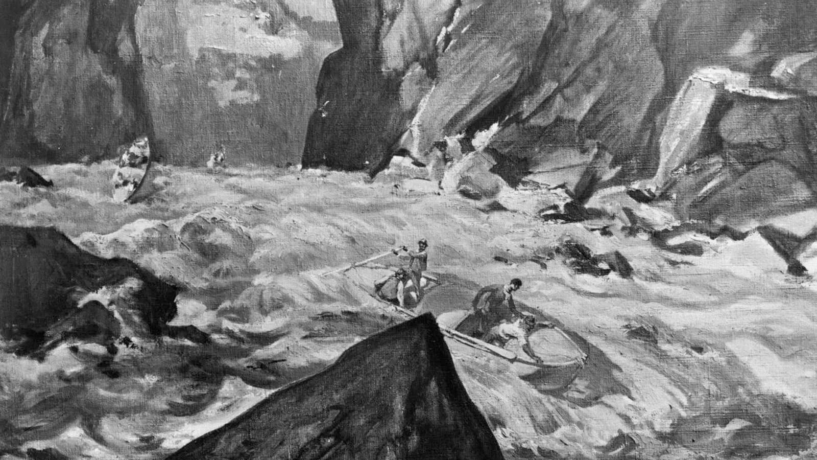
Painting by Henry C. Pitz showing John Wesley Powell and his party descending the Colorado River through the Grand Canyon, presumably during the historic 1869 expedition. (Image credit: Smithsonian Institution, Bureau of American Ethnology)
Intensifying extreme weather events and an insurance crisis are likely to cause significant economic and political disruption in the U.S. sometime in the next 15 years.
The words of explorer John Wesley Powell on the eve of his departure into the unexplored depths of the Grand Canyon in 1869 best describe how I see our path ahead as we brave the unknown rapids of climate change:
Powell’s expedition made it through the canyon, but the explorers endured great hardship, suffering near-drownings, the destruction of two of their four boats, and the loss of much of their supplies. In the end, only six of the nine men survived.
Likewise, we find ourselves in an ever-deepening chasm of climate change impacts, forced to run a perilous course through dangerous rapids of unknown ferocity. Our path will be fraught with great peril, and there will be tremendous suffering, great loss of life, and the destruction of much that is precious.
It is inevitable that climate change will stop being a hazy future concern and will someday turn everyday life upside down. Very hard times are coming. At the risk of causing counterproductive climate anxiety and doomism, I offer here some observations and speculations on how the planetary crisis may play out, using my 45 years of experience as a meteorologist, including four years of flying with the Hurricane Hunters and 20 years blogging about extreme weather and climate change. The scenarios that I depict as the most likely are much harsher than what other experts might choose, but I’ve seen repeatedly that uncertainty is not our friend when it comes to climate change. This will be a long and intense ride, but if you stick through the end, I promise there will be a rainbow.
By late this century, I am optimistic that we will have successfully ridden the rapids of the climate crisis, emerging into a new era of non-polluting energy with a stabilizing climate. There are too many talented and dedicated people who understand the problem and are working hard on solutions for us to fail.
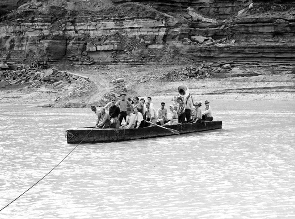
Figure 1. America is about as unprepared for a dangerous trip down the rapids of climate change as this group would have been going down the rapids of the Colorado River in Grand Canyon. Photo taken at the Colorado River crossing at Hite Ferry, Utah, in 1946. (Image credit: Utah Historical Society)
The 1974 made-for-TV movie Hurricane included a subplot loosely based on the hurricane party that allegedly occurred during the 1969 landfall of category 5 Hurricane Camille in Mississippi. The predictable catastrophic end to the party is depicted at 0:05-second mark of the trailer above. Though the party never happened, legendary TV anchorman Walter Cronkite perpetuated the hurricane party story during one of his broadcasts after the hurricane. As the camera panned over the cement slab littered with debris that marked the former location of the Richelieu Apartments, Cronkite narrated: “This is the site of the Richelieu Apartments in Pass Christian, Mississippi. This is the place where 23 people laughed in the face of death. And where 23 people died.”
Although there is a major climate change hurricane approaching, we’re busy throwing a hurricane party, charging up our planetary credit card to pay for the expenses, with little regard to the approaching storm that is already cutting off our escape routes. This great storm will fundamentally rip at the fabric of society, creating chaos and a crisis likely to last for many decades.
The intensifying climate change storm will soon reach a threshold I think of as a category 1 hurricane for humanity — when long-term global warming surpasses 1.5 degrees Celsius above preindustrial temperatures, a value increasingly characterized over the last decade as “dangerous” climate change.
Assuming that we don’t work exceptionally hard to reduce emissions in the next 10 years, the world is expected to reach 2 degrees Celsius of warming between 2045 and 2051. In my estimation, that will be akin to a major category 3 hurricane for humanity — devastating, but not catastrophic.
Allowing global warming to exceed 2.5 degrees Celsius will cause category 4-level damage to civilization — approaching the catastrophic level. And warming in excess of 3 degrees Celsius will likely be a catastrophic category 5-level superstorm of destruction that will crash civilization.
We must take strong action rapidly to rein in our emissions of heat-trapping gases to avoid that outcome — and build great resilience to the extreme climate of the 21st century that we have so foolishly brought upon ourselves.
According to the Carbon Action Tracker (see tweet below), we are on track for 2.7 degrees Celsius of warming; if the nations of the world meet their targets for reducing heat-trapping climate pollution, warming will be limited to 2.1 degrees. There’s a big difference between being hit by a Cat 4 versus a Cat 3, and every tenth of a degree of warming that we prevent will be critical.
Two years on from Glasgow and our warming estimates for government action have barely moved. Governments appear oblivious to the extreme events of the past year, somehow thinking treading water will deal with the flood of impacts? https://t.co/fbM4xY9OJepic.twitter.com/MekGIeU1Z3
As climate scientist Michael Mann explains in his latest book, “Our Fragile Moment,” great climate science communicator Stephen Schneider once said, “The ‘end of the world’ or ‘good for you’ are the two least likely among the spectrum of potential [climate] outcomes.” So forget sci-fi depictions of planetary apocalypse. That will not be our long-term climate change fate.
But the impacts of climate change will be apocalyptic for many nations and people — particularly those that are not rich and White. People and communities with the least resources tend to be the first and hardest hit by climate change, not only because poorer people and communities are inherently more vulnerable to the impacts of any disaster, but also because the extremes induced by climate change tend to be worse in the tropics and subtropics, home to many poor nations.
In the U.S., climate change has already turned life upside down for numerous communities. For example, in North Carolina, the financially strapped, Black-majority towns of Fair Bluff and Princeville are in danger of abandonment from hurricane-related flooding (from Hurricane Floyd in 1999, Matthew in 2016, and Florence in 2018). Seven Springs, North Carolina (population 207 in 1960, now just 55) is largely abandoned.
Climate change was a key contributor to these floods; a 2021 study found that about one-third of the cost of major U.S. flood events since 1988, totaling $79 billion, could be attributed to climate change. And for the town of Paradise, California — utterly destroyed by the devastating Camp Fire of 2018, which killed 85 and caused over $16 billion in damage — climate change has been apocalyptic.
In the U.S., the most likely major economic disruption from climate change over the next few years might well be a collapse of the housing market in flood-prone and wildfire-prone states. Billion-dollar weather disasters — which cause about 76% of all weather-related damages — have steadily increased in number and expense in recent years and would be even worse were it not for improved weather forecasts and better building codes. The recent increase in weather-disaster losses has brought on an insurance crisis — especially in Florida, Louisiana, California, and Texas — which threatens one of the bedrocks of the U.S. economy, the housing and real estate market.
In California, the insurer of last resort, the FAIR plan, had only about $250 million in cash on hand as of March 2024.
“One major fire near Lake Arrowhead, where the Plan holds $8 billion in policies, would plunge the whole scheme into insolvency,” observed Harvard’s Susan Crawford, author of “Charleston: Race, Water, and the Coming Storm.”
It is widely acknowledged that higher weather disaster losses result primarily from an increase in exposure: more people with more stuff moving into vulnerable places, including those at risk of floods. Martin Bertogg, Swiss Re’s head of catastrophic peril, said in a 2022 AP interview that two-thirds, perhaps more, of the recent rise in weather-related disaster losses is the result of more people and things in harm’s way.
But this balance will likely shift in the coming decades. Increased exposure will continue to drive increased weather disaster losses, but the fractional contribution of climate change to disaster losses — at least for wildfire, hurricane, and flood disasters — is likely to increase rapidly, making the insurance crisis accelerate.
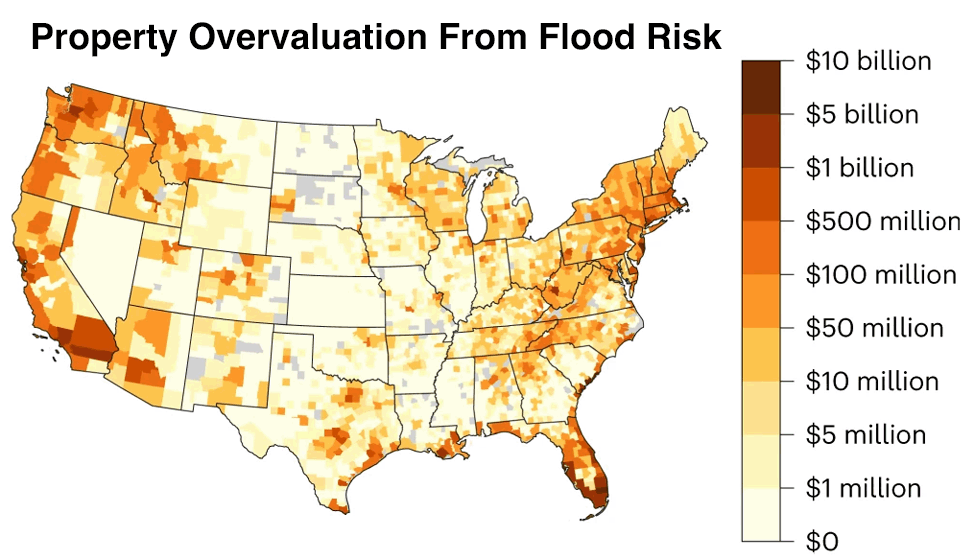
Figure 2. County-level overvaluation of property from flood risk. Florida had the highest property overvaluation — about $50 billion. In 2021, Florida’s real estate industry accounted for $294 billion, or 24% of the gross state product, according to a report from the National Association of Realtors. (Image credit: Gourevitch et al., 2023, Unpriced climate risk and the potential consequences of overvaluation in US housing markets, Nature Climate Change volume 13, pages 250–257)
A 2023 study (Fig. 2) drew attention to a massive real estate bubble in the U.S.: the vast number of properties whose purported value doesn’t account for the true costs of floods. The study estimated that across the U.S., residential properties are overvalued by a total of $121-$237 billion under current flood risks. This bubble will likely continue to grow as sea levels rise, storms dump heavier rains, and unwise risky development continues.
Likewise, U.S. properties at risk of wildfires are collectively overvalued by about $317 billion, according to David Burt, a financial guru who foresaw the 2008 subprime mortgage crisis. Insurers are already pulling out of the areas most at risk, threatening to make property ownership too expensive for millions and posing a serious threat to the economically critical real estate industry.
Climate futurist Alex Steffen has described the climate change-worsened real estate bubble this way:
Something brittle is prone to a sudden, catastrophic failure and cannot easily be repaired once broken. The popping of the real estate Brittleness Bubble will potentially trigger panic selling and a housing market collapse like a miniature version of the Great Financial Crisis of 2008 but focused on the 20% of American homes in wildfire and flood risk zones. In his 2023 Congressional testimony, Burt estimated that a wildfire and flood-induced repricing of risk of the U.S. housing market could have a quarter to half the impact of the 2008 Great Financial Crisis.
However, the 2008 crisis was relatively short-lived, as fixes to the financial system and a massive federal bailout led to a rebound in property values after a few years. A climate change-induced housing crisis will likely be resistant to a similar fix because the underlying cause will worsen: Sea levels will continue to rise, flooding heavy rains will intensify, and wildfires will grow more severe, increasing risk.
Science writer Eugene Linden wrote in 2023, “as we saw in 2008, a housing crisis can quickly morph into a systemic financial crisis because banks own most of the value, and thus the risk, in housing and commercial real estate.”
Crawford of Harvard recently wrote: “Because insurance can help communities and households recover more quickly from disasters, and because so much of the U.S. economy is driven by spending on housing, the inaccessibility and unaffordability of insurance poses a threat to the stability of the entire economy.”
As Sen. Sheldon Whitehouse, a Democrat from Rhode Island, said earlier this year, “The thing about economic crises is that they come on slowly, until they come on fast.”
How the insurance crisis may play out: the “Wholly irrational and completely ad-hoc pirate capitalism” solution
In his blunt 2023 essay, “Insurance Politics at the End of the World,” journalist Hamilton Nolan offers these thoughts on the potential ways this climate change-induced insurance crisis could be addressed:
When will the Brittleness Bubble pop?
When might this “crash into the wall of reality” happen and the Brittleness Bubble pop? Politicians are working extremely hard to keep their jobs by delaying this day of reckoning, artificially limiting insurance rate rises and offering state-run insurance plans of last resort. This approach — the equivalent of giving a blood transfusion to the injured, without stopping the bleeding — does not fix the underlying problem and all but guarantees that the pain of the eventual national reckoning will be much larger. Insurance is designed to transfer risk, but risk is rising everywhere. [ed. emphasis mine]
As the hurricane season is set to begin soon and wildfire risk gradually increasing, private insurers in some states are fleeing areas considered at high risk.
Crawford addressed the issue in a 2024 essay, “Who ends up holding the bag when risky real estate markets collapse?” Citing financial guru Burt, she concluded: “2025 or 2026 is when things give way and it becomes very difficult to offload houses and buildings in risky places where mortgages are suddenly hard to get, much less insurance.” When asked in an interview with Marketplace if the market is due for another correction, as homeowners in places with growing risk of flooding and wildfire have to pay more for insurance, Burt said:
In the same Marketplace story, though, Ben Keys, a professor of real estate and finance at the University of Pennsylvania’s Wharton School, said, “The idea that we would expect there to be a huge wave of defaults or delinquencies feels relatively unlikely.”
But like Burt, climate change futurist Steffen predicts the real estate Brittleness Bubble will pop within five years (10 at the most).
People are beginning to grasp the seismic implications of a widespread loss of home insurance. Good.
But the economic shocks created by finally being forced to acknowledge that our society is unprepared for the realities of climate chaos won't end there.
This reckoning could come sooner for Florida if another $100-billion hurricane hits. The Florida insurance and coastal property market did manage to withstand the $117-billion cost of Category 4 Hurricane Ian of 2022, but another blow like that might well cause a severe downward spiral in the Florida real estate market from which it might never fully recover. This vulnerability was underscored by Florida Gov. DeSantis during a 2023 radio interview with a Boston host, when DeSantis suggested homeowners should “knock on wood” and hope the state didn’t get hit by a hurricane in 2024.
But “knocking on wood” is not an effective climate adaptation strategy for Florida. Because of climate change, Mother Nature is now able to whip heavier bowling balls with more devastating impact down Hurricane Alley. It’s only a matter of time before she hurls a strike into a major Florida city, causing an intensified coastal real estate and insurance crisis. And the odds of such a strike are higher than average in 2024 because of record-warm ocean temperatures in the tropical Atlantic, combined with a developing La Niña event.
Like this hyper-strike rolling robot, Mother Nature is now able to whip heavier bowling balls with more devastating impact down hurricane alley because of the extra heat energy in the oceans from human-caused global warming.
Watch out for increased coastal flooding in the mid-2030s
We may manage to avoid a coastal real estate market crash in the next 10 years if we get lucky with hurricanes and if our politicians continue to pump huge amounts of money to bail out the failing system.
But it will become increasingly difficult to keep the coastal property market propped up beginning in the mid-2030s, because of accelerating sea level rise combined with an 18.6-year wobble in the moon’s orbit. Thus, I expect that the longest we might stave off the popping of the coastal real estate Brittleness Bubble is 15 years.
Figure 3. Predicted change in minor flooding days (>1.74 feet above high tide) in St. Petersburg, Florida, under an “intermediate-high” sea level rise scenario (5.33 feet of sea level rise in 2100 compared to 2000). (Image credit: NASA sea level rise tool)
As I wrote in my 2023 post, 30 great tools to determine your flood risk in the U.S., beginning in 2033, the moon will be in a position favorable for bringing higher tides to locations where one high tide and low tide per day dominate. This will bring a rapid increase in high tide flooding to the coasts of the Gulf of Mexico, the Southeast, the West Coast, and Hawaii. This expected acceleration in the mid-2030s is obvious for St. Petersburg (Fig. 3), plotted using NASA’s Flooding Analysis Tool and Flooding Days Projection Tool. The rapid acceleration in coastal flooding simultaneously along a huge swathe of heavily developed U.S. coast in the mid-2030s will be sure to significantly stress the coastal housing market. And according to the Coastal Flood Resilience Project, the nation is flying blind on the possible impacts: There are no national assessments of the potential loss of major, critical infrastructure assets to coastal storms and rising seas.
Another immediate danger: a series of global extreme weather events affecting agriculture, causing global economic turmoil.
In my 2024 post, “What are the odds that extreme weather will lead to a global food shock?” I reviewed a 2023 report by insurance giant Lloyd’s, which modeled the odds of a globally disruptive extreme food shock event bringing simultaneous droughts in key global food-growing breadbaskets. The authors estimated that a “major” food shock scenario costing $3 trillion globally over a five-year period had a 2.3% chance of happening per year (Fig. 4). Over a 30-year period, those odds equate to about a 50% probability of occurrence — assuming the risks are not increasing each year, which, in fact, they are.
Figure 4. The 2023 ‘Extreme weather leading to food and water shock’ scenario from Lloyd’s. (Image credit: modified from this image)
Yet another concern for the U.S. is the risk of wholly unanticipated “black swan” extreme weather events that scientists didn’t see coming. As Harvard climate scientists Paul Epstein and James McCarthy wrote in a 2004 paper, “Assessing Climate Instability”: “We are already observing signs of instability within the climate system. There is no assurance that the rate of greenhouse gas buildup will not force the system to oscillate erratically and yield significant and punishing surprises.”
One example of such a punishing surprise was Superstorm Sandy of 2012, that unholy hybrid spawn of a Caribbean hurricane/extratropical storm that became the largest hurricane ever observed and one of the most damaging, costing $88 billion. And who anticipated that a siege of climate-change-intensified wildfires in western North America beginning in 2017, causing multiple summers of horrific air quality that would significantly degrade the quality of life in the West? Or the jet stream experiencing a sudden increase in unusually extreme configurations over the past 20 years, leading to prolonged periods of intense extreme weather over multiple portions of the globe simultaneously? As the late climate scientist Wally Broecker once said, “Climate is an angry beast, and we are poking at it with sticks.”
Just as concerning might be future “gray swan” events — extreme weather events that climate models anticipate could happen but exceed anything in the historical record. (“Gray swan” is an expression first coined by hurricane scientist Kerry Emanuel in his 2016 paper, “Grey swan tropical cyclones.”) Several potential gray swan events I have written about include a $1 trillion California “ARkStorm” flood, the potential failure of the Old River Control Structure during an extreme flood that allows the Mississippi River to change course, or a storm like 2015’s Hurricane Patricia, with winds over 200 mph, hitting Miami, Galveston/Houston, Tampa, or New Orleans. The risk of gray swan events is steadily increasing.
I’m often asked if the absurdly extreme weather events we’ve been experiencing recently are the new normal. “No!” I reply. “Heat is energy, so the energy to fuel more intense extreme weather events will increase until we reach net-zero emissions. At that time, the climate will finally stabilize at a new normal with a highly dangerous level of extreme weather events.”
Barring a series of extraordinary volcanic eruptions or a major geoengineering effort, even under an optimistic “low” emissions climate scenario, the earliest the climate might stabilize is in the mid-2070s (Fig. 5); thus, the weather will grow more extreme, on average, for at least the next 50 years. Considering that CO2 emissions have not yet peaked and may be following the “Intermediate” pathway shown below, there is considerable danger that the weather will still be growing more extreme when today’s children are very old early next century. But even when net zero emissions are reached, sea level rise will continue to occur at a pace difficult to adapt to, and the climate crisis will continue to intensify.
Figure 5. Wishful thinking: We’ve reached a “new normal” of extreme weather. In reality, the weather will keep growing more extreme until net-zero emissions are reached. Under the optimistic “Low” scenario presented here, that will not occur until the mid-2070s. (Image credit: 2023 U.S. National Climate Assessment, with annotation added)
The high probability that the weather will grow more extreme throughout the lifetime of everybody reading this essay means that we have to take seriously some very bad long-term threats. As I wrote in my 2022 post, “The future of global catastrophic risk events from climate change,” a global catastrophic risk event is defined as a catastrophe global in impact that kills over 10 million people or causes over $10 trillion (2022 USD) in damage. Since the beginning of the 20th century, there have been only three such events: World War I, World War II, and the COVID-19 pandemic. But climate change is a threat multiplier, increasing the risk of five types of global catastrophic risk events:
Drought
War
Coastal flooding from sea-level rise and land subsidence
Collapse of the Atlantic Meridional Overturning Circulation (AMOC), the powerful currents that circulate warm water in the tropical Atlantic Ocean to the Arctic and back (an August 2024 study gave a 59% chance of an AMOC collapse occurring before 2050)
The likeliest of these is a global catastrophic risk event from sea level rise, which is highly likely to occur by the end of the century. For example, a moderate global warming scenario will put $7.9-12.7 trillion dollars of global coastal assets at risk of flooding from sea level rise by 2100, according to a 2020 study, “Projections of global-scale extreme sea levels and resulting episodic coastal flooding over the 21st century.” Although this study did not take into account assets that inevitably will be protected by new coastal defenses, neither did it consider the indirect costs of sea level rise from increased storm surge damage, mass migration away from the coast, increased saltiness of fresh water supplies, and many other factors. A 2019 report by the Global Commission on Adaptation estimated that sea level rise will lead to damages of more than $1 trillion per year globally by 2050.
Furthermore, sea level rise, combined with other stressors, might bring about megacity collapse — a frightening possibility when infrastructure destruction, salinification of freshwater resources, and a real estate collapse potentially combine to create a mass exodus of people from a major city, reducing its tax base to the point that it can no longer provide basic services. The collapse of even one megacity might have severe impacts on the global economy, creating increased chances of a cascade of global catastrophic risk events. One megacity potentially at risk of this fate is the capital of Indonesia, Jakarta, with a population of 10 million. Land subsidence of up to two inches per year and sea level rise of about an eighth of an inch per year are causing so much flooding in Jakarta that Indonesia is constructing a new capital city in Borneo.
Is the #AMOC approaching a tipping point? Here's my take after researching this topic for over 30 years. Open access, peer-reviewed, in full colour & understandable for non-experts.https://t.co/gMu6Zw5mR7pic.twitter.com/mrgzO9NMxR
— Prof. Stefan Rahmstorf 🌏 🦣 (@rahmstorf) April 11, 2024
I also expect one or more climate change-amplified global catastrophic risk events from drought will occur this century. Mexico City, with a metro area population of 22 million, has suffered record heat over the past year, is in danger of its reservoirs running dry, and is drilling ever-deeper wells to tap an overtaxed aquifer. Though the city will muddle through the crisis now that the summer rains have come this year, what is the plan for 30 years from now, when the climate is expected to be drier and much, much hotter? Although Mexico City can greatly improve its water situation by fixing a poorly maintained system that has a 40% loss rate, it is unclear how the city will be able to survive the much hotter and drier climate of 30 years from now. And at least 10 other major cities are in a similar bind.
Technology can help us adapt to a hotter climate by providing air conditioning (if you are rich enough), but technological solutions to create more water availability when the taps run dry are much more difficult to achieve. I believe water shortages will drive a partial collapse of and mass migration out of multiple major cities 20-40 years from now, significantly amplifying global political and economic turmoil. For example, a 2010 study, “Linkages among climate change, crop yields and Mexico-US cross-border migration,” found that a 10% reduction in crop yields in Mexico leads to an additional 2% of the population emigrating to the United States.
In his frightening 2019 book “Food or War,” science writer Julian Cribb documents 25 food conflicts that have led to famine, war, and the deaths of more than a million people — mostly caused by drought. Since 1960, Cribb says, 40-60% of armed conflicts have been linked to resource scarcity, and 80% of major armed conflicts occurred in vulnerable dry ecosystems. Hungry people are not peaceful people, Cribb argues.
Though climate change itself is not accelerating faster than what climate scientists and climate models predicted, devastating impacts from climate change do seem to be accelerating. That is because the new climate is crossing thresholds beyond which an infrastructure designed for the 20th century can withstand. These breaches are occurring in tandem with an increase in exposure — more people with more stuff living in harm’s way — which is the dominant cause of the sharp increase in weather-disaster losses in recent years. It’s sobering to realize that the current U.S. insurance crisis has primarily been driven by increased exposure and foolish insurance policies that promote development in risky places — not climate change — and that climate change’s relative contribution to the crisis is set to grow significantly.
Accelerating sea level rise alone is sure to cause a massive shock to the U.S. economy; according to a 2022 report from NOAA, sea level along the U.S. coastline is projected to rise, on average, 10-12 inches (0.25-0.30 meters) in the next 30 years (2020-2050), which will be as much as the rise measured over the last 100 years (1920-2020). At this level, 13.6 million homes might be at risk of flooding by 2051, triggering a mass migration of millions of people away from the coast.
If we add to sea-level-rise-induced migration the additional migration that will result from climate change-intensified wildfires, heatwaves, and hurricanes, we are forced to acknowledge the reality that a nation-challenging Hurricane Katrina-level climate change storm has already begun in the U.S., one which has the potential to cause catastrophic damage. As I wrote in my June post, The U.S. is finally making serious efforts to adapt to climate change, there have been some encouraging efforts to prepare for the coming mass migration. But, as I argued in my follow-up post, The U.S. is nowhere near ready for climate change, we remain woefully unprepared for what is coming.
And my subsequent post, Can a colossal extreme weather event galvanize action on the climate crisis?, argues that we should not expect that any future extreme weather event or breakdown of the climate system will galvanize the type of response needed — we’ve already had at least 13 events since 1988 that should have done so, yet have not. Even if such an event did prompt strong, transformative change, it’s too late to avoid having life turned upside-down by climate change. It’s like we’ve waited until our skin started getting red before seeking shade from the sun, and we’re only now taking our first stumbling steps toward shade. Well, it’s a long hike to shade, and a blistering sunburn is unavoidable.
Given the unprecedented nature and complexity of this planetary crisis, there is huge uncertainty on how this drama may unfold; there are climate scientists who offer a more optimistic outlook than I do (for example, Hannah Ritchie, author of “Not the End of the World”), and those who are more pessimistic (James Hansen).
I suggest that you make the most of the current “calm before the storm” and prepare for the chaotic times ahead, which could begin at any time. I will offer my recommendations on how to do this in my next post in this series, “What should you do to prepare for the climate change storm?”
The urgency to rapidly deal with the climate crisis was succinctly summarized by the Intergovernmental Panel on Climate Change in its latest summary report: “There is a rapidly closing window of opportunity to secure a livable and sustainable future for all.”
But taking advantage of that window of opportunity is difficult because of human psychological and political realities. In climate scientist Peter Gleick’s 2023 book, “The Three Ages of Water,” he quotes Harvard’s E.O. Wilson, father of sociobiology, who perhaps said it best: “The real problem of humanity is the following: We have Paleolithic emotions, medieval institutions, and godlike technology. And it is terrifically dangerous, and it is now approaching a point of crisis overall.”
The boat of civilization has already hit multiple rocks along the rapids of climate change and is taking on water. Perilous rapids with even more dangerous rocks and waterfalls lie before us, but the course of our boat cannot be so easily altered to avoid the rocks, because of our Paleolithic emotions and medieval institutions. As a result, we may have only a few more years — or perhaps as long as 15 years — of relative normalcy in our everyday lives here in the U.S. before the approaching climate change storm ends our golden age of prosperity. But this “golden age” was made of fool’s gold, paid for with wealth plundered from future generations.
Figure 6. The North Rose window of Chartres Cathedral, France, 1190-1220 CE. The stained glass window shows scenes of Jesus Christ, the prophets and 12 kings of Judah. (Image credit: Walwyn) Licensed under Creative Commons BY-NC.
Though this essay has dwelt on some grim realities, I am optimistic that we will prevent climate change from becoming a civilization-destroying category 5-level catastrophe. But we must fight extremely hard to correct the course of our boat and not allow its inertia to carry us into the rocks that stud the rapids of climate change. This is not a task that can be accomplished in our lifetimes.
Susan Joy Hassol, the climate communication veteran who served as a senior science writer on three National Climate Assessments, put it this way in an interview with Yale Climate Connections contributor Daisy Simmons: “This is the fight of our lives, and it’s a multigenerational task. We need what’s been called ‘cathedral thinking.’ That is, the people who started working on that stone foundation, they never saw the thing finished. It took generations to get these major works done. This is that kind of problem. And we have to all do our part. The more I act, the better I feel, because I know I’m part of the solution.”
Actions we take now will yield enormous future benefits, and the faster we undertake transformative actions to adapt to the new climate reality, the less suffering will occur. The Global Commission on Adaptation says that “every $1 invested in adaptation could yield up to $10 in net economic benefits, depending on the activity.” We should work to build our cathedral of the future with the thought that each action we take now will multiply by a factor of 10 in importance in the future.
An excellent @nytimes article on rapid growth of wind, solar, & EVs, including factories, in the US. Costs are below fossil and nuclear (see graphs). Reasons why, graphs with how fast, pictures of it happening. https://t.co/uglQDnE97tpic.twitter.com/oIpLmlp28v
But some of the hardest work has been done: The cornerstone of this cathedral of the future has already been laid. The clean energy revolution is here and has progressed far more rapidly than I had dared hope. Passage of the 2021 Bipartisan Infrastructure Law and 2023 Inflation Reduction Act has been instrumental in getting this cornerstone laid. Solar energy is now the cheapest source of energy in world history, and the costs of wind power and battery technology have also plummeted. Two recent reports were optimistic that climate-warming carbon dioxide emissions had finally peaked in 2023, and GDP growth has decoupled from carbon dioxide emissions in recent years, giving hope that economic growth can still occur without making the planet hotter.
At its heart, the root of the climate crisis is humanity’s spiritual inharmoniousness: We overvalue the pursuit of material wealth and we worship billionaires but undervalue growing more connected to our spiritual selves and acting to preserve and appreciate the natural systems that sustain us. Making yourself more peaceful and loving through quiet spiritual pursuits and time spent in nature will help counteract the anxiety and fear sparked by the climate crisis. But in tandem with your increased peace must come a righteous anger to “throw the money changers out of the temple” and topple the might of the fossil fuel industry and its enablers.
So put your shoulder to an oar! Help us power the boat of civilization through the rapids of climate change. All of humanity shares the same boat, and you have the opportunity to make your own unique and valuable contribution to the effort.
We're loving this exercise created by @AyanaEliza & shared by @allwecansave for figuring out what you should do about the climate crisis:
Make a Venn diagram and notice what's at the center: 1. What brings you joy? 2. What is the work that needs doing? 3. What are you good at? pic.twitter.com/m0uVd6ctug
Figure 7. A portion of a 360-degree rainbow seen from a NOAA P-3 hurricane hunter aircraft as it flew through a rain shower near South Florida in 1988. (Image credit: Jeff Masters)
As promised, here is the rainbow at the end. It’s the intro image from my first and last Weather Underground blog posts, “The 360-degree Rainbow,” and “So long, wunderground!” My unique and valuable contribution to building our new cathedral has not yet reached the end of the rainbow, for a rainbow has no end — it is a full circle. One just has to fly high in a rainstorm where the sun is shining to see it.
I will continue to make my voice heard as long as climate science-denying politicians, corporations, media pundits, and wealthy individuals continue to row the boat of civilization into the rocks of climate-change catastrophe. I encourage those of you who have learned about extreme weather and climate change from me to do the same. To get started, learn from one of the best communicators in the business, climate scientist Katherine Hayhoe:
A grassland in an area formerly dominated by boreal forest. Photo credit: Dawn Magness, U.S. Fish & Wildlife Service.
Click the link to read the article on the NOAA website (Wynne E. Moss):
August 5, 2024
Alaska’s boreal forests are declining, as increasing drought stress and fire kill off the next generation of conifer trees. Where boreal forest has disappeared, new plant communities—like grasslands and aspen forests—have begun to take its place.
Elsewhere, in the southeastern United States, droughts have decimated saltmarsh vegetation, turning saltmarshes into mudflats or open water.
In the Southwest, pinyon pines have experienced widespread die-offs during extreme droughts. Meanwhile, junipers and grasses have expanded.
Across the globe, natural resource managers now face the reality of stewarding such landscapes with vastly different species and functions. These are just three examples of drought-triggered ecological transformation, a growing phenomenon that is highlighted in a new paper in the journal BioScience.
Research on ecological drought demonstrates that while many species are tolerant of water shortages, others may experience declines, with recovery taking years or even decades after drought ends. The new study, funded by the U.S. Geological Survey (USGS) National Climate Adaptation Science Center, discussed an even more extreme possibility—that some ecosystems will never recover from drought. Instead of returning to pre-drought conditions, some ecosystems may undergo transformation, or a shift into a new, persistent state, dominated by different forms of vegetation.
Ecosystem transformations represent a major challenge for natural resource agencies. Those caused by drought can be particularly rapid and surprising. To aid preparedness, researchers synthesized science on the mechanisms involved in drought-triggered transformation. Their work provides a broad overview of this phenomenon and highlights three major points about drought’s ability to cause long-term ecological change:
1. Drought-triggered transformations are happening across the globe.
The paper highlights a dozen examples of transformations triggered by drought. They occur in many types of ecosystems, including temperate and tropical forests, grasslands, and woodlands. This suggests the risk of transformation is not limited to arid ecosystems or forests, which have received the bulk of scientific attention.
2. Shifting drought regimes are eliciting more extreme ecosystem responses.
As the climate warms, many regions of the planet are expected to experience novel and more extreme drought regimes. This is true even where annual precipitation is increasing. Certain forms of drought, including hotter droughts, snow droughts, and flash droughts, are becoming more common. Plant communities in a location may not be adapted to the changing character of drought, which may have greater impacts and exacerbate the risk of transformation.
3. Drought interacts with stressors that reduce ecosystem resilience.
Increasing drought severity is not the only factor causing transformation. The ability of ecosystems to recover from drought is also changing in the 21st century. Stressors like habitat loss, invasive species, and fire are increasingly likely to occur alongside or after drought and disrupt recovery after drought. Although managers have little control of the severity of drought, they may be able to reduce the likelihood of transformation by addressing these stressors.
Twelve locations where drought has caused a significant and permanent change in ecosystem composition. Examples occur across an aridity gradient and involve multiple different mechanisms. Figure modified from Moss et al. 2024. Base Map: World Terrestrial Ecosystems 2020.
The Next Challenge: Preparing for the Future
Translating this information into readiness is the next challenge. Many managers are already aware that climate change can trigger large shifts in the systems they manage. But they may not be aware that these changes could happen quite rapidly—after the next severe drought. Syntheses such as this can help managers develop both proactive and reactive strategies to respond to drought. A better understanding of the mechanisms involved also aids in developing predictive science to tell us what systems are most vulnerable. However, some aspects of ecosystems are just not predictable. Rather than aiming to perfectly predict the future, managers could prepare for a range of potential outcomes and consider how their actions could steer the recovery of ecosystems towards preferred conditions after drought.
Denver’s City Ditch is celebrating its 150th anniversary in 2017. Learn about the Ditch’s important role in Denver’s history and how Denver Water helps out.
August 14, 2024
Long before Denver was established, residents of the area drank water directly from the South Platte River and Cherry Creek.
But the surface wells and buckets of water used as a delivery system were not an adequate means of providing the one thing these early travelers needed for survival: water. Irrigation ditches were the next step forward for the growing population spurred by the city’s Gold Rush of 1859.
But the surface wells and buckets of water used as a delivery system were not an adequate means of providing the one thing these early travelers needed for survival: water. Irrigation ditches were the next step forward for the growing population spurred by the city’s Gold Rush of 1859.
Crews work on City Ditch in this 1935 photo. Photo credit: Denver Water
“City Ditch first started flowing in 1867,” said Sarah McCarthy, Washington Park community member. “It’s a huge part of the Denver community.”
City Ditch was the vision of the Capitol Hydraulic Company, which saw an opportunity to bring more water to Denver from the South Platte River system, explained Holly Geist, Denver Water’s records management analyst.
“The Kansas Territorial Legislature allowed the company to build a ditch and use water for agricultural, mining, mechanical and city purposes,” Geist said.
The company’s first attempt to build the ditch failed in the early 1860s in part because the slope wasn’t high enough for water to flow to Denver.
According to Geist, surveyor and engineer Richard Little — the man for whom Littleton is named — was brought in to build a new flow path for the ditch that was farther up the river, closer to Waterton Canyon. Businessman John W. Smith was brought in to complete building the ditch and water began flowing into the city in 1867.
“There really was nothing in the area but scrub where Washington Park is today,” McCarthy said. “The ditch brought water for farms and homes and helped transform City and Washington parks into the urban gardens they are today.”
The city of Denver took control of the ditch in 1875, and by 1898 nearly all of the ditch within city limits had been placed in pipes. Denver Water acquired the ditch in 1918.
Community members “christen the monument with water balloons” during a celebration at Washington Park in Denver on Aug. 12, for the 150th anniversary of City Ditch. Photo credit: Denver Water
City Ditch continues to flow today, but in two sections. The southern section is managed by the city of Englewood and the northern section by Denver Water.
Denver Water’s portion of the open ditch can still be found flowing through Denver’s Washington Park. City Ditch’s primary function now is to irrigate and fill the lakes in Washington and City parks.
In an effort to conserve more river water supplies, Denver Water began using water from its Recycling Plant in 2004 for the northern section of the ditch. Stormwater also flows through it. Washington Park and the open section of City Ditch were listed on the National Register of Historic Places in 1976 and designated a Denver Landmark in 1977.
McCarthy hopes people will visit a monument at Washington Park that honors John W. Smith and the people who helped build City Ditch. The monument is located south of the playground near Smith Lake.
“If John W. Smith were here today, he’d be very proud that City Ditch is still supplying water that’s vital to our community,” McCarthy said. “We hope the anniversary raises awareness about the ditch and its history and increases our community’s pride in the city.”
Colorado River “Beginnings”. Photo: Brent Gardner-Smith/Aspen Journalism
Click the link to read the article on the InkStain website (Kathryn Sorensen, Sarah Porter and John Fleck):
August 16, 2024
Colorado River Basin governance is increasingly struggling with a deep question in water management: When we reduce our use of water, who gets the savings?
If I install more efficient irrigation equipment, should I get credit for the saved water to expand my acreage, or save the water in an upstream reservoir as a hedge against next year’s drought? If I tear out lawns, can I use the saved water to help build the next subdivision, or save the water in an upstream reservoir as a hedge against that next year of drought?
Or should the savings contribute, not to my own resilience and well-being, but to the resilience and the well-being of the system as a whole by simply reducing overall water use?
In a deeply insightful 2013 book, British scholar Bruce Lankford bestowed the unfortunately wonky name of “the paracommons” to this question, and it dogs water policy management around the world.
This issue has been lurking in Colorado River management for a long time. Should we create legal structures that allow users to bank the savings for their own use later? Or should the reductions benefit the health of the system as a whole? There are advantages and disadvantages to both approaches, and we need to design new rules for managing the Colorado River with our eyes open on this question.
Assigned Water
In a new paper, we explore the implications of the two paths for the management of a post-2026 Colorado River.
One is to incentivize conservation by giving water users the chance to bank saved water for later use. Known most commonly as Intentionally Created Surplus (ICS), and more broadly in a series of increasingly creative implementations as “Assigned Water,” this creates short term savings.
The other involves permanent reductions – “System Water.” Water use is reduced for the benefit of the Colorado River as a whole.
In more than a decade of experimentation with these policy tools, we have seen the results. Investment in Assigned Water, attractive to water managers because of the allure of getting their water back, has crowded out investment in the more durable System Water reductions that will be needed to bring the Colorado River into balance.
As we develop new operating rules for the river, we need to be mindful of the differences involved.
Assigned Water does not solve the problem of overallocation because when it is deployed we are borrowing against our own bank. Enduring solutions on the river can only be found by addressing overallocation.
Assigned Water creates critically important operational flexibility; it allows its owner to either forgo water deliveries in one year—or pay someone else to—and take delivery of that water during another potentially desperate time.
Assigned Water is generally insulated from shortage, forfeiture and abandonment.
Protection from shortage and forfeiture has value; Assigned Water creates individual resiliencefor its owner. Because of this, the availability of Assigned Water appears to crowd out investment in collective resilience in the form of System Water.
In conversations about post-2026 operations negotiators are contemplating extending, enlarging and/or enhancing Assigned Water and/or creating an operationally neutral form called Top Water. In any form, Assigned Water lives outside of the existing priority system. In this regard, the conversation involves the reallocation of water in Lakes Powell and Mead.
Critics of the West’s priority system of water delivery can rejoice—nearly 40% of the water in Mead in 2023 was Assigned Water, meaning that Assigned Water is replacing priority to a significant degree. But is the priority system like capitalism in that it has its warts but the alternatives are far worse? As the expansion of the rights of municipal water providers, irrigation districts, foreign nations and tribes to own even more and different kinds of Assigned Water is contemplated for a post-2026 world, consideration should also be given to how these changes may also inure to the benefit of environmental non-governmental organizations, hedge funds and water speculators. Those who share John Wesley Powell’s fears will understand the implications because the expansion of Assigned Water in Lakes Powell and Mead may bring about the ultimate divorce of priority-based water rights from arid lands in the Colorado River Basin.
There are important elements of transparency and fairness at play. The large, powerful players on the River received Assigned Water through negotiations not available to others—meaning, there was no open bidding process or invitation to smaller entities to acquire this valuable water. Apparently, there still isn’t. Thought ought to be given to those other stakeholders—smaller cities, farmers, tribes and others—who have made investments and built economies based on the priority system. Imagine a restaurant that operates on a first-come-first-serve basis and a hungry patron who waits patiently in line for the doors to open only to be told that the rules changed while he was waiting and all of the reservations have been claimed through a process from which he was excluded.
It is helpful to continue to deploy a tool as flexible and alluring as Assigned Water, particularly in the form of operationally neutral Top Storage, so there’s no need to throw the baby out with the bath water. A reasonable path forward may be to allow the creation of Top Storage with appropriate guardrails while including a 50% cut for System Water. Post 2026, Assigned Water will be so valuable that entities likely will be willing to take a big haircut to get it, and such a required contribution solves the problem of developing enduring funding for System Water to a significant degree. Maybe ultimately environmental non-governmental organizations, hedge funds and water speculators get a piece, but if so, it will be at the price of protecting and respecting the priority system upon which so many depend.
a Schematic fold-bifurcation diagram of a model tipping element with global mean temperature (GMT) as a forcing parameter and two stable states separated by the unstable manifold. The red arrows indicate the feedback direction of the entire system if a forcing occurs. This means, that if the system is pushed across the unstable manifold, it will move towards the opposite stable equilibrium state. b Illustrative time-evolution of one sample model run of each tipping element: Greenland Ice Sheet (GIS), West Antarctic Ice Sheet (WAIS), Atlantic Meridional Overturning Circulation (AMOC), Amazon Rainforest (AMAZ), including the threshold for state evaluation (dashed grey line). Credit: Nature Communications
Under current emission trajectories, temporarily overshooting the Paris global warming limit of 1.5 °C is a distinct possibility. Permanently exceeding this limit would substantially increase the probability of triggering climate tipping elements. Here, we investigate the tipping risks associated with several policy-relevant future emission scenarios, using a stylised Earth system model of four interconnected climate tipping elements. We show that following current policies this century would commit to a 45% tipping risk by 2300 (median, 10–90% range: 23–71%), even if temperatures are brought back to below 1.5 °C. We find that tipping risk by 2300 increases with every additional 0.1 °C of overshoot above 1.5 °C and strongly accelerates for peak warming above 2.0 °C. Achieving and maintaining at least net zero greenhouse gas emissions by 2100 is paramount to minimise tipping risk in the long term. Our results underscore that stringent emission reductions in the current decade are critical for planetary stability. [ed. emphasis mine]
Opening ceremony Summer Olympics Paris 2024. Photo credit: Olympics.com
Click the link to read the article on the Heated website (Emily Atkin). Here’s an excerpt:
August 1, 2024
I haven’t had time to analyze media coverage of the 2024 Olympic Games. So I’m not sure how many stories about Tuesday’s dangerous heat in Paris mentioned that the high temperatures were fueled by climate change. But just in case you didn’t see, here’s an important stat: Fossil fuels, deforestation, and animal agriculture made outdoor temperatures at Tuesday’s Olympics about 5.2°F degrees hotter than they would have normally been.
The reason we know this is because of incredible recent advancements in attribution science, which uses observational data and statistical methods to figure out how likely and severe an extreme weather event would be today, compared to how it would have played out in a world un-warmed by human activities. Specifically, the 5.2°F number comes from a “super rapid analysis” published Wednesday by World Weather Attribution (WWA), an international group dedicated to conducting and communicating attribution science. It found the heat wave that’s plagued France and other Mediterranean countries this July would have been anywhere from 4.5°F (2.5°C) to 5.9°F (3.3°C) cooler in a pre-climate-changed world. The average of that range is 5.2°F.
I spell all this out because I want to make it clear: If we want the summer Olympics to continue to exist and be safe for athletes, we need to rapidly reduce emissions from these sectors. I’ve said it before, but I’ll say it again: It’s not enough to say that “climate change” is screwing with the things we love. Communicators have to also be clear about why climate change is happening, so it’s equally clear what must be done.
Editor’s note: Kyle Hilburn, a research scientist in the Department of Atmospheric Science at Colorado State University, wrote this piece for The Conversation in August 2024. Colorado State University is a contributing institution to The Conversation, an independent collaboration between editors and academics that provides informed news analysis and commentary to the general public. See the entire list of contributing faculty and their articles here.
Wildfire blowups, fire whirls, towering thunderstorms: When fires get large and hot enough, they can actually create their own weather.
In these extreme fire situations, firefighters’ ordinary methods to directly control the fire don’t work, and wildfires burn out of control. Firefighters have seen many of these risks in the enormous Park Fire burning near Chico, California, in summer 2024.
But how can a fire create weather?
Satellite images shows how the Park Fire near Chico, Calif., created intense pyrocumulonimbus plumes, visible in white, in July 2024. CSU/CIRA and NOAA
I’m an atmospheric scientist who uses data collected by satellites in weather prediction models to better anticipate extreme fire weather phenomena. Satellite data shows fire-produced thunderstorms are much more common than anyone realized just a few years ago. Here’s what’s happening.
The wildfire and weather connections
Imagine a wildland landscape with dry grasses, brush and trees. A spark lands, perhaps from lightning or a tree branch hitting a power line. If the weather is hot, dry and windy, that spark could quickly ignite a wildfire.
When vegetation burns, large amounts of heat are released. This heats the air near the ground, and that air rises like a hot air balloon because hot air is less dense than cool air. Cooler air then rushes in to fill the void left by rising air.
Fires create their own wind patterns and weather as their heat rises. The illustration is based on a coupled fire-atmosphere computer model, WRF-SFIRE-CHEM. Adam Kochanski/San Jose State University/WIRC
What happens next depends on the stability of the atmosphere. If the temperature cools rapidly with elevation above the ground, then the rising air will always be warmer than its surroundings and it will keep rising. If it rises high enough, the moisture will condense, forming a cloud known as a pyrocumulus or flammagenitus.
If the air keeps rising, at some point the condensed moisture will freeze.
Once a cloud has both liquid and frozen water particles, collisions among these particles can lead to electrical charge separation. If the charge buildup is large enough, an electrical discharge – better known as lightning – will occur to neutralize the charges.
Whether a fire-induced cloud will become a thunderstorm depends on three key ingredients: a source of lift, instability and moisture.
Dry lightning
Wildfire environments typically have limited moisture. When conditions in the lower atmosphere are dry, this can lead to what’s known as dry lightning.
No one living in a wildfire-prone environment wants to see dry lightning. It occurs when a thunderstorm produces lightning, but the precipitation evaporates before reaching the ground. That means there is no rain to help put out any lightning-sparked fires.
Fire whirls
As air rises in the atmosphere, it may encounter different wind speeds and directions, a condition known as wind shear. This can cause the air to spin. The rising air can tilt the spin to vertical, resembling a tornado.
These fire whirls can have powerful winds that can spread flaming ash, sparking new areas of fire. They usually are not true tornadoes, however, because they aren’t associated with rotating thunderstorms.
Timelapse footage shows ‘fire tornado’ form in California wildfire. Timelapse video from 25 July captured California’s Park fire creating what appears to be a ‘fire tornado’. Subscribe to Guardian News on YouTube ► http://bit.ly/guardianwiressub The fire, burning northeast of Chico California, forced thousands of residents in Butte County, about 100 miles northeast of Sacramento, to evacuate their homes. The fire, which stretched over four counties, was believed to be caused by arson, after authorities say a man was seen pushing a burning car into a ravine. Firefighters battle California’s seventh largest wildfire on record as thousands under threat ► https://www.theguardian.com/world/art… The Guardian publishes independent journalism, made possible by supporters. Contribute to The Guardian today ► https://bit.ly/3uhA7zg
Decaying storms
Eventually, the thunderstorm triggered by the wildfire will begin to die, and what went up will come back down. The downdraft from the decaying thunderstorm can produce erratic winds on the ground, further spreading the fire in directions that can be hard to predict.
When fires create their own weather, their behavior can become more unpredictable and erratic, which only amplifies their threat to residents and firefighters battling the blaze. Anticipating changes to fire behavior is important to everyone’s safety.
Satellites show fire-created weather isn’t so rare
Today, these satellites can alert firefighters to a new blaze even before phone calls to 911. That’s important, because there is an increasing trend in the number, size and frequency of wildfires across the United States.
As more people move into fire-risk areas in this warming climate, the risk of fires starting is also rising. With fires come cascading hazards that persist long after the fire is out, such as burn-scarred landscapes that are much more susceptible to landslides and debris flows that can affect water quality and ecosystems.
It’s important to remember that fire is a natural part of the Earth system. As fire scientist Stephen J. Pyne writes, we as humans will have to reorient our relationship with fire so we can learn to live with fire.
For the San Juan Southern Paiute Tribe, the Northeastern Indian Water Rights Settlement Act means more than water — it means finally claiming land they can call home. Although the tribe has lived in their current home base for hundreds of years, they were only federally recognized in 1989, and the land they lived on, in northern Arizona and southern Utah, was incorporated into the Navajo Nation. The Paiutes are the only federally recognized tribe in Arizona without a reservation or land.
In 2000, leaders from the Navajo Nation and the San Juan Southern Paiute Tribe signed a historic treaty, the first intertribal treaty in 160 years. The treaty granted the Paiutes approximately 5,400 acres of land, divided into two parcels, that was occupied by Paiute families. The treaty has never been ratified by Congress, and nearly a quarter century later, the land still has not been granted to the Paiutes. That could change if Congress approves and President Joe Biden signs the water settlement, which would finally allocate these parcels to the San Juan Paiute Tribe…
“With this water settlement, of course water being a precious commodity to this day and it is worth everyone fighting for, what this settlement will actually helps us do get our reservation secured,” said San Juan Paiute President Robbin Preston Jr., “so that all our tribal members can say ‘yes, i do have a home.’”
The science behind the city of San Diego’s multibillion dollar effort to recycle wastewater into drinking water.
Try driving up Morena Boulevard in Mission Valley, or north through Bay Park and Clairemont, and chances are you’ll be bottlenecked by an army of orange traffic cones demarking a huge construction project that will consume northern San Diego for years to come.
The city of San Diego is currently building a massive wastewater-to-drinking water recycling system – but it must tear up the streets to do it. The new pipe route tunnels from Morena Pump Station near the San Diego International Airport, then 10 miles north to University City and then another 8 miles to Miramar Reservoir, the final stop for all our transformed toilet water.
But wait – why is San Diego drinking its own sewage in the first place? And how is that even possible?
That’s why San Diego is very proud of its recycling project, called Pure Water, which will turn 42 million gallons of wastewater into 34 million gallons of drinking water per day once the first phase is complete around 2027. But the project is actually a compromise the city made after years of wrangling over sewage, of which unlike drinkable water, the city often has too much.
A bit of history: In the 1930s, San Diego dumped its sewage into San Diego Bay which began to corrode the hulls of Navy ships and drove tourists away. In 1963, the city, with support from neighboring cities, opened the Point Loma Wastewater Treatment Plant which cleaned wastewater one way, but soon fell short of what the 1972 Clean Water Act required.
San Diego was on the hook to make billions of dollars in upgrades to Point Loma, even though it argued dumping treated wastewater should be OK because, as the saying goes, “the solution to pollution is dilution.” Congress agreed to give the city a pass on the Clean Water Act requirements for a decade until it failed to reapply for a waiver, setting off a wave of litigation. That’s about the time San Diego offered to do something different: Make its wastewater drinkable.
Filtration membranes at the city of San Diego’s new wastewater-to-drinking water facility on June 11, 2024. / MacKenzie Elmer
That seemed to settle qualms from environmentalists angered by Point Loma’s ocean pollution and the feds that were upset over continued Clean Water Act waivers. And here we are.
Pure Water officials told me the water produced on the other side of the multi-step recycling process is so clean, the city must add minerals back in at the end. And there’s the added bonus of San Diego having to buy less imported water – one of the city’s biggest monthly bills. Pure Water is supposed to provide over half the city’s water needs when it’s complete.
So instead of billions in upgrades to Point Loma, the city’s spending billions on Pure Water, about $1.5 billion just for the first of its two phases.
Beyond the miles of new pipeline and pumps yet to be built to round out the system, an expansion of the existing North City Water Reclamation Facility in Miramar is the heart of the purification process. Juan Guerreiro, the director of the city of San Diego’s Public Utilities Department, gave me and our social media journalist, Bella Ross, a tour of the construction.
The North City reclamation plant, and its sister plant in South Bay, were built about 25 years ago to divert some of the waste being sent to Point Loma, clean it, and use it for irrigation. The massive expansion effort is underway while the North City plant is still doing its 24/7 job.
Juan Guerreiro, the director of the city of San Diego’s Public Utilities Department, points to the new Pure Water North City facility under construction on June 11, 2024. / MacKenzie Elmer
“It’s like open heart surgery. You’re running the plant producing recycled water while it’s being expanded,” Guerreiro said.
That plant already strains out all the solids, adds bacteria to eat up bad gunk, chlorinates and then runs water through coal filters – like a big Brita filtration system. You could probably drink the end product, but it wouldn’t pass California’s drinking water standards. Pure Water adds five extra treatment steps, including shooting every water molecule through a filter membrane with pores that are 500,000 times smaller than a human hair.
After all that energy-intensive cleaning, the city dumps the purified water in the Miramar Reservoir where San Diego stores much of its untreated drinking water already. But wait, isn’t it kind of a shame to dump that extra-purified water into a reservoir filled with yet untreated drinking water, then treat it again?
In an abundance of caution, California requires the treated wastewater-turned-drinking water be stored in an “environmental buffer” like a reservoir or an underground aquifer, instead of pumping it straight to public taps. It’s a kind of “just in case” measure for a lot of these new recycling projects. Orange County built a similar wastewater-to-drinking water system in 2008 that injects the treated water into underground aquifers. San Diego doesn’t have many aquifers so the next best buffer is the reservoir.
City of San Diego digging a megatrench to transport treated water from its new Pure Water facility on June 11, 2024. / MacKenzie Elmer
Building Pure Water is a massive undertaking that involves building what officials called a “mega trench” artery connecting the North City Reclamation facility and the new Pure Water facility underneath Eastgate Mall road. But the city is also building a Pure Water education center on site to cure any skeptics of their suspicion of the process.
Now, students, don your lab goggles and learn how Pure Water is done:
How it works now: Someone in the city of San Diego flushes their toilet. The waste flows through pipes in a building then out to the street into a large sewer main. Eventually it hits a pump station which shoots the sewage to its traditional final destination: The Point Loma Wastewater Treatment Plant.
How it will work once Pure Water is complete: Everything is the same at the start, except a new pump station off Morena Boulevard and north of Interstate 8 will be responsible for diverting 32 million gallons of wastewater away from Point Loma and sending it northward to the reclamation plant.
Workers erect a massive retaining wall at the city of San Diego’s new Pure Water facility on June 11, 2024. / MacKenzie Elmer
Once it makes its miles-long journey to the plant, the sewage moves through the first steps of a typical treatment process, starting with what’s called primary. That phase gets rid of the most obvious gross stuff. The water sits still in a settling tank so fats, oils, grease and plastic float to the top where that gunk is skimmed off and sent to disposal. Organic solids (fecal matter, etc.) sink to the bottom and separate from the water.
That water is not ready to drink yet. Its next stop is secondary treatment, where the wastewater moves into huge concrete bathtubs and pumped through with air and microbes that eat up a lot of the organic stuff still floating around. The microbes burp out ammonia, carbon dioxide gases and water. If that bacteria begins to die during this process, it’s a signal to treatment plant staff that something toxic and unusual may have been illegally dumped into the sewage system. (That happened once back in 2016 when a port-a-potty company called Diamond Enviornmental Services got caught dumping its outhouse contents into the city’s wastewater system. The FBI raided the company’s offices. Some of its executives got prison time.)
The wastewater moves to more settling tanks where that well-fed bacteria clump together, die and sink to the bottom. Cleaner water remains at the top inch of the surface, which then flows out onto the city’s prized Pure Water, five-step purification process – and reportedly exceed — drinking water standards.
The reclaimed water first goes through ozone and biologically active carbon filtration. Any pharmaceuticals or personal care products one might worry survived the primary and secondary treatment get broken down by ozone and become food for additional biology in the carbon filter. Ozone, when dissolved in water, turns into a kind of biocide that kills bacteria, parasites, viruses and other bad stuff.
By this stage, the water is ready to be shot at high speed through a membrane filter, which looks like a large PVC pipe filled with straws that contain ultra-small pores. The idea is any microscopic grime or grit still floating around won’t be able to make it through those pores.
Juan Guerreiro, director of the city’s Public Utilities Department, holds a piece of the new Pure Water filtration system at the North City Water Reclamation Facility in Miramar. Ally Berenter and Anna Vacchi Hill with the city of San Diego on June 11, 2024. / MacKenzie Elmer
Next, the water goes through reverse osmosis, another kind of filter with even smaller pores, about the size of a water molecule. This helps remove any excess salts or minerals. “The water that comes through reverse osmosis is some of the cleanest we’ve seen compared to distilled water quality,” said Doug Campbell, the assistant director of the city’s Public Utilities Department’s wastewater branch. It cleans the water so well, Campbell said, minerals must be added back to the water later.
A filtration membrane that’s part of the city of San Diego’s wastewater-to-drinking water system called Pure Water on June 11, 2024. / MacKenzie Elmer
There’s one more step, the water gets flashed by ultraviolet light at the most lethal wavelength for germs or microorganisms. “UV light is really good at harming organic things. So if any viruses, parasites or bacteria make it through the other steps, then the UV light will quickly destroy it,” said Campbell said.
Black Canyon July 2020. Photo credit: Cari Bischoff
From email from Reclamation (Erik Knight):
Releases from the Aspinall Unit will be decreased from 1650 cfs to 1550 cfs on Tuesday, August 20th. Releases are being decreased as flows on the lower Gunnison River are well above the baseflow target of 1050 cfs. Further reductions in the release at Crystal may occur soon if river levels remain well above the target.
Flows in the lower Gunnison River are currently above the baseflow target of 1050 cfs. River flows are expected to remain above the baseflow target for the foreseeable future.
Pursuant to the Aspinall Unit Operations Record of Decision (ROD), the baseflow target in the lower Gunnison River, as measured at the Whitewater gage, is 1050 cfs for August through December.
Currently, Gunnison Tunnel diversions are 1050 cfs and flows in the Gunnison River through the Black Canyon are around 600 cfs. After this release change Gunnison Tunnel diversions will still be 1050 cfs and flows in the Gunnison River through the Black Canyon will be around 500 cfs. Current flow information is obtained from provisional data that may undergo revision subsequent to review.
This scheduled release change is subject to changes in river flows and weather conditions. For questions or concerns regarding these operations contact:
The Central Arizona Project canal passes alfalfa fields and feedlots in La Paz County, Arizona. The fields are irrigated with pumped groundwater, not CAP water. Source: Google Earth.
Imagine that you’ve set off for a hike in the desert of western Arizona, hoping to get up high so you can get a view of the juxtaposition of alfalfa fields against the sere, rocky earth. But you somehow get disoriented, the sun reaches its apex and beats down on you, the temperature climbing into the triple digits. The ground temperature becomes so hot you can feel it through the soles of your Hoka running shoes. Your water bottle is empty. Feeling certain you are going to die you pick a direction and stagger in as straight a line as you can manage, rasping for help. And then, just when you’re about to curl up under a rock and surrender, you see, coming straight out of a hillside, a virtual river. It must be a mirage, you think, or a hallucination, you run toward it, climb the fence, and dive into the cool, deep water.
This is not a fantasy scenario. There is, in fact, a place in the western Arizona desert where a lost traveler could stumble upon a giant canal emerging from the earth.
The Central Arizona Project’s Mark Wilmer pumping plant at Lake Havasu. The 14 plants on the CAP system push water across more than 300 miles with a vertical gain of 3,000 feet. Moving water requires enormous amounts of power, making the CAP the state’s largest single electricity user, with annual power bills totaling $60 million to $80 million. Source: Google Earth.
Central Arizona Project canal daylighting at the Buckskin Mountain Tunnel. Source: Google Earth
The outlet of the San Juan Chama Project runs into Willow Creek west of Los Ojos before running into Heron Lake. Source: Google Earth
The Rio Blanco intake for the San Juan-Chama Project, which takes water from three upper San Juan River tributaries and ships it across the Continental Divide to the Chama River watershed and, ultimately, the Rio Grande. Source: Google Earth
It’s just one of the crazy plumbing projects along the Colorado River and its tributaries. And they can look pretty weird when you stumble upon them in remote places. That’s what happened to me the other day — virtually. I was using Google Earth to chart the 1776 Escalante-Dominguez expedition’s path when, near Chama, I came across a large volume of water emanating from an arid meadow. After some thought I realized it was the outlet for the San Juan-Chama Project that diverts about 90,000 acre-feet of water annually from three tributaries of the San Juan River, sends it through the Continental Divide via a tunnel, and delivers it to Willow Creek and Heron Reservoir. From there it can be released into the Chama River, which runs into the Rio Grande, which is used by Albuquerque and Santa Fe to supplement groundwater and the shrinking Rio Grande.
The Big Thompson Project sucks water out of the Colorado River near its headwaters and siphons it through the mountains via the Alva Adams Tunnel. The water feeds reservoirs that feed Front Range cities and is used to generate hydropower. Adams tunnel inlet at Grand Lake. Source: Google Earth
The Big Thompson Project sucks water out of the Colorado River near its headwaters and siphons it through the mountains via the Alva Adams Tunnel. The water feeds reservoirs that feed Front Range cities and is used to generate hydropower. Penstocks and powerplant at Flatiron reservoir on the right. Source: Google Earth
These things aren’t only unsettling in a visual way, but in a conceptual way as well. One would expect cities and agricultural zones to rise up around where the water is and to grow according to how much water is locally available. Instead, cities rise up in places of limited water and grow as if there were no limits, importing water (and power and other resources) from far away.
The Julian Hinds pumping station, near Desert Center, California, lifts water from the Colorado River Aqueduct 441 feet as it makes its way toward Los Angeles. Source: Google Earth
The Southern Nevada Water Authority was forced to build a third water intake from Lake Mead that was able to draw water as the reservoir continued to shrink. The pumping plant is pictured. Source: Google Earth
Three years ago, climate researchers shocked drought-weary Californians when they revealed that the American West was experiencing its driest 22-year period in 1,200 years, and that this severe megadrought was being intensified by global warming. Now, a UCLA climate scientist has reexamined the data and found that, even after two wet winters, the last 25 years are still likely the driest quarter-century since the year 800.
”The dryness still wins out over the wetness, big time,” said UCLA professor Park Williams.
The latest climate data show that the years since 2000 in western North America — from Montana to California to northern Mexico — have been slightly drier on average than a similar megadrought in the late 1500s. Williams shared his findings with the Los Angeles Times, providing an update to his widely cited 2022 study, which he co-authored with scientists at Columbia University’s Lamont-Doherty Earth Observatory. The new findings reveal that even the unusually wet conditions that drenched the West since the start of 2023 pale in comparison to the long stretch of mostly dry years over the previous 23 years. And that dryness hasn’t been driven by natural cycles alone. Williams and his colleagues have estimated that a significant portion of the drought’s severity — roughly 40% — is attributable to warming driven by the burning of fossil fuels and rising levels of greenhouse gases. The warming that has occurred in the region, an increase of more than 2.5 degrees Fahrenheit since recordkeeping began more than a century ago, has intensified the dry conditions, making the latest megadrought significantly more severe than it would be without climate change.
But are we still in a megadrought? How will we know when the megadrought is finally over? Williams said those questions will take some time to answer, and the conclusions will only become clear in hindsight.
“Based on the definition of megadrought that we’ve been using, which involves looking at the past 10 years to see if dry or wet conditions prevailed, we can only see the termination of a megadrought in hindsight,” Williams said. “If the next few years are on average wet, that will mark the end of the megadrought. If they’re dry, the megadrought will continue.”
Atmospheric carbon dioxide concentrations (CO2) in parts per million (ppm) for the past 800,000 years. On the geologic time scale, the increase to today’s levels (orange dashed line) looks virtually instantaneous. Graph by NOAA Climate.gov based on data from Lüthi et al., 2008, via the NOAA NCEI Paleoclimatology Program.
View of Shoshone Hydroelectric Plant construction in Glenwood Canyon (Garfield County) Colorado; shows the Colorado River, the dam, sheds, a footbridge, and the workmen’s camp. Creator: McClure, Louis Charles, 1867-1957. Credit: Denver Public Library Digital Collections
Western Colorado financial support for purchasing major Colorado River water rights is broadening beyond local governments and water entities thanks to commitments made in recent days by the boards of Colorado Mesa University and Grand Valley Power. CMU’s board on Friday unanimously agreed to commit up to $500,000 toward the effort to purchase the water rights for the Shoshone hydroelectric power plant in Glenwood Canyon for $99 million, and Grand Valley Power’s board recently pledged $100,000…
“We’ve been of course following like everyone else the importance of the Shoshone right and this regional community effort to try and protect western Colorado,” CMU President John Marshall said Friday in an interview. “It just seemed like the obvious thing for the regional comprehensive university here to be in that conversation.”
He said he’s pleased to see the CMU board take the initiative to contribute to the purchase. Thanks to state and CMU funds, the college this summer began a three-year project to upgrade its geothermal-geoexchange plant that it uses for heating and cooling on campus. Already the system saves CMU about $1.6 million a year, and the latest upgrade will result in an additional $260,000 a year in forgone energy costs, Marshall said. He said CMU’s intention is to contribute a total of up to $500,000 over two years resulting from those forgone energy costs to the water rights purchase. Marshall said he thinks every entity that is committing funds to the effort is doing it for the same reason, which is the long-term health of the river…
Grand Valley Power is a not-for-profit electric cooperative serving 19,000 meters in and around Mesa County. Reached for comment Friday afternoon on its $100,000 commitment, Grand Valley Power CEO Tom Walch said in a prepared statement, “Grand Valley Power serves a rural consumer base, a large segment of which relies on agriculture. GVP’s contribution will come from unclaimed patronage capital and won’t affect the electric cooperative’s rates. What the contribution will affect is the rights of our members to feel secure about the future of sustainable water on the Western Slope. Our board recognizes the immense value these water rights hold for our region.”
Jul 24, 2024 How have glaciers changed in the last 100 year? Thanks to the Glacier RePhoto project and many forward-looking photographers, we have this powerful collection of repeat photos to share. Why does it matter: Mountain glaciers are critical to the western United States and other mountainous regions around the world. They provide key water resources, habitat for wildlife and fish, and areas to explore, recreate in, and be inspired by. But they are rapidly receding around the world due to climate change. Places and glaciers included in this video: Cascades, Sierra Nevada, Rocky Mountains, Three Sisters, Glacier National Park, Mount Rainier National Park, Mount Baker, Mount Hood, Mount Adams, Grinnell Glacier, Coe Glacier, Blackfoot Glacier, Emmons Glacier, Collier Glacier, Boulder Glacier, Thunderbird Glacier, and more. To learn more about the Glacier RePhoto project and browse their map of repeat images, visit: https://www.hassanbasagic.com/project…
About me: I’m Scott Hotaling–an Assistant Professor at Utah State University in the Department of Watershed Sciences. My lab studies high mountain ecosystems and the impact climate change and loss of snow and ice is having on them. I created this YouTube channel to share our research and information about climate change with the rest of the world. Learn more about my lab: https://qcnr.usu.edu/research/ccml/ Interested in studying aquatic ecosystems for an undergraduate or graduate degree? Check out my department at Utah State University: https://qcnr.usu.edu/wats/
The Great Salt Lake released 4.1 million tons of carbon dioxide and other greenhouse gases in 2020, researchers found — more evidence that dried-out lakes are a significant source of emissions.
In a new study in the journal One Earth, the researchers [Melissa Cobo and Soren Brothers] calculated that 4.1 million tons of carbon dioxide and other greenhouse gases were released from the drying bed of the Great Salt Lake in 2020, the year Cobo and others collected the samples. This would amount to about a 7 percent increase in Utah’s human-caused emissions, the authors found. While other researchers have documented carbon emissions from dried-out lakes — including the Aral Sea in Central Asia — Brothers said that his study tried to calculate what part of the emissions from this major saline lake could be attributed to humans, as the Great Salt Lake has been drawn down for human use, a decline worsened by climate change and the West’s megadrought of the past two decades.
“This is the first time we’re saying, ‘This is something that’s on us,’” said Brothers, now a climate change curator with the Royal Ontario Museum…Lakes around the world normally store carbon. Plant and animal remains settle on the bottom over thousands of years as sediment, much of it in low-oxygen layers that degrade slowly. When lakes dry out, oxygen can penetrate deep into the sediment, waking up microorganisms that start to feast on the organic matter, releasing carbon dioxide, Marcé said…
Utah’s Great Salt Lake — the largest saline lake in the Western Hemisphere — has been a buffet for microorganisms in recent years. Lake levels fell to record lows two years ago. It rebounded some after the past two wet winters, but vast stretches of dry lake bed remain, and levels still lie below what state officials consider a healthy range. There are many dangers posed by its diminished state, including toxic dust, loss of habitat for birds, and impact on brine shrimp and other industries.
Sunset from the western shore of Antelope Island State Park, Great Salt Lake, Utah, United States.. Sunset viewed from White Rock Bay, on the western shore of Antelope Island. Carrington Island is visible in the distance. By Ccmdav – Own work, Public Domain, https://commons.wikimedia.org/w/index.php?curid=2032320
An aerial view of the Jemez Watershed on June 28, 2024. (Photo by Danielle Prokop / Source NM)
Click the link to read the article on the SourceNM.com website (Danielle Prokop):
July 29, 2024
If approved, the settlements would bring in more than $3.7 billion in federal funds and end decades of water rights litigation
The Navajo Nation president and leaders from Acoma, Ohkay Owingeh and Zuni Pueblos joined tribal leadership from across the nation on Capitol Hill, offering testimony about the benefits of $3.7 billion federal dollars in six proposed water rights settlements across New Mexico.
The deals would settle tribes and Pueblos’ water rights in four New Mexico rivers: the Rio San José, the Rio Jemez, Rio Chama and the Zuni River.
Another bill would also correct technical errors in two previously ratified water rights settlements: Taos Pueblo and the Aamodt settlement Pueblos of Nambé, Pojoaque, Tesuque and San Ildefonso. Finally, a sixth bill would add time and money for the Navajo-Gallup water project to construct drinking water services.
New Mexico representatives presented a record six settlements for Pueblos and tribes at a subcommittee hearing Tuesday, the first step in getting needed Congressional approval to end decades of litigation. Companion proposals from the Senate were heard Friday in the Senate Indian Affairs Committee. Mescalero Apache Tribe President Thora Padilla was introduced to senators with support for the settlements.
As climate change reshapes the Southwest into something hotter and drier, with more strain on its water resources, approaching water collaboratively means communities have a chance to stay, and tribes can exercise their sovereignty.
In front of House members on Tuesday, Ohkay Owingeh Gov. Larry Phillips Jr. said the settlement of the Ohkay Owingeh’s rights on the Rio Chama will offer a means of long-awaited restoration.
“The U.S. bulldozed our river, it destroyed our rivers and bosque,” he said. “This needs to be fixed, the settlement gives us the tools to do that.”
Rep. Teresa Leger Fernández (D-N.M.) said tribes and Pueblos gave up certain acreage that they are entitled to, and worked out drought-sharing agreements to benefit everybody in the region.
Leger Fernández sponsored five of the bills, and Rep. Gabe Vazquez (D-N.M.) sponsored a sixth that was heard on Tuesday.
Additionally, she said the funds will enable more infrastructure, bosque restoration and ensuring water rights protections for neighboring acequias.
Acoma Pueblo Gov. Randall Vicente told the committee that making concessions in the settlement was crucial to preserving water for future generations.
“It is better to have adequate wet water, than paper rights without a water supply,” he said.
Even if the Pueblo enforced having the oldest water right, Vicente said the Rio San José’s system is so damaged, it would take decades for water to reach Acoma.
The settlements can help redress the federal government’s injustices towards Ohkay Owingeh Pueblo, Phillips said. He pointed to the U.S. Army Corps of Engineers and U.S. Bureau of Reclamation’s channelizing of the Rio Chama and the building of Abiquiu Reservoir in the 1950s, which moved water away from the Pueblo.
“Both of these actions resulted in depriving us of our bosque and waters necessary for a proper river,” he said. “We entered into the settlement in order to protect, preserve our water resources and the bosque.”
The loss of water not only impacts the health of Pueblo communities, Phillips said, but it splits people from their lands and means the loss of sacred bodies of water and ceremonies to celebrate them.
Water offers a lifeline to traditional ways and offers prosperity, said Zuni Pueblo Gov. Arden Kucate.
Zuni Pueblo will work to build new drinking water treatment systems and restore waffle garden irrigation practices, a technique used for generations until the turn of the 19th century, when settlers diverted water and clearcut the Zuni River watersheds.
“It will usher in, what I sincerely believe, will be a new chapter for our tribe, allowing us to protect and sustainably develop our limited water resources, to restore traditional agriculture and facilitate much-needed economic development,” Kucate said about the settlement.
Navajo Nation President Buu Nygren also spoke, celebrating water rights settlements with both New Mexico and Arizona.
Some of the settlement agreements are already two years old.The administration supports all of the New Mexico settlements, said Bryan Newland (Ojibwe), the assistant secretary for Indian Affairs at the U.S. Department of the Interior.
“Any delay in bringing clean, drinkable water to communities is going to harm the people who live in those communities,” Newland said. “We also know from our experience that these settlements only get more expensive, and implementation only gets more expensive the longer we wait.”
Tribal water rights are not entirely settled in New Mexico, most notably on the Rio Grande, where a federal assessment team started addressing water claims issues in 2022. Leger Fernández said she hopes the six water rights settlements in other watersheds will provide a model for collaborative management of water rights on New Mexico’s largest river.
An aerial view of the Jemez Watershed on June 28, 2024. (Photo by Danielle Prokop / Source NM)
“These water rights settlements provide the framework for future water rights settlements, which include those involved in Rio Grande,” Leger Fernández said.
Leger Fernández said the moment was still momentous, even if it’s only the first step.
“There’s never been this many settlements at one time,” she said. “There has never been a hearing that was this big.”
What’s the process?
The House Committee on Natural Resources held a legislative hearing on 12 water rights settlements across the U.S. with a projected cost of $12 billion.
The hearing consisted of testimony from federal agencies and heads of tribal governments.
The settlements can now head into a process called mark-up and means they can be added to legislative packages moving forward. Both of New Mexico’s senators sponsored companionate bills.
It’s just the first step in the process, but Leger Fernández said she’s looking to face the biggest hurdle of cost head-on. She and members of the Department of the interior testified that continuing to fight court battles will cost the federal government more money, and that waiting isn’t an option.
“The longer we wait, the more expensive it will be,” she said.
New Mexico Lakes, Rivers and Water Resources via Geology.com.
Click here to access the report on the EPA website:
The fifth edition of Climate Change Indicators in the United States documents how climate change is impacting the United States today, the significance of these changes, and their possible consequences for people, the environment, and society.
Using EPA’s climate change indicators and relevant scientific literature, the report groups indicators into eight themes that help to show interconnections, cause-and-effect relationships, and how physical changes in the atmosphere affect people and the environment. Indicators related to human health and societal impacts of climate change cut across chapter themes and are integrated throughout the report. Each theme includes information on why the changes matter, as well as examples and discussion of the unequal impacts of climate change. The report also provides examples of what people and communities can do to address climate change, and what actions are already underway.
Coal fired plant near Hayden with the Yampa River 2015. Photo credit: Ken Nuebecker
Click the link to read the article on the Big Pivots website (Allen Best):
August 17, 2024
Will there be a water bonus as we close coal plants? In the short term, yes. It’s harder to say in the long term. Here’s why.
Use it or lose it. That’s a basic premise of Colorado water law. Those with water rights must put the water to beneficial use or risk losing the rights to somebody who can. It’s fundamentally anti-speculative. But Colorado legislators this year created a major exception for two electric utilities that draw water from the Yampa River for coal-burning power plants. They did so through Senate Bill 24-197, which Gov. Jared Polis signed into law in Steamboat Springs in late May.
The two utilities, Xcel Energy and Tri-State Generation and Transmission Association, plan to retire the five coal-burning units — two at Hayden and three at Craig — they operate in the Yampa River Basin by late 2028. These units represent Colorado’s largest concentration of coal plants, 1,874 megawatts of generating capacity altogether. That’s 40% of Colorado’s total coal-fired electrical generation. Together, they use some 19,000 acre-feet of water each year.
What will become of those water rights when the turbines cease to spin? And what will replace that power? The short answer is that the utilities don’t know. That’s the point of the legislation. It gives the utilities until 2050 to figure out their future.
While the legislation is unique to the Yampa Valley, questions of future water use echo across Colorado as its coal plants — two units at Pueblo, one near Colorado Springs, one north of Fort Collins, and one at Brush — all will close or be converted to natural gas by the end of 2030.
This story was originally published in the July 2024 issue of Headwaters Magazine. Photo above of the Hayden Generating Station and the Yampa River was taken by Ken Neubecker in spring 2015. All other photos by Allen Best unless otherwise noted.
Both Xcel and Tri-State expect that at least 70% of the electricity they deliver in 2030 will come from wind and solar. The final stretch to 100%? That’s the hard question facing utilities across Colorado — and the nation and world.
Natural gas is expected to play a continued role as backup to the intermittency of renewables. Moving completely beyond fossil fuels? No one technology or even a suite of technologies has yet emerged as cost-effective. At least some of the technologies that Xcel and Tri-State are looking at involve water.
Fossil fuel plants use less than 1% of all of Colorado’s water. Yet in a state with virtually no raw water resources left to develop, even relatively small uses have gained attention. Colorado’s power future will have implications for its communities and their water, but how exactly that will look remains unknown.
Emissions Goals
The year 2019 was pivotal in Colorado’s energy transition. State lawmakers adopted legislation that specified a 50% economy-wide reduction in greenhouse gas emissions by 2030 and 100% by 2050. A decade before, that bill would have been laughed out of the Colorado Capitol. Even in 2019, some thought it unrealistic. But proponents had the votes, and a governor who had run on a platform of renewable energy.
Something approaching consensus had been achieved regarding the risks posed by climate change. Costs of renewables had plummeted during the prior decade, 70% for wind and 89% for solar, according to the 2019 report by Lazard, a financial analyst. Utilities had learned how to integrate high levels of renewables into their power supplies without imperiling reliability. Lithium-ion batteries that can store up to four hours of energy were also dropping in price.
Colorado lawmakers have adopted dozens of laws since 2019 intended to dramatically reduce greenhouse gas emissions. Photo credit: Allen Best/Big Pivots
Tied at the legislative hip to the targets adopted in 2019 were mandates to Colorado’s two investor-owned electric utilities, Xcel Energy and Black Hills Energy. By 2030 they must reduce emissions by at least 80% compared to 2005 levels. Both aim to do even better.
Xcel, the largest electrical utility in Colorado, was already pivoting. In 2017, it received bids from wind and solar developers in response to an all-sources solicitation that caused jaws across the nation to drop. In December 2018 shortly after the election of Gov. Polis, Xcel officials gathered in Denver to boldly declare plans to reduce emissions by 80% by 2030. Platte River Power Authority, the provider for Fort Collins and three other cities in the northern Front Range, later that month adopted a highly conditioned 100% goal. In January 2020, Tri-State announced its plans to close coal plants and accelerate its shift to renewables — it plans to reduce emissions by 89% by 2030. In December 2021, Holy Cross Energy, the electrical cooperative serving the Vail and Aspen areas, adopted a 100% goal for 2030. It expects to get to 91% by 2025.
Colorado Springs Utilities burned the last coal at the Martin Drake power plant along Fountain Creek in August 2022. Photo credit: Allen Best/Big Pivots
Colorado’s emissions-reduction goals are economy wide, not just for power production. In practice, this means replacing technologies in transportation, buildings and other sectors that produce greenhouse gas emissions with low- or no-emissions energy sources. As coal plants have closed, transportation has become the highest-emitting sector. Colorado had 126,000 registered electric vehicles and hybrids as of June but hopes to have 940,000 registered by 2030. Buildings pose a greater challenge because most of us don’t replace houses the way we do cars or cell phones. Solutions vary, but many involve increased use of electricity instead of natural gas.
A final twist that has some bearing on water is Colorado’s goal of a “just transition.” House Bill 19-1314 declared that coal-sector workers and communities were not to be cast aside. Efforts would be made to keep them economically and culturally whole.
Possible Water Dividends
The Cherokee Generating Station north of downtown Denver is now a natural gas-fired power plant.
Where does this leave water? That’s unclear and, as the 2024 legislation regarding the Yampa Valley spelled out, it is likely to remain unclear for some time. The law prohibits the Division 6 water judge — for the Yampa, White and North Platte river basins — from considering the decrease in use or nonuse of a water right owned by an electric utility in the Yampa Valley.
In other words, they can sit on these water rights through 2050 while they try to figure what technologies will emerge as cost competitive. Xcel Energy and Tri-State will not lose their water rights simply because they’re not using them during this time as would, at least theoretically, be the case with other water users in Colorado.
Conversion of the Cherokee power plant north of downtown Denver from coal to natural gas provides one case study of how energy shifts can affect water resources. Xcel converted the plant to natural gas between 2010 and 2015. Its capacity is now 928 megawatts.
Richard Belt, a water resources consultant for Xcel, says that when Cherokee still burned coal, it used 7,000 to 8,000 acre-feet of water per year; since 2017, when natural gas replaced coal, it uses 3,000 to 3,500 acre-feet per year.
Does that saved water now flow downstream to farmers in northeastern Colorado?
“If the wind is really blowing, there could be some water heading downstream on certain days,” Belt answered. In other words, there’s so much renewable energy in the grid that production from the gas plant at times is not needed. A more concrete way to look at this conversion, Belt says, is to step back and look at Xcel’s water use more broadly across its system. It also has the Rocky Mountain Energy Center, a 685-megawatt combined-cycle natural gas plant along Interstate 76 near Keenesburg that it bought in 2009 and began operating in 2012. With the plant came a water contract from Aurora Water.
Xcel has been renegotiating that contract, which it projects will be effective in early 2025. The new contract will allow Xcel to take water saved at Cherokee and instead use it at the Rocky Mountain Energy Center. That will allow it to use 2,000 acre-feet less of the water it has been leasing from Aurora each year. Belt says it will save Xcel customers around $1 million a year in water costs.
“Another way to look at this dividend is that we’re going to hand [Aurora] two-thirds of this contract volume, around 2,000 acre-feet a year, and they can use that water within their system,” Belt explains.
Other coal-burning power plants have also closed in recent years, with water dividends of their own. One small coal plant in southwestern Colorado at Nucla, operated by Tri-State, was closed in 2019. In 2022, Xcel shut down one of its three coal units at the Comanche Generating Station in Pueblo.
Colorado Springs Utilities stopped burning coal at its Martin Drake coal-fired plant in 2021, which is located near the city’s center, and replaced it with natural gas. It used some 2,000 acre-feet of water per year in the early 2000s, and was down to only 14 acre-feet per year in 2023. Colorado Springs Utilities — a provider of both electricity and water — delivers 70,000 to 75,000 acre-feet of water annually to its customers. Whatever water savings were achieved in that transition will be folded into the broader operations. The city’s remaining coal plant, Ray Nixon, burns both coal and natural gas. The city delivers about 2,000 acre-feet per year to Nixon to augment groundwater use there.
The 280-megawatt Rawhide coal-fired power plant north of Fort Collins is to be shut down by 2030. Platte River Power Authority, which owns and operates the plant, had not yet chosen a replacement power source as of June 2024. Platte River delivers electricity to Estes Park, Fort Collins, Longmont and Loveland.
The Cherokee plant along the South Platte River north of downtown Denver uses significantly less water since tis conversion from coal to natural gas. Photo credit: Allen Best/Big Pivots
That leaves just the 505-megawatt Pawnee among Colorado’s existing coal plants. The plant near Brush is to be retrofitted to burn natural gas by 2026. The water dividend? Xcel is trying to keep its options open.
The one commonality among all the possible power-generating technologies that Xcel may use to achieve its goal of emissions-free energy by 2050 is that, with the exception of some battery technologies, they all require water, says Belt. And that, he says, means it would be unwise to relinquish water without first making decisions about the future.
That’s why this year’s bill was needed. Colorado’s two biggest electrical providers, Xcel and Tri-State, both with coal plants retiring in the Yampa Valley, have questions unanswered.
The Future of Energy
Strontia Springs Dam and Reservoir, located on the South Platte River within Waterton Canyon. It is ranked #32 out of 45 hydroelectric power plants in Colorado in terms of total annual net electricity generation. Photo by Milehightraveler/iStock
What comes next? Obviously, lots more wind and solar. Lots. The graph of projected solar power in Colorado through this decade looks like the Great Plains rising up to Longs Peak. Construction of Xcel’s Colorado Power Pathway, a 450-mile transmission line looping around the Eastern Plains, will expedite renewables coming online. Tri-State is also constructing new transmission lines in eastern Colorado. The plains landscape, San Luis Valley, and other locations could look very different by the end of the decade.
Very little water is needed for renewables, at least once the towers and panels are put into place.
You may well point out that the sun goes down, and the wind doesn’t always blow. Storage is one holy grail in this energy transition. Lithium-ion batteries can store energy for four hours. That works very effectively until it doesn’t. Needed are new cost-effective technologies or far more application of known technologies.
One possible storage method, called iron-rust, will likely be tested at Pueblo in 2025 by a collaboration between Xcel and Form Energy, a company that proclaims it will transform the grid. It could provide 100 hours of storage. Tri-State’s electric resource plan identifies the same technology.
Granby Dam was retrofitted at a cost of $5.1 million to produce hydroelectricity effective May 2016. It produces enough electricity for about 570 homes. Photo/Northern Water
Other potential storage technologies involve water. Pumped-storage hydropower is an old and proven technology. It requires vertical differences in elevation, and Colorado has that. In practice, finding the right spots for the two reservoirs, higher and lower, is difficult.
Xcel Energy’s Cabin Creek project between Georgetown and Guanella Pass began electrical production in 1967. In this closed-loop system, water from the higher reservoir is released through a three-quarter-mile tunnel to the second reservoir 1,192 feet lower in elevation. This generates a maximum 324 megawatts to help meet peak demands or to provide power when it’s dark or the wind stops blowing. When electricity is more freely available, the water can be pumped back to the higher reservoir. Very little water is lost.
Near Leadville, the U.S. Bureau of Reclamation has a pumped-storage hydropower project at Twin Lakes, the Mt. Elbert Power Plant, with a more modest elevation difference. The plant can generate up to 200 megawatts of electricity.
Graphic credit: Joan Carstensen
A private developer with something similar in mind has reported reaching agreements with private landowners along the Yampa River between Hayden and Craig. With private landowners, the approval process would be far easier than if this were located on federal lands. Cost is estimated at $1.5 billion.
Belt points out that the Federal Energy Regulatory Commission has streamlined the permitting process for pumped-storage hydro but that technology remains expensive and projects will take probably 10 to 12 years to develop if everything goes well.
“During that 10 to 12 years, does something new come along? And if you’re committed to pumped storage, then you can’t pivot to this new thing without a financial impact,” he says, explaining a hesitancy around pumped storage.
Green hydrogen is another leading candidate in the Yampa Valley and elsewhere. It uses electrolysis to separate the hydrogen and oxygen in water. Renewable energy can be used to fuel the electrolysis. That’s why it is called green hydrogen as distinct from blue hydrogen, which uses natural gas as a catalyst. A news story in 2023 called it a “distant proposition.” Costs remain high but are falling. Tax incentives seek to spur that innovation.
Gov. Polis’ administration remains optimistic about hydrogen. It participated in a proposal for federal funding that would have created underground hydrogen storage near Brush. That proposal was rejected, but Will Toor, the chief executive of the Colorado Energy Office, has made it clear that green hydrogen and other emerging technologies remain on the table. Xcel says the same thing. “It’s not something we are going to give up on quite yet,” says Belt. The water savings from the conversion of coal to natural gas could possibly play into those plans.
Gov. Jared Polis stopped by the Good Vibes River Gear in Craig in March 2020 prior to attending a just transition workshop. Photo credit: Allen Best/Big Pivots
Polis is bullish on geothermal, both kinds. The easier geothermal uses the relatively constant 55 degree temperatures found 8 to 10 feet below ground to heat and cool buildings. The Colorado Capitol has geothermal heating, but the most famous example is Colorado Mesa University, where geothermal heats and cools about 80% of the campus. This technology may come on strong in Colorado, especially in new construction.
Can heat found at greater depths, say 10,000 feet or from particularly hot spots near the surface, be mined to produce electricity? California generates 10.1% from enhanced geothermal, Nevada 5.1%, and Utah 1.5%. Colorado generates zero. At a June conference, Polis said he thought geothermal could produce 4% to even 8% of the state’s electricity by 2040. Geothermal for electric production would require modest water resources.
Nuclear? Those plants, like coal, require water. Many smart people believe it may be the only way that civilization can reduce emissions as rapidly as climate scientists say is necessary to avoid catastrophic repercussions. Others see it as a way to accomplish just transition as coal plants retire.
Costs of traditional nuclear remain daunting. Critics point to projects in other states. In Georgia, for example, a pair of reactors called Vogtle have been completed but seven years late and at a cost of $35 billion, more than double the project’s initially estimated $14 billion price tag. The two reactors have a combined generating capacity of 2,430 megawatts.
New reactor designs may lower costs. The Nuclear Regulatory Commission in 2023 certified design of a small-modular reactor by NuScale. It was heralded as a breakthrough, but NuScale cancelled a contract later that year for a plant in Idaho, citing escalating costs.
With a sodium fast reactor, integrated energy storage and flexible power production, the Natrium technology offers carbon-free energy at a competitive cost and is ready to integrate seamlessly into electric grids with high levels of renewables. Graphic credit: http://NatriumPower.com
Greater optimism has buoyed plans in Wyoming by the Bill Gates-backed TerraPower for a 345-megawatt nuclear plant near the site of a coal plant at Kemmerer. It has several innovations, including molten salt for energy storage and a design that allows more flexible generation, creating a better fit with renewables. Ground was broken in June for one building. An application for the design is pending with the U.S. Nuclear Regulatory Commission. Gates has invested $1 billion and expects to invest many billions more in what he estimates will be a $10 billion final cost. He also hopes to see about 100 similar plants and reduced costs. Other companies with still other designs and ideas say they can also reduce costs. All these lower-cost nuclear solutions exist in models, not on the ground. Uranium supply remains problematic, at least for now, but more difficult yet is the question of radioactive waste disposal.
Into The Future
The potential for nuclear is balled up in the issue of just transition. Legislators in 2019 said that coal communities would not be left on their own to figure out their futures. What this means in practice remains fuzzy.
Consider Pueblo. Xcel Energy on August 1 is scheduled to submit to the Colorado Public Utilities Commission what is being called the Pueblo Just Transition Electric Resource Plan. Through that plan, Xcel must determine to what extent it can, through new generating sources, leave Pueblo economically whole after it closes the coal plants. Existing jobs will be lost, although others in post-closure remediation of the site will be gained. What, then, constitutes a just transition for Pueblo?
What will Xcel propose in October for Pueblo as it makes plans for the retired of the last of the Comanche coal-burning units in 2030? Photo credit: Allen Best/Big Pivots
A task force assembled by Xcel Energy in January delivered its conclusions after nearly a year of study: “Of all of the technologies that we studied, only advanced nuclear generation will make Pueblo whole and also provide a path to prosperity,” concluded the task force. They advised that a natural gas plant with carbon capture would be a distinctly secondary choice.
What will happen with the water in Pueblo? Xcel Energy has a take-or-pay water contract with Pueblo Water for 12,783 acre-feet per year for the Comanche Generating Station. It must pay for the water even if it does not take it. Pueblo Water has a similar take-or-pay contract for 1,000 acre-feet annually for the 440-megawatt natural gas plant operated by Black Hills Energy near the Pueblo airport.
The draw of these water leases from the Arkansas River isn’t that notable, says Chris Woodka, president of the Pueblo Water board, even in what he describes as a “small year,” with low flows in the river. These water leases constitute some 5% or less of the river’s water, Woodka says. Xcel could tap that same lease for whatever it plans at Pueblo. And if it has no use? “We haven’t had many conversations around what we would do if that lease goes away, because it is so far out in the future.”
Xcel and Tri-State both own considerable water rights in the lower Arkansas Valley, near Las Animas and Lamar. Neither utility has shared plans for using the water, as the ideas of coal or nuclear power plants that initially inspired the water purchases never moved forward. Water in both cases has been leased since its acquisition to Arkansas Basin agricultural producers in order to maintain an ongoing beneficial use.
Yampa River. Photo credit: Yampa River Integrated Water Management Plan website
Why don’t Tri-State and Xcel lease their water in the Yampa River as they do in the Arkansas? Jackie Brown, the senior water and natural resources advisor for Tri-State, explains that there is no demand for additional agricultural water in the Yampa Basin. About 99% of all lands capable of supporting irrigated agriculture already get water. This is almost exclusively for animal forage. This is a valley of hay.
However, the Yampa River itself needs more water. The lower portion in recent years has routinely suffered from low flows during the rising heat of summer. Some summers, flows at Deerlodge, near the entrance to Dinosaur National Monument, have drooped to 20 cubic feet per second. Even in Steamboat, upstream from the power plants, fishing and other forms of recreation, such as tubing, have at times been restricted.
One question asked in drafting the legislation this year was whether to seek protection with a temporary instream flow right for some of the 45 cfs that Tri-State and Xcel together use at the plants at Craig and Hayden. The intent would have been to protect the delivery of some portion of that water to Dinosaur National Monument through 2050. That idea met resistance from stakeholders.
Instead, a do-nothing approach was adopted. Those framing the bill expect that most of the time, most of the water will flow downstream to Dinosaur anyway. In most years, no demands are placed on the river from November through the end of June. The challenge comes from July through October. The amount of water, used formerly by coal plants, that reaches Dinosaur will depend upon conditions at any particular time. Have the soils been drying out? Has the summer monsoon arrived?
The Yampa River at Deerlodge Park July 24, 2021 downstream from the confluence with the Little Snake River. There was a ditch running in Maybell above this location. Irrigated hay looked good. Dryland hay not so much.
“Even if you’re adding even half of that [45 cfs], it is a big deal,” says Brown. “If you can double the flow of a river when it’s in dire circumstances it’s a big deal.”
A study conducted by the Colorado River Water Conservation District several years ago examined how much water released from Elkhead Reservoir, located near Hayden, would reach Dinosaur. The result: 88% to 90% did.
Brown says river managers will be closely studying whether the extra water can assist with recovery of endangered fish species and other issues. “There’s a lot of learning to be done. My key takeaway is that that’s really going to contribute to the volume of knowledge that we have and the future management decisions that are made.”
A larger takeaway about this new law is that it gives Colorado’s two biggest electrical providers time. Xcel and Tri-State don’t know all the answers as we stretch to eradicate emissions from our energy by mid-century. Many balls are in the air, some interconnected, each representing a technology that may be useful or necessary to complement the enormous potential of wind and solar generation now being created. All of these new technologies will require water. Some water in the conversion from coal is being saved now, but it’s possible it will be needed in the future.
No wonder Xcel’s Belt says its “imprudent in a very water-constrained region to let go of a water asset that you may not get back, until you know how some of these balls are going to land.”
Receding waters at Lone Rock in Lake Powell illustrate the impacts of megadrought. Hydroelectric generation will be endangered if the lake continues to shrink. Credit: Colorado State University
Colorado River officials in four states, including Colorado, are negotiating a new agreement with the federal government to conserve water and get credit to protect against possible cutbacks in the future.
Water conservation is a big issue in the Colorado River Basin, where prolonged drought, a changing climate, and overuse have strained the water supply for 40 million people. Currently, water conserved on a farm simply reenters streams and can be used by anyone downstream. The negotiations aim to set up a program to track, count and store that water so it can benefit the four Upper Basin states — Colorado, New Mexico, Utah and Wyoming.
Coloradans have asked for a conservation credit program, and this is a way of addressing that feedback, said Commissioner Becky Mitchell, Colorado’s representative on the Upper Colorado River Commission.
“One of the things that I heard primarily was that we need to be getting credit for the work that we are doing, and we need to be getting credit for it now,” Mitchell said Monday during the commission’s meeting.
Farmers, ranchers and other water users are already being paid to cut back their use of Colorado River water. Last year, taxpayers paid farmers and ranchers $16 million to cut their water use through the System Conservation Pilot Program.
The program led to water savings, but it did not require tracking and storing the water. Theoretically, water conserved in the Upper Basin could simply flow downstream to be used on farms, ranches and cities in the Lower Basin, according to critics of the program.
After years of debating and studying possible water credit programs, the commission ramped up its efforts to set up a program in July.
The commission hasn’t explicitly defined how credits will be used yet beyond saying they will benefit Upper Basin states. One possible use is to save up the credits and use them to fulfill the Upper Basin’s interstate water sharing obligations if river conditions worsen drastically and trigger mandatory cuts in the Upper Basin.
Commissioners and officials from the U.S. Bureau of Reclamation, which manages the basin’s vital storage reservoirs, aim to draft a conservation-for-credit agreement by the end of September.
It will identify general criteria for projects that could potentially conserve water for credit, like where conservation is taking place, who can participate, how the program would be regulated and how they plan to calculate conserved water.
If the commissioners approve the draft agreement, they will also have the option to move forward with accepting project proposals. The goal is to have applications in by October and to launch conservation projects in 2025, said Chuck Cullom, the commission’s executive director.
Establishing a conservation-for-credit program won’t be simple.
Building a long-term program to track and store conserved water raises questions about equity, funding, economic impacts and whether the idea is feasible at all.
The devil is in the details, said Andy Mueller, general manager of the Colorado River Water Conservation District, a public water planning and policy agency that spans over half the Western Slope (which is part of the Colorado River Basin).
Andy Mueller, the general manager of the Colorado River District, speaking at the district’s annual seminar on the Colorado RIver, on Sept. 14, 2018 in Grand Junction. Muller expressed concerns about how the state of Colorado might deal with falling water levels in Lake Powell and Lake Mead. Photo credit: Brent Gardner-Smith/Aspen Journalism
He wants to make sure a future program will not disproportionately impact one region, like the Western Slope. Farmers and ranchers in western Colorado have made nearly all of the water cuts through the conservation pilot program, even though communities across the state use Colorado River water.
“It’s a complex accounting world, and it takes time,” he said Monday after tuning into the virtual commission meeting along with about 100 other participants. “We do think they’re moving in the right direction.”
The potential program also has to coordinate with a set of high-stakes negotiations among all seven Colorado River states to decide the rules for storing, releasing and cutting back on water in the river’s main reservoirs, like Lake Powell and Lake Mead. These new rules won’t go into effect until after 2026.
Any credits gained before the end of 2026 will be counted but won’t be able to be used by the Upper Basin until after that process is complete, Cullom said.
The Upper Basin promised to conserve water in a proposal outlining how the four states envision future Colorado River management. Setting up a new conservation program shows the entire basin that the Upper Basin is taking action to cut back on water use, the state commissioners said.
A view of the popular Pumphouse campground, boat put-in and the upper Colorado River. Photo credit: Brent Gardner-Smith/Aspen Journalism
Click the link to read the article on the Summit Daily website (Ryan Spencer). Here’s an excerpt:
August 14, 2024
Grand, Eagle, Garfield and Mesa counties as well as local governments and water entities in Colorado have also pledged funds towards the $99 million purchase of the Shoshone water rights
The Summit County Commissioners have committed $1 million to support the Colorado River District’s effort to purchase and permanently protect the water rights associated with the Shoshone Hydroelectric Power Plant. For decades, the Colorado River District has been in talks with Xcel Energy to buy the rights to water used for Xcel’s Shoshone Generating Station, a hydroelectric plant in Glenwood Canyon. Last winter, the river district reached a historic deal to purchase the water rights from the utility company for $99 million. To date, more than half of that money has been raised. The vote Tuesday, Aug. 13, by the Summit County Commissioners moves the water district a step closer to closing on water rights important to communities up and down the Colorado River.
Rafters lift their paddles in the air as they make their way through a series of rapids on the Blue River as the Gore Range rises above the scene. Performance Tours Rafting/Courtesy photo
The flows guaranteed by the Shoshone rights provide critical water supplies that drive the recreation economies including rafting, kayaking and fishing in Summit, Grand and Mesa counties, according to the river district. Colorado River District general manager Andy Mueller called the commitment from Summit County, “a powerful statement of solidarity and foresight.”
This map shows the 15-mile reach of the Colorado River near Grand Junction, home to four species of endangered fish. Map credit: CWCB
The river district says the flows also are critical to the habitat of four fish listed on the federal Endangered Species Act as well as water security and quality for Western Slope agriculture and drinking water supplies. Since the river district struck a deal to purchase the water rights from Xcel in December, more than 20 Western Slope water entities and local governments have contributed $15.25 million in local funding. That includes the $1 million from Summit County, $1 million pledged by Grand County, $1 million from Mesa County, $2 million from Eagle County and $3 million from Garfield County. The state government has contributed an additional $20 million, and the Colorado River District’s Community Funding program has also contributed $20 million, bringing the total funds secured to date to $55.25 million, according to the river district. The river district says it is now turning its sights to a federal funding opportunity to secure additional funds toward the $99 million required to purchase the water rights
Widespread improvements to ongoing areas of abnormal dryness or drought continued across parts of the eastern United States this week as the remnants of Hurricane Debby moved up the Atlantic Coast. Locally over 10 inches of rain fell in parts of the eastern Carolinas, while widespread rain amounts of at least an inch or two (locally much higher) were common through the eastern Mid-Atlantic and Northeast states. In these areas of heavier rains, one- or two-category improvements to ongoing drought or abnormal dryness were widespread. In eastern portions of the Midwest and across much of the Southeast and south-central United States (except for Oklahoma and the Texas Panhandle), primarily dry weather prevailed, mostly leading to unchanged or worsening drought or abnormal dryness. Swaths of heavy rain fell in parts of northwest Missouri, Oklahoma, northeast New Mexico, Colorado, and southeast Wyoming, leading to localized improvements in drought or abnormal dryness in these areas. The central and north-central United States were mostly cooler than normal this week, especially from Kansas north into the Dakotas and Minnesota, where temperatures from 6 to 12 degrees below normal were widespread. Near- or warmer-than-normal temperatures were common in the West, with the warmest temperatures of 3 to 9 degrees above normal primarily occurring in California, Nevada, and Utah. The eastern United States saw a mix of above- and below-normal temperatures, though most places finished the week within 3 degrees of normal…
Mostly cooler-than-normal weather occurred this week across the High Plains states east of the Continental Divide. Temperatures from Kansas northward into the Dakotas ranged mostly from 6 to 12 degrees below normal. Precipitation amounts varied more widely; parts of southwest Nebraska, Kansas, Colorado, and southeast Wyoming saw heavier rains. This led to improvements in drought or dryness where precipitation deficits lessened. Other areas of central and eastern Nebraska, southeast and northeast Kansas, and western North Dakota were drier, leading to development or expansion of drought and abnormal dryness. Mostly dry weather also continued in western South Dakota where moderate and severe drought continued, and continued dry weather may lead to worsening conditions. Western Wyoming also saw expansions of drought conditions along the Idaho border amid continued dry short-term conditions…
Colorado Drought Monitor one week change map ending August 13, 2024.
Mostly warmer-than-normal weather occurred this week across the West, especially in Utah, Nevada, and California—where temperatures were locally 3-9 degrees warmer than normal. West of Utah and Arizona, mostly dry weather occurred, while heavier rains fell in parts of northeast New Mexico and portions of Utah. The locally heavy rains in northeast New Mexico led to local improvements where precipitation deficits lessened in the short- and long-term. Recent rainfall led to local improvements to ongoing short-term moderate drought along the Utah-Colorado border. Elsewhere, scattered degradations occurred in the northern half of the West region. Northeast Montana saw expansion of moderate and severe drought due to short-term precipitation deficits and deficits in streamflow and soil moisture. A few degradations occurred across southern Idaho due to short-term dryness and streamflow deficits. Similar conditions in southeast Oregon and portions of Washington led to degrading conditions…
Except for the Texas Panhandle and Oklahoma, the South saw primarily dry weather this week. Soil moisture and streamflow dropped in parts of western Tennessee amid growing precipitation deficits, leading to expansion of abnormal dryness and short-term moderate drought there. Similar conditions in Mississippi, portions of Louisiana, and Arkansas led to moderate drought and abnormal dryness expansion. Farther west in Oklahoma, a couple heavy bands of rain fell across central and eastern parts of the state during nighttime thunderstorm complexes. This led to widespread improvements in ongoing drought. A two-category improvement occurred from southern Oklahoma City through Norman, where rainfall amounts of 6 or more inches were common. Heavier rains in the western Texas and Oklahoma Panhandles led to localized improvements where precipitation deficits lessened. Much of Oklahoma and Texas along and just south of the Red River saw short-term dryness intensify, leading to large-scale degradation in drought and abnormal dryness. Temperature anomalies across the region varied north to south. The northern half the region was mostly near normal or cooler than normal (locally 3 or more degrees below normal), while the southern half of the region ranged from near normal up to 3 or more degrees above normal…
Looking Ahead
Through August 19, the National Weather Service Weather Prediction Center is forecasting mostly drier weather in the West, aside from some monsoonal moisture in Utah and Arizona and precipitation in northwest parts of Montana and Washington. Heavier rainfall amounts, locally exceeding an inch, are possible primarily east of the Missouri River and along and north of the Ohio River, covering parts of the Midwest and Northeast.
Looking ahead to the period from August 20-24, the National Weather Service Climate Prediction Center’s forecast favors below-normal temperatures in the Great Lakes, parts of the Upper Midwest and Northeast. South and west of here, warmer-than-normal temperatures are favored, especially from Arizona and New Mexico through Texas and the Gulf Coast. A small area of below-normal temperatures is favored from northern California through the western halves of Washington and Oregon. Wetter-than-normal weather is slightly favored along the Atlantic Coast, the northwest Great Plains, and the central and northern Rocky Mountains, while higher confidence for wetter-than-normal weather exists from northwest California through northwest Oregon and most of Washington. Warmer-than-normal weather is favored in Hawaii, and above-normal precipitation is favored on the Big Island, while equal chances for above- or below-normal precipitation exist elsewhere in Hawaii. In Alaska, warmer-than-normal temperatures are favored in the southeast, while cooler-than-normal temperatures are more likely in central and western portions of the state. The forecast favors drier-than-normal weather in the southeast half of Alaska, while central and northwest Alaska are more likely to receive above-normal precipitation.
US Drought Monitor one week change map ending August 13, 2024.
37% of the Lower 48 is short/very short, 2% more than last week. Topsoils dried out in Nevada and from the Gulf to the Midwest. Driest soil conditions remain in New Mexico, West Virginia, and the Pacific Northwest.
JB Hamby, Imperial Irrigation District’s vice chairman, walks near an irrigated field in the Imperial Valley on June 20, 2023. A new water conservation plan in the district will see more than half a billion dollars spent to incentivize farmers to use less. Photo credit: Alex Hager/KUNC
Click the link to read the article on the KUNC website (Alex Hager):
August 14, 2024
This story is part of ongoing coverage of the Colorado River, produced by KUNC and supported by the Walton Family Foundation. KUNC is solely responsible for its editorial coverage.
The Colorado River’s largest water user agreed to leave some of its supplies in Lake Mead in exchange for a massive federal payout. But environmental advocates say the plan was rushed and could harm wildlife habitat and air quality.
The Imperial Irrigation District, which supplies water to farms in the Southern California desert, stands to receive more than $500 million from the Inflation Reduction Act. The cutbacks, spread out over the next three years, are part of a plan to prop up Lake Mead. Mead is the nation’s largest reservoir and holds water for farms and major cities like Los Angeles, Phoenix and Las Vegas.
State and federal leaders are under pressure to cut back on water demand as climate change shrinks supplies. Imperial, which has a larger allocation of Colorado River water than any other farming district or city between Wyoming and Mexico, has ended up in the crosshairs as a result.
“IID has cleared enormous hurdles to make this deal happen,” JB Hamby, Imperial’s vice chairman, wrote in a press release. “There is no excuse for inaction anywhere along the river.”
In 2023, farmers in the Imperial Valley told KUNC that payments were the only way to get them to use less. That message has landed with policymakers too. The federal government set aside $4 Billion for Colorado River work, and a sizable portion of that has been directed specifically at programs that incentivize farmers to reduce their water use. Those programs have already spent big in the Imperial Valley and other faraway farm districts.
Sun bakes the Salton Sea on June 21, 2023. Environmental advocates worry that a new water-saving plan would result in the lake drying further, harming wildlife habitat and air quality by sending windblown dust toward nearby communities. Photo credit: Alex Hager/KUNC
But as money flows to the Imperial Valley, environmental and health advocates want to make sure there’s enough set aside to stave off negative impacts of bringing less water to the area.
Changes to Imperial Valley water use are virtually inseparable from changes to the Salton Sea.
It’s a giant lake on the Valley’s north end, and it’s mostly filled with runoff from nearby farm fields. As the valley’s farmers use less water, the Salton Sea will continue to dry up, reducing habitat for the flocks of migratory birds that stop there and producing dust storms that increase the risk of asthma and other respiratory diseases among the valley’s residents.
Nataly Escobedo Garcia, water policy coordinator at the Leadership Counsel for Justice & Accountability, co-signed a July letter asking the federal government to go further in protecting wildlife and air quality as it works on water cutbacks near the Salton Sea.
“We completely believe in conserving that water,” she said. “We want to make sure that we have a healthy system, because we also depend on the Colorado River water system. But given the amount of funding that’s available to do this conservation, we don’t see why some of that can’t go towards these direct impacts that communities are going to feel.”
Some critics of the conservation plan’s rollout said the process was rushed, and didn’t allow enough time for public comment on its impacts to the environment. The conservation agreement was inked about five hours after the federal government released its Environmental Assessment.
“You had ample time to do a full environmental impact report, which our community deserves,” Eric Reyes, executive director of local nonprofit Los Amigos de la Comunidad, said at the Imperial Irrigation District board meeting on Tuesday.
“My disappointment overflows,” he said. “The public needs to be informed, we need to be engaged, and this is not the way to do it, at the last second.”
North American Indian regional losses 1850 thru 1890.
Today marks the anniversary of The American Indian Religious Freedom Act of 1978, which once again made it legal for Natives to practice our spiritual and cultural beliefs in the so called united states. They had been outlawed for 95 years by the Code of Indian Offences in 1883.
— Frances *Deadly SoverAuntie* Danger (@FrancesMFDanger) August 11, 2024
In response to a flash drought that has developed throughout the northern Front Range, the Board of Directors of the Northern Colorado Water Conservancy District has increased the quota allocation of the Colorado-Big Thompson Project by 10 percentage points.
In a unanimous vote, the Board on August 14, 2024, increased the quota from 70 percent to 80 percent, meaning an approximate 31,000 acre-feet of water will be made available to allottees of the Project.
According to the U.S. Drought Monitor, a large area of eastern Boulder and Larimer counties have entered severe drought status in July, and an area of drier conditions in the Longmont-Boulder area has worsened into extreme drought conditions, putting at risk the ability of farmers to finish production of their crops for 2024.
Water storage levels in the Project are adequate to meet the additional quota declaration.
Northern Water’s Board typically sets an initial quota in November and a supplemental quota in April, but there have been occasions in which additional quota has been allocated, including in 2020 and 2022. In April, the Board set the quota at 70 percent, which allowed project allottees to access seven-tenths of an acre-foot for each allotment contract unit they own.
The Imperial Irrigation District in California, which uses more Colorado River water than any other district in the West, finalized an agreement on Monday to leave up to 700,000 acre-feet of water in Lake Mead through 2026.
As part of the landmark conservation agreement with the U.S. Bureau of Reclamation, the district will receive federal funding for conservation programs from 2024 through 2026 to conserve up to 300,000 acre-feet a year of water that will remain in Lake Mead to aid the drought-stricken Colorado River.
Funding will be used to pay agricultural water users to implement field-level conservation measures, and short-term pauses of water-intensive crops like established Alfalfa, Bermuda grass, and Klein grass crops.
The agreement approved on Monday by the Imperial Irrigation District Board of Directors is the largest conservation agreement in terms of volume anywhere in the Colorado River Basin, according to the district. The Imperial Irrigation District, serves a large portion of the Coachella Valley in the Colorado Desert region of Southern California.
As of August, Lake Mead is at 33% of capacity, meaning even the latest conservation efforts in California are unlikely to halt emergency water cuts this summer. In 2021 and 2022, Lake Powell and Lake Mead — the two largest reservoirs in the nation — both fell below critical thresholds, triggering emergency cuts and federal action to protect the lakes.
Rebecca Mitchell, John Entsminger, Estevan Lopez, Gene Shawcroft, JB Hamby, Tom Buschatzke at the Getches-Wilkinson Center/Water and Tribes Initiative Conference June 6, 2024. Photo credit: Rebecca Mitchell
JB Hamby, the Vice Chairman of the Imperial Irrigation District and the Colorado River Commissioner for California, said the Imperial Irrigation District’s “efforts provide an example for other states and regions to follow as we plan for a drier future in the Colorado River basin.”
“IID has cleared enormous hurdles to make this deal happen — there is no excuse for inaction anywhere along the river,” he continued.
The new agreement builds on the 100,000 acre-feet of water the Imperial Irrigation District agreed to conserve in Lake Mead last year, a total of about 800,000 acre-feet of conservation through 2026.
Under additional water transfer agreements, the Imperial Irrigation District plans to conserve about 24% of their annual water entitlement for the next three years, or about 500,000 acre feet a year of water.
The district’s aggressive conservation efforts are part of the Lower Basin Plan between Arizona, California, and Nevada to conserve 3 million acre-feet of water by 2026 to protect the Colorado River system from extended drought.
In total, the agreement adds up to over half of California’s commitment to conserve up to 1.6 million acre-feet of water, a total approved by the Bureau of Reclamation for the final Supplemental Environmental Impact Statement for Near-term Colorado River Operations drafted last year.
In 2022, Congress passed the Inflation Reduction Act to provide $4 billion in funding to the Bureau of Reclamation to mitigate drought in the western United States, prioritizing the Colorado River Basin.
“The decisive action taken by our Board today demonstrates how the District and our water users work together to make meaningful contributions to the Colorado River,” said Gina Dockstader, Imperial Irrigation District Director. “We value the collaborative relationship with the Bureau of Reclamation that has allowed us to craft an agreement we can all support and make a difference.”
Salton Sea with the Imperial Valley in the foreground. Ted Wood/The Water Desk
Click the link to read the release on the Imperial Irrigation District website:
August 12, 2024
Today,the Imperial Irrigation District Board of Directors approved a landmark conservation agreement with the federal government to leave up to 700,000 acre-feet of water in Lake Mead through 2026.
The Board’s approval of the System Conservation Implementation Agreement (SCIA) with the U.S. Bureau of Reclamation will provide funding for the implementation of conservation programs from 2024 through 2026 to conserve up to 300,000 acre-feet a year of water that will remain in Lake Mead to aid the drought-stricken Colorado River.
The conservation programs authorized under the SCIA include expanding IID’s existing On-Farm Efficiency Conservation Program (OFECP) and a new Deficit Irrigation Program (DIP). The OFECP incentivizes agricultural water users to implement field-level conservation measures while the DIP would fund short-term idling of established Alfalfa, Bermuda grass, and Klein grass crops. These water conservation measures will unlock the balance of nearly $250 million in federal funding for Salton Sea restoration efforts, authorized in a 2022 historic agreement to accelerate the construction of thousands of acres of dust suppression and aquatic habitat projects.
“The decisive action taken by our Board today demonstrates how the District and our water users work together to make meaningful contributions to the Colorado River and the Salton Sea,” said Gina Dockstader, IID Director and Salton Sea Authority President. “We value the collaborative relationship with the Bureau of Reclamation that has allowed us to craft an agreement we can all support and make a difference.”
“IID’s efforts provide an example for other states and regions to follow as we plan for a drier future in the Colorado River basin,” stated JB Hamby, IID Vice Chairman and Colorado River Commissioner for California. “IID has cleared enormous hurdles to make this deal happen — there is no excuse for inaction anywhere along the river.”
A Collaborative Effort with Far-Reaching Impact
Advocated by the seven Colorado River Basin States, Congress in August 2022 authorized the Inflation Reduction Act to provide $4 billion in funding to the Bureau of Reclamation to mitigate drought in the western United States, prioritizing the Colorado River Basin. In October 2022, the Bureau of Reclamation established the Lower Colorado River Basin System Conservation and Efficiency Program for water delivery contractors, entitlement holders, and tribes.
The program provides funding for near-term water conservation, through 2026, to generate conserved water that remains in the Colorado River system. The agreement approved today by IID is the largest volumetric SCIA anywhere in the Colorado River Basin, and when combined with IID’s 2023 SCIA, will create in excess of 800,000 acre-feet of conservation.
The 2024 – 2026 SCIA will fund the development of significant volumes of conserved water over the next three years that, when combined with IID’s existing 2003 Quantification Settlement Agreementlarge-scale conservation and transfer programs, will total up to 750,000 acre-feet of conservation each year, or about 24 percent of IID’s annual Colorado River entitlement. The federal funding for this conservation is commensurate with IID’s San Diego County Water Authority water transfer program.
About IID and Farming in Imperial Valley:
IID has conserved over 7.7 million acre-feet of water since 2003, with 1.5 million generated through the On-Farm Efficiency Conservation Program since 2013.
Last year, IID conserved 106,111 AF of System Conservation Water that was left in Lake Mead under a 2023 SCIA.
In 2023, IID generated over 500,000 AF of conservation with 215,382 AF created by IID growers participating in the On-Farm Efficiency Conservation Program.
Imperial Valley farmers and IID continue to ramp up water conservation efforts annually, utilizing advanced irrigation technologies and sustainable farming practices, including the installation and use of sprinklers, drip systems, field reconfiguration and precision land-leveling, tailwater return systems, and other field-level conservation measures.
Imperial Valley remains one of California’s and the Colorado River Basin’s top agricultural producers, with one in every six jobs directly related to agriculture, the backbone of the local economy.
“New plot using the nClimGrid data, which is a better source than PRISM for long-term trends. Of course, the combined reservoir contents increase from last year, but the increase is less than 2011 and looks puny compared to the ‘hole’ in the reservoirs. The blue Loess lines subtly change. Last year those lines ended pointing downwards. This year they end flat-ish. 2023 temps were still above the 20th century average, although close. Another interesting aspect is that the 20C Mean and 21C Mean lines on the individual plots really don’t change much. Finally, the 2023 Natural Flows are almost exactly equal to 2019. (17.678 maf vs 17.672 maf). For all the hoopla about how this was record-setting year, the fact is that this year was significantly less than 2011 (20.159 maf) and no different than 2019” — Brad Udall
Proposed bypass channel for the Colorado River with Windy Gap Reservoir being taken offline, part of the agreements around Northern Water’s Windy Gap Firming project.
The finishing touches are just around the corner for the historic and broadly supported Colorado River Connectivity Channel (CRCC). After having been talked about for decades, the CRCC, which has aquatically reconnected two segments of the Colorado River around Windy Gap Reservoir for the time since the reservoir was built in the 1980s, is heading into its third and final construction season, with work expected to wrap up this fall. In this new 5-minute video, Northern Water and Colorado Parks and Wildlife officials discuss the ramping back up of construction, goals for the final construction season, and how fish have been successfully using the new channel since water first started flowing though it back in October.
The Department of the Interior today announced a nearly $105 million investment as part of the President’s Investing in America agenda for 67 water conservation and efficiency projects that will enhance drought resilience across the nation. The investment comes from the Bipartisan Infrastructure Law and annual appropriations.
President Biden’s Investing in America agenda represents the largest investment in climate resilience in the nation’s history and provides much-needed resources to enhance Western communities’ resilience to drought and the effects of climate change. Through the Bipartisan Infrastructure Law, the Bureau of Reclamation is investing a total of $8.3 billion over five years for water infrastructure projects, including rural water, water storage, conservation and conveyance, nature-based solutions, dam safety, water purification and reuse, and desalination. Since the President signed the Bipartisan Infrastructure Law in November 2021, Reclamation has announced $4.2 billion for 575 projects to date.
“Access to clean, reliable water is essential for feeding families, growing crops, sustaining wildlife, and powering agricultural businesses,” said Acting Deputy Secretary Laura Daniel-Davis. “Enabled by the President’s Investing in America agenda, the Biden-Harris administration is bringing historic resources to bear to ensure the stability and sustainability of the Colorado River Basin in the wake of severe drought and to safeguard communities across the West, by strengthening climate resilience and facilitating water conservation.”
“As we work to counter the impacts of drought and climate change, we must embrace opportunities to increase water and energy efficiency wherever possible,” said Reclamation Commissioner Camille Calimlim Touton. “The President’s Investing in America agenda provides the resources to expand these conservation efforts that include canal lining, meter installation, conservation incentives, and gate automation.”
Reclamation anticipates that the projects, located in Arizona, California, Colorado, Idaho, Kansas, Montana, Nebraska, Nevada, Texas, Utah and Wyoming, will save more than 111,000 acre-feet of water annually. That’s enough water to supply approximately 447,000 people for a year. This builds upon $140 million announced for water and energy efficiency projects last year. The complete list of projects can be found on Reclamation’s website.
PARKER, Arizona – South of Headgate Rock Dam, beyond riverbanks lined with willow and mesquite, the broad floodplain of the Colorado River spreads across emerald fields and sun-bleached earth.
The Colorado River has nourished these lands in present-day western Arizona for millennia, from the ancestral Mohave people who cultivated corn, squash, beans, and melons, to the contemporary farmers of the Colorado River Indian Tribes, or CRIT, whose reservation extends for 56 miles along its namesake river.
CRIT has rights to divert a large volume of Colorado River water – nearly 720,000 acre-feet in Arizona and California combined, which is more than twice Nevada’s allocation from the river. To this point, the water has remained within the bounds of the CRIT reservation. But soon, the water might flow to lands far beyond CRIT’s borders.
Due to an act of Congress signed into law in January 2023, CRIT now has the authority to lease or exchange its water for use elsewhere in Arizona. (The authority does not apply to water rights held by CRIT on the California portion of its reservation.) Agreements signed in April with the Arizona Department of Water Resources and the federal Bureau of Reclamation to fulfill administrative requirements in the legislation brought the tribes another step closer to greater control over their water.
What remains is the work of negotiation, both within CRIT and with potential leaseholders. CRIT leadership must decide what it wants in leasing deals – how much water to part with, to whom, for what price, and for how many years. And they will have to find a partner who agrees to those terms.
CRIT’s leasing authority opens a new chapter, not only for the tribes but for other water users in the state who might covet CRIT’s high-value, high-priority Colorado River water. Leasing this water would represent a financial windfall for CRIT’s more than 4,600 enrolled members. CRIT leadership has framed it as an economic and civic development opportunity. For those on the other side of the deal – be they environmental groups, farm districts, mining companies, or fast-growing cities in the center of the state – it is a rare chance for a relatively secure source of water in an arid region where most supplies are already claimed or running out. Homebuilders west of Phoenix, for instance, have recently seen their access to local groundwater restricted by state regulators.
For CRIT leaders, the new powers come at an auspicious time. They see their duty as stewards of the river intersecting with the mounting challenges of maintaining Arizona’s desert empire amid merciless heat and a drying climate.
“With the climate crisis and the drought going on at the present time, there’s going to be a major shortage of water,” Dwight Lomayesva, CRIT Tribal Council vice chairman, said at a conference in March. “But we would like to be part of the solution to the problem.”
A Valuable Asset
CRIT is a union of sorts. Four tribes with distinct histories live on the 278,000-acre reservation that spans Arizona and California. The Mohave, known for farming and beadwork, and the Chemehuevi, masterful basket weavers, were original inhabitants of the land. The Hopi and Navajo came later. The federal Bureau of Indian Affairs relocated members of the two northeastern Arizona tribes to the area after World War Two.
CRIT’s history and location translate into a strong water rights position. Like in most western states, water in Arizona is based on a priority system. “First in time, first in right,” as the saying goes. Junior users, who have a later priority date, are cut off first in times of shortage, while senior users like CRIT who have earlier claims can continue to divert.
CRIT’s reservation along the banks of the Colorado was established in 1865, making it one of the first in time in Arizona for water rights – and one of the last to lose access to water. Crucially, leased water retains its place in the priority system. That’s what makes it valuable, said Cynthia Campbell, the water resources management adviser for Phoenix. “That’s front of the line, basically.”
Not only does CRIT have secure water. The tribes also have a lot of it. Comparatively speaking, their water rights are massive. A display at the CRIT Museum makes the point visually. Tubes of foam insulation painted blue depict the volume of water held by tribes along the lower Colorado River. CRIT has the right to divert 662,402 acre-feet per year to its Arizona lands and 56,846 acre-feet to its much smaller landholdings across the river in California. The museum display reflects this bounty – the blue foam bar representing CRIT’s water towers over the others.
For now, CRIT is keeping its water leasing intentions close to the vest. Chairwoman Amelia Flores and Tribal Council members declined to be interviewed for this story.
John Bezdek, CRIT’s lawyer, said that Tribal Council had been focused on finalizing the state and federal agreements and is now turning its attention to how it might structure leases. “There’s a number of additional steps that need to be done in terms of developing a water code, developing provisions on how proposals will be evaluated, looking at those types of things,” Bezdek said. “And so that is all being done right now. We’re working on the next steps internally.”
Despite that public reticence, the contours of CRIT’s thinking have been previewed in other venues. Vice Chairman Dwight Lomayesva outlined his thoughts on the matter in a panel discussion earlier this year, when he participated in the Eccles Family Rural West Conference, held in Tempe, on March 27.
Lomayesva reiterated the cultural and spiritual significance of the Colorado River to his people. “We want to save the river,” he said. “We’re not just a benevolent nation trying to help other countries and tribes and water districts.”
CRIT has a history of working with state and federal agencies to protect the Colorado River. The tribes participated in a pilot farmland fallowing program from 2016 to2019, in which they saved 45,373 acre-feet for storage in Lake Mead. That deal was the precursor to a larger commitment in 2020, when the tribes pledged to fallow 10,000 acres of farmland and store 50,000 acre-feet of water per year in the basin’s largest reservoir. For the three-year effort, the tribe earned $38 million, from the state and the Environmental Defense Fund.
CRIT’s capacity to lease water is directly related to the farming operations that take place on the reservation. About 79,350 acres are farmed on its Arizona lands, mostly for alfalfa. Some of the land is farmed by a tribal enterprise, but many of the acres are leased by non-tribal members. A majority of the fields are flood irrigated, an inefficient method in which only half of the water is taken up by the crop. The rest eventually flows back to the river or evaporates.
This is important because CRIT can only lease water that it has put to consumptive use in at least three of the previous five years. The consumptive-use stipulation is part of the agreement signed with Arizona and Reclamation in April. CRIT diverts less Colorado River water than its allocation, so the agreement dictates that the tribes can’t part with unused water to which they have rights but bypasses their fields. In effect, it means that water conserved from farming is water that can be leased.
“That’s a very, very important component that we then have to factor into in terms of how we want to develop the program,” Bezdek said.
A huge impediment is CRIT’s obsolete means of moving water to its fields. The Bureau of Indian Affairs, a federal agency, owns and operates the Colorado River Irrigation Project, an irrigation system that is, by all accounts, deteriorating and badly needs repair. It was developed piecemeal starting in the 1870s and diverts water into the main line canal at Headrock Gate Dam. Two-thirds of the 232 miles of lateral canal are made of packed dirt, Lomayesva said. (All quotes from Lomayesva in this piece are from his comments at the March conference.)
Lomayesva said that one study pegged the cost of rehabilitating the system at $300 million – an amount of money that CRIT cannot afford. And even if it could, Lomayesva said that because the tribes do not own the water delivery infrastructure, they would hesitate to invest in it. But he said that leasing deals could provide the capital for farming on the reservation to become more efficient.
“We’re going to only market the water if we can use those funds to develop conservation systems – sprinklers instead of flood [irrigation], pipes instead of dirt ditches, recycle some of that water and reuse it again,” Lomayesva said. “That’s the only reason why we would market our water.”
Others have concluded that the outdated irrigation system is a hindrance. “The high cost to repair infrastructure, including lining canals, reconstructing gates and turnouts, and realigning reaches of the system, limit the Tribes’ ability to realize the full potential value of its water,” according to a 2018 Bureau of Reclamation study.
CRIT recently asked BIA to increase the amount it charges for irrigation water because the tribes believe that the system is underfunded and additional revenue could improve the irrigation infrastructure.
Tribal members voted on an ordinance in 2019 that endorsed leasing and set certain boundaries for its implementation. The ordinance, which passed with 63 percent of the vote, was the result of an attempt a year earlier to recall all nine council members over some residents’ objections to leasing. Two council members, including former chairman Dennis Patch, lost their seats.
Under the ordinance, Tribal Council intends that the same number of acres will be farmed after water is leased. “We are farmers,” Lomayesva said. “We are farmers first, and we will probably always be farmers. And we want to continue farming. But the savings from conservation efforts, we could make some of that water available.”
The way for that to happen is for farming on the reservation to become more efficient – and that means applying less water to the fields. It could happen through conservation. But what tribal leaders like Lomayesva really want is a better irrigation system.
“Water could be made available for conservation or off-reservation leasing, exchange or storage in accordance with the requirements of the federal legislation and agreements if deferred maintenance was addressed along with improvements to the irrigation project,” according to a statement from the tribal government.
From the 2018 Tribal Water Study, this graphic shows the location of the 29 federally-recognized tribes in the Colorado River Basin. Map credit: USBR
How much water might be available? In 2018, CRIT participated in a Bureau of Reclamation study to assess current and future tribal water use in the Colorado River basin. CRIT told Reclamation to assume that up to 150,000 acre-feet per year might be leased and moved off the reservation by 2060. CRIT used the same figure in a December 7, 2020, public meeting discussing the proposed legislation to authorize leasing. However, at the end of July the tribal government said in a statement, “No decisions have been made on a baseline amount of water to be available for leasing.”
What about the length of the leases? Many leases signed as part of a settlement extend for 99 or 100 years. CRIT’s authorizing legislation caps leases or exchange agreements at 100 years. But otherwise CRIT will be a free agent, able to negotiate its terms. Several water policy experts in Arizona interviewed for this story said they heard CRIT was considering a lease length of 25 years. The tribes, however, said in a statement that they have not decided any lease parameters.
The length is significant because of state water supply rules for municipalities. The Arizona Department of Water Resources requires proof of a 100-year supply. A shorter lease would not fully satisfy that requirement, but the water could be used in other ways, said Kathryn Sorensen, the former director of the Phoenix water department. It could be stored underground to offset groundwater pumping, or be paired with other water to fulfill the state’s 100-year directive. In the end, it will be a cost-benefit analysis for cities whether to lease CRIT water with a shorter term, she said.
“Each provider is going to have to weigh the length of the lease versus the priority and weigh the value,” said Sorensen, who is now with the Kyl Center for Water Policy at Arizona State University. “But, look, it’s the highest priority Colorado River water in the state. So it’s bound to be very valuable, even with a short [lease] term.”
Autonomy and Flexibility
Though it has liquid riches, this form of tribal wealth has been stuck in place. Tribes elsewhere in Arizona determined their rights to the Colorado, Gila, Salt, Verde and other rivers through negotiated settlements.
In these agreements, tribes generally ceded a portion of their historical rights in exchange for state and federal funding to build the infrastructure that would deliver water to their lands. A settlement currently before Congress – the Northeastern Arizona Indian Water Rights Settlement – is the largest yet, a $5 billion proposal to determine water rights and build water supply and energy generation systems for the Navajo Nation, Hopi Tribe, and San Juan Southern Paiute.
Those settlements typically include leasing provisions. Twenty-four tribes in the West and eight in Arizona currently have leasing authority. The Fort McDowell Indian Community’s settlement, approved by Congress in 1990, for instance, sends 4,300 acre-feet a year to Phoenix. The lease extends for 99 years. Other central Arizona cities, including Gilbert, Glendale, Mesa, and Scottsdale, lease Colorado River water from the tribes, as do mining companies and a housing developer.
CRIT, however, is an entirely different case study. The tribes did not receive their water through a settlement. Their rights were part of the U.S. Supreme Court decree in 1964 that resolved a Colorado River quarrel between Arizona and California and set water allocations in the lower basin. The decree granted CRIT a significant volume of Colorado River water but it did not confer the right to lease. Instead, CRIT had to seek the blessings of Congress to gain leasing authority.
CRIT is now celebrating that authority. In April, three weeks before the state and federal agreements were signed, the tribes held a Water Rights Day, a community festival “honoring our continued commitment to the living river.”
This story was produced by Circle of Blue, in partnership with The Water Desk at the University of Colorado Boulder’s Center for Environmental Journalism.
Native America in the Colorado River Basin. Credit: USBR
Moab tailings site with Spanish Valley to the south
Click the link to read the article on The Deseret News website (Amy Joi O’Donoghue). Here’s an excerpt:
August 6, 2024
Sixteen million tons of radioactive uranium tailings once sat near the banks of the Colorado River, putting the waterway in peril of contamination on the outskirts of Moab. Removal began in 2009 and was halted for a time due to lack of funding for the U.S. Department of Energy cleanup project, but work is continuing at a steady clip — with nearly 15 million tons shipped by rail to a disposal cell about 30 miles away at Crescent Junction. At this rate, the tailings removal may be completed by next year, but much work remains to be done afterward for full remediation of the area in which the uranium mill operated for nearly three decades…
Mary McGann, a Grand County commissioner who heads up the steering committee involved in the project, said she envisions something similar to Las Colonias Park in Grand Junction, Colorado. It, too, was a remediation site for tailings removal and it, too, is adjacent to the Colorado River…
Contamination from what the locals call “The Pile” has been a problem for the Colorado River in Grand County — before the establishment of the Moab Uranium Mill Tailings Remedial Action, or UMTRA, Project. But the project established groundwater wells to prevent the leaching and to serve other useful purposes.
During the reporting period, which ran in mid-July of 2023 to mid-July this year, officials noted there were over 1,036,719 tons of uranium mill tailings shipped by rail four times a week. To date, the project has shipped more than 14.8 million tons, or about 92% of the total estimated 16 million tons in the tailings pile to be moved. During that same reporting period, more than 151,162 tons of debris was placed in the disposal cell — also shipped by rail. That includes the successful removal of 14 autoclaves — each weighing 16,000 pounds, according to project spokeswoman Barbara Michel.
This tiny young zebra mussel larvae was found in water from the Colorado River near Grand Junction. Wildlife officials are doing more tests to find the source of the invasive mussels and stop them from establishing. Photo credit: Colorado Parks & Wildlife
Click the link to read the article on the KUNC website (Alex Hager):
August 5, 2024
This story is part of ongoing coverage of the Colorado River, produced by KUNC in Colorado and supported by the Walton Family Foundation. KUNC is solely responsible for its editorial coverage.
Water users in Western Colorado are awaiting results of ramped-up testing efforts to control invasive zebra mussels after they were found in the Colorado River and an irrigation canal near Grand Junction. The mussels spread quickly, and can cause wide-reaching harms such as damage to irrigation equipment and disruptions to river ecosystems for native fish.
Ongoing testing is aimed at finding the source of the young zebra mussel larvae and stopping them before they become fully established.
“It’s really kind of looking for a needle in a haystack,” said Rachel Gonzales, a spokeswoman for Colorado Parks and Wildlife.
Colorado Parks and Wildlife found young zebra mussel larvae during routine testing in early July. A few weeks later, more samples from two different locations in the Colorado River included those young mussels, called veligers. Another sample, taken from the Government Highline Canal also had a mussel veliger.
Zebra mussel infestation
State officials and local agricultural leaders have sounded an alarm about the mussels, which had never before been seen in that particular stretch of the Colorado River. Tina Bergonzini, Grand Valley Water Users Association General Manager, called the discovery “devastating.”
The mussels, which latch on to hard surfaces, can clog irrigation pipes and cut off farmers from their water supplies. That would cause harm for the area’s economy, much of which relies on irrigation.
“The Grand Valley is based on agriculture,” Bergonzini said. “A lot of it is vineyards and peach growers. So having zebra mussels get infested into the infrastructure of our commercial ag growers hits not only the agricultural industry, but also our tourism industry.”
Bergonzini’s agency, which provides irrigation water to more than 23,000 acres in Mesa County, is working with an environmental consultant to come up with a response plan. She said the consultant has learned from other mussel infestations in the region. Similar mussels are a persistent challenge for some water providers in the lower portion of the Colorado River Basin, such as the Central Arizona Project, which carries Colorado River water to the Phoenix area.
Cattle graze in the Grand Valley on Jan. 25, 2024. Zebra mussels could clog the valley’s irrigation pipes and cause trouble for the area’s agriculture-driven economy. Alex Hager/KUNC
“We are going to be quite aggressive with mitigating and managing moving forward to make sure that we don’t have the presence of adult mussels,” Bergonzini said.
Wildlife experts also worry about the impact of zebra mussels on the river food chain. They eat small aquatic prey like plankton, adding new competition for fish with similar diets.
Zebra mussels and a related species called the quagga mussel are widespread throughout the Great Lakes region and other areas east of the Colorado River basin. Native to Europe, they were likely introduced and spread throughout parts of the U.S. by boats. To stem further spread in the Southwest, wildlife agencies track boats to prevent cross-contamination and require boaters to clean, drain and dry their watercraft before putting them back in a new body of water.