Petersen Air Force Base. Photo credit: Peterson Air and Space Museum
Click the link to read the article on The Guardian website (Tom Perkins). Here’s an excerpt:
August 12, 2024
The US air force is refusing to comply with an order to clean drinking water it polluted in Tucson, Arizona, claiming federal regulators lack authority after the conservative-dominated US supreme court overturned the “Chevron doctrine”. Air force bases contaminated the water with toxic PFAS “forever chemicals” and other dangerous compounds. Though former US Environmental Protection Agency (EPA) officials and legal experts who reviewed the air force’s claim say the Chevron doctrine ruling probably would not apply to the order, the military’s claim that it would represents an early indication of how polluters will wield the controversial court decision to evade responsibility. It appears the air force is essentially attempting to expand the scope of the court’s ruling to thwart regulatory orders not covered by the decision, said Deborah Ann Sivas, director of the Stanford University Environmental Law Clinic…
The supreme court in late June overturned the 40-year-old Chevron doctrine, one of its most important precedents. The decision sharply cut regulators’ power by giving judges the final say in interpreting ambiguous areas of the law during rule-making. Judges previously gave deference to regulatory agency experts on such questions. The ruling is expected to have a profound impact on the EPA’s ability to protect the public from pollution, and the Tucson dispute highlights the high stakes in such scenarios – clean drinking water and the health of hundreds of thousands of people hangs in the balance…
Several air force bases are largely responsible for trichloroethylene (TCE) – volatile organic compounds – and PFAS contaminating drinking water sources in Tucson. A 10-sq-mile (26 sq km) area around the facilities and Tucson international airport were in the 1980s designated as a Superfund site, an action reserved for the nation’s most polluted areas. The EPA in late May issued an emergency order under the Safe Drinking Water Act requiring the air force to develop a plan within 60 days to address PFAS contamination in the drinking water.
Subscribe to The Y’all — a weekly dispatch about the people, places and policies defining Texas, produced by Texas Tribune journalists living in communities across the state.
EDINBURG — The Rio Grande is no longer a reliable source of water for South Texas.
That’s the sobering conclusion Rio Grande Valley officials are facing as water levels at the international reservoirs that feed into the river remain dangerously low — and a hurricane that could have quenched the area’s thirst turned away from the region as it neared the Texas coast.
Although a high number of storms are forecast this hurricane season, relief is far from guaranteed and as the drought drags on.
For now, the state’s most southern cities have enough drinking water for residents. However, the region’s agricultural roots created a system that could jeopardize that supply. Cities here are set up to depend on irrigation districts, which supply untreated waters to farmers, to deliver water that will eventually go to residents. This setup has meant that as river water for farmers has been cut off, the supply of municipal water faces an uncertain future.
This risk has prompted a growing interest among water districts, water corporations and public utilities that supply water to residents across the Valley to look elsewhere for their water needs. But for several small, rural communities that make up a large portion of the Valley, investing millions into upgrading their water treatment methods may still be out of reach.
A new water treatment facility for Edinburg will undoubtedly cost millions of dollars but Tom Reyna, assistant city manager, believes the high initial investment will be worth it in the long run.
“We see the future and we’ve got to find different water alternatives, sources,” Reyna said. “You know how they used to say water is gold? Now it’s platinum.”
For Edinburg, one of the fastest growing cities in the Valley, the need for water will only grow as their population does. While the city hasn’t faced a water supply issue yet, the ongoing water shortage in South Texas combined with the growing population has put local officials on alert for the future of their water supply.
The Falcon and Amistad International reservoirs feed water directly into the Rio Grande. And while water levels have been low, cities and public utilities have instituted water restrictions that limit when residents can use sprinkler systems and prohibits the washing of paved areas.
Cities have priority over agriculture when it comes to water in the reservoirs. Currently, the reservoirs have about 750,000 acre feet of which 225,000 acre feet are reserved for cities.
A former channel of the Rio Grande, or resaca, winds through agriculture fields near Los Fresnos, on Wednesday. The Rio Grande Valley is facing a drought, greatly affecting farmers in the region. Credit: Eddie Gaspar/The Texas Tribune
Of those 225,000 acre feet, each city or public utility or water supply corporation can purchase what are known as “water rights” which grants them permission from the state to use that water.
But without water for farming, more and more of the water that they own is being lost just in transporting the water to their facilities and that’s directly due to the loss of water for farmers.
This relationship with the agriculture industry arose because irrigation districts were created here first. Cities came after and because they used less water, they were set up to depend on irrigation districts.
Water meant for residential use rides atop irrigation water to water treatment plants. Without irrigation water, cities start to use water they already own to push the rest of their water from the river to a water treatment facility. It’s referred to as “push water.” Much of that water is lost for this purpose.
When water levels at the reservoirs got dangerously low in in the late 1990s, the average city would only get about 68% of the water it owns because the rest would be used as push water, according to Jim Darling, board member of the Rio Grande Regional Water Authority and chair of the local water planning group, a subset of the Texas Water Development Board.
The board is tasked with managing the state’s water supply.
Darling, a former McAllen mayor, has been trying to get cities to think of ways to increase their water supply.
As cities try to temper water demand by issuing restrictions on water usage, Darling said public utilities need to think about the drought not just from the standpoint of managing demand but also by increasing supply.
Jim Darling, chair of the Rio Grande Regional Water Planning Group and former McAllen mayor, points at rivers and tributaries shown on a map at the South McAllen Water Plant, in McAllen, on Monday. Credit: Eddie Gaspar/The Texas Tribune
Darling has been floating the idea of creating a water bank of push water so that water districts can get by without having to go through the process of obtaining approval from the state for more water.
These discussions have been ongoing with the watermaster from the Texas Commission on Environmental Quality, who ensures compliance with water rights. The talks are still preliminary, but a conversation with the watermaster’s office in early July revealed that three or four of the Valley’s 27 irrigation districts were out of water.
“Something needs to be done,” Darling said.
Edinburg’s proposed water plant is still in the early planning stages, but the goal is to stave off water woes by turning their attention to water sources underground.
Their plan is to dig up water from the underground aquifers as well as reuse wastewater. The two sources of water would be blended and treated through reverse osmosis.
Reserve osmosis consists of pushing water through membranes, large cylinders that filter the water. This is done several times until the water is pure and meets drinking water standards set by the Texas Commission on Environmental Quality.
This method isn’t new.
By implementing this practice, Edinburg is following in the footsteps of the North Alamo Water Supply Corporation, a utility that supplies water to eastern Hidalgo County, Willacy County, and northwestern Cameron County.
Filtered groundwater is desalinated through reverse osmosis at the Southmost Regional Water Authority brackish groundwater treatment facility in Brownsville on Monday. The facility treats water to distribute to its five partners, including the Brownsville Public Utilities Board, its main customer and is seeking funding to expand the facility in order to address the region’s drought and water shortage. Credit: Eddie Gaspar/The Texas Tribune
After the drought in 1998, North Alamo turned to reverse osmosis in the early 2000s.
Their facilities currently treat about 10 million gallons of water per day through reverse osmosis which represents one-third of all the water they treat. The rest is surface water from the river but they aim to switch that split, treating two-thirds through reverse osmosis and have a third of surface water.
“We’ve got that mindset that we have to get away from the river,” said Steven P. Sanchez, general manager of North Alamo. “We have to start going to reverse osmosis.”
Hidalgo County officials are trying to take a more “innovative” approach to the area’s water problems.
In April, county officials touted a proposed regional water supply project, dubbed the Delta Water Reclamation Project, that would capture and treat stormwater to be used as drinking water.
The project, expected to cost $60-70 million, started off as a project to mitigate flooding by drawing water away from a regional drainage system. But now, plans include a water plant that would take daily runoff and treat it through reverse osmosis.
“We are the first drainage district to do something like this and of course that’s an exciting thing for us, to be able to do something that’s so innovative and green,” said Hidalgo County Commissioner David Fuentes who sits on the drainage district board. “But it comes with a lot of obstacles and a lot of unknowns.”
One challenge will be financing the water plant. Drainage districts are limited on the bonds they can issue in exchange for a loan. Obtaining funds from the Texas Water Development Board would also be an uphill battle since a drainage district doesn’t fit the usual metrics that a water supply corporation does.
County leaders made the case for their project before a Texas Senate committee hearing in May on water and agriculture, requesting that legislative leaders direct the water development board to give a higher consideration to projects like theirs or to provide a grant program their project would qualify for.
The county drainage district already completed a pilot test of the project and those results are now under TCEQ for review. They expect TCEQ will give them the green light as well as instructions on how to design the plant and steps they need to take to ensure water quality.
Fuentes said they expect that review to be completed early in the legislative session, which would give them a better idea of what they need to ask legislators for.
If the project becomes a reality, the county would sell to water corporations like North Alamo.
Members of the public listen to Cameron County Judge Eddie Treviño Jr. as he begins to lead a water conservation meeting with various stakeholders across the Rio Grande Valley at the county courthouse on Tuesday in Brownsville. Credit: Eddie Gaspar/The Texas Tribune
In Cameron County, located on the east end of the Valley, the Brownsville Public Utilities Board was also motivated by drought conditions to reduce their dependence on the river. With help from their partners in the Southmost Regional Water Authority, the public utilities board spearheaded the construction of a desalination facility that also employs reverse osmosis.
Despite its growing popularity in the Valley, desalination has its drawbacks. The process has faced pushback from environmentalists over the disposal of the concentrated salts and because the process requires a lot of energy.
Southmost and North Alamo hold permits from TCEQ to discharge the concentrate, or reject water, into the Brownsville Ship Channel and a drainage ditch that flows to the Laguna Madre, respectively.
Representatives for both entities said the salinity of the concentrate is less than the salinity of the bodies of water that are receiving that discharge.
“All the aquatic life that’s there, the plant life and everything that feeds off that water is not being harmed at all,” Sanchez said. “We monitor that.”
Sanchez said other solutions would be drying beds, a process of evaporating the water into sludge, and injecting the water about 20,000 feet back into the ground.
North Alamo has also made improvements to their energy consumption. In May, the water corporation upgraded their 16-year-old water filtering equipment, reducing the amount of energy used to create the pressure to push the water through their filtration system.
Sanchez said reverse osmosis has also been more efficient for North Alamo.
North Alamo Water Supply Corporation General Manager Steven P. Sanchez at the NAWSC water treatment facility in Edinburg, on Tuesday. Credit: Eddie Gaspar/The Texas Tribune
Their surface water treatment plant treats about 2.7 million gallons of water daily while the reverse osmosis plant treats 3 million gallons. It’s also become cheaper in the last few years. Treatment of surface water costs them $1.21 per thousand gallons while reverse osmosis costs $0.65 per thousand gallons, according to Sanchez who said RO would still be cheaper even with depreciation.
This wasn’t always the case, he said, but the high cost of chemicals is driven up the cost in treating surface water. But where surface water treatment is cheaper is in the initial cost to establish it.
Sanchez estimated that the initial capital investment for reverse osmosis treatment capable of treating a million gallons per day would conservatively cost about $6-7 million while a surface treatment facility of the same capacity would cost $3-4 million.
Southmost’s plans to double their plant’s capacity would cost an estimated $213 million.
Reyna, the Edinburg assistant city manager, agreed that the initial investment would be the biggest cost for the city but believes it will end up paying for itself.
Not all cities have that as a viable option, though. That initial cost can be an insurmountable hurdle for smaller, rural communities that leaves them unable to invest in solutions. The state could possibly alleviate some of that cost.
During the last legislative session, lawmakers established the Texas Water Fund with a billion dollar investment that will go to a number of financial assistance programs at the Texas Water Development including one that has never had funding before called the Rural Water Assistance Fund.
This will be additional state funding to help rural communities with technical assistance on how to decide what kind of design and what kind of assistance is best for their community. This will help them navigate the process of applying for funding.
Rigoberto Ortañes looks at a rising pool of water, flooding the excavation site, as a crew works on upgrading pipes and valves at a North Alamo Water Supply Corporation water plant in Donna on Thursday. The utility company supplies water to eastern Hidalgo County, Willacy County, and northwestern Cameron County. Credit: Eddie Gaspar/The Texas Tribune
Plans for how the water development board will allocate funds to these new financial assistance programs will be released in late July.
Sarah Kirkle, the director of policy and legislative affairs at the Texas Water Conservation Association expects the state will provide interest rate reductions for loans that will be used on expensive projects.
However, the $1 billion allocated to the Texas Water Fund will not get very far.
“The needs for implementing this state water plan are something like $80 billion and those are outdated numbers that we’re looking to update in the new water planning cycle,” Kirkle said, adding that the plan doesn’t include the cost of wastewater or flood infrastructure.
She noted that the cost of water infrastructure is about two or three times what it was before the COVID-19 pandemic because of disruptions in the supply chain and additional federal requirements for federally-funded projects.
Many small communities also don’t have the resources to plan for their needs, Kirkle said, so many of them don’t participate in the water planning process, leaving no one to speak up for them.
“We really need to make sure that as we see additional water scarcity around the state, that our communities are engaged in planning for their needs and understand where they might have risks and where their water might not be reliable,” Kirkle said.
Reporting in the Rio Grande Valley is supported in part by the Methodist Healthcare Ministries of South Texas, Inc.
Big news: director and screenwriter Richard Linklater; NPR President and CEO Katherine Maher; U.S. Rep. Pete Aguilar, D-California; and Luci Baines Johnson will take the stage at The Texas Tribune Festival, Sept. 5–7 in downtown Austin. Buy tickets today!
The Texas Tribune is a member-supported, nonpartisan newsroom informing and engaging Texans on state politics and policy. Learn more at texastribune.org.
Click the link to read the release on the WMO website:
05 June 2024
There is an 80 percent likelihood that the annual average global temperature will temporarily exceed 1.5°C above pre-industrial levels for at least one of the next five years, according to a new report from the World Meteorological Organization (WMO). This is a stark warning that we are getting ever closer to the goals set in the Paris Agreement on climate change, which refers to long-term temperature increases over decades, not over one to five years.
The global mean near-surface temperature for each year between 2024 and 2028 is predicted to be between 1.1°C and 1.9°C higher than the 1850-1900 baseline, according to the WMO report. It says that it is likely (86%) that at least one of these years will set a new temperature record, beating 2023 which is currently the warmest year.
The chance (80%) of at least one of the next five years exceeding 1.5°C has risen steadily since 2015, when such a chance was close to zero. For the years between 2017 and 2021, there was a 20% chance of exceedance, and this increased to a 66% chance between 2023 and 2027.
The update is produced by the UK’s Met Office, which is the WMO Lead Centre for Annual to Decadal Climate Prediction. It provides a synthesis of predictions from WMO designated Global Producing Centres and other contributing centres.
“We are playing Russian roulette with our planet,” said Mr Guterres. “We need an exit ramp off the highway to climate hell. And the good news is that we have control of the wheel. The battle to limit temperature rise to 1.5 degrees will be won or lost in the 2020s – under the watch of leaders today.”
Mr Guterres also drew on supporting evidence from the European Union-funded Copernicus Climate Change Service implemented by the European Centre for Medium Range Weather Forecasts. This showed that each of the past 12 months has set a new global temperature record for the time of year.
Given these 12 monthly records, the global average temperature for the last 12 months (June 2023 – May 2024) is also the highest on record, at 1.63°C above the 1850–1900 pre-industrial average, according to the Copernicus Climate Change ERA5 dataset.
Ensemble mean forecast 2024-2028. Credit: WMO
“Behind these statistics lies the bleak reality that we are way off track to meet the goals set in the Paris Agreement,” said WMO Deputy Secretary-General Ko Barrett. “We must urgently do more to cut greenhouse gas emissions, or we will pay an increasingly heavy price in terms of trillions of dollars in economic costs, millions of lives affected by more extreme weather and extensive damage to the environment and biodiversity.”
“WMO is sounding the alarm that we will be exceeding the 1.5°C level on a temporary basis with increasing frequency. We have already temporarily surpassed this level for individual months – and indeed as averaged over the most recent 12-month period. However, it is important to stress that temporary breaches do not mean that the 1.5 °C goal is permanently lost because this refers to long-term warming over decades,” said Ko Barrett.
Under the Paris Agreement, countries agreed to keep long-term global average surface temperature well below 2°C above pre-industrial levels and pursue efforts to limit it to 1.5°C by the end of this century. The scientific community has repeatedly warned that warming of more than 1.5°C risks unleashing far more severe climate change impacts and extreme weather and every fraction of a degree of warming matters.
Even at current levels of global warming, there are already devastating climate impacts. These include more extreme heatwaves, extreme rainfall events and droughts; reductions in ice sheets, sea ice, and glaciers; accelerating sea level rise and ocean heating.
“We are living in unprecedented times, but we also have unprecedented skill in monitoring the climate and this can help inform our actions. This string of hottest months will be remembered as comparatively cold but if we manage to stabilise the concentrations of greenhouse gases in the atmosphere in the very near future we might be able to return to these “cold” temperatures by the end of the century,” said Carlo Buontempo, Director of Copernicus Climate Change Service.
The global average near-surface temperature in 2023 was 1.45 °Celsius (with a margin of uncertainty of ± 0.12 °C) above the pre-industrial baseline, according to the WMO State of the Global Climate 2023. It was by far the warmest year on record fuelled by long-term climate warming which combined with other factors, most notably a naturally occurring El Niño event, which is now waning.
Last year’s global temperature was boosted by a strong El Niño. A new WMO Update predicts the development of a La Niña and a return to cooler conditions in the tropical Pacific in the near-term, but the higher global temperatures in the next five years reflect the continued warming from greenhouse gases.
Other key messages:
Arctic warming over the next five extended winters (November to March), relative to the average of the 1991-2020 period, is predicted to be more than three times as large as the warming in global mean temperature.
Predictions of sea-ice for March 2024-2028 suggest further reductions in sea-ice concentration in the Barents Sea, Bering Sea, and Sea of Okhotsk.
A non-native smallmouth bass on the Green River, caught with a native bluehead sucker in its mouth. The biggest threat to native endangered fish are non-native predators, especially the smallmouth bass. Credit: USFWS.
Credit: USFWS
‘We’re reengineering the river in even crazier ways’
In an effort to prevent smallmouth bass — an invasive, voracious predator that feasts on native fish, including the threatened humpback chub — from establishing populations below Glen Canyon Dam, the U.S. Bureau of Reclamation in early July began releasing colder water from Lake Powell via the river outlet works (which are 100 feet lower in a cooler part of the water column) in addition to the hydropower penstocks. Known as the “Cool Mix Alternative,” Reclamation chose this option with the goal of keeping water temperatures below the dam under 15.5 degrees Celsius (60 degrees Fahrenheit), which is too cold for smallmouth bass to thrive.
But a report by a group of scientists at the Center for Colorado River Studies at Utah State University says that factors other than temperature should be taken into consideration when trying to manage the nonnative species. The Western Area Power Administration, which sells the hydropower generated by Glen Canyon Dam, funded the participation of two of the four scientists who authored the report.
The report says the nearest population center of humpback chub is 76 river miles downstream in Grand Canyon water that is too turbid for smallmouth bass to proliferate.
“We think the uncertainty in predictions about smallmouth bass establishment near the downstream humpback chub population centers and their impact on chub populations if smallmouth bass do become established is not adequately recognized,” the report reads.
The report urges water managers to not develop reservoir operation plans that are too prescriptive given the uncertainty about hydrology in the coming years.
“We think the various management actions being considered to control smallmouth bass recruitment are unlikely to be effective given the modest history of success of similar actions in the last two decades in the Colorado River ecosystem,” the report reads. “We recognize that our report differs from the dominant paradigm related to smallmouth bass in the Colorado River basin and that even suggesting this alternative paradigm will likely create disagreements among scientists and … stakeholders.”
This infographic shows how as Lake Powell water levels decline, warm water containing smallmouth bass gets closer to intakes delivering water through the Glen Canyon Dam to the Grand Canyon downstream. Credit: U.S. Geological Survey
Jack Schmidt, a Colorado River expert, professor and lead author on the report, said that it’s ironic that in order to preserve one of the last remaining native components of the river’s natural ecosystem (humpback chub), water managers are looking to increasingly unnatural actions on the already highly engineered river. Messing with nature only begets more messing.
“We’re making the river more unnatural, and we’re reengineering the river in even crazier ways to try to protect the remaining elements of the native ecosystem,” Schmidt said. “And although the intentions of that are incredibly well-meant, over the long run, that may not be possible. … At what point does making the river more unnatural just not make sense anymore?”
What is another way to ensure that releases out of Lake Powell’s hydropower penstocks are cold enough to prevent the establishment of smallmouth bass? Keep the reservoir more full. But with the effects of steady demand, drought and climate change, that’s easier said than done.
The back of Glen Canyon Dam circa 1964, not long after the reservoir had begun filling up. Here the water level is above dead pool, meaning water can be released via the river outlets, but it is below minimum power pool, so water cannot yet enter the penstocks to generate electricity. Bureau of Reclamation photo. Annotations: Jonathan P. Thompson
With the election season in full swing, you are likely hearing a lot about something called “Project 2025.” Project 2025, a document produced by the conservative think-tank, the Heritage Foundation with the support of 30 other leading conservative organizations, is a suggested blueprint for the next conservative President. Regardless of your politics, there are a number of recommendations that have a serious impact on the environment and rivers and clean water, specifically. On the positive side, there are multiple suggestions for infrastructure investment, which would likely be a good thing for rivers. Unfortunately, the vast majority of the changes the blueprint proposes would have a decidedly negative impact on rivers.
In addition to broad cuts within the Department of Agriculture, the Forest Service, and the Department of Energy, among other agencies, there are specific changes called out that will have significant repercussions for rivers.
1. Within the Environmental Protection Agency (EPA), it suggests eliminating the
Office of Environmental Justice and External Civil Rights
Office of Enforcement and Compliance Assistance
Office of Public Engagement of Environmental Affairs
The plan also recommends to “review grant programs to ensure that taxpayer funds go to organizations focused on tangible environmental improvements free from political affiliation.” Project 2025 also recommends a “day one executive order” to stop all grants to advocacy groups. And on water specifically, Project 2025 recommends codifying a “navigable water” clause to “respect private property rights
What this means for rivers: This means that federal funding currently going to conservation organizations, like American Rivers or those on the ground removing dams to restore rivers, could be held up or eliminated. Weakening federal safeguards for clean water means that it will be up to the states to decide, meaning access to clean water will be depend on the politics of one’s state, not necessarily what is needed for healthy communities or ecosystems. And because rivers don’t stop at state borders, pollution could increase everywhere. Many federal safeguards currently in place to protect rivers and clean water, especially in communities that have traditionally been under-served due to their race, cultural, or income makeup, will no longer be enforced.
2. Project 2025 suggests lifting the ban on fossil fuel extraction on federal lands, which would put countless miles of rivers and streams at risk.
What this means for rivers: Putting climate change concerns aside for the moment, with any new fossil fuel extraction, the risk of accidents, leaks, and spills goes up considerably. And as we have seen numerous times before, one accident can damage a river and clean water supplies for decades. Further, the headwaters of many rivers in the U.S. are found on national public land. More pollution, means more risk to the literal places where rivers are born, and that will have impacts to everyone who uses it as a water source.
3. Project 2025 calls for the dismantling of the National Oceanic and Atmospheric Administration (NOAA) by moving some responsibilities to other agencies and privatizing other duties. The National Marine Fisheries Service would be streamlined and some duties transferred to the Fish and Wildlife Service, and the “America the Beautiful” and “30×30” programs withdrawn.
What this means for rivers: The NOAA website says it best:
“From daily weather forecasts, severe storm warnings, and climate monitoring to fisheries management, coastal restoration and supporting marine commerce, NOAA’s products and services support economic vitality and affect more than one-third of America’s gross domestic product. NOAA’s dedicated scientists use cutting-edge research and high-tech instrumentation to provide citizens, planners, emergency managers and other decision makers with reliable information they need, when they need it.”
Without a central agency monitoring our climate and weather, and informing the many parts of our government that need that data, we run the risk of being unprepared for the next hurricane, storm, flood, or drought. We already know that climate change impacts every drop of water in our lives. Ignoring this fact threatens our safety and way of life on Earth.
Eastern North Carolina. after Hurricane Matthew | U.S. Army National Guard, Capt. Michael Wilber
4. With the Department of Energy (DOE), Project 2025 reinforces support for fossil fuels by encouraging more extraction and streamlining public safeguards.
What this means for rivers: We already know that a reliance on fossil fuels will continue to warm our world and intensify floods and droughts. With more drilling and fewer safeguards, threats to rivers and their wildlife and communities will increase.
5. The plan recommends moving the Federal Emergency Management Agency (FEMA) from the Department of Homeland Security (DHS) to the Department of Interior or Department of Transportation, and suggests phasing out programs like the National Flood Insurance Program (NFIP) to private insurance. Disaster preparedness grants would be changed to only go to states – NGOs, Tribal governments, and localities would need to go through State governments for funds.
What this means for rivers: As floods become more frequent and severe, FEMA and the resources it provides become more and more vital. Moving these critical emergency response tools away from an agency that already has the national infrastructure set up to respond when needed would be unnecessarily putting lives at risk. Eliminating federal support programs in favor of state or — even worse — private, control, assures the same vulnerable communities that historically have suffered the most will continue to be under-served, and will have a harder time recovering from the next disaster.
Interested in doing more for rivers? Download our election guide to better understand the threats rivers face in this election. Or join us right now in taking action for clean water by asking Congress to increase federal protections for all streams and wetlands. This is our chance to make a difference!
Colorado River water is the lifeblood of Mesa County and the western U.S. as a whole, and the protection of this resource is crucial for the future prosperity of our community. For this reason, Commissioners approved a letter to Senators Bennet and Hickenlooper in support of the Colorado River Water Conservation District’s (Colorado River District’s) effort to acquire and permanently protect the Shoshone water rights at their July 30 administrative public hearing. The letter is from the Western District of Colorado Counties, Inc. (CCI), which consists of 16 counties on the Western Slope, including Mesa County.
The Shoshone hydroelectric plant is owned by Xcel Energy and is located alongside the Colorado River in Glenwood Canyon. It produces 15 megawatts of electricity and holds some of the largest and most senior non-consumptive water rights on the river, dating back to 1902. An agreement to transfer ownership of these water rights was signed with Xcel Energy in December 2023 for $98.5 million, and the Colorado River District is currently in the process of securing funds for the transfer. Xcel will continue to own and operate the hydroelectric plant, but full ownership of the non-consumptive Shoshone water rights will transfer to the Colorado River District.
Non-consumptive water can be protected from diversion and allowed to continue flowing at a specific rate for a prescribed benefit, which is especially beneficial for water conservation purposes in drought situations and for ensuring flow rates are maintained to protect endangered species.
Administration and permanent protection of the Shoshone water rights by the Colorado River District will:
Maintain Colorado’s agricultural and recreational industries.
Maintain and improve water quality.
Ensure ample stream flow to maintain ecosystem benefits and support endangered fish species in the river.
This agreement is a critical first step toward permanent protection of the benefits provided by the Shoshone water rights. It is a significant step toward ensuring stable and sustainable water flow for our region’s agricultural, recreational, economic, and ecological needs.
To learn more about the Shoshone Water Right Preservation Coalition and Campaign, visit the website.
Click the link to read the article on the NOAA website:
Last month, areas of the U.S. sweltered through record heat and the impacts from raging wildfires, while others experienced the fury of Hurricane Beryl.
Also, through July, the U.S. has endured 19 separate billion-dollar weather and climate disasters — second only to 2023 for the highest amount for the first seven months of the year, according to experts from NOAA’s National Centers for Environmental Information.
Below are more takeaways from NOAA’s latest U.S. monthly climate report:
Climate by the numbers
July 2024
The average July temperature across the contiguous U.S. was 75.7 degrees F (2.1 degrees F above average), ranking as the 11th warmest in the 130-year record.
Temperatures were above average to record-warm across much of the contiguous U.S. California and New Hampshire had their warmest July on record, with 19 other states seeing their top-10 warmest July on record.
July precipitation across the U.S. was 3.04 inches – 0.26 of an inch above average – ranking in the wettest third of the historical record.
Precipitation was below average across much of the West, eastern parts of the Ohio Valley to the Mid-Atlantic, southern Florida and across portions of the Plains. West Virginia had its eighth-driest July on record. Conversely, precipitation was above average across much of the South, Southeast, Midwest, Great Lakes and northern New England. Illinois had its seventh wettest July, while North Carolina had its eighth wettest.
Year to date (YTD, January through July 2024)
The YTD average temperature for the contiguous U.S. was 54.4 degrees F (3.2 degrees F above average), ranking as the second-warmest YTD on record. Temperatures were above average across nearly all of the contiguous U.S., while record-warm temperatures were observed in parts of the Northeast, Great Lakes, southern Plains and Mid-Atlantic. New Hampshire and Vermont both saw their warmest January–July period. An additional 25 states had a top-five warmest year-to-date period. All states ranked in the warmest third of the historical record during this period.
The YTD precipitation total was 20.44 inches, 2.36 inches above average, which ranked 11th -wettest on record. Precipitation was above average across a large portion of the Upper Midwest, Northeast and Deep South, with Rhode Island, Minnesota and Wisconsin each ranking second wettest. Precipitation was below average across parts of the Northwest, northern Plains and west Texas during the January–July period.
A map of the U.S. plotted with 19 weather and climate disasters each costing $1 billion or more that occurred between January and July, 2024. (Image credit: NOAA NCEI)
These events resulted in at least 149 fatalities and caused more than $49.6 billion in damages (Consumer Price Index (CPI)-adjusted). Since 1980, when NOAA began tracking these events in the U.S., the nation has experienced 395 separate weather and climate disasters, where overall damages/costs reached or exceeded $1 billion (based on the CPI adjustment to 2024). The total cost of these 395 events exceeds $2.770 trillion.
Other notable highlights from this report
A map of the U.S. plotted with 19 weather and climate disasters each costing $1 billion or more that occurred between January and July, 2024. (Image credit: NOAA NCEI)
Beryl barrels into the record books: On July 1, Beryl became the earliest Category 5 hurricane and the second Category 5 on record during the month of July in the Atlantic Ocean.
Wildfires scorching the West: The Park Fire, which started July 24, is currently the fourth-largest wildfire in California history, burning more than 400,956 acres. The Thompson Fire caused more than 13,000 people to evacuate around Oroville, California, from July 2-3.
Bringing the heat: An early July heat wave broke records in the West: Palm Springs (124 degrees F on July 5); Las Vegas (120 degrees F on July 7); Redding, California (119 degrees F on July 6); Barstow, California (118 degrees F on July 7 and 8) and Palmdale, California (115 degrees F on July 6.)
The coal mining industry reacted with outrage when the Bureau of Land Management recently announced plans to stop issuing new coal leases on the eastern plains of Wyoming and Montana.
From its headquarters in Washington, D.C., the National Mining Association predicted “a severe economic blow to mining states and communities,” while the industry’s political allies likened the move to declaring “war” on coal communities.
The truth is that coal has been steadily falling from its past dominance as energy king for nearly two decades. Domestic coal consumption dropped to 512 million tons in 2022, down 55 percent since its 2007 peak.
With the downward trajectory expected to continue, the Biden administration’s decision to end coal leasing in the Powder River Basin—the nation’s largest coal-producing region—reflects clear market trends. And far from killing coal, the administration’s plan allows mining to continue as the market transitions.
Billions of tons of previously leased federal coal remain available for mining from 270 tracts across the nation, which combined cover an area larger than Rocky Mountain National Park. One Montana mine has enough coal to keep operating until 2060. Taken together, economic effects related to ending new coal leasing in the Powder River Basin may not be felt until the 2040s and beyond.
Coal companies are well aware that U.S. energy markets have rapidly changed, a fact they soberly tell investors: “Over the last few years, customers have shifted to long-term supply agreements with shorter durations, driven by the reduced utilization of (coal) plants and plant retirements, fluidity of natural gas pricing and the increased use of renewable energy sources,” Wyoming’s largest coal producer, Peabody Energy, disclosed in its 2023 financial filing.
Even with declining markets, the Biden administration did not come to the decision on its own. Arguing that BLM’s past reviews of coal’s contributions to climate change were inadequate, a coalition of environmental groups sued the government and won. That forced the agency to revisit whether more coal leasing was warranted.
“For decades, mining has affected public health, our local land, air, and water, and the global climate,” said Lynne Huskinson, a retired coal miner. She’s a member of the Powder River Basin Resource Council, a Wyoming landowners’ group that was among the plaintiffs.
Now, she said, “we look forward to BLM working with state and local partners to ensure a just economic transition for the Powder River Basin as we move toward a clean energy future.”
Huskinson lives in Gillette, Wyoming, where a dozen highly mechanized strip mines sprawl across the grasslands of the Powder River Basin. The Wyoming mines alone produce 40 percent of U.S. coal while employing less than 10 percent of the nation’s 44,000 coal workers.
The Basin’s mines have leased 8 billion tons of federal coal since the 1990s, a cheap and plentiful supply for the industry. The leasing process allows companies to nominate desired tracts, and then bid with little or no competition. Winning bidders often pay less than $1 a ton for coal, plus a nominal annual rent and a royalty after final sale.
There is little question that leasing helped launch and sustain the region’s energy boom. But in his 2022 decision, Judge Brian Morris of the Federal District Court of Montana cast his eye toward the future. Morris wrote that federal law required BLM to consider “long-term needs of future generations” that included “recreation, range, timber, minerals, watershed, wildlife and fish, and natural scenic, scientific, and historical values.”
The judge also gave the federal agency an out: “Coal mining represents a potentially allowable use of public lands, but BLM is not required to lease public lands.”
Morris’ words cleared the way for BLM to stop leasing, a decision that dovetails with a Colorado College poll that found most residents in eight Rocky Mountain states—including Wyoming and Montana—want Congress to prioritize conservation over energy development on public lands.
Peter Gartrell
The legal wrangling will likely continue, with the BLM reviewing protests from the coal industry and its political allies that lay the groundwork for more lawsuits. For now, though, it seems the Biden administration’s decision to keep coal in the ground not only follows the market and the law, but public opinion, too.
Peter Gartrell is a contributor to Writers on the Range, writersontherange.org, an independent nonprofit dedicated to spurring lively conversation about the West. He is a consultant in Washington, D.C., and covered coal leasing issues as a journalist and congressional staffer.
A truck-and-shovel crew removes overburden at the North Antelope Rochelle mine in Wyoming’s Powder River Basin in January 2020, as a coal shovel works below. (Alan Nash/WyoFile)
Colorado River in Grand Junction. Photo credit: Allen Best
From email from Reclamation (Erik Knight):
The next coordination meeting for the operation of the Aspinall Unit is scheduled for Thursday, August 15th 2024, at 1:00 pm.
This meeting will be held at the Western Colorado Area Office in Grand Junction, CO. There will also be an option for virtual attendance via Microsoft Teams. A link to the Teams meeting is below.
The meeting agenda will include a review of the spring runoff conditions and the forecasting , a summary of reservoir conditions and river flows since April including the spring peak operation, the weather outlook, and planned operations for the remainder of the year.
Handouts of the presentations will be emailed prior to the meeting.
Click the link to read the article on the InkStain website (John Fleck):
I’ve been
a) Playing with Datawrapper as a tool for displaying data here on Inkstain, and
b) Thinking about Albuquerque’s aquifer as bad summer river flows force us back onto groundwater
(City #2, in the North Valley, is one of a quartet of groundwater monitoring wells drilled in the late ’50s as Albuquerque’s population and groundwater pumping began to grow. I use it for big picture attention because it’s reasonably well placed to give a good rough picture of what’s going on, and has a nice long time horizon.)
update:
City Well #2
USGS Groundwater Monitoring Well 350824106375301, better known as Albuquerque’s “City Well #2”
Map: John Fleck, Utton Center, University of New Mexico School of LawSource: USGSCreated with Datawrapper
Remember, anyone from the Classes of 68/69/70 are invited to participate. Help us spread the word. Please post in the comments if you’re planning to attend.
Last night’s storm (July 30, 2021) was epic — Ranger Tiffany (@RangerTMcCauley) via her Twitter feed.
Click the link to read the article on the NOAA website:
August 8, 2024
Key Points:
The average temperature of the contiguous U.S. in July was 75.7°F, 2.1°F above average, ranking 11th warmest in the 130-year record.
The Park Fire is the fourth-largest wildfire in California history as of August 6; beginning on July 24, it burned approximately 401,000 acres and destroyed over 560 structures.
On July 15, a derecho that spawned 32 tornadoes broke the Chicago-area record for most tornadoes in a day.
On July 1, Beryl became the earliest Category 5 hurricane and the second Category 5 on record during the month of July in the Atlantic Ocean.
July temperatures were above average to record warm across much of the western and eastern contiguous U.S.: California and New Hampshire each had their warmest July on record with 19 additional states seeing their top 10 warmest July on record.
The Alaska statewide July temperature was 52.8°F, 0.1°F above the long-term average, ranking in the middle third of the 100-year period of record for the state. Near-average temperatures were observed throughout most of the state, with above-average temperatures observed across much of the Northeast Gulf, Aleutians and South Panhandle.
For the January–July period, the average contiguous U.S. temperature was 54.5°F, 3.2°F above average, ranking second warmest on record. Temperatures were above average across nearly all of the contiguous U.S., while record-warm temperatures were observed in parts of the Northeast, Great Lakes, southern Plains and Mid-Atlantic. New Hampshire and Vermont both saw their warmest January–July period on record. An additional 25 states had a top-five warmest year-to-date period. All states ranked in the warmest third of the historical record during this seven-month period.
The Alaska January–July temperature was 28.6°F, 2.8°F above the long-term average, ranking in the warmest third of the historical record for the state—much of the state was warmer than average while temperatures were near average across parts of the Panhandle.
Precipitation
July precipitation for the contiguous U.S. was 3.04 inches, 0.26 inch above average, ranking in the wettest third of the historical record. Precipitation was below average across much of the West and Rockies, eastern parts of the Ohio Valley to the Mid-Atlantic, southern Florida and across portions of the Plains. West Virginia had its eighth-driest July on record. Conversely, precipitation was above average across much of the South, Southeast, Midwest, Great Lakes and northern New England. Illinois had its seventh wettest July, while North Carolina had its eighth wettest.
Alaska’s average monthly precipitation ranked wettest in the historical record. Much of the state was wetter than average for the month of July, with the Central Interior having its wettest July on record and the North Slope, West Coast and Northeast Interior each experiencing their second wettest July.
The January–July precipitation total for the contiguous U.S. was 20.44 inches, 2.36 inches above average, ranking 11th wettest in the 130-year record. Precipitation was above average across a large portion of the Upper Midwest, Northeast and Deep South, with Rhode Island, Minnesota and Wisconsin each ranking second wettest. Conversely, precipitation was below average across parts of the Northwest, northern Plains and west Texas during the January–July period.
The January–July precipitation for Alaska ranked in the wettest third of the 100-year record, with below-average precipitation observed across parts of the Cook Inlet, Aleutians and South Panhandle regions, near-average precipitation in the Northeast, Central and Southeast Interior regions and above-average precipitation observed across the remaining climate divisions.
Billion-Dollar Disasters
Four new billion-dollar weather and climate disasters were confirmed in July 2024, including one severe weather event that impacted the southern U.S. in mid-May, New Mexico wildfires during June and July, one severe weather event that impacted the central and northeastern U.S. (June 24–26) and Hurricane Beryl (July 8–9).
There have been 19 confirmed weather and climate disaster events this year, which is second only to 2023 for the highest amount for the first seven months of the year, each with losses exceeding $1 billion. These disasters consisted of 15 severe storm events, one tropical cyclone event, one wildfire event and two winter storms. The total cost of these events exceeds $49.6 billion, and they have resulted in at least 149 fatalities.
The U.S. has sustained 395 separate weather and climate disasters since 1980 where overall damages/costs reached or exceeded $1 billion (including CPI adjustment to 2024). The total cost of these 395 events exceeds $2.770 trillion.
Other Notable Events
On July 2–3, the Thompson Fire caused over 13,000 people to evacuate around Oroville, California.
Hurricane Beryl made landfall near Matagorda, Texas on July 8, causing significant damage, numerous power outages and eight fatalities.
The Shreveport NWS issued 67 tornado warnings, the most in a single day on July 8 for this office, due to the remnants of Hurricane Beryl.
On July 17, Washington D.C. hit 101ºF, tying a record for the longest streak of temperatures above 100ºF with four consecutive days.
An early July heat wave brought all-time record-breaking temperatures to portions of the West during July:
Palm Springs, California: 124ºF on July 5
Las Vegas, Nevada: 120ºF on July 7
Redding, California: 119ºF on July 6
Barstow, California: 118ºF on July 7 and 8
Palmdale, California: 115ºF on July 6
US Drought Monitor map July 30, 2024.
Drought
According to the July 30 U.S. Drought Monitor report, about 20% of the contiguous U.S. was in drought, up a little over 1% from the end of June. Drought or abnormally dry conditions expanded or intensified this month across much of the West and Hawaii, and parts of the Central and Northern Plains, the Ohio Valley, the central Appalachians, Tennessee and the Northeast. Drought contracted or was reduced in intensity across much of the Southeast, western portions of the Ohio Valley and parts of Arkansas and Texas.
Monthly Outlook
Above-average temperatures are favored to impact areas across the western and southeastern portions of the U.S. in August, while below-average precipitation is likely to occur in the Northwest and south-central Plains. Drought is likely to persist in the Northwest, Central Plains and Hawaii. Visit the Climate Prediction Center’s Official 30-Day Forecasts and U.S. Monthly Drought Outlook website for more details.
Significant wildland fire potential for August is above normal across portions of the West, Southern Plains and Hawaii. For additional information on wildland fire potential, visit the National Interagency Fire Center’s One-Month Wildland Fire Outlook
From satellite view, the land north of the Arkansas River is a seemingly random checkerboard of vital green and desperate brown, quickly fading from a few thriving farm acres to the broad, water-drained desolation of northern Crowley County.
From the cab of Matt Heimerich’s pickup, each alternating square of emerald corn or desiccated knapweed is a decision by a distant big city — to either share Colorado resources responsibly or toss rural Arkansas River counties to the fate of the hot summer winds.
That square was reseeded with native grass after Aurora bought the water in the 1970s, Heimerich says. That plot, Colorado Springs dried up and it’s all weeds. That farm, Aurora wants to dry it up soon, but the water court referee wants a better reseeding plan.
Heimerich’s family is one of the few farmers remaining in the 790 square miles of Crowley County after city water buy-ups shrank the county’s irrigated acres from more than 50,000 in the 1970s to just a few thousand this year. He jumps down from the pickup to clear invasive kochia weeds from a pipe opening gushing cool canal water down a 1,500-foot corn row.
Straight line diagram of the Lower Arkansas Valley ditches via Headwaters Magazine
Two miles away is downtown Olney Springs, population 310. Crowley County as a whole has only 5,600 residents, and more than a third of those are inmates at two prisons. The only retail operation left in Olney Springs is a soda vending machine against the wall of town hall.
As Heimerich clears his irrigation pipe, he pauses to jab a thumb over his shoulder 150 miles to the north at Aurora, where the population increased by more than 100,000 over 20 years. “When you build a new development, at the end of the day, you’re drying up a farm,” Heimerich said. “Where else is it going to come from?”
“Crowley is just the worst example of what can happen when nobody cares, and nobody pays attention,” he said. The tiny community serves as an enduring reminder of the cultural and economic ruin that occurs when big cities in Colorado and elsewhere purchase farms, dry up the land and move the water to urban areas. It gave rise to the term “buy and dry,” a practice now widely condemned.
The practice was supposed to end in the Lower Arkansas Valley in 2003 with a hard-fought federal court battle and settlement. Since then, state lawmakers and top water and farm agencies have changed laws and spent millions of dollars testing new protective methods for sharing water temporarily between rural and urban areas. They have also spent heavily to improve water quality for thousands of people living near the river who still don’t have clean water to drink.
The big cities insist they have learned their lessons from the Crowley County disaster.
“The results of what happened in Crowley County are unacceptable and widely recognized as a travesty,” said Colorado Springs Utilities spokesperson Jennifer Jordan. “We’ve taken those lessons to heart.”
Arkansas River Basin — Graphic via the Colorado Geological Survey
But outraged Lower Arkansas growers and water districts say new efforts to protect their farm water aren’t working. At the same time, the big cities say new laws making it easier to share farm water don’t provide enough reliable water to grow their communities.
The cities also say big changes in the future water picture, climate-driven reductions in stream flows and threats to their Colorado River supplies leave them little choice but to draw more farm water.
This year they did that, inking deals in the Lower Arkansas worth more than $100 million to buy and lease land and water, raising alarms among local growers and generating big questions about whether the state is doing enough to protect rural farm communities and the water that keeps them going.
Buy and dry light
The cities say a lot has changed in the past 20 years and that these new deals represent innovations in water sharing. But critics in the Lower Arkansas Valley say these same deals signal that no one is doing enough to prevent “buy and dry” or the latest tool in the water acquisition quiver, “lease and dry,” in which water is pulled from farmland periodically.
Aurora, for instance, spent $80 million in April to buy nearly 5,000 acres of farms in Otero County and the more than 6,500 acre-feet of water associated with that land. An acre-foot equals nearly 326,000 gallons of water, enough to irrigate half an acre of corn, or supply at least two urban homes for one year.
Aurora plans to use the water itself in three out of 10 years, leaving it on the farms the rest of the time. Some 4,000 acres of land will be dried up intermittently when Aurora is using the water, according to Karl Nyquist, a developer and grower who negotiated the deal with Aurora and who is operating the farms for Aurora under the lease agreement.
Colorado Springs has a different arrangement just downriver in Bent County, where it will permanently purchase up to 15,000 acre-feet of water from local farmers. Colorado Springs will also help pay local farmers to install modern center pivot irrigation systems that use less water, allowing the city to keep the saved water for its use.
In Crowley County. Photo: Brent Gardner-Smith/Aspen Journalism
In this deal, Colorado Springs and the farmers will be responsible for revegetating any dried-up land. It will use the water in five out of 10 years, and it has agreed to make a one-time, upfront payment of $2.5 million to Bent County plus payments each year based on how much water is taken off the fields. The money is in addition to payments to farmers.
“We wanted to make sure Bent County was kept whole,” said Scott Lorenz, a senior water projects manager with Colorado Springs Utilities.
Bessemer Ditch circa 1890 via WaterArchives.org
And in Pueblo County, perhaps the least controversial of the three deals, Pueblo Water agreed to purchase nearly one-third of the shares in the local historic Bessemer Ditch system for $56.2 million. Pueblo continues to lease the water back to the farmers for now. At the same time, the Palmer Land Conservancy has developed a sophisticated new framework that measures farm productivity on land watered by the Bessemer Ditch and will eventually help direct water to the most productive farms as Pueblo takes its water. The hope is that the new system will increase overall farm productivity on the ditch system and help make up for anything lost when the less productive lands are dried up, according to Dillon O’Hare, Palmer’s senior conservation manager.
Palmer is also working to analyze the impact of the deals on water quality downstream and how to prevent further damage, O’Hare said.
Irrigated farmland is evaporating
The three projects come as new data shows Colorado’s irrigated farmlands are shrinking. Since 1997, the state has lost 32% of these lands, with areas in the Lower Arkansas Valley seeing losses higher than that, according to an analysis of federal agricultural data by Fresh Water News.
Crowley County has lost 90% of its irrigated lands in that period. Pueblo has lost 60.2%, and Bent and Otero have lost 37.6% and 35.2%, respectively.
State agriculture and water officials are worried about the decline, but say they have few tools to prevent it because farmers are free to sell their water rights to whomever they want.
“Am I concerned? Definitely,” said Robert Sakata, a long-time vegetable grower near Brighton, and former member of the Colorado Water Conservation Board who now serves as the director of water policy for the Colorado Department of Agriculture. “We all talk about water being a limited resource, but prime farmland is also limited and it’s important to take that into consideration.”
Not all these losses are due to big city water prospecting. Climate change, market challenges and legal obligations to deliver water to downstream states are also fallowing Colorado farmlands.
Everyone is sympathetic. No one is in charge.
Still, more than 20 years after the intergovernmental peace accords, it wasn’t supposed to be this way.
The Lower Arkansas Valley region is part of the sprawling Arkansas River Basin. The river has its headwaters near Leadville and flows through Buena Vista, Salida, Cañon City, into Pueblo Reservoir and on over the state line east of Lamar.
Its counties were once a sweet spot in the basin’s agriculture economy. The river fed a bountiful chain of tomato, sugar beet and onion fields, as well as acres of luscious Rocky Ford melons, and chiles, corn and alfalfa.
Cities say these latest deals, which they call “water sharing” agreements, will bolster the agricultural economies and keep remaining water on farm fields forever. But the term “sharing” doesn’t sit well with some local farmers and water officials who have a deep distrust of the cities they blame for the region’s decline.
“I call it a charade,” said Mike Bartolo, a retired Colorado State University Extension research scientist who farms in Otero County near Rocky Ford. “You dry up an acre, you’re drying up land that was formerly irrigated. That’s buy and dry.”
While the state’s highly touted Water Plan cheers for the concept of cities helping rural areas thrive after water losses, there is no mechanism or state law or bureaucracy to watchdog new sales.
After the 2003 agreement in the Lower Arkansas Valley, state and local water leaders began testing new ways for cities and farmers to temporarily share water, something that had been almost impossible under older water law.
But Aurora and Colorado Springs say the early experimental programs didn’t provide enough water at reasonable prices to fulfill their fast-growing community needs permanently.
Lorenz, the Colorado Springs Utilities manager, said the city does lease some water in the valley, but it hasn’t been enough to ensure the stability of its long-term water supply.
“The major concern is that we would lease from a particular farmer, and then a different city would come out and buy those water rights and the farmer wouldn’t lease to us anymore,” he said.
And in fact that is what just happened in April, when Aurora purchased the Otero County farms, which had formerly leased water to Colorado Springs.
Colorado Springs Utilities formally opposes the latest Aurora water deal, as do the Southeastern Colorado Water Conservancy District based in Pueblo, and the Lower Arkansas Valley Water Conservancy District in Rocky Ford.
But their anger has so far been expressed by passing resolutions, not filing lawsuits.
How Aurora Water and other cities have treated Arkansas River counties like Crowley after past buy-ups leaves nothing but suspicion about newly announced deals, local leaders say.
Though Aurora says it is not attempting any more permanent dry-ups of local land, “I don’t think any of us believe them,” said Heimerich, Crowley County’s representative on the Southeastern Conservancy board. Heimerich also is a member of the board of Water Education Colorado, which is a sponsor of Fresh Water News. “They’ll do whatever they need to do and apologize later.”
Thornton, Larimer and Weld counties conducted a similar debate publicly — from the 1990s to this year — as Thornton bought up 17,000 acres of northern Colorado farms and their water rights and began drying up the land. County commissioners and other local officials brought their legal weight and bully pulpits to bear in demanding extensive concessions from Thornton. The Adams County city has been reseeding dried up land with native grass and backfilling lost property taxes, but gets mixed reviews from locals.
The latest Lower Arkansas water deals are also pitting Colorado’s big cities directly against each other in conflicts not seen for decades. When the board of Colorado Springs Utilities passed a resolution earlier this year condemning Aurora’s Otero County deal, it was a direct shot from leadership of a city of nearly 500,000 — the Colorado Springs City Council is the utility board.
“The idea is that there’s Denver, there’s a Denver metro complex and they’re going to just do whatever they want to do and the rest of the state has to go along with it,” City Councilman Brian Risley said.
But Alex Davis, a top Aurora Water official, said Colorado Springs’ ire is unwarranted.
“Aurora has worked in close partnership with Colorado Springs for decades and that will continue,” she said. “This is a case where we disagree.”
Peter Nichols, general counsel for the Lower Arkansas Water Conservancy District in La Junta, said he is deeply concerned by what cities are proposing now.
“We thought we were through with all of this. We thought we had it under control,” he said of the Aurora and Colorado Springs purchases.
Nichols is among those who have spent much of the past 20 years creating a system, now known as the super ditch, that allows seven local irrigation companies to negotiate leases with cities.
A map of the Fry-Ark system. Aspen, and Hunter Creek, are shown in the lower left. Fryingpan-Arkansas Project western and upper eastern slope facilities.
Importantly, it also won the legal right to move leased water stored in Pueblo Reservoir out of the valley, via the federal Fryingpan-Arkansas Project and the Otero Pipeline, removing what had been a key barrier to leasing.
Nichols said local growers and water districts have worked hard to find ways to share water so that it doesn’t permanently leave the valley. That the cities are now jumping the line with these new deals isn’t OK with him.
A farmer’s — and a county’s — greatest asset
Colorado Springs and the other thirsty Front Range cities want farmers like the young Caleb Wertz to be the new face of urban water agreements. On a recent 95-degree summer afternoon, Wertz high-tailed it across Bent County driving an ambulance to take an injured neighbor to the hospital. He had planned to be on his farm, but that’s life in the Lower Arkansas Valley.
The population is shrinking, and everyone has too many jobs to count. The local farmer is also a first responder. Your primary care provider is a farmer’s wife.
Arriving back at the farm just after 5 p.m., Wertz talks about what is perhaps the most controversial decision he has ever made: Selling a portion of his agricultural water to fuel housing growth in Colorado Springs.
The deal will pay him enough so that he can install modern irrigation systems, drying up portions of the fields, known as corners, that won’t be reached by the new, center pivot sprinklers, and allow Colorado Springs to buy the saved water.
He is also planting cotton alongside his traditional corn, and he believes he is the first in the state to do so. A new modern variety is supposed to use half the water, just one acre-foot per acre, rather than the two acre-feet of water that older types, such as those grown in Arizona, use.
For Wertz, the agreement will give him enough money to keep farming and enough new technology to make his remaining agricultural water go farther. He will become a rarity in the area: A young farmer with enough land and water to continue the business his family started in 1919 and to expand it.
“The water purchase makes it a lot more doable because we can farm those acres so much more with pivots,” Wertz said. “That’s the case even though we’re drying up the corners. … That has a bad connotation to it. But Colorado Springs is reimbursing the farmers to turn those corners into pasture land or to revegetate. … Even if it is not producing corn, it’s not just becoming wasteland.”
But to some of his neighbors in the valley, Wertz has entered a hostile no-man’s land, facilitating yet another dry-up of farmland in a region that has already lost too much water and land to urban thirst.
“I know people don’t like it and people are entitled to their opinions, but a lot of those are the older generation who don’t like seeing it because of what happened years before I was even born,” said Wertz, who is 23. “I was glad to see the Springs come in and ask questions about working with us.
“We were quite leery at first. But they have proved it to us. It is extending the water use for them and us, and allowing my brother and I to start taking over some of these acres that haven’t been farmed for a while because there isn’t enough manpower.”
But can the land come back after fallowing?
Another worry for Lower Arkansas growers is whether new methods that allow cities to take the water off the fields for one or more years and then return it at a later time, do more harm than good. They’re not sure farmland in the region is resilient enough to bounce back from cycles of city-caused drought.
Perry Cabot, a research scientist and specialist in farming practices and farm economies, has spent years studying the issue. He says that there is hope for fallowing, after years of experiments and tests, but only with crops such as alfalfa and other grasses and sometimes corn.
“The programs we have done saw alfalfa return almost with a vengeance,” Cabot said. “Grass hay is the second-best candidate.”
Nyquist, the developer and grower who is leasing back and farming the land he recently sold to Aurora, agreed, saying fallowing programs do work, but they are not good for small growers who don’t have the cash to buy the necessary new equipment and nutrients that are needed to help fully restore the crops once water returns.
Still, Jack Goble, general manager of the Lower Arkansas Valley Water Conservancy District in Rocky Ford is wary of plans that take water from parts of farm fields over long periods of time.
“And I haven’t found a farmer yet that believes that that’s a viable farming situation, ” he said. “It’s tough to bring that land back.”
Dan Hobbs irrigating from the Bessemer Ditch. Credit: Greg Hobbs
For years, valley water hasn’t been drinkable
Anger aimed west and north from Lower Arkansas Valley towns extends to water quality issues, not just water volume.
For many decades, groundwater wells and the river have been contaminated by farm runoff, mining operations and some naturally occurring pollutants.
The same federal Fryingpan-Arkansas Project that in 1962 created Pueblo Reservoir was also supposed to solve the drinking water problem for 40 communities downriver by building the 130-mile Arkansas Valley Conduit to move clean water from Pueblo Reservoir. But it wasn’t until 2023 that final funding for the $610 million pipeline arrived.
Some downstream leaders are galled that Aurora can start taking more fresh water out of the Arkansas before serious pipeline construction has begun to serve the 50,000 people in long-suffering downstream towns.
“My whole life has been under drinking water restrictions, not being able to attain safe drinking water except to go buy it or to go through extraordinary measures to treat it,” said Dallas May, whose family ranches 15,000 acres north of Lamar. May also is on the Southeastern Colorado Water Conservancy District board.
The Colorado Department of Public Health and Environment’s Water Quality Division, which tests Lower Arkansas water a few times a year, classifies most of the river below Pueblo Reservoir as not supporting drinking water or “aquatic life use.” The classification calls the Lower Arkansas suitable for “warm-water aquatic life” and recreation.
The state did not respond to requests for more detailed assessments of Lower Arkansas water health. Asked if state efforts were improving water quality on the Arkansas, a spokesperson said in an email, “Trend studies require extensive data over a significant period of time. The water quality in watersheds is influenced by a wide variety of factors, including precipitation and weather trends that can highly influence the water quality from year to year.”
Some Lower Arkansas farmers and officials are tired of waiting. They see the problem getting worse as, for instance, Aurora takes more water out of Otero County, “What happens is all of the bad things are concentrated into what is left,” May said, “and that is a huge problem.”
Silence at the state level?
The Colorado Water Conservation Board spent years writing the statewide Water Plan, convening forums and task forces, and conducting listening sessions on the tensions between city water needs and the survival of agricultural communities. They say they are concerned about new city water buys, but add they have no authority to influence any deals because water rights are private property rights and can be bought and sold at will.
The board declined an interview request about Aurora’s water purchase or the broader water use questions.
“The Colorado Water Plan sets a vision for meeting the state’s future water needs and was broadly supported by local communities,” Russ Sands, the board’s water supply planning chief, said in email responses to questions. “But the decisions that happen in local communities regarding their water purchases and planning are largely outside of the state’s control. Accountability for staying true to the vision of the Water Plan is a collective responsibility.”
The loss of irrigated farmland isn’t expected to slow anytime soon as climate change dries up streams and population growth drives cities to buy more. The Colorado Water Plan’s forecast shows the population of the Arkansas River Basin, which includes Colorado Springs and Pueblo, surging more than 60% by 2050, increasing the pressure to tap farm water.
Sakata, the state water policy advisor, who farms near Brighton, said protecting the state’s irrigated farmland will take more work. “We can’t just say lease the water for three out of 10 years. We need to have agreements so that water sharing will be really available.”
As an onion grower, Sakata can’t do interruptible water supply agreements because he has long-standing yearly agreements with suppliers that require him to deliver vegetables. If he fallows his land for a year, the money he would likely be paid wouldn’t be enough to compensate him for the loss of onion sales and the need to support his employees during the break.
Farm research scientist Cabot would like to see the state begin buying irrigated farms, using conservation easements to protect them from development or purchase, and then leasing that land and its water to young growers.
What else state leaders can do to preserve what’s left of Colorado’s irrigated land isn’t clear yet, but Alan Ward, a Pueblo native who is also director of water resources for the Pueblo Water, said the state needs to reexamine its policies and goals.
“There is only so much water available, and I don’t think it’s realistic for the state to continue to think that we can control our urban areas and grow them fast without impacting agriculture.” Clarifying that he was speaking as a private individual, rather than a water official, he said, “I’d rather have the farms continue and not have the urban growth, but I am probably in the minority on that.”
Where does the battle flow next?
Water veterans such as Cabot said the state is likely doing everything it can right now to protect irrigated ag lands. But like Sakata, he says more work needs to be done to shore up farm markets and to create easier, more lucrative water sharing arrangements.
“I don’t want to oversimplify this,” Cabot said, “but the simplest way for cities to get this water is to go to farmers and say ‘How much did you make last year?’ and then offer them 10% more. … These are not just fields. They are farm enterprises.”
Kate Greenberg, Colorado’s agriculture commissioner, is overseeing multimillion-dollar efforts to protect farmlands by improving soil health, solving market challenges and making farm water use more efficient. She says the people of Colorado are on board with her agency’s efforts.
“We did a study last year that showed over 98% of Coloradans believe agriculture is an integral part of our state. If we’re taking water out of agriculture, where are we putting it to beneficial use?
“Are we conserving it to grow urban developments and do we want to see that over preserving agriculture and biodiversity. We need to answer that question as a state.”
Bartolo, the retired CSU researcher, hopes the answer comes soon, before any more of the valley water is siphoned off for urban use.
As news of the deals spreads, Bartolo’s sense of deja vu is growing and his fears for the future of the valley’s irrigated ag lands is growing too. No one knows yet what will happen when Aurora’s contract to use the Fryingpan-Ark to deliver water expires in 2047.
“Having lived through it in my lifetime, I have seen the drastic changes,” Bartolo said.
What worries him, and other growers too, is “what happens if they come back after 2047? What happens then?”
A look at Kamala Harris’ record on clean energy, climate diplomacy, and environmental justice in California, the Senate, and the White House
After weeks of intense media speculation and sustained pressure from Democratic lawmakers, major donors, and senior advisors, President Joe Biden has announced that he is bowing out of the presidential race. He is the first sitting president to step aside so close to Election Day. “I believe it is in the best interest of my party and the country for me to stand down and focus entirely on fulfilling my duties as president for the remainder of my term,” Biden said in a letter on Sunday.
He endorsed his vice president, Kamala Harris, to take his place. “Today I want to offer my full support and endorsement for Kamala to be the nominee of our party this year,” he said in another statement. Not long after, Harris announced via the Biden campaign that she intends to run for president. “I am honored to have the president’s endorsement and my intention is to earn and win this nomination,” she said.
During his term, President Biden managed to shepherd a surprising number of major policies into law with a razor-thin Democratic majority in the Senate. His crowning achievement is signing the Inflation Reduction Act, or IRA — the biggest climate spending law in U.S. history, with the potential to help reduce greenhouse gas emissions up to 42 percent below 2005 levels by 2030. While announcing his withdrawal, Biden called it “the most significant climate legislation in the history of the world.”
Despite his legislative successes, the 81-year-old Democrat couldn’t weather widespread blowback following a debate performance in June in which he appeared frail and struck many in his party as ill-equipped to lead the country for another four years. He will leave office with a portion of his proposed climate agenda unpassed and the U.S. still projected to miss his administration’s goal of reducing emissions at least 50 percent by 2030.
Former president Donald Trump has vowed to undo many of the policies Biden accomplished if he becomes president, including parts of the IRA. And scores of his key advisors and former members of his presidential administration contributed to a blueprint that advocates for scrapping the vast majority of the nation’s climate and environmental protections. Whichever Democrat runs against Trump has a weighty mandate: protect America’s already tenuous climate and environmental legacy from Republican attacks.
With Biden’s endorsement, Vice President Harris, a former U.S. senator from California, is the favored Democratic nominee, but that doesn’t mean she will automatically get the nomination. There are fewer than 30 days until the Democratic National Convention on August 19. The thousands of Democratic delegates who already cast their votes for Biden will either decide on a nominee before the convention, or hold an open convention to find their new candidate — something that hasn’t been done since 1968.
As vice president, Harris argued for the allocation of $20 billion for the EPA’s Greenhouse Gas Reduction Fund, aimed at aiding disadvantaged communities facing climate impacts. She also frequently promoted the IRA at events, touting the bill’s investments in clean energy jobs, including installation of energy-efficient lighting and replacing gas furnaces with electric heat pumps. She was the highest-ranking U.S. official to attend the international climate talks at COP28 in Dubai last year, where she announced a U.S. commitment to double energy efficiency and triple renewable energy capacity by 2030. At that same conference, Harris announced a $3 billion commitment to the Green Climate Fund to help developing nations adapt to climate challenges, although Politico reported that the sum was “subject to the availability of funds,” according to the Treasury Department.
“Vice President Harris has been integral to the Biden administration’s most important climate accomplishments and has a long track record as an impactful climate champion,” Evergreen Action, the climate-oriented political group, said in a statement.
As a presidential candidate in 2019, Harris proposed a $10 trillion climate plan to achieve carbon neutrality by 2045 on the campaign trail, including 100 percent carbon-neutral electricity by 2030. Under the plan, 50 percent of new vehicles sold would be zero-emission by 2030, and 100 percent of cars by 2035. But that proposal, like similarly ambitious climate change proposals released by other Democrats during that election cycle, was nothing more than a campaign wishlist. A better indicator of what her plans for climate change as president would look like — better, even, than her record as vice president, since much of her agenda was set by the Biden administration — could be buried in her record as San Francisco’s district attorney from 2004 to 2011 and as California’s attorney general from 2011 to 2017.
As district attorney, Harris created an environmental justice unit to address environmental crimes affecting San Francisco’s poorest residents and prosecuted several companies, including U-Haul, for violation of hazardous waste laws. Harris later touted her environmental justice unit as the first such unit in the country. An investigation found the unit only filed a handful of lawsuits, though, and none of them were against the city’s major industrial polluters.
As attorney general, Harris secured an $86 million settlement from Volkswagen for rigging its vehicles with emissions-cheating software and investigated Exxon Mobil over its climate change disclosures. She also filed a civil lawsuit against Phillips 66 and Conoco Phillips for environmental violations at gas stations, which eventually resulted in an $11.5 million settlement. And she conducted a criminal investigation of an oil company over a 2015 spill in Santa Barbara. The company was found guilty and convicted on nine criminal charges.
“We must do more,” Harris said late last year at the climate summit in Dubai. “Our action collectively, or worse, our inaction, will impact billions of people for decades to come.”
An aerial view of Assignation Ridge in the Thompson Divide area of Colorado. Project 2025 calls to restore mining claims and oil and gas leases in the Thompson Divide withdrawal area. (Courtesy of EcoFlight)
Written by former members of the Trump administration and other conservative leaders, Mandate for Leadership exhorts its readers to “go to work on Day One to deconstruct the Administrative state.” Among many other measures, it calls for radical reductions in the federal workforce and in federal environmental protections, and for advancing a “Trump-era Energy Dominance Agenda.”
The full text of Mandate for Leadership is below, preceded by an agency-by-agency overview of the proposals that could have the greatest impact on Western land, water and wildlife — as well as on Westerners themselves.
DEPARTMENT OF THE INTERIOR (p. 517)
The Project 2025 recommendations for the Department of the Interior were primarily authored by attorney William Perry Pendley, a vociferous opponent of protections for public lands and wildlife. As acting director of the Bureau of Land Management during the Trump administration, he transformed the agency into what one high-level employee described as a “a ghost ship,” in which “suspicion,” “fear” and “low morale” abounded.
Energy Policy
Pendley notes that the energy section was written “in its entirety” by Kathleen Sgamma of the Western Energy Alliance, an oil and gas industry group; Dan Kish of the Institute for Energy Research, a think tank long skeptical of human-caused climate change; and Katie Tubb of The Heritage Foundation. They recommend reviving the “Trump-era Energy Dominance Agenda” by:
reinstating a dozen industry-friendly orders issued by the Trump administration’s secretaries of the Interior (p. 522);
expanding oil and gas lease sales onshore and offshore (p. 522);
and weakening the National Environmental Policy Act, which requires environmental reviews of federally funded projects, by restoring Trump-era changes that set time limits for reviews, allowed agencies to skip some reviews altogether and eliminated any consideration of a project’s climate impacts (p. 533).
Land Conservation
The project aims to undo large landscape protections by:
The Cascade-Siskiyou National Monument was expanded via proclamation from President Obama in 2017, making the new monument approximately 112,000 acres. Bob Wick/Bureau of Land Management
Wildlife
Pendley expresses particular hostility toward the U.S. Fish and Wildlife Service, whose work he described as “the product of ‘species cartels’ afflicted with group-think, confirmation bias, and a common desire to preserve the prestige, power, and appropriations of the agency that pays or employs them.” He recommends:
delisting the grizzly bear in the Greater Yellowstone and Northern Continental Divide Ecosystems (p. 534);
ending the reintroduction of “experimental populations” outside a species’ historic range (p. 534);
abolishing the Biological Resources Division of the U.S. Geological Survey — which will be difficult to do, as it no longer exists as such and is now part of the National Park Service(p. 534);
The free-market advocate behind Project 2025’s section on the USDA has long railed against the subsidies and food stamp programs administered by the agency. As a fellow at The Heritage Foundation, Daren Bakst penned a lengthy report, Farms and Free Enterprise, that objects to many aspects of the farm bill, which funds annual food assistance and rural development programs. His vision, documented in the report, is present throughout Project 2025’s proposed agency overhaul.
Agency Organization
Project 2025 seeks to limit regulation in favor of market forces by:
reducing annual agency spending, including subsidy rates for crop insurance and additional programs that support farmers for lost crops (p. 296);
eliminating the Conservation Reserve Program, which pays farmers to enrich and protect parts of their land from agricultural production (p. 304);
removing climate change and equity from the agency’s mission (p. 290, 293);
and working with Congress to undo the federal labeling law, which requires consumer products to disclose where they were made and what they contain, as well as encouraging voluntary labeling (p. 307).
Forestry
The project will reduce forests on public lands by:
and rescinding the Biden administration’s Roadless Rule for the Tongass National Forest, which preserves 9.37 million acres of the world’s largest temperate rainforest and puts a cap on logging in the region (p. 531).
Logging within the Cougar Park timber sale in Kaibab National Forest in 2018. The timber project was part of an initiative intended to treat more than 2.4 million acres of ponderosa pine forest across northern Arizona. Dyan Bone/U.S. Forest Service
ENVIRONMENTAL PROTECTION AGENCY (p. 417)
Prior to serving as the EPA’s chief of staff during the Trump administration, Mandy Gunasekara was famous for handing Republican Sen. James Inhofe a snowball to disprove the existence of human-caused climate change. At the EPA, she played a key role in the United States’ withdrawal from the Paris Agreement and in the dismantling of the Obama-era Clean Power Plan. Gunasekara’s vision for the EPA is characterized by staff layoffs, office closures and the embrace of public comment over peer-reviewed science.
Agency Organization
The plan will diminish the agency’s scope of work by:
reducing full-time staff and cutting “low-value” programs (p. 422);
eliminating all research that is not explicitly authorized by Congress (p. 436);
restructuring scientific advisory boards and engaging the public in ongoing scrutiny of the agency’s science — potentially opening the door to a wave of pushback against the international consensus on climate change (p. 422, 436-438);
eliminating the use of catastrophic climate change scenarios in drafting regulation (p. 436);
relocating a restructured American Indian Office to the West (p. 440);
partially shifting personnel from headquarters to regional offices (p. 430);
and striking the regulations, including a program to reduce methane and VOC emissions, that enable the EPA to work with external groups to help enforce laws (p. 424).
Natural Resources
The project would jeopardize clean air and water by:
limiting California’s effort to reduce air pollution from vehicles by ensuring that its standards and those of other states avoid any reference to greenhouse gas emissions or climate change (p.426);
supporting the reform of the Endangered Species Act to ensure a full cost-benefit analysis during pesticide approval (p. 434-435);
repealing some regulations imposed by the Biden administration to limit hydrofluorocarbons, a particularly potent greenhouse gas (p. 425);
and undoing the expansion of the Good Neighbor Program, which requires states to reduce their nitrogen oxide emissions, beyond power plants to include industrial facilities like iron and steel mills (p. 424).
Earthjustice is suing Suncor on behalf of GreenLatinos, the Sierra Club and 350 Colorado
Commerce City has been pummeled so long by toxins spewed by local energy companies — including Suncor Energy — that some residents have almost grown used to the bad water and air that surround them every day, City Councilor Renee M. Chacon said this week. Chacon hopes a lawsuit filed in U.S. District Court this week will make Suncor answer for its environmental abuses. The suit asks a federal judge to force the Suncor refinery to comply with the Clean Air Act, mitigate and offset harm done to the public for violating the federal law and assess fines for each violation of the Clean Air Act up to $121,275 per day. The lawsuit lists 28 specific claims against Suncor and claims that “Suncor consistently and continuously violates the air pollution limits imposed by regulations and conditions of its air permits.” Chacon said in a news release that fines may not be a big enough punishment for Suncor.
“Commerce City has been the sacrifice zone for corporations like Suncor for so long, the abuse to my community has been normalized and even expected to happen for Colorado’s economy,” said Chacon, who is also a member of the activist group GreenLatinos. “No more normalizing this level of cumulative pollution for any community, Suncor should be prosecuted for more than just fines, especially in a state that has acknowledged environmental justice should be a human right to access clean air, land, water, and a better quality of life for all.”
The complaint claims that Suncor has repeatedly violated the Clean Air Act by failing to control hazardous emissions from its Commerce City refinery, resulting in long-lasting harm to surrounding communities in north Denver. Earthjustice filed the lawsuit on behalf of GreenLatinos, the Sierra Club, and 350 Colorado. Before filing the lawsuit, Earthjustice and its clients documented over 9,000 instances of Clean Air Act violations, according to the lawsuit. That includes exceeding federal limits of airborne particulate matter, toxic emissions like benzene and formaldehyde, and other dangerous pollutants.
This U.S. Drought Monitor (USDM) week saw widespread improvement in drought-related conditions on the map across areas of the Southeast, Mid-Atlantic, and in areas of the Midwest. Elsewhere, hot and dry conditions prevailed in areas of the West, Plains, and the South during the past 14-to-30-day period, leading to the expansion and intensification of drought on this week’s map with particular concern over the developing flash drought situation in areas of the Plains states. In the Southeast, Hurricane Debby (Category 1) made landfall Monday morning in Florida’s Big Bend region bringing a powerful storm surge, strong winds, torrential rains, and severe flooding to much of Florida’s Gulf Coast region from southwest Florida to the north-central region. Rainfall accumulations ranged from 2 to 20+ inches across affected areas with the heaviest accumulations logged in the greater Sarasota area. The impacts of Hurricane Debby, which weakened to a tropical storm shortly after making landfall, were also felt across the coastal zones and plains of Georgia and South Carolina with heavy rainfall (up to 15 inches according to radar estimates) and flooding. On the map, some drought-related improvements were made this week in the Carolinas in association with the remnant moisture from Hurricane Debby. However, it is noteworthy that this week’s drought depiction is representative of rainfall that fell until the data cutoff at 8 a.m. ET on Tuesday and additional improvements are expected on next week’s map. Elsewhere, light-to-moderate rainfall accumulations (2 to 4 inches) were observed across areas of the Northeast, Midwest, and in isolated areas of the Northern Plains. Out West, some monsoon-related storm activity was observed in isolated areas of the Four Corners states and Nevada as well as some light shower activity in areas of Idaho and Montana. In terms of reservoir storage in areas of the West, California’s reservoirs continue to be near or above historical averages for the date (August 6) with the state’s two largest reservoirs (Lake Shasta and Lake Oroville) at 111% and 116% of their averages, respectively. In the Southwest, Lake Powell is currently 39% full (64% of typical storage level for the date) and Lake Mead is 33% full (53% of average) with the total Lower Colorado system 44% full as of August 5 (compared to 44% full at the same time last year), according to the U.S. Bureau of Reclamation. In Arizona, the Salt River Project is reporting the Salt River system reservoirs 85% full, the Verde River system 64% full, and the total reservoir system 83% full (compared to 91% full a year ago). In New Mexico, the state’s largest reservoir along the Rio Grande is currently 11% full (25% of average). In the Pacific Northwest, Washington’s Franklin D. Roosevelt Lake is 93% full (121% of average for the date) and Idaho’s American Falls Reservoir on the Snake River is 50% full (84% of average)…
On this week’s map, all states within the High Plains region saw degradations in response to a combination of factors including below-normal precipitation (past 30-60-day period), above-normal temperatures (+4 to 10 degrees F during the past 14 days), high evaporative demand, and intensifying flash drought conditions in recent weeks. Moreover, within the past 30 days, numerous agricultural impacts have been reported by extension agents as well as by local farmers and ranchers to the National Drought Mitigation Center’s (NDMC) Condition Monitoring Observer Reports (CMOR) system. Impact reports include crop stress, critically low soil moisture, water hauling, and reduced forage, with the highest concentration of reports coming in from western portions of the Dakotas, western Nebraska, and eastern portions of Montana and Wyoming. According to the USDA (August 4), statewide topsoil moisture rated by percent short to very short is as follows: Kansas 55%, Nebraska 49%, South Dakota 32%, North Dakota 25%, Montana 68%, Wyoming 83%, and Colorado 58%….
Colorado Drought Monitor one week change map ending August 6, 2024.
Out West, the overall hot and dry pattern observed during the past 30-60-day period continued to desiccate many parts of the region leading to the addition of numerous areas of Abnormally Dry (D0) as well as expansion of areas of drought (primarily Moderate Drought D1) in the Pacific Northwest, California, Intermountain West, and the Southwest. Furthermore, the hot and dry weather continued to exacerbate fire conditions with numerous large fires burning across the region, including California’s Park Fire (northeast of Chico, CA), which has burned ~414,890 acres and was only 34% contained, according to the U.S. Forest Service on August 7. In terms of wildland fire potential for the remainder of August 2024, the National Interagency Fire Center’s Significant Wildland Fire Potential Outlook is forecasting above-normal fire potential across areas of Washington, Idaho, Montana, California, Nevada, and Utah. Looking at statewide reservoir storage (August 1), reservoir storage (as compared to the 1991-2020 median) is above normal in Arizona, Idaho, Nevada, Oregon, and Utah with below-normal levels in Colorado, Montana, New Mexico, Washington, and Wyoming, according to the National Resources Conservation Service…
Across the region, dry conditions prevailed this week as well as above-normal temperatures with the greatest anomalies (+4 to 8 degrees F) observed in the Texas Panhandle and Trans-Pecos regions as well as in areas of southeastern Oklahoma, and southern portions of Louisiana and Mississippi. On the map, deterioration occurred in northern and western portions of Texas, eastern Oklahoma, southern Arkansas, and Mississippi, while near- to above-normal precipitation during the past 30-day period led to widespread improvements across Tennessee. In Oklahoma, the rapidly declining soil moisture and escalating fire danger are heightening concerns about widespread flash drought, according to the Oklahoma Climatological Survey. In Texas, Water for Texas (August 7) is reporting statewide reservoirs currently at 76.7% full with numerous reservoirs in the eastern part of the state in good condition, while many reservoirs in the western half of the state are experiencing below-normal levels. In terms of topsoil conditions across the region, the USDA (week August 4) is reporting the statewide topsoil moisture rated by percent short to very short as follows: Tennessee 29%, Mississippi 39%, Arkansas 47%, Louisiana 22%, Oklahoma 59%, and Texas 67%…
Looking Ahead
The NWS Weather Prediction Center (WPC) 7-Day Quantitative Precipitation Forecast (QPF) calls for moderate-to-heavy rainfall accumulations ranging from 4 to 10 inches across areas of the Eastern Seaboard from Georgia to New England. Lesser accumulations, ranging from 1 to 2 inches, are expected across areas of the Four Corners states as well as in the Central Plains and southwestern portion of the Midwest. Elsewhere in the conterminous U.S., generally dry conditions are forecasted. The Climate Prediction Center (CPC) 6-10-day Outlook calls for a moderate-to-high probability of above-normal temperatures across much of the Four Corners States, much of the Plains states, the South, and Southeast. Conversely, below-normal temperatures are expected across much of California, eastern portions of the Midwest, and the Northeast. In terms of precipitation, there is a low-to-moderate probability of above-normal precipitation across the Pacific Northwest, Intermountain West, areas of the Desert Southwest, Central and Northern Plains, and in Alaska. Below-normal precipitation is expected across most of the South, Southeast, and western portions of the Great Basin.
US Drought Monitor one week change map ending August 6, 2024.
Just for grins here’s slideshow of early August US Drought Monitor maps for the past few years.
Click the link to access the article on the MDPI website (Spencer Blevins, Kristiana M. Hansen, Ginger B. Paige, Anne MacKinnon and Christopher T. Bastian). Here’s the abstract:
Water use efficiency measures are generally recommended to reduce water use. Yet, flood irrigation practices in high-elevation mountain valleys of the Colorado River Basin headwaters generate return flows, which support late-season streamflow and groundwater recharge. Return flows support the ecosystem and provide recreational benefits. This study provides a framework for quantifying how land-use changes and associated return flow patterns affect the economic value of water across uses in a hydrologically connected, shallow alluvial aquifer system. This study first investigates how return flow patterns could change under three alternatives to flood irrigation: an increased use of center pivots, increased residential development, and conversion to pasture. The brown trout was used as an indicator species to track eco-hydrology, return flow, and capacity for recreational activities under each alternative. Estimates from the non-market valuation literature coupled with predicted changes in brown trout productivity approximate associated changes to recreational angler value. Recreational angler values are highest under the flood irrigation alternative. The inclusion of recreational angler values with agricultural values alters the magnitude of returns but not the rankings. These results highlight the potential heterogeneity of conclusions to be drawn regarding water use efficiency, depending on the economic value of water in different uses and the degree of hydrologic connectivity. This study also highlights data gaps and modeling needs for conducting similar future analyses.
Proposed Uinta Basin rail project in #Utah could result in surge of hazardous shipments along Colorado River
Colorado’s attorney general recently left open the possibility he will take a formal role in a case before the U.S. Supreme Court to help block a proposal that would send a massive surge of oil trains along the Colorado River.
“The proposed plan to run two-mile-long trains filled with hundreds of thousands of barrels of waxy crude oil along the Colorado River daily poses an extreme risk to this critical water source and the communities, industries, and farmers that rely on it,” Weiser wrote in an email statement to Colorado Newsline. “This proposal was rightfully tossed out by an appellate court. I am presently considering all options to protect the Colorado River — that includes weighing in with the U.S. Supreme Court as it reviews the case.”
The U.S. Court of Appeals for the D.C. Circuit last year ruled the U.S. Surface Transportation Board, which is the primary federal regulatory agency overseeing U.S. rail projects, erred under the National Environmental Policy Act and ordered the agency to fix significant problems with the proposed 88-mile rail spur’s environmental impact statement.
The appeals court found the STB failed to properly weigh both the upstream and downstream impacts of oil production, including accident data, downline fire risks and the impact to endangered fish from predicted oil spills in the Colorado River.
The seven Utah counties surrounding the Uinta Basin oil fields, which formed the Seven County Infrastructure Coalition, petitioned the Supreme Court to hear the case in March. The Seven County Infrastructure Coalition v. Eagle County case will be heard during the high court’s next session, which begins in October.
Weiser — a former Supreme Court clerk to justices Byron White and Ruth Bader Ginsburg, former dean of the University of Colorado law school, and former U.S. Justice Department attorney in the anti-trust division — has been one of the top state officials critical of the Uinta Basin Railway project.
“I am disappointed the Supreme Court heard (the Uinta Basin) case. We won an important decision,” Weiser said in a phone interview last week. “I have been a vocal critic of the idea of taking what seems to me a high-risk move through a fragile ecosystem by allowing there to be the shipping of oil in railway cars that could lead to the sort of ecological harms we’ve seen happen elsewhere.”
Weiser points to the environmental devastation of Norfolk Southern railroad’s East Palestine, Ohio, chemical train derailment last year.
“It doesn’t take much for a single incident to create extraordinary and lasting damage, and that, too, is a good basis for prohibiting (the Uinta Basin) project for going forward, so we’ll continue to make that case,” Weiser said. “I worry that a Supreme Court that is not interested in protecting our land, air and water could be less sympathetic to this point. We did see that lack of sympathy in the case involving the Clean Water Act.”
Weiser said the only silver lining in that case was that conservative Justice Brett Kavanaugh sided with the liberal minority, joining Justices Sonia Sotomayor, Elena Kagan and Ketanji Brown Jackson in dissenting against the ruling.
“We were successful in that case with Justice Kavanaugh, but obviously we were still a vote short,” Weiser said. “I’m worried about all of our environmental statutes if the mindset is, ‘How do we gut any environmental protections?’ We as a society are going pay a price for that, whether that’s coming from the Supreme Court or a second Trump administration.”
From an antitrust standpoint, Weiser says consolidation in the railroad industry has opened up new risks of harm, because less competition leads companies to be less committed to reliable, safe service and adequate staffing. While federal legislation is stalled, Colorado lawmakers took up the issue last session and set up a new state rail safety office.
“Part of the challenge from a competition standpoint is the Surface Transportation Board I believe has had the sole authority to evaluate mergers in rail, and they’ve been willing to approve mergers in rail that really highly concentrated that industry,” Weiser said, specifically referring to the U.S. Justice Department objecting to the Union Pacific merger with Southern Pacific in 1996.
“I think the system of oversight that does not allow the Justice Department to stop anti-competitive mergers is problematic, and it’s problematic that the Surface Transportation Board took action in this case and did not take the Department of Justice competition concerns more seriously,” Weiser added. Now Union Pacific controls most east-west freight through Colorado and is currently negotiating with the state for a new lease at the state-owned Moffat Tunnel.
Eagle County officials have said they hope the state will take a more active role in the Uinta Basin Railway battle going forward, citing $450,000 in legal fees.
Democratic Colorado Gov. Jared Polis, in a rare statement on the Utah oil-train project, which has united the state’s Democratic lawmakers in opposition, said that if the Supreme Court greenlights the Uinta Basin Railway this fall, it will have “profound implications across the West.”
“It’s a legal case that we’re following, of course,” Polis said recently in Vail, as quoted in the Colorado Times Recorder. “We’re actively monitoring it. It would have a major impact on our state for sure, in terms of transportation. I don’t have any say over it. It’s not up to the governor. It’s a pending court case, so we’re aggressively monitoring it, and it would have profound implications across the West.”
It was nine years ago yesterday, while I was sitting in our Durango home, when a tweet from La Plata County popped up on my screen warning residents of an upstream spill of some sort. “I gotta see this,” I said to myself, running out to the old Silver Bullet and driving it to the 32nd Street Bridge. When I found the water to be its usual placid green, brimming with SUPers and boaters and scantily-clad tubers, I continued north into the broad, flat-bottomed Animas Valley, where the generous monsoon had left pastures green and cottonwoods lush.
I turned onto Trimble Lane, passed the golf course and rows of McMansions to a little turnout by the bridge and was transfixed by the river: Turbid, electric-orange water, utterly opaque, sprawled out between the sandy banks, as iron hydroxide particles thickened within the current like psychedelic smoke.
This image was taken during the peak outflow from the Gold King Mine spill at 10:57 a.m. Aug. 5, 2015. The waste-rock dump can be seen eroding on the right. Federal investigators placed blame for the blowout squarely on engineering errors made by the Environmental Protection Agency’s-contracted company in a 132-page report released Thursday [October 22, 2015]
The crazy color was the result, of course, of the Gold King Mine spill, when contractors for the EPA inadvertently breached an earthen plug in the portal of the Gold King Mine, releasing some 3 million gallons of TANG-hued, acidic, metal-tainted water into a tributary of the Animas River, turning the waterways various shades of yellow and orange for a good 100 miles downstream. The incident drew global attention, shut down the river, and affected recreation, commerce, and agriculture, as well as inflicting trauma on the collective psyches of the riverside communities — some of which still lingers today.
It really seemed, at the time, to be a turning point. After years of lurking under the public radar, abandoned mines and the ways they harm the environment, impair water quality, and sometimes harm human health were finally getting attention. There were congressional hearings on the problem, dozens of stories in the national media, and Gold King downstreamers demanded that the Upper Animas River watershed be declared a Superfund site in order to fix the problem, once and for all.
The “Bonita Peak Mining District” superfund site. Map via the Environmental Protection Agency
Nine years have passed, a Superfund site — the Bonita Peak Mining District — was established, numerous lawsuits have played out, and as much as $160 million has been spent responding to the initial disaster and on Superfund-related activities in the years since. And yet, no meaningful federal policy regarding abandoned mines has been passed by Congress or implemented by the White House. And while Gold King Mine discharges are being treated, keeping some harmful metals out of the streams, very little additional progress has been made on solving the larger problem of abandoned mines in the Upper Animas watershed and their effect on water quality.
It is all a bit discouraging, to say the least. Though none of it is all that surprising.
On the federal policy part, the Biden administration issued a report last summer calling for major reforms to the 1872 General Mining Law. The proposed changes would increase protections on mining claim/lease and permitting end, so as to avoid future Gold King events. And they would establish a reclamation fee and royalties on federal hardrock minerals to help fund a restoration industry tasked with cleaning up abandoned mines.
It all sounds great, but so far has yielded very little actual policy. Yes, the Biden administration increased mining claim fees from $165 to $200. And the Infrastructure Investment and Jobs Act and the Inflation Reduction Act did earmark billions of dollars for abandoned mine — and oil and gas well — cleanup. As for Congress, the closest they’ve gotten to a viable mining law reform bill is one clearing the way for corporations to use public lands as waste dumps.
The problem is that the mining industry wields a great deal of power, especially in Nevada, Arizona, and Utah. And that means that even Democratic, otherwise green-leaning politicians tend to bow down to industry (see Sens. Jacky Rosen and Catherine Cortez Masto, both of Nevada). The Biden administration, meanwhile, has developed a case of carbon tunnel vision, and is looking to streamline and encourage mining for so called “green metals” such as lithium, manganese, cobalt, and copper. And it has also signed on to efforts to bolster the domestic uranium mining industry to support a growing advanced nuclear reactor sector. Implementing the administration’s own recommended reforms could slow those efforts.
Prior to mining, snowmelt and rain seep into natural cracks and fractures, eventually emerging as a freshwater spring (usually). Graphic credit: Jonathan Thompson
As for a lack of progress in the Upper Animas? That’s a more complicated situation. In fact, it’s the complicated nature that makes it so challenging.
Superfund — or CERCLA — seems to work well as a blunt instrument for cleaning up old factories, waste dumps, or other contained industrial sites, and for holding the responsible parties to account. It has a good track record on some mining sites, as well, including several in the West. Even then, however, the cleanup can last for decades, and in the case of draining mines, may require water treatment in perpetuity.
But there’s nothing straightforward or simple about the environmental legacy of mining in the Upper Animas watershed and the 48 sites within the Bonita Peak Mining District Superfund site. The mountains’ innards resemble Swiss cheese, with miles and miles of drifts and shafts in addition to natural fractures and faults that blur hydrological understanding. Indeed, mysteries remain around the exact source and pathways of the water that blew out of the Gold King in 2015. (For what is likely the most exhaustive, and exhausting, chronological dive into the Gold King/Sunnyside/American Tunnel connections, check out this old Land Desk wonkfest. But remember, only paid subscribers have access to the archives!)
Further complicating issues is a fair amount of natural acidity and metal loading that can never be cleaned up, along with the still unanswered question of which stretches of stream may have been able to support fish before mining commenced, and which ones may feasibly be able to support fisheries in the future. In other words, what is the end goal of the project? What would “fixing” the problem, as downstreamers demanded in 2015, look like in terms of specific water quality improvements in specific stretches of streams? And are those desired fixes feasible? Nine years later and those questions linger.
The saddest part of it all, perhaps, is the fact that those questions were being asked and answered, and solutions were being implemented, prior to the Gold King spill. The Animas River Stakeholders Group moved maddeningly slow at times, but they were thorough, realistic in what could be achieved, and effective. They were also efficient: Since their funding was limited, they had to prioritize projects that would give them the biggest water quality bang for their buck. They were also somewhat limited in what they could do thanks to liability issues. While moving or capping a waste pile is fairly low risk, if a “good samaritan” like ARSG tries to fix a draining, abandoned mine, it could become responsible for future problems — like the Gold King blowout, for example. So, ARSG relied on industry partners for draining adits, or called in the EPA.
A lot of folks, myself included, hoped that the Superfund cleanup would incorporate ARSG as an active partner and build upon their efforts. Just imagine what the group, which was formed in 1994 and included a vast storehouse of water quality data and analysis and human expertise, could have done with EPA funding and liability protection? Instead, the EPA started virtually from scratch. The ARSG ultimately disbanded and was replaced by the citizens advisory group, or CAG. Former ARSG Coordinator Peter Butler was brought on as CAG’s chair.
I’d run into Butler on occasion while running or hiking the trails around Durango, and he always seemed a bit frustrated about the lack of progress at the Superfund site and the EPA’s lack of receptiveness to the advisory group’s advice and data collection.
Shortly after the Gold King spill, the EPA had spent many millions of dollars setting up a water treatment facility in the former mining town of Gladstone, at the mouth of the bulkheaded and defunct American Tunnel (which accessed the Sunnyside, the last operating mine in the region, which was shuttered in 1991). But it only treats drainage from the Gold King, letting acid mine drainage from other nearby adits flow unmitigated into Cement Creek, which ultimately joins up with the Animas River. Other than that, the EPA had done very little in the way of substantive remediation, and downstream water quality has remained poorer than it was in the early 2000s, when the Sunnyside’s treatment plant was still up and running. (It’s a very long story, but to sum it up: Legal issues, a lack of funding, and an eviction shut treatment down in 2004, causing water quality and downstream fish populations to deteriorate).
Still, I was a bit shocked when Butler announced his resignation from the CAG late last year, and sent a letter detailing his reasons for moving on. He cited the lack of CAG influence on decision-making, the high turnover among local EPA administrators, and the EPA’s failure to honor promises made to the local community prior to Superfund designation. And, he wrote:
(The EPA later responded, as reported by the Durango Herald’s Reuben M. Schafir)
It was damning criticism and the EPA lost an important advisor when Butler stepped down. And while the CAG continues its work with a capable group of local advisors, Butler’s exit also seemed to signal the end of the Animas River Stakeholders Group era, in which environmentalists, bureaucrats, scientists, and industry collaborated to find working solutions to complex problems.
It has taken me a while to write about this, in part because I do find it somewhat heartbreaking. It also worries me. Earlier this year Navajo Nation advocates and residents celebrated when the EPA finally designated the Lukachukai Mountains Mining District Superfund site after years of lobbying for it. They saw it as a guarantee that dozens of abandoned, Cold War-era uranium mines would finally be cleaned up and would stop oozing toxic material into the water and homes. And maybe it is, but how long will it take?
The sad reality is that no one — not the EPA, not the Stakeholders group, not industry — will ever totally fix the problem of polluting abandoned mines in the Upper Animas watershed. All they can really do is manage it and, in an ideal world, learn from the experience and develop better and more innovative ways to carry out that management. I suppose in EPA-time, nine years isn’t all that long. There’s still time to right the ship so that the project can benefit the water and the local community.
Last week’s $90 million settlement relating to the 2015 Gold King Mine Blowout that turned the Animas and San Juan Rivers TANG-orange for over 100 miles downstream did not bring an end to the legal saga that has dragged on for more than six years (lawsuits against the federal government are still pending). But when the agreement is finalized, Sunnyside Gold Corp—the owner of the nearby, now-shuttered Sunnyside Mine—will finally be free of the mess. Extricating themselves from any further liabilities has cost them about $67.6 million: $40.5 million to the feds; $6.1 million to the State of Colorado; $11 million to the State of New Mexico; and $10 million to the Navajo Nation, not to mention the tens of millions they’d already spent cleaning up a century’s worth of mining mess.
🥵 Aridification Watch 🐫
Glen Canyon Dam. Photo credit: Jonathan P. Thompson/The Land Desk
I’ve seen a bunch of headlines lately to the effect of: “Lake Powell water hits highest level in three years.” It’s accurate and it’s certainly good news for everyone who relies on water from the Colorado River, but it doesn’t really tell the whole story. Yes, deadpool has been delayed for another year or so, boaters have better access to the reservoir, hydropower output should be a bit better, and the ferry between Halls Crossing and Bullfrog Marinas is operating once again.
That said, the headline is a bit of a glass half-full sort of thing. Yet in this case, it wasn’t even half full, at its seasonal peak in early July it was only about 41% of capacity — or 59% empty for all the pessimists. Now water levels are dropping again and likely will continue to do so until next spring, as releases exceed inflows.
In some ways you could say that Lake Powell’s levels are a microcosm of the Southwest’s climate as a whole. We’ve had a few decent to downright-abundant water years, which have eased the drought in most places and helped reservoir levels recover. But the wet years have not ended the Southwest megadrought, now going on its 25th year, which is the most severe dry spell of the last 1,200 years, according to new research out of UCLA. Nor has the above-average snowpack brought Lakes Powell or Mead back to their 1980s glory days. It will take several more consecutive wet years to make that happen.
The increase may not be enough to quell concerns about future water supplies, but the ferry’s up and running again, which is a good sign. I’ve only taken it once: My dad and brother and I took the Lowrider, a 1967 Pontiac Catalina, across Lake Powell many years ago, before taking some hairball, oil-pan-busting Henry Mountain route for which the car was not appropriate. The ferry ride only lasts a few minutes, but it’s kind of cool, and it allows you to see a lot more country with less driving. It only runs when the water level is above 3,575 feet, though, which means you probably only have a month or two to try it out.
Figure 4. Graph showing the distribution of reservoir storage in different parts of the Colorado River basin between 1 January 2021 and 15 July 2024. Credit: Jack Schmidt/Center for Colorado River Studies
Yampa River downtown with low flows. Photo credit: Colorado Water Trust
From email from the Colorado Water Trust (Blake Mamich, Katie Weeman and Holly Kirkpatrick):
(August 2, 2024) – On July 29, Colorado Water Trust (the Water Trust) began boosting flows in the Upper Yampa River with the initial order of 1,000 acre-feet of water (326 million gallons) at a rate of up 10 cfs for instream flow use by the Colorado Water Conservation Board (CWCB). This weekend the flow rate of the releases will increase to up to 45 cfs. The Water Trust is able to release this water out of Stagecoach Reservoir thanks to a ten-year, Temporary Lease for Instream Flow Use Water Delivery Agreement (ISF Lease) with the CWCB and has the contractual opportunity to purchase up to 5,000 acre-feet of water in 2024 if and when the Upper Yampa River needs additional flow. This project, in partnership with the Upper Yampa Water Conservancy District (UYWCD), the CWCB, and the City of Steamboat Springs (City) aims to support a healthy Yampa River, the fish and wildlife that depend on it, as well as the municipal, industrial, agricultural, and recreational uses on the river.
Why this project is needed: Nearly every year, no matter the snowpack and monsoon conditions, the Upper Yampa River’s flows start to dip below healthy levels in the summer and/or fall. These low flows and high temperature conditions on the river create unhealthy environments for fish species and can force the City to institute recreational closures on the Upper Yampa which closes the river to all human interaction and harms local businesses conducting tubing and fly-fishing activities.
How the partnerships work: This is a truly collaborative cross-industry effort between local, state, and federal agencies. Since 2012, Colorado Water Trust has led the effort to contract for water out of Stagecoach Reservoir to purchase and lease water to restore the Upper Yampa if and when the river experienced low flows. Because stored water must be released for a beneficial use, the mechanisms for releasing water to protect the health of the river are complex. Throughout the years, this project has become increasingly collaborative, resulting in a flexible ten-year contract with UYWCD and culminating in the second execution and operation of a ten-year ISF Lease with the CWCB. In the summer and fall, Colorado Water Trust coordinates and leads weekly meetings to report on implementation, discuss input and observations, and address questions from the community. Attendees include representatives from the CWCB, the City, Colorado River Water Conservation District, Friends of the Yampa, Yampa River Fund, the Upper Colorado Endangered Fish Recovery Program, Routt County, UYWCD, and Tri-State Generation and Transmission and local business representatives. During the coordination meetings, attendees provide real-time and on-the-ground observations, critical standards and thresholds are discussed, and pivotal questions are raised and deliberated. Once it is determined that the Upper Yampa needs boosted flows, Colorado Water Trust goes to work in executing our existing ten-year water supply contract with UYWCD and fundraising for the cost of the water.
How the funding works: It is a different compilation every year, but in 2024 we have major support from the CWCB’s Instream Flow program, as well as support from the Yampa River Fund, an anonymous donor in Steamboat Springs, and the Colorado River Water Conservation District.
What’s the impact: Since 2012, Colorado Water Trust has restored nearly 21,000 acre-feet of water to the Upper Yampa (5.88 billion gallons). We anticipate 2024 may be our biggest year yet. We aim to purchase and release up to 5,000 (1.6 billion gallons) of water from Stagecoach Reservoir to the Upper Yampa when it needs boosted flows. This can lower temperatures and protect fish and can hold off recreational closures for the benefit of the local economies and people tied to the river.
Yampa River downtown. Photo credit: Colorado Water Trust
According to a report titled Evaluating the Economic Contribution of Boatable Opportunities on the Yampa River written by Hattie Johnson with American Whitewater and Rachel Bash with Lynker Technologies, “In the example shown here, the extra 30 days of flows over 85 cfs in Steamboat Springs provide the region with about $500,000 of economic contribution.” This is a conservative estimate for Colorado Water Trust’s 2022 purchases and releases on the Yampa River. It is based on reports from rafting and fishing participants and was intended to be a tool that could easily be updated when more data is collected.
How the Upper Yampa is fairing this year: After a relatively cool spring, hot temperatures and dry conditions are taking their toll. Stream temperatures are rising and flows are dropping quickly. This was not unexpected as mid to late July is often when the river starts to need added flows.
QUOTE FROM COLORADO WATER TRUST
”It’s becoming apparent that in almost any year, wet, dry or average, the Upper Yampa River can benefit from additional flow in the late summer and fall months. That’s why it was an easy decision to make this year an operational year for the Instream Flow Lease with the CWCB. This lease was signed in 2022 and the legislation hat allowed it was adopted in 2020, so it’s exciting to use this contemporary tool for streamflow restoration for the first time.” Blake Mamich, Colorado Water Trust.
QUOTE FROM UYWCD
“Recent years have proven that our river system is changing in response to new climate realities,” said Andy Rossi, General Manager for the Upper Yampa Water Conservancy District. “Our partnership with the Colorado Water Trust and the use of CWCB’s Instream Flow Lease will be critical to protecting our river ecosystems and the communities that depend on them for years to come.”
QUOTE FROM CWCB
“The Colorado Water Conservation Board is proud to support continued partnership with the Colorado Water Trust,” said Lauren Ris, CWCB Director. “This important Instream Flow agreement on the Upper Yampa means we are not only addressing immediate ecological needs but also investing in the long-term health and resilience of the river for future generations.”
Stagecoarch Reservoir outflow June 23, 2019. Photo credit: Scott Hummer
Amid all the angst and rhetoric, it is easy to miss the salient fact made clear by this graph: Lower Basin water users have reduced their take on the Colorado River substantially since the early 2000s.
Nevada’s use was the lowest since 1992.
Arizona’s use was the lowest since 1991.
Records that far back in time are tricky*, but California’s take on the river in 2023 was appears to have been the lowest since the late 1940s.
To be clear, the use in the late 1990s and early 2000s was unsustainably large. Praise is due for shrinking Lower Basin use, but the praise should be tempered by the fact that that they didn’t do it until the reservoirs had dropped to scary low levels.
But – crucially – everyone’s economy is doing fine. We’ve absorbed dramatic water use reductions without harming the basic structure and function of the Lower Colorado River Basin communities that depend on the river.
Upper Basin water use. Credit: John Fleck/InkStain
Upper Basin Data
Working with Upper Basin data is trickier*. There’s a new dataset from Reclamation that uses remote sensing to estimate consumptive use from 1971 to 2023. There’s been a good deal of back-and-forth among Colorado River data nerds because of some confusing aspects of the data, which we hope to sort out soon to enable a more useful analysis. But the top line numbers tell a different but also ultimately an optimistic story.
The curve appears (see data nerd confusion caveat above) to show an upward trend since the 1970s with a huge amount of interannual variability. So we haven’t hit the conservation brakes yet, at least at the basin scale. But it also is clear that the Upper Basin is using far less than the 7.5 million acre feet tagged for us in the 1922 Colorado River Compact.
We Can Do This
It is easy to get tangled these days in the anger and finger pointing about who should cut, and by how much, about who has already cut and how and why, about questions that are both technical but more importantly deeply emotional about equity and fairness. We need to remember and learn from our successes.
* A Note on Data
The Lower Basin data from 1964 to the present is contained in the decree accounting reports, prepared by the Bureau of Reclamation since the Supreme Court ruling in the Arizona v. California case back in the 1960s. Prior to that, I have stitched in a dataset created by the numbers wizards at the Metropolitan Water District of Southern California.
The Upper Basin data comes from the new Upper Basin Consumptive Uses and Losses reports published by the Bureau of Reclamation. The were originally published in May, then a revised set was published in June, I’m cautious in my analysis and citation because there are still some things I don’t understand about them.
Utah Gov. Spencer Cox has his issues with how the federal government manages its public lands in the state. But he thinks the Antiquities Act, which allows the president to designate national monuments without congressional approval, should remain.
That’s at odds with the conservative Project 2025 initiative, which calls for the repeal of the act, established in 1906 and used to safeguard some of America’s most iconic public lands.
“I don’t support a complete repeal,” Cox said Friday during the monthly PBS Utah press conference with the governor. “I think the Antiquities Act has value. The problem is the Antiquities Act has not been used the way it was intended to be used.”
Published by the Heritage Foundation, a conservative think tank, Project 2025 is a manifesto describing the various policies that a new Republican administration could enact. It touches on issues like immigration, defense, regulations, the environment and the economy.
Referring to Grand Staircase-Escalante, the manifesto decries “the designation of a vast national monument in Utah over the objections of Utah leaders — but with the support of the Hollywood elite.” It accuses the U.S. Department of Interior of abusing the Antiquities Act and recommends the second Trump administration, if elected, take “a fresh look at past monument decrees.”
Cox, while not advocating for a repeal, echoed some of the sentiments in Project 2025, telling reporters he takes issue with “large scale, million-acre deployments” — that includes national monuments like Bears Ears or Grand Staircase-Escalante.
“That’s just not what this was supposed to do,” he said.
Grand Staircase-Escalante was designated by President Clinton and Bears Ears was designated by President Obama. Both monuments were drastically reduced in size by President Trump, then reinstated by President Biden.
Utah promptly sued the federal government over Biden’s reversal. That case was dismissed in August 2023 by a U.S. District Judge and within days the state filed an appeal with the 10th Circuit Court of Appeals. Cox on Friday reiterated his belief that the case would end up before the U.S. Supreme Court.
“I feel very confident that the Supreme Court will look at this and say presidents have not followed the Antiquities Act the way it was intended to be followed,” Cox told reporters.
But Steve Bloch, legal director for the Southern Utah Wilderness Alliance, said the governor’s interpretation of the act doesn’t mesh with the last century of precedent.
Bloch pointed to national parks like the Grand Canyon, Grand Teton and four of Utah’s Big Five — Arches, Capitol Reef, Zion and Bryce Canyon national parks — which all started as national monuments, designated by a president who used the Antiquities Act. Since 1906, the act has been used over 300 times to set aside millions of acres of land, according to the National Park Service.
“Even without arguing explicitly for a repeal, his version of what the act would authorize a president to do is simply inconsistent with how the act has been used and how the act has been upheld by courts for more than 100 years,” Bloch said. “It’s simply rewriting history to say that Congress didn’t intend to authorize the president to protect large landscapes.”
Repealing the Antiquities Act would require an act of Congress and regardless of political affiliation, public lands, including national monuments in Utah, have broad support among voters in the West.
According to Colorado College’s annual Conservation in the West poll, 83% of respondents said they supported Biden’s “30×30” initiative, which includes a push to designate new national monuments and conserve more land.
About 84% of respondents said they support creating new national parks, monuments and wildlife refuges, and designating new tribal protected areas of historic significance.
Meanwhile, a 2023 poll from Deseret News found that 42% of Utah voters support keeping Bears Ears at its current size, compared to 26% who are opposed.
“The American public supports these types of designations — Utah is a great example. Four of our five national parks started off as monuments. Nobody thinks that was a bad idea,” said Bloch.
Currently two states — Wyoming and Alaska — have exemptions carved out in the Antiquities Act that requires Congress to approve any national monument designations. Cox would like to see something like that in Utah, which he called “the pincushion for Democrats.”
“Whenever they need an environmental win, they just approve another monument in Utah and I don’t think that was ever intended,” Cox said.
Although Project 2025 spells out an ambitious conservative policy agenda, Trump has recently tried to distance himself from it. Earlier this month, he took to Truth Social, claiming he knows “nothing about Project 2025.”
“I have no idea who is behind it. I disagree with some of the things they’re saying and some of the things they’re saying are absolutely ridiculous and abysmal. Anything they do, I wish them luck, but I have nothing to do with them,” Trump wrote.
Rep. Ken Ivory, R-West Jordan, is listed as one of Project 2025’s contributors. And Utah Republican Sen. Mike Lee is quoted on the 922-page initiative’s jacket, calling it a “blueprint” to “dismantle the administrative state and return power back to the states and the American people.”
a–e, From the left to right, respectively: NRLC, woodland, cropland, impervious surface and water body. The horizontal coordinates represent the different urban ladders (ULi, i = 1–5). The vertical coordinates represent the explanation degrees (R2) of different cover types to the surface UHI. f, The schematic representation of urban regions and rural land cover (the variation of color range standing for different urban regions). g, The specific locations of various urban and rural regions. Credit:https://www.nature.com/articles/s44284-024-00091-z
Rural land surrounding urban areas could help cool cities by up to 32.9 degrees Fahrenheit, an analysis in Nature Cities suggests, hinting at a way to cool increasingly scorching urban areas. In an attempt to understand how rural land cover affects urban heat islands — a phenomenon in which cities become significantly warmer than the areas surrounding them — researchers studied data from 30 Chinese cities between 2000 and 2020. They looked at land cover surrounding the urban areas and ranked the capacity of various urban-rural configurations to cool the cities. Rural areas hold “great potential” for cooling urban heat islands, the researchers concluded, with the biggest impacts occurring within a six- to nine-mile radius of the urban boundary. Rural land in that range can reduce the urban heat island intensity by nearly 30 percent, they found.
The reason is a matter of physics, they write: Air warms in cities, leaving a low-pressure zone near the ground that then helps transport cooler air from surrounding rural areas. The rural areas then go on to absorb the heat. Different factors affect the process, including geographic features like hills and mountains, a city’s shape, and climatic zones, the researchers write.
Land use in rural areas “can make a big difference to temperatures downtown,” Shi-Jie Cao, a visiting professor at the University of Surrey’s Global Center for Clean Air Research and a co-author of the paper, said in a news release.
A selection of Colorado butterfly and bee species in the University of Colorado Museum of Natural History Entomology Collection. A collaborative study found that pollinators provide billions of dollars’ worth of services to Colorado, and they are at risk. Credit: Adrian Carper/CU Museum of Natural History
Pollinators are responsible for everything from the food we eat to the clothes we wear, and Colorado would not be so colorful without their contributions to the state’s landscape. But studies have shown that even in protected areas of Colorado, insects have declined by more than 60% over the past few decades.
A pollinator study led by Colorado State University Extension has found that native pollinators are worth billions of dollars to Colorado, and they need protection. The study has resulted in a state law that dedicates public funding to studying and conserving invertebrates and rare plants.
Legislators wasted no time in applying recommendations from the study, which was released in January. The law addresses the No. 1 priority outlined by the study: Protect imperiled native pollinating insects.
Deryn Davidson, principal investigator of the study and CSU Extension sustainable landscape state specialist, said the study and now the law recognize the importance of pollinators and called them significant steps toward invertebrate protection.
“The quick action on this bill is really fantastic because if we do nothing, the decline in not just pollinators but all invertebrates is going to be serious, and we’ll all be affected far more than people realize,” Davidson said.
Squash bees, like this Peponapis pruinosa, are among the most effective squash and melon pollinators. More than a third of the world’s crops depend on pollinators. Credit: Adrian Carper
Before the law, signed by Gov. Jared Polis on May 17, invertebrates were not included among wildlife managed by the state. The law authorizes Colorado Parks and Wildlife to make land management decisions based on pollinator conservation and establishes pollinator-related staff positions.
“The ability to specifically study pollinators and the plants that depend on them is crucial to our understanding of factors impacting native pollinators and how we can best support them,” said Adrian Carper, an entomologist with the University of Colorado Museum of Natural History and co-lead author of the study with Davidson and Steve Armstead of the Xerces Society for Invertebrate Conservation. Carper led the study’s science team, and Armstead led its land management team, while Davidson managed the project overall.
The combined team of experts spent a year synthesizing pollinator data and best management practices for large-scale pollinator conservation to present to the governor’s office at the end of 2023. The 306-page study, commissioned by the Colorado General Assembly in 2022, is the most detailed account of statewide pollinator health ever undertaken.
“This bill begins to implement the recommendations of Colorado’s Native Pollinator Study by enabling our state wildlife professionals to study and conserve all native species, including invertebrates and rare plants that serve as the foundation of healthy, functional ecosystems,” said Sen. Janice Marchman, who co-sponsored the bill in the Colorado Senate.
An orange-tipped cactus borer pollinates a curly cup gumweed; both species are native to Colorado. A collaborative study led by Colorado State University Extension is the most detailed account of statewide pollinator health ever undertaken. Credit: Adrian Carper
Protecting pollinators
The study found that pollinators are worth billions of dollars to Colorado agriculture alone. They are also essential for the plants, wildflowers and wildlife that make the Colorado outdoors so desirable for recreation – a significant economic driver for the state in addition to a quality-of-life enhancer for residents.
“Native pollinators are crucial to our crops, economy, natural areas, and overall health and wellbeing,” Carper said. “Without the pollination services they provide, our landscapes would be much less productive, diverse and sustainable.”
“They’re not just creepy-crawly annoyances,” Davidson added. “Pollinators are the unsung heroes.”
Without protection, however, the outlook for Colorado’s native pollinators is dire. Research in a protected high-altitude meadow near Crested Butte over the past 35 years found that there are about 61.5% fewer insects, due mainly to warmer temperatures and less precipitation.
Habitat loss, climate change, pesticides, inadequate land-management practices and competition from non-native species are the primary causes of pollinator decline.
Colorado has 24 species of bumblebees, and nearly one-fifth are under review for federal protection under the Endangered Species Act. Three Colorado butterflies already are listed as endangered.
“This bill takes a big step forward in making sure we’re managing and protecting the state’s wildlife holistically,” said Marchman, who represents Larimer and Boulder counties in the Senate.
Davidson said that there are simple things people can do in their own yards to help support pollinators, adding that pollinator habitat can boost the curb appeal of your home, too. For more information on how to create pollinator habitat in your own yard, view the video below.
Declining stream flows can have cascading impacts on communities, fish, and wildlife. WRA is supporting policies and agreements to put water back into the rivers that sustain the West.
Healthy rivers are the foundation of the West, but climate change and growing water demands have stretched our rivers thin. Across the region, low flows have resulted in cascading impacts to communities, fish, and wildlife. Drying streams become disconnected from the rest of the river system. Low water levels inhibit fish passage, cause harmful algal blooms, result in higher water temperatures that are dangerous to fish, and increase the spread of invasive species. Communities feel the effects of these low flows as water supplies decline and popular outdoor recreation spots close.
Fortunately, there is a solution to this problem – add water. But unfortunately, water is in short supply in the West. In many cases, much of the water flowing in our rivers is already spoken for, having been legally allocated to cities, farmers and ranchers, industry, and other water users. Under state law in Colorado, water users have long been incentivized to use their full water allotment or risk losing it – a huge deterrent for water conservation.
Thankfully this is changing, as new policies are adopted that promote conservation while protecting water rights. For example, in 2013, a law was passed that allows water users who participate in water conservation programs to leave water in rivers and streams while still maintaining their full water rights. This helped open the door to innovative water sharing agreements to boost river flows.
In 2020, WRA worked with a team of partners to compile a list of high priority streams across Colorado that could benefit from such agreements. Among these streams was Slater Creek.
Located northwest of Steamboat Springs, the picturesque Slater Creek watershed supports numerous ranches, sustains habitat for native fish, and is a popular destination for camping, hunting, and boating. But in the hot summer months, flows in Slater Creek often drop below what is needed to maintain a healthy stream for fish and wildlife.
Seeing this, WRA sprang into action and met with members of the local ranching community to discuss a water sharing project to restore Slater Creek. We built relationships within the community, listened to their concerns, and assured them that any project would be protective of their water rights, and any water sharing agreement would be voluntary, fairly compensated, and mutually beneficial to participants and the river. Through these conversations, we were introduced to a rancher who was interested in working with us. We connected with the Colorado Water Trust, an organization with expertise in water sharing agreements, to get the project off the ground.
Ditch headgate that will be closed under the agreement to leave water in Slater Creek. Photo credit: Western Resource Advocates
Under this new agreement, WRA and the Colorado Water Trust will lease water from the rancher this summer to boost flows in Slater Creek. The rancher will be paid to stop irrigating from mid-July through October, when the river needs water the most. This will benefit 32 miles of Slater Creek, including reaches with instream flow water rights, and will put up to 130 million gallons of water back into the stream. WRA will be monitoring stream health and documenting river flows over the course of the lease. State law limits such leases to five out of every ten consecutive years to preserve agricultural lands. WRA and the Colorado Water Trust plan to continue working in Slater Creek to lease water in the years when it is most needed.
The water sharing agreement in Slater Creek is a prime example of how we can work together to implement solutions that both protect rivers and benefit communities in the face of drought and climate change.
Across the West, WRA is supporting agreements and policies that put water back into the streams that sustain our communities, fish, and wildlife.
For decades, courts have deferred to federal agencies when interpreting vague statutes. What constitutes the “take” or killing of an animal? What does it mean to maintain a wildlife population’s viability? What does “multiple use” mean when it comes to managing Forest Service or Bureau of Land Management lands?
But a recent ruling by the U.S. Supreme Court, Loper Bright Enterprises v. Raimondo, has shifted the authority to make these decisions from the executive branch to the federal judiciary. The 6-3 decision, split along ideological lines and written by Chief Justice John Roberts, did away with what’s known as the Chevron precedent, which instructed courts to defer to agency expertise regarding ambiguous laws, as long as those readings were reasonable.
The Chevron doctrine was one of the most-cited administrative law cases ever. In striking it down, the Supreme Court made an untold number of statutes vulnerable to legal challenges, while curtailing the ability of federal regulators to interpret and enforce existing laws.
“I think the bottom line is it will undoubtedly be disruptive,” said Martin Nie, a professor of natural resource policy at the University of Montana.
High Country News has compiled a list of some of the issues and topics in our core coverage areas that are likely to be impacted by Chevron’s repeal.
Lands, water and wildlife
Multi-use mandates: Several of the agencies that oversee land, water and natural resources are governed by multiple use mandates. Enacted in the 1960s and 1970s, these instruct agencies like the Bureau of Land Management and the Forest Service to promote a variety of outcomes, including recreation, sustained yield of natural resources and conservation.
“The statutes governing the Forest Service and the BLM are famously vague and discretionary,” Nie said.
This is especially true of the Federal Land Policy Management Act, which has directed public land regulation since 1976. The law has been flexible enough to accommodate both the Trump administration’s energy dominance agenda and the Biden administration’s recent conservation rule. The latter involved a new interpretation of FLPMA, elevating conservation to the same level of importance as energy extraction. Without the deference standard, Biden’s new rule will likely face legal challenges.
Josh Osher, public policy director at the Western Watersheds Project, thinks it’s now going to be difficult to impossible for the Fish and Wildlife Service to delist the Greater Yellowstone population of grizzly bears. Amaury Laporte/CC via Flickr
Unexpected upsides: For the nonprofit organizations that watchdog the federal government’s wildlife and natural resource agencies, the ruling may actually offer some benefits.
“The agency deference that has been part of the Chevron decision has worked against us in many cases,” said Josh Osher, public policy director at the Western Watersheds Project.
The nonprofit regularly challenges agency rulemaking and any other decisions that its staff believe do not follow the law. With Chevron’s agency deference gone, Osher thinks it’s now going to be difficult to impossible for the Fish and Wildlife Service to delist the Greater Yellowstone or Northern Continental Divide population of grizzly bears.
Nie believes that environmental laws, like the Endangered Species Act, that are relatively prescriptive as written and may potentially be less impacted by Chevron’s absence. The same legal specificity may help uphold decisions pertaining to national wildlife refuges — given that the U.S. Fish and Wildlife Service has a mandate to protect biological integrity, diversity and environmental health — and the Wilderness Act, which specifically prohibits “trammeling” protected areas.
This optimism is not universal, of course – especially given the uncertainty inherent in undoing 40 years of legal precedent.
“It reduces the effectiveness of our federal agencies that have the expertise on staff because it is up to the judges to interpret technical and scientific aspects of implementing the law, rather than the professional scientists within agencies,” wrote Rebecca Turner, chief policy and partnerships officer at American Forests, in an email to HCN.
The Albuquerque Indian Health Center, in New Mexico, run by the Indian Health Service. C Hanchey/CC via Flickr
Tribal law
Bureau of Indian Affairs: Legal experts say that the repeal of the Chevron precedent will have broad implications for Indian Country.
James Meggesto, an Onondaga citizen who leads the Native American law team at Holland & Knight, said that, on the one hand, the Supreme Court’s decision levels the playing field for tribes that wish to challenge federal regulations that “negatively impact Indian Country.”
“Not every decision of, say, the Bureau of Indian Affairs or the Indian Health Service when they were interpreting statutes necessarily benefited tribal interests,” he said.
But this cuts both ways. Meggesto mentioned two recent Biden administration rules that could now be vulnerable to lawsuits: a move to ease the process of transferring land into trusts to be held for the benefit of a tribe and a revision of regulations governing gaming compacts.
”This (ruling) is going to encourage anti-tribal interests to potentially challenge those in court,” he said. “And so tribes are going to be in a position of wanting to assist the government in defending those positive regulations.”
Meggesto said the recent ruling doesn’t affect the key tenets of Indian law, as expressed in the Canons of Construction of 1832. Those principles, he said, are “that treaties are to be construed as the Indians would have understood them, and federal laws, if they’re ambiguous, should be construed in a manner most favorable to the tribal interest.”
The Bonneville Shoreline Trail winds along the hills above Salt Lake City. Michlaovic/Wikimedia Commons
Climate and clean air
Tailpipe emissions: One of President Biden’s signature climate policies — an Environmental Protection Agency rule that uses the Clean Air Act to limit tailpipe emissions from cars sold in the U.S. — was under threat before Chevron’s repeal. The attorneys general of more than two dozen states, including Idaho, Montana, Utah and Alaska, sued the EPA in April, shortly after it released a final rule that aims to dramatically reduce nationwide carbon emissions by pushing automakers to sell greater proportions of hybrid and electric vehicles.
Existing laws are not explicit regarding whether regulators can take action against mobile sources of greenhouse gases — such as cars — as opposed to stationary sources like an industrial plant, according to Reuters.
The U.S. Court of Appeals for the District of Columbia Circuit will decide whether the rule will stand, without the leeway for agency interpretation that Chevron allowed.
Power plant emissions: Released in April, the EPA’s new carbon rule is ripe for legal challenges in a post-Chevron landscape. The regulation relies on the Clean Air Act, Clean Water Act and Resource Conservation and Recovery Act to limit pollution from power plants, including coal and natural gas plants, effectively pushing them to retire or install carbon capture technology to cut 90% of their greenhouse gas emissions by 2032 — a move hailed by climate advocates. Many states, however, argue that the drastic limits are unreasonable and vastly exceed the EPA’s authority under written law.
The Crossing Trails Wind Farm between Kit Carson and Seibert, about 150 miles east of Denver, has an installed capacity of 104 megawatts, which goes to Tri-State Generation and Transmission. Photo/Allen Best
Clean energy
IRA tax credits: In 2022, Congress passed the Inflation Reduction Act, a sweeping piece of legislation that included numerous tax incentives to spur the clean energy transition.
While the law itself remains intact, in a future without Chevron, legal experts are concerned that agencies will struggle to implement it. Some lawmakers disagreed, for instance, on whether sourcing electric vehicle components from certain foreign countries should be allowed; others have protested a Treasury Department rule that blocks nuclear plants from receiving funding for clean hydrogen projects.
Without the Chevron precedent, legal challenges to agency rules meant to implement the IRA could significantly stall the nation’s progress toward rapid decarbonization.
Wind turbines and utility lines in central Idaho, amid smoke from wildfires in 2021. Simon Foot/CC via Flickr
Transmission lines: To bring more decentralized solar and wind farms onto the power grid, developers need more transmission lines. The long wait times to get them approved have become a bottleneck, endangering the nation’s climate goals.
That’s why, in May, the Federal Energy Regulatory Commission released Order 1920, a regulation that forces transmission operators to be more proactive in their planning process, with the aim of easing connections to the grid. It’s already received partisan pushback from Republican states and state utility commissions, who say that the rule is too prescriptive and limits their legal role in the planning process.
FERC’s sole Republican Commissioner, Mark Christie, is already arguing that Chevron’s repeal will likely nullify Order 1920.
“The most important legal lifeline that Order No.1920 needed was pulled away today,” Christie wrote on the day of Chevron’s repeal, “and the final rule’s chances of surviving court challenges just shrank to slim to none.”
Labor Day Parade on Silverton’s Greene Street, once a strong Union town photo via The Denver Public Library.
Labor
The Fair Labor Standards Act, passed in 1938, mandated a national minimum wage, ended child labor and established overtime pay rules. But the law is at times ambiguous regarding which workers benefit from these standards. Historically, the U.S. Department of Labor issues rules clarifying issues like safety regulations, unemployment standards and union-organizing protections.
Without Chevron, decades of these interpretations are now subject to legal scrutiny. A blog post by Littler Mendelson P.C., a well-known law firm that often represents employers in union and labor litigation, predicts that federal labor regulators will issue fewer and more narrow regulations.
A Texas judge has already ruled to block the Department of Labor’s new overtime rule from going into effect. Devon Ombres, an attorney for the Center for American Progress, a progressive think tank, said that “labor law is so dependent on Chevron deference that virtually any type of progressive regulation that protects workers is going to be challenged under this new paradigm.”
The biggest water trials facing the Rio Grande Water Conservation District and local farmers are set for 2026.
Peter Ampe, attorney for the Rio Grande Water Conservation District, told board members Tuesday that three major water cases are set for trial in 2026. The cases are:
The fourth Plan of Water Management for Subdistrict 1 scheduled for six weeks starting Jan. 2, 2026
Sustainable Water Augmentation Group and its proposed alternative augmentation plan for a group of irrigators in Subdistrict 1 set for a six-week trail starting June 29, 2026
The city of Alamosa and its confined aquifer case set for a three-week trial starting on Oct. 19, 2026
Each of the cases is subject to settlement ahead of any trial. Ampe said the city of Alamosa’s case to guarantee itself more water for future expansion has the best chance of agreement before a trial would begin.
The fourth Plan of Water Management for Subdistrict 1 is a key document that outlines future strategies to recover the unconfined aquifer of the Upper Rio Grande Basin. Farmers in the subdistrict, which covers parts of Alamosa County around Mosca-Hooper and Rio Grande County, are under pressure from state water managers to restore the aquifer.
The subdistrict’s updated water management plan has been approved by the state engineer and needs approval from the District 3 Water Court to go into effect.
The alternative augmentation plan proposed by the Sustainable Water Augmentation Group had the start of a water trial in 2023 only to have the trial come to a sudden end when the group withdrew its application. The application withdrawal came after the town of Del Norte terminated an agreement to lease water to the SWAG farmers as a replacement source for groundwater pumping by SWAG members.
Greg Higel, board chair of Rio Grande Water Conservation District, said the board will have to prioritize spending on attorney fees in its annual budgets. MORE: Alamosa Citizen maintains an extensive archive of water stories.
Dolores River near the confluence with the San Miguel River. Photo credit: Jonathan P. Thompson
Click the link to read the guest column on The Durango Herald website (Regina Lopez-Whiteskunk). Here’s an excerpt:
The Dolores River Canyons represent a significant portion of the cultural heritage for the Ute People that serve as a place of spiritual connection, a place to connect with our ancestors’ stories and traditional practices. These lands are not merely scenery; they are the very foundation of the Ute Mountain Ute identity. Increased mining would not just disrupt the delicate balance of the ecosystem, it would sever the cultural ties that bind my people to part of our ancestral home.
The future of the Ute Mountain Ute Tribe, and Indigenous communities across the country, lies in the enduring strength of our cultural heritage. Protecting the Dolores River Canyons is not just about safeguarding the environment; it’s about ensuring that future generations of Indigenous youth can grow up connected to their land, steeped in the traditions of their ancestors. Imagine the richness of a future where Ute children learn about their history by exploring the canyons, not by reading about the environmental devastation wrought by a bygone mining industry.
Let us choose the path that honors the past, protects the present and secures a brighter future for generations to come. Let us choose to leave a legacy of respect and cultural preservation, not one of environmental destruction and broken promises.
Click the link to read the article on The Denver Post website (Elise Schmelzer). Here’s an excerpt:
July 18, 2024
An invasive species capable of wiping out entire aquatic ecosystems and causing millions of dollars in damage to infrastructure has been found for the first time in the Colorado River, the most important river in the American Southwest. Colorado Parks and Wildlife officials on Tuesday announced the discovery of zebra mussel larvae in the river east of Grand Junction. The mussels are nearly impossible to remove and pose an extreme risk to the critical river, its wildlife and its infrastructure, experts and state officials said. The discovery of the mussels so far upstream on the 1,450-mile river means the species could easily spread downstream and take over large swaths of the Colorado, said Reuben Keller, a professor who studies aquatic invasive species in the School of Environmental Sustainability at Loyola University Chicago. There is no effective way to remove the mussels from a river once they are established, he said…
The Government Highline Canal, near Grand Junction, delivers water from the Colorado River, and is managed by the Grand Valley Water Users Association. Prompted by concerns about outside investors speculating on Grand Valley water, the state convened a work group to study the issue. CREDIT: BRENT GARDNER-SMITH/ASPEN JOURNALISM
Colorado Parks and Wildlife found the first zebra mussel larva — called a veliger — on July 1 during routine testing in the Government Highline Canal, which is diverted from the Colorado River just east of Grand Junction. On July 8, CPW staff collected samples from two locations upstream of the canal diversion. They found a single veliger in each sample. CPW staff have not yet found adult mussels, but they plan to conduct increased sampling. Slower sections of water, like pools and eddies, are more susceptible to mussel infestation, according to the agency. Anyone who uses the river or surrounding waters needs to clean, drain and dry any watercraft or equipment, CPW spokesman Rachael Gonzales said.
“We’re looking at what’s next,” she said. “It’s going to be very difficult — if not impossible — to remove and eradicate them in a system as large and complex as the Colorado River.”
While the zebra mussel is new to the river, the closely related and equally pernicious quagga mussel has established a population further downstream. Large infestations have taken root in the system’s largest reservoirs — Lake Mead and Lake Powell — and caused millions of dollars in damage to dam infrastructure.
In June, the Supreme Court of the United States issued a decision inLoper Bright v. Raimondo on the deference courts must give to federal agencies interpreting and implementing through regulations the laws they administer—a doctrine informally known as “Chevron deference.” This decision will impact how critically-important environmental laws that Audubon cares about – such as the Endangered Species Act, National Environmental Policy Act, Clean Water Act, and Clean Air Act – will be implemented moving forward.
What is Chevron deference?
Chevron deference was a result of a unanimous 1984 Supreme Court decision in the case of Chevron v. Natural Resources Defense Council. Under Chevron, when an agency adopts regulations implementing a statute, if an agency’s interpretation of a statute was challenged in court, the court must answer two questions before the challenge can prevail. First, it must assess whether the United States Congress has spoken directly to the question at issue. If Congress had, the agency’s action must align with the law. However, if Congress had not provided clear guidance on a question, the statute is ambiguous, and the court must assess whether the agency’s action is based on a reasonable interpretation of the law. If the agency had remained within the bounds of what can be reasonably construed to be Congress’s intent in passing the underlying law, the court must defer to the federal agency.
What did the Supreme Court decide?
Under Loper, the Supreme Court held that under the Administrative Procedures Act, courts may not defer to a federal agency’s interpretation of the law when the statute is ambiguous. The decision held that a court reviewing agency actions must “decide all relevant questions of law.” Under Loper, judges may be required to determine technical aspects of science or other detailed aspects related to how agencies should implement or enforce laws. Although the agencies’ interpretation will be given “the most respectful consideration,” the agencies’ interpretation cannot replace the courts’ judgment.
What are the possible impacts to conservation policies important to Audubon?
In practice, Chevron deference allowed Congress to write laws to protect the environment while allowing Executive Branch agencies to implement the intent of the law using their technical expertise in complicated environmental matters. Under the Chevron doctrine, Congress could choose when to utilize the expertise of agency staff and when to weigh in explicitly. For 40 years, the Chevron deference was foundational to the courts’ upholding regulations protecting the environment. With the deference, it provided enhanced certainty to agencies implementing broad laws passed by Congress.
The implications of the decision are likely to present challenges to conservation efforts supported by agency regulations and cause increased litigation and forum shopping. By removing the deference, we may be unable to take full advantage of the scientific expertise and practical experience of federal agencies. The likely increase in litigation also will slow the successful implementation of laws designed to address climate and biodiversity challenges that protect birds and communities.
To minimize these impacts, Congress should consider providing additional guidance on implementation when passing laws, avoid ambiguity, and enshrine aspects of agency authority where necessary to ensure effective policy implementation.
On the other hand, environmentalists may find “wins” when challenging regulations that are incompatible with our goals, such as anti-environmental regulations. In this instance, Congress’s passing detailed laws could ensure that sound environmental policies are advanced regardless of any administration’s position on these issues.
What are the next steps?
Policies informed by science and expertise are urgently needed to ensure that birds and people are protected. North America has lost 3 billion birds in the past 50 years, and Audubon’s science shows that two-thirds of North American bird species are at risk of extinction from climate change.
Audubon will closely monitor how the Supreme Court’s decision affects important environmental laws in the United States. Our commitment to advancing policy to protect bird habitats and address climate change remains unchanged. We will continue to work in partnership with federal, state, local, and tribal governments to ensure a future where birds and people thrive.
CPW’s Daniel Cammack, left, works alongside staff from the Denver Zoo Conservation Alliance to stock boreal toad tadpoles on June 20, 2024. Photo courtesy of Denver Zoo Conservation Alliance.
On June 20, 2024, teams from DZCA and CPW trekked wetlands near Creede to introduce more than 2,200 boreal toad tadpoles that officials hope could eventually host an established population of rare amphibians. This was the second successful breeding and release, including the reintroduction of more than 600 tadpoles in the Gunnison National Forest in 2022.
“This successful breeding and release effort was the result of a tremendous amount of hard work and planning by our Animal Care and Field Conservation teams and our partners at Colorado Parks and Wildlife,” said Brian Aucone, chief conservation officer at Denver Zoo Conservation Alliance. “We’re committed to continuing this effort with CPW for many years to come and doing our part to make sure this important species remains part of Colorado’s ecosystem for future generations.”
Once common in montane habitats between 7,000-12,000 feet in the Southern Rocky Mountains, the boreal toad has experienced dramatic population declines over the past two decades. The decline appears to be related to habitat loss and primarily infection by the chytrid fungus, which can infect most of the world’s 7,000 amphibian species and is linked to major population declines and extinctions globally. Officials estimate there may be as few as 800 wild adult toads left in Colorado.
“It was a very special day to join our partners from Denver Zoo to release boreal toad tadpoles that the Zoo produced at their facility,” said Daniel Cammack, Southwest Region Native Aquatic Species Biologist with CPW. “Consistent propagation of boreal toads in captivity has been the major missing link in our conservation efforts. In the past, we relied solely on collecting fertilized eggs from wild populations to grow into tadpoles at the hatchery and stock at translocation sites. Thanks to the Zoo’s expertise and hard work, we are able to increase our capacity and get more toads out at more locations. This is a critical partnership that we hope will translate to an increase in populations of this unique amphibian across our state.”
Denver Zoo Conservation Alliance has been conserving endangered and critically endangered amphibian species for more than 18 years. In 2018, DZCA became the first zoo in the Northern Hemisphere to successfully breed critically endangered Lake Titicaca frogs, and has since provided more than 250 healthy frogs to zoos and aquariums in the U.S. and Europe. In 2021, the organization successfully bred critically endangered Panamanian golden frogs as part of the Association of Zoos and Aquarium’s Species Survival Plan. In 2022, DZCA and CPW released the first brood – more than 600 tadpoles – from the joint initiative to support boreal toads in a remote wetland in Gunnison National Forest.
CPW has devoted significant resources for more than 30 years toward boreal toad research and continues to explore ways to recover the species. Specifically, CPW researchers focus on developing methodologies for reintroducing toads in historically occupied habitats, detecting chytrid fungus in the wild, marking and identifying individual toads and improving breeding success at the Native Aquatic Species Restoration Facility, which plays a critical role in the state’s efforts to restore populations of boreal toads.
Officials from DZCA and CPW estimate that it will take many years to bring the species back to a level where it is secure in the Southern Rocky Mountains and expect the collaboration to be a multi-year program. Additionally, as part of the wild release program, DZCA launched a community science project where volunteers monitor the species’ high-country habitat to help officials understand the health of current wild populations and determine suitable locations for future reintroduction of toads bred at DZCA’s campus in Denver. For more information, visit DenverZoo.org.
Boreal Toad Release June 20, 2024. Photo credit: Colorado Parks & Wildlife
The orange plume flows through the Animas across the Colorado/New Mexico state line the afternoon of Aug. 7, 2015. (Photo by Melissa May, San Juan Soil and Conservation District)
As the CEO of Northern New Mexico Indigenous Farmers, I see firsthand the struggles our farmers face every day. Our community, inherently connected to our land and rich in agricultural traditions, has been hit hard by an unreliable water system that makes it tough to keep our crops healthy and our livelihoods secure. The Hogback pump station, which should be a dependable source of water, often breaks down, causing us to lose crops and hope. Today, I want to share why securing Energy Transition Act funding for a new pump station is so crucial and how this project will bring much-needed hope to our community.
This image was taken during the peak outflow from the Gold King Mine spill at 10:57 a.m. Aug. 5, 2015. The waste-rock dump can be seen eroding on the right. Federal investigators placed blame for the blowout squarely on engineering errors made by the Environmental Protection Agency’s-contracted company in a 132-page report released Thursday [October 22, 2015]
Our organization was born out of the Gold King Mine spill, a disaster that laid bare the lack of support for our farmers. The spill made our existing problems worse, showing that without quick action, our farming future was at risk. One of the biggest issues we face is our broken-down irrigation system, specifically the Hogback pump station. Its frequent failures leave us with no reliable water supply for our crops, creating a constant state of anxiety for our farmers and resulting in fallow land. This situation can’t go on if we want our community to thrive. That’s why we applied for the ETA grant from New Mexico’s Economic Development Department, and I’m thrilled to announce we were awarded $3.6 million in funding to replace our failing pump station. This isn’t just a fix for our water problems; it’s a lifeline for our entire community. The new pump station, complete with its own solar power, will make sure our farms get a steady and reliable supply of water, leading to healthier crops and more stable incomes for our farmers. But the benefits of this project go beyond water. A reliable pump station will help us rebuild our agricultural sector, providing jobs and boosting local businesses that rely on farming. It will also help us keep our cultural traditions alive, as farming is more than just work for us — it’s a way of life that connects us to our heritage and our land. This project will also bring our community together. Alongside the new pump station, we plan to offer training for our farmers on modern irrigation techniques and sustainable land management. This training will give our farmers the tools they need to use water more efficiently and improve their yields. By learning and growing together, our community will become stronger and more united.
Colorado is currently in the throes of yet another heat wave. Many daily temperature records and some monthly temperature records will be threatened this week across northern and central Colorado. We will see temperatures flirting with the triple digits up and down the Front Range and Urban Corridor. The image below of the National Weather Service 5-day forecast for Denver shows persistent mid-to-upper 90s.
Just earlier this month we saw a heat wave that threatened all-time high temperature records across the state (July 12th – July 14th). The details of the last heat wave can be found in our last blog. For this blog I thought it would be fun to explore heat waves in a bit more detail. First, we’ll examine some of the record heat from around the state. Then we will explore all the factors that need to come together to produce record heat.
Records Around the State
Most of the population centers in Colorado have all-time high temperature records between 100 °F and 110 °F. Records on the Urban Corridor from Fort Collins down to Colorado Springs range from 101 °F to 104 °F. Pueblo gets a bit hotter, with a record of 109 °F. The terrain in western Colorado is extremely complex, and so are the high temperature records. Areas in the valleys such as Grand Junction and Montrose have seen temperatures max out at values a little bit above the Front Range (107 °F and 106 °F respectively). The hottest temperatures ever recorded in Colorado have occurred on the Eastern Plains, with records from 109 °F to 115 °F in Las Animas; this is our state record. People travel from far and wide to enjoy our Colorado mountains in the summertime, and one of the biggest reasons is the thinner, cooler, drier air. Record high temperatures in the mountains are much cooler. Dillon, CO in Summit County has famously never experienced a 90-degree day. Maximum temperature records only get cooler as one travels higher in elevation. The figure below shows record high temperatures across the state. For the sake of comparison, I have also included the maximum temperature record of 80 °F at Slumgullion Pass, which sits at 11,300 feet elevation.
We see in the figure above an obvious relationship between the maximum temperature record observed at a station and elevation. It is much more difficult to see extremely high temperatures in the thin mountain air than in the relatively think air over the eastern plains. This probably feels somewhat intuitive, but can we explain why this is using physics? Why can’t the mountains get as warm as the plains? Why are some summers hotter than others, and why are some heat waves worse than others? The remainder of this blog is devoted to examining the anatomy of a heat wave in detail, and understanding what weather forecasters might be looking for when forecasting in the heat of summer.
Anatomy of Hot Temperatures – What causes the hottest weather on record, or even the hottest weather of the year, and how can forecasters see it coming? To produce the highest possible temperatures, we need several factors to come together: we need the right time of day, the right season, the right large scale atmospheric pattern, stable enough air, and the right microscale conditions. Let’s explore all of these factors!
Time of day: Of course our hottest temperatures occur during the daytime when the sun is out, but how come the heat of the day occurs in the mid-to-late afternoon when the sun is shining most directly on us at noon? Whether or not the surface temperature is increasing or decreasing is determined by whether the earth’s surface is gaining more energy than it is losing. The energy input from the sun will be greatest at noon, but energy inputs continue to be greater than outputs throughout the afternoon, so the temperature continues to rise. This effect is shown in the figure below, which comes from a University Center for Atmospheric Research COMET module. The yellow curve shows the intensity of the sunshine throughout the day. The blue curve shows outgoing radiation, or how much energy is trying to escape from the earth’s surface out to space. As temperatures rise, this number goes up. You can think about it as the earth is “trying” to cool down. The red curve shows temperature throughout a typical day. If the yellow curve is above the blue curve, the temperature increases. If the blue curve is above the yellow curve, the temperature decreases. The maximum and minimum daily temperatures occur at overlapping points.
If you live in Colorado, summer temperatures will probably top out some time between 3:30 and 5:00 PM in summertime. This is 2:30-4:00 in standard time, or approximately 2.5-4 hours after solar noon. We can see a good example of this using the Fort Collins weather station from our last heat wave on July 12th, 2024. The temperature climbed rapidly throughout the morning, becoming close to 100 °F by 1:00 PM MDT (12:00 PM MST, solar noon), and then slowly continuing to creep upward (with small fluctuations) for the next several hours. As late afternoon approached, the energy input from the sun could not keep up with the energy output from the earth’s surface and the temperature began to fall.
Season: We all know summer is the hottest time of year, and most of us intuitively understand why: the days are longer and the sun shines more directly on the land surface during the day. We can put a little bit of math behind this intuition. When the sun shines from directly overhead, it sends 1366 Watts/meter squared of radiative energy though the top of the atmosphere. Some of this energy will be reflected or absorbed before hitting the earth’s surface, but on a clear sky day most of it will be absorbed by the land surface, and in turn, rapidly heat up the near surface atmosphere. The sun’s energy is not truly “constant,” it fluctuates based on sunspot cycles. For the moment, let’s just call maximum output from the sun 100%, and the amount of energy we get from the sun at night 0%.
The fraction of the sun’s energy that reaches the earth’s surface is a function of angle: how high is the sun in the sky? When the sun is directly overhead it is intense and beats directly down on the land surface. When it is on the horizon the energy is diffuse, hitting with a glancing blow. The earth’s tilt is 23.5 degrees, so in the northern hemisphere, we tilt a maximum of 23.5 degrees toward the sun in the summer and 23.5 degrees away from the sun in the winter. This means if you live in Boulder, Colorado, which sits right on the 40th, parallel, the sun will be 40 degrees south of directly overhead at midday on the spring and fall equinoxes, but 63.5 degrees from directly overhead on the winter solstice, and only 16.5 degrees from directly overhead on the summer solstice. We can take the cosine of these angles to see that the sun provides 77% of its maximum energy in Boulder at noon on either equinox, only 45% on the winter solstice, and 96% of its maximum energy on the summer solstice.
Many of our most extreme heat waves across Colorado, and the country, do occur right around the summer solstice (late June), but may also occur throughout July and August. However, our heat waves are certainly not evenly distributed around the summer solstice. There are far fewer in late May and early June even though we receive more direct sunlight than we do in late July and early August. Why? Much as there is a lag between noon and the hottest time of day, a small lag exists between the longest, brightest days and the peak window for heat waves. It takes the atmosphere several weeks to fully equilibrate, or “catch up” to the increase in sunlight during late spring, making it easier to build “heat domes” later in the summer (more on this below). Furthermore, the land surface also tends to dry out as the summer wears on, meaning a greater fraction of the sun’s energy goes into directly heating the land, and a smaller fraction (on average) goes into evaporating water. All things considered, we end up with the largest threats for triple digit heat, in Colorado, in late June and July. The image below shows the official maximum daily temperature records for the Fort Collins weather station for every day of the calendar year. Our earliest 100-degree day on record is June 14th, and our latest is August 1st.
We now know that the potential for record hot surface temperatures peaks in the mid-to-late afternoon in late June through late July, but can we explain why some days are hotter than others? Yes. The simple answer is we need the right weather conditions. Let’s explore the anatomy of a heat wave from a meteorological standpoint.
Large-scale weather pattern: What large scale weather pattern is needed to produce heat waves? The short answer is dry air and high pressure, but we think about this in greater detail. We can think of earth’s atmosphere as being made of up airmasses and the boundaries between them. Air masses are large-scale high pressure systems that can be described as warm and dry (continental tropical, cT), warm and moist (maritime tropical, mT), cool and dry (continental polar, cP), or cool and (relatively) moist (maritime polar mP). Low pressure systems and stormy weather occur in the spaces between, where air masses collide with one another. The figure below shows different types of air masses, and where they tend to occur from Canada’s weather glossary.
To obtain the hottest possible surface temperature we need a hot, dry, high pressure airmass to preside over Colorado. The air needs to be dry because moisture in the air can condense, forming clouds and blocking sunlight. If the near surface layer of air is too moist, thunderstorms will form when the air is heated, cooling conditions back down substantially. High pressure is ideal because air expands outward from high pressure centers, which leads to sinking air. Sinking air draws the driest air down from the upper atmosphere to the surface. Why is sinking air important?
Stability: Have you heard the saying “heat rises?” If this is true, how are such high temperatures possible at the earth’s surface? Heat does indeed rise because hot air is less dense than cool air. However, as hot air rises it expands to equilibrate to the lower pressure at higher altitudes. There is an energy cost to air expanding, and because of this, air cools as it expands. When we measure this cooling, we see that rising air cools at a rate of 9.8 °C/kilometer of elevation gain (about 5.5 °F/thousand feet). The air aloft is usually cooler than the air at the surface, but so long as it is not more than 5.5 °F cooler per thousand feet of rise, the hot air at the surface will remain in place. This is why having relatively warm air aloft, and not just at the surface, is so important. If warm air is in place aloft, the air at the surface will have to be even warmer to rise.
Stability is a big part of the reason high pressure atmospheric conditions are ideal for heat. As mentioned above, high pressure forces air aloft to sink. This air is compressed and warmed as it sinks, also at a rate of 5.5 °F/1000 feet. Hotter and drier than normal air above the surface, which is sometimes called a “heat dome,” suppresses the development of clouds and thunderstorms, forces air down from above that warms as it sinks, and lets the surface air bake to its maximum possible temperature under the hot summer sunshine.
Stability is also why it is nearly impossible to generate triple-digit heat at high elevations. The thin air above our mountain valleys is so reliably cool. In the absence of a “heat dome,” the hot air generated at elevation usually rises and escapes, often triggering thunderstorms. Even record hot air near sea level is surprisingly cool if lifted to the elevations of our Rocky Mountains. For instance, suppose it is hot enough to produce a blistering 132 °F temperature at Furnace Creek in Death Valley. If that air was lifted to 2000 ft elevation, it would be 120 °F. As it happens, 2000 ft is the elevation of Las Vegas, and 120 °F is the all-time record high temperature in Las Vegas. Lift it another 3000 ft and you’re at the elevation of Fort Collins. That same air is now 103 °F. Hey, that is the record high temperature for Fort Collins! As it continues to rise, we hit a mark of 81 °F at 9000 ft (think Summit County) and 53 °F by the time we reach the elevation of Mt. Elbert, nearly 70 °F for just under three miles of vertical displacement.
Thunderstorms can play a surprising role in producing heat waves. If there is too much moisture in the atmosphere, then heating up the land surface will generate thunderstorms, and kill any chance of developing record heat. However, thunderstorms that occurred earlier somewhere upstream can be a key ingredient for creating the perfect heat wave. Air in thunderstorm clouds is saturated, and as this air rises, it cools at a rate much lower than 5.5 °F/1000 feet. When saturated air rises the water vapor is condensed into liquid or even ice. This phase change of water from a gas to a liquid or solid releases latent heat of condensation, counteracting the cooling impact of air expanding as it rises. The image below shows an example of how moist air can return to the surface warmer than it started after releasing latent heat.
The amount of latent, or “hidden” heat in moist air is enormous. If a saturated mass of air in the deep tropics was lifted high enough to condense all water vapor out of the air, and then forced all the way back down to sea level, it could be as hot as 200 °F. We never see air this hot because after moist tropical air is lifted, its density will be far too low to force all the way back to the surface. This air will have to cool for weeks if not months before returning to sea level. However, moist air that is lifted and releases its latent heat of condensation, and then is forced by high pressure to sink at least part way to the surface days later, can create a highly effective heat dome. This is what happened in the June 2021 heat wave over the Pacific Northwest. Storm activity over the Pacific Ocean lifted moisture-laden air into the upper atmosphere, releasing its latent heat. The now dry upper-level air traveled eastward until reaching the western United States. A high pressure airmass over British Columbia forced this air back down, creating a brutal heat dome over Washington and Oregon.
Microscale weather pattern: The record high temperature for Denver is 104 °F, but have you ever driven by an area bank sign, or seen a car thermometer, that says 110 °F? Was that reading wrong? Not necessarily. If the sun is shining directly on the thermometer, then yes, it is wrong. Official temperature readings are taken in thermometer shelters, which are ventilated, but shaded (example below).
If the thermometer is sited in a place with large amounts of asphalt/concrete/steel (e.g. downtown in a large city/Walmart parking lot) it may indeed be that hot! Long-term weather stations are supposed to be sited in more open spaces surrounded by native vegetation. If the temperature was 100 °F at a close by weather station maybe it was 109 °F where you parked your car. This is a well-known concern in large cities. All the concrete and steel and lack of green area traps heat, creating an “urban heat island.” The added heat in structure-dense cities is a major health and human safety concern in many metro areas around the country.
Climate change: To quote a recent article on heat waves by Dr. Andrew Dressler “a rising tide floats all boats.” More heat in the atmosphere means a higher upper bound on how hot temperatures can get. That said, while we are seeing significant increases in the number of hot days (figure below) we are not seeing such obvious movement in record high temperatures.
Conclusion: All things considered, when will you see record heat, and why? 1. Record heat will likely occur in the mid-to-late afternoon immediately after the day’s peak heating hours. 2. Record heat will probably occur in late June or July. August is hot, but the days are already getting shorter, and the intensity of the midday sun has already begun to wane. 3. The air and land will be dry. In Colorado, it is almost impossible to heat humid air to triple digits without clouds forming, and possibly thunderstorms. 4. The surface pressure will be high, which draws dry, compressed air down from the upper atmosphere at seals in warmer conditions. 5. The air above the surface can likely be traced back to thunderstorm activity somewhere else. The latent heat release from these storms is contributing to the heat dome over your head. 6. If a new record occurred at your local long term weather station, it was probably even hotter downtown and on the roadways.
Heat continued to be the dominating feature in the Southwest and Plains. Temperatures were 2 to 6 degrees above normal, with isolated areas seeing temperatures of 6 to 8 degrees above normal. The Southwest reached near record temperatures once again, with the highest 1-day maximum temperature for the week reaching 120 degrees in Death Valley and 110 degrees in surrounding areas. The West and Plains missed out on much of the precipitation that fell this week. These hot and dry conditions have leant themselves to increased fire potential and wildfires. The southern Plains, missing out on the precipitation and experienced above-normal temperature, leading to more drying and degradation. Similar degradations occurred along the western border of the High Plains due to the lack of precipitation, poor soil moisture, and declining streamflows. The Southeast on the other hand received substantial precipitation, vastly improving lingering dryness in the area. The northern Appalachian region saw 1-category degradations where streamflows in north-central West Virginia are critically low…
The High Plains received trace amounts of precipitation, leading to already dry conditions in the western and southern High Plains to further deteriorate. Poor soil moisture in much of Kansas brought about widespread 1-category degradations. In eastern Kansas, along the Missouri border there have been reports dryness and heat stress. Central Kansas has also seen reports of dry ponds and fear of total crop failures. Some of these drier conditions spilled northward into southern Nebraska, which also saw areas of the northeast and western Panhandle deteriorate because of an extended period of dry conditions, dry vegetation, and low streamflow values. Similar conditions were seen across western South and North Dakota and Wyoming. Colorado saw deterioration in the northern Front Range, where extreme temperatures and low humidity made for perfect conditions for wildfires. Two fires were reported on Monday July 29: the Alexander Mountain Fire west of Loveland, the Stone Mountain Fire southeast of Estes Park…
Colorado Drought Monitor one week change map ending July 30, 2024.
The Northwest saw some relief from the extreme heat this week, with temperatures in Nevada, California, Oregon, and Washington being 2 to 6 degrees below normal. Conversely, the Southwest saw more extreme heat. Southern California, the southern tip of Nevada, and western Arizona saw temperatures of over 90 degrees this week with the highest 1-day maximum temperature reaching over 110 degrees. In the northern West, Montana saw slight improvements in the far north where temperatures were slightly below normal but saw similar conditions as North and South Dakota conditions in the central and eastern parts of the state. Central Utah saw minor expansion of abnormal dryness as streamflow began to drop and vegetation is looking dry…
Eastern portions South saw much of the heavy precipitation seen in the Southeast. Southeastern Texas into western Louisiana recorded areas of over 8 inches of rain falling this week. There was a sharp line of where the precipitation fell and did not. West of south-central Texas, northeastward to central Arkansas saw trace amounts of rain. Temperatures were also between 1 and 4 degrees below normal, with eastern Texas and western Louisiana having temperatures of 6 to 8 degrees below normal. Except for north-central Texas and parts of Oklahoma, and western Arkansas, 1-categoy improvements were made. Oklahoma saw a mixture of above- and below-normal temperatures, with hot temperatures heating up at the end of the week (July 23 to 30). Reports of “cover crops being cooked” and “no soil moisture for native grasses to draw from and large pastures have lost much green color and have shrunk considerably” in central Oklahoma’s Logan County…
Looking Ahead
Over the next five days (August 1-6), the Midwest, Northeast, and eastern Southeast are expected to see 1 to 2 inches of rain with heavier amounts predicted in the eastern Midwest and southern Florida. The rest of the Southeast will see more modest amounts of precipitation, deviating from their previous weeks of heavy precipitation. There is currently an Atlantic Disturbance that the National Hurricane Center show a greater than 60 percent chance of developing into a tropical cyclone within the next two days (August 1-2) which could bring heavy rainfall along the Atlantic Coast in the coming week. Isolated areas from Wisconsin, Minnesota, and Iowa to Kansas and higher elevations of Colorado, New Mexico, and Arizona are expected to receive around 1 inch of precipitation. Otherwise, precipitation will be light and spotty leading to much of the West, Texas, southern Oklahoma and Arkansas missing out on the precipitation.
The National Weather Service Climate Prediction Center’s 6-10 day outlook heavily favors above-normal temperatures from the Pacific Northwest across to the Southeast with conditions becoming near normal across the central U.S. and leaning to below normal temperatures further north toward Canada. Much of Alaska is expected to be above normal with below-normal temperatures possible to the southwest. Similarly, Hawaii is leaning towards above-normal temperatures. Many of the lower 48 states are leaning towards above-normal precipitation, centering around Wyoming and Colorado, along with the Atlantic Coast, which could see remnants of the Tropical Disturbance currently in the Caribbean. Alaska’s border with Canada is seeing up to a 70 percent chance of below normal precipitation, with the probability increasing in the west and southwest. Hawaii probability of seeing below-normal precipitation is 33 to 40 percent.
US Drought Monitor one week change map ending July 30, 2024.
More than 350 prominent climate advocates on Tuesday endorsed Vice President Harris for president, a sign that environmental leaders believe hercampaign will energize like-mindedvoters in a way that President Biden could not. In a letter shared first with The Washington Post, big names in the environmental movement — including former U.S. climate envoy John F. Kerry, former secretary of state Hillary Clinton and Washington Gov. Jay Inslee (D)— wrote that Harris has long prioritized climate action and would continue to do so as president.
“We know that protecting our planet for ourselves and future generations requires the kind of bold leadership that Kamala Harris has demonstrated her whole life,” they wrote. “We are proud to support her and be in the fight against climate change with her.”
Inslee, whose ambitious climate proposals during his 2020 presidential campaign influenced Biden’s climate policies, said Harris could help mobilize young voters, a crucial Democratic constituency. Polls show that climate change is a top concern for young people, who are more likely than older generations to face raging wildfires, rising seas and stronger storms in their lifetimes.
“Her candidacy instantly lit an electric spark under young people across the country,” Inslee said. “That’s going to bode well for our fortunes.”
Kerry, who left the Biden administration in March, said in an interview that Harris was a “terrific ally” on climate policy. He noted that she was an early advocate of the United States reaching net-zero emissions by mid-century, and she delivered a forceful speech at the U.N. Climate Change Conference in Dubai last fall.
The News:Western Colorado’s Mesa and Montrose counties propose a 30,000-acre national conservation area for the Lower Dolores River corridor as an alternative to the proposed 400,000-acre national monument. While this may look like a peace offering or compromise of sorts from counties that have opposed protections of any kind, it is just as likely an attempt to block any sort of designation and will probably only further fan the flames of controversy. It’s the latest volley in a half-century-long battle over the fate of the beleaguered river.
The Context:The current controversy over the Dolores River takes me back to when I was a youngster in the early ‘80s. McPhee Dam was under construction on the Dolores River, its proponents having vanquished a movement that sought to block the dam and keep the river free. My parents had been on the losing side of the fight, and I can distinctly remember my father blaming the defeat, at least in part, on outsider environmentalists — including Ed Abbey — deriding the pro-dam contingent as a bunch of “local yokels.
I’m sure my dad took it personally. He was a fourth-generation rural Coloradan, had graduated from Dolores High School, and his mom and sisters still lived in Dolores — apparently making him a “yokel,” even though he opposed the dam. But also he saw it as a major strategic misstep. Not only were these people insulting locals, but they were falling into the pro-dam contingent’s trap, bolstering the dam-building effort in the process.
More often than not, these land protection fights are framed as well-heeled elitist outsiders and Washington D.C. bureaucrats imposing their values on and wrecking the livelihoods of rural, salt-of-the-earth local ranchers and miners. And in almost every case it is a gross oversimplification, at best, and at worst is an inaccurate portrayal and a cynical attempt to disempower locals — and anyone else — who favor land protection. So when those anti-dam folks caricatured the pro-dam contingent as local yokels, they were not only alienating locals who may have been on their side, but also validating the false depiction of the situation.
Fresh snow on Bears Ears. Photo credit: Jonathan P. Thompson/The Land Desk
We saw this play out in the battle over the Bears Ears National Monument designation and Trump’s shrinkage of it in a gross way. The anti-monument contingent insisted that all “locals” were opposed to the monument — and the media largely bought into it — never mind the fact that effort to establish a monument in the first place was driven by local Navajo Nation and Ute Mountain Ute citizens, and was taken up by tribal nations who have inhabited the landscape in question since time immemorial. Never mind that the anti-monument “locals” were backed by mining corporations, right-wing think tanks, and conservative politicians from all over (including a Manhattan real estate magnate and reality TV personality who became President). Utah’s congressional delegation even had the gaul to attempt to disenfranchise and silence the voices of tribal leaders because they happened to be based on the other side of a state or county line that was arbitrarily drawn based on arbitrary grids by dudes in Washington D.C.
The movement to protect the Dolores River has been portrayed in much the same way over the last several decades. It has its roots in 1968, when U.S. Rep. Wayne Aspinall, a Democrat from Colorado’s Western Slope, pushed through the Colorado River Basin Project Act, authorizing the construction of five Western water projects. One of them was the Animas-La Plata Project, a byzantine tangle of dams — including one on the Animas River above Silverton — along with canals, tunnels, and even power plants. Another was the Dolores Project, which included building McPhee Dam several miles downstream of the town of Dolores, which would impound water to lengthen the irrigation season for the Montezuma Valley and allow water to be sent, via canal, to the dryland bean farmers around Dove Creek.
The Dolores River, below Slickrock, and above Bedrock. The Dolores River Canyon is included in a proposed National Conservation Area. Photo: Brent Gardner-Smith/Aspen Journalism.
The prospect of another river being stilled by another giant monolith sparked a movement to block the dam and to designate the Lower Dolores River corridor as a Wild and Scenic River, which would have prohibited mining and oil and gas leasing, while also ensuring enough water would be left in the stream to keep the river “wild and scenic,” which is to say a lot more water than zero, which was the lower river’s flow from mid-summer into fall due to irrigation diversions.
Local farmers were generally in favor of the dam — and against Wild & Scenic designation, since it would likely deprive them of some irrigation water during dry times. But their cause was also backed by powerful agricultural interests on the state level, the pugnacious Durango attorney Sam Maynes, Sen. Gary Hart, the Colorado Democrat, and, probably most importantly, the Ute Mountain Ute Tribe, which would receive a portion of the vast amounts of water to which they were entitled from the Dolores Project. The project was ultimately authorized (though I doubt the local yokel comment had all that much to do with it, really). Construction of McPhee Dam began in 1979 and the reservoir began filling in 1983.
La Plata Mountains from the Great Sage Plain with historical Montezuma County apple orchard in the foreground.
No matter how one feels about dams, you have to admit it had some benefits. In 1978 the federally funded Dolores Archaeological Program was launched to survey, excavate, and study the rich cultural sites that were spread out across the area to be inundated by the reservoir. It was a huge project that brought a slew of researchers to the area, significantly advanced scientific knowledge of the Ancestral Puebloan people who inhabited the region for centuries, and provided the seeds for future archaeological work and organizations, including the Crow Canyon Archaeological Center.
And, contrary to opponents’ fears, the dam didn’t kill the river. Rather it was like putting the river’s manic-depressive flows on lithium. The massive spring runoffs were tempered, but water managers released enough water in most years to scour beaches and preserve Snaggletooth’s whitewater snarl. And for the first time in a century the lower Dolores didn’t run dry in July. In fact, the year-round flows were enough to build and sustain a cold-water fishery for trout in the first dozen or so miles below the dam and a habitat for native fish below that. The Ute Mountain Ute Tribe got both drinking water from the project as well as enough to irrigate a major agricultural enterprise near the toe of Ute Mountain, providing much needed economic development. The Town of Dove Creek receives water from the project as do the formerly dryland farmers, allowing them to diversify their crops. The dam’s completion happened to coincide with the demise of the domestic uranium mining industry, meaning that threat mostly went away as well, along with the need for added protections.
The Dolores River at its confluence with the San Miguel River. Jonathan P. Thompson photo.
Unfortunately, drier times set in and the current megadrought, now going on a quarter century, has depleted the river’s flows and reservoir levels. In order to keep the irrigation ditches flowing as deep into the summer as possible, dam managers have released almost no water during 14 of the last 24 years, essentially desiccating the stream bed below the dam and throwing the riparian ecology out of whack. In the midst of it all the uranium industry made a short-lived comeback between 2006 and 2012. Now it seems to be emerging from its zombified state once again and is targeting numerous sites along the Dolores River. The river runs through the Paradox Formation, as well, meaning it could be targeted by lithium and potash miners. Meanwhile, visitation to the Lower Dolores River has ramped up — along with the impacts — as social media posts reveal the canyons to more people and as the Moab crowd seeks new places to play.
Dolores River watershed
All of that spawned new Wild & Scenic campaigns for the Lower Dolores, but after it became clear they couldn’t get past political hurdles, stakeholders came together to work on a compromise, resulting in a proposal to create a national conservation area on 60 miles of river corridor below the dam, which would withdraw the land from new mining claims and oil and gas leases, bring more attention to the plight of this sorrowful and spectacular river, and possibly more funding to river restoration efforts. But it would leave another 100 miles of the Lower Dolores unprotected, in part because Mesa and Montrose Counties withdrew their support for the plan. Thus the proposal for President Biden to designate 400,000 acres as a national monument.
That proposal, perhaps predictably, has sparked a backlash and an anti-national monument campaign partly fueled by disinformation. And, just as predictably, it’s being falsely framed as a fight pitting locals vs. outsiders. It’s true that a survey commissioned by Mesa County of about 1,200 registered voters in Mesa, Montrose, and San Miguel Counties found that 57% of respondents oppose the national monument proposal. That shows that more locals oppose it, but that quite a few support the initiative, as well. And Center for Western Priorities director Aaron Weiss found that the survey may be biased since its creators consulted with national monument opponents, but not proponents, about which questions to ask and how to word them. And it shows.
For example, the survey precedes one set of questions with: “Currently, uranium mining in the Dolores River Canyon area in the west end of Montrose County impacts the local economy by providing tax dollars and jobs. The current national monument proposal would allow some but not all existing permit holders to continue to operate, but it has not been decided if the proposal would allow new permits or permit renewals in the future.” But this is misleading, because the uranium mining industry remains virtually dead, so the economic impact is zero to negligible. Furthermore, a national monument grandfathers in all existing valid mining claims and has no effect on patented (private) claims. So even if there were operating mines, a monument wouldn’t hamper operations. [ed. emphasis mine] Other questions were similarly misleading by implying that a national monument designation would remove management from the BLM or Forest Service.
Tellingly, the survey also found that 72% of respondents support existing national monument designations “such as Browns Canyon, Chimney Rock, and Colorado National Monument.” Why? Because they value conservation and they’ve seen that national monuments don’t hurt the economy or agriculture or significantly restrict access. That they are less sure about a new national monument might have something to do with the opponents’ simplistic and unfounded argument against it, which is that it could “impose severe economic hardships,” without explaining how.
Nevertheless, Mesa County used the survey to justify a resolution opposing the national monument and supporting its proposal for a vastly scaled down national conservation area. Again, this tactic is an echo of ones used by Bears Ears National Monument opponents. National Conservation Areas don’t inherently offer more or less protections or restrictions than national monuments, but they do need to be passed by Congress. Given how dysfunctional our Congress is, that could take years or even decades.
Yet the Lower Dolores River needs help now. No, a national monument won’t solve all its problems; it may not help the river, itself, at all. Already the fight over the proposal has shone a spotlight on a remote, largely unknown area, which will surely draw more visitors and more damage. A national monument designation at least would provide the possibility of protection against future development and burgeoning crowds.
The Dolores River between Rico and Dolores in southwestern Colorado on Memorial Day 2009. Photo credit: Allen Best/Big Pivots
Sources/Usage: Public Domain. View Media Details
The Dolores River, CO. (Olivia Miller, USGS).The historic flume hanging from a cliff above the Dolores River in western Colorado. This stretch would likely be included in a proposed national monument. Jonathan P. Thompson photo.Dolores River skeleton plant (Lygodesmia doloresensis). Photo by Peggy Lyon via Colorado Natural Heritage ProgramNathan Fey, seen here paddling the Lower Dolores River. The lower Dolores River depends on a deep snowpack for boating releases from McPhee Reservoir. (Photo courtesy Nathan Fey)A view of the Dolores River below Slickrock.The Dolores River in southwestern Colorado on Memorial Day in 2009. Photo/Allen BestPonderosa Gorge, Dolores River. Boating is popular on the Lower Dolores River, which is being considered as a National Conservation Area. Photo credit RiverSearch.com.St Louis Tunnel Ponds June 29, 2010 – view south towards Rico. Photo via the EPA.The Dolores River shows us what’s at stake in the fight to protect the American West — Conservation ColoradoPhoto via the Sheep Mountain AllianceLone Cone from the Dolores RiverDolores River south of Lizard Head PassDolores River above DoloresWestern San Juans with McPhee Reservoir in the foregroundDolores RiverDolores River near BedrockDolores River Canyon near Paradox
“What do you think about this?” My friend, Sonya Daw, had called out to me from where she was standing at the edge of Beaver Creek. I joined her. I had just scrambled over a massive log and was grateful for an excuse to catch my breath.
“Hmm,” I said, still breathing hard. In front of us, water burbled over some branches that had fallen across the creek. Had they fallen, though? Or had they possibly been placed there by beavers?
As one of 11 teams taking part in a “beaver scavenger hunt” across the Cascade-Siskiyou National Monument in southwest Oregon, we were looking for any sign of beavers — willow stumps, sticks with “corn-on-the-cob”-style teeth marks, or even scent mounds, which beavers use to mark territories. What we and the other teams discovered would help the nonprofit Project Beaver focus their beaver-restoration efforts.
My team included Sonya, who writes for the National Park Service, her husband Charlie Schelz, the former monument ecologist, and Barb Settles, a spry 78-year-old and avid naturalist.
Photo: Juliet Grable
Charlie joined us, and we contemplated the creek. “I don’t think that’s anything,” he said. “But look how the sediment is piling up behind the branches; how cool is that?”
It was June 1 — not just a beautiful time to be hiking through the forest but the ideal window for beaver activity. Beaver moms have their babies in late spring and then send their older offspring packing. These dispersing youngsters are on the move, exploring new creeks and sampling the buffet of plants.
We took our time in flatter areas, especially where willows or red osier dogwood — beaver “dessert plants” — grew in clumps near the banks. We weren’t likely to find beavers along this steep stretch, but it was still fun to look and marvel at the enormous sugar pines, Douglas firs, and incense cedars that had escaped loggers’ chainsaws last century.
Wanted: Ecosystem Engineers
The Cascade-Siskiyou National Monument encompasses 114,000 acres, mostly in southwest Oregon. The Klamath and Cascade Mountains converge here, creating a patchwork of oak woodlands, forests, grasslands, and wetlands support a dazzling array of butterflies, bees, birds, and plants, including many that are found nowhere else.
President Bill Clinton designated the monument in 2000, not for its stunning canyons or breathtaking vistas but its “outstanding biological diversity.” In 2017 President Barack Obama expanded the monument by another 48,000 acres.
Beavers undoubtedly once populated the many streams and meadows, but by the time the monument was designated, they had been all but eradicated — the case all over Oregon. Now there is only one known established beaver family in the entire monument, says Jakob Shockey, executive director at Project Beaver. There could be others; Shockey says he’s seen evidence of random individuals on several creeks.
The Bureau of Land Management manages the monument but has partnered with the nonprofit to help bring beavers back. The task has become more urgent in the face of recent drought, which has left its mark in swaths of dead conifers. This part of southwest Oregon is dry and hot in summer, and getting more so. Beaver dams could help hold more moisture on the landscape, attracting more birds in the process. Wet meadows engineered by beavers could even serve as a firebreak, helping tame the spread of catastrophic wildfires.
Friends of the Cascade-Siskiyou National Monument, the group that hosted the scavenger hunt, is a key player in the project.
“We see our role as letting people know what makes the monument special and what’s needed to support the ecological integrity of this special place,” says Friends’ executive director Collette Streight.
Friends has hosted several “bio-blitz” events, where volunteers fan out in search of butterflies or reptiles. Streight wanted to create an event with the “juicy” energy of a bio-blitz that produced data with practical applications. After talking with Schelz, Shockey, and others, she honed in on beavers.
Photo: Friends of Cascade-Siskiyou National Monument
Pond of Dreams
Ultimately, the key to attracting beavers — and more importantly, convincing them to stay and set up shop — is restoring habitat. This “build it and they will come” approach can attract beavers from miles away.
“One of the first steps is to get information: Where are the beavers, and what are they doing right now?” says Streight.
Last summer, they beta-tested the scavenger hunt with a “Hike and Learn” led by Shockey.
“We need to know this information, and it really will impact future restoration work,” says Shockey. “What I don’t have is the ability to walk a bunch of creeks by myself.”
We didn’t find any evidence of beavers on our steep stretch of creek, but after clambering back to the car, we had just enough time to check out a meadow on the upper portion of Beaver Creek, where last fall Project Beaver installed a series of post-assisted log structures, or PALS.
The broad, flat meadow was a totally different landscape from where we’d been searching. Our boots squished as we wandered through clumps of sodden grass. Soon Sonya and I were reaching for our binoculars. Birdsong filled the meadow: Lazuli buntings called from the willows; robins chortled from a massive pine at the meadow’s edge. I broke out the Merlin bird-identification app to sort through the confounding songs of warblers.
Charlie pointed out one of the PALS — several small posts pounded into the creek bottom, with willows woven between them. Water had pooled behind the structure, creating a shallow, murky pond full of bugs.
Photo: Juliet Grable
“This is great to see,” he said, as he bent low to admire butterflies dancing across the surface and examine willow stakes that had been planted there. They were starting to leaf out. It wasn’t difficult to imagine a beaver setting up shop here, and not just for the scenery.
“Beavers like to surround themselves with water; it helps keep them from being eaten,” Charlie told us. Without that buffer, beavers are an easy (and meaty) target for a host of predators, including cougars, bobcats, bears, coyotes, wolves, and of course, humans.
A Rebranding Campaign
Beavers, once pilloried as pests, have undergone an image makeover in the Beaver State, thanks in part to legislative champions. Last year Oregon’s governor signed the “Beaver Believer” bill, which recognizes the rodent’s potential role in mitigating climate change. Beavers, whom the state had perplexingly classified as predators (they’re vegetarians), have now been rebranded as furbearers. As of this July, private landowners must obtain a permit before they can trap or kill so-called “nuisance” beavers. For the first time, the Oregon Department of Fish and Wildlife will also begin collecting data on all beavers killed in Oregon.
Some conservationists have been lobbying the Biden administration to ban hunting and trapping of beavers on federal lands. More locally, advocates have pushed for a trapping ban within the monument’s borders. They hoped it would be included in a new draft “Resource Management Plan” released by the BLM this year, but it was nixed.
Shockey has mixed feelings about such a proposal.
“Traditionally, trapping bans have been used as a wedge issue between those who hunt and those who don’t,” says Shockey. Increasingly, anglers and hunters are coming to appreciate beavers’ good work in streams and meadows — the places they fish and hunt.
And, as Shockey points out, a trapping ban won’t matter if beavers are shot out of spite. Having more beaver advocates actively monitoring in the monument might be the most effective way to protect the animals. Events like the scavenger hunt help by elevating their profile, making more people aware of their presence and importance.
“Beavers are so interesting in the way that people relate them,” says Shockey. “They’re kind of a charismatic animal and they’re easy to find compared to a lot of wildlife that people care about, yet they’re still pretty invisible.”
Setting the Stage
Late in the afternoon, after the scavenger hunt had run its course, 50 or so tired but happy citizen scientists reconvened at the local elementary school to share their findings. A few teams had discovered fresh sign, including along one stretch of creek where Shockey had never detected beavers before. Teams that found no fresh beaver signs shared other sightings — a snake skin, a junco nest, blooming lilies, chewed willow stumps from years past.
Shockey was pleased. “The data are going to directly inform where we’re going to do restoration,” he said, after he’d thanked the volunteers.
“I’m incredibly proud about what we accomplished,” says Streight. From the fundraising campaign to last-minute scrambling when two team leaders cancelled, the scavenger hunt had required a huge amount of effort. Best of all, no one had twisted an ankle or succumbed to heatstroke.
She hopes to capitalize on the scavenger hunt’s momentum. “We feel we could have volunteers at the ready” to help Shockey’s crew monitor sites or plant willow stakes, she says. “They are really jazzed.”
Project Beaver and the BLM have secured $227,000 for beaver restoration, which is enough to support an eight-person crew for three years. Each spring and fall, they will spend two weeks building and repairing structures in creeks, with the ultimate goal of enticing beavers back. They hope to allow beavers to find the habitat on their own and start breeding.
“Can we increase the amount of beaver activity through our restoration work? That’s how we’re going to measure success,” says Shockey.
Heritage Foundation President Kevin Roberts speaking with attendees at the 2022 AmericaFest at the Phoenix Convention Center in Phoenix, Arizona. (Gage Skidmore/Creative Commons/Flickr)
Click the link to read the article on the WyoFile website (Kerry Drake):
July 30, 2024
It’s not enough to be afraid of the Heritage Foundation’s Project 2025, a blueprint for Donald Trump’s White House return. Terrified is more like it.
The 900-page treatise spells out a plan to turn the United States into a MAGA paradise. That may sound like ecstasy to many Wyomingites who gave Trump his largest state margin of victory in his 2020 failed reelection bid, but it would crash the federal government beyond repair.
It promotes an agenda that stands the idea of separation of church and state on its head, and rewrites federal laws to follow the guiding principles of Christian Nationalism. It throws democracy under the bus and takes away freedoms guaranteed in the Bill of Rights.
Project 25 claims it wants to restore “God-given rights,” but its authors don’t mention those rights would only be guaranteed for those who worship the deity that has the federal government’s stamp of approval.
The Heritage Foundation, a far-right “think tank,” has produced similar manifestos since the 1970s. It must have worked overtime to create a controversial new vision of government that is anti-public education, anti-public health, anti-environment, anti-non-Christians, anti-abortion, anti-LGBTQ, anti-immigration and anti-federal workers.
What does Project 25 favor in addition to targeting all of the above? Not surprisingly, the plan endorses cutting taxes for the wealthy, matching the primary goal of the first Trump administration. The Heritage Foundation and 100 other right-wing groups that signed on want to finish Trump’s border wall.
Convicted felon Trump backs many of these proposals, including the National Guard and federal agents rounding up and deporting more than 10 million people who aren’t in this country legally. Wyoming residents in favor of kicking out all non-citizens should realize mass deportations will likely include their friends, co-workers and even family members.
Project 2025 wants to eliminate the U.S. Department of Education, end federal public school funding and send the money to private and religious school voucher programs. Wyoming’s Legislature already went down this path by creating “education savings accounts.”
Do you want to enroll your child in Head Start? Forget about it, because the program won’t exist.
Trump has gone to absurd lengths to drive his golf cart away from the stench of Project 2025 as fast as he can because so many of its recommendations are extremely unpopular.
Don’t be fooled; he’s in bed with these guys. “This is a great group, and they’re going to lay the groundwork and detail plans for exactly what our movement will do,” Trump said at a 2022 Heritage Foundation dinner.
His biggest whopper, though, was this denial: “I know nothing about Project 2025,” Trump wrote on his Truth Social website. “I have no idea who is behind it. I disagree with some of the things they’re saying and some of the things they’re saying are absolutely ridiculous and abysmal. Anything they do, I wish them luck, but I have nothing to do with them.”
Not only does the shrinking Great Salt Lake impact wildlife and expose Utahns to toxic dust, it’s also a major contributor to greenhouse gas emissions.
That’s according to new research from the Royal Ontario Museum, which published a study last week that found the dry lakebed emitted about 4.1 million tons of greenhouse gases in 2020 alone, most of it carbon dioxide.
By comparison, Utah as a whole emitted about 59 million tons of carbon dioxide in 2016, according to the University of Utah’s Kem C. Gardner Institute.
While burning fossil fuels is the largest contributor to human-caused greenhouse gas emissions, the largest terrestrial source — meaning it comes from the earth — is soil. A study published earlier this year in the Institute of Physics’ science journal found that about 80% of the world’s terrestrial carbon is stored in soil.
Drought causes soil to dry and crack, a process called desiccation, which can lead to increased respiration (the release of carbon dioxide). Cracking can also expose deeper and older stores of carbon dioxide in the soil.
That’s essentially the scenario researchers found on the Great Salt Lake — as the lake recedes and exposes more dry lakebed, desiccation increases. According to the study, the drying lake is equivalent to a roughly 7% increase in Utah’s total human-caused greenhouse gas emissions.
“Human-caused desiccation of Great Salt Lake is exposing huge areas of lake bed and releasing massive quantities of greenhouse gases into the atmosphere,” said researcher Soren Brothers. “The significance of lake desiccation as a driver of climate change needs to be addressed in greater detail and considered in climate change mitigation and watershed planning.”
Between April and November 2020, researchers measured carbon dioxide and methane emissions from exposed sediment on the Great Salt Lake, comparing the findings with the estimated release of greenhouse gases from the water. The measurements pointed to a release of about 4.1 million tons of greenhouse gases, 94% of it carbon dioxide.
The research also found that the carbon emissions are accelerated by warming temperatures, even at areas where the lakebed has been exposed for decades.
“These analyses showed that the original lake was not likely a significant source of greenhouse gasses to the atmosphere, making the dried-up lake bed a novel driver of atmospheric warming,” the study reads.
The lake hit its historic low point of 4,188.5 feet in November 2022. Since then, two above-average winters brought increased runoff to the lake, with levels as of Monday at about 4,193.7 feet in the south arm.
The north arm, which is typically lower and saltier due to the railroad causeway that restricts the flow of fresh water, is at about 4,192 feet.
The state defines a “healthy” range for the lake between 4,198 to 4,205 feet.
Three years ago, climate researchers shocked drought-weary Californians when they revealed that the American West was experiencing its driest 22-year period in 1,200 years, and that this severe megadrought was being intensified by global warming. Now, a UCLA climate scientist has reexamined the data and found that, even after two wet winters, the last 25 years are still likely the driest quarter-century since the year 800.
”The dryness still wins out over the wetness, big time,” said UCLA professor Park Williams.
The latest climate data show that the years since 2000 in western North America — from Montana to California to northern Mexico — have been slightly drier on average than a similar megadrought in the late 1500s…Williams shared his findings with the Los Angeles Times, providing an update to his widely cited 2022 study, which he coauthored with scientists at Columbia University’s Lamont-Doherty Earth Observatory. The new findings reveal that even the unusually wet conditions that drenched the West since the start of 2023 pale in comparison to the long stretch of mostly dry years over the previous 23 years. And that dryness hasn’t been driven by natural cycles alone. Williams and his colleagues have estimated that a significant portion of the drought’s severity — roughly 40% — is attributable to warming driven by the burning of fossil fuels and rising levels of greenhouse gases. The warming that has occurred in the region, an increase of more than 2.5 degrees Fahrenheit since recordkeeping began more than a century ago, has intensified the dry conditions, making the latest megadrought significantly more severe than it would be without climate change…Scientists and policy experts widely agree that adapting to aridification driven by climate change in the western U.S. will require major changes in how limited water supplies are managed for farms, cities and the environment.
“Regardless of what happens in the next few years, which will be dictated mostly by the randomness of weather, as the atmosphere continues to warm we should expect it to continue to degrade our water supply,” Williams said. “A warmer atmosphere is a thirstier atmosphere, and without a compensating increase in precipitation, which has not occurred, humans and ecosystems will be left with less water.”
Atmospheric carbon dioxide concentrations (CO2) in parts per million (ppm) for the past 800,000 years. On the geologic time scale, the increase to today’s levels (orange dashed line) looks virtually instantaneous. Graph by NOAA Climate.gov based on data from Lüthi et al., 2008, via the NOAA NCEI Paleoclimatology Program.
Releases from the Aspinall Unit will be decreased from 2100 cfs to 1650 cfs by Thursday, August 1st. Releases are being decreased as the baseflow target for the lower Gunnison River will change to 1050 cfs on August 1st.
Flows in the lower Gunnison River are currently above the baseflow target of 1500 cfs. River flows are expected to remain above the new baseflow target with this release reduction.
Pursuant to the Aspinall Unit Operations Record of Decision (ROD), the baseflow target in the lower Gunnison River, as measured at the Whitewater gage, is 1050 cfs for August through December.
Currently, Gunnison Tunnel diversions are 1050 cfs and flows in the Gunnison River through the Black Canyon are around 1050 cfs. After this release change Gunnison Tunnel diversions will still be 1050 cfs and flows in the Gunnison River through the Black Canyon will be around 600 cfs. Current flow information is obtained from provisional data that may undergo revision subsequent to review.
Click the link to read the article on the Water Education Colorado website (Shannon Mullane):
July 25, 2024
After four years of experimentation, a group of researchers in Texas have successfully used a type of virus — used to combat bacterial infections in medicine — to kill bacteria in wastewater from fracking.
This wastewater, which can come with radioactive, cancer-causing materials, and yes, bacteria, often gets shoved back underground for storage. But increasingly, Colorado and other states are looking at ways to clean the wastewater enough that it can be used in other mining operations instead of fresh water. It’s an intriguing idea in Colorado, where fresh water supplies have been strained by a two-decade megadrought.
Could viruses really help? The potential is there — but so are big questions about practicality, researchers say.
“It’s outside-the-box science. We knew that,” said Zacariah Hildenbrand, part of the six-person University of Texas research team that published a study on the viruses in April. “But I mean, necessity is the mother of all innovation here, and we need to find some novel technologies.”
Wastewater, called produced water, is the major waste stream generated by oil and gas production, according to the group’s research published in the peer-reviewed journal Water. The research was funded by Biota Solutions, a Texas-based research company founded to develop viruses to kill bacteria in produced water.
Oil and natural gas can be thousands of feet below the ground’s surface, where it mixes with brackish water. At that depth, the water can include naturally occurring carcinogenic compounds and radioactive materials. It’s so salty that, if used for irrigation, it could kill plants.
During the fracking process, companies pump a mixture of fresh water, sand and chemicals [ed. including PFAS] underground where it mixes with oil, gas and the brackish water. It returns to the surface and is separated from the oil and gas. The result is produced water, which can not be used for drinking or irrigation, per state regulations.
In Colorado, water used for fracking averaged about 26,000 acre-feet per year from 2011 to 2020, or about 0.17% of the water used in the state, according to the Colorado Division of Water Resources. One acre-foot roughly equals the annual water used by two to three households.
The highest volumes of water used for hydraulic fracturing are used within the counties along the Front Range in Denver-Julesburg Basin.
“In an arid state like Colorado, where we’re worried about how much water is getting down the Colorado River, that rubs a lot of people the wrong way. And it should,” said Joseph Ryan, an environmental engineering professor at the University of Colorado.
Attack of the viral “spiders”
The complex cocktail of produced water also comes with another ingredient: bacteria.
Some of the bacteria can corrode pipes while others sour the gas, which makes it stinkier and requires more processing. Both can cost oil and gas companies money, Hildebrand said.
Historically, companies have treated these bacteria with disinfectants, like chlorine and hydrogen peroxide. But over time, the bacteria can become more resistant. To protect themselves, they change their membrane structure to become less permeable — like putting on a raincoat in a storm, he said.
Some companies end up using twice as many chemicals to kill the same amount of bacteria, which is more costly and less environmentally sustainable, he said.
So the researchers set out to test another technology: The bacteriophage.
Bacteriophages are viruses that infect specific bacteria. They’re like the spiders in the “Starship Troopers” movie, Hildebrand said. Once the phage finds its host bacteria, it hooks into the surface of the cell, injects its DNA into the center of the bacteria, and hijacks the bacteria’s replication mechanisms.
Then it reproduces until the bacteria explodes.
The process allows the virus to multiply exponentially and infect more cells. But Hildebrand stressed the virus targets only its specific host bacteria, not any other type of cell.
Bacteriophages have been used for decades in medicine to treat issues like skin infections, indigestion and food poisoning caused by E. coli.
“Under the microscope, at the atomic scale, it’s scary. It’s an all-out civil war between bacteria and viruses,” he said. “But from the human perspective, it’s totally innocuous.”
Is the virus enough?
The researchers’ study showed that bacteriophages successfully deactivated two strains of bacteria found in produced water — but there are some key hurdles that would need to be addressed for the technique to be used by oil and gas operators.
Produced water could include tens of thousands of bacterial strains, which means researchers would need far more strains of viruses to disinfect the produced water. And right now, there aren’t enough commercially available bacteriophage strains to make it happen, Hildebrand said.
“The goal is, we just learn enough from all of the basins that ultimately I build a 200-phage cocktail that’s kind of a kill-all, if you will. It’s a belt-and-suspenders approach,” he said. “Once I build it initially, it will renew itself in the environment.”
After the up-front costs, the bacteriophage technique would cost less than a penny per barrel because the virus renews itself, Hildebrand said based on his economic estimates.
Ryan of CU Boulder has doubts, big ones.
When it comes to reusing produced water, corroding pipes are a small problem compared to the radioactivity, salinity and carcinogenic compounds, he said.
There are so many microorganisms in the water that it would be difficult to affordably find enough bacteriophages to completely disinfect it. There’s no way fixing the minor problems caused by bacteria would be worth the effort and cost, he said.
“It’s a questionable solution to a problem that just doesn’t seem at the top of the list of importance if you’re trying to do something with produced water,” Ryan said.
Hildebrand acknowledged that disinfection alone is not enough to clean produced water to a reusable level, but it would help, especially if the bacteria have become resistant to other disinfection methods.
Ryan is one of 31 people on the Colorado Produced Water Consortium, which includes industry, state, federal and environmental representatives. (He emphasized he was not speaking for the group.)
In 2023, the Colorado legislature created the consortium to study how to reuse and recycle wastewater from fracking. The group is set to publish its fourth study on produced water Aug. 1 — one of nine that will be presented to legislators and state agencies.
Hope Dalton, the consortium’s director, declined to comment on the fresh-out-of-the-lab research.
“Generally speaking, bench-level research is innovative and new and hasn’t been tested,” she said. “Then you go out to industry and use it on the larger, pilot scale. Once it’s proven at the larger, pilot scale, then it can be implemented as practice.”
That’s the next step for the Texas researchers, Hildebrand said.
“Yes, it’s very early stages, but considering how effectively it works … how robust the phages are and how cheap they are to produce, I think it provides a really unique solution moving forward,” he said.
Mark Harris, General Manager of the Grand Valley Water Users Association, checks on the entrance to Tunnel 3, where water in the Government Highline Canal goes through the mountain to Palisade, continuing to Grand County. Photo credit: Bethany Blitz/Aspen Journalism
Colorado Parks and Wildlife (CPW) announces additional zebra mussel veligers found in the Colorado River and Government Highline Canal after increased testing. With these additional detections, both the Highline Government Canal and the Colorado River meet the criteria for being considered “positive” for zebra mussels.
Through these sampling efforts, one additional zebra mussel veliger was discovered and confirmed in the Government Highline Canal and two additional veligers were discovered and confirmed in the Colorado River at two separate locations between Deb Beque and Grand Junction. There have been no veligers found upstream of the Beavertail Mountain Tunnel in the De Beque Canyon nor have any adult mussels been found in the Colorado River or the Government Highline Canal.
“These results will help guide us on the next steps as we continue working closely with our partners to work on a plan to protect our natural resources and infrastructure crucial to the Grand Valley, including our goal of locating the source,” said CPW Director Jeff Davis.
CPW Aquatic Nuisance Species (ANS) and Northwest Region aquatics staff, along with our partners at the U.S. Fish and Wildlife Upper Colorado Native Fish Recovery Program and U.S. Bureau of Reclamation will continue sampling efforts in the Colorado River and Grand Valley canal systems over the next several weeks. The goal of these efforts is to locate the source of the zebra mussel veligers.
In addition to sampling, CPW continues the increased education efforts on the Colorado River, including voluntary watercraft inspections. From Friday, July, 19 through Sunday, July 21, CPW worked with our local government and the BLM partners to post signage and conduct education outreach at multiple water access points from the De Beque boat ramp to the Westwater boat ramp in Utah. During this three-day operation, ANS and Grand Junction area parks and wildlife staff talked to close to 600 people regarding the importance of cleaning, draining, and drying their watercraft and equipment.
CPW is continuing to evaluate options for the future management of Highline Lake based on this new information. Updates regarding access, fishing regulations, and water management will be provided once those decisions have been made.
Little is known about the full impact of so-called ‘forever chemicals,’ and settlement would prevent participants from suing in the future
In the fall, the district and authority declined to participate in two PFAS-related settlements. Last month, district staff received information about a new settlement the district and authority could elect to participate in, with similar terms to those in the fall, and lower compensation. During their regular meetings on Thursday, July 25, the district and authority boards reviewed and declined the new settlement proposal, and authorized district staff to make decisions about similar settlements going forward…
The district and authority have conducted three studies to sample the water they provide for PFAS over the last five years. Data from the most recent study, conducted in 2023, shows that PFAS have been detected in five out of 11 of the two water providers’ sources, with four detections within the authority, and one in the district. All five detections were below the maximum contaminant level of four parts per trillion. For reference, one part per trillion is the equivalent of one drop of water in 20 Olympic-sized swimming pools…
Part of the challenge of sampling for PFAS is that technology has not caught up to the chemicals — though there are thousands of PFAS chemicals, only 29 can currently be detected. At the moment, not all labs in the United States can test for PFAS, and the testing is very expensive. The district and authority will next sample for PFAS in 2025.


/https://static.texastribune.org/media/files/2858325190c1d789562f2c50d320432b/0717%20RGV%20Water%20-%20Fields%20EG%20%2003.jpg)
/https://static.texastribune.org/media/files/7cfa074c50de95165fe0592f18440fee/0715%20RGV%20Water%20-%20Darling%20EG%2006.jpg)
/https://static.texastribune.org/media/files/ae1fff168fa077164a53e5c72d0fcf0b/0715%20RGV%20Water%20-%20SWRA%20EG%2017.jpg)
/https://static.texastribune.org/media/files/574cb34b24dea723698b5c71fda7766a/0716%20RGV%20Water%20-%20Trevino%20EG%2004.jpg)
/https://static.texastribune.org/media/files/9b717668a41338190969078c76d8983d/Re-edit2%200716%20RGV%20Water%20-%20N%20Alamo%20EG%2011.jpg)
/https://static.texastribune.org/media/files/81b4b861f566647fc17183cd1f705458/0717%20RGV%20Water%20-%20NASWC%20EG%2041.jpg)


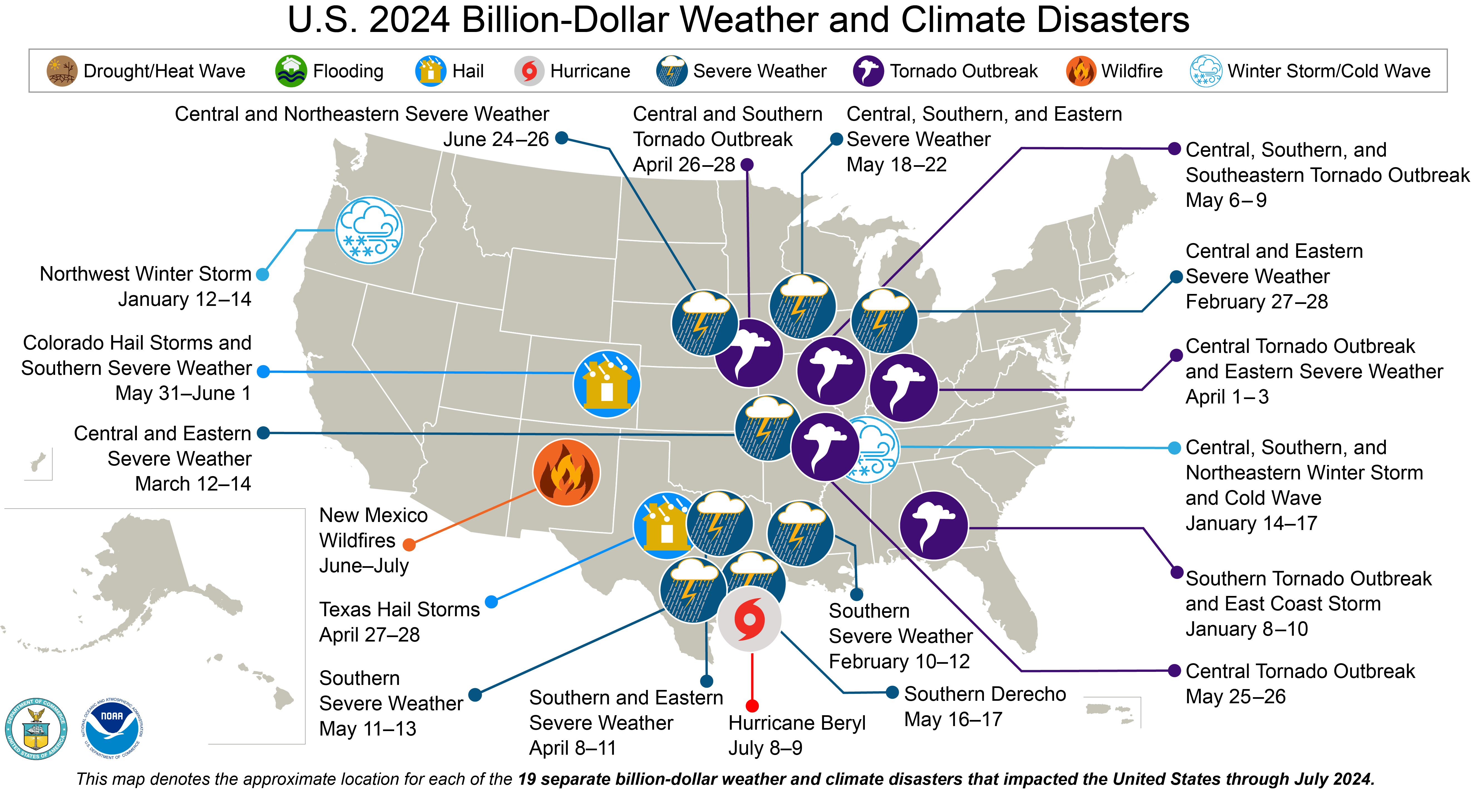


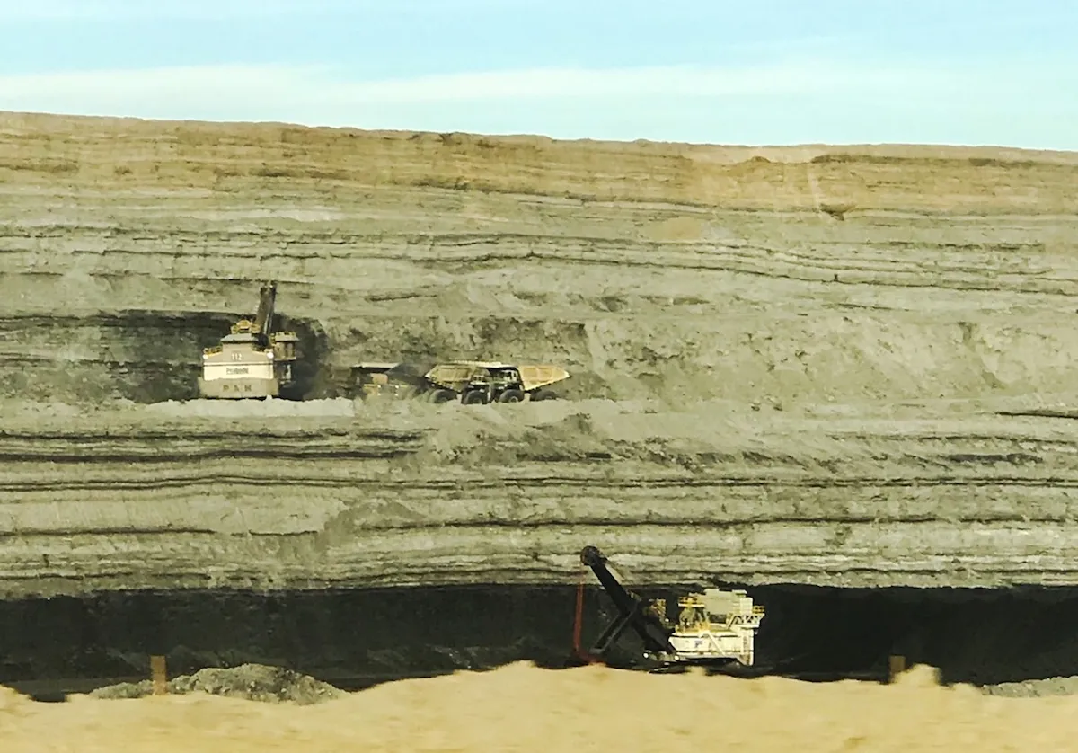
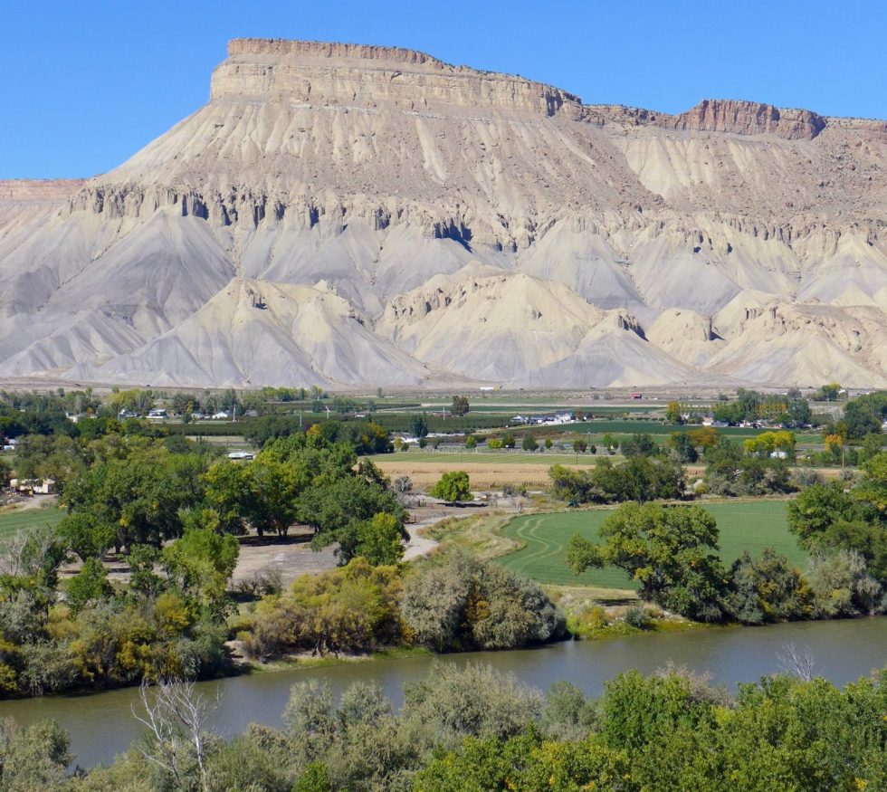


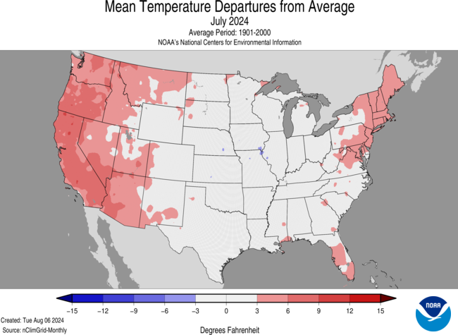
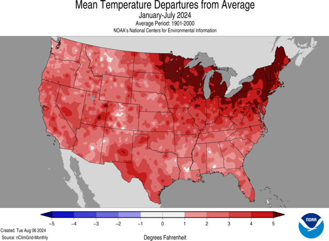
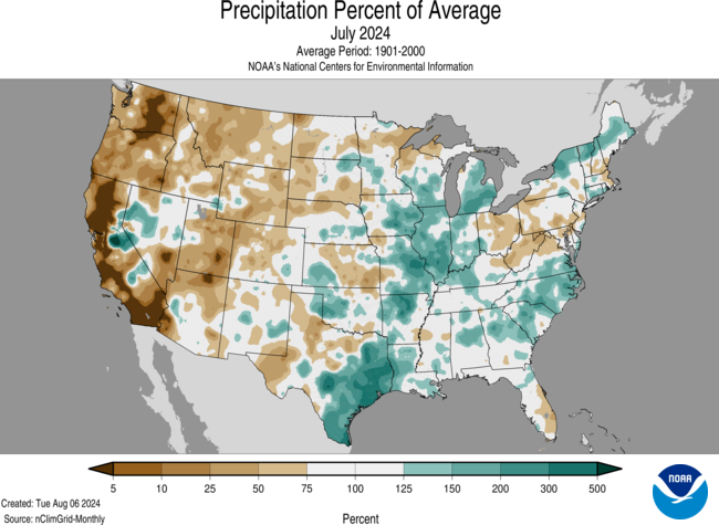
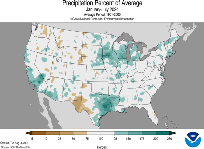
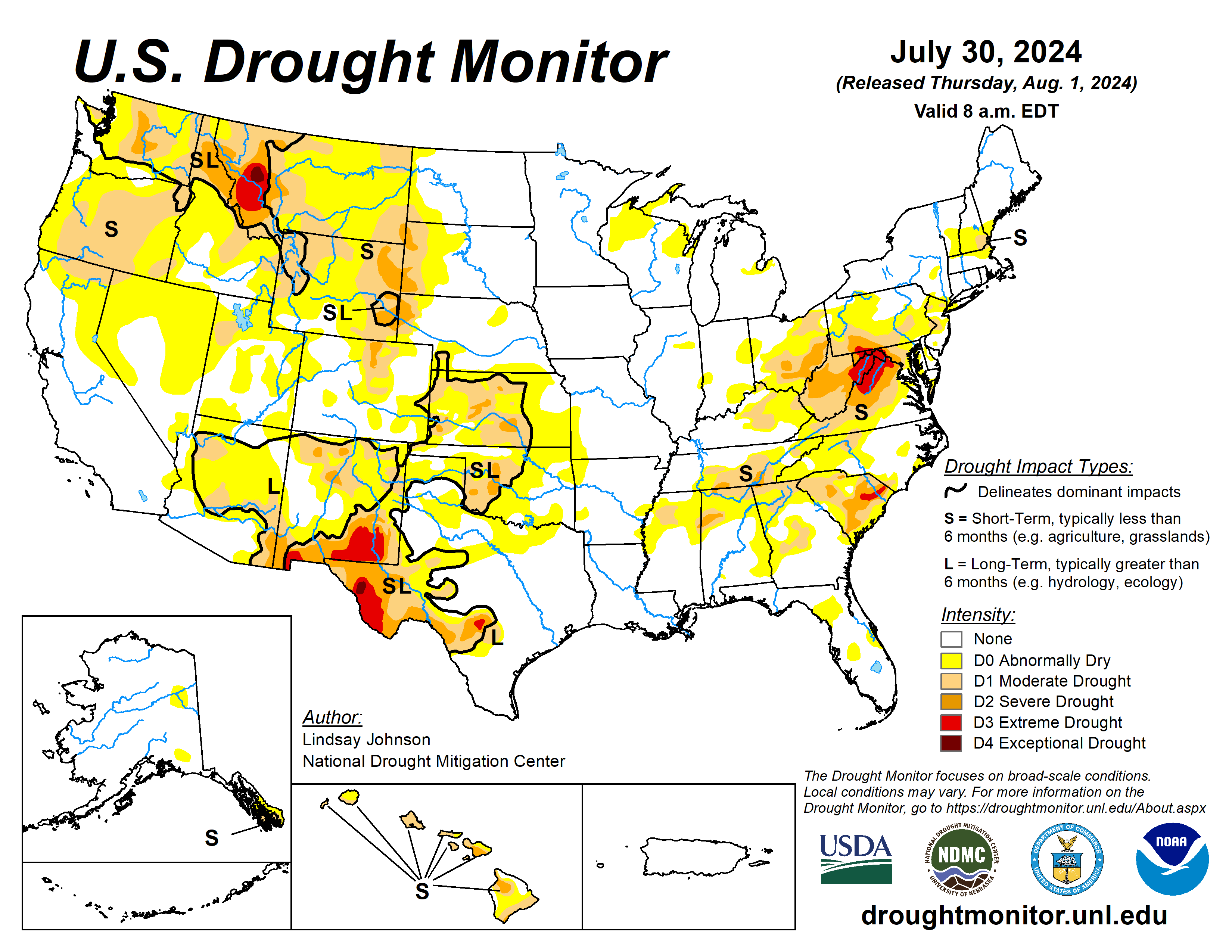


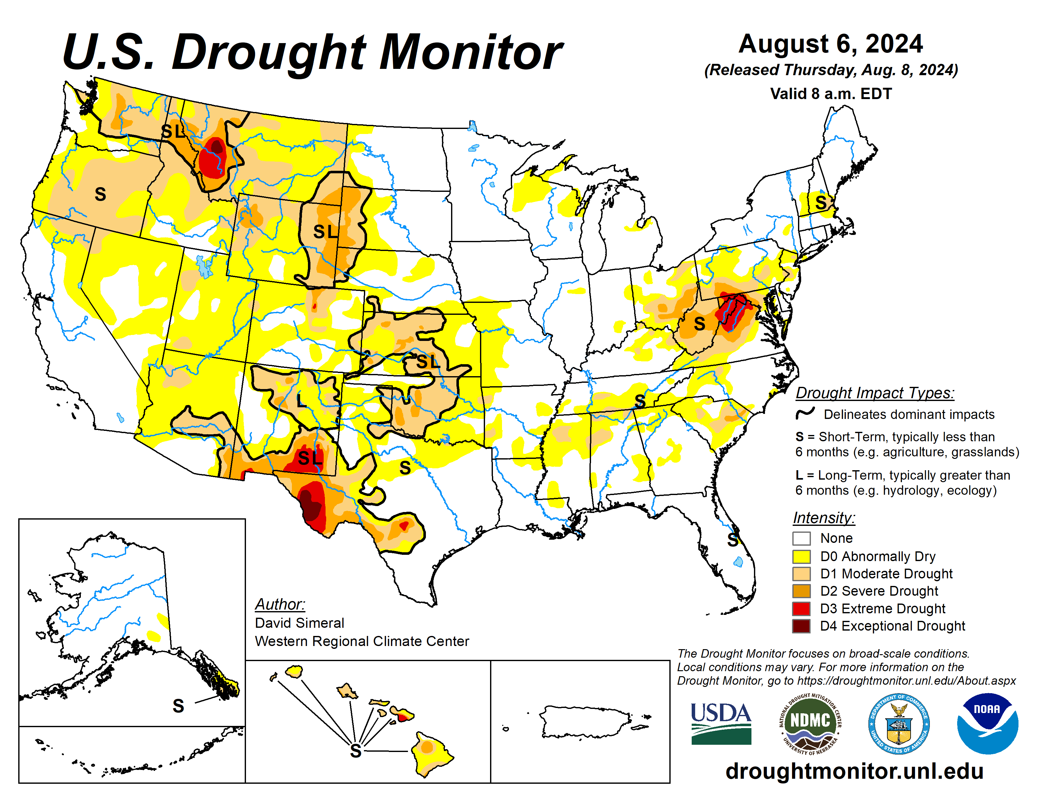
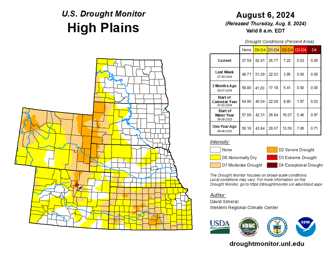
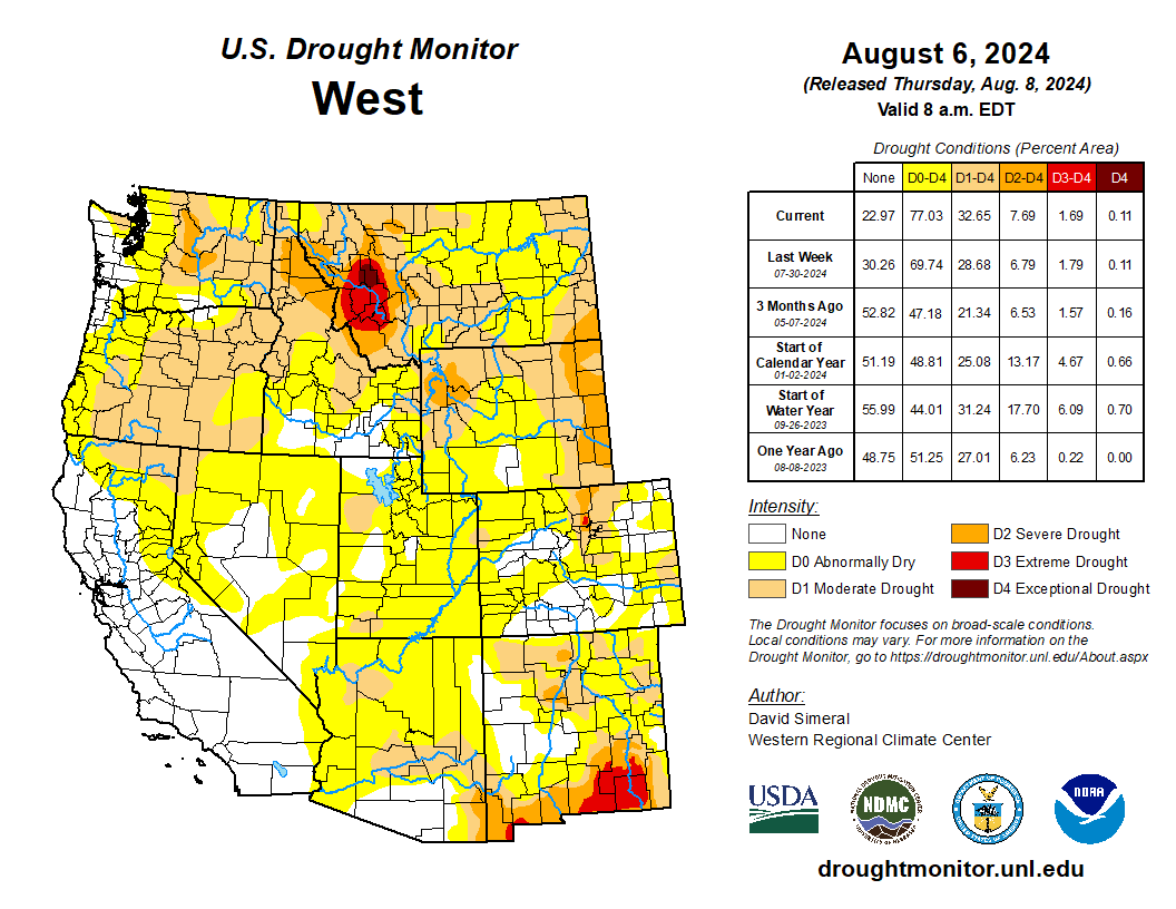


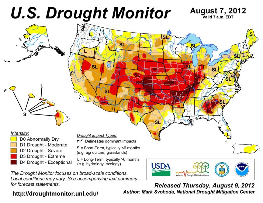
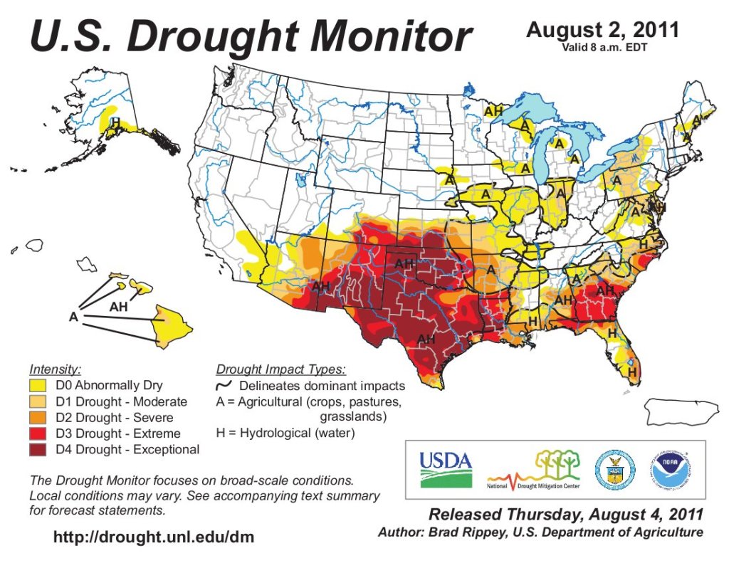


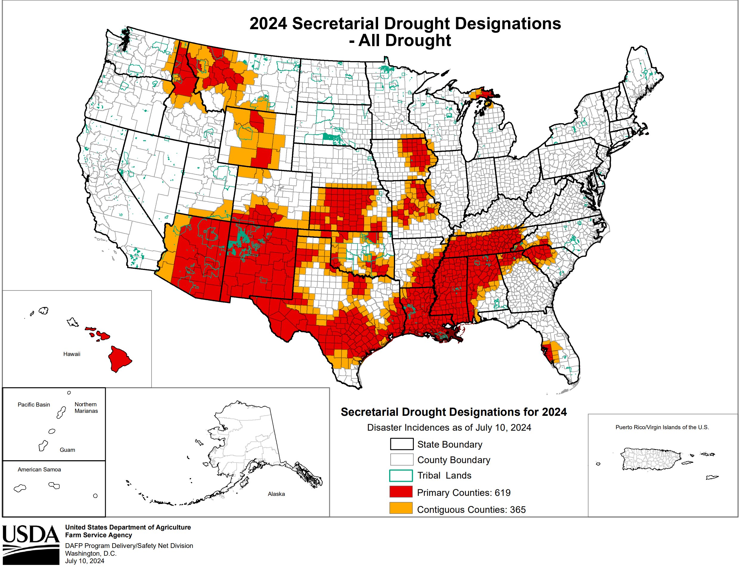
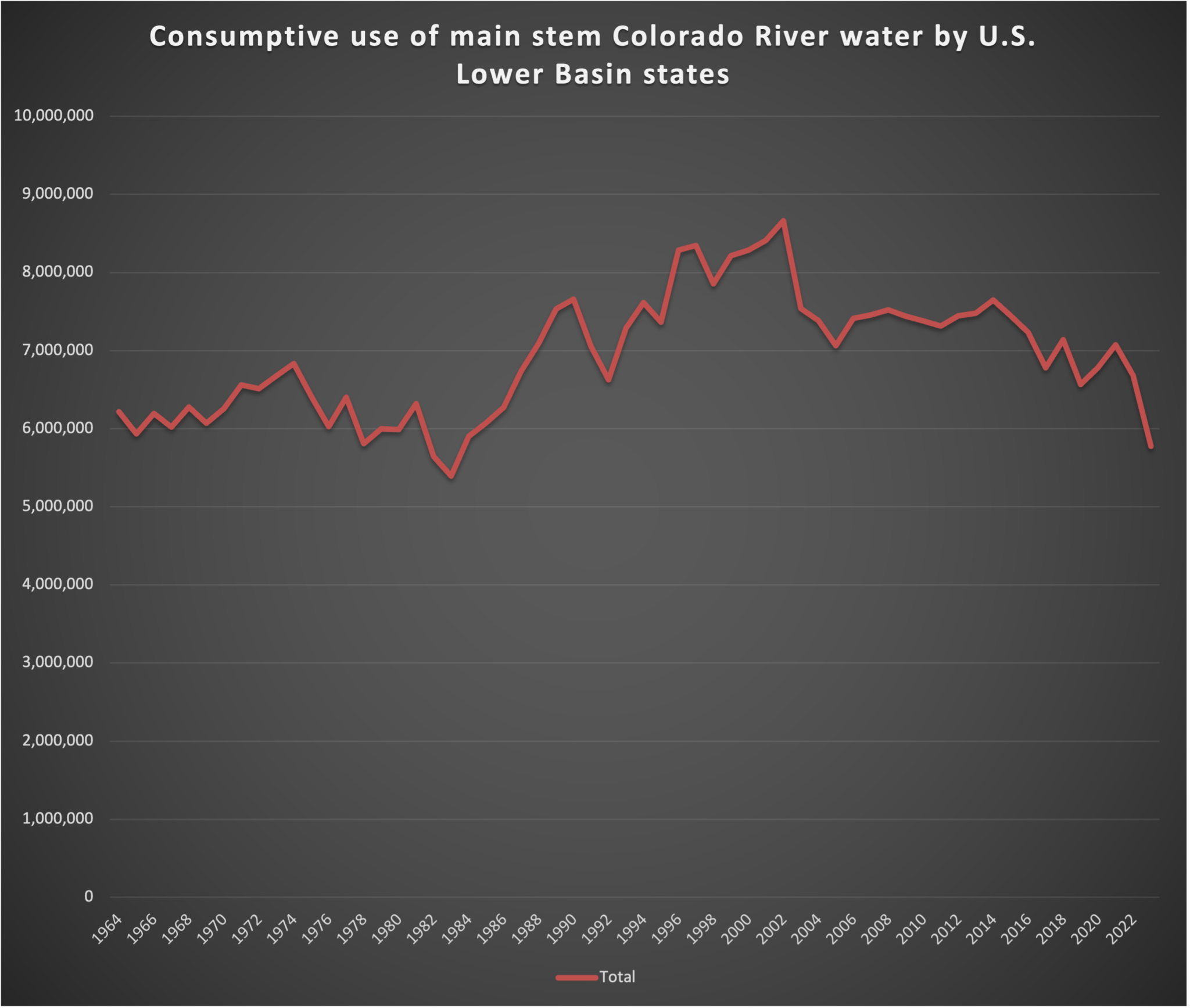


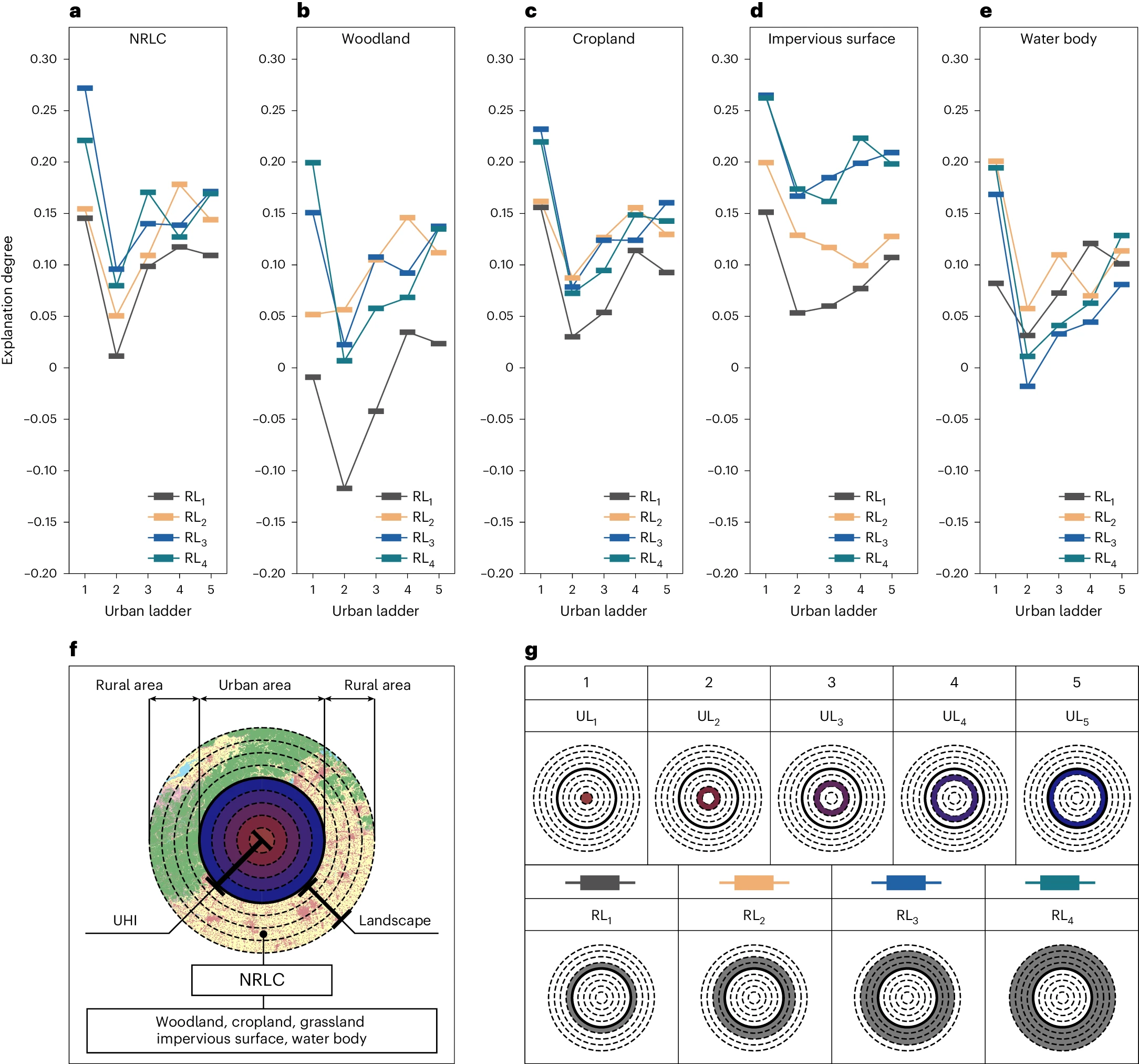


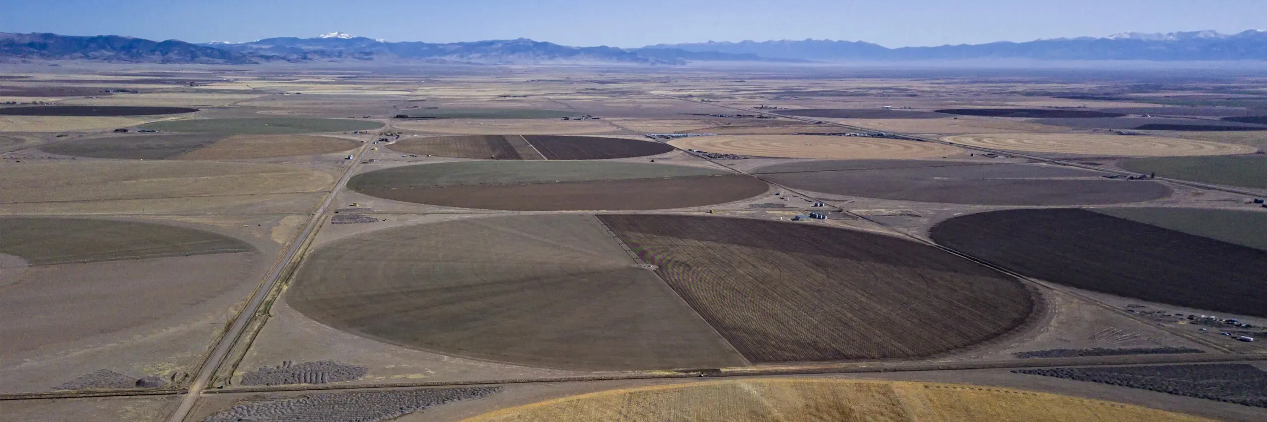


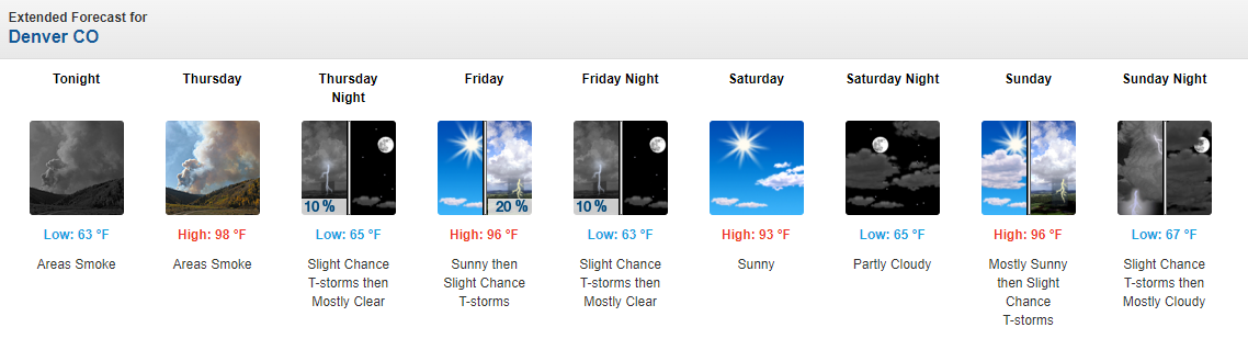
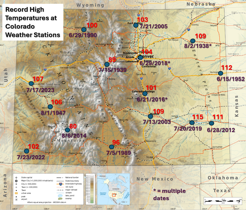
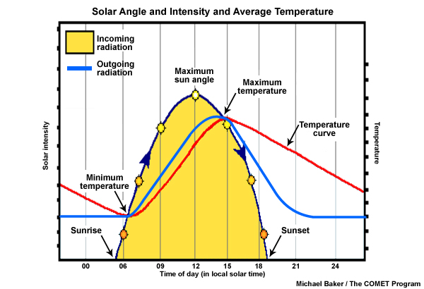
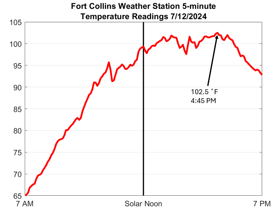
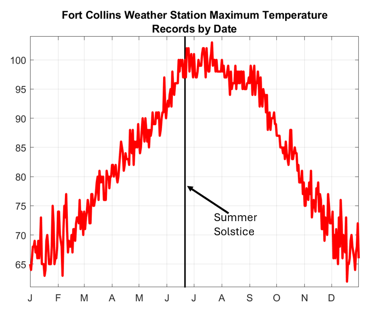
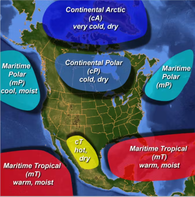

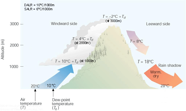
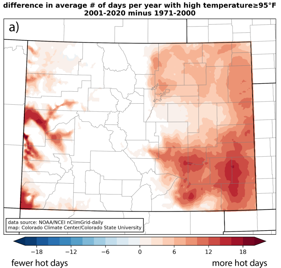


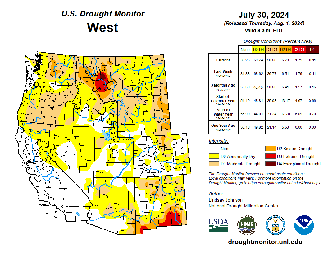
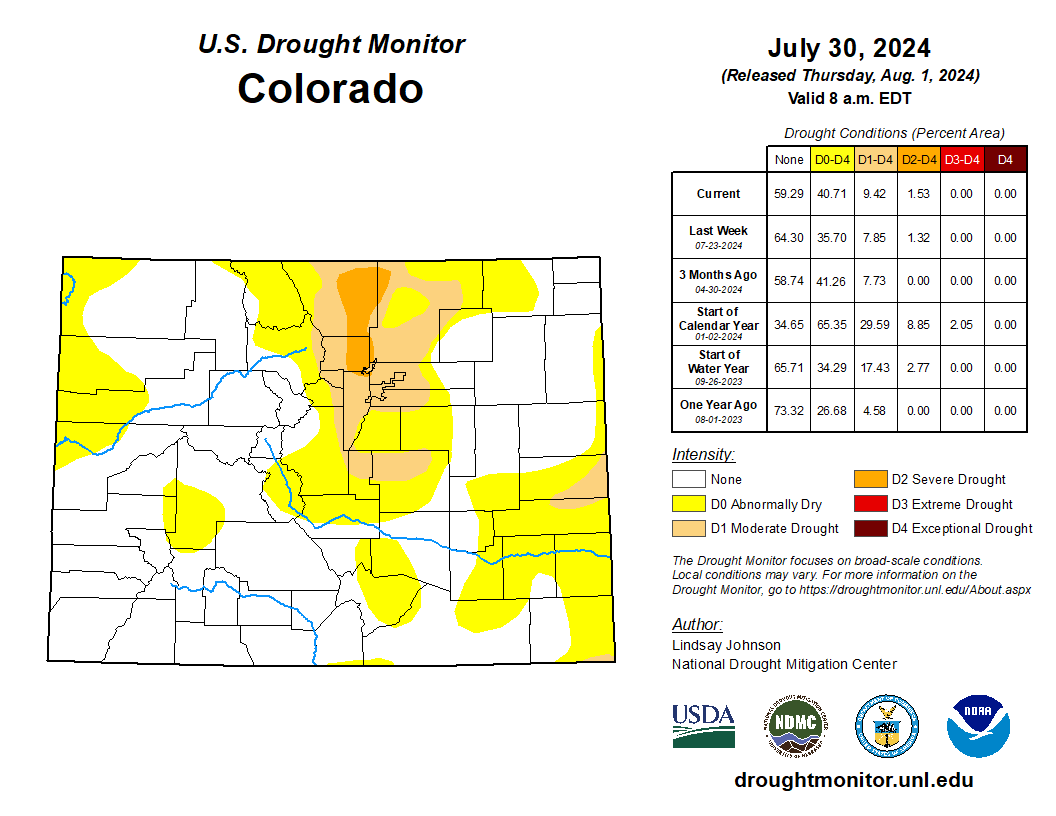
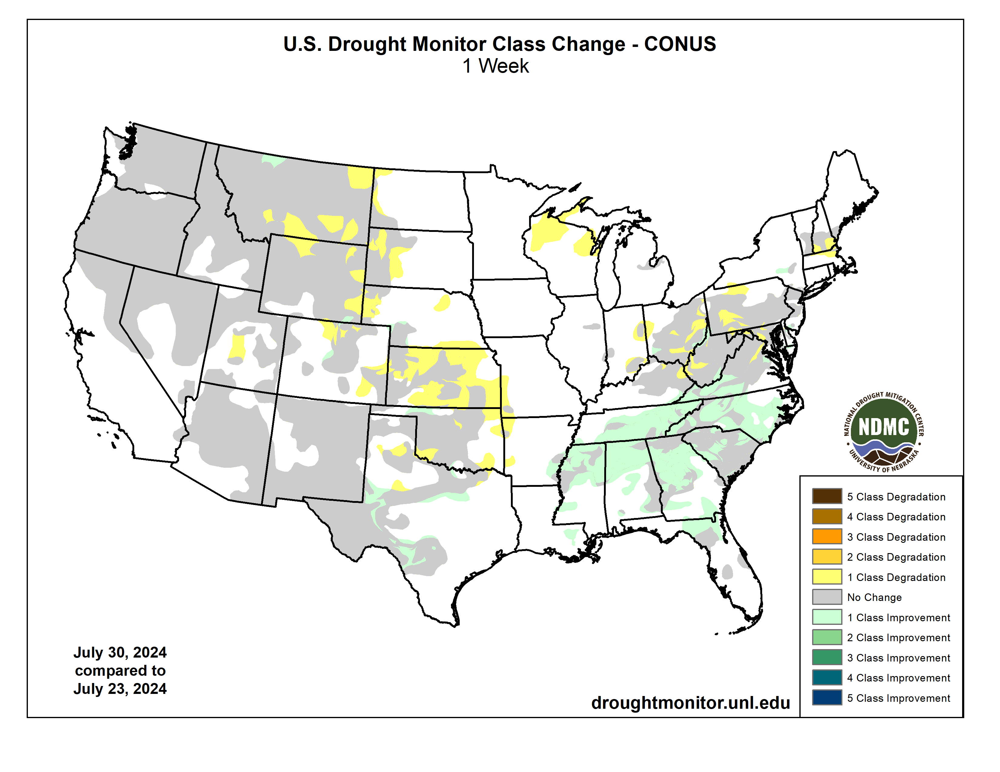

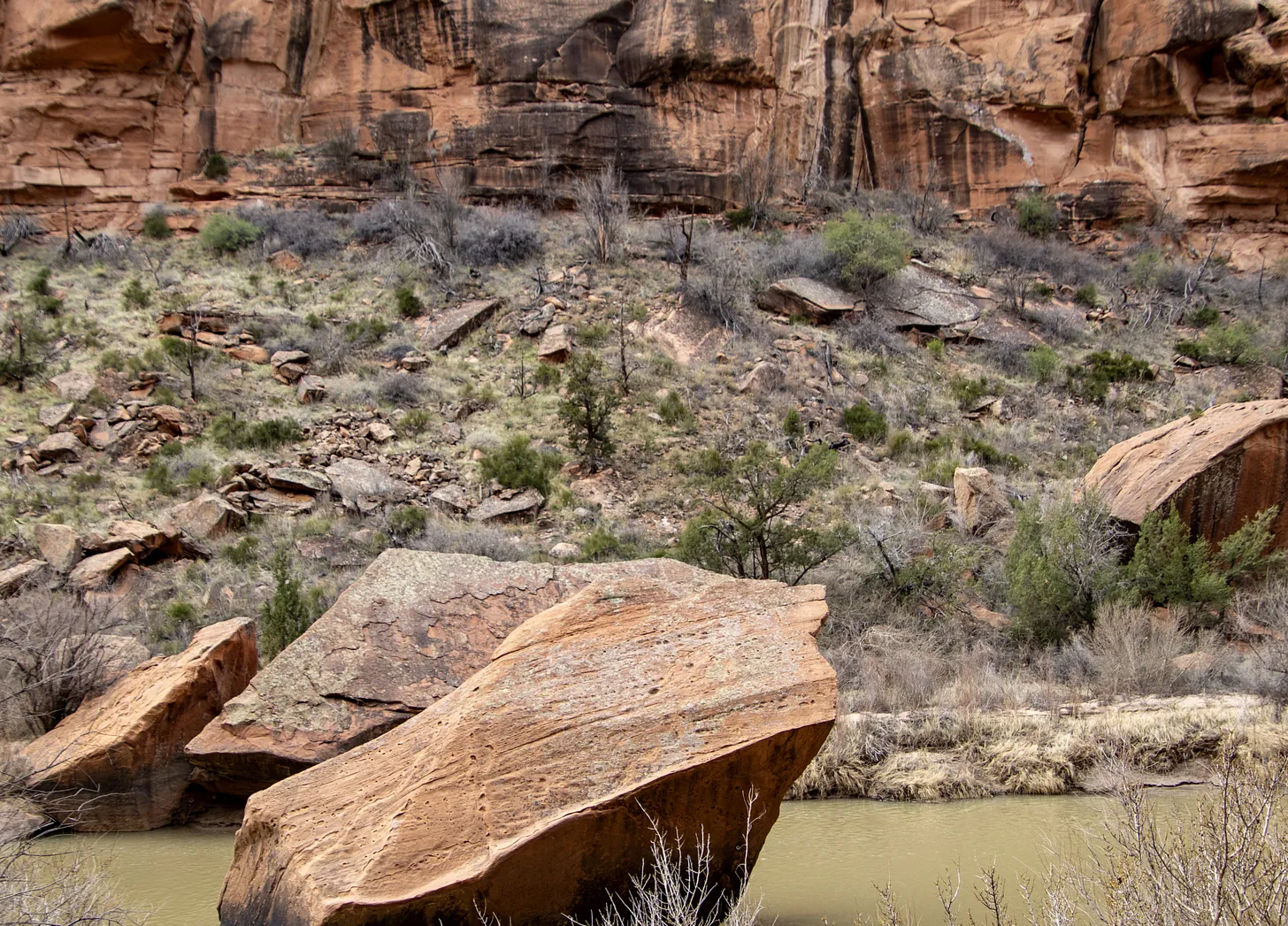


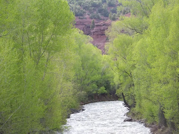


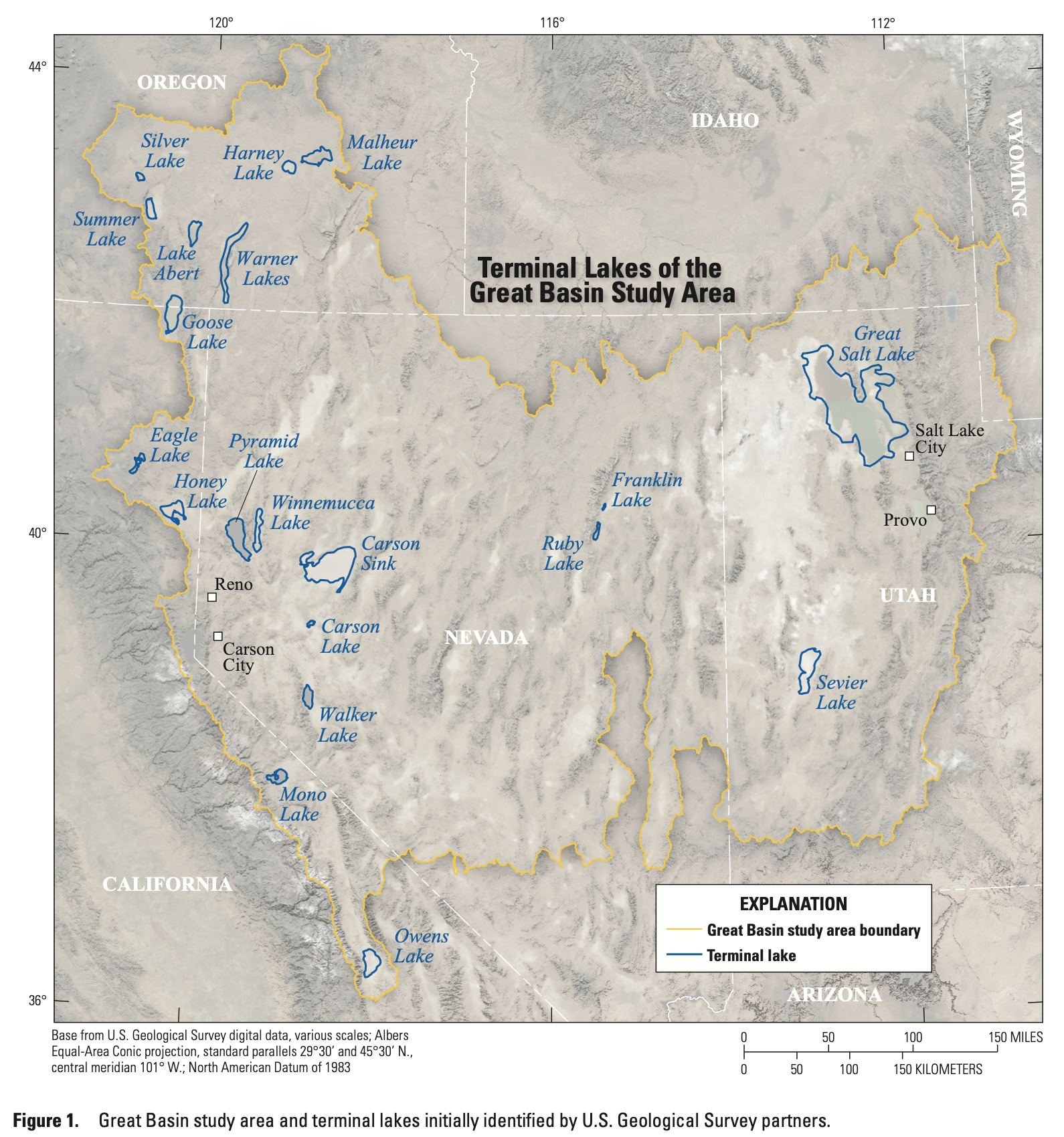

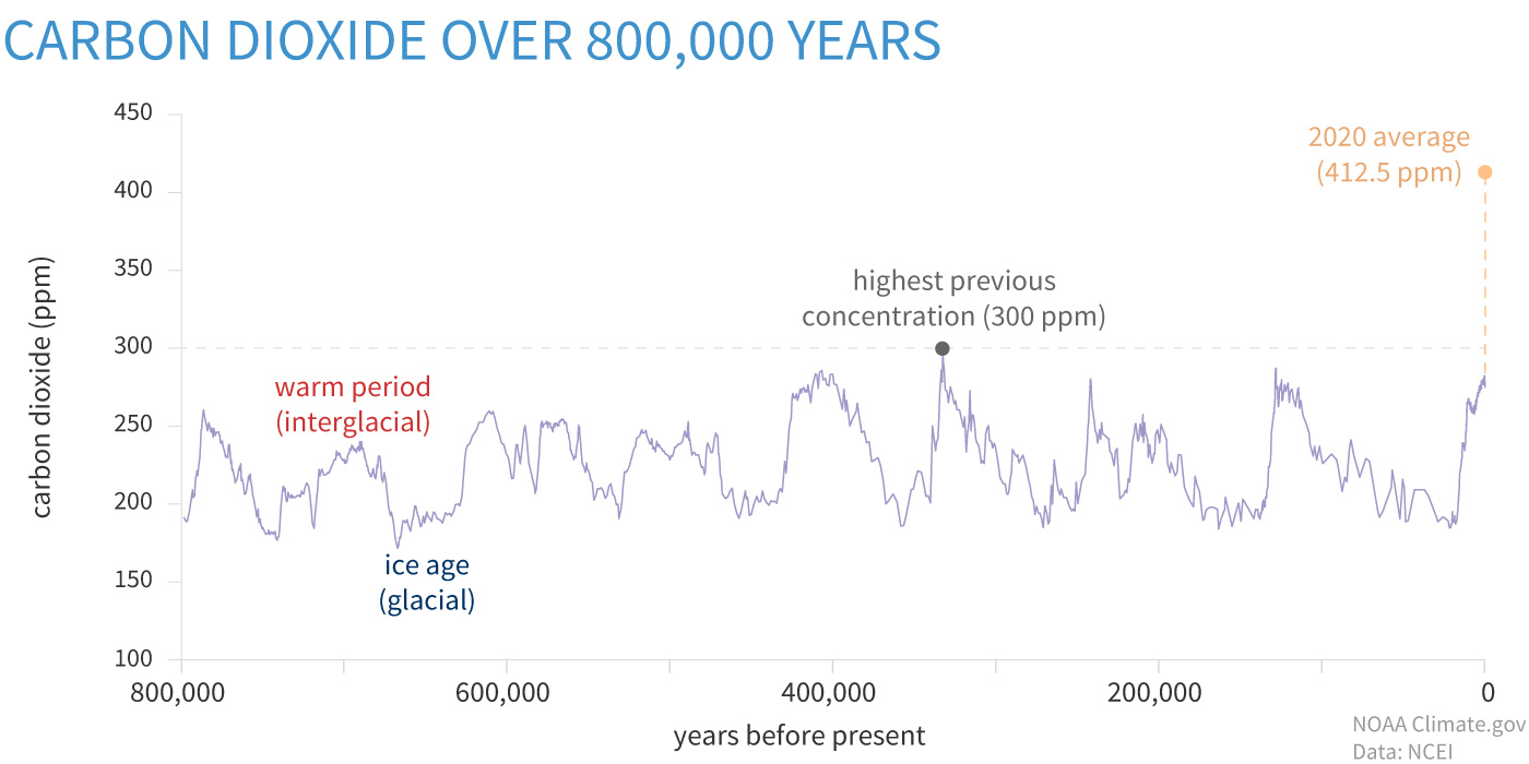


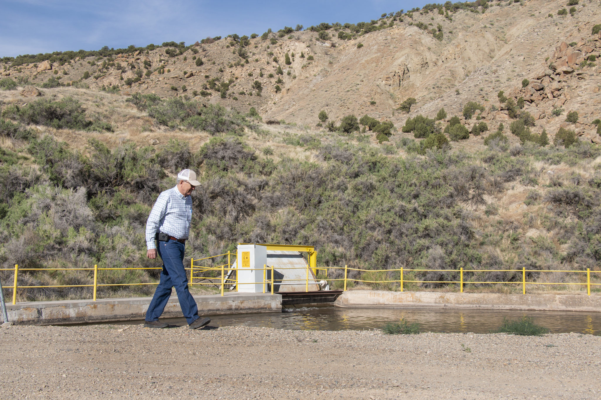
