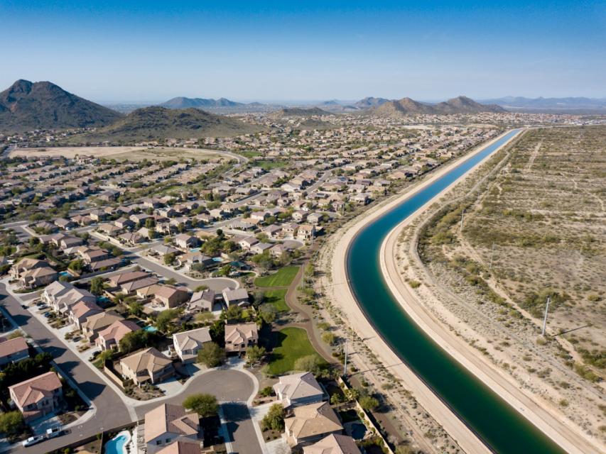
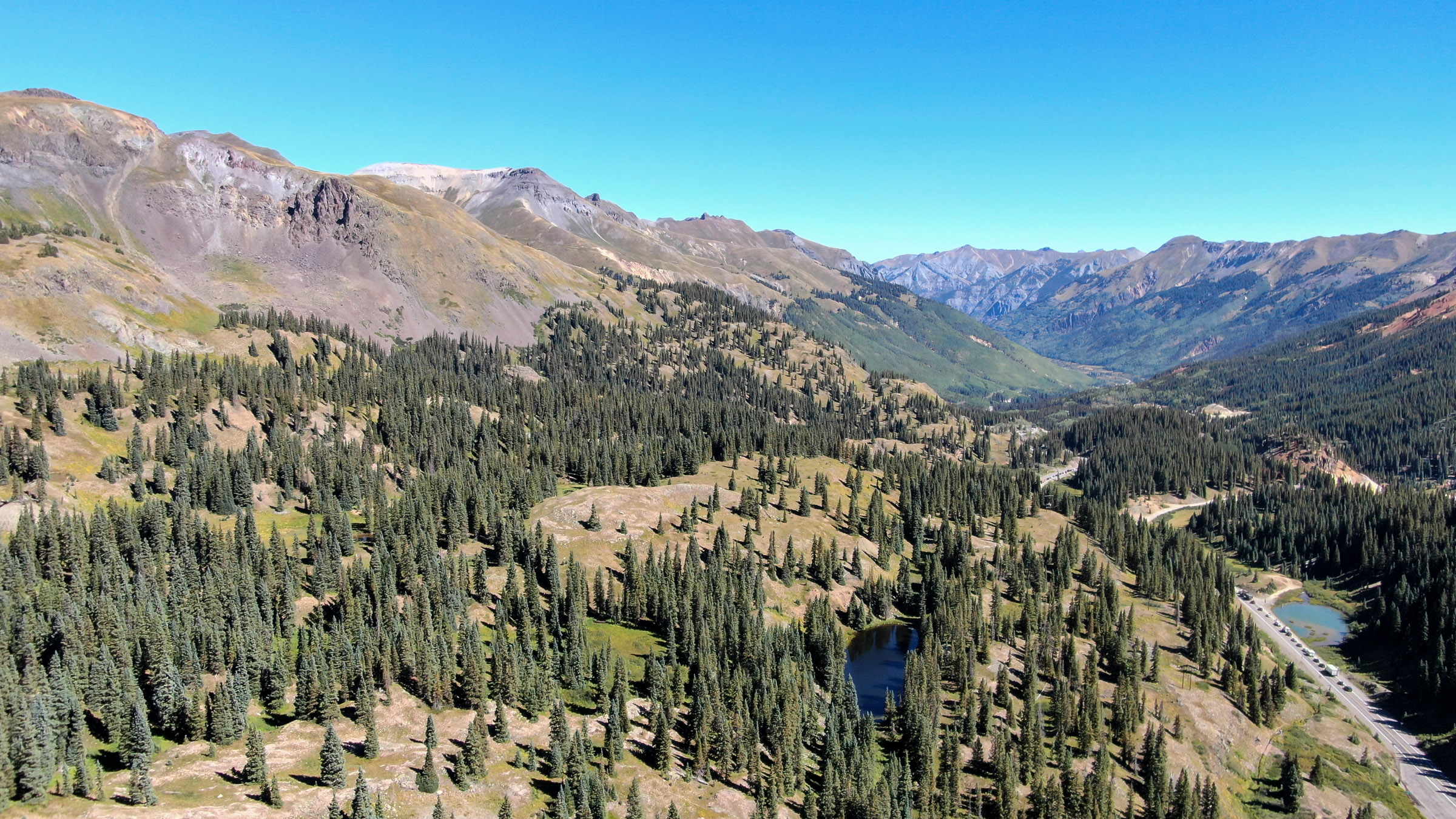
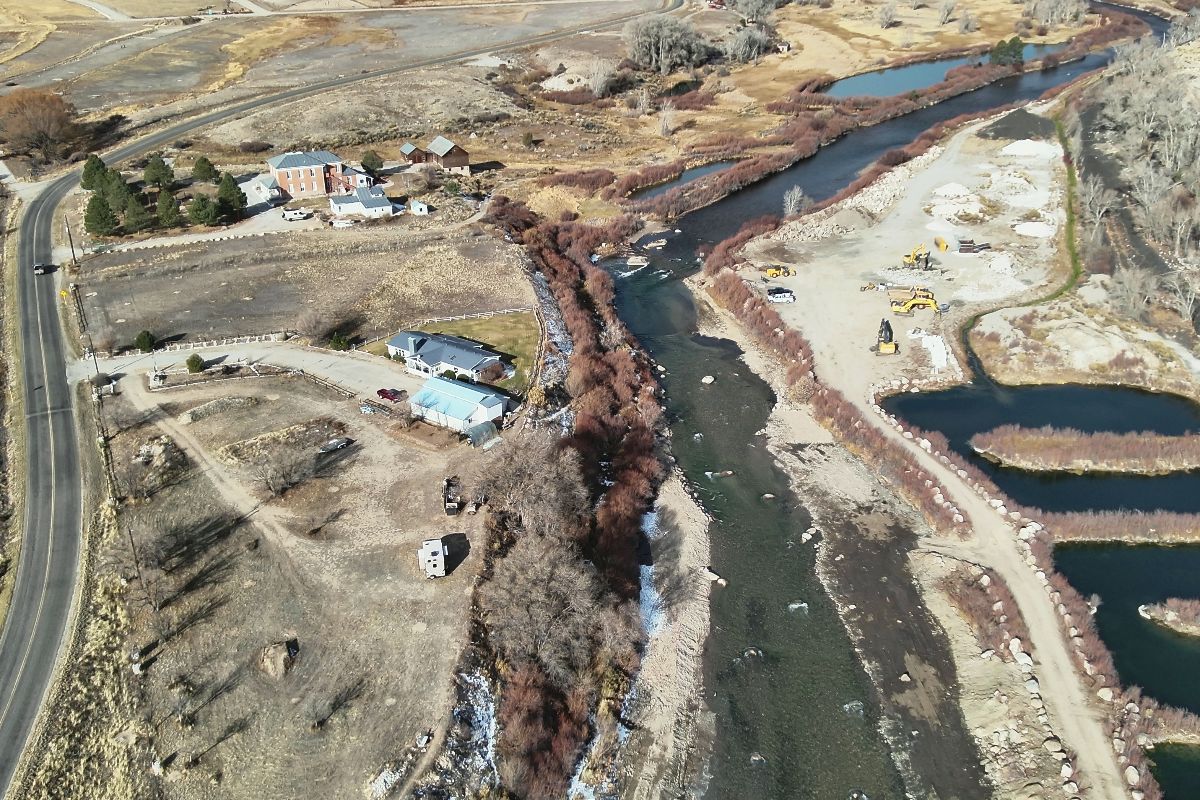
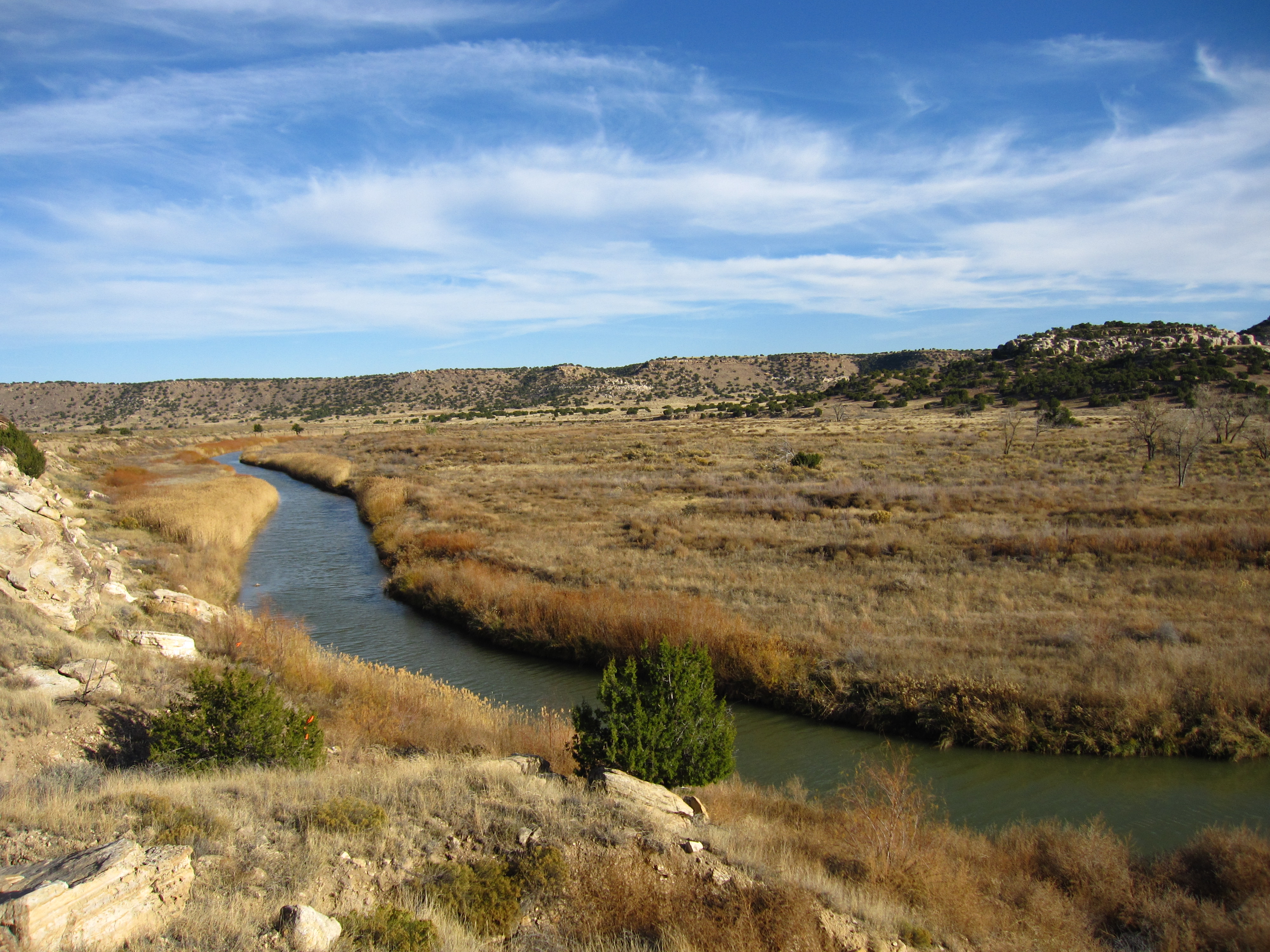
Myriad proposals to tap lithium deposits in southeastern Utah are progressing from the conceptual to the exploratory phases. But they are running up against a familiar obstacle in these arid parts: concern about how the projects might affect diminishing water supplies in the Colorado River Basin.
Lithium is the primary ingredient in lithium-ion batteries, which power everything from cell phones to electric vehicles to grid-scale energy storage. Demand for the stuff has shot up tremendously over the last decade, which has also elevated prices. That, in turn, has sparked interest in developing a domestic lithium industry, with projects sprouting in Nevada, at the Salton Sea and Great Salt Lake, in southern New Mexico, and in the Paradox Formation in the Four Corners Country.
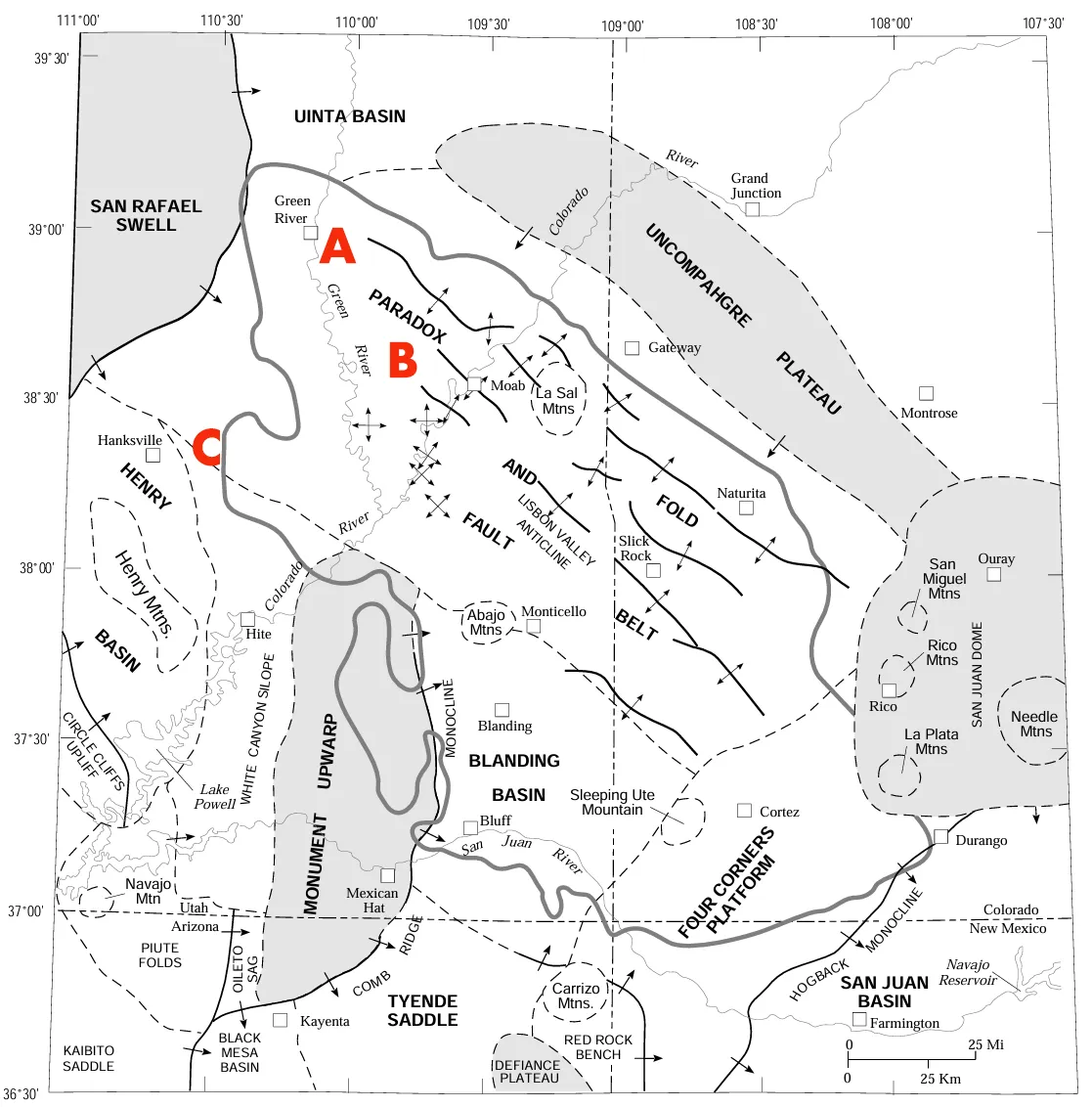
The Paradox Basin and Anson/A1/Blackstone’s main target areas: A. Green River Project; B. Paradox Project; C. Wayne County water rights (and possible future processing plant?).
The Paradox Formation (or Basin), stretching from the northwestern edge of the San Juan Basin up to the town of Green River, Utah, contains oodles of lithium (along with potash and bromide and so on). That’s because some 300 million years ago a sea covered the area, then evaporated, then flooded the area, then evaporated, repeating this cycle about 29 times over the course of 15 million years. The process left behind thick deposits of salts and other materials. Over the ensuing millennia, rock piled up atop the salt, squeezing it into fault lines, where the salt was pushed up into domes that shaped the overlying landscape. Those salt deposits contain lithium.
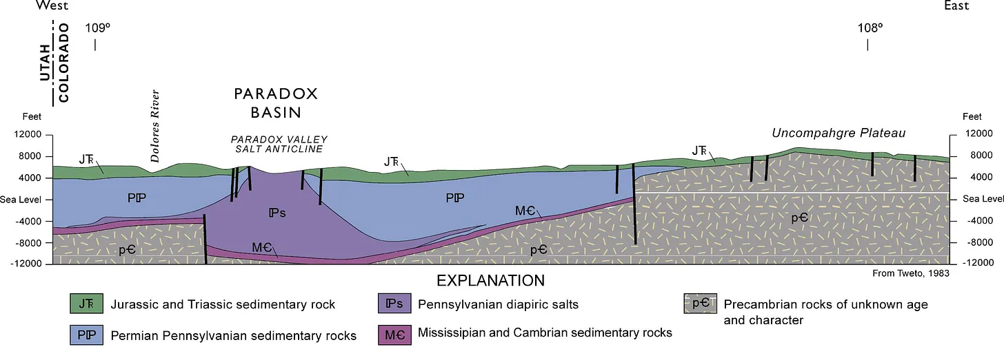
Geologic cross-section of a portion of the Paradox Basin showing a salt dome.
Companies have poked around in the Paradox Formation in search of potash for years. Now they’re going after lithium in a big way, with several firms staking claims in the Lisbon Valley and beyond.
Anson Resources’ Paradox and Green River Projects are probably the furthest along (if investor presentations are to be believed). The Australian company and its subsidiaries — A1 Lithium, Blackstone Minerals, and Blackstone Resources — have been staking claims fervently among the sandstone formations northwest of Moab between the Green and Colorado Rivers over the last several years, amassing more than 1,000 federal mining claims. They also acquired private land surrounding the Department of Energy’s uranium tailings disposal site on the southern edge of the town of Green River as well as securing leases on Utah state land.
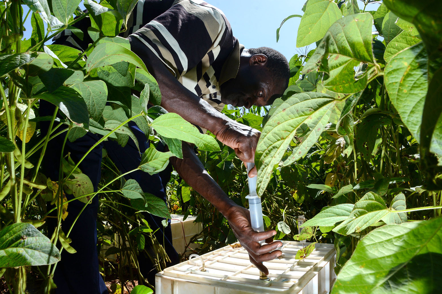
Conventional lithium operations pump mineral-filled water to the surface, put it in shallow ponds, and allow the water to evaporate, concentrating the lithium and associated materials. Potash is extracted like this, as well — a complex of potash evaporation ponds near Moab have gone viral as instagram targets due to their vivid colors. This method not only requires a lot of land for the ponds, but also is water-intensive, with as much as 200,000 gallons of water evaporating for each ton of material produced. Plus, the process can produce a lot of waste and takes a long time.
Anson plans a different approach. They say they will partner with China-based Sunresin and use that firm’s patented direct lithium extraction, or DLE, method. Anson would drill a well (or redrill an old oil and gas well), pump the brine to the surface, and use resin beads to extract the lithium from the water, without evaporation ponds. After the lithium is extracted, the water is injected back underground. That, in theory, makes it a non-consumptive use of the water, meaning it shouldn’t have as much of an effect on water supplies.
But direct lithium extraction is a largely unproven technology, and it’s not clear that it will work in the Paradox Basin. The technique may require fresh water to be injected into the lithium deposits before pumping it to the surface, since the minerals may not be adequately saturated. In the 1950s and 1960s, a couple of facilities in Moab pumped up brine for use in the Atlas uranium mill; they had to pump fresh water into the subterranean salt beds, first, in order to dissolve the salts. Plus, any time you drill deep into the earth and remove or inject water, you’re potentially screwing with the hydrology — and even the geology.
Paradox Valley via Airphotona.com
This has been shown in the oil and gas fields, where “produced water,” or wastewater left over from the drilling and extraction process, is often reinjected deep underground. The process has induced seismic activity, or triggered earthquakes, in the Permian Basin and elsewhere. During the coalbed methane drilling boom in the San Juan Basin in the 1990s, all sorts of weirdness occurred, from methane flowing from water taps to a freshwater spring suddenly becoming hotter — all likely the result of pumping billions of gallons of water from the coal beds to “liberate” the methane, and then shooting it back into the ground. And in the Paradox Basin, a project that captures salt before it can enter the Dolores River and then injects it 16,000 feet underground (to keep Colorado River salinity levels in check) also triggered tremors in western Colorado.
In other words, while direct lithium extraction could be a “game changer” for the industry, making it feasible to commercially extract lithium from geothermal brines under the Salton Sea, for example, many unknowns remain about the technology in general and this proposal specifically.
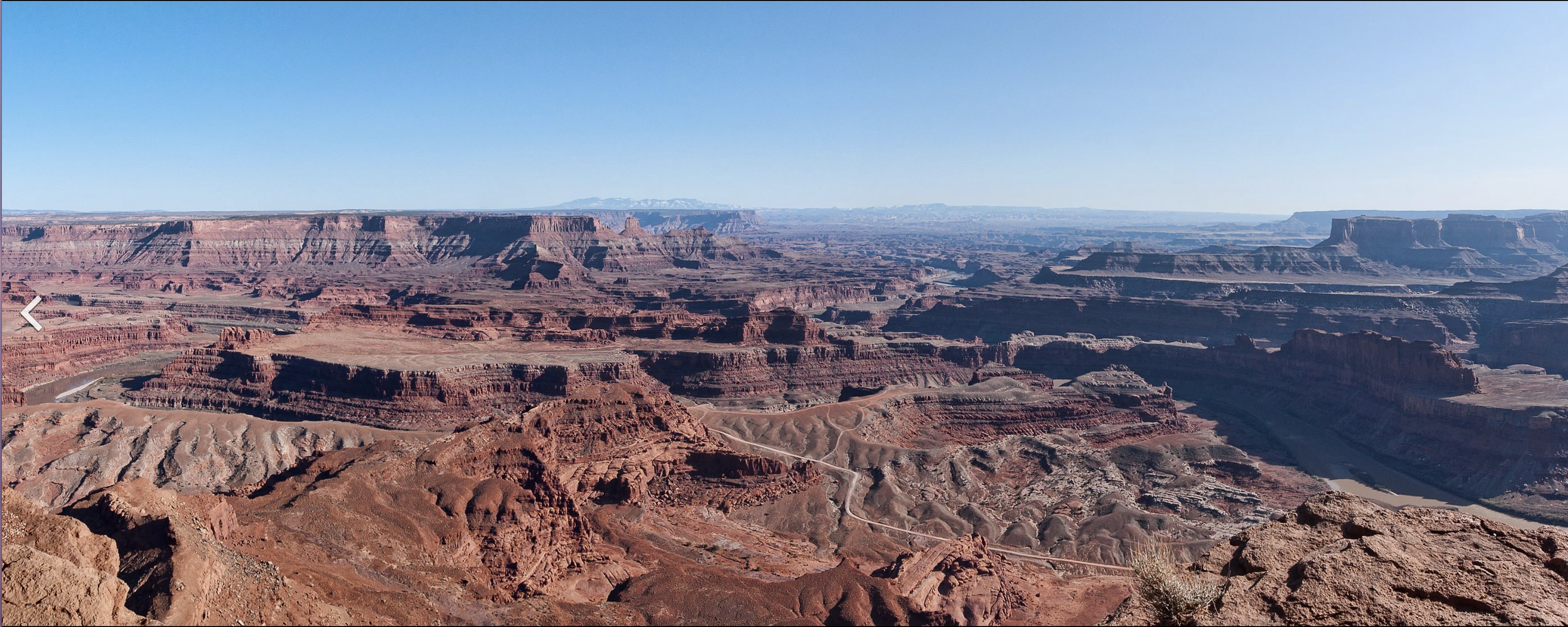
What we do know is that Anson is looking to secure a bunch of water for its operations. Their water right applications seek:
Dead Horse State Park panorama via the State of Utah.
19 cfs (13,755 acre-feet or 4.5 billion gallons per year) from wells located on Utah state land north of Dead Horse Point state park. The brine presumably would then be piped to a processing plant near the Colorado River, the lithium would be extracted, and the wastewater injected back underground. Intrepid Potash, the National Park Service, and a coalition of environmental groups protested the application, in part for its lack of detail and because, well, there really isn’t any extra water available.
Green River Basin
Another 19 cfs from several 8,000- to 9,000-foot deep wells on the south end of Green River adjacent to the uranium tailings depository. After extracting the lithium from a plant on this property, they would inject the wastewater into 5,000- to 7,000-foot deep wells. The Bureau of Reclamation protested this application because of its close proximity to the Green River and the potential to affect surface water supplies and quality. They also worry about direct lithium extraction, writing: “Data shows the success of DLE is hard to predict, consumes both freshwater and brine water, contaminates aquifers, reduces the groundwater table, hurts wildlife, worsens soil conditions …” Ooof.
And they leased 2,500 acre-feet (814 million gallons) per year from the Wayne County Water Conservancy District. This water may be used for processing, but it’s not clear where, yet. Anson has indicated it could have processing facilities in Green River and on the Colorado River below Moab, neither of which is near Wayne County (home of Hanksville). Perhaps they also plan on having a processing plant there.
The water rights applications are still pending.
For more information, check out John Weisheit’s post for FarCountry.org, the website of the Canyonlands Watershed Council.
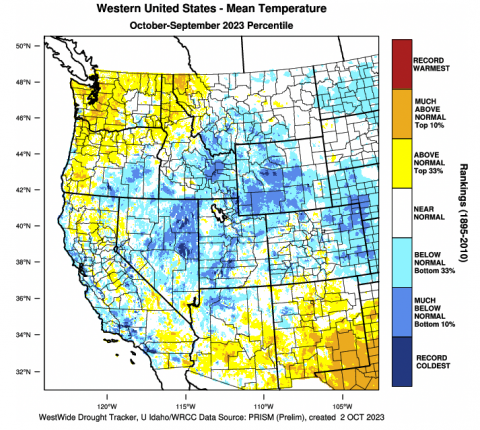
Click the link to access the report on the Colorado Climate website (Russ Schumacher, Becky Bolinger, Peter Goble, Alistair Vierod). Some highlights:
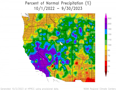
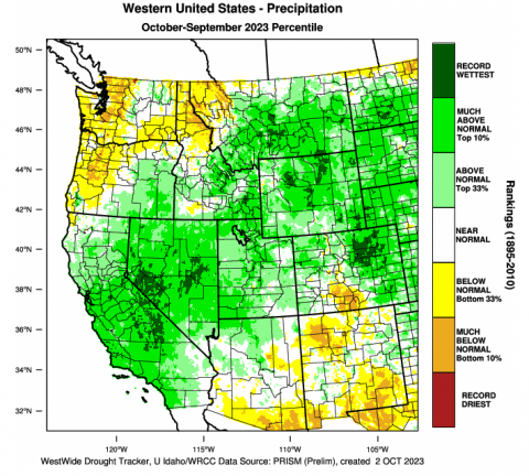
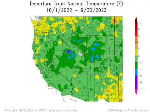
Coolest water year since 2010. Cooler temperatures in fall/winter. Warm final quarter to the water year.
Average statewide temperature: 44.6 ̊F. Coolest in 13 years! Still above the 20th century average
Only the 31st wettest year on record but…Record wet in portions of Weld, Morgan, Boulder, Adams, Denver, Arapahoe, Washington, Elbert, Douglas, and El Paso Counties. Drier than normal for San Luis Valley.
Statewide average: 20.02”. Wettest since 2017. Wet by recent standards, but not compared to the 80’s and 90’s.
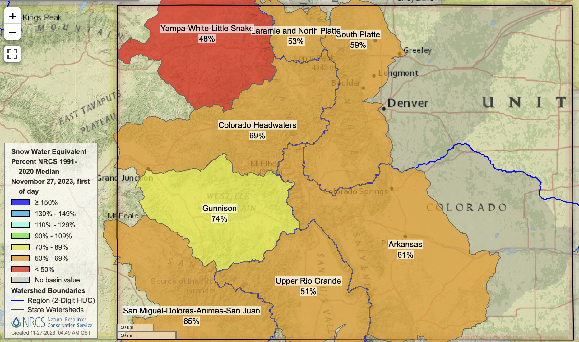
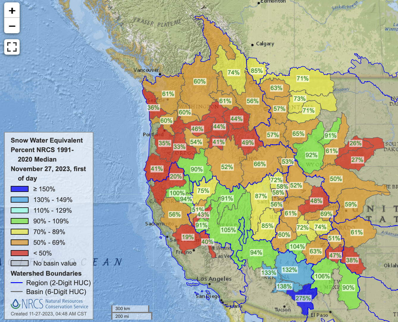
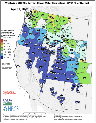
Snowpack on April 1 – above average in all basins
Snowpack on May 1 – above average in all basins except the Arkansas
Click the link to read the article on the USFS website (Randy Moore):
November 24, 2023: In January 2022, we launched our Wildfire Crisis Strategy. This strategy provided a vision for what it will take to meaningfully change how people, communities and natural resources experience risk from wildfire. Its implementation to this point has been funded by the historic down payments Congress made through the Bipartisan Infrastructure Law and the Inflation Reduction Act.
I’m pleased to report that we have made significant progress in implementing this daring and critical strategy.
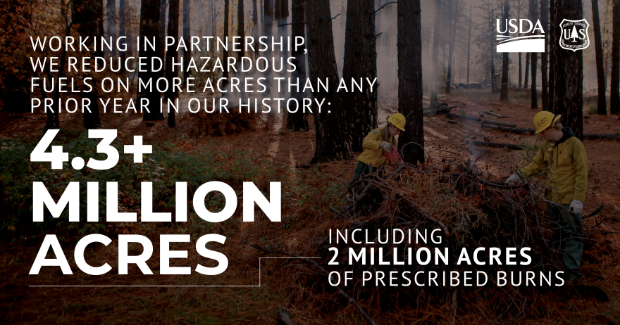
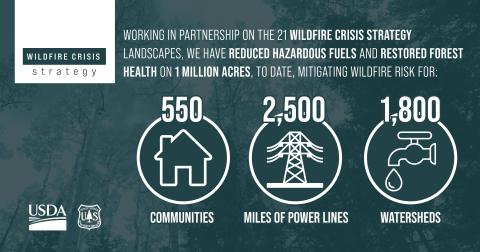
We are focusing our initial efforts on the 250 highest risk firesheds in the West, which account for roughly 80% of the wildfire risk to communities. Our employees and partners have now collectively treated more than 1 million acres within the 21 Wildfire Crisis Strategy priority landscapes. This initial accomplishment is commendable, and I am incredibly proud of our agency. It has come as result of tremendous effort from thousands of employees across all parts of the agency. Our diligent work to reduce hazardous fuels and restore forest health in these landscapes directly translates to mitigating wildfire risk for 550 communities, 2,500 miles of power lines and 1,800 watersheds. In addition, we were able to exceed our national 4-million-acre fuels reduction target, including a record 1.9 million acres treated with prescribed fire. Going into this year, we know we must keep our focus and build upon this accomplishment. With more than 19 million acres still left to treat, this year we plan to exceed last year’s accomplishments as we realize the capacity we built throughout the past year.
In 2023, we worked with partners to reduce hazardous fuels on more acres than any year in our history: over 4.3 million acres, including 2 million acres of prescribed burns. USDA Forest Service graphic by Caitlin Garas.
This includes efforts by 148 unique partner organizations, including tribal nations, state agencies, non-government organizations, and finance and industry partners. Programs like the Collaborative Forest Landscape Restoration Program and Joint Chiefs’ Landscape Restoration Partnership helped bolster these efforts in and around high-risk firesheds.
As you know, the number of acres treated represents just one piece of the larger effort to confront the wildfire crisis. We are assisting at-risk communities with planning for and mitigating wildfire risk through the new Community Wildfire Defense Grant Program. This year alone we’ve invested $197 million of Bipartisan Infrastructure Law funding into projects spanning 22 states and seven tribes. In June, we invested more than $43 million in 123 projects nationwide through the Community Wood Grants Program and Wood Innovations Grant Program. These investments will directly support the strategy to reduce risk in the places where it poses the most immediate threats to communities.
Working in partnership on the 21 wildfire crisis strategy landscapes, we have reduced hazardous fuels and restored forest health on 1 million acres, to date, mitigating wildfire risk for: 550 communities, 2,500 miles of power lines and 1,800 watersheds. USDA Forest Service graphic by Caitlin Garas.
While we strive to limit the severity of future wildfires, another agency priority is reforesting areas after our past wildfires. These two priorities go hand in hand—reducing risk of future wildfires and restoring areas impacted by the historic wildfires over the past years. We have identified 4 million acres of National Forest System lands in potential need of reforestation, which is key to long-term forest recovery and mitigating the effects of climate change. While this need is largely caused by wildfires, additional reforestation needs have also been created by insect infestations, diseases and drought.
To address this reforestation backlog, we released the National Forest System Reforestation Strategy in July 2022. This strategy outlines the goals and objectives that are necessary for successful reforestation, including robust framework to increase the pace and scale of reforestation, address existing needs, anticipate future events and meet the requirements of the Repairing Existing Public Land by Adding Necessary Trees, or REPLANT, Act of 2021.
Accomplishing this work has taken the dedication, time and energy of employees like you. It has required each of us to work in new ways. We have experienced growing pains and challenges, but we are already seeing meaningful results. I want to extend my sincere thanks and gratitude to all of you who have contributed to these efforts. You are making a difference for the American public whom we serve and the natural resources we manage.
We know that fully achieving the vision laid out by the Wildfire Crisis Strategy will require further investments and that those investments need to be sustained. In the coming years, continued funding will allow us to build upon the work we’ve already accomplished. We will continue ramping up the pace and scale of our hazardous fuel reduction and forest management treatments to confront the crisis, using every tool and authority at our disposal and growing the list of partners we work with.
Our goal is a great challenge, but one I know our agency and partners are up for.
Editor’s Note: Provide feedback about this column, submit questions or suggest topics for future columns through the FS-Employee Feedback inbox.
West Fork Fire June 20, 2013 photo the Pike Hot Shots Wildfire Today
Click the link to read the article on the NOAA website:
October Highlights:
January–October 2023 ranked as the warmest such period on record, and there is a greater than 99% chance that 2023 will be the warmest year in NOAA’s 174-year record.
For the seventh consecutive month, global ocean surface temperature set a record high. Antarctica had its sixth consecutive month with the lowest sea ice extent on record.
Fifteen named storms occurred across the globe in October, which was above the 1991–2020 average of 12.
Globally, October 2023 was the warmest October in the 174-year NOAA record. The year-to-date (January–October) global surface temperature ranked as the warmest such period on record. October 2023 marked the fifth consecutive month of record-warm global temperatures. According to NCEI’s Global Annual Temperature Outlook and data through October, there is a greater than 99% probability that 2023 will rank as the warmest year on record.
This monthly summary, developed by scientists at NOAA’s National Centers for Environmental Information, is part of the suite of climate services NOAA provides to government, business, academia and the public to support informed decision-making.
Monthly Global Temperature
The October global surface temperature was 2.41°F (1.34°C) above the 20th-century average of 57.1°F (14.0°C) and ranks as the warmest October in NOAA’s 174-year record. This was 0.43°F (0.24°C) above the previous record from October 2015. October 2023 marked the 47th consecutive October and the 536th consecutive month with temperatures above the 20th-century average. The past 10 Octobers (2014–2023) have been the warmest Octobers on record.
South America and Asia had their warmest Octobers on record. North America, Africa and Europe each had their second-warmest Octobers, while October in Oceania ranked 15th warmest on record. October in the Arctic ranked fifth warmest while the Antarctic region had its sixth-coldest October on record. For the seventh consecutive month, global ocean surface temperature set a record high.
Temperatures were above average throughout most of North America, South America, western, southern and eastern Europe, Africa, Asia, Oceania and the Arctic. Parts of Central and South America, Africa, Europe, northeastern North America and central Asia experienced record-warm temperatures this month. Sea surface temperatures were above average across much of the northern, western and southwestern Pacific as well as the northern Atlantic and the Indian Oceans. Record-warm temperatures covered nearly 11% of the world’s surface this October, which was the highest percentage for October since the start of records in 1951.
Temperatures were near to cooler than average across parts of Antarctica, southern South America, north-central North America, the Nordic countries, Greenland and northern Oceania. Sea surface temperatures were near to below average over parts of the southeastern Pacific Ocean, the eastern Indian Ocean and the southern Atlantic Ocean. Less than 1% of the world’s surface had a record-cold October.
Snow Cover and Sea Ice Extent
October 2023 set a record for the lowest global October sea ice extent on record. This primarily resulted from record-low sea ice extent in the Antarctic, which saw its sixth consecutive month with the lowest sea ice extent on record. Globally, October 2023 sea ice extent was 380,000 square miles less than the previous record low from October 2016.
Map of Arctic (left) and Antarctic (right) average sea ice extent for October 2023. Image courtesy of NSIDC and NOAA NCEI.
The Arctic sea ice extent for October 2023 ranked as the seventh smallest in the satellite record at 2.46 million square miles, or 430,000 square miles below the 1991–2020 average. October sea ice extent in the Antarctic ranked lowest on record at 6.25 million square miles, which was 780,000 square miles below the 1991–2020 average. Eight of the first 10 months in 2023 have seen Antarctic sea ice extent at record-breaking low levels.
According to data from NOAA and analysis by the Rutgers Global Snow Lab, the Northern Hemisphere snow cover extent during October was 170,000 square miles below the 1991–2020 average. This ranks as a near-average Northern Hemisphere snow cover extent for October. Extent was slightly below average in both North America and Eurasia.
Global Precipitation
In general, rainfall anomaly patterns followed the current El Niño and Indian Ocean Dipole patterns, ranging from floods in eastern Africa to drought in Central and South America. Above-average precipitation in Europe somewhat alleviated drought conditions in the region, with floods affecting Italy and the United Kingdom. The mean global precipitation for this October set the record for this month with a value 6% above the long-term average, and the intensity of the global Intertropical Convergence Zone also set a record for October due to global warming and current El Niño conditions.
Global Tropical Cyclones
Across the globe in October, 15 named storms occurred, which was above the 1991–2020 average of 12. Nine of those reached tropical cyclone strength (≥74 mph), and seven reached major tropical cyclone strength (≥111 mph). Super Typhoon Bolaven in the West Pacific and Hurricane Otis in the East Pacific both reached Category 5 strength (≥157 mph). The global accumulated cyclone energy, which is an integrated metric of the strength, frequency, and duration of tropical storms, was about 34% above the 1991-2020 average for October.
Four recently announced federal Bipartisan Infrastructure Law grants for water projects in the region all included one notable common denominator — they all got help in their application process through a special Colorado River District program made possible by a voter-approved tax measure in 2020…According to a news release from the Colorado River District, based in Glenwood Springs, four of the projects are in the district’s boundaries, and all four made use of the district’s Accelerator Grant program, which was established last year to help West Slope water users in navigating the time-consuming and often-expensive requirements for applying for the considerable funding available under the Bipartisan Infrastructure Law. The assistance includes helping pay for feasibility analysis, design, preliminary environmental review and engineering costs. Altogether, through the Bipartisan Infrastructure Law, the Bureau of Reclamation is investing a total of $8.3 billion over five years for water infrastructure projects…
Photo courtesy Wright Water Engineers via the Middle Colorado Watershed Council
■ $746,423 to the Middle Colorado Watershed Council, which in partnership with Garfield County plans to install a fish barrier to prevent non-native fish migration, and upgrade a diversion structure, on Roan Creek outside De Beque.
Uncompahgre River Valley looking south
■ Nearly $1.2 million to American Rivers, which, working with partners, plans to upgrade irrigation infrastructure and enhance aquatic and riparian habitats along a mile of the Uncompahgre River;
August, in the Elk Creek valley. Photo: Brent Gardner-Smith/Aspen Journalism
■ About $3 million to Trout Unlimited and the Middle Colorado River Agriculture Collaborative to upgrade, relocate or combine six diversion structures in order to remove instream barriers to fish passage along five miles of Elk Creek in the New Castle area.
Photo credit: Jonathan Thompson
■ Nearly $1.6 million to the Western Slope Conservation Center, which, in partnership with the North Fork Farmer’s Ditch Association, will modernize the Farmers Ditch diversion and headgate structures downstream of Paonia Reservoir to improve upstream fish passage, increase diversion efficiency and improve safety for boaters.
From email from the Arkansas River Compact Administration (Kevin Salter):
Click the links for the final notice and agenda for the upcoming Arkansas River Compact Administration Annual and Committee Meetings to be held on December 6thand 7th. Please note that the meeting dates and location were changed at the ARCA Annual Meeting held in December 2023. Also attached are the draft agendas for the ARCA committee and Annual meetings.
The ARCA Committee and Annual meetings will be held at the Jim Rizzuto Banquet Room, Otero College Student Center, 2001 San Juan Ave, La Junta, Colorado.
The 2023 Annual Meeting of the Arkansas River Compact Administration (ARCA) will be held on Thursday, December 7, 2023, commencing at 8:30 a.m. MST (9:30 a.m. CST). If necessary, the annual meeting may be recessed for lunch and reconvened for the completion of business in the afternoon. The public is invited to attend the Annual Meeting.
The Engineering, Operations, and Administrative/Legal Committees of ARCA will meet on Wednesday, December 6, 2023, starting at 2:00 p.m. MST (3:00 p.m. CST) and continuing to completion. The public is invited to attend the Committee meetings.
Meetings of ARCA are operated in compliance with the federal Americans with Disabilities Act. If you need a special accommodation as a result of a disability, please contact Stephanie Gonzales at (719) 688-0799 at least three days before the meeting.
The meeting announcement and draft agendas can be found on ARCA’s website:
If you have any questions please feel free to contact Andrew or myself.
Kevin Salter, Division of Water Resources, Kansas Department of Agriculture, 4532 W Jones Ave Suite B Garden City, KS 67846, Kevin.Salter@ks.gov, (620) 276 – 2901.
Andrew Rickert, Program Manager, Interstate, Federal, and Water Information Section, Colorado Water Conservation Board, P 303-866-3441 x 3249 | M 720-651-1918, 1313 Sherman St., Room 718, Denver, CO 80203, andrew.rickert@state.co.us.
This view is from the top of John Martin Dam facing west over the body of the reservoir. The content of the reservoir in this picture was approximately 45,000 acre-feet (March 2014). By Jaywm – Own work, CC BY-SA 4.0, https://commons.wikimedia.org/w/index.php?curid=37682336
November 15, 2023: A state commission that sets water quality standards in Colorado is declining for now to wade into a debate over murky water in Grand Lake.
The Colorado Water Quality Control Commission will instead continue to monitor concerns about the popular tourist destination as federal and state authorities pursue solutions, the commission said at its regularly scheduled meeting Monday.
The lake is considered a prime jewel in Colorado’s scenic landscapes. Located on the western edge of Rocky Mountain National Park, it has been a tourist haven since the late 1800s.
But clarity deteriorated when the federal government began construction on the Colorado-Big Thompson Project, or C-BT, in the late 1930s.
The system gathers water from streams and rivers in Rocky Mountain National Park and Grand County, and stores it in Lake Granby and Shadow Mountain Reservoir.
From there it is eventually pumped up into Grand Lake and delivered under the Continental Divide via the Alva B. Adams Tunnel to Carter Lake and Horsetooth Reservoir on the Front Range to serve more than 1 million residents and hundreds of farms.
The pumping creates turbidity that clouds the lake during the resort area’s prime tourist season in the summer. Before the C-BT was built, the lake was clear to a depth of 9.2 meters, or roughly 30 feet. Now it is far less.
The U.S. Bureau of Reclamation plans to re-examine several options to fix the problem, including harvesting weeds and introducing aeration at Shadow Mountain, said Jeff Reiker, who manages the agency’s Eastern Colorado Area office. Reclamation owns the C-BT system, which is operated by Northern Water.
“We don’t have any major structural alternatives that have been identified as viable,” Rieker said. Some ideas considered previously involved things such as building a tunnel that would transport murky water from Shadow Mountain through Grand Lake, preventing the murkier water from mixing with Grand Lake’s.
“However, we are continuing our efforts to see if any structural alternatives need to be reconsidered. We want to focus on what can be done with our existing funding and authorities.”
The situation is complicated because it involves federal and state agencies, and any effort to redesign the massive system would cost hundreds of millions of dollars.
Early on locals had hoped the lake would be protected from damage caused by the project. A 1937 federal law, U.S. Senate Document 80, was approved in part to protect Grand Lake’s recreational and scenic values, and a 15-year-old state standard was designed to improve water clarity, setting a goal for clarity of 3.8 meters, or about 12.5 feet.
During the pumping process, algae and sediment from Shadow Mountain are carried into Grand Lake, clouding its formerly clear waters, causing algae blooms and weed growth, and harming recreation.
In 2008, the state water quality commission moved to set a clarity standard, but it has since been replaced with a clarity goal and the aim of achieving “the highest level of clarity attainable.”
Northern Water and others have implemented different management techniques, including changing pumping patterns, to find ways to improve water quality. In some years, Northern has been able to improve clarity, but not to historical levels.
The utility is getting better at managing clarity, meeting the 3.8-meter standard 50% of the time in recent years, up from 27% historically, said Esther Vincent, Northern Water’s manager of environmental services.
“We have made notable progress,” she said.
Grand Lake advocates did not object to the commission’s decision, but urged it to bolster efforts to improve water quality.
“There are numerous documents related to efforts to improve Grand Lake clarity,” he said. “And we have seen some improvements. But none of these agreements have moved the needle.”
During the next several months, Reclamation and Northern Water will continue leading efforts to find a fix and the commission could revisit the issue again after 2024.
At the same time, advocates hope to involve Colorado legislators in their efforts to restore the lake and plan to introduce a resolution next year asking lawmakers to endorse their efforts…
Fresh Water News is an independent, nonpartisan news initiative of Water Education Colorado. WEco is funded by multiple donors. Our editorial policy and donor list can be viewed at wateredco.org.
At the Nov. 14 Pagosa Area Water and Sanitation District (PAWSD) Board of Directors meeting, District Engineer/Manager Justin Ramsey announced that PAWSD received a $1 million grant from the Colorado Department of Local Affairs (DOLA) Energy/Mineral Impact Assistance Fund (EIAF) for construction on the Snowball Water Treatment Plant expansion. In an interview with The SUN, Ramsey explained that the grant funding will support the installation of “floating slabs” of concrete as part of the foundation for the expanded plant. He explained that the grant funding will help make up the gap be- tween the $38 million loan PAWSD acquired for the project and the final project cost of just over $40 million. PAWSD obtained “well over $6 million” in grants and principal forgiveness for the project in the last year, Ramsey highlighted.
The Farmers Union Canal and Headgate Improvement Project is going forward with a bump in funds from the Department of Interior. The multi-benefit project from the Rio Grande Headwaters Restoration Project, in conjunction with the San Luis Valley Irrigation District and Colorado Rio Grande Restoration Foundation, will replace the diversion dam and headgates with new structures that divert water more efficiently and provide increased watershed health benefits, including improved fish and boat passage.
The old and ailing headgate, which bifurcates the Rio Grande into its north and south channels downstream of Del Norte, is in need of repairs. So a full replacement will be done instead. A new diversion dam and automated headgates will improve ditch operations, reduce maintenance, and protect and preserve the Farmers Union Canal’s full water rights in the future.
The diversion upgrade will provide safe boat passage and more efficiently deliver water to the Farmers Union Canal and Rio Grande #1 Ditch.
The new diversion dam will include fish and boat passage, connecting aquatic habitat and improving community safety. Adjacent streambank stabilization work will also be done along with the replacement of the headgate. This streambank work will protect the diversion infrastructure, reduce sedimentation in the river, improve water quality for downstream users, and enhance surrounding wildlife habitat. This work will include the installation of rock and root wad structures, along with streambed and aquatic habitat through improved sediment transport at the diversion structure.
By controlling flows into the North Channel, this irrigation infrastructure delivers water to the Farmers Union Canals’ 140 water users and nine other irrigation ditches, irrigating a combined 42,980 acres.
The Farmers Union Multi-Benefit Diversion Infrastructure Improvement Project was awarded a $1.27 million grant on Nov. 15 from the Department of Interior through the Bureau of Reclamation. Along with 30 other projects across 11 states, the funding is part of President Joe Biden’s Investing in America agenda. Colorado U.S. Senators Michael Bennet and John Hickenlooper wrote letters in support of the project.
The collaborative projects focus on water conservation, water management and restoration efforts that will result in significant benefits to ecosystem or watershed health.
“Adequate, resilient and safe water supplies are fundamental to the health, economy and security of every community in our nation,” said Interior Secretary Deb Haaland. “The Interior Department is focused on ensuring that funding through President Biden’s Investing in America agenda is going to collaborative projects throughout the West that will benefit the American people.”
Through the Bipartisan Infrastructure Law, the Bureau of Reclamation is investing a total of $8.3 billion over five years for water infrastructure projects, including rural water, water storage, conservation and conveyance, nature-based solutions, dam safety, water purification and reuse, and desalination. Over the first two years of its implementation, the Bureau of Reclamation selected 372 projects to receive almost $2.8 billion.
The WaterSMART program also advances the Justice40 Initiative, part of the Biden-Harris administration’s historic commitment to environmental justice, which aims to ensure 40 percent of the overall benefits of certain climate, clean energy, and other federal investments flow to disadvantaged communities that have been marginalized by underinvestment and overburdened by pollution.
Air pollution particles from coal-fired power plants are more harmful to human health than many experts realized, and it’s more than twice as likely to contribute to premature deaths as air pollution particles from other sources, new research demonstrates.
In the study, published in the journal Science, colleagues and I mapped how U.S. coal power plant emissions traveled through the atmosphere, then linked each power plant’s emissions with death records of Americans over 65 years old on Medicare.
Our results suggest that air pollutants released from coal power plants were associated with nearly half a million premature deaths of elderly Americans from 1999 to 2020.
It’s a staggering number, but the study also has good news: Annual deaths associated with U.S. coal power plants have fallen sharply since the mid-2000s as federal regulations compelled operators to install emissions scrubbers and many utilities shut down coal plants entirely.
In 1999, 55,000 deaths were attributable to coal air pollution in the U.S., according to our findings. By 2020, that number had fallen to 1,600.
In the U.S., coal is being displaced by natural gas and renewable energy for generating electricity. Globally, however, coal use is projected to increase in coming years. That makes our results all the more urgent for global decision-makers to understand as they develop future policies.
Coal air pollution: What makes it so bad?
A landmark study in the 1990s, known as the Harvard Six Cities Study, linked tiny airborne particles called PM2.5 to increased risk of early death. Other studies have since linked PM2.5 to lung and heart disease, cancer, dementia and other diseases.
PM2.5 — particles small enough to be inhaled deep into our lungs — comes from several different sources, including gasoline combustion in vehicles and smoke from wood fires and power plants. It is made up of many different chemicals.
Coal is also a mix of many chemicals — carbon, hydrogen, sulfur, even metals. When coal is burned, all of these chemicals are emitted to the atmosphere either as gases or particles. Once there, they are transported by the wind and interact with other chemicals already in the atmosphere.
As a result, anyone downwind of a coal plant may be breathing a complex cocktail of chemicals, each with its own potential effects on human health.
Tracking coal PM2.5
To understand the risks coal emissions pose to human health, we tracked how sulfur dioxide emissions from each of the 480 largest U.S. coal power plants operating at any point since 1999 traveled with the wind and turned into tiny particles — coal PM2.5. We used sulfur dioxide because of its known health effects and drastic decreases in emissions over the study period.
We then used a statistical model to link coal PM2.5 exposure to Medicare records of nearly 70 million people from 1999 to 2020. This model allowed us to calculate the number of deaths associated with coal PM2.5.
In our statistical model, we controlled for other pollution sources and accounted for many other known risk factors, like smoking status, local meteorology and income level. We tested multiple statistical approaches that all yielded consistent results. We compared the results of our statistical model with previous results testing the health impacts of PM2.5 from other sources and found that PM2.5 from coal is twice as harmful as PM2.5 from all other sources.
The number of deaths associated with individual power plants depended on multiple factors — how much the plant emits, which way the wind blows and how many people breathe in the pollution. Unfortunately, U.S. utilities located many of their plants upwind of major population centers on the East Coast. This siting amplified these plants’ impacts.
In an interactive online tool, users can look up our estimates of annual deaths associated with each U.S. power plant and also see how those numbers have fallen over time at most U.S. coal plants.
Coal’s role in US electric power generation fell quickly Coal declined significantly as a U.S. source of electricity generation as natural gas and renewable energy increased over the past 15 years.
A U.S. success story and the global future of coal
Engineers have been designing effective scrubbers and other pollution-control devices that can reduce pollution from coal-fired power plants for several years. And the EPA has rules specifically to encourage utilities that used coal to install them, and most facilities that did not install scrubbers have shut down.
The results have been dramatic: Sulfur dioxide emissions decreased about 90% in facilities that reported installing scrubbers. Nationwide, sulfur dioxide emissions decreased 95% since 1999. According to our tally, deaths attributable to each facility that installed a scrubber or shut down decreased drastically.
As advances in fracking techniques reduced the cost of natural gas, and regulations made running coal plants more expensive, utilities began replacing coal with natural gas plants and renewable energy. The shift to natural gas — a cleaner-burning fossil fuel than coal but still a greenhouse gas contributing to climate change — led to even further air pollution reductions.
Today, coal contributes about 27% of electricity in the U.S., down from 56% in 1999.
Globally, however, the outlook for coal is mixed. While the U.S. and other nations are headed toward a future with substantially less coal, the International Energy Agency expects global coal use to increase through at least 2025.
Our study and others like it make clear that increases in coal use will harm human health and the climate. Making full use of emissions controls and a turn toward renewables are surefire ways to reduce coal’s negative impacts.
Lucas Henneman is an assistant professor of engineering at George Mason University. Through its opinion section, Kansas Reflector works to amplify the voices of people who are affected by public policies or excluded from public debate. Find information, including how to submit your own commentary, here.
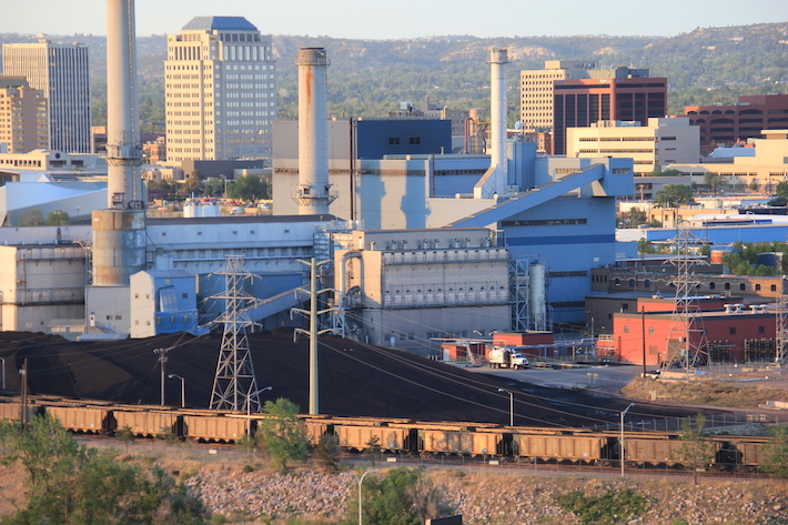
Martin Drake Coal Plant Colorado Springs. The coal plant in downtown Colorado Springs will be closed by 2023 and 7 gas-fired generators moved in to generate power until 2030. Photo credit: Allen Best/The Mountain Town News
While the term may bring to mind the windswept sand dunes of the Sahara or the vast salt pans of the Kalahari, it’s an issue that reaches far beyond those living in and around the world’s deserts, threatening the food security and livelihoods of more than two billion people.
The combined impact of climate change, land mismanagement and unsustainable freshwater use has seen the world’s water-scarce regions increasingly degraded. This leaves their soils less able to support crops, livestock and wildlife.
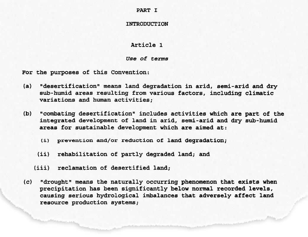
In 1994, the UN established the United Nations Convention to Combat Desertification(UNCCD) as the “sole legally binding international agreement linking environment and development to sustainable land management”. The Convention itself was a response to a callat the UN Earth Summit in Rio de Janeiro in 1992 to hold negotiations for an international legal agreement on desertification.
The UNCCD set out a definition of desertification in a treaty adopted by parties in 1994. It states that desertification means “land degradation in arid, semi-arid and dry sub-humid areas resulting from various factors, including climatic variations and human activities”.
The opening section of Article 1 of the United Nations Convention to Combat Desertification, which was adopted in 1994 and came into force in 1996. Source: United Nations Treaty Collection
So, rather than desertification meaning the literal expansion of deserts, it is a catch-all term for land degradation in water-scarce parts of the world. This degradation includes the temporary or permanent decline in quality of soil, vegetation, water resources or wildlife, for example. It also includes the deterioration of the economic productivity of the land – such as the ability to farm the land for commercial or subsistence purposes.
Arid, semi-arid and dry sub-humid areas are known collectively as “drylands”. These are, unsurprisingly, areas that receive relatively little rain or snow each year. Technically, they are defined by the UNCCD as “areas other than polar and sub-polar regions, in which the ratio of annual precipitation to potential evapotranspiration falls within the range from 0.05 to 0.65”.
In simple terms, this means the amount of rainfall the area receives is between 5-65% of the water it has the potential to lose through evaporation and transpiration from the land surface and vegetation, respectively (assuming sufficient moisture is available). Any area that receives more than this is referred to as “humid”.
You can see this more clearly in the map below, where the world’s drylands are identified by different grades of orange and red shading. Drylands encompass around 38% of the Earth’s land area, covering much of North and southern Africa, western North America, Australia, the Middle East and Central Asia. Drylands are home to approximately 2.7 billion people (pdf) – 90% of whom live in developing countries.
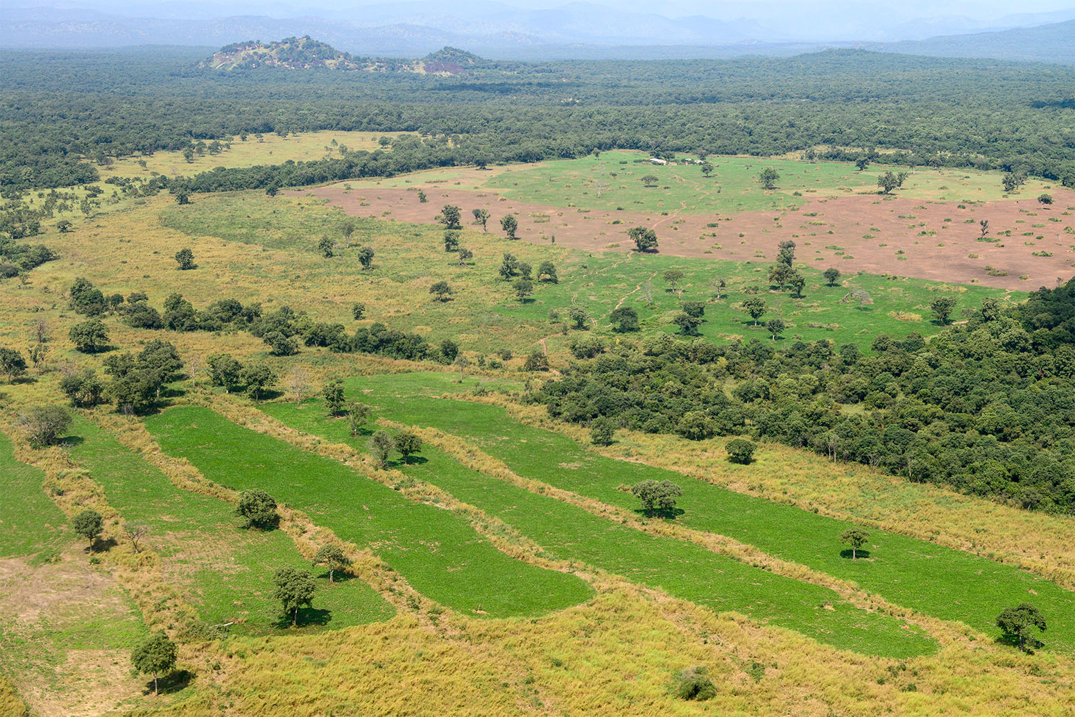
Drylands are particularly susceptible to land degradation because of scarce and variable rainfall as well as poor soil fertility. But what does this degradation look like?
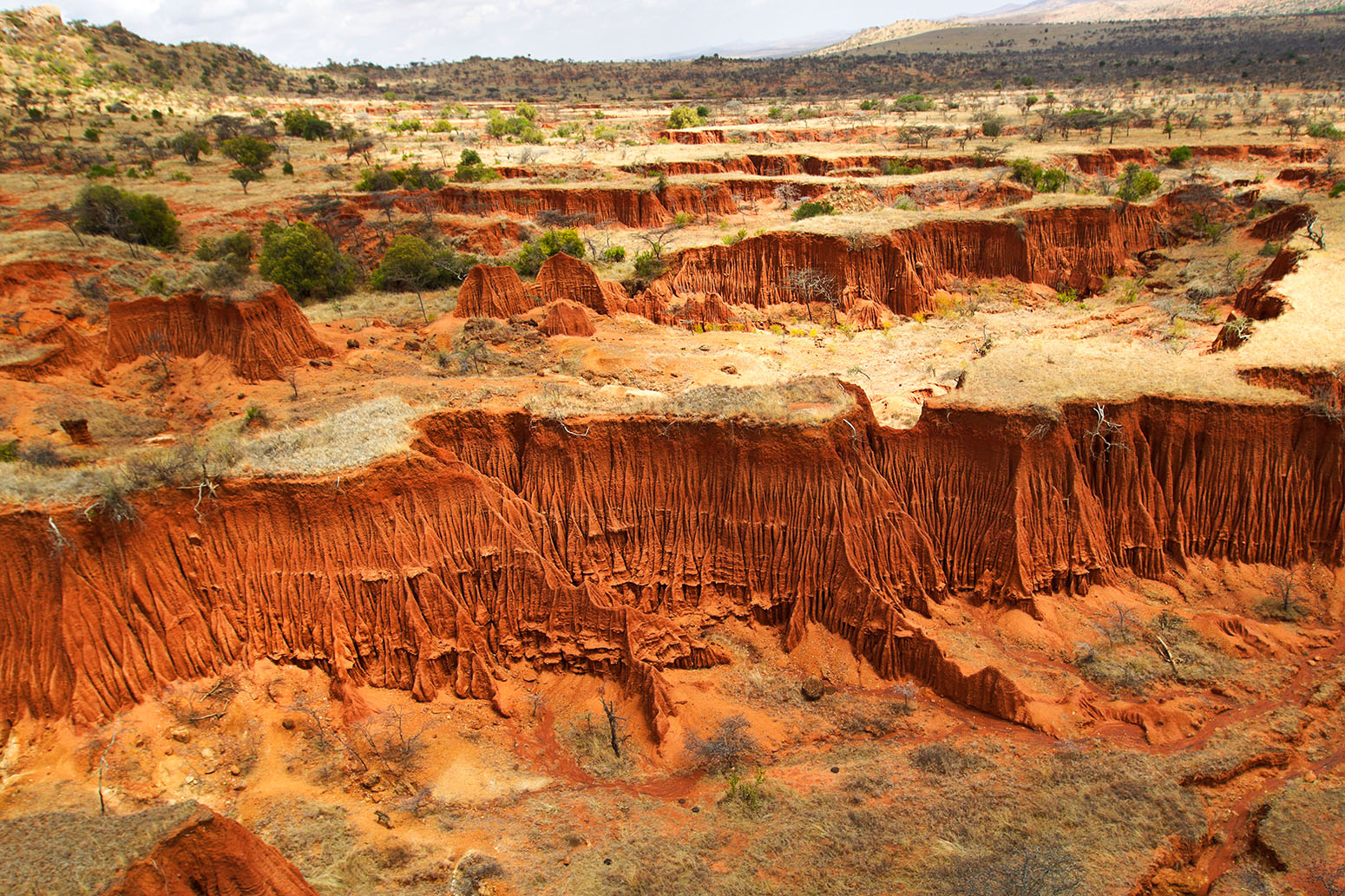
There are numerous ways in which the land can degrade. One of the main processes is erosion – the gradual breaking down and removal of rock and soil. This is typically through some force of nature – such as wind, rain and/or waves – but can be exacerbated by activities including ploughing, grazing or deforestation.
A loss of soil fertility is another form of degradation. This can be through a loss of nutrients, such as nitrogen, phosphorus and potassium, or a decline in the amount of organic matter in the soil. For example, soil erosion by water causes global losses of as much as 42m tonnes of nitrogen and 26m tonnes of phosphorus every year. On farmed land, this inevitably needs to be replaced through fertilisers at significant cost. Soils can also suffer from salinisation – an increase in salt content – and acidification from overuse of fertilisers.
Then there are lots of other processes that are classed as degradation, including a loss or shift in vegetation type and cover, the compaction and hardening of the soil, an increase in wildfires, and a declining water table through excessive extraction of groundwater.
The direct causes of desertification can be broadly divided between those relating to how the land is – or isn’t – managed and those relating to the climate. The former includes factors such as deforestation, overgrazing of livestock, over-cultivation of crops and inappropriate irrigation; the latter includes natural fluctuations in climate and global warming as a result of human-caused greenhouse gas emissions.
Land affected by overgrazing by cattle in India. Credit: Maximilian Buzun / Alamy Stock Photo.
Then there are underlying causes as well, the IPBES report notes, including “economic, demographic, technological, institutional and cultural drivers”.
Looking first at the role of the climate, a significant factor is that the land surface is warming more quickly than the Earth’s surface as a whole. (Recent research shows that this is because the “lapse rate” – the rate that air temperatures decrease with height through the atmosphere – is experiencing larger decreases over the ocean than land. This results in smaller increases in surface ocean temperatures compared to the land surface as global temperatures rise.) So, while global average temperatures are around 1.1C warmer now than in pre-industrial times, the land surface has warmed by approximately 1.7C. The chart below compares changes in land temperatures in four different records with a global average temperature since 1970 (blue line).
Global average land temperatures from four datasets: CRUTEM4 (purple), NASA (red), NOAA (yellow) and Berkeley (grey) for 1970 to the present day, relative to a 1961-90 baseline. Also shown is global temperature from the HadCRUT4 record (blue). Chart by Carbon Brief using Highcharts.
While this sustained, human-caused warming can by itself add to heat stress faced by vegetation, it is also linked to worsening extreme weather events, explains Prof Lindsay Stringer, a professor in environment and development at the University of Leeds and a lead author on the land degradation chapter of the forthcoming IPCC land report. She tells Carbon Brief:
“Climate change affects the frequency and magnitude of extreme events like droughts and floods. In areas that are naturally dry for example, a drought can have a huge impact on vegetation cover and productivity, particularly if that land is being used by high numbers of livestock. As plants die off due to lack of water, the soil becomes bare and is more easily eroded by wind, and by water when the rains do eventually come.”
(Stringer is commenting here in her role at her home institution and not in her capacity as an IPCC author. This is the case with all the scientists quoted in this article.)
Both natural variability in climate and global warming can also affect rainfall patterns around the world, which can contribute to desertification. Rainfall has a cooling effect on the land surface, so a decline in rainfall can allow soils to dry out in the heat and become more prone to erosion. On the other hand, heavy rainfall can erode soil itself and cause waterlogging and subsidence.
Dr Katerina Michaelides, a senior lecturer in the Drylands Research Group at the University of Bristol and contributing author on the desertification chapter of the IPCC land report, describes a shift to drier conditions as the main impact of a warming climate on desertification. She tells Carbon Brief:
“The main effect of climate change is through aridification, a progressive change of the climate towards a more arid state – whereby rainfall decreases in relation to the evaporative demand – as this directly affects water supply to vegetation and soils.”
Climate change is also a contributing factor to wildfires, causing warmer – and sometimes drier – seasons that provide ideal conditions for fires to take hold. And a warmer climate can speed up the decomposition of organic carbon in soils, leaving them depleted and less able to retain water and nutrients.
As well as physical impacts on the landscape, climate change can impact on humans “because it reduces options for adaptation and livelihoods, and can drive people to overexploit the land”, notes Stringer.
That overexploitation refers to the way that humans can mismanage land and cause it to degrade. Perhaps the most obvious way is through deforestation. Removing trees can upset the balance of nutrients in the soil and takes away the roots that helps bind the soil together, leaving it at risk of being eroded and washed or blown away.
Forests also play a significant role in the water cycle – particularly in the tropics. For example, research published in the 1970s showed that the Amazon rainforest generates around half of its own rainfall. This means that clearing the forests runs the risk of causing the local climate to dry, adding to the risk of desertification.
Food production is also a major driver of desertification. Growing demand for food can see cropland expand into forests and grasslands, and use of intensive farming methods to maximise yields. Overgrazing of livestock can strip rangelands of vegetation and nutrients.
This demand can often have wider political and socioeconomic drivers, notes Stringer:
“For example, demand for meat in Europe can drive the clearance of forest land in South America. So, while desertification is experienced in particular locations, its drivers are global and coming largely from the prevailing global political and economic system.”
Local and global impacts
Of course, none of these drivers acts in isolation. Climate change interacts with the other human drivers of degradation, such as “unsustainable land management and agricultural expansion, in causing or worsening many of these desertification processes”, says Dr Alisher Mirzabaev, a senior researcher at the University of Bonn and a coordinating lead author on the desertification chapter of the IPCC land report. He tells Carbon Brief:
“The [result is] declines in crop and livestock productivity, loss of biodiversity, increasing chances of wildfires in certain areas. Naturally, these will have negative impacts on food security and livelihoods, especially in developing countries.”
Stringer says desertification often brings with it “a reduction in vegetation cover, so more bare ground, a lack of water, and soil salinisation in irrigated areas”. This also can mean a loss of biodiversity and visible scarring of the landscape through erosion and the formation of gullies following heavy rainfall.
“Desertification has already contributed to the global loss of biodiversity”, adds Joyce Kimutaifrom the Kenya Meteorological Department. Kimutai, who is also a lead author on the desertification chapter of the IPCC land report, tells Carbon Brief:
“Wildlife, especially large mammals, have limited capacities for timely adaptation to the coupled effects of climate change and desertification.”
For example, a study (pdf) of the Cholistan Desert region of Pakistan found that the “flora and fauna have been thinning out gradually with the increasing severity of desertization”. And a study of Mongolia found that “all species richness and diversity indicators declined significantly” because of grazing and increasing temperatures over the last two decades.
Degradation can also open the land up to invasive species and those less suitable for grazing livestock, says Michaelides:
“In many countries, desertification means a decline in soil fertility, a reduction in vegetation cover – especially grass cover – and more invasive shrub species. Practically speaking, the consequences of this are less available land for grazing, and less productive soils. Ecosystems start to look different as more drought tolerant shrubs invade what used to be grasslands and more bare soil is exposed.”
This has “devastating consequences for food security, livelihoods and biodiversity”, she explains:
“Where food security and livelihoods are intimately tied to the land, the consequences of desertification are particularly immediate. Examples are many countries in East Africa – especially Somalia, Kenya and Ethiopia – where over half of the population are pastoralists relying on healthy grazing lands for their livelihoods. In Somalia alone, livestock contributes around 40% of the GDP [Gross Domestic Product].”
The UNCCD estimates that around 12m hectares [29,652,645 acres] of productive land are lost to desertification and drought each year. This is an area that could produce 20m tonnes of grain annually.
This has a considerable financial impact. In Niger, for example, the costs of degradation caused by land use change amounts to around 11% of its GDP. Similarly in Argentina, the “total loss of ecosystem services due to land-use/cover change, wetlands degradation and use of land degrading management practices on grazing lands and selected croplands” is equivalent to about 16% of its GDP.
Loss of livestock, reduced crop yields and declining food security are very visible human impacts of desertification, says Stringer:
“People cope with these kinds of challenges in various ways – by skipping meals to save food; buying what they can – which is difficult for those living in poverty with few other livelihood options – collecting wild foods, and in extreme conditions, often combined with other drivers, people move away from affected areas, abandoning the land.”
People are particularly vulnerable to the impacts of desertification where they have “insecure property rights, where there are few economic supports for farmers, where there are high levels of poverty and inequality, and where governance is weak”, Stringer adds.
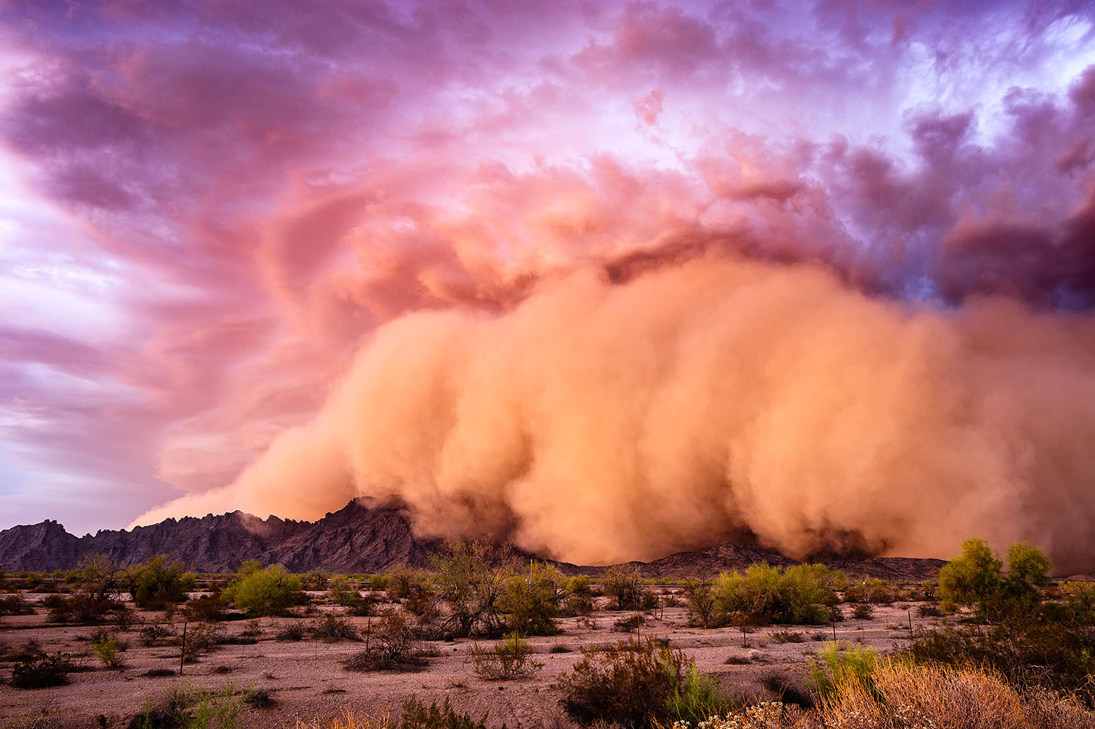
Another impact of desertification is an increase in sand and dust storms. These natural phenomena – known variously as “sirocco”, “haboob”, “yellow dust”, “white storms”, and the “harmattan” – occur when strong winds blow loose sand and dirt from bare, dry soils. Research suggests that global annual dust emissions have increased by 25% between the late nineteenth century and today, with climate change and land use change the key drivers.
A Haboob dust storm rolls over the Mohawk Mountains near Tacna, Arizona, 9 July 2018. Credit: John Sirlin / Alamy Stock Photo.
Dust storms in the Middle East, for example, “are becoming more frequent and intense in recent years”, a recent study found. This has been driven by “long-term reductions in rainfall promot[ing] lower soil moisture and vegetative cover”. However, Stringer adds that “further research is needed to establish the precise links between climate change, desertification and dust and sandstorms”.
Dust storms can have a huge impact on human health, contributing to respiratory disorders such as asthma and pneumonia, cardiovascular issues and skin irritations, as well as polluting open water sources. They can also play havoc with infrastructure, reducing the effectiveness of solar panels and wind turbines by covering them in dust, and causing disruption to roads, railways and airports.
Climate feedback
Adding dust and sand into the atmosphere is also one of the ways that desertification itself can affect the climate, says Kimutai. Others include “changes in vegetation cover, surface albedo (reflectivity of the Earth’s surface), and greenhouse gases fluxes”, she adds.
Dust particles in the atmosphere can scatter incoming radiation from the sun, reducing warming locally at the surface, but increasing it in the air above. They can also affect the formation and lifetimes of clouds, potentially making rainfall less likely and thus reducing moisture in an already dry area.
Soils are a very important store of carbon. The top two metres of soil in global drylands, for example, store an estimated 646bn tonnes of carbon – approximately 32% of the carbon held in all the world’s soils.
Research shows that the moisture content of the soil is the main influence on the capacity for dryland soils to “mineralise” carbon. This is the process, also known as “soil respiration”, where microbes break down the organic carbon in the soil and convert it to CO2. This process also makes nutrients in the soil available for plants to use as they grow.
Soil erosion in Kenya. Credit: Martin Harvey / Alamy Stock Photo.
Soil respiration indicates the soil’s ability to sustain plant growth. And typically, respiration declines with decreasing soil moisture to a point where microbial activity effectively stops. While this reduces the CO2 the microbes release, it also inhibits plant growth, which means the vegetation is taking up less CO2 from the atmosphere through photosynthesis. Overall, dry soils are more likely to be net emitters of CO2.
So as soils become more arid, they will tend to be less able to sequester carbon from the atmosphere, and thus will contribute to climate change. Other forms of degradation also generally release CO2 into the atmosphere, such as deforestation, overgrazing – by stripping the land of vegetation – and wildfires.
Mapping troubles
“Most dryland environments around the world are being affected by desertification to some extent,” says Michaelides.
But coming up with a robust global estimate for desertification is not straightforward, explains Kimutai:
“Current estimates of the extent and severity of desertification vary greatly due to missing and/or unreliable information. The multiplicity and complexity of the processes of desertification make its quantification even more difficult. Studies have used different methods based on different definitions.”
And identifying desertification is made harder because it tends to emerge relatively slowly, adds Michaelides:
“At the start of the process, desertification may be hard to detect, and because it’s slow it may take decades to realise that a place is changing. By the time it is detected, it may be hard to halt or reverse.”
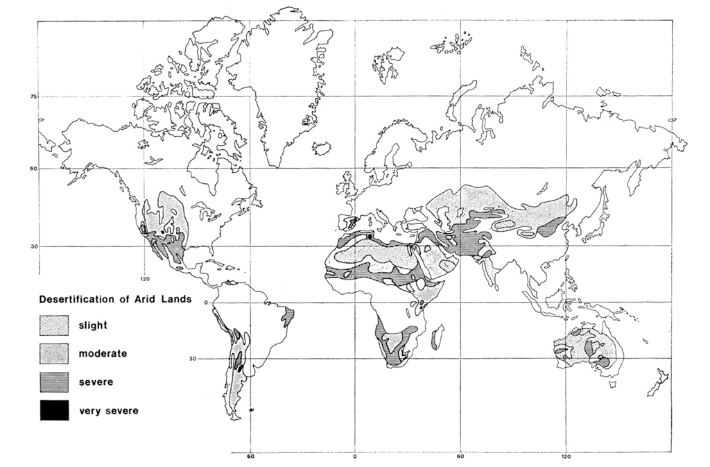
Desertification across the Earth’s land surface was first mapped in a study published in the journal Economic Geography in 1977. It noted that: “For much of the world, there is little good information on the extent of desertification in individual countries”. The map – shown below – graded areas of desertification as “slight”, “moderate”, “severe” or “very severe” based on a combination of “published information, personal experience, and consultation with colleagues”.
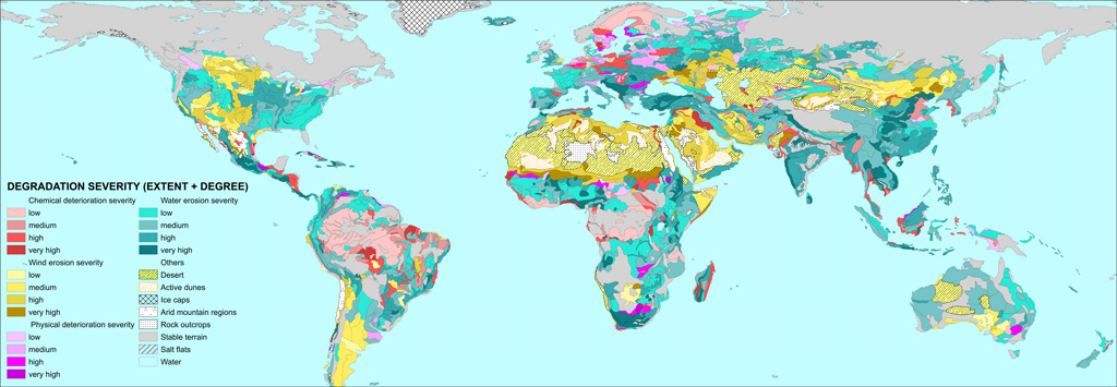
The GLASOD map, shown below, details the extent and degree of land degradation across the world. It categorised the degradation into chemical (red shading), wind (yellow), physical (purple) or water (blue).
Global Assessment of Human-induced Soil Degradation (GLASOD). Shading indicates type of degradation: chemical (red), wind (yellow), physical (purple) and water (blue), with darker shading showing higher levels of degradation. Source: Oldeman, L. R., Hakkeling, R. T. A. and Sombroek, W. G. (1991) World Map of the Status of Human-Induced Soil Degradation: An explanatory note (rev. ed.), UNEP and ISRIC, Wageningen.
Nevertheless, by the time the third WAD – produced by the Joint Research Centre of the European Commission – came around two decades later, the authors “decided to take a different path”. As the report puts it:
“Land degradation cannot be globally mapped by a single indicator or through any arithmetic or modelled combination of variables. A single global map of land degradation cannot satisfy all views or needs.”
Instead of a single metric, the atlas considers a set of “14 variables often associated with land degradation”, such as aridity, livestock density, tree loss and decreasing land productivity.
As such, the map below – taken from the Atlas – does not show land degradation itself, but the “convergence of evidence” of where these variables coincide. The parts of the world with the most potential issues (shown by orange and red shading) – such as India, Pakistan, Zimbabwe and Mexico – are thus identified as particularly at risk from degradation.
Map showing “convergence of evidence” of 14 land degradation risks from the third edition of the World Atlas of Desertification. Shading indicates the number of coincident risks. The areas with the fewest are shown in blue, which then increase through green, yellow, orange and the most in red. Credit: Publication Office of the European Union
The future
As desertification cannot be characterised by a single metric, it is also tricky to make projections for how rates of degradation could change in the future.
In addition, there are numerous socio-economic drivers that will contribute. For example, the number of people directly affected by desertification is likely to increase purely because of population growth. The population living in drylands across the world is projected to increaseby 43% to four billion by 2050.
The impact of climate change on aridity is also complicated. A warmer climate is generally more able to evaporate moisture from the land surface – potentially increasing dryness in combination with hotter temperatures.
Glossary: RCP4.5: The RCPs (Representative Concentration Pathways) are scenarios of future concentrations of greenhouse gases and other forcings. RCP4.5 is a “stabilisation scenario” where policies are put in place so atmospheric CO2 concentration levels… Read More
However, climate change will also affect rainfall patterns, and a warmer atmosphere can hold more water vapour, potentially increasing both average and heavy rainfall in some areas.
There is also a conceptual question of distinguishing long-term changes in the dryness of an area with the relatively short-term nature of droughts.
In general, the global area of drylands is expected to expand as the climate warms. Projections under the RCP4.5 and RCP8.5 emissions scenarios suggest drylands will increase by 11% and 23%, respectively, compared to 1961-90. This would mean drylands could make up either 50% or 56%, respectively, of the Earth’s land surface by the end of this century, up from around 38% today.
This expansion of arid regions will occur principally “over southwest North America, the northern fringe of Africa, southern Africa, and Australia”, another study says, while “major expansions of semiarid regions will occur over the north side of the Mediterranean, southern Africa, and North and South America”.
Research also shows that climate change is already increasing both the likelihood and severity of droughts around the world. This trend is likely to continue. For example, one study, using the intermediate emissions scenario “RCP4.5”, projects “large increases (up to 50%–200% in a relative sense) in frequency for future moderate and severe drought over most of the Americas, Europe, southern Africa, and Australia”.
Glossary: RCP8.5: The RCPs (Representative Concentration Pathways) are scenarios of future concentrations of greenhouse gases and other forcings. RCP8.5 is a scenario of “comparatively high greenhouse gas emissions“ brought about by rapid population growth,… Read More
Another study notes that climate model simulations “suggest severe and widespread droughts in the next 30–90 years over many land areas resulting from either decreased precipitation and/or increased evaporation”.
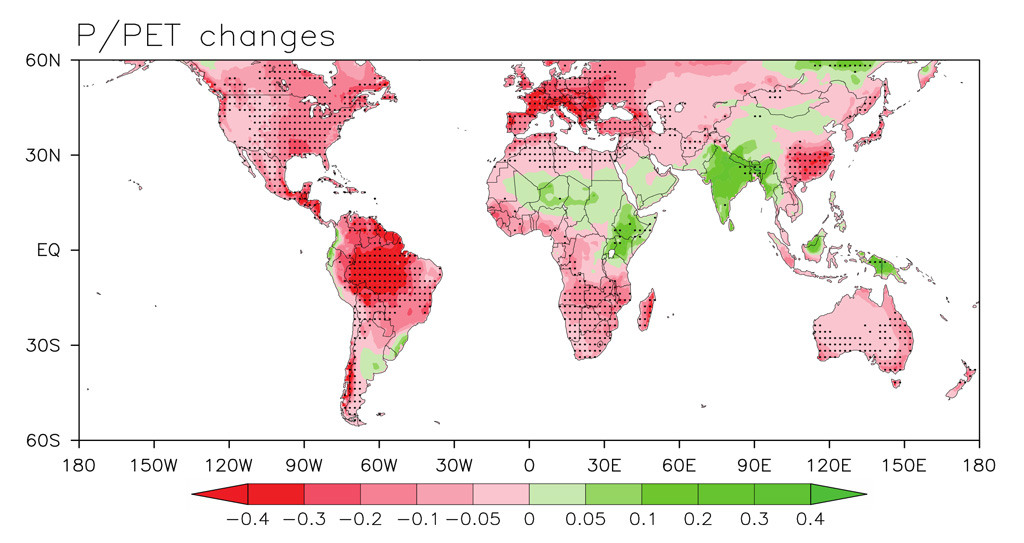
However, it should be noted that not all drylands are expected to get more arid with climate change. The map below, for example, shows the projected change for a measure of aridity (defined as the ratio of rainfall to potential evapotranspiration, PET) by 2100 under climate model simulations for RCP8.5. The areas shaded red are those expected to become drier – because PET will increase more than rainfall – while those in green are expected to become wetter. The latter includes much of the Sahel and East Africa, as well as India and parts of northern and western China.
Projected changes in aridity index (the ratio of rainfall to PET), simulated over land by 27 CMIP5 climate models by 2100 under the RCP8.5 scenario. Source: Sherwood & Fu (2014). Reproduced with permission from Steven Sherwood.
Climate model simulations also suggest that rainfall, when it does occur, will be more intense for almost the entire world, potentially increasing the risks of soil erosion. Projections indicate that most of the world will see a 16-24% increase in heavy precipitation intensity by 2100.
The UN has designated the decade from January 2010 to December 2020 as the “United Nations decade for deserts and the fight against desertification”. The decade was to be an “opportunity to make critical changes to secure the long-term ability of drylands to provide value for humanity’s well being”.
What is very clear is that prevention is better – and much cheaper – than cure. “Once desertification has occurred it is very challenging to reverse”, says Michaelides. This is because once the “cascade of degradation processes start, they’re hard to interrupt or halt”.
Stopping desertification before it starts requires measures to “protect against soil erosion, to prevent vegetation loss, to prevent overgrazing or land mismanagement”, she explains:
“All these things require concerted efforts and policies from communities and governments to manage land and water resources at large scales. Even small scale land mismanagement can lead to degradation at larger scales, so the problem is quite complex and hard to manage.”
The idea of LDN, explained in detail in the video below, is a hierarchy of responses: first to avoid land degradation, second to minimise it where it does occur, and thirdly to offset any new degradation by restoring and rehabilitating land elsewhere. The outcome being that overall degradation comes into balance – where any new degradation is compensated with reversal of previous degradation.
“Sustainable land management” (SLM) is key to achieving the LDN target, says Dr Mariam Akhtar-Schuster, co-chair of the UNCCD science-policy interface and a review editor for the desertification chapter of the IPCC land report. She tells Carbon Brief:
“Sustainable land management practices, which are based on the local socio-economic and ecological condition of an area, help to avoid desertification in the first place but also to reduce ongoing degradation processes.”
SLM essentially means maximising the economic and social benefits of the land while also maintaining and enhancing its productivity and environmental functions. This can comprise a whole range of techniques, such as rotational grazing of livestock, boosting soil nutrients by leaving crop residues on the land after harvest, trapping sediment and nutrients that would otherwise be lost through erosion, and planting fast-growing trees to provide shelter from the wind.
Testing soil health by measuring for nitrogen leakage in Western Kenya. Credit: CIAT / (CC BY-NC-SA 2.0).
But these measures can’t just be applied anywhere, notes Akhtar-Schuster:
“Because SLM has to be adapted to local circumstances there is no such thing as a one size fits all toolkit to avoid or reduce desertification. However, all these locally adapted tools will have the best effects if they are embedded in an integrated national land use planning system.”
Stringer agrees that there’s “no silver bullet” to preventing and reversing desertification. And, it’s not always the same people who invest in SLM who benefit from it, she explains:
“An example here would be land users upstream in a catchment reforesting an area and reducing soil erosion into water bodies. For those people living downstream this reduces flood risk as there is less sedimentation and could also deliver improved water quality.”
However, there is also a fairness issue if the land users upstream are paying for the new trees and those downstream are receiving the benefits at no cost, Stringer says:
“Solutions therefore need to identify who ‘wins’ and who ‘loses out’ and should incorporate strategies that compensate or minimise inequities.”
“Everyone forgets that last part about equity and fairness,” she adds. The other aspect that has also been overlooked historically is getting community buy-in on proposed solutions, says Stringer.
Research shows that using traditional knowledge can be particularly beneficial for tackling land degradation. Not least because communities living in drylands have done so successfully for generations, despite the tricky environmental conditions.
This idea is increasingly being taken on board, says Stringer – a response to “top-down interventions” that have proved “ineffective” because of a lack of community involvement.
Colorado Attorney General Phil Weiser this week expressed reservations about the Colorado River District’s proposal to acquire major senior water rights associated with the Shoshone hydroelectric power plant in Glenwood Canyon, voicing discomfort with the idea of a proposed instream flow right not being owned by the state. Speaking at a Colorado Water Conservation Board meeting, Weiser told river district General Counsel Peter Fleming that the ordinary structure in Colorado is for the state, through the state board, to own instream flow rights…
The proposal is for the river district to lease the acquired water rights back to Xcel for operation of the plant. The river district proposes that it and the CWCB would apply to state water court to get an alternate beneficial purpose of an instream flow added to the Shoshone water rights, to ensure the ability to keep the water in the river when it isn’t used for power generation, such as when the power plant is undergoing repairs. Although water entities already have agreed to generally keep water flowing as if the plant is in operation even when it is shut down, the river district and partners are seeking to protect those historic flows permanently, including in the case of the plant closing…
Fleming said the river district’s position is that the river district would assign the state the right to use the water rights for instream flows. He said that effectively the state would hold the right to use the water for instream purposes, but the only caveat is that Xcel wants to use the water for hydropower as long as the plant is operating, and the river district as the owner of the water rights would lease to Xcel the right to use the water…
Fleming said that although the CWCB ordinarily owns instream flow rights, state law also lets water users loan water to the CWCB for instream flows on a temporary basis, and other types of agreements also are in place. He said state law contemplates the state board using any means of acquiring the right to use instream flows, whether it be via loans, donations, acquisitions or obtaining “any sub-interest in the water right.”
[…]
Said Weiser, “What I don’t understand is why you’re talking at all about owning a title for something that’s use is in perpetuity and ordinarily managed by the state. That is not quite making sense to me as something that is outside of the way we tend to operate.” Weiser said the river district’s goal of getting to a status quo that’s sustainable for the Western Slope “seems to be accomplished by an instream flow right that is owned by the state and this body (the CWCB).”
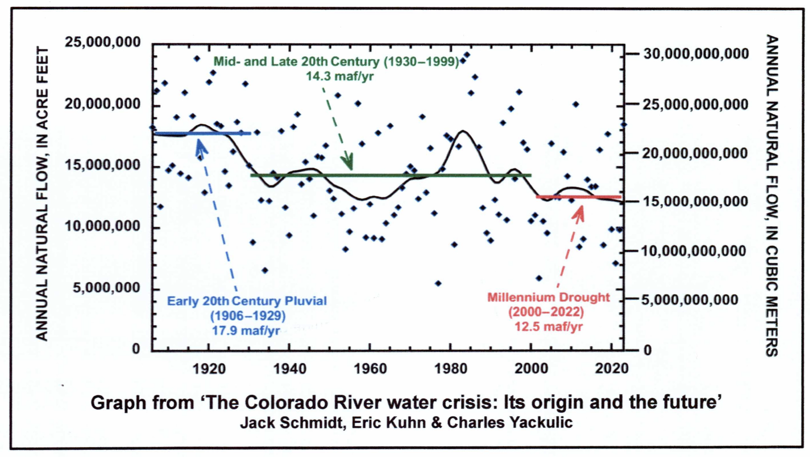
“New plot using the nClimGrid data, which is a better source than PRISM for long-term trends. Of course, the combined reservoir contents increase from last year, but the increase is less than 2011 and looks puny compared to the ‘hole’ in the reservoirs. The blue Loess lines subtly change. Last year those lines ended pointing downwards. This year they end flat-ish. 2023 temps were still above the 20th century average, although close. Another interesting aspect is that the 20C Mean and 21C Mean lines on the individual plots really don’t change much. Finally, the 2023 Natural Flows are almost exactly equal to 2019. (17.678 maf vs 17.672 maf). For all the hoopla about how this was record-setting year, the fact is that this year was significantly less than 2011 (20.159 maf) and no different than 2019” — Brad Udall
Click the link to read the article on the AZCentral.com website (Brandon Loomis). Here’s an excerpt:
The arrival of the winter snow season, which sustains the river and last year bailed out water users facing critically low reservoirs, brings new questions for water managers: Will El Niño conditions in the Pacific Ocean produce a wet winter in the Southwest and parts of the Rockies? And could a second straight wet winter wallop the region with above-average snowfall and again forestall more drastic conservation measures?
[…]
[Jack] Schmidt isn’t predicting the weather, but he has crunched the numbers on the drought or aridification patterns that plunged the Colorado into peril over the last 23 years and they aren’t pretty. Last winter was the second-wettest of that time, behind 2011. There have been a handful of high-snow, high-flow years in that span, but none was followed immediately by another. Each such winter has provided no more than a two-year arrest in the system’s downward slide. Without another one this winter, Schmidt said, the region will be back in crisis despite the states’ agreed cutbacks…And history shows that those who hope another wet winter will forestall tough choices risk disappointment…
Already, the region has used about a fifth of last winter’s windfall, Schmidt said. That’s enough to set water storage back where it was in June of 2021, a time that was better than last year, but still an impending disaster that sent water managers scrambling and forced central Arizona farmers to prepare for a cut off…Like Schmidt, federal forecasters and some water system managers are tamping down optimism for this El Niño…National Weather Service meteorologists reinforced the uncertainty in a Phoenix briefing this week. Their predictions for northern Arizona’s high country, which saw big snows in tandem with the Rockies last winter, amount to essentially even odds…Scanning moderate to strong El Niños in recent decades, [Ken Drozd] found that about half bring wet winters to the state, meaning snow in the north. About 30% are drier than normal, including the winter of 2015-2016. About 20% are near normal. At present, the Weather Service’s Climate Prediction Center gives roughly even odds to all three possibilities: wet, dry and normal.
Palisade is just east of Grand Junction and lies in a fertile valley between the Colorado River and Mt. Garfield which is the formation in the picture. They’ve grown wonderful peaches here for many years and have recently added grape vineyards such as the one in the picture. By inkknife_2000 (7.5 million views +) – https://www.flickr.com/photos/23155134@N06/15301560980/, CC BY-SA 2.0,
The Palisade Board of Trustees voted unanimously last Tuesday to raise its sewer rates in 2024 to $57.23 from the current single family residential rate of $35.37. The rate increase is intended to pay for a capital project to construct a pipe for Palisade’s waste water to the Clifton Sanitation Districts chemical plant and decommission its sewer lagoons. The rate increase was recommended through a rate study, which was completed and presented to the Trustees earlier this year. The rates will help pay back a $16.5 million loan from the United States Department of Agriculture, which was announced in late April. It also got around $5.6 million in grant funding from the USDA.
The new rates will also come with a new method for determining how much impact individual users have on the wastewater system. That method is called EQU. It is currently used by the Clifton Sanitation District. Palisade has had an EQU ordinance in place for years, but never implemented it, Town Attorney Jim Neu said…A single family home is considered one EQU, while a building with larger use, like a school, could be several EQUs. The Palisade rate in 2024 will be $57.23 per EQU.
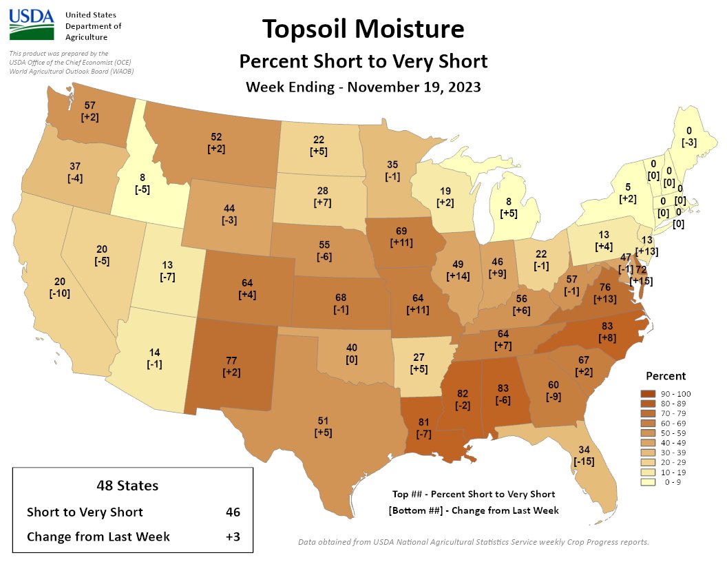
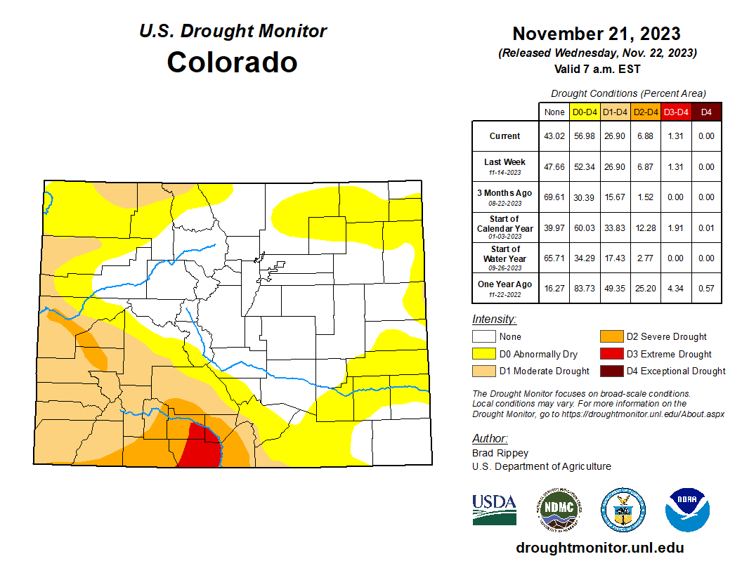
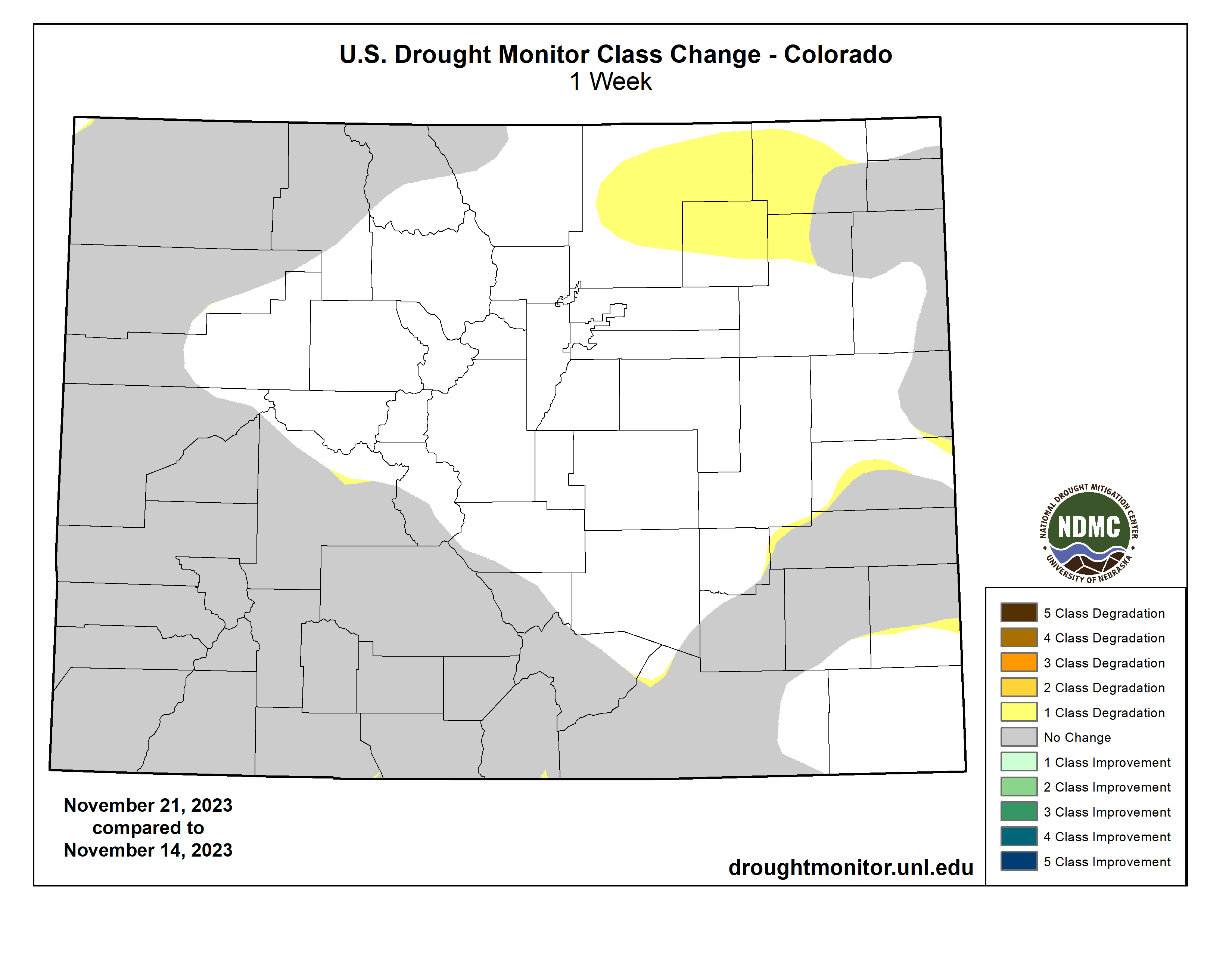
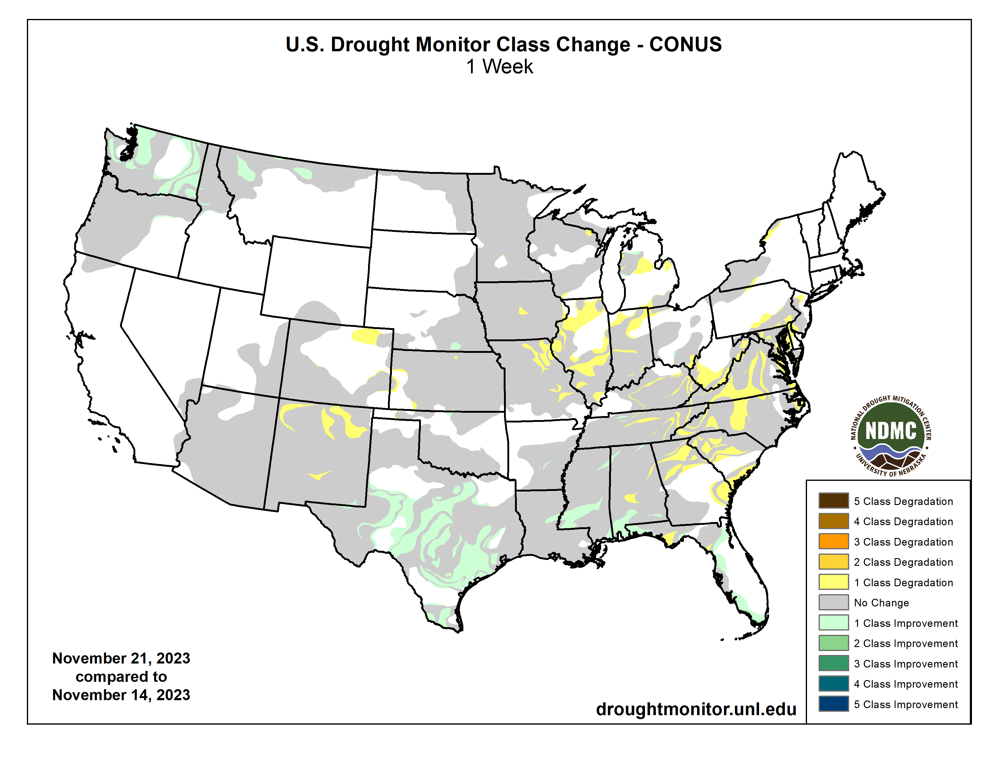
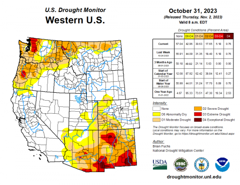
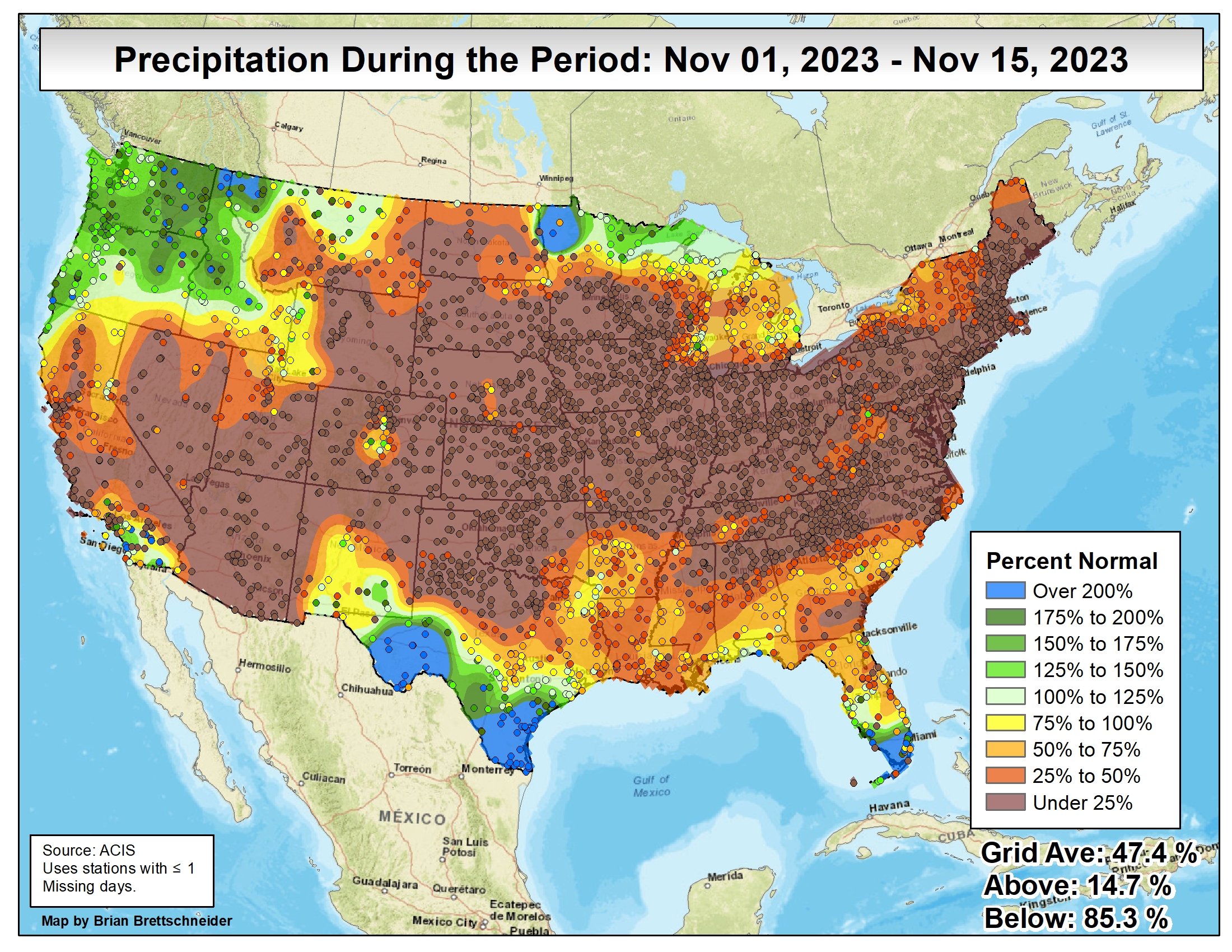
46% of the continental US is short/very short, a 3% increase since last week. A band across the mid-Atlantic and central US dried out, with rapid drying in NJ, DE, VA, IL, MO, & IA. Much of the SE is still dry, but improved.
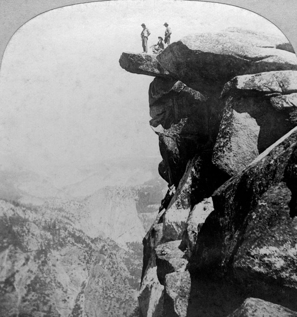
Abraham Lincoln has an almost saintly place in U.S. history: the “Great Emancipator” whose leadership during the Civil War preserved the Union and abolished slavery.
Often overlooked among his achievements is legislation he signed June 30, 1864, during the thick of the war – but only marginally related to the conflict. The Yosemite Valley Grant Act preserved the Yosemite Valley and Mariposa Grove in California as a park “held for public use, resort, and recreation … for all time.”
It was the first time the federal government had set aside land for its scenic value, and it created a model for U.S. national parks, which are themselves hallowed sites in American culture. Originally granted to the state of California, Yosemite formally became the third U.S. national park in 1890, joining a system of picturesque lands that hold spiritual and patriotic significance for millions of Americans.
At the same time, however, the establishment of national parks had severe consequences for Native American peoples across the continent. My research on the religious history of U.S. national parks illustrates how religious justifications for establishing parks contributed to the persecution of Indigenous tribes, a reality that the National Park Service has begun to redress in recent decades.
US civil religion
With more than 300 million annual visitors, the U.S. National Park System is a much-valued treasure. It encompasses stupendous scenery, opportunities for encounters with wildlife, outdoor recreation and commemoration of important places and events.
But the parks’ significance goes beyond this. The national parks, historic sites, battlefields and other sites of the National Park Service are sacred places in U.S. civil religion: the symbols, practices and traditions that make the idea of a nation into something sacred, seemingly blessed by a higher power.
First brought attention by sociologist Robert Bellah, civil religion flourishes alongside conventional religious traditions, like Christianity or Buddhism, with its own sacred figures, sites and rituals. In the U.S., these include George Washington and Martin Luther King Jr., the U.S. flag and Pledge of Allegiance, and national holidays such as Independence Day.
I have observed that many of the most sacred places of the nation’s civil religion are found in sites cared for by the National Park Service, from Independence Hall in Philadelphia and the Statue of Liberty in New York to Mount Rushmore in South Dakota.
In addition, the National Park System is a testament to Manifest Destiny, a prominent feature of U.S. civil religion. This 19th-century notion held that Americans had divine blessing to expand the borders of the nation. As historian Anders Stephanson writes in his book about Manifest Destiny, it became “a catchword for the idea of a providentially or historically sanctioned right to continental expansionism.”
This westward expansion came at the expense of Native Americans and other groups that previously inhabited the territory. For many Protestant Christian Americans, the superlative scenery of natural sites like Yosemite and Yellowstone affirmed their belief that God intended for them to conquer and settle the American West in the decades following the Civil War – as I write about in my forthcoming book.
Products of Manifest Destiny
The earliest national parks were established as products of Manifest Destiny, amid the national push to bring land from the Mississippi to the Pacific into the United States, which many white Americans viewed as a mission to expand settled Christian society.
Beginning with Yellowstone in 1872, followed by Sequoia, Yosemite and Mount Rainier, the early parks created in the 19th century had symbolic significance for U.S. civil religion. In many Americans’ eyes, the sites’ beauty affirmed their belief that the U.S. was exceptional and divinely favored.
Westward expansion had severe consequences for American Indian nations, and the earliest national parks played a role in forcing their removal, as historian Mark David Spencehas documented. Transforming lands into national parks for visitors’ enjoyment meant dispossessing communities whose ancestors had valued those places for generations.
Following the creation of Yellowstone, the world’s first national park, a band of Shoshone people who had been there for generations – the Tukudika, or Sheep Eater – were relocated to a reservation in Wyoming. A similar situation involved the Nitsitapii, or Blackfeet people, whose treaty rights were abrogated with the establishment of Glacier National Park in 1910.
In contrast, the Yosemite Indians of California, who were mainly a band of Miwok people known as the Ahwahneechee, remained in Yosemite long after it became a national park. By 1969, though, they had been eliminated from the park through decades of onerous regulations, economic pressures and attrition.
The site of a former Miwok village in Yosemite Valley is now an outdoor museum display of traditional shelters. Thomas S. Bremer, CC BY-ND
A new era
Over the past few decades, the National Park Service has made progress in acknowledging Native American connections to parklands, beginning to address the history of Manifest Destiny and Indigenous peoples’ exclusion.
The agency is a key contributor to the Interior Department’s recent initiative to facilitate tribal co-management of federal lands. Though much still needs to be done, national park managers are increasingly consulting and cooperating with tribal authorities on a range of issues.
Deb Haaland, the first Native American in U.S. history to hold a cabinet position, initiated a process to review and replace derogatory names on federal lands – one of her earliest actions as secretary of the interior. For example, she specifically identified the term “squaw” – a slur often directed at Indigenous women – as offensive, declaring that “racist terms have no place in our vernacular or on our federal lands.” Within a year of her directive, 24 places in the National Park System had new names.
Tribes have also cooperated with a variety of national parks to restore bison herds. Historically, these animals were central for many tribes not only as a source of food and materials for tools, clothing and blankets but also in traditional spirituality. The Interior Department’s 2020 Bison Conservation Initiative and partnerships with the InterTribal Buffalo Council have helped begin to restore herds on Native American lands with bison from national parks, including Yellowstone, Badlands and Grand Canyon.
The city says the new application is unique because Thornton asked community members about what was most important when it comes to site selection and used that information to determine the preferred route…The application is not yet available from the Larimer County Planning Division, but the city of Thornton has posted some information and a map of the preferred route on a project website. The city also sent the Coloradoan its executive summary for the application…
Thornton says the new proposed route through the county is about 10 miles long, 16 miles shorter than what was first proposed in 2018. A pump station would be moved two miles north of where it was proposed to land owned by Water Supply and Storage Company…The new proposed placement affects 20 outside property owners, according to Thornton, whereas the last project crossed 40 properties, according to Todd Barnes, communications director for Thornton…The plan incorporates other changes the city proposed after commissioners told the city to go back to the drawing board in late 2018, like locating the pipeline along County Road 56 instead of through Douglas Road and aligning part of it with the proposed pipeline for the Northern Integrated Supply Project, a separate water project…Thornton says the new application provides precise locations for the pipeline and its parts so residents “can have a clear understanding of potential impacts from the project.”
[…]
In the new application, Thornton contends any concerns about how the project affects river levels is an issue outside of the county’s authority and is under the jurisdiction of a water court. The city also asserts that because of the court ruling, Larimer County may not consider Thornton’s potential use of eminent domain and “may not require (or criticize Thornton for not including) inclusion of concept of putting water ‘down the river.’ “
I am most thankful today for all the folks (particularly my children) that have and are helping me to work through a most difficult year of losses. Thank you from the bottom of my heart.
The graph above may look familiar; I used it in a post last summer (June 27, ‘Beyond 2026’). It illuminates a study by three ‘Colorado River elders’: hydrologist Jack Schmidt, retired river manager Eric Kuhn, and USGS scientist Charles Yackulic.
I personally think that every meeting convened on Colorado River issues should have this graph projected on the wall until we all grow to accept it as the reality of our past, present and future situations. Certainly it should be illuminating the meetings currently in process, as representatives of the seven Colorado River Basin states, and its 30 First People tribes, sit down to figure out how to ‘reoperate’ the river after the current ‘Interim Guidelines’ expire (guidelines now modified twice, with increasing urgency) in 2026.
The graph is a record of the flow volumes of the river over the past century-plus, from 1906 to 2022. The flyspecks all over the graph are the annual flows – illustrating a fundamental problem for river planning: the flows are literally all over the map, enabling those motivated more by politics than science to find evidence for any desired perception of bounty or paucity. The wavy black line is their ‘smoothing curve based on the locally weighted least squared error method for the nearest 15% of the data set’ – essentially an effort to sort a pattern out of the seemingly random behavior of the river. What the black line shows is a fairly clear downward trend in the averaged flows – but with upward loops that might inspire hope in anyone grasping for hope.
The brilliance of their study, though, lies in the three straight lines stepping down on the graph. They have broken the recent 117 years of flows – basically the period of our heavy involvement with the River – into three periods, divided around two extended dry spells:
The blue line shows the average of the river volumes from 1906 to 1929, since discovered through tree-ring studies to have been the wettest period in the river’s natural history going back many centuries. This ‘pluvial’ (very wet period) coincided with what I would call the early dawn of the Anthropocene Epoch, when we humans were beginning to really develop our technical abilities to fundamentally change the geological and ecological ‘nature’ of the planet, to better meet the needs of our swarming species. The Colorado River Compact was created in the middle of this first period; the seven states who divided the river in order to conquer it believed they were working with a river whose roughly measured annual flows averaged just under 18 million acre-feet (maf). Call it the Pluvial Period of our Colorado River. (I say ‘our Colorado River,’ the river which Euro-American civilization claimed as it own to do with as we will – as opposed to the Colorado River on which our river is an ephemeral, maybe one millennium, maybe less, overlay.)
The green line represents the average of flows for the period from a 1930s ‘wake-up’ dry spell to the end of the century – and the dry spell that began in 2001. The ‘smoothing curve’ shows that, for that 70-year period, the river only came close to the pluvial-period average briefly in the 1980s. The average flow for whole 70-year period was 14.3 maf, 20 percent below the pluvial average. The early 1930s saw the construction of Hoover Dam, and by the end of that period our river was fully developed, all the major structures in place for our various human uses, ranging from irrigation water for four or five million acres of desert land, to domestic water for 35-40 million people, to whitewater in the canyons affording the industrialized recreational opportunity to go risk your life. These changes have also been accompanied by unanticipated and unwanted collateral changes, worst of which are the climatic consequences of the substances that fueled all of our impressive development. Call this the Early Anthropocene Period of our Colorado River.
The red line represents the average of the river’s volume of flow since the dry spell at the turn of the century – 12.5 maf, 14 percent below the average flow of the Early period, and 30 percent below the average flow of the ‘Pluvial River.’ This period – like the pluvial period – is a short period in the scale of even human time, let alone geological time, but most scientists says it is probably the shape of the future we’ve shaped for ourselves; the red line is much more likely to gradually slope down than go back up, as we continue to pump carbon gases into the atmosphere. Call this the Woke Anthropocene Period – with a flip of the bird for those who wish to remain ‘unwoke’ about the situations we must try to address.
Eugene Clyde LaRue measuring the flow in Nankoweap Creek, 1923. Photo credit: USGS via Environment360
So – today we are working with a river that is roughly only about two-thirds the size of the river a century ago, when we began making plans for controlling and using the river.This being the case – is it unrealistic to suggest that maybe we should start from scratch with this new river we’ve created? Work out a new reality-based post-2026 management plan for our Woke Anthropocene River (the red line on the chart)?
I realize that probably sounds like I’m suggesting we throw out the revered Colorado River Compact, or at least do radical surgery on it. Well, yes, I am suggesting that. I am aware that numerous Colorado River water mavens have said that this is simply impossible, out of the question, but I’m going to argue that it is impossible not to at least seriously dig into it and make some major changes, for a number of very prescient reasons.
The first and most obvious reason is the fact that we have known since the drought of the 1930s and the anemic flows of the 1940s that the 17.9 maf Pluvial River for which the Compact was written was gone, which negated the ‘equitable division and apportionment’ specified in the Compact. When representatives from the four states of the Compact’s Upper Basin gathered in 1948 to create an Upper Colorado River Compact, they knew already that there might only occasionally be 7.5 million acre-feet (maf) of water per year for them, especially since the State Department had given Mexico 1.5 maf/year in 1944, on top of the 7.5 maf the existing Compact said the Upper Basin had to deliver on average to the Lower Basin.
So instead of apportioning 7.5 maf among themselves, they created percentages of whatever was left in the river after fulfilling the Compact and Mexican obligations: 51.75 percent for Colorado, 11.25 percent for New Mexico, 23 percent for Utah, and 14 percent for Wyoming. But X percent of what? That was a problem; estimates dropped from around 6 maf immediately after WWII to around 4 maf today, even as Upper Basin use was increasing. Nonetheless, that division into percentages of what’s actually there in the river, over a five or ten year rolling average, makes more sense than firm numbers devoid of real context.
Another serious flaw in the Compact is its failure to take into account system losses – evaporation, bank seepage, et cetera. For the free-flowing Pluvial River, when the Compact was created, these were relatively minor – maybe 5-8 percent or so of the flow. But as the reservoirs and long canals were added, the system losses increased to around 12-13 percent for the Early Anthropocene River (green line on the graph). And now in the warmer and drier Woke Anthropocene Period, system losses are closer to 16 percent of the total flow, maybe more. It’s hard to get good numbers for this because the science of measuring it, especially sublimation and transpiration, is still fairly primitive.
Being committed to deliver defined quantities to the Lower Basin and Mexico, the Upper Basin states absorb their system losses as part of their ‘whatever is left’ portion of the river’s water, but the Lower Basin states have never deducted from their 7.5 maf share the system losses from their several reservoirs (including the huge Mead Reservoir) and hundreds of miles of open canals. They have written it off as covered by ‘surplus flows’: Upper Basin water that made it past Lee Ferry or, since the 1960s, into Powell Reservoir, which the ever-accommodating Bureau continues to pass along as ‘surplus.’ This included roughly 10 million acre-feet of water since 2000 that the Upper Basin has no storage for above Powell (effectively Lower Basin storage), but that ‘surplus’ only made up about half of the Lower Basin’s system losses for the Woke period; the rest was drained from reservoir storage, creating most of the shortages in the 2020s. Real hydrology has to dominate distribution. [ed. emphasis mine]
Topographic map of the US. Credit: Epic Maps
Another Compact problem: The division of the Colorado River into two basins – hailed as a stroke of genius in the 1920s – was not a smart thing to do with a desert river. A desert river only exists because of a ‘water producing’ upland high enough to cool and condense precipitation from air forced up its slopes. At least 85 percent of the water in the Colorado River comes from snow and rain in the 10 percent of the natural basin above 8,000 feet elevation – a boundary that bears no relation to the geographically and ecologically irrelevant state boundaries that are the basis for the Compact division.
A desert river divides naturally into a ‘water producing’ region and a ‘water using’ region. Would it not make a great deal of sense for all of those in the water-using portion of the desert river to be directly involved in – and invested in – the care and keeping of the water-producing portion of the river?
But that is unthinkable under the Compact, which is based on those geographically irrelevant state boundaries, creating two geographically clumsy state-based ‘basins’ that are pitted against each other, the upper one mandated to pass a set amount of water to the other regardless of the climatic vagaries imposed on their mutual headwaters, conceivably having to eventually sacrifice some of its own uses of the waters to deliver the set quantities.
The state-based two-basin division was just a field-expedient solution to the problem that really drove the Compact Commissioners: how to persuade Congress that there was enough agreement among the seven states on the use of the river’s water to allow Congress to go ahead and fund the creation of a big control and storage dam on the mainstem. But the expedient solution has resulted mostly in a worsening antipathy between the state-based basin that includes both the river’s water-producing region and quite a bit of its water-using region, and the state-based basin that consumes most of the produced water and produces comparatively little.
An example of what this means can be seen in the recent ‘forest planning’ process for the Grand Mesa, Uncompaghre and Gunnison National Forests. These three National Forests are mostly above 8,000 feet in the Gunnison River Basin where 15 to 20 percent of the Colorado River’s water is produced. The forests shade and shelter the winter snowpack from sun and wind, but also cause the sublimation of an undetermined part of it through branch interception, and [then] drinking heavily from the water as the snowpack melts; there are probably a host of other more subtle and complex interactions affecting water production.
But the draft forest plan issued last summer did not even mention the Colorado River by name, let alone its water needs. Concerns expressed by probably more people than just me resulted in a couple paragraphs in the revised final draft plan about the river and its climate-related troubles, but there is still no sense that the plan requires forest managers to be as actively concerned about their organic charge to ‘secure favorable flows of water’ as they traditionally are about the companion charge to provide a dependable supply of timber. And which is more important for the Colorado River Basin: timber production (small and scraggly compared to the northern Rockies) or water production?
Yet an admittedly quick search of the hundreds of comments on the first draft and the objections to the final draft show no comments about this omission from any of the big water users downriver from the forests. And the Compact does not encourage what would be construed as interbasin meddling. We need to be one river.
Native America in the Colorado River Basin. Credit: USBR
A final reason why the Colorado River Compact should probably be scrapped and a new one created is the fact that the 30 First People nations overlaid on the seven states will no longer be covered (literally) and dismissed with a single sentence; they will be part of the new management regimen, and this alone mitigates for starting over. They have popular support that the representatives of the Great Father in Washington no longer enjoy, and will either be, in the immortal words of Lyndon Johnson, in the tent, or out of the tent pissing in.
In fact, a place to start the whole process of planning for the new Woke Anthropocene River might be for everyone involved to look at a document called ‘A Common Vision for the Colorado River System: Toward a Framework for Sustainability.’ This comes from a ‘Ten Tribes Partnership’ of desert First Peoples, most of whom have gone through, or are still going through, the ‘settlement’ process of negotiating for some portion of the water that should have been theirs since the creation of their reservations (see my last post). Its authors understand the patience, and the willingness to give a little (or a lot) to get a little, that will have to be present as we all figure out what to do beyond 2026 with a shrinking river. Many will find their vision statement naive, but at least they have an articulated and somewhat unified vision, which can hardly be said for the Compact states, where each state just wants, as one water leader said for Colorado, ‘for our state to come out stronger.’ Stronger than what, or whom, and how?
Top: Ron Mettle, left, and Sandy Bertch replaced thirsty turf with low-water native species at the edge of their HOA’s property in Greeley but hope to now expand replacements into other parts of the commons area. Photo credit: Allen Best/Big Pivots
Click the link to read the article on the Big Pivots website (Allen Best):
Nov 22, 2023
This story, a collaboration of Big Pivots and Aspen Journalism, is part of a series that examines the intersection of water and urban landscapes in Colorado.
Between 50% and 60% of Coloradans live in housing governed by homeowners associations, commonly called HOAs. Squeezing water devoted to urban landscapes must necessarily involve these neighborhoods.
It’s already happening but, so far, mostly on the edges. A case in point: a small HOA in Greeley called Bittersweet Pointe.
“We keep saying that all the other HOAs are pointless,” Sandy Bertch, president of the board of directors, joked as he led visitors to a hillside on the edge of the HOA’s commons area.
There, three-fourths of an acre of Kentucky bluegrass had been replaced this year by a mixture of blue grama and buffalo grass. With a summer of watering bills now in hand, Bertch estimates that the HOA needs 60% less water to irrigate that section. More turf replacement will occur on the HOA’s 2.5 acres of common ground, Bertsch promised, now that the efficacy of the native grasses has been demonstrated.
The HOA is among the smallest you’re likely to find. It has 11 duplexes, or 22 units altogether, all of whose residents are retired. It is self-managed, unlike most HOAs, which employ property management firms.
Ron Mettler, a retired electrical engineer, was president of the board when he brought up the subject of turf conversion. He got immediate pushback. “Don’t you touch that green grass. That’s why I am here,” said a resident, who has since died.
Finally, last year, consensus was achieved. Costs were crucial. The retirees will save money in reduced water bills and won’t need to mow the difficult hillside as frequently.
Making the decision easier was the city of Greeley’s incentive: $1 a square foot for removal of Kentucky bluegrass in addition to rebates for water efficiency.
Clinching the deal was the shared perception of growing water scarcity. Homeowners agreed that they needed to do their part in lessening demands.
“These two are poster children,” Ruth Quade, Greeley’s water conservation administrator, said of Mettler and Bertsch. “The key to a successful project is having one or two champions, and that is what these two are.”
Every turf conversion project needs a champion, says Ruth Quade, water conservation administrator for Greeley. This lawn of this Presbyterian church has been partially replaced with pollinator-friendly vegetation. Photo/Allen Best
Replacing Kentucky bluegrass and other cool-weather grasses with native grasses and other less-thirsty species will not solve all of Colorado’s water problems. Nearly 90% of water in Colorado goes to agriculture. Only 7% of the state’s water gets used within towns and cities, and roughly half of that goes to outdoor use for lawns, gardens and other urban landscaping.
So, why does it matter? For one thing, it’s very expensive, and politically fraught, for cities to develop new water sources, usually from distant locations. Treating that water to potable standards is expensive, too. Water used indoors, which is largely contained in pipes, can be recycled. Water engineers calculate that 85% of water used for outdoor landscapes is lost because of evaporation and other causes.
All of this has water providers looking to focus on water devoted to discretionary outdoor use in road medians, business parks, homes and common areas. Experts say this transition to less water-demanding landscapes in urban areas will take many years.
Clearings around castles
How did thirsty bluegrass become the landscaping default, the cultural norm in Colorado and elsewhere?
“Nowhere in the world are lawns as prized as in America,” Michael Pollan wrote in an essay published in The New York Times Magazine in 1989. “In little more than a century, we’ve rolled a green mantle of grass across the continent, with scarcely a thought to the local conditions or expense.”
In his essay, “Why Mow? The Case Against Lawns,” Pollan shared that when he was a child growing up on New York’s Long Island, his father defied convention and refused to mow the turf at the family’s tract house. The turf grew tall enough to flower and seed, something impossible with mowed lawns. “The lawn rippled in the breeze like a flag,” wrote Pollan.
Neighbors saw something else. Some instructed their children not to play with the young Pollan. Later, when he got a lawn himself, Pollan began mulling the purpose of lawns. In this suburban paradise, he concluded, such individuality was unacceptable.
Pollan and other writers have traced our modern idea of a lawn to the early 17th century. In at least one telling, aristocrats wanted clearings around their castles for defensive purposes. They either had animals graze it or dispatched servants with scythes to keep the grasses low.
The idea of grassy lawns around homes was transferred to the United States in the mid-19th century. At first, it was limited to the American aristocracy. Thomas Jefferson put in a lawn at Monticello. So did other wealthy landowners. But for Americans of lesser means, yards were devoted to more functional pursuits, such as the growing of vegetables or the keeping of pigs and other animals. Photo credit: Allen Best/Big Pivots
“Turf War,” a 2008 essay by Elizabeth Kolbert published in The New Yorker, identifies Andrew Jackson Downing as a seminal influencer as the masses began to embrace lawns. In his 1841 book, “A Treatise on the Theory and Practice of Landscape Gardening,” Downing, based in New York, took aim at the dowdy rural landscapes of his familiarity. He equated personal self-improvement with gussied-up front yards.
“In the landscape garden, we appeal to that sense of the Beautiful and the Perfect, which is one of the highest attributes of our nature,” Downing wrote. Essential to that perfect garden, Downing wrote, was an expanse of “grass mown into a softness like velvet.”
Others spread the gospel. Frank J. Scott, in an 1870 book titled “The Art Of Beautifying Suburban Home Grounds of Small Extent,” wrote that “a smooth, closely shaven surface of grass is by far the most essential element of beauty on the grounds of a suburban house.” Frederick Law Olmsted deployed the broad lawns of Central Park and also planted grass in some of our first suburbs.
Technology also played a role. In 1830, a textile engineer in England adapted a carpet cutter to create the world’s first reel lawn mower. After an improved design in 1870, hand-pushed lawn mowers were produced by the tens of thousands annually. In 1893 came a patent for the first steam-powered mower. We were well on our way to the Saturday ritual many people know so well. “Over time,” wrote Kolbert, “the fact that anyone could keep up a lawn was successfully, though not altogether logically, translated into the notion that everyone ought to.”
Kolbert further identified the role of what farmers call inputs. To get potassium and other essential elements to spur growth, farmers over the ages had used everything from human dung to ground-up bones. In Europe, some robbed human graves for the skeletons. On the American Great Plains, bison were shot, their bones piled high and shipped to the East Coast.
Costs of waging war on weeds
In 1909 came an invention in Germany with profound but conflicting implications. Fritz Haber, a chemist who later won the Nobel Prize, figured out an economical way to synthesize ammonia from atmospheric nitrogen.
One result: explosives and gasses used to help run up the death toll in World War I to 20 million. Another: the ability to create fertilizer that, when applied to fields, enabled the world’s population to expand by several billion more than it probably would have otherwise.
This synthesized fertilizer could also be applied to turfgrass to counteract the seasonal cycle. By tricking the plants into putting out new growth, wrote Kolbert, fertilized grass could become ever-green. Other chemicals could quell the yellow blemishes of dandelions and every other shade of plant deemed a weed. That includes clover, which otherwise has value for fixing nitrogen in the soil. Such is the cost of having unadulterated grass.
By the time baby boomers were mostly toddlers, the idea of a perfect lawn had swept the country, even to the smallest of Colorado towns and cities. Along the shores of the Atlantic Ocean, Abraham Levitt, the namesake for the Long Island town, declared that “no single feature of a suburban residential community contributes as much to the charm and beauty of the individual home and locality as well-kept lawns.”
In “The Lawn: A History of an American Obsession,” Virginia Scott Jenkins pointed to the export of this idea to deserts of the Southwest and also to the Middle East. “Even the American community in Saudi Arabia has front lawns in the middle of the desert,” she wrote.
“Don’t crush me,” says this sign at a housing development in Timnath. Native grasses take several years to get established, but then require far less maintenance and water. Photo/Allen Best
Perfection was possible — but at a well-known cost. Rachel Carson, in her 1962 book, “Silent Spring,” described the risk to human health posed by indiscriminate pesticide use. This, wrote Kolbert, inverted the calculation about the meaning of a well-tended, unblemished lawn. “Instead of demonstrating that a homeowner cared about his neighbors, a trim and tidy stretch of turf showed that he didn’t,” Kolbert wrote.
What then? If shaved lawns of green no longer represent civic virtue, what should take their place? That’s the question now being addressed in Colorado and many other places.
Perfect lawns also bump up against a hard hydrologic reality in Colorado. It is the nation’s seventh-most-arid state, and the story of the 21st century has been of a warming, drying climate.
Cities with growing populations exist in this shifting axis between supply and demand. They’re looking to conserve water in the most-cost-effective ways. To succeed, some of this must necessarily involve homeowners associations.
Private governments
Homeowners associations have been described as private governments enforcing covenants among homeowners. Colorado as of 2022 had 10,510 HOAs with 2.4 million residents, according to the Community Associations Institute, a national organization. Most are managed by private companies. And, according to detractors, they tend to be stuck in their ways.
Before George Teal became a Douglas County commissioner, he was a member of the Castle Rock City Council for 6½ years. Because the city was heavily reliant on a large but unrenewable underground aquifer, it wanted to encourage low-water landscapes — what it calls ColoradoScapes.
Homeowners associations resisted, said Teal. He cited “just numerous examples” given to the City Council members each year of homeowners being told by their HOAs that they could not rip out their turf. That included his own neighborhood and HOA, Crystal Valley Ranch, one that he describes as consisting of mostly working middle-class people. A change would have required a 65% vote. He similarly cites another HOA, Woodland, which consists of more-affluent residents.
“It became kind of a rallying cry on the council,” Teal said in a recent interview. “What could we do to get HOAs to accept the more water-smart landscape methodologies that were being advocated by our water utility?”
The answer was nothing. Local governments did not have the power to curb HOA powers. It had to be done at the state level.
Colorado legislators have nudged HOAs toward less water-consumptive landscapes several times in the last few years. Photo/Allen Best
In 2019, Colorado legislators passed the first of four laws that do so. House Bill 19-1050stipulates that it is contrary to public policy for common-interest communities, such as HOAs, to “prohibit or limit installation or use of drought-tolerant vegetative landscapes, or require cultivated vegetation to consist wholly or partially of turf grass.”
The law did allow HOAs to adopt aesthetic guidelines.
In 2021 came another law, HB21-1229. It required HOAs to allow artificial turf in backyards and also solar panels, once again subject to “reasonable aesthetic guidelines.”
These steps were applauded by Jody Beck, an associate professor in the College of Architecture and Planning at the University of Colorado Denver. “Extensive green lawns are almost never an appropriate expression of responsible citizenship in the arid West, if by responsible citizenship we mean the conscientious use of limited shared resources,” he said.
In 2022, legislators did not specifically target HOAs and water. Instead, HB 22-1151 instructed the state’s chief water agency, the Colorado Water Conservation Board, to develop a program for the voluntary replacement of turf in cooperation with local governments and appropriated $2 million for that work. After administrative expenses, $1.5 million has been awarded to more than two dozen local jurisdictions in Colorado.
Later that same year, legislators were advised that another law was needed to close a loophole in the 2019 law. At least some HOAs had used the clause that gave them aesthetic discretion in reviewing plans to effectively stall or even block turf-replacement projects proposed by owners of single-family homes.
Proponents have cited abundant anecdotal evidence. The most-direct evidence came from a survey conducted in 2021 by Western Resource Advocates in cooperation with the city of Greeley. The survey was intended to reveal the primary barriers keeping residents from replacing some or all of their grass with water-wise landscaping. Cost? Expertise? Aesthetics?
Nothing was asked by the survey about HOAs, but when allowed the opportunity to describe the challenges, 41 of the 720 who completed the survey cited their HOAs.
A step in the right direction
This year’s bill had bipartisan support. “In practice, we see barriers to people who want to replant their front yards with more water-conserving plants,” said state Sen. Sonya Jaquez Lewis, a Democrat from Longmont, when introducing the bill, HB23-178, at a legislative committee hearing.
Another bill sponsor, Sen. Perry Will, a Republican from New Castle, who represents seven Western Slope counties, cited demands on the Colorado River. “This will not save all of Colorado’s water, but it is a step in the right direction.”
The bill requires that HOAs must select at least three preapproved water-saving landscaping templates that residents can follow. Residents and HOAs can choose to go for other designs, but at least three options must be preapproved. There’s no real excuse for saying no.
Part III. How bluegrass lawns became the default for urban landscapes Some Colorado HOAs have started moving the needle, while state legislators prod others into water-wise landscapes; plus, a history of how we arrived at a certain idea of landscape perfection.
Part IV coming. The outliers of the native grass movement. Some Coloradans have taken it upon themselves to remove their thirsty turf, and a non-profit is helping them do it.
Part V coming. Do we really need bluegrass in road medians? And Aurora, Castle Rock and Denver push for sharper limits on what can be installed in the first place.
The state’s most significant organization representing HOAs didn’t bother to show up to testify one way or another. The bill passed with minor opposition grounded in questions of local control.
Teal, who testified in both legislative committee hearings, said he would have preferred local control. But, given the sweeping powers of HOAs, he believed the state had to step in order to aid municipalities. “Water conservation and water reuse have become primary goals of the town of Castle Rock and, I think, soon will become one of our primary policy goals here in (Douglas) County as well,” he said.
Robert Greer, a Denver attorney, helped draft the bill that he says closed the loophole in the 2019 law that was big enough to “drive a solar system through.”
He was driven, he said, most powerfully by a desire to create urban landscapes that accommodate pollinators of the natural ecosystem. His sentiment is part of a broad and powerful undercurrent in Colorado’s push to replace Kentucky bluegrass, perennial ryegrass and other imported cool-season varieties. It’s not all about saving water.
Also testifying was Chris Marion, who began work in 2017 as a water conservation specialist. After getting a master’s degree in sustainability planning from the University of Colorado Boulder, he founded a company called 3.0 Management. It provides management for about 40 HOAs in metropolitan Denver.
Marion sees an opportunity for HOAs and other places with large expanses of turf to rethink their landscapes. Irrigation systems installed 40 to 50 years ago need replacement or updating, Some HOAs are poorly funded for replacement of leaking pipes and so forth.
“It’s not only the cost of water, but the associated maintenance costs of older grass,” he said.
Something else is going on, a shifting cultural norm. The impetus for expanses of Kentucky bluegrass that we see today was “simple, cost-effective landscaping, which was primarily bluegrass.” Now, said Marion, younger generations in particular have become at least aware of “the concept of personal ecological footprints.”
That shift in attitudes is now being integrated into governance of HOAs.
A sidewalk divides Kentucky bluegrass on the left from the native grasses at the Oak Ridge commons area in Fort Collins. Photo/Allen Best
Lessons from Fort Collins
In Fort Collins, Colorado’s fourth-largest city, with a population of 170,000, residents of the Oak Ridge VII homeowners association were informed in 2018 that they would have to pay $18,000 more annually for water.
When the tap fee for the commons area owned by the 52 members of Oak Ridge VII and two other HOAs had been assessed several decades ago, it assumed a maximum volume of water. Water use for that commons area had been rising, exceeding the maximum. Homeowners had to figure out how to use less water or pay the greater fee.
The 10.1-acre commons area consists of expansive lawns interspersed with trees that turn bright with warm colors during the fall. It also has a soccer field and a 1.4-acre detention area designed to hold stormwater. Water can get 1 foot deep when it rains, as it did prodigiously this year. In previous drier years, though, Kentucky bluegrass required irrigation to maintain its well-coiffed look.
In 2019, HOA directors approved conversion of the bluegrass to buffalo and blue grama grasses. A survey of homeowners found that 80% supported the shift. Later, another problem area — a small south-facing hill that was difficult to irrigate and mow — was also replaced. Water use for the park has declined to 3.1 million gallons per year — the original projected need when the subdivision was created 30 years ago — from 4 million to 5 million gallons per year.
The full cost of the landscaping work of $86,000 was defrayed by $57,000 in grants from Northern Water, the bulk water provider, and the city of Fort Collins. “We never could have done it without the grants,” said Susan Gilbert, a homeowner who championed the shift.
“People have loved it,” said Gilbert during a walk through the park. A pollinator park along the concrete pathway, buzzing with bumblebees, has been particularly popular.
Weeds can be a problem in conversions, and this was no exception. The HOA had its landscaper apply herbicides in some spots.
“Everybody gets a little jittery when we do spraying,” said Milan Hanson, president of the HOA’s board of directors.
“During the first year or two, I think every native grass conversion looks pretty bad,” he added.
Tony Koski, a professor of turfgrass sciences at Colorado State University and described by many as the guru of water-wise landscaping in Colorado, condones the use of herbicides as essential in landscape conversions, but he counsels care and transparency.
Native turf grasses green up more slowly in spring and turn brown more rapidly in autumn, as was evident at this commons area of a homeowners association in Fort Collins in mid-October. Kentucky bluegrass and other imported grasses have a longer season of green. Photo/Allen Best
The need for herbicides diminishes as the native grasses become dominant over the course of about three years. But homeowners planting native grasses should expect to see the new turf brown more quickly in the fall and green up more slowly in the spring.
Still, Oakridge residents have seen enough to think about converting other places to native grasses.
What caused the increased water use? It’s not uncommon, said Frank Kinder, water-efficiency manager for Northern Water. The agency distributes Colorado River water to providers along the northern Front Range.
“People are watering earlier and watering more during a year to keep up the appearance,” said Kinder. “The landscape may take up to 120% of the previous amount in order to keep looking like what people want it to look like.”
HOAs undertaking conversions can have different motivations: costs, concerns about climate change, a desire for landscape diversity or easier maintenance. “Bluegrass takes a lot of work to meet certain expectations,” said Kinder.
Key lessons from Fort Collins and Greeley HOAs are that turf replacements take time and are most easily accomplished with partnerships. Key in both cases, too, were grassroots champions.
Very likely, you will also begin to see more and more cool-weather turf converted to low-water landscapes in Colorado’s HOAs. That’s exactly what some of those who helped draft some of Colorado’s recent laws intended. Call it a grassroots movement.
Next: Colorado allows sales of only low-flush toilets to better conserve limited water. What role should the state have in reducing water use allocated to urban landscapes? A task force has been studying the state’s options and opportunities.
Allen Best, a longtime Colorado journalist, publishes Big Pivots, which tracks the energy and water transitions in Colorado and beyond. Aspen Journalism is a nonprofit, investigative news organization covering water, environment and community. This story is part of a five-part series produced in a collaboration between Big Pivots and Aspen Journalism. Find more at https://bigpivots.com and at https://aspenjournalism.org
High Plains Drought Monitor map November 21, 2023.West Drought Monitor map November 21, 2023.Colorado Drought Monitor map November 21, 2023.
Click the link to go to the US Drought Monitor website. Here’s an excerpt:
This Week’s Drought Summary
During much of the drought-monitoring period ending November 21, mostly dry weather dominated the country, aside from some downpours in Florida and environs. By November 20-21, however, a storm system crossing the central and eastern U.S. slowed a rapid fieldwork pace but delivered much-needed rain in some of the nation’s key drought areas, including the South. According to the U.S. Department of Agriculture, the U.S. corn harvest was 93% complete by November 19, ahead of the 5-year average of 91%. On the same date, harvest progress numbers for sorghum (96% complete), peanuts (92%), and cotton (77%) were also ahead of average. Until the arrival of the late-period storm, precipitation was mostly confined to a few small areas—across the lower Southeast and from the Ohio Valley into the Northeast. However, parts of Florida’s peninsula received excessive rainfall (4 to 10 inches or more), as a non-tropical storm system grazed the region. Some precipitation also fell in the West, with many of the highest totals in portions of the Pacific Coast States. For the second week in a row, near- or above-normal temperatures prevailed nearly nationwide…
There were few changes in the drought depiction, despite some light to moderately heavy precipitation late in the monitoring period. By November 19, Kansas led the High Plains with topsoil moisture rated 68% very short to short, followed by Colorado at 64% and Nebraska at 55%. On that date, Kansas also led the U.S. with 32% of its winter wheat rated in very poor to poor condition, nearly twice the national value of 17%…
Colorado Drought Monitor one week change map ending November 21, 2023.
Generally light to locally moderately heavy rain and snow showers dotted the West. There were some additional improvements in the drought situation in the Northwest, and some slight further deterioration in the southern Rockies and environs. New Mexico led the West on November 19 with topsoil moisture rated 77% very short to short…
Precipitation fell in some areas both early and late in the drought-monitoring period. In Texas and environs, beneficial impacts from previous rainfall necessitated further improvement in the drought situation, in addition to last week’s changes. Farther east, heavy showers and locally severe thunderstorms overspread the Mississippi Delta and neighboring areas late in the monitoring period, with modest reductions in the coverage of exceptional drought (D4) in parts of Louisiana and Mississippi. On November 19, prior to the arrival of significant rainfall, pastures were rated at least 60% very poor to poor in Mississippi (69%), Tennessee (61%), and Louisiana (60%). On the same date, Mississippi led the region with topsoil moisture rated 82% very short to short, followed by Louisiana at 81% and Tennessee at 64%…
Looking Ahead
A low-pressure system crossing the Midwest will gradually weaken and drift eastward, while a trailing cold front will largely clear the Atlantic Seaboard by Wednesday. Additional rainfall across the eastern one-third of the U.S. could reach 1 to 3 inches, especially in the middle Atlantic States. Thanksgiving Day, November 23, will feature mild, dry weather across much of the country, although snow may blanket portions of the northern and central Rockies. The generally quiet pattern should last through the weekend after Thanksgiving, with most areas experiencing seasonable temperatures and minimal precipitation. In fact, negligible precipitation is expected during the next 5 days in much of the Mississippi Valley, as well as an area stretching from California to Texas.
The NWS 6- to 10-day outlook for November 27 – December 1 calls for the likelihood of near- or below-normal temperatures and precipitation across most of the country. Warmer-than-normal weather will be confined to southern Florida and areas along the Pacific Coast, as well as the nation’s norther tier from Washington to Montana. Meanwhile, wetter-than-normal conditions should be limited to the Deep South, from the southern half of Texas to the southern Atlantic Coast.
US Drought Monitor one week change map ending November 21, 2023.
The Central Arizona Project canal cuts through Phoenix. Arizona has made deals with the Gila River Indian Community to leave some of the tribe’s Colorado River water in the canal for urban use. Photo by Ted Wood/ Water Desk
The climate-driven shrinking of the Colorado River is expanding the influence of Native American tribes over how the river’s flows are divided among cities, farms and reservations across the Southwest.
The tribes are seeing the value of their largely unused river water entitlements rise as the Colorado dwindles, and they are gaining seats they’ve never had at the water bargaining table as government agencies try to redress a legacy of exclusion. Photo credit: Ted Wood/The Water Desk
Western Water in-depth: Tribes hold key state-appointed posts for first time as their water rises in value
The climate-driven shrinking of the Colorado River is expanding the influence of Native American tribes over how the river’s flows are divided among cities, farms and reservations across the Southwest.
The tribes are seeing the value of their largely unused river water entitlements rise as the Colorado dwindles, and they are gaining seats they’ve never had at the water bargaining table as government agencies try to redress a legacy of exclusion.
The power shift comes as the federal government and seven states negotiate the next set of rules governing the river that flows to nearly 40 million people and irrigates more than 4 million acres of farmland.
The tribes stand to hold outsized sway in those discussions. Altogether, they hold rights to more water than some of the states in the Colorado River Basin, which stretches from Wyoming to Mexico. Tribes such as the Navajo Nation, Gila River Indian Community and Jicarilla Apache Nation also hold some of the most senior rights to the water, giving them first dibs on the precious flows before cities like Phoenix and Los Angeles.
But most tribes haven’t been using their full allotment because they lack the infrastructure to put their water to use or because their water rights remain unsettled.
Large volumes of water meant for the tribes flow downstream and are captured, stored and used by cities and farms that have far more developed networks of canals, pumps, reservoirs and water treatment plants. The water not used by tribes has helped to slow the decline of major reservoirs like Lake Powell and Lake Mead and spur growth in the arid Southwest.
Now, tribes are poised to use more of their water, straining an already oversubscribed river system that has been pushed to its limit by more than 20 years of sustained drought.
While some water users in Arizona, Nevada and Mexico are facing a third straight year of water cuts, tribes with ironclad water rights are reaping record amounts of federal infrastructure funding under the Biden administration.
“Downstream users have built a reliance on tribes and their unused or unsettled water,” said Lorelei Cloud, vice chair of the Southern Ute Indian Tribe in southwest Colorado. “But our tribe plans to fully develop our water to support our economic development and the resiliency of our people.”
Lorelei Cloud, member of the Southern Ute Indian Tribe’s tribal council. (Source: Water Education Foundation)
Once an afterthought, Basin tribes are gaining recognition and bargaining power. In the past five years, the tribes have seen significant advances:
Thirsty water users in states like Arizona and New Mexico are leasing water from tribes or paying them to leave water in the system.
The federal government began engaging directly with tribes alongside state representatives on the river’s future operating rules.
Some Basin states for the first time appointed tribal leaders to important negotiating posts.
“Tribes are very cognizant that [their unused water] is being used by others,” said Anne Castle, the federal appointee to the Upper Colorado River Commission and former assistant Interior Department secretary for water and science. “Political will has been shifting toward greater recognition of the need to address these inequities and to ensure that tribal rights and interests are protected in these ongoing discussions that are going to result in changes to the way the Colorado River operates.”
A Major Power Shift
For over a century, compacts, treaties, laws and drought plans were hatched among the federal government, Mexico and the seven Western states that use the river: Wyoming, Utah, Colorado, New Mexico, Arizona, Nevada and California.
Missing from the decision-making tables were Basin tribes that hold rights to nearly a quarter of the river’s water.
In recent years, however, tribes have increasingly inserted themselves into broad discussions over the river’s management through a series of groundbreaking studies and water-sharing deals with Basin states.
The power shift can be traced back to at least 2018 when the Interior Department’s Bureau of Reclamation and a tribal consortium known as the Ten Tribes Partnership issued a study that for the first time tried to quantify the Basin tribes’ current and likely future water uses.
Native America in the Colorado River Basin. Credit: USBR
A 2021 update by the Getches-Wilkinson Center for Natural Resources, Energy and the Environment at the University of Colorado Boulder, found that tribes hold rights to 3.2 million-acre feet or approximately 22 to 26 percent of the Basin’s average annual water supply. It also estimated the yet-to-be-settled amount of tribal water claims at 400,000 acre-feet. That’s more than the entire state of Nevada is allotted in a year.
The quantification made the enormity of the tribes’ water shares explicit and strengthened their bargaining power as the Lower Basin states and federal government were scrambling to devise a new system of water cuts. Guidelines for operating Lake Powell and Lake Mead were proving insufficient and the Basin states were locked in tense negotiations over new drought rules.
Discussions were particularly thorny for Arizona because, unlike California and Nevada, much of its allotted river water is reserved for tribes with land in the state. Under pressure to take significant water cuts, the state pitched a proposal that the Gila River Indian Community said could reduce the amount of water set aside for the tribe.
After the tribe threatened to sue, Arizona negotiated a deal to pay the tribe $60 million in exchange for 500,000 acre-feet of water through 2026. The state also paid the Colorado River Indian Tribes (CRIT) to leave some of its water in Lake Mead.
Jason Hauter
“The Gila River Indian Community really forced itself into that [negotiation] process,” said Jason Hauter, a water attorney and tribal member. “It ended up taking a leadership role because it had the most water at stake.”
The 2019 deal marked a turning point: The federal government and states have since routinely offered to pay tribes to conserve water and sought their advice on the shrinking river’s future.
In 2021, the Gila River Indian Community and CRIT agreed to preserve up to 179,000 acre-feet of water under the deal known as the 500+ Plan, a move that cushioned the blow of water cuts to urban and agricultural users in central Arizona.
Earlier this year, the Gila River Indian Community agreed to conserve up to 40 percent of its river allocation each year through 2025 in exchange for up to $150 million from the federal government. It also received money for a new pipeline to deliver recycled wastewater across the reservation for irrigation, which will further reduce its reliance on Colorado River water.
“Time and again, the Gila River Indian Community has demonstrated its deep commitment to strengthening our water future in the face of historic drought,” Arizona Sen. Kyrsten Sinema said in a statement.
An innovative deal is also underway in the Upper Basin, as the Jicarilla Apache Nation is leasing nearly half of its annual river share to bolster New Mexico’s water supply and increase San Juan River flows to benefit endangered fish. Previously, the tribe leased the water supply to coal-fired power plants that are now facing closure.
Celene Hawkins, who heads The Nature Conservancy’s engagement with Basin tribes, said the Jicarilla-New Mexico deal could serve as a model for other multi-benefit water deals in the Upper Basin. The conservancy helped the two sovereign governments negotiate and implement the 10-year program, which released its first batch of water in June to support endangered Colorado pikeminnow and razorback sucker populations.
“It was the first time that we have seen an Upper Basin tribal nation and a state work together in this way,” said Hawkins, who advises the Water and Tribes Initiative, a group dedicated to enhancing tribal water resources. “Water leasing is a super-critical tool in the bigger toolbox that we’re going to need to handle the drought and water stress that’s hitting the Basin.”
Gaining Seats at the Table
It remains an uphill fight, but tribal nations are starting to gain ownership in the management of the Colorado River. Tribal members now hold a variety of positions at key agencies that decide river policy and for the first time are included in Basin-wide planning sessions.
“Attitudes have changed as we have progressed as a society, so generally there is more inclusion,” Hauter said.
Last year, Utah designated a tribal seat on its Colorado River negotiating board. The inaugural appointee, Paul Tsosie, an attorney and a member of the Navajo Nation, previously served as the Interior Department’s Indian Affairs head of staff.
This year, Colorado appointed Cloud of the Southern Ute Indian Tribe as the first tribal member of the Colorado Water Conservation Board. And last March, California appointed Jordan Joaquin, president of the Fort Yuma Quechan Indian Tribe, to its Colorado River board.
Paul Tsosie. Photo credit: Water Education Foundation
The federal government is also doing more to court tribal perspectives under Interior Secretary Deb Haaland, the first Native American cabinet secretary.
The federal Bureau of Reclamation this past summer held a pair of brainstorming sessions open to all Basin tribes and states. Some participants cast the meetings as “groundbreaking” and an important show of transparency from the federal government.
“They were historical meetings,” said Crystal Tulley-Cordova, principal hydrologist with the Navajo Nation. “Tribes had the opportunity to be able to engage in ways that haven’t occurred before.”
Reclamation officials say the meetings will continue as Basin water users negotiate a replacement for Colorado River operating guidelines that expire at the end of 2026.
Hauter, the Gila River Indian Community member and Water and Tribes Initiative advisor, said tribes historically have found out about new water policies after they became final. He said Reclamation’s “Federal-Tribal-State” meetings will give tribes insight into what the governments are considering and a rare chance to present their own solutions for the over-tapped river system.
The top negotiators for California, Nevada and Arizona echoed Hauter’s point, saying they look forward to continued collaboration with Basin tribes.
“Successful management of the Colorado River will depend on the support and participation of the tribes,” they wrote in a recent letter to Reclamation.
Reclamation officials declined to be interviewed for this story but issued a statement saying the federal government “continues to value the input of the tribes and stakeholders … and will continue to host meetings with this group throughout the post-2026 process.” The agency anticipates publishing a draft of its long-term river management strategies by the end of 2024, with a final plan approved in early 2026.
Drought Forces Change
Basin states and the federal government are paying more attention than ever to tribal water use. Federal tribal reserved water rights were recognized in the 1908 landmark Winters v. United States decision, in which the Supreme Court held that when the government established reservations for tribes it implicitly reserved water rights for them.
A canal delivers Colorado River water to the Gila River Indian Community south of Phoenix. Photo by Ted Wood/Water Desk
Resolved tribal water claims are included in the Colorado River allocations for the states in which reservations are located. For example, the Gila River Indian Community’s 653,500 acre-feet comes out of Arizona’s annual river share.
The effects of climate change – longer, more severe droughts, more extreme hot spells and more variable precipitation – are placing a premium on tribal water. The annual amount of reserved water is often more than some tribes can use. Tribes are rarely paid for what they can’t or don’t use. Their unused reserves stay in the river system, enriching users downstream.
Over the past two decades, dry conditions have cut flows from the Colorado River’s main tributaries, but water use across the Basin hasn’t dropped equally. The unused tribal water helped keep a stable supply for some of the river’s largest users. The cushion, however, is vanishing as demand outstrips supply: Average flows in the Upper Basin have already dropped 20 percentover the past century and increased tribal water use seems inevitable.
Meanwhile, water cuts have become a reality in Mexico and the Lower Basin states.
Reclamation declared water shortages on the river for the first time in 2022 and again in 2023. Though much of the Basin recorded above-average snowfall last winter, the agency said cuts will continue next year for Arizona, Nevada and Mexico. With talks beginning on new river operating rules, there’s growing agreement among federal and state negotiators that an even more rigorous system of cuts needs to be implemented.
Castle, who chairs the interstate commission representing Utah, Colorado, Wyoming and New Mexico, said Basin states are more concerned about the possibility of tribes maximizing their supply than they were in 2007 when the current set of guidelines was adopted.
“There’s a significant chunk of water that the tribes control that is not yet used and is a potential addition to the problem,” Castle said. “So, trying to get ahead of that problematic situation is part of the motivation.”
The 2018 Tribal Water Study estimated the Upper Basin tribes were using 670,000 acre-feet a year, or just 37 percent of their total reserved and settled rights. Castle said the commission is vetting those numbers with tribes and states to get a clear picture of how much more water tribes might develop in the coming years.
Infrastructure Problems Linger
For tribes, putting their Colorado River water to beneficial use remains a difficult proposition.
Those who have gone through the arduous process of settling and quantifying their water claims often lack the infrastructure for diverting water to farms, businesses and homes on rural reservations. Moreover, a range of laws and bureaucratic hurdles restrict how and where a tribe can use its water.
Much of the irrigation infrastructure and technology on the Southern Ute Reservation in Colorado is antiquated. The channel on the right looks much as it did in the 1950s photo on the left. Source: Tribal Water Study Basic projects, like expanding a water treatment plant or installing a new drinking water pipeline, can advance at a glacial pace, as tribes must deal with a variety of different federal agencies to get them approved. Even when funding is available, it can be difficult to launch projects as tribes often lack the resources to navigate the various regulations, fees and environmental reviews. Credit: Water Education Foundation
Basic projects, like expanding a water treatment plant or installing a new drinking water pipeline, can advance at a glacial pace, as tribes must deal with a variety of different federal agencies to get them approved. Even when funding is available, it can be difficult to launch projects as tribes often lack the resources to navigate the various regulations, fees and environmental reviews.
On the Navajo Nation reservation, which stretches across more than 17 million acres in Arizona, New Mexico and Utah, approximately 30 percent of families live without tap water and rely on bottled or hauled supplies.
Cloud, who serves on the leadership team for the Water & Tribes Initiative, said her Southern Ute Indian Tribe uses only a quarter of its reserved water because of shoddy infrastructure. Most of the tribe’s farmers rely on a federally built system more than a century old with broken diversion structures, leaky canals and clogged ditches.
“The federal government says they don’t have the funding to fix their own infrastructure,” Cloud said. “We can’t use the water if the infrastructure is failing.”
The underutilized water supply gets chalked up as a missed economic opportunity. A North Carolina State University study this year found Western tribes collectively lose hundreds of millions of dollars each year due to their unused water.
Some of the Ute Indian Tribe’s irrigation system is in poor condition, as shown here on the Uintah Canal east of Salt Lake City. Source: Tribal Water Study
Outstanding tribal water rights claims continue to complicate matters. Nearly a dozen of the 30 federally recognized tribes in the Basin have at least partially unsettled claims.
To tap into its reserved water, each tribe must negotiate with the state or states where it has land to quantify the size of its share. This process averages 22 years and can cost tribes millions of dollars in legal and consulting fees. There is an additional layer of federal oversight, as Congress must sign off on deals made between states and tribes.
Expediting the outstanding claims, most of which are in Arizona, is in the best interest of Basin water users as talks intensify over a new set of river guidelines, Castle said.
“It’s a burden on everybody to have this unquantified amount hanging out there,” she said.
Tribes as Part of the Solution
Tribal leaders and experts say being involved in the crafting of the next set of river management rules could benefit Basin tribes in a variety of ways, including compensation for their unused water.
Hauter, of the Gila River Indian Community, said one potential solution would involve paying tribes to not develop or increase their water use for a set period. These “forbearance” deals would suspend a portion of a tribe’s allotment and continue to allow non-tribal users to use the water.
The Gila River, a major tributary of the Colorado River, flows through the Gila Box Riparian National Conservation Area, east of Safford, Arizona. Photo by Ted Wood/Water Desk
Joaquin, president of the Fort Yuma Quechan Indian Tribe in California, said forbearance deals like the one the tribe negotiated with California water agencies in 2005, generate income for tribes for badly needed drinking water infrastructure and reduce the risk of new draws on the river.
“This is an opportunity that should not be squandered,” Joaquin said in a recent letter to Reclamation officials.
Additional support for tribal water infrastructure may also be on the horizon. By being in the same meeting rooms, tribal leaders will be able to convey the scope of their drinking water problems to the federal government and states’ top negotiators.
“It’s a straight-up issue of equity for American citizens,” Castle said.
While the federal Bipartisan Infrastructure Law provided a “groundbreaking” amount of money for fixing and building new drinking water systems, Castle said tribes need additional assistance getting their projects shovel-ready. More money would help tribes with the design, engineering, permitting and other pre-construction stages.
With the demand for tribal water increasing across the Basin, tribes could press to level the playing field when it comes to profiting from their unused water.
Federal laws enacted more than a century ago, decades before any Southwest state was established, effectively bar tribes from sending water off their reservations. Marketing water to non-tribal users requires congressional approval, a difficult task to achieve for even the most well-resourced, politically connected tribe.
CRIT got the nod from Congress earlier this year to market some of its allotted Colorado River supply off-reservation. It plans to use the revenue to make its water delivery systems more efficient.
Streamlining the process would allow tribes to find new ways to share their water with farmers or cities.
The states and the federal government could also find new ways to support investment in tribal lands. Peter Culp, an attorney specializing in Western water law and policy, said tribes often do not have the means to undertake projects that could help reduce erosion, water pollution and wildfire risks.
“We need to think more broadly to solve the problem we face,” Culp said. “We’re not going to address the declining [water supply] without thinking about the significant investments that need to be made in tribal lands.”
Tribes entering the negotiations want the federal government and the states to give serious consideration to their visions for managing a shrinking river they have relied on for time immemorial.
“[Drought] is opening the eyes of people whose thoughts have been very restrictive of tribal water and haven’t wanted tribes at the table,” Cloud said. “This is an opportunity for us to be part of the solution.”
Know someone who wants to stay connected to water in the West? Encourage them to sign up for Western Water and follow us on Twitter, LinkedIn, Facebook and Instagram.
Map of the Colorado River drainage basin, created using USGS data. By Shannon1 Creative Commons Attribution-Share Alike 4.0
This photo shows the newly-installed headgate stem wall at the Sheriff Reservoir dam in Routt County. The town is moving forward with repairs to the dam’s spillway after the Colorado Division of Water Resources placed restrictions on the 68-year-old structure in 2021.
Town of Oak Creek/Courtesy photo
Oak Creek is preparing to move forward with important upgrades to a 68-year-old dam at Sheriff Reservoir…With the threat of a dam breach, the town worked with the engineering firm W. W. Wheeler & Associates to create a hydrology study to determine what repairs would be necessary. Completed this year, the report used updated high elevation hydrology formulas to anticipate how much water the dam and its spillway would need to handle in a maximum flood event. According to Torgler, the study found the spillway would need to be expanded from its current 32 feet to 55 feet across. Approved by the state’s engineer Monday, the study is key, the town administrator said, because it was originally believed the expansion improvement would need to be 330 feet across…
After completing work to replace the headgate on the dam, which sits close to the structures base on the reservoir side, the project will now turn to the completion of the design engineering for the spillway enhancements, Torgler said. To date, the town has spent $520,000 for design engineering for the headgate and the purchase and installation of operating equipment and $320,000 for final design work. Cost estimates for the spillway work will be ready by the end of the year.
Torgler said that without performing the dam improvements, there would be a significant reduction in the amount of water stored in the reservoir. He noted the reservoir provides recreational opportunities for locals and visitors, but it is also Oak Creek’s drinking water supply.
Click the link to read the article on The Denver Post website (John Aguilar). Here’s an excerpt:
As Thornton filed its latest application for a water pipe permit with Larimer County on Monday, officials had hope that they would face less resistance this time…A no vote [from the Larimer County Commissioners] would jeopardize long-term growth plans in Thornton, Colorado’s sixth-largest city, for years to come by hampering the ability to access water it bought the rights for decades ago.
“Though it has been frustrating all these years, I firmly believe this is a better project with all the community feedback,” said Brett Henry, executive director of utilities and infrastructure for the city of Thornton. “It’s more clear about what to expect. There are less unknowns.”
[…]
Thornton says the pipe’s new proposed alignment through Larimer County holds several advantages over a route the county rejected in early 2019. It would take 16 fewer miles of pipe in the county than the original route called for, and the project’s western terminus would avoid a number of neighborhoods that had raised concerns around construction disruption. The city is also willing to move a proposed pump station well apart from homes. The station would be used to divert the water shares Thornton owns in the Poudre to a collection of reservoirs northwest of Fort Collins. The pipe would then traverse 22 properties in Larimer County before crossing into Weld County and turning south. City spokesman Todd Barnes said Thornton already has begun discussions with most of the landholders about obtaining easements for the pipe.
Researchers characterized the properties of microplastics in clouds at the top of Mount Tai (shown here), finding the particles could play a role in cloud formation. gutou/Shutterstock.com
Click the link to read the release on the ACS website:
From the depths of the seas to snow on mountains and even the air above cities, microplastics are turning up increasingly often. Now, in ACS’ Environmental Science & Technology Letters, researchers have analyzed microplastics in clouds above mountains. They suggest that these tiny particles could play a role in cloud formation and, in turn, affect weather.
Microplastics — plastic fragments smaller than five millimeters — originate from a myriad of items used daily, such as clothing, packaging and car tires. As research in the field evolves, scientists are not only detecting microplastics in the atmosphere but also investigating how they may play a role in cloud formation. For example, a group of researchers recently detected plastic granules, which had water-attracting surfaces, in Japanese mountaintop clouds. So, to learn more, Yan Wang and colleagues set out to look for microplastics in mountain clouds, used computer models to figure out how they could have gotten there, and tested how the particles could have impacted — and been impacted by — the clouds.
Wang and the team first collected 28 samples of liquid from clouds at the top of Mount Tai in eastern China. Then they analyzed the samples and found:
Low-altitude and denser clouds contained greater amounts of microplastics.
Particles were made of common polymers, including polyethylene terephthalate, polypropylene, polyethylene, polystyrene and polyamide.
The microplastics tended to be smaller than 100 micrometers in length, although some were as long as 1,500 micrometers.
Older, rougher particles had more lead, mercury and oxygen attached to their surfaces, which the researchers suggest could facilitate cloud development.
To investigate where the plastic particles in the clouds originated, Wang and the team developed computer models that approximated how the particles traveled to Mount Tai. These models suggested that airflow from highly populated inland areas, rather than from over the ocean or other nearby mountains, served as the major source of the fragments. In laboratory experiments, the researchers demonstrated that microplastics exposed to cloud-like conditions — ultraviolet light and filtered cloud-sourced water — had smaller sizes and rougher surfaces than those exposed to pure water or air. Additionally, particles impacted by the cloud-like conditions had more lead, mercury and oxygen-containing groups. These results suggest that clouds modify microplastics in ways that could enable the particles to affect cloud formation and the fate of airborne metals. The researchers conclude that more work is needed to fully understand how microplastics affect clouds and the weather.
The authors acknowledge funding from the National Natural Science Foundation of China.
The first time that the global temperature anomaly has broken through +2.0 °C, for a single day in observational history. Much more to come in the months ahead.
Institute to be part of the Boulder-based Native American Rights Fund and likely will play a major role in the Colorado River Basin discussions
The Walton Family Foundation has committed $1.4 million during the next three years to create a Tribal Water Institute. The institute is to provide tribal nations the resources and training to advocate for their water rights and develop policy solutions.
It will be housed within the Boulder-based Native American Rights Fund, or NARF. The organization was established in 1970 and has provided legal assistance to Native American tribes, organizations, and individuals nationwide who might otherwise have gone without adequate representation.
This money for the Tribal Water Institute will double the Native American Rights Fund’s staffing devoted to water issues, allowing it to take on more casework. The goal is also to build a pipeline of new leaders and develop research and forward-thinking policy proposals.
“Addressing the West’s significant water challenges requires an all-hands on deck approach. Tribal Nations must be included in water decision-making,” said Moira Mcdonald, environment program director of the Walton Family Foundation.
“Tribal Nations often have the most senior water rights in the Colorado River Basin and throughout the West. But they are under-represented in federal and state policy discussions. That is unjust and unwise. We need to listen to their voices. More inclusive decision-making will lead to greater benefits for the environment and society as a whole.”
David Gover, managing attorney for the Native American Rights Fund, said the new institute will help fill a critical gap.
“It will provide legal support, train water attorneys, develop policy ideas, and educate state and federal decision-makers,” he said. “By increasing law and policy expertise within Tribal Nations, we can help Indian Country ensure water is available for generations to come.”
The Native American Rights Fund declares that its mission is to hold governments accountable. We fight to protect Native American rights, resources, and lifeways through litigation, legal advocacy, and legal expertise.
Anne Castle, a senior fellow at the Getches-Wilkinson Center at the University of Colorado Law School, welcomed the announcement.
“Tribal water rights and related interests are getting increased and much needed attention in the western U.S. and the Colorado River Basin in particular,” she observed. “It will be wonderful to have additional expert legal minds addressing these important issues with the practical and thoughtful experience NARF brings to bear.”
Castle was assistant secretary for water and science in the U.S. Department of Interior during the Obama administration.
The Walton Family Foundation, at its core, consists of three generations of descendants of the founders, Sam and Helen Walton, and their spouses. The foundation works in three areas, including protecting rivers and oceans. The foundation has become an important source of funding for many of the players in the Colorado River Basin during recent years. Many a conference has been underwritten, at least in part, by the Waltons. See more here.
As for how this new investment will be used, NARF identified five ways:
A fellowship program to train young attorneys to represent and advocate for tribal water law solutions.
Advocacy for tribal water rights. “To our knowledge, there is no national tribal organization or academic institution that focuses on tribal water rights or policy development,” says NARF. “The institute will help fill this gap and provide much-needed recommendations and other legal resources to guide tribal water policy.”
A semi-annual report detailing water-related legal information and opportunities. Included will be such details as case summaries, pending legislation, successful settlements, and related commentary.
Support for participation in the Ad Hoc Water Group; the group has been operated since 1981 by the Western States Water Council and NARF.
Continuation of a biennial Indian water settlement symposium that has been held since 1991.
RED MOUNTAIN PASS, COLORADO – On a sunny day in September, with the leaves starting to turn more than two miles above sea level, scientists and volunteers hauled metal stakes, tall measuring sticks and simple trail cameras into Colorado’s high country to seek answers to pressing questions about forests and the snowpack.
Surrounding them were bald peaks, some exceeding 13,000 feet, that would soon be buried in the seasonal accumulation of snow. The snowpack serves as the foundation of the state’s water supply and a critical water source for tens of millions of people in 18 other states and Mexico, plus millions of acres of crops.
Despite the snowpack’s importance in Colorado and elsewhere, scientists still struggle to accurately measure how much snow is out there–and how much water it contains–as climate change threatens to further diminish the frozen reservoir that so many rely on.
In a region with complex weather and roller-coaster topography, each storm dumps a unique pattern of precipitation, favoring some mountains over others, and leaving behind vastly different snow totals due to such factors as elevation and the wind’s direction.
But even in an area as small as a single backyard, how the snow accumulates on the ground–and how long it sticks around–can vary tremendously depending on the presence of trees, shade and other features, posing challenges for traditional monitoring approaches.
“Snow distribution is very heterogeneous, so that means it’s very different within small spatial scales,” said Jake Kurzweil, a hydrologist and associate director of water programs at the Durango, Colorado-based Mountain Studies Institute.
Kurzweil was in a sunny clearing next to a stand of conifers, taking a break as his colleagues arranged stakes and pounded them into the ground of the heavily shaded forest, the sound of clanking metal mixing with the incessant barking of a squirrel.
“If we just move 20 meters to our south here,” he said, “we’re actually going to have quite a different snowpack than where we’re standing right here.”
This corner of the rugged San Juan Mountains features a diversity of conditions even without human influences. But in Colorado and around the West, land managers are making their own mark on forests by pursuing projects that remove trees before a wildfire strikes, improve wildlife habitat and support scenic or recreational goals, all of which can affect the way snow accumulates and dissipates.
To understand how such treatments influence the snowpack, and to inform land-management decisions, researchers are looking to “snowtography,” an emerging approach that relies on automated trail cameras snapping repeated photos of the snow’s depth across a series of points on a straight line known as a transect.
“Snowtography is not a new technology but rather a novel application of fairly simple components,” according to a 2021 handbook produced by The Nature Conservancy, Western Water Assessment and U.S. Department of Agriculture’s Agricultural Research Service. The free publication explains how anyone can build and install their own snowtography equipment using materials from a hardware store and inexpensive cameras. (The handbook was funded by the Walton Family Foundation, which also supports The Water Desk.)
As Kurzweil and others set up the stakes for the measuring sticks along the transects, Haley Farwell, a graduate student at Northern Arizona University, scaled a ladder to gingerly fasten cameras to the trunks of trees with screw-in mounts and carefully adjust the angle of the lenses so they targeted the stakes.
“I have a climbing background, so it’s not so bad for me,” said Farwell, whose master’s thesis will use data from the site to study the connection between forests and the snowpack.
Parker Randles, a sophomore at Fort Lewis College in Durango who is working toward his Snow & Avalanche Studies Certificate, had another demanding job: using a post driver to jam the stakes into the ground, which was sometimes unforgiving due to buried rocks.
“There were some rough spots, but overall it went pretty smooth,” said Randles, a ski patroller who said he was interested in the project because “snow is super cool to me.”
Even if a transect is short enough for someone to throw a snowball from one end to the other, the depth of the snow along that line will be anything but uniform. In fact, the researchers have deliberately chosen sites where conditions change markedly over short distances so they can understand how this variability affects the snowpack.
“Our goals are, one, to improve our understanding of forest dynamics and snowpack, and that’ll help us improve our hydrologic modeling, which will help us improve our water forecasting,” Kurzweil said. “But really the primary goal is to understand and work with forest managers and land managers and the Forest Service to say, ‘Hey, if you’re going to do forest treatments, can we optimize the treatments to accumulate and retain snow?’”
The collaborative effort is meant to complement the existing network of more than 900 automated SNOTEL sites that are scattered across the West and run by the federal Natural Resources Conservation Service. These monitoring stations employ a “snow pillow” filled with antifreeze liquid that can calculate the weight and water content of the snow above. They also measure snow depth and climatic conditions, but the SNOTEL stations can only beam data on a single point, giving a useful yet very limited glimpse at snow conditions.
“Critically, that one location was almost never in the forest. So we had information about snow conditions in open clearings, and not just any open clearings, but usually SNOTELs were located in positions on the landscape where snow persisted for the longest,” said Joel Biederman, a leader in the snowtography effort at the Southwest Watershed Research Center, part of the USDA’s Agricultural Research Service. “Trees have all these effects, and the way that they’re arranged geometrically are what we would call the 3D forest structure. It matters.”
In addition to gathering images from the cameras, scientists will learn about changes in soil moisture and collect data on “snow water equivalent,” the key measure of how much water lies within the snowpack.
“We’re really accountants for water, if you will,” Kurzweil said. “By having these different data points, it really allows us to quantify how much of that snow is going into the ground, how deep into the ground is it going, versus how much is going into the sky versus how much might be running off.”
Researchers also want to understand what happens to snow at lower elevations as warming temperatures due to climate change threaten to decrease snow cover.
“Historically, a lot of good snow science has been done, but it’s been concentrated disproportionately in places that are cold, high-elevation, get lots of snowfall and have what we would call a stable seasonal snowpack,” Biederman said. “There’s an increasing prevalence as winters are warming of ephemeral snowpacks in places that used to have stable snowpack at kind of moderate elevations or lower latitudes, like here in Arizona.”
Across the West, scientists are employing and exploring a variety of technologies to improve the accuracy of snowpack monitoring, including shooting lasers out of planes and using satellites to aid in measurement. But even with a much clearer picture of how much snow is on the ground on April 1, a key date for the Southwest’s seasonal water supply, researchers and water managers still face challenges in predicting spring and summer streamflows, particularly in a place like Colorado where April and May can feature major snowstorms and highly variable weather.
“Even if we have perfect snow information and we could absolutely 100% quantify the snow at any time, we will still have runoff forecast uncertainty from the weather component alone. We don’t know on April 1st how the rest of spring is going to play out,” said Jeff Lukas, an independent climate researcher formerly at the University of Colorado Boulder who isn’t involved in the Colorado snowtography project.
While SNOTEL has limitations, it’s still the “essential backbone of snowpack monitoring and will remain so,” Lukas said. The Rio Grande Basin has been the “classic example in which SNOTEL has not worked as well” in predicting subsequent streamflows, Lukas said, possibly because the monitoring sites don’t capture the variability in the landscape. “Because of where they are and where they aren’t,” he said, “you can get a misleading picture in more years than in other basins where SNOTEL tends to work pretty reliably, at least at peak (snowpack).”
The nearly $250,000 in funding supporting the two new snowtography sites in Colorado, each with dozens of sampling locations, is comparable to the cost of building, permitting and installing a single new SNOTEL station, but the snowtography funding also covers two years of monitoring and scientific research.
Funding for the project comes from the Southwest Water Conservation District, The Nature Conservancy, Town of Silverton, Northern Arizona University, Colorado Water Conservation Board and San Juan Headwaters Forest Health Partnership.
Other partners in the Colorado project include the Mountain Studies Institute, Fort Lewis College, USDA Agricultural Research Service, Dolores Water Conservancy District, Dolores Watershed Resilient Forest Collaborative, Center for Snow and Avalanche Studies and Western Water Assessment.
Researchers also have installed snowtography equipment in other Western states, including Arizona and Wyoming.
“Things are growing rapidly. We now have 15 snowtography stations averaging about 40 or 50 measurement locations. So daily snow depth at 40 or 50 points times 15,” said Biederman. “It’s our goal to get to where we’re actually informing management, but we’re not there yet.”
The Water Desk’s mission is to increase the volume, depth and power of journalism connected to Western water issues. We’re an initiative of the Center for Environmental Journalism at the University of Colorado Boulder.
The view from an Airborne Snow Observatory plane as it flies over a mountainous region to capture data on the snowpack. Photo credit: Airborne Snow Observatories Inc.
The Grand Canyon is magical in any season, but fall may take the cake for the perfect boating season on that stretch of the Colorado River. Cool mornings, warm days that are still long enough to dry out your gear after a day of getting hammered by huge waves, and starry nights that appear after the sun has dipped below the ramparts of rock in the distance. This year, canyon explorers are lucky to experience the additional gift of abundant sand from the High Flow Experiment(HFE) that was conducted in April, 2023.
I was on the river a couple of weeks ago, conducting survey activities alongside scientists from the United States Geological Survey’s (USGS) Grand Canyon Monitoring and Research Center (GCMRC). This is part of a long-running program to quantify impacts to various resources throughout the canyon from the construction of Glen Canyon dam in the early 1960s. Since the early 1990’s, scientists from GCMRC and Northern Arizona University have been using geodetic survey techniques to measure sand volume, in three dimensions, to a select group of around 40 beaches and sandbars from Lee’s Ferry to Diamond Creek. The changes are compared year over year and show trends of how these beaches shrink or grow based on Colorado River flow conditions over the year. These measurements are coupled with photographic evidence from cameras also placed throughout the canyon to observe these changes across an entire year or multiple years.
The beach below Redwall Cavern | Photo by Sinjin Eberle
My observation? There is a lot of sand down there, with huge beaches the likes of which I have not seen in many years. The last time an HFE was conducted in the canyon was 2018, and the last time a spring high-flow was conducted was in 2008. Without these HFEs, the sediment-reduced water coming out of Glen Canyon dam actually erode beaches and sandbars, deteriorating conditions over time that impact not only beaches for recreation but allow greater encroachment of vegetation as well as the gradual uncovering of cultural resources near the river throughout the 277-mile corridor. Nearly every beach that was either surveyed, seen from a distance, or camped on was larger – much larger – than what I have seen before. And many of the beaches actually had two stages of sandbars; a lower, very large bench of flat sand, and a higher, more piled berm of sand behind it which formed a tall dune crest or back-bench of soft sand. The volumes we witnessed in places were surprising to say the least.
The beach at Buck Farm illustrates the two-bench effects from this summer. The foreground shows sand deposited up to about 19,000cfs, while the distant bench shows sand up to about the 42,000cfs elevation. Photo by Sinjin Eberle
This configuration of sand was created by the flow regime that was the HFE itself as well as the summer flows that followed. When the HFE was conducted in mid-April, about 42,000 cubic feet per second of water (a very high flow!) was released continuously for 72 hours before the flows were brought back down to normal (~10,000cfs). That mobilized more than 1.5 million tons of sand that had been deposited by the Paria River (roughly 15 miles downstream) over the past couple of years – this is the sand that rebuilt the beaches and sandbars I saw on my trip. After the HFE, though, Bureau of Reclamation moved nearly 10 million acre-feet of water from Lake Powell to Lake Mead, creating unusually high flows (topping out at about 19,000 cfs) each day all summer long. These higher daily flows actually stripped some of that new sand at the lower elevations of the channel, shooting it downstream. In September, Reclamation pulled the flows back a bit more, revealing those lower, expansive benches of sand.
Where is all this leading? Well, in early October Reclamation issued a Notice of Intent for scoping some supplemental rules related to the Long-Term Experimental Management Plan, or LTEMP. While much of what is being considered is related to a situation where invasive small mouth bass have come into the canyon from Lake Powell, threatening the humpback chub population in the canyon, it also is proposing to amend the guidelines for how HFEs are conducted. The new rules would make it so the period of time that sand is accounted for in the canyon would be longer (on an annual basis rather than two, shorter timeframes) as well as lengthening the one of the periods that HFEs could be conducted (importantly making it so HFEs could be triggered in May and June, which they cannot be under the current rules.)
Importantly, you can comment on these new rules. You can read more at the Notice of Intent link above and send your comments by email to LTEMPSEIS@usbr.gov. But you only have until November 3 to make your voice heard.
Seeing these beaches and sandbars firsthand is an extraordinary experience, but being able to speak up for the canyon and all that depend upon it is both a privilege and responsibility. I know that I for one am proud to be able to put my energy into making my voice heard for such a special place. And for even more Grand Canyon exploration, check out our award-winning storymap, Caught in the Middle, which we published last spring.
Sunset paints the walls towering above Basalt Camp in Grand Canyon | Photo by Sinjin Eberle
The 2023 water year began with nearly two-thirds of the Intermountain West in drought. Much-above average precipitation fell across nearly the entire region during winter and many long-term monitoring sites in Utah and western Colorado broke snow-water equivalent (SWE) records. Above average winter precipitation and snowfall caused above-to-much-above average seasonal streamflow volumes across nearly the entire region. Wet winter conditions alleviated drought in many locations. An active North American monsoon season caused areas of above average precipitation in late summer and fall which alleviated drought conditions in all but 8% of the region.
Precipitation during the 2023 water year was above normal to much-above normal for much of the region, except for a large region of south-central Colorado and pockets of eastern Utah and eastern Wyoming where precipitation was 50-90% of normal. Much-above normal conditions of up to 200% occurred in pockets of western and northern Wyoming, east of the Denver area in Colorado, and southwestern Utah. Record wet conditions occurred in much of northeastern Colorado, particularly along the Front Range and counties surrounding Denver, regions of northern Wyoming from Park and Hot Springs to Sheridan, Johnson, and Crook Counties, and southeastern Wyoming near Cheyenne and Laramie.
Temperatures during the 2023 water year were below normal for the region, besides small pockets of slightly-above normal temperatures in each state, particularly in the San Luis Valley region of Colorado. Temperatures ranged from near-normal to -6°F below normal throughout the region, with the coldest temperatures from normal observed in northwestern Colorado, northwestern and northeastern Utah, and western Wyoming. Based on mean temperature data from 1895-2010, the region experienced much-below normal temperatures, particularly in southwestern Utah, western and central Wyoming, and eastern Colorado. Record cold temperatures were observed in small pockets of southwestern Utah and Fremont County in Wyoming.
April 1st snow-water equivalent was above average to much-above average for nearly all river basins in Colorado, Utah, and Wyoming. Many river basins and individual SNOTEL sites received record SWE accumulation during the 2023 water year; as a statewide average Utah received record SWE accumulation in 2023, breaking the previous record set in 1983. The largest snowpacks were found in Utah and western Colorado including record SWE accumulation in the Lower Bear, Dolores, Lower Green, Jordan, Lower San Juan, and Weber River Basins.
Seasonal runoff volume was above-to-much-above average for all regional river basins except for the Arkansas River Basin where spring runoff volume was slightly-below average. Seasonal runoff volume for the Upper Colorado River Basin was 157% of average. Seasonal streamflow volumes were highest in Utah and western Colorado and lowest in the Arkansas and South Platte River Basins.
Drought was removed from nearly all of the Intermountain West during the 2023 water year. In late September 2022, drought covered 64% of the region. By late September 2023, only 8% of the region was in drought. In Utah, where D3-D4 (extreme to exceptional) drought covered nearly 60% of the state at the start of the water year, extremely high winter precipitation and an active monsoon in August-September caused statewide drought coverage to fall to 5% by September 2023. A portion of northwest Wyoming remained in drought after winter 2023, but a wet August completely removed drought from Wyoming. In Colorado, deep winter snowpacks aided the removal of drought conditions only to see drought return by August. Finally, drought conditions on Colorado’s Eastern Plains were completely removed after very wet conditions in May and June.
Reservoir storage conditions improved significantly across the entire region except for Lake Powell which saw a more modest improvement of conditions. Reservoir storage is average to above average for nearly every major reservoir in the region. The huge 2023 snowpack brought much above average runoff volume into Lake Powell. By July 2023, Lake Powell rose 60 feet increasing from 24% to 36% of capacity by the end of the 2023 water year.
November 10, 2023 – CO, UT, WY
October precipitation varied throughout the region, generally with above normal conditions in Wyoming and below normal conditions in Colorado and Utah. October temperatures were near-normal across the region, leaning towards the warmer side overall. Regional snow-water equivalent (SWE) was mixed, with the greatest variance of much-above to much-below normal SWE in Utah. Drought conditions slightly expanded during October and at the end of the month, drought covered 11% of the region. El Niño conditions persisted during October and are expected to remain through late spring. NOAA seasonal forecasts for November suggest an increased probability of above normal temperatures and equal chances for precipitation for the region.
Regional precipitation during October was a mix of conditions, including much-above normal conditions in Wyoming and much-below normal conditions in Colorado and Utah. Greater than 200% of average precipitation was observed in large regions of Wyoming, including Park, Hot Springs, and Fremont Counties in the west and Johnson, Converse, and Niobrara Counties in the east, as well as Baca County in southeastern Colorado. Less than 25% of average precipitation was observed in pockets throughout the region, mainly in southern Utah and southeastern Colorado where pockets of less than 2% of average precipitation were observed. Above and below normal conditions were observed throughout the region, with Wyoming seeing more above normal conditions and Colorado and Utah seeing more below normal conditions overall.
Regional temperatures were near-normal (+/- 3°F of average), mainly leaning slightly-above normal throughout. Many pockets of above normal temperatures (+ 3-6°F of average) were scattered throughout the region, particularly in Colorado and Utah. There was one anomalous pocket of much-below normal temperatures in Duchesne and Summit Counties in Utah, ranging from -9 to -15°F of average and below.
As of November 1, snow-water equivalent (SWE) conditions were mixed for the region, particularly in Utah with much-below normal SWE in the south and much-above normal SWE in the north. SWE was above normal in northern Utah, northern Wyoming, and the West Slope of Colorado, and below normal in southern Utah, southern Wyoming, and southwestern Colorado. In Colorado, most SNOTEL sites reported 1-2″ of SWE with a high of 2.8” in Schofield Pass near Maroon Bells. In Utah, most SNOTEL sites reported 0-1″ of SWE with a high of 1.4” at the Farmington site. Lastly, in Wyoming, most SNOTEL sites reported 1-4″ of SWE with a high of 4.1” at the Blackwater site near Yellowstone Lake.
Note: Current SWE as a percent of normal maps are often skewed at this time of year due to the very low average SWE this early in the season.
At the end of October, drought covered 11% of the region, a 3% increase from late September. Wyoming is no longer drought-free with D1 moderate drought development in Carbon and Sweetwater Counties. In Utah, there was a 1-category degradation in drought conditions in Uintah County. In Colorado, there was a mix of 1-category degradations in drought conditions in the Eastern Plains and the northwest and southwest, and 1-category improvements on the West Slope.
October streamflow conditions in the Upper Colorado River Basin were above normal in the Upper and Lower Green River Basin, near-normal in the White-Yampa River Basin, and below normal in the Colorado River Headwaters, Gunnison, Dolores, and San Juan River Basins. Most locations in the Utah portion of the Great Basin experienced normal to much-above normal streamflow conditions. Rivers in Wyoming also experienced normal to above normal streamflow conditions with much-above normal conditions in the Big Horn, Tongue, and Powder River Basins.
An El Niño advisory remained in place through October as above average sea-surface temperatures occurred across the equatorial Pacific Ocean and temperature anomalies increased in the central and east-central Pacific. El Niño conditions are projected to remain in place through late spring as there is greater than an 80% chance of El Niño conditions continuing through the March-May forecast period. The NOAA monthly temperature outlook for November suggests an increased probability of above average temperatures for the region, with a 40-50% chance of above normal conditions for the majority of Colorado and Wyoming and a 50-60% chance of above normal conditions for all of Utah. The NOAA seasonal precipitation outlook for November-January suggests below normal conditions for northern Wyoming and the seasonal temperature outlook for November-January suggests above normal conditions for northern and western Utah and the majority of Wyoming.
Significant October weather event. Halloween weekend snowstorm. From October 28-29, a stalled jet streak over Colorado coupled with the coldest air of the season caused scattered bands of heavy snow to develop throughout the state. Thanks to this storm, Denver received its first snowfall of the season, with up to 8” of snow. Many areas in the Denver metro area received more than 8” of snow, including Aurora at 10.4”, Englewood at 10.2”, and Cherry Creek Reservoir at 9.5”. Castle Rock received 12.5” of snow and Colorado Springs received 11”. Other locations receiving heavy snow included Eldora with 14”, Estes Park with 13”, and Evergreen with 11.5”. The heaviest snow totals were recorded in the central mountains, with a high of 24” just north of Crested Butte in Gothic. Crested Butte received 19″, Copper Mountain received 16.9”, Breckenridge received 16”, and Silverthorne received 15.6”.
This low-head dam was built on the Arkansas River west of Salida in 1956 to provide water to hatcheries. It was rebuilt in 1988 with a boat chute, seen on the right, to provide a safe passage for watercraft. Still, the dam was a deadly hazard. Colorado Parks and Wildlife removed the dam with help from its partners the Chaffee County Board of County Commissioners. Photo courtesy of Colorado Parks and Wildlife.
Nov. 16, 2023 SALIDA, Colo. – Colorado Parks and Wildlife on Thursday lifted a closure of the Arkansas River above Salida that was imposed last month to allow removal of a low-head dam located 1.5 miles upstream from CPW’s Mount Shavano State Fish Hatchery.
The river was reopened as crews completed removal of the dam and an adjacent boat chute, said Tom Waters, CPW’s park manager for the Arkansas Headwaters Recreation Area, which encompasses 152 miles of the Arkansas River from Leadville to Pueblo.
“We are happy to announce the river is open again, weeks sooner than expected, to instream recreation,” Waters said. “The closure and mandatory portage signs have been removed and the buoy line barrier across the river has been taken down.”
Waters said final clean-up work along the banks should be done by Nov. 23.
CPW had closed the stretch of river from the Chaffee County Road 166 Bridge to the Salida Boat Ramp to allow heavy equipment to break up and remove the dam, which was first built around 1956 to collect water for the hatchery downstream. The dam was rebuilt in 1987 with an adjacent boat chute.
“By removing the dam, we have eliminated a deadly threat to the thousands who boat on this popular stretch of the Arkansas River each year,” Waters said. River water, spilling over the dam, churned at the bottom of the dam structure, creating a powerful hydraulic that capsized and trapped boaters and swimmers. Since 2010, three people have died at the dam.
Removing the dam also enhances movements of fish – brown trout, rainbow trout and native white suckers – by easing migration access to about 85 miles of the Gold Medal river upstream. Barriers like the dam limit genetic diversity by essentially isolating segments of the river’s fish population.
The ability of fish to move freely in a river also helps to prevent overpopulation by balancing the amount of habitat and forage with the number of fish it can support.
“This project is a great example of how CPW works with its local partners to accomplish important projects for the public,” said April Estep, deputy regional manager of CPW’s Southeast Region. She specifically praised CPW’s partners, including the Chaffee County Board of County Commissioners, who provided $100,000 toward the $1.1 million removal effort.
The dam has not been used as a hatchery water supply since 2000 after whirling disease was detected in the river. Whirling disease is caused by a parasite that infects rainbow trout, leaving them deformed and swimming in circles before it quickly kills the youngest fish. CPW spent $1.5 million at the hatchery to convert it to clean spring water to raise its fish.
Photo shows the dam prior to the start of demolition in October. Photo credit: Colorado Parks & Wildlife
Then crews built a dam to channel the main flow of the river through the old chute so excavators could begin breaking up the dam. Photo credit: Colorado Parks & WildlifeCrews started by sealing off the boat chute and using excavators to remove the chute structure, creating a smooth river bottom so the Arkansas River could be diverted through it. Photo credit: Colorado Parks & WildlifeFinally, the dam was removed and rock structures were placed in the river channel to slow water flow and create fish habitat. The structures are visible from the aerial photos. Photo credit: Colorado Parks & WildlifeFinally, the dam was removed and rock structures were placed in the river channel to slow water flow and create fish habitat. The structures are visible from the aerial photos. Photo credit: Colorado Parks & WildlifeFinally, the dam was removed and rock structures were placed in the river channel to slow water flow and create fish habitat. The structures are visible from the aerial photos. Photo credit: Colorado Parks & Wildlife
Rio Grande at Albuquerque, November 2023. Photo credit: John Fleck
Click the link to read the article on the InkStain website (John Fleck):
Finishing the new book has thrown me into a time warp.
We’re about to hand in a manuscript for a book that traces a century and a half of the evolution of Albuquerque’s relationship with the Rio Grande, leading up to now. But the now of the act of writing (November 2023) is different from the now that will exist when the book first emerges in 2025, and the now in which readers experience it in the years that follow.
This conceptual muddle is crucial for the book. We are trying to describe the process of becoming that made Albuquerque what it is. That process of becoming, we argue at some length, cannot be understood without understanding how we as a community came together to act collectively to manage our relationship with the river that flows through our midst.
But – and this is the crucial thing, because it explains why we are writing this book – the process of becoming is never done. We hope to help inform Albuquerque’s discussion of what happens next.
There’s less water. What do we do? We will never stop negotiating our complex relationship as a community with the Rio Grande.
I spent a delightful afternoon yesterday that stretched well into the evening, listening to a series of enormously consequential discussions of these issues at the monthly meeting of the board of directors of the Middle Rio Grande Conservancy District. One of the district’s senior folks recently pointed out how often, during the most difficult of discussions, they look at me sitting in the audience and see me grinning. Those most difficult discussions are the most fascinating to me.
I found myself leaning forward in my chair frequently, shifting my position to see the faces of the board members and staff as they wrestled with this stuff.
I grinned a lot.
Three things from yesterday’s meeting stood out. All three are things that would have merited a significant newspaper story back in my Albuquerque Journal days. This blog post is not that, but if you’re paying attention to Middle Valley water you should keep an eye out for these three incredibly important developing issues.
1) NEW MEXICO’S RIO GRANDE COMPACT DEBT IS LIKELY TO RISE
The Rio Grande Compact, an agreement among Colorado, New Mexico, and Texas to share the waters of the compact’s eponymous river, has a tricky sliding formula determining how much water each state is allowed to consume (through human use as well as riparian evapotranspiration), and how much it must pass to its downstream neighbor. It’s got some wiggle room – states can run a debt, as long as it doesn’t get too large and they catch up in subsequent years. But the changing hydrology of the Middle Valley has made it increasingly difficult for New Mexico to meet its downstream delivery obligations.
New Mexico is currently 93,000 acre feet in debt because of under deliveries in recent years. The hole’s likely to get a lot deeper this year, thanks to a big spring runoff (which increases New Mexico’s required deliveries) and a lousy monsoon (good summer rains can help make up a deficit – this year they did not). If our debt rises above 200,000 acre feet, bad things happen.
El Vado Dam and Reservoir. Photo credit: USBR
2) EL VADO DAM RECONSTRUCTION IS TAKING A LOT LONGER THAN IT WAS SUPPOSED TO TAKE
El Vado Dam was built in the 1930s to store water for Middle Rio Grande Valley irrigators, allowing storage of spring runoff to stretch the growing season threw summer and into fall. But it’s kinda broken. Contractors working for the US Bureau of Reclamation began work a couple of years ago to fix it, with the expectation that it would take a couple of years. It is now widely understood that it may not be done and in operation again until 2027. Or later.
This would be devastating to the portion of irrigators in the Middle Rio Grande Valley that farm for a living. As our book will deeply argue, it’s critical to understand that this represents a minority of irrigated land in the valley. Much of the farming here is non-commercial, “custom and culture” farming, a supplemental income (or even, for the affluent, a delightful money loser) for people whose livelihood doesn’t depend on it. But for either class of irrigators, a lack of late summer and fall water makes things incredibly hard.
El Vado’s problems have not been publicly announced yet, but all the cool kids are talking about them. Expect something more substantive at December’s MRGCD board meeting.
Side channels were excavated by the Bureau of Reclamation along the Rio Grande where it passes through the Rhodes’ property to provide habitat for the endangered silvery minnow. (Dustin Armstrong/U.S. Bureau Of Reclamation)
3) FALLOWING
We could see a substantial expansion of acreage fallowed, with a big chunk of federal money paid to irrigators to forego their water in the next few years. MRGCD has been building the institutional widget to do this for several years, with federal money flowing to irrigators to lay off watering their land for either a partial or full season as part of a federally funded program to generate water to meet Endangered Species Act requirements for our beloved Rio Grande silvery minnow. In 2023, that generated (in accounting terms, be skeptical of the four-digit precision) 3,615 acre feet of water.
For 2024, the MRGCD, working with federal money funneled through the state, will push for a dramatic increase. Price per acre will double, to $400 an acre for a split season (irrigate in spring and fall, but not in summer when demand is highest) and $700 an acre for a full season. It’s a voluntary program, so all depends on how much irrigators want to join in, but I can imagine a lot of people looking at the El Vado shitshow and taking the money.
There was a very confusing board discussion that involved an actual invocation of Roberts Rules of Order by the district’s legal counsel and a vote that I still don’t understand with people who support the program voting “no” and people who oppose it (I think) voting “yes”. If I was still a reporter I would have had to sort all of this out while an editor hovered barking about deadlines, but thankfully it’s just a blog that no one actually reads, written by an old guy in pajamas still working on his morning coffee and breakfast.
The bottom line is the possibility of the compensated fallowing of as much as 8,000 acres next year, ~15-ish percent of all irrigated land. I think. As I said it was a pretty confusing thing, and I’m not done with breakfast.
The Rio Grande Basin spans Colorado, New Mexico and Texas. Credit: Chas Chamberlin
Lake Powell September 23, 2022. Photo credit: NASA
Lake Powell October 30, 2023. Photo credit: NASA
Click the link to read the article on the NASA website:
A wet winter in western states provided a short-term reprieve to the decades-long drought in the reservoir.
After falling to record lows in early 2023, water levels in Lake Powell—the second-largest reservoir in the United States—rebounded in the summer of 2023. Above-average snowmelt from the Rocky Mountains provided some short-term relief to the reservoir, but long-term drought remains.
The images above show portions of Lake Powell, which straddles the border of Utah and Arizona, as of October 20, 2023 (right), compared to September 23, 2022 (left). As of November 12, 2023, lake levels stood at 3,572 feet (37 percent full), which is just below the 1991–2020 average for that date. The 2023 image was acquired with the OLI (Operational Land Imager) on Landsat 8 and the 2022 image was acquired by the OLI-2 on Landsat 9.
The Colorado River feeds Lake Powell and Lake Mead farther downstream. Most of the river basin is arid or semi-arid and generally receives less than 10 inches (25 centimeters) of precipitation per year. Managed by the U.S. Bureau of Reclamation (USBR) and other agencies, the river provides water and electric power to roughly 40 million people—most notably the cities of Las Vegas, Phoenix, Los Angeles, and San Diego—and water to 4 to 5 million acres of farmland in the Southwest.
A series of nine atmospheric rivers brought significant amounts of rain and snow to the western U.S. in December 2022 and January 2023. But much of the precipitation in the Colorado River Basin stayed frozen at high elevations of the Rocky Mountains, preventing it from entering Lake Powell. On April 13, water in the lake fell just below 3,520 feet, its lowest level since the reservoir was filled in 1980.
As temperatures increased in spring and summer, above-average runoff from the Rockies provided a much-needed reprieve. The amount of water held in the reservoir rose from 22 percent full in April to about 40 percent full in early July.
Water levels Lake Powell 1980 – 2023. Image credit: NASA
But it will take much more than one wet year to refill the reservoir to “full pool” (elevation 3,700 feet). Two decades of drought in the American Southwest have drawn down water in the reservoir. Water levels in Lake Powell fell to a record low in 2022 and again in 2023.
In April 2023, USBR released a draft Environmental Impact Statement for Colorado River Operations, which assessed the chances of the reservoir falling below the critical elevation of 3,490 feet. This elevation, known as the “minimum power pool,” is the level below which water can no longer flow through the intake valves in the dam to generate hydroelectric power. USBR warned that water levels had a 57 percent chance of dropping to below the minimum power pool before 2026. But because of above-average runoff in the spring and summer, USBR revised these estimates in October 2023. They found that the chance of the reservoir dipping to this elevation through 2026 had fallen to 8 percent.
The impact statement noted that although there is year-to-year variation in flow in the Colorado River and its tributaries, the basin is still in a prolonged period of aridification caused by climate change. Drought and low runoff from 2000 to 2022 have led to “the driest 23-year period in more than a century and one of the driest periods in the last 1,200 years.”
“New plot using the nClimGrid data, which is a better source than PRISM for long-term trends. Of course, the combined reservoir contents increase from last year, but the increase is less than 2011 and looks puny compared to the ‘hole’ in the reservoirs. The blue Loess lines subtly change. Last year those lines ended pointing downwards. This year they end flat-ish. 2023 temps were still above the 20th century average, although close. Another interesting aspect is that the 20C Mean and 21C Mean lines on the individual plots really don’t change much. Finally, the 2023 Natural Flows are almost exactly equal to 2019. (17.678 maf vs 17.672 maf). For all the hoopla about how this was record-setting year, the fact is that this year was significantly less than 2011 (20.159 maf) and no different than 2019” — Brad Udall
High Plains Drought Monitor map November 14, 2023.West Drought Monitor map November 14, 2023.Colorado Drought Monitor map November 14, 2023.
Click the link to go to the US Drought Monitor website. Here’s an excerpt:
This Week’s Drought Summary
During the drought-monitoring period ending November 14, precipitation was focused across a few geographic areas, including portions of the Northwest, South, and Great Lakes region. In places where precipitation fell, winter grains, cover crops, and rangeland and pastures generally benefited from the boost in topsoil moisture. That was especially true in the South, which has been contending with serious “flash drought” issues, including a rash of autumn wildfires. However, Southern rainfall coverage was spotty, with many areas receiving only light showers. Elsewhere, Northwestern precipitation was heaviest from the Cascades westward, although key agricultural areas farther inland received some moisture. Following a nearly nationwide cold outbreak in late October and early November, warmth returned across most of the country, amplifying drought impacts in some of the driest areas…
Pockets of drought were mainly focused across eastern and southern sections of the region, with worsening conditions noted in parts of Kansas and neighboring states. According to the U.S. Department of Agriculture, topsoil moisture was rated more than one-half very short to short on November 12 in Kanas (69%), Nebraska (61%), and Colorado (60%). On the same date, 17% of the U.S. winter wheat crop was rated in very poor to poor condition, although state-level numbers were higher in Kansas (33% very poor to poor) and Nebraska (18%)…
Colorado Drought Monitor one week change map ending November 14, 2023.
Aside from modest improvements in the Northwestern drought situation, there were few changes in the depiction. Despite the recent Northwestern precipitation, some interior agricultural areas remained dry, with topsoil moisture rated (on November 12, by the U.S. Department of Agriculture) 55% very short to short in Washington, along with 41% in Oregon. In addition, more than one-quarter (29%) of Oregon’s winter wheat was rated in very poor to poor condition on that date. Farther south, New Mexico led the region on November 12 with topsoil moisture rated 75% very short to short, despite patchy precipitation during the drought-monitoring period…
Heavy rain in parts of Texas and along the Gulf Coast contrasted with mostly dry weather farther north and inland. Accordingly, one- to locally two-category improvements in the drought depiction were noted in western, central, eastern, and southern Texas, while other areas experienced either no change or one-category drought deterioration. In fact, exceptional drought (D4) expanded further into the Tennessee Valley and environs. On November 12, the U.S. Department of Agriculture rated topsoil moisture 88% very short to short in Louisiana, along with 84% in Mississippi. On the same date, pastures were rated 71% very poor to poor in Mississippi, along with 57% in Louisiana and 56% in Tennessee…
Looking Ahead
Mostly dry weather will prevail during the next several days across the nation’s mid-section, including the Plains and upper Midwest. Farther south, showers will continue to shift eastward along and near the Gulf Coast, with the potential for late-week rain and gusty winds in parts of Florida. During the weekend, a low-pressure system accelerating northward near the Atlantic Seaboard could result in coastal wind and rain in New England. Elsewhere, a storm system parked west of California will remain offshore for the next couple of days, although rain and snow showers will spread inland at times. Late in the weekend, some of the Pacific storm energy interacting with a surge of cold air arriving from western Canada should lead to an increase in rain and snow shower activity across parts of the western and central U.S., although precipitation will initially be light. The NWS 6- to 10-day outlook for November 21 – 25 calls for the likelihood of below-normal temperatures east of the Rockies, while warmer-than-normal weather will prevail in the West. Meanwhile, below-normal precipitation in most areas west of the Mississippi River should contrast with wetter-than-normal weather in the East, as well as northern sections of the Rockies and High Plains.
US Drought Monitor one week change map ending November 14, 2023.
President Biden’s Bipartisan Infrastructure Law investing in environmental projects to increase water availability
11/15/2023WASHINGTON — The Department of the Interior today announced $51 million from President Biden’s Investing in America agenda for 30 new Environmental Water Resource Projects in 11 states through the Bureau of Reclamation. The collaborative projects focus on water conservation, water management and restoration efforts that will result in significant benefits to ecosystem or watershed health.
“Adequate, resilient and safe water supplies are fundamental to the health, economy and security of every community in our nation,” said Secretary Deb Haaland. “The Interior Department is focused on ensuring that funding through President Biden’s Investing in America agenda is going to collaborative projects throughout the West that will benefit the American people.”
As part of the Biden-Harris administration’s commemoration of the two-year anniversary of the Bipartisan Infrastructure Law, Principal Deputy Assistant Secretary for Water and Science Michael Brain announced the selections during a visit to Grand Junction, Colorado, where eight of the selected projects are located.
“These locally led initiatives utilize the investments from President Biden’s Bipartisan Infrastructure Law to demonstrate quantifiable and sustained water savings, all while providing a direct benefit to the surrounding ecosystems,” said Principal Deputy Assistant Secretary MichaelBrain. “These types of projects and robust cooperation with stakeholders are helping to improve watershed health and increase water reliability and access for families, farmers, and Tribes.”
President Biden’s Investing in America agenda represents the largest investment in climate resilience in the nation’s history and is providing much-needed resources to enhance Western communities’ resilience to drought and climate change. Through the Bipartisan Infrastructure Law, Reclamation is investing a total of $8.3 billion over five years for water infrastructure projects, including rural water, water storage, conservation and conveyance, nature-based solutions, dam safety, water purification and reuse, and desalination. Over the first two years of its implementation, Reclamation selected 372 projects to receive almost $2.8 billion.
The WaterSMART program also advances the Justice40 Initiative, part of the Biden-Harris administration’s historic commitment to environmental justice, which aims to ensure 40 percent of the overall benefits of certain climate, clean energy and other federal investments flow to disadvantaged communities that have been marginalized by underinvestment and overburdened by pollution.
Arizona
Altar Valley Conservation Alliance, Surface Water Conservation for Drought and Climate Resilience in the Altar Valley Watershed
Reclamation Funding: $1,213,809
The Altar Valley Conservation Alliance, in partnership with the Pima County Regional Flood Control District, will use a series of nature-based features in the Altar Wash watershed, southwest of Tucson, Arizona, to slow flows, improve groundwater infiltration, and create surface water habitat for wildlife. The Alliance will install low-tech natural infrastructure in dryland streams facilities across 8,985 acres of the wash, which will slow the runoff, reducing erosion and retaining water in the wash for longer periods. The project will enhance drought and climate change resilience, reduce downstream flood impacts and increase the sustainability of agricultural operations.
California
San Bernardino Valley Municipal Water District, Hidden Valley Creek Aquatic and Riparian Habitat Restoration Project
Reclamation Funding: $3,000,000
San Bernardino Valley Municipal Water District will implement the Hidden Valley Creek Aquatic and Riparian Habitat Restoration Project within the Upper Santa Ana River Watershed, a tributary of the Santa Ana River, in southern California. The project will restore and improve the condition of 21.7 acres of degraded aquatic and riparian habitat, including habitat for the threatened Santa Ana Sucker. The district will construct new and restored stream channel, establish a buffer of native riparian vegetation on each side of the stream, and enhance a 1.2 acre floodplain bench. The project will include non-native plant removal and site revegetation efforts. This restoration will improve water quality, increase habitat connectivity, and provide crucial support for recovering endangered and sensitive species.
Uncompahgre River
Colorado
American Rivers, Inc, Uncompahgre River Multi-Benefit Project
Reclamation Funding: $ 1,198,376
American Rivers, in partnership with the Ward Water Group and local landowners, will upgrade irrigation infrastructure and enhance aquatic and riparian habitats along one mile of the Uncompahgre River in western, Colorado. The current push-up diversion dam structure has caused channel widening, reduction of aquatic habitat diversity, and a decrease in floodplain connectivity. American Rivers will improve the Ward Irrigation Ditch infrastructure by constructing 2 cross-vane weirs, installing a new concrete stoplog bypass at the headgate, and piping 5,600 linear feet of open irrigation ditches. The project will improve aquatic and riparian habitat within the channel by constructing cross-vane weirs, J-hook vanes, rock vanes, and boulder clusters; revegetating the banks and meanders using willow pole clusters and riparian plant species plugs; and removing invasive vegetation.
Rio Grande through the eastern edge of Alamosa July 5, 2022. Photo credit: Chris Lopez/Alamosa Citizen
Colorado Rio Grande Restoration Foundation, Farmers Union Multi-Benefit Diversion Infrastructure Improvement Project
Reclamation Funding: $1,274,625
The Colorado Rio Grande Restoration Foundation, in partnership with the San Luis Valley Irrigation District, will upgrade the diversion infrastructure for the Farmers Union Canal and Rio Grande #1 Ditch, in southwestern Colorado, to meet agricultural, ecological, recreational, and community needs. The current diversion infrastructure creates a barrier to fish passage, is hazardous for boaters, and requires frequent maintenance. The partners will construct a new diversion structure, incorporating fish passage that will allow fish to access an additional 1.42 river miles of habitat. The project also includes restoration of streambank through the installation of rock and root wad structures and streambed and aquatic habitat through improved sediment transport at the diversion structure. The diversion upgrade will provide safe boat passage and more efficiently deliver water to the Farmers Union Canal and Rio Grande #1 Ditch.
Mancos River in Montezuma County
Mancos Conservation District, Riparian Restoration and Infrastructure Improvements to Better the Ecological Processes of the Mancos Watershed
Reclamation Funding: $2,482,686
The Mancos Conservation District, in partnership with the Town of Mancos, will implement a multi-benefit project consisting of a suite of infrastructure improvements and nature-based solutions along the Mancos River, a tributary of the San Juan River, in southwestern, Colorado. The partners will upgrade three agricultural diversion structures, install remote metering and telemetry equipment on 10 agricultural pipeline headgates, complete fire mitigation work on 650 upland acres and replace invasive riparian plants with native species adjacent to the Mancos River. The project is downstream of Reclamation’s Jackson Gulch Reservoir and will mitigate wildfire risk to the reservoir and water supplies in the Mancos River Watershed.
Roan Cliffs Aerial via Rocky Mountain Wild
Middle Colorado Watershed Council, Roan Creek Fish Barrier and Diversion Infrastructure Upgrade
Reclamation Funding: $746,423
The Middle Colorado Watershed Council, working in partnership with Garfield County, will install a fish barrier to prevent non-native fish migration, and upgrade a diversion structure on Roan Creek, in western Colorado. The upper portion of Roan Creek, a tributary of the Colorado River, contains a unique native fish assemblage comprised of Colorado River cutthroat trout, bluehead sucker, Paiute sculpin, and speckled dace. Non-native fish in the Roan Creek watershed harm the river system’s ecology by predating on or hybridizing with the unique native species. Construction of a fish barrier will effectively eliminate the upstream movement of non-native fish to improve Roan Creek’s aquatic and riparian habitat and protect the native fish.
Purgatoire Watershed Partnership, Purgatoire River Fish Passage
Reclamation Funding: $2,403,748
The Purgatoire Watershed Partnership will improve fish passage at the Baca-Picketwire diversion dam on the Purgatoire River in downtown Trinidad, Colorado. The Purgatoire River supports a robust assemblage of fish species and is of local and regional interest for conservation. Currently, ecological function is impaired because the existing concrete diversion dam is not passable to fish. This project will restore fish habitat connectivity and enhance recreation opportunities by adding a low-gradient engineered riffle feature that mimics a natural channel. The upgrade will allow fish access to 3.3 miles of main river, wetlands, 20 miles of Raton Creek, and many stream miles within ephemeral drainages, including approximately 4 miles of Moore’s Canyon and 9 miles of Colorado Canyon. The project is also expected to have flood mitigation, sediment transport, and bank stabilization co-benefits.
Los Pinos River
Southern Ute Tribe, Nannice Canal Diversion and Fish Passage Project
Reclamation Funding: $651,920
The Southern Ute Tribe, in partnership with the Bureau of Indian Affairs (BIA) and The Nature Conservancy, will implement the Nannice Canal Diversion and Fish Passage project on the Southern Ute Indian Reservation in southwestern, Colorado. Part of the BIA-owned and operated Pine River Indian Irrigation project that receives water from Reclamation’s Vallecito Dam, the Nannice Canal Diversion is a low-head dam that sweeps across the Los Pinos River and creates a significant fish barrier. Fish get entrained in the Nannice Canal during low flows and during irrigation season. The Southern Ute Water Resources Division will upgrade the diversion structure and install a fish screen and fish ladder. The project will restore river connectivity, improve fish passage, and eliminate fish entrainment during low flows, while continuing to allow the diversion of Nannice Canal’s decreed water.
August, in the Elk Creek valley. Photo: Brent Gardner-Smith/Aspen Journalism
Trout Unlimited, Inc, Middle Colorado River Agriculture Collaborative: 4 Fish Passage/ Irrigation Diversion Upgrade Projects on Elk Creek-a tributary to the Colorado River
Reclamation Funding: $2,999,595
Trout Unlimited and the Middle Colorado Agriculture Collaborative will upgrade, relocate, or combine six diversion structures to remove instream barriers to fish passage in the Elk Creek west of Glenwood Springs, Colorado. These upgrades will open approximately five miles of aquatic habitat in Elk Creek to fish passage. The project is anticipated to improve stream morphology, increase instream flows, and benefit irrigators by increasing the operational capabilities of the diversions and reducing transmission losses of vital irrigation water.
Agriculture in the U.S. Southwest is at high risk from the impacts of climate change. EcoFlight photo of the North Fork Valley by the Western Slope Conservation Center.
Western Slope Conservation Center, Farmer’s Ditch Improvement Project
Reclamation Funding: $ 1,594,799
The Western Slope Conservation Center, in partnership with North Fork Farmer’s Ditch Association, located in west-central Colorado, will modernize the Farmers ditch diversion and headgate structures to improve upstream fish passage, increase diversion efficiency, and improve safety for boaters. The project will upgrade the existing concrete headgate structure with a long-lasting alternative headgate that is equipped with remote automation technology, enabling more efficient water deliveries to irrigators while maximizing water that remains in the river. In addition, the Center will install graded riffle and small pools and drops to mimic the natural morphology of the river for approximately 200 feet below the diversion to promote upstream fish passage and allow for safe recreational boating.
Hawaii
Hawaii Department of Land and Natural Resources, Protecting Forests for Water Supply Sustainability in Molokai, Hawai’i
Reclamation Funding: $936,892
The state of Hawai’i Department of Land and Natural Resources, Division of Forestry and Wildlife, will expand protection of native landscapes in the north-eastern portion of Molokai, one of the five Hawaiian Islands. Invasive hooved animals, including feral pigs, deer, and goats, are the main threat to Hawai’i’s original forests, negatively impacting water supply, increasing flood risk and land erosion, and threatening several listed species. The project will reduce populations and associated damage to the forest due to these invasive animals through animal control and installation of fencing to exclude them from 3,340 acres within the Pelekunu Valley. The project will also remove hooved animals from an additional 12,000 acres along the north shore of Molokai in an area with steep terrain that is not possible to fence. The island of Molokai relies on ground water for all fresh water needs and is designated as a groundwater management area by Hawai’i’s Commission of Water Resources Management. The forest provides increased water infiltration into the aquifer and reduces soil erosion and associated water quality issues.
Idaho
City of Pocatello, Rainey Park Stream Restoration and Wetland Creation
Reclamation Funding: $1,635,276
The city of Pocatello, Idaho, will implement a river restoration project on the Portneuf River in downtown Pocatello. The health of the Portneuf River has been severely compromised by flood protection levees and the construction of a concrete channel, which removed hundreds of acres of wetlands when installed. Restoration will be accomplished by moving the river’s existing riprapped levee to an area of city-owned property. A wetland and side channel will be installed adjacent to the levee, along with accessible river access for anglers and floaters. Additionally, a stormwater pond will be installed to capture the first flush of sediment-laden waters from city streets. This project builds on the concepts developed in the 2016 Portneuf River Vision Study and addresses a wide range of environmental goals, including improving hydrologic functions by increasing floodplain, wetland, and riparian habitat areas, and improving water quality.
The Nature Conservancy, Loving Creek Tributaries Restoration and Water Conservation Project
Reclamation Funding: $1,900,217
The Nature Conservancy, in partnership with Idaho Department of Fish and Game and landowners, will complete a suite of nature-based features on four reaches of Loving Creek, located in Blaine County in south central Idaho. The four project locations span the full extent of Loving Creek from its headwaters to the outlet at Silver Creek. Through a combination of in-stream restoration work, sediment removal, and riparian habitat creation, the project will restore 2.75 miles of active stream channel, regenerate riparian and wetland habitat, and remove one fish passage barrier to holistically restore connectivity to 5.72 miles of upstream habitat. The project also will revive upland and agricultural buffer habitat and pipe 1,200 linear feet of open water delivery canal to conserve 9 acre-feet of water, which will remain in Loving Creek as instream flow. Despite improvements in agricultural management and land use practices over the past several decades, water quality and habitat conditions in Silver Creek and its tributaries remain degraded. This project will restore more natural channel morphology, increase habitat complexity, and improve water quality in Loving Creek.
Nez Perce Soil and Water Conservation District, White Road Passage Project
Reclamation Funding: $367,091
The Nez Perce Soil and Water Conservation District will improve anadromous fish habitat for Federally listed Steelhead Trout in the Tom Beall Creek watershed, a tributary to Lapwai Creek, located in northern Idaho. The project will improve watershed health within the boundaries of the Reclamation’s Lewiston Orchard Project. The district will replace an existing culvert with a fish passable structure to support the migration of the Steelhead Trout and additional species including Coho and Chinook Salmon. When completed, the project will provide access to approximately two miles of habitat and reduce area flood risk. The project also will improve water quality to downstream recreational and agricultural water users. The project is supported by the Lapwai Creek Ecological Restoration Strategy developed collaboratively with the Nez Perce Tribe, National Marine Fisheries Service, Idaho Department of Transportation, Nez Perce County, city of Lapwai, city of Culdesac, Lewiston Orchards Irrigation District, a landowner advisory group, and several Idaho state government divisions.
Nez Perce Soil and Water Conservation District, Lower Clearwater Snake Rivers Phase I
Reclamation Funding: $451,889
The Nez Perce Soil and Water Conservation District will undertake the Lower Clearwater Snake Rivers Phase I Project in Culdesac, Nez Perce, and Lewis Counties, in northwest Idaho. The project will improve watershed health within the boundaries of the Reclamation’s Lewiston Orchard Project. The district will enhance anadromous fish habitat for Federally listed Steelhead Trout and improve overall water quality in the Lower Clearwater River Basin. The district will upgrade a culvert for aquatic organism passage, thin approximately 129 acres of forest to mitigate wildfire risk and install over 100 instream wood structures to enhance over 10,000 feet of stream for juvenile steelhead habitat. The project will yield ecological benefits including improved habitat function, optimized flow timing, increased groundwater recharge, and reduced sedimentation.
Trout Unlimited, Inc, Completion of the Alta Harris Creek Boise River Side Channel and Fish Passage Project Along the Boise River
Reclamation Funding: $734,103
Trout Unlimited, together with the city of Boise, Idaho, will improve aquatic ecology in the Boise River by restoring spawning and rearing habitat for salmonid fishes, and providing fish passage connection between the lower Boise River and Barber Pool, downstream of Reclamation’s Arrowrock Dam. The project will enhance 3,800 feet of existing side channel and include construction of 1,600 feet of new side channel, complete riparian revegetation with native plants, and construct of a fish passage facility at Barber Dam. The fishway design will better accommodate fluctuating river flows and variable water surface elevation. Completion of this project will reconnect 2.5 miles of the main-channel Boise River with 5 acres of adjacent riparian habitat and over a mile of side channel for spawning and rearing of juvenile fish. The project also will allow fish to bypass a half mile of the Boise River with a risk for fish entrainment in water delivery canals.
Wood River Land Trust, Warm Springs Preserve Stream Restoration and Irrigation Improvement Project
Reclamation Funding: $1,733,154
Wood River Land Trust, in partnership with the city of Ketchum, Idaho, will enhance and improve the ecological function of the 65 acre Warm Spring Preserve along the Warms Springs Creek in Blaine County, in central Idaho. Warm Springs Creek in the project area has been artificially confined, concentrating flow, and creating incision and floodplain abandonment. There is virtually no floodplain connectivity within the northern half of the project reach. The project will restore 1.3 miles of Warm Springs Creek through instream earthwork to create pools, point bars, and constructed riffles, and installation of woody debris structures to promote in-channel complexity. The project will also create nine acres of adjacent floodplain habitat by lowering the floodplain. The floodplain restoration will be complemented by revegetation with low-water native plant species along the riparian zones and throughout the preserve, which will collectively aid in improvement of water quality and temperature of Warm Springs Creek.
New Mexico
Chama Peak Land Alliance, Increasing Resiliency in the San Juan-Chama Project Headwaters
Reclamation Funding: $3,000,000
The Chama Peak Land Alliance will conduct ecological forest thinning on approximately 2,150 acres to protect source watersheds for Reclamation’s San Juan-Chama Project, the Rio Chama headwaters, and the Rio Brazos headwaters from the impacts of future wildfires. Forests in these headwaters are unnaturally dense and homogenous, putting them at risk of severe wildfires and deterioration of watershed function. These watersheds supply crucial drinking water to the cities of Albuquerque and Santa Fe, and numerous tribes, Pueblos, and rural communities throughout New Mexico. In addition to threatening water supply infrastructure, a severe wildfire could cause water quality impairments, flooding erosion and significant degradation of habitat for fish and wildlife.
Pueblo of Isleta, Restoring Watershed Function and Protecting Sacred Ancestral Sites on the lower Rio Puerco, a tributary of the Rio Grande
Reclamation Funding: $2,487,942
The Pueblo of Isleta will build resilience in the lower Rio Puerco watershed by implementing nature-based watershed restoration techniques to restore natural watershed function on an approximately 30,000 acre parcel of the Comanche Ranch and neighboring lands, in central New Mexico. Forming a part of the Pueblo of Isleta lands, the Comanche Ranch comprises over 90,000 acres of public and private lands and is home to upwards of one hundred sacred ancestral sites, including an important cultural site, the Pottery Mound. The ranch forms an integral part of the Rio Puerco lower watershed, the primary source of sediment to the middle Rio Grande and Reclamation’s Elephant Butte Reservoir. The Pueblo and stakeholders have identified that loss of vegetation and increasingly higher energy monsoonal storms that have resulted in erosion and soil loss throughout the uplands in this region and threaten the cultural sites downstream. The Pueblo will utilize a series of watershed restoration practices that spread and slow runoff flows, increase groundwater infiltration, and reduce erosion, including contour plowing with native seed imprinting, contour stone line and brush weir installation to protect plantings and slow runoff, and riparian restoration and revegetation on a section of the Rio Puerco adjacent to Pottery Mound, including the planting of wild medicinal and traditionally gathered edible plants.
Nevada
Southern Nevada Water Authority, Muddy River Riparian Corridor Improvements at Warm Springs Natural Area
Reclamation Funding: $743,329
The Southern Nevada Water Authority will protect the Warm Springs Natural Area, a 1,250 acre property located in southern Nevada, and downstream habitat from drought impacts. The property is regionally significant as it contains more than 20 perennial springs that form the headwaters of the Muddy River and numerous habitat types. These resources provide habitat for several protected and sensitive species, including the endangered Moapa dace, endangered southwestern willow flycatcher, and threatened yellow-billed cuckoo. The project will widen the riparian corridors along 0.3 miles of the mainstem of the Muddy River and establish mesquite bosques along the corridor, resulting in the creation of 12 acres of new habitat. These actions will increase habitat for listed species, improve hydrologic conditions, lessen wildfire risk, and reduce erosion and sedimentation during flood events. Non-native vegetation will be removed and replaced with native vegetation to restore the area to the natural habitat that existed before the area was converted for agricultural purposes.
Oregon
Crooked River Watershed Council, Lower Crooked River Riparian, Floodplain, and Habitat Restoration Project
Reclamation Funding: $1,400,000
The Crooked River Watershed Council, working in partnership with the Ochoco Irrigation District, will restore habitat and enhance ecological features on two project sites just downstream from Prineville, Oregon. Hydrology in the Crooked River watershed is impacted by upstream Dams, including Reclamation’s Bowman Dam, leading to loss of floodplain continuity, degraded channel structures, and water quality impairments, impacting native Spring Chinook Salmon and Columbia River Steelhead populations that inhabit the watershed. To address these impairments, the Council will strategically place approximately 130 large wood structures to promote habitat complexity, stabilize eroding streambanks on 3,285 linear feet of stream channel, restore approximately 19 acres of floodplain and upland habitat, improve 0.22 acres of alcove habitat, and create 0.42 acres of wetland.
Deschutes Land Trust, Ochoco Preserve Restoration – Phases 2 and 3
Reclamation Funding: $3,000,000
The Deschutes Land Trust, with support from the Oregon Department of Fish and Wildlife, will restore aquatic, floodplain, and upland habitat across 124 acres on the Ochoco Preserve, located in Crook County, Oregon, adjacent to the city of Prineville. The Crooked River and Ochoco Creek support reintroduced spring Chinook salmon and summer steelhead, as well as a host of other native aquatic species. The waterways frequently experience low flows, elevated summer stream temperatures, and poor water quality. These issues are compounded by a lack of suitable habitats for both fish and terrestrial wildlife, and the impacts to river ecology of Reclamation’s Crooked River Project, including Bowman and Ochoco Dams. The Deschutes Land Trust will lead efforts to create over 2 miles of new main baseflow stream channels, 1.5 miles of side channels, over 11 acres of wetland, and restore 37 acres of floodplain and 75 acres of upland habitat, significantly increasing available habitat for native species.
Texas
Menard County Water Control and Improvement District #1, Pipe a 2.5 mile section of the Menard Canal and dedicate 1,100 acre-feet instream
Reclamation Funding: $1,891,500
Menard County Control and Improvements District #1, in central Texas, will upgrade the Menard Canal irrigation water conveyance system to reduce losses so that more water is kept in the San Saba River for fish and wildlife benefit. A water loss study conducted by U.S. Geological Survey in the summer of 2014 showed that the 6-mile long canal experiences an approximately 50% loss over the first 2.5 miles. The project involves replacing the first 4,000 feet of the unlined Menard Canal with pipe, and re-sloping, reshaping and partially filling the next mile of unlined canal to create a narrower channel profile. Following that narrowed span of canal, the district will pipe an additional 2,000 feet of the canal and install gates to control flow. The district has committed to leaving the majority of the conserved water, 1,100 acre-feet per year instream for a 30 year term. The additional instream flows will contribute significantly to baseflow of the San Saba River and create a more reliable supply of water for downstream aquatic habitat. Sections of the San Saba River downstream from the project that will benefit from the increased flows include critical habitat for the Texas fatmucket and Texas pimpleback mussel species.
Washington
The Confederated Tribes and Bands of the Yakama Nation, Lower Yakima River: Anadromous Fish Survival
Reclamation Funding: $2,248,677
The Yakama Nation, in partnership with the Benton County Conservation District, will improve conditions for anadromous fish species in the Prosser, Snively, and Confluence reaches of the lower Yakima River, in central Washington. The project will address two key elements of the Yakima Basin Integrated Plan: fish passage and habitat protection and enhancement. The Yakima Nation will complete instream restoration work to expand a cold-water refuge within the Yakima River mainstem at the confluence of Amon Creek, including construction of 1,400 linear feet of cool water channel habitat and restoration of 20 acres of riparian zone through invasive vegetation removal and revegetation with native species. The Yakima Nation will also complete electrofishing and install a fish trap on the Wanawish Dam to remove and prevent reintroduction of invasive predatory fish species that impede the migration of endangered fish species. These improvements will benefit the federally threatened Middle Columbia River steelhead; spring and fall/summer run Chinook, Coho, and Sockeye salmon; and the Yakima population of Pacific lamprey. The project area is downstream of Reclamation’s Yakima Project, which impacts river flows, temperatures, and habitat conditions in this area.
The Confederated Tribes and Bands of the Yakama Nation, Yakima River Mile 89.5 Side Channel and Floodplain Restoration
Reclamation Funding: $600,000
The Confederated Tribes and Bands of the Yakama Nation will reconnect approximately 9 miles of side channel along the Yakima River within the Yakama Reservation, in south central Washington. Upstream flow regulations tied to Reclamation’s Yakima Project have constricted historical floodplain processes and cut-off side channel access for native fish species, leading to degradation of riparian and wetland habitat areas. The Yakama Nation will excavate five historic side channel sections connecting to the mainstem of the Yakima River, install two constructed logjam inlet structures to ensure fish access to the mainstem of the river, and install three stream ford crossings to access the project site. The excavation of side channels will increase winter and spring off-channel habitat utilized by Middle Columbia River Steelhead and restore hydrologic connectivity to a total of 135 acres of floodplain and wetland habitat. The project is supported by the Yakima Basin Integrated 10-Year Action Plan developed by water and land management stakeholders.
The County of Chelan, Camas Meadows Streamflow and Ecosystem Restoration Project
Reclamation Funding: $468,903
The Chelan County Natural Resource Department, in coordination with the Washington Department of Natural Resources, will restore wet meadow hydrology in Camas Meadows, a unique meadow ecosystem within the steep canyon drainages of north-central Cascade Mountains in Washington. The 1,300 acre meadow flows into Camas Creek, a tributary of Peshastin Creek, in the Wenatchee Watershed. Due to widespread floodplain disconnection and irrigation withdrawals, the Peshastin sub-basin is among the top three flow-limited sub- basins in the Wenatchee Watershed, with chronic low flows and high stream temperatures limiting recovery of ESA-listed steelhead and spring Chinook that reside throughout Peshastin Creek and in the lower reaches of Camas creek. Historic land use practices have resulted in Camas Meadows being confined into ditch-like channels with incision ranging from 4 feet to 8 feet, causing rapid and early drying of the meadow. This projectwill restore the natural hydrology of the meadow by replacing the meadow outlet culvert, re-grading the channel and meadow elevations, installing channel-spanning habitat log structures, and re-planting with native shrubs and plants. The project will restore floodplain connectivity and wet meadow hydrology for a modeled additional water storage of 180 acre-feet and an anticipated year-round baseflow contribution of 0.2 cfs.
Kittitas Conservation Trust will implement an in-stream restoration project on river mile 2-3 of Gold Creek, in Kittitas County, Washington. Located just east of Snoqualmie Pass in Kittitas County, Washington, Gold Creek is the headwaters of the upper Yakima River and flows for approximately 8 miles from the Alpine Lakes Wilderness into Keechelus Reservoir in the Central Cascade Mountains. Upstream fish passage is blocked at Reclamation’s Keechelus Dam on the downstream end of the reservoir. Prolonged dewatering conditions and a century’s worth of anthropogenic channel widening have dramatically impacted the habitat and health of the creek’s Federally threatened Bull Trout. The Trust will install a total of 28 large woody debris structures along the river mile. The instream wood replenishment will create habitat complexity, including deeper pools with shaded cover, provide relief from high velocity flood flows, and ensure optimal habitat for both the successful rearing of juvenile Bull Trout and migration of mature fish. The project also will provide floodplain reconnection, which will improve groundwater recharge from flood flows, and reduce the likelihood of future flood events further harming the channel morphology.
Kittitas Reclamation District, Kittitas Reclamation District – South Branch Piping
Reclamation Funding: $3,000,000
The Kittitas Reclamation District, located in central Washington, will restore in-stream flows and provide benefits to fish and wildlife in Mantash Creek, an over-appropriated tributary of the Yakima River. The project will involve the piping of a 2,656 linear feet section of the currently unlined South Branch Canal, which is part of Reclamation’s Yakima Project. Once piped, the district anticipates conserving approximately 385 acre-feet per year currently lost to seepage. The district will designate this otherwise lost water through an allocation, management, and protection agreement, that involves careful monitoring of stream flow on Mantash Creek to maintain optimal conditions for Yakima Basin fish species, including Coho and Chinook Salmon, Mid-Columbia Steelhead, and Bull Trout. The Washington State Department of Ecology is responsible for water protection and enforcement and will ensure that conserved water stays instream.
Wyoming
City of Casper, North Platte River Restoration — Izaak Walton Reach
Reclamation Funding: $3,000,000
The city of Casper, in collaboration with members of the Platte River Revival Committee, will complete a river and riparian restoration project on the Izaak Walton reach of the North Platte River in Natrona County, Wyoming. The North Platte River is a Blue Ribbon trout fishery, but this reach suffers from significant bank erosion, tight riverbend geometry, a lack of riffle-pool complex development, poor bedform complexity, meager floodplain connectivity, and is characterized by a low quality riparian vegetation community. These conditions have resulted in degraded habitat for trout as well as native aquatic and terrestrial species. These characteristics have also contributed to reduced ecological function, adversely affected the regional municipal water supply, degraded aesthetic values, and impaired river recreation. The city of Casper will restore over 5,150 linear feet of the North Platte River that will involve regrading of the riverbed, banks, and floodplain to create appropriate geometry and bedform complexity, reduce riverbank degradation, and improve instream and riparian habitats.
Trout Unlimited, Inc, Sage Creek Watershed Restoration for Drought Resilience and Sediment Control
Reclamation Funding: $1,513,538
Trout Unlimited, working in partnership with Wyoming Game and Fish, will complete a multi-part restoration project, including nature-based features, in the Sage Creek Watershed, located in southwestern Wyoming. The project will involve the installation of 50 beaver dam analogs, 160 aggradation structures, and an aquatic invasive species barrier along a 5.6 mile stretch of Sage Creek. These installations will be complemented by a robust invasive plant removal and native riparian reseeding along 7.6 miles of both the Sage and Trout Creeks. Together, these actions are estimated to restore 453 acres of valley floor habitat and protect 79.5 linear miles of aquatic habitat from invasive trout that inhabit Reclamation’s Flaming Gorge Reservoir just downstream of the project site. The project is additionally expected to reduce channel incision and erosion to reduce sediment and nutrient delivery to Flaming Gorge Reservoir, protect native trout from hybridization, and increase groundwater recharge and surface water availability.
Eagle River Water & Sanitation District General Manager Siri Roman. Photo credit: Allen Best/Big Pivots
Click the link to read the article on the Big Pivots website (Allen Best):
The Western Slope delivers 70% of the Colorado River water. So why do Aspen, Vail and other places want to replace thirsty turf?
This story, a collaboration of Big Pivots and Aspen Journalism, is part of a series that examines the intersection of water and urban landscapes in Colorado.
If you’ve ever slipped and spun your way across Vail Pass through a wet, heavy snowstorm, you can be excused for wondering how Eagle River Valley communities could ever have too little water.
Vail and its neighbors do have that problem, though. It has become evident in the growing frequency of drought years in the 21st century.
U.S. Drought Monitor July 23, 2002.
First came 2002. Water officials, verging on panic, restricted outdoor water use. The drought was believed to be the most severe in 500 years. Fine, thought water officials as rain and snow resumed, we’re off the hook for at least our lifetimes.
West Drought Monitor map October 12, 2021.
In 2012 came another drought, one nearly identical in severity. More bad years followed in 2018 and 2021. The Eagle River normally chatters its way down the valley through Avon and to a confluence with the Colorado River near Glenwood Canyon. In those bad, bad drought years, it sulked. The shallow water was hot enough to endanger fish.
“New plot using the nClimGrid data, which is a better source than PRISM for long-term trends. Of course, the combined reservoir contents increase from last year, but the increase is less than 2011 and looks puny compared to the ‘hole’ in the reservoirs. The blue Loess lines subtly change. Last year those lines ended pointing downwards. This year they end flat-ish. 2023 temps were still above the 20th century average, although close. Another interesting aspect is that the 20C Mean and 21C Mean lines on the individual plots really don’t change much. Finally, the 2023 Natural Flows are almost exactly equal to 2019. (17.678 maf vs 17.672 maf). For all the hoopla about how this was record-setting year, the fact is that this year was significantly less than 2011 (20.159 maf) and no different than 2019” — Brad Udall
Colorado River flows have declined 20% since 2000. Having water rights is not enough. And the future looks even hotter and, because of that heat, drier. Brad Udall, a senior scientist and scholar at Colorado State University, warns of up to 20% additional flow loss by midcentury.
Average temperatures in the Colorado River Basin are projected by the U.S. Bureau of Reclamation to rise 5 to 6 degrees Fahrenheit during the 21st century. The agency projects slightly greater increases in Colorado and other upper basin states.
Average temperatures in the Colorado River Basin are projected significantly, even in headwaters areas such as in Glewnood Springs, where this photo was taken after a rainstorm in September 2023. Photo/Allen Best Top photo: Siri Roman of Eagle River Water and Sanitation District. Courtesy photo.
In Vail, managers of the Eagle River Water and Sanitation District have decided they need more storage. They plan a 1,200-acre-foot reservoir near Minturn called Bolts Lake. That compares with the 257,034-acre-foot storage of Dillon Reservoir. At that capacity, this new reservoir will be the most cost-effective way to ensure resilience as the climate becomes more variable. With the reservoir, they hope to capture water during high-runoff years for use in the district’s service territory from Vail through Edwards.
Demand reduction will be another tool of growing importance in a hotter, sometimes drier climate. Managers hope to reduce water demand in the district 5% by 2026 even as new housing, especially more affordable units, gets built. That’s 400 acre-feet per year.
The most productive place to wring these savings will be in water used for outdoor landscapes. Only 25% — or even less — of water applied to lawns returns to streams and rivers compared with 95% of water used indoors.
Siri Roman, the district’s general manager, said short-term change, such as restricted lawn watering in drought years, can be a strategy. But her district wants to effect permanent change.
“It’s not about drought years,” she said. “It’s about a drying climate. We have to get people to shift their attitudes, to know that water is getting to be more scarce.”
Roman’s district, like other water utilities in Colorado, is targeting nonfunctional turf. Precise definitions vary, but nonfunctional generally refers to grasses that require large volumes of water to irrigate but rarely see human feet except when mowed. It is also described as aesthetic turf.
Three years ago, Eagle River Water began offering rebates of $1 per square foot to customers willing to replace thirsty lawns with landscapes that use less water. Using state aid, the district this year bumped up the incentive to $2.
“We are not saying it needs to be stone and look like Arizona,” Roman said.
Directors of the district in October also agreed to new tiered rates that will discourage high-volume consumption.
Other Western Slope communities have also set out to discourage thirsty landscape choices. Motivations vary, but for many, there is also acknowledgement of the need to walk the talk of water conservation expected of Front Range communities. “That is something I hear a lot from communities I am working with,” said Marjo Curgus, a consultant.
‘Lawn Begone’ in Durango
Almost a decade ago, Steve Harris, a water engineer in Durango, summoned the local news media to his house to watch him remove sod from his front yard. He also had bumper stickers produced: “Lawn Gone.” In an editorial, the Durango Herald offered an alternative: “Lawn Begone.”
Harris believed that Colorado needed to make clear that decorative lawns had less value than agriculture. He worked with his state legislators to draft a bill that would have limited transfers of agricultural water to cities if that water went to lawns. As for his own lawn, Harris thought that he and others on the Western Slope couldn’t just pay lip service to this idea.
At the Colorado Capitol, the bill introduced in 2014 by then-Sen. Ellen Roberts and then-Rep. Don Coram was quickly shelved. Local governments objected. So did ag producers who thought state legislators had no business blocking their abilities to sell water rights.
Instead, the idea was directed to an interim committee for further study. Bills sometimes get sent there to die. In this case, the conversation continued, as Roberts had intended.
Since then, legislators have adopted several laws. A bill that passed in 2022, House Bill 22-1151, does not institute a prohibition but instead allocated $2 million to the Colorado Water Conservation Board, $1.5 million of which went to local jurisdictions to spur voluntary replacement of irrigated turf.
The law asserts that for every 100 acres of turf converted to water-wise landscaping, up to 200 acre-feet of water can be conserved. The act defines water-wise landscaping as a water- and plant-management practice that emphasizes using plants with lower water needs.
Whether that much water gets saved also depends upon whether irrigation systems are changed to match the lesser water needs of the new landscapes. Grass that needs 12 inches of supplemental water per year need not continue to get 25.
All that funding has now been allocated. On the Western Slope, the municipalities of Cortez, Glenwood Springs and Frisco were awarded funds as was the Eagle County Conservation District. The state agency said 25% of turf-replacement funds were for Western Slope entities.
Rep. Marc Catlin of Montrose and then-Rep. Dylan Roberts of Frisco, two of the four prime sponsors, are from the Western Slope. Another prime sponsor, Sen. Cleave Simpson of Alamosa, now has a district that encompasses southwest Colorado, while Roberts has become a senator.
Without state funding, Montrose County approved grants for seven turf-replacement projects.
“From the start, I thought this initial effort might have more value from an education and outreach perspective than actual water savings,” said Justin Musser, the county’s natural resources manager.
Projects were chosen based on various objectives. For example, do the new landscapes provide energy savings or wildlife benefits? “We are not overly prescriptive,” said Musser. “If you have a good plan that references standards from the Colorado State University Extension or another reputable source, the application gets a higher ranking.”
Why would Montrose County be interested in yanking sod to save water?
“It’s important that we look at these types of things across the Colorado River basin,” Musser said. “We would want people in California and Arizona and Nevada to be looking at these types of programs, too. I think it makes sense for a place like Montrose County to be conserving water as much as we can, too.”
But, he added, this is “one part of a very complex issue.”
As this diagram (Snake Diagram) shows, native flows in the Arkansas River Basin are dwarfed by the amount of water in West Slope basins (created by the Colorado Water Conservation Board).
Droughts versus aridification
The Western Slope of Colorado produces 70% of the water in the Colorado River, according to the Colorado River Water Conservation District. Some of that water stays in Colorado. About half of the water for Front Range cities comes from the Western Slope. Yet more of the Colorado River gets diverted to farms in the South Platte and Arkansas river valleys.
And, of course, water from the Western Slope flows downstream to farms and cities in Arizona, California and Nevada.
The Colorado River has infamously been falling short of meeting all demands. The river first failed to reach the Sea of Cortez in the 1960s and, as diversions in Arizona and elsewhere expanded, has ceased to reach the sea altogether since the 1990s — save for an especially engineered pulse in 2014.
In 1922, when delegates of the seven states met to negotiate the Colorado River Compact, they assumed that flows of the early 20th century would be the norm, delivering more than 20 million acre-feet. As Eric Kuhn and John Fleck explain in their book, “Science Be Dammed: How Ignoring Inconvenient Science Drained the Colorado River,” it had been a wet period.
It didn’t stay that wet, and in the 21st century it has been delivering far less water, an average 13.2 million acre-feet through 2022. Andy Mueller, general manager of the Glenwood Springs-based Colorado River District, and others have warned that continued warming could depress flows to 9 million acre-feet during coming decades. Or even less.
Grand Junction has a maze of irrigation canals but the municipal water utility gets water from a creek that flows from the Grand Mesa. Photo/Allen Best
Grand Junction more recently adopted regulations curbing water needed for urban landscaping. The city has adopted sustainability goals, “and water plays a big part of that,” said Randi Kim, utilities director for the city of 69,000 people.
Cost savings enter into the city’s calculation as it prepares for a projected 91,000 residents by 2040. The municipal utility taps high-quality water from Kannah Creek, which originates on Grand Mesa. When that is insufficient to meet demands, as the city utility projects will be the case by 2040, the city will tap the Gunnison River but will need to pay more to treat the dirtier water.
Rising heat can also drive higher demand. Grand Junction in July reached 107 degrees, tying the record that had been set just two years before. The city’s 13 highest temperatures have occurred this century.
This is but one aspect of the changing and drying climate, a process that many — including Kim — describe as aridification. “I think people realize that we have to change the way we use and manage water, and it really affects every aspect of our lives,” she said.
Grand Junction’s new regulations apply to new developments. Turf that does not meet the city’s definition of “functional” cannot exceed 15% of landscaping. The new regulations also require low-water vegetation in traffic medians and some other common areas.
Steamboat Springs, although cooler and wetter than Grand Junction, faces similar challenges. It gets 24 inches of precipitation a year, compared with 10 inches for Grand Junction. Some years, the snow along streets of Steamboat gets piled higher than the head of a rim-rattling professional basketball player.
These prodigious snowfalls have not been yielding equally impressive runoffs in the Yampa River. Several times during the longer, hotter summers of the 21st century, the river slunk to such shallow depths that water officials decreed a temporary end to fishing. It almost happened again in July before temperatures cooled and rain arrived.
“We were one day from the river being shut down again,” said Madison Muxworthy of the Yampa Valley Sustainability Council, a nonprofit. “It was crazy.”
The Yampa River at Deerlodge Park July 24, 2021 downstream from the confluence with the Little Snake River. There was a ditch running in Maybell above this location. Irrigated hay looked good. Dryland hay not so much.
Muxworthy calls the Yampa River the “life beat of our community.” The description is apt. Kayakers paddle amid the waves during runoff months, and anglers drop lines every season. There are always people along the river banks.
In 2021, heeding local sentiment, the sustainability council launched a water-conservation program focused on outdoor use. Working with the city government and Mount Werner Water and Sanitation District, the group created a guidance document for landscapes called “Yampascaping.” Four educational workshops this year were well attended.
“Citizens are really interested in this because they see the impacts from climate change that we’re already having,” said Muxworthy, her organization’s soil moisture, water and snow program manager. “It’s really easy for them to make the connection and want to do something about it.”
The Mount Werner district, which serves the base of the city’s bigger ski area, offers rebates of $1 per square foot for turf removal.
Eighty miles south of Steamboat, at a 131-unit multifamily project along the Eagle River called The Reserve, turf-removal incentives of $2 per square foot have also helped the homeowners association replace a half-acre of thirsty grasses with native vegetation. The homeowners hope to replace another 60% of the more than 4 acres of common area.
Saving water is paramount in the mind of Deb Forsline, a director of the homeowners association. She sometimes lulls her grandchildren to sleep with the soothing sound at river’s edge and, at other times, accompanies her husband on fishing expeditions, knitting while he dangles lines. “It’s about saving water for the river, not the money,” she said of the efforts to reduce water for landscaping.
It’s all about saving water, says Deb Forsline, explaining the native grasses installed at The Reserve, a housing project at Edwards where she lives. Photo/Allen Best
Diane Johnson, communications and public affairs manager at Eagle River Water and Sanitation District, concurs. The $2 per square foot “helps move the thinking of people who have already been thinking about it,” she said.
Roman, the district’s general manager, points to the innate connection that most of her district’s 31,000 consumers have with the outdoors. “A lot of people who live here year-round know that it is irresponsible to overuse.”
A steeper staircase of water rates
After the 2002 drought, the Eagle River district adopted an inclining block rate structure. The more you use, the more you pay. The district got inconsistent results. Larger homes and those with more expansive and water-intense landscaping dropped their use in smaller percentages than smaller homes. The rate structure had been flawed, allowing larger homes to pay less per 1,000 gallons than smaller homes for the same volume of water. Different rates were needed to snag the attention of high-volume consumers.
Aspen had the same problem. It adopted tiered water rates in 2005. Managers thought the rates would discourage high volumes of consumption. But even in drought years, some properties continued stubbornly high volumes.
In 2017, Aspen adopted a new approach. The regulations require reduced water use in the landscape and irrigation plans for new and redeveloped projects. Such caps are called budgets. Like Denver and Boulder, Aspen has almost no new development of raw land. The law imposes a hard cap of 7.5 gallons per square foot of landscape. That’s about a foot of water, or roughly half of the supplemental water required in Colorado for Kentucky bluegrass. The law also requires so-called “smart” irrigation systems and alternative plants but leaves some flexibility in how developers and their consultants stay within the water budgets.
So far, 110 to 120 projects in Aspen have been reviewed, but only 15 to 20 have been executed – still too soon to discern clear results in water savings for the city, said Rob Gregor, utilities permit coordinator. Still, the city has leveled its water use and hopes to achieve even greater efficiencies in water devoted to residential and commercial landscapes. That could leave more water in Castle Creek and the Roaring Fork River, one of the goals of the program.
Durango, with 19,000 people and a projected population of 25,000 by 2035, has considered using rates to nudge high-volume users to less demanding landscapes. Justin Elkins, utilities manager, said the city hopes to encourage voluntary reductions in water use by allowing water users to monitor the volume of their use and compare it to consumption by their neighbors.
The Ute Water Conservancy District has successfully used rates to encourage water conservation. The Grand Junction-based district delivers water to rural and exurban areas of the Grand Valley from Cameo to the Utah border. Customers tend to be more responsive “when it hits them in the pocketbook,” said Andrea Lopez, the district’s external affairs manager. “As they use more water and enter into tiers that become steeper with the more they use, we usually see a reduction in use.”
That’s what Eagle River Water has done. Like Aspen, the Vail Valley has some wealthy homeowners. Under the old tier system, somebody in a smaller home paid more per gallon than somebody in a larger home, if they both used the same large volume.
Beginning in January, Roman was on the agenda of everybody from Rotary clubs to Eagle County commissioners. “Really, this is targeting our excessive users,” she told the Vail Town Council at a June meeting. “They’re the ones that are going to feel this.”
District directors in October approved the new tiered rates that intend to discourage high-volume consumption.
Linn Brooks uses about 7,000 gallons of water a month at her house in Avon after transitioning the yard to water-wise principles. Before, it used 15,000 to 25,000 gallons. Courtesy photo
In Wildridge, a neighborhood on the south-facing slopes of Avon, Linn Brooks has shown what is possible in landscape conversions. Fifteen years ago, before she started transitioning her landscape, her home used 15,000 to 25,000 gallons a month. Now, it uses, at most, 7,000 gallons a month and her landscape is commanding.
The takeaway, she said, is that communities can have vibrant landscapes and protect property values – and still use less water.
Next: How did bluegrass lawns in Colorado become the default? Some trace it to the castles of Europe. Half or more of Coloradans live in neighborhoods governed by homeowners associations. Some have started to curb thirsty bluegrass, but others needed a firm nudge this year from state legislators.
Allen Best, a longtime Colorado journalist, publishes Big Pivots, which tracks the energy and water transitions in Colorado and beyond. Aspen Journalism is a nonprofit, investigative news organization covering water, environment and community. This story is part of a five-part series produced in a collaboration between Big Pivots and Aspen Journalism. Find more at https://bigpivots.com and at https://aspenjournalism.org
THE NEWS: The anticipated and feared nuclear renaissance suffered a major blow this week when Oregon-based NuScale and Utah Associated Municipal Power Systems killed plans to construct a small modular nuclear reactor power plant in Idaho. Several years in the making, the project had become too expensive and there were too few subscribers to make it financially viable.
THE CONTEXT: As the need to cut greenhouse gas emissions from the electric power sector has grown more urgent over the last couple of decades, so-called climate hawks have increasingly looked to nuclear power as a decarbonization tool. That’s because the nuclear reaction — like solar or wind energy — emits zero carbon when generating power. And even when mining, processing, and enriching uranium as well as building the nuclear plant are taken into account, nuclear power still emits far less than fossil fuels.
These pro-nuclear climate hawks, or green nuclear evangelists, as I like to call them, tend to brush aside safety concerns and the problem of storing the spent reactor fuel, otherwise known as radioactive waste. And they often completely ignore the impacts of uranium mining, past and present. But it’s more difficult to get around the astronomical cost of building a new conventional nuclear reactor: The price tag for the Vogtle plant in Georgia, still under construction, is around $31 billion so far.
So, the green nuclear evangelists have focused on keeping existing plants, such as Diablo Canyon in California, open. And, to a lesser extent, on developing smaller, unconventional reactors that won’t cost so much.
The euphemistically named Carbon Free Power Project was supposed to fit the bill. It was pushed by a Portland startup called NuScale, which would include 12 60-megawatt reactors installed on the vast Idaho National Laboratory, and the Utah Association of Municipal Power Suppliers, or UAMPS. With 46 members scattered across the Interior West, UAMPS would own and operate the plant, while NuScale would build the reactors.
When I wrote about the project five years ago, NuScale claimed that its small modular reactors, or SMRs, would be safer and use less water than conventional reactors. But the big selling point was their relatively low buy-in cost. A utility could, theoretically, build a micro-nuke plant for less than $2 billion upfront, which ain’t exactly cheap but also isn’t $31 billion. The reactors would be manufactured in a facility, then trucked to the installation; what NuScale lost in economies of scale, it hoped to offset with the volume of reactors produced. NuScale’s main investor, the Fluor corporation, also benefited from oodles of federal subsidies.
NuScale managed to clear a number of regulatory hurdles, but the project would only come to fruition if UAMPS succeeded in selling the concept to its members. This wasn’t easy: It ran into early resistance in Price, Utah, where leaders feared it would help kill the local coal industry; in Truckee, California, because it would hamper the community’s efforts to go 100 percent renewable; and in Los Alamos, New Mexico, where residents were leery of investing in unproven technology, not to mention the high projected operating costs relative to other energy sources. Anti-nuclear activists in Utah and Idaho battled the project, too, mostly because it would use a lot of water and add to the growing stockpile of radioactive waste.
In the ensuing half-decade, projected costs continued to rise, scaring off more of the potential subscribers. And several major wind and solar and battery storage projects have also moved forward, making such a plant less desirable — even if it is “carbon free.”
Pronghorn and wind turbines, Wyoming. Jonathan P. Thompson photo.
Meredith Slater, S. Denver. Photo credit: Allen Best/Big Pivots
Click the link to read the article on the Big Pivots website (Allen Best):
Pace of transition has accelerated, deepened and broadened as headwaters state struggles to embrace limits of water supply in a warming, likely drying climate
This story, a collaboration of Big Pivots and Aspen Journalism, is the first of a five-part series that examines the intersection of water and urban landscapes in Colorado.
Like weekly haircuts for men, a regularly mowed lawn of Kentucky bluegrass was long a prerequisite for civic respectability in Colorado’s towns and cities. That expectation has begun shifting.
A growing cultural norm blesses a broader range of respectable landscapes, which require not much more water than what occurs naturally across most of Colorado. Denver, for example, averages 15.6 inches annually.
Native grasses, most prominently buffalo and blue grama, need half to one-third as much of the supplemental water a year required to keep Kentucky bluegrass — a species native to Europe — bright green. In metro Denver, for example, Westminster and Broomfield estimate that these cool-season grasses require 24 to 29 inches of supplemental water annually in addition to the 15 to 16 inches of average precipitation. Other water-wise landscape choices can also ratchet down water requirements by at least half.
Many homeowners have the additional goal of installing shrubs, flowers and other plants that attract pollinators.
The shift can be traced back to at least 1981, when Denver Water coined the term “xeriscape” to reflect landscaping choices that use less water. The drive to cut excessive water use for landscapes picked up significantly during and after the searing drought of 2002. When that drought ended, many consumers retained their new, more judicious habits of irrigation.
Now, say water providers and others, the pace of transition has accelerated, deepened and broadened. If still far from universal, Coloradans have started developing a new aesthetic around urban landscapes. What is required to be a responsible homeowner and property manager is being redefined.
With Colorado River water woes still unresolved and depletion of aquifers in the Denver Basin and elsewhere continuing, Big Pivots in collaboration with Aspen Journalism set out to understand water devoted to urban landscapes in Colorado. This is the first of five stories about this giant and probably long-term shift in how we use water in urban landscapes.
Nobody argues that this shift alone will solve Colorado’s water challenges. Water devoted to lawns and other urban landscapes constitutes just 3% to 4% of Colorado’s total water consumption. Nonetheless, that use is being questioned as never before.
Western Slope residents have long objected to dewatering of rivers and streams for lawns along the Front Range. Now, water utilities on both sides of the Continental Divide see more-judicious use of water as being the most cost-effective strategy in serving larger populations in a hotter and possibly drier climate. And many homeowners have decided that by replacing imported varieties of turf with native plants, they can be part of the solution to declining populations of pollinating insects.
Colorado legislators have passed several laws in recent years to curb standard turf-growing practices. In January, they will be asked to approve a bill that would require local governments and homeowners associations to ban the installation, the planting or the placement of new nonfunctional turf, artificial turf or invasive plant species in commercial, institutional or industrial properties. The bill takes aim at purely aesthetic non-functional turf along roads and in medians. Residential homes would be exempted from the prohibition.
At Interlochen, a business park in Broomfield, an expanse of grass lies behind a fence at a corporate headquarters. Photo by Allen Best
Nonfunctional turf generally means grass intended to be seen but rarely, if ever, touched by human feet. For example, the Flatirons Mall in Broomfield, a hospital in Fort Collins and a warehouse complex in Aurora have broad swathes of green grass surrounding them. Another example is along the drive-up lane to an ATM at a bank on East Colfax Avenue in Denver. Cosmetic or aesthetic turf is universal.
The bill has the backing of both Denver and Aurora. They argue that replacing existing turf, a costly task, is negated if the saved water is then used for new development that hews to the old habits of landscape. Aurora, in particular, has made clear that voluntary approaches have had only marginal success.
Colorado Springs, although equally committed to reducing water use, believes that a harder but better approach will be more effective in the long term. The Colorado Municipal League, representing 270 of the state’s 272 towns and cities, has concerns. At issue is a familiar one in Colorado: state mandate vs. local prerogative.
Voluntary approaches, though, have been impressive. For example, thoughtful design can be found in abundance at Centerra, a commercial and housing complex in Loveland. There’s still bluegrass, but it tends to be minimized.
In Boulder, Resource Central began offering water-conservation services to Front Range communities during the severe drought of 2002. The nonprofit reports a rapid uptick in its lawn replacement and other programs. It now has relationships with 47 water providers who help support the nonprofit’s Garden In A Box and other programs.
“This is the first year that we have seen more than 10,000 people participating in our various water-conservation programs, which tells us that this is rapidly becoming the new norm in Colorado,” said Resource Central CEO Neal Lurie, referring to lower-water landscapes. “What happens is one person makes a change in their yard and their neighbors come over and ask, ‘What are you doing?’”
It is that neighbor-to-neighbor conversation that is driving the urban landscape changes evident to anyone moving about most Colorado towns and cities.
Centerra, a business and residential complex in Loveland, blends traditional and new landscaping in ways that lessen water requirements and heighten visual interest. Photo by Allen Best
Growing awareness of water scarcity also drives these altered sensibilities as well as new government regulations limiting outdoor water use. Declined flows in the Colorado River figure prominently in the thinking of many individuals but also public officials.
Aurora adopted bold restrictions on water use for outdoor landscapes in 2022. No use of Kentucky bluegrass or other so-called cool-weather varieties that use higher volumes of water will be allowed at new golf courses. The same applies to new front yards, although 500 square feet or 45% of backyards, whichever is less, will be permitted. The regulations also take aim at water for road medians and curbside landscapes. Fountains, waterfalls and other ornamental water features will also be banned in new development.
Aurora Mayor Mike Coffman — whose city has the state’s third-highest population, at 400,000 — cites worries about potential diminishment of water imported from the Colorado River basin as one of several reasons for taking action. “The longer you wait, the more dramatic your decisions have to be,” he said. “I think we’re on the right path.”
At least 38 utilities and other water providers have instituted turf-replacement programs, offering incentives that in some places can reach $3 per square foot of turf removed. That’s almost double the number of jurisdictions of just a few years ago. Like Aurora, many local governments have also adopted limitations on outdoor landscaping. Broomfield adopted regulations in late August.
Doing their small parts
In southeast Denver, Meredith Slater took a break on an August morning to explain why she and her husband, Jake Hyman, earlier this year had replaced the lawn of their brick home with plants native to Colorado and nearby areas. The yellow, red and orange flowers were thick with bees and other pollinators.
“Over the last few years, I’ve come to recognize that native bees, birds and insects don’t have a place to call home in much of Denver because of all the grass and nonnatives,” Slater said as her husband used a tiller to rip out the remaining Kentucky bluegrass on the other half of the front yard. “That was part of the impetus for this.”
Slater works for a global organization called ActionAid. It operates in 40 countries, many of them in Africa and Asia, to assist farmers faced with the challenges of a warming climate. That work has made her particularly attentive to the challenge of protecting adequate water for agriculture. In Denver, she sees water devoted to lush green lawns as wasteful.
“I’m just trying to do my little part with my front yard,” she said.
Her thought was echoed by dozens of homeowners from Colorado Springs to Fort Collins to Durango who were interviewed for this series of stories. “We’re not going to save the world, but we’re doing what we can,” said a Denver homeowner.
Colorado gets 83% of its water from rivers, streams and other surface sources, while the other 17% comes from groundwater, according to the 2023 Colorado Water Plan. Agriculture uses about 90% of Colorado’s water, towns and cities 7%, and industry 3%.
Within urban areas, outdoor irrigation consumes roughly 50% of water.
Why would cities want to cut outdoor use? Motivations vary.
For most jurisdictions, conserving water through reduced outdoor use represents the cheapest way to serve larger populations. Colorado Springs Utilities, for example, serves a population of 500,000 but has expectations of serving 800,000 at buildout.
Population growth along the Front Range during the past century has been primarily satisfied by transmountain diversions. Half of the water for Front Range cities comes from the Western Slope. In theory, Colorado has undeveloped water in the Colorado River. New transmountain diversions, though, can be very expensive and problematic. Aurora and Colorado Springs, for example, completed their Homestake diversion project in 1967. Since the early 1980s, they have been seeking additional diversions from Homestake Creek, an Eagle River tributary. Conservation has been more easily accomplished.
Easier in most cases than transmountain diversions — but still difficult — has been converting agriculture water to municipal use. That’s true even in the South Platte River Basin. As The New York Times reported in a September story, the Denver suburb of Thornton began acquiring water rights near Fort Collins in 1985. Construction of a 72-mile pipeline to bring that water to Thornton residents and businesses has barely started.
A pipeline almost to Nebraska
Several of Denver’s south-metro-area cities have been unsustainably drafting the Denver Basin aquifers. Parker gets nearly 60% of its water from the aquifers; Castle Rock attributes “most” of its water from the aquifers.
Parker Water and Sanitation District, working with farmers in the Sterling area, plans to pump water roughly 125 miles across eastern Colorado. It estimates the cost at $800 million. Castle Rock may participate in that project and also has a project called Box Elder that would draw water from 60 miles away in northeastern Colorado.
Lessened demand from landscaping means less need for costly new infrastructure. It also makes water utilities more resilient in the face of drought. Landscapes can sparkle with little water. Actually, they can be even brighter at times. After all, the “perfect” lawn is a monotone, unblemished by yellow dandelions or anything else.
Still other water providers have been motivated simply by a desire to leave water in streams and rivers. That’s the case in Vail, which is landlocked with no expectations of significant expansion. There, the town has been replacing water-consumptive Kentucky bluegrass in town parks since 2019 with less-thirsty native species. This year’s projects also include removal of grass from an on-ramp to Interstate 70.
Vail’s motivation is simple: to preserve flows in Gore Creek and protect the aquatic environment, said Todd Oppenheimer, the town’s capital projects manager.
Boulder has a robust portfolio of water rights and self-imposed growth limitations. Unlike neighboring jurisdictions along the Front Range, It has no practical considerations driving landscape changes. But for 20 years, it has been participating in Resource Central’s water-saving programs. This year, the city provided each customer $500 that can be applied toward either turf removal or Garden In A Box programs.
Turf removal reflects community values, said Laurel Olsen, Boulder’s utilities engagement and outreach senior program manager. “We have decided as a community that wise use of our resources is a high priority.”
Turf grown to be seen but rarely, if ever, used, can be found across Colorado, including along roads and parking lots surrounding a shopping complex in Broomfield. Photo/Allen Best
In theory, this should result in Boulder’s leaving more water in creeks. The city, however, does not have a tabulation of that.
Colorado’s state government has also been delivering nudges. State legislators in 2022 directed the state’s leading water agency, the Colorado Water Conservation Board, to develop a statewide program that would use financial incentives to encourage the voluntary replacement of irrigated turf with water-wise landscaping. That law allocated $2 million for the programs. Through early September, funding had been awarded to 25 jurisdictions with 13 others considered “eligible.” A deadline to apply for a second round of grants was in late August.
In February, Gov. Jared Polis appointed 21 members to a new Urban Landscape Conservation Task Force. He asked them to identify practical ways to advance outdoor water-conservation through state policy and local initiatives. Members must report their findings in January.
Several of the major water providers in the Colorado River basin have also agreed to reduce water for urban landscapes.
In August 2022, water providers from Denver, Aurora and Pueblo, along with those from Los Angeles and other southwestern cities, announced a memorandum of understanding. The MOU commits participating water utilities to “reduce the quantity of nonfunctional turf grass by 30% through replacement with drought- and climate-resilient landscaping, while maintaining vital urban landscapes and tree canopies that benefit our communities, wildlife and the environment.”
The MOU does not specify water savings, only the reduction in turf.
Shifting attitudes
Driven, at least in part, by the Colorado River troubles, public perceptions have been shifting rapidly.
Denver Water has conducted surveys since 2016 that ask respondents how scarce they think water is now, and how scarce they think it will be in 10 years. Survey results show a sharp uptick in concern.
“Two-thirds of people think water is scarce now, and 90% of people think water is going to become more scarce in the future,” said Greg Fisher, manager of demand planning for Denver Water.
Fisher sees a link to the “innumerable Colorado River stories” that have been published and broadcast in recent years. “We’re attaching that to climate change. And I think from what I read, it’s a lot of people asking, ‘What can I do? I now understand there’s this problem in the Colorado River. What can I do to help that?’ And I think we’re starting to show them a way that they can help.”
Denver Water in 1981 coined the term “xeriscape,” combining the Greek prefix “xero,” which means dry, with landscape. Water conservation advocates now rarely use it. They say too many people take it to mean zero-landscape, and for many, that means rocks and cactus. Yards of gravel are anathema to landscape architects. Not only are gravel yards boring, but they contribute to the heat-island effect of urban areas.
Colorado Springs-based landscape architect Carla Anderson said she constantly stresses the alternatives to turf grasses imported from other parts of the world to Colorado’s semi-arid climate.
“I have been advocating for years – not saying that grass is bad but to put it in places that make sense. A little bit of turf can go an awful long way in creating a feeling of an oasis,” she said. “The good thing is we’re getting some wonderful options to bluegrass.”
Gravel spread across lawns, such as this one in Denver, may seem like an easy replacement for turf, but landscape architects roll their eyes, as do others. Also, gravel yards contribute to the heat-island effect of urban areas. Photo by Allen Best
In her work, she sees a generational shift. Older people, generally 70-plus, tend to insist on bluegrass lawns because they see it as a status symbol. “If you have this big, sweeping front lawn, you have made it,” she said.
Younger generations, even including those in their 60s, have a broader perspective. They are less likely to assign status to a lawn.
But conversions to water-wise landscapes do take time and energy. “That is a stumbling block for a lot of lower-income people,” said Anderson.
Riding on a bus in Colorado Springs, her attention was directed toward a weedy front yard. “What would you call that?” she was asked. “An unkempt yard.”
Colorado Springs officials estimate that 30% of homes in the city are unkempt. The challenge they see is to ease the conversion to low-water yards. They hope to help foster native grasses, which use little water and, once installed, demand less maintenance.
The process of changing attitudes will take time, said Anderson. “It won’t happen overnight. We have this long affair with the bluegrass lawn in all corners of our country, and so the process of changing people’s perception of what is right and looks good, what is aesthetically pleasing, is a significant process. It is just going to take time. Unfortunately, we don’t have that much time. We need to crack down and save water in a hurry.”
A new word
As the word “xeriscape” falls out of favor, it is being replaced with new words: water-wise, water-efficient and Coloradoscape.
“There is no agreement yet” on which should be the commonly accepted phrase, said Lindsay Rogers of Western Resource Advocates, a group that has devoted substantial resources to the shift.
“We want climate-appropriate landscapes in Colorado that are verdant and beautiful and use native plants but also use less water than Kentucky bluegrass,” she said.
Westminster is unusual among Front Range cities in its small reliance on the Colorado River. The city’s water utility located midway between Denver and Boulder serves 135,000 people. Most of the water comes from Clear Creek. And it has no expectations of rapid growth, unlike Aurora, which envisions a near doubling of population in the next 50 years.
More than 80% of Westminster residents live in single-family homes and have above-average affluence. Converting lawns into water-efficient landscapes, which saves both time and money in the long term, has high up-front costs that rebates by utilities only partially cover.
From his perspective as Westminster’s senior water resource analyst, Drew Beckwith sees a broad social transformation beginning.
“We are in the midst of seeing this social change in how people view a green lawn along the Front Range of Colorado,” he said.
Beckwith perceives a challenge to prevailing notions. Bright-green lawns require not only regular irrigation in most years, but frequent fertilization. They must be mowed regularly, at least to conform to cultural expectations.
“My customers are saying, ’I don’t want to do that anymore,’ and I don’t think it’s only because of the cost of water,” Beckwith said. “I think there is a new social idea, that a green-grass lawn is not a very responsible thing to do in a water-short and dry area like Colorado.”
Westminster, like dozens of other municipalities along the Front Range, has been paying homeowners to replace thirsty turf. The city shares the costs of landscape transformation with homeowners by providing a rebate on physical turf removal, providing new plants to take its place, or a mix of the two. From 11,000 square feet, when the program began in 2020, the program expanded last year to 107,000 square feet in 191 separate projects. On average, customers paid $560 for each project, and the city paid $650.
“We have taken out 4 acres of turf grass in residential properties in Westminster over the last three years,” Beckwith said. That’s enough water for 20 single-family homes.
In these numbers, Beckwith sees just the earliest stage of a transformation.
“You will have the bleeding edge of folks who pick it up because they are super trend-setters. They were doing this over a decade ago,” he said. “I think we are past the bleeding edge, and we are now into the early adopters. These are normal people who are saying, ’Yeah, this is probably something we should do.’”
Beckwith expects to see, during the next three to five years, many more of the early adopters wanting to replace their turf.
”And then we are going to be in the meat of that general population that is going to start changing their landscapes,” he said. “Beyond will be some people who will never want to change. And that’s OK.”
Nothing to the contrary
By Beckwith’s classification, Don and Jill Brown would be classified as being on the bleeding edge. They live in a red-brick house in Colorado Springs with a large lot. He’s a counselor, of marriages among other things, and she is an author.
In 2017, they decided to do something with a weedy 30-foot-by-80-foot section of their large lot. But instead of Kentucky bluegrass, said Don Brown, they wanted vegetation more natural to Colorado. They chose blue grama.
After planting buffalo grass in their yard in Colorado Springs, Don and Jill Brown rarely need to mow it and give it little water. Once established, it outcompetes weeds. Photo by Allen Best
The grass can go brown in a drought but does not die. “In a dry year, we might water it once or twice. This year, not at all,” he said.
It grows to be about knee-high, but that’s it. Once established, it leaves no room for weeds. He rarely mows.
“We really love it,” he said. “We like the look of it. We like the low maintenance. And we especially like the sense of being responsible stewards of this property.”
A native grass, blue grama evolved in the context of Colorado’s arid environment, the nation’s seventh driest, with an average 18.1 inches of precipitation annually. Colorado Springs gets a little less: 15 to 16 inches.
“In this fairly arid state, we learned that if you use native plants, you will do a lot better,” Don Brown said.
As for the aesthetics, it hasn’t provoked any contrary comments from passersby. “It looks like a meadow,” he said.
Next in the series: The Western Slope delivers 70% of the Colorado River water. So why do Aspen, Vail and Grand Junction, too, want to crimp thirsty turf?
Allen Best, a longtime Colorado journalist, publishes Big Pivots, which tracks the energy and water transitions in Colorado and beyond. Aspen Journalism is a nonprofit, investigative news organization covering water, environment and community. This story is part of a five-part series produced in a collaboration between Big Pivots and Aspen Journalism. Find more at https://bigpivots.com and at https://aspenjournalism.org
Months of discussion on who will help decide the future of water supply in Douglas County have come to an end now that county leaders have chosen 11 members of a new volunteer board…The forming of the new volunteer board — the Douglas County Water Commission — comes against the backdrop of a controversial proposal to pump about 22,000 acre-feet of water per year to Douglas County from the San Luis Valley in the southern part of the state…Last year, county leaders Abe Laydon and Thomas joined together in deciding not to move forward with that project, while elected leader George Teal has continued to support it. [Sean] Tonner, one of the principals of Renewable Water Resources, attracted news media attention for throwing his hat in the ring to serve on the water commission…The water commission is expected to help create a plan regarding water supply and conservation, among other aspects of water in the county. It’ll consist of unpaid volunteers, according to the county…The main members of the water commission, named on Nov. 6, include the following.
Representing District I, or northeast Douglas County:
• James Eklund, who had worked on the state’s water plan, according to county staff.(Removing the requirement for being a landowner or a resident of Douglas County allowed for choosing Eklund, who told county leaders he is “in the city and county of Denver.”)
• Jack Hilbert, formerly one of Douglas County’s elected leaders.
• Donald Langley, who serves on the Parker Water board.
Representing District II, including central and south Douglas County:
• Clark Hammelman, a former Castle Rock town councilmember.
• James Maras, a Perry Park Water and Sanitation District board member.
• Roger Hudson, a Castle Pines city councilmember.
Representing District III, or northwest Douglas County:
• Frank Johns, who said he has worked on various water plans for communities over the years. Johns serves on the board of the Centennial Water and Sanitation District, which serves Highlands Ranch.
• Evan Ela, a longtime water attorney.
• Harold Smethills, a member of the Dominion Water and Sanitation District board and a developer of the Sterling Ranch area in northwest Douglas County.
Appointees “at large,” meaning from the county as a whole, include Tonner and Tricia Bernhardt, who has a bachelor’s degree in agricultural economics from Colorado State University and a master’s degree in environmental policy and management from the University of Denver, according to a LinkedIn page.
Potential Water Delivery Routes. Since this water will be exported from the San Luis Valley, the water will be fully reusable. In addition to being a renewable water supply, this is an important component of the RWR water supply and delivery plan. Reuse allows first-use water to be used to extinction, which means that this water, after first use, can be reused multiple times. Graphic credit: Renewable Water Resources
Official opening of the Gunnison Tunnel by President Taft at the west portal
From email from Reclamation (Erik Knight):
Releases from the Aspinall Unit will be decreased from 850 cfs to 350 cfs on Tuesday, November 14th. Releases are being decreased in response to the end of irrigation diversions to the Gunnison Tunnel. The Gunnison Tunnel will be shut down on November 14th.
Flows in the lower Gunnison River are currently above the baseflow target of 1050 cfs. River flows are expected to remain above the baseflow target for the foreseeable future.
Pursuant to the Aspinall Unit Operations Record of Decision (ROD), the baseflow target in the lower Gunnison River, as measured at the Whitewater gage, will be 1050 cfs for November and December.
Currently, Gunnison Tunnel diversions are 500 cfs and flows in the Gunnison River through the Black Canyon are around 320 cfs. After this release change Gunnison Tunnel diversions will be 0 cfs and flows in the Gunnison River through the Black Canyon will still be near 320 cfs. Current flow information is obtained from provisional data that may undergo revision subsequent to review.
Sunrise March 10, 2023 Alamosa Colorado with the Rio Grande in the foreground. Photo credit: Chris Lopez/Alamosa Citizen
From email from the Alamosa Citizen (Chris Lopez):
Colorado figures it over-delivered on the Rio Grande Compact this year by 10,000 to 15,000 acre-feet and as such extended the irrigation season for some Valley farmers to Nov. 8. The over delivery on Rio Grande Compact water is another reason why the Rio Grande has so little flow this fall and likely won’t pick up without some natural moisture. “It’s probably not going to happen for any time soon because we are actually over-delivered on our compact obligations,” said Craig Cotten, division engineer in the San Luis Valley for the Colorado Division of Water Resources. “We will have delivered a little bit too much to downstream states.” Cotten made the comments during a taping last week of The Outdoor Citizen podcast hosted by Marty Jones. You can hear his full remarks on the over delivery of Rio Grande Compact water inthis episodeof The Outdoor Citizen.
KEMMERER—TerraPower, backed by billionaire Bill Gates and the U.S. Department of Energy, plans to build the pilot “Natrium” liquid-sodium-cooled nuclear energy plant here, hoping its success will spur the deployment of Natrium and other small nuclear reactors throughout the nation and around the world.
A schematic of TerraPower’s proposed Natrium nuclear power plant. Credit: TerraPower
The next-generation technology presents myriad considerations for the Nuclear Regulatory Commission, which has authority over the safety, security and environmental implications of such facilities. It would also be the first industrial nuclear facility in Wyoming, and locals have many questions:
Does the NRC take seismic activity into account? When might the spent radioactive fuel waste be shipped off to a permanent storage facility? Will there be regular NRC inspections, and how often?
Sen. Dan Dockstader (R-Afton), however, shares another concern that is top-of-mind for locals who are eager for the economic boost that developers promise: Can the NRC speed up the approval process “if you get the right people in place?
“I’m running out of time planning and creating legislation to make sure this all comes together,” he said.
Dockstader was among more than 100 local residents who attended the NRC’s two information sessions here Tuesday. The agency sent a dozen staff members to this isolated southwestern Wyoming town of 2,400 to field questions about what many anticipate will be an expedited review process.
Review process
TerraPower and its contractors have already drilled more than 100 boreholes here to help “investigate” the suitability of the location, according to the company, and it plans to begin construction of the sodium testing facility and other non-nuclear portions of the 345-megawatt Natrium nuclear reactor energy plant in 2024.
Sen. Dan Dockstader (R-Afton) poses a question to Nuclear Regulatory Commission officials during a public meeting Nov. 7, 2023, in Kemmerer. (Dustin Bleizeffer/WyoFile)
The nuclear plant will be “co-located” next to PacifiCorp’s Naughton power plant just outside of Kemmerer. One coal-burning unit at the plant was converted to natural gas, and the two remaining units there will be converted to natural gas in 2026.
Before the company can begin assembling the nuclear components, however, it must complete a licensing application that can pass the NRC’s review process, which includes several opportunities for the public to weigh in on the proposal. The NRC expects to receive TerraPower’s application, and initiate the official review process in March.
“Now is an opportune time to conduct this initial outreach and to explain the analysis process of reviewing applications for construction and operation,” NRC’s Chief of Advanced Reactor Licensing William Jessup said.
Although the NRC is developing a new review process specific to “advanced” reactors such as Natrium, which uses molten sodium as a coolant instead of water, TerraPower has tentatively agreed to seek approval via the long existing “Part 50” review, according to Jessup. It includes multiple review tracks, each with a safety and environmental component: one to consider a construction permit, and another to consider an operating license. The process requires the NRC to produce an environmental impact statement — all of which include public input and multiple opportunities for the normal administrative and legal challenges that come with large federal permitting activities, Jessup explained.
Typically, the arduous NRC review can take up to seven years or more to complete — with no guarantee of final approval. Last year, the NRC denied Oklo Power, LLC’s application to build a “fast reactor” in Idaho for allegedly failing to provide sufficient information on the facility’s design.
TerraPower — which is embarking on its first NRC licensing attempt — hopes to win approval much sooner, however, thanks in part to the 2019 Nuclear Energy Innovation and Modernization Act. The law — championed by Sen. John Barrasso (R-Wyoming) — set a maximum review timeline of 36 months. Additionally, TerraPower expects to help the NRC trim that timeline even further by filing information ahead of schedule.
It all depends on TerraPower submitting thorough information that doesn’t require many requests to fill in unanswered questions, according to the NRC.
Patricia Vokoun, Mallecia Sutton and William Jessup of the Nuclear Regulatory Commission field questions during a public meeting Nov. 7, 2023, in Kemmerer. (Dustin Bleizeffer/WyoFile)
“If we have all of these discussions and address all of these topics before the application even comes in, then you would expect that it may make the review go faster,” Jessup told WyoFile.
Questions
Many locals are eager for the potential economic boon the $4 billion project might bring to this region, which has long relied on the diminishing coal industry to power its economy. But many of the same people, and others, are concerned about the high-stake risks that come with a nuclear facility.
Does the NRC take seismic activity into account?
Yes, NRC officials said, adding that they are aware that there is seismic activity in the Rocky Mountain Region.
Several residents, including Rep. Scott Heiner (R-Green River), asked when the radioactive spent fuel might be transported to a permanent storage facility.
“Is there a permanent solution for waste that is being worked on at this time?” Heiner asked.
No, there is no permanent nuclear fuel waste repository in the U.S. at the moment, NRC officials said. Though NRC staff in attendance indicated they “anticipate” one will be built, others have long indicated that there’s no clear path to building a permanent repository, which has been discussed for decades.
For now, that means spent nuclear fuel will be “temporarily” stored on site — for how long, nobody knows.
The NRC also fielded questions about how nuclear fuel will be transported to the facility and how safety of those radioactive materials will be ensured. The NRC, along with several other federal agencies, closely manage the transport of such materials in cooperation with state agencies, according to staff members. A specific plan, however, will be worked out in the NRC’s review, they said.
NRC representatives also assured locals that they will maintain partnerships with local emergency managers and state environmental authorities.
Many questions about TerraPower’s Natrium design, however — such as water consumption and where the company will find enough construction and permanent workers — are up to the company to answer. However, most of those details — with the exception of information that the NRC agrees to deem proprietary — will be included in the application and public review, according to NRC staff.
“That’s the reason we’re here tonight,” Jessup said. “We’re here to get the message out early about our process and how to interact.”