Sunrise over Golden, Colorado. Photo credit Terry Smith via The City of Golden.
Click the link to read the article on the Ark Valley Voice website (Jan Wondra). Here’s an excerpt:
The month of July 2023 just ended. It is in the record books as the hottest month in the history of the world while humans have been around; or at least in the past 120,000 years or so. It will obliterate the record for the hottest recorded month, upping the record by a formerly unheard of potential 2.7 degrees Fahrenheit. In fact, according to a report from the United Nations’ World Meteorological Organization and the European Commission’s Copernicus Climate Change Service, it was hotter this past month than anything we’ve seen in the last 80 or so years. But then again, humans only have data for about 100 years or so; an era considered the “sweet spot” in planet livability for humans.
This past month is the latest in a string of records that have made the past nine years the hottest in the history of our planet. Anyone who can read data knows we’re in trouble. On July 27, the United Nations Secretary-General António Guterres made an urgent speech in New York warning that the only surprise is the speed of climate change, saying “Climate change is here, it is terrifying and it is just the beginning.” He declared that “the era of global boiling has arrived.” Add to the extreme heat, the extreme weather that feels as if it is all happening at once, and we could be forgiven for wondering what on earth is going on. The answer is that ‘on earth”, we humans continue to screw it up, pumping billions of particles of CO2 and methane into the atmosphere; fueling an accelerating climate crisis.
In the ultimate irony, as the temperatures have surged across the affluent parts of the world, people there are cranking up their air conditioning — creating an endless cycle of climate disruption.
KARACHI: The month of July has rewritten the record books as it stands out as the hottest month ever on a global scale. Unrelenting heat waves have sizzled large swathes of Europe, the United States, and parts of Asia, leaving countries grappling with severe weather conditions. From Puerto Rico to Pakistan, Iran, India, and all the way to Siberia, climate records have not just been shattered, but smashed.
In June more than 4.7 million hectares of land in Canada were scorched by wildfires, painting skylines an eerie shade of orange over Ottawa, Montreal, and Toronto, where a dense haze obstructed views of the CN Tower, a 553.3-meter-tall iconic landmark that dominates the downtown skyline of one of Canada’s largest cities. However, this was not just Canada’s problem; billowing smoke traveled across continents, reaching as far as Europe, serving as a wake-up call for everyone trying to ignore the climate crisis and its far-reaching consequences.
A month later, all efforts were concentrated on dousing blazes raging on the Greek islands of Evia and Corfu, in addition to Rhodes, where wind-whipped infernos forced the government to evacuate more than 19,000 tourists and residents. The scars left behind by these fires are all too visible. Many towns in Greece were left with a severe shortage of water because of the damage to their resources. According to the country’s weather Institute, Greece faced the longest heatwave in its history, with its hottest July weekend in 50 years, with the mercury rising in some parts up to 45 Celsius (113 Fahrenheit).
To leading scientists, none of this comes as a surprise. The likely trajectory of climate change, given the current global performance on emissions reduction, has been spelled out repeatedly by climate experts, and their cries have been falling on deaf ears for quite some time. While warming caused by greenhouse gases is not unexpected, seeing some of the climate records being broken was not anticipated. The global average temperature has been rising, and in July this year, it broke through 17 degrees for the first time. Furthermore, the record for the hottest day on earth fell not just once but three times in a week. And it is not just the land that is warmer; the oceans, which take up most of the world’s heat, have also witnessed unprecedented temperatures.
A new state Colorado River Drought Task Force will meet nine times between now and early December, and hold two public hearings to develop recommendations on how the parched river’s supplies will be managed inside state lines as its flows continue to decline.
At its first meeting Monday [July 31, 2023], 100 people joined the virtual session as the 17-member task force began planning the work it must conclude by Dec. 15.
“We are at a truly historic moment in Colorado River history,” said Kathy Chandler-Henry, an Eagle County Commissioner who is non-voting chair of the group.
“We are tasked with providing recommendations for programs addressing drought in the Colorado River Basin. … It’s a tall order but I am confident we can deliver. … My hope is that we can reach a broad consensus. My concern is the time crunch … 4.5 months in water time is a blink of an eye.”
Lawmakers created the Colorado River Drought Task Force in May when they approved Senate Bill 23-295. The 17-member task force includes representatives of environmental groups, urban and agricultural water users, and the Southern Ute and Ute Mountain Ute tribes, among others. Its task: to recommend state legislation that would create new tools and programs to address drought and declining flows on the Colorado River.
The seven-state Colorado River Basin is divided into two regions, with Colorado, New Mexico, Utah and Wyoming comprising the Upper Basin, and Arizona, Nevada and California making up the Lower Basin.
But it is in the Upper Basin and in Colorado, specifically, where roughly two-thirds of its flows originate.
Colorado is home to eight major rivers, four of which are major tributaries to the Colorado River on the West Slope. They are the Yampa/White/Green, the Gunnison, the San Juan/San Miguel/Dolores, and the Colorado River itself.
Four river basins, the Colorado, Yampa/White, Gunnison and Southwest would participate in a demand management program that eventually will include the entire state. Source: Colorado River District
This year, negotiations among the states and the federal government are beginning on how to manage and protect the river now and beyond 2026, when many of the existing Colorado River management agreements expire.
Overuse in the Lower Basin is considered to be the largest issue to resolve, but Upper Basin states may be called on to reduce their agricultural water use as well. One proposal, known as demand management, is to create a new drought pool in Lake Powell by having farmers and ranchers fallow their fields in return for cash payments. And the state’s urban water users may also be called on to cut back.
Colorado water users on the West Slope and Front Range are concerned that changes to the river’s seven-state management system could harm their water rights.
Scott Hummer, water commissioner for District 58 in the Yampa River basin, checks out a recently installed Parshall flume on an irrigation ditch in this August 2020 photo. Compliance with measuring device requirements has been moving more slowly than state engineers would like.
CREDIT: HEATHER SACKETT/ASPEN JOURNALISM
Mike Camblin, a task force member representing agricultural water users, said it would be critical to find ways to ensure farmers’ and ranchers’ lands remain healthy and their operations profitable. Agriculture uses 80% of the Colorado River’s supplies across the basin and the agricultural industry is deeply worried that it will take the hit if and when reductions are required.
“I hope we can come up with a plan. I would hate to see our ancestors cuss us down the road,” Camblin said.
Melissa Youssef, a task force member who is also mayor of Durango, said her city is already seeing its water supplies reduced. She said she was glad to have a seat on the task force and to have a say in how her community should be protected.
“My hope is that we can come together, making our positions abundantly clear. We have senior water rights on two rivers, but we are exposed to a reduction in water supplies through drought,” Youssef said.
Alex Davis, assistant general manager of Aurora Water, is a task force member representing Front Range water users. She said urban reliance on the Colorado River is significant.
Colorado transmountain diversions via the State Engineer’s office
Roughly half of water supplies for Aurora and Denver, among others, come from the Colorado River.
“My concern is that people will bring very specific agendas from different entities that will benefit their constituents but may not be beneficial to the state as a whole,” she said.
The group will meet at sites around the state, with one meeting each month slated to be in-person and the others designed to be virtual. The next meeting is Aug. 10 in Denver. It is in-person. A location has not yet been determined. All meetings are open to the public.
Jerd Smith is editor of Fresh Water News. She can be reached at 720-398-6474, via email at jerd@wateredco.org or @jerd_smith.
Rio Grande in Albuquerque, Aug. 4, 2023. Photo by John Fleck
Click the link to read the article on the InksStain website (John Fleck):
The Rio Grande, already dry in the San Acacia reach south of Socorro, has begun drying in the Isleta reach south of Albuquerque. And with a record hot dry summer, we could see it dry in Albuquerque again this year, as it did last year for the first time in 40 years.
Problem 1 this year is that it’s hot and dry. Problem 2 is that El Vado Reservoir, built in the 1930s to store spring runoff for use at times like this, is under repair. So the stored water that would provide both irrigation and environmental benefits is unavailable.
This morning’s water management notes from the USBR noted 30 miles dry in the San Acacia Reach and a mile of dry riverbed in the Isleta reach.
Flow this morning through Albuquerque was a bit above 300 cubic feet per second. The median for this point in August is ~600 cfs.
The San Juan Water Conservancy District (SJWCD) Board of Directors approved moving forward with a contract with Rick Ehat for engineering consultation on the district’s reservoir project and discussed a lease agreement for river access on a 20-acre parcel ing that governmental immunity jointly owned by SJWCD and the ing that governmental immunity jointly owned by SJWCD and the Pagosa Area Water and Sanitation District.
Colorado River “Beginnings”. Photo: Brent Gardner-Smith/Aspen Journalism
Click the link to read the article on the Colorado Public Radio website (Michael Elizabeth Sakas). Here’s an excerpt:
The Colorado state legislature created the task force last year to bring together representatives from agriculture, water managers from Front Range cities and Western Slope towns, environmentalists, Southern Ute and Ute Mountain Ute representatives and industry. The 17 members will meet 10 times until Dec. 7, when it will submit a report of recommendations to lawmakers ahead of the 2024 legislative session…Colorado’s new task force will consider how the state might be affected if the Colorado River and its reservoirs drop to critically-low levels. The federal government has threatened to step in and make water cuts necessary to prevent that. There’s also concern that, eventually, Colorado and the other upper-basin states— Wyoming, Utah and New Mexico — might have to respond to legal challenges if the downstream states — Arizona, Nevada and California — feel they aren’t getting enough water.
“My greatest fear about the task force is that we know that the lower basin is going to be watching, other states in the Colorado River Basin are watching,” said Lee Miller, general counsel of the Southeastern Colorado Water Conservancy District. “That we don’t give them fuel to divide us more or use it against us in the negotiations for the interim guideline extension.”
[…]
Upper Colorado River Commissioner Rebecca Mitchell, who was recently appointed as the state’s first full-time Colorado River representative and negotiator, is a member of a subcommittee that will focus on tribal water issues.
“I think really my focus is to make sure that as I go into the negotiations, that Colorado stands united, because I think that’s going to be incredibly important,” Mitchell said at the meeting.
She said the current guidelines on how managing the Colorado River and Lake Mead and Lake Powell, “aren’t working for us right now, and they really have not worked for the tribes ever.”
Native America in the Colorado River Basin. Credit: USBR
In October 2022, Canada-based Atomic Minerals Corporation announced it had “acquired by staking” more than 6,500 acres of public land on Harts Point in southeastern Utah, a sandstone mesa just outside Bears Ears National Monument that’s bordered on one side by Indian Creek, a popular rock-climbing area. The company’s word choice was a bit off: It didn’t actually acquire the land, it merely secured the right to exploit it: to mine it by locating — or staking — 324 lode claims.
Atomic Minerals didn’t need to get a permit from regulators or inform the public in order to do this. Nor did it have to consult with the tribal nations that had unsuccessfully urged the Obama administration to include Harts Point in Bears Ears. Nope; the uranium mining company’s American subsidiary merely needed to file the locations with the Bureau of Land Management and pay $225 per claim in processing, filing and maintenance fees. The BLM then gave the company the preliminary go-ahead to do exploratory drilling on the land, once again without public notice or rigorous review.
If the corporation decides to go forward with mining, the proposal will become subject to environmental analysis. But once it obtains the relevant permits, Atomic Minerals is free to ravage Harts Point and yank uranium and other minerals belonging to all Americans out of the ground, without paying a cent in royalties.
If this sounds like a scenario right out of the 19th century, that’s because it is. Hardrock mineral exploration on public lands is governed by the General Mining Law of 1872, which makes “all valuable mineral deposits” in public lands “free and open to exploration.” The law hasn’t fundamentally changed in 151 years, making it one of the most persistent of what the late scholar Charles Wilkinson dubbed the “Lords of Yesterday,” the old and obsolete laws governing natural resource use and extraction.
Over the past couple of years, companies have staked a slew of new claims on public lands. The current land rush mirrors that of the late 1800s, when corporations used the law to profit from places like the Red Mountain region of Colorado, where the mining legacy lives on in the form of tainted water and torn-up landscapes. Only this time, they’re going after more than gold and silver; they also want the so-called “green metals” — the lithium, cobalt, copper and rare earth elements used in electric vehicles and other clean energy applications. At the same time, a recent push to start building advanced nuclear reactors appears to be rousing the domestic uranium mining industry from its decades-long slumber.
That, in turn, has sparked a new push from lawmakers, environmentalists and the Biden administration to finally bring federal mining law into the 21st century. But can this Lord of Yesterday really be deposed? Or will corporate greed, profit and political inertia once again use their influence and money to prop up this rusty old framework?
Map: The Barry Lawrence Ruderman Map Collection/Stanford University Libraries
Prospectors flocked to the Red Mountain Mining District in the San Juan Mountains of Colorado in the 1880s and 1890s, staking claims on the iron-rich red-orange slopes that give the place its name.
The only thing a claimant needed was evidence that some minerals were present and the willingness to do $100 worth of work annually. Today, claimants merely have to pay an annual maintenance fee of $165 per claim in order to keep it active.
Most of these were 10-acre lode claims that follow a mineral vein. A few larger placer claims can also be seen on this map; they were usually staked along riverbeds for extracting minerals from gravel or sand. Scattered amid the chaos are also smaller mill sites, which are claims on non-mineral lands used to build mills or dispose of tailings.
This image was taken during the peak outflow from the Gold King Mine spill at 10:57 a.m. Aug. 5, 2015. The waste-rock dump can be seen eroding on the right. Federal investigators placed blame for the blowout squarely on engineering errors made by the Environmental Protection Agency’s-contracted company in a 132-page report released Thursday [October 22, 2015]
The typical claimant back then was an individual, like Olaf Arvid Nelson, who staked the Gold King claim over the hill from here in 1887. (It was the site of a notorious disaster in 2015.) Claimants then usually leased or sold their claims to corporations or investors with resources to develop the mine.
Then, as now, corporations could pull unlimited quantities of minerals from their claims without paying a cent of royalties to the minerals’ actual owner — the American public. This amounts to a subsidy of hundreds of millions of dollars per year, mostly to multinational corporations. No one knows exactly how much, because no one keeps track of mineral production from federal lands.
The 1872 General Mining Law allows claimants to patent, or acquire, clear title to their claims, for a paltry fee just five years after staking it. This provision encouraged the privatization of thousands of acres of public lands, resulting in a chaotic land-ownership pattern — and headaches for local officials — in former mining zones like Red Mountain.
Then, in 1994, Congress put a moratorium on all new land patents. But it did so without changing the law itself, meaning that lawmakers must renew the moratorium on a yearly basis. Meanwhile, companies continue to stake and mine un-patented claims under the 151-year-old law.
The General Mining Law of 1872 contains no environmental provisions and no reclamation requirements, so corporations can simply walk away from their mines once they’re no longer profitable. Hundreds of thousands of legacy mining sites now dot the Western U.S.; many of them have never been cleaned up and continue to spew acid mine drainage into streams. Most of the claims on this map were part of the Idarado Mine Colorado Superfund cleanup in the 1990s.
Mining law by the numbers
11.36 million Acres of public land staked with active mining claims at the end of the 2022 fiscal year. This is a 932,000-acre increase from the previous year.
228,696 Number of active mining claims covering nearly 6 million acres of federal land in Nevada at the end of FY 2021.
267,535 Number of active mining claims on federal land in Nevada as of June 12, 2023, an increase of nearly 40,000 in just 18 months.
13 Minimum number of active mining claims staked within Bears Ears National Monument since 2016. These claims were located either in the months just before the national monument was established, or after it had been shrunk by then-President Donald Trump but before President Joe Biden restored the boundaries. National monument status bars new mining claims, but does not affect existing ones like these.
$34.4 billion Value of non-fuel mineral production in 2019 on all lands in 12 Western states.
Unknown Amount of that mineral production extracted from federal lands. The number is unknown because federal agencies do not track production. Earthworks, a mining watchdog group, has estimated that $2 billion to $3 billion worth of minerals is extracted from public lands annually.
12.5% to 18.75% Royalty rate on oil, natural gas and coal extracted from public lands.
$14.8 billion Royalties paid on oil and gas production from federal lands in 2022.
$0 Royalties paid on hardrock minerals extracted from mining claims on public land, including copper, gold, silver, lithium, uranium and various “green metals,” between 1872 and 2023.
SOURCES: Bureau of Land Management, Government Accountability Office, Congressional Research Service, Earthworks, Center for American Progress
The Klamath River Basin was once one of the world’s most ecologically magnificent regions, a watershed teeming with salmon, migratory birds and wildlife that thrived alongside Native American communities. The river flowed rapidly from its headwaters in southern Oregon’s high deserts into Upper Klamath Lake, collected snowmelt along a narrow gorge through the Cascades, then raced downhill to the California coast in a misty, redwood-lined finish.
For the past century, though, the Klamath – a name derived from a Native American term for swiftness – hasn’t been free-flowing or flush with salmon. Dams block fish from the upper watershed’s spawning grounds. Reservoirs host toxic algae blooms. Parasites and pathogens that can flourish when dam-regulated flows are low have wiped out salmon by the tens of thousands.
The Klamath’s ecological vitality — above and below the dams — has diminished along with longstanding tribal connections to the river.
Now, after decades of tireless negotiating among myriad parties, the Klamath is being given a chance to return to a more natural state. Construction crews this summer are taking out the first of four essentially defunct hydroelectric dams choking a 64-mile stretch, with the remaining three slated to come out by the end of 2024 in the largest dam removal project ever undertaken.
But several questions remain: Will the Klamath’s damaged ecosystem recover? How will salmon respond, and can they find their way back above the former dam sites for the first time in more than 100 years? How will the river’s food web change? Will the algae blooms disappear with the reservoirs?
Scientists aren’t exactly sure — a river restoration plan of this size has never been tried — but they are pouncing on the opportunity to find out.
Using techniques and lessons learned from previous dam removals, biologists are studying salmon ear bones to track migratory routes, charting water temperature and chemistry changes and mapping cold water pools salmon use to survive the summer heat.
Native Americans most affected by the dams are on the front lines of the research. Along the river, from its origin in Klamath Falls, Oregon to its mouth near Crescent City, California, basin tribes are tracking fish populations, monitoring water quality and gathering other data across a rugged, remote watershed larger than the states of Vermont and Connecticut combined.
Success on the Klamath River could serve as a blueprint for restoring other watersheds and, proponents say, energize a growing worldwide trend of removing obsolete or seismically unsafe dams.
Klamath River Basin and dams. Source: U.S. Geological Survey
“We’re now in the age of dam removal, so we’re going to learn a ton out of this,” said Robert Lusardi, a freshwater ecologist with the University of California, Davis, who is tracking watershed changes in collaboration with the Karuk and Yurok tribes. “There’s such a larger purpose here for the science and the work and understanding what dam removals mean for the ecology — and also the people of the Klamath River.”
Removing the dams won’t fully return the Klamath to its natural state. Other major dams on the 254-mile-long river will remain and growers and communities will continue to take their legal share of its flows. Also, river temperatures are bound to grow warmer with climate change and water quality problems tied to the basin’s legacy of gold mining and logging will linger.
Nevertheless, the world is paying close attention to the remote basin that straddles California and Oregon, eager to see how the dam removals will change the well-being of the river, its fish and the region’s Native Americans who see themselves as part of the Klamath’s ecosystem.
“A dam removal project of this scope is unprecedented,” said Sarah Null, a Utah State University professor who studies the effects of dams on ecosystems and fish diversity. “Everyone, I would say, is watching this.”
Nation’s Biggest Dam Removal Takes Shape
The four dams were built between 1908 and 1962 to generate electricity for the developing agricultural region, but cost concerns and political pressure from tribes and environmental groups ultimately drove the decision to remove them.
Crews tear down the Copco No. 2 power dam on the Klamath River in July 2023. Photo by Shane Anderson/Swiftwater Films
The dams’ owner, PacifiCorp, couldn’t get them relicensed in the early 2000s without spending at least $450 million on fish ladders and other renovations. Besides, there was little demand for the electricity, the reservoirs weren’t designed for irrigation or flood control, and they were slowly filling with sediment. The Berkshire Energy subsidiary decided to abandon the federal relicensing process.
A constellation of tribes, environmental groups and fishing interests blamed the dams for “cutting the river in half,” spurring algae blooms and blocking salmon from more than 400 miles of their critical spawning and rearing habitat. They used an unprecedented 2002 disease outbreak on the Klamath that killed more than 34,000 adult salmon to generate public and political support for dam removals.
The Klamath’s salmon populations were sliding toward extinction and removing the dams was the quickest way to arrest the decline of the fish and the tribes’ cultural ties, the groups argued. Since the first power dam was built more than a century ago, an entire run of chinook went extinct and other salmon species have declined by 90 percent.
“We’ve changed the ecosystem to be unfit for a lot of species,” said Alex Gonyaw, senior fish biologist for the Klamath Tribes. “We have seven species that are struggling or are extinct from here and then there’s a lot of others that are holding on but very much struggling.”
In 2016, dozens of parties signed the Klamath Hydroelectric Settlement Agreement, including the Department of the Interior, the states of Oregon and California, basin tribes and several local governments and irrigation districts.
Still, it took several years for PacifiCorp to clear regulatory hurdles and devise a plan that would limit its financial obligations. It ultimately handed control of the dam demolitions and habitat restoration to a newly created nonprofit, the Klamath River Renewal Corporation, which is run by a group of appointees representing Oregon and California, basin tribes and non-governmental organizations. A similar nonprofit was created a decade ago to remove two dams and build a fish bypass around a third impoundment on Maine’s Penobscot River.
Last fall, after negotiations that spanned more than 20 years, the long-held aspirations of tribes and environmentalists became reality. Federal regulators approved a sweeping dam removal plan.
“It’s not the only dam removal but it’s the biggest one so far in terms of complexity, number of dams and positive impact for rivers,” said Brian Johnson, president of the renewal corporation’s board of directors. “We think of it as the start of the biggest river restoration effort that anybody has ever seen.”
The project’s estimated $450 million cost is being covered by surcharges PacifiCorp collected over nine years from customers in Oregon and California and $250 million from Proposition 1, a sweeping water bond California voters approved in 2014.
Brian Johnson
In June, the dam removal proponents’ efforts began to pay off as heavy machinery started tearing away the gates and spillway of the smallest dam, Copco No. 2. The dam will be completely out by September and the reservoir drawdowns will begin early next year along with the demolition of the three other dams.
The combined height of the four dams is more than 400 feet and up to 15 million cubic yards of impounded sediment will wash down the river toward the ocean. Draining the reservoirs will muddy stretches of the river and may cause short-term water quality issues for fish. However, that is scheduled in the winter when salmon aren’t migrating.
Experts predict the bulk of the sediment will settle in the river system or reach the estuary after two years. This sediment removal approach has been used in other high-profile dam removals without causing major changes to river channels.
“If the experts are wrong, the habitat is degraded and anadromous fish stocks don’t recover, our concern is that the water needed to clean up the mess will come at the expense of agriculture,” said Moss Driscoll, director of water policy for the Klamath Water Users Association.
Providing Scientific Clues
Scientists and conservationists see the Klamath dam removals as a rare opportunity to chronicle a large-scale restoration of a watershed.
For the past several years, researchers with government agencies, universities, tribes and non-governmental groups have been gathering information on the river’s current state. After the dams are gone, they will use the data to detect changes in fish migration, water quality, food webs and sediment.
Algae blooms flourish in Klamath’s Iron Gate Reservoir. Photo by EcoFlight
Salmon will be reintroduced to the formerly dam-blocked stretches of Klamath, and scientists want to make sure the river habitat has enough deep pools and vegetation to shelter juvenile fish from predators and hot temperatures. Healthy rearing habitat in the river is key to salmon survival and rebuilding the Klamath’s beleaguered native fish populations. Knowing favored salmon hideouts and rearing areas can help take the guesswork out of post-dam habitat restoration work.
One group of researchers believes clues can be culled from the salmon’s ear bones.
Ear bones, or otoliths, taken from salmon carcasses have markings that track a fish’s rate of growth, like tree rings. Researchers have long used otoliths to measure the age of fish, but now a team led by UC Davis’ Lusardi, the Yurok Tribe, U.S. Fish and Wildlife Service and the National Marine Fisheries Service are using them to map salmon movements.
About the size of a black bean, otoliths have unique patterns that correspond to levels of strontium, a silvery earth metal that seeps into waterways naturally. Researchers measure the percentages of strontium in the otoliths and compare the data with strontium water samples collected throughout the Klamath basin.
“We can understand where salmon rear, how long they rear and what time they leave for the ocean by using this strontium identifier or geolocator,” said Lusardi, who also works for California Trout, a nonprofit group.
Lusardi called the method “pioneering” in relation to dam removal and said the results will help guide habitat restoration work in the Klamath basin and elsewhere.
Further up the river in California’s Humboldt and Siskiyou counties, Karuk Tribe biologists are working with Lusardi and Alison O’Dowd, a river ecologist at Cal Poly Humboldt, to track how salmon diets change during and after the dam removals.
Researchers are using carbon and nitrogen isotopes from fish collected by the Karuk to establish baseline salmon diets. The sampling process will continue over the next several years to gauge how a more free-flowing river affects aquatic food webs.
The Karuk Tribe has witnessed firsthand the dams’ devastating effects on salmon as its ancestral territory is just downstream of the lowest hydroelectric dam to be removed. Like the others, Iron Gate Dam was built in 1962 without a fish ladder so it became the final stopping point for sea-run fish.
Toz Soto, Karuk fisheries program manager, said Iron Gate Dam and other dams are largely to blame for the extinction of an entire run of spring-run chinook that once supported a bustling tribal fishery. He said the Karuk Tribe, California’s second largest in enrolled members, is optimistic about the possibility of resuming a salmon fishery once the dams are gone.
“The ability for Karuk tribal people to practice their ceremonies again and harvest spring-run salmon…it’s a big deal,” Soto said. “We’re hoping within a few generations of salmon returns we’ll start to see positive impacts from the dam removals.”
In addition to the dams, the Karuk are trying to document other contributing factors to the salmon decline.
Soto said the tribe has a variety of research projects in addition to food webs, including chinook genotyping, water quality on the Klamath and the Scott and Shasta river tributaries and wildfire effects on fish and hydrology. He predicts the algae blooms that have become emblematic of Klamath reservoirs will happen less frequently once the dams are gone.
Robert Lusardi
The Karuk have looked to a major dam removal project in Washington state to guide their own research. The tribe has visited and held conferences with the Lower Elwha Klallam Tribe, which played a prominent role in the demolition of two salmon-blocking dams on the Elwha River more than a decade ago. Soto said the Elwha created a “proof of concept” that the Karuk and other Klamath basin tribes have tried to implement.
“There’s a lot of cross-pollination between the two removal efforts,” he said.
Meanwhile, upstream of the dam removals, at the top of the Klamath watershed, the Klamath Tribes and the Oregon Department of Fish and Wildlife are releasing juvenile salmon into the upper basin for the first time since the hydroelectric dams were built.
The Klamath Tribes, whose members include the Klamath, Modoc and Yahooskin-Paiute, want to understand how chinook salmon will navigate stretches above the dam that have been blocked for more than 100 years. To do this, biologists implant acoustic tags in young hatchery salmon and release them strategically throughout the upper basin. The goal is to pinpoint areas the fish find hospitable for habitat restoration.
Once salmon and other native fish species like steelhead trout and Pacific lamprey can move back by themselves into the upper basin, they will face a completely altered and, in many ways, impaired ecosystem. One major hurdle is Upper Klamath Lake, the largest freshwater body west of the Rocky Mountains where the river’s headwaters drain in southern Oregon.
Early results have been encouraging. Fish have found their way from the upper tributaries to the southern end of Upper Klamath Lake. The next test is whether fish can withstand the lake’s poor water quality and warm water during the often inhospitable summer months.
“The big question is will they survive Upper Klamath Lake?” said Gonyaw, a Klamath Tribes biologist. “We’ve added (non-native) fish species that weren’t there before, we’ve likely added diseases and we’ve altered the hydrology of the lake.”
After Upper Klamath Lake, salmon will still face a gauntlet of obstacles on their journey to the ocean, including navigating fish ladders on dams that aren’t being removed and predatory fish and birds.
Prepping the Ecosystem
Repairing ecosystem damage caused by humans is important to the ultimate success of the Klamath dam removals.
Karuk fisheries workers net chinook salmon at one of the tribe’s ceremonial fishing locations. Source: Resource Environmental Solutions/ Swiftwater Films
Habitat work is underway between Iron Gate and Keno dams, a severely degraded 60-mile stretch where little research or restoration work has been done compared with other parts of the watershed.
To help fill the data gaps, researchers are using helicopters equipped with thermal infrared cameras to map cold springs where salmon can still thrive in a warming climate, said Bob Pagliuco, a marine habitat specialist with the National Oceanic and Atmospheric Administration, which is responsible for recovery of struggling salmon populations. Little is known about these cold springs because they have been covered by reservoirs over the last century or are on private land largely inaccessible to researchers.
On the ground, Pagliuco’s team is investigating ways to reconnect the Klamath to its floodplains, developing relationships with private landowners and evaluating whether canals and diversions need fish screens. He said more than 25 groups have expressed interest in the 82 projects ranked in a restoration guidebook his agency prepared with Trout Unlimited and the Pacific States Marine Fisheries Commission.
“There hasn’t been a lot of investment here so it’s kind of fertile ground,” Pagliuco said of the stretch of the river between the four dams being removed. High on the repair list are the Klamath’s tributaries that were drowned by the dam. They must be cleared of the muck the reservoirs leave behind.
The Yurok Tribe is one of the groups restoring the landscape around Iron Gate Reservoir and has recruited an ecologist who headed the Elwha River revegetation in Washington. The tribe is clearing invasive grasses and will monitor changes in stream velocity and water quality. Billions of native plant seeds and thousands of trees such as oaks will be planted across 2,200 acres of previously submerged land.
Reintroducing native species to sites where they haven’t been for decades will deter starthistle, meadow knapweed and other non-native invasive plants from overtaking the riverbanks.
The tribe is also planning habitat work downstream of the dams on the Trinity River, the largest Klamath tributary.
Onna Joseph, a Yurok restoration technician, gathers seeds for revegetating beds of drained reservoirs on the Klamath. Source: Restoration Environmental Solutions/Swiftwater Films
Earlier this year, the Yurok received a $4 million California state grant to remove mine tailings and bring back 32 acres of degraded floodplain. The Yurok hope the Oregon Gulch Project will provide badly needed juvenile salmon and steelhead habitat and allow the approximately one-mile-long river corridor to evolve into a more natural state.
The Yurok Tribe, California’s largest by enrolled members, canceled its commercial salmon fishery in 2023 for the fifth year in a row due to dwindling salmon populations.
“I am confident that we can rebuild salmon stocks through dam removal, habitat restoration, and proper water management, to a level that would support tribal, ocean commercial and recreational fisheries,” Barry McCovey Jr., Yurok Fisheries Department director, said in a statement.
Trish Chapman, who managed the 2015 removal of San Clemente Dam on the Carmel River for the California State Coastal Conservancy, said the restoration challenges will continue after the Klamath dams are gone and that planners must adapt to unforeseen changes.
“Ecological restoration, by its very nature, comes with large uncertainties. For a project to be resilient, you need to account for those uncertainties in the design,” said Chapman, whose agency is helping with the removal of the Klamath dams and Matilija Dam in Ventura County.
‘If You Unbuild it, They Will Come’
In late June, the nonprofit entity in charge of the demolitions released aerial photos showing excavators digging into the core of Copco No. 2. The photos garnered press coverage and were shared on social media, but more importantly they signaled the Klamath project had finally moved out of the planning phase.
Fog on the lower Klamath River near Arcata, California. Photo by Steve Gough/ U.S. Fish and Wildlife Service
The images of yellow heavy machinery tearing into the dam’s spillway gates prompted a cathartic release for many who have been fighting for decades to open this stretch of the Klamath.
“I’m still in a little bit of shock,” said Soto, the Karuk biologist. “This is actually happening…It’s kind of like the dog that finally caught the car, except we’re chasing dam removal.”
Old dams are coming out across the nation and in Europe more frequently than ever before: Last year, 65 U.S. dams were removed in 2022 and a total of 2,025 since 1912. In Europe, at least 325 dams or weirs came down last year alone, according to American Rivers which advocates for and tracks the removals.
Recent history has shown that aquatic species can bounce back quickly once rivers are undammed.
A pair of hydroelectric dams came out on the Elwha River in 2012 and 2014, allowing federally threatened salmon, bull trout and steelhead to approach the river’s headwaters in Washington’s Olympic Mountains for the first time in nearly a century.
Summer steelhead, chinook and coho salmon are no longer fenced out of their spawning areas and have recolonized naturally above the old dams. One species, sockeye salmon, has returned to the Elwha from as far away as Alaska.
“If you unbuild it, they will come,” said Sam Brenkman, a National Park Service chief fisheries biologist whose team is monitoring fish populations in 12 major watersheds, including the Elwha.
Brenkman also attributed the recovery to a fishing moratorium on the Elwha that has been in place since 2011.
Klamath proponents are also buoyed by a similar recovery on Maine’s Kennebec River, where large numbers of native sea-run species such as shad, salmon, sturgeon and blueback herring have returned nearly 25 years after the removal of Edwards Dam. The resurgence of the Kennebec fish populations has roundly surpassed biologists’ expectations and many credit the 1999 project with igniting the dam removal trend that continues today.
In California and Oregon, the Klamath project is setting a new bar: “Never before have so many large dams been removed from a single river at one time in the United States,” a Congressional Research Service report states. Many are interested in the project as a proof of concept for other major dam removals.”
You don’t have to look far from the Klamath basin to find other dams that have outlived their usefulness, said Soto, the Karuk fisheries manager. He noted the Wiyot Tribe and others on the nearby Eel River are pushing for the removal of two hydroelectric dams that are close to the end of their lifespans.
“We have set a good example (on the Klamath),” Soto said. “I think the biggest lesson is it takes time and persistence and I think tribes have that. They’re not going anywhere and there’s people who will fight for dam removal and when they’re gone, their kids will fight for dam removal.”
Know someone who wants to stay connected to water in the West? Encourage them to sign up for Western Water and follow us on Facebook, Twitter, LinkedInand Instagram.
Dry conditions dominated the West and southern Plains, coupled with above-normal temperatures. Precipitation was most widespread throughout much of the upper Midwest and central Plains and into the Northeast. Almost the entire country had near- to above-normal temperatures this last week, with the greatest departures over the Southwest and central Plains where temperatures were at least 4-7 degrees above normal. Cooler-than-normal temperatures were recorded in the Pacific Northwest with departures of 3-6 degrees below normal. At the end of the current U.S. Drought Monitor period, significant rains developed over portions of the Midwest and central Plains, and they will be accounted for in the next analysis…
Precipitation was mixed in the region for the week. Areas of northwest North Dakota and throughout much of Nebraska recorded above-normal precipitation while most of Kansas, eastern South Dakota and eastern Colorado were below normal for the week. Temperatures were above normal for the week along with some areas of high dew point temperatures too. Departures were generally 2-4 degrees above normal for the week, with areas of central Kansas, western North Dakota and eastern Nebraska 6-8 degrees above normal. The recent trend of wetter conditions over Nebraska allowed for improvements to be made to the drought depiction this week. Extreme and severe drought were improved over north central Nebraska and southeast Nebraska. Drought expanded and intensified over most of northern North Dakota where moderate drought conditions now cover much of the northern tier of the state. Abnormally dry conditions expanded over northern South Dakota…
Colorado Drought Monitor one week change map ending August 1, 2023
Temperatures were mixed in the region with areas of the Pacific Northwest recording below-normal temperatures with departures of 3-6 degrees below normal. Most of the rest of the region was near normal to above normal, with the greatest departures over the Southwest with temperatures generally 3-6 degrees above normal. The monsoon moisture became more widespread throughout the Southwest, with areas of the Four Corners states all seeing scattered rain events. The central valley of California as well as the Pacific Northwest also recorded above-normal precipitation. Moderate drought was introduced in southeast Utah into southwest Colorado and expanded in southern New Mexico. Abnormally dry conditions expanded over northern New Mexico and southwest Utah and southwest Colorado. Montana had an expansion of severe and moderate drought and a large expansion of abnormally dry conditions. In the Pacific Northwest, severe drought was expanded in Washington and Oregon, moderate drought expanded in northeast and southwest Oregon and abnormally dry conditions expanded into more of central Washington…
Temperatures were near normal to slightly above over most of the region, with the greatest departures from normal in west Texas and the Texas and Oklahoma panhandles, where departures were 4-6 degrees above normal. It was an incredibly dry week over the region with only a few pockets of showers over northern Arkansas and coastal areas of Texas. Most of the region recorded zero precipitation for the week. Severe drought expanded over east Texas and southern Louisiana and a new area of severe drought was introduced over far west Texas. Moderate drought expanded over southwest Oklahoma and northern Texas…
Looking Ahead
Over the next 5-7 days, precipitation chances are anticipated to be best over the northern Rocky Mountains, central Plains and into the Southeast where forecasted rain totals could approach 3-4 inches in places. Dry conditions will dominate the southern Plains, Southwest and along the West Coast. Temperatures will be 12-15 degrees below normal over the central Plains to the northern Rocky Mountains and 8-12 degrees above normal in the southern Plains and Southwest.
The 6–10 day outlooks show a high probability of cooler-than-normal temperatures over the Northern Rocky Mountains, central and northern Plains and into the Midwest. The best chances of above-normal temperatures are over the Southwest, southern Plains and into the Southeast. Much of the country is showing an above-normal chance of above-normal precipitation, with only the Southwest and far southern Plains having high probabilities of below-normal precipitation.
US Drought Monitor one week change map ending August 1, 2023
Just for grins here’s a slideshow of US Drought Monitor maps for early August for the past few years.
The Nation had called on the federal government under its treaty obligations to the tribe to assess Navajo water needs and make a plan to fulfill them if necessary, but the court’s decision was that the government had no obligation to do that. It was a blow to a place where nearly a third of people don’t have reliable access to clean water.
But as the Navajo Nation Council celebrated 100 years of governance earlier this month, President Buu Nygren raised the Supreme Court ruling in his opening speech.
“Many feel this 5-4 ruling was a loss for us, but it wasn’t,” he said.
That is because, according to President Nygren: “Both the majority and dissenting opinions noted correctly that the Navajo Nation has a claim to the water rights in the mainstream Colorado River.”
And the majority opinion notes that the Navajo, “may be able to assert the interests they claim in water rights litigation, including by seeking to intervene in cases that affect their claimed interests.”
The dissenting opinion, written by Justice Neil Gorsuch, included this note:
“After today, it is hard to see how this Court (or any court) could ever again fairly deny a request from the Navajo to intervene in litigation over the Colorado River or other water sources to which they might have a claim.”
Now that July is over, the official meteorological diagnosis of the month is in: It was friggin’ hot! On a global level, it was the hottest month on record, maybe even the hottest in the last 120,000 years. The figures for the West aren’t in yet, but I think we can all agree it was an abnormally warm and dry month for most places.
Phoenix experienced a full month — i.e. 31 consecutive days — of 110+ degrees Fahrenheit maximums (from June 30 to July 30; the streak was broken July 31, when the mercury topped out at a chilly 108 F). That included three 119-degree F days and a record-breaking overnight low of 97 F. And the average daily temperature for the month was nearly 103 degrees, shattering the old record and more than seven degrees above “normal.”
Although the monsoon has made it to some parts of southern Arizona, dumping three-fourths of an inch of rain on Tucson and knocking out power to some 50,000 people, it’s missing other parts of the state. Phoenix-proper hasn’t received measurable precipitation since March 22. Ugh.
Sure, that’s Phoenix, which is always a cauldron. But how about these all-time record-breakers?:
120 degrees F: Maximum temperature in Ajo, Arizona, on July 20, breaking the previous record of 119 F set in 2021.
93 F: Maximum temperature in Del Norte, Colorado — at nearly 7,900 feet above sea level — on July 26 and 27, breaking the record set in 2015.
85 F: Maximum temperature at Parker Peak, Wyoming — at 9,400 feet in elevation — on July 24, breaking the record set a day earlier (previous record: 82 F set in 2002).
78 F: Minimum temperature at Bredette, Montana, on July 23.
The point being it’s hot everywhere, even in the high country, and always, even in the coolest part of the night in Montana.
The good news is that all that heat was preceded by a really wet winter and spring, saving us from complete disaster. The bad news is the heat has conspired with a late-arriving monsoon to suck up a lot of that moisture, leaving less for the rivers and vegetation tinder-dry and flammable.
Here’s a look at precipitation at the Columbus Basin SNOTEL site in the La Plata Mountains of southwestern Colorado. There were big snows from late December into March, then someone turned off the taps it seems and the usual mountain rains didn’t materialize in early July, per normal. Now it’s just started raining. Let’s hope it keeps up.
The big winter resulted in a big spring runoff, naturally. But the high heat + low spring-summer precipitation melted and evaporated the snow, dashing hopes of an extra-long rafting season on many streams. After running far above median levels even into late July, many rivers — including the Dolores and Animas — are now running below normal for this time of year. That ripples downstream to Lake Powell, where inflows have also dropped rapidly since July 1, and are now even below 2022 levels for this date, causing reservoir surface levels to drop four feet in less than a month. A good, Colorado Plateau-wide monsoon will help fix that — if it materializes — but continued heat will continue to sap moisture from the streams and reservoirs.
This all meshes with a new study on climate change’s effects on the Colorado River. The researchers nicely summarize the key points of the study:
“We find that the basin has roughly 10% less water available under present-day conditions due to warming since the 1880s. The majority of water loss has occurred due to a heightened sensitivity to warming in the basin’s regions associated with snowpack, compared to regions without snowpack. We also demonstrate that without this warming, the Colorado Basin would have had significantly larger amounts of water available, equal to the size of Lake Mead, over the duration of the 2000–2021 megadrought.“
Did you get that? Climate change has stolen a whole Lake Mead from the Colorado River over the last couple of decades and the hydro-thievery will continue and even accelerate as temperatures rise.
This should provide yet more impetus to efforts to stop burning fossil fuels in the hope of slowing warming. But it also should be a reminder that even if drought conditions have subsided, the big aridification has not ended. We can’t be lulled into complacency by a good snow year, even a record-breaking one, or some flash-flood-triggering downpours. Lake Powell is still less than 40% full. The Colorado River still carries less water than has been allocated to its users, meaning they collectively must cut consumption by at least 2 million acre-feet per year, likely a lot more. Easing water use restrictions is a bad idea. The heat is in it for the long haul, I’m afraid, and we must act accordingly.
Fire season got a pretty slow start across most of the West, but now it’s upon us and it’s getting ugly in some places, with new blazes in Arizona, Montana, Alaska and Washington. The Hayden Fire in Idaho has burned through 18,000 acres.
Perhaps the most severe blaze is the one that may have seemed the most unlikely: The York Fire, which has torn through 77,000 acres of Joshua Trees, junipers, cacti, and other Mojave Desert vegetation along the California-Nevada border southwest of Las Vegas. It has bled into the newly established Avi Kwa Ame National Monument and is moving toward the Wee Thump Joshua Tree Wilderness. The fire’s severity has been exacerbated by a buildup of fuel — including invasive grasses and mustards — resulting from the wet winter and spring.
Chris Clarke, in his Letters From the Desert newsletter, has a short yet powerful, heartfelt early impression of the fire. I’d suggest you read it and then subscribe to his newsletter, a lovely chronicle of the Mojave Desert.
Random Real Estate Room
Christian Burney has a nice piece in today’s Durango Herald about how “Bicycle Bob” Gregorio — an all-around good guy, genius bicycle mechanic, and longtime fixture of the Durango cycling community — is building an adobe home in Aztec, New Mexico. The project is cool; the thing compelling him to do it in Aztec, not so much. Gregorio was priced out of the Durango housing market after living there for decades. It just seems wrong that one of the town’s icons can’t live in the place he loves and to which he as contributed so much.
The Colorado River Basin is an important natural resource for the semi-arid southwestern United States (US), where it provides water to more than 40 million people. While nearly 1.5°C of anthropogenic warming has occurred across this region from the 1880s to 2021, climate models show little agreement in the precipitation change during the same historical period, with no trend in the mean of the latest (sixth) generation of Global Climate Models. As such, here we focus on how the CO2 increase and associated anthropogenic warming over the historical period has impacted runoff across the Colorado Basin. We find that the Colorado Basin’s runoff over the historical period has decreased by 8.1% per degree Celsius of warming (°C−1). However, the magnitude of this sensitivity is reduced to 6.8% °C−1 when considering vegetation response to historical CO2. For present-day conditions, this translates to runoff reductions of 10.3% due to anthropogenic increases in both temperature and CO2 since 1880. We demonstrate that Colorado Basin’s natural flow has been decreased by roughly the storage of Lake Mead during the 2000–2021 megadrought due to this long term anthropogenic influence, suggesting the basin’s first shortage in 2021 would likely not have occurred without anthropogenic warming. We further show warming has led to disproportionate aridification in snowpack regions, causing runoff to decline at double the rate relative to non-snowpack regions. Thus, despite only making up ∼30% of the basin’s drainage area, 86% of runoff decreases in the Colorado Basin is driven by water loss in snowpack regions.
Updated Colorado River 4-Panel plot thru Water Year 2022 showing reservoirs, flows, temperatures and precipitation. All trends are in the wrong direction. Since original 2017 plot, conditions have deteriorated significantly. Brad Udall via Twitter: https://twitter.com/bradudall/status/1593316262041436160
Key Points
A 10.3% reduction in Colorado Basin’s present-day natural flow exists due to anthropogenic warming despite vegetation response to CO2
Anthropogenic warming reduced Colorado Basin’s natural flow by roughly the storage of Lake Mead during the ongoing megadrought (2000–2021)
Greater aridification in snowpack regions is causing water losses to occur roughly twice as fast compared to non-snowpack regions
Plain Language Summary
The Colorado River Basin provides a crucial source of water for an expansive water-limited region covering the southwestern US and its major cities. Several studies have demonstrated that this basin has experienced substantial reductions in water availability due to warming. Here, we quantify how reductions in water availability have varied from 1954 to 2021 across this basin due to human-driven warming that has occurred since 1880. As a part of this analysis, we include how the vegetation response to historical increases in CO2 has impacted water losses. We find that the basin has roughly 10% less water available under present-day conditions due to warming since the 1880s. The majority of water loss has occurred due to a heightened sensitivity to warming in the basin’s regions associated with snowpack, compared to regions without snowpack. We also demonstrate that without this warming, the Colorado Basin would have had significantly larger amounts of water available, equal to the size of Lake Mead, over the duration of the 2000–2021 megadrought.
For more than 30 years, climate researchers have been puzzling about how human-forced climate change affects the El Niño Southern Oscillation (ENSO), the warm phase of which we refer to as El Niño and the cold phase as La Niña. There are two aspects to this question:
Has climate change affected ENSO already? and
How will climate change affect ENSO in the future?
Arguably, we have made more progress on the second question than the first because greenhouse gas forcing in the future is expected to be stronger than it has been up to now; the stronger the forcing, the more obvious its impacts become. Whether climate change has already affected ENSO has been a harder nut to crack. A previous blog article by Tom DiLiberto summarized the conclusions from the latest IPCC report, which essentially found that there was no clear evidence yet for an impact of climate change on tropical Pacific sea surface temperature (SST) anomalies related to ENSO. However, in a recent study published in Nature Reviews Earth and Environment, Wenju Cai and colleagues revisit this question, reviewing past studies and performing new analyses to provide additional insights on this important question.
One of the primary sources of information we have for past ENSO behavior is the instrumental record of sea surface temperatures (SST) from the tropical Pacific. Many have noted that the most recent period of the observed SST record in key ENSO index regions, like Niño-3.4, exhibits higher-amplitude variability than the early part of the record. The most recent 50-60 years, for example, appears to be more energetic, with larger swings up and down, than the previous 50-60 years. Cai and colleagues make this point using several different data sources and methods—evidence that the pattern is real, not just a data quality problem due to the relative sparsity of data before 1950.
Sea surface temperature in the Niño-3.4 region of the tropical Pacific from 1900 to 2023. Monthly data have been smoothed with a 5-month running mean after removing a seasonal climatology for 1981-2010. Red peaks are El Niño events and blue troughs La Niña events. The approximate mid-point of the time series is indicated by the vertical black line in 1960. The white area between ±0.5°C signifies neutral conditions. Data is from HadISST, which uses satellites and other in situ observational data.
Assuming the bigger swings are real, the key question is why? We might expect climate change to have already made an impact on ENSO because the atmosphere now holds 50% more heat trapping greenhouse gas concentrations than it did at the start of the Industrial Revolution (footnote #1). The challenge is to tease the forced part of the signal out of the background noise of natural ENSO variations. The question can’t be answered by just the data itself because the record is too short and the farther back in time we go, the less reliable the data becomes. Just because the most recent period has stronger variability (those larger ups and downs mentioned above) than earlier periods does not automatically mean that climate change is the cause, since it could be just the natural waxing and waning of ENSO cycle variations from one decade to the next.
Cai and colleagues use the full arsenal of multi-century-long computer simulations from the latest generation of climate models, combined with sophisticated analysis techniques, to address this question. The model simulations are not intended to exactly mimic the historical record of ENSO variations. However, many of these models can reasonably simulate key aspects of the observed dynamics and statistical behavior of ENSO (footnote #2). The authors use multiple different analysis approaches from which a consistent result emerges: there is a high likelihood that ENSO variations have increased in amplitude by up to 10% since 1960 due to the observed rise of greenhouse gas concentrations in the atmosphere.
An ENSO index that characterizes variability in the 60 years before 1960 (green) and the 60 years after 1960 (purple) for several models, each with a very large ensemble (about 40 on average) of simulations (footnote #3). The y-axis shows the standard deviation of the index. The mean across the multimodel large ensemble averages is designated LE MMEM and the multimodel ensemble average across all Coupled Model Intercomparison Project 6 (CMIP6) models is designated as CMIP6 MMEM. See paper for details.
One manifestation of this amplified cycle is that strong El Niño and La Niña events are becoming stronger and more frequent, just as we’ve observed in the more recent historical record. The big events pack the most punch, so even though 10% doesn’t sound like much, it juices up the strongest and most societally relevant year-to-year climate fluctuation on the planet. Combined with the other ways global warming has affected ENSO impacts (footnote #4), this amplified cycle translates into more extreme and frequent ENSO-linked droughts, floods, heat waves, wildfires and severe storms like we observed during the recent triple dip La Niña that ended last March and the major 2015-16 El Niño a few years ago.
Illustration by Anna Eshelman, NOAA Climate.gov.
This work forms a bridge to past research that clearly indicates ENSO variations are likely to become even stronger (by 15-20% under high emission scenarios) later this century if atmospheric greenhouse gas concentrations continue to rise. The article also goes beyond just saying that there is a detectable signature of climate change in ENSO cycle variations today; it also explains how this happens in physical terms. ENSO arises from self-reinforcing feedbacks between the atmosphere and ocean and those feedbacks become stronger in a warmer world. Under increased greenhouse gas forcing, the upper layers of the tropical Pacific warm faster than the deeper ocean. The warmer surface layer enhances precipitation, and together they increase the density stratification of the upper ocean, making it more sensitive to wind forcing. Thus, the coupling of the ocean and atmosphere becomes stronger, making the swings between El Niño and La Niña more extreme.
There are caveats though. The saying “All models are wrong, but some are useful,” attributed to the British statistician George Box, applies here. The conclusions of this study rely on the current generation of climate models, which have known limitations in the tropical Pacific Ocean. However, they are the best tools available to us for addressing this problem, and Cai and colleagues wring out every bit of information there is from them to make their case.
Lead Editor: Michelle L’Heureux (NOAA)
Footnotes:
(1) Why might increasing greenhouse gases lead to increased variability? Climate change can exert its influence in two ways: through “thermodynamics” and “dynamics.” Thermodynamics is easy to understand as it is the direct response to increases in heat trapping greenhouse gases in the atmosphere. The dynamics, related to winds and currents in our atmospheric and oceanic system, can change too, leading to increased ENSO variability as we explain later in this blog post.
(2) Because of known imperfections in climate models, we don’t want to rely on just one model. So, Cai and colleagues used over 40 models (called an “ensemble”) and while these models may all be imperfect, they are imperfect in different ways. So, if we make an average across the ensemble (what we call an “ensemble mean”) we can extract useful information that will be more reliable than provided by any individual model alone.
(3) Single-model large ensemble experiments are useful for characterizing uncertainty due to internal variability as opposed to uncertainty due to model differences. Each ensemble member is generated from slightly different initial conditions, which through the “butterfly effect” of chaos, yields a different time history for each ensemble member. The spread of the different members is a measure of internal variability, which can be reduced by averaging across all members to form an ensemble mean. In the study by Cai and colleagues, further confidence is gained by averaging the ensemble mean of seven model large ensemble experiments (what they call the large ensemble multimodel mean, or LE MMEM).
(4) Climate change can amplify ENSO impacts, even if ENSO properties and dynamics are not affected. The reason is simple. A warmer atmosphere holds more moisture, so that when ENSO events lead to conditions that favor enhanced precipitation in a particular region, it can rain even harder. Likewise, greenhouse gas forced warming trends can lead to soil moisture deficits that help to intensify ENSO-related drought development. So, it’s a double whammy if in fact greenhouse gas forcing does boost the variability in ENSO cycle sea surface temperatures, like Cai and colleagues argue, since not only will ENSO be stronger but its impacts will be further amplified.
Updated Colorado River 4-Panel plot thru Water Year 2022 showing reservoirs, flows, temperatures and precipitation. All trends are in the wrong direction. Since original 2017 plot, conditions have deteriorated significantly. Brad Udall via Twitter: https://twitter.com/bradudall/status/1593316262041436160
Click the link to read the article on the CBS News website (Bill Whitaker). Here’s an excerpt:
Brad Udall, a climate scientist at Colorado State University, went out on Lake Powell with us…
Bill Whitaker: So what does this tell you about what’s happening on the Colorado River?
Brad Udall: Well, it’s a signal of the long-term problem we’ve been seeing since the year 2000, which is climate change is reducing the flows of the Colorado significantly…
Brad Udall has strong connections to the river. As secretary of the interior, his uncle, Stewart Udall, opened the Glen Canyon Dam. His father, Congressman Mo Udall, fought to channel river water to Arizona. As a young man, Brad was a Colorado River guide. Today he analyzes the impact of climate change on water resources.
Bill Whitaker: Is the west on a collision course with climate change?
Brad Udall: In some ways yes, but we have fully utilized this system. We’ve over-allocated it, and we now need to think about how to turn some of this back. ‘Cause the only lever we control right now in the river is the demand lever. We have no control over the supply. So we have to dial back demand.
Seventy percent of Colorado River water goes to agriculture. When the federal government declared the water shortage, it triggered mandatory cutbacks. Pinal County, Arizona got hit hard…
Amelia Flores: All the water users are gonna have to give up something to keep that water in the lake.
Amelia Flores is chairwoman of The Colorado River Indian Tribes, a reservation of four tribes a few hours west of Phoenix, with the oldest and largest water rights in Arizona. After being moved to reservations, Southwest tribes got rights to about a quarter of the river’s flow, but government red tape and lack of infrastructure have prevented them from using their full allotment. Flores told us until this drought, tribes were never included in water negotiations.
Bill Whitaker: Why had you not had a seat at the table before this?
Amelia Flores: Because the tribes have always been overlooked in the policymaking and– and in– in the law of the river. But that day has come to an end.
Native America in the Colorado River Basin. Credit: USBR
Uinta Basin rail project in Utah could result in dramatic increase of hazardous material on Union Pacific line through Colorado
State officials since last spring have quietly been reaching out to communities along Colorado’s main east-west rail line to gauge local sentiment as the state negotiates a new lease with rail giant Union Pacific, which pays $12,000 a year to send trains through the state-owned Moffat Tunnel.
Union Pacific’s 99-year lease to use the 6.2-mile Moffat Tunnel expires Jan. 6, 2025, and Kate McIntire, a regional manager for the Colorado Department of Local Affairs, has been tasked with “developing our list of concerns, potential opportunities, roles, responsibilities, and ways stakeholders would like to ensure they’re involved in the negotiation.”
McIntire, in conjunction with the Colorado Department of Transportation and the recently formed Public-Private Partnership (P3) Collaboration Unit of the Department of Personnel and Administration, will be ramping up outreach this fall and through 2024.
McIntire expects to hear more input from counties and towns along Union Pacific’s Central Corridor rail line between Denver and Grand Junction about the controversial 88-mile Uinta Basin Railway proposal in Utah. The project would send up to 350,000 additional barrels of oil per day along the route, which travels for about 100 miles along the headwaters of the endangered Colorado River.
“Yes, some of those comments came up and were addressed more directly to Union Pacific,” McIntire said of meetings the state has already held with Denver Water, which uses the Moffat Tunnel’s original 1922 bore hole for transmountain water diversions; Adams, Gilpin, Grand and Jefferson counties; and the cities of Arvada, Golden, Winter Park, Fraser and Kremmling.
Asked to characterize some of the comments she’s hearing on an oil train project that’s already been approved by the U.S. Surface Transportation Board and on the high end would more than quintuple the amount of freight rail traffic on Colorado’s Western Slope, McIntire offered this:
“I’ll just kind of draw back on the fact that we’re really early in a complex process with legal considerations, roles, responsibilities, and potential opportunities that may or may not be tied to the lease,” McIntire said. “But we’re definitely aware of those concerns, and we’ll continue to do everything we can to ensure stakeholders are engaged.”
The city of Denver estimates the Uinta Basin project will quadruple the amount of hazardous materials transported by rail through the metro area as up to five two-mile-long oil trains a day chug east through the Moffat Tunnel at the base of the city-owned Winter Park Resort ski area and then make their way down through Denver and toward Gulf Coast refineries.
Eagle County, where the Central Corridor rail line separates from Interstate 70 at Dotsero and follows the Colorado River through remote canyons northeast into Grand County, is suing the Surface Transportation Board to overturn or at least more comprehensively consider the down-the-line impacts of Uinta Basin trains from inevitable derailments, spills, wildfires and climate change.
Environmental groups have also filed suit, and Eagle County has the support of Glenwood Springs, Minturn, Avon, Red Cliff, Vail, Routt, Boulder, Chaffee, Lake and Pitkin counties.
Freight trains sit idle in rail yards in Grand Junction on May 16, 2023. (Chase Woodruff/Colorado Newsline)
Seeking more state support
“Still conspicuously absent in these efforts is the state of Colorado,” Eagle County Attorney Bryan Treu wrote in an email. “Anything the state can do to get off the sidelines and participate would be appreciated. We would encourage the state to use all tools at its disposal, including any Moffat Tunnel lease negotiations, to protect every Colorado community along the rail corridor that will be forced to face very real risks of derailment, spills, water contamination and fires.”
Asked to characterize the comments the Nebraska-based railroad company is hearing on the Uinta Basin Railway and whether it’s appropriate for Colorado to consider opposition to the Utah project in its Moffat Tunnel lease negotiation, Union Pacific spokesperson Robynn Tysver responded: “Union Pacific is aware the Moffat Tunnel lease expires in 2025, and negotiations are underway,” Tysver wrote in an email. “Union Pacific is required by federal law to transport hazardous commodities that Americans use daily, including crude oil, fertilizer and chlorine, and 99.9% of the hazardous material shipped by rail reaches its destination safely.”
Union Pacific chief safety officer Rod Doerr on Monday told the Colorado General Assembly’s Transportation Legislation Review Committee the company hasn’t specifically analyzed the risks of increased oil-train traffic from the proposed Uinta Basin Railway project. The committee will meet again in August to consider potential legislation in the next session that starts in January.
Since the General Assembly first created the Moffat Tunnel Improvement District for taxing purposes in 1922 and still owns the tunnel and administers it via DOLA, the terms of the lease might logically be a topic of discussion.
“It’s crazy that Union Pacific pays Colorado far less rent for the Moffat Tunnel than the median price of a studio apartment in Denver,” said Ted Zukoski, attorney with the Center for Biological Diversity, which is suing to stop the oil trains. “This is a once-in-a-lifetime opportunity for (Gov. Jared Polis) to protect Colorado communities, our water, our rivers, and our public lands from hazardous materials spills from trains that travel through the Moffat Tunnel.”
Eagle County’s Treu, who said he’s yet to hear from the state on the Moffat lease, would like to see a lot more pushback from the state against federal approvals for the Utah oil-train partnership backing the project, which is still seeking funding via tax-exempt U.S. Department of Transportation bonds.
“We asked the (Colorado Attorney General’s) office to participate as an amicus party in our litigation against the Surface Transportation Board,” Treu said. “The state declined, leaving us to fend for ourselves. That response was surprising considering the crux of this litigation is STB’s complete failure to consider the downline impacts to the sensitive Colorado River corridor through all of Colorado. This isn’t just an Eagle County issue.”
The office of Colorado Attorney General Phil Weiser responded with the following statement:
“As the Attorney General said in his letter to the federal government, the Uinta Basin Railway proposal is as risky to our environment and communities as it is unsupported by Coloradans. It should not move forward. And it most definitely should not receive federal subsidies. The Attorney General’s Office has visited with advocates on the risks the UBR poses to our state, has collaborated with Colorado’s congressional delegation on options to prevent construction, and is committed to visiting with any group with ideas on how to protect Colorado’s environment from this risky venture.”
From left, Glenwood Springs Mayor Jonathan Godes, state Sen. Dylan Roberts, U.S. Rep. Joe Neguse, U.S. Sen. Michael Bennet and Colorado House Speaker Julie McCluskie participate in a press conference near Interstate 70 at the confluence of Grizzly Creek and the Colorado River to voice opposition to the Uinta Basin Railway project, April 7, 2023. (Chase Woodruff/Colorado Newsline)
In various forms, both Colorado U.S. senators — Democrats Michael Bennet and John Hickenlooper — and a majority of the state’s U.S. House delegation, particularly Democratic Rep. Joe Neguse, have reached out to a variety of federal agencies to oppose the Uinta Basin Railway.
Jonathan Godes, a Glenwood Springs City Council member and former mayor whose term ended in April, said he has yet to be contacted by DOLA on the Moffat Tunnel lease, but he looks forward to hearing from McIntire, who is a former Grand County manager and former acting Jefferson County manager.
Godes says he doesn’t yet have enough information to comment on the Moffat Tunnel lease negotiations or possibly using them to restrict hazardous material transport through Glenwood.
“But I will say that I’m really glad that both of our senators, Congressman Neguse, commissioners in Eagle County, Grand County, and leaders in dozens of municipalities all agree that this is objectively and definitively a horrible idea for our communities, for the Western Slope, the mountain communities in the state of Colorado,” Godes said. “I’m looking forward to when the state decides to join up with our congressional delegation and our local leaders in solidarity against this abomination.”
Tennessee Pass Line
Terry Armistead, a Minturn Town Council member, mayor pro tem, and a member of the Minturn Railroad Committee, made it clear she was not speaking for the whole committee or the entire town council, but she acknowledged she has spoken to McIntire.
“In regards to the Tennessee Pass Line, I heard nothing in that short meeting of any substance, unfortunately. It was kind of anticlimactic,” Armistead said of a long-dormant Union Pacific rail line that connects to the Central Corridor at Dotsero and heads southeast along the Eagle and Arkansas rivers to Pueblo — a route that if revived would avoid the Moffat Tunnel and Denver altogether.
That is one of the fears Eagle County expressed in its litigation — added pressure to restart rail traffic on the Tennessee Pass Line through Avon and the former mining and railroad towns of Minturn and Red Cliff off the backside of Vail Mountain.
Armistead said she started calling Eagle County Commissioner Matt Scherr, who used to be mayor and still lives in Minturn, four years ago when the TPL revival idea first came up, telling him, “Minturn is too small a voice in the room, and we can’t do this alone; the county needs to speak for all of us.” She supports the county’s position regarding the Moffat Tunnel lease and would like to see Union Pacific be allowed to formally abandon the TPL for an outdoor recreation trail.
“I’m not going to mince words. I would love to see (the Tennessee Pass) rail ripped up,” Armistead said of the line that’s been dormant since 1997 — the year after a Union Pacific and Southern Pacific merger. “I would love to see them sell us, or sell somebody the land, and develop the rail yard in Minturn. I’ve been saying it for years.”
DOLA’s McIntire could not say if the status of the Tennessee Pass Line will be at all considered in the Moffat Tunnel lease negotiation, since it’s a separate and active Union Pacific rail line.
“We’re still very early in this process and we really haven’t determined whether that’s a separate issue or not,” McIntire said. “I don’t want to come out and say that that’s not going to be something that we’re going to address.”
For Union Pacific, which did try to formally abandon the TPL in the late 1990s after the merger — only to be snubbed on that front by the U.S. Surface Transportation Board — it’s somewhat of a moot point.
“We have no plans of reopening the Tennessee Pass,” Union Pacific’s Tysver said.
Aerial view of Navajo Dam and Reservoir. Photo credit: USBR
From email from the Reclamation Western Colorado Area Office:
BUREAU OF RECLAMATION
NAVAJO DAM RELEASES
SENT VIA E-MAIL
July 28th, 2023
In response to falling flows in the critical habitat reach, and an updated USGS gage shift that shows flows are lower than previously gaged, the Bureau of Reclamation has scheduled an increase in the release from Navajo Dam from 500 cubic feet per second (cfs) to 700 cfs for tomorrow, July 29th, at 4:00 AM.
Releases are made for the authorized purposes of the Navajo Unit, and to attempt to maintain a target base flow through the endangered fish critical habitat reach of the San Juan River (Farmington to Lake Powell). The San Juan River Basin Recovery Implementation Program recommends a target base flow of between 500 cfs and 1,000 cfs through the critical habitat area. The target base flow is calculated as the weekly average of gaged flows throughout the critical habitat area from Farmington to Lake Powell.
This scheduled release change is subject to changes in river flows and weather conditions. If you have any questions, please contact Susan Behery (sbehery@usbr.gov or 970-385-6560), or visit Reclamation’s Navajo Dam website at https://www.usbr.gov/uc/water/crsp/cs/nvd.html
Sunrise March 16, 2022 San Luis Valley with Mount Blanca in the distance. Photo credit: Chris Lopez/Alamosa Citizen
From email from Pete Kolbenschlag:
The first week of July included at least four days in which the global temperature was the highest ever recorded on earth. A recent study shows mountain areas are seeing a decrease in snowpack and an increase in intense rain events. Many high elevation places in our region, including Pitkin, Garfield, Gunnison, Delta, Montrose, and Ouray counties, are already heating more quickly than other places in the United States and world.
As the tourist season began, wineries and businesses in Colorado’s North Fork Valley were facing an unexpected challenge – the main highway east was destroyed by the raging run-off from a small. normally placid creek. And while, so far, western Colorado has avoided the smoke-choked skies we have suffered in years past, the Mountain West has been the anomaly as never-before-seen levels of wildfire ravage Canada and pour smoke across much of the U.S.
The climate emergency is here. While its costs remain unknown, failure to act with the urgency needed only means that what comes due will be even more expensive and more deadly. Western Slope watersheds like the Gunnison River and the Roaring Fork are vital national headwaters. As this area heats more quickly than most of the world, and as our snowpack shifts to torrential rainfalls more damaging than welcome – the fate of this region matters to more than just the locals who live and work here.
And for those who follow climate science, the crisis we face is existential and demanding of immediate, far-reaching action. But science also indicates that we still have some time to act. We are living right now through the impacts of global heating, which will now–due to decades of wilful inaction–certainly grow worse. But how worse remains up to us.
The Inflation Reduction Act is the largest-ever federal contribution to addressing climate change. Through the IRA, western Colorado can solidify itself as a global climate leader. Small cities like Glenwood Springs, Montrose, Grand Junction and Gunnison can provide the research, professional services and economic muscle to help move results-driven solutions forward. And even rural places with small populations, like the North Fork Valley, can showcase rural climate leadership – such as installing more renewables on farms through systems such as agrivoltaics, providing more funding to help farmers shift toward more regenerative practices, and prioritizing the conservation and rehabilitation of degraded lands, habitats, and watersheds.
Climate science does not care if someone believes in it or not. And after decades of intentional industry paltering, direct lies and misdirection too many still think that climate change is not real, is not significant, is not human-driven, or is not worth the effort and cost to address. They are wrong. But the damage from these false-beliefs is more the cover they provide to cowardly or corrupt politicians and policy-makers looking for an excuse, often any excuse, not to act. Industry disinformation campaigns find public purchase which can stymie individual action, but it is the armies of lobbyists that do the real damage, The decades of industry lies have provided cozy cover for failed leaders, bad actors and polluters. And now the crisis the fossil fuel industry’s own (covered-up) science accurately described is here. Hitting like a heatwave, Like a mudslide. Like a wildfire.
But that’s not just my observation: the world’s preeminent body on climate change and climate science, the Intergovernmental Panel on Climate Change largely seems to agree in its 6th Assessment, noting in its spring 2022 installment that sufficient climate action is “being impeded by deliberate misrepresentation of that science to protect vested interests,” according to a summary from the Imperial College of London.
Colorado does not need leaders driving toward the future by looking in the rear-view mirror. The Western Slope has a once-in-generations opportunity right now to step forward as a major force, and national model, for climate action. Now, with historic funding on the table to help western Colorado prepare for and mitigate contributions to and impacts from climate change – the resistance of some leaders to taking action is more than just a climate failure, it is an economic and community-leadership failure too.
With leadership matched to the moment, this work can prepare our communities for what is to come and for a more sustainable energy future. But to seize that opportunity we need policymakers, in city and county governments, in the State House, and in Congress, ready to step up with the commitment and drive to meet it.
Pete Kolbenschlag, founding Director at Colorado Farm & Food Alliance
Pete Kolbenschlag is a rural advocate, long-time climate activist, and director of the Colorado Farm & Food Alliance which works to provide a platform for rural leadership to support secure, equitable and resilient food systems, conservation, and climate action.He lives in Delta County.
Photographer Dave Showalter had a great idea – to show the Colorado River’s promise through the life it supports and stories of people working to protect it.
Where there’s water, there’s life.
That’s what author and conservation photographer Dave Showalter wants us to know about the Colorado River. Yes, climate change and drought are creating unprecedented stress on this magnificent river. Yes, the people who depend on the river are facing a future with less water.
But that’s just part of the story. In his new book, “Living River,” Showalter tells a story of optimism that he believes can spur greater action to protect the Colorado.
“Hope and love are more powerful emotions than despair,” he writes.
The foundation supported the publication of “Living River” to help people understand the the Colorado and see it through a different lens. The river is far more than just a delivery system for water in a thirsty region.
I spoke with Showalter about his connection to the river and where he finds hope for its future.
A double rainbow arches over the Painted Wall in Black Canyon at Gunnison National Park.
Photo Credit: Dave Showalter
I’ll just start by asking why did you want to do this book?
I heard an expert, who should have known better, say the Colorado River was dead. And that kind of just triggered something in me. I thought, “You know what, that’s just not my experience. My experience is where there’s water, there’s life.” We need to change the narrative about how we talk about these rivers if we want to save them.
Mature cottonwoods arch over the upper Gila River in autumn.
Photo Credit: Dave Showalter
Why call the book “Living River?”
Right now, we’re focused a lot on the river’s plumbing system, and rightfully so, because of systemic water shortages exacerbated by climate change, and our commitments to agriculture and downstream communities. But the fact of the matter is the river must continue to flow to reach those big users at the bottom of the watershed. And where rivers flow, there is life. And there is ample opportunity to protect that life. So why not tell that story? Why not take people to the river? I feel strongly that nobody’s going to care unless they go to the river – physically or through story – to see what’s at stake and how incredibly diverse and beautiful and wild it can be.
An American pika jumps between rocks, carrying flowers and grasses in Rocky Mountain National Park.
Photo Credit: Dave Showalter
Who do you hope to reach in telling the story of the Colorado as a “living river?” What do you hope they take away from the book?
I think you’re always assessing, “Who is my audience?” For the people making decisions about water allocations, I think this story serves to remind them that we still have a river to protect. We have a watershed, and all the rivers that feed into the big river are worth protecting, too.
Lupine bloom in an alpine meadow in the San Juan mountains.
Photo Credit: Dave Showalter
And for everyone who isn’t in those rooms making decisions about water, I hope they come away with a better understanding of how we need to change our relationship to water in the West during the driest period in 1,200 years. How we relate to water and how we interact with rivers is critically important right now. For me, it’s visceral, it’s personal. I want people to feel that sense of what it’s like to be standing in the waters of a wild river, to feel the pulse and the energy and that deep connection. I want us to reach a point, culturally, where we see no separation between us and the rivers that flow through us.
Turquoise-blue waters sparkle at the confluence of the Little Colorado River and the Colorado River.
Photo Credit: Dave Showalter
In what way do you want folks to change their relationship to the river and the water that they use?
There’s a process that happens when we ask the question, “Where does my water come from?” We realize it’s not the tap. And it’s not the reservoir. Maybe it’s a place atop the Rocky Mountains somewhere. And if we go there, either virtually or in person, and then we start asking the questions like, “How’s the water used? Where does it go?”
The Yampa River winds through towering cliffs on its journey west to meet the Green River in Dinosaur National Monument.
Photo Credit: Dave Showalter
Then we feel compelled to engage. Culturally, if we do that at scale, we start to become the river and we begin talking about water in the West in a different way. It’s not a resource, but it’s a life force. I want to show what it is to be part of a larger watershed community. Maybe that helps us find solutions. Every one of us is going to share in the cuts that are coming. We are only going to be able to absorb those cuts if we feel a sense of community.
Elders of the Bears Ears Inter-Tribal Coalition gather for an overnight ceremony.
Photo Credit: Dave Showalter
What do you say to people who might see the images of drought and depleted reservoirs and think it’s maybe already too late for the Colorado?
The approach I took with this story is to tell it through people who are doing good work. We call them river keepers. No matter where you go in the watershed, whether it’s the top of the watershed or in the Colorado River Delta, you find people who are doing conservation in communities.
Cynthia Wilson of the Navajo Nation holds a container of Bears Ears potatoes.
Photo Credit: Dave Showalter
They’re working for decades of their lives to protect a particular reach of a river. I wanted people to see these hopeful signals of what happens when we come together as a watershed community. We’re not going to save all of it, but there’s a whole lot of the watershed where there’s really strong signs of hope and great work happening. We need to draw upon that for inspiration.
You obviously made a very deliberate choice here to make this a story about people, as well as the river.
If we want to bring people to these issues and compel them to engage in some way, they need to see themselves through the good work of others. When we see these river keepers, that’s an invitation for all of us to say, “You know what? You can join in this work at any level that you want to.
Henry Wilson Sr. of the Navajo Nation fills a 325-gallon water almost daily to provide water to his family’s home in Monument Valley.
Photo Credit: Dave Showalter
What’s your favorite place on the river or in its watershed?
It depends on the season and there are many favorite places. I love going into the headwaters, above timber line, roaming the alpine tundra. It’s spectacular. But it is also amazing to visit the wild Upper Gila River, go anywhere in the Grand Canyon region, see the restoration in the Colorado River Delta in Mexico, and travel to Bears Ears National Monument to be with Indigenous folks who don’t even have access to clean water and to experience their own sacred connection to the land and the water. It’s soul stirring. You get a sense of how we need to be present for each other in this moment and not let lack of water divide us, but let it bring us together.
A yellow warbler sings from restored willow along Colorado’s Fraser River. Photo credit: Dave Showalter
Sage grouse gather on the Green River. Photo credit: Dave ShowalterThe Colorado River is impounded behind the Glen Canyon Dam in Lake powell. Photo credit: Dave ShowalterWhite-tailed ptarmigan is camoflaged in the snows of the Rocky Mountains. Photo credit: Dave ShowalterBig Dominguez Creek. Photo credit: Dave ShowalterA beaver swims on the flood-prone Upper Gila River. Photo credit: Dave Showalter
Randy Meisner, a founding member of the Eagles whose broad vocal range on songs like “Take It to the Limit” helped catapult the rock band to international fame, died on Wednesday at a hospital in Los Angeles. He was 77. Mr. Meisner, the band’s original bass player, helped form the Eagles in 1971 along with Glenn Frey, Don Henley and Bernie Leadon. He was with the band when they recorded the albums “Eagles,” “Desperado,” “On the Border,” “One of These Nights” and “Hotel California.”
“Hotel California,” with its mysterious, allegorical lyrics, became among the band’s best-known recordings. It topped the Billboard Hot 100 in 1977 and won a Grammy Award for record of the year in 1978…
He left the band in September 1977 but was inducted with the Eagles into the Rock & Roll Hall of Fame in 1998. An essay by Parke Puterbaugh, published by the Hall of Fame for the event, described the band as “wide-eyed innocents with a country-rock pedigree” who later became “purveyors of grandiose, dark-themed albums chronicling a world of excess and seduction that had begun spinning seriously out of control.” The Eagles sold more records than any other band in the 1970s and had four consecutive No. 1 albums and five No. 1 singles, according to the Hall of Fame. Its “Greatest Hits 1971-1975” album alone sold upward of 26 million copies. Before joining the Eagles, Mr. Meisner was briefly the bassist for Poco, another Los Angeles country-rock band, formed in 1968. He left that band shortly afterward and joined Rick Nelson’s Stone Canyon Band.
Arkansas Valley Conduit “A Path Forward” November 22, 2019 via Southeastern.
From email from Southeastern (Chris Woodka):
The Arkansas Valley Conduit (AVC) has received an additional $100 million in federal funding, the Department of Interior announced Thursday.
“We are exceedingly excited about today’s announcement,” said Jim Broderick, Executive Director of the Southeastern Colorado Water Conservancy District. “This funding will help us to continue to accelerate the construction of the Arkansas Valley Conduit in order to provide a clean, reliable drinking water supply to the people of the Lower Arkansas Valley.”
The AVC is being constructed by the Bureau of Reclamation and the Southeastern District’s Water Activity Enterprise are building the AVC, which will deliver water to 50,000 in 39 communities east of Pueblo. Reclamation has started construction on the trunk line of the AVC, while Southeastern awarded its first contract for Avondale and Boone delivery lines last week.
The most recent funding brings the total federal funding for AVC to $221 million since 2020, on top of about $30 million previously spent.
The state of Colorado has pledged $120 million toward the AVC, Southeastern has contributed $4.8 million and counties and participants have contributed or pledged $3 million in American Rescue Program Act (ARPA) funds, and participants have contributed about $2 million.
Roughly 1,000 linear feet of 30-inch diameter HDPE pipe has been welded for the Arkansas Valley Conduit trunk line. It will be placed in a trench 9 feet deep, which is being excavated by heavy equipment on Thursday, July 27, 2023. (Photo by Southeastern Colorado Water Conservancy District.)
WASHINGTON – The Department of the Interior today [July 27 2023] announced a $152 million investment from President Biden’s Bipartisan Infrastructure Law that will bring clean, reliable drinking water to communities across the West through six water storage and conveyance projects. The projects in California, Colorado and Washington are expected to develop at least 1.7 million acre-feet of additional water storage capacity, enough water to support 6.8 million people for a year. The funding will also invest in a feasibility study that could advance water storage capacity once completed.
President Biden’s Investing in America agenda represents the largest investment in climate resilience in the nation’s history and is providing much-needed resources to enhance Western communities’ resilience to drought and climate change, including protecting the short- and long-term sustainability of the Colorado River System. Through the Bipartisan Infrastructure Law, Reclamation is investing a total of $8.3 billion over five years for water infrastructure projects, including water purification and reuse, water storage and conveyance, desalination and dam safety. The Inflation Reduction Act is investing an additional $4.6 billion to address the historic drought.
“In the wake of severe drought across the West, the Department is putting funding from President Biden’s Investing in America agenda to work to provide clean, reliable drinking water to families, farmers and Tribes throughout the West,” said Secretary Deb Haaland. “Through the investments we’re announcing today, we will expedite essential water storage projects and provide increased water security to Western communities.”
“Water is essential to every community – for feeding families, growing crops, powering agricultural businesses and sustaining wildlife,” said Bureau of Reclamation Commissioner Camille Calimlim Touton. “Our investment in these projects will increase water storage capacity and lay conveyance pipeline to deliver reliable and safe drinking water and build resiliency for communities most impacted by drought.”
The selected projects from today’s announcement are:
California:
B.F. Sisk Dam Raise and Reservoir Expansion Project: $10 million to the San Luis and Delta- Mendota Authority, to pursue the B.F. Sisk Dam Raise and Reservoir Expansion Project. The project is associated with the B.F. Sisk Safety of Dams Modification Project. Once completed, the project will develop approximately 130,000 acre-feet of additional storage.
North of Delta Off Stream Storage (Sites Reservoir Project): $30 million to pursue off stream storage capable for up to 1.5 million acre-feet of water in the Sacramento River system located in the Coast range mountains west of Maxwell, California. The reservoir would utilize new and existing facilities to move water in and out of the reservoir, with ultimate release to the Sacramento River system via existing canals, a new pipeline near Dunnigan, and the Colusa Basin Drain.
Los Vaqueros Reservoir Expansion Phase II: $10 million to efficiently integrate approximately 115,000 acre-feet of additional water storage through new conveyance facilities with existing facilities. This will allow Delta water supplies to be safely diverted, stored and delivered to beneficiaries.
Colorado
• Arkansas Valley Conduit: $100 million to continue construction of a safe, long-term water supply to an estimated 50,000 people in 39 rural communities along the Arkansas River. Once completed, the project will replace current groundwater sources contaminated with radionuclides and help communities comply with Environmental Protection Act drinking water regulations for more than 103 miles of pipelines designed to deliver up to 7,500 acre-feet of water per year from Pueblo Reservoir.
Washington
• Upper Yakima System Storage Feasibility Study: $1 million to begin a feasibility study to identify and assess storage alternatives within the Kittitas Irrigation District area. The district could
utilize conserved water or water diverted for storage as part of total water supply available for tangible improvements in meeting instream flow objectives, tributary supplementation efforts, aquatic habitat improvements, and support the delisting of steelhead and bull trout populations to meet the goals of the Yakima Basin Integrated Plan.
• Cle Elum Pool Raise Project: $1 million to continue to increase the reservoir’s capacity to an additional 14,600 acre-feet to be managed for instream flows for fish. Additional funds for shoreline protection will provide mitigation for the pool raise.
Today’s investments build on $210 million in funding announced last year from the Bipartisan Infrastructure Law for water storage and conveyance projects.
Water developers want to construct an $80 million, 264-foot-high dam on the West Fork of Battle Creek south of Rawlins. This artist’s conception shows what the reservoir would look like in a Google Earth rendition. (Wyoming Water Development Office)
More detailed analysis is underway for “less environmentally impactful” locations for the proposed 264-foot high concrete West Fork Dasm and 130-acre reservoir
Citing a need to examine alternative dam and reservoir sites, officials have pushed back the expected completion of the environmental review of the proposed and contested West Fork Dam.
The Savery-Little Snake River Water Conservancy and Colorado’s Pothook Water Conservancy District want Wyoming to build the 264-foot-high dam in the Medicine Bow National Forest and swap state land with forest service property to streamline and enable the project. Designed to meet irrigation desires and provide other benefits to Carbon County’s Little Snake River Valley, the proposed 10,000 acre-foot reservoir would flood 130 acres at the confluence of the West Fork of Battle Creek and Haggarty Creek.
But the proposed development in a steep, forested canyon drew opposition over its cost, location, need, efficiency and potential environmental impacts. Opponents have criticized a proposed land exchange between Wyoming and the Medicine Bow that would put the development site in state hands and construction more firmly under its control.
Wyoming, which would pick up the bulk of the initially estimated $80-million dam cost, favors that site and design, said Jason Mead, director of the Wyoming Water Development Office. Wyoming has touted the development as one that would meet late-season irrigation needs and provide environmental benefits too.
“When the state and [irrigation] districts went through the feasibility analysis, it was felt, based on the information, that the West Fork site was the least environmentally damaging practicable alternative,” he wrote in an email.
The U.S. Natural Resources Conservation Service anticipated completing a draft environmental impact statement in September. The review of alternative sites has added “a few months to the anticipated schedule” spokeswoman Alyssa Ludeke wrote in an email, but how long the delay might be is unknown.
A better solution?
Wyoming identified nine alternative sites, one or more of which will now be reviewed in depth in the draft environmental impact statement.
“We have to do a more detailed analysis to see if [they are] less environmentally impactful or provide a better answer, a better solution,” Shawn Follum, an engineer with the NRCS, said Friday. “While there’s a preferred alternative [at the West Fork site], that’s the very beginning, not a deal.
“We’ve not seen any indication that that site won’t be a possibility,” Follum said.
Agricultural lands in the Little Snake River valley on the border of Wyoming and Colorado. (Angus M. Thuermer, Jr./WyoFile)
Meantime, the Medicine Bow National Forest continues to work on a “feasibility analysis” to inform the Forest Supervisor whether to move forward with a land exchange for the West-Fork site. There’s no deadline for that yet, said Aaron Voos, the Medicine Bow spokesman, and no guarantee a land swap would take place.
“It is looking highly likely that one of the alternatives analyzed will include a non-land exchange option, such as a special use permit,” Voos said.
The Medicine Bow has been analyzing the feasibility of the proposed land exchange, Voos said. If feasible, the Forest Service would determine whether an exchange is in the public interest.
“‘Public interest’ is required to be addressed and will be heavily factored into the Forest Supervisor’s recommendation to proceed or not proceed,” Voos wrote in an email.
Wyoming shunned obtaining a special use permit for the West Fork site because environmental reviews and other regulatory burdens would have been more complex. If the reservoir land were instead exchanged and became state property, construction permitting would be simpler, according to state officials.
Wyoming may have underestimated the complexity of the undertaking, stating in a proposed contract that it expected 100 comments on the development plan with only 40 being substantive. Instead, people submitted 936 comments, of which 96% opposed the project, according to a tally by WyoFile.
The study’s delay is not a surprise, Mead said. “Oftentimes federal agencies want a little more information to determine if an alternative should be dismissed or not, or may want to reconsider other sites,” he said. The additional analyses will ensure “a reasonable range of alternatives” is considered, he said.
New work necessary for the draft environmental impact statement includes hydraulic analysis and other tasks, some of which may involve field work, Follum said. It’s possible that work could be delayed by snow, extending the task until next spring, he said.
The NRCS is leading the environmental study with cooperation from the Medicine Bow National Forest and other agencies.
Angus M. Thuermer Jr. is the natural resources reporter for WyoFile. He is a veteran Wyoming reporter and editor with more than 35 years experience in Wyoming. Contact him at angus@wyofile.com or (307)… More by Angus M. Thuermer Jr.
Areas of the High Plains, Central Plains, Midwest and South had the most active precipitation patterns over the last week. Record-setting rains were recorded over western Kentucky and the area had significant flooding. The monsoon season in the Southwest has remained quiet with record-setting heat dominating the region into the southern Plains. Temperatures were cooler than normal over most of the central Plains, Midwest and Mid-Atlantic with departures of 2-4 degrees below normal widespread. Temperatures in the West, Southwest, South and Southeast were warner than normal, with some departures in Arizona 8-10 degrees above normal for the week and most other areas at least 2-4 degrees above normal…
It was a mostly dry week across the region with the most significant rains falling over eastern Wyoming, western Nebraska, eastern Colorado and western Kansas, with some pockets of above-normal precipitation over southern South Dakota and eastern Nebraska as well. Temperatures were cooler than normal over much of the region with departures of 1-3 degrees below normal. Abnormally dry and moderate drought conditions were expanded in northern North Dakota and all of western Kansas saw a full categorical improvement this week. Improvements to severe and extreme drought were made over southeast South Dakota and into northern Nebraska. Severe drought was expanded in eastern South Dakota along the border with Minnesota…
Colorado Drought Monitor one week change map ending July 25, 2023.
The ongoing heatwave was impacting much of the Southwest into southern California over the last several weeks. Temperatures in the region were well above normal for most areas and some departures in the Southwest were 8-10 degrees above normal this week. Areas of northern Utah and Nevada as well as portions of western Wyoming had above-normal rainfall this week. Moderate and severe drought were expanded in Idaho as well as the north and western portions of Montana. Abnormally dry conditions expanded over southern and southwest Colorado with moderate drought introduced this week in south central Colorado. A vast expansion of abnormally dry conditions was made in Arizona into western New Mexico, with moderate and severe drought expanding over southern New Mexico. Moderate drought also expanded over northern and northwest New Mexico…
Temperatures were cooler than normal throughout Oklahoma and most of Arkansas, but warmer than normal elsewhere with departures in west Texas 6-8 degrees above normal. Areas of northern Oklahoma and Arkansas recorded above-normal precipitation, but most other areas were dry with little to no rain this week. A new area of severe drought was added over east Texas into southern Louisiana. Moderate drought was expanded over east Texas and abnormally dry and moderate drought conditions expanded over south Texas with a new area of severe drought introduced. Severe and extreme drought expanded over central and eastern portions of Texas as well. Southern Mississippi had abnormally dry conditions expand this week related to short-term dryness…
Looking Ahead
Over the next 5-7 days, much of the West and the southern Plains into the South look to be quite dry. Some monsoonal moisture is anticipated over the Four Corners with light precipitation anticipated over the High Plains and Midwest. The wettest conditions are anticipated over the Great Lakes and into the Northeast as well as the Florida peninsula. Temperatures are anticipated to be above normal over the central and southern Plains and into the South. Cooler-than-normal temperatures are anticipated over the coastal areas of the West.
The 6–10 day outlooks show that there are above-normal chances of warmer-than-normal temperatures over the lower Mississippi Valley and most of the southern Plains into the Southeast as well as in the Pacific Northwest. There are also above-normal chances of cooler-than-normal temperatures over New England. The greatest likelihood of above-normal precipitation is over the Rocky Mountains and New England while the greatest likelihood of below-normal precipitation is in the Southeast.
US Drought Monitor one week change map ending July 25, 2023.
Navajo Treaty signers at Fort Sumner, June 1868. (General William Nicholson Grier Collection, National Museum of the American Indian Archive Center, Smithsonian Institution)
Click the link to read the article on the InkStain website (John Fleck):
A guest post by Friend of Inkstain Jason Robison, the Carl M. Williams Professor of Law & Social Responsibility at the University of Wyoming College of Law and chair of the Colorado River Research Group
By Jason Robison
A few weeks ago, on June 22, the U.S. Supreme Court (SCOTUS) handed down its much-awaited decision in Arizona v. Navajo Nation. Twenty years in the making, but with a far longer backstory, the decision’s significance stems, in no small part, from what SCOTUS did not do, including vis-à-vis tribes with water rights held in trust by the federal government that may be affected by negotiations over Colorado River management between now and 2026.
Water Injustice on the Navajo’s “Permanent Home”
Too much historical context surrounds Arizona v. Navajo Nation to recount. In the big picture, this context encompasses the Crusades of medieval Europe; the Age of Discovery (read: Discovery Doctrine); and successive colonization efforts of Spaniards, Mexicans, and Americans from 1540-present. I’ll highlight just a few pieces of the human and legal geography.
Native America in the Colorado River Basin. Credit: USBR
One of the Colorado River Basin’s most remarkable qualities is the rich presence of Native peoples. They have inhabited the basin, holding existential relationships with the river system, since time immemorial. At present, the Diné (Navajo) are one of 30 tribal sovereigns residing on 29 reservations across the basin, with the Navajo Reservation being the largest in the country: 27,413 square miles, slightly bigger than West Virginia. (Map to the right, here’s a bigger version.
An 1868 treaty established the Navajo Reservation, in a modest portion of the tribe’s vast traditional lands, designating it the Navajos’ “permanent home” and providing for farming and animal raising to take place there. An earlier 1849 treaty had called for the reservation’s eventual creation, as well as promised the Navajo would “forever remain” under the federal government’s “protection.” To be clear, though, the 1868 treaty enabled the Navajo to return to their “permanent home” only after enduring the tragic Long Walk, followed by the tribe’s inhumane internment at Bosque Redondo in eastern New Mexico, between 1864 and 1868—a shameful episode in U.S. history. The reservation later grew, in increments, to its current size.
The 1868 treaty raises a basic question: What’s needed on the dry Colorado Plateau for a tribe’s “permanent home” to be just that? Water is life. As recognized by the United Nations General Assembly, “the right to safe drinking water and sanitation [is] a human right that is essential for the full enjoyment of life and all human rights.” But you might not know it after spending time on the Navajo Reservation or reading the tribe’s complaint in the lawsuit.
“How did we get here, in this country, in the twenty-first century?” That pitch-perfect query, from the Navajo’s Supreme Court brief, captures the moral and emotional upshot of the water-access issues outlined in the tribe’s complaint (third amended complaint). In some parts of the reservation (i.e., the Coppermine region), “91% of Navajo households . . . lack access to water”; “[o]ver 30% of Navajo tribal members live without plumbing, and in some areas of the Navajo Reservation the percentage is much higher”; and while tribal members use “around 7 gallons of water per day for all of their household needs,” the U.S. average is 80-100 gallons. Water injustice of this sort is not unique among Colorado River Basin tribes.
From Surplus Guidelines to Cert Petitions
Arizona v. Navajo Nation aimed at this injustice. As with the broader context, the case’s procedural history is too lengthy to detail, but suffice it to say the litigation had run for roughly two decades before SCOTUS’s decision.
The Navajo Nation filed suit in 2003 against the Department of the Interior, Secretary of the Interior, Bureau of Reclamation, and Bureau of Indian Affairs. One claim was that these federal defendants had violated the National Environmental Policy Act (NEPA), another was that they had breached trust obligations to the tribe, while developing the 2001 surplus guidelines for the Lower Colorado River. Three basin states intervened as defendants—Arizona, Nevada, and Colorado—joined by major agricultural and municipal water agencies, including Central Arizona Water Conservation District, Imperial Irrigation District, Metropolitan Water District of Southern California, and Southern Nevada Water Authority.
Settlement negotiations spanned a decade but did not bear fruit. The case then moved through the lower federal courts from 2013-2022. In a nutshell, the U.S. District Court for the District of Arizona ruled against the Navajo in 2014, 2018, and 2019, and it was reversed by the Ninth Circuit Court of Appeals in 2017 and 2022. SCOTUS’s decision focused on the 2022 opinion from the Ninth Circuit. Contrary to the district court, it held the Navajo’s third amended complaint stated a viable breach of trust claim against the federal defendants—a claim extended in the complaint to Colorado River management decisions beyond the 2001 surplus guidelines, including the 2007 shortage guidelines and Minute 323 to the U.S.-Mexico Treaty.
The tribe was thoughtful and strategic about its request for relief. One piece was an assessment by the federal defendants of “the extent to which the Nation requires water from sources other than the Little Colorado River to enable its reservation in Arizona to serve as a permanent homeland.” Another piece was inseparable: “a plan to secure the needed water.” A final piece was for the federal defendants to manage the Colorado River “in a manner that does not interfere with the plan to secure the water needed by the Navajo,” including “mitigation measures to offset any adverse effects” of management actions. An intertwined assessment, plan, and water management regime—that was the Navajos’ request.
With the Ninth Circuit’s 2022 opinion, this relief moved one step closer to reality, and the case rose to the national level. SCOTUS agreed to review it—granted certiorari—following a petition from the federal defendants and another from the basin states and agricultural and municipal water agencies. One question presented was about SCOTUS’s decree in the epic Colorado River case of Arizona v. California: Did the Ninth Circuit’s opinion infringe on the decree’s jurisdictional provision? Another question addressed the breach of trust claim: “Can the Nation state a cognizable claim for breach of trust consistent with this Court’s holding in Jicarilla based solely on unquantified implied rights to water under the Winters Doctrine?”
Arizona v. Navajo Nation & What Lies Downstream
SCOTUS split 5-4. Justices Kavanaugh and Gorsuch wrote the majority and dissenting opinions, respectively, and Justice Thomas penned a concurrence that won’t be discussed further below. My angle in wading through the decision is to emphasize what the Court did not do, rather than what it did, in an admitted attempt to see silver linings of some of the “nots” for negotiations over Colorado River management during the next several years—specifically, ongoing processes for developing replacements for the 2007 shortage guidelines, Drought Contingency Plans, and Minute 323, all slated to expire in 2026.
Quick work can be made of the Arizona v. California decree question. SCOTUS did not answer it. In the last footnote on the last page of the majority opinion, the Justices described the question as going to the case’s merits, not jurisdiction, and declined to do more.
That’s because of how the Court came out on the breach of trust claim. By the narrowest margin, the Justices diverged, with the majority applying (mistakenly according to the dissent) an analytical framework from a 2011 case noted above, Jicarilla Apache, to reject the Navajo’s claim. Despite this loss for the tribe, three aspects—again, silver linings—of the Court’s holding are worth considering in relation to what lies “downstream” along the Colorado River.
“The 1868 treaty reserved necessary water to accomplish the purpose of the Navajo Reservation.”
First, SCOTUS did not dilute the Winters doctrine. “When the United States establishes a tribal reservation,” described the majority, “the reservation generally includes . . . the right to use needed water on the reservation, referred to as reserved water rights.” The dissent recited the doctrine in full; flagged how the extent of the Navajos’ Winters rights has never been assessed; and canvassed the tribe’s persistent efforts to have its Lower Colorado River rights quantified, both in and since Arizona v. California. All told, Winters remains intact. It underpins the five basin tribes’ reserved rights quantified in Arizona v. California. It has spurred 17 negotiated settlements quantifying other basin tribes’ water rights from 1978-2022. And it is a foundation for future settlements (or adjudications) to address unresolved water rights claims held by nearly a dozen basin tribes. Resolving those claims is a basinwide policy priority that should be pursued in parallel with negotiations over post-2026 Colorado River management. The Navajos’ unquantified water rights along the Lower Colorado River and the Little Colorado River cannot go unmentioned here. Nor can the majority’s description of Winters’s application: “The 1868 treaty reserved necessary water to accomplish the purpose of the Navajo Reservation.”
Second, SCOTUS did not call into question the existence of a general trust relationship between the federal government and tribes in the context of policymaking over the Colorado River, even though the decision reinforces the Court’s strict test for bringing breach of trust claims in litigation against the federal trustee. As the majority acknowledged, “this Court’s precedents have stated that the United States maintains a general trust relationship with Indian tribes, including the Navajos.” The opinion surveyed past water-related legislation and infrastructure investments intended to satisfy “the United States’ obligations under the 1868 treaty.” The federal defendants’ brief contained the same content. Likewise, in key NEPA documents—e.g., the 2023 draft supplemental environmental impact statement on near-term Colorado River operations—the Bureau of Reclamation has described basin tribes’ water rights as “Indian Trust Assets,” “held in trust by the federal government for the benefit of Native American Tribes or individuals.” So despite the majority’s holding on the breach of trust claim in this specific case (see below), the general trust relationship remains intact in the policymaking context, including negotiations over post-2026 Colorado River management. Basin tribes should have meaningful opportunities to engage in the negotiations—perhaps as part of a Sovereign Governance Team—and negotiators should consider with care quantified and unresolved tribal water rights while developing reservoir operating rules, conservation programs, etc.
Third, SCOTUS did not preclude the Navajo or other basin tribes from bringing future breach of trust claims against the federal trustee, stemming from Colorado River management. The majority described the Navajo’s claim in this specific (narrow) way: “In the Tribe’s view, the 1868 treaty imposed a duty on the United States to take affirmative steps to secure water for the Navajos.” (Emphasis added.) While the dissent provided an extensive, well-reasoned analysis that supported interpreting the treaty precisely this way, the majority was unwilling. Nonetheless, the pivotal thing for my purposes is a distinction emphasized by the majority several times: “The Navajos’ claim is not that the United States has interfered with their water access.” (Emphasis added.) The dissent elaborated in this way:
This distinction between affirmative steps versus non-interference is significant. What might a successful breach of trust claim rooted in federal interference with the Navajo’s (or other basin tribes’) water rights look like? As this question applies to negotiations over post-2026 Colorado River management, I won’t attempt to answer it now. But I’d be remiss not to flag it, as well as the distinction on which it’s based, among the notable aspects of SCOTUS’s decision.
My hope is the question doesn’t require an answer over the next few years of Colorado River governance. Winters remains a solid foundation for basin tribes’ quantified and as-yet unresolved water rights, and the general trust relationship applies to these water rights in policymaking processes. Despite its reinforcement (arguable misapplication) of the strict breach of trust analysis, Arizona v. Navajo Nation did not undo those bedrock principles. The dissent’s closing aspiration lies at their confluence: “some measure of justice will prevail in the end.”
Native land loss 1776 to 1930. Credit: Alvin Chang/Ranjani Chakraborty
Sinead O’Connor, the outspoken Irish singer-songwriter best known for her powerful, evocative voice, as showcased on her biggest hit, a breathtaking rendition of Prince’s “Nothing Compares 2 U,” and for her political provocations onstage and off, has died. She was 56…Recognizable by her shaved head and by wide eyes that could appear pained or full of rage, Ms. O’Connor released 10 studio albums, beginning with the alternative hit “The Lion and the Cobra” in 1987. She went on to sell millions of albums worldwide, breaking out with “I Do Not Want What I Haven’t Got” in 1990. That album, featuring “Nothing Compares 2 U,” a No. 1 hit and MTV staple, won a Grammy Award in 1991 for best alternative music performance — although Ms. O’Connor boycotted the ceremony over what she called the show’s excessive commercialism…
At 15, at a wedding, she sang “Evergreen” — the love theme from “A Star Is Born,” made famous by Barbra Streisand — and was discovered by Paul Byrne, a drummer who had an affiliation with the superstar Irish band U2. She left boarding school at 16 and began her career.
Ringside seats to the decline of Lake Mead. Sometimes all we can do is sit and watch and wonder. Credit: InkStain
Click the link to read the article on the InkStain website (John Fleck):
When last we visited, Lake Mead sat at elevation 1,054.28 feet above sea level. It’s now at 1,058.34, which is up ~13 feet from when I took the above photo last December.
I hope they moved those chairs.
The good news is the current forecast calling for the combined storage of Lake Mead and Lake Powell to end the water year up nearly 5 million acre feet from a year ago.
The bad news is that total identifiable water use reductions in this year of chaotic crisis fire drill total just 1.2 million acre feet, according to the Bureau of Reclamation’s July 14, 2023 forecast.
This is not enough.
Who’s Using What?
Kudos to Southern Nevada, which at ~202kaf is on track for its lowest take on the Colorado River since 1992. Clark County’s population has nearly tripled in that time.
At ~860kaf, the Central Arizona Project is on track to make its lowest draw on the Colorado River since 1995.
At ~803kaf, the Metropolitan Water District of Southern California’s forecast draw on the river is taking 12.5 percent less than its average over the last decade, but Met is weird because of California State Water Project wet year chaos, so I’m not sure I fully understand what they’re up to. (Jump in the comments and explain, Met friends!)
The Imperial Irrigation District is forecast to take ~2.5maf from the river this year, which is basically unchanged from its use over the previous decade.
What is Needed
The analysis by Jack Schmidt et al suggests that, based on 21st century hydrology, we need to cut 1.5 million acre feet per year just to stabilize the system. If we want to actually refill a bit, to provide cushion against the sort of catastrophe that was narrowly averted this year by a big snowpack, the cuts need to be even deeper.
Four decades of dithering, with the last big snowpack circled in red.
The above graph from their paper shows the problem. I’ve circled the last big snowpack year in red, and you can see the others as well. Every time we got bonus water, we just used it.
Resilience is the ability for the Colorado River Basin to prepare for and adapt to climate shifts and extremes, including rising temperatures, increased drying, and variability in precipitation. Resilience on the Colorado River means identifying, piloting, and implementing durable strategies to avoid or mitigate climate-related risks to the Colorado River community.
Updated Colorado River 4-Panel plot thru Water Year 2022 showing reservoirs, flows, temperatures and precipitation. All trends are in the wrong direction. Since original 2017 plot, conditions have deteriorated significantly. Brad Udall via Twitter: https://twitter.com/bradudall/status/1593316262041436160
Regaining functionality in Colorado’s headwaters systems by restoring nature’s design
Most of Colorado’s source streams are changing rapidly and look nothing like they did a couple hundred years ago. With climate change impacting headwater areas, we’re learning to appreciate what was lost—and what can be regained.
Intrepid though they were, the first European explorers and settlers along the West’s various river systems did a lot of complaining. Pioneers groused about downed trees blocking their path and waterlogged ground that made footing treacherous. Mosquitoes, debris jams, underwater snags, and a confusing network of secondary streams thwarted humans’ attempts at efficient travel.
Intrepid though they were, the first European explorers and settlers along the West’s various river systems did a lot of complaining. Pioneers groused about downed trees blocking their path and waterlogged ground that made footing treacherous. Mosquitoes, debris jams, underwater snags, and a confusing network of secondary streams thwarted humans’ attempts at efficient travel.
“It was hard to boat, hard to hike,” explains Ellen Wohl, an author and geosciences professor at Colorado State University who has researched written accounts of early exploration–along with virtually every other aspect of changing stream structure and ecology. A self-professed fast-talker and a preeminent expert on how rivers interact with the land over time, she rattles off terms such as “spatially heterogeneous” and “morphological influences” with the casual ease of someone ordering a pizza. Yet she also translates fluvial geomorphology into blessedly common language: In their natural state, says Wohl, streams are messy. “They’ve got pools, riffles, constrictions and expansions, logjams, beaver dams, and wetlands that spread across the valley floor.”
Such tangles were particularly thick at headwaters—the source streams feeding into the larger rivers that we know by name, such as the Colorado and South Platte rivers. Beavers typically turned these smaller waterways into a vexing labyrinth of dammed pools and wetlands choked with water-loving willows and trees.
And so, feeling antagonized by the headwaters’ soggy, messy terrain, Colorado’s early European settlers devoted their energies to tidying up. They extirpated the beavers and demolished their dams; settlers also straightened and diverted the streams to irrigate crops and fill miners’ rocker boxes. Human engineering replaced nature’s infrastructure across most of the state’s headwater systems. Consequently, neat channels surrounded by pliant grasses replaced the jumble of wetlands that once characterized source streams from the Eastern Plains to high-alpine valleys.
Fast forward almost 200 years and Colorado communities are facing new threats. Catastrophic wildfires, enduring drought, and waterborne pollutants endanger the many cities that developed downstream of headwater systems. Experts now believe that the swampy ecosystems that once tormented early explorers may actually become allies in weathering and adapting to these new threats. Restoring natural infrastructure, such as beaver habitat and the wetlands it creates, could shield communities from damaging floods, purify water of toxins and high sediment loads, and reduce the apocalyptic effects of megafires. Such benefits become possible when people appreciate the genius of headwaters’ natural state—but only if people can learn to live with their mess.
The Big Thompson River headwaters flow through Moraine Park, which doesn’t appear to be degraded—at least not to most observers. They see a simple ribbon of water snaking among grasses that allow for unobstructed views of the surrounding summits as well as the valley’s resident elk—making this one of the best-loved areas of Rocky Mountain National Park. Even anglers flock here to cast for Big Thompson trout without worrying about tangling their lines in trees or shrubs, both of which are largely absent.
However, this kind of naked channel isn’t natural, explains Mark Beardsley of EcoMetrics, a collective of scientists that analyzes and restores headwaters. The Big Thompson’s ribbon-like stream resulted from previous generations’ attempts to impose order on what was once a jumbled, waterlogged valley. Before, willows and trees slowed the water’s flow and created sanctuaries for juvenile members of many wildlife species. The slower water also would let woody debris like leaf litter, branches and roots settle out of the flow, keeping downstream rivers cleaner.
But in its current state, says Wohl, “Big Thompson in Moraine Park provides less attenuation of water, solutes [such as nitrate], and sediment moving downstream, and less diverse and abundant aquatic and riparian habitat than it provided when the beavers were more active there.” And across Colorado, many headwater streams now look as stripped-down as the Big Thompson. “We have simplified our headwaters into ditches,” says Wohl. “Like a tree that’s had all its branches cut off, but actually, all those branches are really important to the health of the tree.”
Ellen Wohl is a geosciences professor and researcher at Colorado State University, author and renowned leader in geomorphology and restoration. Here, she poses for a photograph along Spring Creek, a small stream that flows through Fort Collins and the surround urban area and is protected along much of its length by open space and natural areas. Photo by Matt Staver
Changes began with the fur trade in the early 1800s, when trappers all but eliminated beavers from Colorado. By some estimates, today’s beaver population represents just 10% of historical numbers. Without those dam-builders, many headwaters lost the ponds and waterlogged uplands that once filled valleys such as Moraine Park. Where wetlands persisted, settlers drained them to establish streamside homesteads and ranches.
Scientists define streams by numerical order: A first-order stream has no tributaries, and a second-order stream is created at the confluence of two first-order drainages. Headwater streams are typically first- and second-order streams. They can be found at various elevations, from mountain valleys to the plains, and their characteristic plants vary by ecosystem. Regardless of where they’re located, headwaters often take on tangled shapes that slow the water’s progress and distribute it across meandering oxbows and liquid fingers that look more like wet webs than streamlined ribbons. Though some Colorado headwaters stop flowing during dry seasons, historically they’re moist, soggy places that keep water on the landscape, like sponges.
Colorado River headwaters tributary in Rocky Mountain National Park photo via Greg Hobbs.
And headwater streams are often so small that they could be plowed over or piped underground, explains Wohl. Many were diverted to run mines and ranches. Others served as flumes conveying felled timber, and, says Wohl, as those logs rode snowmelt rushing downstream “it was like taking a scouring brush to the channel.”
Over time, as headwater streams lost their “branches” and became a single trunk of water, they began to act like irrigation ditches that accelerate water, and everything in it, to locations downstream. With climate change intensifying both storms and droughts, the canal-like efficiency of modified headwaters is proving to be a detriment for communities across Colorado. “Floods get bigger, with a higher peak flow for a shorter time,” Wohl says. Researchers are only now beginning to measure the flood-intensifying impact of channelized headwaters and every site is different, but according to unpublished modeling studies conducted by Nicholas Christenden, a PhD student at CSU’s Department of Civil and Environmental Engineering, one Front Range site demonstrated that restored beaver structures and associated vegetation might attenuate peak flow by 26%.
Faster, stronger floodwaters pose many long-term threats to stream and community health. They threaten bridges and riverside roads, and pollutants—including everything from sediment to agricultural chemicals—get funneled into municipal water sources.
Biodiversity also suffers from this channelization, because without complex wetlands and floodplains, streams support a less diverse population of insects, fish, amphibians, plants, birds and even bacteria.
Yet Colorado has managed to preserve a limited number (about 20% of the state’s total headwaters mileage, estimates Wohl) of “stage-zero” headwater streams that still function as nature designed. On this scale developed a decade ago and commonly used by stream health practitioners, stage zero refers to these unaltered systems. As streams degrade they can go from stage zero up to stage four before they start to recover. The scale maxes out with stage-eight streams, which have recovered to near pre-disturbance levels. Stage-zero systems demonstrate remarkable resiliency during extreme weather events, and they’ve persuaded some experts that we need to up our investment in preserving and restoring headwaters, not as we made them, but as they were.
Should you hike up to the uppermost reaches of Cochetopa Creek, within La Garita Wilderness in the San Juan Mountains, you will find a waterlogged, willow-choked valley that Wohl adores. “Oh it’s beautiful,” she croons of this stage-zero gem.
With its beaver ponds and meandering secondary channels where juvenile amphibians and fish can take shelter and grow, the Cochetopa Creek headwaters is a de facto sponge that slows and retains water passing through. Floods are dispersed across its many inlets, which trap pollutants and suspend sediment and return clear water to the flow downstream, just as a water treatment plant might do, but without the multi-million-dollar price tag. Thus the chain-of-ponds system also reduces the impact of high-energy surges. That water-purifying capability also traps atmospherically deposited nitrates, phosphates and other chemicals, which would otherwise concentrate in downstream water bodies where they trigger toxic algae blooms, says Wohl, who published her findings in a 2018 paper for Biochemistry.
Healthy mountain meadows and wetlands are characteristic of healthy headwater systems and provide a variety of ecosystem services, or benefits that humans, wildlife, rivers and surrounding ecosystems rely on.
The complex of wetlands and connected floodplains found in intact headwater systems can slow runoff and attenuate flood flows, creating better downstream conditions, trapping sediment to improve downstream water quality, and allowing groundwater recharge. These systems can also serve as a fire break and refuge during wildfire, can sequester carbon in the floodplain, and provide essential habitat for wildlife. Graphic by Restoration Design Group, courtesy of American Rivers
Many river stretches in Colorado have been impacted by human use. In her book “Virtual Rivers,” Ellen Wohl describes how rivers and headwater systems have been degraded over time. “As land-use changes have resulted in changes to the water and sediment entering stream channels, these channels may become unsightly, pose a hazard to human life and property because of excessive scouring or sediment filling, or no longer provide some desired function, such as fishing.”
Here we see an unhealthy system with an incised stream channel that is disconnected from its floodplain, resulting in reduced water storage, less groundwater recharge, and degraded water quality. Unlike in a wetland system, runoff and flood water flow quickly out of a degraded meadow because they cannot spread out and seep in. Increased flows cause further erosion, cutting deeper and wider channels that are less meandering and sending more sediment downstream. Graphics by Restoration Design Group, courtesy of American Rivers
“Certainly we see significant benefits downstream,” explains Dan Brauch, a Gunnison-area fisheries biologist with Colorado Parks and Wildlife. Cochetopa’s stage-zero beaver complexes store water that’s slowly released during late summer’s hot, dry periods, which improves water quality and quantity for downstream trout, Brauch says. “That water retention is also important to this area’s agricultural properties, because it means that more water is likely to reach those irrigators for a longer portion of the season,” he continues. Of course not all stream systems react to beaver activity in the same way. A 2015 study looking at the impacts of beaver dams on streamflow and temperature in Utah found that beavers don’t have consistent results on streamflow. During the study period, beaver development caused more variability in stream systems but, the report says, continued study is needed to better predict and understand beavers’ impacts.
The complex of wetlands found in intact headwater systems, such as at Cochetopa Creek, also can serve as a fire break and refuge for the area’s animals during wildfire. “Every living thing that can get there will,” attests Beardsley. After widespread fires, waterlogged headwater systems remain as a “big green patch,” he continues, from which repopulation efforts take hold in the surrounding burn.
These wetlands even sequester carbon in the floodplain to counterbalance the factors fueling climate change. Wohl’s study of North St. Vrain Creek concluded that while its broad, sponge-like floodplains represent just 25% of the total channel length within the river network, they store 75% of its organic carbon. “Headwaters that remain in their original condition provide a lot of ecosystem services,” Wohl says.
Residents of Glenwood Springs, for example, enjoy lower water costs because several of their headwater systems retain many of their natural processes. “Bison Lake Basin, No Name Creek and Grizzly Creek watersheds are [considered] stage-one watersheds exhibiting high geomorphic, hydrologic, and biotic integrity,” says David Boyd, public affairs officer for the White River National Forest, where these headwaters are located. That’s advantageous to the city’s water treatment, explains Matt Langhorst, Glenwood Springs’ public works director. “The water that comes out doesn’t have a lot of sediment, so it costs us a little less money to put it through the treatment process, and we pass that savings along to residents of Glenwood Springs,” he continues.
What’s more, these headwater wetlands also support a boggling diversity of flora and fauna, says Sarah Marshall, a wetland ecologist with CSU’s Colorado Natural Heritage Program. “The most intact systems just have more species,” she explains. “Birds, mammals, bugs, bats—all of it,” she continues. “Between the sights and also the sounds, it’s a very rich sensory experience to be in a diverse wetland.”
Headwaters’ power is their complexity, says Marshall. “When you take water out of that system,” as has happened at the Big Thompson and so many Colorado headwater streams, “You take away that complexity piece.” It’s like trying to support a reef ecosystem without the coral. Headwater wetlands, like coral reefs, “Provide a structure or a home for a lot of living species, and is itself a living thing, with fungi and bacteria that live in the soil,” Marshall explains. Trout, for example, depend on the deep pools that beavers create to survive the cold Colorado winters, because only those pockets stay warm enough to keep fish alive, whereas most headwater streams are so shallow that they freeze solid.
Yet defining what “healthy” means when describing headwater streams remains challenging, says Marshall. Health isn’t based on easily definable traits and each system is unique. Still, says Wohl, there are certain markers that generally point to “healthy” headwater systems. “Natural systems are not static, so there should be a range of variability,” she continues. Water flows will vary greatly between peaks and lows; water temperature will differ by location; species’ numbers may also fluctuate. Healthy headwaters, says Wohl, “have the ability to sustain their natural communities.” Thus native migratory birds and wild trout should be able to live, season to season, without replenishment or support from human agencies.
Beardsley, meanwhile, defines a healthy headwater system as one that’s preserved its natural processes. “In human health, we’d say that the person can still perform their vital functions,” he explains. Yes, scientists can measure water quality and use that to indicate something about purity, but “health is broader than that,” Beardsley explains. “It’s about physical and biological integrity, where plants, animals and abiotic parts all depend on one another.” In other words, he concludes, health is something that’s challenging to define or measure, but “defining and measuring it is something we can and must do to restore healthy watersheds.”
For all their planetary and human benefits, healthy headwaters come with tradeoffs that people sometimes find hard to accept. Hikers don’t like soaking their boots amidst flooded willows that stymy progress. In their natural state, headwaters are jumbled, cluttered places that frustrate our preference for efficiency.
But the biggest concern comes from downstream water users, including some water providers, municipalities, agricultural producers and others who raise concerns about the potential implications of holding water on the floodplain. These water rights holders worry that water retained upstream in headwaters areas—whether in wetlands or behind beaver dams—might alter or limit the amount of flows or timing of runoff, impacting the water that they legally have a right to use.
But, says Marshall, “If you want to catch fish and you want clean water to drink, you really need the mess upstream.”
When land and water managers or property owners seek to rehabilitate headwater streams that have suffered decades of replumbing and degradation, they can follow a surprising number of clues that indicate how the waterway once functioned.
Some glimpses remain in the written records that settlers left. “There are general land office descriptions, when people surveyed, that document what they saw,” says Marshall. “They are sometimes very descriptive, especially with the acres that were difficult to cross,” she jokes. In their snarled, labyrinthian state, headwaters have never facilitated easy passage for humans’ preferred forms of travel.
Technological imaging can also provide sketches of headwaters’ former shapes, sizes, and historical footprint. “Aerial photography lets us see evidence of where rivers used to be,” notes Marshall. Imprints from former beaver ponds and wetlands often remain on the land and suggest the paths that water used to take through valleys that now evidence a single stream among stark grasses.
LiDAR, which stands for light detection and ranging, is yet another way that researchers discern evidence of past water patterns. LiDAR has helped water managers assess snowpack depth across various headwaters in Colorado, and the data can also guide practitioners who want to understand what a particular stream looked like before human re-engineering.
“Aerial imagery of the Big Thompson in Moraine Park, as in a lot of mountain parks, shows broad floodplains that used to be a mix of meadows and wet places, with meandering, multi-threaded sliver channels that historically had beavers and large wood,” Marshall explains. But as elk replaced beavers in Moraine Park, the woody vegetation all but disappeared, either because it was browsed by ungulates or didn’t find sufficient water, and the simplified stream dug into the floodplain, losing its connection to the surrounding ecosystem.
Sometimes, Wohl and other researchers look at data, such as streams’ hydrographs, to determine the threshold requirements for sustaining key ecological functions. “Fish spawning, for example, might require a certain minimum flow and distribution,” Wohl explains. Managers can aim for those targets, rather than trying to restore working waterways to their pristine conditions.
Indeed, it’s not always easy—or desirable—to try to recreate the past with today’s streams. After all, they’re living, dynamic systems, not museum artifacts, and they’re healthiest when they have the freedom to change and adapt. “You could pick a point in history to return to,” says Beardsley, “But these ecosystems are always changing and evolving. So there’s no point in trying to create a static system.” The idea is to restore streams’ multi-faceted functionality, so earth, water, rock, chemical and biological elements all work together—and then let the system run itself.
In fact, headwaters’ adaptability is precisely what makes them such valuable assets for human communities looking to boost their resiliency in the face of climate change. “We want systems that can react and adapt to future pressures,” Beardsley continues. When torrential rains fall on mountainsides that have been denuded by wildfire, headwater systems can slow the flooding and filter the water before it arrives at municipal infrastructure—but only if these streams retain some version of their original, natural processes.
Along Stroh Gulch, a headwater stream in Parker, Colorado, that feeds into Cherry Creek, developers are building the new 1,200-acre Tanterra development with the stream top of mind. The Mile High Flood District and partners have developed a plan that Tanterra’s developers are implementing to revive the stream’s health while allowing development to proceed. Photo by Matt Staver
That’s why the Mile High Flood District (MHFD) recently helped a landowner in Parker to create a development plan that restored Stroh Gulch, a headwater stream that feeds Cherry Creek. Not that Stroh Gulch was pristine: Located on a cattle ranch, it includes reaches that have lost their native scrub oak and have become channelized. But as the landowner prepared to offer the property to housing developers, the MHFD collaborated on a vision for the project that would revive the headwater stream’s health and meet builders’ economic needs. Three years ago, E5X Management and Muller Engineering Company accepted the project parameters, and this year, construction begins on the 1,200-acre Tanterra development.
Instead of lining Stroh Gulch with concrete and reducing it to nothing more than a ditch, developers are planting grasses, shrubs and trees that restore the stream’s heterogeneity. “We look at them as infrastructure,” explains Barbara Chongtua, MHFD’s development services director. “One benefit to homeowners is the aesthetic component, that these become places to walk, meditate and play,” she continues. “But the natural system—we refer to it as nature-based solutions—also slows the water down and prevents erosion,” she explains. The water infiltrates the ground closer to its source, so it doesn’t all dump into the active channel. According to simulations conducted by Muller Engineering, the interplay of rocks, shrubs, and trees “really beat down the peak and the frequency of runoff,” says Chongtua.
“The Mile High Flood District is dedicated to protecting people, property, and our environment, and we used to do that with a lot of concrete and rock, to contain [flooding],” Chongtua continues. “But now we’re realizing that we can achieve that protection by working with nature, by working with its living systems, which are a lot more cost-effective and get stronger over time.” Tanterra is just the beginning. Says Chongtua, “This gives us a pilot project that we can scale up.”
Improving the health of Stroh Gulch makes a positive difference, even though the stream isn’t likely to achieve stage zero status. Because, experts agree, headwaters health isn’t an all-or-nothing game: Degrees matter. The rehabilitation efforts that are most likely to succeed also work by degrees, so that the best candidates for restoration typically retain some of their defining characteristics, says Beardsley. For example, it’s hard to relocate beavers to a zone where they have no food, habitat, or building materials.
At the Tanterra development site in Parker, Colorado, a diverse array of partners have been collaborating to ensure that as the new community is built, the stream is restored. Partners include the Mile High Flood District, Muller Engineering, HEI Civil, Naranjo Civil Constructors, Westwood Professional Services, E5X Management and Parker. Photo by Matt Staver
It’s difficult to relocate beavers, period, says Beardsley. They’re natural forces that humans can’t readily control. So at Trail Creek, located within the Taylor River headwaters between Gunnison and Crested Butte, efforts merely invited beavers onto the mile-long segment. Wanting to improve water quality above Taylor Park Reservoir, local land managers worked with funding partners that included the National Forest Foundation and the Coca-Cola Corporation to restore water-holding wetlands. Beginning in 2021, volunteers sunk wooden posts into the stream banks and wove willows between them to create artificial beaver dams that, they hoped, would attract beavers from the surrounding forests.
It worked: By the following summer, beavers had returned to the valley after a 20-year absence and had constructed a dam and lodge that had begun to saturate the once-parched riparian zone. Retained water nourished the 200-plus willows that teams had planted, and the revived interaction between plants, water and wildlife promises to reverse the encroachment of sagebrush that had replaced riparian plants throughout the corridor.
“The big benefit is that water remains on the landscape,” says Beardsley. “That provides a big resiliency factor in times of drought.”
Coloradans have different needs and face a fresh set of threats that didn’t bear on those European settlers 200 years ago. “We’ve traded away a lot of those functions and benefits [of headwaters] by some of our past land uses,” says Beardsley. “But we can trade back, which is exciting.” Trail Creek and related projects indicate that headwater streams can indeed heal, when humans set them up to self-adapt.
“We don’t know how they should respond to a lesser snowpack or drier conditions or wildfire,” admits Beardsley. But he trusts nature to figure it out. “We ha
A freelance writer living in Steamboat Springs, Kelly Bastone covers water, conservation and the outdoors for publications including Outside, AFAR, 5280, Backpacker, Field & Stream, and others.
The U.S. Forest Service-owned parcel known as Janeway is adjacent to the Crystal River. A potential nature-based aquifer recharge project could reconnect the historic floodplain to the river and retime spring flows as part of a water supply replacement plan. CREDIT: HEATHER SACKETT/ASPEN JOURNALISM
Two studies have shown that a large meadow on the east side of the Crystal River known as Janeway shows promise as a potential site for a water-replacement project. But at least one Pitkin County official is questioning the need for a basin-wide water replacement plan at all.
Engineers say the 50-acre, 1,000-foot-wide historic floodplain just downstream of the Crystal’s confluence with Avalanche Creek could work as a location for a project to help junior water users solve shortages in dry years. One study looked at inundating that floodplain with water from the Crystal River during spring runoff, which would percolate through layers of earth and be stored as groundwater before seeping back to the river days, weeks or even months later.
This type of nature-based aquifer recharge project that retimes water from spring runoff could also have added benefits for the riparian ecosystem by reconnecting the floodplain to the river, which has been channelized by decades of development in the Crystal River Valley including the construction of Highway 133 and the railroad before that. The historic Janeway townsite is marked by the ruins of a log structure and old railroad grade, but the U.S. Forest Service parcel is now dominated by native grass, potato cactus, mountain mahogany, sagebrush and juniper.
“I think the Janeway is of particular interest given its location,” said Fay Hartman, southwest regional program conservation director with environmental group American Rivers, who worked on the nature-based solutions study. “It’s a pretty good-sized floodplain, which is obviously important. In the initial analysis it seems like it’s the best fit.”
Janeway was also one of the sites considered by Colorado River Engineering, which is the engineering firm that conducted an analysis for the West Divide Water Conservancy District and the Colorado River Water Conservation District of potential water-supply replacement options. This draft study considered more traditional water-replacement methods that are not natural-process based. If the nature-based concept does not move forward at Janeway, West Divide may explore the construction of a recharge pond at the same location.
“It is a similar concept with a more simplified approach,” the study reads. “It would not provide the riparian floodplain benefits that the nature-based solutions project does, but would have reduced costs for construction, operation and maintenance.”
The Crystal River flowing in late June just downstream of Janeway. Studies have identified the historic floodplain as a potential site for aquifer recharge as part of a valley-wide augmentation plan.
CREDIT: HEATHER SACKETT/ASPEN JOURNALISM
Historic call spurs studies
The two studies aimed at finding replacement water came at the direction nearly five years ago of engineers from Division 5 of Colorado’s Division of Water Resources. During the hot, dry summer of 2018, the Ella Ditch, which pulls water from the Crystal River and irrigates hayfields south of Carbondale, placed a call on the river for the first time. That means the Ella Ditch wasn’t getting the full amount to which it is entitled and upstream junior water users had to stop taking water so that the Ella could get its full amount.
The Ella Ditch, which irrigates agricultural land south of Carbondale, placed a call on the Crystal River for the first time ever in 2018. Photo credit: Brent Gardner-Smith/Aspen Journalism
The Ella Ditch has water rights that date to 1902, and any water rights younger than that — including those held by the town of Carbondale, the Marble Water Company and several residential subdivisions along the Crystal River — were subject to being shut off under a strict administration of the river by DWR. Under Colorado’s system of water law known as prior appropriation, those with the oldest water rights have first use of the river.
Most junior water rights holders have what’s known as an augmentation plan, which allows them to continue using water during a call by releasing water from a backup source, such as a nearby reservoir. The problem is that some of the in-home water users on the Crystal don’t have an augmentation plan.
The goal of the two studies, which were largely funded by grants from the state of Colorado and the River District, was to find potential sources of augmentation water. The initial study by Colorado River Engineering looked at traditional sources of replacement water like off-channel storage ponds.
A second study by American Rivers and others looked at nature-based solutions like aquifer recharge. That study looked at four potential project sites — Thompson Creek Open Space, Avalanche Creek confluence, Coal Creek and Janeway — with the Janeway site being the most promising. To address environmental concerns from Pitkin County and others, the River District has promised that any storage constructed as part of an augmentation plan will not happen on the main stem of the Crystal River.
Finding potential augmentation supply sites in the Crystal River Valley has been difficult, said Brendon Langenhuizen, director of technical advocacy at the River District.
“It’s a really tight basin. It’s really narrow with lots of steep tributaries, which means there’s not a lot of off-channel reservoir sites,” he said. “There’s not a lot of valley bottom where we could develop something.”
Source: Crystal River Augmentation Plan Feasibility Study. Credit: Laurine Lassalle – Aspen Journalism
Amount of water needed
Although Janeway is the most promising area for a nature-based solution and the one overlapping potential project site of the two studies, it still has drawbacks. The aquifer recharge project with additional environmental benefits is estimated to cost $1.5 million. The project could include a 765-foot excavated channel at the south end of the floodplain so it could be hydrologically connected to the river. Small porous wood structures across the floodplain would aid in ponding and water retention and revegetation efforts could include willows, cottonwoods and wetland sedges.
But this project wouldn’t meet all of the augmentation needs. And there are also still unanswered questions about the retiming of flows: The lagged natural return flows may not align with when water is needed. According to the Colorado River Engineering study modeling, the Janeway project site could provide up to 60 acre-feet of lagged return flows to the river over the course of the summer, with the most occurring in June. But the highest water demands are in July and the most likely months for a call are July, August and September, so the Janeway site is estimated to only provide 10 to 20 acre-feet toward solving a shortage.
Engineers are applying to the U.S. Forest Service for permits to install measurement devices known as piezometers to gather more information about the groundwater on the site.
“We have a request in to run some localized tests on the aquifer to see how fast water could move back to the Crystal River,” Langenhuizen said. “What we are looking for is some delay. Our peak demands are in July and if we could get two to three months delay that would be really helpful.”
According to the study, the total replacement water needed is 105 acre-feet. An acre-foot is the amount of water needed to cover an acre of land to a depth of one foot and could supply one to two families a year. July’s potential requirement is 34 acre-feet.
Other sources of augmentation water could be up to 38 acre-feet from Beaver Lake, which is located in Marble and managed by Colorado Parks and Wildlife; 10-15 acre-feet from Upper Basin Pond, a small, off-channel pond on private land upstream of Marble; and about 10 acre-feet from Rapid Creek Pond, a small off-channel parcel on private land downstream of Marble.
Other sites like the Orlosky Reservoirs in Marble, upper Coal Creek and lower Avalanche Creek were deemed not workable for a variety of reasons. The study also says that irrigators were approached about an agreement where they could temporarily cease irrigation to make water available to other users, but there was limited interest.
All four identified supplies would need to be built at their maximum capacities to meet a potential 20% future increase in demand of 11 acre-feet, according to the study.
This illustration from the study from Colorado River Engineering shows four potential sources of augmentation water and their general location in the Crystal River basin. The Janeway site would involve an aquifer recharge project that supplies 10 to 20 acre-feet of replacement water during the time it’s needed most.
Pitkin County concerns
Assistant Pitkin County Attorney Laura Makar is skeptical that an expensive, complicated augmentation plan for junior water users on the Crystal is necessary.
“We are talking about such a small amount of water that is needed so it still seems to me there is a pretty substantial flaw in not looking to see if there is any use of water on the Crystal that shouldn’t be occurring or isn’t occurring legally right now,” Makar said.
Like most places on the Western Slope, agriculture is king on the Crystal, with ranches on the lower reaches using far more water to grow hay and alfalfa than what’s needed to keep residential taps flowing.
Making sure all water users on the Crystal are held to the same standard should be the first step toward finding water to meet demands, Makar said.
“Why would we not want to look at low-hanging fruit that might be politically difficult but is actually engineering-wise and physically easy?” Makar said. “Instead we are looking at very difficult physical engineering solutions because we aren’t looking at what exists in the system.”
According to Division 5 Engineer James Heath, the wells for indoor water use that triggered the augmentation plan studies use less than 1% of the water used by agriculture on the Crystal. He said he has never shut off wells for in-home domestic use due to them using water out of priority, and probably would not in the future. His office has said it will not shut off indoor use as long as water users are working toward finding a solution, although outdoor watering of lawns, gardens and landscaping may be curtailed.
“Generally, what we try to do is limit the outdoor use and allow for indoor use to continue,” he said. “We can get the biggest bang for the buck by curtailing the outdoor use, which is where most of the consumption happens.”
The Crystal River at the fish hatchery just south of Carbondale was running at about 10 cubic feet per second on Oct. 13, 2020, much lower than the state’s instream flow standard of 60 cfs. Rivers in the Roaring Fork watershed have seen below-average streamflows in water year 2020, which ended Oct. 1, despite a slightly above-average snowpack. Dry soil conditions threaten to bring a similar scenario in water year 2021. Photo credit: Heather Sackett/Aspen Journalism
Heath said in general agricultural water users are not wasting water on the Crystal. The problem, he said, is that there is sometimes not enough water in the river to meet demands, especially in late summer of dry years. He said during the summers of 2020, 2021 and 2022, some irrigators were not getting their full share and could have placed a call, but chose not to.
But waste has occurred at least once in recent years. In 2018 — the same year as the first-ever call on the Crystal — a water commissioner from the Division of Water Resources turned down the headgate of the Lowline Ditch for what he said was waste, based on state guidelines.
During the 2018 call, the East Mesa Ditch loaned 1 cubic foot per second of water to the town of Carbondale — under an emergency substitute water-supply plan that allowed a temporary change in water use from agriculture to municipal — so it could continue to legally supply about 50 homes on the Nettle Creek pipeline with water. Makar said there’s no legal reason water users couldn’t craft a similar more permanent agreement, which could be activated if a call ever comes on again.
“It certainly has been done and done successfully,” she said.
Denver Water CEO Jim Lochhead at the Hydro building on the new CSU Spur Campus at the National Western Stock Show complex in Denver in January. Courtesy: Denver Water
Veteran Colorado water attorney Jim Lochhead has been part of most of the history-making Colorado River deals crafted over the last 30 years including California’s landmark 2003 quantification settlement agreement, where the state famously agreed to cut back its overuse of the Colorado River. For decades, he advised state and local agencies on Colorado River issues. He also served as head of the Colorado Department of Natural Resources under Gov. Roy Romer from 1994 to 1998.
But in 2010 he moved into a decidedly different role: running Denver Water, a 1,200-employee agency that serves more than 1.5 million customers in the Denver metro area and which operates as an independent government agency.
Under his leadership, Denver Water launched a major capital investment program, which included a new, hyper-green operations complex. It built a new water treatment plant and battled on many fronts to launch a controversial expansion of Gross Reservoir. The agency also launched one of the largest lead pipe replacement programs in the country.
Lochhead, who announced he was leaving Denver Water in December, has a departure date of Aug. 7. Alan Salazar, chief of staff for the city of Denver, will take over as interim CEO for the next year, until a permanent hire is made.
But is Lochhead, 71, planning to retire? Not just yet. See what this high-profile water veteran has to say about the state of the Colorado River these days and what his future may hold.
The following interview has been edited for clarity and length.
Question: Why leave now, when issues on the Colorado River are just getting interesting?
Answer: I think as a CEO you need to realize what your shelf life is. I’ve accomplished what I was hired to do. When I came, Denver Water was right in the middle of negotiating the Colorado River Cooperative Agreement [a deal that resolved many, though not all, conflicts between West Slope Colorado River water users and those on the Front Range, including Denver.]
I was really brought in to move Denver Water forward in terms of being a trusted leader in the water industry and in serving customers, and to focus us on the sustainability of our water supply and the health of our watersheds. I’d like to leave Denver Water in a good place, and I feel like we’re in good a place.
Question: This summer critical negotiations begin on how to operate the Colorado River system and the two major reservoirs on the river, lakes Powell and Mead, in ways that stop overuse and allow the system to operate more efficiently. Have you heard any great ideas that you think would solve its problems?
From the 2018 Tribal Water Study, this graphic shows the location of the 29 federally-recognized tribes in the Colorado River Basin. Map credit: USBR
Answer: Unfortunately, no. What we need is a path forward that includes the tribes in the basin. We need a process that is not so onerous for participants so that we can collaborate and come to solutions. It’s going to require tremendous leadership.
Question: Lakes Powell and Mead operate under different agencies, in some cases use different calendars, and serve different regions. Some have suggested that the two lakes should be operated as one, to simplify management and improve operational efficiencies. Do you support this idea?
Answer: It’s worth exploring. We need to be looking at totally different ideas about how the system is managed.
Question: Others have suggested that any new reservoirs or dams should be stopped, that the seven-state Colorado River Basin should be closed to new water development. What are your thoughts on this?
Answer: I don’t even know how you would do that. There is no authority. In Colorado [and the other Upper Basin states of New Mexico, Utah and Wyoming] the prior appropriation system is self-limiting. [The system delivers water in times of scarcity based on which water right is the oldest. Any newly claimed water rights, in practicality, would never receive water.] All of our rivers are over-appropriated. If you are going to do something new you have to buy an existing water right. You would just be shifting use between sectors.
And in the Lower Basin [Arizona, California and Nevada] the amount of water that is taken is limited by contract and federal law to 4.4 million acre-feet in California, 2.8 million acre-feet in Arizona, 300,0000 in Nevada and 1.5 million acre-feet in Mexico. The big problem is that river [transit] losses and evaporation sit on top of all of that.
Question: Farms and ranches use as much as 80% of the water in the Colorado River Basin. What could be done to reduce agricultural water use while protecting the farm economies and food supplies?
Answer: The fundamental dilemma that we have is the conflict between the priority dates of long-established irrigation districts in the Lower Basin and the Upper Basin under the priority system, versus new development and growth that is occurring that is junior in priority.
If we strictly went by those priorities, you would literally be cutting off the Central Arizona Project, as well as Las Vegas, Denver and the Metropolitan Water District [of Southern California]. That’s just not going to happen. So how do we equitably manage through that dilemma, so that ag economies and the communities that have grown to depend on those priorities grow and can rely on that supply? And how do we have security of water for the 40 million people who live in this basin?
It is going to result in a shift of waters. The Lower Basin has asked for $1.2 billion to reduce demands. I don’t have a silver bullet, but to me that is the heart of the negotiation that is going to have to occur.
Question: A number of people have suggested that a new forum of some kind needs to be created to help solve the Colorado River’s problems now. You’ve said that you don’t plan to retire. If you were offered the opportunity to run that new entity, would you take it?
Answer: Going out to pasture is not my nature. I would have to think about it. I would love to stay involved.
Jerd Smith is editor of Fresh Water News. She can be reached at 720-398-6474, via email at jerd@wateredco.org or @jerd_smith.
“Whether we had a good (water) year or not, we know there’s a lot to address and deal with … I encourage you to continue with your discussions and continue talking.” Those were the final words from District 3 Water Court Judge Michael Gonzales just before adjourning court last Thursday in the Sustainable Water Augmentation Group case. The water court trial may have ended suddenly, but the issues surrounding the unconfined aquifer do not, and therein lies the problem. The irrigators in Subdistrict 1, who are responsible for restoring the unconfined aquifer and feel the pressure of the clock running on a state engineer order to make it happen by 2031 or else, just did adopt and the state engineer approved, a new strategy to recover the aquifer. Problem is the plan, called the Fourth Amended Plan of Water Management for Subdistrict 1, will undoubtedly end up in District 3 Water Court due to objections. And once it lands there, it’s likely to be a couple of more years before the chief water judge makes a decision on whether to approve, according to the experts. In the meantime, expect more retired acres to permanently retire water. It seems to be the only way.
A tragic night in Fort Collins 26 years ago birthed what grew into the single largest daily precipitation network in the U.S. The July 1997 Spring Creek Flood killed five people, injured 54 and caused millions in damages. The catastrophe turned into a grassroots collaboration that served as impetus for the creation of the Community Collaborative Rain, Hail and Snow Network, which has grown from its humble Fort Collins beginnings into 26,000 volunteer citizen scientists across the country and beyond.
“I had never seen a storm like that in my entire life,” said Nolan Doesken, Colorado’s state climatologist at the time and founder of CoCoRaHS…
It wasn’t just the copious amount of rain that caused one of the city’s most damaging natural disasters July 27-28, 1997, but also the wide variance in rain received across the city. Western parts of the city saw more than 14 inches of rain in 31 hours, while the center of the city saw 6 inches and eastern areas 2 inches. The 14.5 inches was nearly as much precipitation as the city sees in an average year. But those measurements weren’t known because there wasn’t a way to reliably measure torrential rains in Colorado, Doesken said.
“The state had just completed a study of extreme rain events at the time,” he said. “The conclusion was we didn’t for sure know how much rain fell during past storms producing rain that creates flooding. I felt this was my chance.”
State Sen. Kerry Donovan, middle, and Rep. Dylan Roberts, right, speaks at the legislative session at Colorado Water Congress in January, 2020. Donovan . Heather Sackett/Aspen Journalism
We spoke with Senator Dylan Roberts, D-Avon, for the summer 2023 issue of Headwaters magazine “The Healthy Headwaters Issue” about healthy riparian systems and Senate Bill 23-270, signed into law in early June. Sen. Roberts sponsored this bill on Projects to Restore Natural Stream Systems and continues to work on next steps related to restoration. Sen. Roberts is a member of the WEco Board of Trustees and chair of the Colorado Senate Agriculture and Natural Resources Committee, he serves Colorado’s Eighth Senate District.
Can you speak to the importance of Colorado’s headwater systems, and what you hear from constituents about healthy streams and riparian areas?
So this is an issue that’s incredibly important here on the Western Slope and here in the headwaters area of the Colorado River, or any river system. Having healthy watersheds is vital for the entire river system. I’ve heard of and personally seen many great stream restoration projects across my district and across the state and have been able to see the value of them and the way they preserve our environment and protect our watersheds. So that is one of the reasons why I was very enthusiastic to sponsor the stream restoration legislation last session.
It was building off of some of the great work that we’ve seen with stream restoration projects across the state but also hearing from local governments and nonprofit groups and organizations that wanted to do more [restoration work] but were running into legislative hurdles or cost burdens preventing those projects from happening. So the reason for that legislation was to reduce some of the barriers getting in the way of these important projects.
And it sounds like the focus of that bill was significantly narrowed before it was passed, can you talk about what happened there? Is there an impact?
So we had been working with stakeholders and [the Colorado Department of Natural Resources] (DNR) for many months prior to the introduction of that bill and then the work continued after the introduction and we heard some very valid concerns from folks in the water community that the threat in the way the bill was introduced could have unintended consequences … so we worked with them through amendment and committee processes and narrowed the scope of the bill. So the bill [that passed] this year was focused on minor restoration projects and we’re going to continue the conversation this summer and fall and into the next [session] about tackling bigger restoration projects … ultimately the legislation that passed is going to be very impactful and is ultimately going to help us set up a conversation [around bigger restoration projects] moving forward.
What comes next? Is there ongoing work and study to see if some of the gray areas around restoration can be cleared up through legislation in the future?
I was just speaking with DNR about this and we are currently planning a field trip for the Water Resources and Agriculture Review Committee to go down to the San Luis Valley in July to look at some stream restoration projects that have happened down there … Then I plan to have the stream restoration topic as part of our committee agenda during our fall meeting and hope to engage all of the relevant stakeholders if we decide to move forward [with reintroducing legislation] in the next session.
For folks on the committee and the broader water community, to make sure they’re comfortable with the bill we need to figure out the size of projects or the scope of projects that would be acceptable to move forward outside of the water court process. The big concern that we heard before the bill was amended this year was that there were projects that were too big to move forward without going through the water court process which would have put some downstream users at risk without having a forum to object to that.
We need to find what is the acceptable size of a project that we can put in statute that doesn’t need to go through the water court process, and what size of project should still need to go through that [water court] process so it’s finding that delineation point.
Ideas in water take a lot of time to discuss and we don’t want to rush into anything and have things result in unintended consequences. So just having the stream restoration concept top of mind for folks in Colorado in a multi-year process will get everyone comfortable with the process, get everyone an opportunity to engage, and make sure we’re not rushing through legislation.
I’ve heard that everyone thinks stream restoration projects are a good thing but it was a new thing for a lot of people to see legislation that would have expanded [the scope of which projects can proceed without going through water court]. But the fact that we’re just keeping it at the top of everybody’s radar will help a lot to make folks more comfortable.
Is there anything else in the works or that you’re thinking about related to the restoration and preservation of stream systems?
On the restoration front, one of the other reasons why we passed the bill this year and something I’m going to stay in touch with DNR on is there is a historic amount of funding available from the federal government through some of the legislation that Congress passed over the last couple of years that can be accessed through these projects. So that’s the other hurdle is having the approval and funding to [proceed with these projects and implement them]. So I want to continue following how does Colorado maximize the federal funding for these projects.
Us passing that bill and getting it signed into law is a huge step because now Colorado can say we’ve cut down some barriers. We want to maximize federal funding to get as many of these projects off the ground as possible.
And as a Water Education Colorado (WEco) board member, anything to say about your time on the board or our work?
I am thrilled and honored to be on the WEco board. I just became the chair of the Senate Agriculture and Natural Resources Committee over the past year so that’s how I’m able to be on that board [one seat on the WEco board is reserved for the Senate committee chair and one seat is reserved for the House Agriculture, Livestock and Water Committee chair] but I’ve been involved with WEco during my time on the legislature, and value the things that WEco does.
I think us working on stream restoration and WEco’s work more broadly couldn’t come at a more important time. We know Colorado’s water future is top of mind for many people and a lot of people are worried about our state’s water future. The work that WEco does and the work the legislature is doing could not be more important. There are a ton of opportunities and exciting things happening with WEco and the state so I’m excited about the work ahead.
WHEN the town of Del Norte terminated its agreement this week to lease water to the Sustainable Water Augmentation Group, it effectively killed the SWAG’s efforts to get an alternative augmentation plan through state District 3 Water Court.
Sustainable Water Augmentation Group withdrew its application Thursday for its own augmentation plan separate from Subdistrict 1 of the Rio Grande Conservation District, whose rules SWAG operators have been following and now will continue to follow in the irrigation seasons ahead. The owners of SWAG irrigate 17,255 acres in Alamosa, Rio Grande and Saguache counties and had proposed fallowing 5,014 under the plan.
The withdrawal of SWAG’s application was a sudden end to a water court trial that had been scheduled to last five weeks by Chief District Water Court Judge Michael Gonzales due to the technical and complicated issues of managing the supply of water for irrigators in the San Luis Valley.
Gonzales’ ruling earlier in the day Thursday, in which he denied a motion by SWAG on how it wanted to address the loss of the Del Norte water in its application, convinced members of SWAG to withdraw.
Since it had lost the Del Norte water as a replacement source for groundwater pumping, SWAG attorneys had proposed that they be allowed to update their application with data from the 2023 water year to demonstrate how the SWAG plan never really needed the Del Norte water to begin with.
Gonzales ruled that wouldn’t be fair to water users and the state Division of Water Resources opposing the plan. Gonzales said SWAG knew going into the water trial that the Del Norte water may not be legally available to it and could have anticipated that before Del Norte actually took the water away.
“The Del Norte lease went away on the second day of trial through no fault of the applicant. I realize that,” Gonzales said. SWAG at that point, he said, had an option to “simply remove reference to the Del Norte water” from its application and provide updated numbers for the trial to move forward.
Instead, said Gonzales, “the applicant made what may be a strategic decision … to amend their disclosures to not only reflect that they would no longer be relying on the Del Norte water, but in addition to that to incorporate the 2023 numbers from the subdistrict and to ultimately change their theory of the case. I think that’s the best way to summarize it.”
“That I find significant. That is significant and substantial,” Gonzales said.
The district court judge told applicants and opposers that it was unfortunate for the trial to come to such a sudden end given the important and complicated issues facing irrigators in Subdistrict 1 as they work to restore the unconfined aquifer of the Rio Grande Basin.
“I’m sorry we’re at this point … I think our issues that we as a community and we as a district number three have to address, those don’t end today. We know that full well. Whether we had good (water) year or not, we know there’s a lot to address and deal with … I encourage you to continue with your discussions and continue talking.”
The Environmental Protection Agency recently earned applause from environmental groups for a move that went largely unnoticed.
For the first time, the U.S. government in 2022 included methane emissions from dams and reservoirs in its annual report of human-caused greenhouse gas emissions to the Inventory of Greenhouse Gases and Sinks required by the United Nations Framework Convention on Climate Change…
While we’ve long known that coal and gas-fired power plants emit troubling amounts of greenhouse gases, research has found that reservoirs can emit significant amounts of methane, too — which has a global warming potential 85 times that of carbon dioxide over 20 years — along with smaller amounts of nitrous oxide and CO2.
Emissions from some reservoirs can even rival that of fossil fuel power plants. Yet, until now, there’s been no real accounting at the national or international level for these emissions, which fall under the category of “flooded lands.”
“To our knowledge, the U.S. is the first country to include estimates of methane emissions from flooded lands in their greenhouse gas inventory,” the EPA press office told The Revelator.
That may be in part because calculating reservoir emissions isn’t a simple task, as The Revelator reported last year:
“Tracking emissions from reservoirs is complicated and highly variable. Emissions can change at different times of the year or even day. They’re influenced by how the dam is managed, including fluctuations in the water level, as well as a host of environmental factors like water quality, depth, sediment, surface wind speed and temperature.”
Water rushes through 12 spillway gates at the U.S. Army Corps of Engineers’ Hartwell Dam in Georgia. Photo: Doug Young, (CC BY 2.0)
EPA researchers are working to improve how they calculate those emissions, and they’re also conducting a four-year study of CO2 and methane emissions from 108 randomly selected U.S. reservoirs. This aims to “inform a greater understanding of the amount of greenhouse gases emitted from U.S. reservoirs, and the environmental factors that determine the rate of greenhouse gas emissions from reservoirs,” according to the agency’s website…
Last year [Save the Colorado], along with more than 100 other organizations, petitioned the EPA to begin a rulemaking to include dams and reservoirs under the United States’ Greenhouse Gas Reporting Program, which currently requires 8,000 facilities, including coal- and gas-burning power plants, to declare their greenhouse gas emissions. Hydroelectric plants and other reservoirs aren’t currently included in that list.
There are a few reasons why they should report their emissions, the petitioners explain. Hydropower is largely regarded as a clean, emissions-free energy source — although research suggests otherwise.
“As a result, the federal government, states and utilities frequently make decisions regarding climate policies and advancing toward a cleaner electric sector based on incomplete information and mistaken assumptions regarding dams and reservoirs’ greenhouse gas emissions,” the petition states.
If operators of hydroelectric dams are required to regularly report emissions, that would help agencies, nonprofits and the public better assess whether current dams should be relicensed or decommissioned — and whether new projects should be built.
The result, the petitioners say, would be “better-informed climate policies and better-informed permitting decisions.” A win-win.
The United States continuing to report dam emissions to the United Nations, and at home, would also send an important international signal.
A high desert thunderstorm lights up the sky behind Glen Canyon Dam — Photo USBR
Washington D.C.– More than 500,000 people are calling on the U.S. Forest Service to protect mature and old-growth trees and forests from logging on federal land as a cornerstone of U.S. climate policy.
In April the Forest Service issued a rulemaking proposal to improve the climate resilience of federally managed forests. The public comment period on the proposal closed today.
In addition to the hundreds of thousands of people who weighed in, dozens of environmental and grassroots organizations submitted comments, including the Climate Forests Campaign, a coalition of more than 120 organizations working to protect mature and old-growth trees and forests on federal land from logging.
Activists and environmental advocates gathered today at the D.C. offices of the Department of Agriculture, which oversees the Forest Service, to celebrate the amount of public support.
“Hundreds of thousands of people from across the country have chimed in with enthusiastic support for President Biden’s order to protect mature and old-growth forests on federal land,” said Blaine Miller-McFeeley, senior legislative representative at Earthjustice. “Establishing a durable, nationwide, rule to protect these vital forests would be a historic climate achievement for the U.S.”
“The public wants the nation’s mature forests and trees to be protected from the chainsaw, and with good reason,” said Garett Rose, senior attorney at the Natural Resources Defense Council (NRDC). “They store carbon. They protect imperiled species. They safeguard key waterways. It’s well past time for the federal land managers to adopt a rule that durably protects these climate-critical trees–and lets them be a key ally in the climate right.”
“Mature and old-growth forests are the only proven, cost-effective carbon capture and storage technology. We just have to let them grow,” said Randi Spivak, public lands policy director at the Center for Biological Diversity. “It’s really frustrating that the Forest Service, in the midst of this proposal, is still planning to log even more of these old trees. Our climate can’t wait another year for a rule. The time to act is now.”
“Climate change isn’t off in the distant future; it’s here, now. My hometown of Montpelier, VT and others across the Northeast were ravaged by climate-driven floods on July 10th that could have been mitigated by the presence of old-growth forests,” said Zack Porter, executive director of Standing Trees. “As the single largest steward of forests in the nation, the US Forest Service has an obligation – not just an opportunity – to protect communities from natural disasters by managing national forests, often located in critical headwaters, to grow old.”
“We are urging President Biden to enact a clear rule protecting mature and old growth forests from the Forest Service chopping block,” said Adam Rissien, WildEarth Guardians’ ReWilding Manager. “Public support has never been higher for bold, effective solutions to keep carbon in the woods and in the ground.”
“I’m not surprised that so many people took the time to get involved in this comment period. We love our trees and forests so of course people spoke up, said Ellen Montgomery, public lands campaign director for Environment America Research & Policy Center. “Our forests clean our water, are home for wildlife and are an incredible ally in our work to stop climate change. Our mature and old-growth forests and trees are worth more standing than as lumber.”
Earlier this month, the Bureau of Land Management (BLM) concluded a public comment period for its own proposed rulemaking, with hundreds of thousands of people calling on the federal government to protect mature and old-growth trees and forests from logging. In March the BLM announced its wide-ranging “Conservation and Landscape Health” rule, with a goal to “promote ecosystem resilience on public lands” and included an acknowledgment of the importance of mature and old-growth trees and forests.
In addition to the two proposed rules, the Forest Service and the BLM releasedan inventory of mature and old-growth forests, the first of its kind, as required by theexecutive order President Biden signed on Earth Day 2022. The White House directed the Forest Service and the BLM to inventory and conserve mature and old-growth forests on federal land, and to implement policies to address threats facing forests.
The Climate Forests Campaign has been elevating calls from community members, scientists, and activists around the country about the necessity of protecting these mature and old-growth trees and forests, including from the ongoing threat of logging. The coalition has highlighted the threat to mature and old-growth forests and trees in two reports, citing 22 of the worst logging projects on Forest Service and BLM-managed forests.
Mature and old-growth forests are some of the most effective tools available for mitigating climate change and promoting biodiversity.They store huge amounts of carbon and keep it out of the atmosphere. They also provide essential wildlife habitat and are the most fire-resilient trees in the forest. As the world experiences record-shattering heat and widespread climate disasters, protecting these forests is critical for preventing the worst impacts of climate change.
Last week featured a highly variable precipitation pattern across the contiguous states. Over 3 inches of rain fell on broad areas across the central Appalachians, central and southern Virginia, parts of the northern and central Carolinas, much of New England and the adjacent Northeast, parts of Florida, the central Gulf Coast Region, the lower and middle Mississippi Valley, the Upper Midwest, the southern Great Lakes Region, and the central Great Plains. Between 5 and 7 inches soaked some areas in the southern tier of Arkansas, areas near the central Alabama/Mississippi border, the Florida Panhandle, and southwestern Virginia. In contrast, very little precipitation fell from the Rockies westward to the Pacific Coast,, the Dakotas, Oklahoma and western Kansas, most of Texas, central and western Louisiana, part of the Illinois Valley, the Tennessee Valley, the interior Southeast, parts of the upper Ohio Valley, most of the coastal and piedmont areas in the Carolinas, upstate New York, and the central mid-Atlantic Region. In the south-central and southwestern parts of the Lower 48, intense heat accompanied dry weather, with the week averaging 5 to 9 deg. F above normal from Texas westward through the desert Southwest and part of the southern half of the Rockies. Temperatures reached 129 deg. F near Baker, CA on July 16. Elsewhere, the Northeast, Florida, the lower Mississippi Valley, and the West Coast States were also warmer than normal…
Drought remained widespread across Kansas, Nebraska outside the Panhandle, and southeastern South Dakota, with some swaths of improvement incurred in eastern parts of Nebraska and Kansas. Meanwhile, dryness and drought expanded slightly across northern North Dakota, and with the Southwest Monsoon off to a slow start, abnormal dryness has developed over a large part of the southwest quarter of Colorado. Other parts of the central Rockies and most of the Dakotas are unchanged from this past week. In South Dakota, 31 percent of Spring Wheat and 19 percent of oats are in poor or very poor condition, along with 15 percent of Spring Wheat in North Dakota…
Colorado Drought Monitor one week change map ending July 18, 2023.
There was little rainfall in the West Region this past week, but since this is a dry time of year in much of the Region outside the Four Corners States, there was little change in dryness and drought for most areas; however, monsoonal rainfall was again lacking in the Four Corners, prompting a significant expansion of abnormal dryness across New Mexico, Arizona, and southeastern Utah. D0 and D1 also increased across west-central and northeastern Montana…
A broad range of conditions can be found across the region, and even regarding the week’s rainfall totals, some got too much while others languished in heat and drought. Most of Texas was dry this past week, and conditions deteriorated south of the Panhandle. D3 and D4 conditions (extreme to exceptional drought) expanded in the middle of the state, and severe drought (D2) pushed northward toward the central Red River Valley. Agriculture is increasingly impacted by the drought here, with 45 percent of the Texas cotton crop in poor or very poor condition. Almost half of rangelands were in poor or very poor condition, increasingly stressing livestock. In addition, 27 percent of Texas oats are in poor or very poor condition.
Elsewhere, the only other area remaining in D2 to D3 are north-central and southwestern Oklahoma, and agricultural impacts have been far milder outside the Lone Star State. Heavy rains over the past two weeks have left a large swath across the Panhandles, central Oklahoma, the north half of the Lower Mississippi Valley, and much of Tennessee free of any abnormal dryness…
Looking Ahead
According to the Weather Prediction Center (WPC), over the next 5 days (July 20 – 24, 2023) moderate to heavy precipitation is expected across parts of the central and southern High Plains from central New Mexico northward into southeast Wyoming, and eastward across western Kansas, the Oklahoma Panhandle, and adjacent locales. Totals near or over 2 inches are forecast for parts of northeastern Colorado, western Kansas, and the Oklahoma Panhandle. Light to locally moderate amounts are expected in higher elevations of the southern Rockies and some adjacent locations, with at least a few tenths of an inch possible over the central Rockies and part of the Great Basin. Little or no precipitation is expected elsewhere from the Plains States westward to the Pacific Coast, except in parts of extreme southeastern Texas. Most of the Lone Star State is forecast to receive little if any precipitation. Farther east, moderate to heavy rains are expected near the central Gulf Coast, southeaste4rn Georgia and the eastern Carolinas, eastern Tennessee, and parts of the northern Appalachians. Anywhere from 1.5 to locally 3.5 inches of precipitation may fall from extreme southeastern Louisiana across southern Alabama and the adjacent Florida Panhandle, The Coastal Plains in Georgia and South Carolina, northeastern North Carolina, and a few areas scattered across northern Pennsylvania, central and northeastern New York, and western New England. Light to moderate totals are expected over most of the middle and lower Mississippi Valley, the mid-Atlantic Region, the Great Lakes Region, and the Ohio Valley, and portions of Peninsular Florida. Temperatures are expected to remain considerably above normal from the Rockies to the Pacific Coast, over much of the northern and southern Plains, across Peninsular Florida, and in New England. Temperatures should average closer to normal elsewhere, with slightly cooler than normal conditions expected over and near the greater Ohio Valley and the adjacent interior Southeast.
During the ensuing 5 days (July 25 – 29), the Climate Prediction Center (CPC) favors above normal temperatures for almost all of the contiguous states and Alaska, except in the Pacific Northwest. Odds for significantly above-normal temperatures exceed 70 percent in a large area encompassing the eastern Great Basin, central and southern Rockies, and most of the Plains from central North Dakota southward into central Texas. Meanwhile, there are slightly enhanced odds for wetter-than-normal weather over the southeastern Great Lakes Region, the interior Northeast and New England, the western Great Lakes Region and upper Mississippi Valley, and western Washington. Odds slightly favor drier-than-normal weather in the northern Intermountain West, the Great Basin, much of Oregon and adjacent California, the southern High Plains, most of the central and southern Great Plains, the middle and lower Mississippi Valley, the lower Ohio Valley, the Tennessee Valley, the Southeast, and the South Atlantic Coastal Plain from northern Florida into North Carolina.
US Drought Monitor one week change map ending July 18, 2023.
Photo credit from report “A Preliminary Evaluation of Seasonal Water Levels Necessary to Sustain Mount Emmons Fen: Grand Mesa, Uncompahgre and Gunnison National Forests,” David J. Cooper, Ph.D, December 2003.
Looking to oversee hundreds of streams and wetlands left unprotected by a recent U.S. Supreme Court ruling, Colorado water quality officials have taken emergency action to provide at least temporary protections while a more permanent program can be set up.
The move comes just weeks after a U.S. Supreme Court decision sharply reduced the number of wetlands and streams protected under the Clean Water Act.
“We will rely on this temporary policy while we work out something longer term,” said Nicole Rowan, director of the Colorado Department of Public Health and Environment’s (CDPHE) Water Quality Control Division.
Under the new policy, the CDPHE is requiring notice of discharge into state waters and it will use its new authority to guide its enforcement actions when unpermitted dredge and fill materials are discharged into state waters, according to Kaitlyn Beekman, a CDPHE spokesperson.
Members of a working group, which includes environmental and agricultural interests, as well as water utilities and mining companies, have been working with the state to explore how to create a permanent mechanism to protect Colorado’s streams and wetlands in the future.
At issue is how the U.S. EPA defines so-called Waters of the United States (WOTUS), which determines which waterways and wetlands are protected under the federal Clean Water Act. The definition has been heavily litigated in the nation’s lower courts since the 1980s and has changed dramatically under different presidential administrations.
But on May 25 in Sackett v. EPA, the U.S. Supreme Court decided, among other things, that the WOTUS definition that included wetlands adjacent to streams, was too broad.
In its ruling, the court said only those wetlands with a direct surface connection to a stream or permanent body of water, for instance, should be protected.
The court decision has far-ranging implications for the environment, as well as agriculture, construction and mining, all major parts of Colorado’s economy, officials said.
The decision may also have more impact in semi-arid Western states, where streams don’t run year round and wetlands often don’t have a direct surface connection to a stream.
“Although the court’s decision directly addresses only the scope of ‘adjacent wetlands,’ its description of ‘waters of the United States’ as including only relatively permanent bodies of water connected to traditional interstate navigable waters will likely result in ephemeral and intermittent waters, which constitute the majority of Colorado’s stream miles, being outside the scope of federal Clean Water Act jurisdiction,” the CDPHE said in a statement on its website.
Under the Clean Water Act, the EPA and the U.S. Army Corps of Engineers are responsible for issuing permits and enforcing violations when dredge and fill activities associated with construction and road projects, among others, harm wetlands and waters considered to be waters of the United States.
Right now, though, as a result of the new Supreme Court decision, no agency has the authority to issue a permit or take enforcement action on these newly unprotected wetlands, according to Trisha Oeth, CDPHE’s director of environmental health and protection programs.
“There are waters that used to be protected under federal law and you used to be able to get a permit [for dredge and fill work]. Now there is no protection and no way to get a permit,” Oeth said.
Alex Funk, director of water resources and senior counsel at the Theodore Roosevelt Conservation Partnership, said he was pleased the state was moving quickly to fill in the regulatory gap.
“We were not excited about Sackett,” Funk said. “But we’re glad Colorado is doing something about it.”
Funk is hopeful that the CDPHE and lawmakers will move to introduce legislation next year that will create a wetlands law specific to Colorado that will offer broad, lasting protections. Funk said a handful of states, including Ohio and New York, have taken similar action to address the changes to the Waters of the U.S. rule.
Agricultural interests have long been worried about the WOTUS rule, because irrigators routinely work with streams and irrigation systems on their lands, where wetlands also exist.
Austin Vincent, general counsel and policy director for the Colorado Farm Bureau, said his members are comfortable with the approach the CDPHE is taking in part because there are critical exemptions for on-farm work, such as irrigating, plowing and irrigation system maintenance.
Part of the problem in the past is that the law changed so frequently, that it was difficult to know with certainty where and when permits were needed, Vincent said.
“It’s a big, big issue,” he said. “We want to make sure that the definition the state comes up with doesn’t encompass an overly broad number of waterways … Certainty is difficult in water. But we want as much certainty as we can get from the regulatory community.”
Jerd Smith is editor of Fresh Water News. She can be reached at 720-398-6474, via email at jerd@wateredco.org or @jerd_smith.
Ephemeral streams are streams that do not always flow. They are above the groundwater reservoir and appear after precipitation in the area. Via Socratic.org
Click the link to access the article on the Science Direct website (Joel B. Sankey, Amy East, Helen C. Fairley, Joshua Caster, Jennifer Dierker, Ellen Brennan, Lonnie Pilkington, Nathaniel Bransky, Alan Kasprak). Here’s the abstract and highlights:
Highlights
•Integrity of 362 Colorado River archaeological sites assessed 60 years after damming.
•River-sourced aeolian sand decreased since 1973, making most sites more erosion-prone.
•Proportion of sites eroding by gully processes has increased since 2000.
•Erosion limits management goal to maintain or improve site integrity in situ.
The archaeological record documenting human history in deserts is commonly concentrated along rivers in terraces or other landforms built by river sediment deposits. Today that record is at risk in many river valleys owing to human resource and infrastructure development activities, including the construction and operation of dams. We assessed the effects of the operations of Glen Canyon Dam – which, since its closure in 1963, has imposed drastic changes to flow, sediment supply and distribution, and riparian vegetation – on a population of 362 archaeological sites in the Colorado River corridor through Grand Canyon National Park, Arizona, USA. We leverage 50 years of evidence from aerial photographs and more than 30 years of field observations and measurements of archaeological-site topography and wind patterns to evaluate changes in the physical integrity of archaeological sites using two geomorphology-based site classification systems. We find that most archaeological sites are eroding; moreover, most are at increased risk of continuing to erode, due to six decades of operations of Glen Canyon Dam. Results show that the wind-driven (aeolian) supply of river-sourced sand, essential for covering archaeological sites and protecting them from erosion, has decreased for most sites since 1973 owing to effects of long-term dam operations on river sediment supply and riparian vegetation expansion on sandbars. Results show that the proportion of sites affected by erosion from gullies controlled by the local base-level of the Colorado River has increased since 2000. These changes to landscape processes affecting archaeological site integrity limit the ability of the National Park Service and Grand Canyon-affiliated Native American Tribes to achieve environmental management goals to maintain or improve site integrity in situ. We identify three environmental management opportunities that could be used to a greater extent to decrease the risk of erosion and increase the potential for in-situ preservation of archaeological sites. Environmental management opportunities are: 1) sediment-rich controlled river floods to increase the aeolian supply of river-sourced sand, 2) extended periods of low river flow to increase the aeolian supply of river-sourced sand, 3) the removal of riparian vegetation barriers to the aeolian transport of river-sourced sand.
Glen Canyon Dam construction. Credit: Sibley’s Rivers
Some people call the Great Plains “flyover country.” Outdoor enthusiasts sail above it on the way to the mountains of Acadia, California’s redwoods or Utah’s red rock. Conservationists, too, have bypassed the region. Few big public preserves or parks exist there.
Ecologist Curtis Freese hopes that changes.
His new book, Back From the Collapse: American Prairie and the Restoration of Great Plains Wildlife, is a call to protect and restore the northern Great Plains and the biodiversity it once held in great numbers. That includes swift foxes, beavers, river otters, bison, elk, pronghorn, black-footed ferrets, grizzly bears, wolves and numerous species of grassland birds.
Some of that work is already underway. In 2002 Freese helped launch the nonprofit American Prairie, which aims to establish a preserve of 3.2 million acres in northeast Montana where the mixed-grass prairie has escaped the wrath of the plow that uprooted many other areas of the Great Plains. The group’s about halfway to its goal, with nearly 600,000 acres of deeded lands or leased public lands, along with 1.1 million acres of the Charles M. Russell National Wildlife Refuge.
“The region offers our best chance to reassemble the native wildlife community within a vast reserve large enough to preserve the ecosystem to its fullest potential,” he writes in the book.
The Revelator spoke with Freese about the biodiversity of the northern Great Plains, what it would take to restore native wildlife, and what obstacles remain.
Why do you think the Great Plains is often neglected when it comes to conservation?
I think there’s two main reasons. One was that compared to wetlands or forests or mountains, agriculture could simply get a quick jump on colonizing the Great Plains. You didn’t have to drain the wetlands, you didn’t have to clear the forest, you just opened the gates and let the cows out. It was all right there, ready to eat or plow.
Secondly, the turnover from 1870 to 1895 was dramatic. There had never been such a big change in the world so quickly — from an ecosystem where there was nothing but wild ungulates, to one that virtually eliminated all the ungulates and you had nothing but livestock. Because it was eliminated so quickly, there wasn’t a chance for the public to appreciate what had been — to say, “We need a big Great Plains park like Yellowstone.” We never had the chance.
What was the biodiversity of the region like before European colonization brought plows and cows? And how does that compare with what’s there now?
This was one wild, rambunctious system that went through a lot of ups and downs. We had glaciers covering it just 12,000 years ago. In the mixed-grass prairie it’s 110 degrees Fahrenheit in the summer and sometimes it’s -50 degrees in the winter, so you’ve got to be tough to live there. Prairie wildlife exhibits that. Bison don’t need to go to water nearly as much as cows do.
When Lewis and Clark went through eastern Montana [in 1805-1806] they saw more wildlife than any other place in their trip — either to the east or to the west of the Rocky Mountains — all the way to the coast. It was just a remarkable ecosystem that we once had.
Curtis Freese. Courtesy of the author.
Now most of the species are either [greatly diminished] or not there at all, such as the wolf. Wolves now are in the Rocky Mountains of Montana, but back in the 1880s and 1890s, the state put a bounty on them, and every year roughly 4,000 to 6,000 wolves were killed, mostly in the plains of eastern Montana.
Today we’ve got relatively good numbers of deer because people like to hunt deer and they’re not quite so threatening to agriculture. But the elk numbers are highly suppressed because of depredation concerns about crop land, and pronghorn numbers are still down. The bison is simply a fraction of 1% of what it once was.
What’s the potential to be able to restore some of these populations of native wildlife?
What I see in northeast Montana — and what’s great about this ecosystem — is its diversity of habitat. You’ve got the Missouri River running through it. Then you’ve got floodplains and the rugged Badlands-like environment as you come out of the floodplain up into the rolling prairie. And then there are these isolated mountain ranges, like the Little Rocky Mountains, with pine forests. You have this wonderful cross section of habitats that support a great diversity of species. Some only live down in those floodplains. Some live in the rolling prairie, like the swift fox, and others live in the more mountainous and forested areas, like mountain lions.
The diversity of habitat is there, and much of it’s intact, but there’s still a threat of prairie being plowed up and put into wheat and barley. Once you plow it up, that’s the killer threat. Nothing survives very well in a wheat field.
Charles M. Russell National Wildlife Refuge was established, in part, for pronghorn. Photo: USFWS (CC BY 2.0)
Put bison out there [instead], they’ll double the population every three or four years, no problem. Three of the Indian reservations in the region have bison. Grasslands National Park just across the border in Saskatchewan has bison. But we need to create much bigger herds of bison to mimic what they once did to that ecosystem and support the diversity of grassland habitat by their grazing. So there’s a long way to go in terms of building back the wildlife numbers.
Some, like the black-footed ferret, have a real challenge ahead of them because prairie dogs, which are their main source of food, continue to be poisoned and shot. Another threat is an introduced disease that came decades ago from Asia and is highly lethal to prairie dogs, as well as ferrets.
Others are also going to take some extraordinary effort to bring back. With wolves and grizzly bears, the problem isn’t a lack of food — or as we say, the “ecological carrying capacity” of the environment. It’s the social carrying capacity — people’s tolerance for big predators. We need to have some innovative approaches to enabling these big predators.
What does recovery look like for native grassland birds, many of whom are also declining?
Ecologist Andy Boyce said that recovering birds should be the easiest. They don’t threaten anybody. They move around to find the best habitat. And yet we still have declining bird populations because of three main threats.
One is the ongoing conversion of grasslands to cropland. The problem there as much as anything is the huge farm subsidies that lead to more plow-up and conversion of prairie to cropland.
The second is homogeneous grazing. In rangeland management the idea is to have the cows eat half the grass and leave half the grass everywhere. Uniform grazing. Well, to a lot of birds, that’s the worst outcome because some birds like it grazed down to the ground. Other birds like it not grazed at all. If you’re a five-inch-tall bird, that difference in grass height is like the difference for us of walking through a forest versus the shrubland.
So we need bison, and sometimes fire, to go back and recreate that diversity of grassland habitat, which birds depend upon.
The third one that’s an increasing threat are the new neonicotinoid insecticides, which are shown to be highly toxic to migratory birds and pollinators like butterflies and bees.
What’s needed to boost conservation in the region?
There are three pillars of conservation in the Great Plains. The first is no more sod busting, no more conversion of grassland to cropland.
Number two is the ranching community needs to be much more friendly to prairie wildlife. A lot of ranchers do a good job. There’s a lot of good ranch management going on, but a lot of them don’t. For example, prairie dogs are still much maligned and not tolerated, and they don’t create that much of a problem for ranching. And we also still see bison as belonging behind a fence, which is nuts.
We need to have a new kind of approach to ranching that realizes wildlife like bison, big predators, and small animals like prairie dogs, all have a place. Ranching can provide corridors and safe passage between parks, refuges and reserves for wildlife to move through.
Then third, we’ve got to have big protected areas of a million acres or more. Those are the cornerstone of wildlife conservation, whether you’re in the Great Plains, the Amazon or the Arctic. So we need more places like American Prairie and the Charles M. Russell Refuge across the Great Plains if we want to restore and conserve everything from prairie birds to ferrets to large predators and ungulates.
A black-footed ferret in the Charles M. Russell Wildlife Refuge. Photo: USFWS, (CC BY 2.0)
We’ve got a lot of public lands in the Bureau of Land Management lands and National Grasslands, which are managed by the Forest Service. An act of Congress could convert those into more protected status.
Those places have a multiple-use mandate that includes biodiversity conservation. I think we simply have to provide greater weight to the biodiversity benefits of these public lands that belong to all the public, not just to the ranching communities that graze them. I think we need to have a shift in attitudes about what the best use of these lands is. And I think in a lot of cases, these public lands, the best use is for wildlife biodiversity conservation.
In just the Great Plains alone, we’re spending $10 billion a year to subsidize farming. What if we just took 10% or 20% of that and we apply it to buying and conserving grasslands?
Private lands have got to be part of the solution too, because especially in the southern Plains, almost all the lands are private lands.
A third part of the solution is Tribes. Indian reservations are engaging in wildlife restoration as well.
American Prairie, working with the Charles M. Russell National Wildlife Refuge, can serve as a place where the American public can visit a landscape of an endless sky and wildlife with no fences, the likes of which you won’t see unless you go to the African Serengeti now. It used to be the African Serengeti in the Great Plains. Once people experience that, it’s going to be a revelation of, “Yes, we could have this, we could restore it.”
Colorado River “Beginnings”. Photo: Brent Gardner-Smith/Aspen Journalism
Click the link to read the article on the Audubon website (Abby Burk):
This article was originally written in 2018 and updated in June 2023.
Is the name of a river really that important? If it’s the “Colorado River,” absolutely. The Colorado River is a lifeline in the West for people, birds, and nature. On July 25th, Colorado River Day, we pause to celebrate and reflect on the awe-inspiring 1,450 miles of the Colorado River.
But the “Colorado River” has not always traveled this distance. The Colorado River flowed from the subalpine headwater meadows of present-day Rocky Mountain National Park to the Gulf of California for millions and millions of years. The River got so developed in just the last 100 years that it has rarely flowed to the sea for decades. And, the Colorado River never did before 1921, but not because of hydrology.
Colorado River headwaters tributary in Rocky Mountain National Park photo via Greg Hobbs.
Indigenous peoples named the rivers of the Colorado Basin. Then, Western Europeans began applying their names, starting with Spanish exploration in the 16th century. Until 1921, the Spanish name “Colorado”—meaning “red”— flowed exclusively below the confluence of the Grand and Green Rivers deep inside modern-day Canyonlands National Park in Utah. As Europeans settled into the West, they named the stretch of river between the Green and the Gunnison Rivers the Grand River. Late in the 1800s, the name “Grand River” replaced many other river names and was applied to the growing river flowing from the western slopes of La Poudre Pass on the Continental Divide in northern Colorado to the confluence with the Green River in Utah (about 350 river miles).
Grand River Ditch
Today, the legacy of the name “Grand River” persists in place names. The Grand River lent its name to: the Grand Ditch, which pulls water from the Colorado River’s headwaters to the eastern slope; the town of Grand Lake, the City of Grand Junction, in the Grand Valley, from its location at the junction of the Gunnison and Colorado (formerly the Grand) Rivers. Both Utah and Colorado have a Grand County named after the river. However, the Grand Canyon was named by John Wesley Powell purely for the grandeur of the Canyon rather than for the river’s upper reaches.
Early in 1921, the Colorado River was at the center of a brawl over names and ownership brewing in the State of Colorado and the U.S. House of Representatives. The Honorable Colorado Congressman Edward Taylor, a Glenwood Springs resident, advocate for West Slope water, and known for being a fount of knowledge and love for Colorado, presented a determined case to the Committee on Interstate and Foreign Commerce of the United States House of Representatives. To Taylor names mattered, and he had one goal: to convince the Committee to pass a resolution to Congress that would officially change the name of the Grand River to the Colorado River. Although the states of Utah and Wyoming opposed it, Taylor had fuel for his case from supportive Coloradans and state legislators for the name change of the river, Colorado’s namesake river.
Map of the Colorado River drainage basin, created using USGS data. By Shannon1 Creative Commons Attribution-Share Alike 4.0
There was disagreement. At that time, the Colorado River began in Utah below the confluence of the Grand and Green Rivers. Politicians from Utah and Wyoming opposed the name change because the Green River, which runs through Utah and Wyoming, is the longer tributary with a larger drainage area. Congressman Taylor rebutted their arguments with two justifications. First, the Grand River contributes a significantly larger volume of water than the Green River. And second, the Grand River originates in the State of Colorado and should be known as the Colorado River.
Congressman Taylor’s efforts triumphed. On July 25th, 1921, Congress passed House Joint Resolution 460, which officially changed the name of the Grand River to the Colorado River. But “Colorado” was just the last name in this amazing river’s long line of labels. A little over a year later, the Colorado River Compact of 1922 was finalized, guiding the River’s apportionment.
Due to the historic name change, July 25th is now known as Colorado River Day. This day honors the River’s history and its critical importance to people and the environment. Riparian habitats like the forests and wetlands that line the Colorado River support some of the arid West’s most abundant and diverse bird communities, serving as home to some 400 species. The Colorado River also provides drinking water for more than 40 million people, 90% of the nation’s winter vegetable production, irrigates 5.5 million acres of farms and ranches, and supports 16 million jobs throughout seven states, with a combined annual economic impact of $1.4 trillion.
Congressman Taylor’s love for the Colorado River and his state serve as examples to us now when there is so much talk about water scarcity, conflict, a rethinking of river relationships, and needed rebalancing of how the West lives with the realities of the River’s water availability. The value of the Colorado River is essential to all of us and the ecosystems we depend upon, and it’s up to us to ensure its future.
The Salton Sea (pictured above ) straddles the Imperial and Coachella valleys and has long been a sticking point in Colorado River deals. But the federal government recently committed up to $250 million for restoration efforts at the sea. (Source: Water Education Foundation)
Click the link to read the article on the KUNC website (Alex Hager). Here’s an excerpt:
The Imperial Valley produces $2.9 billion in crops and livestock each year. That’s because the valley’s Imperial Irrigation District (IID) holds the largest single allocation of Colorado River water – bigger than any other farming district or city between Wyoming and Mexico. But now, that water allocation is under increasing scrutiny from water managers looking to cut back on water use and correct a perilous gap between supply and demand on the Colorado River. The valley’s farmers are bound together by IID. The body represents growers in negotiations about water rights and wields a tremendous amount of clout. California’s share of Colorado River water is larger than any other state, and about 70% of it is earmarked for IID…
Imperial Valley growers often court criticism for the amount of water they use, but are quick to assert just what they do with it – grow a sizable portion of America’s vegetables. Estimates vary because Imperial’s greens are packaged and counted alongside veggies from other nearby regions, but around 90% of the nation’s leafy greens sold in the winter are grown with Colorado River water between a few valleys in California, Arizona and Mexico. Imperial contributes a large portion of that…
[Jack] Vessey and his peers are also churning out fields of alfalfa hay, a particularly thirsty crop fed to cattle. Vessey said alfalfa is an important piece of his growing portfolio, and can be planted when fields need a break between seasons of leafy greens better suited for human consumption. Alfalfa growth in the Imperial Valley and elsewhere across the river basin has drawnwidespreadcriticism. Cities under pressure to use Colorado River water more judiciously are quick to point out that about 80% of the river’s water is used for agriculture, and some critics point to alfalfa as a glaringly inefficient use within that sector. The Colorado River basin as a whole ships an estimated $880 million of hay overseas each year, with most going to China, Japan and Saudi Arabia…
[John] Hawk’s sentiment is a common one around these parts. Conservation takes a backseat to the bottom line. New technologies and methods exist that could help farmers like Hawk cut back on water use, but there’s little incentive to install them without money on the table…Hawk argued that even compensated cuts would be painful – threatening local jobs and risking an increase to the cost of vegetables and the cost of beef and dairy produced with the help of Imperial hay…[Michael] Cohen is skeptical that drip irrigation could serve as a silver bullet for agencies looking to squeeze some extra water out of the Imperial Valley, and expects farmers would bristle at programs that incentivize them to fallow their fields – pausing or permanently stopping growth in some areas. The next frontier, he said, is shifting to different types of crops, exploring alternatives to alfalfa and other similar water-intensive grasses. That’s a process that could see some of the Colorado River’s biggest tensions play out in the grocery aisle.
Geothermal exchange via Top Alternative Energy Sources
Click the link to register for the webinar on the NGWA website:
Overview:
In this one-day short course, you will learn about the equipment and tools used to drill and install vertical ground loops. You will also learn the proper procedures for grouting geothermal boreholes.
The ground source heat pump industry has increased in activity with the extension of both the residential and commercial geothermal tax credits that were signed into law in 2022. As geothermal involves more work than an average water well, proper education is key for groundwater professionals to understand what is required.
Additionally, ISCO Industries will guide you through the proper methods of thermally fusing HDPE pipe. The demonstration, followed by hands-on participation, will focus on the two most common methods of thermal fusion applicable to the geothermal industry: manual butt fusion and socket fusion. All equipment and materials will be provided for your use. Upon completion, you will leave with an understanding of why HDPE is the absolute best material for geothermal installations.
THE eyes of the San Luis Valley water world will be on state District 3 Water Court on Monday, where District Water Court Judge Michael Gonzales begins to hear testimony on an augmentation plan filed by a group of ag producers in Subdistrict 1 of the Rio Grande Water Conservation District.
The group of 12 – umbrellaed under the name SWAG or Sustainable Water Augmentation Group – is seeking the first group augmentation plan filed under the Colorado Division of Water Resources’ 2015 Groundwater and Irrigation Season Rules. The rules govern groundwater withdrawals in the San Luis Valley and are a constant source of state government oversight on the Valley’s groundwater and surface water users.
Opposing the SWAG application is the influential Rio Grande Water Conservation District, which applies the state groundwater rules through a formation of subdistricts with oversight from farmers and ranchers who own water rights and wells within a subdistrict. The Colorado Water Conservation Board and host of local water users have also filed objections to the SWAG plan.
The fact Chief Water Court Judge Gonzales set five weeks to hear from the applicants, and water managers and users in opposition, speaks to the weight of the case, both in substance and precedence, to the arguments and the sheer volume of court documents associated with the SWAG case.
There are 1,946 scanned documents and over 1,000 exhibits in the voluminous court file – all part of a water augmentation plan that has the potential to upend the years of collaboration that Colorado Attorney General Phil Weiser applauded during a recent trip to the Valley.
“This community has shown the state of Colorado what collaboration looks like,” he said. “The Rio Grande Basin issues related to groundwater really have called for people figuring out how we work together.”
That notion of collaboration and everyone-in-it-together gets flipped on its head with the SWAG case.
What it’s all about
SWAG producers are part of Subdistrict 1, the Valley’s most lucrative for crop sales of the six subdistricts, but also the most challenged when it comes to reaching the state engineer’s order to achieve and maintain a sustainable water supply.
In this case that means bringing stability to the unconfined aquifer of the Rio Grande Basin, a directive the subdistrict has been working on since it first formed in 2006 only to find itself continuing to fight an uphill battle.
Here’s the problem: The state engineer has given the subdistrict until 2031 to reach the sustainable benchmark, but during the past 12 years that subdistrict irrigators have been reducing groundwater pumping and retiring once-productive land, the bar to water sustainability has hardly moved.
OW time is ticking and Subdistrict 1 has moved to adopt even more restrictive groundwater pumping measures under its Fourth Amended Plan of Water Management, which the state engineer blessed on June 20, some 13 years after approving the first plan. It’s an amended document the farmers and ranchers in the subdistrict spent the past 18 months discussing, crafting and sending to the full Rio Grande Water Conservation District board and state engineer’s office for review and approval.
It’s also the document that pushed the SWAG to develop and file its own augmentation plan in state District 3 Water Court. Its big objection to the Subdistrict 1 plan is a new groundwater overpumping fee of $500 per acre-foot, up from $150 and the subject of lengthy debate during formation of the plan.
Farm operators would pay the hefty overpumping fee any time they exceed the amount of natural surface water tied to the property of their operation. The whole point of the Fourth Amended Plan of Water Management is to let Mother Nature dictate the pattern of how irrigators in Subdistrict 1 restore the unconfined aquifer and build a sustainable model for farming in the future.
The plan relies on covering any groundwater withdrawals with natural surface water or the purchase of surface water credits, which is a game-changer particularly for farm operations like those in SWAG which have little to no natural surface water coming into their land.
SWAG says it owns 257 member wells covering 17,317 irrigated acres. Its augmentation plan relies on purchasing land for the surface water and retiring the acres. The finer arguments – on whether SWAG is contributing its “proportional” share to creating a “Sustainable Water Supply” and not interfering with the state of Colorado’s obligations under the Rio Grande Compact – will define the case.
Members of the SWAG Board of Directors attend the Rio Grande Water Conservation District Board meeting on July 14: Les Alderete, left, Asier Artaechevarria and Willie Myers.
The finer arguments to be made
To wade a bit deeper into the mud, the state engineer’s 2015 groundwater rules added more responsibility to the Valley’s groundwater users beyond making sure senior surface water rights aren’t harmed. The rules also require augmentation plans like the one being sought by SWAG to “bear proportionally the obligation to replace or Remedy Injurious Stream Depletions and for achieving and maintaining a Sustainable Water Supply.”
And the rules say groundwater irrigators can’t “prevent unreasonable interference with the State of Colorado’s ability to fulfill its obligations under the Rio Grande Compact.”
The directive to bear proportional share in achieving and maintaining a “Sustainable Water Supply” and not interfering with the state’s obligations under the Rio Grande Compact to New Mexico and Texas is what makes the SWAG application and the preceding weeks of testimony and evidence a water case to watch.
“This will be up to the court to finally figure out what do these (augmentation plans) look like going forward?’” said Cleave Simpson, the Rio Grande Water Conservation District General Manager and state senator representing the SLV. “As expensive as it is and as divisive as it is, it’s kind of a necessary step I guess.”
STORY GLOSSARY
Augmentation Plan: Historically required of junior water users on over-appropriated streams, like those in the Rio Grande Basin, to obtain sufficient replacement water to offset any injurious depletions to senior water rights. Under the state Department of Water Resources 2015 Groundwater and Irrigation Rules, an augmentation plan also must help achieve and maintain a sustainable water supply and not interfere with Colorado’s obligations under the Rio Grande Compact and annual water delivery to New Mexico and Texas.
Subdistrict – A defined territory within the Rio Grande Water Conservation District that helps promote local interests and accomplish improvements within that defined “special improvement district” or “subdistrict.” Currently there are six subdistricts, numbered consecutively as they were created. Subdistrict 1 was formed in 2006, and others subsequently after. Participation among crop producers is voluntary. Each subdistrict has a board of managers. Their decisions are voted on by the Rio Grande Water Conservation District’s Board of Directors.
SWAG – A group of groundwater users within Subdistrict 1 who have crafted their own augmentation plan rather than participate in the subdistrict’s Plan of Water Management and Annual Replacement Plan that have been approved by the state. The group says it has 257 member wells covering 17,317 irrigated acres.
Fourth Amended Plan of Water Management – Specific to Subdistrict 1, it establishes how irrigators will meet the state Division of Water Resources order to recover and create a sustainable unconfined aquifer. The first Plan of Water Management was approved in May 2010, and there were subsequent amendments to the plan approved in June 2017 and August 2018. The fourth amended plan was approved by Colorado Division of Water Resources in June 2023 and final by the Rio Grande Water Conservation District Board on July 14. There is a 10-day period from when the RGWCD board gave final approval that allows irrigators to challenge the plan in district water court and there are already challenges, meaning it won’t go into effect until it’s approved by the water court.
When I was leading groups into the Wyoming wilderness in the 1990s, once we left a trailhead we were on our own.
If somebody got hurt, we could walk or carry the injured person out or send runners to the road to call for support. In the case of a life- or limb-threatening emergency, we could use a transponder to try to send a coded message to a passing aircraft, pleading for help.
Things have definitely changed.
“People expect to be rescued,” said Tod Schimelfenig, who has been on the search and rescue team for Fremont County, Wyoming, since the 1970s. “Maybe it’s that a whole generation has grown up with instant communication, and that drives what they do when they go into the wilderness.”
What they do, according to Schimelfenig, is go farther and attempt more difficult objectives, which means demands on search and rescue teams have increased sharply over the last decade.
The United States has a patchwork of search and rescue organizations charged with responding to backcountry emergencies. Who comes to your aid depends on where you are and what land management agency is responsible. Most have volunteer teams that report to a local law enforcement officer, although some national parks, like Yosemite or Grand Teton, have paid crews on call.
In the 1930s, The Mountaineers, a Seattle-based climbing group, came up with what they called the Ten Essentials to help prepare people for outdoor emergencies. The checklist became ubiquitous. But it’s longer now, says Maura Longden, a member of the Teton County Idaho Search and Rescue, who trains teams across the country.
In addition to practical things like water, food, a map and layers of clothing, the essentials list now includes cellphones, personal locating beacons and GPS devices. Communication is critical.
Carol Viau, who’s been with Teton County, Wyoming, Search and Rescue for 23 years, says that many people choose climbing routes, ski descents and remote peaks just by surfing the Internet.
This past winter Viau helped rescue a skier who’d been injured in a fall while deep in the Tetons —a place he’d chosen online. He used his phone to call for assistance, and Teton County’s SAR team brought him out.
Jim Webster has been involved in search and rescue since the 1970s and leads the Grand County, Utah, SAR team. He says today’s outdoor recreationalists aren’t as self-sufficient as they used to be.
This spring, Webster’s team helped rescue a canyoneer who realized — midway down a rappel into a slot canyon — that her rope failed to reach the ground. She hung suspended in the air until rescuers were able to find her and haul her back out of the canyon.
Another spring rescue involved a solo boater who decided he wanted out from descending a flood-stage river. He couldn’t — or wouldn’t — go farther. Webster said he called for help and a rescue boat went to his aid.
Both of those calls had happy endings. But Webster’s team has experienced the opposite, including recovering the body of a BASE jumper last fall.
Webster says his team of 30 to 35 people responds to around 120 calls per year, an average of two a week. But teams often get two or three calls in a single day. Most teams are made up of volunteers, though in the case of Grand County, volunteers get paid when they’re on a call. Many have to take time off from work to respond.
This past winter in Wyoming, Viau says she was called out every day for a week — usually just as she was getting off her job as a guide at Jackson Hole Mountain Resort. That stretched her eight-hour days into 12-plus-hour days. She’s so busy, she says, she doesn’t think she should own a dog.
It’s undeniable that the volunteer search and rescue system is feeling the strain. Last October, Christopher Boyer, executive director of the National Search and Rescue Association, told the PBS NewsHour the current system was “broke.”
What’s the solution? In Colorado, you can buy an inexpensive SAR card that reimburses a county for the cost of your rescue. Or what about diverting some tax revenue to equip and pay teams?
For now, these unsung heroes keep bringing a victim back alive. They do it even when the desperate caller has gone somewhere they probably shouldn’t have — somewhere they couldn’t leave without help.
Molly Absolon is a contributor to Writers on the Range, writersontherange.org, an independent nonprofit dedicated to spurring lively conversation about the West. She writes in Idaho
A scorcher has settled over the entire Southwestern United States, with highs expected to hit the triple digits for several days in a row from Bakersfield to Las Vegas to Grand Junction. Phoenicians will be doing the Summer Solstice Swelter during that long day and short night—the minimum temperature is sticking at just below 90 degrees, to give even those used-to-be-cool predawn hours an ovenlike ambience.
That type of heat can cause the human body to go haywire, short-circuiting the renal system, causing the brain to swell, blood pressure to drop, heart-rate to increase, blood clots to form. Last year this heat-caused cascading failure proved fatal for more than 300 people in greater Phoenix.
Heat-associated deaths by year in Maricopa County, Arizona. Source: Maricopa County Public Health.
Now, the electricity grid is not a living organism, but it can behave like one in a variety of ways. And just as excessive heat can ripple through the vital organs of the body, so too can it trigger chain reactions and feedback loops in the power system that keeps society churning along. Which is why during heatwaves like this one—that threatens to drag on in varying degrees of intensity throughout the summer—the power often goes out, right when folks need it most to keep their homes habitable.
To continue with the body metaphor, the grid has a heart, made up of all of the generators such as power plants and wind farms and so forth; a circulation system made up of arteries (high voltage transmission lines) and capillaries (distribution lines that carry power to your home or business); and organs, or the electricity consumers. The supply of power generated must always be equal to the collective demand. If demand kicks up, then the grid operators (the brain) have to increase the output of the “heart” accordingly.
In the West, we get our power from the Western Interconnect, which is actually broken up into about 38 separate grids, each with its own heart and brain and organs.
On a summer’s afternoon, as the temperature rises, thermostats signal air-conditioners to start running in order to keep homes and businesses comfortable and—in some cases—survivable. Cooling space requires a lot of energy. A 2013 study found that during extreme heat events, about half of all electricity use goes toward space-cooling of some sort. So when some 18 million residential AC units, plus all of the commercial units, kick in across the West, it increases the demand—or load—on the respective electricity grids significantly.
Some of that sudden increase in demand is offset by a corresponding uptick in solar generation, if available on the grid, and wind power—assuming the wind’s blowing at the time. The problem is, solar generation tends to peak in the early afternoon, but temperatures—and therefore AC-related demand—peak a few hours later. Grid operators need to turn to other resources in order to match that late afternoon peak.
Probably the best source of “peaking” power is a hydroelectric dam, which is essentially a big battery in that it stores energy in the form of water that can be run through turbines to generate power at the flip of a switch. Except, well, in the hottest, driest years, just when that hydropower is most needed, hydroelectricity is in short supply thanks to shrinking reservoirs.
Meanwhile, the nuclear reactors that are currently in service can’t be ramped up or down to “follow the load.” The same goes for coal power plants. Still, those sources provide important baseload, a fairly constant stream of power. Yet many thermal power plants run less efficiently when the ambient temperature is high, and nearly all of them—whether nuclear, coal, or natural gas (steam, not turbine)—need billions of gallons of water per year for cooling and steam-generation purposes, another problem during drought. And the warmer that water is, the less effective it is: Nuclear plants have been forced to shut down because the cooling water is too warm.
Since grid operators have no control over wind or solar generation and there aren’t enough batteries online yet, they have little choice but to turn to natural gas peaker plants, which can be cranked up quickly but are also expensive to run and emit more pollutants than conventional plants, including greenhouse gases that warm the climate and exacerbate heat waves and drought. Sometimes even that’s not enough to meet demand and grid operators must “shed load,” or do rolling power outages.
But usually all that power being pumped out of the giant, multi-generator heart of the grid is sent across the deserts in high-voltage transmission lines, where we once again run into heat-related problems: Power lines work less efficiently in high heat, causing them to sag, break, and come into contact with vegetation, which can ignite wildfires. And wildfires, in turn, can bring down transmission lines, thereby triggering chain reactions that can ripple through the entire grid and kill power—and air conditioning—for millions.
And that smoke? It’s not so good for solar power: Smoke from wildfires was so thick last summer that it blotted out the sun and diminished solar power generation in California, which meant grid operators had to scramble to make up for the loss.
Even when the power does make it to the air conditioners without triggering disasters, troubles remain. Air conditioners work by pulling heat from indoors and blowing it outside, as anyone who has walked past an AC vent when its running has experienced. Multiply that phenomenon by hundreds of thousands and you’ll get an increase in nighttime temperatures and exacerbate the urban heat island effect, according to a study by an Arizona State University researcher. Not only are the emissions from generating power to run the air conditioners heating things up, but so is running the air conditioners, themselves.
And heat doesn’t affect everyone equally. Various studies have found that heat disproportionately affects people of color and those who live in lower-income neighborhoods. That’s in part because those neighborhoods don’t have as many trees or green-spaces, which mitigate the urban heat islands. And it’s also due to the fact that they are less likely to be able to afford air conditioning equipment or the electricity to run them. It’s just another way in which wealth inequality ripples throughout society, creating health inequality, quality of life inequality, opportunity inequality, and so forth.
The first priority is to help the people who are most affected by the heat and the resulting grid failures, while also reducing greenhouse gas emissions so as not to exacerbate the heat even further. And we need to pursue solutions for the grid, by installing more batteries and energy storage, breaking down the divisions between the balkanized grids in the West, expanding transmission in some places to enable moving clean power across big distances so that solar and wind from the Interior can match up with California’s demand peak, while also focusing on micro-grids for fire-prone areas and rooftop solar paired with batteries—for everyone, not just the wealthy—so that the grid becomes somewhat redundant.
It’s a massive challenge, but we have to take it on before it’s too late.
***
And on the lighter side, please witness comedian Blair Erskine’s impression of a spokesperson for the Texas grid:


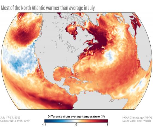


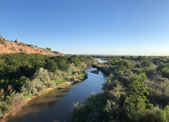
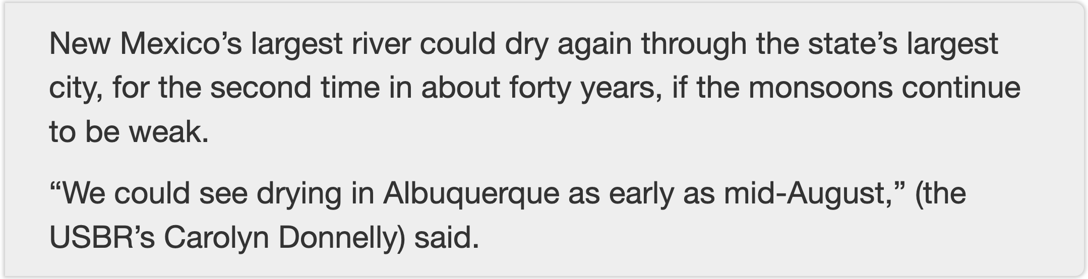
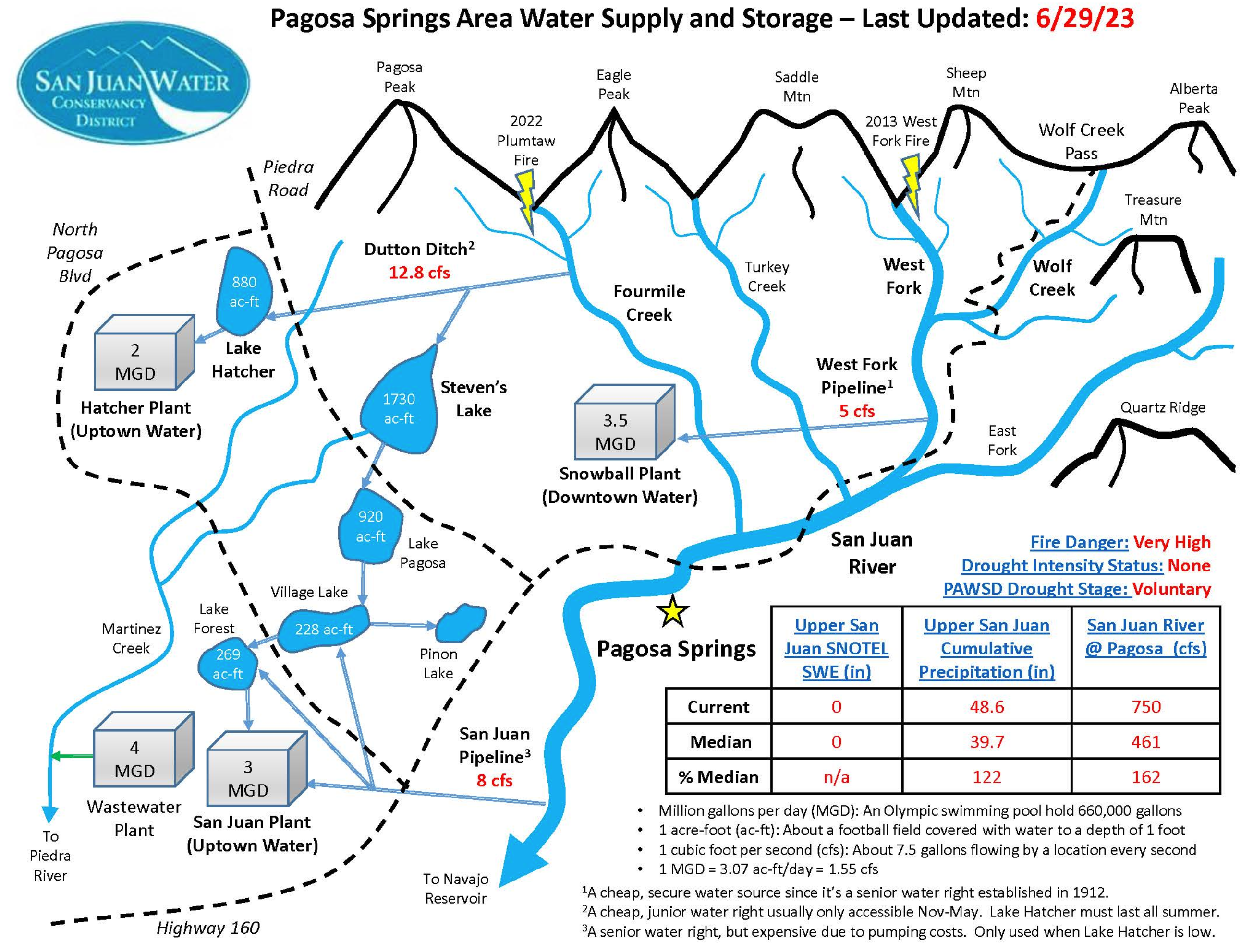


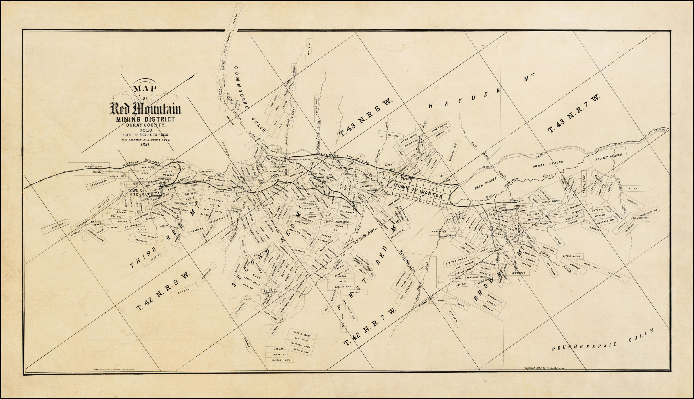


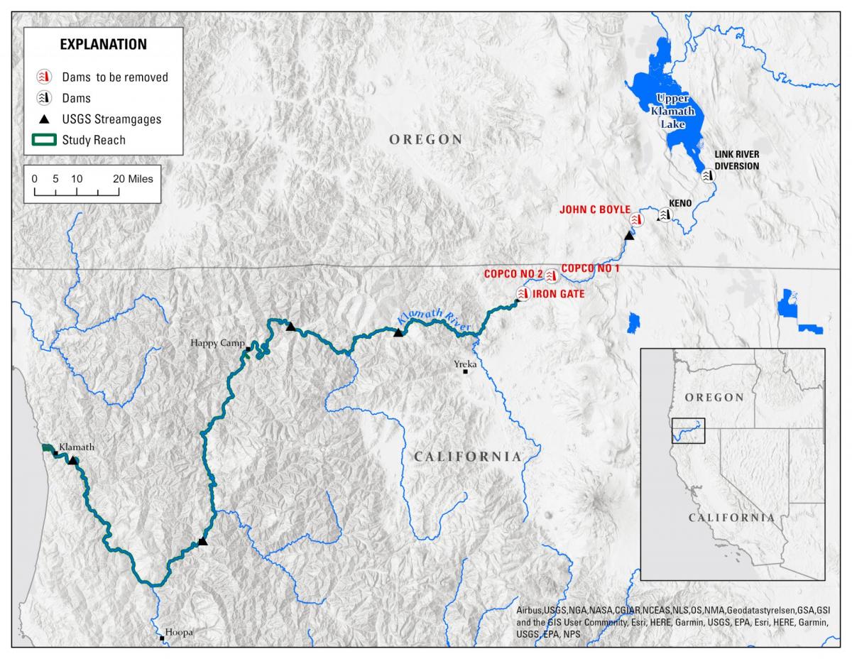

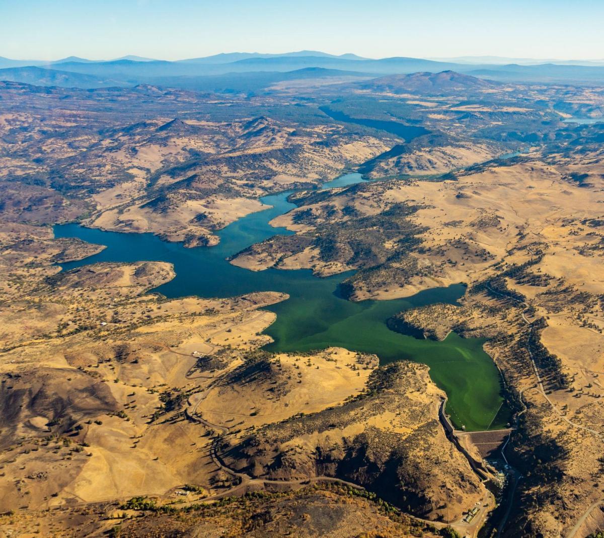
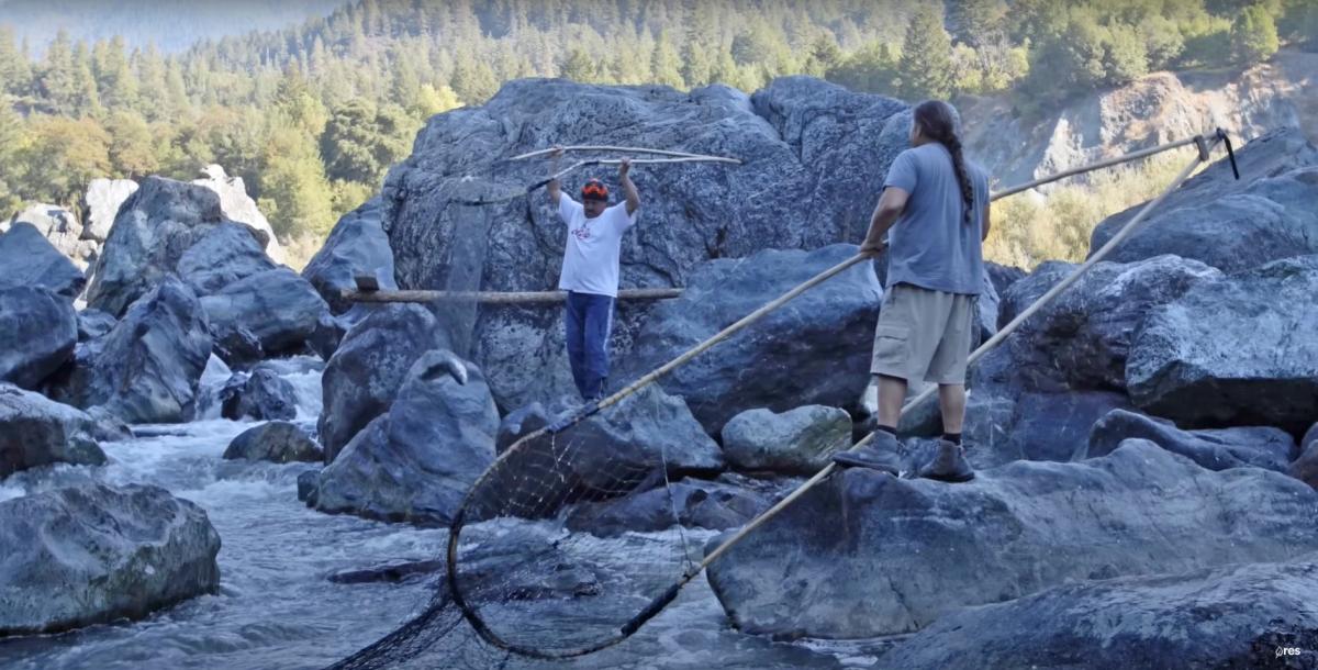
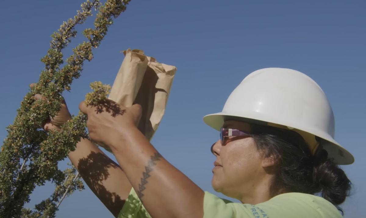
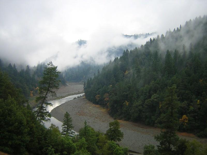

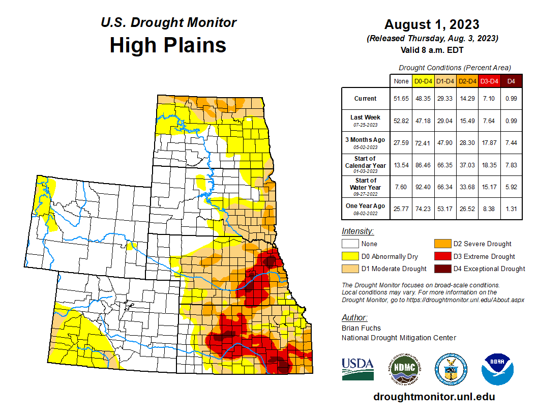
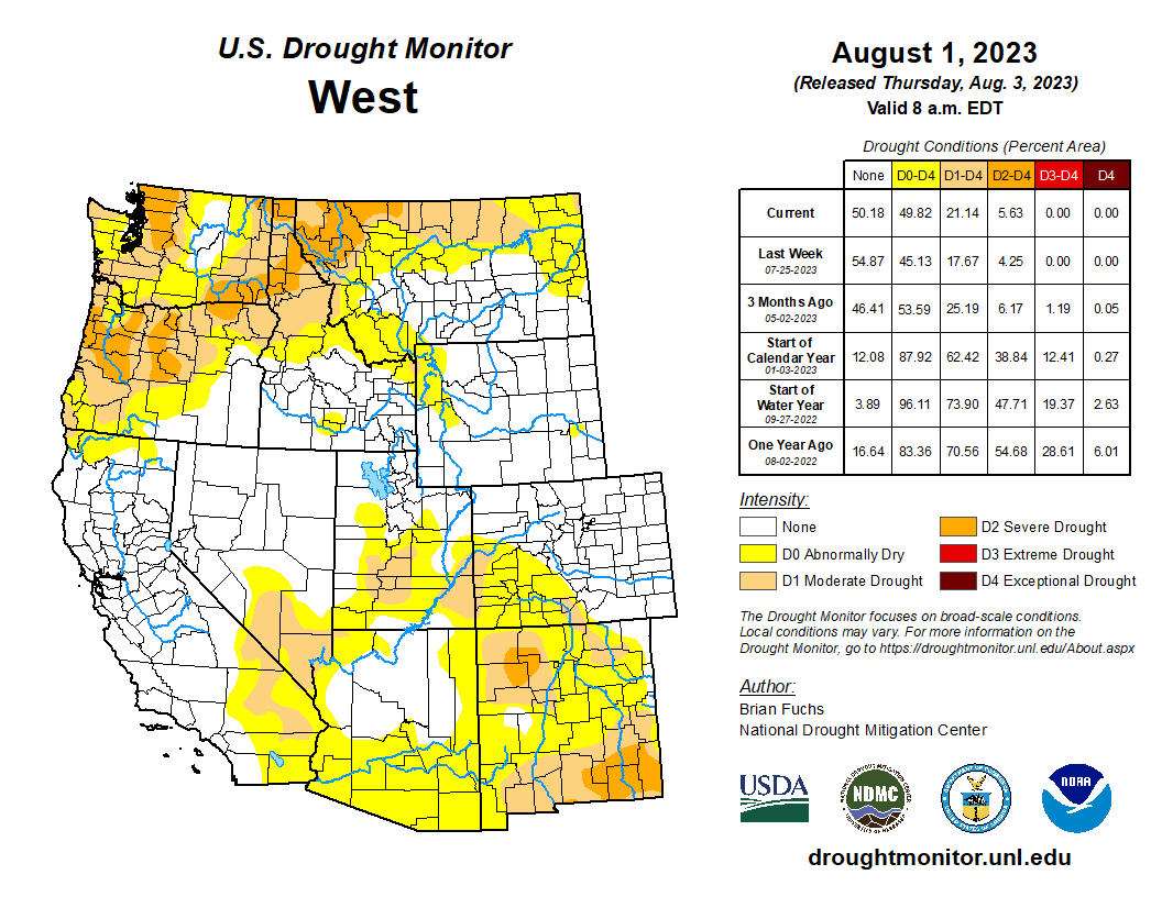
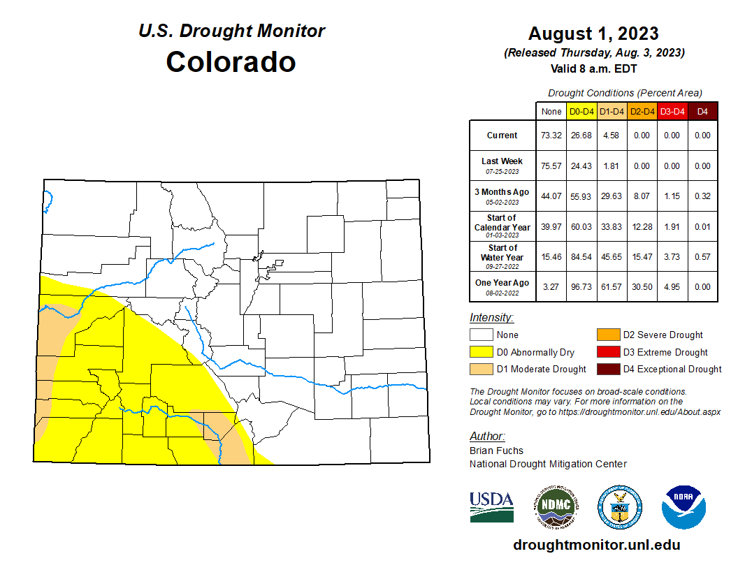
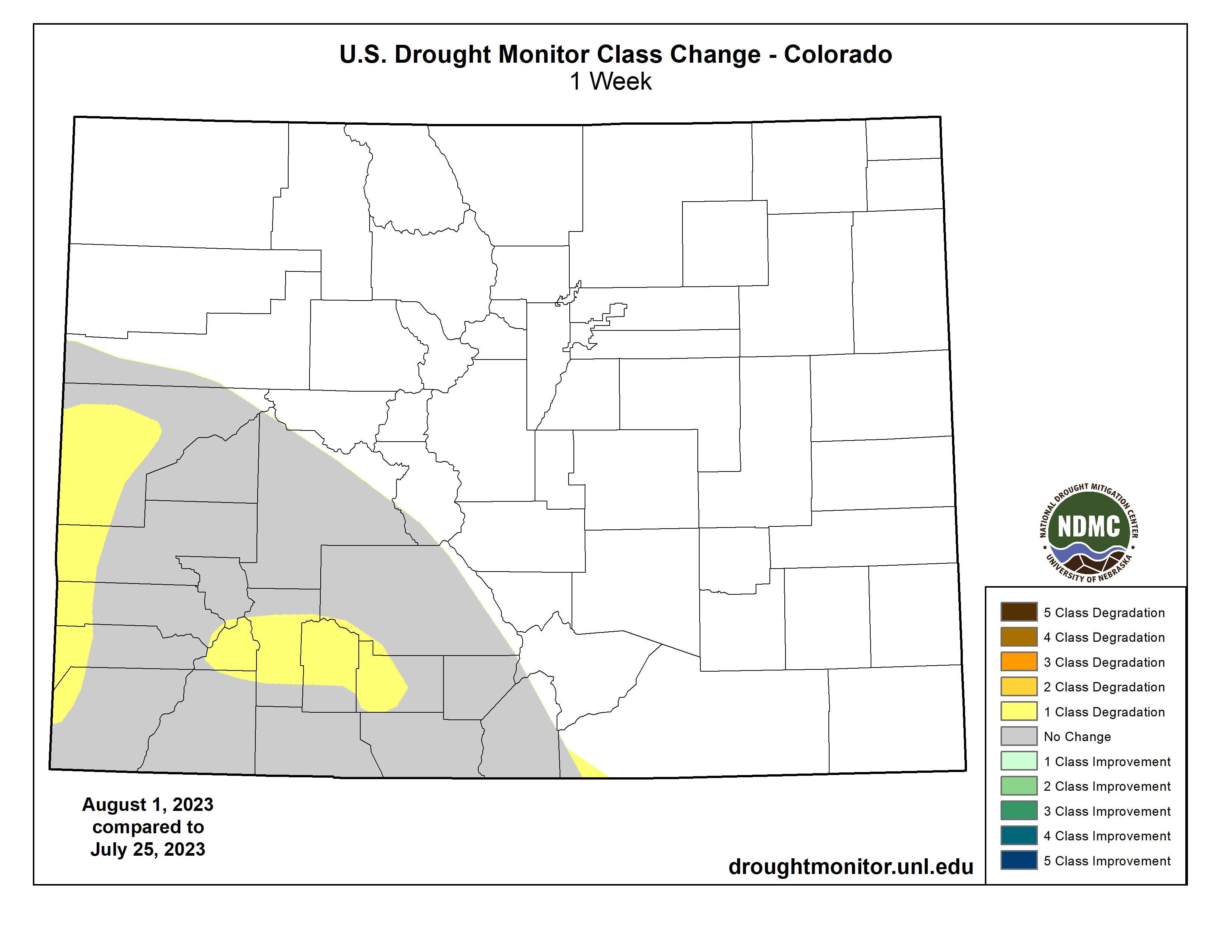
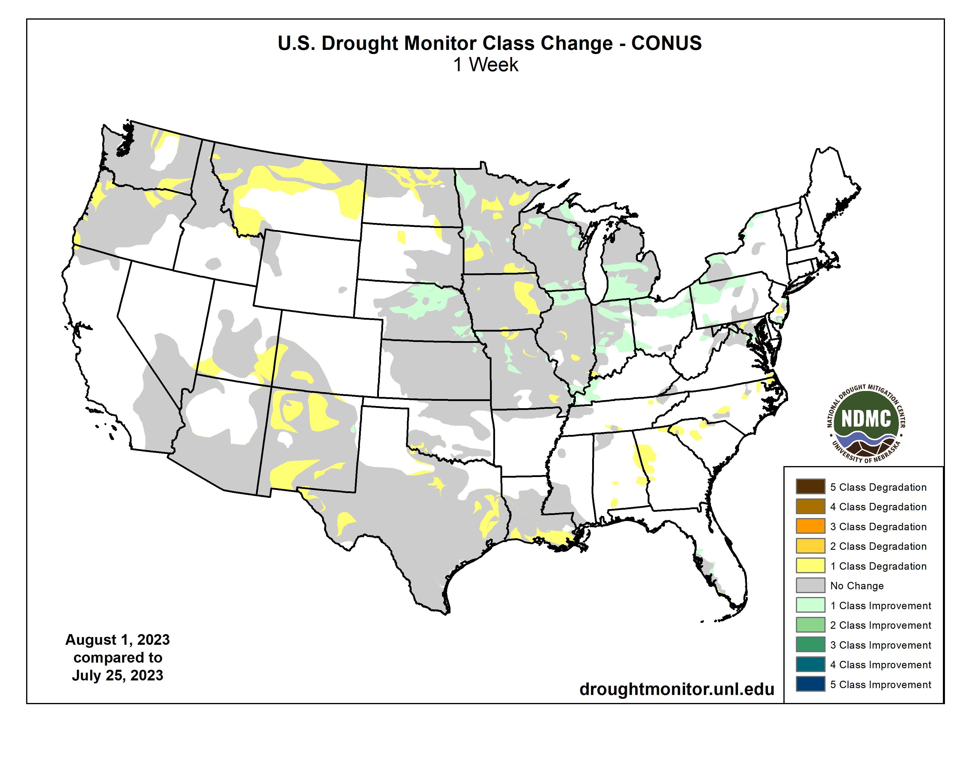
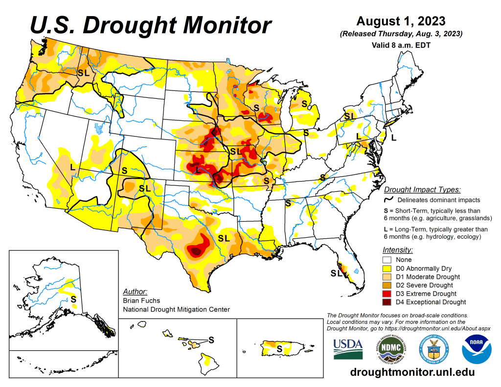
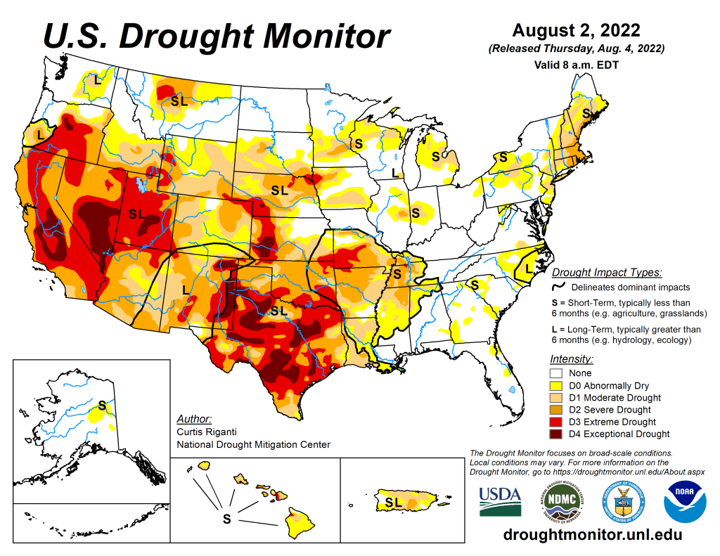
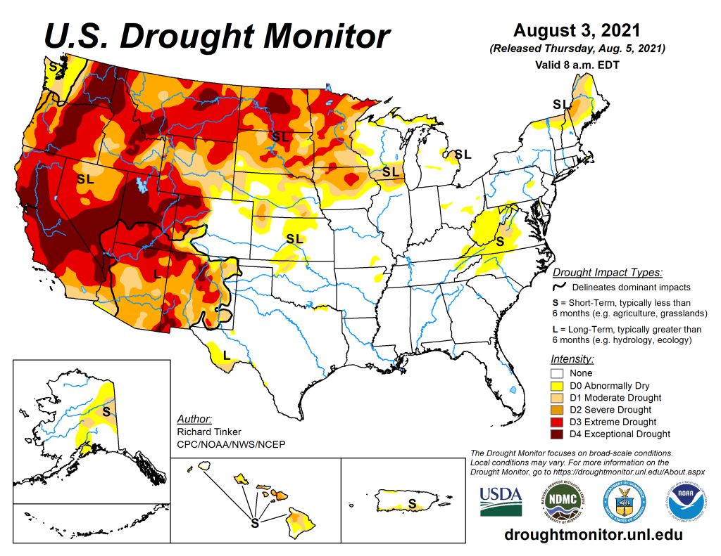
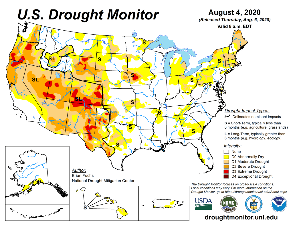
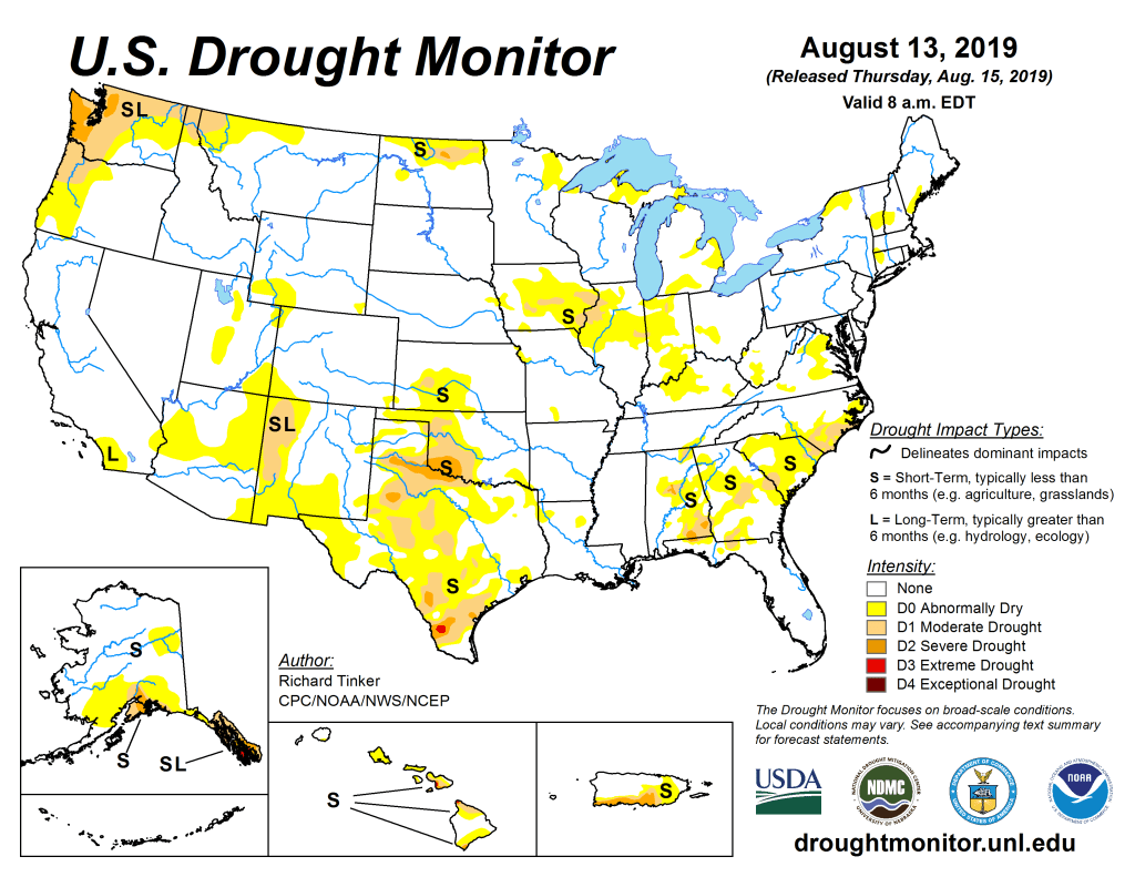
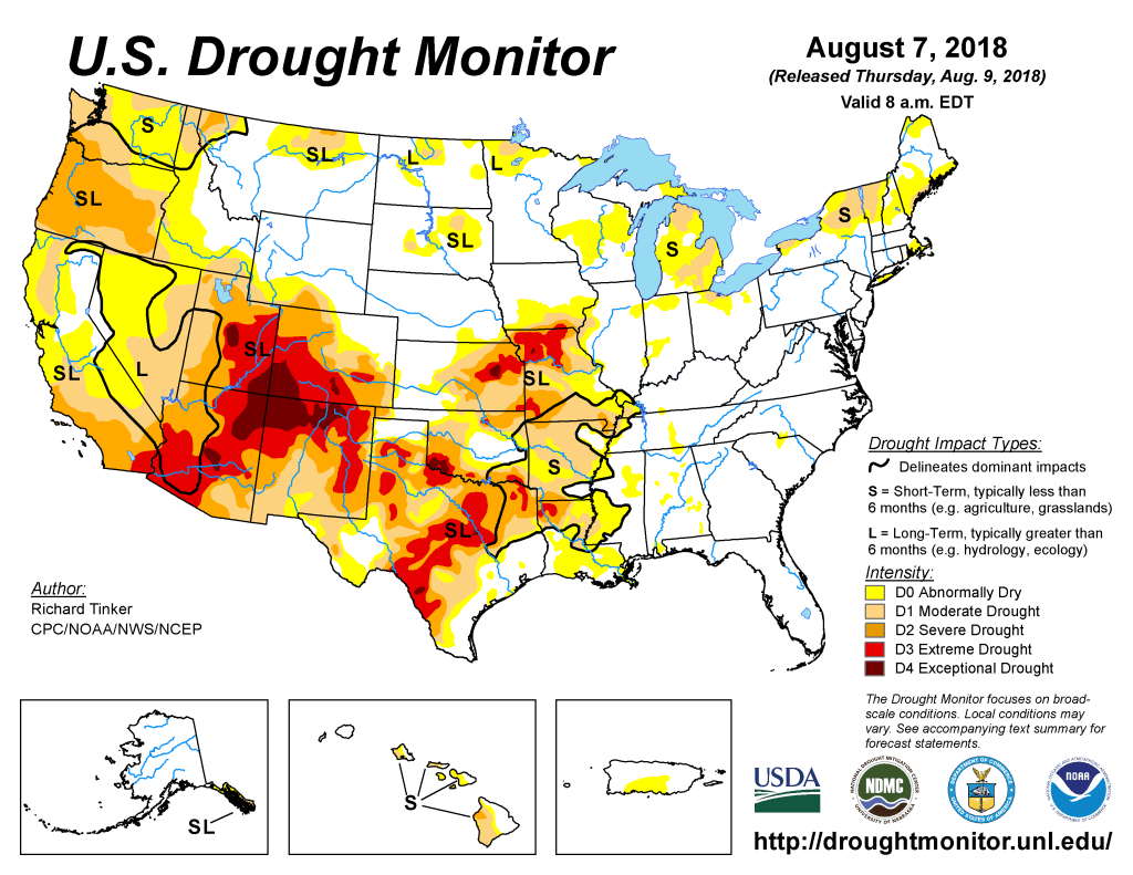
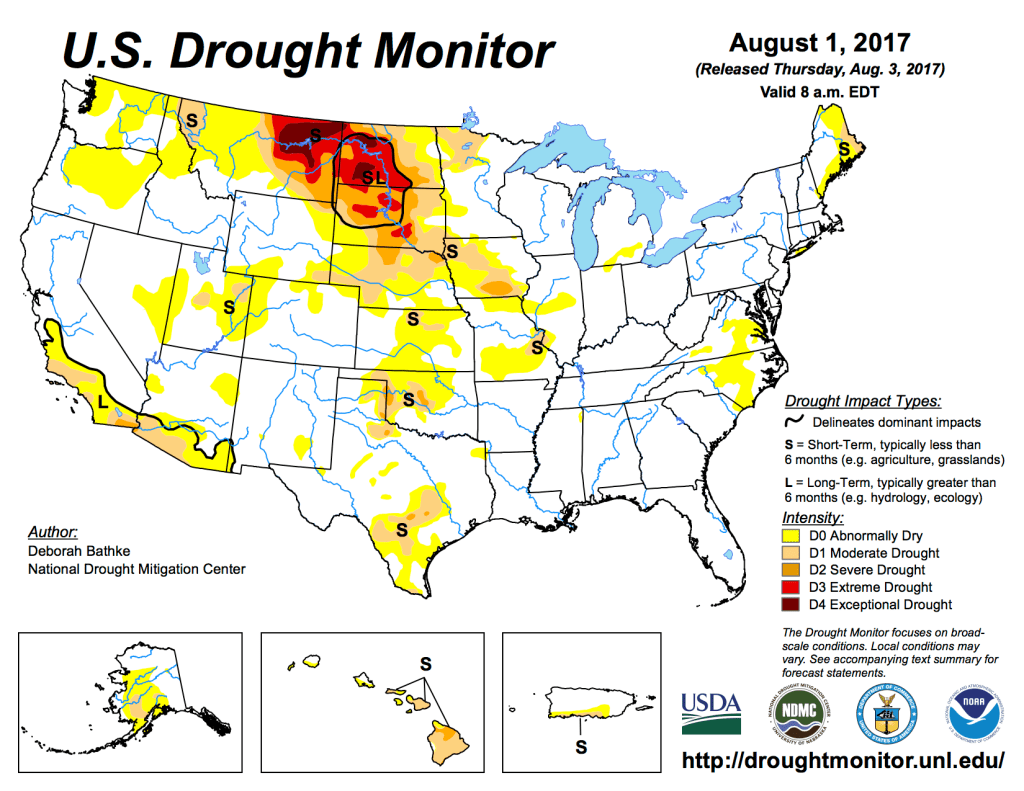
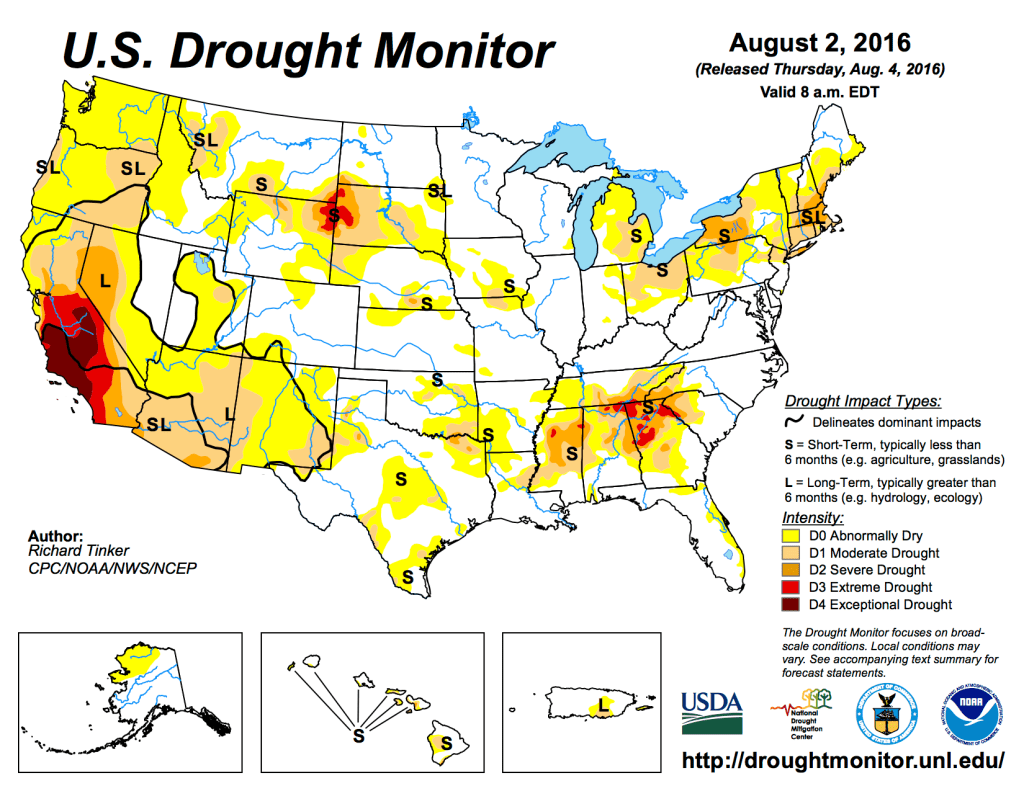
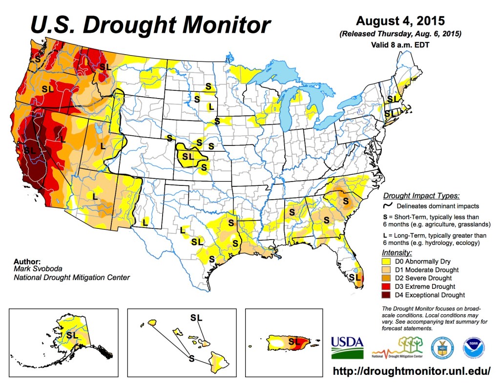
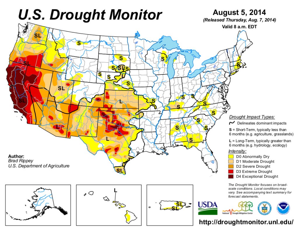
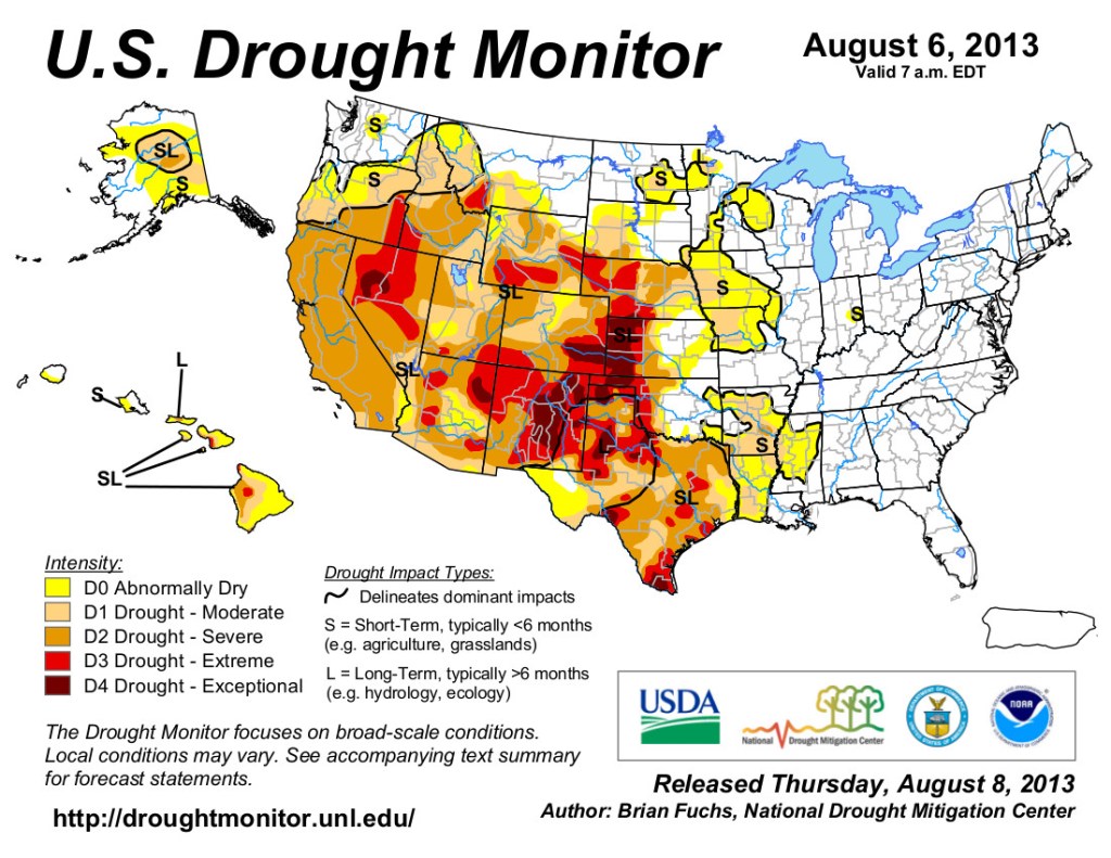
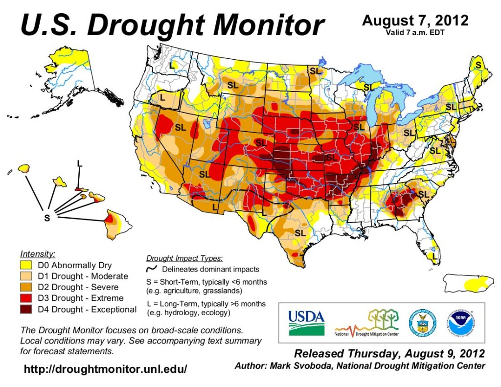
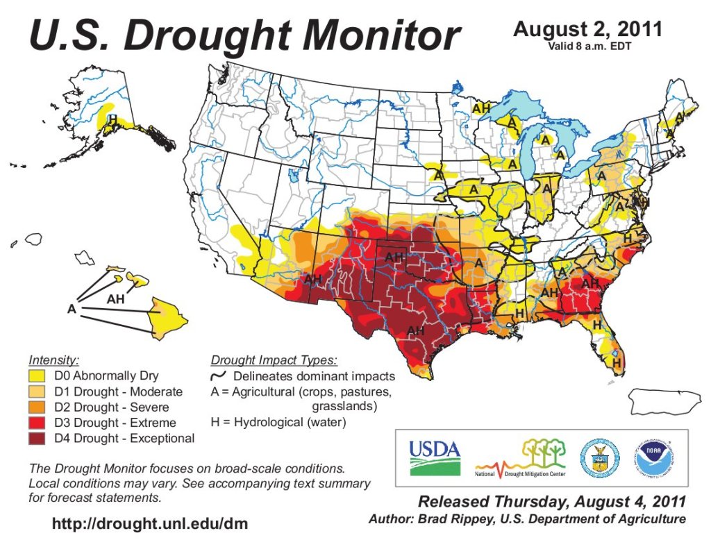


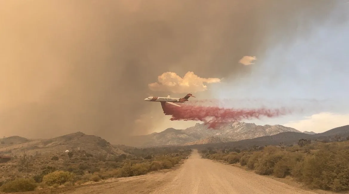
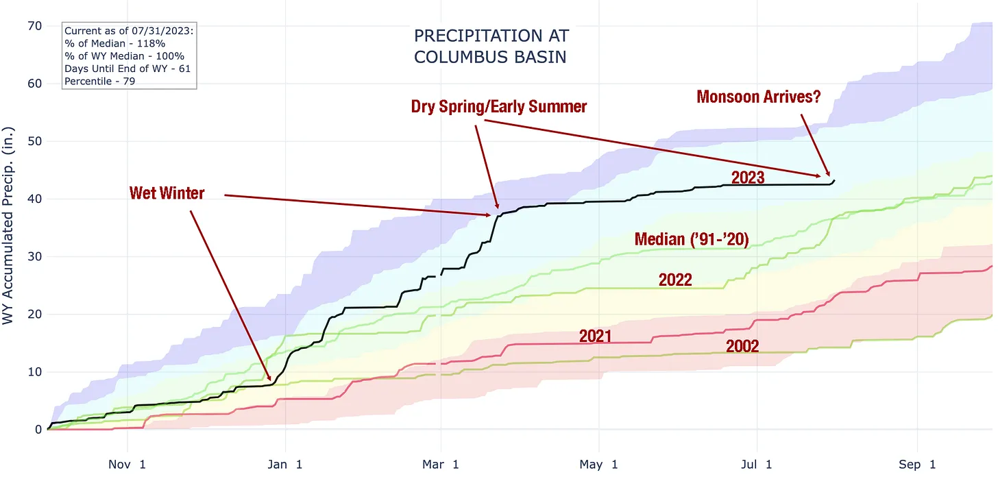
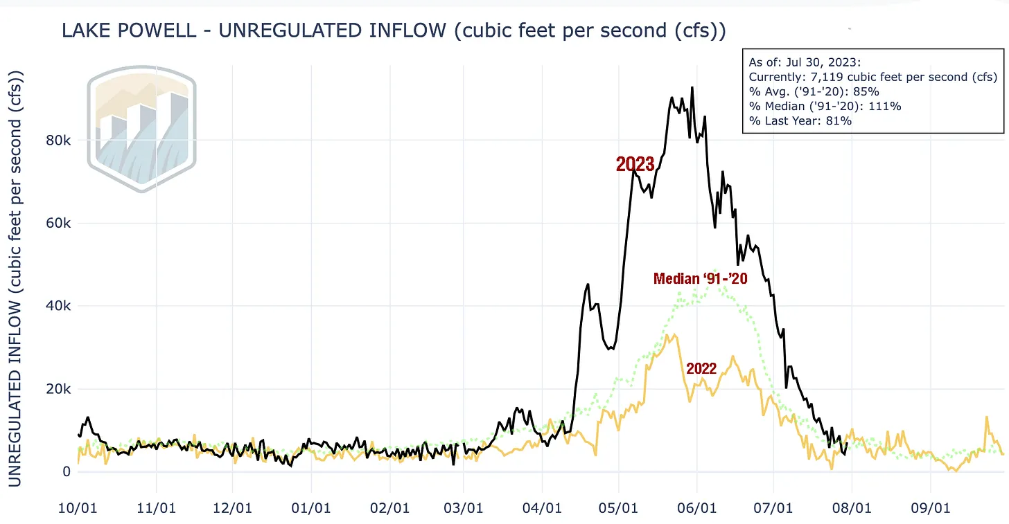

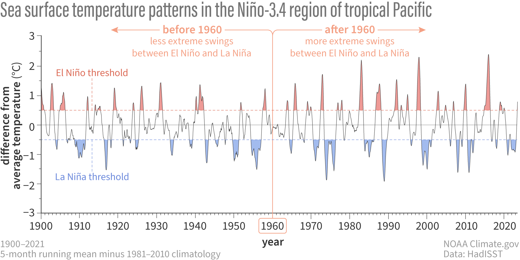
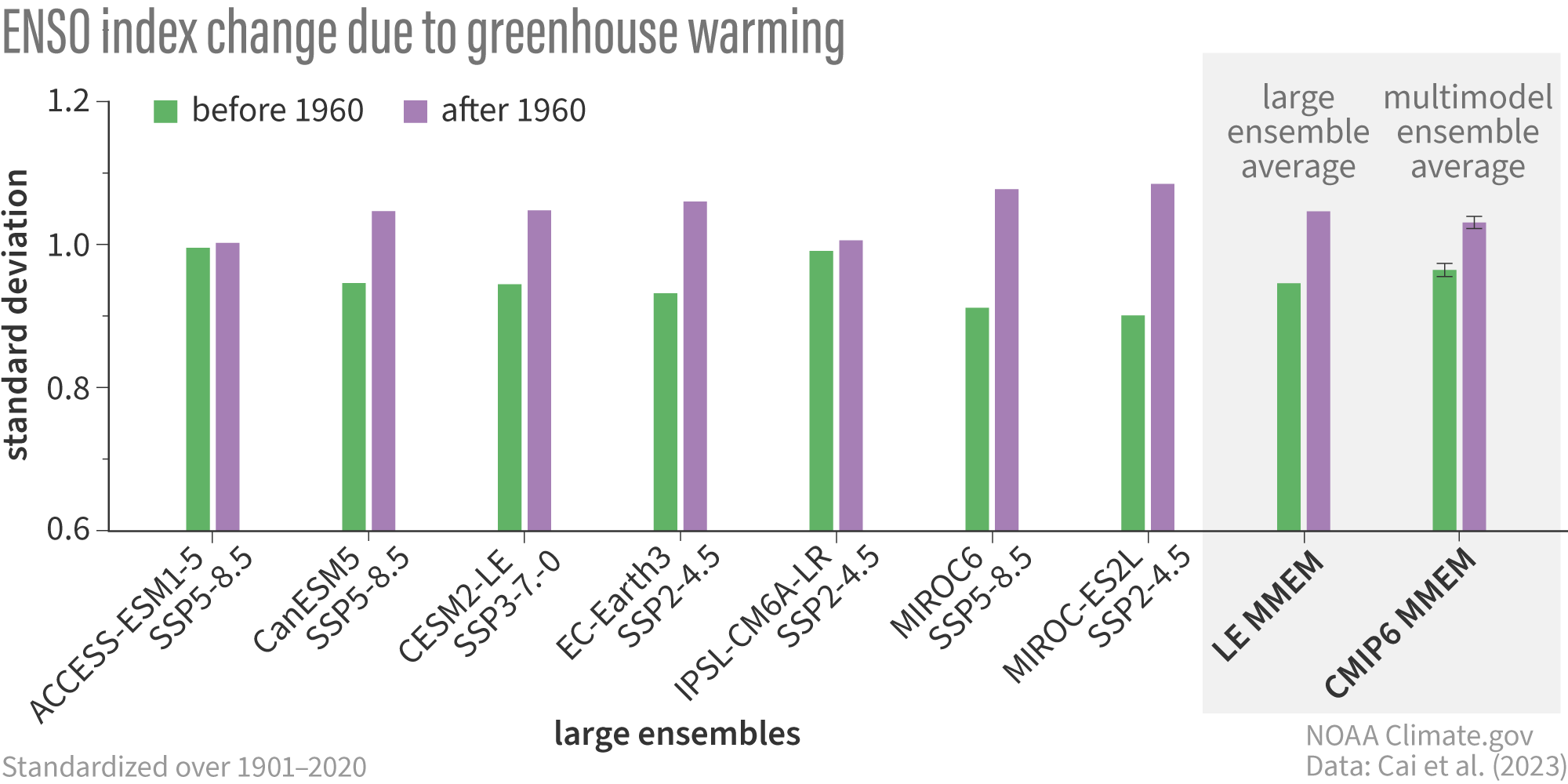
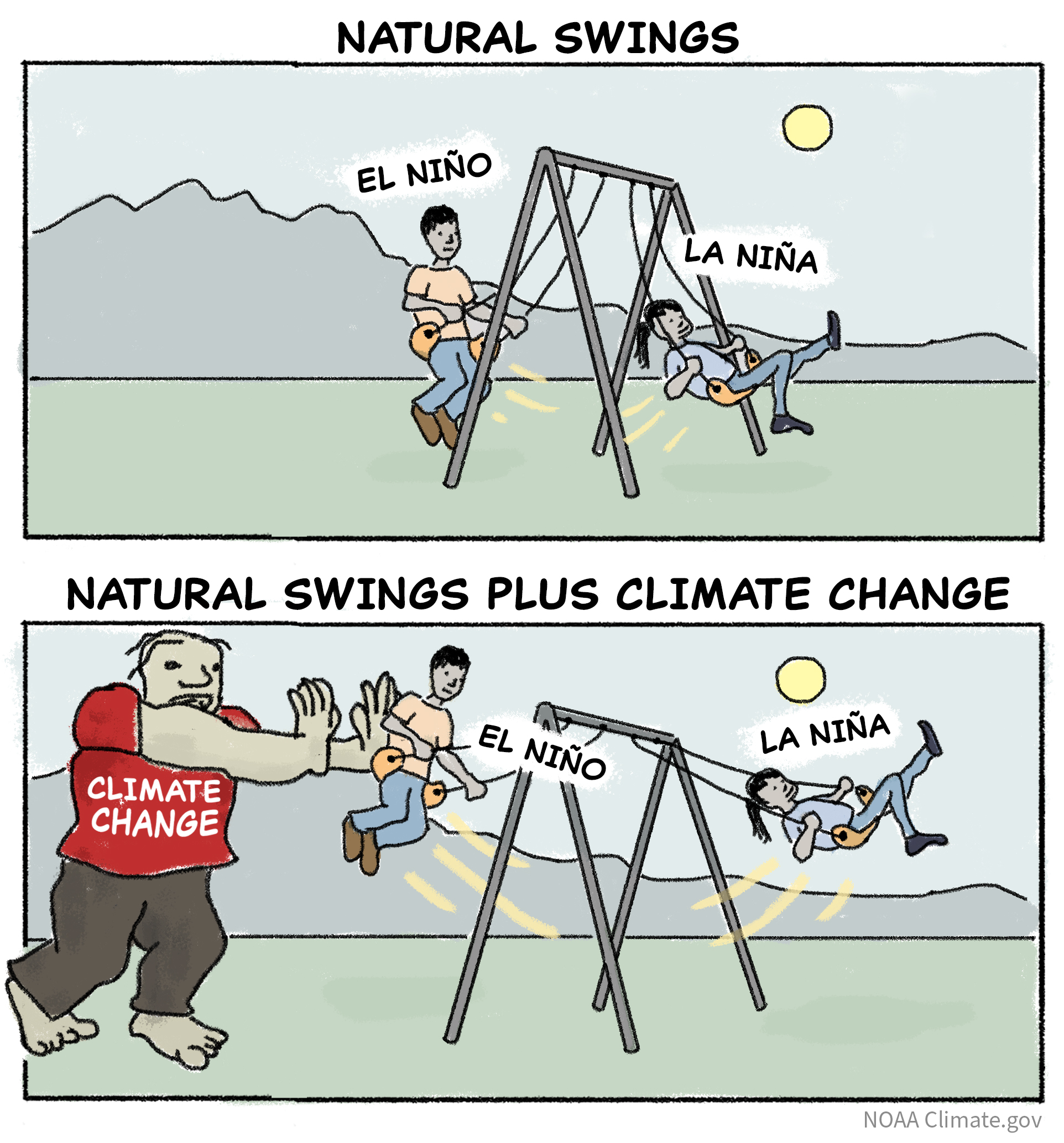
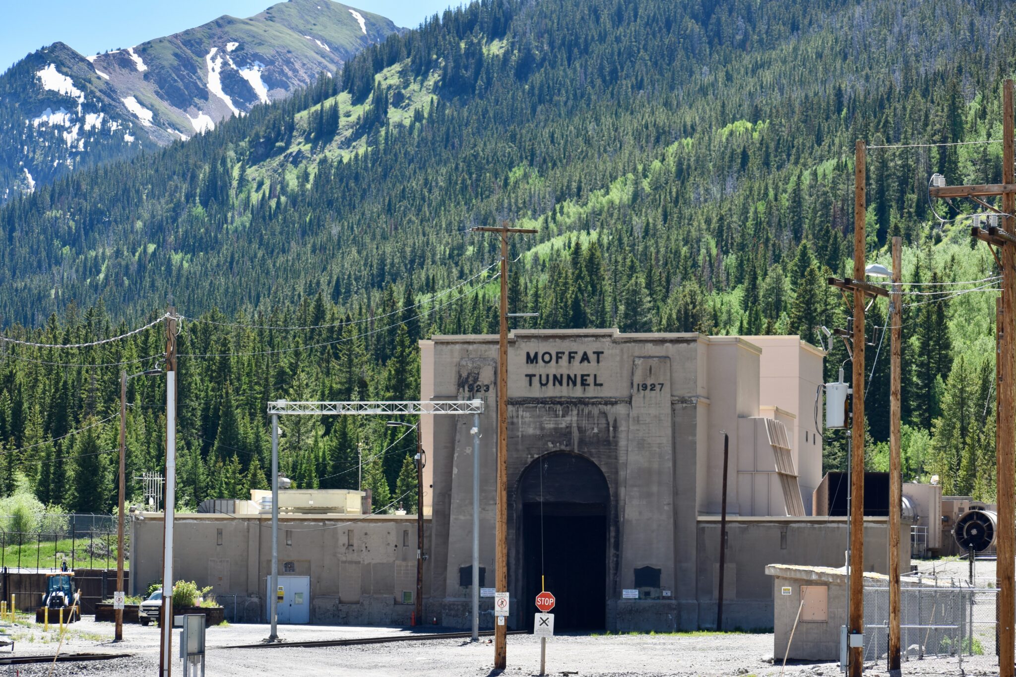
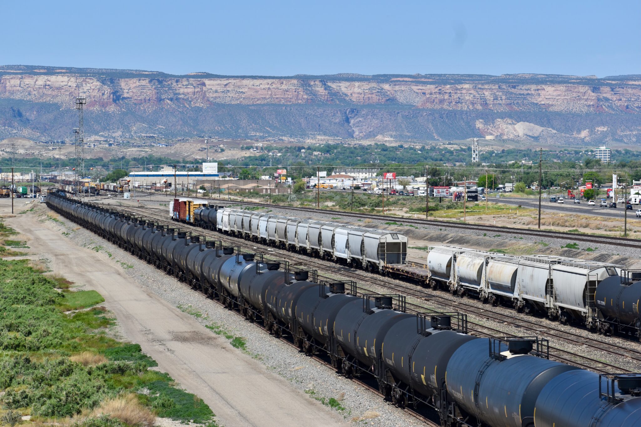
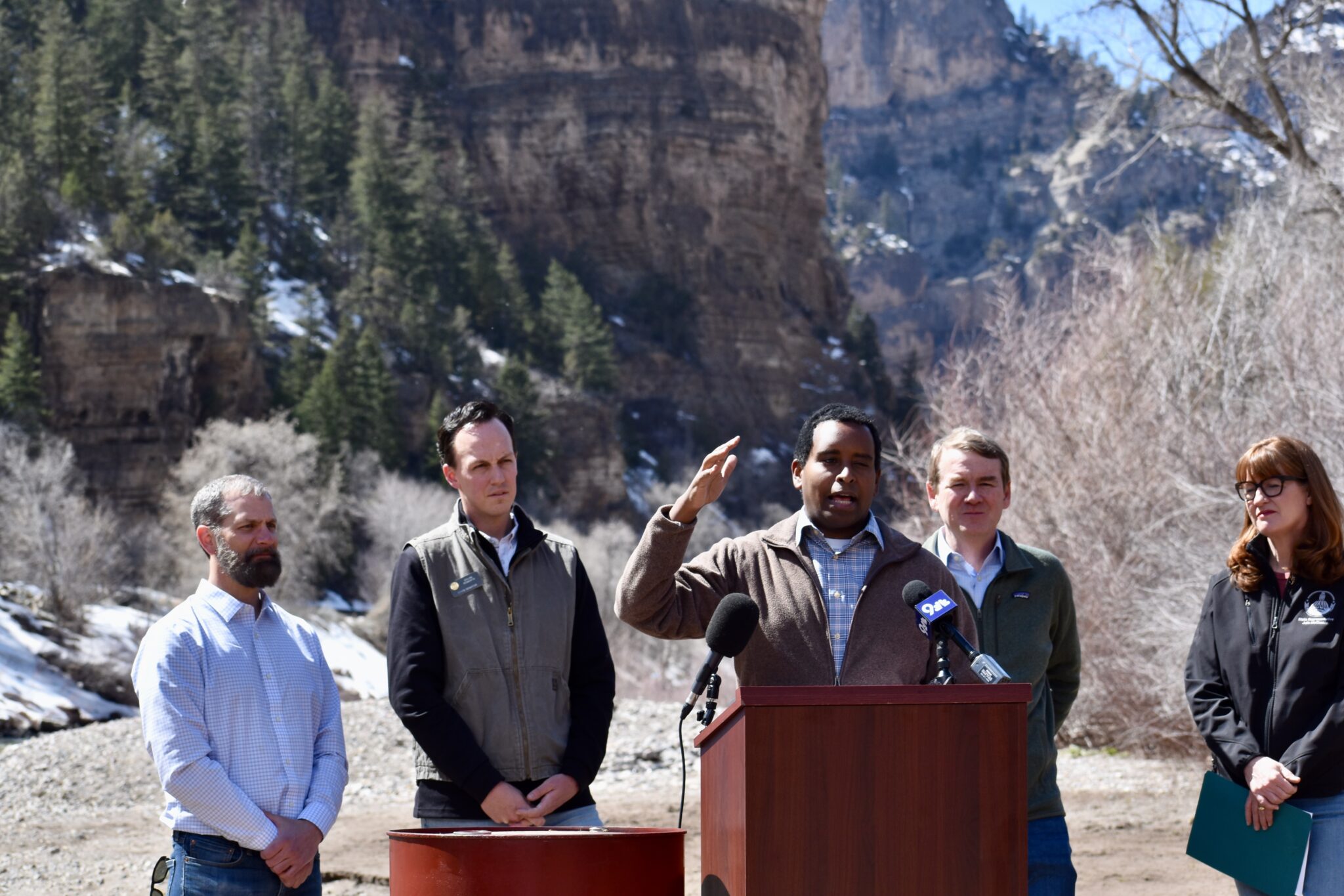


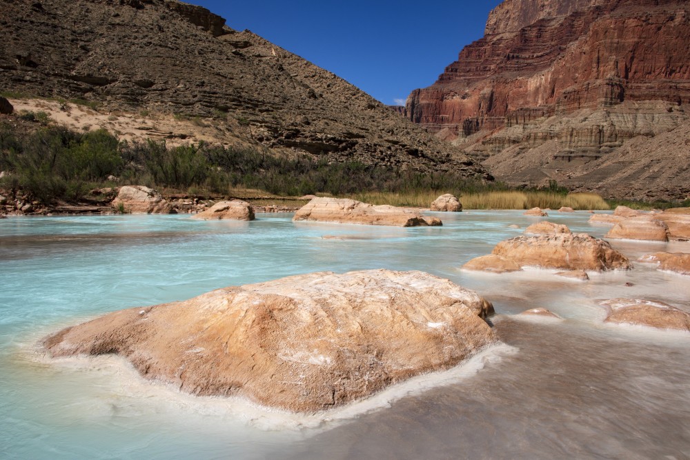
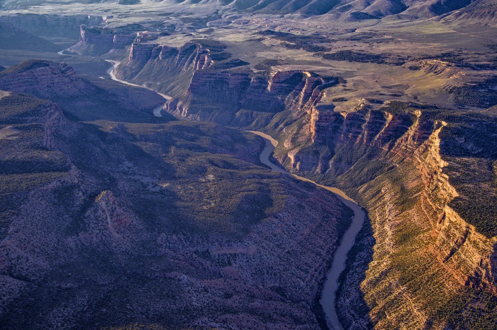
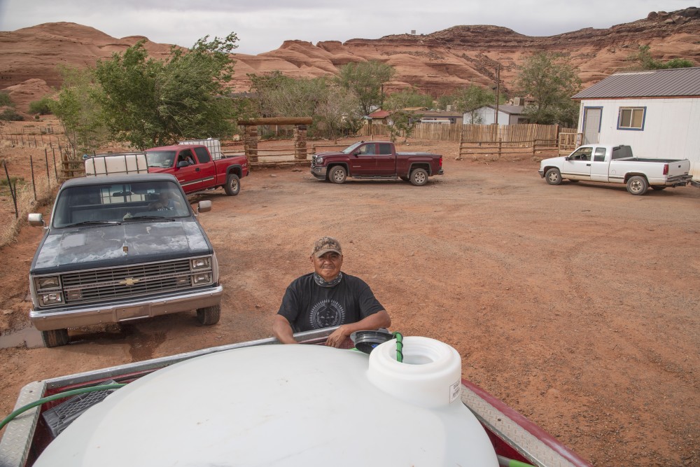
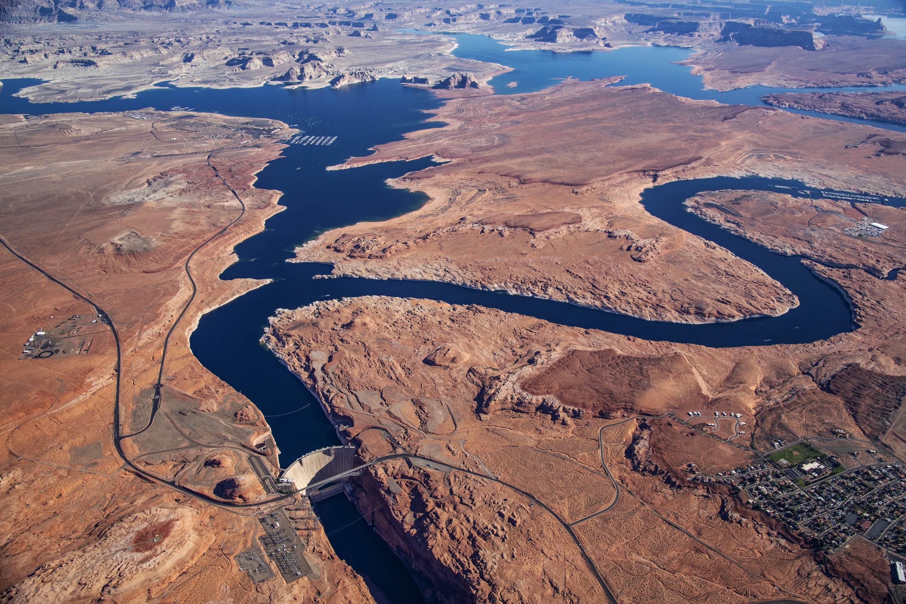
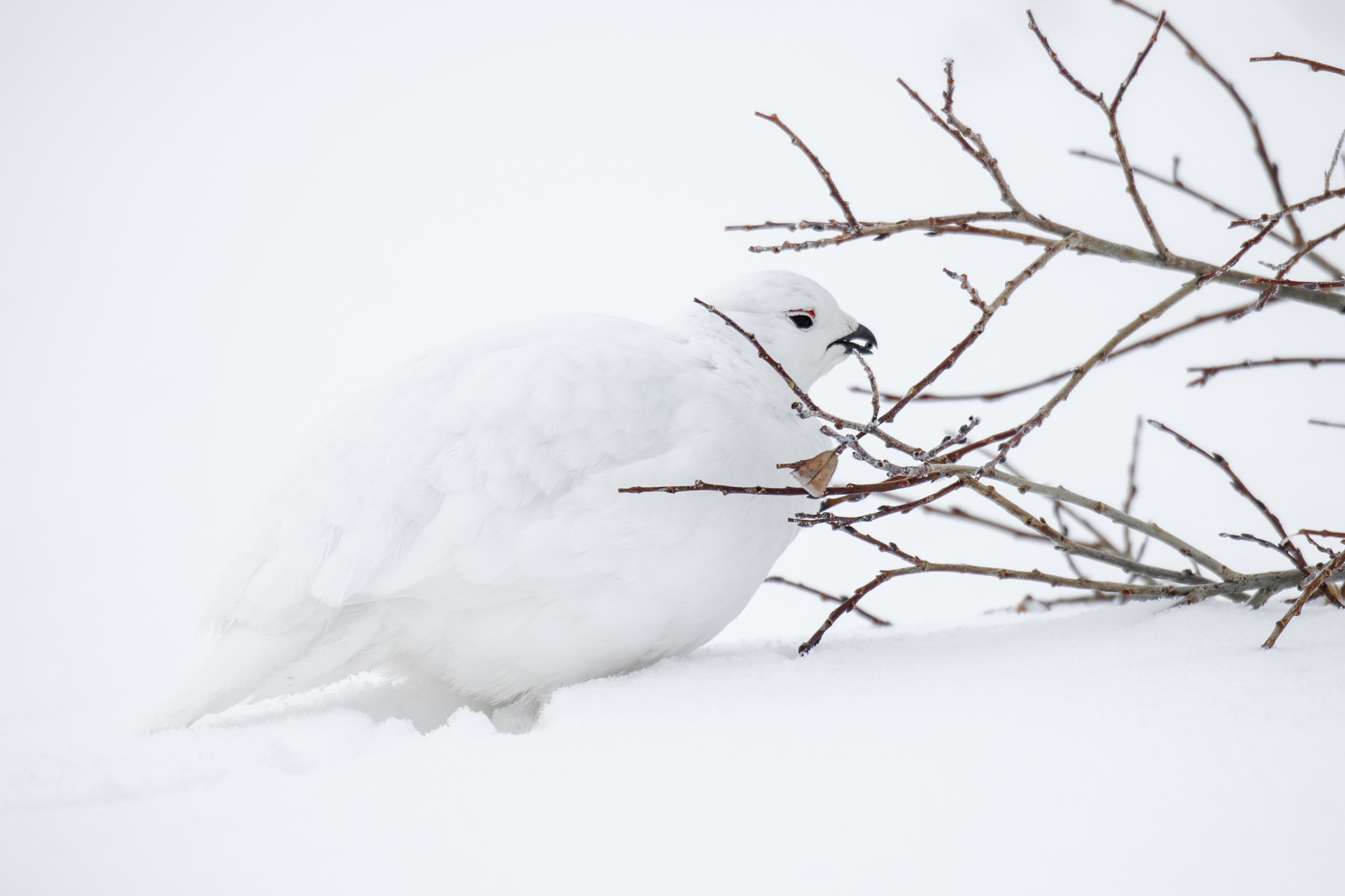


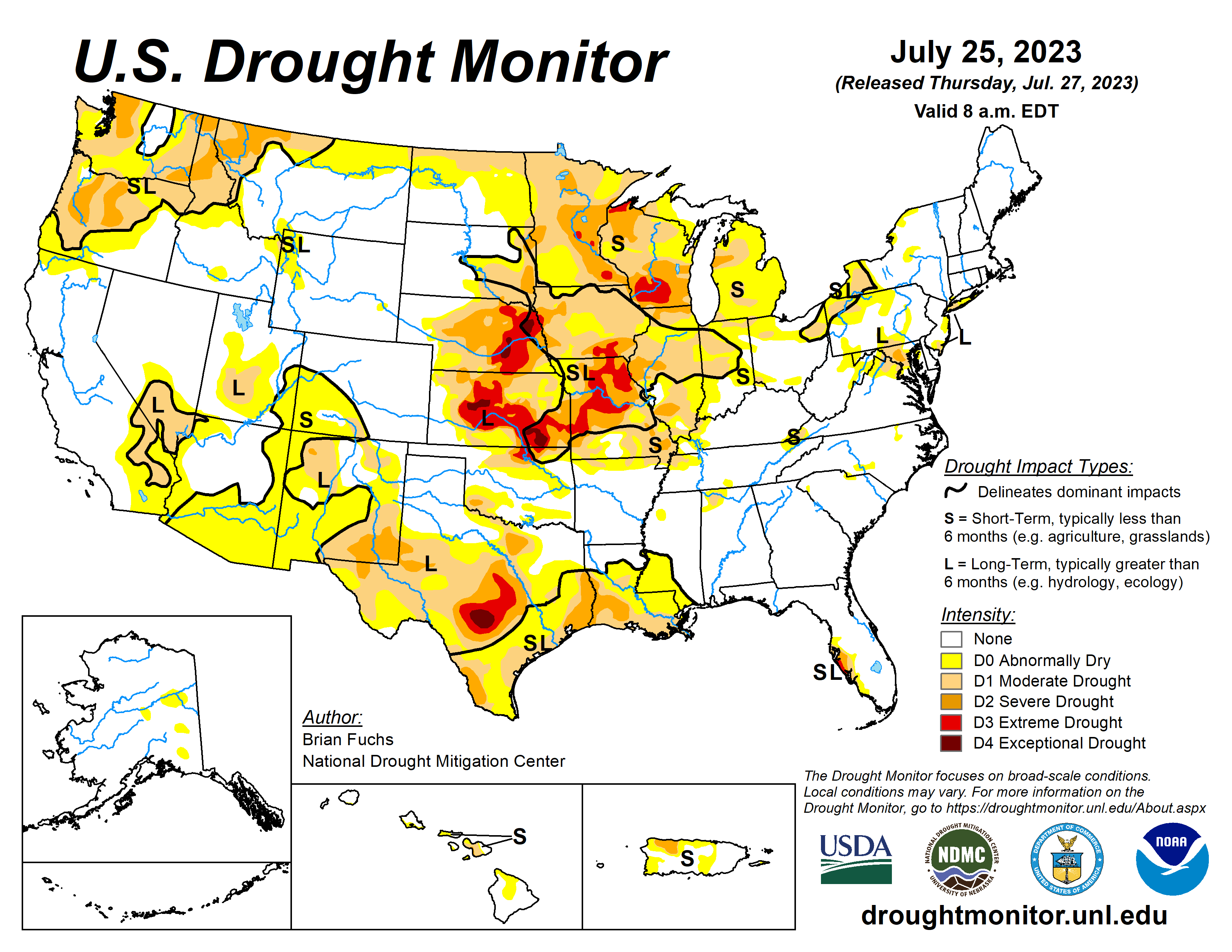
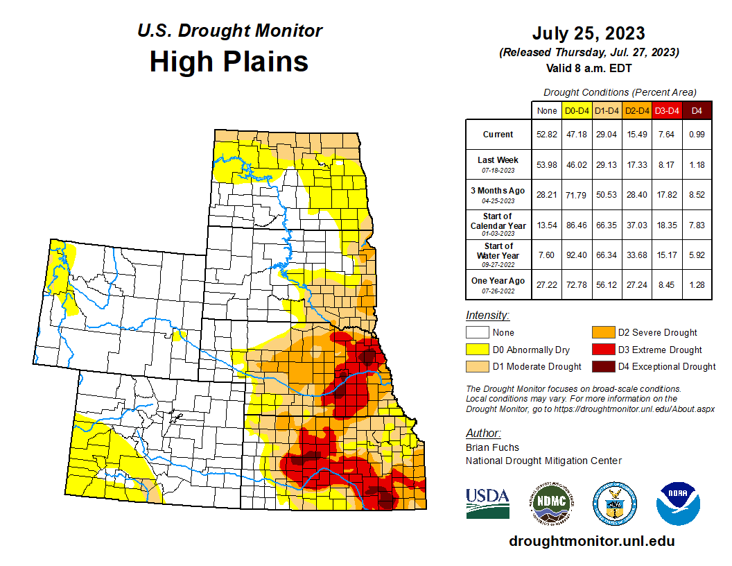
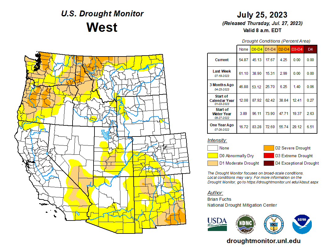
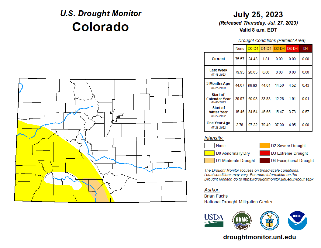
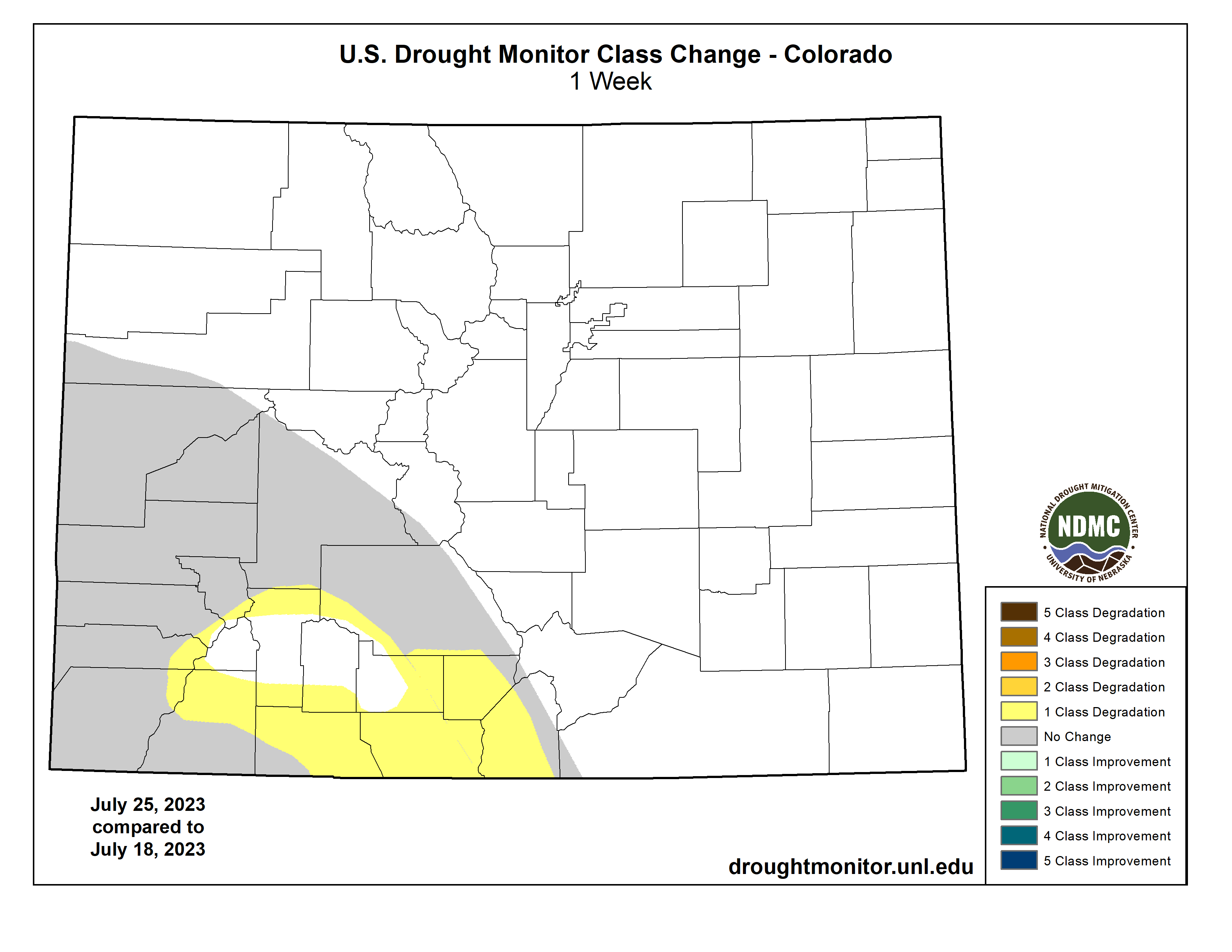
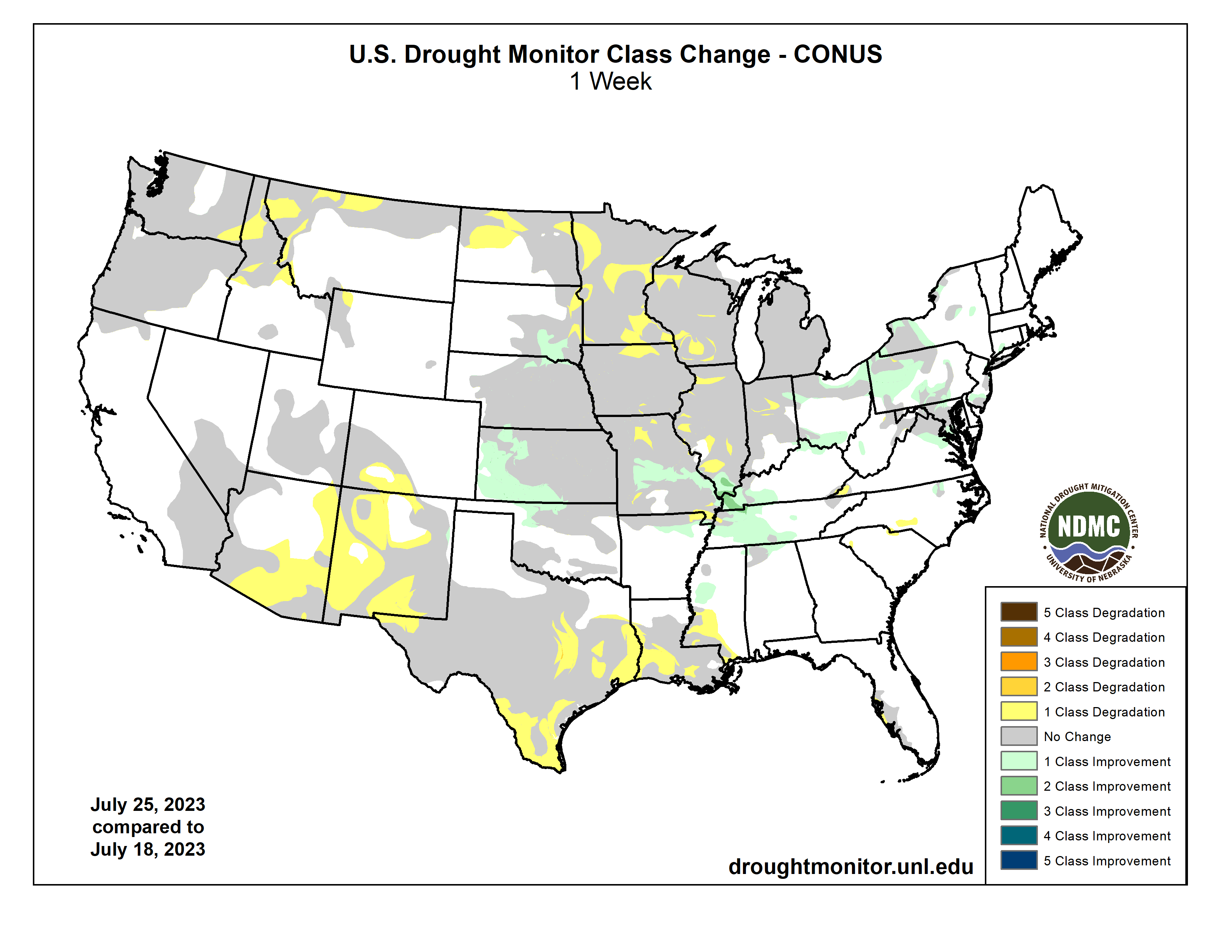


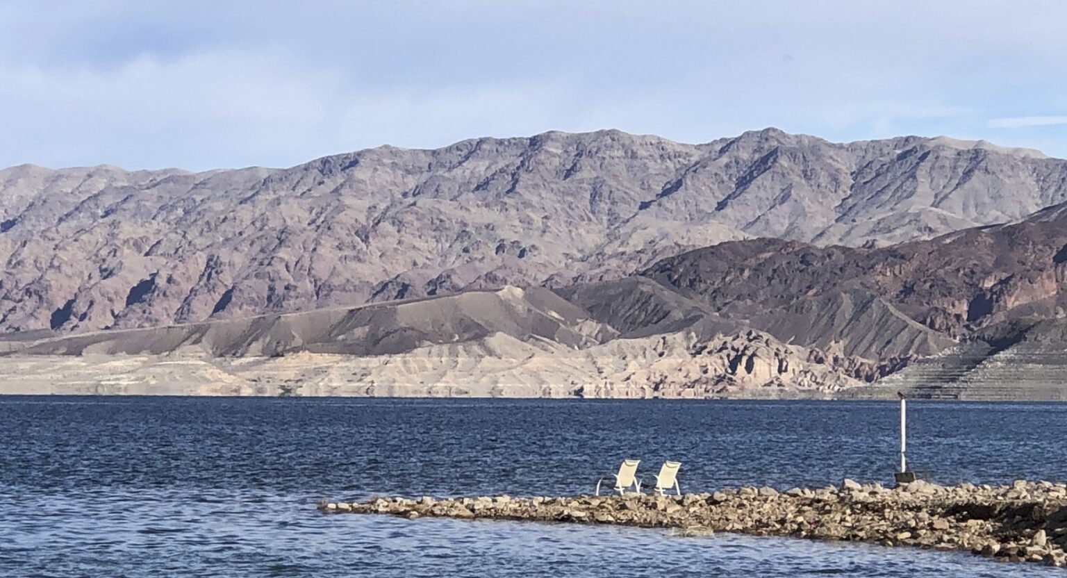

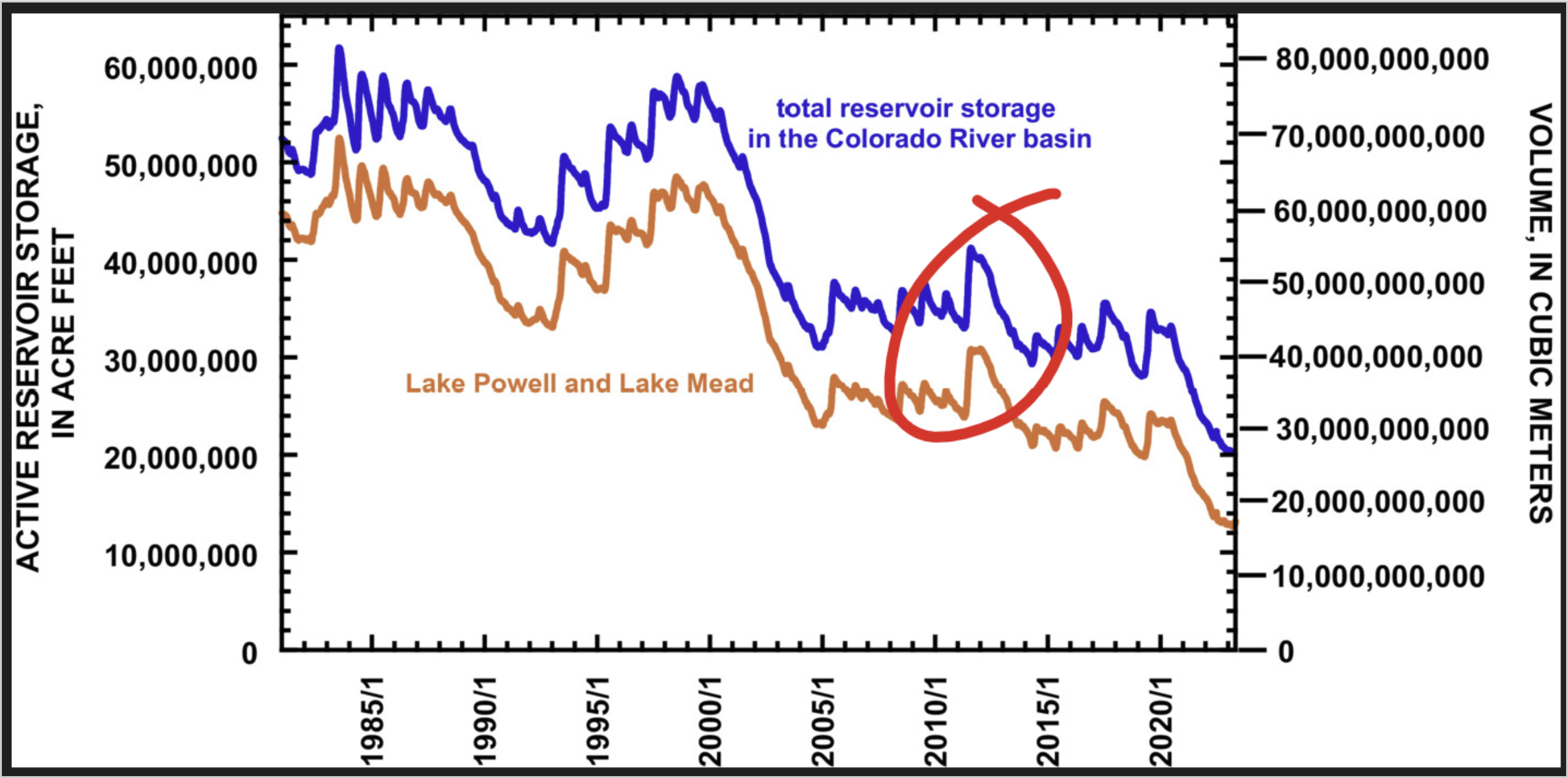


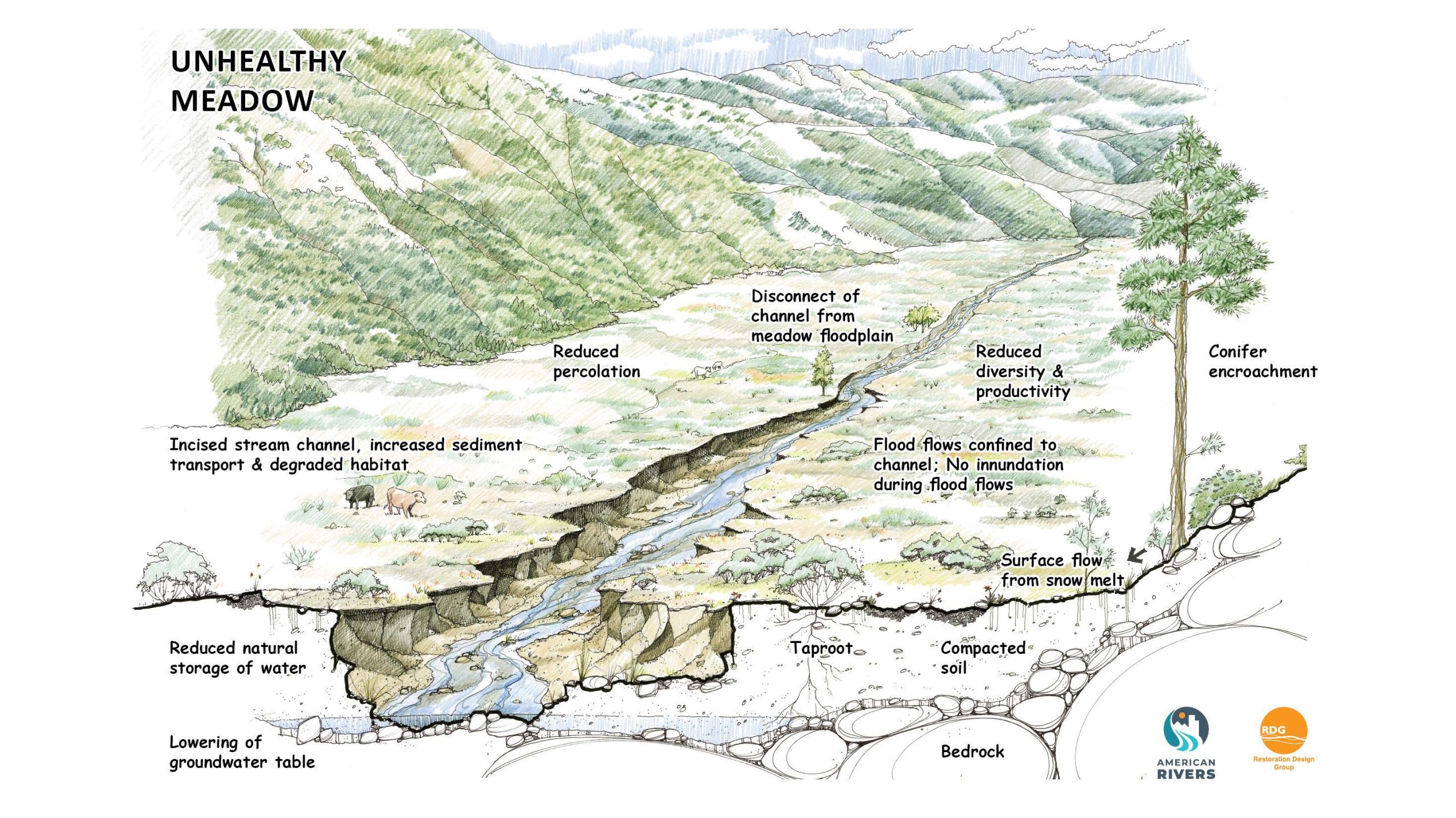
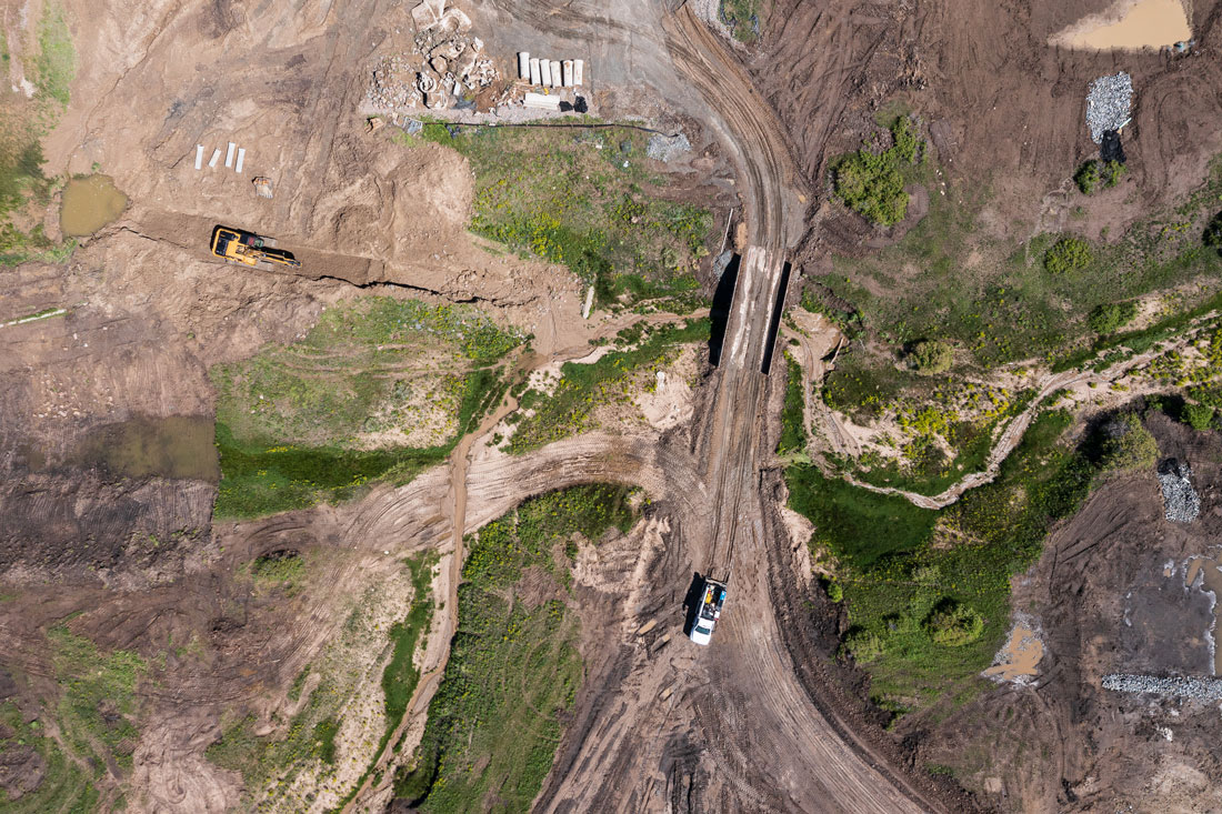
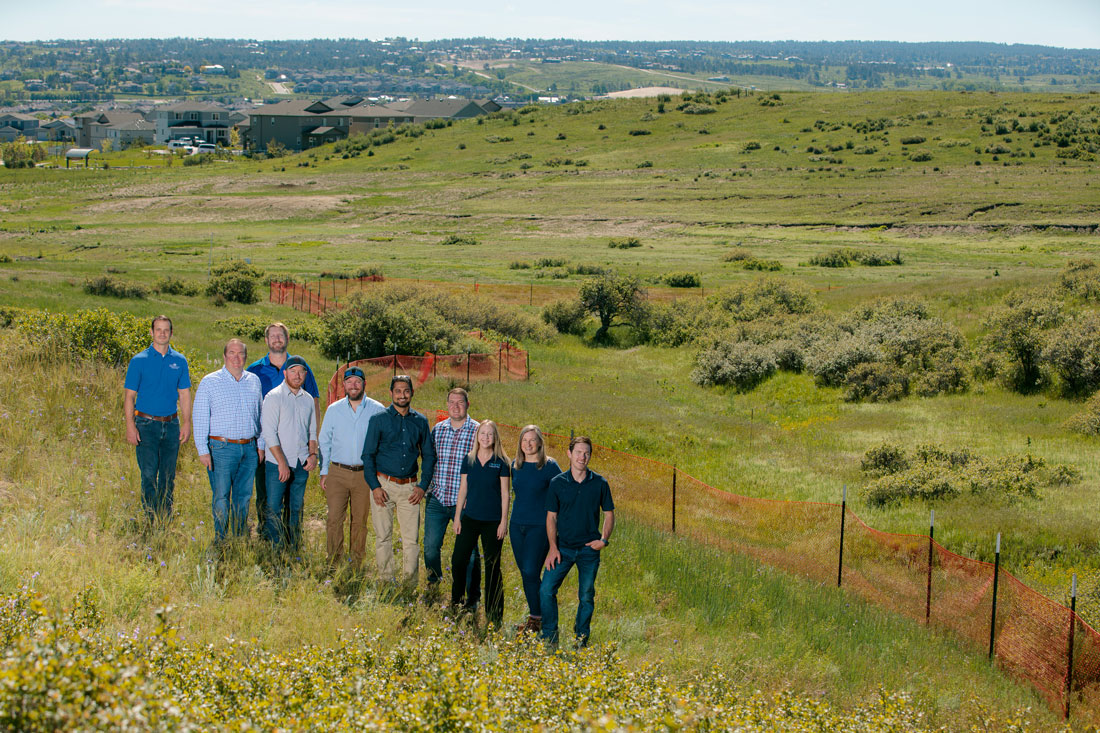

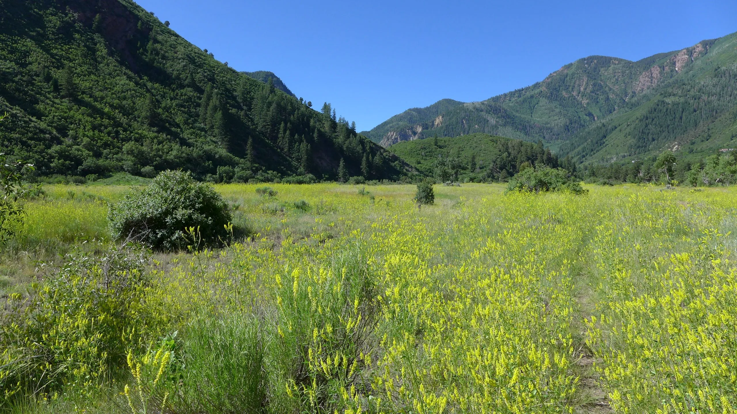

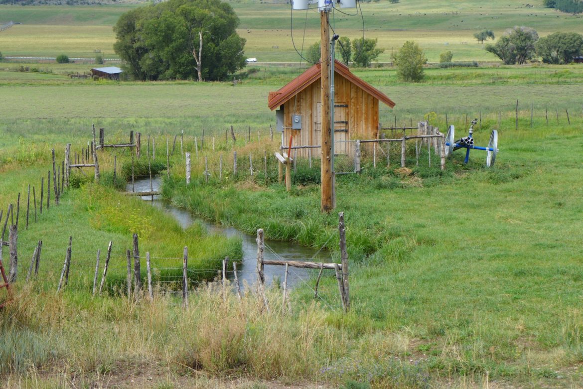
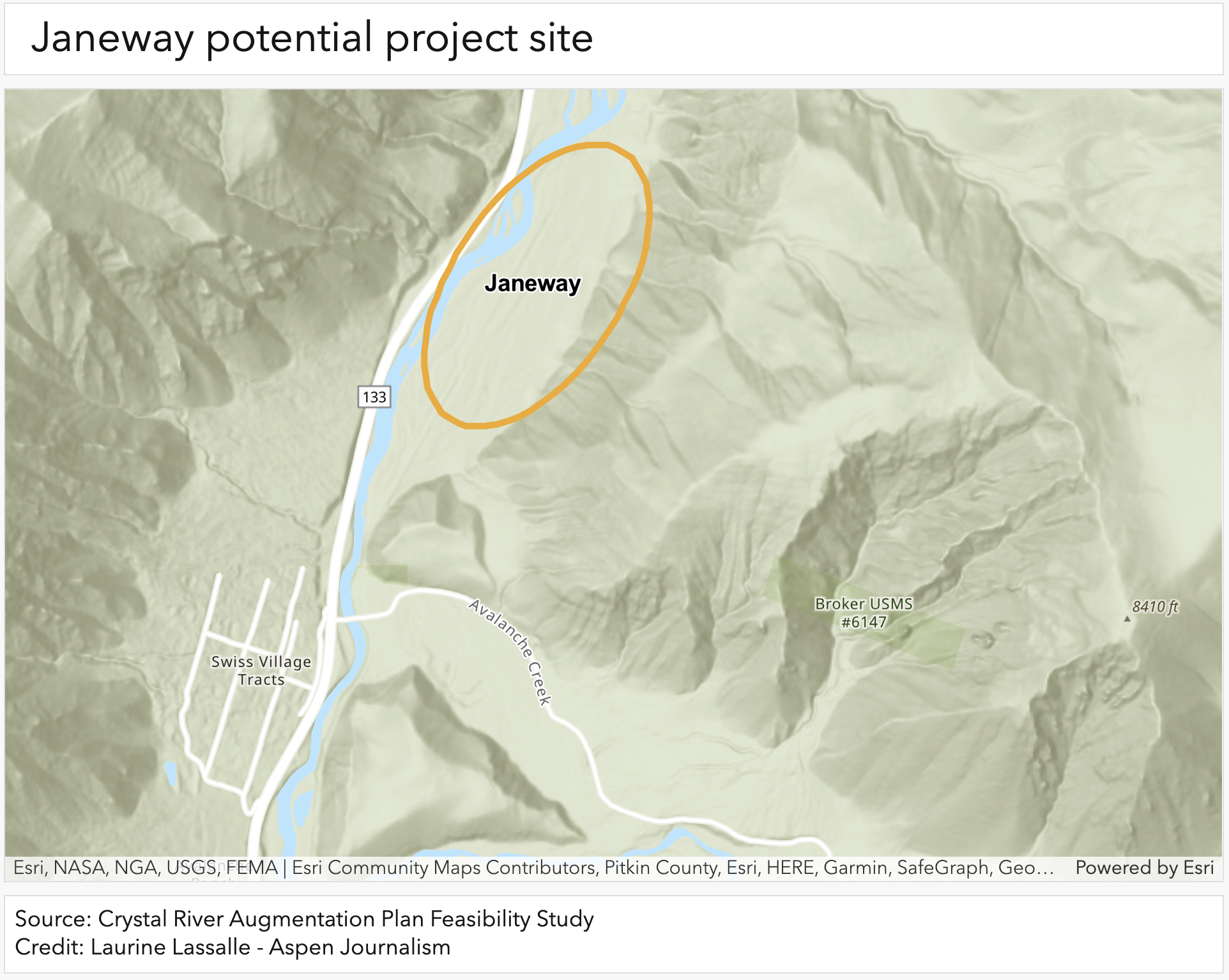


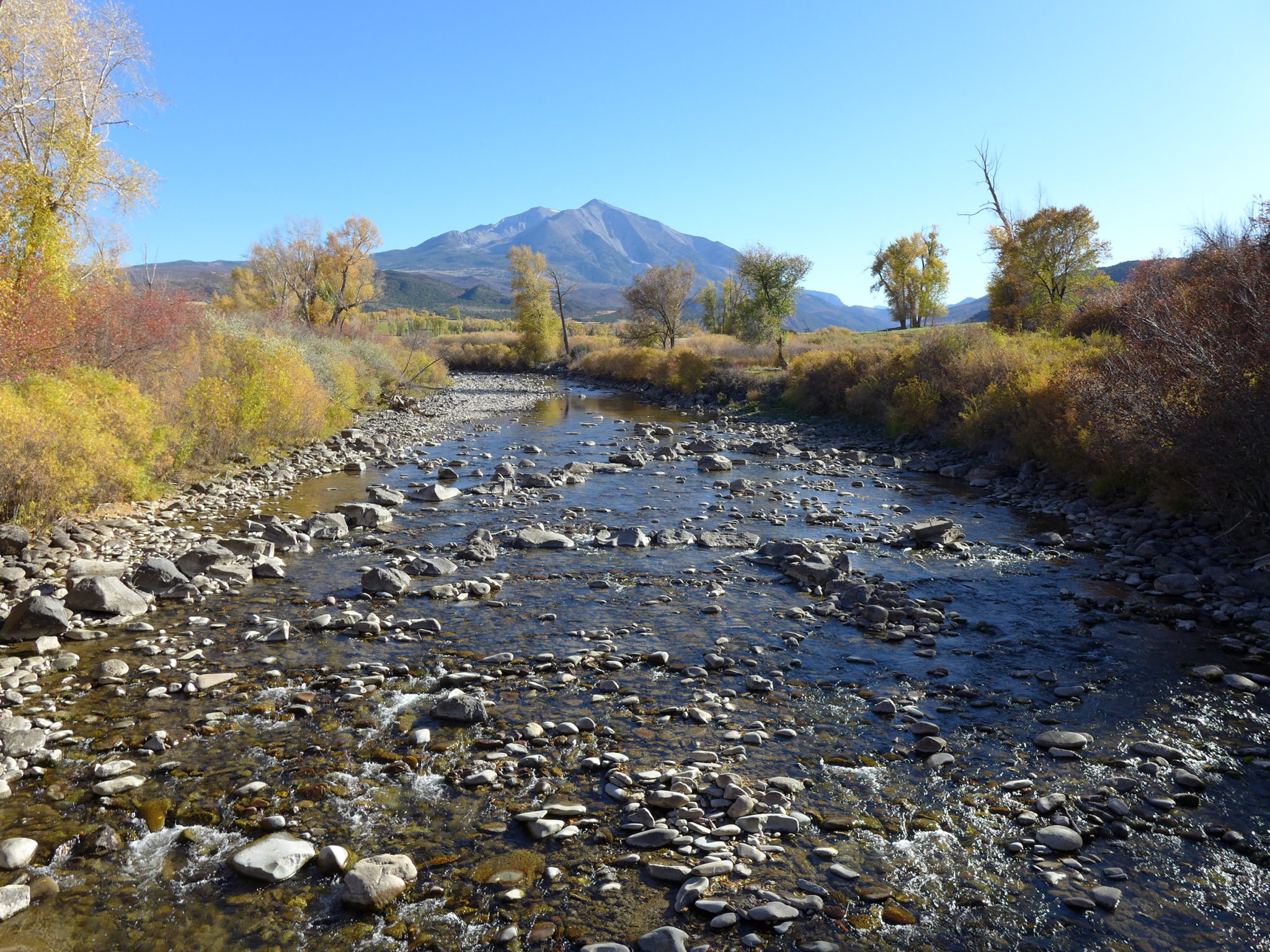


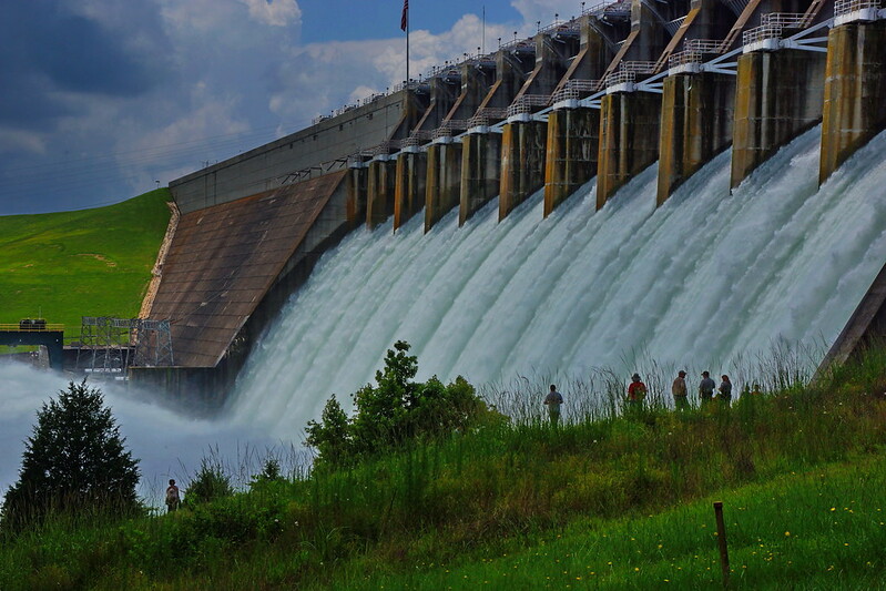

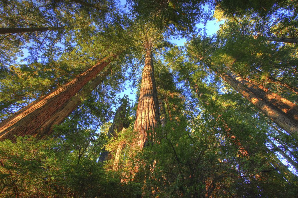
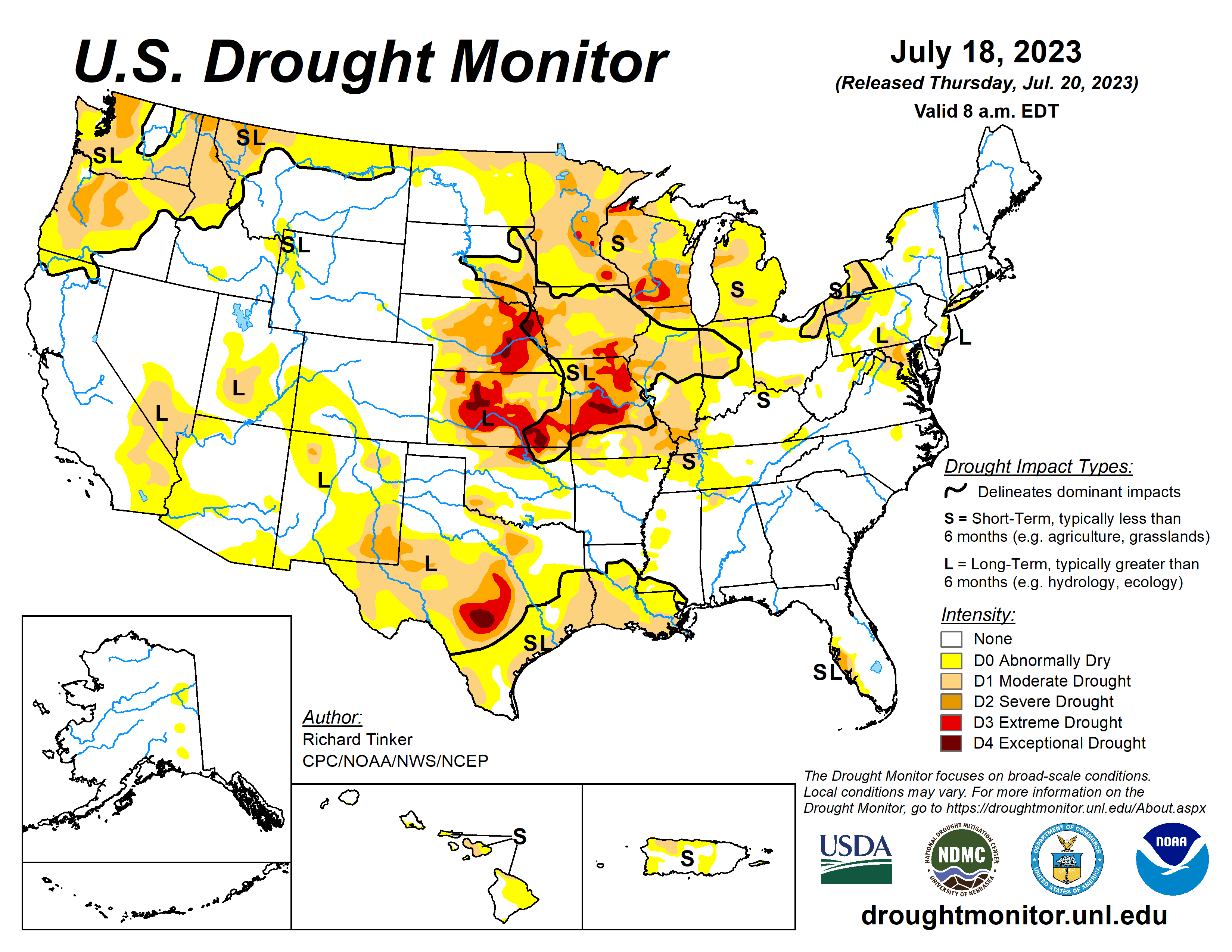
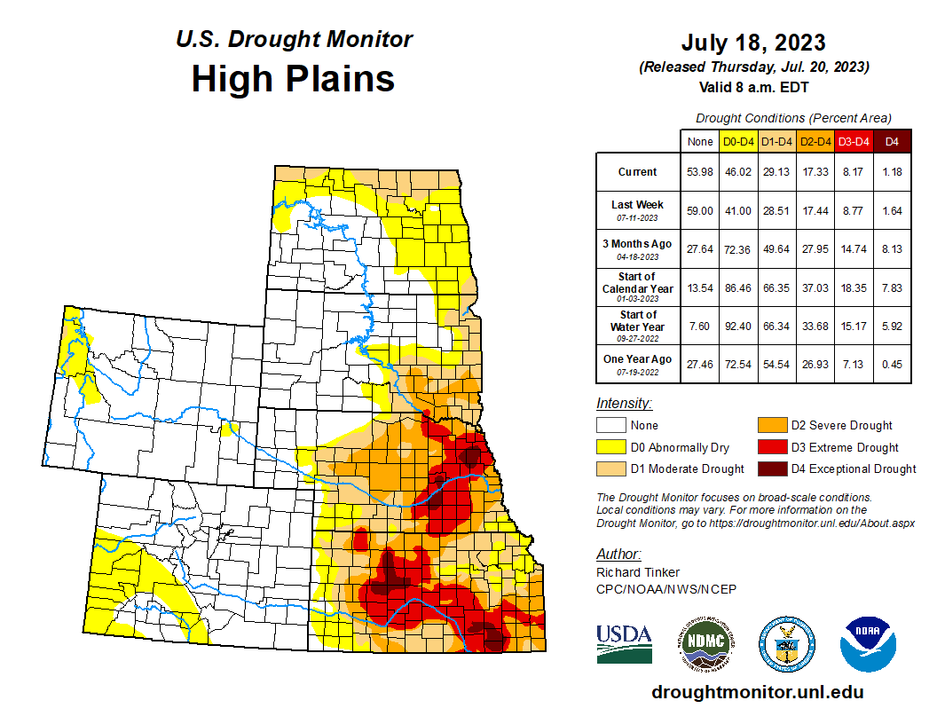

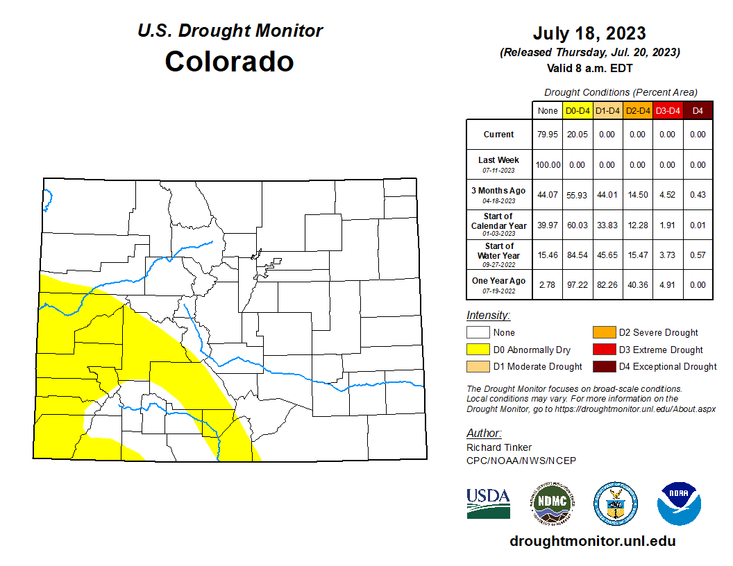

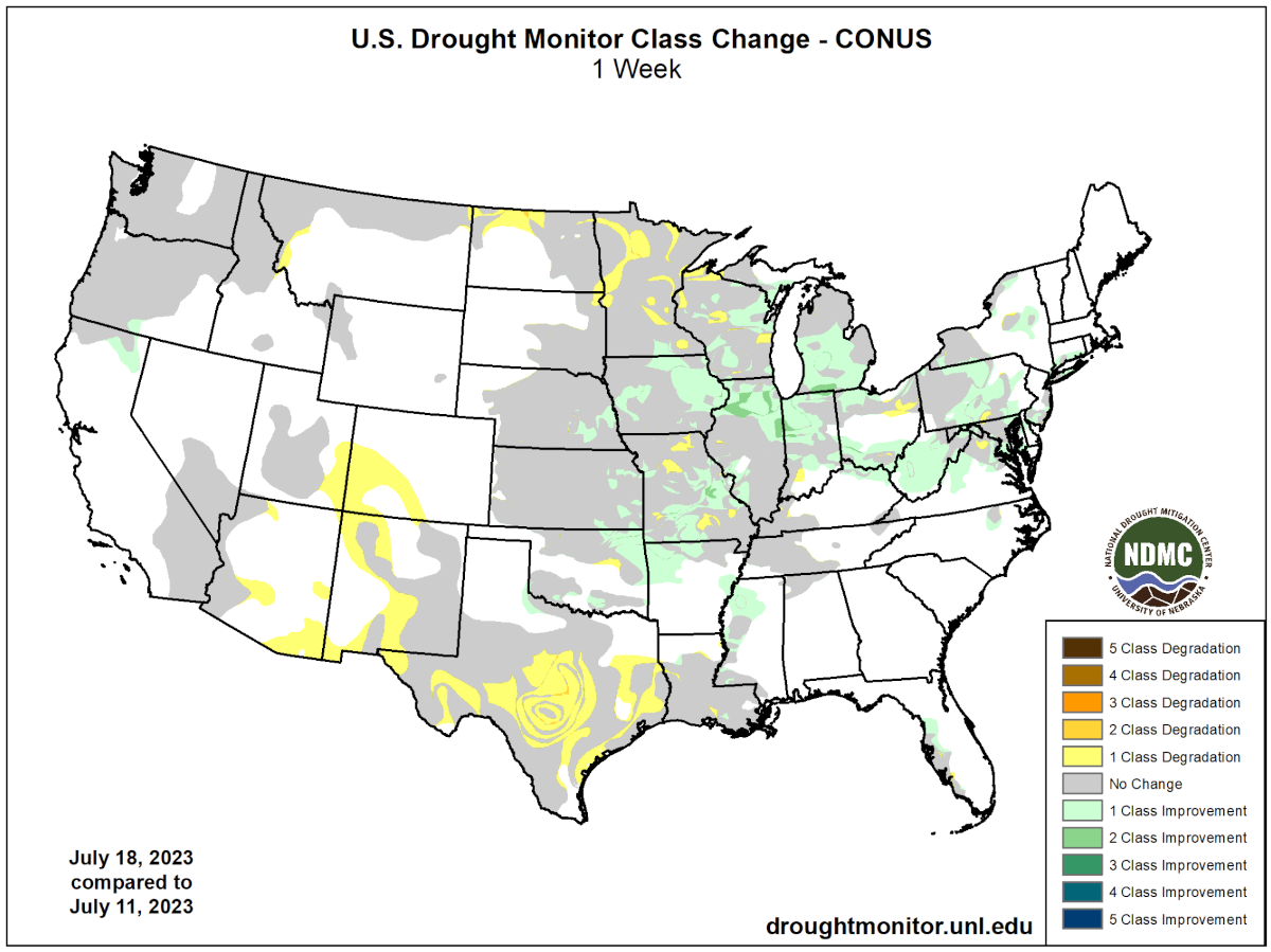


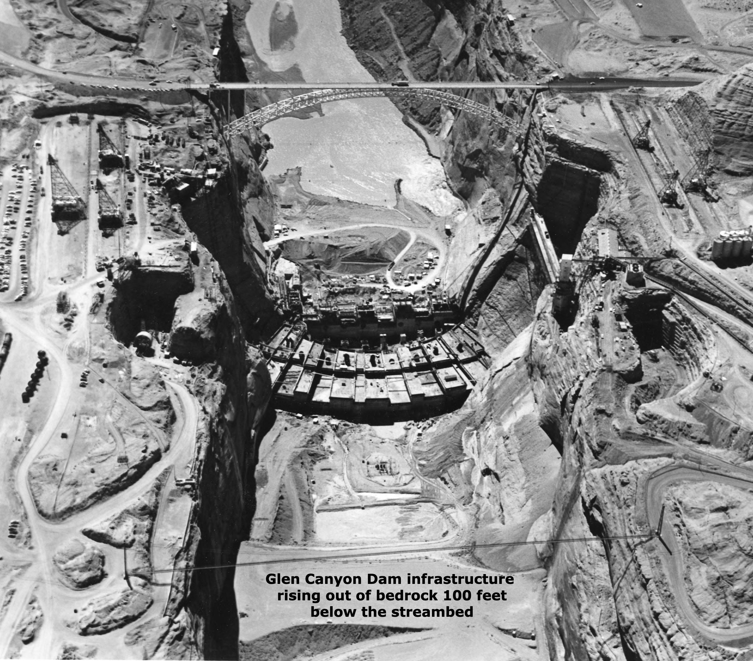
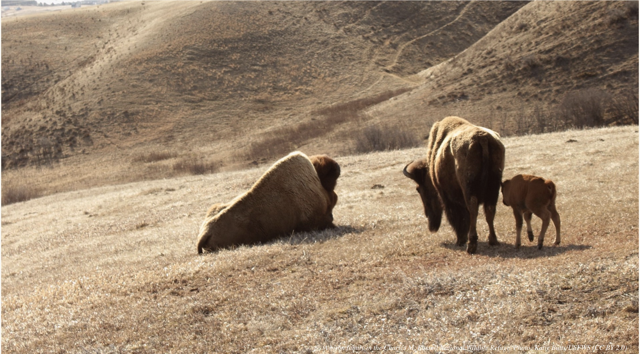


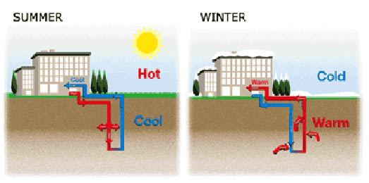


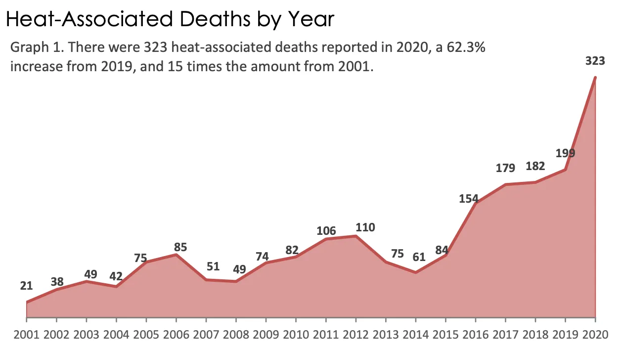

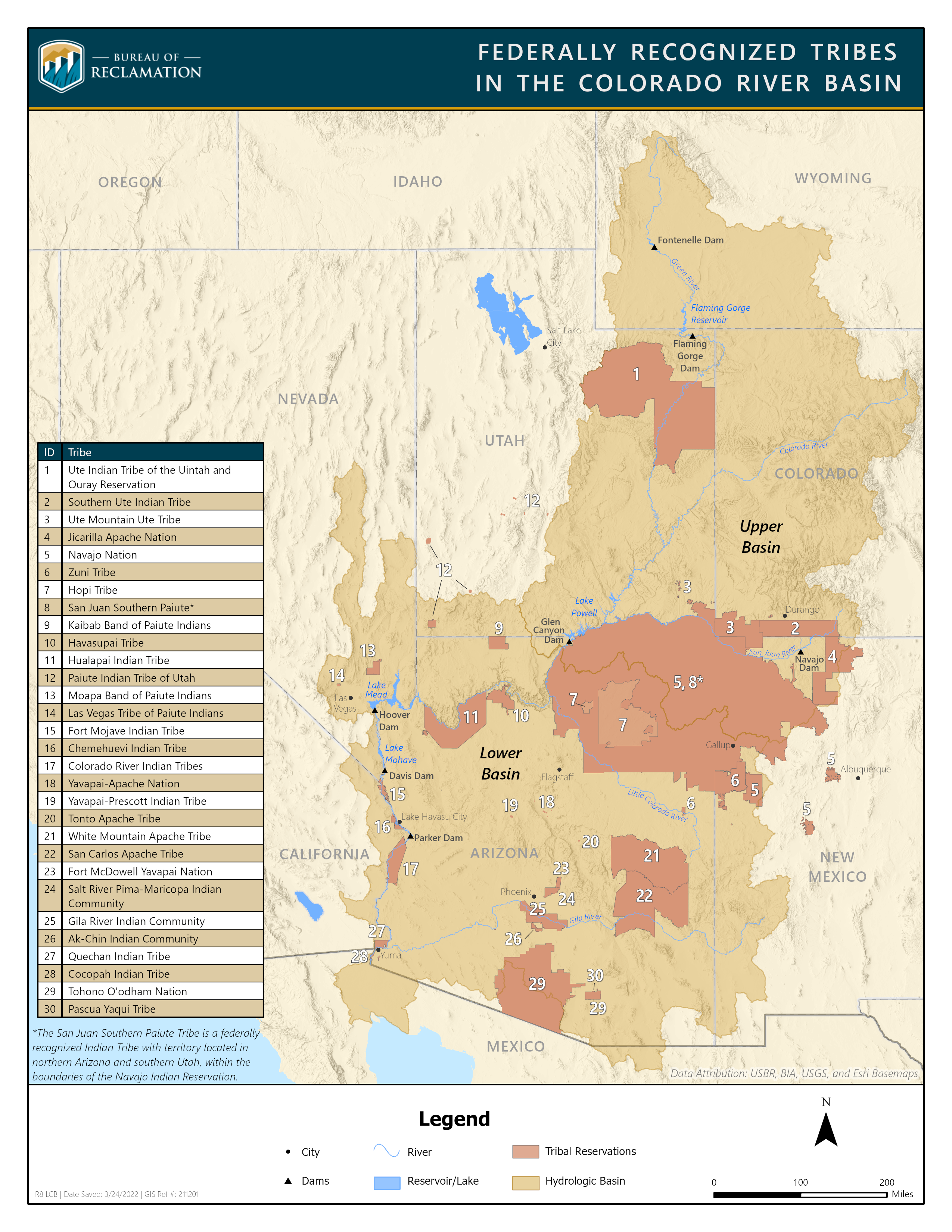