No amount of planning or legislation can make more water — but it can help the parched Western Slope make more use of the water it has.
The trillion-dollar Infrastructure Investment and Jobs Act authorizes, as part of an overall $55 billion for water infrastructure, $8.3 billion under its Western Water Infrastructure title for the Bureau of Reclamation between Fiscal Years 2020 — 2026.
On the laundry list of designated funds for Western Water Infrastructure are $3.2 billion for aging infrastructure, $1.5 billion for storage, $1 billion for the Drought Contingency Plan on the Colorado River and $400 million for WaterSMART and energy efficiency grants.
“All in all, it’s certainly the most meaningful investment in Western water resources that we’ve seen in my generation,” said Zane Kessler, director of Government Relations for the Colorado River District. The district sees an opportunity to fight for some of those dollars to flow into western Colorado, he said — and there are several meaningful investments that Colorado and the Western Slope are well-equipped to pursue…
The act provides additional funding to the Aging Infrastructure Account created in 2020’s Consolidated Appropriations bill. This funding helps the Bureau of Reclamation provide direct loans to finance the non-federal share of major, nonrecurring maintenance of water infrastructure owned by the bureau, in water projects across the West that require major upgrades or replacement.
“As those facilities, most of which are more than 50 years old, continue to age, the issue of storing and delivering water effectively, efficiently and in a timely matter only increases,” a summary from The Ferguson Group states. The Ferguson Group represents the Family Farm Alliance, of which the Colorado River District is a member.
Of the $3.2 billion, $100 million is to be available for dam rehabilitation, reconstruction or replacement. Another $100 million is to be available for reserved or transferred works that have suffered a critical failure, per the summary.
Water storage, groundwater storage and conveyance projects receive a $1.05 billion boost and of that, $100 million is to fund grants to plan and build small-surface water and groundwater storage projects.
There is $1 billion available for water projects authorized by Congress before July 1 of this year in accordance with the Reclamation Rural Water Supply Act of 2006.
The river district is pleased overall with the package of options the Infrastructure Investment and Jobs Act opens up, Kessler said, and it will be working to bring some of those dollars here.
The infrastructure act’s passage comes at a time of dire drought in the Gunnison Basin and Colorado.
The boat ramp at the Lake Fork Marina closed for the season on Sept. 2 due to declining reservoir levels. The Bureau of Reclamation is making emergency releases out of Blue Mesa Reservoir to prop up levels in Lake Powell and preserve the ability to make hydropower. CREDIT: HEATHER SACKETT/ASPEN JOURNALISM
Earlier this year, Blue Mesa Reservoir was drawn down a total of 36,000 acre-feet between August and October and Flaming Gorge in Utah released 125,000 acre-feet. Navajo Reservoir in New Mexico is set to have released 20,000 by December — a trio of infusions mandated by the Upper Basin Drought Response Operations Agreement to keep hydropower operational at Lake Powell…
The earlier drawdown at Blue Mesa took 17,000 acre feet from the reservoir in August; 16,000 acre feet in September and 3,000 acre feet in October, according to BuRec numbers.
That provided the requisite 36,000 acre feet to Powell from Blue Mesa, but at the end of October, Powell was 156 feet from full pool, with an elevation of 3,544.25 acre feet. It had 7.18 million acre feet in storage — 30% of live capacity, as Catlin noted.
He and others eye the weather and potential snowpack. They wait. They hope.
Catlin said that as it is, the entire Gunnison Basin is drying so much, it’s hard to say what the overall impact might be — but more than agriculture would suffer…
Taylor Park Reservoir
Blue Mesa has about 218,000 acre feet in storage, he said. Taylor Park, another pot of water in the BuRec-managed Aspinall Unit, sits “OK” at 59,000 acre feet in storage, Knight said. Ridgway Reservoir has 63,000 acre feet in storage, a bit low, but in light of how dry the year was, not as bad it could be, he also said…
Blue Mesa’s elevation sat at 7,431 this week — ideally, it would reach 7,490 by the end of December.
“We’ll be nowhere close to that,” [Erik] Knight said.
Already, there is not enough water flowing through the Colorado River to meet all of the demands on the watershed, which spans seven U.S. states and crosses into Mexico. And as the climate changes, scientists warn that those who depend on the watershed should plan to receive even less water each year…
Already, the Lower Colorado River Basin states that rely on Lake Mead — Arizona, California and Nevada — have been meeting to discuss and find funding for a program that would keep more water in the reservoir in an attempt to stave off further shortages and cuts. That plan would keep about 500,000 acre-feet in the reservoir next year and in 2023…
The states came together to develop the plan as part of a consultation clause in an existing 2019 agreement, known as the Drought Contingency Plan. That plan builds off of a set of operating guidelines for the river, approved in 2007 and set to expire in 2026. At the same time that water officials from the seven Colorado River states tackle near-term issues, they are all positioning to negotiate a new set of guidelines.
The Colorado River is governed by a series of overlapping laws, contracts, compacts and agreements, including the guidelines. Working within these structures, the states face a major challenge — to reduce use on the river and prepare for the worst-case scenario of a future with far less water to go around. Next month, water officials from across the basin are set to meet in Las Vegas to discuss that challenge and other issues facing the river.
John Entsminger, the general manager of the Southern Nevada Water Authority, said he is “cautiously optimistic” that the states will be able to find a way to lower use “because of the structures we’ve already put in place.” He noted that if Lake Mead were to hit 1025 feet above sea level, current agreements would already trigger cuts of about 1.3 million acre-feet of water.
The Nevada Independent spoke to Entsminger about the negotiations and how dry of a future Colorado River water officials should plan for. Our conversation has been edited for clarity and length.
What do you see as the greatest challenge facing the Colorado River moving forward?
I hate to be obvious, but the biggest challenge for the river is we have a lot less water than people have legal entitlements.
How does that play into discussions around management as they’re evolving right now?
It makes the interstate and international discussions much more difficult, because really what you’re ultimately doing is negotiating to divide up a far smaller pie than what was believed to be the case in the 20th century.
Brad Udall: Here’s the latest version of my 4-Panel plot thru Water Year (Oct-Sep) of 2021 of the Colorado River big reservoirs, natural flows, precipitation, and temperature. Data (PRISM) goes back or 1906 (or 1935 for reservoirs.) This updates previous work with @GreatLakesPeck.
You mentioned not that long ago, testifying in Congress, that “the river community is far from a consensus about how dry of a future to plan for.” What are some of the differing opinions right now? And where are people on establishing that baseline of what the future looks like for the river?
I was on a panel at the University of Colorado Law School within the last six weeks or so. And a couple people on the panel were asked that question of how dry a future should we be planning for, and I said I thought an 11 million acre-feet annual flow of the river is probably a good place to start based upon what I’ve heard from folks like Jonathan Overpeck and Brad Udall and other smart climate scientists.
But there were some folks on that panel that threw out a number of 13 to 14 million acre-feet, which, frankly, is quite a bit more water than the average of the last 20 years. So I think just from that exchange, you can see that there isn’t currently a consensus on what sort of worst-case scenario should we be planning for, as we negotiate operating guidelines for post-2026.
Let’s take that number, 11 million acre-feet. What would it mean in terms of water use to get to that number?
As a basin (seven states plus the country of Mexico), we’re currently using about 14 [million acre-feet]. So it would mean finding a way to cut current uses by three million acre-feet and not add any new uses, at least without retiring a commensurate amount of existing uses.
Knowing how hard it is to reduce use, that sounds like a very big challenge. Do you think that’s an achievable goal?
That’s the amount of water that Mother Nature gives us. We don’t really have a choice whether or not to achieve it. You have to find a way to live within the amount of water that nature actually gives you.
Signing ceremony for the Colorado River upper and lower basin Drought Contingency Plans. Back Row Left to Right: James Eklund (CO), John D’Antonio (NM), Pat Tyrell (WY), Eric Melis (UT), Tom Buschatzke (AZ), Peter Nelson (CA), John Entsminger (NV), Front Row: Brenda Burman (US), and from DOI – Assistant Secretary of Water and Science Tim Petty. Photo credit: Colorado River Water Users Association
With each passing, snowless day, Denver extends its new record of the latest date at which the first measurable snow falls, busting through the old record of Nov. 21, set in 1934.
Climatologists are watching as the record climbs, estimating Denver’s dry spell could last until early December. But that’s not nearly as worrisome as the lagging snowpack levels in southwest Colorado, they say, specifically in the Sangre de Cristo, San Juan and San Miguel mountains.
Colorado needs an above-average snowpack year to start recovering from a dry summer this year and last year, Climatologist Becky Bolinger of Colorado State University said. Without that snowpack, water levels along the parched Colorado River will likely remain low…
“We’re not off to a very good start,” Russ Schumacher, another CSU climatologist and director of the Colorado Climate Center said.
Data collected by the U.S. Department of Agriculture’s Natural Resources Conservation Service shows that snowpack around Alamosa sits at 37% of normal levels. Further west, around Durango, snowpack sits at 34% of normal levels.
Mountains further north are faring better, the data shows. Snowpack around Ouray and Gunnison is 61% of normal. Snowpack around Aspen and Glenwood Springs is 72% of normal.
The gap between current conditions and normal snowpack is concerning, Bolinger said, but it’s also early in the season. Peak snowpack levels don’t come around until mid-April, and between now and then the difference will shrink as storms pass through…
Schumacher said he expects snow to accumulate better in the northern portion of the state this winter while the southwest is more likely to remain drier and warmer…
Basically, La Niña years typically translate to a good supply of winter storms in Colorado’s northern mountains, Schumacher said…
If La Niña conditions persist, Schumacher said he’s worried about a dry winter. Plus, what little moisture might fall during that time could also be lost as warmer temperatures melt snow prematurely and it’s absorbed by the dry ground, he said.
La Niña intensifies the average atmospheric circulation—surface and high-altitude winds, rainfall, pressure patterns—in the tropical Pacific. Over the contiguous United States, the average location of the jet stream shifts northward. The southern tier of the country is often drier and warmer than average. NOAA Climate.gov illustration.
Westwide SNOTEL November 21, 2021 via the NRCS.Colorado snowpack November 29, 2021 via the NRCS.Illustration from an 18th-century Icelandic manuscript shows Ullr on his skis and with his bow. Credit: Wikimedia
Some of the highest concentrations of radium-contaminated drinking water in the nation are clustered in rural southeast Colorado, according to a recent compilation of data.
The problem is hardly new. The presence of radium in the area’s groundwater, which is linked to an increased cancer risk particularly for children, has been known for decades. The newly compiled data shows that out of the 50,000 water systems included in the research, six of the ten worst radium levels in the nation are in Colorado.
The water providers are required to inform their customers of the contamination, and they say they’d like to fix the problem, but providing clean, radium-free tap water in the most remote areas comes with an untenable price tag.
A massive infrastructure project that promises to largely resolve the problem, the Arkansas Valley Conduit, broke ground this year, but its completion is years away and the bulk of its funding hasn’t materialized yet.
For now, most are hopeful that the conduit will be fully funded and fully built, but until then, the faucets in the area will still provide water with as much as four times the legal radium limit…
Radium poses a unique risk to children, because it is treated by the human body like calcium and deposited into developing bones, where it remains radioactive and can kill and mutate cells.
Although the area’s groundwater was known to have contaminants, high levels of radium in Colorado’s groundwater became a regulatory problem around 20 years ago, when the Environmental Protection Agency promulgated new radionuclide standards. Federal law allows up to 5 picocuries of radium-226 or radium-228, the most common versions of the element, per liter of water…
Rocky Ford Melon Day 1893 via the Colorado Historical Society
According to the Environmental Working Group’s new drinking water contamination data compilation, the worst radium content in the nation is found in Rocky Ford, where there was an average of 23 picocuries of radium per liter of water.
Eighteen other water systems in Colorado contain more than the legal limit. Most are clustered around the small rural towns of Rocky Ford, Swink and La Junta, about an hour’s drive east from Pueblo. The new data show one in every six Otero County resident has tap water above the federal limit.
After years of testing, studies and planning, the solution that‘s emerged is one proposed sixty years ago: The Arkansas Valley Conduit, the massive clean water delivery system proposal that stalled for decades over the project’s equally massive price tag.
Elsewhere in the state the Peak View Park mobile home park, situated on a wooded hillside along U.S. Route 24 in Woodland Park, registered more than twice the legal limit of radium for years, as the owners struggled to get the problem fixed…
But a key feature of the system Peak View Park installed is the access to Woodland Park’s sewer system. LaBarre said he had to make arrangements with the city’s wastewater treatment officials about the timing of their extraction system’s wastewater disposal, so that they can send the radium-saturated byproduct of the extraction process into the sewer when the system can adequately handle it…
The lack of a sewer system is what cripples any similar efforts in the more rural areas around La Junta. There, where many of the residents use septic tanks, storing an extraction byproduct would be prohibitively expensive…
Bill Long, the president of the Southeastern Colorado Water Conservancy District, said the towns along the first 12 miles of the [Arkansas Valley Conduit], Boone and Avondale, should be getting clean water from the conduit by 2024.
More funding will be needed to finish the project, and Long said he believes there will be money allocated from the recently passed federal infrastructure bill, and that the funds could help get the conduit finished, but that the details aren’t yet clear.
Arkansas River Basin alluvial aquifers via the Colorado Geological Survey
THROUGH their research on the San Luis Valley wetlands and bird migration patterns, Cary Aloiaand Jenny Nehring can tell you ducks that are divers are arriving on average 1.24 days earlier in the Valley, and ducks that are dabblers 1.7 days earlier.
WHAT DOES IT MEAN?
“Means that every year the peak migration is occurring 1.5 days earlier,” said Aloia. “If we look at historic records, peak migration was end of March-ish and now we’re looking at getting close to the beginning of March. What’s significant to that is that the irrigation season starts April 1. That means that farmers aren’t putting water out on their properties, they aren’t flood irrigating when the peak number of birds are there.
“What that also means is because peak numbers are March, the beginning of March, the birds start coming in the end of January now and February, and so we’ve got this period of time where we’re really limited because of an irrigation system.”
It’s complicated, but then it isn’t. Simply, climate change – where we experience extreme weather events hot and cold, and experience an overall warming to the seasons – is having a damaging effect on the natural wildlife of the Valley, the natural lands of the Valley, and how we all use it.
Photo: Ryan Michelle Scavo
The complication enters with solutions put forth to address the changing climate and how far the Valley is willing to go to address it. Spending time with Aloia and Nehring helps in understanding the circumstances and conditions.
The Alamosa Citizen visited recently over a Zoom call with Aloia and Nehring to talk about their research and ongoing work to address the Valley’s changing environment. Aloia and Nehring are biologists who work together as Wetland Dynamics and consult with companies and governmental agencies to preserve and conserve wetlands, riparian areas, and ecosystems like the San Luis Valley.
Their study, “San Luis Valley Wetland and Wildlife Conservation Assessment” published in 2019 and updated in 2020, is in the category of must reading if you care an iota about the San Luis Valley and how it’s faring in the first decades of the 21st century as climate change makes its presence more acutely felt.
“I would say we’ve got the climate change aspect, but we’ve also got sort of this urban push into wildlife habitat and the change in not only conversion of different types of wetlands, but the complete loss of wetlands,” said Aloia. “As the assessment pointed out, we have about a third of the wetlands that we had historically, and we continue to keep pushing that envelope, converting wetlands, and part of that conversion is, of course, the drought that we’re going through. We’ve lost a lot of wetlands because the water doesn’t get where it was historically.
Now we’re getting into climate change, human migration patterns as people seek out lesser-known and less-crowded spaces, land development, and intersecting it with the natural habitats that are being impacted by it all.
Here’s how Nehring follows up her partner Aloia’s comment when she said, “‘We have an exponential number of people coming here.”’
“I was reading a book on migration this last year,” Nehring said, “and they were talking about how if you watch a warbler foraging through just trees on the bank of a river, and it’s a bird that’s migrating. Neotropical songbirds migrate at night and they land in the morning, and they’ll feed and rest through the day, and then they’ll take off and fly another stretch that night. Or maybe they’ll stay two days. And it’s very weather dependent, and they follow rivers. Rivers are huge landmarks for migrating birds, and so if you watch a warbler foraging during migration, about once every three seconds, it’ll glean a little bug off a leaf and it’s eating.
Photo credit: Ryan Michelle ScavoPhoto credit: Ryan Michelle Scavo
“And if an area is cleared of that vegetation, and maybe the bird has to fly a bigger distance between clumps, and maybe their foraging goes from once every three seconds to once every four seconds, seemingly minuscule, but that means it’s a 25 percent increase in its energy expenditure to just eat.
“So if you think of the development Cari has referenced, people have moved to the Valley and there are a lot of rural areas across Colorado and the U.S. that have seen this shift because of COVID. If you just drive from South Fork to Creede, or anywhere along our river ways, you can see where a new house is, and you can see that people clear vegetation to the water because it gives them a better view, better access or whatever. But if you imagine, if you add all that cleared vegetation up, you’re having a huge impact in foraging areas for neotropical migrants and other wildlife.”
“And the same goes for grassland species,” Aloia adds, bringing more context and perspective to the conversation. “Nationally, continentally, we’ve seen a huge decline in grassland species. They took it really hard with that September snow that we had a year ago, and if you drive down the (county road) 8 South between Monte Vista and Alamosa, if you drive that road, the amount of clearing that has gone on just with greasewood, rabbit brush, sort of the more upland species that you don’t usually equate with wetlands, and having those sort of temporarily flooded areas that we identified in the assessment as being something that we’ve lost significantly, those areas are being cleared, and what we have is exposed ground now and weeds, and all kinds of things.
Photo credit: Ryan Michelle Scavo
“If you drive that in the spring and the fall, or if you’ve ever walked through a greasewood area, the amount of birds that are utilizing those types of areas is astounding. And we’re losing that habitat. As we know, at least 82 percent of all wildlife species use riparian areas or wetlands in some capacity during their life history. So even though we may look at those as really upland species, there is a lot of crossover between different habitat ecosystem types. So then we can’t just focus on a specific riparian or wetland area, we have to look at the system as a whole and see how we’ve really fragmented everything.
This year Nehring and Aloia noticed what they characterized as a “huge change in the bird migration for water fowls coming to the San Luis Valley.”
“We saw a three week shift in when the geese were breeding and bringing off their broods,” said Aloia. “We didn’t see the water fowl coming into the Valley as early as they usually do in the fall. It’s much later, and honestly I don’t even know that we’ve really seen it yet.
Sandhill Cranes West of Dunes by NPS/Patrick Myers
“We obviously have the cranes coming through and they sort of straggle in, in the fall. But in terms of water fowl they know that our water resources this year were low, they have a sense for that, and can just pass us by. Because they have wings, they are able to shift and go where resources are and I think we’re going to see that more and more.”
Nehring referenced a widely publicized study first reported in the journal Science that documented the loss of 3 billion birds, or one in every four birds, since 1970. “I’m thinking now, 3 billion birds in 30 years, that’s really dramatic but I think we’re entering into a new time period where we’ll have equally dramatic losses in a shorter period of time,” she said.
“And I think it’ll not only be birds,” said Aloia, “but it’s going to be other bigger wildlife species that may garner more attention because they’re more identifiable, more people know about them. We as biologists have definitely seen how the birds have changed in their movements and numbers, but I think that it’s definitely going to become more apparent to a bigger part of the population.”
Dead ponderosa pine trees in California. Credit: Charles Koven, University of California, Berkeley.
Here’s the release from North Carolina State University (Laura Oleniacz):
A new study shows climate change can have cascading effects on forests. Using computer modeling, researchers from North Carolina State University, the Los Alamos National Laboratory and other institutions found increased temperatures during an historic drought in California contributed to the death of large numbers of giant pine trees by speeding up the life cycle of a tree-killing beetle.
Published in the journal Global Change Biology, the study found a nearly 30% increase in ponderosa pine (Pinus ponderosa) tree death during California’s 2012-2015 drought due to attacks from the western bark beetle. Researchers said the findings highlight how climate change can compound threats forests face, and raise questions about their ability to act as reservoirs for greenhouse gases.
“This has huge implications for how we manage forests – not just in California, but everywhere,” said study co-author Robert Scheller, professor of forestry and environmental resources at North Carolina State University. “With climate change, it’s not just wildfires and weather events, but also how changing climate conditions can impact insects, fungi and other biological agents of tree mortality.”
During the drought, researchers documented widespread tree death throughout the central and southern Sierra Nevada mountain range of California. The ponderosa pine, a large tree that lives at higher elevations, suffered the most, as it’s the only host for the western pine beetle in the region. In some areas, nearly 90% of large ponderosa pine trees died, U.S. Forest Service researchers found.
“There are dead trees snaking across the landscape – dead, giant trees,” said Zachary Robbins, the study’s lead author and a graduate student at NC State. “We estimated that this mortality event would have occurred during the drought, but it would have been less severe under historic temperatures.”
To understand how temperature influenced the beetles’ attacks on the trees, researchers created a computer simulation of the beetles’ life cycle, their attack behavior, the number and size of trees, tree defenses and likelihood of death during certain stages of the drought. Then they combined all of those variables to model the beetles’ attack behavior and tree defenses under contemporary (2001-2018) compared with historical (1895-1945) temperatures. They compared and tested their model using data gathered in the field.
While the trees can defend themselves against attacks by the beetle, their defenses were down during drought, researchers said. To save water, the trees put the brakes on photosynthesis, which could affect their ability to expel the beetles as they try to chew through bark. The beetles kill the trees when they dig intricate tunnel systems to lay their eggs into the trees’ circulatory system, preventing nutrients from flowing through the tree.
“These beetles primarily live in trees that are weakened or dying, but when weather events occur, they start spreading across the landscape, and multiplying rapidly,” Robbins said. “The beetles can develop more quickly when it’s warmer. Also, lower temperatures in winter keep the populations in check. They die when winters are cold, but as temperatures warm, that may occur less often.”
They attributed a 29.9% increase in tree death to the beetles’ attacks – primarily from increases in development rates of the pine beetle, and to a lesser degree, to reductions in the beetles’ death over the winter.
They also reported that each degree increase in temperature may have increased the number of pine trees killed by more than 35 to 40% – if increased beetle populations and declines in host tree defenses act separately.
“Higher temperatures increased the number of beetles that existed on the landscape by speeding up their life cycle by about a half generation,” Robbins said. “It lowered the over-wintering mortality a little bit, but not in a very pronounced way. Overall, what this means is that the beetles were able to reproduce more efficiently because they had these quicker generation times, and killed trees more quickly during the drought period.”
The researchers are also concerned that small changes in the beetle population could have big effects.
“Even a slight increase in generations can increase tree mortality considerably,” Robbins said.
The researchers said the findings raise multiple questions about forests in the future. It creates a more nuanced picture of the role they could play in storing, or releasing, carbon. The ponderosa pineis thought of as a fire-resistant species that’s less likely to burn in wildfire events.
“These old trees are large stores of carbon that could be released back into the atmosphere either slowly as they decompose, or rapidly through wildfire,” Robbins said. “As you have new species replacing them that might be more fire prone, that can be a big deal in terms of how much carbon we’re storing in these forests versus what we’re releasing back into the atmosphere.”
Scheller said the death of the trees is likely to leave a lasting mark. It also raises questions about forests as long-term tools for controlling climate change.
Mountain Pine Beetle kill via USGS.
“We’re talking about a mass mortality event of incredibly large and old conifers,” he said. “There will be new species to replace those, but the forest won’t recover right away. And those original tree species may not return for hundreds of years, if ever.”
The study, “Warming Increased Bark Beetle-Induced Tree Mortality by 30% During an Extreme Drought in California,” was published online in Global Change Biology. In addition to Robbins and Scheller, the other authors were Chonggang Xu, Brian H. Aukema, Polly C. Buotte, Rutuja Chitra-Tarak, Christopher J. Fettig, Michael L. Goulden, Devin W. Goodsman, Alexander D. Hall, Charles D. Koven, Lara M. Kueppers, Gavin D. Madakumbura, Leif A. Mortenson, James A. Powell. The study was supported by the UC National Laboratory Fees Research Program under grant No. LA-UR-20-30376, the McIntire-Stennis project MIN-17-095, grants from the Pacific Southwest Research Station Climate Change Competitive Grant Program, PSW–2016–03, PSW–2017–02), and the NC State Chancellor’s Faculty Excellence Program…
Abstract: Quantifying the responses of forest disturbances to climate warming is critical to our understanding of carbon cycles and energy balances of the Earth system. The impact of warming on bark beetle outbreaks is complex as multiple drivers of these events may respond differently to warming. Using a novel model of bark beetle biology and host tree interactions, we assessed how contemporary warming affected western pine beetle (Dendroctonus brevicomis) populations and mortality of its host, ponderosa pine (Pinus ponderosa), during an extreme drought in the Sierra Nevada, California, and United States. When compared with the field data, our model captured the western pine beetle flight timing and rates of ponderosa pine mortality observed during the drought. In assessing the influence of temperature on western pine beetles, we found that contemporary warming increased the development rate of the western pine beetle and decreased the overwinter mortality rate of western pine beetle larvae leading to increased population growth during periods of lowered tree defense. We attribute a 29.9% (95% CI: 29.4%–30.2%) increase in ponderosa pine mortality during drought directly to increases in western pine beetle voltinism (i.e., associated with increased development rates of western pine beetle) and, to a much lesser extent, reductions in overwintering mortality. These findings, along with other studies, suggest each degree (°C) increase in temperature may have increased the number of ponderosa pine killed by upwards of 35%–40% °C−1 if the effects of compromised tree defenses (15%–20%) and increased western pine beetle populations (20%) are additive. Due to the warming ability to considerably increase mortality through the mechanism of bark beetle populations, models need to consider climate’s influence on both host tree stress and the bark beetle population dynamics when determining future levels of tree mortality.
Some of the threats climate change poses to Colorado: shorter winters, forests killed by invasive pine beetles, and habitat loss for the Pika, which thrives in cold, high-altitude environments. Photo credit Conservation Colorado and Western Resource Advocates.
The Piedra River near Arboles set a new record low for this date with a flow rate of just 28.9 cubic feet per second (cfs) as of noon on Tuesday, Nov. 23, according to the U.S. Geological Survey (USGS).
The previous record low for this date was set in 1990 at 44 cfs.
The highest recorded rate for this date was 490 cfs in 1987.
Based on 59 years of water records at this site, the average flow rate for that date is 107 cfs. According to the USGS, the San Juan River was flowing at a rate of 44.4 cfs in Pagosa Springs as of noon on Tuesday, Nov. 23.
Based on 86 years of water records at this site, the lowest recorded flow rate for this date is 34 cfs, recorded in 1976.
The highest recorded rate for this date was in 1987 at 360 cfs. The average flow rate for this date is 87 cfs.
Snow report
According to the U.S. Depart- ment of Agriculture (USDA) Na- tional Water and Climate Center’s snow pack report, the Wolf Creek summit, at 11,000 feet of eleva- tion, had 3.6 inches of snow water equivalent as of noon on Tuesday, Nov. 23.
The San Miguel, Dolores, Ani- mas and San Juan river basins were at 34 percent of the Nov. 17 median in terms of snow pack.
Colorado Drought Monitor map November 23, 2021.
Drought report
The National Integrated Drought Information System (NIDIS) was last updated on Nov. 16.
The NIDIS website indicates 100 percent of Archuleta County is abnormally dry.
The percentage of the county in a moderate drought is listed at 70.86, which is consistent with the previous report.
The NIDIS website also notes that 47.66 percent of the county is in a severe drought stage, consis- tent with last week’s report.
Additionally, the NIDIS website notes that 10.33 percent of the county remains in an extreme drought, consistent with last week’s report.
Imagine life as a small fish. Your world is confined to swimming in creeks, rivers and streams searching out food, seeking shelter from predators, finding resting spots and, of course, fulfilling the biological urge to reproduce. For the female, finding just the right spot to lay one’s eggs is instinctual, and mosttravel great distances in search of suitable habitat.
Now image swimming along and encountering a structure the size of the Glen Canyon Dam – relatively speaking. There’s no going further – it’s pretty much the end of the road. This is the dilemma of a small fish as it confronts a water diversion structure.
Today one small fish, a native Bluehead Sucker, has cause for celebration. A completed project on East Divide Creek, a tributary to Divide Creek that flows into the Colorado River south of Silt, has opened up more than five miles of its historic habitat unreachable to the fish before now. Five miles is a considerable distance in which the fish population can expand, increasing resiliency for the species and reducing the risk of local extinction.
The project involved the reconfiguration of a diversion structure to make it easier for fish to swim upand over it. The King Heatherly diversion structure, located on public lands managed by the Bureau of Land Management’s (BLM) Colorado River Valley Office, but owned and operated by the Spring Creek Ranch, is critical for providing water to raise local crops and livestock. The structure needs to operate effectively and efficiently, but if designed properly, can continue to do so while accommodating fish passage. Scott Schreiber, an engineer with Wright Water Engineers (WWE), knows just how to do that.
Scott and his team of engineers and biologists developed a design with a rock ramp gradual enough for fish to swim up. The ramp has a rough bottom, mimicking a natural stream, complete with small boulders for fish to rest behind on their way upstream. The ramp also acts to stabilize the diversion structure and includes improvements to make annual maintenance easier for Spring Creek Ranch.
“The opportunity to connect these habitats provides great pride for WWE and myself as we look for ways to reconnect our sensitive watersheds for future generations. Using creative solutions and advanced hydraulic modeling, my team was able to understand velocity distributions across theproposed rock ramp to verify they were within the Bluehead Sucker’s burst and prolonged speedranges,” Scott said.
Brian Barackman, owner/operator of Diggin’ It River Works, was the local contractor selected to construct the project. His crew utilized heavy equipment outfitted with state-of-the-art electronics and GPS systems that allowed for precision placement of rock, pipe, fabrics, and vegetation. The resulting structures appear natural looking and should blend into the surrounding environment as they revegetate with native willows and grasses.
Bluehead Sucker, along with Flannelmouth Sucker, and Roundtail Chub are imperiled Colorado River basin native fish species. Collectively called “the three species,” their conservation is a cooperative effort across their range which includes New Mexico, Nevada, Wyoming, Utah, and Arizona. The three species currently only occupy a fraction of their historic range in large part due to habitat fragmentation by dams and water diversion structures. Other threats to the species include climate change, altered water quality, introduction of predatory and competitive species, and for the two sucker species, hybridization with non-native sucker species. All three fish species are found throughout the Middle Colorado Watershed and are part of an Integrated Water Management Plan that seeks to restore habitat for these species through projects like the King Heatherly Fish Passage project.
Fisheries biologist from the BLM and Colorado Parks and Wildlife (CPW) will be closely monitoring the success of the project by surveying for fish both below and above the structure, to determine if upstream movement is occurring. Documented successes from the project will be used to inform the design of subsequent projects like this in the watershed and across these species range, of which dozens have been identified.
“King Heatherly is the first project in Colorado focused on fish passage specifically for bluehead suckers. We hope this project lays a foundation to provide a blueprint for future fish passage structures for native fish in western Colorado and illustrates the feasibility of modifying structures to include fish passage,” says Jenn Logan, CPW Native Aquatic Species Biologist.
Also key to the success of projects like King Heatherly is the cooperation of a number of partners from private landowners to federal land management agencies, state resource agencies, and watershed organizations. As Tom Fresques, BLM Fish Biologist, noted “The Bluehead Sucker is a such a cool fish and the BLM is excited to have such a diverse collaborative partnership working to improve and expand habitat for this native species on public lands managed by the BLM.”
Paula Stepp, Executive Director for the Middle Colorado Watershed Council added, “Working collaboratively with local farmers and ranchers allows MCWC, BLM and CPW to enhance the water management capabilities of irrigation systems while providing native species the infrastructure to increase their long-term survival.”
Project funding came from a series of grants from the Desert Fish Habitat Partnership, BLM, CPW, and U.S. Fish and Wildlife Service. Project management was handled by the Middle Colorado Watershed Council. Please contact MCWC for more information or interest in a tour.
Improving the King Heatherly diversion dam for the health of native species
King Heatherly diversion structure. Photo credit: Middle Colorado Watershed Council
THE TARGET
Located south of Silt, CO on lands managed by the Bureau of Land Management, the King Heatherly Diversion Dam is a structure that has operational issues and needs to be improved. The project objectives are to:
Improve habitat connectivity for resident fish by improving upstream passage of the structure during the spring flow regime
Reduce maintenance needs and costs associated with the structure
Demonstrate the viability of projects of this type in the Middle Colorado watershed (Glenwood Springs to DeBeque)
Secondary objectives include:
Enhance hydraulics of the diversion structure, thereby improving width to depth ratios, as well as minimizing plunge pools and undermining of the structure;
Reduce or eliminate entrainment of fish into the ditch during the spring diversion period.
The bluehead sucker is primary native species that will benefit from this structural improvement project. The bluehead sucker has an impressive jump for a sucker, which still isn’t that impressive. They are listed as a ‘sensitive’ species by the Bureau of Land Management for Colorado. This dam is located on East Divide Creek, and would connect three miles of habitat along that creek.
THE PLAN
In 2018, the Middle Colorado Watershed Council contracted Wright Water Engineers to make modifications and to improve the structure. The BLM is sponsoring the improvement, as the structure is on public land. Picture updates will be coming soon to document this project.
The location of the King Heatherly Diversion Improvement project. Graphic credit: Middle Colorado Watershed Council
Yampa River. Photo credit: Yampa River Integrated Water Management Plan website
Here’s the release from the Colorado Water Trust (Dana Dallavalle) and the Upper Yampa Water Conservancy District (Holly Kirkpatrick):
Steamboat Springs, Co., (November 18, 2021) – On Wednesday November 17th, the Upper Yampa Water Conservancy District (UYWCD) board of directors approved a 10-year contract with the Colorado Water Trust (Water Trust) for the purchase of stored water in Stagecoach Reservoir. The water supply contract, deemed for environmental, instream and recreational use, is the first long-term contract that extends beyond temporary one-year contracts between UYWCD and the Water Trust in years past.
Since 2012, the Water Trust has purchased and released 14,500 acre-feet of water into the Yampa River from Stagecoach Reservoir. Water Trust releases help maintain healthy streamflow and water temperature from Stagecoach Reservoir downstream through the City of Steamboat Springs during hot and dry summer months.
Historically, UYWCD and the Water Trust have worked together to negotiate contract terms as needed on an annual basis using state legislation that allowed for environmental water releases to be loaned for instream flow use in 3 out every 10 years.
In 2020, Colorado House Bill 20-1157 was passed, allowing for the establishment of amended rules governing the Colorado Water Conservation Board’s (CWCB) Instream Flow and Natural Lake Level Program, previously governed by the 3 in 10 rule. Effective March 17, 2021, the amended rules provide potential for increased flow rates and expand the temporary loan of water rights for instream flow use from 3 years to 5 years out of every 10 in addition to potential loan renewals for up to three 10-year periods.
Renewable loans through the program could allow environmental releases to bolster flows in the Yampa River for up to 15 out of 30 years if needed.
For the past year, UYWCD and the Water Trust have been working towards a longer-term contract that could help support the Yampa River during low flows and utilize the new state legislation. The new 10-year contract ensures 100 acre-feet of water in the general supply pool of Stagecoach Reservoir will be allocated to the Water Trust each year if supply is available. The contract also allows for the Water Trust to purchase additional water from two other contract pools in Stagecoach Reservoir at various volumes as needed. Payment for water contracted outside of the general supply pool will only be collected if the water is released.
“As drought conditions and water scarcity continue to challenge our basin, having this 10-year contract in place will help minimize some of the recurring challenges we typically face each year when we revisit temporary contracts without constraining UYWCD water supplies or Water Trust funds. Developing longer- term solutions frees up time and money for all our partners to be even more innovative in their collaboration to keep the river flowing,” said Andy Rossi, General Manager of the Upper Yampa Water Conservancy District.
UYWCD and the Water Trust will be one of the first in the state to utilize the newly amended statute and rules when they present the 10-year contract as part of their joint application to the CWCB program, which is anticipated to take place in January of 2022. Following completion of the CWCB application review, UYWCD and the Water Trust hope to secure a loan of water rights for instream flow use by spring of 2022, making the first 10-year contract effective through 2032.
“UYWCD and the Water Trust have forged something new here. It’s a big step forward for the Yampa River Project and collaborative water management in general. We can now focus our efforts on the new instream flow loan application, and if we are successful, to expanding the Project’s benefits downstream of the instream flow reach where it can benefit even more of the river and all those who rely upon it,” commented Alyson Meyer Gould, Staff Attorney for the Water Trust.
The success of the Yampa River Project involves many partners and dedicated donors including: The Yampa River Fund, Yampa Valley Community Foundation, Tri-State Generation and Transmission Association, and individual donors as well as key project partners: The City of Steamboat Springs; Upper Yampa Water Conservancy District; Catamount Development, Inc.; Catamount Metropolitan District; Colorado Parks and Wildlife; Colorado Water Conservation Board; and the Colorado Division of Water Resources. Without these generous donations and the collaborative work of numerous local and statewide entities, water releases to support the health of the Yampa River would not be possible.
FromThe Associated Press (Brittany Peterson and Sam Metz):
hen Aurora buys one bucket of water, it’s really buying multiple buckets of water. Each drop of water will likely be used over and over again.
The growing city approaching 400,000 residents isn’t interested so much in acquiring single-use water anymore, said Greg Baker, spokesperson for Aurora Water. With its Prairie Waters potable reuse system, Aurora can recapture and reuse about 95% of the city’s water, so having multiple uses written into water rights agreements has become a top priority as water rights are likened to gold in the West — expensive and often hard to come by.
Aurora’s method — sterilizing wastewater from toilets, sinks and factories and then piping it back into homes and businesses as tap water — is catching on across the U.S.
In the Los Angeles area, plans to recycle wastewater for drinking are moving along with little fanfare just two decades after similar efforts in the city sparked such a backlash they had to be abandoned. The practice, which must meet federal drinking water standards, has been adopted in several places around the country, including nearby Orange County…
The shifting attitudes around a concept once dismissively dubbed “toilet to tap” come as dry regions scramble for ways to increase water supplies as their populations boom and climate change intensifies droughts. Other strategies gaining traction include collecting runoff from streams and roads after storms, and stripping seawater of salt and other minerals, a process that’s still relatively rare and expensive.
Though there are still only about two dozen communities in the U.S. using some form of recycled water for drinking, that number is projected to more than double in the next 15 years, according to WateReuse, a group that helps cities adopt such conservation practices.
In most places that do it, the sterilized water is usually mixed back into a lake, river or other natural source before being reused — a step that helps make the idea of drinking treated sewage go down easier for some.
In Aurora, the process is thanks to the Prairie Waters system, which was opened in 2010. It starts south of Weld County along the Platte River, where Aurora holds water rights that can be used “to extinction,” meaning nearly endlessly.
“Essentially, this means that the water residents use for washing, laundry, showering, as well as some of the water from lawn watering, stays in the South Platte River Basin,” Aurora Water explains…
A few dozen wells on the basin pull water through hundreds of feet of sand and gravel to purify the water. Next, the water is pumped into basins of more sand and gravel where filtration continues. Finally, pipes take the water to three different pump stations, which lift the water 1,000 feet over a ridge and back to the Peter D. Binney Purification Facility, near Aurora Reservoir.
From there the water is treated and pumped back out to the city’s thousands of homes and businesses, where the cycle begins all over again…
Currently, the facility treats about 50 million gallons of water each day…
Funding for more wastewater recycling projects is on the way. The bipartisan infrastructure bill passed by Congress has $1 billion for water reuse projects in the West, including the $3.4 billion project in Southern California.
And tucked into the federal budget reconciliation package being debated is $125 million in grants for alternative water sources nationwide that could include reuse technologies.
Plans for expansion of the Aurora Prairie Waters project are ever-evolving and so there isn’t a build out budget attached, Baker said.
Based on recent breakthroughs in instruments and data modeling, researchers from the Department of Geoscience and the Department of Electrical and Computer Engineering at Aarhus University have collaborated to develop an effective technology to measure groundwater accurately from the surface.
The new technology sends very much cleaner signals than have so far been possible using NMR-based (nuclear magnetic resonance) measurements, and this enables the researchers to make a detailed map of the hydrogeological and geological structure of the subsurface, even in inaccessible areas.
The research has just been published in Geophysical Research Letters.
“Using this new technology, NMR measurements are now a cheap, fast and, above all, very accurate tool for mapping and characterizing groundwater systems. There are problems with groundwater all over the world, and the really good news is that, using this tool, we can better map the groundwater and thereby take better care of it,” says Assistant Professor Denys Grombacher from the Department of Geoscience.
Groundwater is a critical source of freshwater for many billions of people, but climate change, pollution and over-exploitation are making it more difficult to find suitable areas as a groundwater source.
NMR measurements are the only technique available today that enable direct non-invasive measurements of the water content and pore properties of the soil.
NMR is short for Nuclear Magnetic Resonance and in short it means that we influence the hydrogen atoms in water molecules in the subsurface using a man-made magnetic field on the surface.
Hydrogen atoms have a nuclear spin which, in principle, aligns with the magnetic field of the earth, either with or against the field—just like small magnets. A pulse from the artificially created magnetic field changes the spin direction of the hydrogen atoms, and when the pulse fades out, the atoms return to the direction they had before. This realignment emits an electromagnetic field that can be measured.
NMR measurements have a disadvantage, however, in that background noise from the electricity grid, for example, can interfere with the signals, and this can make it exceedingly difficult to measure the very weak electromagnetic field in the realignment.
Roughly speaking, the researchers are looking for a whisper-like voice among the audience at a Motörhead rock concert, and this is where the new technologies in the field of data transmission and modeling come into play.
“We can sort of direct the microphone towards the specific sound source we want to hear, and through a number of identical pulses almost ‘force’ a clear signal from the hydrogen atoms in the soil. The computer can piece together the signal we receive to an accurate reproduction of the original signal using data modeling,” says Associate Professor Jakob Juul Larsen from the Department of Electrical and Computer Engineering.
The research team sees the new technology as a breakthrough in groundwater modeling, and as a quick, stable, reliable and inexpensive alternative for mapping groundwater throughout the world.
The research is being headed by Associate Professor Jakob Juul Larsen from the Department of Electrical and Computer Engineering and support is from a grant from the Independent Research Fund Denmark of DKK 5.9 million.
A Nature survey reveals that many authors of the latest IPCC climate-science report are anxious about the future and expect to see catastrophic changes in their lifetimes.
As a leading climate scientist, Paola Arias doesn’t need to look far to see the world changing. Shifting rain patterns threaten water supplies in her home city of Medellín, Colombia, while rising sea levels endanger the country’s coastline. She isn’t confident that international leaders will slow global warming or that her own government can handle the expected fallout, such as mass migrations and civil unrest over rising inequality. With such an uncertain future, she thought hard several years ago about whether to have children.
“My answer was no,” says Arias, a researcher at the University of Antioquia in Medellín, who was one of the 234 scientists who wrote a climate-science report published by the Intergovernmental Panel on Climate Change (IPCC) in August (see go.nature.com/3pjupro). That assessment, which makes clear that the world is running out of time to avoid the most severe impacts of climate change, will figure prominently in climate negotiations over the next two weeks at the COP26 meeting in Glasgow, UK.
Many other leading climate researchers share Arias’s concerns about the future. Nature conducted an anonymous survey of the 233 living IPCC authors last month and received responses from 92 scientists — about 40% of the group. Their answers suggest strong scepticism that governments will markedly slow the pace of global warming, despite political promises made by international leaders as part of the 2015 Paris climate agreement.
Six in ten of the respondents said that they expect the world to warm by at least 3 °C by the end of the century, compared with what conditions were like before the Industrial Revolution. That is far beyond the Paris agreement’s goal to limit warming to 1.5–2 °C.
Source: Nature analysis
Most of the survey’s respondents — 88% — said they think global warming constitutes a ‘crisis’, and nearly as many said they expect to see catastrophic impacts of climate change in their lifetimes. Just under half said that global warming has caused them to reconsider major life decisions, such as where to live and whether to have children. More than 60% said that they experience anxiety, grief or other distress because of concerns over climate change.
An aerial view showing the 63-acre parcel of land, located to the left of the racetrack and gravel pit, purchased by the city of Aspen due to its being a potential site for a new reservoir contemplated as part of an 50-year Integrated Water Resources Plan. A new reservoir in Woody Creek would require an 8-mile pipeline to convey water to the city’s treatment plant. CREDIT: BRENT GARDNER-SMITH/ASPEN JOURNALISM
The city of Aspen’s recently released integrated water resource plan outlines the strategy for an adaptable, phased approach to meet increasing demands and a large pool of “emergency” storage to protect against threats to supplies from Castle and Maroon creeks.
Aspen Utilities Director Tyler Christoff, Utilities Resource Manager Steve Hunter and John Rehring of Carollo Engineers, the Denver-based firm that the city hired to complete the study, presented the IWRP to City Council members at a work session Monday night. The report, which looks 50 years to the future, uses projections about population growth and climate change impacts to determine that the worst shortfalls could occur in two consecutively dry years and be about 2,300 acre-feet total over the course of both years.
To make up for that gap, the report offers six different portfolios of potential new water sources, including storage, nonpotable reuse, groundwater wells, Hunter Creek, enhanced water conservation and drought restrictions. The IWRP says storage is included in five of the six portfolios because no single supply option or combination of supply options can completely mitigate shortages without the use of at least some operational storage.
Two storage pools
The plan proposes two separate storage pools to meet demands under projected conditions in 2070: a 520-acre-foot operational pool and a 5,300-acre-foot emergency-storage pool to provide up to 12 months of water.
Since the report recommends a phased approach with each additional implementation coming after a predetermined trigger is reached, the first phase of operational storage would be for just 130 acre-feet to buffer the seasonal shortage. Streams are highest with runoff in the spring, but demands on Aspen’s water system are highest in late summer, when streamflows are low — and this is the gap operational storage aims to fill.
The construction of the combined 5,820 acre-feet of storage and its associated pipelines and pumps comes with a hefty price tag — it is estimated to cost more than $400 million in 2021 dollars as it is implemented over the coming decades.
Aspen Utilities Resource Manager Steve Hunter stands at the city’s Castle Creek water diversion in this February 2021 file photo. Castle Creek is the source of most of Aspen’s potable water, but the city recently released a report laying out options for increasing its access to water supply from other sources in case something prevented the city from using its diversion infrastructure tapping Castle and Maroon creeks, or flows on those creeks were greatly reduced due to climate change. CREDIT: HEATHER SACKETT/ASPEN JOURNALISM
“We want to make it flexible and adaptable so that we are ready for that worst-case condition,” Rehring told council members. “We implement as needed as we see those conditions unfold over time.”
The report says the emergency-storage pool must be full and ready for use when the need arises — if, for example, an avalanche makes the city’s supplies in Castle and Maroon creeks unusable. “Regardless of siting and co-location, emergency-storage volumes would be filled and maintained at their defined capacity until needed for an emergency,” the IWRP reads.
Storing water specifically until an emergency occurs is not a decreed beneficial use under Colorado water law. But municipal water providers often have a lot of leeway to plan for future needs, which could include storage projects.
Part of the goal of the IWRP is to narrow the city’s options for moving its conditional water rights for reservoirs in Castle and Maroon valleys. After a lengthy court battle, in which 10 entities opposed Aspen’s plans, the city gave up its water rights in those particular locations. One of the places to which the city could move them is a 63-acre plot of land that it bought in Woody Creek in 2018. If the city stores water there, it would have to pump it back uphill to the water-treatment plant via an 8-mile pipeline.
City Council member Ward Hauenstein asked about the timeline for storage and renewing the city’s conditional water rights.
To keep these rights, the city will have to show, through a 2025 filing in water court, that it still intends to use them and that it is making progress on a project.
“Recent history across Colorado shows that it could take decades to implement a storage project, even after sizing and siting analyses are completed,” the report reads. “Therefore, reservoir planning must start immediately.”
Aspen City Council will vote on whether to adopt the IWRP at a later meeting. Mayor Torre thanked the staff, consultants and community members who weighed in on the plan.
“The work you guys are doing on this is some of the most important work Aspen is going to have the benefit of over the coming 10, 20, 30 years,” he said. “Thank you.”
The recent passage of the Infrastructure Investment and Jobs Act (H.R. 3684) brings hope for birds, ecosystems, and communities in the arid West. The Act is a cornerstone of the Biden-Harris Administration, addressing long-awaited infrastructure needs with historic amounts of funding for transportation, electricity, and broadband internet projects. Audubon widely supported this bill, especially funding that will address the ongoing climate crisis, including for clean energy projects, climate resiliency upgrades, transit, and electric vehicles. But more funding, including many of the proposals in the current reconciliation bill, is needed to more completely address our changing climate and water security challenges.
In addition to these more “traditional” projects, the infrastructure bill includes a significant number of programs aimed at addressing the challenging drought conditions of the West. This funding comes none too soon, as the situation becomes more dire—the result of ongoing, multiple, connected crises: long-term megadrought, crippling heat waves, and disastrous fire seasons. The bill includes funding to address water and drought in the West through a variety of programs; Audubon is extremely pleased to see the following included:
$300 million for Drought Contingency Plan implementation, including $50 million for Upper Basin States
$400 million for WaterSMART Water and Energy Efficiency Grants, including $100 million for natural infrastructure projects
$100 million for the Cooperative Watershed Management Program, focusing on natural feature or nature-based feature improvement projects
$250 million for the Aquatic Ecosystem Restoration Program
$100 million for multi-benefit watershed projects
$50 million for Colorado River fish species recovery programs
Reauthorization of the Clean Water and Drinking Water state revolving funds (SRFs) and supplemental appropriations for the following:
Clean Water SRF: $19.9 billion
Drinking Water SRF: $17.3 billion
Lead Line Replacement funds: $15 billion
PFAS targeted funds: $1 billion through the Clean Water SRF, $4 billion through the Drinking Water SRF, $5 billion through the Small and Disadvantaged Communities drinking water program
And $1.9 billion in supplemental funding for U.S. Army Corps of Engineers aquatic restoration projects.
(note: all funding amounts are for five years)
The bill also includes funding for water recycling and reuse, rehabilitation and replacement of aging infrastructure, rural water projects, and water storage projects. There are also significant increases in funding for existing Tribal water settlements and provisions to address climate resilience, especially in Indigenous communities. Altogether, the variety of funding amounts to a historic investment in natural, technical, and built solutions for the ongoing water crisis.
We are actively engaged in supporting drought response and water conservation to protect birds and people. The federal funding provided in the infrastructure bill supports our long-term efforts to improve science, provide federal engagement, deliver clean drinking water, and protect natural resources to promote solutions that benefit birds and build resilient communities and ecosystems. Audubon looks forward to the distribution of this funding and the implementation of projects and programs to support birds and people throughout the West.
This fall Colorado has launched two new programs, one aimed at removing firefighting foam containing so-called “forever chemicals” from fire departments, military bases and other properties and an emergency grant program aimed at helping communities where the chemicals have appeared in drinking water.
The chemicals, known broadly as PFAS or poly- and per-fluoroalkyl substances, have long lifespans and have been linked to certain cancers. Contained in such common substances as Teflon and Scotchguard, they are also widely used to fight fires, particularly those involving jet fuel.
“We’re learning more every day about PFAS and its exposure in our environment,” said Erin Garcia, a spokeswoman with the Colorado Department of Public Health and Environment (CDPHE).
Widefield aquifer via the Colorado Water Institute.
The unregulated substances were once thought to be rare, but since at least 2015 have shown up at alarming levels in communities such as Fountain and Security, where groundwater was contaminated by runoff from the nearby Peterson Air Force Base. Those two communities were forced to shut down their water systems, find temporary substitute supplies, and build new treatment systems.
The chemicals have also been found in groundwater wells that serve Commerce City and in areas near the Suncor Refinery in Adams County and Buckley Air Force Base in Aurora, among other sites.
Two years ago, as more testing revealed more contaminated sites, the CDPHE vowed to boost its oversight. Since then the Colorado Legislature has provided the health department with more authority and money to combat the problem, including conducting surveys to identify contaminated sites and drinking water systems, and providing as much as $8 million to buy contaminated firefighting foam and store it, and to help communities whose water has been tainted by the compounds.
Sugarloaf Mountain fire station.
Dozens of fire departments, military facilities, water utilities, and commercial properties as diverse as hotels and apartment complexes, are now monitoring and testing for the substances.
As Colorado has ramped up its oversight, last month the EPA announced it would begin work on a regulation that will, for the first time, set a limit on PFAS compounds in drinking water. It is set to be available for public review next fall and would be finalized by the fall of 2023.
Ron Falco, CDPHE’s safe drinking water program manager, said he’s pleased the EPA is moving to regulate PFAS, but he said fast action is critical.
“We want the EPA to hit that timeline,” he said.
The South Adams County Water and Sanitation District, which serves Commerce City, is watching the state’s progress carefully. It discovered PFAS contamination in 2018 when it began testing voluntarily for the substances after the crises in Fountain and Security.
It already had in place a carbon filtering system and was able to strengthen it to reduce PFAS contamination in its system to 35 parts per trillion (ppt), half of the EPA’s voluntary 70 ppt guideline. It also had to shut down wells whose contamination levels were so high, 2400 ppt, that no amount of carbon filtering could remove the chemicals fast enough to keep the drinking water safe.
“The key here is that we can treat the current levels,” said Kipp Scott, manager of drinking systems at the South Adams County district, but better treatment will be needed once the federal regulation takes effect.
And that means the district will need to install a new system that uses an ion exchange technology to remove the chemicals. Its estimated cost is $70 million. Scott said the district hopes the state’s emergency grant fund and new federal infrastructure dollars will help cover the cost.
“I hope this moves in the right direction, and we can continue to provide safe water to our customers,” Scott said.
Jerd Smith is editor of Fresh Water News. She can be reached at 720-398-6474, via email at jerd@wateredco.org or @jerd_smith.
No matter your background, water plays a vital role in your day-to-day life. Like other necessities, it can be easy to take for granted, but a lack of it will quickly impact every facet of life. Businesses, for instance, can’t operate without reliable running water, lawns/fields go brown as municipal and agricultural users alike cut back on irrigation to prioritize critical needs, industrial operations weigh costs of doing business, and regional ecological health suffers as stream flows drop below levels sustainable for aquatic organisms.
In Rio Blanco County, the primary source of water is, well, the Rio Blanco, Spanish for “White River.” Historically, the White River has been “un-managed” compared to many other streams and rivers in the state.
Though irrigators, industrial users and municipalities are still expected to abide by mandated water allocations, residents in the Northwest Colorado region have so far enjoyed water use that is loosely monitored, if at all. Due to state legislation, declining precipitation/stream flows and Colorado’s obligation to deliver a certain amount of water to lower-basin western states, that state of affairs is set to change.
“The White River is part of a bigger system,” said Liz Chandler, coordinator of the Planning Advisory Committee for the White River Integrated Water Initiative (WRIWI). The locally-driven effort, which involves community stakeholders aims to establish a framework to guide future water use decisions and maintain some level of local control over water. Chandler explained the importance of the process amid mounting pressure on the Colorado River, its tributaries and by extension 40 million Americans who rely on its water as a result of declining snowpack/runoff and record low water levels in the nation’s largest reservoirs, Lake Powell and Lake Mead.
“Those big river issues may come back upstream into the White River,” said Chandler, “and so the more people [that] can be involved in this water initiative, the more control the White River basin is going to have of its own water,” said Chandler…
“‘The future is unknown, and yet with that given, we need to be prepared,’ said [Kari] Brennan, adding ‘whether you are involved in agriculture, or just use it municipally in your home, recreational, any of that, it’s good to know what’s going on, and also have a voice. This is the opportunity to have a say in what the White River Basin does with our water.'”
The White River Integrated Water Initiative is now in its second phase, and comes as a result of the 2016 Colorado Water Plan, which among other things, set a goal to have 80% of the state’s rivers, streams and critical watersheds under “management plans” by 2030…
The four goals of the initiative.
• Protect and preserve existing water rights and other beneficial water uses.
• Protect and enhance water quantity and quality through promoting best management practices for a) forest health b) riparian health c) rangeland health d) favorable conditions of streamflow.
• Identify opportunities for creation of infrastructure to support efficient consumptive and non consumptive uses.
• Support the development and maintenance of efficient and necessary long term storage solutions that will improve, enhance and ensure irrigation, river health, water quantity, water quality and native/recreational fisheries…
You can also reach out to reach Project Coordinator Kari Brennan at kari.districts@gmail.com and PAC Coordinator Liz Chandler at liz.districts@akvwallergmail-com
After decades in which governments and industry groups have often assumed that the shift to renewable energy will be a financial burden, economists and analysts are increasingly making a case that the opposite is true: The transition will lead to cost-savings on a massive scale that will add to its momentum.
A recent paper by University of Oxford economists and mathematicians finds that a rapid transition to renewable energy would lead to global savings of $26 trillion compared to the costs of maintaining the current energy mix.
Another recent paper, published by the International Renewable Energy Agency, or IRENA, looks at previous technological revolutions to help understand the implications of rapid growth and falling costs of renewable energy.
The findings are providing some analytical heft to ideas that clean energy advocates have long argued about how the transition will lead to vast economic benefits as renewable energy continues to get cheaper.
The researchers who wrote the Oxford paper looked at how wind and solar power have gone from some of the world’s most expensive energy sources to some of the cheapest, and extrapolated those results to chart a future in which prices continue to plummet…
The paper’s authors sought to understand why so many high-profile forecasts have underestimated the pace of cost decreases for renewable energy, especially solar power. They found that most economic models do not adequately grasp the tendency of technologies to get much cheaper at times of rapid expansion and competition, and that models tend to be built in ways that are more likely to show gradual change.
The underlying idea is based on Wright’s Law, a concept developed by engineer Theodore Wright in the 1930s who wrote about how the costs of a technology declines as production increases.
“The more you deploy, the more the costs come down,” said Matthew Ives, an Oxford economist and co-author of the paper. “You get a feedback dynamic, which is runaway change.”
Forecasts that show a slow and expensive transition are harmful because they help to reinforce the idea that fossil fuels will continue to dominate our global energy supply for decades, Ives said. This idea can steer decisions for governments, companies and institutional investors.
Ives and three of his colleagues wrote the paper for the Institute for New Economic Thinking at the Oxford Martin School. It is a working paper, which means it has not yet gone through peer review.
From the 2018 Tribal Water Study, this graphic shows the location of the 29 federally-recognized tribes in the Colorado River Basin. Map credit: USBR
FromColorado Public Radio (Michael Elizabeth Sakas):
Leaders of 20 Tribes in the Colorado River basin signed a letter to Secretary of the Interior Deb Haaland, urging for inclusion in the upcoming negotiations on how to manage the Colorado River system in a changing climate.
Daryl Vigil, water administrator for the Jicarilla Apache Nation, has pushed for increased tribal participation in Colorado River renegotiation discussions. Courtesy of Bob Conrad via The High Country News
“As the legal structure exists in terms of the policy of the Colorado River, we don’t have any formal inclusion,” said Daryl Vigil, a member of the Jicarilla Apache Nation with Jemez Pueblo and Zia Pueblo affiliation.
Vigil is the water administrator for Jicarilla Apache Nation and the co-facilitator of the Water and Tribes Initiative, a group of Tribal members and water experts working together to build capacity of Tribes to participate in Colorado River negotiations. The efforts of the initiative helped create the letter to Haaland.
Leaders of the two Tribes in Colorado, Chairman Manuel Heart of the Ute Mountain Ute Tribe and Chairman Melvin Baker of the Southern Ute Indian Tribe, both signed the letter.
When the Colorado River Compact was signed in 1922 by the seven states in the basin, the Tribes were not included in the allocation of Colorado River water. Since then, the states have continued to leave the 30 federally recognized Tribes in the basin out of the decision making process on how to manage the river.
In 2007, the states adopted interim river management guidelines to respond to worsening drought conditions without input from the Tribes. The guidelines will be replaced by a new framework in 2026.
The letter to Secretary Haaland calls for the Tribes to have an “essential role” throughout the process of developing the new guidelines.
Vigil said since the Tribes are sovereign governments, they should be invited to a “sovereign table that doesn’t exist” to discuss how the Colorado River is managed. Instead, the states act as a trustee to represent tribal water interests, he said.
water scarcity driven by drastic climate-change along the Dolores River in southwest Colorado has been a real jaw-grinder for folks who bear a century’s worth of grudges over who gets water, how much and when.
After 22 years of drought, the river is down to a trickle this late fall and the water storage it feeds, McPhee Reservoir, has shrunk to its lowest level in decades. Even when the runoff was flowing last spring, the Dolores project was already in water shortage mode and farmers only got 10% of what they’re normally allocated, which means they were only able to grow 10% of the crops they’re used to producing.
Much of the farmland lays fallow…
The water that was released from McPhee Dam tells the story, said Colorado State University senior water and climate scientist Brad Udall: “The agreement is for 25 cubic feet per second minimum flow release and they were releasing 1/5 of that.”
Colorado Drought Monitor map November 23, 2021.
The U.S. Drought Monitor map shows Colorado’s Four Corners region in bright red, in the extreme drought category.
“I have said for years that the southwest portion of the state is very much at risk for these kinds of drought,” Udall said. “We should expect for them to occur repeatedly throughout the 21st century.”
[…]
Desperate times
At the mouth of the Dolores, one of the only things standing between a shovel to the head and civility is a Montezuma County sheriff deputy whose job it is to keep watch on water robbers.
Dave Huhn is a tall, silver-haired deputy with a bad back from 12 years of ditch riding. He sips from a Big Gulp-sized iced tea as he travels miles of county roads; a badge, a gun and a tablet of citations are his shield.
“Communication is everything and just because you’ve lived out here 100 years doesn’t mean you’re doing it right,” explains Huhn, who was given the responsibility of enforcing complicated Colorado water laws by the county commissioners in 2009. “You can’t steamroll these people. You’re not out there talking with a physicist. You’re out there talking with someone who needs to produce your food. You’ve got to listen to the problem.”
[…]
[Marty] Robbins is the keeper of the ditch deeds, which are the official record of water rights. He opened a drawer and pulled out a thick leather-bound dossier of evidence. It is the smoking gun in the world of water crime.
“My whole world changed when Dave took over ditch issues,” Robins said. “Around here, you have a whole lot of attitude and very little forgiveness.”
District 3 San Miguel County Commissioner Kris Holstrom and Norwood Mayor Pro-Tem Candy Meehan are working together to make sure Norwood has water in the future.
Currently, Holstrom with the West End Economic Development Corporation (WEEDC) and April Montgomery are collaborating to bring groups together, including the Lone Cone Ditch Company, Farmers Water Development, Norwood Water Commission, Norwood Fire Protection District, the Town of Norwood and San Miguel Watershed Coalition.
In a grant application that is due Dec. 1 to the Colorado Water Conservation Board (CWCB), the collaboration, with WEEDC as the fiscal agent, is going after a 75-25 percent match of what could be millions of dollars.
Holstrom and Meehan said the grant is for bringing a third-party engineer to Wright’s Mesa to examine major water projects, layer them and “plan and prioritize” for sustainable water for the region. Holstrom said it can help with water supply and storage.
Holstrom said the engineer won’t be hired to come and take over water on Wright’s Mesa. She said each organization can still go after its own grants. She said “buckets of money” are soon going to be available in the near future, though, and the grantors want to see collaboration.
For a region in extreme drought, Meehan said it only makes sense to do this work…
Should the collaborators on Wright’s Mesa be awarded — and they just might considering officials at CWCB were described as being “very enthusiastic” regarding the incoming grant application — the organizations who’ve contributed then become stakeholders. Only then would a regional partnership be established. Next, a regional comprehensive water plan could also be done…
Holstrom said Monday that she’s pleased various organizations on Wright’s Mesa are agreeing to go for the collaborative grant. She said the “yesses and nods” are an indication that it’s time to look into getting the funding to sustain water in the Norwood area.
Brad Udall: Here’s the latest version of my 4-Panel plot thru Water Year (Oct-Sep) of 2021 of the Colorado River big reservoirs, natural flows, precipitation, and temperature. Data (PRISM) goes back or 1906 (or 1935 for reservoirs.) This updates previous work with @GreatLakesPeck.
Drought has tightened its grip on the Western U.S., as dry conditions tick on into their second decade and strain a river that supplies 40 million people. Experts agree that things are bad and getting worse. But how exactly do you measure a drought, and how can you tell where it’s going?
Brad Udall is an expert on the subject, studying water and climate at Colorado State University’s Colorado Water Center. Lately, his forecasts for the basin haven’t been particularly uplifting.
“You cannot look at these and not be concerned,” Udall said. “The climate models tell us this is going to get worse. There’s every reason to believe it’s going to get worse. It’s gotten worse since 2000. The spooky thing is that it seems to be getting worse at a faster rate.”
He cites four specific metrics that scientists use to quantify drought. They’re all connected, and they all paint a bleak picture of what the future might have in store.
It all starts with heat
All over the globe, temperatures are rising. In the Colorado River basin, hotter days are the first domino in a cascade of numbers that tell the story of drought. In the 21st century, average temperatures in the upper Colorado River basin are more than 2 degrees Fahrenheit warmer than in the previous century…
Dry soil keeps water out of rivers
You don’t have to be a scientist to notice changes in temperature and precipitation. But another metric that has an outsized influence on drought is harder to spot without specialized equipment. The amount of moisture in soil plays an important role in drought, and high temperatures are making conditions drier…
Precipitation is dropping, too
As much as high temperatures and dry soil are contributing to drought, recent years have also brought bad news for perhaps the most obvious metric: there’s less water falling from the sky…
Flows are low
Across the West, a sprawling web of streams and creeks carries water into the Colorado River. And across the West, they’re all carrying less…
So where do we go from here?CSU’s Brad Udall has some good news and some bad news. He thinks it’s within our technological capability to turn around some of the effects of climate change. But disagreements over policy and the very facts of climate change are standing in the way.
When Project 7 began drawing up plans for a water resiliency program in 2019, its leaders didn’t plan to invest in connecting a raw water line from the Ridgway Reservoir to a new treatment plant in Ridgway.
The new treatment plant and water line would be designed so additional capacity can be added in the future, allowing a maximum capacity of approximately 10 million gallons per day, more than a 30% increase in drinking water supply for the region.
The plan to construct the Regional Water Supply Program in conjunction with the Ridgway Water Treatment Plant is a decision driven by water supply security. The project will add a second water source to the region while serving all Project 7 members.
The valley hasn’t yet experienced water supply interruption, but Project 7 intends to stay ahead of a slew of risks that could potentially affect over 50,000 people and thousands of local businesses.
The new treatment plant would allow direct access to existing water rights in the Ridgway Reservoir while building a system resilient to wildfire, drought and transmission interruptions in the Gunnison Tunnel.
Project 7 Water Authority is a wholesale water treatment provider that supplies to the City of Montrose, City of Delta, Town of Olathe, Tri-County Water Conservancy District and the Menoken and Chipeta water districts, although each entity owns its own water rights.
Although geographically the second smallest entity in the cooperative by size, the City of Montrose uses roughly 50% of the water supply due to population density, with about 8,000 residents using water services from Project 7…
As it stands, the Gunnison River remains the only water supply source for the region, with one treatment facility to provide to the six entities within the cooperative.
The cooperative projected the overhead cost of the project to be between $50 – $70 million. The estimate includes the raw water line, but will become more specific as the design process progresses, said Miles Graham, spokesman for the resiliency program.
City of Montrose customers will see an increase in water rates on Jan. 1, 2022, due in part to Project 7’s elevated fees. Huggins noted that the impact of increasing wholesale rates for customers depends largely on the size and budget of the district…
Montrose residential water bills will increase by $4.86 per 3,000 gallons of water used per month and increase $1.35 per 1,000 gallons used per month, due in part to the water supplier raising its own fees by 15%.
At this stage in the planning process, it’s impossible to predict the cost for each entity without knowing the ultimate program cost or the amount of outside state and federal support, said Graham.
By using a uniform rate structure for all entities to provide local funding, the cost will be shared equally throughout the valley and supplemented by aggressively seeking grants and low-interest loans.
As the process moves forward, the team will be able to test and determine which treatment technology is best for the new plant and raw water line, as well as finding opportunities to make use of existing water distribution infrastructure near the new facility site.
The cost may be higher to build the raw water line, but overall, the cost to run and operate will be lower since the water quality leaving the reservoir will provide a stable water supply, Huggins noted. The water will also be easier to treat, with less influence from rain events washing mud and silt in the river that have to be removed, allowing for mitigated operation costs…
Water treatment plants often use electrical backup generators that run on diesel or natural gas, which is typically banned in the event of a wildfire, the engineer said. Because a gas-run generator on a tank of fuel presents a dangerous risk, utility companies usually shut off any natural gas in the area if a wildfire is present.
“So if you think about an emergency situation, having the ability to bring water down to this site and continue operations at the plant without having to pump it up from the river made a lot of sense. [It’s] a more sustainable solution than the other options for getting water to the site.”
Construction for the project is expected to begin in 2023. The new water line and treatment plan is slated to go online by 2025.
Click on a thumbnail graphic to view a gallery of drought data from the US Drought Monitor.
US Drought Monitor map November 23, 2021.
West Drought Monitor map November 23, 2021.
West Drought Monitor map November 23, 2021.
Colorado Drought Monitor map November 23, 2021.
Click here to go to the US Drought Monitor website. Here’s an excerpt:
This Week’s Drought Summary
A couple Pacific weather systems moved across the contiguous U.S. (CONUS) during this U.S. Drought Monitor (USDM) week. The storm track kept to the northern states, but the systems dragged cold fronts with them that stretched the width of the CONUS, from the Great Lakes to the Gulf of Mexico coast. The systems spread rain and snow to the coastal Pacific Northwest and parts of the northern Rockies, but they weakened as they moved through a western ridge. This circulation pattern starved them of moisture, so much of the West to Great Plains received little to no precipitation, but the fronts picked up Gulf of Mexico moisture as they moved east, spreading precipitation across the Lower Mississippi to Ohio Valleys, eastern Great Lakes, and Northeast. Only a few areas received above-normal precipitation for this time of year, including spots in the Pacific Northwest, Ohio Valley, Deep South Texas, and the southern half of Florida. Weekly temperatures averaged near to cooler than normal in the Pacific Northwest, Great Lakes, Ohio Valley, and Mid-Atlantic states. Much of the West, Great Plains, and Southeast were warmer than normal. Persistent above-normal temperatures in the Plains contributed to excessive evapotranspiration in western portions of the Great Plains as well as parts of the West, as seen in EDDI and ESI indicators. Lack of precipitation, excessive evapotranspiration, and windy conditions further dried soils, again especially in western portions of the Plains, as seen in several soil moisture indicators. Drought indicators such as the Standardized Precipitation Index (SPI) and Standardized Precipitation Evapotranspiration Index (SPEI) showed dry conditions at long-term time scales in the West to northern Plains, at short-term time scales in the Southeast to Mid-Atlantic and Lower Mississippi Valley regions, and both short- and long-term time scales from the Southwest to southern and central Plains. Precipitation over the last 4 weeks lessened drought intensity slightly in parts of the West, but continued dryness expanded or intensified drought in parts of the Plains, Deep South, Southeast, and Mid-Atlantic states…
Except for half an inch or more of precipitation over the mountains of northern Colorado and northwest Wyoming, a tenth of an inch to no precipitation was observed across the High Plains region. Drying soils, high evapotranspiration, and worsening SPI and SPEI drought indicators led to expansion of D3 in northeast and southeast Colorado and southwest Kansas, and D0-D2 in eastern portions of Colorado and western portions of Kansas. Decreasing soil moisture, lack of snow, and dry long-term SPI/SPEI indicators prompted expansion of D3 in north central Wyoming and D1 and D2 in southeast Wyoming…
Colorado Drought Monitor one week change map ending November 23, 2021.
Half an inch to locally 2 inches of precipitation fell along coastal areas of Oregon and Washington, with half an inch over eastern Washington to northern Idaho. Less than half an inch occurred further south to northern portions of California and the Great Basin. Areas further south received no precipitation this week. Dry soils, high evapotranspiration, and severely dry SPI and SPEI values prompted expansion of D4 in northern Montana. According to November 21st statistics from the U.S. Department of Agriculture, 99% of Montana’s topsoil moisture was short or very short (dry to very dry) and 42% of the winter wheat crop and 99% of the pasture and rangeland were in poor to very poor condition. D1-D3 expanded in eastern New Mexico. Even though California and Nevada were mostly dry this week, the impacts from the atmospheric river event and frontal rains of October continued to be felt. With moist soils, wet SPI and SPEI indicators for the last 1 to 6 months, and slightly improved reservoir levels and snowpack, a reassessment of conditions resulted in the pullback of D4 in the Sacramento River Valley in California, and a pullback of D2 and D3 in northern Nevada. D3 was also pulled back slightly in southwest Montana and adjacent Idaho…
Half an inch to locally an inch of rain fell over Mississippi, Tennessee, eastern parts of Arkansas, and parts of Louisiana. Half an inch to locally over 2 inches was observed over Deep South Texas. Other than those areas, most of the South received no precipitation this week. Drying soils, high evapotranspiration, and worsening SPI and SPEI drought indicators prompted expansion of D0-D3 in western parts of Oklahoma and Texas, while D0-D1 expanded in eastern portions of Texas and Oklahoma to western parts of Mississippi. The rains in Deep South Texas eliminated moderate drought and contracted abnormal dryness along the southern Rio Grande River…
Looking Ahead
A frontal system will sweep across the eastern CONUS during November 24-30 with another Pacific weather system moving into the Pacific Northwest near the end of the period. They will be moving through a circulation pattern consisting mainly of an upper-level ridge in the West and trough in the East. An inch to 2 inches of precipitation is forecast to fall along the Texas coast to east Texas and over northern portions of the Northeast, with half an inch or more stretching from the southern Rio Grande Valley to New England. Half an inch to an inch of precipitation is expected over the northern Rockies and coastal sections of Oregon and Washington, with up to 5 inches in the forecast for northwest portions of Washington. Up to half an inch is predicted for parts of the Four Corners states in the Southwest, parts of the Great Lakes, and coastal parts of the Mid-Atlantic to Northeast states. Little to no precipitation is expected for much of the West, Great Plains, and Upper Mississippi Valley due to the circulation pattern associated with the western ridge. With the storm track to the north and systems moving into the Great Lakes, much of the Southeast will receive little to no rainfall. Temperatures are expected to be warmer than normal in the western and central CONUS and cooler than normal along the East Coast. The outlook for December 1-6 shows drier-than-normal weather favored from the Southwest to Great Lakes, from the Ohio Valley to Southeast, and western half of Alaska, with wetter-than-normal weather favored over the Pacific Northwest to northern Rockies, parts of southern Texas, and southeast Alaska. Odds favor colder-than-normal weather over the East Coast and warmer-than-normal weather over the western and central CONUS, with the warmer-than-normal conditions shifting eastward as the period progresses. Colder-than-normal temperatures dominate Alaska in the outlook.
US Drought Monitor one week change map ending November 23, 2021.
FromThe High Country News [November 23, 2021] (Sarah Tory):
Every summer in Colorado’s San Luis Valley, a long, high desert valley ringed by mountains, Jose Martinez watches in admiration as water flows from an irrigation pipe across the contours of his land, feeding the eight acres of alfalfa he grows near his home in San Francisco, a town of less than 90 people. The water comes from a network of communal irrigation ditches, or acequias, which comes from an Arabic word meaning “water bearer.” The acequias were built in part by his ancestors who arrived in southern Colorado more than 150 years ago with other Hispanic families from what is now New Mexico, establishing seven villages around Culebra Creek.
“I get to thinking, back in the day, these men dug it all by what we call pico y pala — pickaxe and shovel,” Martinez, 76, told me when I visited recently. We were sitting in his kitchen on a cold October day with his wife, Junita, 70, while the two of them explained how acequias work.
Unlike normal irrigation ditches, acequias are a communal resource, collectively owned and governed by their parciantes, or members — the group of small-scale farmers with water rights to the ditch. Acequias are egalitarian, too: whether you irrigate one acre or 100 acres, you get one vote in decisions about the ditch in exchange for helping to clean and maintain the acequia. The parciantes elect a three-member commission to make decisions around ditch maintenance and operations, as well as a mayordomo to manage the irrigation infrastructure and tell people when they can irrigate and when they have to shut their gates.
Junita and Jose Martinez on their vara land, which is pipe irrigated with acequia water. Jose remembers when his family would plant vegetables on their plot, but now he plants hay, which requires less labor, and yields a larger profit. Luna Anna Archey
In Colorado, acequias are found in four of the southernmost counties and irrigate only a tiny fraction of the state’s agricultural output. But in a region where some water rights have been sold to the highest bidder and private gain is sometimes prioritized over collective well-being, acequias remain a powerful antidote to the forces threatening rural communities — a way of valuing local resources beyond their dollar amount and a catalyst for sharing them in times of scarcity. During dry years, acequias work to ensure that everyone weathers the shortages equitably; occasionally, Jose has opted to forego his water entirely when he sees no prospect of a decent crop, so that other parciantes can have more.
“Our concept is community,” Junita explains. “If I can’t get something, why should I hurt my neighbor, if I could just let him have my water — maybe he can grow something?”
The Culebra-Sanchez Canal, a feeder ditch in the acequia system in the San Luis Valley. Luna Anna Archey
THAT COMMUNAL MINDSET originates in part from the families who arrived in the southern San Luis Valley in the mid 19th century to settle the one-million-acre Sangre de Cristo Land Grant. Drawn by promises of land and resources, they established small farming communities on land where the Cuputa band of Ute people had roamed for thousands of years, until they were gradually killed or forced out by European colonizers beginning in the 1600s. The families settling the valley beginning in the 1850s were primarily from Mexico, which had sold the territory now known as New Mexico — including the southern end of the San Luis Valley — to the U.S. government a few years earlier at the conclusion of the Mexican-American War.
Families built acequias and shared access to a mountainous tract of land in the nearby Sangre de Cristo mountains, known locally as La Sierra, which they relied on for water, firewood and foraging. The land grant was eventually sold, but its subsequent owners honored the historical rights of local families to access La Sierra.
Growing up, Jose Martinez remembers how families built cellars to store the vegetables grown on the land nourished by the acequias, as well as meat from deer and elk hunted in La Sierra — food that would last them the winter. Although they live in what is now one of Colorado’s most impoverished counties, “we ate like kings,” he said.
That all changed in 1960, when John Taylor, a North Carolina timber baron, bought 77,500 acres of La Sierra, renaming it the Cielo Vista Ranch and closing it off to the local community to create a logging operation. Taylor’s logging wrought lasting damage on the land. Poorly constructed roads created erosion, reducing the amount of water that flowed from the mountains into the acequias, according to area residents.
One of many gates blocking public access to privately-owned Cielo Vista Ranch. Residents with ancestral rights to the land won access in a Supreme Court ruling. They now have keys to the gates, but are only able to use the land for specific purposes, like gathering firewood, and they often face harassment by Ranch employees. Luna Anna Archey
The water wasn’t the only resource reduced or eliminated as a result of Taylor’s actions. Without access to La Sierra for grazing, local families lost their herds and the culture of self-sufficiency that had sustained them for decades. Many, like Jose Martinez’s family, moved out of the valley. Those that stayed saw their health and well-being deteriorate. People went on food stamps and rates of diabetes soared. There were psychological impacts, too.
“You lose the relevance of what your land means,” said Shirley Romero Otero, the head of the Land Rights Council, which formed in the town of San Luis in the late 1970s to stop Taylor from denying access to the property. (A group of San Luis community members are participating in The Colorado Trust’s Community Partnerships strategy; Romero Otero previously was part of this effort.)
In 1981, the Land Rights Council mobilized local residents to sue Taylor for blocking their historical right to access the property. The ensuing legal battle lasted 40 years, fought by generations of the same families and leading to an April 2003 Colorado Supreme Court ruling, Lobato v. Taylor. The ruling granted people the right to graze their animals, cut timber and gather firewood on the land, if they could prove they were heirs to property that was part of the original Sangre de Cristo land grant.
The privately-owned Culebra Range in the background of San Francisco, Colorado. Residents call the mountains La Sierra. Luna Anna Archey
“WE’RE SUCH DIEHARDS,” Junita told me, pointing to an old black-and-white photo from the early days of the land rights struggle taped to their refrigerator. Her husband was among the roughly 5,000 people given keys to access the ranch gates after a nearly 15-year process of identifying the land grant descendants.
“We won’t let go,” Jose added.
The Martinezes owe their persistence in part to the acequias, which are the lifeblood of each village, binding people to the land and to each other. Every spring, acequia communities gather for an annual ritual called La Limpieza to clean the ditch in preparation for the irrigation season. For families, it serves as a de facto reunion — regardless if someone has moved to Denver or to California, people come back for La Limpieza.
For Junita, that communal aspect is why acequias are important: working together to cultivate a shared resource. It’s also why she feels so strongly about protecting those resources from wealthy outsiders who threaten that culture. “We’re a land- and water-based people,” Junita explained.
The current owner of the Cielo Vista Ranch is William Harrison, heir to a Texas oil fortune, who bought the Cielo Vista property in 2018. According to its real estate listing, the ranch was listed at $105 million and encompasses 23 miles of the Sangre de Cristo Mountains, including 18 peaks over 13,000 feet and one over 14,000 feet, Culebra Peak — the highest privately owned mountain in the U.S., and quite possibly the world.
Harrison’s ranch hands have intimidated and harassed local people who tried to access the property, according to court filings and residents — despite the legal rulings affirming the rights of the land grant heirs. With the threat of a violent confrontation growing, Jose and Junita’s children told their father they don’t want him going up onto the ranch alone to collect firewood, which he, like many locals, uses to heat their home.
A week before I visited, the Land Rights Council filed a motion in Alamosa Municipal Court to safeguard local residents’ rights to access the ranch. During a two-day hearing, a judge heard testimony about how the ranch’s aggressive surveillance tactics infringed on the community’s hard-won traditional land rights, including tracking people with drones and armed ranch hands approaching people with dogs. The ranch denied use of such tactics.
In an email, Harrison, through his lawyer, wrote that he believes that a few “bad apples” have abused those rights on occasion, illegally hunting, joy-riding ATVs and sneaking onto the property to fish. “That being said, we are fully committed to bringing the animosity of the past to a close, and are making a good-faith effort to bring healing and peace,” he added.
A sign in the town of San Luis provides notification of a community meeting about accessing La Sierra. Luna Anna Archey
IF ACEQUIAS are the seams holding communities together, they are also what makes them vulnerable: the stitching that can come undone. In recent years, developers have approached communities elsewhere in the San Luis Valley to buy their water rights and then move the water from the aquifer below the valley over Poncha Pass and into the Arkansas River for growing Front Range cities.
“Some of those places look like ghost towns because of that,” said Peter Nichols, a lawyer with the Acequia Project, a pro-bono legal assistance program supported by the University of Colorado Boulder Law School.
Thus far, acequia communities have resisted those efforts, ensuring their water stays with the land. With the help of the Acequia Project and Colorado Open Lands, an environmental nonprofit, acequias have adopted bylaws that protect acequias from outside buyers.
Still, like any collaboration, acequias are not perfect, said Sarah Parmar, the director of conservation at Colorado Open Lands. “It’s messy because there are human relationships involved, and anytime you have a community that goes back multiple generations, there are going to be grudges and things that have happened that they’re going to bring into those situations,” Parmar said.
But more than anything, acequia communities recognize that water is not just an asset; “it’s a piece of everything,” Parmar told me. “If you pull on that thread, the whole sweater unravels.”
Junita and Jose Martinez at their home in San Francisco, Colorado. Nana Ditch, the “mother ditch,” runs through their property. Luna Anna Archey
JOSE GRABBED JUNITA’S ARM to steady her as the two walked outside to show me the Nana Ditch, the “mother ditch” that gurgles beneath the willow trees in their backyard.
“It would kill me to see water flow by that doesn’t belong to us,” Junita said. “We’d have to go away.”
Today, abandoned houses are scattered amongst the roads and villages of the Culebra watershed — a reminder of how this community, like so many rural communities, has changed. North of the villages, giant agricultural operations have replaced the smaller family-run vegetable farms that once filled the San Luis Valley, while their high-tech center pivot irrigation systems are depleting the aquifers beneath the valley floor at an alarming rate.
Meanwhile, so many people have left, with the population of Costilla County nearly half what it was in 1950. When their children were growing up, Jose and Junita moved to Colorado Springs so the girls could get a better education. But people are returning to the valley, too, like Martinezes did in 2002. Jose began growing alfalfa on his family’s eight acres again, and a few years ago, two of the girls bought the lots on either side of their parents, where they hope to one day build their own homes.
In the Spanish dialect spoken in northern New Mexico and southern Colorado, there is a term called querencia, which translates roughly to “heart home or place.” Even after they left the valley, Jose and Junita would bring the girls back to San Francisco every summer to remind them: “This is where you come home.”
Junita and Jose Martinez’s land on the periphery of San Francisco, Colorado. Luna Anna Archey
This story was republished with permission from Collective Colorado, a publication of The Colorado Trust.
Sarah Tory writes from Carbondale, Colorado. Follow @tory_sarah
Acequia La Vida via Greg Hobbs.
Santa Cruz River, Acequia de La Puebla, Chimayo
Selection of the 2015 native heirloom maize harvest of the seed library of The Acequia Institute in Viejo San Acacio, CO Photo by Devon G. Peña
An acequia along the Las Trampas in northern New Mexico is suspended on a trestle. (Eddie Moore/Albuquerque Journal)
Fig. 2. Mexican Land Grants in Colorado and New Mexico. The Baumann map depicted here mislabels these Mexican land grants as “Spanish”. Source: Paul R. Baumann 2001. SUNY-Oneonta.
Water from acequias, a shared collection of gravity-fed irrigation ditches have been a historical part of irrigation in the San Luis Valley. Acequia San Antonio via Judy Gallegos
Acequia del Cerro, San Luis
Acequia cleaning prior to running the first water of the season
San Pedro Acequia. The headgate of the second oldest acequia in Colorado. Photo by Devon G. Peña
Bella Cruz has lived next to the People’s Ditch in San Luis for more than 60 years. Appropriated in 1852, it is the first surface water right in Colorado. Photo credit: Alamosa Citizen
San Luis People’s Ditch March 17, 2018. Photo credit: Greg Hobbs
San Luis People’s Ditch spanning the long lot system
Local youth participate in the production of chicos del horno at Corpus A. Gallegos Ranch. San Luis, CO Photograph by Devon G. Peña
San Luis People’s Ditch via The Pueblo Chieftain
The country’s second largest potato producing region, is in its 18th year of drought in 2020. The San Luis Valley in Colorado is known for its agriculture yet only has 6-7 inches of rainfall per year. San Luis People’s Ditch
Solar farms are proliferating on undeveloped land, often harming ecosystems. But placing solar canopies on large parking lots offers a host of advantages — making use of land that is already cleared, producing electricity close to those who need it, and even shading cars.
Fly into Orlando, Florida, and you may notice a 22-acre solar power array in the shape of Mickey Mouse’s head in a field just west of Disney World. Nearby, Disney also has a 270-acre solar farm of conventional design on former orchard and forest land. Park your car in any of Disney’s 32,000 parking spaces, on the other hand, and you won’t see a canopy overhead generating solar power (or providing shade) — not even if you snag one of the preferred spaces for which visitors pay up to $50 a day.
This is how it typically goes with solar arrays: We build them on open space rather than in developed areas. That is, they overwhelmingly occupy croplands, arid lands, and grasslands, not rooftops or parking lots, according to a global inventory published last month in Nature. In the United States, for instance, roughly 51 percent of utility-scale solar facilities are in deserts; 33 percent are on croplands; and 10 percent are in grasslands and forests. Just 2.5 percent of U.S. solar power comes from urban areas.
The argument for doing it this way can seem compelling: It is cheaper to build on undeveloped land than on rooftops or in parking lots. And building alternative power sources fast and cheap is critical in the race to replace fossil fuels and avert catastrophic climate change. It’s also easier to manage a few big solar farms in an open landscape than a thousand small ones scattered across urban areas.
But that doesn’t necessarily make it smarter. Undeveloped land is a rapidly dwindling resource, and what’s left is under pressure to deliver a host of other services we require from the natural world — growing food, sheltering wildlife, storing and purifying water, preventing erosion, and sequestering carbon, among others. And that pressure is rapidly intensifying. By 2050, in one plausible scenario from the National Renewable Energy Laboratory (NREL), supplying solar power for all our electrical needs could require ground-based solar on 0.5 percent of the total land area of the United States. To put that number in perspective, NREL senior research Robert Margolis says it’s “less land than we already dedicate to growing corn ethanol for biofuels.”
It works out, however, to 10.3 million acres. Because it is more efficient to generate power close to customers, some states could end up with as much as five percent of their total land area — and 6.5 percent in tiny Rhode Island — under ground-based solar arrays, according to the NREL study. If we also ask solar power to run the nation’s entire automotive fleet, says Margolis, that adds another 5 million acres. It’s still less than half the 31 million acres of cropland eaten up in 2019 to grow corn for ethanol, a notoriously inefficient climate change remedy.
Despite the green image, putting solar facilities on undeveloped land is often not much better than putting subdivisions there. Developers tend to bulldoze sites, “removing all of the above-ground vegetation,” says Rebecca Hernandez, an ecologist at the University of California at Davis. That’s bad for insects and the birds that feed on them. In the Southwest deserts where most U.S. solar farms now get built, the losses can also include “1,000-year-old creosote shrubs, and 100-year-old yuccas,” or worse. The proposed 530-megawatt Aratina Solar Project around Boron, California, for instance, would destroy almost 4,300 western Joshua trees, a species imperiled, ironically, by development and climate change. (It is currently being considered for state protected status.) In California, endangered desert tortoises end up being translocated, with unknown results, says Hernandez. And the tendency to cluster solar facilities in the buffer zones around protected areas can confuse birds and other wildlife and complicate migratory corridors.
A solar parking facility at Rutgers University in Piscataway, New Jersey, with an output of 8 megawatts of electricity.
The appeal of parking lots and rooftops, by contrast, is that they are abundant, close to customers, largely untapped for solar power generation, and on land that’s already been stripped of much of its biological value.
A typical Walmart supercenter, for instance, has a five-acre parking lot, and it’s a wasteland, especially if you have to sweat your way across it under an asphalt-bubbling sun. Put a canopy over it, though, and it could support a three-megawatt solar array, according to a recent study co-authored by Joshua Pearce of Western University in Ontario. In addition to providing power to the store, the neighboring community, or the cars sheltered underneath, says Pearce, the canopy would shade customers — and keep them shopping longer, as their car batteries top up. If Walmart did that at all 3,571 of its U.S. super centers, the total capacity would be 11.1 gigawatts of solar power — roughly equivalent to a dozen large coal-fired power plants. Taking account of the part-time nature of solar power, Pearce figures that would be enough to permanently shut down four of those power plants.
And yet solar canopies are barely beginning to show up in this country’s endless acreage of parking lots. The Washington, D.C., Metro transit system, for instance, has just contracted to build its first solar canopies at four of its rail station parking lots, with a projected capacity of 12.8 megawatts. New York’s John F. Kennedy International Airport is now building its first, a 12.3 megawatt canopy costing $56 million. Evansville (Indiana) Regional Airport, however, already has two, covering 368 parking spaces, at a cost of $6.5 million. According to a spokesperson, the solar canopy earned a $310,000 profit in its first year of operation, based on premium pricing of those spaces and the sale of power at wholesale rates to the local utility.
Rutgers University built one of the largest solar parking facilities in the country at its Piscataway, New Jersey campus, with a 32-acre footprint, an 8-megawatt output, and a business plan that the campus energy conservation manager called “pretty much cash-positive from the get-go.” A new Yale School of the Environment study finds that solar canopies on parking lots could provide a third of Connecticut’s power, help meet the governor’s target of a zero-carbon electric sector by 2040, and incidentally serve environmental justice by reducing the urban heat island effect. So far, however, few such canopies exist in Connecticut, according to Kieren Rudge, the study’s author.
One reason such facilities are still scarce is that building solar on developed land can cost anywhere from two to five times as much as on open space. For a parking lot canopy, says Pearce, “you’re looking at more substantial structural steel with a fairly substantial concrete base.” It’s like putting up a building minus the walls. For a public company fixated on quarterly results, the payback time of 10 or 12 years can also seem discouragingly long. But that’s the wrong way to look at it, says Pearce. “If I can give you a greater-than-four-percent return on a guaranteed infrastructure investment that will last for 25 years minimum,” that’s a smart investment. It’s also possible to avoid the upfront cost entirely, with a third-party business or nonprofit paying for the installation under a power purchase agreement.
One other reason for the persistent scarcity, according to Blocking The Sun, a 2017 report from Environment America, a Denver-based coalition of state environmental groups, is that utility and fossil fuel interests have repeatedly undermined government policies that would encourage rooftop and parking lot solar. That report described anti-solar lobbying by the Edison Electric Institute, representing publicly-owned utilities; the American Legislative Exchange Council (ALEC), a lobbying group known for inserting right-wing language into state laws; the Koch-funded Americans for Prosperity; and the Consumer Energy Alliance, a fossil fuel-and-utility front group, among others.
Throwing Shade, a 2018 report from the Center for Biological Diversity, gave a failing grade to 10 states for policies that actively discourage rooftop solar. These states — Alabama, Florida, Georgia, Indiana, Louisiana, Oklahoma, Tennessee, Texas, Virginia, and Wisconsin — represent a third of the nation’s rooftop solar potential, but delivered just 7.5 percent in 2017. They typically make it difficult for homeowners or property owners to install solar and connect it to the grid, or they prohibit a third party from paying for the installation. Most also lack a net-metering policy, or otherwise limit the ability of solar customers to feed the excess energy they produce by day into the grid, to be credited against what they take back at other times. Most also lack renewable-portfolio standards, which would require utilities to generate, or purchase, a portion of their electricity from renewable energy sources.
Floating solar panels in Da Mi, Vietnam. SIPA VIA AP IMAGES
It’s possible to overturn such rules. In 2015, a Nevada power company pushed the public utility commission to approve measures penalizing rooftop solar. A voter backlash soon drove the legislature, in a unanimous vote, to override the commission and restore pro-solar regulations. Voters could also go a step further and push state and local governments to encourage smarter solar power siting, with tax breaks for rooftop and parking solar, and also, says Rebecca Hernandez, for solar installations that incorporate multiple technical and ecological benefits.
That could mean added state incentives to build solar farms on brownfields, closed landfills, or degraded farmland, and not on more fragile or productive ecosystems. According to a 2019 Nature study, U.S. degraded lands now cover an area twice the size of California, with the solar potential to supply more than a third of the nation’s electrical power. It could also mean incentives for new technologies. For instance, “floatovoltaics” — solar panels floating on inland canals, wastewater lagoons, and other water bodies—are cheaper to build and more efficient because of natural cooling. In some circumstances, they also benefit wildlife, attracting herons, grebes, cormorants, and other waterfowl, probably to feed on fish attracted to the shade underneath.
Smarter incentives could also apply to working farms — for instance, in the dry, unprofitable corners of fields with huge, center-pivot irrigation systems, or in fields planted with shade-tolerant crops. Massachusetts already has the first such incentive program, targeting solar farms paired with pollinator plantings, or designed for grazing by sheep, as well as in other dual-purpose categories.
It’s possible zoning restrictions on solar farms could follow, especially in areas already anxious about the loss of farmland to subdivisions. But it’s unlikely. States are more likely to follow the example of California, where “net-zero energy” building codes, together with economic practicalities, now dictate that almost all new commercial and residential buildings incorporate solar power from the start. In that scenario, parking lots, long a drain on retail budgets and a blight on the urban landscape, will instead belatedly begin to play their part in generating power — and shading the world, if not saving it.
Richard Conniff is a National Magazine Award-winning writer whose articles have appeared in The New York Times, Smithsonian, The Atlantic, National Geographic, and other publications. His latest book is House of Lost Worlds: Dinosaurs, Dynasties, and the Story of Life on Earth. He is a frequent contributor to Yale Environment 360.
Fort Collins-Loveland Water District and South Fort Collins Sanitation District said they are working with law enforcement to investigate “ongoing acts of sabotage from unknown parties” that have reportedly caused serious harm to district and employee property.
The alleged acts of sabotage are tampering with critical pump stations, emptying of primary storage tanks and fire hydrants, and malicious vandalism of employee property, the districts said in a news release. The first instance was discovered in September 2019 and may have occurred prior to that time, and the issues have continued since then, according to district officials.
District leaders are asking anyone with information about the incidents to contact local law enforcement or email communications@fclwd.com. The districts want to hear about any suspicious activity at district hydrants, tanks and pump stations.
The quality of water and reclamation services delivered by the districts haven’t been compromised, leaders said, and district infrastructure is safe. The districts are working with legal counsel, outside advisers and law enforcement to investigate the activities, which district officials said are felony criminal offenses…
It’s not clear which law enforcement agencies are involved in the referenced investigation. The districts wouldn’t answer that question. Representatives of Larimer County Sheriff’s Office and Loveland Police Department said their agencies aren’t involved, and Fort Collins Police Service representatives said they assisted with an investigation in 2019 but haven’t been involved recently. The Coloradoan also reached out to the FBI but hadn’t received a response as of Friday afternoon…
District officials said they haven’t been able to share information publicly until now because of the sensitive nature of the investigation. They added they’ve invested in more advanced equipment to prevent situations like this one from happening again. A dedicated FAQ about the investigation is posted at http://fclwd.com/saysomething.
From American Rivers (Michael Fiebig and Fay Hartman):
Over 10 million residents in the West get their drinking water from rivers originating on public lands, and according to the Natural Resources Conservation Service, 80 percent of all wildlife species, including migratory birds, rely on riverside lands at some stage in their lives. At the same time, nearly one-third of freshwater species face extinction worldwide, in part due to pollution. As such, streams with exceptionally high water quality, and the benefits they provide to fish, wildlife, and people, are some of the most important places we can protect across the country.
American Rivers, Big Dominguez Creek, Fay Hartman, Outstanding Waters
Many of Colorado’s headwaters streams contribute vital, high-quality water for people, agriculture, and wildlife downstream. This clean water is not only important to the overall health and resilience of the rivers in the region but by extension the health of the communities, ecosystems, and economies connected to it. As we move into a future of increasingly disruptive climate uncertainty, and as streams with exceptional water quality become disturbingly rare, it is more important than ever to protect such sources of water that provide resiliency for both people and the environment.
The Clean Water Act gives individual states the authority to designate Outstanding National Resource Water protections for waterways with exceptionally high water quality to ensure that their water quality is not degraded. Colorado’s state-level Water Quality Program includes a robust anti-degradation provision, the most rigorous of which is designated as “Outstanding Waters” (OW). For a river stretch to be considered “outstanding” it must meet 12 water quality standards, have outstanding natural resource values such as aquatic life habitat or recreational use, and be threatened by outside impacts requiring additional protections. OW designations also require robust community outreach and support for potential stream reaches. The Colorado Water Quality Control Commission (WQCC) reviews each river basin across the state for new designations on a triennial schedule.
The triennial review for streams within the Animas, Dolores, San Juan, San Miguel, and Gunnison River basins began in 2020. American Rivers has partnered with American Whitewater, Colorado Trout Unlimited, Conservation Colorado, Mountain Studies Institute, High Country Conservation Advocates, The Pew Charitable Trusts, San Juan Citizens Alliance, Trout Unlimited and Western Resource Advocates to examine streams in these basins that are the highest quality and deserving of increased water quality protections by the State. Over the past year and a half, groups have been collecting water quality data for potential OW stream candidates, documenting natural resource values, and meeting with local stakeholders to gather community support.
Our coalition is proposing 17 streams to the Water Quality Control Commission for new OW protections in these basins. These stream reaches provide critical aquatic habitat for native trout species, macroinvertebrates (that is, bugs), birds, and other wildlife; provide significant contributions to downstream resilience and ecosystem services like high-quality drinking and irrigation water and provide exceptional recreational opportunities like fishing, swimming, and paddling. Since 2020, volunteers and staff have been collecting water samples for analysis from all 17 streams, four times per year – even visiting somewhat frozen streams in winter.
Alex Funk, American Rivers, Big Dominguez Creek, Outstanding Waters
Over the last two years, American Rivers and our partners have been presenting the data supporting our list of candidate streams to the WQCC during their annual hearings, and their feedback has been encouraging! In the coming months, we will conduct additional water quality sampling and finish up our outreach to the communities surrounding these streams in preparation for the final hearing for the Gunnison-San Juan region, slated for June 2022.
For more information, or if you’d like to get involved, please contact Mike Fiebig, Southwest River Protection Program Director, or Fay Hartman, Southwest Region Conservation Director.
United States Department of Agriculture (USDA) Rural Development Colorado Acting State Director Irene Etsitty announced that USDA is investing over $188 thousand to improve infrastructure in Colorado’s rural areas through the Community Facilities (CF) Direct Loan and Grant Program. The Town of Blanca will receive a $9,000 grant to replace the town’s water system meter reader. The current handheld reader is outdated, the new unit will assist the Town in collecting accurate readings for residents which will contribute toward appropriate billing for the water system. “The CF Program is key to ensuring that rural areas enjoy the same basic quality of life and services enjoyed by those in urban areas. The assistance provided today will help keep rural Colorado’s communities resilient and will assist with public safety, educational resources, and other public services,” said Etsitty.
Including Blanca other Colorado projects announced are:
* Custer County will receive a $48,700 grant to purchase a new vehicle for the County Sheriff’s Department. The all-terrain cruiser will ensure that law enforcement officials will be able to adequately respond to any incident in the county.
* The Town of Kersey will receive a $18,000 grant to purchase office equipment and furniture for the renovated Town Hall which houses the municipal departments and employees, including the law enforcement department.
* The Town of Oak Creek will receive a $28,400 grant to purchase a vehicle for the town’s Public Safety Department. Road conditions and inclement weather have made it challenging for public safety officials to respond and the addition of this all-terrain vehicle will help improve the speed and efficacy of responses.
* Phillips County will receive a $24,200 grant to purchase a patrol car for the Sherriff’s Department. The new 2021 Chevy Tahoe will ensure that law enforcement in this rural community have the reliable equipment they need.
* Season’s Schoolhouse Inc. will receive a $10,000 grant to purchase equipment for the daycare facility in Gunnison.
* Spanish Peaks and Bon Carbo Fire Protection District in Aguilar will receive a $50,000 grant to purchase a new fire apparatus with the capacity to transport large quantities of water to the scene of a fire. The new apparatus equipped truck will effectively cut response time in half and double the capacity of the District to fight fires.
Investments complement the recently announced funding availability under USDA’s Emergency Rural Health Care Grants, which also is being administered through the Community Facilities program, Through this program, USDA is making up to $500 million available through the American Rescue Plan to help rural health care facilities, tribes and communities expand access to COVID-19 vaccines, health care services and nutrition assistance.
Under the Emergency Rural Health Care Grants, Recovery Grant applications will be accepted on a continual basis until funds are expended. For more information, visit http://www.rd.usda.gov/erhc.
Nationwide, USDA is investing $222 million to build and improve critical community facilities in 44 states, Guam, Northern Mariana Islands and Puerto Rico
To learn more about these programs, interested parties should contact the specialist servicing their county. Also see theCommunity Facilities Direct Loan Program Guidance Book for Applicants (PDF, 669 KB) for a detailed overview of the application process.
Under the Biden-Harris Administration, USDA Rural Development provides loans and grants to help expand economic opportunities, create jobs, and improve the quality of life for millions of Americans in rural areas. This assistance supports infrastructure improvements; business development; housing; community facilities such as schools, public safety and health care; and high-speed internet access in rural, tribal and high-poverty areas. For more information, visit http://www.rd.usda.gov/co.
The insect world’s version of the ultramarathon is now taking place across the United States. Monarch butterflies have started their journey to the groves where they’ll spend the winter. Monarchs west of the Rocky Mountains have a long trip to the California coast before them, while eastern monarchs have a hefty 3,000-mile trek to the forests of Mexico.
Despite their hardy nature, monarchs have suffered severe population losses. In the past several decades the eastern population has declined 80%, while its western counterpart has fared even more poorly. In the West, monarchs are at less than 0.1% of the population they had in the 1980s. Last year’s winter count fell short of just 2,000 butterflies. These numbers reflect a very real threat of extinction for this iconic species.
But there’s hope, and it comes from an unexpected place: the Biden administration’s infrastructure agenda.
In addition to supporting traditional infrastructure such as roads and bridges, the current version of the Infrastructure Investments and Jobs Act in Congress contains funding for pollinator-friendly roadsides, as well as provisions to revegetate areas devastated by invasive species.
Throughout the United States, there are 10 million acres of prime space for habitat along roadsides. Why not use it to rebuild populations for butterflies and bees? That’s the opportunity before us, and the infrastructure bill would provide $2 million annually to relevant agencies for pollinator-friendly plantings. Grants of up to $150,000 would go toward much-needed projects for “planting and seeding of native, locally appropriate grasses and wildflowers, including milkweed.” Other techniques to protect pollinators detailed in the bill — yes, it’s that thorough — are as simple as reducing mowing frequency, timing mowing to avoid disturbing pollinators, and using pesticides more judiciously.
Roadside milkweed. Photo: Katie McVey/USFWS
None of these concepts are new. Earlier this year, similar language appeared in the Monarch and Pollinator Highway Act of 2021, a bill introduced by Rep. Jimmy Panetta (D-Calif.) and Sen. Jeff Merkley (D-Ore). Several years before that, the U.S. Department of Transportation issued best management practices for this type of roadside habitat. On a more local level, nine state departments of transportation — including those in California, Iowa and Florida — have led the way on these common-sense projects.
Another piece of the infrastructure bill would provide $50 million annually in grants to eliminate, control and prevent invasive plants, which throw native ecosystems out of balance. The Invasive Plant Elimination Program would prioritize funding to revegetation programs utilizing native plants and wildflowers, including pollinator-friendly species. This strategy offers a boon to pollinators and other wildlife in these healing ecosystems.
And they need the help. America’s pollinators face an imperiled future due to decades of exposure to toxic pesticides, disappearing habitat and a changing climate. In addition to monarchs, one report found that more than half of native bee species in North America are in decline, including the rusty patched bumblebee. We need infrastructure that prioritizes these creatures.
Smooth coneflower growing under transmission lines. Photo: Caroline S. Krom, U.S. Fish and Wildlife Service, NC Sandhills Safe Harbor Coordinator
If we’re wise, we’ll invest in pollinator habitats for several reasons. First, given that insect pollinators contribute tens of billions of dollars of value to our agriculture, it makes economic sense to ensure they’re abundant and healthy themselves. Roadside habitats near farms can increase pollination services and boost crop yields while reducing crop pests in the process.
Second, losing pollinators — especially native species — can have permanent ecological repercussions. Tremors in the web of life caused by the extinction of our pollinators affect animals that depend on them for food and nearly 90% of all flowering plants, including those that have co-evolved with these pollinators.
Third, losing monarch butterflies and other pollinators would make our lives less rich and less beautiful.
Endangered mission blue butterfly (Icaricia icarioides missionensis). Photo: Stuart Weiss/USFWS
Congress can help. While building roads and a more robust infrastructure system, Congress should also vote for the bill so we can build roadside habitats and increase the resiliency of pollinator populations. Providing diverse, healthy habitat will meet a long-neglected need for the thousands of native pollinators in the country. Along the way, it will help put these vital insects to work — for nature’s benefit and for our own.
The work to save our pollinators will not end with the infrastructure bill, but with this added to the protections already in place, we can halt the monarch’s flutter toward extinction.
The opinions expressed above are those of the author and do not necessarily reflect those of The Revelator, the Center for Biological Diversity or its employees.
Monarch butterfly on milkweed in Mrs. Gulch’s landscape July 17, 2021.
Scenes from the Seeded and Natural Orographic Wintertime Clouds: The Idaho Experiment (SNOWIE) project, which was undertaken in Idaho’s Payette Basin in winter 2017. Credit: Joshua Aikins via Aspen Journalism
As the first winter storms rolled through this month, a King Air C90 turboprop aircraft contracted by the hydropower company Idaho Power took to the skies over southern Idaho to make it snow.
Flying across the cloud tops, the aircraft dropped flares that burned as they descended, releasing plumes of silver iodide that caused ice crystals to form and snow to fall over the mountains.
In the spring, that snow will melt and run downstream, replenishing reservoirs, irrigating fields and potentially generating hundreds of thousands of additional megawatt hours of carbon-free hydropower for the state.
Idaho Power, a private utility serving more than half a million customers in southern Idaho and eastern Oregon, has used cloud seeding to pad its hydroelectric power production for nearly two decades. But over the past few years, the utility has ramped up its snow-making efforts at the behest of state officials concerned about dwindling water supplies.
This year, the western United States is in the midst of one of its worst droughts in recent memory. As of Tuesday, about one-third of the country — mainly west of the Rocky Mountains — is experiencing severe to exceptional drought. Nearly all of Idaho is under at least a severe drought.
West Drought Monitor map November 16, 2021.
Today, Idaho cost-shares the cloud seeding program, estimated to produce 1 million acre-feet of additional water annually, to the tune of about $2 million a year. In April, the state passed a bill to expand its cloud seeding efforts.
Residents of the Gem State aren’t the only ones embracing cloud seeding, a 75-year-old technology that many scientists still view with skepticism. With a recent experiment providing the first unambiguous evidence that cloud seeding can increase snowpack levels, research into artificial rainmaking is undergoing a small renaissance.
As the West experiences a historic drought and climate models point to more dry spells in the future, states are doubling down on their cloud seeding programs…
A six-year study that Wyoming conducted from 2008 to 2013 — among the most ambitious done thus far — estimated that cloud seeding can boost precipitation within seedable clouds by about 3.3 percent over the winter season. But those findings did not meet key thresholds for statistical significance, meaning scientists were unable to say for sure that the extra snowfall produced by seeded clouds wasn’t the result of chance…
Other studies have measured gains of up to 10 percent but have been similarly unable to prove that the benefits were actually due to seeding, according to Sarah Tessendorf, a scientist at the National Center for Atmospheric Research (NCAR) who studies cloud seeding…
In 2017, NCAR teamed up with a consortium of universities and Idaho Power to launch a first-of-its-kind experiment called SNOWIE (Seeded and Natural Orographic Wintertime Clouds: The Idaho Experiment). From January to March, the researchers used specialized aircraft to inject silver iodide into clouds over the Payette Basin north of Boise and measured the impact on snow using a suite of aerial and ground-based radar, snow gauges and models.
The results, published last year in the Proceedings of the National Academies of Sciences, were unambiguous: Cloud seeding works. On three occasions, the researchers saw ice crystals form inside seeded clouds in the exact zigzag pattern the aircraft had flown.
The results, published last year in the Proceedings of the National Academies of Sciences, were unambiguous: Cloud seeding works. On three occasions, the researchers saw ice crystals form inside seeded clouds in the exact zigzag pattern the aircraft had flown.
There are lots of research questions left to answer. Eighteen additional cloud seeding attempts by the SNOWIE team didn’t have a clear effect on snowfall. The program, which is funded to run for two to three more years, is now focused on teasing out any subtle effects of seeding that might have occurred during those attempts and using high-resolution computer models to better quantify cloud seeding under a range of conditions. The temperature of the clouds, the amount of supercooled liquid water inside them, and conditions like wind direction all play a role in cloud seeding’s effectiveness…
Eric Hjermstad, field operations director, Western Weather Consultants, lights a cloud seeding generator north of Silverthorne, Colorado. Photo credit: Denver Water
This month, Colorado, which has conducted cloud seeding operations since the 1950s, is hoping to install ground-based silver iodide generators in the North Platte River Basin bordering Wyoming. For two winters, both states have been seeding their respective sides of the basin using aircraft…
Part of the reason that states out west are embracing cloud seeding, despite lingering uncertainties about the benefits, is that it’s cheap. Utah, which estimates that its statewide network of 165 silver iodide generators boosts snowpack by 5 to 15 percent, says the program cost works out to just $2.18 per acre-foot of water produced…
But there is an even more fundamental reason that cloud seeding is gaining popularity. “The only way to add water to the system is through cloud seeding,” Rickert said. “I do think it’s gaining support because of the dire straits we’re in with regards to drought.”
Farmers inspect dairy pasture at James Ranch in Durango, Colo.
FromThe Ag Journal (Candace Krebs) via The Pueblo Chieftain:
Since Julie and her husband John Ott moved home to her parent’s farm, the James Ranch north of Durango, three decades ago, three other siblings have joined them on the 400-acre operation where they produce meat, vegetables, fruit, eggs and cheese that is sold through their own restaurant and market.
Demand has grown so much that they now partner with more than 50 local farms and ranches in the community as well as purchasing from Valley Roots food hub in the San Luis Valley and the Southwest Food Co-op.
Following on the heels of the much discussed United Nations Climate Change Conference in Glasgow, Scotland, the Institute for Science and Policy at the Denver Museum of Nature and Science convened a panel for the purpose of looking at how climate and agriculture intersect closer to home.
It was hosted in conjunction with Colorado State University System’s new Spur Campus in Denver.
The James Ranch is a model of conscientious integration of people, land and livestock. Taking a different but parallel approach is Tocabe, a two-location fast casual restaurant and market in Denver that focuses on native and indigenous foods.
Co-owner Matt Chandra said the goal was to create a pathway to the market for tribal communities in the region and beyond. His co-owner Ben Jacobs is a member of the Osage Nation of Northeast Oklahoma where the market’s bison meat is processed.
To him, doing right by the climate includes sourcing meat directly from Native American ranchers, dishing up smaller portion sizes and putting produce and vegetables at the center of the plate.
“There’s a huge consumer education piece to it. It’s about quality over quantity,” Chandra said. “It’s about the meal, memories and the impact it creates over being overly stuffed and full.” In Southeastern Colo- rado, Nicole Rosmarino believes the future lies in preserving natural ecosystems with native wildlife and vegetation.
“Bison are at the crux of restoration efforts, or at least they should be,” she said.
As founder and executive director of the Southern Plains Land Trust, she helps oversee more than 32,000 acres of shortgrass prairie. The flagship property, the Heartland Ranch, is larger than several national parks and even some countries, and continues to grow in size.
Whereas over 90 percent of the nation’s bison are managed as livestock, those on the Heartland Ranch are intended strictly to provide ecosystem services…
The preserve prohibits cultivation in perpetuity in exchange for participation in a carbon market, she explained. An estimate by an international climate standards group estimated the value of the biodiversity and climate services on their ranch at more than $8 million per year, she said.
“Every dollar we earn we allocate to acquiring more land and sequestering more carbon,” she said. “It’s a sustained and intentional effort to put dollars back in the local community, which is struggling with a poverty level three times the state average.” Climatologist Michael Mann uses the term “doomerism” to describe a feeling of irrational skepticism and futility that is becoming increasingly rampant, according to Brad Udall, a scientist and scholar with CSU since 2014.
Brad Udall: Here’s the latest version of my 4-Panel plot thru Water Year (Oct-Sep) of 2021 of the Colorado River big reservoirs, natural flows, precipitation, and temperature. Data (PRISM) goes back or 1906 (or 1935 for reservoirs.) This updates previous work with @GreatLakesPeck.
“You see it from a lot of different quarters,” he said during the webinar. “We are facing challenges the likes of which humanity has never seen. But I like to think people will rise to the occasion and figure out how to work together.” Udall, who focuses on how climate impacts water resources in the West, particularly within the Colorado River basin, was previously with the University of Colorado but said he enjoyed being at CSU because of its connection to the agriculture community.
“In the water world, what gives me optimism is that people know each other now. The greenies know the ranchers now,” he said. “In this state people talk to each other and that’s where the solutions will come from.” Eugene Kelly, the deputy director of CSU’s Ag Experiment Station, echoed that observation, saying starting and having those conversations was important.
The panel, which took turns weighing in on the merits of animal agriculture, the potential for reducing water and energy use and the challenge of eliminating food waste, was overall mostly optimistic about moving forward in the wake of a global pandemic.
The James Ranch restaurant, which holds weekly dinners on Thursday nights to introduce diners to the farmers who feed them, has been like “an oasis” for many during trying times, John Ott said.
Wildland firefighters apply structure wrap to the base of a giant sequoia tree to protect it from the KNP Complex Wildfire, September 17, 2021. Photo credit: Inciweb.org
Lightning-sparked wildfires killed thousands of giant sequoias this year, leading to a staggering two-year death toll that accounts for up to nearly a fifth of Earth’s largest trees, officials said Friday.
Fires in Sequoia National Park and surrounding Sequoia National Forest tore through more than a third of groves in California and torched an estimated 2,261 to 3,637 sequoias, which are the largest trees by volume.
Nearby wildfires last year killed an unprecedented 7,500 to 10,400 giant sequoias that are only native in about 70 groves scattered along the western side of the Sierra Nevada range. Losses now account for 13% to 19% of the 75,000 sequoias greater than 4 feet (1.2 meters) in diameter.
Blazes so intense to burn hot enough and high enough to kill so many giant sequoias — trees once considered nearly fire-proof — puts an exclamation point on climate change’s impact. A warming planet that has created hotter droughts combined with a century of fire suppression that choked forests with thick undergrowth have fueled flames that have sounded the death knell for trees dating to ancient civilizations.
According to the U.S. Geological Survey (USGS), the San Juan River was flowing at a rate of 51.5 cfs in Pagosa Springs as of noon on Wednesday, Nov. 17.
Based on 86 years of water records at this site, the lowest recorded flow rate for this date is 24 cfs, recorded in 1952. The highest recorded rate for this date was in 1995 at 312 cfs. The average flow rate for this date is 93 cfs.
As of noon on Wednesday, Nov. 17, the Piedra River near Arboles was flowing at a rate of 48.1 cfs. The highest recorded rate for this date was 365 cfs in 1995. The lowest recorded rate for this date was 47.3 cfs in 2003. Based on 59 years of water records at this site, the average flow rate for that date is 115 cfs.
Snow report
According to the U.S. Department of Agriculture (USDA) National Water and Climate Center’s snow pack report, the Wolf Creek summit, at 11,000 feet of elevation, had 4 inches of snow water equivalent as of 12 p.m. on Nov. 17.
The San Miguel, Dolores, Animas and San Juan River Basins were at 69 percent of the Nov. 17 median in terms of snow pack.
Colorado Drought Monitor map November 16, 2021.
Drought report
The National Integrated Drought Information System (NIDIS) was last updated on Nov. 9.
The NIDIS website indicates 100 percent of Archuleta County is abnormally dry. The percentage of the county in a moderate drought is listed at 70.86, which is consistent with the previous report. The NIDIS website also notes that 47.66 percent of the county is in a severe drought stage, consistent with the previous week’s report. Additionally, the NIDIS website notes that 10.33 of the county remains in an extreme drought, consistent with the previous week’s report. No portion of the county is in an exceptional drought.
Coyote Gulch’s Leaf charging in the Town of Kremmling Town Park August 21, 2017.
Here’s the release from The Nature Conservancy (Eric Bontrager):
The following is a statement by Kameran Onley, director of North American policy and government relations at The Nature Conservancy, after the U.S. House of Representatives approved the $1.7 trillion Build Back Better Act that includes the United States’ largest-ever investment in climate action:
“The Build Back Better Act would help us achieve the emissions cuts and nature gains we need to ensure a cleaner, healthier, safer future. It includes $555 billion in climate investments and stronger policies to address the climate crisis than we’ve ever seen before.
“These are vital investments for supporting a strong economy, a healthy population and a sustainable, resilient natural world.
“This bill would bring unprecedented investments in clean energy, climate-smart forestry and agriculture initiatives and a civilian climate corps. All are substantial and much-needed advances that would also create jobs and improve our quality of life. These are vital investments for supporting a strong economy, a healthy population and a sustainable, resilient natural world.
“Today’s progress on this bill, along with the newly enacted bipartisan infrastructure bill, gives us a healthy dose of the momentum and hope we need to fully tackle the twin climate and nature crises. They are also a promise to the world that the United States will live up to its climate commitments and lead the way on providing solutions. Together with recent international commitments to reduce methane emissions and global deforestation, this collective movement to get serious on climate action can make a tremendous difference and energize us for continued progress.
“As the bill heads to the Senate for consideration, we look forward to working with congressional leaders to ensure the final Build Back Better Act contains robust and effective climate provisions.”
Zack Bashoor was 19 years old when he joined the U.S. Forest Service in northwestern Montana to fight wildfires. At the time, Bashoor saw firefighting as his career, but after three summers of running chainsaws, digging trenches around blazes and covering structures in protective wrap, he left to become a resource forester at a lumber mill. Many of his peers left firefighting, too, citing the industry’s toxic workforce culture and low compensation for a physically demanding job with a risk of injury or occasionally, death. “There’s this conundrum where a lot of brilliant young people come in and they eventually end up leaving,” Bashoor said. “They find something better to do that isn’t as dangerous and pays a little more money. There were very limited paths to permanent employment.”
Firefighters on the march: The Pine Gulch Fire, smoke of which shown here, was started by a lighting strike on July 31, 2020, approximately 18 miles north of Grand Junction, Colorado. According to InciWeb, as of August 27 2020, the Pine Gulch Fire became the largest wildfire in Colorado State history, surpassing Hayman Fire that burned near Colorado Springs in the summer of 2002. Photo credit: Bureau of Land Mangement-Colorado, via InciWeb and National Interagency Fire Center.
But that might be changing, thanks to President Joe Biden’s infrastructure bill, which will raise wages for wildland firefighters and make some positions year-round. The $1.2 trillion legislation, which was signed into law by Biden Monday, includes $3.3 billion for wildfire management. While wildfire is a natural — and necessary — part of a healthy ecosystem, the more severe megafires of recent years are becoming increasingly common and destructive — fueled in part by climate change, as well as by fire suppression. In addition to improving incentives for wildland firefighters, the legislation will work to make forests more resilient to fire and curb its damaging effects by allocating $500 million each to thinning projects, planning and conducting prescribed fires, developing and improving fuel breaks where fires can be stopped or lulled, and mapping and defending at-risk communities. It also funds projects such as fire science research, real-time monitoring equipment and restoration treatments on federal and tribal land with a “very high” wildfire potential.
“It is encouraging to see additional funding being made available for restoration and climate- and wildfire-adaptation of forest ecosystems where the exclusion of fire over the past century has contributed to the vulnerability of current conditions to drought and wildfire,” Keala Hagmann, a research ecologist and assistant professor at the University of Washington, wrote in an email. Hagmann said it was “particularly encouraging” to see language in the bill that supports thinning and timber harvesting in an “ecologically appropriate” manner in order to retain large trees, along with timelines for monitoring progress and effects.
Large-scale funding is long overdue, said Lenya Quinn-Davidson, a fire advisor with the University of California Cooperative Extension in Humboldt County and the director of the Northern California Prescribed Fire Council. “It’s time to radically increase the scale of the work we’re doing,” she said. “We’ve never seen the investments we need to get ahead. It’s important for us to dump huge amounts of funding on this work and build the workforce to do it.”
Support for that workforce is a key part of the infrastructure bill. Increasing pay for wildland firefighters is necessary to bolster retention and raise the morale of those employed by the federal government, who are often lured away by higher-paying state, local and private industry. Firefighter shortages have become common in recent years even as fire seasons grow longer and more destructive. Some workers struggle with homelessness and economic uncertainty.
Many seasonal firefighters are classified as “forestry technicians” on paper, but the bill creates a new role — actually called “wildland firefighter” — that comes with a base pay raise of $20,000 or 50% of the starting salary, whichever is less. Wildfire Today reports that a rookie firefighter whose previous base pay was $28,000 — before overtime and hazard pay, which significantly bump up earnings at the end of a season — would see their base pay jump to $42,000. That has real implications for entry-level firefighters and could give the Forest Service a better shot at retaining people like Bashoor. The bill also seeks to convert at least 1,000 firefighters of the roughly 15,000 federal wildland firefighters to year-round employees. In addition, it allocates money to establish mental health programs, including treatment for post-traumatic stress disorder.
It’s important to note that the infrastructure bill doesn’t put money into bank accounts today or tomorrow. What it does is authorize future Congresses to appropriate $3.3 billion for wildfire risk reduction efforts over several years. And appropriation doesn’t always equal implementation. Andy Stahl — a forester who has worked for the U.S. Forest Service, an Oregon forestry trade association and numerous conservation groups and is now the executive director of the nonprofit Forest Service Employees for Environmental Ethics — thinks it will be hard to hire people for the newly funded projects given current labor shortages. “I don’t know who these people are that Congress thinks are just beating down the doors saying, ‘This is the job I want,’ or are beating down the doors saying they want any job at all,” Stahl said.
Other experts say the allocations are a good start but not enough, given the scale of 21st century megafires. Matt Wibbenmeyer, an environmental economist at the policy research organization Resources for the Future, said that while the infrastructure bill addresses some of the challenges facing fire management agencies, even more money is needed. For example, the Forest Service alone estimates it needs $5 billion to $6 billion a year over the next 10 years to reduce flammable forest fuels in high priority areas — more than the bill allocates for many years. And the clock is ticking, as climate change continues to prime more forests for ignitions with hotter, drier summers. “It’s a step in the right direction, but what we really need here is an order of magnitude increase in how much of this risk reduction we’re investing in,” Wibbenmeyer said. “I think we have to get used to the fact that climate change is going to be expensive.”
Kylie Mohr is an editorial intern for High Country News writing from Montana. Email her at kylie.mohr@hcn.org or submit a letter to the editor.
The Colorado National Guard responds to flooding in Boulder in 2013. (Credit: U.S. Department of Defense)
Here’s the release from CU Boulder News (Daniel Strain):
On Monday, President Joe Biden signed the Infrastructure Investment and Jobs Act into law––targeting roughly $1.2 trillion to shore up the nation’s aging, sagging and crumbling roads, bridges and other infrastructure. According to estimates from the White House, Colorado alone could receive $3.7 billion to improve its roads, $917 million for public transportation and more.
Keith Porter is an adjunct professor in the Department of Civil, Environmental, and Architectural Engineering at CU Boulder. He led a 2019 report called “Natural Hazard Mitigation Saves.” In it, Porter and his colleagues argued spending money now could save the nation trillions of dollars in coming decades––through reducing the costs for repairs, preventing deadly disasters such as bridge collapses, keeping commercial trucks on the move and more.
Porter sat down with CU Boulder Today to talk about the new infrastructure bill and why living with aging roads and bridges is like living with credit card debt.
A lot of critics of this bill have expressed sticker shock. But you’ve made the case that it will cost us a lot more money in the long term not to invest in infrastructure.
It’s a false economy to skimp on our utility and transportation infrastructure. We all rely on it. Society doesn’t work without roads, bridges and water systems.
What will this bill mean for Colorado?
If Colorado is like the rest of the nation, this bill is going to partially close our investment gap in infrastructure, but it’s not going to close it completely. Nationwide, the $1.2 trillion investment is about half of what the American Society of Civil Engineers (ASCE) says we need to spend over the next 10 years just to have adequate infrastructure. And the number keeps climbing because we under-invest.
So you see this as just a start?
It’s like paying only half your credit card bill. We can’t live off that credit indefinitely.
When you look at Colorado, what are some of the biggest challenges facing our infrastructure?
We’ve got hail and tornados, and we’ve got flooding, just like our neighboring states. We’ve got fire in the wildland-urban interface. To some extent, we have earthquakes, less than California, but we also build weaker. We have all of the natural disasters that cost the country big bucks, except for coastal flooding and hurricanes, obviously.
How much money do we stand to save by making our infrastructure more resilient to those kinds of hazards?
We estimate, for example, the money that gets spent on making our roads and bridges more resilient to flooding will save $8 for every dollar spent. You either pay for it now, or you pay for it a whole lot more later.
Flooding is clearly a big issue in Colorado—something we learned in 2013 and again this summer when a mudslide shut down I-70 around Glenwood Canyon for weeks. Can investment in infrastructure prevent that kind of disaster in the future?
The climate is getting hotter, and we’re going to have more and more wildfires. They’re going to be followed by more severe rains, and we’re going to get mudslides. It’s going to be really hard to make that road mudslide-proof.
But most of our roads are the stuff you drive on to get to the 7-Eleven or your child’s school. What you do is build the road higher and the storm sewer system better so the water can run off into a storm sewer rather than sweeping you and your kid away.
This week’s wildfire near Estes Park also drove home just how vulnerable the state is to fire. What can we do to reduce those risks?
We have guidance called the International Wildland-Urban Interface Code. If we adopt that for areas where cities grow into wildlands, it could save $3 dollars for every dollar spent and maybe more.
What kind of actions does that code recommend?
It says you can’t build the sidings of buildings out of vinyl––use cement board or stucco, instead, something that can’t ignite. It requires you do things like put a noncombustible skirt around the house so there aren’t trees and bushes right up against it. Just having that gravel skirt makes a huge difference.
Now that this bill has been signed, what do you think the biggest priorities are for improving infrastructure around the country? Roads? Bridges? Power grids?
If you look at the America’s Infrastructure Report Card from the ASCE, there are Cs and Ds across the board. We have to do it all. It’s too late to say, “Yes this, but not that.” That’s how we got here in the first place––by economizing on things you just don’t economize on.
Forest health is an important driver of overall watershed health and is a focus area in the Colorado Water Plan. A recent “Forest Health Study: 10 Takeaways to Inform the Colorado Water Plan” was completed by the Colorado Water Conservation Board (CWCB) to evaluate relevant forest health research, identify active workgroups focused on watershed and forest health, and assess modeling and analysis tools for critical decision making. The study was based off interviews with 30 subject matter experts on forest and watershed health and it identifies ten major takeaways that emerged from the research and interviews conducted in the study.
This effort will inform statewide dialogue around challenges and opportunities in forest health. This document can guide stakeholders in their local forest health and/or watershed health enhancement efforts and will be used to inform the Colorado Water Plan update.
Camille Stevens-Rumann, a forestry researcher at Colorado State University, graduate assistant Zoe Schapira, and field technician Zane Dickson-Hunt gather data in 2019 at the 2018 Spring Creek Fire burn scar, near La Veta, Colo. Here, aspen and scrub oak have sprouted but all pine trees and cones were destroyed in the fire. Photo by Mike Sweeney
The megafire era gripping the West isn’t just a threat to human development. Fires now burn so intensely that they literally reshape forests, shift tree species, and turn calm waterways into devastating mudflows.
A 2017 University of Colorado study analyzing 15 burn scars left from fires in Colorado and New Mexico found that as many as 80% of the plots did not contain new seedlings. In a 2020 follow-up study project under different climate change scenarios, the most severe scenario, where climate change continues unabated through 2050, showed as many as 95% of ponderosa pine and Douglas fir forests would not recover after a fire. In a “moderate” scenario where emissions decline after 2040, more than 80% of the forest would be replaced by scrubby grassland.
That, said study author Kyle Rodman, could have serious implications for waterways, due to the lack of established trees to stabilize soil and reduce the risk of flooding.
“Just because there aren’t trees doesn’t mean there’s no vegetation. Grasses and shrubs can hold back the soil, but it won’t be the same,” says Rodman, now a postdoctoral research assistant at the University of Wisconsin.
Nearly two decades later, the site of the 138,000-acre Hayman Fire, which burned in an area southwest of Denver in 2002, is still marred with patches of bare ground. That fire, according to a U.S. Forest Service (USFS) study, was so severe in areas that it consumed the canopy foliage as well as the seed bank for the forest’s ponderosa pines and Douglas firs, limiting regeneration. Overall, the study predicted “gradual return to preferred conditions” in the Hayman Fire area, though some of the worst-hit patches may see permanent vegetation changes.
In lower elevations, some of the heartier species, like the ponderosa pine and Douglas fir, are having trouble regrowing because of the increased heat and months-long drought. A 2018 study found that even seedlings of those species that were given supplemental water in burned areas had lower survival rates than expected because of the harsh natural conditions.
“When you’re planting a garden, those first few days are so critical. The plants need water to establish their roots and get healthy,” Rodman says. “Trees work a much longer timescale. Those first few years should be cool and wet and we just don’t have those conditions too often.”
Some tree species, like the high-elevation lodgepole pine, generally rely on fire because the heat helps them open and release seeds. But recent fires are burning so intensely that even lodgepole cones are consumed.
A 2020 study in BioScience found that burned forests are showing “major vegetation shifts” and recovering more slowly than expected. In some cases, heartier species might give way to drier shrub-dominated vegetation that can burn more easily. The study found that, generally, those post-fire “forested areas will have climate and fire regimes more suited to drier forest types and non-forest vegetation.”
That means that hearty forests used to adapting to natural changes are now facing conditions “outside the realm of the disturbances that some forests can handle,” says lead author Jonathan Coop, a professor of environment and sustainability at Western Colorado University.
“We have this paradigm that fire is a natural part of the forest and that forests will always recover,” Coop adds. “These days, we shouldn’t count on that.”
That vegetation shift is especially worrisome for waterways. Normally, forest floors soak in rain and snowmelt, releasing it to waterways slowly throughout the spring and summer. Burn-scarred watersheds, however, have faster runoff and a lower water yield because of the loss of natural material and because of hydrocarbons from smoke permeating the soil. A USFS analysis found that more than 50% of wildfire-scarred land area in Colorado showed increased erosion potential, mudslide threats, and sediment in streams for at least 3-5 years after a fire.
Those effects can last even longer depending on natural conditions, says USFS research engineer Pete Robichaud. The wild seasonal swings from climate change are challenging forests by dumping more precipitation on less stable ground.
“The drought cycle is bigger and the wet cycle is more intense,” Robichaud says. “The perfect storm is a high-severity fire followed by a high-intensity rainfall event.”
The harsh natural conditions, as well as widespread damage from bark beetles, has complicated typical recovery efforts. Some scientists say the rapid changes in forest conditions and fire characteristics make it hard to know what the best recovery strategy is. In some forests, for example, aspen trees that regenerate from low-ground structures rather than relying on seeds to sprout may dominate. Especially in low-elevation areas, shrubbier species like the Gambel oak may regrow faster in forests once driven by conifers.
A nursery manager plants a whitebark pine at Glacier National Park in Montana in September 2019, part of an effort to restore vegetation following a wildfire. Photo credit: Chip Somodevilla/Getty Images via Pew Research
While replanting is a natural step in recovery (USFS hosts six national nurseries that act as seed banks, although it has restrictions on where certain species can be planted), there are even concerns that the natural conditions should prompt a re-examination of how best to revitalize forests. Ultimately, Coop says, we should expect that forests may not look the same as they did in a pre-megafire era.
“I think this points to the need for all stakeholders and the public to start to think outside the box as far as how we evaluate the forests and ecosystems we depend on,” says Coop. “We might have to think about what ecosystems we are saving and under what circumstances we’ll have to let things go and let some changes unfold.”
Jason Plautz is a journalist based in Denver specializing in environmental policy. His writing has appeared in High Country News, Reveal, HuffPost, National Journal, and Undark, among other outlets.
When Denver’s early settlers built the High Line Canal back in the 1880s, little did they know what the future would hold for the 71-mile man-made waterway that stretches from Waterton Canyon southwest of Littleton all the way to Aurora.
The High Line Canal was originally designed to deliver irrigation water to farmers on the dry plains of Denver. While Denver Water still owns and uses the canal to deliver irrigation water to customers, the canal corridor also has grown into a recreational asset and an ecological resource for the metro area.
On the recreational side, each year around 500,000 people walk, run and ride the canal’s 71-mile maintenance road that also serves as a popular trail. As an ecological resource, some sections of the canal structure itself are now being used for stormwater management.
The High Line Canal is an irrigation ditch built in the 1880s. Denver Water still uses the canal to deliver irrigation water to customers when conditions allow. Photo credit: Denver Water.
The evolution of the public’s use of the canal for recreation and stormwater management, along with its original role as a water delivery method, is one of the reasons why Denver Water and regional partners, including cities, counties, park and flood districts and stormwater management entities, have partnered with the High Line Canal Conservancy. The nonprofit organization’s mission is to preserve, protect and enhance the 71-mile canal in partnership with the public.
Denver Water plays an active role in the ongoing discussions about the canal’s future as it continues to serve its High Line customers. Because the canal has a junior water right and experiences high seepage and evaporation losses over large distances, Denver Water is looking for more reliable and efficient ways to deliver water to some of the High Line customers.
The High Line Canal in operation in May 2021. The canal is an inefficient means of delivering water long distances. It can get clogged with debris and loses 60% to 80% of its water to the ground due to seepage. Photo credit: Denver Water.
“As the canal’s role in the metro area evolves, Denver Water is committed to making sure it remains a beneficial asset to the community,” said Jeannine Shaw, government relations manager at Denver Water. “That’s why in 2020, the Denver Water Board of Commissioners approved a historic $10 million pledge to the High Line Canal Conservancy to invest in the long-term care and maintenance of the canal corridor.”
Included in the pledge is a piece of property and an office building located adjacent to the canal in Centennial for the Conservancy to use as its new headquarters.
The High Line Canal Conservancy’s new headquarters is located along the canal in Centennial. Denver Water provided the building to the nonprofit as part of a financial pledge in 2021. Photo credit: Denver Water.
As part of this evolution, the Conservancy, Denver Water and canal stakeholders are creating a new management structure called the Canal Collaborative to formally connect the regional partners as they guide the future of the canal.
Representatives from the Canal Collaborative pose with supporters for a picture to celebrate their work. Photo credit: High Line Canal Conservancy.
“The collaborative helps us do more together than any one entity can do alone,” said Suzanna Fry Jones, senior director of programs and partnerships for the High Line Canal Conservancy. “The collaborative management structure will ensure this treasured resource is preserved, protected and enhanced as a regional legacy for future generations.”
The formalized structure will benefit citizens and the environment along all 71 miles of the canal as it winds its way through Denver as well as Adams, Arapahoe and Douglas counties.
The Canal Collaborative includes the High Line Canal Conservancy, Denver Water, Arapahoe and Douglas counties, the cities of Aurora, Denver, Cherry Hills Village, Greenwood Village and Littleton, the Highlands Ranch Metro District, the Mile High Flood District, the Southeast Metro Stormwater Authority and South Suburban Parks and Recreation.
“The collaborative is important because we need to have a group that brings together all of the jurisdictions so we can hear from each one of those entities and their communities about what’s most important to them,” said Nancy Sharpe, Arapahoe County Commissioner for District 2, which includes Centennial, Greenwood Village, a portion of Aurora and unincorporated central Arapahoe County.
The Conservancy was formed in 2014 and has developed “The Plan for the High Line Canal,” which lays out guidance for repurposing the corridor along with over 100 recommendations for new projects.
Here’s a look at some of the developments along the canal in recent years.
Ecological resource
Under the new Stormwater Transformation and Enhancement Program, High Line Canal partners are looking at ways to allow and move stormwater through areas of the canal to improve water quality and manage local flooding in the South Platte River Basin. This is in addition to the canal’s existing irrigation delivery purposes.
Stormwater is any rain and snow that eventually flows off any impervious surface and into the canal.
Several structures have been built in or on the side of the canal to help manage the flow of stormwater through the channel.
The new structures that are located on the side of the canal help improve drainage on city streets and collect debris and trash before water enters the canal.
The structures being built inside the canal also help catch and stop debris and trash from flowing down the channel. They also temporarily slow down and detain water to filter out sediment.
These structures are designed to improve water quality before the water reaches receiving streams. Moving stormwater through the canal could provide an additional 100 days that the canal could be wet in some parts of the channel, which would benefit vegetation along the corridor while also enhancing the recreational user experience.
“Often times across the country, old utility and railroad corridors become degraded once their primary uses have been reduced, so we’re happy to see areas of the High Line Canal being maximized and transformed into green infrastructure,” Shaw said.
The City of Littleton built a stormwater management system on Windemere Street. Snow and rain drain through a grate on the street and into a pipe that flows into the High Line Canal. Photo credit: Denver Water.The City and County of Denver built four “drive-through forebays” at the end of several streets next to the High Line Canal across from Eisenhower Park. Before the structures were built, stormwater would flow uncontrolled and unfiltered into the canal. The forebays act as pre-treatment structures that will slow water down and allow sediment and trash to settle onto the street before entering the canal. Photo credit: Denver Water.The City and County of Denver built three concrete structures called water quality berms in the canal. This structure in the canal at Wellshire Golf Course will control the flow of water and catch trash and debris, making it easier to remove while providing cleaner water. Photo credit: Denver Water.A new water quality berm with a headgate in the High Line Canal at Eisenhower Park in Denver. The berm temporarily detains stormwater to promote filtration of sediment before water passes through to improve water quality in the canal’s receiving streams. Photo credit: High Line Canal Conservancy.When the High Line Canal is not in operation, gates are fully opened at stream crossings. This allows stormwater that’s been filtered in the canal to go into receiving streams such as Big Dry Creek at deKoevend Park in Centennial. Big Dry Creek eventually flows into the South Platte River. Photo credit: Denver Water.
Along with Littleton and Denver, stormwater projects are also being implemented in Centennial, Douglas County and Greenwood Village with additional projects in progress. Learn more about the Stormwater Transformation and Enhancement Program in this video.
Denver Water and its regional partners also are exploring other opportunities to allow the canal structure to be used. In areas where it has adequate stormwater capacity the canal could provide additional benefits to the neighboring communities and their surrounding environment to improve water quality in the South Platte River basin.
“As we navigate the evolving future for the lands the High Line Canal irrigates, Denver Water is excited to further the work with our regional partners to find additional utility for this cherished resource,” Shaw said.
The High Line Canal in September 2021, near the South Quebec Way trailhead in southeast Denver. The canal is dry most of the year when not in operation for irrigation deliveries. Moving stormwater through the channel improves water quality and could add an additional 100 days when the canal could be wet in some parts of the canal. Photo credit: Denver Water.
Tree canopy health
There are more than 23,000 mature trees along the High Line Canal, but many are at the end of their life span. The Conservancy is working with Denver Water and regional partners to remove dead trees and trim others to improve overall tree health and safety along the canal’s recreational trail.
To maintain the canal’s urban forest, the Conservancy’s Plan recommends planting 3,500 new trees by 2030. The species of trees being planted will be more drought tolerant than many of the old cottonwood trees currently along the canal.
In the fall of 2021, the Conservancy, along with the support of local volunteers and The Park People, planted 175 new, drought-tolerant trees. Photo credit: High Line Canal Conservancy.
Trail improvements
A major goal of the Conservancy and the Canal Collaborative is to make it easier, safer and more fun to walk or ride on the canal’s recreational trail. The Conservancy is working with local jurisdictions to add new pedestrian bridges, trailheads, underpasses, mile markers and wayfinding signs.
A biker rides through the new underpass that goes under South Colorado Boulevard and East Hampden Avenue next to Wellshire Golf Course in south Denver. The project provides a critical connection to allow safe passage under two busy streets, resulting in easier trail access and encouraging more users. The collaborative project was funded by the City and County of Denver, Cherry Hills Village and Arapahoe County along with funds from the federal government. Photo credit: Denver Water.A new sign along the High Line Canal trail in Aurora installed in 2021 provides a map to help trail users navigate the corridor. Photo credit: Denver Water.Arapahoe County Open Spaces opened a new trailhead on South Quebec Way in southeast Denver. The site includes parking, a bathroom, a trash can and a trail map. Adding new trailheads is major goal of the High Line Canal Conservancy to improve access and facilities for the public. Photo credit: Denver Water.
Canal Improvement Zones
Under The Plan, the Conservancy has worked with the community and jurisdictional partners to identify nine Canal Improvement Zones. These are locations where residents asked for trail enhancements to increase physical activity, foster community connections and create access points to nature.
Many of the sites are in diverse neighborhoods where the canal corridor has been historically under-utilized and lacked investment.
Enhancements may include pedestrian bridges, improved trail access, benches, signs, gathering spots and play areas.
The first location to see new projects is the Laredo Highline neighborhood in Aurora, thanks to a $180,000 grant from the Colorado Health Foundation and an additional $180,000 from Arapahoe County.
A rendering of enhancements to the High Line Canal trail in Aurora’s Laredo Highline neighborhood. The enhancements include a new pedestrian bridge to improve trail access and new play and seating areas. Image credit: High Line Canal Conservancy.
“I grew up in the Laredo Highline neighborhood and the canal has always helped bring the community together,” said Aurora resident Janak Garg. “We’re really looking forward to the new bridge and other improvements coming to the neighborhood.”
Janak Garg and his family stand at the spot where a new pedestrian bridge will be built across the canal in Aurora’s Laredo Highline neighborhood. Photo credit: Denver Water.
New mile markers
A very noticeable and welcome improvement to the trail is the addition of new mile markers. In the past, there were a variety of mile markers with different mileage from each jurisdiction, which made it confusing for hikers and bikers.
Now there are new Colorado red sandstone mile markers that line the trail from start to finish, paid for through donations by the Conservancy’s founding partners.
Most of the markers have a quote or message from the founding partners, like Al Galperin who lives near the South Quebec Way Trailhead, whose message reads: “Be the reason someone smiles today.”
“I hope it brings a little bit of extra joy to people on the trail,” Galperin said. “It’s nice to be able to help out and see all the new features coming to the canal.”
Al Galperin and his dog Brody stand next to one of the new mile markers along the High Line Canal trail. Galperin is one of the High Line Canal Conservancy’s Founding Partners who made a donation to help fund the mile marker project. Photo caption: Denver Water.
“It’s inspiring to see all these improvements and we’re excited for the future of the canal,” Shaw said. “The Conservancy and all of the partners are doing a great job leading the way and working with Denver Water and the community.”
Denver Water crews participate with volunteers to help clean up the canal in Aurora in April 2021. Photo credit: Denver Water.
Visit highlinecanal.org to sign up for monthly emails for information on events throughout the year. The website also provides information about history of the canal, new projects and volunteer opportunities.
Click on a thumbnail graphic to view a gallery of drought data from the US Drought Monitor.
US Drought Monitor map November 16, 2021.
High Plains Drought Monitor map November 16, 2021.
West Drought Monitor map November 16, 2021.
Colorado Drought Monitor map November 16, 2021.
Click here to go to the US Drought Monitor website. Here’s an excerpt:
This Week’s Drought Summary
Drier weather in the southwestern United States, western Great Plains, and Southeast led to drought conditions developing or worsening for parts of these regions this week. The northern Great Plains, western Great Lakes, the Northeast, and the Pacific Northwest saw significant precipitation this week, which led to improving drought conditions in parts of these regions. Slightly warmer than normal weather occurred in the Northeast, and warmer weather also occurred west of the Mississippi River. The warmest temperatures, compared to normal, were found in the northwestern Great Plains and in the West, with some areas seeing temperatures at least 6 degrees above normal. In Hawaii, drought conditions stayed the same or worsened after another drier week. Similar conditions occurred in Puerto Rico this week, where degrading conditions were spread across the island…
The eastern edge of the High Plains region saw notable precipitation amounts this week, in particular the eastern parts of North Dakota and Kansas. Otherwise, largely dry weather ruled the week. Precipitation amounts were sufficient in northeast North Dakota to reduce long-term deficits enough to cause improvements in long-term drought. In eastern Colorado and western Kansas, drought worsened and expanded in some locations, as soil moisture continued to decrease and precipitation deficits on the short- and long-term continued to grow. Most of the High Plains saw a warmer than normal week, with the warmest temperature anomalies (4 to 10 degrees above normal) taking place in western Nebraska and Kansas, the western Dakotas, and eastern Colorado and Wyoming. Residual effects from the now mostly long-term drought continued in the Dakotas, where livestock producers had problems feeding herds due to alfalfa and hay shortages…
Mostly warmer than normal weather occurred in the West region this week. Many parts of the region saw temperatures range from 4 to 8 degrees above normal. Significant precipitation mostly occurred in the northern Sierra Nevada and in western Montana, northern Idaho, and in Washington and Oregon. In western Washington and Oregon, precipitation totals of 2 to 6 inches, with locally higher amounts, were common. Improvements were made to drought conditions in Washington, Oregon, Idaho, and western Montana where long-term precipitation deficits, soil moisture, and groundwater were improved the most. Conditions in south-central Wyoming and northwest Colorado also improved where short-term precipitation shortfalls had lessened and soil moisture had increased. In north-central Montana, short- and long-term precipitation deficits mounted and soil moisture and streamflow decreased, leading to the expansion of exceptional drought. In California, citrus crops have taken a hit as a result of the long-term drought conditions, and reservoirs continue to be very low…
In the South this week, rain fell primarily to the east of Interstate 35 in Texas and Oklahoma, and in Arkansas, northwest Louisiana, and parts of Tennessee. Overall, though, the week was somewhat dry across the region. Along and west of I-35 in Texas and Oklahoma, temperatures generally ranged from 2 to 6 degrees above normal, and some areas locally reached 8 degrees above normal. East of there, temperatures were either near normal or slightly cooler than normal. In Texas and the Oklahoma Panhandle, drought conditions largely stayed the same or worsened, due to mounting short-term precipitation deficits, decreasing streamflow in some locations, high evaporative demand, and decreasing soil moisture in some areas. Moderate short-term drought also expanded in coverage in northern Louisiana, western Mississippi, western Tennessee, and southern Arkansas this week, where short-term precipitation deficits worsened and soil moisture decreased. Drought conditions in Arkansas, Louisiana, Tennessee, and east Texas, along the Red River, and in deep south Texas, are mostly short-term. Other areas experiencing drought in the South have drought conditions on both the short- and long-term…
Looking Ahead
The Weather Prediction Center’s forecast (valid Nov. 17-24) shows a deep low pressure system over Canada affecting much of the central and eastern half of the Lower 48. The system’s warm front will bring a mix of snow, sleet, and freezing rain to the Northeast. Temperatures behind the front are expected to be up to 20 degrees above normal. The system’s cold front will push through the mid-section and eastern U.S. through Friday. It is expected to bring showers and thunderstorms to parts of the South and Southeast. Temperatures in the eastern half of the country are expected to drop 1 to 7 degrees below normal after the front passes. The cold air will set up lake-effect rain and snow showers over the Great Lakes. Meanwhile, a new storm system will affect the Pacific Northwest. This is expected to bring more rain and high elevation snow to the region. Temperatures across much of the West are expected to be 2 to 8 degrees above normal.
The Climate Prediction Center’s 8- to 10-day outlook (valid Nov. 24-30) favors below normal precipitation across much of the West and parts of the High Plains and Midwest. Above normal precipitation is favored from the eastern part of the Southwest along the Gulf Coast and into the Southeast. Above normal temperatures continue to be likely for the western U.S. Below normal temperatures are favored for much of the east.
US Drought Monitor 1 week change map ending November 16, 2021.
The Uncompahgre may have a legal guardian in its future after a town vote, though critics of “rights of nature” resolutions call “personhood for the river” an empty gesture and a paradise for lawsuits from angry property owners.
The Ridgway town council has voted to give “rights of nature” to the Uncompahgre River that flows on the edge of its downtown, joining Nederland and a long list of international locations saying they want to be better stewards of their wild spaces.
The council followed the lead of Mayor John Clark in approving the river rights resolution 5-0, with one abstention. Supporters said that while their vote was largely symbolic, at the very least they want it on the record that preserving the environment of the Uncompahgre’s basin is important to town leaders.
“We believe nature deserves equal footing” with those who use the river’s water and other resources for other gains, Clark said after the vote on Nov. 10. “And so I’m pretty excited to be one of the few communities in the nation that are stepping up on this.”
It’s just a resolution for now, with no clear enforcement path. But the “personhood for the river” discussion is part of a growing effort to protect natural areas by granting them some legal form of a right to exist, after centuries of human intervention. Nederland already passed such a measure in the summer of 2021, and the nonprofits Earth Law and Save the Colorado are helping to spread the conversation in more Colorado towns. Save the Colorado says people have expressed interest in Lyons, Fort Collins and Crested Butte.
The natural rights movement has gone as far afield as New Zealand and Nigeria, with some efforts focused on protecting revered tribal lands, others to stop dams from forever changing valued waterways…
Legal critics of the strategy, though, contend that water can’t have rights unto itself, and that the people proposing to speak for Colorado’s rivers may have narrow views that don’t serve the state as a whole.
Cross Section 7, looking upstream channel, from right hand bank, October 23, 2003. Photo credit: USGS
“The problem is the assumption that one particular party gets to unilaterally say what the interests of the stream are,” said David McDonald, an attorney who has followed the natural rights movement for the Mountain States Legal Foundation. “The stream has no voice. It’s not a person. It’s a collection of inanimate objects. These organizations are asking us to give them a great deal of trust.”
For rivers, the premise begins with the reality that all the rights to the water in Colorado streams are already carved up and passed out to buyers including ranchers, town water supplies, beer brewers and power utilities. The trout and the frogs and the mayflies and the H2O itself don’t get a say, while the water is pushed and pulled and dammed and drained.
The rights of nature movement, Durango-based Earth Law attorney Grant Wilson said in an interview, treats rivers as living entities. That’s a revolution, he said, from centuries of water law that treats river water as a human property. Wilson went to Ridgway to explain the resolution before the town council held its vote.
Assigning the water and the wildlife a guardianship recognizes that “nature just like humans has inherent and fundamental rights, and that recognizing those rights and incorporating them into the legal system is a part of the solution to environmental degradation,” said Wilson, who worked with Clark on the proposal.
After a lot of “whereas-es” that give a nice history of the Uncompahgre Valley, the first “therefore” of the resolution hints at the real point: “The right to maintain natural flow sufficient in quantity to maintain ecosystem health.” Meaning that even those who paid a lot of money for water rights shouldn’t be able to just dry up the river in the ongoing drought — in the future, they may have to argue with an attorney appointed by the town to represent the Uncompahgre as a client worth protecting.
The idea of a legally recognized mouthpiece for the voiceless is already common, Wilson noted, for children in family court or the ailing elderly. The resolutions have rarely been tested in the United States to see what new legal structures they might create. In practical terms, a town like Ridgway could pass a resolution and then work toward appointing an “independent, qualified legal guardian serving as basically the human voice of ecosystems in a way that governments currently don’t,” he said.
Nederland’s Alan Apt said he brought a similar resolution to the town board he sits on not as a launching point for endless litigation, but to put into words the importance local residents place on Middle Boulder Creek. Apt said he agrees with water advocates’ desire to “have the ecosystem be part of the conversation, the Boulder watershed, so that when we make decisions, it’s a reference point.”
Nederland holds some of its own water rights from Boulder Creek, currently stored in Barker Reservoir, and sees itself as a high-country link between the origins of mountain water near the Continental Divide to the west, through town, and down to Boulder on the east, Apt said.
Mountain States Legal Foundation would want to know, McDonald said, which inanimate object has the new natural rights — the water flow? The mosquitos? The frogs? And who decides whether the water’s right to exist is more important than a rancher’s right to use water to raise cattle, or a town’s right to supply a popular kayaking rapid?
[…]
The resolutions are far from ironclad, McDonald acknowledged. “But these are fringe ideas that are becoming more popular, and ideas are powerful. I think it’s important to stand against them.”
Wilson has no doubt the resolutions in Ridgway and other cities will be questioned by those who hold water rights or development dreams. But, he said, even holding the discussion helps a mountain town agree on shared values and what’s worth protecting.
The Suncor refinery in Commerce City is pictured on Sand Creek near where it meets the South Platte River. Both streams have highly challenged water quality, though many conservationists argue they can get still better. Photo credit: Suncor
Following repeated pollution violations this year and calls to shut down the Suncor Energy oil refinery in Commerce City, Colorado health officials are seeking to renew the facility’s water quality permit, albeit with tighter restrictions.
The refinery has been allowed to operate on expired permits because the company applied to renew them before they lapsed. And now officials with the Colorado Department of Public Health and Environment are considering a new water quality permit for the facility, spokeswoman Erin Garcia said in a release.
The new permit would be more restrictive than the old one, Garcia said, and aims to better protect Sand Creek and downstream waters. The permit would also require more transparency surrounding the refinery’s operations and impose more pollution monitoring requirements and limits for toxic metals and chemicals.
Suncor would be required to conduct “frequent” site inspections ensure that drinking water moving through its property remains safe, bolster its maintenance operations and alert people by text message if or when a spill occurs…
But the draft permit isn’t finished yet, so state officials are soliciting public input. The department will host a virtual meeting Thursday between 6:30 p.m. and 8 a.m. to review current details of the draft permit. In addition the department will accept public feedback on the draft through Feb. 10, 2022. Additional details and public comment sections can be found online at http://cdphe.colorado.gov.
The facility has repeatedly violated pollution standards, even after state health officials boasted last year of fining the company up to $9 million for violations in 2017. Between March 27 and April 22 of this year, the refinery exceeded pollution limits 15 times, emitting too-high levels of hydrogen sulfide, carbon monoxide and sulfur dioxide…
State officials are also currently considering an air quality permit for the refinery, which would allow more of some types of pollution and crack down on others, The Denver Post reported in May. That proposed permit would raise permissible limits of volatile organic compounds that form ground-level ozone by 138 tons per year and allow 11 tons more particulate soot a year. It would, however, reduce sulfur dioxide and carbon monoxide…
In the bigger picture, however, Suncor has pledged to invest $300 million in the refinery before 2023 to make the facility “better, not bigger.” To that end, Adesanya told The Post in September that the company installed an automated shutdown system in part of the plant last year and will upgrade the rest of the facility with similar technology by the end of next year.
The Colorado River is a vital lifeline for the arid U.S. Southwest. It supplies water to seven states, Mexico, 29 Indian reservations and millions of acres of irrigated farmland. The river and its tributaries support 16 million jobs and provide drinking water to Denver, Salt Lake City, Albuquerque, Las Vegas, Los Angeles, San Diego, Phoenix and Tucson – in all, 40 million people.
These rivers also course through several of the world’s most iconic national parks, including the Grand Canyon in Arizona and Canyonlands in Utah. Today millions of people visit the Colorado River Basin to fish, boat and explore.
Southwestern states, tribes and Mexico share the Colorado’s water under the century-old 1922 Colorado Compact and updates to it. But today, because of climate change and rapid development, there is an enormous gap between the amount of water the compact allocates to parties and the amount that is actually in the river. With users facing unprecedented water shortages, the compact is hopelessly inadequate to deal with current and future realities.
I have studied water resource development for 35 years and written extensively about Native American waterrights and the future of America’s rivers. As I see it, the compact rests on three fundamental errors that now plague efforts to develop a new vision for the region. I believe the most productive way forward is for states and tribes to negotiate a new agreement that reflects 21st-century realities.
The Colorado River and its tributaries drain parts of seven Western states and 29 Indian reservations. Climate.gov
Flawed data and allocations
The compact commissioners made two fatal blunders when they allocated water in 1922. First, they appraised the river’s volume based on inaccurate data that wildly overestimated it. Actual annual historic flows were far below what was needed to satisfy the dictates of the compact.
There is evidence that the commissioners did this purposefully: Reaching an agreement was easier if there was more water to go around. This strategy guaranteed that the compact would allocate more water than was actually in the river, a situation now referred to as the “structural deficit.”
Second, the compact allocated water in fixed amounts rather than percentages of the river’s actual flow. That approach would be viable if river flow were constant and the agreement were based on sound science. But the Colorado’s flow is highly variable.
The compact divided the river artificially into an Upper Basin (Wyoming, Colorado, Utah and New Mexico) and a Lower Basin (Arizona, Nevada and California), and allocated 7.5 million acre-feet of water to each basin. An acre-foot is enough water to cover an acre of land to a depth of one foot, or about 325,000 gallons.
In 1944, a treaty allocated an additional 1.5 million acre-feet to Mexico, for a total of 16.5 million acre-feet. However, actual flow has typically been below that amount. River volume at the time of the compact was about 18 million acre-feet per year, but the 20th-century average was closer to 14.8 million acre-feet. And then things got much worse.
Drought and climate change have pushed the Colorado River to a crisis point.
In the past 20 years, climate change has further reduced the Colorado’s volume. A “megadrought,” now in its 21st year, has reduced flows by nearly 20%, and studies predict that it will fall 20% to 35% or more by midcentury. In late August 2021, Lake Mead, the nation’s largest reservoir, was just 35% full. Lake Powell, the second-largest U.S. reservoir, was less than 30% full.
That month, the Bureau of Reclamation declared an official shortage, which will force Arizona, Nevada and Mexico to make significant cuts in water use. In short, the original fixed allocations are no longer anchored in reality.
In my view, a much better approach would be to allocate water among the states and tribes in percentages, based on a five-year rolling average that would change as the river’s flow changes. Without such a shift, the compact will merely perpetuate a hydrological fallacy that leads water users to claim water that does not exist.
No Native participation
Beyond these errors, the compact also rests on a fundamental injustice. The 30 tribal nations in the Colorado River Basin are the river’s original users, and their reservations encompass huge swaths of land. But they were completely left out of the 1922 allocations.
Tribes have gone to court to claim a share of the Colorado’s water and have won significant victories, beginning with the landmark 1963 Arizona v. California ruling, in which the U.S. Supreme Court recognized water rights for five Indian reservations in the Colorado River Basin. The tribes continued to press their claims through numerous negotiated settlements, starting in 1978 and continuing to this day. They now have rights to over 2 million acre-feet of water in the Lower Basin and 1.1 million acre-feet in the Upper Basin. And 12 tribes have unresolved claims that could total up to 405,000 acre-feet.
Currently, however, tribes are not drawing all of their water because they don’t have the pipelines and other infrastructure that they need to divert and use it. This allows non-Indian communities downstream to use the surplus water, without payment in most cases. I believe a new compact should include tribes as equal partners with states and give them meaningful and significant roles in all future negotiations and policymaking in the basin.
[More than 140,000 readers get one of The Conversation’s informative newsletters.Join the list today.]
I see these discussions as an excellent opportunity to discard the compact’s unworkable provisions and negotiate a new agreement that responds to the unprecedented challenges now affecting the Southwest. As I see it, an agreement negotiated by and for white men, based on egregiously erroneous data, in an age when people drove Model T cars cannot possibly serve as the foundation for a dramatically different future.
In my view, the 1922 compact is now an albatross that can only inhibit innovation. Eliminating fixed rights to water that doesn’t actually exist could spur members to negotiate a new, science-based agreement that is fairer, more inclusive and more efficient and sustainable.
Ouray County Water Users Association wants to build Ram’s Horn Reservoir on the upper reach of Cow Creek, shown here. Ouray County has requested that the CWCB delay a filing for an instream flow water right below this reach. CREDIT: HEATHER SACKETT/ASPEN JOURNALISM
Ouray County is asking the state water board to delay a water court filing designed to protect streamflows so it can try to resolve issues in a separate but related water court case.
In July, the Colorado Water Conservation Board approved an instream flow water right on Cow Creek, a tributary of the Uncompahgre River, and asked staff to file for the right in water court by the end of this year. Instream flow rights are held exclusively by the state with the goal of preserving the natural environment to a reasonable degree. The state board, which is charged with protecting and developing Colorado’s water supply, holds instream flow rights on about 1,700 stream segments and 9,700 miles of stream throughout the state.
Now, Ouray County is asking the CWCB to delay the filing by six months so that the two governmental entities can try to work out the board’s opposition to a reservoir and pipeline project on Cow Creek on which the county is a co-applicant. CWCB directors will consider the request at their regular meeting Thursday.
In a November letter to Ouray County, Robert Viehl, the CWCB’s chief of the Stream and Lake Protection Section, noted that state statutes set clear rules and timelines for commenting and making hearing requests, and that the county’s request to delay the filing falls outside of those parameters.
“Any entity had the opportunity to state concerns with the Cow Creek appropriation and filing of the water right at the CWCB’s March, May and July 2021 meetings, when the appropriation was noticed before the board,” the letter reads. “This request by Ouray County is outside of the set administrative process for the appropriation and filing on instream flow water rights.”
The CWCB, at the recommendation of Colorado Parks & Wildlife, is seeking instream flow protections for a 7.4-mile reach of Cow Creek — from its confluence with Lou Creek to its confluence with the Uncompahgre River, downstream of Ridgway Reservoir. CPW says this reach contains important fisheries, including the last-known remnant population of bluehead sucker in the upper Uncompahgre River basin.


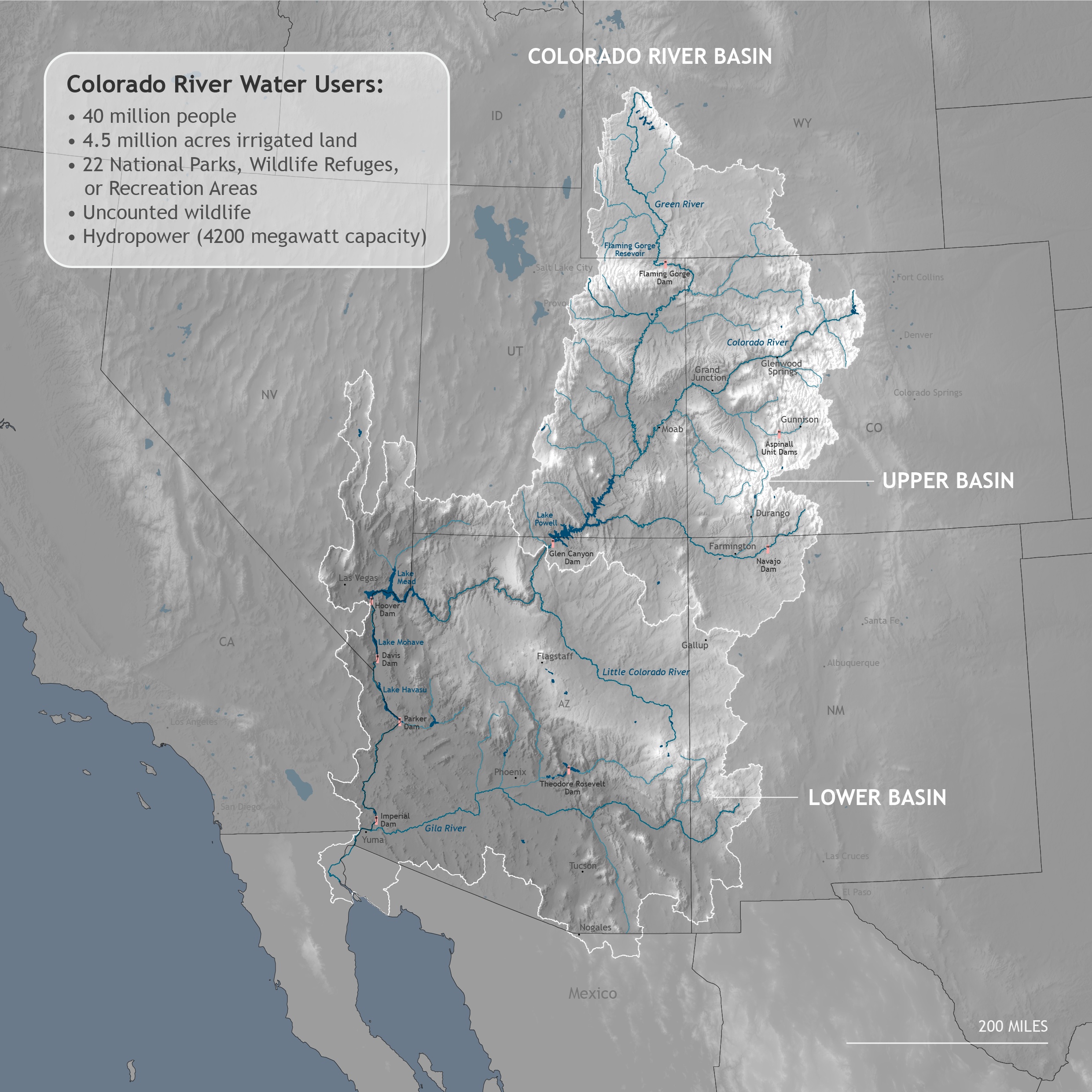