
Take the time to thank a veteran for their service today.

Take the time to thank a veteran for their service today.

From the Valley Courier (Julia Wilson):
“We were one of 60 schools from Colorado, New Mexico, Texas and Mexico that tested the river for 11 different parameters on the same day and at the same time,” said AHS science teacher Katie Montague. The goal of the study is to create a snap shot of the river from the headwaters all the way down into Mexico. The plan is to continue the project annually to create a history of data that can be analyzed by scientists now and in years to come.
“This is an incredible accomplishment,” Tricia Cortez, Dia del Rio 2010 coordinator with the Rio Grande International Study Center that sponsored the project, said. “We created tremendous excitement among teachers and students throughout the basin, and witnessed a growing awareness and concern for issues impacting our river and watershed. With the help of our many partners throughout the basin, we hope to replicate this event year after year.”
More Rio Grande River basin coverage here.

From the Fort Collins Coloradoan (Bobby Magill):
“In my view, there’s a very high risk there’s not enough water,” Eric Kuhn, manager of the Glenwood Springs-based Colorado River Water Conservation District, said Friday.
Many residents of southwestern Wyoming fear Million’s Regional Watershed Supply Project could kill the region’s recreation economy centered on Flaming Gorge Reservoir.
Kuhn spoke to some of those residents in Rock Springs in late October to provide them with a western Colorado perspective of the implications of the pipeline…
Long term averages of water flow in the Green River suggest there’s plenty of water in the river system that hasn’t been appropriated for human consumption, Kuhn said. But averaging the river’s declining flows over the last 30 years, “it’s nowhere close,” he said.
If the pipeline were to deplete Flaming Gorge of its water, southwest Wyoming’s recreation economy could take a huge hit, he said. “I think there’s going to be significant opposition in Wyoming, and specifically in southwestern Wyoming, to this project,” Kuhn said.
Million said Kuhn and the Colorado River District have a political agenda aimed at keeping as much water as possible in the Colorado River system rather than letting it be pumped to the Front Range.

From email from Reclamation (Kara Lamb):
We have passed the half-way mark in our annual maintenance across the Colorado-Big Thompson Project. There are roughly four weeks left.
This afternoon, we started running water through the Alva B. Adams Tunnel for some power generation on the upper portion of the project. As a result, Lake Estes is anticipated to rise a couple feet in water level elevation. It will begin a more typical pattern of water level fluctuation by Friday.
At 10:00 p.m. on Thursday, November 11, we will begin increasing releases from Lake Estes through Olympus Dam to the Big Thompson River. The first release will increase by 100 cfs, bringing the river below the dam to about 140 cfs. At 11:00 p.m., we will increase by about 150 cfs, putting 300 cfs in the river below the dam. We will increase by about 90 cfs around midnight, putting the river at about 440 cfs. We anticipate that releases to the Big T will range between 390-440 cfs for the next couple of weeks, possibly longer. The duration of the release through Olympus Dam, and the rate of flow, are largely dependent on freezing temperatures.
Water released to the river will be recaptured at the Dille Diversion near the mouth of the Big Thompson Canyon. From there it will run, via the Charles Hansen Feeder Canal, to Horsetooth Reservoir. Currently, Horsetooth is at an elevation of about 5378. It should start rising again by Friday afternoon.
Meanwhile, flows to the southern power arm of the system will remain on hold. Annual maintenance continues at the Pole Hill Power Plant, in the Bald Mountain Pressure Tunnel, at the Flatiron Power Plant, and along portions of the Charles Hansen Feeder Canal south of the Big Thompson Canyon. As a result, both Pinewood and Flatiron reservoirs remain drawn down to dead storage. We anticipate both reservoirs will start refilling in mid-to-late-December.
For the last week, Carter Lake has maintained an elevation around 5682 feet. However, it will likely drop more before the middle of next month. It is anticipated we will begin pumping water to Carter in late December.
More Colorado-Big Thompson Project coverage here.

From The Pueblo Chieftain (Chris Woodka):
The meetings both will be on Nov. 18: 1 p.m. at the Gobin Community Building in Rocky Ford; and 6 p.m. at the Lamar Community College Bowman Building. Shareholders on the Bessemer, Catlin, Fort Lyon, High Line, Holbrook, Otero and Oxford canals were sent letters last week with information about two lease agreements that would sell water to Aurora and the Pikes Peak Regional Water Authority over the next 40 years…
The Super Ditch board has approved agreements that would allow:
– Leases of up to 8,020 acre-feet per year to the Pikes Peak group in El Paso County for the next 40 years. The amount of water could increase to 20,000-25,000 acre-feet per year over time.
– Leases of up to 10,000 acre-feet per year to Aurora in three years out of 10, subject to restrictions specified under intergovernmental agreements until 2048.
Only the consumptive use of water could be leased and farm ground would have to be dried up during the lease period. Leases would be for $500 per acre-foot and the Super Ditch would be responsible only for moving the water to Lake Pueblo. The rate would escalate according to the Colorado Municipal League Utilities Index, and the leases could be extended by mutual agreement.
More Arkansas Valley Super Ditch Company coverage here and here.
Schweizer said the Super Ditch board has talked about limiting the participation to 30-35 percent of acreage.

From The Douglas County News Press (Rhonda Moore):
On Oct. 26, Utilities Director Ron Redd proposed to increase water rates over a five-year period, beginning in 2011. Redd presented a plan to introduce a tiered approach that by 2015 will have a net affect of a 30 percent rate increase for residential customers. Over that period of time, commercial customers will experience a drop in their water bills of more than 2 percent, beginning with a 17 percent rate decrease in year one and continuing with annual rate increases through year five. The reason for the decrease to the commercial rates is an adjustment to the fixed costs associated with its customer base, Redd said…
If town council approves the rate increases at second and final reading, customers will begin seeing changes to their water bills beginning in January, 2011. The average residential customer will pay about $6.25 more per month for water, or a 5.88 percent increase. Those increases will continue through 2015, when residential customers will be paying about $32 more each month, or $384 per year, than they pay today. In the first year of the rate increases, commercial customers will save abouyt $50 each month, with a 17 percent decrease in their bills. The commercial rates will then undergo various rate increases over the next four years, resulting in a two-percent decrease from what they pay today.
More infrastructure coverage here.
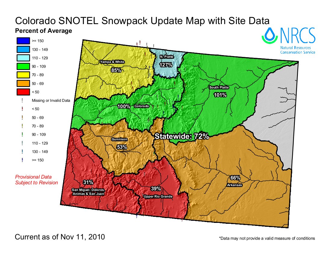
From the Glenwood Springs Post Independent:
Overall, the snowpack for the [Roaring Fork] watershed is at 81 percent of average. However, the upper Roaring Fork River drainage is starting off the season with above average snowpack, while the upper reaches of the Crystal River drainage are well below average…According to the report, the Roaring Fork at Independence Pass was 125 percent of average as of the first of November, while the Crystal at Schofield Pass was at just 44 percent of average.

From the Pagosa Sun (Marsha Porter-Norton):
The San Juan River Workgroup will meet at 5:30 p.m. Monday, Nov. 29. This meeting was rescheduled from a previously announced date. The meeting location is the Ross Aragon Community Center. The Workgroup will discuss the East Fork…
To learn more and to find all the meeting handouts, schedule and minutes as well as information about the River Protection Workgroup go to http://ocs.fortlewis.edu/riverprotection/ (click on “San Juan River Workgroup” on the left side) or call the Southwestern Water Conservation District at 247-1302 or call the San Juan Citizens Alliance at 259-3583.
More San Juan River basin coverage here.

I ran across a cool graphic on Wikipedia this morning that shows global tropical cyclone tracks. With the miracle of computers the graphic designer was able to flatten the earth on top and bottom while overlaying the tracks of tropical cyclones. Click on the thumbnail graphic to the right to see it in detail.