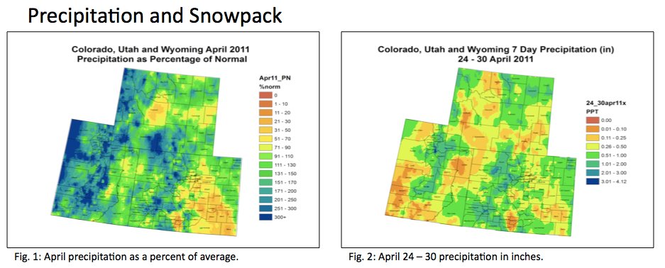
Cortez: Watering restrictions start May 15

A picture named watersprinkler.jpg

From the Cortez Journal

Watering restrictions are enforced between May 15 and Sept. 15 each year. During this time, watering of yards is not allowed between the hours of 10 a.m. and 5 p.m…

The city recommends using alternative grass types such as fescues, wheat grasses, and blue grama rather than Kentucky bluegrass. They require less water and are easier to maintain. Your local garden center can give you more information on the best grass for your property.

More conservation coverage here.

Snowpack news: Snowpack as a percent of average climbs again with this week’s beautiful rain (and snow)

A picture named snowpackcolorado05122011

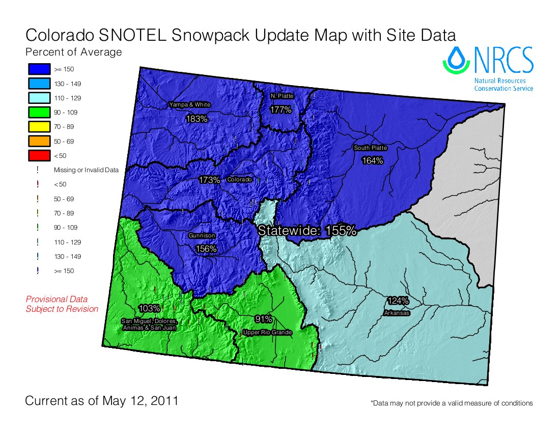
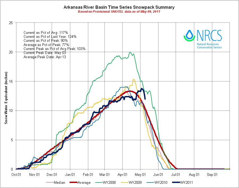
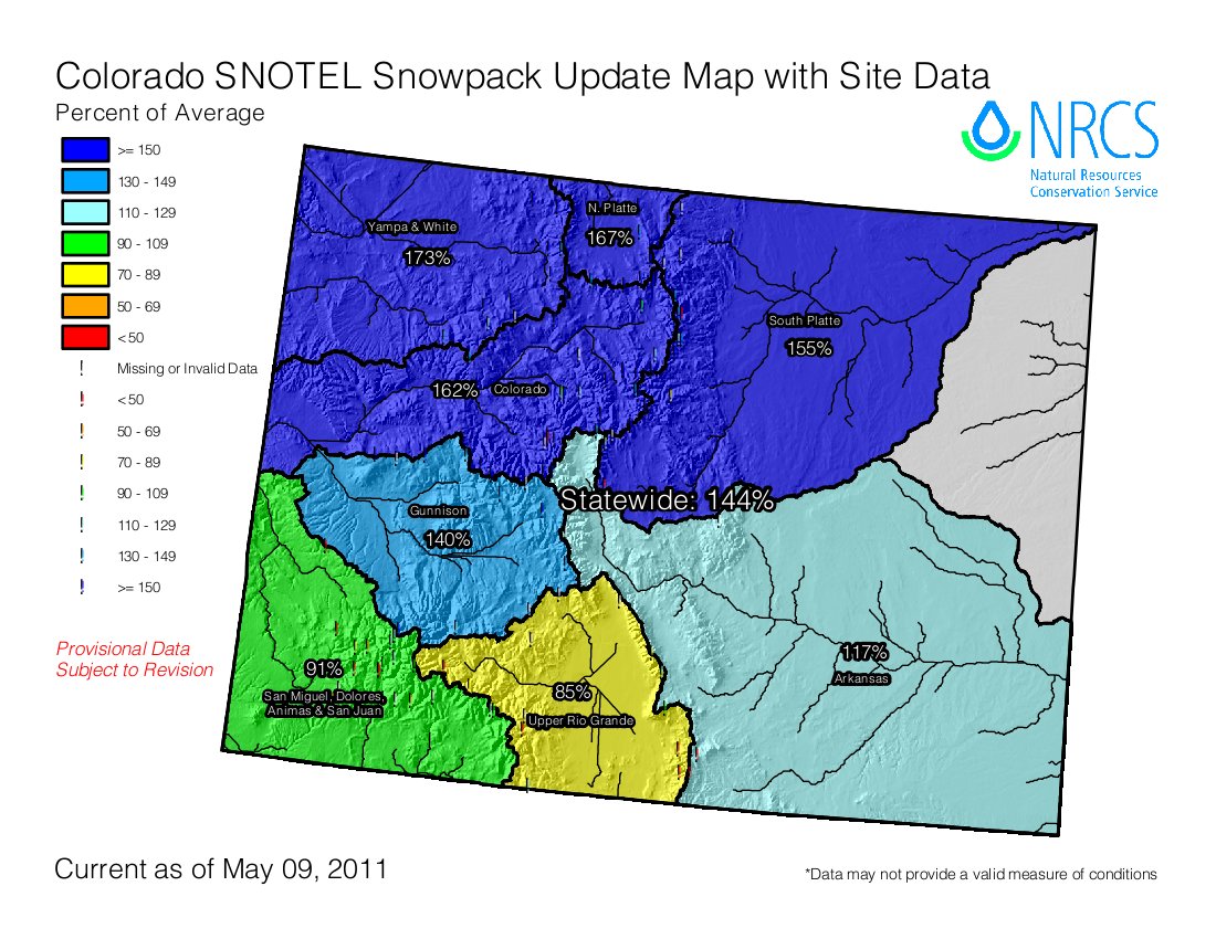
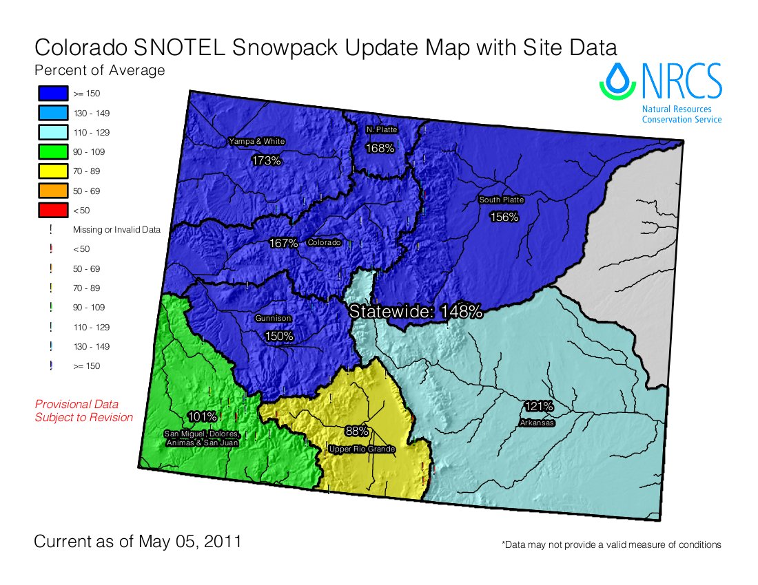
Snowpack as a percent of average keeps climbing across the state. This is a reflection of the cool temperatures delaying runoff. This week’s storm added to the impressive numbers — statewide snowpack is 155% of average.

On Wednesday at the combined Flood and Water Availability Task Forces meeting, Mike Gillespie from the NRCS, cautioned those present not to pay a whole lot of attention to the percent of average snowpack. He said that at this time of year the numbers are skewed by past melt-outs. He said that he looks at the current peak as a percent of average peak number. For example, the South Platte basin’s current peak as a percent of average peak is 146%.

Click here for the snowpack time series graphs for Colorado from the Natural Resources Conservation Service.

Arkansas River Roundtable recap: Is the state paying enough attention to the water needs of agriculture?

A picture named spainsunflower.jpg

From The Pueblo Chieftain (Chris Woodka):

“We’ve established that there is a need for municipal and industrial water by 2050, and it’s a discussion point at a very high level in the state,” said Reeves Brown, a Beulah rancher who also sits on the Lower Arkansas Valley Water Conservancy District board. “But we’re hurting ourselves by not contemplating how much agriculture we need at this time.”

His comments struck a chord with other members of the roundtable during a routine discussion of how the roundtable’s progress will be reported to the state…

“We just let the ag water float around in discussions, but have no way of quantifying what we need,” Brown said. “Agriculture has a value that I think society as a whole is overlooking.”

Some believe growing enough food in the coming decades will be a problem that needs to be addressed on a global scale. “Maybe with 5 million people coming, we should start talking about a food gap,” said Jeris Danielson, a water consultant and former state engineer. “Also, I agree we have not looked at the environmental benefits of water used in agriculture.”

More IBCC — basin roundtables coverage here.

Colorado State University — Pueblo: 1,300 students attend the ‘Discovering Water in Pueblo’ water festival

A picture named studentslesherjhsamples.jpg

From The Pueblo Chieftain (Chris Woodka):

Now in its 13th year, the water festival continues to enchant youngsters — all 1,900 of them who attended Thursday’s event. Ask a group of them what their favorite exhibit was and the answers will change as quickly as Colorado weather. “Aqua-robics,” one boy said confidently.

“He means aerobics,” a girl nearby chimed in.

“No, it was called aqua-robics,” another girl added.

So, what did the girls like?

“Aqua-robics.”

“Aqua-robics.”

And the next five as well. There’s a ton of peer pressure in fourth grade…

The annual event is primarily sponsored by the Pueblo Board of Water Works, the Bureau of Reclamation, CSU-Pueblo, the Southeastern Colorado Water Conservation District, St. Charles Mesa Water District and Pueblo West Metropolitan District. Numerous other local agencies have exhibits and local businesses have signed on as co-sponsors.

More education coverage here.

Grand County: Nearly 400 students participate in ‘Watershed Week’

A picture named grandlake.jpg

From the Sky-Hi Daily News (Tonya Bina):

The nonprofit Grand County Water Information Network coordinated with teachers to bring all sixth- through eighth-grade students on field trips to the rivers, to water treatment plants, to diversion system tours, on ranches or at the molybdenum mine…

Watershed Week “reinforces that responsibility at a young age when students are being introduced to scientific principles,” [said Alex Brooks]. East Grand sixth-graders learned about timely issues such as human impacts on the watershed through water diversions in the Grand Lake area. A representative of the Northern Water Colorado Conservancy District shared information with classes, as well as a member of the Grand Lake Area Historical Society, who talked about Grand Lake’s pre-diversion history. Students also learned how the mountain pine beetle epidemic affects the watershed…

West Grand sixth-graders learned how the Climax molybdenum mine has a responsibility to return clean water to the river. The class also conducted snowpack measurements and learned about the mountain pine beetle. East Grand seventh-graders toured the Fraser Ponds and learned about fish stocking from the Colorado Division of Wildlife and about riparian habitats. West Grand seventh-graders toured Muddy Creek, sampled bug life in the stream, learned about ranch irrigation, and learned of healthy soils from the Bureau of Land Management. And eighth graders from East Grand learned how chemistry is used in wastewater treatment at the Granby and Tabernash treatment plants. The classes also did water quality sampling on the Fraser River. At West Grand, eighth graders toured the Hot Sulphur water treatment plant and did water sampling on the Blue and Colorado rivers. They also learned about the water used at the Climax Mine.

More education coverage here.

Colorado-Big Thompson Project update: Horsetooth and Carter reservoirs on the rise

A picture named coloradobigthompsonmap.jpg

From email from Reclamation (Kara Lamb):

Northern Water is ending the non-charge program on Wednesday, May 11–tomorrow morning. As a result, the pump up to Carter Lake will go back on and inflows to Horsetooth Reservoir will pick up. The delivery of water through the concrete chute at the mouth of the Big Thompson Canyon will also end.

By tomorrow afternoon, upwards of 220 cfs will be flowing into Horsetooth Reservoir. Both it and Carter Lake are expected to begin rising again.

Meanwhile, the warm days over the weekend have generated a little melting snow coming into Lake Estes up in Estes Park. As a result, we have been bumping up releases from Olympus Dam to the Big Thompson River. Tonight, May 10, at midnight, releases will bump up again to about 200 cfs.

We are also updating our webpages as we move into the spring run-off season. When you visit us on-line, be sure to check the menu on the left side of the page for updates on other features around Reclamation’s Eastern Colorado Area Office. We are also tracking snow pack and reservoir levels.

More Colorado-Big Thompson Project coverage here.

Snowpack/runoff news: The Rio Grande Roundtable gets the bad news about water year 2011 runoff

A picture named riograndebasin.jpg

From the Valley Courier (Ruth Heide):

Referring to the Rio Grande and Conejos River systems, [Division of Water Resources Division 3 Division Engineer Craig Cotten] said, “We are looking at about a 75 percent of average year on both systems, roughly.”

Cotten said he is maintaining the same streamflow forecast in May as he had in April for both the Rio Grande and Conejos. He said although the Natural Resources Conservation Service (NRCS) has bumped up its estimated streamflow forecast, he is maintaining a more cautious prediction. His office is looking at a preliminary annual flow on the Rio Grande at Del Norte of 480,000 acre feet, the same as predicted last month…

Of the 480,000 acre feet forecast, the Rio Grande would owe 121,000 acre feet to downstream states as obligated by the interstate Rio Grande Compact. Colorado is able to deliver much of that during the wintertime, Cotten said, so only about 10 percent of that obligation would have to be sent downstream during the irrigation season. However, because the system is seeing some return flows right now to help with the compact obligation, the current curtailment of ditches on the Rio Grande is only 6 percent, he added.

Cotten said his office is keeping the same forecast numbers for the Conejos River system as last month, although the NRCS forecast went up slightly there as well. He is looking at 240,000 acre feet annual flow on the Conejos, with 69,000 acre feet of that required to be sent downstream, or a delivery obligation of 16 percent during the irrigation season. The Conejos system is not seeing the same return flows to the rivers as the Rio Grande, so the curtailment right now is 16 percent…

Cotten also reported on the status of the Elephant Butte and Caballo Reservoirs in New Mexico that hold the water for the Rio Grande Compact. Credit water from Colorado and New Mexico is stored in those reservoirs, for example. The reservoirs hold more than two million acre feet but right now contain a fraction of that. “They are dropping significantly every day,” Cotten said. He said there’s a good possibility that all the storage water in Elephant Butte/Caballo will be used up this year so that all that will be left will be credit water and San Juan/Chama water to keep the system going. Most of the credit water is New Mexico’s, he added.

Runoff news: Larimer and Boulder counties on flood watch

A picture named floodplain.jpg

From the Berthoud Recorder:

Flash Flood Watch issued by NWS for foothills portion of Larimer County. Snowmelting with additional rainfall on top of what has already fallen could lead to flooding issues later today. An additional 1″-1.5″ of liquid equivalent is possible through today…

Flash Flood Watch issued by NWS for foothills portion of Boulder County. Snowmelting with additional rainfall in the Fourmile burn area could lead to flooding issues later today. An additional 1″-1.50″ of liquid equivalent is possible through today.

From the Windsor Beacon (David Persons):

State officials have notified area municipalities that it’s possible the Poudre could run as fast as 6,000 cfs. That’s about 22 percent more water and would equal the volume of the April 30-May 1, 1999, flood, widely recognized as a major 10-year event for the town.

Buena Vista: PaddleFest May 27 — 29

A picture named standuppaddling.jpg

From The Mountain Mail:

Hosted by Colorado Kayak Supply, the weekend celebrates the start of the summer paddling season. Additional events include water education, fun competitions, the Buena Vista Pro/Am Rodeo, beer gardens, live music, and movie premieres. Water events include free stand up paddle board and kayak demonstrations, competitions for youths and adults, and high caliber educational on-water courses. Competitions and river demonstrations will be at South Main Square. Flat water paddling events will use the town lake in McPhelemy Park…

More information is at www.ckspaddlefest.com.

More whitewater coverage here.

Colorado River basin: Wildlife Commission hears water plan concerns

A picture named coloradorivergranby.jpg

Here’s the release from the Colorado Division of Wildlife:

Colorado Wildlife Commissioners heard a day of presentations and testimony Friday as they continued to evaluate draft plans to mitigate impacts to fish and wildlife resources submitted by proponents of two major transmountain diversion projects.

The public hearing came midway through the Commission’s 60-day review of mitigation and enhancement plans pertaining to Denver Water’s Moffat Collection System project and the Northern Colorado Water Conservancy District’s Windy Gap Firming project. The meeting was held at the Hampton Inn and Suites on Highway 50 in Salida.

Wildlife Commission Chairman Tim Glenn said he was encouraged that Denver and Northern had incorporated additional changes to their draft plans based on public input during the past several months.

“Denver Water and Northern have listened to the concerns about impacts to fish and wildlife in the Upper Colorado River system and improved their plans in response,” Glenn said. “I think everyone’s focus is the health of these rivers and we look forward to continuing these discussions through staff during the next month.”

Ken Kehmeier, a senior aquatic biologist with the Division, presented staff’s analysis of Denver’s and Northern’s plans for mitigating impacts from the proposed projects as well as enhancing existing conditions on the impacted streams and rivers.

Following staff and public testimony, Commissioners asked for additional information about whether the mitigation plans were sufficient to protect cool water temperatures in the headwaters of the Colorado and Fraser River systems.

They questioned whether flushing flows would be adequate to rejuvenate cobble beds important for trout spawning and trout forage that have been degraded by previous water development. Commissioners said that they would like to see additional funding to help restore healthy river conditions and a legally binding agreement to ensure restoration would occur. They also suggested the Division should have an integral role in developing and managing restoration projects through the adaptive management process known as Learning by Doing.

Denver Water’s Moffat Collection System Project is designed to firm up the yield from its existing water rights on the West Slope, primarily by enlarging Boulder’s Gross Reservoir and diverting additional water from the Fraser, Williams Fork and Blue rivers.

Northern’s Windy Gap Firming Project is proposing to firm up the yield from its existing water rights in the Upper Colorado River by diverting additional water to the proposed new Chimney Hollow Reservoir west of Loveland.

In addition to the Commission’s fish and wildlife mitigation plan process, Denver Water recently announced it had reached a complex legal settlement with Grand County and 33 other groups regarding longstanding concerns about the health of the Colorado River that includes funding for aquatic habitat and development of the Learn by Doing process.

The Wildlife Commission is scheduled to make a final recommendation on the adequacy of the mitigation plans at its June meeting in Grand Junction.

“Healthy river systems are critically important to the future of this state,” Glenn said. “The Commission’s review of these projects has been lengthy and we greatly appreciate all of the input we have received on how we can best fix the river. Water projects like this have to be done right if we’re going to have healthy wildlife and a healthy tourism economy.”

Additional information regarding the Wildlife Commission’s review, including links to DOW staff evaluations of the mitigation and enhancement plans being offered by Denver Water and Northern, can be found on the Division’s web site at: http://wildlife.state.co.us/LandWater/Water/MoffatWindyGapMitigationProjects/.

More coverage from Bruce Willoughby writing for The Denver Post. From the article:

The commission dedicated the day solely to public commentary on two controversial transmountain water diversion projects proposed for Colorado River headwaters, and river advocates crammed the docket with impassioned pleas for assurance that the projects won’t decimate fragile fisheries such as the Fraser River, Williams Fork, Blue River and the Upper Colorado itself. They came away with none…

Representatives from Grand County, Trout Unlimited, Northwest Colorado Council of Governments, Colorado River Landowners and Western Resource Advocates expressed concerns over the proposals by the Northern Colorado Water Conservancy District to annually draw thousands of acre-feet more water from Windy Gap Reservoir for Front Range storage and by Denver Water to increase diversions through the Moffat Tunnel to an enlarged Gross Reservoir near Boulder…

“I see dead brown trout on the bank every year in August because the water temperatures are too high,” said rancher Ron Jones, whose Fraser River frontage merits Gold Medal designation. “If they want to take the water, then they should put the money into doing what it takes to protect the rivers.”

It’s an interesting perspective — putting the health of the rivers ahead of the perceived need for more water elsewhere. There is some money on the table dedicated to enhancement of a portion of the Colorado, but consensus holds that it’s not nearly enough. And as currently proposed, many mitigation measures are conditional upon the volume of water already diverted and stored in East Slope reservoirs, not necessarily what’s happening in the rivers it’s being drawn from.

The Wildlife Commission, meanwhile, finds itself in the compromising position of attempting to address flaws it has identified in the proposals and finding a way to enforce its stance in the next month. After that, the Colorado Water Conservation Board will have 60 days to affirm or modify the commission’s recommendation as the state’s official position.

More Colorado River basin coverage here.

Arkansas River basin: The Pueblo West Metropolitan District Board and Aurora Water reach agreement for a 5,000 acre-foot water swap

A picture named twinlakesdiversionsystem.jpg

From The Pueblo Chieftain (Jeff Tucker):

The resolution, approved unanimously by the board, will allow the district to trade up to 5,000 acre-feet of water owned by the district in Twin Lakes Reservoir to Aurora for up to 5,000 acre-feet it owns and stores in Lake Pueblo…

Prior to the vote, board member Chuck Green noted that such an agreement isn’t anything new. The Pueblo Board of Water Works had a similar agreement with Aurora dating back to 1992. The metro board’s new agreement will actually replace the water works’ agreement, which expires in 2012. Pueblo West attorney Tom Mullans also noted that Aurora will pay an assessment for the number of shares of Twin Lakes water that gets traded to the metro district. Normally, Pueblo West would pay that money, which would have left the district on the hook for up to $100,000 annually, said District Manager Jack Johnston…

The metro board took a number of other water-related actions Tuesday, unanimously approving a $206,466 contract with CH2M Hill Engineers, Inc., to design a pump station to connect the Southern Delivery System to the metro district’s water treatment and distribution systems. The board also unanimously approved a resolution to participate with the Southeastern Colorado Water Conservancy District’s environmental analysis for its proposed excess-capacity master contract. The district’s share of the cost would be about $172,000 during the course of the study.

More Arkansas River basin coverage here.

Flaming Gorge pipeline: A new report commissioned by The Arkansas and Metro roundtables recommends a task force to study the proposed project

A picture named flaminggorgepipelinemillion.jpg

From The Pueblo Chieftain (Chris Woodka):

The report recommends three possible ways to structure a Flaming Gorge task force:

– A stand-alone task force would build on the work of the CWCB and relate to work being done by the Interbasin Compact Committee, but remain independent to provide full attention to Flaming Gorge proposals.

– An IBCC-based task force would allow a wide selection of interests and experts to evaluate Flaming Gorge plans, as well as bring new perspectives into the discussion.

– A CWCB-based task force would focus more direct statewide attention on the project and provide more authority to conclusions reached during the discussions.

More coverage from Chris Woodka writing for The Pueblo Chieftain. From the article:

The scope of the task force was presented to the Arkansas Basin Roundtable at its meeting Wednesday by consultants Mike Hughes and Heather Bergman…

About 80 water leaders across the state were interviewed for the report, which was funded by the Colorado Water Conservation Board at the request of the Arkansas and Metro basin roundtables. Under the $40,000 grant, the consultants identified the need to form a task force. They also will organize the makeup of the task force and set the first meeting, probably in late June. The approach they are leaning toward is forming a free-standing committee, since the respondents disagreed over whether the CWCB or Interbasin Compact Committee should lead the discussion.

The committee would number 17 and be a mix of state officials and various interest groups from both sides of the Continental Divide. The committee probably won’t include the proponents of two versions of a Flaming Gorge pipeline, Fort Collins entrepreneur Aaron Million and Parker Water and Sanitation Manager Frank Jaeger, leader of the Colorado-Wyoming Coalition. It also would not have federal regulatory agencies as members. “Those people need to be in the room, but not at the table,” Bergman said…

“I think Frank Jaeger and Aaron Million need to be on the board,” said Jay Winner, general manager of the Lower Arkansas Valley Water Conservancy District, which has supported Million’s plan as a way to take pressure off farm water in the state. “You have three people building the same project.”

More Flaming Gorge pipeline coverage here and here.

A beautiful rain is falling

A picture named onedayrainfallurbandrainage05112011

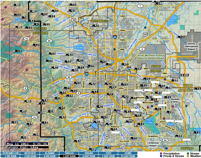
It’s been raining pretty steadily overnight. Click on the thumbnail graphic to the right for a screen shot of the Urban Drainage District’s Alert System map of one day rainfall this morning at 5:36 a.m. The closest gauge to Gulch Manor (Little Dry Creek) is reading .55 inches of precip. At 5:00 a.m. the rain was mixed with snow.

Rainfall is important to the South Platte River basin. Since the runoff has not started in earnest flows in the South Platte River are very low. Yesterday flows at the Denver gage were below 120cfs then it started raining. This morning the Colorado Division of Water Resources Denver gage is showing 285cfs and climbing.

The National Weather Service website is showing a strong band of moisture over most of northern Colorado.

Energy policy – oil and gas: Duke University — ‘Hydrofracking Changes Water Wells’

A picture named marcellushydraulicfracturing.jpg

Here’s the release from Duke University (Timothy Lucas):

A study by Duke University researchers has found high levels of leaked methane in well water collected near shale-gas drilling and hydrofracking sites. The scientists collected and analyzed water samples from 68 private groundwater wells across five counties in northeastern Pennsylvania and New York.

“At least some of the homeowners who claim that their wells were contaminated by shale-gas extraction appear to be right,” says Robert B. Jackson, Nicholas Professor of Global Environmental Change and director of Duke’s Center on Global Change.

Hydraulic fracturing, also called hydrofracking or fracking, involves pumping water, sand and chemicals deep underground into horizontal gas wells at high pressure to crack open hydrocarbon-rich shale and extract natural gas.

The study found no evidence of contamination from chemical-laden fracking fluids, which are injected into gas wells to help break up shale deposits, or from “produced water,” wastewater that is extracted back out of the wells after the shale has been fractured.

The peer-reviewed study of well-water contamination from shale-gas drilling and hydrofracking appears this week in the online Early Edition of the Proceedings of the National Academy of Sciences.

“We found measurable amounts of methane in 85 percent of the samples, but levels were 17 times higher on average in wells located within a kilometer of active hydrofracking sites,” says Stephen Osborn, postdoctoral research associate at Duke’s Nicholas School of the Environment. The contamination was observed primarily in Bradford and Susquehanna counties in Pennsylvania.

Water wells farther from the gas wells contained lower levels of methane and had a different isotopic fingerprint.

“Methane is CH4. By using carbon and hydrogen isotope tracers we could distinguish between thermogenic methane, which is formed at high temperatures deep underground and is captured in gas wells during hydrofracking, and biogenic methane, which is produced at shallower depths and lower temperatures,” says Avner Vengosh, professor of geochemistry and water quality. Biogenic methane is not associated with hydrofracking.

“Methane in water wells within a kilometer had an isotopic composition similar to thermogenic methane,” Vengosh says. “Outside this active zone, it was mostly a mixture of the two.”

The scientists confirmed their finding by comparing the dissolved gas chemistry of water samples to the gas chemistry profiles of shale-gas wells in the region, using data from the Pennsylvania Department of Environmental Protection. “Deep gas has a distinctive chemical signature in its isotopes,” Jackson says. “When we compared the dissolved gas chemistry in well water to methane from local gas wells, the signatures matched.”

Methane is flammable and poses a risk of explosion. In very high concentrations, it can cause asphyxiation. Little research has been conducted on the health effects of drinking methane-contaminated water and methane isn’t regulated as a contaminant in public water systems under the EPA’s National Primary Drinking Water Regulations.

The Duke team collected samples from counties overlying the Marcellus shale formation. Accelerated gas drilling and hydrofracking in the region in recent years has fueled concerns about well-water contamination by methane, produced water and fracking fluids, which contain a proprietary mix of chemicals that companies often don’t disclose.

Shale gas comprises about 15 percent of natural gas produced in the United States today. The Energy Information Administration estimates it will make up almost half of the nation’s production by 2035.

The study was funded by the Nicholas School and Duke’s Center on Global Change. Nathaniel R. Warner, a PhD student of Vengosh’s, was a co-author.

Independent of the PNAS study, Jackson and colleagues at the Center for Global Change, the Nicholas School and Duke’s Nicholas Institute for Environmental Policy Solutions have issued a white paper on hydrofracking at http://www.nicholas.duke.edu/cgc. It includes recommendations for monitoring and addressing potential environmental and human health risks.

Meanwhile, here’s a look at the benefits (jobs, business activity) of the Marcellus shale play in New York along with the drawbacks (greatly increased truck traffic, increased leachate generation, additional odor concerns), from the American Agriculturalist. From the article:

“The Marcellus play has been good for the landfill business,” says Jay Alexander, general manager of the Wayne Township Landfill. But as Larry Shilling, regional vice president of Casella Waste Systems, adds, “The wastes are not without their challenges.”

Both will be speakers during a May 19 web-based seminar on May 19, presented by Penn State Extension. “The Impacts of the Natural Gas Industry on Landfill Operations,” will start at 1 p.m…

The May 19 online Webinar addresses opportunities and concerns. Registration details are on the webinar page of Penn State Extension’s natural-gas website: http://extension.psu.edu/naturalgas/webinars.

Thanks to Loretta Lohman for the link.

More oil and gas coverage coverage here and here.

Gunnison River basin: Dust on snow events equal last year but the mass contained in the dust is much less

A picture named dustonsnowsanjuans.jpg

From The Crested Butte News (Alissa Johnson):

“We’ve had a relatively uneventful dust season,” said Frank Kugel, general manager of the Upper Gunnison River Water Conservancy District. “Thus far there haven’t been any [dust events] with the significant impact on snowpack that we’ve had in recent years, so that’s the good news. The bad news is the snowpack is accumulating and it should be dropping at this time of the year. We are actually higher to date than we were in 2008, so flooding is now getting to be a concern.”

According to Chris Landry, dust-on-snow expert and director for the Center for Snow and Avalanche Studies in Silverton, Colo., the Gunnison Basin has actually seen the same number of dust events this year as last, but there seems to be less dust.
“The difference between this year and last is that the mass of dust contained [in the snowpack] is less. It appears that way, at least. Data samples are still being processed,” Landry said.

More Gunnison River basin coverage here.

Energy policy — geothermal: Two organizations appeal decision to lease USFS land near Tomichi Dome

A picture named geothermalenergy.jpg

From The Crested Butte News (Alissa Johnson):

The Forest Service has received two appeals against forest supervisor Charlie Richmond’s February 4 decision to consent to lease 3,756 acres of National Forest Service land near Tomichi Dome for geothermal development. The parcel is one of two areas approved in March for geothermal leasing by the Bureau of Land Management (BLM), which manages the mineral estate and would manage the sale and development of the leases for both parcels of land…

Public scoping of the potential lease identified a wide range of environmental concerns, including protection for the Gunnison sage grouse, Canada lynx habitat, wetland riparian areas and large game habitat. According to Gunnison District forest ranger John Murphy, there were enough concerns that Forest Service discussion included consideration of not leasing. “There are a lot of restrictions on the lease,” Murphy said. “If somebody decides to operate on National Forest system lands, it will be controlled very tightly.”

Those stipulations include measures such as prohibiting disturbance within four miles of known or yet to be discovered lekking grounds for the Gunnison sage grouse and seasonal limitations on surface disturbance to protect winter game range. But both the Double Heart Ranch and the Center for Native Ecosystems filed appeals against the Forest Service decision to lease. The major points of concern surround the protection of the Gunnison sage grouse.

More geothermal coverage here and here.

Orchard City: The Meadowview Pipeline Company to disband, service will be assumed by the town

A picture named orchardmesa1911

From the Delta County Independent (Hank Lohmeyer):

Under the agreement approved by the town board on April 28, the Meadow View neighborhood will disband their private company and become direct, individual water customers of the town. Roy Fleeger, president of the pipeline company board, said, “The agreement is the result of a lot of hard work by everyone. I know that we spent at least a couple of hundred hours researching different aspects. The town was very responsive to all of our concerns, and when we explained our reasoning they agreed with us on almost every point we raised. The discussions were extremely amicable on all sides.”

Under the deal agreed to, the town will install a new pipeline to serve the neighborhood off of the West Side main line, and each of the 42 current tap owners on the Meadow View system. The town will pay half of the estimated $71,792 cost of materials for the new line. The 42 tap owners will pay the other half for materials. They will also pay installation costs, estimated at $66,800.

More Gunnison River basin coverage here.

Children across the nation are expected to team with the organization Our Children’s Trust to sue state governments over inaction on climate change, there will be a march in Denver on Saturday

A picture named meltwaterlake.jpg

Since the baby boomers don’t have the political will to tackle climate change a generation of children are taking on the job of forcing action. Here’s a report from Vanessa Miller writing for the Colorado Daily. From the article:

The lawsuit is part of a coordinated youth effort to sue government leaders or file administrative actions in all 50 states. A nationwide team of legal experts has been assembled through the nonprofit organization Our Children’s Trust to represent the young people in their lawsuits. Xiuhtezcatl Roske-Martinez, 11, of Boulder, is a leader of the Colorado-based Earth Guardian group and one of the plaintiffs named in the suit against the state of Colorado, Gov. John Hickenlooper, the Colorado Department of Health and Environment, the Colorado Air Quality Control Commission and the Colorado Department of Natural Resources. The goal is to “force action on climate change” in all 50 states, translating to a reduction in carbon dioxide emissions and implementation of reforestation programs, according to the lawsuit.

A gathering of thousands of young people is planned in Denver on Saturday, one of dozens of marches around the world to raise awareness of global warming. “Right now, our governments are not protecting our planet; they are just destroying it,” Xiuhtezcatl said. “I want to make sure my planet is habitable for future generations so we won’t be stuck with this mess.”

Xiuhtezcatl said he’s excited to be part of the march and legal effort, but — above all — he hopes it will make a difference to the adults who are in leadership positions. “I think it’s great that there are lots of other kids in their own state trying to fight for their future,” he said. “But we need everyone to take action — not just the kids.”[…]

The Boulder County lawsuit identifies specific environmental concerns as being tied to global warming and climate change, including reduced water flows, pine beetle destruction, massive wildfires, shortened ski seasons, frequent heat waves and more illness from insect-borne diseases…

If you go:

What: A “mega march” to raise awareness about climate change

When: Noon Saturday

Where: The march will begin at Cuernavaca Park (20th and Platte streets, near REI) in Denver and proceed two miles before ending at Civic Center Park. The event will include speakers, music and entertainment.

From the Colorado Independent (Scott Kersgaard):

A group of Colorado kids filed suit last week against the state of Colorado, Gov. John Hickenlooper, Colorado Department of Health and Environment, Colorado Air Quality Control Commission, and Colorado Department of Natural Resources as part of a coordinated effort to force action on climate change. Similar suits have been filed in all 50 states and against the federal government. In conjunction with the legal actions, youth marches are being held all over the world this week, including more than 60 in the United States, culminating with Denver’s march, Saturday, May 14.

More climate change coverage here and here.

2011 Colorado legislation: Governor Hickenlooper signs HB 11-1289 and HB 11-1274

A picture named smithsditchwashingtonparkdenver.jpg

From The Pueblo Chieftain:

Hickenlooper also signed into law a bill that requires water users’ approval before water structures can get a historical designation. Under HB1289, before a water structure can be placed on the National Historical Register, holders of water rights associated with the structure must consent. Its sponsors said historical designations can greatly delay needed improvements and maintenance to structures and be detrimental to water users…

Hickenlooper also signed HB1274, sponsored by Sen. Gail Schwartz, D-Snowmass Village, which provides $14 million in funding for water projects from the Colorado Water Conservation Board. It devotes $12 million to the Animas-La Plata project on the Western Slope. The bill provides $500,000 to the Arkansas River Decision Support System to map irrigated acreage, delineate parcels and collect surface and groundwater data.

More 2011 Colorado legislation coverage here.

The Palmer Land Trust is seeking nominations for conservation awards

A picture named saguachecreek.jpg

From The Pueblo Chieftain:

The awards recognize significant achievements in Southern Colorado in four categories: Lifetime achievement, recent land protection achievement, exceptional environmental stewardship and innovative conservation projects or programs…The nomination form and award criteria are available at www.palmerlandtrust.org. Nominations are being accepted through June 1.

More conservation coverage here.

Runoff news: Some melt over the weekend but cooler temperatures forecast this week will help delay the runoff

A picture named snowpackarkansasbasin05092011

From The Pueblo Chieftain (Chris Woodka):

For the first time this year, water began flowing through the Boustead Tunnel at Turquoise Lake, where the Fryingpan-Arkansas Project brings water into the Arkansas River basin. “What I’m thinking is that the longer runoff waits to begin, the higher the temperatures will be,” said Roy Vaughan, manager of the Fry-Ark Project for the Bureau of Reclamation. “It’s looking a lot like 2008.” The faster runoff would make it more difficult to capture the projected 94,200 acre-feet of water that could be brought over this year, Vaughan explained. In 2008, the yield from a near-record snowpack was diminished by about 10 percent because of the way it melted.

On Sunday and Monday, the Boustead Tunnel was running about 50 cubic feet per second, or 100 acre-feet per day. The tunnel can run 945 cfs, or almost 1,900 acre-feet daily once snow begins to melt…

Imports from other sources also could be limited by space in reservoirs. There is a healthy snowpack, about 130-150 percent in the Leadville area…

Accounts at Twin Lakes, primarily owned by Colorado Springs, Pueblo, Pueblo West and Aurora, are likely to be topped off. The Homestake Project, a joint venture between Aurora and Colorado Springs, and the Busk-Ivanhoe Project, jointly operated by Pueblo and Aurora, are likely to leave some of their water on the Western Slope because there aren’t many places to put it. Municipal storage accounts are fuller than they have been for years. A two-week extension for storage in the flood-control pool at Lake Pueblo helped in late April, but the level at the lake has been drawn down by agricultural demand in the dry Arkansas Valley in the last two weeks…

Meanwhile, Reclamation has been drawing down Turquoise Lake in anticipation of Fry-Ark imports, making space for 82,000 acre-feet of water. The water also is being moved early to avoid high flows on Lake Creek — which can leach heavy metals into the river — later in the year…

Farmers in the Lower Arkansas Valley are hoping for all the transmountain water they can get, as drought conditions continue. Because cities need less than their full share of Fry-Ark water, about 60,000 acre-feet should be available for use later in the season by valley farmers. The entire eastern part of the state continues to be listed under severe drought, with extreme drought conditions creeping into the southeastern corner of the state near Springfield.

From The Grand Junction Daily Sentinel (Dennis Webb):

There’s currently more than a 50 percent chance of the Colorado River flooding at Cameo, and flooding is all but a certainty on part of the Yampa River, the Colorado River Basin Forecast Center says. The upside is that runoff into Lake Powell is predicted to be 139 percent of average, possibly meaning even more inflow into that reservoir than during the big runoff years of 1995 and 1997, said Eric Kuhn, general manager of the Colorado River Water Conservation District…

The forecast center is predicting a 90 percent chance of the Yampa River reaching an average daily flow of 23,000 cubic feet per second, which is above flood stage, at Deerlodge Park in Moffat County, and odds are 50-50 that the flow could reach 28,000 cfs. It says flooding likewise is all but a certainty on the Green River at Jensen, Utah…

The forecast center says there’s a 50 percent chance of the Colorado River at Cameo topping out at an average daily flow of 28,000 cubic feet per second, and a 75 percent chance of it reaching 24,000 cfs. Flood flow at Cameo is 25,350 cfs. The average annual peak daily flow there is 17,500 cfs.

Snowpack news: The South Platte River basin is dropping against average — 155%

A picture named snowpackcolorado05092011

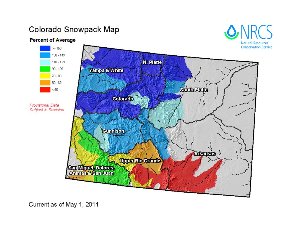
Snowpack is declining against average in the South Platte River basin down from 156% of average since last week. Here’s the link to the South Platte Graph. The Rio Grande and southern Arkansas River basins are hurting.

A picture named snowpackcoloradobysubbasin05012011

Here’s the link to the May 1 Colorado Basin Outlook Report from the National Resources Conservation Service.

From the Delta County Independent (Hank Lohmeyer):

Rob Fiedler, emergency coordinator for the county, reported to the BoCC Monday that 100 inches of wet snow was just measured at the Trickle Park gauging station. “That’s 130 percent of average,” Fiedler said.

Colorado River Cooperative Agreement: Prior appropriation often conflicts with maintaining streamflow

A picture named coloradorivercooperativeagreementmap.jpg

From The Pueblo Chieftain (Chris Woodka):

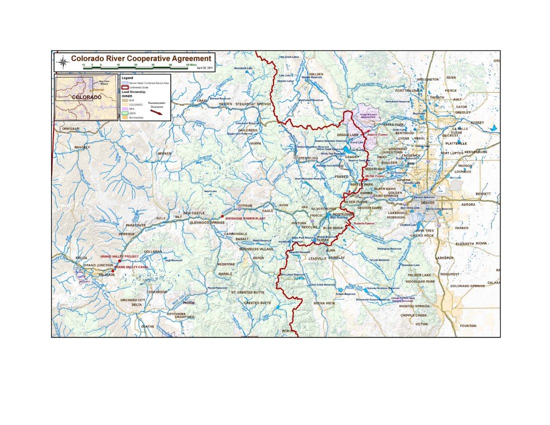
“A change to a water right has become a suicide mission and hamstrings these types of agreements,” [Eric Kuhn, executive director of the Colorado River Conservation District] said at last week’s Interbasin Compact Committee. His comments brought a chorus of agreement, and talk of how to implement flexibility and creativity in water rights among others around the table.

Actually, the state has spent months talking with the negotiators about the kinds of things that might be acceptable in guaranteeing flows, State Engineer Dick Wolfe said this week. “We’ve looked at the agreement in order to talk about implementation,” Wolfe said. “We went through a process to identify flexibility in existing laws.”[…]

There are five separate agreements with state and federal agencies that have to be reached in order to implement the Colorado River Cooperative Agreement. State provisions include a Blue River consent decree from Division 5 Water Court in Summit County, agreement on delivery of consumptive flows from Denver in Grand County, and an agreement on environmental flows. Agreements with the Bureau of Reclamation must be reach on the Shoshone power plant and for Green Mountain Reservoir operations…

“We push to have them take it to water court,” Wolfe said. “It minimizes what a future state engineer or division engineer may decide.” While court decrees are paramount, the state engineer can administer contracts between water users, and can also shepherd state in-stream flow rights (which can only be held by the Colorado Water Conservation Board) to meet flow demands. Water court case filings serve to notify other water users if changes are being contemplated.

More Colorado River Cooperative Agreement coverage here.

Colorado Division of Wildlife: Moffat Collection System and Windy Gap Firming projects hearings recap

A picture named coloradotransmountaindiversionscu.jpg

From The Mountain Mail (Joe Stone):

Commission chairman Tim Glenn pointed out that authority of the commission is limited to review of mitigation plans to address impacts to fish and wildlife by the proposed projects.

Representatives from Grand County, Trout Unlimited, Northwest Colorado Council of Governments, Colorado River Landowners and Western Resource Advocates urged commissioners to seek more extensive measures than those proposed in mitigation plans. Specific issues during public testimony include higher water temperature, insufficient flushing flow, nutrient loading, effect of climate change, need for monitoring and adaptive management and adequacy of long-term financing…

Studies cited during testimony indicate mayfly species below Windy Gap Reservoir have been reduced from 17 species in 1983 to five species in 2010. Stonefly species have declined from 10 to four during the same time. Both insects are important food sources for trout.

Commissioners heard from the City of Broomfield and Platte River Power Authority who support mitigation proposals. They said reservoir projects would strengthen their operations…

Final recommendation from wildlife commissioners is due in June. After the wildlife commission adopts a final recommendation, the Colorado Water Conservation Board will have 60 days to affirm or modify it.

More coverage from the Associated Press via the Aurora Sentinel. From the article:

At a meeting Friday in Salida, Grand County was among those who told wildlife commissioners to better preserve stream flows so that river temperatures are cool enough for fish to thrive, and so that river systems can be flushed of sediment that can choke bugs that provide food for trout…

Both water suppliers have proposed steps such as not diverting water to their systems in the summer when stream flows drop below a certain level or when water temperatures get too high. Critics said diversions should be restricted whenever those thresholds are crossed, not just on certain dates.

More Moffat Collection System Project coverage here. More Windy Gap coverage here.

Aspinall Unit update: Flows in the Gunnison Gorge and Black Canyon should be 3,150cfs by Saturday

A picture named blackcanyoninnercanyonnps.jpg

From email from Reclamation (Dan Crabtree):

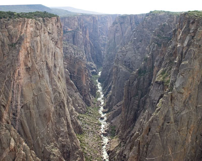
We know there is a lot of interest concerning peak flow operations on the Gunnison River this year. Reclamation would like to assure you that we are taking all flow and timing requests seriously and doing our best to weigh all issues. Timing of the peak operation is dependent on many factors including tributary flows, flooding considerations, and maximizing downstream benefits. Thanks for your patience as we watch these factors and set the timing of the peak operations. As soon as we know, you’ll know.

Flow Update – After further data analysis we found it prudent to increase releases from the Aspinall Unit to assist in accommodating the larger forecasted runoff. Consequently releases from Crystal Reservoir will be increased by 200 cfs per day through May 14th. At that time, flows in the Black Canyon and Gunnison Gorge will be about 3,150 cfs. Again, the one day peak target for the Black Canyon water right is now 6,800 cfs.

More Aspinall Unit coverage here.

Runoff news: Flood risks and drought both attributed to La Niña

A picture named cherrycreekflood08031933castlewooddamfailure.jpg

From the Associated Press (Lynn DeBruin/Catherine Tsai) via MSNBC.com:

Randy Julander, supervisor for the Utah Snow Survey, described more colorfully the disparity between the snow buried, flood endangered parts of the West and those that are parched and burning: “They’re wishing they could get a little of what we have. (The wet weather) just continues to get worse. At this point, all you can do is open the chute, let her buck and hope your butt stays glued to the saddle.” Julander was referring to the coming melt with snowpacks at 200 percent of normal or higher throughout northern Utah. One lower-elevation area in the mountains 50 miles east of Salt Lake City is at 750 percent of normal — with another big storm headed to the region early this week…

In Colorado, the city of Denver and Loveland Ski Area are separated by a mere 75 miles. Yet, the city, east of the Rockies on the high plains, has had only 21.8 inches of snow this season, the second-lowest in history with records dating back to 1882. Loveland, at the top of the Continental Divide, entered the weekend within four inches of breaking its season snowfall record of 572 inches (some 49 feet, set in 1995-1996). “It’s almost a record low for one and a record high for another. You get the idea how extreme that is,” said Kevin Houck, an engineer with the Colorado Water Conservation Board. “If I were a water manager, I’d be very happy about this.”

From 9News.com (Lori Obert):

In Grand County, emergency management officials say Lake Granby is expected to see 25 percent higher inflows this year than in years past. Grand County is offering free sandbags to its residents. Emergency management officials believe this could be the worst year of flooding since 1985.

From the Associated Press via the Aurora Sentinel:

The possibility of flooding is at its highest in recent history, and federal authorities have been reporting “unbelievable” snow levels across the northern mountains, with snowpack northeast of Steamboat Springs measuring more than 200 inches deep, or about 16.6 feet…

Overall snowpack levels for the Yampa/White basins were reported at 165 percent of average. Levels northwest of Fort Collins were measured at 160 inches, or nearly 13.5 feet. In some locations, the snow was almost too deep to measure…

The Rio Grande basin measured in at only 72 percent of average. Dry vegetation, low moisture levels and high winds have sparked several wildfires in the region and national wildfire experts have been predicting a costly season in the area as they continue to struggle with drought conditions. About 180 miles east, Greeley officials have also begun to prepare for high water levels from the spring runoff. They predicted the flow rate of the Poudre River north of the city to peak at 6,000 cubic feet per second — enough to fill four Olympic size swimming pools every minute. The highest flow rate ever recorded for the Poudre river peaked at 6,610 cubic feet per second in 1999 when the river flooded its banks, caused several road closures and threatened homes.

Rio Grande River basin: The river is in trouble this year from stem to stern

A picture named usdroughtmonitor05032011

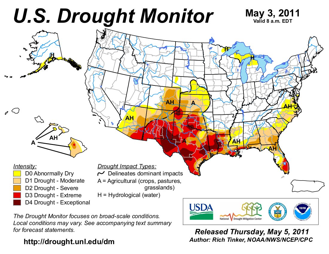
Click on the thumbnail graphic to the right and check out the Rio Grande basin. The river is in trouble this year from stem to stern. Here’s a report from Matt Hildner writing for The Pueblo Chieftain. From the article:

“It’s really in tough shape after this winter,” said Cindy Villa, a range specialist for the Natural Resources Conservation Service. While scattered portions of the valley may be in decent shape because of a high water table or exceptional weather, the majority of the 1.3 million acres of private range land is in either severe or moderate drought, according to the U.S. Drought Monitor. The National Weather Service’s monitoring station in Alamosa recorded only 10.5 inches of snowfall this winter. That total, which is 21 inches below average, ties the winter of 1999 and 2000 as the third-driest on record…

Gary Snell, who oversees the grazing programs for both federal agencies in the valley, said the main concern if conditions don’t improve would be a lack of drinking water for the herds if creeks and springs run dry at lower elevations.

From National Public Radio (John Burnett):

Standing on a sand bar spawned by the drought conditions, Texas Parks and Wildlife official Randy Blankinship points to where the Rio Grande should empty into the Gulf of Mexico — but no longer does. “It looks like the mouth of the Rio Grande is about 100 yards from the Gulf,” he says. “It comes about 100 yards short of its destination.” This is just one symptom of what is becoming the longest drought on record, surpassing even the devastating dry spell of the 1950s.

Bobby Sparks grows cotton and grain sorghum in the Rio Grande Valley, at the southern tip of Texas. When well-watered, locals brag, this soil grows the sweetest grapefruit and the juiciest melons on the planet. But seven years of drought has cost millions of dollars in crop losses, and left the farmers dispirited, Sparks says: “We’ve got people talking about retiring, talking about selling out, putting up mobile home parks… anything to generate money. They realize water is never gonna be here like it used to be.”

More Rio Grande River basin coverage here.

Uncompahgre Watershed Partnership and the Mountain Studies Institute ‘Abandoned Mines and Water Quality Conference’ recap

A picture named uncompahgrewatershed.jpg

From The Telluride Watch:

The conference, attended by over 50 community members, regional county commissioners and state and federal agency managers, and by AmeriCorps VISTA volunteers, examined varying perspectives regarding the future of mining in the county and its potential effects on water quality and on local and neighboring watersheds. Rob Runkel, of the US Geological Survey, discussed what is happening above Ouray in the historic Red Mountain Creek mining district, and Camille Price, project manager for the Colorado Department of Public Health and the Environment, discussed the history and remediation of the Idarado mine. MSI’s Chris Peltz gave a presentation on possible remediation solutions, one of them Biochar, a product made from beetle-kill lodgepole pine that is used to add carbon to damaged soil systems.

Colorado Trout Unlimited’s Snake River Project Manager Elizabeth Russell discussed Navigating Liability in Watershed Restoration, followed by a panel discussion moderated by Pat Willits of the Trust for Land Restoration. In that discussion, representatives from The Lake Fork Valley Conservancy, Animas River Stakeholders Group, Willow Creek Reclamation Committee, Kerber Creek Restoration Project, and the Coal Creek Watershed Coalition gave histories of their group’s formation, and reported on their organizations’ progress in recent years…

Interested parties can visit www.uncompahgrewatershed.org, for a Power Point Presentation, and to find out more about the organization, and to be kept apprised of upcoming meetings the UWP is organizing, concerning Total Daily Maximum Loads and about Non-Point Source Discharge Permits and how they work. The UWP and MSI would like to thank MOSAIC Community Project, Alpine Bank, Colorado Trout Unlimited and Colorado Non-Point Source Pollution Program for their financial support.

More Uncompahgre River watershed coverage here.

Ruedi Reservoir: Inspections for invasive mussels to resume later in the month

A picture named zebramusselinfestation.jpg

From The Aspen Times (Janet Urquhart):

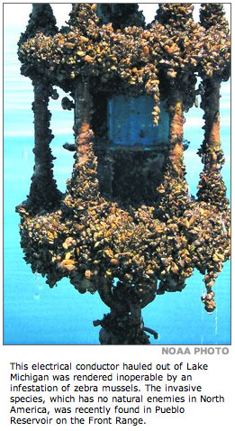
Boaters at Ruedi Reservoir, east of Basalt, will again face weekend inspections, starting in late May, but the future of the program — an effort to prevent the spread of invasive species — is unclear. The Ruedi Water and Power Authority stepped up last year to spearhead the inspection program on summer weekends from Memorial Day through Labor Day. In 2009, inspections were infrequent — the Colorado Division of Wildlife arranged for a roving inspection unit to set up occasionally at the Ruedi boat ramp, adjacent to the Ruedi Creek campgrounds. This year, RWAPA hopes to have more people involved, in order to speed up the process of checking boats at busy times, according to Mark Fuller, the authority’s director. Inspectors are looking for zebra and quagga mussels, destructive species that have infested other Colorado reservoirs, but have not been detected in Ruedi, according to Fuller.

More invasive species coverage here and here.

CWCB: The Joint Water Availability & Flood Task Force meeting May 11 will include a discussion of activating the state drought plan

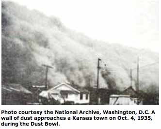
A picture named dustbowl.jpg

From email from the CWCB (Ben Wade):

A Joint Meeting of the Water Availability and Flood Task Forces is scheduled from 1:00-3:45pm on May 11 at the Colorado Division of Wildlife, 6060 Broadway, Denver, CO, in the Bighorn Room. [Here’s the agenda.] Please Note: There will be a discussion on the activation of the State Drought Mitigation & Reponse Plan.

South Platte Roundtable April 12 meeting notes

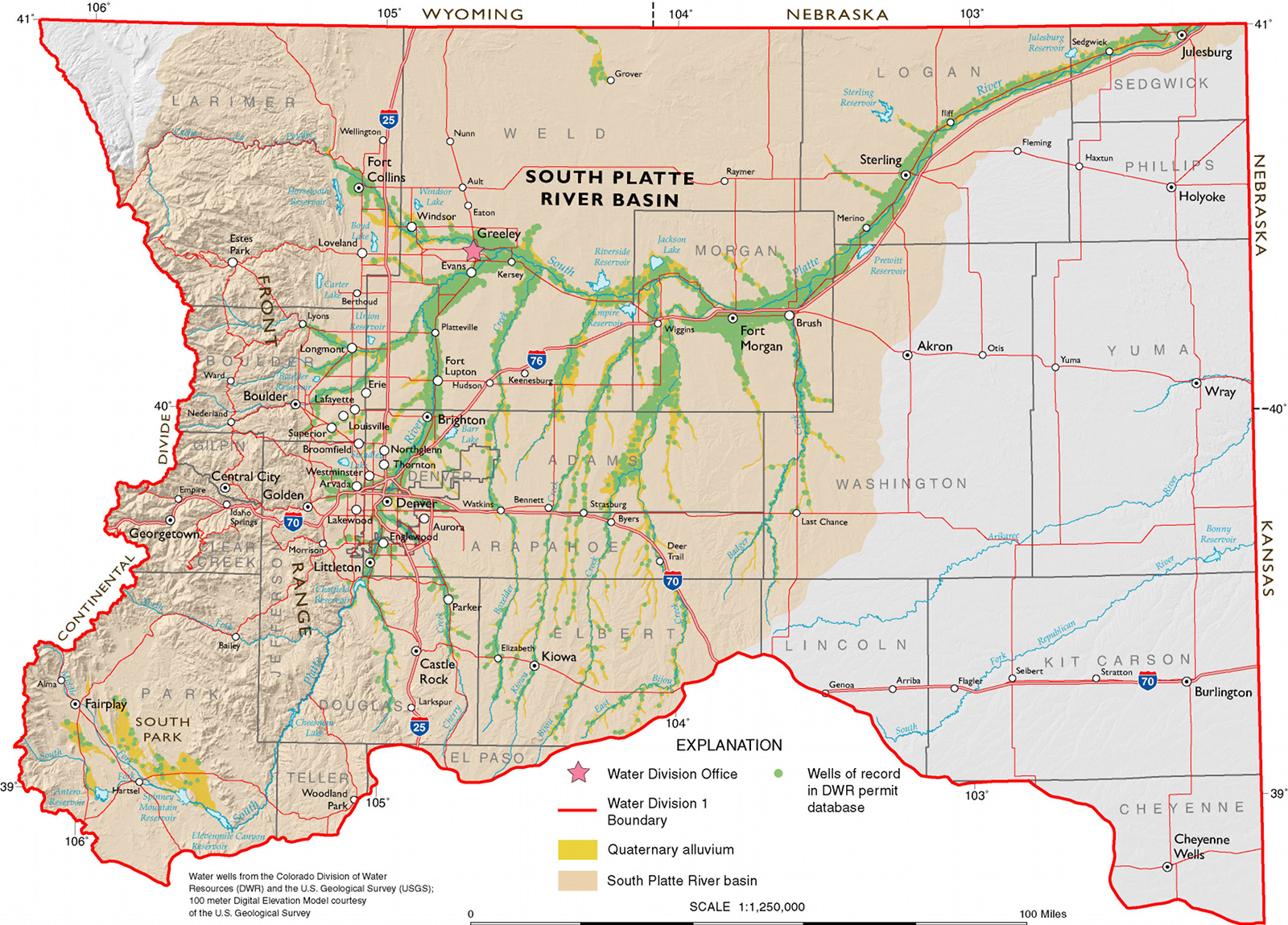
A picture named southplatteriverbasincgs.jpg

Click here for the notes from the April 12 roundtable meeting.

More IBCC — basin roundtables coverage here.

Flaming Gorge pipeline: Aaron Million — ‘I have tried and tried to get the state more involved’

A picture named flaminggorgepipelinemillion.jpg

If you ask me I’d bet that most at the state prefer not to pick a winner when he’s hoping to run a for profit operation in the middle between water users and water supply. There will only be one last large transmountain diversion to the Front Range. Here’s a report from Chris Woodka writing for The Pueblo Chieftain. From the article:

“I think the Interbasin Compact Committee needs to evaluate and perhaps use a third party to look at the three projects that are out there,” Million said. He includes Flaming Gorge, Blue Mesa and Yampa pump-back projects that were included in a preliminary report by the Colorado Water Conservation Board. “Then they ought to make a recommendation to the governor, and the governor ought to promote it,” Million said. While there are others interested in the project, Million said the public-private model is the best way to get the job done. Private construction of the pipeline could save the state 30 to 50 percent on costs, and Colorado and the federal governments are already struggling with huge fiscal problems…

He ticked off benefits to the state:

– Flaming Gorge Reservoir would provide 3.8 million acre-feet of storage that is already constructed.

– “It takes pressure off the Colorado River basin so they can develop their water resources as they see fit.” The state also could look at ways to include Western Slope benefits such as those included in the proposed Colorado River Cooperative Agreement.

– It would provide a new source of water and reduce pressure on agricultural water rights in the South Platte and Arkansas River basins.

– Million also wants to provide either direct or return flows for environmental purposes.

More Flaming Gorge pipeline coverage here and here.

Happy National Train Day

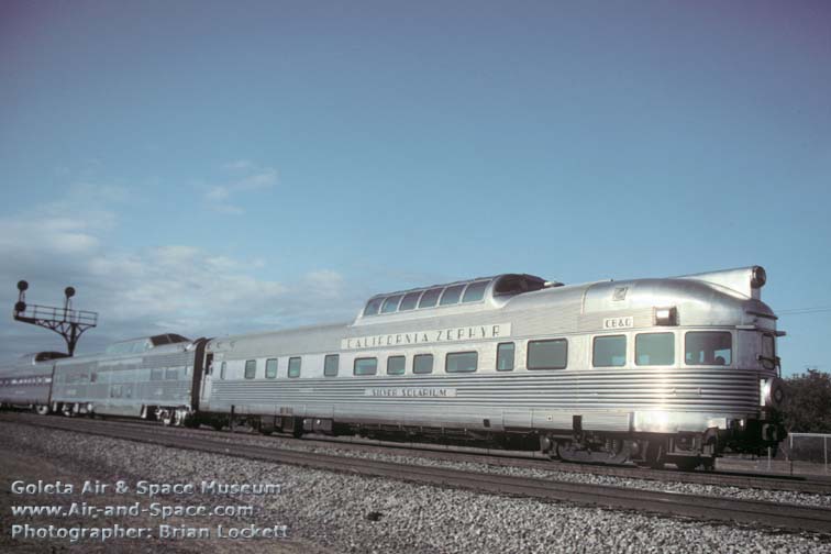
A picture named californiazephyr.jpg

When Mrs. Gulch and I arrived at Chicago Union Station this afternoon it was overrun by people celebrating National Train Day.

Snowpack/precipitation/runoff news: Lake County tallies 166.6 inches of snow for the water year so far

A picture named snowpackcolorado05052011

From the Leadville Herald-Democrat (Carol Werckman):

According to local weather guru Charlie Kuster, so far through April 30 of this snow year, which isn’t over until June 30, Lake County has received 166.6 inches of snow. This is almost 150 percent of normal, he said. Normal is around 114 inches…Climax records support the “lots of snow” theory. So far, as of April 30, the snowfall at Climax has already broken the record for the annual total, which was 380.1 inches. It now measures 382.3 inches, with one more month of measuring to go. Also, the total for April snow at Climax was just half an inch below the record of 69.8 inches. This April Climax received 69.3 inches.

From the Sky-Hi Daily News (Tonya Bina):

“Everything to Lake Powell is above 100 percent,” said Don Meyer of the Colorado River District, in an overview of May 1 forecasts for probable runoff volumes. The Colorado Basin River Forecast Center indicates early to mid-May would be the optimum time for a prolonged warm period to melt snows and decrease the probability of spring floods…

Collectively, water engineers went out on a limb and guessed that peak runoff may take place from mid-June to the end of June, and that flows on the Colorado River at the Kremmling gauge below the confluence of the Blue River might reach around 12,000 cubic feet per second (cfs), which is about double the peak flow of last year and triple the historical average peak flow of around 4,000 cfs…

operators at Willow Creek Reservoir, a much smaller impoundment constructed to pump water into Lake Granby, are taking it as “low as can take the reservoir safely,” [Andrew Gilmore of the Bureau of Reclamation] said. That’s in preparation for projected runoff from the Willow Creek Basin, which is sitting at a record-breaking 203 percent of average snowpack. Gilmore said Big-Thompson operators are preparing Willow Creek to capture an expected 97,000 acre-feet of runoff, or the equivalent of seven times the capacity of the reservoir…

And Adams Tunnel on the east end of Grand Lake, which sends water to the northern Front Range for power generation and municipal and agriculture use, is running full right now, engineers said. At peak runoff, operators plan to close Adams Tunnel, allowing East Slope reservoirs to capture native runoff on the east side of the Continental Divide…

In the Moffat System operated by Denver Water, Jones Pass has tied the record for the most snow on May 1, said Bob Steger of Denver Water. Steger said Denver Water plans to reserve a certain amount of space in Gross Reservoir to prepare for peaks on the Fraser River. But the “wild card,” he said, is Denver Water’s junior water rights on South Boulder Creek, the water from which is also stored in Gross. At Williams Fork, Denver Water is conducting repairs on the reservoir’s outlet works, which means it is “limping on 70 to 80 cubic feet per second with temporary outlet works,” Steger said. By next week, repairs should be completed, allowing the reservoir to release more water at that time in preparation for capturing runoff.

Colorado-Big Thompson Project update: Making room for runoff

A picture named coloradobigthompsonmap.jpg

From email from Reclamation (Kara Lamb):

The end of this week brought some visible changes to the east side of the Colorado-Big Thompson Project. As most of you have probably already noted, we are preparing for a significant run-off season, when mountain snow melt comes down, increasing flows in rivers and streams. Additionally, some other changes are also going on.

Most importantly, Northern Water, the entity representing the water users for whom the C-BT was originally built, has declared the availability of non-charge water. As a result, yesterday May 5, releases from Carter and Horsetooth Reservoirs went up. Carter is currently releasing around 600 cfs. Horsetooth is releasing upwards of 1300 cfs. Most of that is through Horsetooth Dam, but about 55 cfs is being released for municipal use through Soldier Canyon Dam.

Tomorrow morning two more changes will occur. We will turn off the pump to Carter Lake first thing in the morning, around 7 a.m. Also about that same time, we will increase the release of water to the Big Thompson Canyon at the canyon mouth, right above the Dam Store. We have been releasing just under 200 cfs through today. Tomorrow morning, that release will jump to about 520 cfs. This water is also being released as part of the declared non-charge program. This will make for quite an impressive view from the Dam Store’s upper deck.

More Colorado-Big Thompson Project coverage here.

Aspinall Unit update: The Colorado Basin River Forecast Center released their May 1 forecast — 945,000 acre-feet into Blue Mesa

A picture named aspinallunit.jpg

From email from Reclamation (Dan Crabtree):

The Colorado Basin River Forecast Center (CBRFC) has issued the final May 1st forecast. In the two week period between April 18th and May 2nd the CBRFC forecasts that the runoff into Blue Mesa Reservoir has increased by 145,000 ac-ft to 945,000 ac-ft. This changes the Black Canyon water right one day peak target to 6,800 cfs. Although additionally challenging, Reclamation still plans to operate the Aspinall Unit in a manner which will allow this peak target to be met. Our tentative plans are to implement this peak operation toward the latter part of May or first part of June, depending on the hydrologic behavior of other tributaries. This peak operation will require a spill at Crystal Reservoir of around 3,000 cfs. Normally Reclamation attempts to manage the peak in the mid to late May timeframe, however in some years weather and runoff conditions may dictate the peak occur at a later time.

Also, additional space is required in the Aspinall Unit to accommodate this year’s projected runoff. Consequently, releases from Crystal Reservoir will increase by 100 cfs per day until May 16th when flows in the Black Canyon and Gunnison Gorge will reach about 2,500 cfs. At that time, the mid-May forecast will be evaluated and further increases are likely for the remainder of that week. Further updates will be provided as the time of peak operation approaches.

More Aspinall Unit coverage here.

Animas-La Plata Project: Reclamation is testing the outlet works at Lake Nighthorse

A picture named lakenighthorsesummer2010

From The Durango Herald (Dale Rodebaugh):

Test releases of water, which will occur for about three weeks, accomplish two objectives, first-fill engineer Tyler Artichoker said. “If you build something, you test it to see how it functions,” Artichoker said. “But the tests also will show us how the system works when a project sponsor downstream requests water.”[…]

Test releases, ranging from 5 to 200 cubic feet per second, will show how well drop structures – basins that slow the flow of water and dissipate its energy – work. The basins in effect eliminate 200 feet of the 500-foot drop in elevation from the dam to the river, Artichoker said. There are 11 drop structures in Basin Creek from the dam outlet works to its confluence with the Animas River five miles away. The lower stretch of Basin Creek was left in its natural state except for the drop structures, built of grout-covered rip-rap. Test releases will establish how long it takes for water to reach the Animas, Artichoker said. The information will indicate to project partners in New Mexico how much lead time is required when they want water.

More Animas-La Plata Project coverage here and here.

Durango: The Southwestern Water Conservation District hosts their 16th Annual Children’s Water Festival

A picture named studentslesherjhsamples.jpg

From The Durango Herald (Dale Rodebaugh):

The festival, sponsored by the Southwestern Water Conservation District, brought students from La Plata, Archuleta, San Juan and Montezuma counties. Twenty-three stations, among which students rotated, each presented a different aspect of people’s relationship with water…

Students also learned about water safety, the danger of invasive species such as quagga and zebra mussels, why native Colorado trout are planted in streams and lakes and why wetlands are important. The presentations were made by members of the local, state and federal agencies, private organizations and businesses.

More education coverage here.

Southern Delivery System update: Colorado Springs Utilities inks the final contracts with the Bureau of Reclamation

A picture named sdspreferredalternative.jpg

From The Colorado Springs Gazette (Debbie Kelley):

The U.S. Bureau of Reclamation on Wednesday signed final contracts with Colorado Springs Utilities, the city of Fountain, Pueblo West Metropolitan District and the Security Water District, Kara Lamb, a Bureau spokeswoman said Friday. “All of the issues have been resolved, and the construction of the pipeline can go forward,” she said…

Construction for the pipeline’s first phase is expected to cost $880 million, plus financing costs of 40-year bonds, Rummel said. Utilities issued $180 million in Build America Bonds in September, to pay for construction for this year and 2012. Water rate hikes will help fund the project. Two 12 percent increases, one of which took effect in January, have been approved so far. The connection to two new man-made reservoirs, Upper and Lower Williams Creek reservoirs, is in a future phase and expected to raise the cost of the system…

The final sign-off by participants comes after a 60-day public comment period for 38-year storage, conveyance, and exchange contracts. The period ended April 25.

More Southern Delivery System coverage here and here.

Runoff/snowpack news: Lake Powell is on the rise

A picture named glencanyondamconst.jpg

From KSL.com (John Hollenhorst):

Forecasters had been expecting a good year at Lake Powell from all the snowmelt heading down the Colorado River. But the latest forecast jumped two million acre feet — enough water to fill an acre, two million feet deep! And that’s just the increase over last month’s forecast. “I was surprised that it went that high,” said Richard Clayton, a hydraulic engineer with the U.S. Bureau of Reclamation. “I was aware of the snowpack conditions. but I was very surprised that they jumped it up that fast.” In the coming weeks Lake Powell will rise a few inches a day, then nearly a foot a day heading into summer. “It will increase maybe 15 feet in the next month, but then it’s really going to take off in June,” Clayton said. When the last snow melts, Lake Powell will have risen 50 feet for the year, ending up nearly 25 feet higher than last year.

From the Deseret News (Amy Joi O’Donoghue):

The Green River, infused with the rushing waters of Colorado’s Yampa River, is expected to fill farm fields and damage homes. The Yampa is expected to be 6 to 10 feet above its peak levels.

The estimated inflow into Lake Powell has jumped by 2 million acre-feet of water in just one week, leading the Bureau of Reclamation to revise its estimates on how much the lake will rise. Overall, Lake Powell will receive 11.5 million acre feet because of runoff. Initially thought to fill 10 feet higher, the lake will rise by as much as 25 feet. The BOR’s Ed Vidmar said over the next four to six months, as much water will be released as possible downstream to Nevada’s Lake Mead, and the power plant will run at full capacity. The excess water, he noted, is good news for the Colorado River Basin and for Lake Powell recreationers, with the lake being 45 feet from full by sometime in July.

A picture named snowpackcolorado05052011

From 11News.com:

The National Resource Conservation Service says a water measuring station near Steamboat reached 73 inches of water content. The previous record for that area was 71.1 inches set back in 1978. There was so much snow that the 16 foot tall measuring gauge had to be extended.

From the Vail Daily (Randy Wyrick):

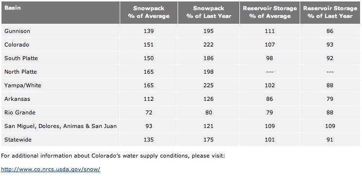
Snowpack for our area — the Colorado River Basin — is 151 percent of normal and more than twice as much as last year (222 percent), according to the United States Department of Agriculture’s Natural Resources Conservation Service…

Vail Mountain set a new snowfall record with 524 inches for the 2010-11 season. The last time Vail Mountain recorded even close to that much snow was during the 1977-78 season, when the resort had 505 inches. In fact, the ski season ended with a winter storm warning that lasted three days.

Colorado River basin: Anglers are still working on protection for upper basin streams

A picture named eisenhowerfishing.jpg

Anglers are still concerned with potential streamflow issues at the Colorado River headwaters, in light of the proposed Moffat Collection System and Windy Gap Firming projects, despite the euphoria over the Colorado River Cooperative Agreement announced a week ago. Here’s a report from Bob Berwyn writing for the Summit County Citizens Voice. From the article:

Altogether, the projects have the potential to reduce Colorado River flows to less than 25 percent of their historic native flows. Biologists and anglers have already observed increases in stream temperatures, algae blooms, and declines in fish populations throughout the Colorado River headwaters. Taking more water out of these rivers could be catastrophic if mitigation efforts fall short, according to Trout Unlimited. Both proposals are currently under review by federal and state agencies, with detailed mitigation plans at issue. The Colorado Wildlife Commission will take input on the mitigation plans Friday, May 6 at a public hearing in Salida, and Trout Unlimited, a coldwater fisheries conservation group, plans to ask the commission to make sure there’s an insurance policy in place for the Fraser River and the Upper Colorado.

“We think what we’re asking for is pretty reasonable,” Whiting said. “This is the only chance we’re going get to address some of these impacts. We need to have an insurance policy,” she added. Whiting said the environmental studies for the Moffat and Windy Gap projects dealt with some of the anticipated impacts in a speculative way, and that there’s no way of knowing exactly how the increased diversions — planned during the peak flow season — will play out. If the money currently earmarked toward enhancements is sufficient, great. But if not, there needs to be a pot of money in reserve to do the needed work, she said. Specifically, Trout Unlimited said that significant restoration work and monitoring will be needed to ensure healthy aquatic ecosystems on the Fraser and Upper Colorado rivers. The group estimates that it will cost about $14 million for the needed work, yet only a fraction of that funding is included in the mitigation plans…

Trout Unlimited also wants the Front Range utilities to make a commitment to stop diversions when the water gets too warm or flows drop too low. Removing too much water from the river during runoff or during critical hot summer months raises stream temperatures and eliminates flushing flows that are needed to keep river ecosystems alive. If flushing flows are not occurring or if temperatures rise above state standards, fish can die. Water providers need to make a commitment to stop diversions when stream temperatures approach state standards or if flushing flows are not occurring in accordance with the community-led Grand County Stream Management Plan. These commitments, combined with ongoing monitoring, are what is referred to by the concept of ‘Adaptive Management.’

More Colorado River basin coverage here.

Arkansas River valley: Irrigators depending on Fryingpan-Arkansas Project flows to hold off this year’s drought

A picture named fryingpanarkansasproject.jpg

Storage is the key for irrigators in dry years. Here’s a report about the use of Fryingpan-Arkansas Project transmountain water in the Arkansas River valley this year, from Chris Woodka writing for The Pueblo Chieftain. From the article:

“Fry-Ark water is about what we live on,” said Donny Hansen, president of the Holbrook Canal. “The longer it stays cold in the mountains, the better for us. We have a junior water right, but a senior storage right because early on they realized we would need it.”

Even the Bessemer Ditch in Pueblo County is looking for a large allocation of Fry-Ark water, and has leased some water from Colorado Springs. “As dry as it is, we ’re really dependent on (Fry-Ark flows) because it just doesn’t seem like it’s going very far,” said Bessemer Superintendent Mike Hill. “The more we can get, the better.”[…]

The Bureau of Reclamation Tuesday announced 94,200 acre-feet of water will be imported through the Boustead Tunnel this year. Of that, a little more than 77,000 acre-feet is expected to be available for allocation, said Bob Hamilton, engineering supervisor for the Southeastern Colorado Water Conservancy District. Requests from municipalities total about 16,000 acre-feet, which would leave more than 61,000 acre-feet for agriculture — about the same amount that would naturally flow into the Bessemer Ditch in an average year. The district will allocate the water later this month.

More Fryingpan-Arkansas Project coverage here.

CWCB: Alan Hamel — ‘To me, Flaming Gorge needs to be in the top two or three projects we consider’

A picture named dnrpipelineconcepts309

Chris Woodka sat down with CWCB member Alan Hamel (Pueblo Board of Water Works) to talk about the future for water supplies in Colorado. Here’s his report from The Pueblo Chieftain. From the article:

“To me, Flaming Gorge needs to be in the top two or three projects we consider,” Hamel said. “I do think Flaming Gorge could take pressure off agriculture in the South Platte and Arkansas basins. It could also eliminate some, but not all, of the West Slope consequences of water projects within Colorado.”

Through the roundtable process, Hamel has been working on a water bank concept with the Gunnison Basin Roundtable that would use Blue Mesa Reservoir as a backstop for junior water rights in the Colorado River basin, rather than piping water from it. Keeping a pool of water available for release during a potential downstream call would prevent the need to curtail transmountain water rights, under the roundtables’ proposal.

Flaming Gorge provides a different advantage by bringing a new source of water into the state, adding storage that could benefit the entire state as well. “With Flaming Gorge, or any new project, we need to prioritize. There are not enough resources to build all of them,” Hamel said.

Hamel, who formerly represented the Arkansas Basin Roundtable on the IBCC, sees a role for both state water agencies in moving a project forward. “To me, the CWCB is the policy side, and it has a talented staff and the expertise to evaluate a project,” Hamel said. “The IBCC can find common ground, communicate and resolve the concerns between the East Slope and the West Slope.”

More CWCB coverage . More IBCC — basin roundtables coverage here.

Snowpack/runoff/precipitation news: Statewide snowpack stands at 148% of average

A picture named snowpackcolorado05052011

From the Fort Collins Coloradoan (Bobby Magill):

[Don Day of DayWeather in Cheyenne] said a major slow-moving storm system is in position to soak Northern Colorado between Monday and Thursday, but there is a possibility the storm could track to the north of the state. Another could blow through the following week, he said. The storms bring the possibility of heavy rain to the mountains, kicking off the runoff season, which could see significant flooding on the Poudre River. “The next four days, we’re going to get the day and nighttime melting,” Day said. “Next week, we’re going to get rain on top of that. It’s the start of about six to eight weeks where we’re really going to be on pins and needles watching (for flooding).”[…]

The water content of the snowpack west of Fort Collins is extraordinary. At Joe Wright Reservoir along Colorado Highway 14, the snowpack’s water content was 194 percent of normal on Wednesday. The South Platte River Basin average is 153 percent, with some snowpack monitoring sites in the North Platte Basin reading greater than 200 percent. Rocky Mountain National Park spokeswoman Kyle Patterson said heavy spring storms above tree line have piled up to 14 feet of snow along parts of Trail Ridge Road that had very little snow this time last year.

With respect to snowpack the rich get richer and the San Luis Valley is still dry as can be. Here’s a report from Ruth Heide writing for the Valley Courier. From the article:

Precipitation in March, for example, was “generally below average across the area,” the Weather Service stated. Alamosa received only 0.02 inches of precipitation in March. “This is 0.44 inches below average for the month and makes March of 2011 the second driest March on record in Alamosa,” according to the Weather Service. At the same time temperatures were mainly above average across the area. Alamosa temperatures during that time period came in 3.9 degrees above average making March the 11th warmest on record in Alamosa, according to the Weather Service…

As of Wednesday, the Natural Resources Conservation Services SNOTEL report for the Upper Rio Grande Basin showed snowpack at 100 percent of average including Wolf Creek Summit, which showed 105 percent of average and Lily Pond at 63 percent. The eastern side of the Valley, the Sangre de Cristo Mountain Range, sat at 54 percent of average on May 4. Overall reservoir storage this spring was running below average across Southern Colorado, with storage in the Rio Grande Basin on April 1 at 82 percent of average overall, below storage levels for that time last year, according to the Weather Service.

Stream flow was generally at or below average on April 1 across the Rio Grande Basin, the Weather Service added. “Water users can expect below average to well below average flows this spring and summer. April to September runoff projections range from 34 percent of average for Sangre De Cristo Creek to 76 percent of average for the Rio Grande at Thirty Mile Bridge, Saguache Creek near Saguache and the inflow to Platoro Reservoir. “The lowest stream flow forecasts in the state are concentrated along the Sangre de Cristo Mountains affecting both the Rio Grande and Arkansas Basins. Runoff forecasts along some of these smaller tributary streams range from 40 to 60 percent of average. Water users across Southern Colorado should plan for late summer shortages especially if the monsoon is disappointing this year.”

A picture named wyutcoprecipitationapril1011coloradoclimatecenter.jpg

Here are the notes from this week’s “NIDIS Weekly Climate, Water and Drought Assessment Summary of the Upper Colorado River Basin” hosted by the Colorado Climate Center. Click on the thumbnail graphic to the right to see the precipitation for April.

From the Summit Daily News (Janice Kurbjin):

A graph by the Blue River Watershed Group shows that the 2011 snowpack in the Colorado River Basin reached about 165 percent of average at the end of last month, surpassing 1984’s snowpack which hit about 160 percent of average in May. Natural Resources Conservation Service data has the Colorado River Basin at 151 percent of average. Water content at Copper Mountain, which flows into Ten Mile Creek, is at its highest this year, and the snow survey site on the Snake River above Keystone is at 231 percent of average…

“The last two weeks in April were when we really got pounded with some of the biggest storms of the season — pretty relentless — at some of these locations,” said snow survey supervisor Mike Gillespie of the Natural Resources Conservation Service…

The North Platte, Yampa and White river basins have all hit 165 percent of average snowpack, and the South Platte is at 150 percent of average. The Arkansas River is at 112 percent of average.

The high snowpack is causing water officials, like Steger, to take precautions in water management. Steger has a balancing act on his hands — not drawing Dillon Reservoir down so much so it can’t fill, but trying to mitigate overfill and downstream flooding. He estimates there’s a 90 percent chance the May through July total inflows would exceed 210,000 acre-feet, and a 10 percent chance inflows could reach 290,000 or more. The 30-year average is about 160,000 acre-feet…

Statewide, snowpack is at 135 percent of average, and at 175 percent of last year. That reflects a less bright situation in southern Colorado, where “it’s a totally different story,” Gillespie said. The Rio Grande and southern Arkansas rivers below Canon City are seeing below average runoff and are already well into the melt season. That trend extends into southwestern Colorado — the San Miguel, Dolores, Animas and San Juan rivers, Gillespie said.

From The Denver Post (Joey Bunch):

“The longer the melt is delayed, the more likely we are to see stream flows that we haven’t seen in a decade or more, possibly back to 1984,” said Michael Lewis, associate director of hydrologic data at the U.S. Geological Survey’s Colorado Water Science Center in Lakewood…

At a news conference Wednesday morning, the Natural Resources Conservation Service, which measures snowpack, said accumulations north of the Gunnison River basin range from 148 percent to 170 percent of their 20-year averages, setting records for depth and water content.

From the Estes Park Trail (Juley Harvey):

The runoff is coming, as sure as there is snowpack and warm weather. It`s a matter of when and how much. Town and county officials held a public meeting Monday night, warning residents to expect a 30-percent higher runoff than last year. Don`t panic, but do prepare is the message. Also, officials said the responsibility to protect private property is that of the residents. While sandbags will be provided in declared emergencies, it is up to the residents to monitor their situations and take proper precautions, such as having flood insurance and watching the weather carefully.
“We`ll pray for gentle warming!” one resident concluded, as the meeting ended…

The Natural Resources Conservation Service of the United States Department of Agriculture is watching, and supplied these snow survey results for April on its website, as of April 27. Deer Ridge at 9,000 feet reported an average snow depth of 33 inches, 400 percent of last year’s; Hidden Valley at 9,480 feet reported an average snow depth of 56 inches and 226 percent of last year’s; Willow Park at 10,700 feet reported 95 inches of average snow depth, 219 percent of last year’s; and Bear Lake at 9,500 feet averaged 81 inches of snow, 208 percent of last year’s.

Andrew Gilmore of the Bureau of Reclamation, Eastern Colorado Area office, said they look at Bear Lake and Lake Irene sites to measure the snow pack and predict what might happen to the reservoirs. “We’re setting new records (at the two locations),” he said…

Gilmore said operators like to maintain the water flowing below the dam [ed. in the Big Thompson] as well as at Lake Estes at 1,100 cubic feet per second (CFS).

Douglas County water entities kick off ‘DC Water Smart’ effort to complete planning for a regional water project

A picture named denveraquifer.jpg

Here’s the release from the Douglas County Water Authority:

A group of area water entities has come together to complete regional water infrastructure planning efforts.

The pursuit will utilize the considerable work performed to date by members of the S. Metro Water Supply Authority to complete regional water infrastructure planning in the region, and move on to analysis of regional economics and financial considerations of water solutions in the Douglas County area.

The goal of the effort is to complete planning and then identify private, state, and federal options to fund construction of a regional water project. The process is scheduled to run through February 2012, and will include opportunities for public participation and comment.

The process began in April with a series of seven public listening sessions held at local libraries in the area.

More South Platte River basin coverage here.

Interbasin Compact Committee: Can the IBCC help the Front Range tap into the proposed Flaming Gorge Pipeline?

A picture named flaminggorgepipelinemillion.jpg

From The Pueblo Chieftain (Chris Woodka):

The Flaming Gorge pipeline project, a proposal by Fort Collins entrepreneur Aaron Million that also is being examined by a coalition of water providers in Colorado and Wyoming, may provide a test of the decision-making capabilities of the IBCC. “The whole IBCC process is about bringing people together,” Stulp said. “The IBCC helps people understand the larger picture.”

In the case of Flaming Gorge, the larger picture includes the South Metro Water Supply Authority, a consortium of 13 of the thirstiest water providers in the growing area who are looking for ways to supplement a dwindling supply of groundwater from the Denver Basin aquifers. The aquifers make up a closed system that is not replenished as fast as it is being pumped…

“Any project, whether it’s Flaming Gorge or something else, has to be good for the whole state,” Stulp said. “That doesn’t mean everyone has to be happy. I think the IBCC can look at it from that wide perspective.” The CWCB is looking at forming a Flaming Gorge task force, which would provide the same sort of away-from-the-table setting that led to the Denver Water-Colorado River agreement. The IBCC still would be a place where ideas could be exchanged and concerns brought to light, Stulp said. The unique aspect of Flaming Gorge, from Stulp’s perspective, is that it brings more water into the state that could not be used anywhere else because of how the Green River flows into and out of the state…

“It’s kind of like bringing in an outside company for economic development,” Stulp said. “You bring new water in without hurting what’s already here.” At the same time, Stulp does not rush into a position where Flaming Gorge would be the only solution. He approves of the IBCC’s approach to consider conservation, alternative agricultural transfers, improvement of yield from identified projects and potentially even other transmountain projects.

More Flaming Gorge pipeline coverage here and here.

Energy policy — oil shale: Shell official tells BLM public meeting in Golden that revising Bush-era rules will delay energy independence for the U.S.

A picture named shellfreezewalloilshale.jpg

From the Associated Press (Catherine Tsai) via The Denver Post:

Tracy Boyd, a Shell official, was among speakers at Bureau of Land Management public meetings in Golden on efforts to review the Bush administration plan released in 2008. About 50 people attended afternoon and night sessions…

While some say developing oil shale could help reduce U.S. oil imports, the Government Accountability Office said in a report last year that oil-shale development could have “significant” impacts on water quality and availability. Past studies have shown one to 12 barrels of water, or up to about 500 gallons, may be needed to produce one barrel of oil, the report said…

Companies are still years from finding a profitable way to heat kerogen in the shale to produce oil. “By then, most of us should be driving electric cars,” said Mike Chiropolos of Western Resource Advocates. He and others contend Colorado has other forms of sustainable energy that should be explored before heating rocks to extract oil.

More oil shale coverage here and here.

Green Mountain Reservoir operations update: 1200 cfs in the lower Blue River by the weekend

A picture named greenmountainreservoir.jpg

From email from Reclamation (Kara Lamb):

[May 5] we’ll start ramping up releases again from Green Mountain Dam to the Lower Blue. This time, we’re ramping in 100 cfs increments. The first change will be at 8:00 a.m. tomorrow, May 5. That will put us at 900 cfs. Tomorrow afternoon around 6 p.m., we’ll go up another 100, putting 1000 down the Lower Blue. Two similar changes will happen at those same times on Friday, May 6. This means by the weekend, we will be releasing 1200 cfs to the Lower Blue. We’re trying to make room in the reservoir for snow melt. At this time, the reservoir elevation still remains fairly low.

More Colorado-Big Thompson coverage here.

Colorado River Cooperative Agreement: ‘Summit State of the River’ speakers tout win-win for Summit County and Denver Water

A picture named morninggloryspillwaydillonreservoir.jpg

From the Summit Daily News (Janice Kurbjin):

“I remember thinking, this is the craziest thing I’ve ever gotten myself into. There are so many issues. There are so many players,” said Summit County Commissioner Thomas Davidson, who was the point person for many of the water conversations.

As Denver Water takes on responsibilities such as defining its service area, recycling and reusing water, setting conservation goals and timelines, Summit County reaps many specific benefits, officials said. In particular, county municipalities and ski resorts get more water — 1,743 acre-feet more water. Some is free, some has conditions, but what it translates to is a firmer supply in dry years for towns and ski resort snowmaking — which likely means a more protected economy.

Denver Water has also agreed to maintain the Dillon Reservoir water level at or above 9,012 feet in elevation between June 18 and Labor Day. It’s the critical level for Frisco Marina to be operational, helping drive the county’s summertime economy. “It’s their reservoir and their water rights,” Summit County manager Gary Martinez said, but they’ve agreed to not take water for recreational or hydropower on the Front Range to the detriment of Dillon Reservoir.

Also on the tourism front, the deal helps maintain recreational flows at or more than 50 cubic feet per second — primarily to benefit fishing, Silverthorne-Dillon joint sewer operations and, at higher flows, boating — into the Blue River below Dillon Dam in normal years. Dire drought circumstances are the exception, when lawn watering is banned by Denver Water — an event that’s never occurred, Lochhead said.

A one-time $11 million windfall from Denver Water comes to the county for wastewater treatment plant improvements, environmental enhancements, forest heath projects and local water and sewer work. Also, Denver Water will have the ability to sell water to some south metro area water providers, with some of the money going toward a Western slope fund for similar projects in Summit County.

More Colorado River Cooperative Agreement coverage here.

Snowpack/runoff news: Another day, another increase in the statewide snowpack as a percent of average

A picture named snowpackreservoirstoragetable05012011

Here’s the May 1 release from Mike Gillespie and the Natural Resources Conservation Service:

Snowfall across northern Colorado during April was one for the record books. The latest snowpack measurements, conducted by the USDA – Natural Resources Conservation Service (NRCS), show record levels of snowpack at many measuring sites throughout the Yampa, Colorado, and North and South Platte basins in Colorado.

Of particular interest is a new all-time record snowpack at the Tower SNOTEL site which, on average, receives the greatest snowfall of any location in the state measured by the NRCS. This site, located on Buffalo Pass in the Park Range northeast of Steamboat Springs, reached a total accumulation for this season over 200 inches deep, with 72.6 inches of water content. This exceeds the previous record reading of 71.1 inches of water equivalent measured in 1978, according to Allen Green, State Conservationist with the NRCS. This sets an all-time state record for total snowpack at any individual site in Colorado.

Other sites across the northern tier of the state saw long-time records fall. For example the snow course on Cameron Pass, west of Fort Collins, shattered the old record this month with 48.0 inches of water content. The old record was measured back in 1971 with 42.5 inches of water. This site has been measured since 1936 and is one of the oldest snow course sites in the state.

“Even many of the old-timers have never seen some of the depths measured across northern Colorado this month”, said Green.

While northern Colorado has received abundant snowfall this year, it’s a completely different story across the southern portion of the state. Snowfall during April was below average once again this month, continuing the trend set since January.

The latest surveys indicate the lowest snowpack percentage in the state was measured in the Rio Grande Basin at only 72% of average. While snowpack percentages in the combined San Juan, Animas, Dolores and San Miguel basins of southwestern Colorado improved slightly during April, those basins remain below average.

For most of the state, this spring’s runoff and summer water supplies will be excellent. With the exception of the Rio Grande, and those basins in southwestern Colorado, runoff volumes for the April through July period are expected to range from slightly above average to near record volumes. The basins that can expect some of the largest volumes include the Yampa, North Platte and along the Cache La Poudre River in the South Platte Basin.

Current reservoir storage remains in good condition across most of the state. Only the Rio Grande and Arkansas basins are reporting below average storage as the state enters the snowmelt season. The only anticipated water shortages this year are expected in the Rio Grande basin where below average runoff has combined with below average reservoir storage. Elsewhere across the state, water supplies should be the best in over a decade.
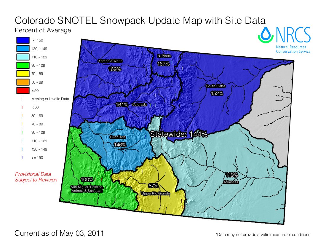
A picture named snowpackcolorado05032011

Yesterday morning the statewide snowpack stood at 144% of average, this morning it’s at 146%. Look at the Yampa/White basins — 170%! The hope is for a slow melt out to minimize flooding. It’s going to be a great year for storage. Here’s a report from Chris Woodka writing for The Pueblo Chieftain. From the article:

The snow in the mountains will help bring relief to the Arkansas Valley, which has been gripped by drought since last August. After Sunday’s storm, even the Sangre de Cristo, Wet Mountains and Spanish Peaks were coated in white after being bare for weeks.

For the northern part of the state, the snow is old news by now. At Buffalo Pass near Steamboat Springs, the snowpack measured 16 feet on Tuesday, with a snow water equivalent of 72.6 inches — the highest amount since record-keeping began in the 1930s, said Mike Gillespie, state snowpack coordinator for the Natural Resources Conservation Service. Cameron Pass, a site near Fort Collins in the South Platte River basin, is showing snow water of 48 inches, which eclipses the record of 40.9 inches set in 1986…

For the past decade, spring runoff has been coming about two weeks sooner than historically recorded. But this year, the peak snowpack has yet to arrive in most of the northern mountains — and usually, that occurs in mid-April…

The Bureau of Reclamation is projecting 94,200 acre-feet of imports based on a snowpack of 181 percent of average in the Fryingpan-Arkansas collection area in the upper Roaring Fork basin. “There’s some concern it will melt too quickly to capture it all,” said Linda Hopkins of the Pueblo Reclamation office…

There is reason to be cautious, however. In 2008, 100,000 acre-feet of runoff was projected in early May, but only 90,000 acre-feet came through the Boustead Tunnel because of the way the snow melted. Reclamation has been releasing additional water from Turquoise and Twin Lakes to make room for the Fry-Ark water, and storage in Lake Pueblo is not an issue at this time…

Flows in the Arkansas River are below average for this time of year, reflecting the slow runoff. For the past decade, runoff has begun about two weeks earlier than normal, and reached multiple peaks in several years as temperatures rose and fell.

From The Aspen Times (Scott Condon):

The snowpack at the agency’s Independence Pass site as of May 1 was the third highest for that date in the last 74 years, according to research by Mike Gillespie, snow survey supervisor. Records for the site go back to 1937. The water content in the snowpack at the Independence Pass site was 24.8 inches on Sunday, Gillespie said. That level was topped only by readings for that date in 1947 and 1957, he said. In more recent times, the snowpack at Independence came close to this year’s level in 1995 when the water content was 24.20 inches. The snowpack at Independence Pass was 159 percent of average for May 1, the agency reported…
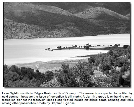
Elsewhere in the basin, the snowpack was 223 percent of average at Nast Lake; 187 percent of average at Kiln; and 161 percent of average at Ivanhoe. All of those sites are in the Fryingpan Valley, between 8,700 feet and 10,400 feet in elevation. In the Crystal Valley, the snowpack was 204 percent of average at North Lost Trail near Marble; 168 percent of average at McClure Pass; and 142 percent of average at Schofield Pass. Those sites range from 9,200 to 10,700 feet in elevation. Basin-wide, the snowpack was 164 percent of average, the NRCS reported…
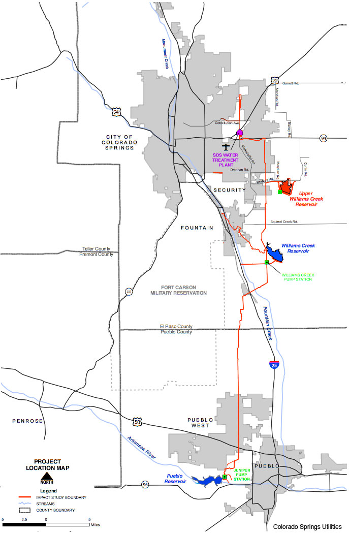
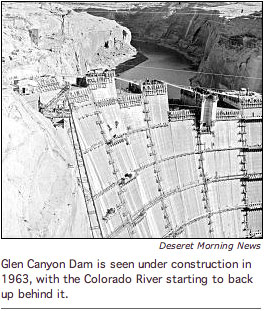
“Of particular interest is a new all-time record snowpack at the Tower SNOTEL site which, on average, receives the greatest snowfall of any location in the state measured by the NRCS,” the agency said in a press release. “This site, located on Buffalo Pass in the Park Range northeast of Steamboat Springs, reached a total accumulation for this season over 200 inches deep, with 72.6 inches of water content. This exceeds the previous record reading of 71.1 inches of water equivalent measured in 1978.”[…]

“For most of the state, this spring’s runoff and summer water supplies will be excellent,” the NRCS said. With the exception of the Rio Grande basin and areas in the southwest, “runoff volumes for the April through July period are expected to range from slightly above average to near record levels,” the agency said.

From the Longmont Times-Call:

Buffalo Pass in the Park Range northeast of Steamboat Springs, reached a total accumulation for this season over 200 inches deep, with 72.6 inches of water content. This exceeds the previous record reading of 71.1 inches of water equivalent measured in 1978, according to Allen Green, State Conservationist with the NRCS.

From the Summit County Citizens Voice (Bob Berwyn):

Rather than worrying having enough, the big concern this year is for the potential of flooding in many local river basins, including the Upper Blue between Hoosier Pass and Breckenridge. where Colorado Springs usually diverts up to 150 cubic feet per second of water through a pipeline under the Continental Divide. This year, Colorado Springs is working on a rehabilitation project on Montgomery Reservoir, said project engineer Kalsoun Abbasi, explaining that, at the most, Colorado Springs will only be able to divert one-tenth of that amount.

There’s also potential for high water below Dillon Reservoir in the Blue River, said Steger, Denver Water’s raw water supply manager. Much will depend on exactly how fast and when the peak snowmelt occurs. The snowpack across the Blue River Basin is more than 150 percent of normal, with the Copper Mountain SNOTEL site recording its highest reading ever, dating back to the late 1970s. “We’ve got serious concerns about flooding below the dam,” said Denver Water manager Jim Lochhead, sitting in a panel discussion with Summit County officials…

Green Mountain Reservoir will also fill sometime in June, said Ron Thomasson, who manages the reservoir for the federal Bureau of Reclamation, predicting the Blue River below Green Mountain Dam could run at levels not seen sice 1995, another big snow year.

From the Associated Press via The Durango Herald:

The U.S. Department of Agriculture’s Natural Resources Conservation Service measured snowpack in Poudre Canyon that reached more than 160 inches, or almost 13.5 feet, at one point, according to a story in The Greeley Tribune. Officials said the snow was almost too deep to measure in some places…Weld County officials worry about the melting snow’s effect on the Poudre River. They say the river could flow at 6,000 cubic feet per second, or 1,700 cfs more than last spring. Crews are removing debris to prevent log jams when the streamflow increases.