
Click here to read the whole outlook from Mike Baker. Here’s the introduction:
1. Neutral-ENSO (El Nino-Southern Oscillation) conditions exist in the Pacific Ocean during the past three months. The outlook is for neutral conditions to continue through at least the Northern Hemisphere summer of 2013.
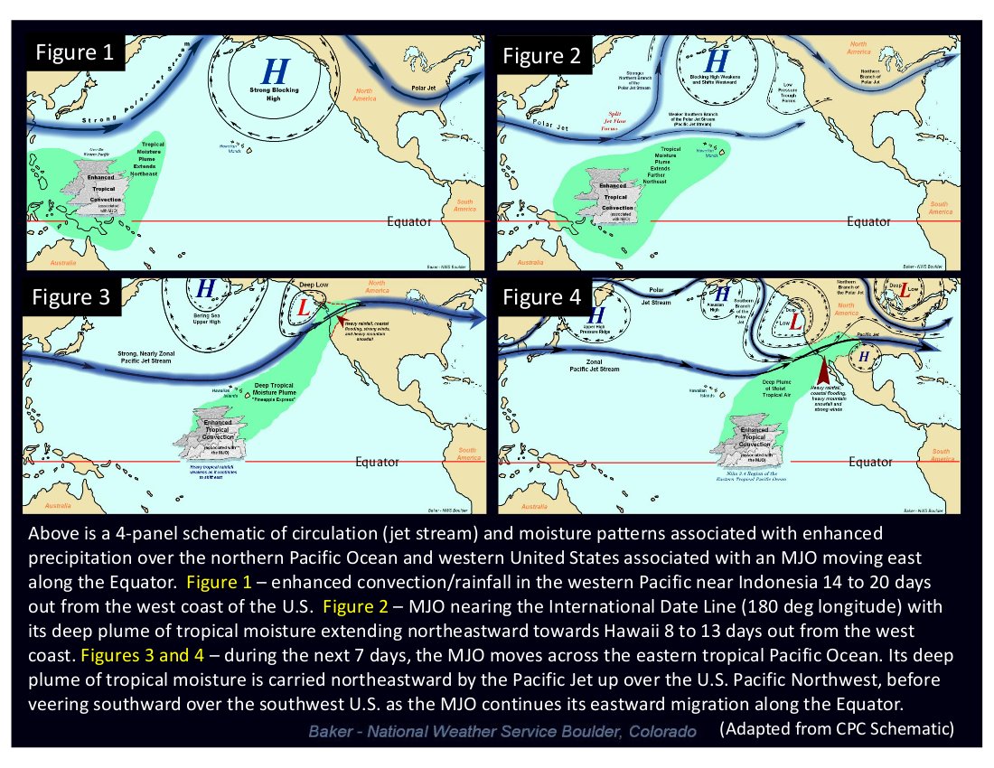
2. A moderate to strong MJO (Madden-Julian Oscillation) formed in the western tropical Pacific Ocean around Indonesia near the beginning of 2013. Over the next several weeks the MJO slowly migrated eastward along the Equator, losing some of its strength along the way. Around the middle of January, a weakened MJO crossed the International Date line and preceded to move across the eastern tropical Pacific. During the last week of January and first two weeks of February, 2013, as the MJO moved across the eastern equatorial Pacific, a wide area of enhanced precipitation spread from the west coast of the U.S. to the central and southern Rocky Mountains, and then eastward throughout the southern tier states.
3. Western Colorado experienced one of its coldest Januarys on record this year, while eastern sections of the state saw some of the warmest January temperatures in quite some time. January was a very dry month for Colorado. The little precipitation that managed to fall in eastern Colorado during the first three weeks of January, fell as rain due to unseasonably warm temperatures. Not until the last week in January did parts of Colorado see its first significant precipitation in over a month, and mainly in the form of snow. However, by this time, the state’s snowpack had suffered, with snow water equivalents well below average statewide.
4. Soil moistures were also severely depleted in many parts of Colorado during January 2013, and extreme to exceptional drought conditions continued to plague much of the state since late in 2012. The outlook for drought in Colorado during the next three months is for it to persist and possibly intensify.
5. The March 2013 climate outlook from the Climate Prediction Center (CPC) calls for better than a 33 percent chance of below average precipitation across Colorado. CPC’s March temperature outlook is less certain. It calls for at least a 33.3 percent chance for above average temperature across the southeast corner of Colorado, better than a 33 percent chance for colder than average temperatures in the far northwest, and an equal or undeterminable chance for above, below or near average temperature for the remainder of the state.
6. For March-May 2013, the outlook from CPC calls for better than a 33 percent chance for below average precipitation, and at least a 33.3 percent chance for above average temperature across Colorado.
From the Summit County Citizens Voice (Bob Berwyn):
So if the El Niño-La Niña cycle isn’t driving the weather, what is? What we do know is that conditions over the Pacific Ocean are the key to understanding exactly what path storms will take across the western United States, and that conditions in the North Atlantic can also be a factor…
So far this winter, meteorologists have pointed to a combination of a cooler-than-average conditions in the Pacific (similar to La Niña) and warmer-than-average ocean temps in the Atlantic as a factor in continuing dry conditions overall.
And in the latest three-month outlook from the National Weather Service in Boulder, meteorologist Mike Baker also discussed the influence of the Madden-Julian Oscillation (MJO) — basically a 30- to 60-cycle of moisture pulses moving around the globe from west to east…But once the wave passed, sea surface temperatures once again cooled to values near those associated with a weak La Niña, fueling more concern that Colorado could see a dry spring. The official outlook from NOAA’s Climate Prediction Center reflects those concerns, with better than average chances for above-normal temperatures and below-normal precipitation through May.