

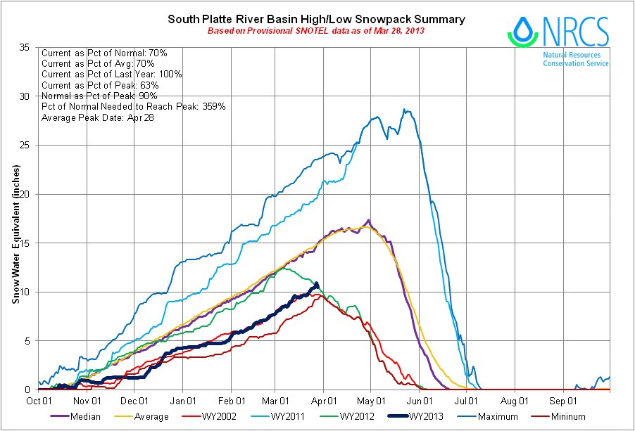
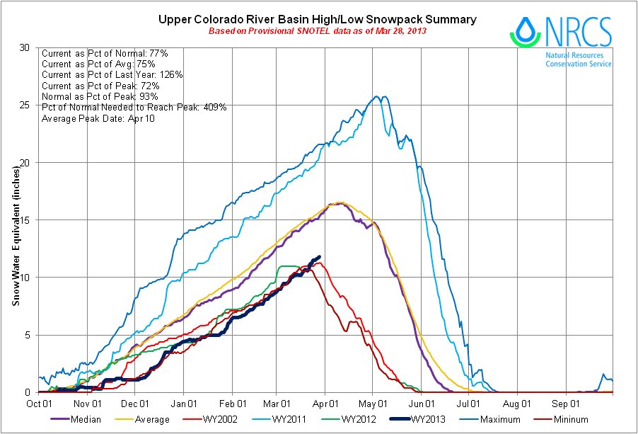
Click on the thumbnail graphics for the statewide snowpack map along with the Basin High/Low graphs for the South Platte Basin and Upper Colorado River basins. Both basins are now above the 2002/minimum line and the South Platte is on line with 2012.
From the Loveland Reporter-Herald (Tom Hacker):
March did not provide a hoped-for rescue for Northern Colorado water users, as the mountain snowpack that feeds rivers enters April still shy of average. In fact, the Rocky Mountain National Park monitoring stations that measure how the Big Thompson River will fare this spring and summer offer some of the state’s worst news. As the Colorado calendar’s wettest month, March is the touchstone for farmers and municipal utilities that supply homes and businesses, and for rafters, fishermen and others with recreation interests. But a mountain snows during the past month were merely average, and after a much drier-than-normal winter, that means less snow up there and projections of less water down here…
Of all the state’s more than two dozen river basins, the Big Thompson and Poudre watersheds are among the driest…
Surveys Wednesday of four stations that gauge the snowpack in mountains west of Loveland show three that have less than 40 percent of the 30-year average snowpack, and the fourth faring only slightly better…
[Brian Werner — Northern Water] on Thursday was returning from meetings on the Western Slope, where conditions are slightly better, with the Colorado River headwaters snowpack at about 80 percent of normal…
Data from monitoring stations at four Rocky Mountain National Park locations tell the story of a dry winter getting drier. Here is how the numbers stack up against the historical average.
Deer Ridge: 30 percent of average.
Hidden Valley: 38 percent of average.
Willow Park: 38 percent of average.
Bear Lake: 61 percent of average.
From the Longmont Times-Call (Pierrette J. Shields) via The Denver Post:
[Levi] Sievers, a soil conservation technician, and Sylvia Hickenlooper, a soil conservationist, hike 10,000 feet up the Longs Peak Trail in Larimer County in January, February, March and April every year to gather data for the U.S. Agricultural Service’s snow survey. The information is compiled with data taken from dozens of other manual sites and automated sites statewide and used to developed the water supply outlook for the state in the run-up to warmer weather and higher water demands.
Hickenlooper and Sievers took 10 samples from designated sites along the measurement location, marked with yellow diamond-shaped signs with a red arrow on them, which has been used as a site for decades. They measured the depth and weight of the snow in the samples, and Hickenlooper then crunched the numbers. “I was hoping it would be a little bit better,” she said, leaning over her calculator and pad, while kneeling in the snow.
The 30-year average for the site is 10.8 inches of water in the snowpack. Her calculations showed for March, the average is 5.4, even after some encouraging snowfall during Colorado’s snowiest month…
Hickenlooper said that most of the state’s snowpack has been at about 70 percent of average, while the Longs Peak site was only at 50 percent from February measurements. Still, that was up from 25 percent in January.
The data Hickenlooper and Sievers gather at their four snowpack measurement sites will be forwarded on for inclusion in the April report. Those reports are watched closely by municipalities and irrigation companies, which likely will have to make plans for a dry season.