


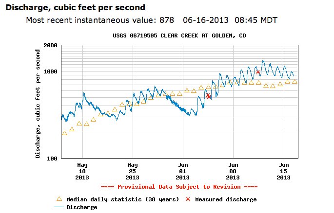
Standley Lake is the supply bucket for Westminster and Northglenn. Thornton also has storage in the reservoir. Staff from all three cities were breathing easier last week after the reservoir reached 95.5 feet and was declared operationally full by the dam tender. Clear Creek streamflow looks to have peaked on June 12 (click on the thumbnail for the hydrograph from the middle of May to today).
From the Summit County Citizens Voice (Bob Berwyn):
After a big weather turnaround in April and May, Dillon Reservoir is well on its way to filling, with the water level reaching an elevation of just about 9,008 on June 13, just nine feet below capacity. The last time the water level was this high was July 26, 2012. “We think it’s likely we’ll fill or at least get within a few feet of full elevation,” Denver Water spokesperson Stacy Chesney said.
Peak inflow into the reservoir was June 10, with the mainstem of the Blue River and the rest of the basin tributaries combining to deliver 1,754 cubic feet of water per second. The inflow hovered around that level early in the week, and started to drop a little bit by Thursday and Friday as the snowpack at higher elevations dwindled. By June 14, most of the automated SNOTEL sites had melted out, making it more difficult to assess how much runoff is still to come…
Chesney said Denver Water projects releasing between 50 and 100 cfs down the Lower Blue the next few months and will also divert water through the Roberts Tunnel to the South Platte, currently flowing at a rate of about 150 cfs.
Overall, Denver Water’s storage in the South Platte system is nearing capacity. Antero Reservoir just two feet below full and Eleven Mile Reservoir is at capacity, holding more than 98,000 acre feet. On the West Slope, Williams Fork Reservoir, Denver Water’s other big bucket, is about five feet below full, holding 89,000 acre feet, with a capacity of 97,000 acre feet.
Green Mountain Reservoir, administered by the U.S. Bureau of Reclamation, has also bounced back from what looked like it was going to be a woeful summer. As of mid-June, Green Mountain was about 76 percent full and still rising, according to BuRec spokesperson Kara Lamb.
From The Denver Post (Ally Marotti):
Northern Water officials aren’t waiting for the the [Big Meadows Fire] to be out to develop a protection plan. “It’s obviously a concern,” Northern Water spokesman Brian Werner said. “We’ve been talking for a couple years now about our watershed — what happens if and when it goes up in smoke. We’re gonna have some impact when the rains come.”
Northern Water partially supplies water to 860,000 people in 33 northern Colorado towns and cities. The company brings water to the Front Range from the Western Slope, and Grand Lake — 5-miles south of the fire — is the main reservoir.
Werner and his colleagues are worried all the debris from the fire will be washed into the lake when the summer rains come. “It’s anyone’s guess when that’ll happen,” Werner said. “It will happen.”
The sludge cannot be prevented from washing into the lake, Werner said. Northern Water has stepped monitoring, putting out extra sensors to keep track of the debris. The utility also is talking about preventative measures, such as anchoring debris booms in the lake to catch some of the sludge if the debris hits hard. But Werner said the fire, which was considered 30 percent contained as of Friday morning, isn’t as bad as it could be. Most likely, any debris washed into the lake will dissipate, settle on the bottom, and won’t harm the water supply.
From The Denver Post (Kieran Nicholson):
Twelve Colorado counties qualify for federal disaster relief because of drought conditions. Colorado Gov. John Hickenlooper was notified this week by U.S. Secretary of Agriculture Tom Vilsack about the designation, according to a Governor’s Office media release…
The primary counties are Dolores, Hinsdale, La Plata, Montezuma, Ouray and San Miguel. The contiguous counties are Archuleta, Gunnison, Mineral, Montrose, Saguache and San Juan.
The federal disaster relief includes Farm Service Agency (FSA) emergency loans. Farmers in eligible counties have eight months from the date of the declaration to apply for emergency loan assistance. FSA will consider each emergency loan application on its own merits, taking into account the extent of production losses, security available and repayment ability, the release said.
From The Pueblo Chieftain (Matt Hildner):
The U.S. Department of Agriculture has declared two San Luis Valley counties as natural disaster areas due to damages and losses caused by drought. Agricultural producers in Mineral and Saguache counties will now be eligible to apply for low interest emergency loans from USDA’s Farm Service Agency. Farmers have eight months from the date of the declaration to apply for loans to help cover part of their actual losses.
The declaration, issued Tuesday by the agency, also named 10 other counties in Southwestern Colorado. This year all but three Colorado counties, including Rio Grande County in the valley, have received the designation.
From the Albuquerque Journal (John Fleck):
Flows on the river are measured in cubic feet per second (cfs), an arcane but commonly used water flow metric on U.S. rivers. Normally at this time of June, the Rio Grande at Albuquerque’s Central Avenue Bridge is flowing at a bit more than 2,000 cfs. As I’m writing this, the river’s flowing at 527 cubic feet per second. But it will soon begin dropping significantly. Because of the drought, there is very little natural flow in the river. Most, if not all, of the river’s flow currently is water being released from storage behind dams on the Rio Chama. Without that, water managers say the river would be nearly dry by now in Albuquerque.
Since 2003, rules adopted by the U.S. Fish and Wildlife Service to protect the endangered Rio Grande silvery minnow required water managers to maintain a flow of 100 cfs at the USGS Central Avenue streamflow measurement gauge. But with supplies of supplemental storage water nearly exhausted, the river’s managers, with the concurrence of the FWS, have agreed to let the river drop to 50 to 60 cfs this summer.
The last time the river dropped below 100 cfs was late September and early October of 1989. The last time the river essentially went dry completely at Central was September of 1981.
From the CoCoRaHS blog:
New Mexico has become ground zero of the drought that has been in progress over the western U.S. the past two years. A little over 82 percent of the state is in Extreme to Exceptional Drought according to the latest U.S. Drought Monitor. That’s the highest percentage of any state currently affected. Conditions have significantly worsened over the last three months. At the start of the calendar year about 32 percent of the state was in Extreme to Exceptional Drought, and by March it was up to 50 percent.
CoCoRaHS observers have been documenting the drought impacts, and some of the descriptions sound like they could have come from the Dust Bowl. Here are two excerpts.
Santa Fe County
We are noticing that wild animals, birds and mammals, are increasingly desperate for water and therefore losing some of their instinctive fear of humans and other predators. The combination of severe drought and smoke from two wildfires nearby is making some mammals panic at times and come toward us rather than flee us when we are outside.Luna County
Because we’ve had so little moisture fall from the sky and we’ve had daily winds from 20 to 65/70 mph at least 80% of the population is suffering from “allergies” we didn’t know we ever had! No one around here has a “lawn” of grass…instead we all measure just how deep the sand is now…the folks with the least amount of sand are considered lucky because they have less dusting/sand clean up to do on the inside of their homes. We’ve been told by a local farmer that he is now having to pay $20.00 for a bale of hay so he is going to have to sell all of his live stock next week – he can’t afford to feed them any longer. And, we’ve heard that the local rancher spent over $100,000.00 in the last nine months trying to keep his cattle heavy enough to get them to market. We know that we haven’t seen any of his cattle in our immediate area in the last 4 or 5 months…which means his heard head count is way down. Would you like us to start measuring the sand in our rain gauge rather than waiting for some moisture to land in it?
From jfleck at inkstain:
There was a round of press coverage last month (including from me) when Mike Connor, head of the U.S. Bureau of Reclamation, told reporters that internal Bureau modeling suggested as much as a one-in-three chance that Lake Mead would drop so low by 2016 that the federal government would make the first ever formal shortage declaration on the Colorado River.
New data out yesterday suggests that may have been too optimistic. The latest operational report from the Bureau now suggests a good chance of hitting the shortage trigger by mid-2015. Arizona and Nevada take the hit, and it’s a small hit initially, but it grows as Mead drops further. The latest monthly modeling report (the Bureau’s much-read 24-Month Study) now suggests Lake Mead’s surface elevation could drop to 1,075 feet above sea level – the level at which a formal shortage declaration is required – as early as June 2015. As I understand the rules, this would likely mean a reduction in water deliveries (initially, a small reduction) beginning in the fall of 2015.
Actually, it doesn’t exactly say we’ll be under 1075 in June 2015. The 24th month of the study (remember the name – it’s a 24-Month Study) is May 2015, at which point the Bureau figures Lake Mead’s elevation will sit at 1,075.28 feet above sea level. That’s 3 inches – the wake of a slow boat – above the drought trigger.
From The Durango Herald (Dale Rodebaugh):
The three-month outlook appears dry and hot. The federal government on Wednesday declared six counties, including La Plata, as primary natural disaster areas because of ongoing severe drought conditions. A couple of events that don’t bode well are happening, said Mark Svoboda. The drought has definitely shifted to the West, Svoboda said, referring to his office’s color-coded map that shows Southwest Colorado in red (extreme drought) but not the purple of exceptional drought that is choking Colorado’s plains counties. Southeast Colorado is in the third year of drought. Six months ago, the map showed a lot of the east in red, Svoboda said…
A map produced by the Climate Prediction Center, an arm of the National Oceanic and Atmospheric Administration, shows all of Colorado, New Mexico, Arizona, Utah, Nevada, California and Wyoming and parts of Texas, Kansas, Idaho and Oregon as areas where drought can continue or intensify…
The possibility of a summer with continuing drought and its effect on water supply hasn’t caused Durango city officials to panic, spokeswoman Sherri Dugdale said Wednesday. The level of water in Terminal Reservoir, which stores the city’s water supply, is at stage 1, which requires no action, Dugdale said.
Hey monsoon fans – we're starting to see the precursors coming up the Sierra Madre from southern Mexico: http://t.co/SHl9m5Zfyl #nmwx
— jfleck (@jfleck) June 16, 2013