
In honor of the Project WET Conference being held in Denver this year, Governor Hickenlooper has officially… http://t.co/L8a9MxfNef
— One World One Water (@OWOW_MSUD) June 27, 2013
Day: June 27, 2013
Ouray: The city is trying to bolster its water rights to protect against a downstream call

From The Watch (Samantha Wright):
Thus the City of Ouray has been forever saddled with junior water rights compared to thirsty downstream irrigators, who are more and more likely to place a call on the city’s water supply as that water becomes ever scarcer in future years. This is the basic problem which the city seeks to resolve.
CDWR conducts tabulations of water rights throughout its various districts every two years. Water rights holders have one year from the time of the tabulation to object to a particular determination. The last tabulation of water rights affecting the City of Ouray took place in 2012, and the next one occurs in 2014.
The City of Ouray, through [City Attorney Kathryn Sellars], intends to file an official objection to the CDWR’s 2012 tabulation which enabled the M&D Canal to make a call on the city’s water supply last year.
In a position paper sent to to Division 4 Water Engineer Bob Hurford on June 13 outlining this objection, Sellars related the complicated history of water adjudication in Colorado and exposed special circumstances which, she argued, underline several flaws in the system when applied to Ouray.
Central to her argument is the so-called “subordination clause” in the first general adjudication decree in Division 4 in 1888 which “subordinates” agricultural water uses to so-called domestic water use but has been interpreted narrowly so as not to equate “domestic” with modern-day municipal water use…
“We don’t have the authority to tabulate a water right in the way the City of Ouray is asking,” [Jason Ullman, Assistant Division Engineer for CDWR’s Division 4] argued. “We have told them we would not oppose them if they filed with the water court to request that the seniority of water rights be clarified, and see what the water court judge says. They really need to take the matter to someone who has the authority to direct us to retabulate.”
CDWR’s research has not produced any other examples of other Colorado municipalities in the same situation as Ouray.
“It’s just the way the priority system was developed in Colorado,” Ullman said. “They couldn’t foresee this problem back then. It’s worked well for over 100 years, but there are some quirks in the system. The point is, we would not file an opposition to their request for retabulation, but the court needs to give its blessing to that. Because there is no other municipality in this situation.”
Parker signs on to the WISE project for future supplies
From the Parker Chronicle (Chris Michlewicz):
Parker Water joins nine other members of the South Metro Water Supply Authority that have signed on to WISE, or the Water Infrastructure and Supply Efficiency agreement. The June 13 approval by the PWSD board of directors adds another source of water for the area’s long-term needs, said district manager Ron Redd.
Parker Water pulls much of its water supply from the Denver Basin Aquifer, but it also captures an average of 5,000 acre-feet annually off Cherry Creek. The WISE agreement will have Parker piping 12,000 acre-feet of recycled water from Aurora and Denver every 10 years for an indefinite period of time.
Water rates will likely go up 1 percent to 2 percent incrementally because of WISE, although any increases will not occur until a thorough rate analysis is conducted, Redd said. The results of the analysis will be released in mid-2014.
The PWSD will start receiving the first trickles of water in 2016 and get full delivery of 1,200 acre-feet starting in 2021. The district hopes to use an existing pipeline along the E-470 corridor to transport the water and is in the process of negotiating with the East Cherry Creek Valley Water and Sanitation District. If an agreement is not reached, the district would have to build its own infrastructure at a steep cost…
The supply coming from Denver and Aurora is water that has been used and treated. The district will again reclaim the water, meaning the average of 1,200 acre-feet coming in each year will actually measure close to 2,400 acre-feet, Redd said, adding there is a possibility that Parker Water might purchase more WISE water in the future…
Rueter-Hess Reservoir, which the PWSD built for storage, contains around 6,000 acre-feet. By the time the new water treatment plant off Hess Road opens in 2015, the reservoir will contain 15,000 to 20,000 acre-feet. It has the capacity for 72,000 acre-feet.
American Meteorological Society: Understanding Uncertainties in Future Colorado River Streamflow #ColoradoRiver
Click here to go to the AMS website for the publication. Click here to read the early online release.
Here’s the abstract:
The Colorado River is the primary water source for more than 30 million people in the U.S. and Mexico. Recent studies that project streamflow changes in the Colorado River all project annual declines, but the magnitude of the projected decreases range from less than 10% to 45% by the mid-21st century. To understand these differences, we address the question the management community has raised: “why is there such a wide range of projections of impacts of future climate change on Colorado River streamflow, and how should this uncertainty be interpreted?” We identify four major sources of disparities among studies that arise from both methodological and model differences. In order of importance, these are differences in: Global Climate Models (GCMs) and emission scenarios used; ability of land surface and atmospheric models to simulate properly the high elevation runoff source areas; sensitivities of land surface hydrology models to precipitation and temperature changes; and methods used to statistically downscale GCM scenarios. In accounting for these differences, there is substantial evidence across studies that future Colorado River streamflow will be reduced under the current trajectories of anthropogenic greenhouse gas emissions, due to a combination of strong temperature-induced runoff curtailment and reduced annual precipitation. Reconstructions of pre-instrumental streamflows provide additional insights; the greatest risk to Colorado River streamflows is a multi-decadal drought, like those observed in paleo reconstructions, exacerbated by a steady reduction in flows due to climate change. This could result in decades of sustained streamflows much lower than have been observed in the ~100 years of instrumental record.
Here’s a release from one of the sponsoring organizations, the Cooperative Institute for Research in Environmental Sciences:
The Colorado River provides water for more than 30 million people in the U.S. West, so water managers have been eager to understand how climate change will affect the river’s flow. But scientific studies have produced an unsettling range of estimates, from a modest decrease of 6 percent by 2050 to a steep drop of 45 percent by then.
A new paper by researchers at the University of Washington (UW), CIRES, NOAA and other institutions across the West investigates and explains why those estimates differ and summarizes what is known about the future of this iconic Western river—key information for decision makers.
“We know, for example, that warmer temperatures will lead to more evaporation and less flow,” said co-author Bradley Udall, who contributed to the study as director of the CIRES Western Water Assessment, a NOAA-funded program at the University of Colorado Boulder. Udall is now director of CU-Boulder’s Getches-Wilkinson Center for Natural Resources, Energy and Environment at Colorado Law. “Although projections of future precipitation aren’t as clear, it’s likely that we’re going to see a reduction in overall flow in the Colorado,” Udall said.
The study is published this week in theBulletin of the American Meteorological Society.
While the paper does not narrow the existing range of estimates, it provides context for evaluating the current numbers. The 6 percent reduction estimate, for example, did not include some newer climate model runs, which tend to predict a drier West. And the 45 percent decrease estimate relied on models with a coarse spatial resolution that could not capture the effects of topography in the headwater regions. The new analysis, thus, supports more moderate estimates of changes in future flows.
“The different estimates have led to a lot of frustration,” said lead author Julie Vano, who recently earned a UW doctorate in civil and environmental engineering. “This paper puts all the studies in a single framework and identifies how they are connected.”
In evaluating recent scientific papers that estimate future flow of the Colorado River, she and her co-authors identified several reasons for different flow estimates. Among them are differences in:
Climate models and future-emissions scenarios used. Models run with higher future greenhouse gas emissions, for example, typically produce warmer and often drier climates, and smaller Colorado River flows. The models’ spatial resolution, which is important for capturing topography and its effects on snow distribution in the Colorado River’s mountainous headwaters. Models with coarser resolution tend to overestimate the sensitivity of runoff to climate change. Representation of land surface hydrology, which determines how precipitation and temperature changes will affect the land’s ability to absorb, evaporate or transport water. Methods used to downscale from the roughly 200-kilometer resolution used by global climate models to the 10- to 20-kilometer resolution used by regional hydrology models. The new paper also highlights several important realities faced by Western water managers reliant on Colorado River flows. The early 20th century, for example, is the basis for water allocation in the basin, but was a period of unusually high flow, so Colorado River water is already overallocated. Moreover, tree ring records suggest that the Colorado has experienced severe droughts in the past and will do so again, even without any human-caused climate change. If exacerbated by steadily decreasing flows due to climate change, such a “megadrought” could result in decades of extremely low streamflow, much lower than observed in the last century.
– See more at: http://cires.colorado.edu/news/press/2013/coloradoriver.html#sthash.EGBPC9pg.dpuf
From the Fort Collins Coloradoan (Bobby Magill):
…the river’s flows are likely to greatly decline, according to an American Meteorological Society paper co-authored by Bradley Udall, director of the Western Water Assessment at the University of Colorado Boulder…
Studies have long shown that flows in the river will decline, but projected decreases have ranged from 10 percent to 45 percent.
The wide range in projected flow decreases occurred because of differing climate models scientists used and how they accounted for the vulnerability of mountain snowpack to climate change, according to the paper.
Regardless of previous streamflow projections, it’s clear that the Colorado River’s flow will likely decline significantly in the coming years, according to the paper…
Tree ring records show severe droughts have been common in the past and will come again, according to the paper. If climate change makes those droughts worse, already-low flows in the river will decline even further. “Such a ‘megadrought’ could result in decades of extremely low streamflow, much lower than observed in the last century,” the paper says.
From the Summit County Citizens Voice (Bob Berwyn):
A new study by an interdisciplinary team of scientists from around the West doesn’t provide a definitive answer [ed. to the question of how far streamflow may drop] — but it does help explain why the estimates are so different and may help narrow the range in the next generation of climate models.
“We tried to tease apart all the reasons for this broad range,” said Brad Udall, who contributed to the paper as director of the CIRES Western Water Assessment, a NOAA-funded program at the University of Colorado Boulder. When you include all the elements, including natural climate variability and the challenges of downscaling models, the biggest message is continuing uncertainty, Udall said.
“We really don’t know, but we have pretty good handle that it’s negative. It ranges from, we can handle this, to, Oh my God, it’s really off the charts and we need to rethink water management in the basin,” he said. “This paper puts people on notice that you’re going to live with this uncertainty.”
The paper also assesses what scientists do know, including that future emissions of greenhouse gases really matter. Regardless of the other variables, climate models agree that, the warmer it gets, the drier it gets, Udall said, outlining some of the key points of the study.
As they surveyed various Colorado River studies, the team found that the models are all over the map, so it matters which one is used for projections — but 70 percent of the models indicate that flows will decrease.
One of the challenges is related to the scale of the models. Udall said it’s important to remember that 85 percent of the water in the Colorado River Basin comes from 15 percent of the basin’s geographic span, a relatively small mountain region (the Colorado River headwaters) where climate models have a hard time projecting global warming impacts based in part on the complex topography.
On the other hand, the study was able to make some conclusions about the relationships between temperatures, precipitation and flows, showing, for example, that if precipitation holds steady, runoff decreases by about 2 to 5 percent for every 1.8 degrees Celsius of warming.
Drought news: The June Drought Update is hot off the presses from the CWCB #COdrought

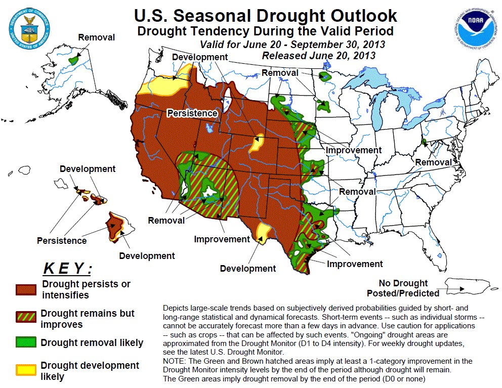
Here’s the update from the Colorado Water Conservation Board (Taryn Finnessey):
Following a near average May, with regard to temperature and precipitation (93%), June has brought increased temperatures and below average precipitation for much of the state. While storms have brought some moisture relief to the southeastern plains which have been faced with exceptional drought conditions for two years, soils are so dry in this region that some fields have become hydrophobic. Rolling dust storms have been reported on multiple occasions and many more storms will be needed to alleviate dry conditions. Areas of the state that saw beneficial springtime moisture have now begun to dry out; and the southwest has seen recent changes in their drought classification from “severe” to “extreme.” Fires have broken out statewide and many communities have implemented fire bans.
As of the June 18, 2013 US Drought Monitor, 100% of Colorado continues to experience some level of drought classification. Conditions across the state have either remained constant or declined since May. D1 (moderate) conditions cover 25% of the State; while D2 (severe) covers 40% and D3 (extreme) accounts for an additional 18%. 18% of the state is now experiencing exceptional drought (D4). Fires have broken out across many parts of the state and the fire situation rating for the Rocky Mountain Area has increased to Preparedness Level 4. This rating indicates highly complex large fire activity is occurring, with multiple large fires in the zone. Fire severity is extreme as reported in multiple areas, and fires are escaping initial attack, as evident by the number of large fires. Multiple regional dispatch centers are experiencing an incident requiring type-1 or type-2 teams, and a majority of zone resources are committed. Thus far in June the Yampa/White, South Platte and Gunnison River Basins have received 0% of their average June precipitation. The Rio Grande has receive 13% of average while the southwestern basins have gotten 14% of their average monthly rainfall. All of these basins, with the exception of the South Platte, were also below average for May. As of the first of June,statewide reservoir storage is at 78% of average. The highest storage levels are in the Yampa/ White River Basin, at 111% of average, while the lowest storage in the state is the Rio Grande basin at 40% of average. All other basins range from 50% to 92% of average. Last year at this time the state was at 98% of average reservoir storage. Despite runoff that has filled some reservoirs, most municipalities and water providers have maintained watering restrictions implemented earlier this spring. The CWCB drought response portal http://www.COH2O.co continues to help individuals determine the restrictions in their specific community. Northern Colorado Water Conservancy District continues to hold the C-BT quota at 60%. Streamflow forecasts indicate below average streamflow across much ofthe state, although improvements have been made in the forecasts since May. The Colorado and South Platte have the highest streamflow forecasts ranging from 62-111% of normal. The lowest forecasts in the state are in the Upper Rio Grande, with flows ranging 14% to 52% of normal. The Southwestern, Arkansas and Gunnison also have low forecasts ranging from 26-71% of normal. Surface Water Supply Index (SWSI) values represent near normal surface water conditionsin parts of the Colorado and South Platte, but remain negative elsewhere in the state.Below average reservoir storage and low streamflow forecasts contribute to these values and data reflect conditions on June 1, 2013.
More coverage from the Summit County Citizens Voice (Bob Berwyn):
June is living up to its history as one of the driest months in the Colorado high country, with very little precipitation in the state’s key river basins.
From The Colorado Springs Gazette (Monica Mendoza):
Two members of the Colorado Springs City Council are concerned that the city’s watering restrictions are too hard on residents with big yards.
Some homeowners have to choose between letting a lawn die and paying a premium to water it, council member Joel Miller said.
The drought, coupled with the watering restrictions and the higher price tag on water usage over 2,000 cubic feet per month, is forcing some people to decide what is more important – saving the grass or saving money, he said last week in his role as Colorado Springs Utilities board member.
“People are saying, ‘I have to choose – is it going to cost me $5,000 to put in a new lawn,'” Miller said. “People are doing the math. I wish we didn’t have to do that. There are lawns that are dying.”
It’s the 2,000-cubic-foot threshold triggering higher water rates that troubles Miller and council member Don Knight.
If water restrictions are needed next summer, there should be some consideration for residents who have yards larger than 3,000 square feet, which was the figure used to calculate typical usage, Knight said. Even if homeowners with yards larger than 3,000 square feet follow the two-day-a-week watering restrictions, they find themselves going over 2,000 cubic feet of water per month, he said.
Denver Water has relaxed watering restrictions. Here’s the release (Stacy Chesney):
Denver Water’s supply situation has greatly improved since Stage 2 drought restrictions were put in place April 1, thanks to an unexpectedly wet spring and citizens’ reduced water use. As a result, at its meeting today, the Denver Board of Water Commissioners adopted a resolution declaring a Stage 1 drought — which removes the two-day-per-week assigned watering schedule — effective immediately. Customers may water no more than three days per week and must follow Denver Water’s annual watering rules.
“Our customers have responded very well to the call to use even less water, and we can finally be confident that enough water from the late-season snows has reached our reservoirs to bring them to reasonable levels,” said Greg Austin, president of the Denver Board of Water Commissioners. “While the drought is not over, conditions have improved enough that customers may water a third day, if their lawns need it. We all still need to do our part to protect against the possibility of another dry winter, and we ask everyone to continue to use even less.”
On March 27, 2013, the board declared a Stage 2 drought, based on 60 percent snowpack, extremely dry conditions and lower-than-normal reservoirs. Late-season weather improved conditions significantly, and the snowpack in both of Denver Water’s watersheds ended up above 90 percent of the average peak. More important, much of the snow made its way into Denver Water’s reservoirs, which are currently 92 percent full on average. Runoff is ending, and Denver Water doesn’t expect reservoirs to fill much more. The utility’s reservoirs were about 91 percent full this time last year.
From The Denver Post (Bruce Finley):
Denver water commissioners on Wednesday decided to let customers water their lawns and gardens three days a week, instead of two. Denver Water’s mountain reservoirs are 92 percent full, and since restrictions took effect April 1, the utility’s 1.3 million customers have used 3.4 billion gallons less than average, spokeswoman Stacy Chesney said.
The conservation has reduced Denver Water revenues by $12 million, Chesney said. That sum could climb to $30 million by year end, so Denver Water has trimmed its budget by $22 million, she said. “There’s a delicate balance between protecting water supplies and investing in the maintenance and repair our system needs, especially in times of drought,” she said.
Thornton, too, lifted its two-day-a-week restriction as reservoirs reached 80 percent full.
However, because Aurora Water’s reservoirs are still only 67 percent full, the utility is sticking with its two-day-a-week lawn rule, even though residents have used 4,000 acre-feet less water — 1.3 billion gallons — this year spokesman Greg Baker said.”We’re not as fortunate as Denver. They were lucky to get the snow where they needed it.”
Colorado Springs officials continue to charge extra for water. As a result, lawns once green are turning brown…
In Denver, residents cut overall average daily usage to 85 gallons, down from 104 gallons in 2001, utility data show.
Yet south suburban Parker residents still use 123 gallons a day. Beyond metro Denver, water use remained elevated in Scottsdale, Ariz. (219), Salt Lake City (117), Phoenix (110), San Diego (136) and Los Angeles (123). Only in one major city, Albuquerque, did people use less than in Denver — 70 gallons a day.
Weekly Climate, Water and Drought Assessment of the Upper Colorado River Basin #ColoradoRiver #COdrought
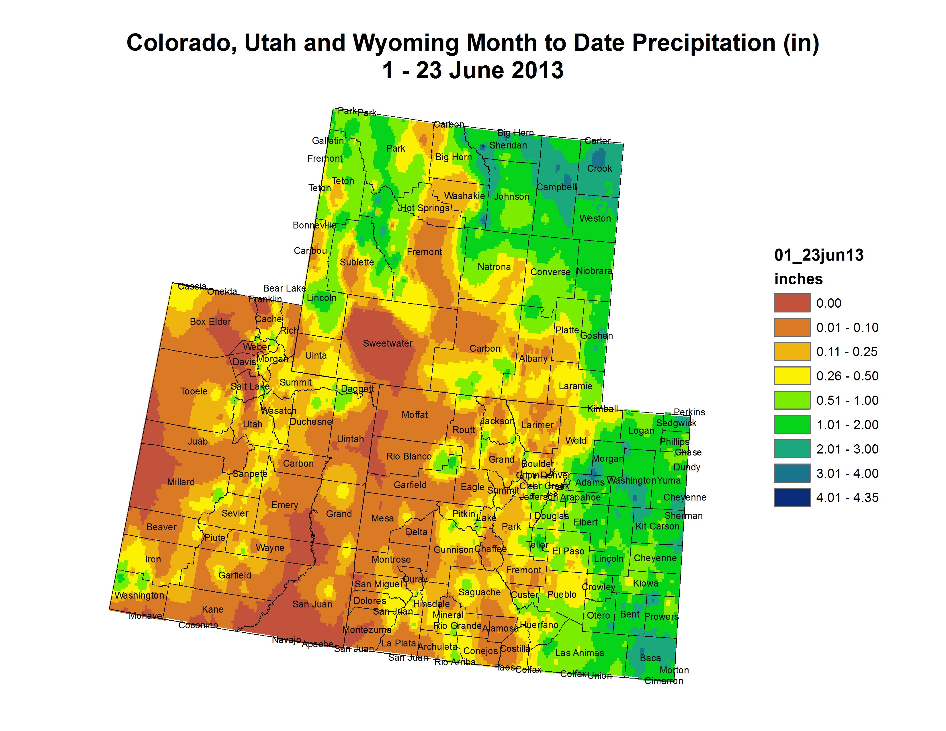
Click on the thumbnail for the month-to-date precipitation map for the Upper Colorado River Basin. Click here to read the current assessment from Tuesday’s webinar.