Slow recovery for Glen Haven, Drake #COflood

Glen Haven October 2013 via NBC News

From NBCNews.com (Tony Dokoupil):

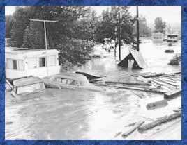
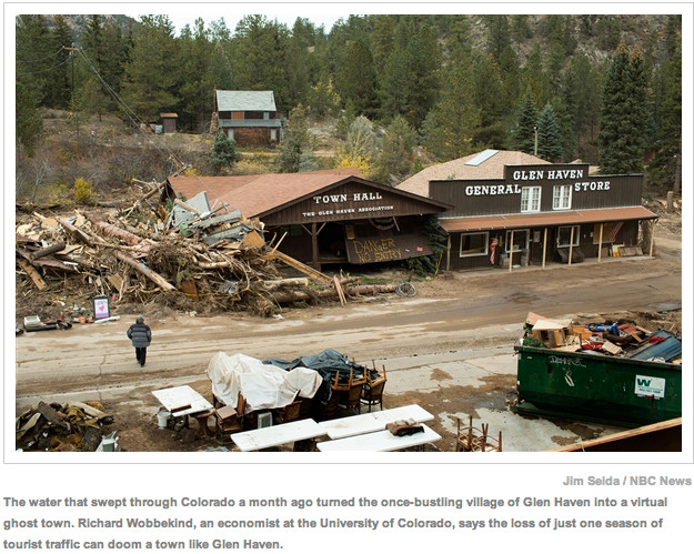
…while the bigger cities of central Colorado — from Boulder to Loveland to Fort Collins — are bustling again, at least two once-gleaming villages in the foothills are virtual ghost towns, isolated by gaps in the asphalt and rivers that undid a century of civilization in a week of heavy rain. In Glen Haven, a 400-person jewel box on the road to Rocky Mountain National Park, an estimated 80 percent of the homes are empty and every business downtown is closed or totally gone — swept seven miles into the town of Drake, a thousand-person tourist draw that’s also now obliterated and empty except for a handful of holdouts who refused to be evacuated…

The water that cascaded out of the Rockies last month ripped through 24 counties, killing nine people and dampening 2,500 square miles in the heart of Colorado. But the communities of Glen Haven and Drake may be the most devastated, deserted areas left — as well as the most at risk of becoming genuine ghost towns before the “spirit of recovery” finds them too.

“There’s been a lot of talk and a lot of meetings but not much action,” said Steve Childs, owner of the Glen Haven General Store, which was knocked sideways in the flood by a Ford Bronco and the remnants of Town Hall.

Though still officially closed by the county, with roads blockaded to discourage mischief and buildings nailed with red signs reading “UNSAFE,” NBC toured Glen Haven and Drake this week with a pass from the sheriff and the good will of locals. The result, coupled with interviews with more than a dozen residents, was a tour of two map-dots that feel forgotten by the relief effort — and the locals are fighting to make sure they aren’t forgotten by history…

As winter approaches it’s only going to get worse for both towns. Many homes in the area are considered seasonal or secondary, which federal assistance won’t cover, and while a Federal Emergency Management Agency representative says that requests for public assistance through firehouses and homeowners associations should be approved, they haven’t been yet in Glen Haven — the kind of paperwork delay Gov. Hickenlooper has blamed on furloughs at FEMA’s Washington office during the government shutdown.

But who should clean up the destroyed downtowns and private roads chewed through by water? That’s easy to answer in a tax center like Boulder or Fort Collins, which has its own heavy equipment and a staff of skilled operators. Small towns rely on the county, in this case Larimer, which so far hasn’t found the funds to help with the “community needs” list on the fire house wall in Glen Haven. It includes dump trucks, dumpsters, chainsaws, a wood chipper, barricades and traffic cones…

In Drake, according to Sgt. Gerald Baker, a first responder in the county sheriff’s office, “a whole mountain came down” in a mudslide so loud that people covered their ears. They “believed the earth was coming to an end,” he said, and after debris temporarily dammed up the river, it almost did for some people. The blockage released a “tsunami” of water into the canyon. Or as a member of the road crew rebuilding Highway 34 put it: “Goodbye, Drake.”

From the Northern Colorado Business Journal (Steve Lynn):

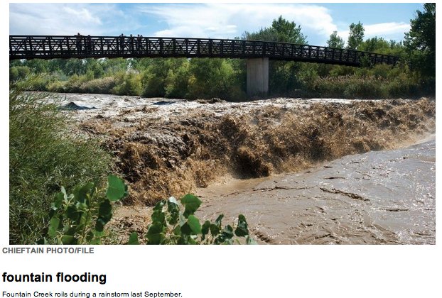
Cities and water districts are on the hook for at least $13.5 million to repair water and sewage systems ripped apart by floods that struck Northern Colorado in September. The city of Evans was among the hardest hit: The cost of a new wastewater treatment plant to replace the badly damaged plant will cost as much as $7 million, Evans spokeswoman Kristan Williams said…

Cities in Northern Colorado are grappling with how to deal with the flood-battered wastewater treatment infrastructure. While water infrastructure in some cities such as Fort Collins escaped unscathed, Loveland, Greeley, the Left Hand Water Conservancy District and others saw heavy damage…

The Left Hand Water Conservancy District estimates $2.5 million in repairs to its damaged water infrastructure, General manager Chris Smith said. Flooding redirected Left Hand Creek so that the district’s main water intake no longer collects water. The water district also saw damage to multiple treated water lines on Boulder Creek and the St. Vrain River…

In Loveland, city officials estimate repairs will cost between $3 million and $4 million. Damage to wastewater lines will hundreds of thousands of dollars more to repair. The city’s water treatment plant on the Big Thompson River was not damaged, but flooding along the Big Thompson destroyed sections of two other important water lines, including a 20-inch water line and another 36-inch water line. The city disconnected service in those lines and patched in service to the 48-inch water line that city and construction contracting crews were able to save. The city has stopped getting water from the Big Thompson, instead drawing its supply from Green Ridge Glade Reservoir because of river water quality concerns…

The city of Greeley suffered damage to a portion of one of five treated water lines, cutting service to more than 50 customers, said Jon Monson, director of Greeley Water and Sewer. The city has rerouted clean water from other sources to those customers.

From The Denver Post (Mark Jaffe):

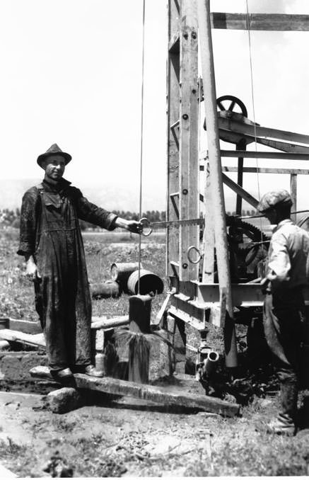
As floodwater started to rise Sept. 11, some oil and gas operators began shutting wells and securing facilities. It would be five days before state regulators announced their own plans.
“Did the state have a disaster plan for the oil and gas fields?” asked Bruce Baziel, energy program director of the environmental group Earthworks. “It was hard to tell.”

From the start, state oil and gas regulators were gathering information and passing it on to the incident commander overseeing disaster response, said Alan Gilbert, a Colorado Department of Natural Resources official.

“That’s our role as a technical agency,” Gilbert said.

Throughout the first flood weekend, oil companies provided information on their own operations to the Colorado Oil and Gas Conservation Commission.

“Demands on us to be transparent were high,” said Tisha Schuller, president of the Colorado Oil and Gas Association, an industry group.

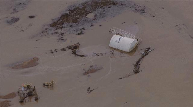
Yet as pictures of bubbling pipes, spouting wells and floating tanks began to appear on social media, fears rose about what was happening in the flooded oil fields. On Sept. 16, as the flood covered parts of the oil-rich Denver-Julesburg Basin, more steps to assess impacts were announced by the oil and gas commission staff.

“We intend to compile an ongoing spreadsheet with the status of operations,” said Matt Lepore, executive director of the commission.

Regulations require operators to report spills. Lepore asked for the industry’s voluntary cooperation in assessing the status of all wells.

“In the middle of a disaster, it strikes me that this ought to have been required,” said Peter May-smith, executive director of Conservation Colorado. “If it wasn’t required by regulation, the governor should have issued an executive order.”

The steps announced were “ad hoc,” but the commission was monitoring the situation, DNR’s Gilbert said.

“We are going to have a formal review,” Gilbert said. “We’ll look at what worked and what didn’t work.”

Within days, the commission had about 18 inspectors in the field checking sites. It used its mapping capabilities to identify wells and facilities in floodplains and focus on those. About 1,500 wells were identified in the floodplains of the South Platte and other Front Range rivers, Gilbert said.

“For years, conservation groups have pressed for limited drilling in floodplains, and the state and the industry have fought it,” said Gary Wockner, Colorado program director for Clean Water Action. “Part of this wasn’t a natural disaster but a man-made disaster.”

The industry estimated that at the height of the flooding, 1,900 wells were shut in. There are more than 20,000 wells in the basin. State inspectors counted 14 “notable releases” primarily from overturned or damaged tanks, totaling 1,042 barrels (43,764 gallons) of petroleum products. There were 13 releases of produced water—which contains well impurities—totaling 430 barrels (18,060 gallons), according to the state.

“That’s thousands of gallons of pollutants poisoning our waterways,” Wockner said. “It isn’t something to be dismissed.”

By Thursday, inspectors had covered 90 percent of the wells and facilities in the floodplains, Gilbert said.

“When you have an industrial activity of this scale, you need clear contingency plans,” said Conservation Colorado’s May-smith. “A clear plan in advance.”

State officials will review how effective regulations were in preventing flood spills and whether reporting and emergency plans were adequate, Gilbert said.

Could that lead to new rules or plans?

“That is what we are going to look at,” Gilbert said.

State and industry officials insist their performance was good.

“It was chaos—11,000 homes, 200 miles of road, destroyed,” the Oil and Gas Association’s Schuller said. “You can’t plan for that. You just have to be flexible and responsive.”

From The Denver Post (Joey Bunch):

Nearly a month in steps are being taken on the long road to Colorado’s recovery from September’s floods that tore through roads, towns, homes and lives. In response, the Colorado legislature announced a 12-member bipartisan Flood Disaster Study Committee Wednesday.

Senate Democrats appointed Sen. Jeanne Nicholson of Gilpin County, Sen. John Kefalas of Fort Collins and Sen. Matt Jones of Louisville. The Republicans named Sen. Kent Lambert of Colorado Springs, Sen. Scott Renfroe and Sen. Kevin Lundberg of Berthoud.

Republicans in the House are represented by minority leader Brian DelGrosso of Loveland, Rep. Stephen Humphrey of Severance and Rep. Jerry Sonnenberg (of Sterling. The Democrats appointed Rep. Mike Foote of Lafayette, Rep.Jonathan Singer of Longmont and Rep. Dave Young of Greeley.

House Speaker Mark Ferrandino, D-Denver, stated, “We’re doing this in a strictly bipartisan way because politics has no place in disaster relief. Unlike Washington, we’re coming together to address a difficult issue facing our state.”

The group will meet five times before and during the next legislative session to review short-term relief and long-term planning for flood recovery.

State and FEMA analysts are still collecting information about the losses. Eventually they will tell us how costly the storm was. The preliminary numbers have been grim, and the toll is expected to rise as FEMA continues to collect damage assessments and calculates more specific estimates on how much repairs will cost.

“It’s abundantly clear that we need to get to work on policy that helps victims and proactively mitigates future disaster,” Nicholson said in a press release from the Senate Democrats. “We have a nonpartisan, urgent charge, and I welcome the help of anyone in fulfilling it.”

Kefalas added in his statement: “In the days following the flood, I spent time with displaced families, and I witnessed how our community pulled together. Collaboration between the public and private sectors was critical for effective, timely and humane responses.”

DelGrosso’s statement called helping flood victims a top priority for the special committee. “I am hopeful the committee will find consensus on ways we can assist flood victims, better equip Colorado to respond to future flood disasters and rebuild the infrastructure impacted by the floods as soon as possible.” he said.

From the Colorado Springs Business Journal (Cameron Moix):

While the north-central section of the state received the brunt of damage caused by the summer flooding — which the governor’s office has estimated at $300 million to $500 million — Colorado Springs and its surrounding communities also sustained severe damage to parks and infrastructure…

The majority of work on or pertaining to state roadways in the Pikes Peak region should be completed by early spring and will produce a bill of approximately $15 million, according to estimates by the Colorado Department of Transportation.

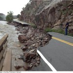
Doug Lollar, the north program engineer for CDOT’s Region 2, said that the majority of El Paso County’s damage is concentrated around the Waldo Canyon burn scar near Manitou Springs, which covered U.S. Highway 24 with feet of floodwater, scattered debris and left much roadway in disrepair…

El Paso County sustained initial damages to its roads estimated at $1.85 million from late-summer floods, according to a Sept. 18 news release…

While the city of Colorado Springs has experienced an estimated $13 million in damage as a result of the floods, Senior Communications Specialist Krithika Prashant said that damage assessments are ongoing to determine specific areas of focus and a concise breakdown of that estimate.

Colorado Water Plan: ‘We’ve got ample crises’ — James Eklund

From The Pueblo Chieftain (Chris Woodka):

Colorado has suffered through drought, wildfires and floods in the six months since Gov. John Hickenlooper ordered up a state water plan. While simply having a plan would not have prevented any of it, state response might have improved if a plan were in hand.

“We know the plan isn’t a silver bullet. I’m reminded of that quote by the great water philosopher Mike Tyson: ‘Everyone has a plan until they get punched in the face. We’ve been punched in the face,” said James Eklund, director of the Colorado Water Conservation Board.

Eklund addressed the Southeastern Colorado Water Conservancy District Board Thursday, explaining the progress CWCB has made so far in developing the plan. The plan will be on the governor’s desk after the 2014 election, even if a new governor would be coming on board. That’s a parallel situation to 2010, when the Interbasin Compact Committee wrote a letter to outgoing Gov. Bill Ritter and Hickenlooper detailing its progress toward addressing a looming municipal supply water gap. That laid the groundwork for Hickenlooper to step up the effort of statewide water planning and his vow to develop a state plan before 2016. The planning process needs to continue regardless of whether Hickenlooper wins reelection, Eklund said.

“We’ve got ample crises, and we need to respond in a way to address the problems,” he said.

The plan would address the needs of agriculture, cities, recreation and environment in a way that avoids further dry-up of farms to support urban needs. To do so, the state will have to find new ways to cooperate in water projects, improve forest health in watersheds, protect property rights, preserve water systems and remove regulatory barriers to new projects, Eklund said.

More Colorado Water Plan coverage here.

Longmont: South Platte Forum October 23-24

Screen Shot 2013-10-17 at 11.58.06 AM

I’m a bad blogger. I totally forgot to do a post about next week’s South Platte Forum. I believe that there is still time to register for all the fun and great information.

Click here to register.

Also, the Colorado Water Congress POND committee is holding a silent auction to help with flood relief in the basin at their event on Wednesday.

Click here to register for the POND event.

Ski areas, et. al, kick off this winter’s cloud-seeding program

Cloud-seeding graphic via Science Matters

From the Colorado Independent (Bob Berwyn):

In Colorado, ski-area operators and water managers have been known to do a few rain dances and — privately at least — pray to their own God when drought strikes. But in the age of technology and hubris, when nearly every challenge is met with engineering, they aren’t just waiting for Mother Nature to put her cards on the table. Instead, there’s a growing interest in seeding clouds with silver iodide to coax every possible bit of moisture from passing storms.

Weather modification has historic roots in the Cold War era, when both the U.S. and Soviets looked at ways to weaponize weather, and more recently, U.S. intelligence agencies decided to help fund a far-reaching study aimed at determining if there’s a way to mitigate global warming with technology and engineering.

Proponents have claimed for years that seeding can increase snowfall in targeted areas by as much as 15 percent. As a result, water providers like Denver Water, and big ski resorts, including Vail, Breckenridge and Winter Park, are all helping fund a $1 million cloud-seeding program in Colorado’s north-central mountains, hoping to improve ski conditions, as well as boost stream flows and reservoir storage.

Recent news about record-low flows from Lake Powell, the key Colorado River reservoir, has spurred even more interest in enhancing natural precipitation, said one of the state officials who manages what’s formally called a weather modification program. A roster of companies involved in cloud seeding and related activities shows that weather modification is a growth industry.

The state program is run by the Colorado Water Conservation Board, which issues permits and sets basic rules — for example cloud-seeding stops when the snowpack reaches a certain level to address concerns about avalanches and flooding.

But those rules haven’t quelled concerns, as there are still a few people left who probably think that tinkering with the weather on a large scale is probably one of the worst ideas ever. Those sentiments were reflected during a hearing for cloud seeding permits in the early 2000s. Residents of Evergreen turned up en masse to claim that, ever since Vail started seeding clouds (way back in the 1980s), snowfall in their town has declined.

The CWCB program was jump-started with state seed money in the early 1970s, but since then has become 80 percent – 90 percent self-funded through grants and participation by resorts and water providers, with everyone seeing cloud-seeding as a low-cost alternative to building new reservoirs and pipelines. And with an uncertain outlook for Colorado River flows, even downstream states like Arizona and California are ponying up to help pay for cloud seeding in the headwaters.

The question about downwind impacts seems reasonable. After all, there’s only so much moisture in every cloud. But weather experts like Colorado state climatologist Nolan Doesken say there’s not a shred of evidence to show that cloud-seeding affects snow and rainfall downwind of the specific target areas. The weather pattern most suitable for mountain cloud seeding (a steady, moisture-laden jet stream out of the northwest) generally leave the plains high and dry.

On the other hand, Doesken said there’s no clear evidence to show that seeding enhances snowfall anywhere near the amount claimed.

“If it really increased snowfall by 15 percent, you’d be able to see that in streamflow records from, say, the Gunnison Basin (where seeding has been ongoing for many years), but that’s not the case,” Doesken said. Overall, he believes that seeding does boost precipitation, but by a lesser amount than claimed…

So when your score your first face shots this coming winter, go ahead and enjoy the celebratory bonfire in honor of Ullr, the Norse god of skiing. But just to be on the safe side, don’t forget to raise your glass in a toast the men and women who promise better living — including more snow — through chemistry and engineering.

More cloud-seeding coverage here and here.

Arvada water and wastewater rates to increase for 2014

Arvada School circa 1888 photo via ArvadaHistory.org

From the Arvada Press (Crystal Anderson):

The rate increase, which will affect current water, wastewater and water tap rates, will go before the city council mid-November, and should it be approved, will go into effect Jan. 1, 2014.
According to Jim Sullivan, the director of utilities for Arvada, this is a general, annual increase.

˝The rates change every year, so that there isn’t a sudden jump, by doing small increases, we are allowing for the increase to be incorporated into budgets,” he said.

When the new year begins, Arvada’s water rates will rise around 4 percent adding an additional $1 a month or $12 an year to residents’ water bills. Wastewater rates will also rise around 4 percent, which will increase bills 90 cents a month or $10.80 a year…

The increase comes as a result to increases in raw water by Denver Water and increased service charges by the Metro District. The funds will go towards the water system and the costs associated such as repair materials and maintenance…

Compared to neighboring cities, Arvada has one of the lowest water rates, and is projected to stay low despite a possible increase in 2015.

The public hearing will be held Monday, Oct. 21 at 6:30 p.m. in the City Council Chambers, 8101 Ralston Road, Arvada.

More infrastructure coverage here.

CMU: Upper #ColoradoRiver Basin Water Conference — Sharing Experiences Across Borders

Hayfield message to President Obama 2011 via Protect the Flows

From Colorado Mesa University (Hannah Holm) via the Glenwood Springs Post Independent:

On Nov. 6-7, water experts and users from around Colorado and other states in the Colorado River Basin will converge on Colorado Mesa University for the third annual Upper Colorado River Basin Water Conference.

The theme of the conference is “Sharing Experiences Across Borders,” and it will provide an opportunity for the exchange of fresh information and fresh ideas on how to address our region’s water challenges.

Regional water leaders will explain how they are planning to address increased demands on dwindling water supplies and discuss whether changes are needed in how water is allocated between states. Scientists will present new insights on what river and stream flows could look like in the future, as well as relate how the weather systems that caused catastrophic flooding on the Front Range in September affected our side of the mountains. Farmers will talk about some of the challenges they face related to environmental issues, and examples will be given of how stream and habitat restoration has been accomplished at the Moab mill tailings site and on ephemeral streams in Colorado’s high country. Literary and historic perspectives on water in the West will also be offered.

Some of the high-profile speakers will include:

Keynote speaker James Eklund, director of the Colorado Water Conservation Board

Dan McCool, University of Utah political science professor and author of the 2012 book “River Republic: The Fall and Rise of Americas Rivers”

Sandy Fabritz-Whitney, director of the Arizona Department of Water Resources

Eric Kuhn, general manager of the Colorado River District

In addition to listening to formal presentations, participants will have the opportunity to mix and mingle with each other and learn about participants’ projects and experiences.

The conference will be held in the University Center on CMU’s campus. It begins at 8 a.m. and continues until late in the afternoon both days, with an evening reception on Nov. 6. The full program, registration and lodging information can be found at http://www.coloradomesa.edu/watercenter.

The public is welcome to participate in this conference. The conference fee of $140 includes breakfast and lunch both days, as well as the reception. One-day and student rates are also available, and CMU students and employees can attend for no charge. A limited number of scholarships are also available for those who would otherwise not be able to attend. For more information, check the website, email watercenter@coloradomesa.edu or call the Water Center at CMU at 970-248-1968.

More Colorado River Basin coverage here and here.

Colorado Springs’ Mayor Bach includes $25 million for stormwater projects in his 2014 budget

Fountain Creek swollen by stormwater in 2011 -- photo via The Pueblo Chieftain
Fountain Creek swollen by stormwater in 2011 — photo via The Pueblo Chieftain

From The Pueblo Chieftain (Chris Woodka):

Colorado Springs Mayor Steve Bach says his 2014 budget contains $25 million for stormwater projects. The amount breaks down to $9 million for new construction, $7.2 million in pending grants and $8.8 million in emergency funds related to fires. A list provided by city staff shows that $14.25 million would go to high-priority projects identified in the recent stormwater needs assessment by CH2MHill.

“The City of Colorado Springs is not standing idly by when it comes to our stormwater needs as we head into 2014. The $25 million we anticipate spending in the next year includes numerous projects identified as high priorities in the recent CH2MHill Stormwater Needs Assessment. We are finding efficiencies and repurposing dollars wherever possible to address this critical need in our city,” Bach said in a press release.

Bach is at odds with Colorado Springs City Council, El Paso County and communities on a regional task force over the approach to stormwater. The mayor wants to redirect existing funding to cover needs, while the task force wants a long-term, sustainable approach.

Pueblo County commissioners have asked Colorado Springs to identify projects that help protect Pueblo from flood impacts as part of an ongoing inquiry into conditions agreed to in a 1041 permit for the Southern Delivery System.

Meanwhile Colorado Springs Utilities is proposing rate hikes for 2014. Here’s a report from Abbie Burke writing for Fox21News.com. Here’s an excerpt:

…the rate hike for water was approved back in 2012.

“We already had approved a 10 percent increase for water services,” Bill Cherrier, Chief Planning and Finance Officer for CSU, said.

The water rate increase was approved to help pay for the Southern Delivery System.

“That is our new water system to provide more water supply and redundant water supply to the community,” Cherrier said…

“When we look at the residential bill it’s expected to go up about 4.75 percent in the next year,” Cherrier said.

For the average customer, with a $200 bill, that’s about $10. The rate increase will go before city council for approval at the end of November. A public rate hearing will be held November 12, which will be open for comments.

More stormwater coverage here.

Wastewater: Greeley’s Water Pollution Control Facility reduced energy use by 11.5% from 2011-2012 — Greeley Water

‘Worldwide production of oil shale has nearly doubled in the last six years’ — Jeremy Boak

Map of oil shale and tar sands in Colorado, Utah and Wyoming -- via the BLM
Map of oil shale and tar sands in Colorado, Utah and Wyoming — via the BLM

From The Grand Junction Daily Sentinel (Gary Harmon):

Reports of the death of the oil shale industry are grossly exaggerated, a Colorado School of Mines expert said.

Oil shale “is no longer in its infancy,” Jeremy Boak, director of the Center for Oil Shale Technology and Research at Mines, said during the opening of the 33rd annual Oil Shale Symposium here. “It might be in its rambunctious adolescence.”

Worldwide production from oil shale has nearly doubled in the last six years from 18,000 barrels per day of crude oil from oil shale to 35,000 barrels per day, Boak said.

The states of Colorado, Utah and Wyoming contain the richest deposits of oil shale in the world. The deposits of northwest Colorado are the most significant of them.

Shell Oil, however, this year announced it was pulling out of its Mahogany Project in Rio Blanco County, citing increased risk and competition. Shell was working on producing oil from deeply buried oil shale with little surface disturbance. Even though it is ceasing its Colorado operations, Shell is continuing to work in Jordan on a project, Boak said.

Other energy giants, such as Petrobras in Brazil, and Total in France, are continuing to work on oil shale production.

Planned projects and others in the works could account for production increases of as much as 10 percent over the next five to 10 years, Boak said.

Though critics have questioned the amount of water an industry would use, “I think we’ve got a perfectly good estimate of water use,” about 0.4 percent of the water used annually in Colorado each year, Boak said.

More oil shale coverage here and here.

Greeley to hike stormwater rates 7% for 2014 for additional manpower

Greeley Irrigation Ditch No. 3 construction via Greeley Water

From The Greeley Tribune (Analisa Romano):

Greeley residents will pay an average of 39 cents more per month in stormwater fees next year, thanks to a 7 percent hike that must be approved by the city council each year.

Even so, the city is about $50.4 million behind in stormwater projects that need attention, said Joel Hemesath, director of Greeley Public Works. Part of the backlog is because the city didn’t implement a stormwater fee until 2002, so stormwater for a time was competing for funding against other infrastructure needs.

When the city began the stormwater fee, officials intended to raise rates by 7 percent each year, but rates were frozen in 2010 and ’11 because of the recession, Hemesath said.

The average fee for residential customers next year will rise from about $5.61 per month to $6 per month. The average for commercial users will rise by $10.95 to $167.06 per month, and industrial users will pay $8.63 more, at $131.94 per month.

The increase brings Greeley’s residential stormwater rates on par with Adams County, with the city roughly in the middle when comparing what residents pay other governments, according to Public Works data.

Residents in Pueblo pay an average of $6.25 per month, and Loveland residents pay about $10.39 per month. Arvada residents pay about $4.30 per month, and residents of Littleton pay about $2.50 per month.

The increase will garner an additional $263,000 to help pay for a second crew of stormwater workers to be hired by the city next year, an additional stormwater engineer and the cost of the maintenance work they will do on detention ponds and stormwater pipes, Hemesath said.

He said the salaries of the new employees are also helped by a bolstered 2014 budget, which Greeley officials increased due to an expected rise in revenue.

The additional crew will be available to work on the $800,000 worth of projects budgeted in the stormwater fund next year. They will work to design a project to upsize existing stormwater pipes from Sanborn Park down to the Poudre River, install a stormwater pipe before crews begin construction on East 20th Street, and install some filters that clean collected stormwater before it’s released back into the river.

Ten projects, scheduled for 2015-22, are budgeted at $15.7 million, with the actual construction of the Sanborn Park to Poudre project at a cost of $9.6 million. That doesn’t count the 14 unfunded projects that total $50.4 million, bringing Greeley’s total future capital improvement needs in coming years to $75.9 million.

More stormwater coverage here and here.

Colorado Springs: Mayor Bach wants to elevate Parks to permanent favored water rate status over other rate payers

Colorado Springs circa 1910 via GhostDepot.com

From The Colorado Springs Gazette (Monica Mendoza):

Mayor Steve Bach’s proposed 2014 parks budget is counting on a reduced water rate from Colorado Springs Utilities so that the city can water its parks at the same level it did in 2013. Bach’s budget seeks to spend $2.6 million on water in 2014. If the city cannot negotiate a lower water rate with Utilities, the city would need $1.3 million more – money that is not in the budget.

Council members Val Snider and Merv Bennett said the council is in discussions with Utilities about a reduced rate for the city, which started in 2010 under a pilot program…

What it means: The proposed park budget assumes Utilities would continue a discounted municipal water rate. The discounted rate applies during what has been called the irrigation season, from May to October. It would not apply to year-around watering.

More infrastructure coverage here.

Pall Aria™ Water System Part of the Solution for Providing Renewable Water Supply to Castle Rock, Colo.

The Pall Aria(TM) water treatment system is part of a process that is enabling the town of Castle Rock, Colo. to transition from non-renewable water sources up to a 35-percent renewable supply.

Here’s the release from Pall Corporation:

The installation of a new water treatment system at the Plum Creek Water Purification facility in Castle Rock, Colo. is enabling the town to treat and deliver renewable surface water to residents and businesses for the first time. As part of the facility, which opened in June 2013, the Pall Aria system is a key component in a unique seven-step treatment process the Colorado town is using to treat renewable surface water from alluvial wells near East Plum Creek that are under the influence of surface water.

“The Pall Aria water treatment system is part of a process that is enabling the town to transition from non-renewable water sources up to a 35-percent renewable supply,” said Walt Schwarz, P.E., Town of Castle Rock Utilities project manager. “The opening of the plant represents an important step toward our goal of 75-percent renewable water. The Pall system gives us the flexibility we need to accelerate our efforts as we pursue our long-term water goals.”

With the opening of this new facility, the town is not only moving closer to realizing its stated renewable water goal, but is also expected to save on total water purification costs.

Featuring a treatment capacity of up to 4 million gallons per day (MGD), the Pall Aria system is currently treating approximately 2.7 MGD. The treatment facility, including the Pall system, is expandable to 12 MGD, which will help enable the town to meet future demand.

“The Plum Creek Water Purification Facility is an example of the forward-thinking utility companies that have deployed our technologies and helped establish Pall as the leader in drinking water treatment solutions,” said Mitch Summerfield, general manager, Pall Process Systems. “We are honored to help treat the renewable water supply for present and future residents of Castle Rock.”

After the membrane filtration system was delivered and installed, Pall technicians provided start-up assistance and training for the town’s plant operators. Pretreatment includes aeration, flocculation/sedimentation, and green sand filtration, and is designed to remove iron, manganese, and organic matter prior to membrane filtration. Membrane filtration provides a barrier to suspended particles as well as organisms such as Giardia lamblia and Cryptosporidium that are associated with surface water. To learn more about Pall Aria water treatment systems, please visit: http://www.pall.com/water.

More infrastructure coverage here.

The Pueblo Board of Water Works is considering a 3% rate hike for 2014

Pueblo photo via Sangres.com

From The Pueblo Chieftain (Chris Woodka):

Pueblo water users could see a 3 percent rate hike next year under a preliminary budget released Tuesday by the Pueblo Board of Water Works. The final figure could change, however. A budget workshop is planned Nov. 12, followed by a Nov. 19 public hearing. Estimates will be fine-tuned by then. The increase would be in line with increases over the past two years of 3.5 percent in 2012 and 2.75 percent in 2013.

Pueblo’s water rates remain the lowest of major cities in Colorado, according to the annual survey taken by the water board.

A 3 percent increase represents about $1 per month for the average homeowner, excluding outside watering.

Utilities costs are expected to remain steady, while there would be more than $3 million in capital projects that are needed to maintain the water system, according to a memo by Seth Clayton, director of administrative services.

The $34.4 million budget represents a 4 percent increase from this year’s $32.9 million budget. However, actual expenditures this year are projected to be just $29.6 million.

Revenues also will be down, it appears. The largest source of revenue are metered water sales, which were expected to total $22.6 million this year, but likely will fall $1 million short. That represents a large decline in water use. Consumption is down 5.47 percent through September, despite drought conditions that continued until August.

Some of the cutback in consumption is a result of the city of Pueblo’s efforts to conserve water in outdoor irrigation. But homeowners cut back on lawn watering during the last two months as rains returned to the area. On the plus side, outside water sales could rebound next year if weather conditions improve.

The water board cut back one-year water leases this year in order to rebuild storage supplies.

More infrastructure coverage here.

H.R. 3189: Water Rights Protection Act (Reps. Tipton and Polis, NSAA vs. USFS)

Trail map for Powderhorn Ski Area via liftopia
Trail map for Powderhorn Ski Area via Liftopia

Here’s an update for H.R. 3189 from Chris Woodka writing for The Pueblo Chieftain. The bill is a result of new permitting requirements currently being litigated in a lawsuit between the NSAA and USFS:

A bill to protect ski area water rights from federal water claims is advancing in Congress. The bill, HR3189, is sponsored by Rep. Scott Tipton, R-Colo., who is alarmed at federal encroachment on water rights in Western states. Tipton questioned witnesses in House Natural Resources Water and Power Subcommittee hearings last week.

The legislation is cosponsored by Rep. Jared Polis, D-Colo., and has received strong support from a broad coalition of local, state and national interests concerned with recent federal attempts to tie up privately held water rights.

“Recent federal attempts to manipulate the federal permit, lease and land management process to circumvent long-established state water law and hijack privately held water rights have sounded the alarm for all non-federal water users that rely on these water rights for their livelihood, and have already hurt stakeholders in Colorado and in other Western states,” Tipton said.

The U.S. Forest Service is attempting to require the transfer of privately held water rights to the federal government as a permit condition on National Forest System lands. There is no compensation for the transfer of these privately held rights despite the fact that many stakeholders have invested millions of their own capital in developing them, Tipton said. During the hearing, witnesses from Colorado and Utah testified on the need for legislation to protect privately held water rights from federal takings.

The Forest Service permit condition already has hurt a number of stakeholders in Colorado including the Powderhorn Ski Area in Grand Junction and the Breckenridge Ski Resort.

The state Legislature passed a resolution in April opposing the Forest Service requirement to tie up water rights in land leases for ski areas.

More NSAA vs. USFS coverage here. More water law coverage here.

CU Boulder Research Community Responds to Boulder Floods #COflood

Surfing Boulder Creek September 2013 via @lauras

Here’s a blog post detailing the response of the CU Boulder research community to the flooding in Boulder County, written by Colorado Foundation for Water Education intern Abby Kuranz running on Your Colorado Water Blog. Click through and read the whole post. Here’s an excerpt:

The University of Colorado-Boulder is situated in the foothills-plains interface of the Flatirons, where Boulder Creek flows through the city center. Boulder Creek, which typically runs at about 300 cubic feet per second, maxed out at 5,000 cfs during the 5-day deluge…

As cleanup in Boulder continues, roads are re-opened, and hiking and biking trails are rebuilt. CU-Boulder researchers are also picking up the pieces. While many researchers will need to adjust and redesign long- and short-term projects, others are using the rare opportunity to gather data for unique comparisons in an effort to accurately characterize the hydrologic event.

The City of #Boulder is asking citizens to contribute to a crowdsourced #boulderflood assessment map #COflood

Business Week: Why Are So Many Counties Trying to Secede From Their States?

51st State Initiative Map via The Burlington Record

From Bloomberg Business Week (Claire Suddath)

“It’ll be North Colorado. Or maybe New Colorado,” says Jeffrey Hare, founder of the so-called 51st State Initiative and a resident of Weld County, currently in the northern part of regular Colorado. In November, residents of Weld and 10 other counties will vote to determine if residents are interested in seceding from the state. Hare says he knows he’s fighting an uphill battle and that forming a new state is much more complicated than just redrawing a few borders. New (or North) Colorado would have to come up with a school system, maintain its own roads, and collect taxes—the latter a tricky prospect for a state conceived by Tea Partiers. But Hare is so sick of “those people in Boulder,” as he calls them, that he’s willing to take a stab at it.

He’s not alone. Northern Californians are trying to assemble the new state of Jefferson—again. (They tried in 1941, going so far as to inaugurate a governor.) Last year, Michigan’s Upper Peninsula briefly considered independence from the downstate mitten. And in Maryland, a man named Scott Strzelczyk is leading a movement to allow the five westernmost, Republican-leaning counties to separate from the rest of the state. “Here at the state level, we’re controlled by a single party—Democrats—and we feel we have no other recourse,” he says. “We’re sick and tired of being sick and tired. We want to be our own state.”

It’s important to point out that none of these movements are attempts to secede from the United States. They’re not like the dozens of online petitions signed in the wake of President Obama’s re-election that sought to declare independence from America, and which were openly embraced by white nationalist groups. (Secession-happy Texas is keeping its petition alive; it had over 125,000 signatures before the federal shutdown took the petition temporarily offline.) And while the movements that are furthest along, those in Colorado and Maryland, are backed by Tea Partiers (you can find people urging each other to to sign up for the 51st State Initiative on the Tea Party Community website), not every proposed state would be populated with conservatives.

Last year, Arizona’s liberal-leaning Pima County, home to Tucson, tried to declare itself the state of Baja because it didn’t want to be governed by Arizona’s conservative majority. In a twist, the impetus for the Baja movement was a proposed bill that would have allowed Arizona to nullify federal laws it didn’t like; the bill was defeated. Pima was thus trying to secede from Arizona because Arizona was distancing itself from the U.S. Or, as early Baja organizer Paul Eckerstom told the Wall Street Journal at the time: “We actually want to stay in the union. It seems Arizona doesn’t.”[…]

The interesting thing about these new movements isn’t their likelihood of success, but the fact that they constitute blatant attempts at ideological gerrymandering. “In previous state secession movements, there was usually a sense of compromise in the end that often diffused these things,” says Michael Trinklein, author of Lost States, a book about past statehood movements, “but now that we’re so polarized, it’s feeling as if these are movements of last resort.”[…]

Leaders of Colorado’s 51st State Initiative have said they’re modeling their efforts on the Kansas movement. Hare points to a host of issues—Colorado’s alternative energy requirements, water rights, taxes—that compelled him to try breaking away from his home state. “But when we saw the gun control bills that were happening, myself and a couple of other people thought: How can we nullify this? The concept of statehood came out of that—we could bring a proper constitution to the new state,” he explained. A problem is that local voters have already recalled two state senators who proposed the gun control legislation and are in the process of trying to recall a third. So the 51st State Initiative is addressing something that has already been resolved via Colorado’s democratic process.

That’s the difference between the new crop of state secessions and its predecessors. The United States isn’t just divided into red and blue states; it has further split into red and blue counties. Instead of celebrating that together, they reach agreements that are essentially purple, people get angrier and angrier whenever the other color bleeds into their own.

From The Greeley Tribune (Analisa Romano):

Proponents and opponents of the 51st state measure on the Weld County ballot can agree on one thing: North Colorado would be different from what Colorado is now. But those on either side of the issue disagree on whether that’s a good thing or a bad thing.

At a panel discussion hosted by the Greeley/Weld County League of Women Voters on Monday night, Weld County commissioners Barbara Kirkmeyer and Sean Conway said they believe a different state would not disenfranchise residents, as they feel our current state legislators do, while Bob Ruyle, a water attorney and a member of the Greeley Water and Sewer Board, and Steve Mazurana, retired professor of political science at the University of Northern Colorado, said a new state would mean new problems.

Education, water, financial feasibility and commissioners’ legal authority to initiate the 51st state movement were whittled down to the finer points, the issues volleying among panelists as more than 200 people moaned and clucked their tongues during the forum at Hensel Phelps Theater at the Union Colony Civic Center.

“Whether this passes or not, the disconnect is a problem,” Conway said.

Mazurana said he wasn’t even sure of that. He said this year’s state legislation demonstrates the ebb and flow of politics, and questioned whether the argument for a 51st state would be a moot point if Republicans dominate the state Legislature in coming years.

“Take it easy,” he said. “This is one legislative session.”

Commissioners countered that this past legislative session was one of the worst they have seen, citing complaints from constituents who wished to testify before bills who were turned away and the rural renewable energy bill and proposed oil and gas regulations as times when commissioners and others imperative to those processes were not invited to speak at the state Capitol.

On a number of points, either side insisted they were in the right:

» On the power of commissioners to initiate the 51st state, Ruyle said that power is not expressly listed in state statute or the county’s home rule charter, which it must be, if commissioners take any action. He said the power to alter or change government lies solely with the citizens, and the initiative must be citizen-led. Kirkmeyer said a provision in the county’s charter allows commissioners to go through a process to get an initiative or referendum on the ballot, which gives them that power. She said commissioners are expressly charged with representing their constituents.

» On financing the new state, Mazurana said the new state would have to purchase UNC, three state parks and three prisons, and pay for a national guard, state infrastructure, state law enforcement and other services. Ruyle said about 83 percent of the new state’s assessed value would come out of Weld County, so the county would be subsidizing the other 10 counties that wish to form North Colorado. He said oil and gas may be helping Weld to thrive economically, but he said he doesn’t have faith in the long-term stability of the industry.

Conway said an I-News Network analysis of the financial aspect of the 51st state, which said the 11 northeastern counties receive more state funding for education and other services than they contribute, left out $115 million that Weld County gives to the state land board, meaning North Colorado actually gives more money to state coffers than it receives. He said the new state’s business philosophy would be similar to that of Delaware, another small state, which has the greatest number of Fortune 500 companies in the country.

» On water issues, Ruyle said a number of things would have to be renegotiated, such as the new state’s compact with Colorado on water use. In the interim, he said the new state could be left with no water rights. Ruyle said the new state would have to get permission from a water court for every acre-foot of water that flows outside of Colorado’s boundaries, at a cost of about $1.5 million per year. Ruyle and Conway differed on the results of a U.S. Supreme Court case that Conway cited as precedent for why Colorado could not completely impede the water received by North Colorado, and he said resolutions of support from Colorado counties on the Western slope would mean hassle-free headwaters for the new state.

» On the cost of tuition, Mazurana and Ruyle said students who were formerly a part of Colorado would have to pay out-of-state tuition to go to the likes of the University of Colorado and Colorado State University. Conway countered that tuition in Wyoming is cheaper for Colorado students to pay out-of-state than to pay for an education at CU and CSU, thanks to the state Legislature’s lack of attention to funding for higher education. Ruyle said part of the problem is Colorado’s TABOR law, which doesn’t allow the legislators as much taxing authority.

More 51st State Initiative coverage here.

Steamboat Springs: Stormwater enterprise not in the cards

Steamboat Springs
Steamboat Springs

From Steamboat Today (John F. Russell):

A task force created this year to study the stormwater needs in Steamboat has concluded a new fee or utility shouldn’t be created at this time to help cover the cost of maintenance and upgrades.

Instead, the task force is recommending that for the time being, the city’s stormwater upgrades can be covered out of its own budget by hiring more personnel and dedicating more equipment and materials to maintain the infrastructure…

The demand for the millions of dollars worth of stormwater improvements in Steamboat was the result of the city never having a comprehensive plan to keep up and expand its current system, City Manager Deb Hinsvark said as the task force was being created in January.

Last year, the city tapped Short Elliott Hendrickson, a firm of engineers, architects, planners and scientists based in St. Paul, Minn., to perform a $180,000 infrastructure study of Steamboat’s bridges, culverts and dams.

The firm recommended that the city invest at least $17 million in new capital projects to upgrade its stormwater system and help manage future flooding.

The consultant also found Steamboat’s stormwater infrastructure included “aging drainage infrastructure, much of which is in need of replacement immediately or within 5 to 10 years.”

The task force of 13 community members and five representatives from the city staff was created to help the city plan for the future.

Since February, they usually met once every two weeks and became experts in the city’s stormwater master plan.

“They deserve tremendous kudos for all the time they put into it,” Beall said about the task force, adding the discussion was robust and technical at times.

More stormwater coverage here and here.

State launches ColoradoUnited.com website for disaster recovery

Evans Colorado September 2013 via TheDenverChannel.com

Here’s the release from Governor Hickenlooper’s office:

Gov. John Hickenlooper today announced a new website that will serve as a comprehensive one-stop location for information about recovery efforts related to the historic flooding in Colorado last month.

The website, ColoradoUnited.com, includes the latest recovery news, current information about impacted areas and how to get help. There is also a place where the public can contact the Recovery Office through a simple form that will be reviewed and responded to within 24 hours.

“All of Colorado is united in helping communities impacted by flooding recovery,” Hickenlooper said. “This website puts important information all in one place and will serve as a resource for people and businesses that are rebuilding. The site will also include the latest updates about recovery efforts and give people a way ask questions and get help quickly.”

The name ColoradoUnited was chosen to illustrate how communities in and out of the flooded areas are coming together to help recovery efforts and are united in making Colorado better and stronger after the disaster.

Visitors to the new website will find an interactive Google map that includes information about road closures, shelters, weather conditions and current traffic flow. The site also includes embedded links to traffic cams and dozens of pictures taken by the Civil Air Patrol.

A “Get Help” part of the website includes information about temporary housing, financial and insurance assistance, medicine and counseling, legal assistance, rebuilding houses, businesses and farmers, and disaster unemployment assistance.

Another section about “Home Safety” includes tips for returning home safely to engage in cleanup and rebuilding. There are other resources for water and food safety, clearing debris and sanitation and winterizing homes.

Chronicling the rainfall from the September storms #COflood

Upper Colorado River Basin September 2013 precipitation as percent of normal

From CBSDenver.com (Alan Gionet):

“The evidence that is left for us we’re going to try to make the best sense out of it and try to come up with some answers,” said Russell Stroud, lead hydrographer in the area for the Colorado Division of Water Resources.

Stroud was joined by U.S. Geological Survey workers as they tried to compute the amount of water that poured down the Big Thompson Canyon. Those workers are now furloughed and the numbers have been delayed. But people in the area have guessed the water’s flow at 15,000 cubic feet per second.

They will compute the maximum flow — how high the water got.

“Agencies like (the Federal Emergency Management Agency) will use that to delineate their flood maps and insurance will use FEMA’s flood maps to determine insurance rates and zoning and so forth,” said Jeff Kitchen, a USGS hydrologist…

The heaviest rains were in Larimer County, Boulder County and Aurora. In some areas of the Eastern Plains there was little rain, just downstream flooding. Boulder County had the most.

“If you just simply average those numbers, we came up with 8.9 inches in seven days across the county,” said the National Weather Service’s Bob Glancy.

Lake Powell: ‘It can’t be considered a reliable source of water anymore’ — John Weisheit #ColoradoRiver

Monkey Wrench Gang cover via The Tattered Cover Denver
Monkey Wrench Gang
Ken Sleight the original Monkey Wrencher photo via Salon

Here’s an in-depth look at the movement to decommission Glen Canyon Dam from Brandon Loomis writing for Arizona Central. Click through and read the whole article and check out the photos. Here’s an excerpt:

Two men sat beside the Colorado River at Lees Ferry slugging Coors and stoking a “probably illegal” fire into the morning, cooking up a dream that would infuse both their lives’ quixotic work.

The new friends shared a brainstorm for a bold plan, which a sly smile from one of them 4-1/2 decades later indicates was only half-bluster:

Let’s get rid of Glen Canyon Dam.

It was a radical idea that got them proudly labeled as “kooky.” Today, for everyone from government water managers to university professors to wakeboarders, the concept is at least as wild now that the thirsty Southwest has grown up. But some people still sit around dreaming of draining Lake Powell, and a few think science is on their side…

If this sounds like the plot of a suspense novel, it kind of is. [Ken Sleight’s] campfire companion was Edward Abbey, who had by then written his “Desert Solitaire” memoir but not “The Monkey Wrench Gang.” That 1975 novel envisioned a handful of saboteurs battling the West’s creeping industrialism and working for Glen Canyon Dam’s demise. Abbey died in 1989…

Sleight became the inspiration for the book’s big-eared, Jack Mormon river runner, “Seldom Seen Smith,” and to this day, he remains committed to the cause. He has filed lawsuits and staged rallies, and he still believes. Maybe, he said, the current drought will persuade water managers to drain Powell so they can fill Lake Mead, the critical trough for big population centers downstream of the Grand Canyon.

“I’m on the threshold of going,” he said of his mortality. “But I always wanted to see that water flowing freely.”[…]

For technical expertise, Sleight defers to John Weisheit, a fellow Moab environmentalist with the Living Rivers group. Weisheit notes that Powell is less than half-full, its water level is dropping, and it is projected to have larger swings in water level as climate change takes hold. The government could restore the river’s — and the Grand Canyon’s — ecological health by draining Powell and still could fill Lake Mead, he said.

“It can’t be considered a reliable source of water anymore,” Weisheit said of Lake Powell. “Send (the water) down to the place it’s been going for 6 million years, which is the Gulf of California,” he said of excess water that Mead could not hold…

To some grappling with the Southwest’s water future, dam removal is inconceivable.

“It’s a non-starter,” said Dave White, co-director of Arizona State University’s Decision Center for a Desert City, which studies water-sustainability options to deal with climate change. “(There is) zero probability of removing either Glen Canyon or Hoover.”

The reason is that those dams, after a wet-weather cycle, can capture and store four years of river flows to dole out during drought.

“(Dam removal) would be fairly catastrophic,” White said. “We have too much demand on an annual basis to be met by the natural in-flow of the river.”

Even without accounting for climate change, he said, the Bureau of Reclamation’s water-supply study found that population growth in coming decades would suck Lake Mead to below 1,000feet in elevation in 7percent of the years. That elevation is low enough to trigger a water shortage and rationing among the states — something that has never happened. The lake’s current elevation is about 1,107feet. Farm fields across the Sonoran Desert, which currently use the majority of Arizona’s Colorado River water, could go fallow…

Floods that could destroy Glen Canyon Dam have occurred more commonly than was assumed 50 years ago. “Nature will decide when this is a problem and how much of a problem it is, but there are data that were not available when Glen Canyon was designed,” Baker said. “Dams are things that last for 100 years, but they don’t last forever.”[…]

…activist Sleight said much of the area can be as beautiful as he remembers. Some of the side canyons already have responded to the lower water level. He remembered a trip to Davis Gulch in the 1990s, the last time the water neared this low point. New cottonwoods were growing.

“The main canyon is going to take years and years — 100years — to come back,” Sleight said. “Maybe it’ll never come back. But the side canyons, they will come back. They’re flushed out by floods.”

Paul Ostapuk, a reservoir booster with the group Friends of Lake Powell, hopes it never comes to that. He imagines dredging, sediment bypasses and other fixes keeping the dam functional for 1,500 years. Even then, he said, the mud piling up behind the dam may have built up to become prime soil for a farming boom.

“I see Lake Powell never really going away,” Ostapuk said.

From USA Today (Brandon Loomis):

Paul Ostapuk of Page and a Friends of Lake Powell member sees it differently. Pacific Ocean patterns dictate snowfall cycles that feed the Colorado River, and they have swung wildly before. Ostapuk finds it ironic that those who swore high water would topple the dam in the early 1980s when huge releases of water dangerously ripped rock from dam-bypass tunnels now are saying drought spells doom.

“It’s hard for me to believe that right at 2000, when (Lake Powell was) basically full, that a permanent climate switch happened,” he said. “Don’t give up on the Colorado River. It could come roaring back, and I think people will be surprised how much water comes down.”

The river is erratic, draining anywhere from 5 million acre-feet in a drought year to 20 million after an epic winter. Each acre-foot supplies roughly enough water for two households for a year. Without both Lake Mead and Lake Powell, Ostapuk said a water shortage already would be drying up Arizona farms. California has older, superior rights to Colorado River water that would trump Arizona’s during a crisis.

“You have to have the ability to catch the wet years, so you can ration it out in the lean times,” he said. “If you’d only had Lake Mead (during the current drought), it would be totally empty. Lake Powell’s what’s getting us through this.”

The Bureau of Reclamation concurs. It calls Lake Powell critical to the mix of water-supply options already projected to fall short — barring extensive conservation and reuse efforts — during the coming half century.

“Drawing down Lake Powell would result in reduced yield to the system,” bureau spokeswoman Lisa Iams said in an e-mail. “Losses due to evaporation would increase if additional water currently stored in Lake Powell were released to Mead,” because Mead is at a lower, hotter elevation.”[…]

Below the dam, the aquatic legacy is mixed. Water gushing through the hydropower turbines comes from deep in the reservoir is colder than native fishes such as the endangered humpback chub evolved to withstand. As chubs and other species declined downstream in the Grand Canyon, non-native cold-water trout thrived and created Arizona’s finest trophy rainbow fishery at Lees Ferry.

The dam also blocked the sand that had flowed through the canyon for ages, altering fish and wildlife habitat while depleting beaches river rafters use. Smaller beaches support less windblown sand to root mesquites and other vegetation, or to cover and preserve archaeological sites from erosion.

“The Colorado River Storage Project Act passed in ’56, and the big dam-building era was on us,” said Jan Balsom, Grand Canyon National Park’s deputy chief of resource management. “It wasn’t until years later that we realized what was happening environmentally.”[…]

Visitors to Glen Canyon National Recreation Area pump some $400 million into northern Arizona and southern Utah, according to Friends of Lake Powell. That figure is similar to a $380 million estimate that Northern Arizona University researchers made in 1999.

The dam generates hydropower to supply cooperatives that have 4 million customers spread from Arizona to Wyoming. It generates less power now when the water is low.

The dam has eight turbine units, each capable of producing 165 megawatts. A single megawatt is enough to power 250 homes at a given moment.

But that capacity is available only when the reservoir is full. Plant supervisor Roger Williams said the water pressure now yields 135 megawatts per unit. Another water-level drop of 100 feet and the dam would have to cease hydropower production or risk damage to the turbines. By that time, the units would be producing just 75 megawatts apiece.

These economic drivers are apart from the development and crops grown through the reservoir’s water deliveries, or its cooling of the nearby Navajo Generating Station, the West’s largest coal-fired power plant.

Growing awareness of the damage to the Grand Canyon led to an environmental-protection act in 1992, mandating dam releases that take river ecology into account.

Since then, the Interior Department has sought to restore something of the river’s past characteristics. Since 1996, and most recently last fall, the department has loosed four huge water flushes from the dam to mimic historic floods and churn up sandbars…

Rafters who don’t mind starting below the dam have an argument for corralling the Colorado. The dam evens out the peak flows each spring and keeps the river a little higher through fall, said Korey Seyler of Colorado River Discovery tours in Page. He has paying customers March through November.

Without the dam? He figures he would close shop in September when river rocks emerged.

Ostapuk, the Friends of Lake Powell member, said Glen Canyon remains wild, with uncrowded side canyons requiring no permit to explore.

“It’s just pure, raw adventure out there,” Ostapuk said.

Fifty years after that last bucket of concrete, when Page Mayor Diak stops to look at the dam and the high-voltage lines spreading from it across the Colorado Plateau, he still sees the future. Whether building a dam here was ideal is now pointless to argue, he said.

“You can’t live in the 15th century and expect to have the things that we have now,” Diak said.

More Colorado River Basin coverage here and here.

CMU: 2013 Upper Colorado River Basin Water Conference November 6-7, 2013 #ColoradoRiver

Colorado River Basin including out of basin demands -- Graphic/USBR
Colorado River Basin including out of basin demands — Graphic/USBR

Click here for the pitch. From the website:

Sharing Experiences Across Borders

Topics will include:

  • Understanding and Using Water Suppy and Streamflow Information
  • Following up on the Colorado River Basin Supply & Demand Study: Report from Work Groups
  • Agricultural Experiences and Challenges Across the Upper Basin
    The Navajo Water Rights Settlement
  • Should changes be made in inter-state water administration?
  • Bonus: “Water Law in a Nutshell” class by Atty Aaron Clay on Nov. 8

    The latest climate briefing from the Western Water Assessment is hot off the presses

    US Drought Monitor October 8, 2013
    US Drought Monitor October 8, 2013

    Click here to go to the climate dashboard. Scroll down for the new stuff. Here’s an excerpt:

    September Precipitation and Temperatures, and Current Drought

    September ended the 2013 water year on a very wet note across the region, with most of the region receiving at least 200% of normal precipitation, and only a few small areas seeing drier-than-normal conditions Western US Seasonal Precipitation. The last month with comparable wet anomalies across the region was December 2007. A persistent rain event from September 9th–17th, caused by a late monsoonal surge from the south reinforced in eastern Colorado by very moist upslope flow, brought most of the month’s precipitation, including extraordinary totals for Boulder, Colorado (9″ in 24 hours; 17” in seven days) and the surrounding area. (See the WWA’s preliminary assessment of the Front Range rain event and the severe flooding it caused.)

    Other areas with over 5” of precipitation for the month included far southeastern Wyoming, south-central Utah, the Uinta Basin in northeastern Utah, the southeastern Yellowstone Plateau, and the San Juans in southwestern Colorado.

    With this late surge, the final HPRCC Water Year Precipitation map Western US Seasonal Precipitation for 2013 showed that the previously scattered areas with above-average precipitation since October 1 have enlarged and merged, covering perhaps one-third of the three-state region, with the wettest areas in northeastern Colorado, southern Utah, and northern Wyoming. But, as in the 2012 water year, most of the region still ended up drier than normal.

    Despite all the precipitation, the temperatures in SeptemberWestern US Seasonal Precipitation were warmer than average across the region, except in parts of western Utah and western Colorado. Most areas were 1–6°F above monthly average temperatures for September.

    The latest US Drought Monitor, representing conditions as of October 1 Modeled Soil Saturation Index, shows significant and widespread improvement in the persistent drought conditions, by one to three categories, compared to one month ago. The most dramatic improvements were in northeastern Colorado, where up to D2 drought conditions were brought to normal, and in southwestern Colorado, where D3 drought improved to D0 Modeled Soil Saturation Index. The proportion of Colorado in D2 or worse drought dropped from 60% on September 3 down to 12% on October 1; in Utah, 54% down to 16%; and in Wyoming, 48% to 22%. Region-wide, the overall drought extent and severity is now lower than it has been since April 2012.

    Valuing ag water workshop: ‘Rural communities are at stake here. We’re making progress’ — Dan Keppen

    Crop circles -- irrigated agriculture
    Crop circles — irrigated agriculture

    From the Ag Journal Online (Candace Krebs):

    At the event, economic experts from across the West met with water users and planners to discuss ways to compute the full benefit derived from agricultural use of water and to avoid the “buy and dry” scenario under which water rights are permanently transferred from struggling farms to deeper-pocketed cities, industries and environmental groups. Many of the ideas that flowed during the interactive conference were obvious and already much discussed. Others were more futuristic and ambitious.

    Frank Ward, an agricultural economist and water policy expert at New Mexico State University, said that on a trip to Israel he learned government officials there are avoiding taking water from agriculture by investing in desalination plants.

    New Mexico is in the process of looking at similar ways to treat more of the state’s highly saline groundwater and make it available for use, he said.

    In Ward’s opinion, water transferred out of agriculture is often “grossly under-priced.” If the cost of water more accurately reflected the true value, urban centers would have more incentive to adopt conservation measures, and potential sources like desalination that “look quite expensive” now might appear cheaper and become preferable to drying up farmland, he said.

    Dan Keppen, executive director of the Family Farm Alliance who lives in Oregon’s Klamath Valley, said reducing burdensome regulation so that water storage projects and other infrastructure improvements were less daunting and costly to pursue could expand the water supply.

    Short of expanding the size of the pie, however, the challenge that remained was how to better divvy up what’s left.

    Agricultural interests and municipalities both stand to benefit from a push already under way to create more tools to allow water rights holders to derive value from the water they own in times of scarcity without having to sell off those rights permanently.
    Colorado leads the nation in exploring alternative transfer methods for sharing water between agriculture and other users. With funding allocated by the state legislature, the Colorado Water Conservation Board operates a grant program for projects that explore rotational fallowing, partial irrigation, water banking, alternative water supply agreements and more.

    One grant is currently being used to study rotational fallowing of crop production along the Super Ditch in the lower Arkansas Valley. Another study on the lower South Platte is looking at ways to minimize the economic impact of reduced irrigation use…

    One suggestion often made is that irrigated farmers switch from growing lower value crops like commodity grains to higher value ones like fruit and vegetables.

    But during a breakout discussion, Brighton grower and session moderator Robert Sakata had a chance to explain the downsides, which include high risk due to high input costs, narrow harvesting windows, lack of labor and increased auditing requirements. Despite the reputation his family has built up over multiple generations, he said they were feeling pressured to switch from growing sweet corn to feed corn, because consumer-ready produce is difficult to raise consistently when water supplies are marginal…

    Another big challenge that was addressed from various angles was how to convey to the general public the full range of benefits derived from keeping water in agricultural use.

    Tom Binnings, founder and senior partner at Summit Economics, a private consulting firm in Colorado Springs, said he was uncertain that freeing up farm labor to move into other industries was strictly a negative, but added that agriculture’s most compelling story was the aging farm population and what it would mean to lose the next generation of farmers.

    “What you lose is a very specialized knowledge base,” he said. “What happens when that is lost is one of only two alternatives: you import more or you move toward corporate farming.”

    More water law coverage here.

    Wiggins: Raw water system improvements overcome nitrate problems

    Drilling a water well
    Drilling a water well

    From The Fort Morgan Times (Dan Barker):

    Interim Town Administrator Jon Richardson said he had taken samples of water from all over the town, and the water has much lower levels of nitrates. That means residues of nitrates from years of contaminated well water have washed away in the new water the town brought on line in mid-September, he said.

    Also the hardness of the water is down, Richardson said during the Wiggins Board of Trustees meeting Wednesday. The town plans to send out a notice to residents, said Town Clerk Jessica Warden-Leon. Richardson said he wanted to encourage people to stop using water softeners, since they are not needed and the water treatment plant has to deal with them…

    He noted that the sprinkler system built for the town park is hooked into the old wells, and so it does not take any of the new water. The same holds for the Wiggins School District’s football field.

    More Wiggins coverage here and here.

    Massive spruce beetle outbreak in Colorado tied to drought, according to new CU study #COdrought

    Here’s the release from the University of Colorado (Sara Hart/Thomas Veblen/Jim Scott):

    A new University of Colorado Boulder study indicates drought high in the northern Colorado mountains is the primary trigger of a massive spruce beetle outbreak that is tied to long-term changes in sea-surface temperatures from the Northern Atlantic Ocean, a trend that is expected to continue for decades.

    The new study is important because it shows that drought is a better predictor of spruce beetle outbreaks in northern Colorado than temperature alone, said lead study author Sarah Hart, a CU-Boulder doctoral student in geography. Drought conditions appear to decrease host tree defenses against spruce beetles, which attack the inner layers of bark, feeding and breeding in the phloem, a soft inner bark tissue, which impedes tree growth and eventually kills vast swaths of forest.

    Spruce beetles, like their close relatives, mountain pine beetles, are attacking large areas of coniferous forests across the West. While the mountain pine beetle outbreak in the Southern Rocky Mountains is the best known and appears to be the worst in the historical record, the lesser known spruce beetle infestation has the potential to be equally or even more devastating in Colorado, said Hart, lead author on the new study.

    “It was interesting that drought was a better predictor for spruce beetle outbreaks than temperature,” said Hart of the geography department. “The study suggests that spruce beetle outbreaks occur when warm and dry conditions cause stress in the host trees.”

    A paper on the subject was published online in the journal Ecology. Co-authors include CU-Boulder geography Professor Thomas Veblen; former CU-Boulder graduate student Karen Eisenhart, now at Edinboro University of Pennsylvania; and former CU-Boulder students Daniel Jarvis and Dominik Kulakowski, now at Clark University in Worcester, Mass. The National Science Foundation and the National Geographic Society funded the study.

    The new study also puts to rest false claims that fire suppression in the West is the trigger for spruce beetle outbreaks, said Veblen.

    Spruce beetles range from Alaska to Arizona and live in forests of Engelmann spruce and subalpine fir trees in Colorado. The CU-Boulder study area included sites in the White River, Routt, Arapaho, Roosevelt and Grand Mesa national forests as well as in Rocky Mountain National Park.

    The CU-Boulder team assembled a long-term record of spruce beetle outbreaks from the northern Front Range to the Grand Mesa in western Colorado using a combination of historical documents and tree ring data from 1650 to 2011. Broad-scale outbreaks were charted by the team from 1843-1860, 1882-1889, 1931-1957 and 2004 to 2010.

    The researchers used a variety of statistical methods to tease out causes for variations in the dataset at 18 sites in Colorado. “The extent to which we could distinguish between the warming signals and the drought signals was surprising,” said Veblen. “These are two things that easily can get mixed together in most tree ring analyses.”

    There are several lines of evidence that drought is the main driver of the spruce beetle outbreak. The new study showed when northwest Colorado was in a warm, wet climate period from 1976 to 1998, for example, both spruce beetle reproduction and tree defenses like “pitching” beetles out of tree interiors with resin were likely high. But during that period of warming, outbreak was minimal.

    The strongest climate correlation to spruce beetle outbreaks was above average annual values for the Atlantic Multi-decadal Oscillation, or AMO, a long-term phenomenon that changes sea-surface temperatures in the North Atlantic. Believed to shift from cool to warm phases roughly every 60 years, positive AMO conditions are linked to warmer and drier conditions over much of North America, including the West.

    Veblen said the AMO shifted from its cool to warm phase in the 1990s, meaning the climate phenomenon could be contributing to drought conditions in the West into the middle of this century. A 2006 tree-ring study involving Veblen, his former student, Thomas Kitzberger and researchers from several other institutions concluded that the warm phase of AMO also was correlated to increased wildfires in the West.

    In addition to AMO, the researchers looked at two other ocean-atmosphere oscillations — the El Nino Southern Oscillation and the Pacific Decadal Oscillation — as well as past temperatures, precipitation and aridity to better understand the spruce beetle outbreaks. The team found that another effective predictor of drought conditions was summer “vapor pressure deficit,” a measurement of atmospheric dryness, said Veblen.

    In the new study, the researchers were particularly interested in “radial growth” rates of tree rings from sub-canopy trees of various species in the study areas that thrived following outbreaks. One hallmark of spruce beetle outbreaks is that slow radial growth rates in such areas are followed by extremely rapid radial growth rates, an indication smaller trees flourish in the absence of the larger spruce trees because of decreased competition for water and increased opportunities for photosynthesis, said Hart.

    The area of high-elevation forests affected by spruce beetles is growing in the West, Hart said. “In 2012, U.S. Forest Service surveys indicated that more area was under attack by spruce beetles than mountain pine beetles in the Southern Rocky Mountains, which includes southern Wyoming, Colorado and northern New Mexico,” she said. “The drought conditions that promote spruce beetle outbreak are expected to continue.”

    One big concern about spruce beetle outbreaks is their effects on headwater streams that are important for water resources, said Veblen. “In the short term, trees killed by spruce beetles will lead to less water use by trees and more water discharge into streams. But in the long term, the absence of the trees killed by beetles may lead to less persistence of snow and earlier runoff.”

    Veblen said it might seem counterintuitive to some that spruce-fir subalpine forests in Colorado are larger by area than lodgepole/ponderosa pine forests. “It is probably because spruce and subalpine forests are found in more remote areas not as visible to most people,” he said. “But potentially, the current spruce beetle outbreak could affect a larger area than the mountain pine beetle outbreak.”

    The study had its beginnings in 1986, when Veblen and his students began compiling spruce and subalpine fir tree rings from various study sites in the Colorado mountains. Tree rings from individual trees — which carry information about weather, climate and even events like volcanic eruptions — can be matched up and read with rings from other trees, much like the pages of a book, from year to year and even from season to season.

    FEMA has distributed over $40 million in flood relief so far #COflood

    New Saint Vrain River channel after the September 2013 floods -- photo via the Longmont Times-Call
    New Saint Vrain River channel after the September 2013 floods — photo via the Longmont Times-Call

    From KDVR (Sara Morris):

    According to FEMA, in the last 30 days they’ve supplied more than $41 million in individual assistance to Colorado flood victims to help them make repairs to their homes.
    Boulder County received the most assistance with over $24 million, followed by Weld and Arapahoe Counties.

    From The Denver Post (Emilie Rusch)

    More than 100 homeowners along Clear Creek in Wheat Ridge are facing the prospect of having to get flood insurance next year. New maps for the National Flood Insurance Program were officially approved by the Federal Emergency Management Agency this summer and go into effect Feb. 5. A total of 267 parcels of land in Wheat Ridge will be added to the floodplain under the maps, while 82 are removed, according to city documents.

    Not all parcels are homes — roughly 55 percent of the current map is open space — but an estimated 100 to 200 residences will fall under the flood-insurance program starting next year, said Mark Westberg, engineering design supervisor for the city.

    “It’s a big impact on people,” Westberg said. “If you have a mortgage, your mortgage company is required by federal law to get flood insurance.”

    Wheat Ridge officials are working on policy changes that could lower the cost of flood insurance across the city, Westberg said.

    Wheat Ridge residents are eligible for a 20 percent discount on insurance policies based on the city’s flood-protection rating. That brings the cost of insurance in Wheat Ridge down to about $1,100.

    ‘…we don’t yet know all that Colorado’s Water Plan will include’ — Russ George

    Arkansas Valley cantaloupe planting April 2012 photo via The Pueblo Chieftain
    Arkansas Valley cantaloupe planting April 2012 photo via The Pueblo Chieftain

    Here’s an opinion piece written by Russ George running in the Glenwood Springs Post-Independent. Here’s an excerpt:

    Water is in short supply. In the coming decades, there could be a gap between water supply and demand of as much as half a million acre-feet or more per year. The entire state is put at risk by this scenario, but it is particularly threatening to Colorado’s rural communities. Unless we do something to manage our water future differently than we do today, more and more agricultural water will be bought to supply our growing cities, thereby drying up hundreds of thousands of acres of productive farm land and jeopardizing the economy and livelihoods of rural Colorado. Northeastern Colorado alone is expected to lose approximately 20 percent of agricultural land currently under production from purchase agreements already in place.

    This water supply future is unacceptable. We must have a plan that uses our best thinking and problem solving to provide an adequate and secure water future for all Coloradans. In May of this year, the governor issued an executive order directing the Colorado Water Conservation Board (CWCB) to develop Colorado’s Water Plan. This is an unprecedented undertaking for Colorado, but fortunately much of the work that is needed to develop the plan is already done…

    The CWCB, IBCC, and Basin Roundtables have reached consensus on a variety of actions that will lead to a better water future, including support for alternatives to permanent “buy-and-dry” of agriculture, conservation, projects that meet certain criteria, and more. Colorado’s Water Plan will not be a top-down plan full of state mandates and requirements. Instead, it will be built on the foundation of the work of the CWCB, the IBCC and the Basin Roundtables. And that is a strong foundation.

    The citizens in each basin are in the process of developing a water plan for their region. Because this effort is under way, we don’t yet know all that Colorado’s Water Plan will include. What we do know is Colorado’s Water Plan will be balanced and will reflect Colorado’s best values. The governor’s executive order specifies that Colorado’s Water Plan must promote a productive economy that supports vibrant and sustainable businesses and cities, viable and productive agriculture, and a robust skiing, recreation and tourism industry. The plan must further efficient and effective water infrastructure promoting smart land use and a strong environment that includes healthy watersheds, rivers and streams, and wildlife.

    Colorado’s Water Plan will reaffirm the Colorado Constitution’s recognition of priority of appropriation while offering recommendations to the governor for legislation that will improve coordination, streamline processes and align state interests.

    More Colorado Water Plan coverage here.

    ENSO-neutral is expected into the Northern Hemisphere spring 2014 — NOAA

    ENSO Model plume September 2013
    ENSO Model plume September 2013

    Click here to read the discussion. Here’s the synopsis:

    ENSO-neutral is expected into the Northern Hemisphere spring 2014.

    ENSO-neutral continued during September 2013, as sea surface temperature (SST) anomalies were near-average across much of the equatorial Pacific Ocean. Except for the Niño-1+2 region, all of the latest weekly Niño index values were between 0°C and -0.5°C. The oceanic heat content (average temperature in the upper 300m of the ocean)weakened , as a consequence of an upwelling oceanic Kelvin wave contributing to below-average temperatures in the east-central Pacific Ocean. The strength of the tropical atmospheric circulation anomalies, as reflected by convection and winds, also weakened over the last month. Slightly enhanced convection remained over parts of Indonesia, with weakly suppressed convection evident near the Date Line. Low-level winds were near average, while anomalous westerly winds prevailed at upper-levels. Collectively, these atmospheric and oceanic conditions reflect ENSO-neutral.

    51st State Initiative (Secession): Do Weld Commissioners have the authority to advocate for secession?

    51st State Initiative Map via The Burlington Record
    51st State Initiative Map via The Burlington Record

    From The Greeley Tribune (Analisa Romano):

    Three Greeley attorneys are questioning whether Weld County commissioners have the authority to initiate the 51st state movement, calling on the Weld County Council to investigate the issue. In a letter sent on Monday to Don Mueller, chairman of the Weld County Council, the three attorneys — Robert Ruyle, Stow Witwer and Chuck Dickson — say the Colorado Constitution gives citizens the authority to alter their form of government, but no such authority is granted to county commissioners.

    “We have reviewed the Colorado Constitution, the statutes of Colorado and the Weld County Home Rule Charter,” the letter states. “We can find nothing in the law giving the Board of County Commissioners the power or authority to advocate, investigate or initiate the secession of Weld County from the state of Colorado.”

    Weld County Commissioner Doug Rademacher said those claims are “totally baseless.”

    “We obviously wouldn’t be doing it if we didn’t have a legal basis to do it,” Rademacher said.

    Witwer, one of the attorneys who signed off on the letter, said commissioners’ proposal to secede from Colorado is their most recent action in a number of instances that he said don’t necessarily fall under their authority. He said no state law or county charter outlines commissioners’ authority to focus on issues outside of county affairs.

    Weld commissioners have said they were approached by a group of residents who asked them to start a secession movement. But Witwer said the fact that constituents approached them still doesn’t grant commissioners authority to start the movement.

    Witwer said the November ballot question asking voters whether they would like to secede isn’t an official action, but more of a poll. He said that kind of initiative has no real legal base.

    Weld County Attorney Bruce Barker acts as legal counsel for commissioners and the Weld County Council, so the letter asks the county council to seek a neutral attorney to investigate commissioners’ authority.

    Mueller said on Tuesday he had not seen the letter and wished to comment after he had seen it. Barker also declined to comment until he has discussed the letter with county council members.

    Witwer said he agrees with the sentiment that started the 51st state proposal, which is that state legislators are not tending to the concerns of rural Coloradans.

    “It isn’t that I reject the idea that there is some dissidence among the rural community,” he said.

    But Witwer said he feels there are a number of logistical issues, namely water rights, that pose too many difficulties to allow the creation of a new state.

    He said the letter came about after he and Ruyle struck up a conversation about the 51st state movement, and the three attorneys decided a letter to the county council, which oversees commissioners, was the best way to express concern.

    More 51st State Initiative coverage here.

    COGCC is about 80% through their well site inspection list in the aftermath of the #COflood

    Flooded well site September 2013 -- Denver Post
    Flooded well site September 2013 — Denver Post

    From The Denver Post:

    The Colorado Oil and Gas Conservation Commission on Tuesday said it has completed the inspection of about 1,355 oil and gas wells, or about 80 percent of facilities in a newly defined “flood-impact zone.”

    Spokesman Todd Hartman described the expanded map as an “exercise designed to use an excess of caution in ensuring any location potentially affected receives an assessment and evaluation.”

    The agency, charged with both regulating and promoting the oil and gas industry in Colorado, now is tracking 13 so-called notable releases of oil totalling 43,134 gallons. This is down two from the last report on Oct. 2 because the agency is continuing to assess two damaged facilities but has not confirmed spills.

    The number of tracked releases of produced water — a product of oil extraction that contains some dissolved hydrocarbons — rose by two to 17 totalling 26,385 gallons.

    The state health department on Tuesday said it has tested water in 29 locations in the flood zone, but found no evidence of oil and gas contamination.

    Steve Gunderson, director of the state’s water quality control division, said his agency would typically categorize the spill of 40,000 gallons of crude into surface water as catastrophic. “But a lot of it was probably spilled at the height of the flood. A lot of it probably got diluted pretty quickly, or moved up into the air, was aerosolized.

    “The volume of water is one reason we aren’t seeing it now,” he said. “We’ll continue to check it.”

    More oil and gas coverage here and here.

    ‘…what gets published the first day gets remembered forever’ — Nolan Doesken #COflood

    South Platte Flooding 1965 -- photo via the City of Denver
    South Platte Flooding 1965 — photo via the City of Englewood

    Allen Best does the math and science behind the phrase in this report running in The Denver Post:

    Do you know how to make a meteorologist squirm? Ask for hard numbers immediately after a flood or a big rainfall, especially something like the September deluge that drenched many parts of Colorado’s Front Range with 10 inches of rain in just a few days. In some places, up to 18 inches of rain fell, most of it within the space of 36 hours.

    Almost immediately there came a report that this was a 100-year flood in Boulder. Well, no, said a later report; it was more like a 50-year flood, and possibly less. Maybe it was a 100-year flood somewhere else. Check with us in a few months.

    Others — including meteorologists at the National Oceanic and Atmospheric Administration — announced that it was a 1,000-year rainfall. Really? A thousand years is an awful long time. What about the massive flooding of 1938, others wanted to know? Where does that rank in the scheme of things?

    If the great deluge of 2013 in Colorado revealed anything, it was that the science of rainfall, flooding and even global warming is still imprecise. We all want clear answers and instant tabulations, the way that a website can report page visits and even the locations of viewers. Most of the time, however, the hard sciences can’t give us the hard numbers and precise explanations that we crave.

    “Be very careful about historical frequencies, because what gets published the first day gets remembered forever,” said Nolan Doesken, Colorado state climatologist, at a recent forum organized by the government consortium, Western Water Assessment.

    Doesken pointed to the Big Thompson flood of 1976, in which 12 to 14 inches of rain fell in just a few hours, creating a giant surge of about 32,000 cubic feet of water per second. Some 143 people died as a result. At the time, it was described as a 100-year flood. But an expert in evaluating flooding, who later methodically examined the canyon, concluded that nothing comparable had occurred since the Ice Age ended 10,000 years ago.

    Historical records have been kept in Colorado for only a little more than 100 years. And yet we know that giant storms have occurred many times over the centuries. Every year, Colorado has remarkable deluges somewhere within its borders.

    “Throughout history, we have had monsters pretty often somewhere in the state,” Doesken said. “I think there are 50 100-year floods each year somewhere in Colorado.”

    Scientists would like something other than the simple description of “100-year” floods in favor of a more complicated evaluation that emphasizes the actual frequency of major incidents. Too often, a 50-year flood is assumed to mean that such an event happens every 50 years, almost like clockwork, though in fact two so-called 50-year floods can occur two years in a row.

    “We’re trying to get away from all those aging atlases,” said Kelly Mahoney, a research scientist with the Cooperative Institute for Research in Environmental Sciences, based at the University of Colorado. “But after a day or two of staying away from (the hard numbers), those numbers (still) flow to the top.”

    Sometimes, floods occur in places that have never before been identified as floodplains. Such was the case in 1997, when a deluge swamped Fort Collins, killing several people. The water ran in “entirely new channels — very subtle channels — that had not been identified,” noted Doesken. The basement of Morgan Library at Colorado State University got swamped, for example, though it’s nowhere near a creek. “Flash floods can happen anywhere.”

    Martin Hoerling, a research meteorologist who specializes in climate dynamics at NOAA’s Earth System Research Laboratory in Boulder, made the same point, in a more general way.

    “Caveats can get in the way of sound bites,” he said. “As scientists, caveats is all we do.”

    Mapping of flood plains is also imprecise, in part because the construction of buildings and other alterations over time have changed the flow of water. Mahoney said identified flood plains are “constructs, and not determinations of truths for all time.”

    Can global warming explain at least part of this deluge? The answer seems to be a definite “maybe.” As Hoerling put it, “I am skeptical that you can include or exclude climate change. Our models just aren’t good enough.”

    Globally, the atmosphere contains an estimated 5 percent more moisture than it did 50 years ago. In the Boulder area, just prior to the recent storm, there was a great deal of water vapor — 150 to 200 percent more than normal. But how much did that added water vapor contribute to making it a 1,000-year event, at least in some places?

    “It is a factor, but still a very small factor,” said Hoerling. In other words, weird weather has been with us for a very long time.

    Arizona Game and Fish executive selected to lead Colorado Parks and Wildlife

    Roxborough State Park photo via Colorado Parks and Wildlife
    Roxborough State Park photo via Colorado Parks and Wildlife

    Here’s the release from Colorado Parks and Wildlife (Todd Hartman):

    Robert Broscheid, a longtime part of the leadership team at the Arizona Game and Fish Department, has been selected as the new director for Colorado Parks and Wildlife. Broscheid is currently the Special Assistant to the Director at Arizona Game and Fish. He was selected to lead CPW by Colorado Department of Natural Resources executive director Mike King after candidates were considered by the Colorado Parks and Wildlife Commission, as well as a stakeholder group organized to participate in the interview process.

    Broscheid began at Arizona Game and Fish in 1997 and moved through a variety of positions of increasing responsibility over 17 years. He started as a Wildlife Specialist and went on to serve as Habitat Branch Chief and Assistant Director of the Wildlife Management Division. For the last six years he has served as Deputy Director for the agency and Executive Director of Arizona’s Natural Resource Review Council established by Arizona Governor Jan Brewer to develop a comprehensive, statewide strategy for natural resource management and economic development.

    “Bob Broscheid brings a rock solid foundation in natural resources management, a strong focus on serving the customer and remarkable energy and enthusiasm for parks and wildlife stewardship to this position,” King said. “We’ll also benefit from his long experience in working collaboratively across state and federal agencies, as well as with landowners and a wide variety of outdoor recreation, conservation and sporting organizations.”

    “I appreciate the opportunity to lead an organization of such dedicated staff, and thank Governor Hickenlooper, the Department of Natural Resources and the Parks and Wildlife Commission for this opportunity,” Broscheid said. “I look forward to leading one of the top parks and wildlife organizations in the country in a place with the kind of natural resources that Colorado offers. It’s a dream come true.”

    NSAA vs. USFS

    Trail map for Powderhorn Ski Area via liftopia
    Trail map for Powderhorn Ski Area via liftopia

    From the Grand Junction Daily Sentinel (Gary Harmon):

    Congress hasn’t delegated authority to the Forest Service to seize private water rights, a Boulder water attorney told a congressional subcommittee Thursday. Glenn Porzak, who represents the National Ski Areas Association and Colorado water agencies, said a Forest Service water-rights policy cast a shadow on the water rights owned by ski areas and other public lands users. The policy required ski areas to surrender state water rights as a condition of obtaining federal operating permits.

    Such a policy “creates great uncertainty and great uncertainty inhibits investment,” Porzak said. “That speaks to the urgency of Congress acting on behalf of private water rights.”

    Porzak spoke at a hearing of a House Resources subcommittee, which was considering the Water Rights Protection Act by U.S. Reps. Scott Tipton, R-Colo., and Jared Polis, D-Colo. The measure, H.R. 3189, would prohibit federal agencies from demanding water rights through the use of permits, leases, and other land-management arrangements.

    Porzak and Tipton said its important to move forward because a congressional task force concluded in 1997 that Forest Service efforts to “gain control over water rights are invalid because they exceed the Forest Service’s authority” and would result in unconstitutional takings of private property, Porzak said in his testimony.

    No Forest Service officials attended the hearing, in part because of the federal shutdown. Subcommittee Chairman Tom McClintock, R-Calif., said also that Forest Service officials had notified him before the shutdown that they were reconsidering the policy and wouldn’t attend the hearing.

    A federal judge found last year that the Forest Service had failed to follow public-review and comment guidelines and temporarily nullified the policy.

    The policy was first used when the new owners of Powderhorn Mountain Resort near Grand Junction were required to surrender water rights to obtain their permit to operate in the Grand Mesa National Forest.

    Differences over the water-rights policy have caused problems between ski areas and the Forest Service, which typically work closely together, Porzak said.

    “It’s clear on this issue a wedge has been driven” between ski areas and the Forest Service, Porzak said.

    From Colorado Copper Condos:

    The two biggest ski industry trade associations are joining forces to leverage their lobbying clout with the federal government. In late September, board members from SnowSports Industries America and the National Ski Areas Association teamed up in Washington, D.C. to meet with lawmakers — and also to discuss how to grow participation in snow sports.

    “Getting all of us to focus on the issue and share best practices is the best way to move the needle for the industry. The resorts and the equipment providers are symbiotically linked,” said Stephen Kircher of Boyne Resorts and the NSAA board. We agreed that we need to set our goals higher for conversion, and that we need to rely on data to set these goals.”

    The meetings on Capitol Hill with Members of Congress and their key staff members focusing on five main issues: Consumer Product Safety Improvement Act, Miscellaneous Tarriff Bill, TSA Policy for Avalanche Air Bag Canisters, Water Rights for Land Resorts and Immigration and Visas…

    Water Rights for Land Resorts
    Last year, NSAA successfully challenged in federal court a USFS water policy that would require ski areas to turn over ownership of valuable water rights to the U.S. without compensation. The policy also places restrictions on the transfer of water rights that originate off the National Forest System lands, reducing their value and hindering a ski area’s ability to transfer or sell such water rights in the future. These clauses substantially impair the value of these ski area assets and hinder a ski area’s ability to obtain access to capital for growth and expansion in the future by lowering the valuation of the ski area’s assets.

    More water law coverage here.

    ‘…roundtable members determined there was no conflict with issuing the contracts to Barber’ — Chris Woodka

    Basin roundtable boundaries
    Basin roundtable boundaries

    From The Pueblo Chieftain (Chris Woodka):

    The Arkansas Basin Roundtable this week elected officers and hired its chairman as a consultant to finish its basin plan. Gary Barber was elected chairman of the roundtable, a position he has held since 2007. Betty Konarski of El Paso County and SeEtta Moss of the Arkansas Valley Audubon Society were elected as vice-presidents. Jay Winner and Jeris Danielson remain as representatives to the Interbasin Compact Committee with Jim Broderick as alternate.

    Barber’s company, WestWater Research LLC, was chosen to finish the roundtable’s portion of the state water plan, which Gov. John Hickenlooper wants to see completed by the end of next year. Two contracts to WestWater will total $127,000, which will complement work already under contract to CDM.

    During discussion, roundtable members determined there was no conflict with issuing the contracts to Barber, and voiced confidence in his leadership of the roundtable.

    Barber has spearheaded compilation of most reports by the roundtable since its inception in 2005 in an unpaid position.

    From the Valley Courier (Lauren Krizansky):

    Human safety is still the number one focus of the Rio Grande Watershed Emergency Reaction Coordination Team (RWEACT ), and they are hoping today’s efforts will make a difference in the future. On Wednesday, RWEACT Executive Director Tom Spezze updated the Rio Grande Roundtable on the current condition of the $33 million West Fork Complex Fire (WFCF) aftermath.

    “It is an enormous amount of ground we have covered,” Spezze said. “Now we are entering the long-term stewardship phase.”

    The RWEACT hydrological team, he said, is working to install two additional stream gauges above the Little Squaw Creek Resort with audible alarms to notify the resort residents.

    “That’s a big deal,” Spezze said. “It’s a black area waiting for a flash flood… It will come. We are banking on it.”

    The gauges will monitor flow as well as flow stoppage, he said. The team is also working to install signage for the six rain gauges, and developing a model to predict potential spring run-off.

    A debris flow study is nearly complete to guide RWEACT, which will allow further preparation efforts to develop, he said. Initial data shows Little Squaw Creek baseline water flow is 103 cubic square feet per second, which could jump to 732 cubic square feet per second in a flooding event.

    The RWEACT emergency management team is working to install a 300-watt National Weather Radio Transmitter to improve weather forecasting in the Upper Rio Grande Valley, he said. The radio will use the existing State of Colorado 800 tower on the Pool Table Road. These tools replace the Doppler radar that was temporarily stationed on top of Bristol Head this summer to assist in weather tracking, he said.

    “This will fill the gap,” Spezze said. “It is permanent and the public can tune in.” The RWEACT natural resources team has been working with the US Geologic Survey to map debris flow potential, he said. In coordination with the Division of Water Resources, the teams will install six water quality probes to monitor dissolved oxygen, pH, temperature , dissolved solids and dissolved sediments in strategic locations.

    Plans continue for a debris flow management structure above the Little Squaw Re sort, he said. The team is also developing a seeding and hydro-mulching project for up to six test plots in the burn scar areas adjacent to Forest Service Road 520, below the Rio Grande Reservoir. Since the WFCF is still not 100 percent contained, access to the burn scar in the wilderness area is still permitted.

    “It’s pretty cool that we can do that,” Spezze said. “This work will give a natural, environmentally-friendly appearance.”

    In addition, RWEACT is partnering with the Brown Family, the owners of Lake Humphreys, to cost share sediment dredging, a debris trash rack and debris boom, he said. This project will preserve and protect the 482-acre-foot , pre-compact , on-channel reservoir from WFCF aftermath along Goose Creek and protect human life and structures on the lower Goose Creek corridor.

    “It (the area) is very important to this basin,” Spezze said. “We are doing our part.”

    The RWEACT economic recovery team is focusing on marketing and business recovery discussions, including the potential rebranding of the Silver Thread corridor, he said. A social media workshop is planned to help managers and business owners learn more about accessing and utilizing social media tools to spread information to the public and to consumers. Regional discussion are also taking place and include working with the lodging tax board of Rio Grande, Mineral and Hinsdale Counties and an increased emphasis on sustainability and resiliency of local businesses, he said.

    Logging within the burned area is scheduled to continue , but will undergo some priority changes.

    More IBCC — basin roundtables coverage here.

    ‘State lawmakers today are not as connected to their farming roots’ — Rebecca Love Kourlis

    Young farmers
    Young farmers

    From The Pueblo Chieftain (Chris Woodka):

    A former state Supreme Court justice who served as a water judge advocates more flexibility in water law as a way to preserve irrigated agriculture in Colorado. And some down-home schooling for water judges and justices.

    “One of the challenges is to find a way to integrate the state engineer and water court into a framework that permits flexibility,” Rebecca Love Kourlis said during last week’s workshop on valuing agricultural water.

    The workshop was hosted by the Colorado Ag Water Alliance and the Arkansas Basin Roundtable. Its goal was to provide policy makers with an economic basis for finding the true value of water used in farm settings.

    State lawmakers today are not as connected to their farming roots as those who re-codified Colorado Water Law in 1969, said Kourlis, the daughter of former Colorado Gov. John A. Love and executive director of the Institute for the Advancement of the American Legal System.

    At the same time, Colorado has 13 water court judges or alternates and seven Supreme Court justices — just 20 people — to interpret the laws. So it is imperative that the judicial branch has a firm understanding of the needs of farmers when making water decisions.

    “You in this room need to talk to water judges about the system. They need to know your concerns and have grounding,” Kourlis said.

    She sparked some debate when she said that farmers and ranchers are wary of the court system and “avoid it at all costs.” One farmer replied that he sees the courts as a “safe haven” to protect his water rights, while a rancher said the cost of going to court for individual farmers is prohibitive. Colorado water law basically prohibits injury to other water rights in any change of use case, but engineering studies are expensive. Kourlis said those viewpoints need to be conveyed to judges and justices.

    “The value of Colorado agriculture and the pivotal nature of water rights cannot be underestimated,” she said.

    More water law coverage here.

    Sante Fe: Day of Action for a Full and Fair Farm Bill

    Photo via the City of Santa Fe
    Photo via the City of Santa Fe

    From the Taos Valley Acequia Association:

    WHAT: Day of Action for a Full and Fair Farm Bill
    WHERE: Santa Fe Farmers’ Market – Santa Fe Railyard
    WHEN: Wednesday, October 16, 2013

    11:00am Gathering to eat atole (blue corn)
    12:00pm Press Conference – Full and Fair Farm Bill Now

    WHO: Speakers and cosponsors:
    New Mexico Acequia Association (Paula Garcia)
    Taos County Economic Development Corporation (Pati Martinson and Terri Badhand)
    Northern New Mexico Stockmans’ Association (Dave Sanchez)
    American Friends Service Committee (Don Bustos)

    Cosponsors – Rural Coalition, National Latino Farmers and Ranchers.

    Carbon Valley: Water line repair and replacement is a top priority #COflood

    Weld County Road 13 September 25, 2013 via the Town of Firestone
    Weld County Road 13 September 26, 2013 via the Town of Firestone

    Here’s the release from the Town of Firestone:

    Repairs Continue to Water Supply Lines

    Firestone Flood Facebook Photo Gallery

    Firestone Flood Photo Gallery NOTE: Until repairs are made by our website provider, the latest photos from Oct. 10 are not included in this gallery.

    Repairs continue to be made on two of the three water lines supplying the Carbon Valley area which were damaged in last month’s flooding. The Central Weld County Water District has been working steadily on repairing the lines which were damaged when the St. Vrain River washed out a portion of Colorado Boulevard (CR 13) north of Firestone. In addition to the water lines, nine other utility crossings were also damaged in that area. Until repairs are complete, the town continues to operate on a limited water supply and water restrictions.

    On Sept. 27, the CWCWD brought into service a 20-inch temporary bypass piping line to increase water supply to the Carbon Valley area. This temporary piping lies on top of a dam built by the CWCWD to divert water back to the St. Vrain River, as well as down a portion of Colorado Boulevard to connect the lines while repairs continue to the main water supply lines. With the temporary bypass piping line in service, Firestone revised its mandatory water restrictions for residential, commercial and HOA-owned properties.

    As of Oct. 10, the CWCWD finished the replacement of the 36-inch main water line across the washed out portion of Colorado Boulevard. In the coming weeks, connections of the repaired line will need to be made to the vicinities of where the temporary piping was installed.

    In addition to the repairs being made to the water supply lines, crews are working in synchronized efforts to make road repairs to Colorado Boulevard to expedite the reopening of that roadway.

    Fountain Creek: ‘We don’t think sustainable funds are there through a sales tax’ — John Cassiani

    Fountain Creek
    Fountain Creek

    From The Pueblo Chieftain (Chris Woodka):

    Businesses, not just government, want to see a higher level of commitment to stormwater funding in Colorado Springs. “We’re looking for an ongoing commitment, with a dedicated funding source that’s stable,” said John Cassiani, a real estate consultant who has served on El Paso County’s stormwater task force.

    “When you look across the state and see that we are the largest city in Colorado without a stormwater fee, we need one,” Cassiani said. “We don’t think sustainable funds are there through a sales tax.”

    The task force wants to base assessments on square footage of property creating either a separate authority or a stormwater district within the Fountain Creek Watershed Flood Control and Greenway District. The assessments would appear on property tax bills to avoid the kinds of non-payment issues associated with Colorado Springs’ stormwater enterprise when it collected fees from 2007-09. Communities would sign on, agreeing to maintain at least the current level of funding for maintenance. The money collected would be spent on critical projects that cross political boundaries, but returned to communities proportionately over time.

    Colorado Springs City Council and El Paso County commissioners have voted to support the plan, and to gather public input prior to making a suggestion of how to proceed.

    No set amounts for stormwater funding have been set, or a timetable developed for when projects would be constructed, City Council President Keith King said.

    From The Pueblo Chieftain (Chris Woodka):

    Mayor Steve Bach calls his plan to address flooding a “Storm Water Hybrid.” He proposes regional cooperation through an authority managed by Colorado Springs.

    “We have the lion’s share of responsibility and I am not comfortable with the city delegating that to another entity,” Bach said.

    Bach plans to use current funding levels on Springs Community Improvements Program bonds that were approved by voters in 1998-99.

    From The Pueblo Chieftain (Chris Woodka):

    While the number of Colorado Springs stormwater projects dropped, cost estimates rose for the remaining projects in an engineering report released Friday. The CH2MHill report was ordered by Mayor Steve Bach, who was alarmed that the city’s stormwater backlog costs apparently rose from $500 million in 2009 to almost $688 million in last year’s estimate by a stormwater task force. The new amount was about $535 million.

    The engineers started by looking at a list of 282 projects within Colorado Springs, as well as reviewing stormwater documents going back 40 years, project manager Mark Rosser explained. Those projects were part of the task force’s larger study that identified $850 million in backlog for all of El Paso County, as well as nearly $11 million in operation and maintenance needs.

    The consultants removed 44 projects that had been constructed, duplicated or that no longer existed. One of those was a $138 million project to replace all corrugated metal pipe drains in the city.

    The remaining projects were rated according to urgency, and in some cases broken out into multiple projects.

    “We were dealing with long reaches of streams,” Rosser said.

    From that list of 239 projects, about 44 were given high priority, with a total cost of $162 million — more than twice the amount critical projects were estimated at in 2009.

    The longer Colorado Springs waits to begin addressing projects, the worse things will get, he added.

    “The work doesn’t consider what happened in September and October.”

    CH2MHill is working on a similar estimate for El Paso County, expected to be completed in December.

    From The Pueblo Chieftain (Chris Woodka):

    Pueblo County commissioners Terry Hart and Sal Pace don’t want to wade into El Paso County politics, but would like to see tangible results on protecting Pueblo from the ravages of Fountain Creek.

    “What are you doing today to protect us and how can we rectify that?” Hart asked El Paso County and Colorado Springs officials at a meeting this week.

    The commissioners want to hold Colorado Springs to its commitment to help control stormwater made while seeking federal and county permits for the Southern Delivery System.

    Pace, who represented Pueblo in the state House at the time, has always been critical of the decision by Colorado Springs City Council in 2009 to abolish the stormwater enterprise.

    While most of council at that time — just one of the nine members sat on the board then — thought voters meant to end what tax crusader Doug Bruce called a “rain tax,” others found the message unclear. That does nothing to help Pueblo, which will spend about $200,000 to clean up after the latest downpour in September.

    The city also must convince the Army Corps of Engineers to repair its damaged reinforcement of the bank at 13th Street, where a freeway interchange, railroad tracks and flooding are threatened.

    Hart wants county staff to review which of the projects are designed to protect Pueblo as flows cross the county line.

    “I’m concerned about the patience level of our community,” Hart said. “It is difficult, given what has occurred. The amount of funding over several years seems to have been drained.”

    Pace also is concerned about how recent accounting of stormwater projects has changed in Colorado Springs after the large wildfires denuded huge swaths of landscape.

    “The two fires create more of an issue, but it’s been an issue before,” Pace said. “We had large trees uprooted here, and smaller rain events are creating larger flood events. Whatever path is chosen, we have to know it will be successful. There is a lot of skepticism in Pueblo.”

    More Fountain Creek coverage here and here.

    Metro District Honored for Excellance in Innovation

    Metro Wastewater Bob Hite Treatment Plant
    Metro Wastewater Bob Hite Treatment Plant

    Here’s the release from the Metro Wastewater Reclamation District (Kelley Merritt):

    The Water Environment Research Foundation honored Metro Wastewater Reclamation District this week with the Award for Excellence in Innovation for advancing new technology at the Robert W. Hite Treatment Facility (RWHTF).

    The District was recognized for collaboration with the Metropolitan Water Reclamation District of Greater Chicago to explore and evaluate a shortcut in the wastewater treatment process.

    Through shared participation in the studies, both utilities were able to reduce research costs and stretch resources.

    The award recognizes organizations that have made improvements to wastewater and stormwater collection, storage or treatment operations, facilities, or processes by applying WERF research.
    Chairman of the Board Margaret R. Medellin, District Manager Catherine R. Gerali, RWHTF Director of Operations and Maintenance Steve Rogowski, and Operations Officer Jim McQuarrie accepted the award at WEFTEC 2013, held in Chicago this week.

    Over a six-month period in 2012, the nearly $205,000 pilot study was developed at the Metro District to determine if the unique approach would be a solution for long-term nutrient removal needs.

    The study showed the treatment outcome with the new process was as effective as conventional approaches, but the results were achieved much more efficiently.

    The Metro District was formed under Colorado law in 1961 and is the largest wastewater treatment agency in the Rocky Mountain West. It provides wholesale wastewater transmission and treatment service to 59 local governments, including cities, sanitation districts, and water and sanitation districts. They, in turn, provide retail wastewater service to about 1.7 million people in a 715 square-mile service area in metropolitan Denver.

    More wastewater coverage here and here.

    Flood relief dough is starting to flow #COflood

    Flood damage Big Thompson Canyon September 2013 -- photo via Northern Water
    Flood damage Big Thompson Canyon September 2013 — photo via Northern Water

    From email from Northern Water:

      CWCB Flood Recovery Grant Program

    The Colorado Water Conservation Board has approved a $1.65‐million grant for flood recovery purposes, with Northern Water acting as the fiscal agent to administer the Program under the purview of the CWCB.

    Grant awards can fund up to 75 percent of project costs that are not reimbursed from other funding sources, up to $25,000 per project for technical services, or up to $20,000 per project for shovel‐ready projects. Water users may be awarded a maximum of $100,000 for any combination of up to five projects.

      Eligible applicants

    Eligible applicants include agricultural, domestic, municipal, and/or industrial water users in the South Platte River basin impacted by the September 2013 floods. Neighboring water users are encouraged to work collaboratively to minimize costs and cooperatively address river re‐channelization or relocation.

      Eligible projects

    The purpose of this grant is to provide “seed money” for restoration and rehabilitation projects by facilitating document preparation required for CWCB or other loan applications that are necessary to fund the full cost of needed repairs, and to fund initial construction to assist efforts to get back online temporarily or permanently. Grants could be used to further determine the best course for restoring the river channel.

    Examples of allowable projects for this short‐term assistance may include, but are not limited to, technical assistance for and/or construction of:

    ‐ Stream re‐channelization
    ‐ Diversion structures
    ‐ Headgates
    ‐ Conveyance structures
    ‐ Pipelines
    ‐ Ditch repair or cleanup

      Timing: Application review and award cycle

    Northern Water will begin accepting applications on October 14, 2013. Applications, whether hard copy or electronic, must be received by Northern Water before 4:30 PM on the deadline date. The application and review process will repeat every two weeks until grant funds are exhausted. The table below shows these dates, with an example of four cycles…

    *Because cycles are to continue until funds are exhausted, the actual number of cycles could be less or more based on availability of funds.

    Contact information and forms
    Find more information about the grant program, including the application form and instructions, by:

    ‐ Visiting Northern Water’s website, http://www.northernwater.org
    ‐ E‐mailing FloodRecoveryGrantProgram@northernwater.org
    ‐ Calling Jerry Gibbens or Amy Johnson at Northern Water, 800‐369‐7246

    From The Greeley Tribune (Eric Brown):

    Colorado officials have made available $15 million for low-interest loans and another $1.65 million in grants to help water providers start repairing systems that were damaged in last month’s historic flooding.

    Those announcements were made at a recent meeting of the South Platte Roundtable — consisting of experts from the South Platte River basin, who meet every other month, sometimes more frequently, to discuss water issues in the region.

    The meeting, the group’s first since last month’s floods, drew a larger crowd than normal and featured discussions on funding recovery efforts.

    Nearly all agricultural irrigation ditches, reservoir companies and other water providers in the region experienced damage along their systems — ditches, dykes, gravel pits, canals, head gates and other diversion structures along the rivers that were washed out or destroyed and now need to be repaired, or even rebuilt.

    Water officials at the meeting acknowledged that the $15 million in emergency loans and $1.6 million in grants would only be “a drop in the bucket” compared to the large amount of dollars needed to complete all of the repairs in the region.

    Frank Eckhardt, a board member with the Central Colorado Water Conservancy District in Greeley, said at the meeting his district alone has about $1 million in needed repairs.

    While the dollar amount may be small, officials stressed they wanted to free up some dollars quickly, so water providers could get started on the repairs, which need to be done before next spring, when water providers will need to capture mountain snowmelt in their reservoirs, and then deliver water to farmers starting to grow crops.

    Officials with the Colorado Water Conservancy Board — an organization created about 75 years ago to provide policy direction on water issues in the state — is providing the $15 million in emergency loans and $1.5 million of the $1.65 million in grants.

    The South Platte Roundtable unanimously agreed at its meeting this week to contribute $150,000 to the grant pot, bringing the total in grant dollars available to $1.65 million.

    The Northern Colorado Water Conservancy District in Berthoud will serve as the “financial agent” for the grants.

    Eric Wilkinson, general manger at Northern Water, explained at the meeting that the grants distributed wouldn’t exceed $25,000, although each water provider could receive up to five grants.

    He further noted that, with $25,000 being the maximum, the grants would ideally go toward technical assistance, such as consulting with engineers and other experts, rather than going toward the actual construction work.

    The CWCB is handling requests for the $15 million available for emergency loans.

    The CWCB will offer 30-year loans, which for three years will carry zero percent interest with no payments required. The following 27 years of the loan payments will include interest based on current rates.

    The CWCB’s loans typically require a 10 percent down payment but that’s not required for the $15 million the CWCB recently freed up.

    Applications for emergency loans are due by Wednesday, and based on the expected volume of requests, Kirk Russell, the finance and administration chief with the CWCB, said the organization will look to free up more dollars to loan out.

    Discussions of doing so will take place during an Oct. 21 meeting of the CWCB, he noted.

    Loan applications will also be considered for approval during the Oct. 21 meeting.

    The next application deadline for emergency loan funding will be Nov. 1, with those applications being considered at a CWCB meeting in November.

    ‘We’re getting more students talking about water, understanding where their water comes from’ — Dave Miller

    Students pulling samples
    Students pulling samples
    From the Keystone Science School:

    H2O OUTDOORS

    Fall 2013 Session: November 13-15

    Fall 2013 Brochure

    H2O Outdoors is a three-day, standards based, educational camp held at the Keystone Science School campus. The program, sponsored by Keystone Science School, Colorado River District, Aurora Water and Denver Water, is open to all Colorado high school students.

    H2OThe aim of the program is to help students understand the issues and questions surrounding Colorado’s water resources and how the decision-making process works in real life. Students will experience firsthand where Colorado’s water comes from, learn about Colorado’s water law while hiking the Continental Divide, and conduct hands-on water quality experiments as they explore and observe their watershed. They’ll also meet experts representing actual stakeholder groups, and collaborate with fellow students to create water management policy recommendations. At the close of the program, students will present their findings during a “town hall” style dialogue.

    Keystone Science School provides meals and dorm-style housing for all students and chaperones. Thanks to generous sponsorships from the Colorado River District, Aurora Water and Denver Water, the program is offered at no charge to participants and requires only a nominal administrative fee. Our goal is to create a program with a diverse geographic representation of students across Colorado.

    Watch this video produced by our partners at Aurora Water!

    From the Sky-Hi Daily News (Leia Larsen):

    Through a hands-on three-day camp held at the Keystone Science School, students will learn where Colorado’s water comes from and the intricacies of the state’s water law. The school started the program, called H20 Outdoors, in 2009. This year, the school will be accepting 60 applicants, doubling its amount of participants from years past…

    Hiking through the Continental Divide, students will conduct water quality experiments and study their watershed. They’ll meet with actual water stakeholders in Colorado, including Denver Water and the Colorado River District. They’ll assume stakeholder roles and work with fellow students to create their own water management recommendations.

    “That’s really something that makes this program different,” Miller said. “Students are given a stakeholder role, and assume that role through the whole program and exploring things through that lens.”

    More education coverage here.

    ‘I don’t intend to sit back and watch the daisies grow’ — Pat Mulroy #ColoradoRiver

    Pat Mulroy via The Earth Institute at Columbia University
    Pat Mulroy photo via The Earth Institute at Columbia University

    From the Las Vegas Sun (Conor Shine):

    In the early months of the new century, life was good for Pat Mulroy.

    A years-long and often contentious battle over Nevada’s right to excess water that roared down the Colorado River, through Lake Mead and into California, was nearing a resolution. Mulroy’s tenacious negotiating and relentless politicking, traits that would come to define her career, had her and all of Southern Nevada poised for a momentous victory that would allow the region a share of the river surplus and the fuel for continued growth.

    “There was probably a four-month window in 2000 when I could have said: ‘OK. The world is wonderful. I’m putting on my rose-colored glasses and I’m done,’” Mulroy said. “I miss those four months.”

    In the nine years since 1991, when she became general manager of the Southern Nevada Water Authority, Mulroy already had made more progress raising the region’s stature among Colorado River players than any Las Vegas water official had in the previous 60 years.

    But unknown to Mulroy and other water officials along the Colorado River, a drought of unprecedented severity was taking hold in the western United States.

    “We were happily overusing the Colorado River in 2000 and 2001. I took a resource plan to the board that showed we had a reliable 50-year water supply and then … whammo,” she said…

    There’s still more to be written about the future of water in a region besieged by drought, but Mulroy’s days as a central character are numbered. After 24 years at the helm of the Las Vegas Valley Water District and then SNWA, Mulroy, 60, announced last month her retirement…

    Her prowess helped Nevada earn respect among Colorado River states and transformed once-wasteful local water districts into a unified organization recognized nationally for its conservation efforts.

    “We may only have only 2 or 3 million people in Nevada, but she has an equal voice on the Colorado River as the 37 million people in California,” said Sen. Harry Reid, a longtime Mulroy ally. “They have to respect us because of her.”

    Mulroy’s legacy will be tied to the success of the sprawling metropolis she helped water, the billions the authority spent doing it and the environmental costs of a controversial grab for groundwater in rural Nevada.

    “Mulroy was not here when they first pumped water out of Lake Mead and into Las Vegas. It wasn’t supposed to be our main water supply, and now of course we are utterly dependent on it. That’s not her fault; her job is to make the water flow, and she’s done that,” said historian Michael Green, a professor at College of Southern Nevada. He places Mulroy in a category alongside Reid, casino magnate Steve Wynn and others for their impact on Southern Nevada. “You can argue about what she did, but you can’t argue that she did it.”[…]

    From its founding in 1991 until 1999, the authority’s budget grew from $600,000 to roughly $150 million. Today, its operating budget is $454 million. New pipelines, pumping stations and treatment facilities were needed to keep up with the constant influx of new residents.

    Mulroy successfully persuaded voters in 1998 to approve a 0.25 percent increase in the county sales tax to pay for construction. With Reid’s help, Mulroy got a portion of the millions made each year from federal land sales around Las Vegas diverted to SNWA. The funds helped fuel a $2.1 billion expansion of water treatment and delivery systems, a spending binge that 15 years later residents are just starting to feel through rate hikes.

    Like many critical decisions throughout her career, Mulroy insists necessity forced the water system expansion…

    Her efforts put California on notice and positioned the Golden State as a water-hogging, water-wasting villain.

    “The beginnings were pretty rocky. We were the ones with the most to lose,” said Jeff Kightlinger, general manager of Southern California’s Metropolitan Water District. “She was tough and she was calling us out, saying that we were not being responsible players on the river. I remember pushing back on her: ‘You’re a city in the desert; you don’t need to be telling Southern California what we should do.’”

    Mulroy found an ally in Bruce Babbitt, interior secretary under President Bill Clinton and a former Arizona governor. Babbitt had once represented the rural Nevada counties opposing Mulroy’s groundwater grab, but the two found common ground in reining in California.

    Negotiations on the river dragged in the late 1990s. Concerns were addressed, compromises were made.

    “Pat is a very strong-willed person. She’s very upfront and very outspoken. Some people would say a little bit over the top at times,” said David Modeer, general manager of the Central Arizona Project, which provides water to large portions of Arizona, including Phoenix. “The bottom line with Pat is she is always willing to reach an equitable compromise.”

    Deliberations resulted in a pair of landmark deals formalized in 2001 — one requiring California to share surpluses as long as the Colorado was flush and another allowing Nevada to bank part of its unused allocation in Arizona, building up a savings for a non-rainy day…

    Dire circumstances called for drastic, expensive measures that Mulroy again said were the only available choices. Among the most visible was the authority’s “cash for grass” program, which provided $165 million worth of rebates to consumers who replaced their water-thirsty lawns with efficient xeriscaping. More than 130 million square feet of turf were ripped up, forever altering the suburban landscape but saving 7 billion gallons of water each year.

    Consumption fell from an annual high of 330,000 acre-feet of water to 234,000 acre-feet — even while the valley’s population grew by 400,000 people…

    With the Colorado’s ability to meet Southern Nevada’s water needs in question, the authority restarted its plans to build a pipeline to siphon groundwater from four rural counties, this time reducing its scope to target five valleys.

    Ranchers, environmentalists and rural elected leaders objected.

    “She’s really been hard to nail down on exactly what is she going to do up here. How much is the project going to cost? It’s been difficult to get into a real discussion with them,” said Gary Perea, a former White Pine County commissioner. “We are going to have all of the negative effects and none of the positives.”

    Mulroy plowed ahead, driven again by what she saw as necessity.

    “It’s not a matter of right or wrong, it’s the only solution. The one thing I’ve said over and over again is give me another solution that works,” Mulroy said.

    She had her supporters, too.

    “It wasn’t as if she has had a royal flush and she could pick whatever cards she wanted. She had very few hands,” Reid said. “She did the best she could. When it’s all over and done with, it will be good for the whole state.”

    If the project clears legal battles, the debt-strapped agency still would need to find a way to pay for the pipeline, which is estimated to cost at least $3.2 billion…

    Rapidly dropping levels at Lake Mead forced construction of a third intake straw to ensure the authority can draw from its biggest water source.

    The project has since gone $200 million over budget, to $800 million. Paying for it wouldn’t have been a problem had the recession not halted the valley’s growth and, with it, the continuous stream of connection fees that had fueled the previous decade’s boom.

    Over four years, the authority’s connection fee revenue, its main way of paying for new construction, dropped 98 percent from a high of $188 million to a recession low of just $3 million.

    This pinch forced the authority to draw down reserves and delay projects. With the economy still sputtering and debt payments set to ratchet up, the authority turned to a rate hike in 2012. Mulroy describes the increase as the biggest, if not the only, regret of her career.

    “We tried so hard to protect the community in 2008, 2009, 2010, 2011. We refinanced debt. We lived off our reserves. We probably pushed it too far.”

    Included in the rate increase was a surcharge on rarely used fire lines — special dedicated water lines that provide more water pressure in case of a fire. Businesses previously hadn’t paid for those lines, and the surcharge led to the tripling of some customers’ water bills — several thousand dollars in some cases.

    After community outcry, the authority cut the surcharge in half. A citizens committee’s subsequent review and endorsement of the reduced surcharge was proof, Mulroy said, it was the right and necessary course of action, even if it could have been handled better…

    “If we hadn’t have had to go out and essentially spend almost another $1 billion on the third intake that has no growth component to it, we would have had a slight rate increase but never what we had in 2012,” she said. “We’re not the only water utility in the country that’s building facilities that we never thought we’d have to in order to adapt.”[…]

    It’s in the international forum that Mulroy hopes to write her next chapter.

    She said she’s developed a deep compassion for the social and humanitarian impacts of global water access.

    “I took a job and found a passion,” she said. “I am convinced that one of society’s primary challenges over the course of the next 60 or 70 years is going to be water resources. The struggle is we have 19th-century infrastructure and 19th-century attitudes that aren’t equipped to deal with what’s ahead. I don’t intend to sit back and watch the daisies grow.”

    More Colorado River Basin coverage here and here.

    Fountain Creek: ‘We certainly have to plan for more than a 10-20 year event’ — Dennis Hisey

    Fountain Creek Watershed via the Colorado Springs Gazette
    Fountain Creek Watershed via the Colorado Springs Gazette

    From The Pueblo Chieftain (Chris Woodka):

    A special district formed to improve Fountain Creek should be looking at what it would take to build a large flood control dam, officials from two counties agreed Thursday.

    “I don’t think it’s too early to begin looking at a dam, when you look at the events up north,” Pueblo County Commissioner Sal Pace said during a workshop with El Paso County and Colorado Springs officials.

    Smaller retention ponds in Boulder and Larimer counties were overrun by the force of water from 500-year storms, while larger dams in the Denver area held, Pace said.

    “There is a lesson to be learned. Do we need a large flood control structure on Fountain Creek?” Pace asked.

    “In my view, that has to be driven by science and the Fountain Creek district needs to be involved in it,” said Dennis Hisey, an El Paso County commissioner. “We certainly have to plan for more than a 10-20 year event.”

    The U.S. Geological Survey is completing a study for the Fountain Creek Watershed Flood Control and Greenway District that shows a large dam is equally effective as 44 small retention ponds.

    The cost of building and operating either type of system remains an unknown.

    “I hope our next step (for the Fountain Creek district) is to look at the cost of each of the options,” said Terry Hart, chairman of the Pueblo County commission.

    “If an event (like last month’s Northern Colorado storms) hit us next season, it would be incredibly devastating to all of our jurisdictions,” Hart said.

    From The Pueblo Chieftain (Chris Woodka):

    The Army Corps of Engineers is being asked to repair a project it completed just four years ago to stabilize a critical portion of bank along Fountain Creek in Pueblo. Repairs made in 2009 washed out during a Sept. 13 storm that also damaged other portions of Fountain Creek throughout the city of Pueblo. The Corps repairs would be in addition to an estimated $200,000 of work by the city in the Fountain Creek channel.

    “I don’t know how long the process would be,” said Daryl Wood, Pueblo stormwater coordinator. “We’ll rely on the Corps to rebuild the embankment.”

    The washout occurred on about 165 feet of a wire-wrapped levee at 13th Street. The area is critical, because the bank is just a few feet away from Union Pacific railroad tracks and a few yards from the 13th Street interchange of Interstate 25. The railroad has been notified.

    While the Fountain Creek levee protects the Downtown area, washouts could affect its effectiveness at that point. Fountain Creek hits and departs the bank at a 90-degree angle under the current alignment. The Corps would have to decide if the alignment of the waterway could be changed through that section.

    Prior to 1999, Fountain Creek flowed parallel to the area. Some large boulders set to protect the 13th Street area washed out in subsequent storms, and the wire-wrapped rip-rap that replaced them washed out this year.

    The Eighth Street Bridge is located just downstream and several large trees were left strewn in the channel after the Sept. 13 storms, creating the potential for clogging the waterway as well.

    “When the storm happened on Sept. 13, there were 2.8 inches of rain above Pueblo in a 24-hour period,” said Will Trujillo, levee safety program manager for the Corps. “In spot locations, there were 12-13 inches of rain.

    When we receive that type of storm we notify any public sponsor in that section.”

    The sponsor in this case is the city of Pueblo, which now has the job of detailing the damage to the project.

    The Corps will schedule an inspection, determine the extent of damage and make any needed repairs, Trujillo said.

    More Fountain Creek coverage here and here.