


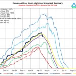
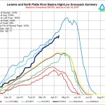
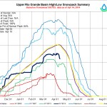
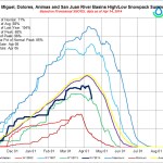

Click on a thumbnail graphic to view the gallery of snowpack data from the Natural Resources Conservation Service.
From the Associated Press via The Grand Junction Daily Sentinel:
Up to 18 inches of snow are on the ground after snow returned to Colorado over the weekend.
The Colorado Avalanche Information Center said Monday the northern Front Range got as much as 18 inches of snow from this storm, and Loveland Pass area received almost 12 inches. The northern Colorado region also got up to 18 inches of new snow.
From The Colorado Springs Gazette (Andrea Sinclair):
The spring storm that passed over Colorado Springs didn’t leave behind as much snow as originally predicted, but enough to make 2013-2014 the snowiest season in 13 years, according to the National Weather Service.
The official report from the Colorado Springs Airport was 1.5 inches, putting the season’s total at 34.4 inches, said meteorologist John Kalina.
In 2000-2001, Colorado Springs received 56.8 inches of snow, Kalina explained…
The snowiest winter in Colorado Springs on record was in 1956-57, when 89.4 inches dumped on the city.
El Paso County seemed to get the worst of the storm Sunday afternoon and evening, when up to an inch of snow piled up in Monument and Black Forest…
Higher elevations, both north and south of Colorado Springs got double-digit snowfall totals, according to the Colorado Avalanche Information Center and the weather service in Pueblo.
The northern Front Range got up to 18 inches and the Loveland pass measured up to 12 inches overnight, prompting the avalanche center to warn of a moderate risk of snowslides.
In the Wet Mountains, west of Westcliffe reported up to 13 inches, Kalina said.