Click here to read the April release from the Natural Resources Conservation Service:
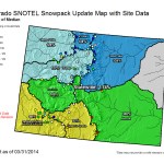
COLORADO’S SNOWPACK HOLDING STEADY
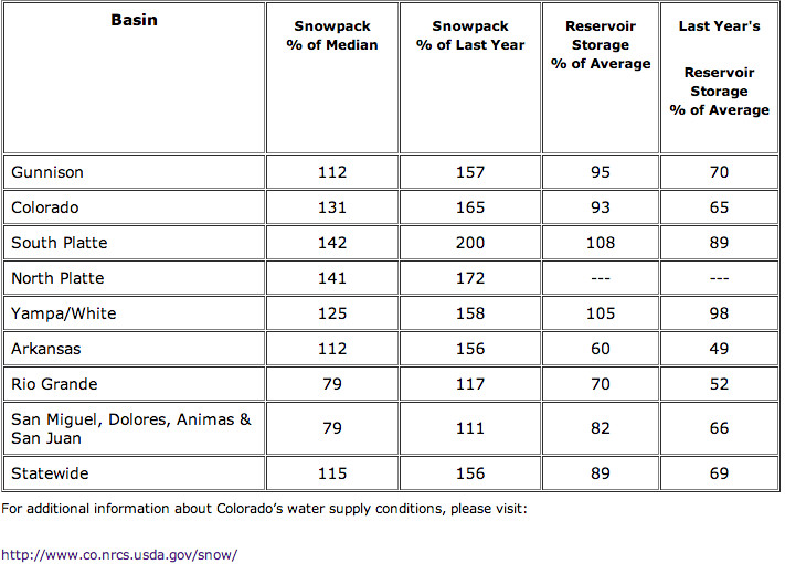
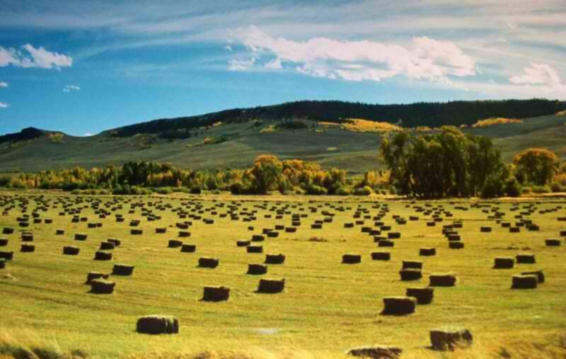
The latest snow measurements conducted by the USDA Natural Resources Conservation Service (NRCS), indicate that Colorado’s statewide snowpack continues to track above normal. Surveys conducted on April 1, show statewide snowpack at 115 percent of median, which is 156 percent of the snowpack measured one year ago. The current statewide report continues the trend of above normal totals that have been measured throughout this winter. This is great news for the state’s major water users who rely on the melting snowpack for the majority of their spring and summer surface water supplies.
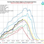
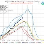
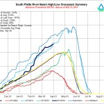
March brought a continuation of previous weather patterns, with most storms favoring the northern mountains ranges while storm systems in the southern mountains were few and far between. Unfortunately, the storm systems passing through during March lacked the moisture that the previous month’s systems had. As a result, the majority of snowpack totals for the major basins across the state showed slight decreases in percentages. In fact only two of the major basins, the Colorado basin and the Yampa, White and North Platte basins, recorded snowpack percentages that improved compared to last month. At 142 percent of median, the South Platte River basin boasts the highest basin wide total in the state; the basin has not recorded snowpack levels this high since 2011.
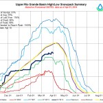
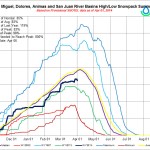
With all the northern basins continuing to report above normal snowpack percentages, the outlook for spring and summer water supplies in these regions is excellent. Across the Colorado, South Platte, Yampa, White and North Platte basins and the headwater portions of the Gunnison and Arkansas basin’s, runoff volumes are currently anticipated to be well above normal this season. Meanwhile, the latest measurements show snowpack conditions across the southern mountains continuing to track below normal for the third consecutive month. April 1 measurements put the Upper Rio Grande basin at just 79 percent of median, and the combined San Miguel, Dolores, Animas and San Juan basins at 80 percent of median. The effect of this is that spring and summer streamflow volumes are expected to be below normal across southwestern Colorado this year. While there is still a possibility for spring snowstorms to improve conditions in these basins, the chances are extremely low given that the normal maximum snowpack is typically reached in the first week of April.
At the end of March reservoir storage across the state was holding steady at 89 percent of average. The northern basins are all reporting storage above or near normal for this time of year while the Arkansas, Upper Rio Grande, and southwest basins all have below normal storage.
“No matter who you are, if you understand water better in the Arkansas basin, it will benefit everyone,” said Scott Lorenz, who joined the foundation’s board this year.
Lorenz lives near Rye and manages the Arkansas Groundwater Users Association, a wellaugmentation group. He and Nicole Seltzer, CFWE executive director, visited Thursday with The Pueblo Chieftain editorial board, along with other groups and individuals throughout the Arkansas Valley.
“We’ve been notably absent from the Arkansas basin,” Seltzer said, explaining that the foundation formed statewide in 2002 as a response to severe drought that caught the state off-guard. “We want to have a larger presence in the Arkansas Valley.”
The foundation can have mutual benefits.
“We provide a lens for the wider state and resources for local water educators,” Seltzer said.
Those resources include publications — Headwaters magazine and a series of Citizens Guides that look at water issues. CFWE also organizes workshops and tours, including one of the Arkansas River headwaters set for September.
The group also sponsors a program for emerging water leaders, which is how Lorenz became involved with CWFE.
Lorenz plans to use his time on the board to increase awareness of the importance of agriculture. There are young farmers who are optimistic about the future of farming, but to do that they also need to protect the availability of irrigation water.
“Sometimes we make ourselves the target,” Lorenz said. “I think CWFE will focus on the facts. One of those is that we have to have water on the land to be viable.
More Colorado Foundation for Water Education coverage here and here.
Here’s the release from the University of Colorado at Boulder:
A free, downloadable guide for individuals who want to collect baseline data on their well water quality and monitor their groundwater quantity over time was released this week by the University of Colorado Boulder’s Colorado Water and Energy Research Center (CWERC).
The “how to” guide, “Monitoring Water Quality in Areas of Oil and Natural Gas Development: A Guide for Water Well Users,” is available in PDF format at http://cwerc.colorado.edu. It seeks to provide well owners with helpful, independent, scientifically sound and politically neutral information about how energy extraction or other activities might affect their groundwater.
The guide spells out the process of establishing a baseline for groundwater conditions, including how best to monitor that baseline and develop a long-term record.
“Baseline data is important because, in its purest form, it documents groundwater quality and quantity before energy extraction begins,” said CWERC Co-founder and Director Mark Williams, who is also a fellow at the Institute of Arctic and Alpine Research and a CU-Boulder professor of geography.
“Once a baseline has been established, groundwater chemistry can be monitored for changes over time,” Williams said. “The most accurate baselines are collected before energy extraction begins, but if drilling has already begun, well owners can still test their water to establish a belated baseline and monitor it for changes. That might not be scientifically ideal, but it’s a lot better than doing no monitoring at all.”
CWERC’s guidance builds on the state’s public health recommendations that well owners annually test water for nitrates and bacteria. The guide encourages well water users to collect more than one pre-drilling baseline sample, if possible.
CWERC recommends collecting both spring and fall samples within a single year because water chemistry can vary during wet and dry seasons. Well owners should measure the depth from the ground surface to the water in their wells in the fall, during the dry season, so that they can keep track of any changes.
“Colorado’s oil and gas regulators have established some of the most comprehensive groundwater monitoring regulations in the country, but those regulations do not require oil and gas operators to sample every water well in an oil or gas field,” Williams said. “So we wanted to develop a meaningful tool for people who want to test their water themselves or those who need information to help negotiate water testing arrangements as part of surface use agreements with drillers in their area.
“Ultimately, it is the responsibility of the well owner to know their own well and understand their water. This guide will help Coloradans do just that.”
The guide specifically outlines what well water users may want to test for and provides a list of properly certified laboratories that offer water-testing services. In addition, the guide assists individuals in interpreting the scientific data, chemical references and compound levels that are outlined in the laboratory results they will receive and any industry tests or reports related to drilling in their area.
CWERC studies the connections between water and energy resources and the trade-offs that may be involved in their use. It seeks to engage the general public and policymakers, serving as a neutral broker of scientifically based information on even the most contentious “energy-water nexus” debates.
CWERC was co-founded in 2011 by Williams and Joseph Ryan, a CU-Boulder professor of civil, environmental and architectural engineering, with funding from the CU-Boulder Office for University Outreach.
To download a free copy of the guide, visit http://cwerc.colorado.edu. For questions about obtaining the guide or to order a printed version, visit the website or call 303-492-4561.
Click here to go to the US Drought Monitor website. Here’s an excerpt:
Summary
This U.S. Drought Monitor week saw an active weather pattern across much of the West coast and northern Rockies as a series of disturbances moved through the region delivering rain showers to the lower elevations and mountain snow showers to the higher elevations. Scattered snow showers were observed in higher elevations of the Intermountain West while the Southwest remained in a warm and dry pattern. Across portions of the South and Southeast, scattered rain showers were observed while locally heavy rain and snow showers fell across much of New England. In the Northern Plains and Upper Midwest, the pattern of below-normal temperatures and snow showers persisted. Across the Southern Plains and western portions of Texas, dry and windy conditions continued to deplete soil moisture levels. On this week’s map, slight improvements were made in northern California and northeastern Oregon, while conditions deteriorated in southern Colorado. Moving eastward, conditions in the southern Plains, western Texas, and the lower Midwest deteriorated while New England saw improvements…
The Plains
As with most of the northern tier, the northern Plains experienced below-normal temperatures and areas of snowfall including blizzard-like conditions early this week in the Dakotas. According to the NWS in Bismarck, North Dakota, record daily maximum snowfall (8.1 inches) was observed in Bismarck on Monday. In the southern Plains, continued short-term precipitation deficits, declining range and pasture conditions, and areas of below-normal streamflow activity led to expansion of areas of Moderate Drought (D1) and Severe Drought (D2) in the eastern half of Kansas and central Oklahoma where areas of Severe Drought (D2) pushed eastward. Temperatures were generally near-normal to slightly above-normal in the southern portions of the Plains during the past week…
The West
During the past week, a series of disturbances pushed on-shore from the Pacific delivering much-needed rain and snow to northern California and Oregon. In northern California, liquid precipitation accumulations ranged from two-to-six inches in the northern coastal mountains while the northern Sierras received three-to-eleven inches. In the northern half of the Central Valley, precipitation accumulations were less than one and a half inch. Despite short-term gains, the long-term deficits across the region remained substantial. According to the California Department of Water Resources, California’s snowpack has increased since the first snow survey on January 3rd, but the latest survey results show California’s snow-water equivalent is only 32 percent of the average April 1st measurement when the snowpack is generally at its peak level prior to spring melt. In light of this week’s significant precipitation accumulations in the northern Sierra, a one-category improvement from Extreme Drought (D3) to Severe Drought (D2) was made to reflect short-term gains over the areas of greatest precipitation accumulations ranging from four-to-eleven inches. In northeastern Oregon, a one-category improvement from Moderate Drought (D1) to Abnormally Dry (D0) was made to reflect near-normal snowpack conditions in the Blue and Wallowa Mountains. In the Southwest, a warm and dry pattern continued across the region leading to slight deterioration of conditions in southwestern Colorado…
Looking Ahead
The NWS HPC 7-Day Quantitative Precipitation Forecast (QPF) calls for moderate-to-heavy precipitation accumulations (two-to-six inches) across the lower Midwest and moderate accumulations (two-to-three) in the South and Southeast. The Upper Midwest, New England, central Rockies, and Pacific Northwest are forecasted to receive accumulations of less than two inches. The 6-10 day outlooks call for a high probability of above-normal temperatures across the West while below-normal temperatures are forecasted across the South, Midwest, and Eastern tier. A high probability of above-normal precipitation is forecasted across portions of the Southeast, Mid-Atlantic, New England, northern Plains, and Pacific Northwest while the remainder of the West, southern Plains, and western portions of the South are expected to have below-normal precipitation.
It is time for the Republican River Water Conservation District Board of Directors to hold its regular quarterly meeting in Yuma. It will be held at Quintech on Thursday, April 10, beginning at 10 a.m. Public comment is scheduled for 1 p.m.
The board will receive a report from Assistant Attorney General Scott Steinbrecher on the negotiations with Kansas regarding compliance with the Republican River Compact, the Bonny Reservoir accounting issue, and the compact compliance pipeline. There also could be other matters addressed by Steinbrecher.
The pipeline has been put to use this past winter as Kansas agreed to a one-year test run in 2014. Tracy Travis, the pipeline manager, will provide a report on the pipeline.
Conservation has been a focus, particularly with a symposium sponsored by the RRWCD and local businesses held last month highlighting the need to conserve the Ogallala Aquifer, the region’s source of water. The board will discuss conservation survey results during the April 10 meeting.
Also on the agenda, HDR Engineering will give a report regarding the Colorado Water Plan. There also will be a presentation on the Great Divide.
The board will consider purchasing agency bonds, and receive reports on various recent meetings and programs.
Quintech is located at 529 N. Albany St. in Yuma. For further information, or having any questions, please call RRWCD General Manager Deb Daniel at 970-332-3552, or email her at deb.daniel@rrwcd.net. The RRWCD website is http://www.republicanriver.com.
John McClow, Colorado’s Commissioner on the Upper Colorado River Commission, will provide a brief summary of the Law of the Colorado River: the Colorado River Compact, the Upper Colorado River Basin Compact, and the Mexican Treaty of 1944. This will be followed by a description of collaborative efforts among the seven Colorado River Basin states, the Department of the Interior, and Mexico to adapt the law to changing conditions on the river.
From 1999 through 2013, the Colorado River Basin has experienced serious drought. Policy makers have responded to this drought with the development of new management strategies for the major storage reservoirs in the system (Lake Powell and Lake Mead) to prevent them from reaching critical storage levels. These strategies could affect all Colorado River stakeholders.
This is a “not-to-be-missed” presentation for all professionals interested in management of the Colorado River and the effects of long-term drought in the Colorado River Basin. Tune in for recent updates from the Upper Colorado River Commission.
“In 2013 at this time we were in a pretty dire situation. We were well below average for snow pack and snowfall,” said Patrice Lehermeier, spokesperson for Colorado Springs Utilities.
Fortunately, that’s not the case this year.
“The best way to describe it is cautiously optimistic,” said Lehermeier.
Optimism that this winter’s snow will mean years of water.
“If the snow that we’ve received in the mountains melt like we think it will, we can see our reservoirs and water storage at a two year supply. That’s a really good number for us,” said Lehermeier.
The majority of Colorado Springs water comes from the Upper Colorado Basin. Right now it’s 130% of average snowfall.
“Here’s the important part though- just because we’re not in mandatory restrictions doesn’t mean you should start over using water. Our goal is to sustain public safety. We know the drought is only one winter away, and who knows what could happen next summer. We also know that wildfire is a huge concern across our state and this area is a victim of some of that devastation,” said Lehermeier.
The past two years have been challenging for whitewater-rafting companies. A meager snowpack created particularly tough times in summer 2012. There were very few Class IV rapids in the entire state, Ingram said, and most of the rafting that could be offered was a Class II float trip.
Business was better last summer, thanks to an improved snowpack and stronger economy, Ingram said.
Savvy tourists nowadays check streamflows before booking a rafting trip just like they check snow conditions before blowing a wad on skiing vacations. Ingram said reservations are rolling in already because of the prospects of impressive flows.
“I’m looking at a good Slaughter House season,” he said, referring to the Class IV Slaughter House Falls downstream from Aspen. Based on current conditions, experience tells him the streamflow will allow his company to run the falls at least halfway through July if not the entire month…
The Roaring Fork River Basin ecosystem also will be a winner this year. The riparian areas and wetlands located alongside rivers and creeks will be replenished from high flows and high groundwater, said Sharon Clarke, watershed action director for the Roaring Fork Conservancy, a Basalt-based nonprofit focused on education and activism on water issues…
Snowpack levels in the Roaring Fork Valley have been higher than average since the region was hit by storms in late October. The Roaring Fork River Basin as a whole is at 126 percent of average, according to the Natural Resources Conservation Service, the agency that tracks snowpack.
In the vast geographic area covered by the Roaring Fork Basin, the snowpack ranges from a low of 115 percent of average at McClure Pass to 135 percent of average at Schofield Pass in the Crystal River headwaters and 134 percent of average at Ivanhoe, near the Fryingpan River headwaters.
East of Aspen, near the headwaters of the Roaring Fork River, the snowpack is 123 percent of average.
“It’s touching where it was in 2011, but in 2011 it kept cranking,” Clarke said. That’s the spring when the snow didn’t stop coming in April and May.
Conditions were perfect in late May and June 2011 for a long, sustained runoff that didn’t peak as abruptly as feared, given the high snowpack. The Roaring Fork River peaked at about 8,000 cubic feet per second at Glenwood Springs, according to the Colorado River Basin Forecast Center, a division of the National Weather Service and National Oceanic and Atmospheric Administration.
The Roaring Fork River’s highest recorded level was 11,800 cfs at Glenwood Springs in 1995, according to the forecast center. The low was 1,870 cfs in 2012…
It’s too early in the runoff season for an accurate picture of the Roaring Fork River’s peak. That will depend on how warm it gets, for how long and when, said Eric Kuhn, director of the Colorado River District, an organization that protects western Colorado water interests. However, it appears the volume of water produced by the snowpack melting from May through July will range between 110 and 120 percent of average.
“We’re thinking it’s going to be a good year,” Kuhn said.
The big advantage of the higher volume is that water managers can build storage levels in reservoirs, he said. There should be enough water remaining after irrigation and municipal uses to store in the reservoirs. Even Lake Powell in Utah, which has been drawn down to sustained, low levels, will “bump up a little” this year, Kuhn said.
The U.S. Bureau of Reclamation has boosted releases from Ruedi Dam to above 210 cfs to make room for anticipated runoff. It increased the discharge to a higher level than usual earlier than usual. Ruedi Reservoir is currently two-thirds full. With the higher-than-average snowpack in the upper Fryingpan River Valley, prospects are great for a long boating season at high water levels on Ruedi.
Diversions from the Fryingpan-Arkansas Project from the upper Fryingpan River basin and from the Twin Lakes Canal Co. diversion system, from the upper Roaring Fork River basin, will likely benefit from the above-average snowpack. The diversion systems are limited by capacity, Kuhn said. If the snow melts at a slow and steady pace rather than during a more compact time period, they can divert water for more days.
A thin layer of dust that a windstorm deposited on the Aspen area Sunday evening may play a key role in how the snowpack melts this spring and early summer, according to Chris Landry, executive director of the Center for Snow and Avalanche Studies in Silverton.
High winds blowing the dry sands of the Southwest and the Colorado Plateau slammed into the Colorado mountains late Sunday afternoon and into the evening. There was so much dust in the air, blowing through in plumes, that the sky turned an odd orange-ish hue before sunset.
“It was a significant event,” Landry said. The nonprofit center runs the Colorado Dust-on-Snow Program, which monitors “dust events,” measures how much dust gets deposited in the snowpack and assesses how it will affect the spring runoff.
Landry was in the field Sunday visiting 11 sites in Colorado, including McClure Pass in the Crystal River Valley, where the program monitors snowpack and assesses dust. He and a colleague stayed in Steamboat Springs on Sunday night and weren’t sure initially how extensive the dust incident was because fresh snow fell overnight at the resort. It became more apparent, by the time they reached Interstate 70, that dust had coated the snowpack, and it was “dead obvious” by the time they reached the Roaring Fork Valley that it was significant, Landry said.
It affected the mountains as far east as Loveland and extended into the Grand Mesa to the west and Red Mountain Pass and the surrounding San Juans to the south. The Dust-on-Snow Program still is assessing how far north the dust spread.
“This was a huge event. It might have got most of the mountains,” Landry said.
Although it covered a widespread geographic area, it didn’t leave a layer of dust as thick as windstorms did at some locations in the Colorado mountains last spring, Landry said. His staff will collect snowpack samples in June, where all layers have merged, to assess the dust’s potential impact on runoff. The dust leaves a distinctive layer in the snow sample.
Most dust storms occur in March, April and May, so the prospects are high that more will roll through the mountains, according to Landry…
Sunday’s storm was the fourth incident to deposit dust in at least a portion of the mountains. Two earlier events left smaller amounts of dust in the Aspen-area snowpack, he said…
The Colorado Basin River Forecast Center in Salt Lake City is signaling that a warming trend next week could kick off low elevation runoff, causing the Yampa River in Steamboat Springs and downstream in Moffat County to begin to rise steeply.
The center is projecting that the Yampa will flow well above its historic norm at more than 350 cubic feet per second Thursday through Sunday. But the river’s flow could begin to stair-step more steeply to more than 700 cfs late next week. And if that comes to pass, it will because of a significant warming trend.
The Yampa at Maybell, west of Craig, also is expected to rise but with bigger peaks and valleys than further upstream in Steamboat. At Maybell, the river was flowing at more than 1,000 cfs Tuesday and could spike to nearly 1,700 cfs by Monday.
Greeley had far less precipitation than normal in March — typically a big snow month — but three months deep into the year, 2014 overall is still a wet one.
During March, Greeley received just .4 inches of snow — only 5 percent of its typical 8.3 inches for the month — and, with rain factored in, received just .75 inches of total precipitation, which is only 67 percent of its historic average of 1.12 inches, according to numbers provided by the Colorado Climate Center based in Fort Collins.
However, thanks to an abnormally wet January and February, Greeley’s total precipitation for 2014 is 3.23 inches — well above the typical 2 inches it receives through the end of March, and ranking as the fifth-wettest year on record — and it’s total of 18.9 inches of snow this year are right about normal for the city.
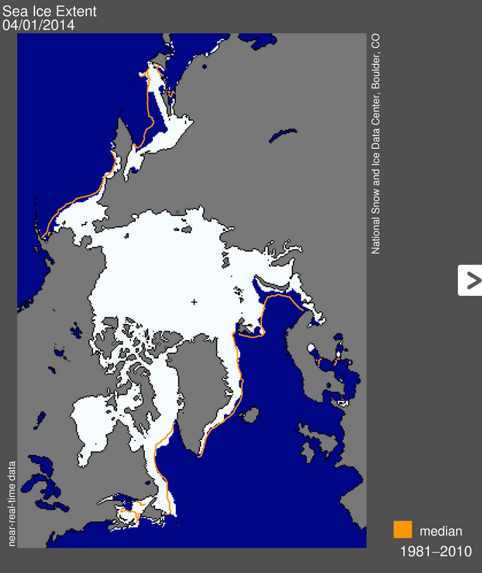
Arctic sea ice reached its annual maximum extent on March 21, after a brief surge in extent mid-month. Overall the 2014 Arctic maximum was the fifth lowest in the 1978 to 2014 record. Antarctic sea ice reached its annual minimum on February 23, and was the fourth highest Antarctic minimum in the satellite record. While this continues a strong pattern of greater-than-average sea ice extent in Antarctica for the past two years, Antarctic sea ice remains more variable year-to-year than the Arctic…
Arctic sea ice extent for March 2014 averaged 14.80 million square kilometers (5.70 million square miles). This is 730,000 square kilometers (282,000 square miles) below the 1981 to 2010 average extent, and 330,000 square kilometers (127,000 square miles) above the record March monthly low, which happened in 2006. Extent remains slightly below average in the Barents Sea and the Sea of Okhotsk, but is at near-average levels elsewhere. Extent hovered around two standard deviations below the long-term average through February and early March. The middle of March by contrast saw a period of fairly rapid expansion, temporarily bringing extent to within about one standard deviation of the long-term average.
The Weld County Youth Corps Association recently received grant dollars to help mitigate invasive plant species along the area’s rivers and protect the state’s water resources.
This will likely come as exciting news to water users in northeast Colorado’s South Platte River Basin, who see invasive phreatophyte plants — deep-rooted plants that obtain water from permanent ground supplies or from the water table — as a major problem.
A study conducted last year by the Colorado Water Institute showed that invasive phreatophyte plants continue to increase in the South Platte basin, resulting in large quantities of non-beneficial consumptive water use — perhaps as much as 250,000 acre feet per year, or 80 billion gallons.
According to a news release, the Weld County Youth Conservation Corps will receive $15,000 to remove invasive vegetation from riverbanks and sandbars of the South Platte River.
The project is coordinated with and sponsored by Ducks Unlimited.
The corps will also receive $7,500 to eradicate tamarisk and Russian olive along the St. Vrain River in a project for the Weld County Weed Division.
A total of five projects in 2014 — funded through a $50,000 grant from the Colorado Water Conservation Board, which is a division of the Department of Natural Resources — will be conducted by Colorado Youth Conservation Association-accredited youth corps in conjunction with local project sponsors in four counties throughout the state.
For the South Platte River project, the Weld County Youth Corps Association crew will clear invasive vegetation from three protected properties located along the South Platte River in Weld and Morgan counties. This work will improve the river channel habitat for waterfowl and other wildlife and reduce consumptive water use.
The project will start at Weld County Road 1 and extend about three linear miles toward the confluence with the South Platte River.
The Weld County Youth Corps Association proposal was one of eight representing $105,000 in requests for 14 weeks of work to mitigate these plants throughout the state.
The Weld County Youth Corps Association — serving youth and young adults ages 14-24 — engages its corps members in community and conservation service projects throughout Weld County.
A crowd of more than 100 people echoed a mantra in unison that multiple Colorado Springs officials stressed at a flood preparedness meeting on Tuesday night.
“Up, not out,” the said loudly after being prompted by police Lt. Dave Edmondson…
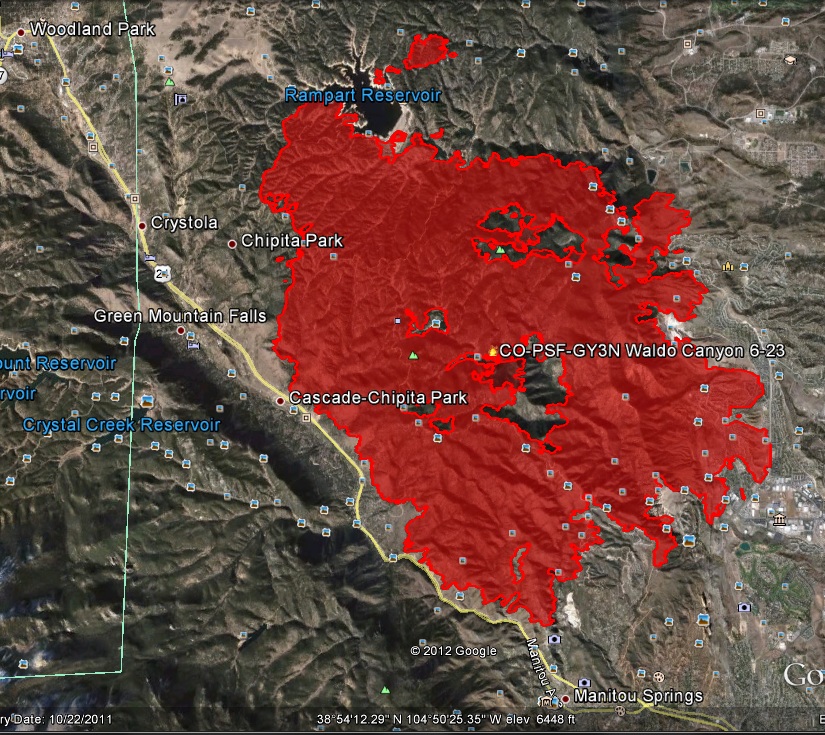
City officials, including Emergency Manager Brett Waters and others talked about the 2013 floods that struck the city and El Paso County in July, August and September. Waters said his colleagues and the residents need to “take flood risk very seriously,” noting that flash floods coming out of the Waldo Canyon Fire burn scar are going to be an issue “for at least the next 10 years.”
Tim Mitros, the city’s development review and stormwater manager, showed slide after slide of the dangers that lie in the Camp Creek drainage in the hills to the west of Colorado Springs. The pictures illustrated barren, burnout out slopes that have already, and could, send tons of dirt rocks and other debris into the channel along Garden of the Gods Park. and into the Pleasant Valley neighborhood.
“We’ve got to keep the sediment up in the burn area,” Mitros said.
Mitros said city crews will begin building a large sediment detention pond on the east end of Garden of the Gods Park in the next month. At that time, workers will also begin doing repairs to the channel in the middle of 31st Street near Pleasant Valley. They will be adding a “protective layer of concrete” to badly damaged parts of the creek between West Fontanero Street and Echo Lane.
The work is the beginning stages of a $37 million project to rebuild the channel from Garden of the Gods Park to Colorado Avenue, Mitros said. The city already allotted $8.8 million to do work in Camp and Douglas creeks. MIiros said the final designs for the entire project will be unveiled at another Camp Creek watershed public meeting from 5 to 7:30 p.m. April 29 at Coronado High School.
National Weather Service meteorologist Jennifer Stark also talked about the dangers of debris in the Camp Creek and Douglas Creek areas. She said storms in September that ravaged the Front Range from El Paso County north to the Wyoming border left tons and tons of debris sitting just above the city.
“The next big rain event could bring that stuff down,” she said.
The images of a glowing sky that filled the air with choking smoke won’t soon fade, but the damage to forested hillsides charred by the Waldo Canyon Fire in 2012 will be more troublesome for years. Colorado Springs had a taste of things to come during last September’s torrential rains, but it will take millions of dollars and at least a decade to recover the damaged landscape.
“We built basins to collect sediment over a 10-year period, but they filled up during the flooding last September,” said Tim Mitros, Colorado Springs stormwater manager, during a media tour of projects Wednesday.
So now the city is building a series of ponds that will trap floodwater, along with making other drainage improvements on North Douglas Creek, South Douglas Creek, Queens Canyon, Cheyenne Creek and Camp Creek on the west side of Colorado Springs. Altogether the projects will cost $8.8 million in additional stormwater funding from federal, state and city sources.
The catch basins worked, but filled too quickly, Mitros explained during a tour of one on North Douglas Creek on the Flying W Ranch. The idea behind them was to allow new vegetation to sprout as they filled, but the storms left a bed of gravel that would just sheet off water in the next storm.
Jason Moore, director of land management for the Flying W, explained how downed trees are criss-crossed along the creek bed to slow down minor flows.
“They’re in a W shape, so we call them Flying W’s,” Moore joked.
The ponds are being constructed with the cooperation of landowners, but must be cleaned by city crews after each storm dumps its load of sediment. Mitros said the city is fortunate because it is working with only two large landowners, the Navigators and Flying W, and both have been cooperative.
“Without the ponds, the sediment will continue to fill the concrete channel below and put them in danger of being overtopped,” Mitros said.
That will continue to be a big job. Colorado Springs still is hauling 6,000 cubic yards of sediment — 600 truckloads — that washed into Garden of the Gods Park after last summer’s storms. There would be some benefit to Pueblo, because anything done high up in the watershed helps to slow down the water reaching Fountain Creek, Mitros said. Primarily, however, the projects are being undertaken to protect the homes and businesses in the Mountain Shadows neighborhood that was decimated when the Waldo Canyon Fire burned 347 homes. Those homes are being rebuilt, but now face a different threat. They lie below valleys that are normally dry, but which become running rivers when it rains. Because the fire burned off much of the vegetation, any flood becomes about 10 times as powerful, said Leon Kot, restoration coordinator for the Natural Resources Conservation Service.
Besides the new threat of runoff, Colorado Springs also is dealing with miles of concrete storm ditches, some more than 50 years old, that have fallen into disrepair. About 1,000 feet of 8-foot diameter pipeline buried near Eighth Street and Cheyenne Boulevard was overwhelmed by the September flooding and is being replaced in a $750,000 project.
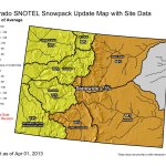
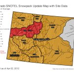
Click on a thumbnail graphic for a trip down the snowpack memory lane for the past three years. The 2012 map followed a warm and dry March when the below average snowpack melted out early. The 2013 map preceded the monster April and early May that helped end the drought over northern and central Colorado. The current snowpack bodes well for runoff this season.
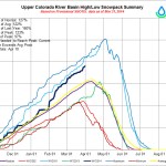
The USDA Natural Resources Conservation Service Kremmling Field Office snow surveyors Mark Volt, Noah Bates took the April 1 snow survey measurements during the last days of March. Snowpack for Middle Park and the upper Colorado River Basin stands at 144 percent of average, compared to 79 percent last April 1, 2013. The snowpack surpasses the 135 percent reading in the height of the year of 2011, and 62 percent in the drought year of 2002.
Snowpack in the mountains above Middle Park now ranges from 114 percent to 206 percent of the 30- year average.
The Granby snow course near C Lazy U Ranch, which has been read since 1949, set a new record high for the second month in a row. Snow density is averaging 31 percent, which means that for a foot of snow there are 3.72 inches of water. Irrigators, towns, river runners and other water users can expect higher than normal river levels this summer.
Reservoir storage remains higher than last year. From this point on, spring runoff will be highly dependent on melting conditions (i.e., temperature and wind), as well as spring snow accumulation and/or rainfall.
Most of the snow courses around Middle Park have been read since the 1940s. Snow course readings are taken at the end of each month, beginning in January and continuing through April. March is historically the snowiest month, and the April 1 readings are the most critical for predicting runoff and summer water supplies, as most of our high country snowpack peaks around that time. Manual snow courses will be read for the final time this year at the end of April.
From the Glenwood Springs Post Independent (Hannah Holm):
Current efforts to develop a Colorado Water Plan have been largely driven by a large projected gap between urban water needs and developed supplies. Gunnison Basin water planners, however, are more focused on a current gap between agricultural needs and developed supplies. The water managers and stakeholders that make up the Gunnison Basin Roundtable are concerned that efforts to address the urban gap will negatively impact agricultural uses, whose importance goes beyond food production to environmental and recreational values.
In the Gunnison Basin, which stretches from the headwaters near Crested Butte, Lake City, Ouray and Paonia downstream to Delta and Grand Junction, the anticipated gap between municipal needs and developed supplies is relatively small, while the gap between agricultural needs and supplies is already large.
According to the latest statewide water supply study, the present gap between water requirements to fully meet crop demands and water available is about 128,000 acre-feet per year in the Gunnison Basin. An acre-foot is about enough water to fill a football-field-sized tub one foot deep. This is generally considered sufficient to sustain two to three average households for a year.
Agricultural water shortages are experienced in every water district in the basin. The district that includes the North Fork of the Gunnison River and Delta has the largest gap at over 75,200 acre-feet per year. This district also has the largest number of irrigated acres in the basin, with 90,200. The Lake Fork and Lower Uncompahgre districts have the smallest gaps, at between 2,500 and 3,000 acre-feet per year. The farmers of the 79,800 irrigated acres in the Lower Uncompahgre District benefit from senior water rights and upstream reservoirs, while the Lake Fork District contains just 16,500 irrigated acres.
Analysis conducted so far points to a need for additional upstream reservoir storage to support late-summer and fall irrigation. The Wilson Water Group, the consulting group hired by the Gunnison Basin Roundtable to assist with the basin plan, is conducting targeted technical outreach meetings to more precisely identify the causes of the shortages and identify potential projects to address them. Causes for shortages can be categorized as physical (insufficient water available), legal (water is present, but the irrigator doesn’t have rights to it), storage-related (insufficient late-season water), or efficiency-related (sufficient water could be available if managed more efficiently).
The focus on agriculture in the Gunnison Basin makes sense, given that the Gunnison Basin Roundtable’s primary goal is to “protect existing water uses in the Gunnison Basin.” Agriculture (mostly grass and alfalfa hay, but also pasture, fruit trees, wine grapes and the famous Olathe Sweet Sweet Corn) accounts for approximately 90 percent of the basin’s water consumption. In addition to its intrinsic value, irrigated agriculture is also seen as supporting other valuable attributes of the basin’s landscape. It provides the aesthetic “open space” important to the basin’s growing recreational economy, and the flood irrigation for high hay meadows slows the flow of water downstream, supporting late-season streamflows. Flood irrigation also creates wetland areas that nurture birds and other wildlife.
Additional goals, supporting that primary goal of protecting existing water uses, include addressing municipal and industrial shortages, quantifying and protecting environmental and recreational water needs, and maintaining and modernizing critical water infrastructure, including hydropower.
The Gunnison Basin Roundtable has also put forward a number of “statewide principles” for consideration by other basin roundtables. These principles warn of the hazards of new water projects on the Western Slope and encourage conservation and the development of local projects to meet local needs. Those principles are a response to the perception that Basin Roundtables in basins east of the Continental Divide continue to look west for new water supplies, despite the fact that additional depletions from the West Slope could increase the risk that Colorado may not be able to meet its contractual obligations to the downstream states that share the Colorado River.
The basin roundtables are working to collect public input on water needs and priorities as well as to technically analyze supplies and demands. In order to learn more and take a survey to contribute your insights, go to http://www.ugrwcd.org and click on “Gunnison Basin Water Plan.”
Mark Waage, the manager of water resources planning for the utility Denver Water, told a meeting of the Interbasin Compact Committee (IBCC) in Denver that Front Range interests are not necessarily seeking “firm yield,” or reliable annual supply, from a new trans-mountain diversion project, but instead could settle for diverting water only when a wet winter like this one gives the Western Slope and downstream consumers more than they need to satisfy existing water rights.
“We are looking for wet year water,” said Waage after the meeting. “There are going to be wet years when we can develop more water. In dry periods, this project wouldn’t divert from the Colorado [River], and we would rely on [buying water rights from] Front Range agriculture instead,” along with reservoir and groundwater aquifer storage and mechanisms like rotational fallowing that permit farmers to temporarily lease their water rights to cities.
The suggestion by Front Range interests that they’re willing to forego diversions during dry years stands in sharp contrast to their usual and long-standing insistence that “firm yield” for the Front Range from new trans-mountain diversion projects is inevitable.
Existing diversion projects — like the Twin Lakes tunnel underneath the Continental Divide between the Roaring Fork and Arkansas river basins — already have the capacity to pipe as much as 600,000 acre-feet (roughly six Ruedi Reservoirs) of water to the Front Range each year…
Just how much of the “new supply” sought by the Front Range will come from the Western Slope remains a looming question as officials work to draft a statewide water plan as ordered by Colorado Gov. John Hickenlooper last year…
In the meantime, members of the IBCC will now take the emerging framework for a new trans-mountain diversion project back to their respective roundtables for input, before drilling down further on the details in future meetings.
Any agreement on a new project that parties on opposite sides of the Continental Divide can hammer out will likely be reflected in the statewide water plan. Still, the plan itself won’t explicitly endorse any proposed new projects.
“We’re not going to pick winners and losers, or projects that are given a green light, so to speak, or a red light, so to speak,” said James Eklund, the executive director of the Colorado Water Conservation Board, which oversees the IBCC and the roundtables.
Eklund spoke at a meeting with state legislators on the statewide water plan that took place in February. “Instead what we’d like to do,” he said, “is focus on a regulatory path where we might be able to someday have the state endorsement of a project.”[…]
For the IBCC members charged with protecting water supplies on the Western Slope, who have long clashed with Front Range cities over the idea of new trans-mountain diversion projects, Waage’s modest statement last week on behalf of Denver Water— vague and general though it was — sounded like something of a breakthrough.
“They are now willing to talk about a project that’s not going to divert every year, and that’s new,” said Jim Pokrandt, communications and education director for the Colorado River District, which protects Western Slope water interests. “There seemed to be a coalescing around a project that would only work intermittently.”
Eric Kuhn, the Colorado River District’s general manager, said that although Front Range water interests have long hinted that they might accept a new trans-mountain diversion project that doesn’t pull water every year, “this is the first time that the idea has surfaced with some consensus.”[…]
Specifically where a new trans-mountain diversion project would be located also remains to be seen. Front Range interests have proposed several possibilities in recent years, including projects pulling anywhere between 100,000 and 250,000 acre feet from the Green River at Flaming Gorge Reservoir in Wyoming, from the lower Yampa River, or from the Gunnison River at Blue Mesa Reservoir west of Gunnison…
Since many of the water rights now used by the Front Range to divert Western Slope water under the Continental Divide were adjudicated after 1922, there’s a chance that a so-called “compact call” would force some Front Range water interests to stop diverting water temporarily.
Faced with the insatiable demand of their urban customer base, those Front Range interests could then begin leasing water from farmers on the Western Slope in order to continue their usual diversions, extending into western Colorado the practice of “buy and dry” water transfers from farms to cities that is now common on the Front Range.
To alleviate fears of such a scenario playing out, Waage of Denver Water told the IBCC meeting last week that the Front Range would be willing to assume the “hydrologic or legal risk” associated with a new diversion project, meaning that diversions from the project would cease in the event of a compact call before Western Slope water users with more senior rights had to curtail their own use.
“The risk of compact curtailment has been a stumbling block for years, and we are looking now at how to minimize and share that risk,” said Waage. “We need to look at water projects that won’t lead to the curtailment of the Western Slope’s Colorado Compact allocation.”[…]
“I think to decide whether there is enough water, the Front Range would have to do a very detailed risk analysis,” said Kuhn of the Colorado River District. “Because of climate change, we know that the [water supply] baseline is going to change. I think most of the science suggests that we will not have more water in the future than we do now.”
Southern Delivery System route map — Graphic/Reclamation
From the Colorado Springs Independent (Pam Zubeck):
Outside of a handful of parcels tied up in eminent-domain court actions, the city has amassed the vast majority of land needed to complete the 66-inch-diameter line across Pueblo and El Paso counties. And as for those in court, Utilities has been granted possession; at issue is determination of their value.
Which leaves only one other property acquisition needed for the pipeline itself, and a couple dozen others for related projects. Overall, the land-acquisition project is on schedule, if significantly over budget.
“We are pleased to be nearly complete with acquiring the land needed for SDS,” says Utilities project manager John Fredell in a statement. “We have worked hard to be fair with property owners and appreciate their cooperation to advance this critical project for our community and partners.”[…]
The city’s initial foray into acquiring property for the project, in 2003 and 2004, caused an uproar, and a tightening of city real estate acquisition procedures. Utilities, in some cases without Utilities Board approval, had made offers for homes near Jimmy Camp Creek, northeast of the city, for up to three times the homes’ assessed values, plus six-figure moving costs — in one case, $340,000. The city paid $6.1 million for 14 properties and then allowed the former owners to rent for $300 a month indefinitely.
Within a few years, the city abandoned the Jimmy Camp area as a reservoir site due to archaeological values and other factors, and instead chose Upper Williams Creek near Bradley Road.
In 2009 and 2010, Utilities tangled with Pueblo West residents and left some hard feelings in its wake. The buried pipeline, which traverses the back portions of residential lots, can’t be built upon, which residents say renders their yards unusable.
Resident Dwain Maxwell, who’s forced Utilities into condemnation court, says he was paid $1,850 for land his appraisal said was worth $16,500. Meanwhile, he estimates Utilities has spent four times that amount on attorneys. “I feel like they’ve not been honest with us,” he says today.
Gary Walker of Pueblo County is also still in condemnation court with the city, and declined to be interviewed for this story. But he notes in an email that he’s been recognized repeatedly for his stewardship of the land at his ranch, and was the first to sign up for the reintroduction of the black-footed ferret under federal rules. “How do you put a price on the destruction of something so important as our environment?” he asks.
In 2012, Utilities went up against the Norris ranching family for a chunk of land for Upper Williams Creek Reservoir. After the Norrises moved to create their own reservoir, a deal was reached in which the city paid the family $7.5 million for 791 acres.
But the biggest single acquisition was land next to the Norris property owned by the State Land Board. The city paid more than $11.8 million for 1,128 acres, the highest per-acre price paid for pipeline property…
Utilities needs to acquire about 15 additional properties for the reservoir site, but the reservoir won’t be built until SDS’ second phase, from 2020 to 2025, as demand requires. The city also needs 11 more properties for a section of pipe for treated water, Rummel says.
So far, the city has spent $34.6 million on land for SDS. That’s about 38 percent more than the $25 million estimate in 2009 for 274 parcels in Phase 1 and reservoir land. If costs for surveys, appraisals, real estate fees and closings are added, the cost is $45 million, or 22 percent more than the 2009 “all-in” estimate of $37 million.
Water rates, meantime, haven’t increased as much as earlier predicted. Ratepayers saw 12 percent hikes in 2011 and 2012, and 10 percent increases in 2013 and 2014. A 5 percent hike is expected in 2015. Previously, 12 percent annual jumps were forecast from 2011 through 2017.
More Southern Delivery System coverage here and here.
Colorado Water Plan website screen shot November 1, 2013 From the Summit Daily News (Alli Langley):
Summit County’s struggle is meeting the water needs of growing communities while satisfying Front Range water rights established here in the 1930s and ’40s.
“They need to be making land use plans for themselves,” said County Commissioner Karn Stiegelmeier, “instead of relying on us to save them.”[…]
The Colorado Basin needs to rally around the idea of no additional water for other basins, said Peter Mueller, of the Nature Conservancy.
Both Stiegelmeier and Mueller are part of the Colorado Basin Roundtable, one of nine groups of stakeholders created in 2006 by the Colorado Water for the 21st Century Act…
In Frisco, water experts, local leaders and residents concerned about the future of water convened Wednesday to discuss the Colorado Basin Implementation Plan.
The plan must show how the basin will produce the projected water needed by 2050, said Louis Meyer, the project manager for SGM, the civil engineering and surveying firm in Glenwood Springs creating the plan.
David Baldinger Jr., the official observer for the National Weather Service, said his weather station not far from Steamboat Springs High School finished March with 16.1 inches of snow and14.7 on the ground, compared to 28.5 inches accumulation and 20.8 on the ground at the end of March 2013.
Baldinger Jr. confirmed that consistent snowfall has been the hallmark of the weather pattern the past two months — February began with snowfall in town on 14 of the first 17 days…
Monday’s measured snowfall of 6 inches at midmountain and 7 inches at the summit marked the biggest 24-hour snowfall of the month. Steamboat finished up with 13 inches of midmountain snow and 17 at the summit in the final five days of the month.
For the season, Steamboat now has seen 333 inches of snowfall and is within a couple of inches of the 20-year average with the ski season scheduled to end April 13…
The amount of moisture contained in the snowpack at several key measuring sites in the mountains above Steamboat Springs already is greater than the median peak for the season, according to records kept by the National Resources Conservation Service…
A snowpack measuring site at 9,400 feet on the west summit of Rabbit Ears Pass that is maintained by the NRCS shows 35.3 inches of water is contained in the snow there. That’s 145 percent of the median for the date, but also 135 percent of the median peak, which isn’t statistically due for another four weeks April 28.
The median peak water stored at the end of the winter on Rabbit Ears is 26.1 inches compared to 35.3 inches there now…
The Tower site, at 10,500 feet elevation on Buffalo Pass, just northeast of the city of Steamboat, is storing significantly more water than Rabbit Ears right now — 51.3 inches — and the median date when it peaks isn’t until May 9. As of March 31, the snowpack at the Continental Divide is 147 inches deep and 118 percent of median for the date. Coincidentally, that is 100 percent of the median.
Steamboat typically sees two phases of spring runoff, the first when lower elevation boosts river flows, and the second much later when the snow above 9,000 feet finally gives in to the longer, warmer days of spring.
The book launch is today. Click here to go to the Tattered Cover website to order it. Watch the trailer here.
I’m about halfway through the book, somewhere in Japan, at the world’s smallest bar. I had no idea that there was a body of science around humor and laughter.
In the 1930s, a 6-foot-tall, 60-feet-wide diversion dam was built in Tabeguache Creek, just upstream from its confluence with the San Miguel River, for the purposes of providing water to the Town of Uravan.
That dam remained for roughly 80 years, even as the uranium mining town was abandoned, declared a Superfund Site and razed in a reclamation project.
When Uravan shuttered, the dam stopped diverting water for human consumption. It continued, however, to block upstream passage to three species of native fish that rely on warm-water tributaries for their spawning grounds.
Until recently, that is. Thanks to a Bureau of Land Management project that was supported by the San Miguel Watershed Coalition and Nature Conservancy, the diversion dam was dismantled earlier this month.
Following two years of research, planning and securing funding, it took crews from Reams Construction a day and a half to pull all of the concrete out of the streambed.
And just like that, Tabeguache Creek was flowing free.
Peter Mueller, who is both the Nature Conservancy’s Southwestern Colorado Project Director and a board member on the Watershed Coalition, said the removal was a great thing to witness.
“One of the things that is so critical for the Nature Conservancy, the Coalition and BLM is that the native fish use these tributaries for spawning,” Mueller said. “And so to be able to remove this diversion structure and open up another eight miles of habitat, with full cooperation of both private landowners and the federal government … we were really excited about it.”
Amanda Clements, an ecologist with the BLM, said the project came about when the agency’s fish biologist was examining Colorado maps for migration barriers.
“He spotted this one,” Clements said.
Through follow-up investigation, Clements said, the BLM discovered that water rights of the dam had been determined abandoned and that removal of the structure would open up a lot of habitat for three species of native fish: Roundtail chub, Flannelmouth sucker and Bluehead sucker. All three are considered “BLM Colorado sensitive species.”
More San Miguel River watershed coverage here and here.
For one week now, the Colorado River has been flowing into its delta. It’s the first ever deliberate release of water here to benefit the environment.
That the river is flowing again in its delta is somewhat astounding, all the more remarkable because it’s happening as the result of cooperation between the United States and Mexico under a new collaborative agreement on river and water management.
These releases – lasting eight weeks – are being made from Morelos Dam, about 100 miles (160 kilometers) upstream from the river’s end at the Upper Gulf of California (Sea of Cortez). About 75 of those river miles (120 kilometers) are typically wet, either from a high groundwater table or the tides that make their way upstream. But a reach of about 25 miles of the channel have been dry for decades, hot sand baking in the desert sun.
For the Colorado River to flow all the way to the Upper Gulf it needs to cross that sandy reach, and on March 29, 2014 it had made it down about 20 of those 25 miles, and about 40% of the total flow volume had been released.
Two new and three returning directors have been appointed to the Southeastern Colorado Water Conservancy District board. The appointments were approved by Deborah Eyler, chief district judge in Pueblo, in conjunction with other chief judges throughout the nine-county area within the district. The new members will take their seats at April’s meeting. There are 15 directors who serve four-year terms on the board that oversees the Fryingpan-Arkansas Project.
Pat Edelmann, retired head of the U.S. Geological Survey office in Pueblo, and Curtis Mitchell, head of Fountain Utilities, have joined the board.
Returning directors are Bill Long of Las Animas, Ann Nichols of Manitou Springs, and Tom Goodwin of Canon City.
Edelmann, 58, replaces Shawn Yoxey as a Pueblo County representative on the board. Pueblo has two other directors on the board, Vera Ortegon and David Simpson.
Edelmann retired in 2011, and spent most of his career in the Pueblo USGS office studying the Arkansas River and Fountain Creek. He frequently presented USGS reports and studies to the Southeastern board during his career.
Mitchell, 55, replaces Greg Johnson. Mitchell worked for Colorado Springs Utilities for 30 years before joining Fountain Utilities five years ago.
“I was involved with the startup of the Fountain Valley Authority, so I have a lot of interest as a water professional in the startup of the Arkansas Valley Conduit,” Mitchell said.
Building the conduit, which will serve 40 communities east of Pueblo, is the district’s top priority.
Long, 59, a business owner and Bent County commissioner, is president of the board. He was appointed to the board in 2002.
Nichols, 68, an economist and treasurer of the board, was appointed in 2006. Her father, Sid Nichols, was a charter member of the board.
Goodwin, 61, a farmer and rancher, was first appointed in 2011. His father, Denzel Goodwin, was a longtime member of the board.
More Southeastern Colorado Water Conservancy coverage here.
Photo via The Pueblo Chieftain FromThe Pueblo Chieftain (Chris Woodka):
Three contracts totaling more than $600,000 were approved Friday by the Fountain Creek Watershed Flood Control and Greenway District board. The contracts are funded by state grants. They include two contracts for $502,000 for the Upper Fountain Creek and Cheyenne Creek restoration master plan, and another for $107,000 for the Frost Ranch restoration project. The three projects are among five projects the district is directly coordinating throughout the watershed. They also include a flood detention demonstration pond in Pueblo, located behind the North Side Walmart, and a project on Monument Creek.
In addition, the district has cooperated in obtaining other grants for communities along Fountain Creek.
Those efforts include a sediment collector in the city of Pueblo, which is being evaluated by the city, and a Great Outdoors Colorado grant that included funds for a wheel park, expanded park and beach area on the East Side just south of Eighth Street.
During discussion of flood control alternatives on Fountain Creek, Pueblo Councilwoman Eva Montoya said projects to the north are needed to control Pueblo flows.
“We have to have detention ponds there, so it doesn’t wash out what we are doing in Pueblo,” she said.