“The roundtables have no authority…But let’s define what a good project looks like” — Gary Barber #COWaterPlan

Basin roundtable boundaries

From The Pueblo Chieftain (Chris Woodka):

Preparing for a flood of meetings on the state water plan, Arkansas Basin Roundtable members are wondering what style of umbrella to bring.

“How will the plan be used?” asked Sandy White of the Huerfano County Conservancy District. “There are a lot of cranky people like me in Huerfano County who want to know.”

White elaborated, saying that it’s apparent that projects listed in the plan won’t be fast-tracked and those omitted won’t be black-listed. The plan also won’t alter water rights.

Betty Konarski, roundtable chairwoman, said it’s important to know which projects are being contemplated, even if the plan doesn’t say how or when they will be accomplished.

“One of our goals is following on,” she said. “Which of these can we turn into a project and initiate. Once we see them all, we can see how they can work together.”

Alan Hamel, the basin’s director on the Colorado Water Conservation Board, said there is value in identifying needs in order to reinforce the importance of projects and coordinate permitting by state agencies.

Dave Taussig, of Lincoln County, asked how the state plan would interact with local planning efforts, which could override state edicts on growth and water development.

“The roundtables have no authority,” said Gary Barber, who stepped down as chairman of the roundtable in order to work as a consultant on the basin implementation plan. “But let’s define what a good project looks like.”

Barber spent most of Wednesday afternoon going over details of the plan, and reviewed the history of how the roundtable formed after the 2004 State Water Supply Initiative was crafted.

SWSI was updated in 2010, and from it, Gov. John Hickenlooper charged the roundtables, the Interbasin Compact Committee and the Colorado Water Conservation Board to develop a state water plan.

Roundtable members are being asked to fan out into the countryside to gather input before an Arkansas Basin implementation plan — just one ingredient in the state’s recipe for its water future. Some meetings already have been held and comments are filtering back to the roundtable.

At least 15 meetings are planned throughout the basin. A complete list, as well as details about the water plans, can be found at the website, http://arkansasbasin.com.

More Colorado Water Plan coverage here.

Full list of Great Outdoors Colorado flood-recovery grants #COflood

2014 Most Endangered Rivers from AmericanRivers.org #ColoradoRiver

American Rivers 2014 Most Endangered Rivers

Click here to go to the American Rivers website to view the list:

1. San Joaquin River

Outdated water management and excessive diversions leave the river dry in stretches, threatening water quality, fish and wildlife, agriculture, and leaving communities vulnerable in the face of drought.

2. Upper Colorado River

The river’s health, fish and wildlife, agriculture, and recreation are threatened by new proposed diversions and increasing water demands.

3. Middle Mississippi River

A proposed new levee would cut off the river from the floodplains that protects downstream communities from floodwaters and provide habitat for fish and wildlife.

4. Gila River

An unnecessary water diversion and pipeline would harm fish and wildlife, river health, and local economics dependent on outdoor recreation and tourism.

5. San Francisquito Creek

The 65-foot Searsville Dam blocks threatened steelhead from reaching habitat upstream, impairs water quality, and poses flooding risks for local communities.

6. South Fork Edisto River

Excessive agriculture withdrawals threaten the river’s health and downstream water users, including other farmers.

7. White River (Colorado)

15,000 proposed new oil and gas wells in the region threaten to ruin clean drinking water and fish and wildlife habitat.

8. White River (Washington)

Salmon, steelhead, and bull trout populations are often killed at the unsafe and outdated Buckley Dam.

9. Haw River

Drinking water and recreation areas for more than one million people are threated by polluted runoff and wastewater.

10. Clearwater/Lochsa Rivers

The Wild and Scenic rivers’ cold-water fisheries, scenery, and whitewater are threatened by industrialization that would bring huge mega-loads bound for Canadian tar sands onto narrow roads beside the rivers.

From USA Today (Doyle Rice):

The San Joaquin River in central California — one of the sources of San Francisco’s drinking water and an agricultural resource for the fertile San Joaquin Valley — is the nation’s “most endangered river,” according to a report from American Rivers…

Other rivers on this year’s list include the Upper Colorado River system in Colorado; a stretch of the Mississippi River in Missouri, Illinois and Kentucky; the Gila River in New Mexico and the San Francisquito Creek in California.

Rounding out the Top 10 are the South Fork Edisto River in South Carolina; the White River in Colorado; the White River in Washington; the Haw River in North Carolina; and the Clearwater/Lochsa Rivers in Idaho.

The list is not a series of the “worst” or most polluted rivers.

Three factors govern the rivers’ selections, according to Irvin: “One is the significance of the river for human and natural communities,” he says. “The second is the magnitude of the threat for a particular river, while the third is a major decision that the public can help influence in the coming year.”

From the Sky-Hi Daily News (Leia Larsen):

The Upper Colorado’s primary threat is new transmountain diversions as the state’s metro population continues to grow.

“Having tapped the headwaters of the Colorado mainstem, some Front Range water interests are currently considering diversions from rivers farther away, like the Yampa and Gunnison rivers — rivers not yet impaired by transmountain diversions,” the American Rivers report said…

“The ‘America’s Most Endangered Rivers’ report is a call to action to save rivers that are at a critical tipping point,” said Ken Neubeck of American Rivers in a press release. “We cannot afford more outdated, expensive and harmful water development schemes that drain and divert rivers and streams across the Upper Colorado Basin.”

From Aspen Public Radio (Marci Krinoven):

A new list names the Upper Colorado River basin the second most endangered stretch of water in the country. The conservation group American Rivers released its annual “top-10” list Wednesday and local rivers like the Roaring Fork and Frying Pan are part of basin that’s threatened…

Neubecker says Front Range communities are desperately looking for new water supplies and that could come from the upper Colorado and its tributaries. He says the listing raises public awareness.

“There are an awful lot of people, especially on the Front Range, who have no idea where their water comes from. It’s getting better than it used to be. But, there are still a lot of people who don’t understand that every time they run their faucet, they’re draining the Colorado River system.”

One other river in the state made the list: the White River in northwestern Colorado. According to the list, it’s main threat is oil and gas drilling.

Snowpack news (% of avg): South Platte = 140% (best in state), Arkansas = 106%, Upper Rio Grande = 83% #COdrought

From The Pueblo Chieftain (Chris Woodka):

Last week’s snow and rain will get the farming season off to the best start it has seen in four years.

“I’m always optimistic about farming,” said Tom Rusler, who farms near Avondale on the Bessemer Ditch. “But last week’s moisture was about as nice as they come, we got about half an inch down here, but I just got back from Leadville and the snow is beautiful up there.”

The snow helped winter wheat, triticale and alfalfa crops already in the ground. It also softened up the ground for spring planting, which will occur between now and mid-June.

“I got about six-tenths of an inch, which is the most moisture I’ve had in three years,” said John Singletary, who was surveying his fields near Vineland. “It came at a great time and will allow us to plant in moisture this year.”

Farmers also are encouraged by winter water, which finished 50 percent better than last year but shy of average, and Fryingpan-Arkansas Project imports, which are expected to be above average.

Snow and rain fell over most of the Arkansas River basin last week, but was heaviest in the mountains and foothills. Five-day precipitation totals ranged from just 0.14 inches in Prowers County to nearly 2 inches at Twin Lakes. Some places in Pueblo County got as much as an inch during that period.

More moisture and cooler weather are expected to move into the area by the weekend.

From Aspen Public Radio (Marci Krinoven):

Spring runoff in the Roaring Fork Valley typically starts around this time, in early to mid-April. It peaks later in the spring. This year mountain snow is plentiful and once it melts, river flows are predicted to be higher than average. But, the timing of the melt is important. Aspen public Radio’s Marci Krivonen spoke with Sarah Johnson, the Outreach Coordinator for the Roaring Fork Conservancy. She says the snowpack in the Roaring Fork watershed is well above average.

The Arkansas Basin Roundtable is sponsoring a dozen meetings to gather input for their basin implementation plan #COWaterPlan

Arkansas River Basin -- Graphic via the Colorado Geological Survey
Arkansas River Basin — Graphic via the Colorado Geological Survey

From The Pueblo
Chieftain
(Chris Woodka):

Ready to dive in? A dozen meetings have been scheduled to get input from communities on the Arkansas River basin’s portion of the state water plan. The meetings, sponsored by the Arkansas Basin Roundtable, are in response to last month’s decision by the roundtable to reach out into the sprawling basin to gather input as the state moves toward developing a draft water plan by the end of the year under an order by Gov. John Hickenlooper. The meetings also address concerns by some state lawmakers that community outreach on water issues is lacking, despite nine years of roundtable meetings throughout Colorado.

The Arkansas Basin Roundtable has launched a website (http://arkansasbasin.com) that lists the meeting times and places, as well.

Included are the roundtable’s monthly meeting, 11:30 a.m. today at Colorado State University-Pueblo; and the Arkansas River Basin Water Forum, April 22-24 in La Junta. Smaller community meetings will begin next week, with meetings in Trinidad and Walsenburg on April 16. Upcoming meetings will be in Gardner, April 25; La Veta, April 29; Springfield, April 29; Lamar, May 1; Salida, May 6; Hugo, May 7; Las Animas, May 20; Rocky Ford, May 27; and Fowler, May 27. Meetings also will be scheduled for Colorado Springs, Pueblo and Simla.

The website also includes more detailed information about the water plan through a link to the state water plan website at http://coloradowaterplan.com.

From The Pueblo Chieftain editoral staff:

When the Arkansas River Basin Water Forum convenes for its 20th annual gathering April 23-24 in La Junta, there should be just one topic at the top of its agenda — water for agriculture. Those attending this year’s forum will take time to discuss the Colorado Water Plan, which is currently being developed thanks to an executive order by Gov. John Hickenlooper. Arkansas River basin water users and officials will talk about a number of topics — including drought, irrigation rules and weed control — during the two-day gathering. But their discussion and eventual input into the water plan shouldn’t stray from agriculture and the need for consistent water supplies in Southern Colorado.

Agriculture is the backbone of the region’s economy. Without a reliable water supply that will ensure a sustainable future for farmers and ranchers in the Arkansas Valley, our most important industry and our overall economy will be in jeopardy.

Water interests in the Arkansas River basin need to send a clear and unified message through the Colorado Water Plan process that agriculture, more than growing cities, should be the state’s No. 1 priority when it comes to the allocation of water resources.

If we don’t stay together in that belief, growing communities to the north will continue to come shopping for water in Southern Colorado, leading to the loss of productive farms and ranches throughout the region.

There are effective tools available to hang on to Arkansas River water, including conservation easements with farmers and ranchers to tie water rights to specific land. A legislative measure to forbid the transfer of more water out of a basin of origin could be part of the debate as well.

Our water resources are valuable and finite. The new water plan needs to acknowledge that fact, and strengthen agriculture’s grip on its fair share of the available resources.

Meanwhile it’s full steam ahead with work on the Rio Grande Roundtable basin implementation plan according to this report from Charlie Spielman writing for the Valley Courier:

This is the sixth article in the Narrow the Gap water series addressing the Rio Grande Basin Water Plan. VALLEY In 2004, the Colorado Water Conservation Board (CWCB) completed the Statewide Water Supply Initiative (SWSI) Phase 1 Study. One of the key findings of the study was that while SWSI evaluated water needs and solutions through 2030, very few municipal and industrial (M&I) water providers have identified supplies beyond 2030.

Beyond 2030, growing demands may require more aggressive solutions. Since the SWSI Phase 1 Study was completed, Colorado’s legislature established the

“Water for the 21st Century Act.” This act established the Interbasin Compact Process that provides a permanent forum for broad-based water discussions in the state. It created two new structures : 1) the Interbasin Compact Committee (IBCC), and 2) the basin roundtables. There are nine basin roundtables each located in one of Colorado’s eight major river basins and the Denver metro area.

The CWCB determined that the forecast horizon for the water demand projections needed to be extended to the year 2050 to better represent the long-term water needs that the state will face. The West Slope basin roundtables suggested the 2050 timeframe for the demand projections so that potential growth rates on the West Slope could be better characterized. Infrastructure investments and commitment of water supplies also require a longer view into the future. In addition, several of the SWSI Identified Projects and Processes (IPPs) with Environmental Impact Statement (EIS) requirements have used a planning horizon of 2050. Finally, the 2050 timeframe matches the ongoing energy development study conducted by the Colorado and Yampa-White Basin Roundtables. (CWCB, M&I Water Projections.)

The Municipal and Industrial Rio Grande Basin Water Plan workgroup knows that unless action is taken, water shortages for San Luis Valley cities and towns will be inevitable. So the team set about laying out frame work for the Rio Grande Basin’s Municipal and Industrial uses. By working together the committee has uncovered some interesting facts:

  • The Division of Water Resources doesn’t characterize any wells as “industrial” but as commercial.
  • There is a healthy photovoltaic solar electric business established in the San Luis Valley, and future growth of this sector seems assured. As an added bonus, this generating capacity uses relatively little water.
  • Reasonable projections of future oil and gas drilling indicate that the industry’s future water use will probably not be extensive.
  • Opportunities for significant water requirements for hydro power plants appear limited at this time.
  • Total municipal and industrial water use in the Rio Grande Basin is likely to remain at less than 1-3 percent of the agricultural water use. A situation that is much different, when looking at other cities and towns in river basins across the state.
  • The several municipalities in the Rio Grande Basin that obtain their water from confined aquifer wells provide significant water to the surface system and to the unconfined aquifer in the form of treated waste water. Presently these towns receive no credit or benefit from their contribution. Moving forward these municipalities will need to secure their well water resources by obtaining water augmentation plans or by joining a sub-district . The implementation of new water rules and regulations will lay out a specific blueprint of how these communities can move forward. Further complicating the water outlook for San Luis Valley municipalities is the Colorado Department of Public Health and Environment’s (CDPHE) lowering of the maximum arsenic limits tolerances to 2 parts per billion . This action will greatly increase water treatment costs.

    Water is nearly as “invisible” as air. Unfortunately this creates a complacency that has led to failing infrastructure and severe water shortages in unexpected places like Atlanta, Georgia where, according to Charles Fishmen author of “The Big Thirst” , several million people have been added to the population in the past 20 years without increasing its water supply.

    The key for municipalities is to improve their outreach and education efforts about conservation and population. When simple conservation techniques are implemented, the water savings are quite remarkable. Lowering water demands as a result of water efficiency can assist providers in avoiding, downsizing, or postponing the construction and operation of water supply facilities and wastewater facilities as well as eliminating , reducing, or postponing water purchases. In addition to these water supply benefits , there are other societal, political, and environmental benefits.

    At present there appears to be no communities within the upper Rio Grande Basin at risk regarding the development of adequate water supplies and /or obtaining augmentation water. Planning and conservation, however , will allow them to move smoothly towards 2050. The Rio Grande Basin Roundtable would like input in the development of the Rio Grande Basin Water Plan. The most effective methods to become involved are: attend the Rio Grande Basin Roundtable monthly meetings the second Tuesday of each month at the SLV Water Conservancy office , 623 Fourth Street in Alamosa; submit comments directly online at http://www.riograndewaterplan. webs.com or attend any one of the five Basin Water Plan subcommittee meetings. The lead consultant is Tom Spezze (tom@dinatalewater.com).

    Charlie Spielman, represents municipal and industrial water users on the Rio Basin Roundtable and also serves as chair of the M&I subcommittee for the Rio Grande Basin Water Plan.

    More Colorado Water Plan coverage here.

    Aspinall Unit update: The Uncompahgre Water Users are calling for water #ColoradoRiver

    Gunnison Tunnel via the National Park Service
    Gunnison Tunnel via the National Park Service

    From email from Reclamation (Erik Knight):

    The Uncompahgre Valley Water Users Association (UVWUA) will be diverting an additional 100 cfs through the Gunnison Tunnel tomorrow morning Tuesday, April 8th. At the same time, releases from Crystal Dam will also be increased by 100 cfs, from 750 cfs to 850 cfs. After this change, the total flow through the Gunnison Tunnel should be about 400 cfs, which should leave about 450 to 500 cfs in the Gunnison River downstream of the tunnel.

    The latest newsletter (The Current) from the Eagle River Watershed Council is hot off the presses

    Eagle River Basin
    Eagle River Basin

    Click here to read the newsletter.

    More Eagle River Watershed coverage here.

    A look at James Eklund and the #COWaterPlan

    Colorado Water Plan website screen shot November 1, 2013
    Colorado Water Plan website screen shot November 1, 2013

    From Colorado Public Radio (Rachel Estabrook):

    …Gov. John Hickenlooper has ordered the state to create a water plan; he wants a draft of it by December 2014, to be finalized in 2015. The plan will be based on what local groups organized around watersheds, called basin roundtables, come up with over the next several months. The basin roundtables will meet throughout the spring and will deliver their wish lists to the state over the summer.

    To lead the massive effort, Gov. Hickenlooper has chosen James Eklund to direct the Colorado Water Conservation Board.

    “We have water where we don’t have people, and we have to make sure we address that problem as best we can,” Eklund says.

    That also means there are people where there isn’t much water. Eklund says you can draw a line down the middle of Colorado.

    “If you think of Colorado as a rectangle…and you draw a line right down the middle of that rectangle…80 percent of the water falls on the left side of that line and 80-87 percent of the people are on the right side of that line,” Eklund says.

    In addition to the looming gap between how much water Colorado has and how much it needs, Eklund says he’s worried about a trend known as “buy and dry,” where cities, mostly on the Front Range, buy water rights from farmers, leaving the farms to dry up.

    “The challenge that we face as a state when that happens is a ripple effect that spreads through the local economy, the community,” Eklund notes. “If you’re not farming, you’re not paying into the tax base. You’re not sending your kids to school. You’re not going to the grocery store, the cafe. And that is a challenge for the entire community.”

    Eklund is careful to point out that he doesn’t want to stop arrangements between willing sellers and willing buyers.

    “But we want to give people options,” he says.

    That includes encouraging rotational fallowing, a method that allows farmers to let parts of land go dry for a year or more and sell the water rights for only that period of time, restarting production on that land later.

    Ultimately, Eklund says, the solution to Colorado’s water crisis will include more conservation – and that could mean sacrifices.

    “We’re all going to have to bear some pain,” Eklund says. “And how we bear that pain, and who bears what percentage of it, who bears what risk – that’s the conversation that’s going on right now in Colorado in shaping this water plan.”

    Eklund says that could mean rules about how much water people can use. It could mean water providers will start using aggressive tiered pricing schemes to make it expensive to use water. For farmers, Eklund says, continued buyouts of their land would be very painful.

    As the basin roundtables go on, some conservation groups worry that not enough attention will be paid to keeping the rivers flowing. Those rivers are important to Colorado’s natural habitats and to the state’s recreation industry. Eklund says he’s listening to those concerns.

    “We have been aggressive in reaching out to the conservation and environmental community to make sure their voice is heard in all of this,” he says, “and that our water plan doesn’t become some glossy report that sits on a shelf somewhere.”

    Eklund is encouraging citizens to participate in the planning process. A schedule of the basin roundtable meetings and a link to give input to the plan are at the Colorado Water Conservation Board’s website.

    More Colorado Water Plan coverage here.

    @CoCoRaHS — The newest animation is now on YouTube: Weather vs Climate

    Colorado River District state of the river meetings scheduled #ColoradoRiver

    Colorado River Basin in Colorado via the Colorado Geological Survey
    Colorado River Basin in Colorado via the Colorado Geological Survey

    From email from the Colorado River District (Martha Moore):

    Annual Colorado River District State of the River public information meetings:

    v Tues., May 6, Summit County State of the River meeting, co-sponsor: Blue River Watershed Group (more info TBD)

    v Tues., May 13, Grand County State of the River meeting; co-sponsor: Grand County Board of County Commissioners
    Mountain Parks Electric, 321 West Agate Avenue, Granby, CO, 6:00pm

    v Wed., May 14, Middle Colorado State River meeting; co-sponsor: Middle Colorado Watershed Council
    Garfield County Library, 815 Cooper Ave., Glenwood Springs, CO, 6:00pm

    v Thurs., May 15, Mesa County State of the River meeting; co-sponsor: Water Center at Colorado Mesa University
    Mesa County City Hall, 250 North 5th Street, Grand Junction, CO, 6:00pm

    v Mon., June 2, Gunnison County State of the River meeting; co-sponsor: Upper Gunnison River Water Conservancy District (more info TBD)

    v Eagle River Valley State of the River meeting; co-sponsor: Eagle River Water and Sanitation District (more info TBD)

    More Colorado River Basin coverage here.

    NRCS: The April 1 Basin Outlook Report is hot off the presses #COdrought

    Click here to read the report from the Natural Resources Conservation Services. Here’s an excerpt:

    SUMMARY OF WATER SUPPLY CONDITIONS

    SNOWPACK
    Snow surveys conducted on April 1 reported the snowpack in the Colorado River basin to be at 130 percent of median. The basin received above normal snow accumulation for the third consecutive month. March precipitation was 116 percent of average in the basin and total precipitation for the water year remains at 118 percent of average this month.

    RESERVOIR
    Reservoir storage has greatly improved over the past year in this basin. End of March reports had storage volumes at 93 percent of average compared with 65 percent of average reported last year at this time.

    Streamflow forecasts improved again this month thanks to continued snow accumulation in the basin. April to July forecasts currently range from 153 percent of average for the Inflow to Dillon Reservoir to 109 percent
    of average for the Roaring Fork at Glenwood Springs.

    Snowpack news (% of normal): Upper #ColoradoRiver Basin = 126%

    Statewide snowpack as a percent of normal April 7, 2014 via the NRCS
    Statewide snowpack as a percent of normal April 7, 2014 via the NRCS

    From the Vail Daily (Scott N. Miller):

    Snowpack in any given year is compared to a 30-year median of measurements. The 2012 snow year was a historic low. The 30-year part of the chart shows the “snow water equivalent” — the amount of water in the snowpack peaking in late April, before runoff hits.

    On average, the snowpack at the Vail measurement site is melted off about June 7. In the 2012 snow year, the snowpack peaked before March 20 at a paltry 12.5 inches of water, and was melted off before the end of April.

    This year, as of Friday, the measurement site at Vail was already above the 30-year peak of 22.5 inches. More snow would likely drive the snowpack higher, although this week’s forecast calls for clear, warm weather…

    Across the Colorado River basin, of which the Vail Valley is a part, snowpack was 31 percent higher than the 30-year average…

    What the runoff season will be like is anyone’s guess, of course. We could have a cool, moist spring that slows the runoff to a relative dribble, leaving rivers rising but clear enough to fish, or we could see a string of warm days in April and May that quickly evaporates the snow and muddies the streams…

    Given how quickly snow and water can ebb and flow, [Steve Visosky] thinks the valley is probably in good shape for its water supply for the coming summer. But, he said, things could be better.

    “I really think we should have more water storage,” he said. “You hate to see all that water just go down the river and not have it when you need it.”

    Meanwhile dust on snow is trending upward, according to this report from John Peel writing for The Durango Herald. Here’s an excerpt:

    “The notable thing is that we are still on that same pace,” Chris Landry, director of the center, said Friday afternoon just after posting the most recent report on http://www.codos.org. “That is a pace where the frequency of dust events is much higher than it was 10 years ago.

    “We’re not retreating back to the 20th century, when the frequency of these events was much lower,” he said.

    What it means in terms of how it affects humans is, first of all, very possibly the snowpack will melt sooner than normal.

    Weather to come will still have a large effect, but the bottom line is that when dust settles on the snow’s surface it “dramatically advances” the rate at which snow melts. White snow reflects much of the sun’s energy, but darker-colored dust particles absorb that energy, heat up and contribute to the melting of the snow. That means spring runoffs occur sooner, affecting everyone from farmers and ranchers to river runners.

    Another, perhaps less-obvious effect, is that dust in the snowpack can cause a destabilizing effect in the snowpack, making spring avalanches more likely in the backcountry. There’s little that skiers can do to combat that – even skiing earlier in the day may not help, Landry said.

    And large dust deposits have a more obvious effect.

    “Dust is miserable to ski on,” Landry said. “Essentially, you’re skiing on mud.”

    Since 2003, the Center for Snow and Avalanche Studies has kept track of dust events in Senator Beck Basin just to the northwest of Red Mountain Pass. This snow season, five such events have been catalogued in the basin…

    Studies show that most of the dust comes from the greater Colorado Plateau, an area that includes all the Four Corners states. Dust storms are exacerbated by soil conditions (drought, for example) and soil disturbance, Landry said.

    Although 10-plus years of study was not in itself enough to convince Landry of the certainty of a continuing trend toward dustier snowpack, a paper by Janice Brahney of the University of British Columbia did. Brahney’s study “very clearly verified” a 200 percent increase in dust deposited in western Colorado since the mid-1990s.

    “Her paper really validated what was sort of glaring, obvious, but not statistically sound trend in our own dust log,” Landry said. “Now, I do say that this frequency and intensity of these dust storms has definitely increased in the last decades and maybe most dramatically in the last eight to 10 years.”

    Overall so far this season, the Center for Snow and Avalanche Studies categorizes dust deposits as “moderate to heavy” and snowpack as “average” for the Senator Beck Basin.

    Snowpack in the basin that includes the Animas, San Juan, Dolores and San Miguel rivers was 82 percent as of Friday, putting it below average.

    NOAA Sea ice update: 2014 Arctic winter maximum, Antarctic summer minimum

    seaiceextentapril2014vianoaa

    From NOAA:

    It’s finally here! Yesterday, scientists from the National Snow and Ice Data Center announced the ultimate sign of spring: Arctic sea ice reached its winter peak on March 21, 2014, and the annual melt season is underway.

    This winter’s maximum sea ice extent in the Arctic was 14.91 million square kilometers (5.76 million square miles), making it the fifth smallest winter maximum since satellite records began in 1979.

    Meanwhile, Southern Hemisphere sea ice reached its annual low point on February 23, 2014. This year’s summer minimum extent was 3.54 million square km (1.37 million square mi), which was the fourth largest in the satellite record.

    Global warming due to rising atmospheric concentrations of carbon dioxide and other greenhouse gases is having different impacts on sea ice patterns in the Arctic versus the Antarctic. The Arctic is experiencing declines in ice cover in nearly all areas and all seasons, with especially large losses in summer.

    In the Antarctic, sea ice trends are more variable. Over the Southern Ocean as a whole, sea ice extent has increased by a small amount on an annual basis, with decreases in some basins and increases in others and changes in some seasons but not others.

    Two Rivers Water & Farming Company acquires additional farmland in Pueblo County

    Straight line diagram of the Lower Arkansas Valley ditches via Headwaters
    Straight line diagram of the Lower Arkansas Valley ditches via Headwaters

    Here’s the release from Two Rivers via The Wall Street Journal:

    Two Rivers Water & Farming Company (http://www.2riverswater.com) announced today that the Company has completed the acquisition of additional irrigated farmland in Pueblo County, Colorado. Two Rivers will add the new acquisition to irrigated farmland the Company currently owns and present a 250 acre fruit and vegetable farm unit for sale and lease back to investors at the Global AgInvesting Conference in New York City starting April 29, 2014.

    Two Rivers acquires irrigated farmland used for feed crop production and redevelops it into fruit and vegetable crop production. Once redevelopment is completed, the Company sells the farmland to institutional investors with a lease back from the investors to Two Rivers. Through these types of transactions, Two Rivers is able to expand revenues and earnings without having to issue additional common stock.

    Two Rivers expects to add 1,000 acres to its fruit and vegetable planting in 2015 through sale/lease-back type transactions. Two Rivers produce is grown and marketed through Dionisio Farms and Produce, a wholly owned subsidiary of Two Rivers, which has over 50 years experience growing and selling produce to national accounts in the United States.

    More Arkansas River Basin coverage here.

    SB14-115’s goal is greater public participation in the #COWaterPlan #COleg

    Colorado Water Plan website screen shot November 1, 2013
    Colorado Water Plan website screen shot November 1, 2013

    From The Durango Herald (Joe Hanel):

    …legislators fret they will be left out of the process. And they worry the public will be caught unaware, even though years of work and hundreds of public meetings have gone into drafting the plan.

    Rep. Steve Lebsock, D-Thornton, said he wants to avoid repeating mistakes the state government made when it partnered with a private company to expand the highway between Denver and Boulder and add toll lanes.

    Even though every local government in the area signed off on the plan in public meetings, hundreds of angry people turned out last winter to oppose that plan and said they were taken by surprise.

    “Perception is reality,” Lebsock said. “It’s absolutely critical that our government, with an assist from the Legislature, is willing to hold public meetings.”

    That’s the idea behind Senate Bill 115, which advanced Monday after an 11-1 vote in the House Agriculture Committee.

    It was proposed by Sen. Ellen Roberts, R-Durango, and Sen. Gail Schwartz, D-Snowmass Village, who thought Hickenlooper’s administration was ignoring the Legislature while drafting the water plan. Originally, the bill would have required the Legislature to approve the Colorado Water Plan.

    Now, the bill requires the Legislature’s summer water committee to hold hearings around the state this year and in 2015 to take public testimony on the plan.

    Two of the meetings would have to be in Southwest Colorado…

    Nine years ago, the Legislature created a system of “water roundtables” in each major river basin to start working on a state water plan while reaching out to as many people as possible.

    Those roundtables have been at work for nearly a decade and have held hundreds of public meetings, which have not always been well-attended.

    More 2014 Colorado legislation coverage here. More Colorado Water Plan coverage here.

    Jon Monson retires from @GreeleyWater

    Greeley Irrigation Ditch No. 3 construction via Greeley Water
    Greeley Irrigation Ditch No. 3 construction via Greeley Water

    From The Greeley Tribune (Analisa Romano):

    When Jon Monson was hired by the city of Greeley to act as director of the Water and Sewer Department 18 years ago, he was all arms in the air and enthusiasm for the job.

    “You’re on the side of angels,” Monson told The Tribune in an April 29, 1996, interview — just 10 days into the job. “You’re one of the good guys protecting the environment … and providing water that’s necessary for life. That’s exciting.”

    On Thursday — just three days into retirement — not much had changed.

    “I would like to stay involved in water,” Monson said of his plans as a retiree. “People respect the transformative power of water to create the environment we want to create.”

    Monson’s passion for the job came up a number of times among coworkers and friends at Monson’s last day this week as something they will remember him by and miss.

    Monson will be missed for his quotes from famous people like Benjamin Franklin and Plato, his “data-dense” graphics, his Socratic style and his Christmas bread, said Harold Evans, chairman of the Greeley Water Board, at Monson’s retirement party Monday.

    But more importantly, Monson will be missed for his leadership.

    “Things work well and are delivered in a cost-effective manner, plus Greeley is positioned well for the future with its critical infrastructure of water and wastewater,” Evans said. “That’s the definition of leadership.”

    In his time with the city, Monson set the tone for the development of Greeley’s water system with the 2003 Water Master Plan, helped rebuild both the Bellvue and Boyd Lake water treatment plants, was recognized by the state for the city’s water conservation program, expanded the Bellvue pipeline to near completion, acquired at least 10,000 more acre-feet of water in anticipation of population growth, oversaw a great deal of improvements on the sewer system and created more local water storage, such as at the Poudre Ponds.

    Through it all, Monson has never faltered in saying he loves his job, said Charlotte Hansen, his wife.

    “To be able to love your work, that is a true gift in life. Well, this man loves his work. Believe me,” Hansen said at Monson’s retirement party.

    There were challenges through the years, the worst of which was the painstakingly long process of environmental permitting for projects like the Bellvue pipeline or water storage, Monson said. Although even those things he said he understood as necessary components of the job.

    Greeley Mayor Tom Norton said Monson steered the city particularly well through major upgrades to Greeley’s wastewater treatment plant, which has been recognized by the EPA for sustainability and energy efficiency.

    “Jon led the way to making the wastewater facilities as important as water facilities, and our stewardship for clean water downriver as well as clean water upriver,” Norton said. “I think that’s very, very important.”

    Monson also was honored this week by the Farr family, who said W.D. Farr — a Greeley leader who left a number of legacies, including planning for water — was particularly fond of him.

    “It was such a wonderful gift that W.D. gave me in the last decade of his life, to give some inkling, some fraction of what he knew about water,” Monson said Thursday. “The more I think about it, it was a gift from me to him to give him the opportunity to share what he knew. And I hope to do that, to find some way of passing that on.”

    During retirement, Monson said he hopes to work for Engineers Without Borders and work on his fly-fishing skills. In the near future, Monson will be sailing, traveling to Europe to visit his wife’s family and track down his own ancestors and meet his daughter in Nepal as she and her husband motorcycle through South Asia.

    Before Greeley, Monson worked in south Florida as a utility director. Before that, he lived in Boulder and moved around the South as a water engineer.

    “Greeley has been really good to me,” Monson said Thursday with a nostalgic smile. “It was a good place to spend half my career.”

    More Greeley coverage here.

    “There is no additional water for additional support to other basins” — Steve Acquafresca #COWaterPlan #ColoradoRiver

    Colorado transmountain diversions via the State Engineer's office
    Colorado transmountain diversions via the State Engineer’s office

    New transmountain diversions of water from the Colorado River Basin to the Front Range got a frosty reception from Grand Valley water users and residents Thursday.

    At certain times during the year, more water travels east through tunnels than flows downhill along the Western Slope, said Max Schmidt, general manager of the Orchard Mesa Irrigation District, during a town hall meeting in Grand Junction City Hall on the development of a statewide water plan.

    “There’s nothing left to give,” Schmidt said to about 40 people gathered in the meeting sponsored by the Colorado River Basin roundtable and the Water Center at Colorado Mesa University.

    Grand Valley water users haven’t strayed from their original reaction to calls for a new transmountain diversion, said Larry Clever, general manager of the Ute Water Conservancy District, the largest supplier of water in the Grand Valley.

    “It’s going to be a fight” if a new transmountain diversion is proposed, Clever said. “If Lake Mead and Lake Powell spill over, then maybe, but until then, we fight.”

    State officials have said the statewide water plan, which is to be complete by December 2015, with a draft due to Gov. John Hickenlooper by this December, won’t include a transmountain diversion. The plan, however, is expected to outline the terms under which one might go forward.

    Comments in the town hall are to be reflected in a Colorado River Basin plan. It, along with other basin plans, are to be reflected in the statewide plan.

    The Colorado River Basin is already a donor basin unable to meet the demands that officials expect by 2050, Mesa County Commissioner Steve Acquafresca said.

    “There is no additional water for additional support to other basins,” Acquafresca said.

    More Colorado Water Plan coverage here.

    The City of Aspen has a long list of projects for the #ColoradoRiver Basin Implementation Plan #COWaterPlan

    aspen
    From Aspen Journalism (Brent Gardner-Smith):

    Tall new dams in pristine spots on upper Castle and Maroon creeks. Bigger dams on Lost Man and Lincoln creeks in the headwaters of the Roaring Fork River. A bigger reservoir at the city’s water plant. Water pumped up from deep underneath Aspen. Treated effluent pumped from the Aspen wastewater plant to the city golf course. Water left in the river instead of being diverted to the Wheeler irrigation ditch.

    These projects are all on a list that Mike McDill, the city of Aspen’s deputy director of utilities, wants included on a larger list of regional water projects now being compiled by the Colorado River Basin Roundtable.

    “If it is already on the list, at least people can’t say they didn’t know we were thinking about it,” McDill said…

    Over 500 “projects, policies and processes” are now on the Colorado roundtable’s draft priority list, including Aspen’s suggested projects. The list, which is part inventory, part to-do list, and part wish list, is to be winnowed down in the next two months by the roundtable.

    “Putting projects on the roundtable’s list is a good way to provoke conversation,” said Louis Meyer, a consulting engineer with SGM, who is leading the development of the Colorado roundtable’s basin plan. “It is also incumbent on us to show the state that we have a list of water needs.”[…]

    During recent public roundtable meetings, McDill has described Aspen’s list of projects in a calm and pragmatic matter, despite the scale of some of them.

    “Our concern is we have a lot of water in June and not so much water the rest of the year,” McDill said about the potential value of reservoirs on upper Maroon and Castle creeks.

    Today the city of Aspen diverts water from lower Castle and Maroon creeks for its water supply, but it does not have any water storage capacity beyond the tiny Leonard Thomas Reservoir at the water plant, which can hold 14 acre-feet of water.

    If built someday as described by the city’s conditional water right, the Maroon Creek reservoir would store 4,567 acre-feet of water behind a 155-foot-tall dam just below the confluence of East Maroon and West Maroon creeks, which is known as a stunningly beautiful location. A Maroon Creek reservoir would cover 85 acres of U.S. Forest Service land about a mile-and-a-half below Maroon Lake.

    The Castle Creek reservoir would hold 9,062 acre-feet of water behind a 170-foot-tall dam located about two miles below the historic town site of Ashcroft in a verdant valley. It would inundate 120 acres of mostly private land.

    The city has renewed the conditional water rights for the two reservoirs eight times since they were decreed in 1971 and is required to do so again in 2016, when it must show it is making progress toward building the reservoirs.

    “Aspen will build the Castle Creek and Maroon Creek reservoirs if necessary and if in the best interest of citizens of the community,” city officials said in 2012…

    Also on Aspen’s list of potential projects is the enlargement of existing reservoirs, including Grizzly Reservoir and Leonard Thomas Reservoir…

    Grizzly Reservoir was built in the 1930s on upper Lincoln Creek, a tributary of the Roaring Fork River. The reservoir is owned by the Twin Lakes Reservoir and Canal Co., of which the city of Colorado Springs is now the majority owner. The reservoir holds about 570 acre-feet of water and primarily serves as the forebay to the tunnel that Twin Lakes uses to divert water under the Continental Divide…

    The smaller Lost Man Reservoir, also owned by Twin Lakes, backs up water on Lost Man Creek and then diverts it to Grizzly Reservoir…

    But Kevin Lusk, a principal with Colorado Springs Utilities, and the president of the Twin Lakes Reservoir and Canal Co., threw cold water this week on the idea of expanding either Grizzly or Lost Man reservoir.

    “Twin Lakes has no plans or interest in enlarging these facilities,” Lusk said via email. “Nor has anyone talked to us about these ideas.”[…]

    Also on the city’s list is expanding Leonard Thomas Reservoir at the city’s water plant above Aspen Valley Hospital so it can hold 25 acre-feet instead of 14 acre-feet…

    Another water project on the municipal list is to determine just how much water is under the city of Aspen, and whether it is suitable for drinking.

    In 2012 and 2013, the city drilled a water-well near Herron Park 1,520 feet underground in search of hot water it could use for geothermal energy.

    But in July 2013 the city announced that it did not find water hot enough to make electricity, but it did find a steady stream of clear water coming up out of the well at 29 pounds per square inch, about half of the water pressure in a normal household.

    “This summer, we’re putting a pump into the well to analyze the water and get some feel for the capacity of the aquifer,” McDill said.

    If it turns out there is still a lot of water 1,500 feet underground Aspen, the city may install a larger, permanent pump into its test well to create a back-up supply of water…

    The pump back project, which is well under way, will allow the city to reuse water from the Aspen Consolidated Sanitation District to supplement its irrigation water on the municipal golf course, and to provide irrigation and snowmaking water for other entities, including the Buttermilk Mountain ski area.

    “It is intended to keep more water in the Castle Creek by not diverting for the golf course,” McDill said.

    The source of the water is “treated municipal effluent” and pipes already have been installed from the sanitation plant, past the Burlingame neighborhood, and to a pond on the city golf course.

    The city is still seeking a water right for its pump back project from state water court, and has been working out agreements with a long list of opponents.

    The water is to be primarily used to irrigate 12.3 acres of landscaping along Highway 82 and Cemetery Lane, according to documents in water court. It also could supplement irrigation on 131 acres of the Aspen golf course, 21 acres of land in the Burlingame project, and 80 acres of the Maroon Creek golf course.

    In all, 233 acres of land could receive water from the project and water could be used to make snow on as much as 156 acres of land at Buttermilk…

    The Fork is often below a flow level of 32 cfs, which is the minimum amount of water the CWCB has determined is necessary to protect the environment “to a reasonable degree.” Last year, the city entered into a short-term water [lease] with the CWCB to leave 6 cfs of water in the river instead of diverting the water into the Wheeler Ditch, which is located river-left just downstream of the Aspen Club pedestrian bridge. The water in the Wheeler Ditch is typically used by the city for landscaping and irrigation in various parts of central Aspen…

    The Colorado River basin roundtable is scheduled to next discuss its draft list of projects on Monday, April 14, from noon to 4 p.m. at the Glenwood Springs community center.

    More Colorado Water Plan coverage here.

    Snowpack/runoff news: Roaring Fork watershed early April accumulations looking good #COdrought #COflood


    From the Glenwood Springs Post Independent (Will Grandbois):

    he state as a whole is roughly 115 percent of normal, with a sub-par winter in the southern mountains (including the Rio Grande, Dolores and San Juan drainages) bringing the average down somewhat. Snow telemetry (SNOTEL) data provided by the Roaring Fork Conservancy shows a snow-water equivalent of 126 percent of normal in the Upper Colorado River Basin.

    That’s the equivalent of about 20 inches of liquid water across the valley’s high country, well above peak snowpack in both 2012 and 2013, as well as the 30-year average for the region. It has been a good year for skiers, and it looks promising for healthy rivers and forests into the summer.

    April is a key month in forecasting the year’s stream flow. Often it represents the peak snowpack for the Water Year, which runs October through September. This trend has been subverted in recent years. Early melting in 2012 signaled the beginning of one of the worst fire years in memory, while late runoff in 2013 was a small salvation in an otherwise below average year…

    Dust storms, a frequent occurrence in recent years, also speed melting. The Colorado Dust-On-Snow Program recorded five such storms in the Rockies so far this year. That’s slightly less than 2012 and 2013, with a clean fall and an average March. April and May are big months for dust storms, so it’s too early to be sure how this year will compare on that metric.

    “We’re now entering the thick of it,” Chris Landry, executive director of the Center for Snow and Avalanche Studies in Silverton, told the Aspen Times. He called the most recent dust storm on April 1 “a significant event,” but added that subsequent weather will dictate how this dust will play out.

    So far, stream flows throughout the region are mostly above average. Discharge at Ruedi Reservoir has been set to 210 cubic feet per second, well over the 45-year average of 137 cfs. That might increase if snowpack continues to accumulate in coming weeks.

    Meanwhile, many eyes are on the snowpack and the potential runoff problems in the flood affected areas along the Front Range. Here’s an report from Ryan Maye Handy writing for the Fort Collins Coloradoan. Here’s an excerpt:

    Since September 2013 flooding swept across the Front Range, communities from Colorado Springs to Glen Haven have been preparing for the spring runoff, which could dislodge leftover flood debris and further damage areas torn apart by fall floodwaters. In a year with above-average snowpack, everyone from federal government conservationists to mountain fire departments are bracing for the worst.

    But hydrologists and climatologists say there is no guarantee this year’s spring runoff will be as catastrophic as many anticipate. As with wildfire season, the intensity of spring runoff depends entirely on weather.

    “Not all runoff seasons are created equal,” said Nolan Doesken, the state’s climatologist. “Just because you have a certain amount of snow, doesn’t mean you have a certain flooding potential. It all comes down to how snow melts.”[…]

    Colorado hasn’t had this good of a snowpack — roughly 130 percent of normal — since 2011. Northern Colorado soils are still saturated after the fall floods; reservoirs are filled higher than normal, and rivers are running at twice or three times their average volume for early April.

    River communities like Drake, Glen Haven, and parts of Estes Park are still scrambling to remove flood debris from the Big Thompson River’s path.

    Since the September floods, places like Big Thompson Canyon have been in a race against time, trying to beat the arrival of spring runoff. The Colorado Department of Transportation hastily rebuilt the ravaged U.S. Highway 34, and has since been readying the canyon for snowmelt. Since January, the Natural Resources Conservation Service has poured all of its local energy into clearing debris or shoring up more than 44 weak points — or “exigent sites” — along the river…

    Treste Huse, a hydrologist with the National Weather Service, worries that runoff will move sediment left behind by the September floods, or possibly cause land and rock slides along highways. River channels changed after the floods, and Northern Colorado residents could see water and dirt being poured into new places this spring.

    But for Huse, like Doesken, this spring’s runoff potential depends on a few relatively unpredictable factors.

    “It’s going to be dependent on future snowfall, how high stream levels are during the snowmelt, freezing and thawing in the mountains, future rainfall and the timing, and whether the rain falls on the snowpack,” she said.

    The long and variable list of factors recently convinced Doesken that runoff might not be the catastrophe that everyone expects it to be. The state climatologist has changed his mind about this year’s snowmelt a few times–at first it wasn’t a big deal, then it was, and now the current weather pattern has him thinking Colorado could escape relatively unscathed.

    If Colorado has a consistently warm spring, then the snowpack will slowly melt over time, as it did in 2011. Come summer, there will be little left once the temperatures rapidly rise, Doesken said.

    On the other hand, a colder spring with a few lower-elevation snowstorms could create the opposite effect. Then, the snowpack would stay intact — even increase — until warmer temperatures suddenly hit, melting the snow rapidly. If Colorado gets a multi-day upslope winter storm that dumps moisture on the foothills, then Doesken says he will start to worry.

    “The longer you push the snowmelt to when it (summer) starts, the closer to midsummer you are, it’s going to be really interesting,” he said. “It will all unfold day by day, week by week, over the course of the next six to seven weeks.”

    NOAA: Heat-trapping gas concentrations top 400 ppm, two months earlier than last year

    coalfiredpowerplant

    From NOAA:

    Over the last five days beginning on March 16, 2014, carbon dioxide levels have surpassed 400 parts per million at NOAA’s Mauna Loa Observatory in Hawaii. This is nearly two months earlier than last year when the concentration of this greenhouse gas was first recorded above 400 parts per million on May 9, at the historic NOAA observatory.

    We caught up with James Butler, Ph.D., Director of NOAA’s Global Monitoring Division, to ask about what it means that we reached this milestone earlier than last year. To track carbon dioxide concentrations daily click here.

    What does it mean that carbon dioxide levels topped 400 ppm on March 16 this year at Mauna Loa Observatory, nearly two months earlier than last year?

    JB: 400 ppm is essentially a milestone along the way, reminding us that carbon dioxide continues to increase in the atmosphere, and at faster rates virtually every decade. This is consistent with rising fossil fuel emissions.

    Why is it earlier this year?

    JB: Seasonal swings in atmospheric carbon dioxide with highs in the Spring and lows in the Fall make “400 ppm” an annual event that must come earlier every year with rising atmospheric carbon dioxide.

    Is there a tipping point, or carbon dioxide concentration that sets off severe consequences for human and planetary health?

    JB: 400 ppm is not a tipping point. It is a milestone, marking the fact that humans have caused carbon dioxide concentrations to rise 120 ppm since pre-industrial times, with over 90 percent of that in the past century alone. We don’t know where the tipping points are.

    How long do you expect these higher levels to last?

    JB: Two to three months; the peak should occur again in May and this year may be over 402 ppm. Next year we expect it will be over 404 ppm, etc.

    Are we seeing the increase accelerate with time?

    JB: Carbon dioxide concentrations have increased every year since Dave Keeling of the Scripps Institution of Oceanography started making measurements on the slopes of Mauna Loa volcano in 1958. The rate of increase has accelerated from about 0.7 ppm per year in the late 1950s to 2.1 ppm per year during the last decade.

    Please explain the role of the natural cycle for carbon dioxide emissions?

    JB: Plant growth drives the uptake of carbon dioxide from the atmosphere and is strongest in the early to mid-summer. Planetary respiration from decaying plant matter puts carbon dioxide back into the atmosphere all year long, but the fall and winter drop in photosynthesis allows respiration to dominate during those months, which brings carbon dioxide back up.

    Do you expect carbon dioxide levels to top 400 ppm even earlier next year?

    JB: Yes. Every year going forward for a long time.

    What are we seeing globally at other measuring sites?

    JB: Arctic sites all reached 400 ppm about a year before Mauna Loa last year. Southern hemispheric sites will follow with South Pole reaching 400 ppm in a few years.

    What would it take to reverse the upward trend of carbon dioxide concentration?

    JB: Elimination of about 80 percent of fossil fuel emissions would essentially stop the rise in carbon dioxide in the atmosphere, but it would not start decreasing until even further reductions are made.and then it would only do so slowly.

    La Junta: Arkansas River Basin Water Forum, April 23-24 #COWaterPlan

    Arkansas River Basin via The Encyclopedia of Earth
    Arkansas River Basin via The Encyclopedia of Earth

    From The Pueblo Chieftain (Chris Woodka):

    A proposed state water plan, drought impacts, irrigation rules and weed control will be discussed at a regional forum in La Junta this month. The Arkansas River Basin Water Forum is planned April 23-24 at Otero Junior College. There also will be a community workshop from 6 to 9 p.m. April 22.

    This is the forum’s 20th year of bringing people from all parts of the Arkansas River basin together to discuss

    On the morning of April 23, James Eklund, director of the Colorado Water Conservation Board, will discuss the state’s water plan now being developed under an executive order by Gov. John Hickenlooper.

    That afternoon, participants in the forum will have the opportunity to give their input into the basin’s portion of the plan.

    The Bob Appel Friend of the Arkansas award will be presented at the luncheon.

    On April 24, irrigation rules and the importance of agriculture to the Arkansas River basin will be in the spotlight.

    Conservation and heritage will be discussed at the luncheon, with invasive species the topic for the afternoon.

    For information, visit http://arbwf.org or call the CSU Extension Office, 545-2045, or Jean Van Pelt, Southeastern Colorado Water Conservancy District, 948-2400.

    More Arkansas River Basin coverage here.

    Rifle: Design changes help cut construction estimates for new water treatment plant

    riflegap
    From the Glenwood Springs Post Independent (Mike McKibbin):

    The cost of Rifle’s new water treatment plant has been cut by $3 million, after some recent design changes. The city expects to put the project — funded by a $25 million loan — out to bid in early April and award a contract in June…

    The new plant will be located on city property along U.S. Highway 6. Work is expected to last up to two years…

    In a follow up interview on [March 21], Miller explained that the cost savings come in part from changing the design from concrete-lined sludge drying beds and gravity thickeners to clay-lined drying beds. That will save $2 million, he noted.

    “Clay is cheaper than concrete and we can have city crews do that work instead of the contractor,” Miller said.

    More than $1 million will be saved by renegotiating a contract with General Electric to defer a second stage membrane filtering system, he added…

    More Rifle coverage here.

    CWFE’s President’s Award Reception, May 2

    From the website:

    Registration is now open! Support the Colorado Foundation for Water Education at our annual President’s Award Reception.

    May 2, 2014
    History Colorado Center, Denver
    6-9:30 pm

    Register Here

    This spring we’ll honor Alan Hamel with the President’s Award and Sean Cronin of the St. Vrain and Left Hand Water Conservancy District with the Emerging Leader Award.

    alanhamelpuebloboardofwaterworksadminbuildingchieftainAlan Hamel, 2014 President’s Award
    Caring for People and Watersheds
    Growing up in Pueblo in the 1950s, Alan Hamel liked to swin in the Arkansas River. His father, Bob, owned an automobile repair business. His mother, Jean, worked as a psychiatric technician at the state hospital. in those days, Pueblo was a gritty industrial town largely dependent on Colorado Fuel and Iron, its steel and iron mill the principal employer. Ethnically diverse, a town of working men and women located at the confluence of the Arkansas River and Foundation Creek, Pueblo had a long history of manufacturing rails for the narrow gauges that opened up the Colorado Rockies for mining, timbering, settlement and recreation. Read more about Alan Hamel

    seancroninviacffwe042014
    Sean Cronin, 2014 Emerging Leader Award
    Shifting Rivers, Changing Course
    Sean Cronin got used to planning for drought in his former job as a water resources manager for the City of Greeley, but since the devastating September 2013 flood in northern Colorado, he’s been coping with way too much water.
    As excutive director of the St. Vrain & Left Hand Water Conservancy District, Sean is helping to piece together relationships necessary to construct more resilient water systems and riverine habitat for the near and long term. Read more about Sean Cronin

    Fort Collins: April Innovation After Hours Presented by the Colorado Water Innovation Cluster, April 10

    waterfromtap
    Click here for the pitch and to register:

    You’re invited to join the Colorado Water Innovation Cluster for next week’s Innovation After Hours which is packed with exciting, quick and informative updates from Colorado’s water sector!

    This month, we focus on one of our region’s upcoming initiatives called the Net Zero Water Planning Template which is creating a path to net zero water, and provide a networking opportunity for creative people to meet and exchange ideas.

    More education coverage here.

    Monitoring the pulse of the #ColoradoRiver — National Geographic

    Pulse flow tongue upstream of San Luis Rio Colorado
    Pulse flow tongue upstream of San Luis Rio Colorado

    From National Geographic (Sandra Postel):

    Now in its 14th day, the historic pulse flow coursing through the Colorado River Delta toward the sea is under the careful watch of dozens of scientists who fan out across the landscape to measure and track its vital signs – from flow rates and salinity levels to seed dispersal by native cottonwoods and willows.

    The goal is to learn as much as possible from this unique experiment in large-scale ecosystem restoration so that future pulse flows – designed to mimic the spring flood that naturally occurred before large dams and diversions were built – will deliver as many benefits to river health, habitat creation and local communities as possible.

    “This is a once in a career kind of thing,” said Karl Flessa, professor of geosciences at the University of Arizona in Tucson and Co-Chief Scientist of the monitoring team for Minute 319, the binational agreement signed in late 2012 that established the terms of the pulse flow.

    “Scientists all around the world are watching.”

    More Colorado River Basin coverage here.

    Ditch companies are running out of time for repairs, the runoff is coming #COflood

    St. Vrain River floodplain November 2013 via the Longmont Times-Call
    St. Vrain River floodplain November 2013 via the Longmont Times-Call

    From the Longmont Times-Call (Tony Kindelspire):

    Left Hand Creek has been diverted from its main channel by a temporary earthen dam with two 48-inch pipes running through the middle of it. That’s so the workmen can rebuild the diversion dam and headgate that last September’s flood obliterated.

    “We have like 13 spots that we’re working on, various levels of destruction, with this being the worst. This is the Allen’s Lake diversion,” said Plummer, vice president of maintenance and operations for the Left Hand Ditch Co. “Most everything was just buried in debris. … The Allen’s Lake diversion was just rolled up into a ball of concrete and steel.”[…]

    Ditch companies control the water rights to irrigation ditches and are charged with maintaining them. The Left Hand Ditch Co. is typical of most such entities: it’s privately held and owned by shareholders — in the case of Left Hand, 460 shareholders. Sixteen percent of its shares are owned by the Left Hand Water District and goes toward drinking water, and the rest goes to agriculture.

    Ditches operate using diversion dams and headgates. The dams slow the water and back it up so it can then flow through the headgate, which is opened to let water through.

    In the Allen’s Lake diversion both the dam and headgate were wiped out, and in the narrow riverbed of Left Hand Canyon, the only way to replace them is to divert the river, build half the structure, then move the river again and build the other half.

    “We’ll get that (side) done and then we’ll move the river back over,” Plummer said as he watched the construction crew pour concrete. “What we’re doing is racing, we’re racing the run-off.”[…]

    Sean Cronin, executive director of the St. Vrain & Left Hand Water Conservancy District, attended an emergency meeting of the Highland Ditch Co. in the days following the flood.

    “Not repairing this is not an option,” Cronin recalls hearing the shareholders — many of whom are farmers — saying in the meeting. “This is how we make our living.”

    Cronin said there are 94 ditches and reservoirs within the St. Vrain & Left Hand district, and of those 43 suffered some amount of damage, totaling about $18 million. Some, such as the Highland, were completely destroyed.

    September’s flood all but wiped out the Highland’s diversion dam and headgate, which were built in 1870. What little remained after the water subsided was not repairable.

    The Highland Ditch, the biggest in the St. Vrain basin, goes all the way to Milliken, primarily serving ag land but also providing some of the city of Longmont’s drinking water.

    The diversion dam and headgate were rebuilt at a cost of $750,000, according to Wade Gonzales, superintendent of the Highland Ditch Co…

    The “Big Three” headgates, as far as Longmont is concerned — the Highland, the Oligarchy and the Rough & Ready/Palmerton — were all destroyed by the flood, according to Kevin Boden, environmental project specialist with the city of Longmont’s Public Works and Natural Resources Department.

    The Oligarchy, it should be noted, actually held up during the initial flood but then finally gave way the following Sunday during heavy rains.

    All three either have been or will be repaired by May 1, Boden said…

    [Dave Nettles] said that although the Poudre, Big Thompson and Boulder Creek watersheds all sustained some damage, none of them reached the “catastrophic” levels seen in the St. Vrain and Little Thompson watersheds.

    More infrastructure coverage here.

    Southwestern Water Conservation District 32nd Annual Water Seminar recap #ColoradoRiver

    southwesternwaterconservationdistrictmap

    From The Durango Herald (Sarah Mueller):

    Speakers addressed the controversial practice of transmountain diversions, which takes water from the Western Slope to the Front Range. The water crosses the Continental Divide.

    “Frankly, on the Front Range, they’re really not interested in depleting that aquifer; they’re more interested in the transmountain diversions,” Rep. Don Coram, R-Montrose said. “They haven’t addressed the situations of storage; their answer is there’s more water on the Western Slope than they need.”

    Steve Harris, president of Harris Water Engineering, talked about the recent controversy over his idea of limiting lawn size in new suburban developments after 2016. The bill, sponsored by Sen. Ellen Roberts, R-Durango, drew fierce opposition from home builders and utility companies.

    “About half the people I talked to thought that was a great idea and the other half thought I was a demon,” he said. “In this state, I know what it’s like to get between people and grass.”

    Roberts rewrote the bill to call for a study of water conservation.

    Another bill floating through the General Assembly would require Colorado residents to purchase “WaterSense” fixtures, such as toilets, shower heads and faucets, after 2016.

    Coram said he opposed the bill because the products don’t save much water, and it’s impossible to enforce. WaterSense is a Environmental Protection Agency program labeling products as water-efficient…

    Kehmeier, speaking on the water banks panel, said he’s participated in an informal marketplace among local farmers with personal reservoirs where people could lease excess water…

    The Colorado Water Conservation Board also gave an update about creating the state’s water plan. Gov. John Hickenlooper directed the board last year to develop the plan. A draft plan is expected to go to Hickenlooper by the end of the year.

    More Southwestern Water Conservation District coverage <a href="

    Snowpack news (% of avg): San Miguel, Dolores, Animas, and San Juan = 83%

    From The Durango Herald (Dale Rodebaugh):

    The snowpack in the combined Animas, San Juan, Dolores and San Miguel river basins was 79 percent of the 30-year median April 1; however, this week’s storms brought the basins up to 82 percent.

    If it’s any consolation, the combined snowpack this April 1 is 111 percent of what it was last year on the same date.

    There’s a chance late storms could increase the snowpack for the southern San Juan basins, but it’s unlikely since the maximum level is generally reached in the first week of April.

    In other words, it’s as good as it’s going to get for the Animas, Dolores, San Juan and San Miguel basins…

    Overall, the statewide snowpack is above normal – 115 percent of the median on April 1 and 156 percent of the April 2013 number.

    But storms carried less moisture in March than in previous months. As a result, the major basins showed a slight decrease in snowpack.

    Only two basins – the Colorado and the combined Yampa, White, North Platte – had snowpack percentages higher than last month.

    Storms have provided runoff that improved storage in reservoirs statewide.

    Reservoir storage in the Animas, San Juan, Dolores and San Miguel basins was 82 percent of average, compared with 66 percent at this time last year.

    Statewide, reservoirs held 89 percent of their average, compared with 69 percent a year ago.

    From The Fort Morgan Times (Michael Bennet):

    A few weeks ago, I was lucky enough to strap on some snowshoes for a short hike on Berthoud Pass with local water managers and staff from the Natural Resources Conservation Service (NRCS). They were taking a manual reading of the state’s snowpack and checking the automatic SNOTEL measurement device. Undersecretary Robert Bonnie, the U.S. Department of Agriculture’s top environmental and natural resource official, and the man who oversees NRCS, also came along.

    These snowpack measurement systems, some that date back to the 1900s, are a critical part of the Snow Survey and Water Supply Forecasting program that Colorado water officials rely on to anticipate river flows in the spring when the snow melts and calculate how much water will run off into rivers and reservoirs. Our state’s farmers and ranchers depend on these forecasts to decide how much and what type of crops to plant, while metropolitan leaders use the data to decide how best to meet their needs in the coming years and to prepare for potential flooding.

    Beyond Colorado, these measurements are important for states downstream that depend on our watersheds. Colorado contains nine major watersheds, each with its own snowfall patterns and obligations to other states. While some of these water sources may be at 100 percent, in other regions the levels may be less than half of the normal supply. Many of the state’s water rights agreements are predicated on the level of snowpack making the accuracy of these measurements particularly important.

    Recently, however, funding for the Snow Survey and Water Supply Forecasting Program was threatened by budget cuts and sequestration.

    Colorado communities from across the state shared their strong concerns that cutting funding to this program would damage the accuracy of the measurements and reduce the effectiveness of this vital planning tool. In response to these concerns, we joined forces with Colorado’s water community, Senator Mark Udall, and Congressman Scott Tipton to urge the NRCS to reconsider the cuts. After working with local

    communities, water managers, and the NRCS, we secured funding for the program for this winter. In addition, we secured funding in congress for the next fiscal year.

    “The dust storms we had here a week or so ago are just about as bad as I’ve ever seen” — Joe Rosengrants #COdrought

    US Drought Monitor Colorado statewide map and stats April 1, 2014
    US Drought Monitor Colorado statewide map and stats April 1, 2014

    From The Denver Post (Joey Bunch):

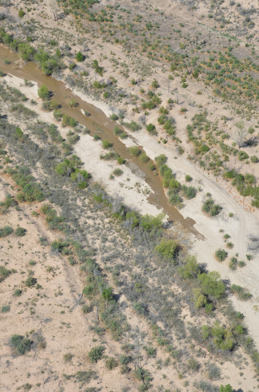
    Topsoil blew into a dark cloud that swept across the flat landscape of southeast Colorado once again Monday afternoon. Footsteps leave dust in loose pockets and grit in the teeth of those who speak. The land pays a bigger price. After nearly four years of deep drought, wind-churned dust has become a slow-moving natural disaster. Comparisons to the Dust Bowl are no longer hyperbole — they’re accurate.

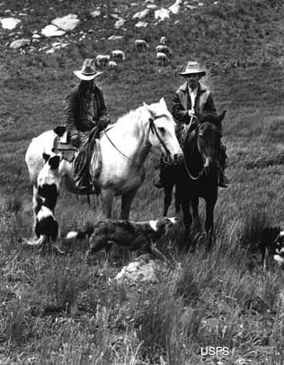
    “The dust storms we had here a week or so ago are just about as bad as I’ve ever seen,” Joe Rosengrants said. The 79-year-old farmer and rancher is part of a family that has worked the land in Baca County since 1910.

    His son Mike and others in the family here still tend thousands of acres of farm and ranchland and thousands of head of cattle. They also mind the skies for any glint of rain. “We can go a long way on just a little bit of rain down here,” Mike Rosengrants, 56, said as he delivered hay to cattle spread across 8 arid miles. “But we haven’t even been getting that.”

    The devastation of this drought comes in three forms: pastures that have dried up or are choked by drifts of sand; tumbleweeds that blow into tall hills against fences, homes and barns; and massive dust storms that steal topsoil and could make it harder to grow grain, wheat and sunflowers for years.

    The region hasn’t seen normal amounts of rain since the blizzards of 2007. Southeast Colorado averages 12 to 16 inches of rain annually, but many areas have gotten fewer than 8 inches each year since 2010, according to National Weather Service data.

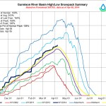
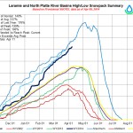
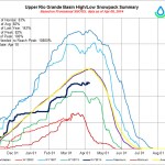
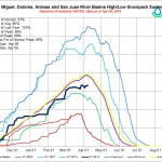
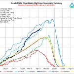
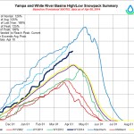
    Since the latest drought officially set in late in the summer of 2010, the Arkansas Valley has been drier for a longer sustained period of time than during the Dust Bowl, said Nolan Doesken, the state climatologist at Colorado State University.

    “We have not seen consecutive years this dry,” he said.

    As goes the rain, so go the people. The county’s ties to cows and crops have inextricably linked its upswings and downturns to the weather.

    Between 1930 and 1940, the southwestern Great Plains, home to thousands of settlers, suffered a severe drought. Dry-land farming led to the systematic destruction of prairie grasses, and overgrazing destroyed large areas of grassland. Gradually, the land was laid bare, and environmental damage began to occur. Strong winds in the region were devastating. The overfarmed land began to blow away.

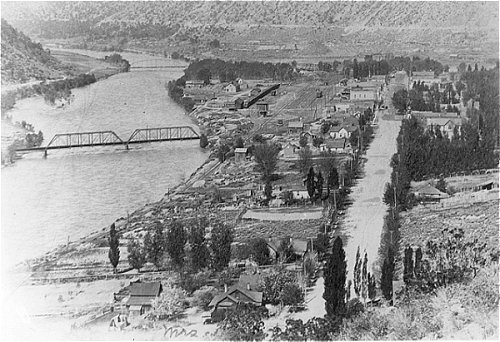
    From 1935 to 1938, Baca County accounted for some of the worst soil erosion of the Dust Bowl era. The railroad’s arrival here in 1926, along with homesteaders who spilled over from Oklahoma, swelled the county’s population to its peak of 10,570 residents in 1930. By 1940, after a decade of crop failures, the population had dwindled by almost 42 percent.

    Last year, the census showed 3,682 county residents, down 2.8 percent since 2010, while the rest of the state grew by 4.8 percent.

    Only a quarter of that population loss occurred between 2010 and 2012, and three-quarters of it took place just last year.

    Ward Williams, 65, is leasing out his 200 acres north of Springfield so cattle can chew off the stubble of his last grain-sorghum harvest in 2012. He had hoped to leave it to his children to farm, something he has done for more than 30 years.

    “It’s just too much of a cycle of booms and busts,” he said, his foot on the bumper of his old Ford pickup outside the Alco store in Springfield. “Kids that grow up here, if they have anywhere else to go, they aren’t staying here.

    “If it doesn’t get over soon, this (drought) might leave the land to the big corporate operations that can ride it out, and not for the people who grew up down here.”

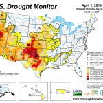
    Drier than the Dust Bowl

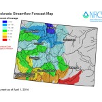
    Most of Colorado has made it out of the deep drought. The regions hardest hit by September’s floods are now drought-free, although a swath of western Colorado is “abnormally dry,” according to the U.S. Drought Monitor.

    Southeast Colorado, however, shows only variations of bad news — severe, extreme and exceptional stages of drought, according to the drought analysis.

    And the hardest-hit areas are along the agriculturally vital Arkansas River.

    The decade-long Dust Bowl had periodic wet years. This drought in many areas of southeast Colorado has had an unyielding presence since 2010, Doesken said.

    “It’s really been back to back to back — and, now, it appears — to back years of drought,” he said. “Normally, they get just enough precipitation to grow something down there, but they haven’t had that in a full 3½ years now.”

    Crop data indicate that about 15 percent of the farmland in Baca County is irrigated, fed by high-country reservoirs. That leaves 85 percent of the naturally sandy soil turning to dust — “more blowable ground,” Doesken called it.

    Years to recover

    Displaced topsoil means it could take years for the land to bounce back.

    “They’re so far in the hole right now that even if they do get a few (rain) storms, … it’s not going to immediately solve the problems,” Doesken said.

    PHOTOS: Southeast Colorado drought conditions akin to Dust Bowl

    The cattle herd in this corner of the state has dwindled, but not entirely because of drought. Cattle prices and hay prices have been up since 2011, coaxing some to sell off parts of their herds. Big ranchers, like the Rosengrants family, had the luxury of moving cattle to rented fields elsewhere in Colorado or other states to take advantage of rain and grazing there, said Ron Carleton, the state’s deputy commissioner of agriculture.

    Because the worst of the drought has been in the last year and a half, the depths of the crop losses haven’t yet been plumbed, at least not on paper, he said, so the data isn’t yet reflecting the worst effects.

    Eugene Backhaus, the state resource conservationist, said the end might not be in sight when the rain eventually starts to fall.

    “If you consider recovery getting things back to what they were before, with the amount of degradation and the depth of the drought, my best guess is three to five years,” he said. “The grasses down there are so damaged. When you’ve lost all the seeds and the root system is destroyed, then there’s nothing to grow back. The only way you’re going to get grass back in there is to put it in mechanically.

    “And that takes time and money.”

    Taxpayers already have posted a big financial stake in southeast Colorado’s productivity.

    Baca County farmers and ranchers received $413 million in government aid between 1995 and 2012, including $85.9 million in crop-insurance subsidies and $50 million in disaster grants, according to the Environmental Working Group, an advocacy organization that monitors such federal programs.

    Farmers in Baca County received government checks to seed grass on 269,249 acres of cropland to try to hold down the soil, according to the county’s U.S. Department of Agriculture’s Farm Service Agency.

    Kevin Larson — a researcher at the Plainsman Research Center in Walsh, Colorado State University’s agricultural experiment station for southeastern Colorado — said the current drought isn’t a measure of the investment in such programs.

    “Just can’t grow anything if there’s not any precipitation on it,” he said. “It’s as simple as that.”

    The research center’s work these days focuses on making the best use of sparse precipitation, urging farmers to plant varieties that mature faster and use less water, or weighing the trade-offs of no-till farming, which keeps the ground covered but also makes weeds harder to fight.

    The Western Kansas Weather Modification Program — the seeding of clouds with silver iodide crystals — began just across the border from Colorado’s struggling counties in 1975.

    When the effort spread into southeast Colorado about a decade ago, with the aim of suppressing crop-destroying hail storms in southwest Kansas, leaders in southeast Colorado protested, afraid it would cause more hail on their crops instead, Larson said. The program in Colorado soon fizzled out.

    The Colorado Water Conservation Board offers grants to water providers and local governments to help pay for cloud-seeding programs. In the parched southeast corner of the state, however, there have been no takers.

    But the solutions and practices that researchers have worked out, that government officials have promoted and that landowners have adopted since the Dust Bowl have kept this bad drought from turning into a catastrophe, Larson said.

    Hope and fear in drought

    Doesken said there’s reason for hope for this year, even if it depends on temperature fluctuations over the tropical Pacific Ocean.

    The El Niño weather pattern, if it takes shape, tends to mean rain for the Eastern Plains, he said.

    “But there’s no guarantee they’ll get more precipitation this spring,” he said.

    Wildfires also are a big concern. Some fields are parched to a stark white. The high winds would make a grass fire explode across thousands of uninterrupted acres primed to burn, said a group of local residents outside the Alco store in Springfield.

    The abundance of tumbleweeds — the thin, dry aftermath of a Russian thistle bloom late last summer — makes Jeff Turner, 52, of the Campo area worry even more.

    “If fire hits one of those, it might as well be soaked in gas,” Turner said. “Imagine that spinning ball of fire coming across your property at 30 miles per hour.”

    Others here say land-related hardship is a tradition, and they will wait on the rain.

    “It will start raining again,” said Prowers County resident Flauran Beckwith. “It has to.”

    The Rosengrants family is faring well because of diversity, said father and son. In addition to tending to cattle and crops, family members work in real estate, teach school and do hair.

    “During the Dust Bowl, people didn’t have as many opportunities,” said Joe Rosengrants.

    But the family’s foundation is, as it has been for more than a century, the land, said the patriarch.

    “You’re just attached to the soil, and you love it,” he said.

    His son says it another way.

    “There’s a cost to living out here.”

    US Rep. Scott Tipton queries top Interior officials about federal policy (USAA vs. USFS)

    Sheep Herders on the Uncompahgre Plateau
    Sheep Herders on the Uncompahgre Plateau

    From The Durango Herald (Katie Fiegenbaum):

    Tipton’s questions for Vilsack focused on the ability of federal agencies to take or place conditions on water-use permits held by ski areas and ranches.

    “I’d just be curious: How much of your resources are you going to be putting in to develop a taking (of) Fifth Amendment right(s) in the West when it comes to the private-property rights of water?” Tipton asked.

    Vilsack said the agency understands the law, does not intend to infringe upon any private-property rights and will have a clarification forthcoming.

    Tipton insisted that his bill, the Water Rights Protection Act, was necessary to ensure certainty on the issue. In an interview, Tipton expressed frustration at Vilsack’s ambiguous responses.

    The Water Rights Protection Act, which would prohibit agencies from placing conditions on water-use agreements, was passed by the House on March 24 and awaits action in the Senate. Obama issued a statement in March opposing the bill.

    Tipton also expressed concern to Vilsack about climate hubs, a multi-agency effort announced in February to deliver information to farmers and ranchers to help them adapt to climate change. Tipton wants clarity on their purpose and expressed concern that the hubs will be duplicating work done by the National Oceanic and Atmospheric Administration. One of seven regional climate hubs will be in Fort Collins.

    “I’m not trying to make a judgment,” Tipton said in an interview. “I want to get clarity on why or how much, and if these are duplicative.”

    He also was assured by Vilsack that progress was being made on preventing forest fires by increased leasing of air tankers…

    He also inquired about progress of clean water projects in Colorado, hydroelectricity and the potential addition of the sage grouse to the list of endangered species, which Interior is considering. Tipton asked for some measurable species preservation goals to be identified before a decision is made about the endangered species designation.

    Given the short amount of time allocated to each representative for questioning, many lawmakers choose to fill their time with questions and have the department follow up with them. In some other cases, answers could not be fully provided at the hearing.

    “I think, as you saw, the answers that came from the secretary were ‘We’ll have to get back to you,’” Tipton said in an interview.

    Tough going for cattlemen in the dry southwestern part of the state #COdrought

    From The Durango Herald (Ann Butler):

    “The folks on the west side of the county have been hurt worse than anyone else,” said Wayne Semler, the recently elected president of the La Plata-Archuleta Cattlemen’s Association who runs cattle and farms south of Bayfield. He has shrunk his herd between 25 and 30 percent in the last couple of years. “With no irrigation, water tables dropping and springs drying up, they’re really struggling.”

    The heavy rains last fall and a predicted El Niño weather pattern, which generally brings us moisture, may make this year a little better, he said.

    “Last year’s snow melted into the ground because it was so dry, so there was no runoff” he said. “This year, at least, the soil moisture’s a little higher.”

    Morley said rain this year is more critical than ever as the drought continues.

    “We’re all praying for rain,” she said. “Tell people we all need to pray for rain.”[…]

    Most cattle ranchers run cow/calf operations, where the calves are fattened up during the summer for market in the fall.

    Some ranchers feed the heifers, or mama cattle, on their own land all year long, grazing in the pasture for the summer, feeding them hay grown in their fields during the colder months.

    “We fed our cattle longer than normal,” Semler said about 2013. “And our hay last year, some fields we cut once, some none at all. We had a grasshopper problem, too.”

    Other ranchers, like Brice Lee, whose ranch is south of Hesperus, move them from private pastures in New Mexico, where they’ve wintered the heifers, to private pastures in Colorado for the summer.

    “Last year, we only got four days of water, when we normally get 30 to 40,” Lee said. “Most everybody’s had to adjust. We haven’t harvested hay in two years, and we haven’t had a lawn for several years because we didn’t want to waste the water.”

    Still others winter the cattle on their own land, moving them during the summer to pastures in the mountains where they have grazing permits on Forest Service or Bureau of Land Management land.

    More La Plata River coverage here.

    Flood control solutions for Fountain Creek are far from settled

    Fountain Creek Watershed
    Fountain Creek Watershed

    From The Pueblo Chieftain (Chris Woodka):

    The type of storm that would creating the worst flooding on Fountain Creek and the Arkansas River east of Pueblo might just seem like another rainy day for much of the region. But the lessons of floods in 1965 and last September’s close call for Pueblo show that Fountain Creek can froth up in a hurry when rains hit El Paso County to the north. Putting a small dam here and there would not be the most effective way to stop the water.

    A recent U.S. Geological Survey study of dams on Fountain Creek shows that an 85-foot tall dam north of Pueblo would be the single-most effective way to mellow out flood waters and trap sediment. The drawbacks of the dam are that highways, railroad crossings and utilities might have to be relocated. There would also be the chore of removing sediment after large storms.

    Smaller detention ponds, with dams no higher than 10 feet, are touted by many as a better alternative. But as Colorado Springs and Pueblo already are discovering, smaller ponds also require high maintenance. Similar dams failed to hold stormwater in the South Platte during last September’s record rains. And the cost of flooding to utilities and roads was a major side effect of the 1965 flood.

    A different study of flooding was done by the USGS in 1974, nine years after the disastrous 1965 flood. Unlike the current study, it largely eluded the spotlight and has not been widely cited during the 40 years since it was written. It looked at floods in the Arkansas River basin in three states, Colorado, Kansas and New Mexico and assessed the causes, effects and damage caused by heavy rains from June 13-20, 1965. The study chronicled $60 million of damage overall, with $40 million in Colorado. In today’s dollars, that would be about $300 million. Of that, 55 percent of the damage was to agriculture; 20 percent to roads and utilities; and 25 percent to cities and businesses, with about 85 percent of that amount in Pueblo.

    The study also looked at peak flows within the basin during the 1965 flood and compared them to other major floods, particularly the 1921 flood on the Arkansas River. The flows were considerably less in 1965 than in 1921, mainly because storms were centered over tributaries that fed into the Arkansas River below Pueblo, rather than in the watershed upstream from Pueblo.

    The study found a huge benefit to Lamar from John Martin Reservoir, which cut two-thirds of the peak flows raging from upstream. The Lamar area did not escape the wrath of the storm, however, because of large storm cells centered above Two Buttes and Holly. The Arkansas River stayed swollen for days after the rains.

    The heaviest rainfall in the 1965 storm came from Colorado Springs and the Holly-Two Buttes area, where 12-18 inches fell over a four-day period. Pueblo saw only a couple of inches during that time. The ground already was saturated from rains the previous two months throughout the region. Flows on Fountain Creek reached 47,000 cubic feet per second at their peak, while neighboring Chico Creek hit 52,000 cfs.

    The 2014 study by the USGS modeled a 100-year storm that would send about 37,000 cfs from Colorado Springs to Pueblo and then looked at hypothetical dams along the way.

    “A dam at any location could be modeled,” said David Mau, head of the Pueblo USGS office.

    The intensity of that storm would not be as great as the 1965 flood. In addition, Colorado Springs today has five times as many people and many more square miles of parking lots, roof tops and streets that shed water quickly and would make flooding that much worse for Pueblo.

    Levees were built on Fountain Creek to protect Pueblo, but sediment has reduced their effectiveness. Some structures meant to protect Pueblo were damaged by the relatively small flow last September.

    The attention in Colorado Springs is focused on the accelerated runoff from the Waldo Canyon and Black Forest fires. Structures are being built. Town meetings are preparing neighborhoods for flooding. A vote to create a regional stormwater fee is heading for the ballot in November.

    Colorado Springs also made a commitment to Pueblo County in its permit process that new development from the Southern Delivery System won’t worsen the condition of Fountain Creek.

    While the rains may hit Colorado Springs first and make flooding more intense because of the fires, the 1974 USGS study shows the bigger wallop would come to Pueblo and the Lower Arkansas Valley.

    More Fountain Creek watershed coverage here.

    Middle Colorado Watershed Council: First Annual #ColoradoRiver Clean Up — South Canyon to Silt

    New Castle back in the day via the Red Slipper Diary
    New Castle back in the day via the Red Slipper Diary

    Click here to read their April 2014 newsletter:

    We need Volunteers! The Council is hosting its first annual Colorado River cleanup and needs help picking up litter along the public riverbanks from South Canyon to Silt on Saturday, April 26, 2014. Many areas will be accessible to volunteers on foot, but boaters are especially encouraged to participate.

    The cleanup will be followed by a community barbecue and picnic for volunteers, with burgers and bratwursts and other fabulous food donated by local restaurants, starting at noon.

    Anyone can volunteer. Please let us know you’re coming so we can plan for food and drinks. Sign up in advance here. If you are able to bring a suitable raft or boat, tell us when you pre-register. We can work out shuttles and rides.

    Sign-in will start at 8:00 a.m. at Grand River Park (on the south side of the river) in New Castle. Walk or bike to the park if you live nearby — parking is limited.

    Volunteers should wear sturdy shoes, sunscreen, a hat, and work gloves, and bring drinking water.

    More Colorado River Basin coverage here.

    Managing Lake Powell’s power pool, will it benefit from the current snowpack? #ColoradoRiver

    Glen Canyon Dam -- Photo / Brad Udall
    Glen Canyon Dam — Photo / Brad Udall

    From The Grand Junction Daily Sentinel (Gary Harmon):

    Federal officials fretted for a year that they might have to take action as the water level in Lake Powell fell perilously close to the point that Glen Canyon Dam couldn’t generate electricity. Those fears were staved off, but not eliminated, after a meeting on Friday that involved top officials from the Interior Department and Bureau of Reclamation, according to Colorado officials who attended the meeting.

    “They’ve been concerned since last year” when federal officials began modeling flows into Lake Powell and concluded that two dry years similar to 2012 and 2013 could threaten the intakes into the electricity-generating turbines, said Upper Colorado River Basin Commissioner John McClow on Wednesday.

    “They’re nervous now,” said Eric Kuhn, general manager of the Colorado River Water Conservation District, “Six months ago, they were more nervous.”

    Snowpack of 110 percent of average or more so far this year in the Colorado mountains has alleviated much of the immediate concern, McClow said.

    “We’ve gotten a reprieve this year, but we’re still working” on plans that would forestall any need for federal involvement in river management beyond the bureau’s existing role, McClow said.

    What expanded federal involvement might mean is unclear, but Mesa County Commissioner Steve Acquafresca, who represents the county on the Colorado River Water Conservation District board, said it’s extensive.

    The issue isn’t whether the upper Colorado River is delivering enough water to meet the requirements of a 1922 compact among the seven basin states, but whether the water level in Powell is high enough to allow electricity generation.

    “They’re talking about taking over management of the river if the power intakes (in Lake Powell) start sucking air,” Acquafresca said. “They’re not going to let that happen. You can’t start to develop a vortex in the reservoir.”

    That vastly overstates the authority of the Bureau of Reclamation, said Larry Walkoviak, director for the bureau’s upper Colorado region.

    “Each state has its own set of laws and we have to comport with those states’ water laws,” Walkoviak said. As the federal manager of the bureau’s dams and other facilities upstream from Glen Canyon, “I don’t have the authority to do something like that.”

    The secretary of the Interior is the water master for the river below Glen Canyon, he noted, but not above.

    Even at 39 percent full, the level of Lake Powell remains about 85 feet above the penstocks that feed the turbines in Glen Canyon Dam, so it seems that for the coming summer and probably more, the issue of electricity generation is likely moot, Walkoviak said.

    Walkoviak was present at the meeting on Friday in Washington, D.C., that included Mike Connor, deputy secretary of the Interior; Anne Castle, assistant secretary for water and science; McClow; Kuhn; and James Eklund, director of the Colorado Water Conservation Board.

    Eklund, Kuhn and McClow all stressed the significance of Colorado officials having contingency plans for low water levels in Powell at the ready when they met with the federal officials.

    A three-party, state-developed contingency plan allayed much of the federal fear, McClow said.

    “The bureau has given us every indication that it intends to work with us,” Eklund said

    That plan calls for releasing more water than would otherwise be the case from the Aspinall Unit of dams on the Gunnison River, as well as Navajo Lake and Flaming Gorge; voluntary, compensated release of water rights by some users; and continued work to augment existing supplies.

    The plan includes provisions for endangered species and for recreation and other uses, McClow said.

    More Colorado River Basin coverage here.

    Say hello to The Water Values Podcast with David McGimpsey

    PalisadePeachOrchardClick here to listen. From email from David McGimpsey:

    I thought I’d let you know about a project I’ve been working on. I launched a podcast about water this week. I posted the first three sessions of The Water Values Podcast to http://thewatervalues.com. The episodes are also available on the website and a number of podcast directories, including iTunes (https://itunes.apple.com/us/podcast/the-water-values-podcast/id843026539) and Stitcher (http://www.stitcher.com/s?fid=46602&refid=stpr).

    I’ve had some great guests from all over the country so far – Matt Klein, a former Indiana enviro regulator and former water utility exec; Jack Wittman, a hydrogeologist who’s worked all over the country; John Entsminger, the new GM of the Southern Nevada Water Authority; Jim Salzman, a Duke University professor; Jenn Vervier, the Director of Sustainability and Strategic Development for New Belgium Brewery; Mike McGuire, the California-based engineer, author, and water blogger; and Ellen Wohl, a Colorado State University professor. (As indicated above, only 3 of these episodes have been released to date). I have some great guests lined up, too.

    More education coverage here.

    Mountain system monitoring at Senator Beck Basin, San Juan Mountains, Colorado

    Senator Beck Basin via the National Center for Snow and Avalanche Studies
    Senator Beck Basin via the National Center for Snow and Avalanche Studies

    Click here to read the abstract and access the report:

    A hydrologic modeling data set is presented for water years 2006 through 2012 from the Senator Beck Basin (SBB) study area. SBB is a high altitude, 291 ha catchment in southwest Colorado exhibiting a continental, radiation-driven, alpine snow climate. Elevations range from 3362 m at the SBB pour point to 4118 m. Two study plots provide hourly forcing data including precipitation, wind speed, air temperature and humidity, global solar radiation, downwelling thermal radiation, and pressure. Validation data include snow depth, reflected solar radiation, snow surface infrared temperature, soil moisture, temperatures and heat flux, and stream discharge. Snow water equivalence and other snowpack properties are captured in snowpack profiles. An example of snow cover model testing using SBB data is discussed. Serially complete data sets are published including both measured data as well as alternative, corrected data and, in conjunction with validation data, expand the physiographic scope of published mountain system hydrologic data sets in support of advancements in snow hydrology modeling and understanding.

    Cotter and the CPDHE are still trying to work out a de-commissioning agreement for the Lincoln Park/Cotter Mill superfund site

    Lincoln Park/Cotter Mill Site via The Denver Post
    Lincoln Park/Cotter Mill Site via The Denver Post

    From The Denver Post (Bruce Finley):

    A broken pipe at Cotter Corp.’s dismantled mill in central Colorado spewed 20,000 gallons of uranium-laced waste — just as Cotter is negotiating with state and federal authorities to end one of the nation’s longest-running Superfund cleanups.

    Colorado Department of Public Health and Environment officials said last weekend’s spill stayed on Cotter property.

    In addition, uranium and molybdenum contamination, apparently from other sources on the Cotter property, has spiked at a monitoring well in adjacent Cañon City. A Feb. 20 report by Cotter’s consultant said groundwater uranium levels at the well in the Lincoln Park neighborhood “were the highest recorded for this location,” slightly exceeding the health standard of 30 parts per billion. State health data show uranium levels are consistently above health limits at other wells throughout the neighborhood but haven’t recently spiked.

    “This isn’t acceptable,” Fremont County Commissioner Tim Payne said of the spill – the fourth since 2010. “(CDPHE officials) told us it is staying on Cotter’s property. But 20,000 gallons? You have to worry about that getting into groundwater.”

    Environmental Protection Agency and CDPHE officials are negotiating an agreement with Cotter to guide cleanup, data-gathering, remediation and what to do with 15 million tons of radioactive uranium tailings. Options range from removal — Cotter estimates that cost at more than $895 million — or burial in existing or new impoundment ponds.

    Gov. John Hickenlooper intervened last year to hear residents’ concerns and try to speed final cleanup.

    Cotter vice president John Hamrick said the agreement will lay out timetables for the company to propose options with cost estimates.

    The spill happened when a coupler sleeve split on a 6-inch plastic pipe, part of a 30-year-old system that was pumping back toxic groundwater from a 300-foot barrier at the low end of Cotter’s 2,538-acre property, Hamrick said.

    Lab analysis provided by Cotter showed the spilled waste contained uranium about 94 times higher than the health standard, and molybdenum at 3,740 ppb, well above the 100-ppb standard for that metal, said Jennifer Opila, leader of the state’s radioactive materials unit.

    She said Cotter’s system for pumping back toxic groundwater is designed so that groundwater does not leave the site, preventing any risk to the public.

    In November, Cotter reported a spill of 4,000 to 9,000 gallons. That was five times more than the amount spilled in November 2012. Another spill happened in 2010.

    At the neighborhood in Cañon City, the spike in uranium contamination probably reflects slow migration of toxic material from Cold War-era unlined waste ponds finally reaching the front of an underground plume, Hamrick said.

    “It is a blip. It does not appear to be an upward trend. If it was, we would be looking at it,” Hamrick said. “We will be working with state and EPA experts to look at the whole groundwater monitoring and remediation system.”

    An EPA spokeswoman agreed the spike does not appear to be part of an upward trend, based on monitoring at other wells, but she said the agency does take any elevated uranium levels seriously.

    The Cotter mill, now owned by defense contractor General Atomics, opened in 1958, processing uranium for nuclear weapons and fuel. Cotter discharged liquid waste, including radioactive material and heavy metals, into 11 unlined ponds until 1978. The ponds were replaced in 1982 with two lined waste ponds. Well tests in Cañon City found contamination, and in 1984, federal authorities declared a Superfund environmental disaster.

    Colorado officials let Cotter keep operating until 2011, and mill workers periodically processed ore until 2006.

    A community group, Colorado Citizens Against Toxic Waste, has been pressing for details and expressing concerns about the Cotter site. Energy Minerals Law Center attorney Travis Stills, representing residents, said the data show “the likely expansion of the uranium plume, following the path of a more mobile molybdenum plume” into Cañon City toward the Arkansas River.

    The residents deserve independent fact-gathering and a proper cleanup, Stills said.

    “There’s an official, decades-old indifference to groundwater protection and cleanup of groundwater contamination at the Cotter site — even though sustainable and clean groundwater for drinking, orchards, gardens and livestock remains important to present and future Lincoln Park residents,” he said. “This community is profoundly committed to reclaiming and protecting its groundwater.

    More Lincoln Park/Cotter Mill superfund coverage here.

    Water summit drew large crowd — Fort Morgan Times

    Map of the South Platte River alluvial aquifer subregions -- Colorado Water Conservation Board via the Colorado Water Institute
    Map of the South Platte River alluvial aquifer subregions — Colorado Water Conservation Board via the Colorado Water Institute

    From The Fort Morgan Times (Jenni Grubbs):

    The large crowd at Progressive 15’s Water Summit had their fill of water-related information March 28 at the Country Steak-Out in Fort Morgan, but it seemed they were still thirsty for more, asking nearly every speaker lots of questions and seeking more resources.

    The speakers addressed a number of different topics, including: potential and currently pending legislation and ballot issues that could affect water law, and weather forecasts and the plan the state is forming for dealing with water for the future.

    After Progressive 15 Chairman Barry Gore explained the nonprofit group’s mission as an advocacy agency for its members, Joe Frank from the Lower South Platte Water Conservancy District spoke about the history of public trust doctrine and how it could affect Colorado if adopted here…

    After a break for lunch, the crowd heard from National Weather Service Senior Hydrologist Treste Huse about weather and flood forecasts for Colorado.

    She said that while Morgan County received 300 percent of normal precipitation in 2013, “it’s drying up this year.”

    Northeast Colorado could see higher risks of flooding this spring and summer due to higher water tables, reservoirs already at capacity and the melting of a high snow pack. Landslides also could be possible with that flooding.

    Huse also said that it was possible that 2014 would have El Nino weather patterns in Colorado, which could lead to wetter than average conditions in the south and far east parts of the state.

    Later, former Colorado Agriculture Commissioner John Stulp, who now is an advisor in Gov. John Hickenlooper’s Water Office, spoke about the Colorado Water Plan.

    He said that while drought was growing in southeast Colorado, most of the state was not in a drought.

    Yet, he recognized that flooding could become an issue again.

    “We’re hopeful that the snowpack comes down in an orderly manner,” he said.

    More South Platte River Basin coverage here.

    Water Hazards: From Risk to Recovery — AWRA Colorado Section Annual Symposium (May 2)

    September 2013 flooding
    September 2013 flooding

    Click here to go to the symposium page for the pitch and to register.

    Managing water resources in Colorado requires managing risk. This year’s symposium will feature discussions on the various types of risks to our water resources, with special consideration given to the impacts and implications of the September 2013 floods.

    We are pleased to have an outstanding and diverse group of speakers, including our Keynote Speaker, James Eklund who will discuss the relationship between the State Water Plan and managing risk. Presenters in our morning session will help us better understand the types of risks to water resources. The afternoon break-out sessions will feature experts from a variety of disciplines who will discuss the on-the-ground impacts of the September 2013 floods. The day will conclude with insights from Jamestown Mayor Tara Schoedinger and CSU Sociology Professor Stephanie Malin, who will help us understand how risk impacts our communities.

    To raise money for the Scholarship Fund, we are holding our fourth annual silent auction at the symposium.

    Radiometer near Mancos used to forecast cloud-seeding potential

    Calibrating the radiometer via The Durango Herald
    Calibrating the radiometer via The Durango Herald

    From The Durango Herald (Mary Shinn):

    On Monday meteorologist, Marta Nelson, installed a temporary radiometer at Jackson Lake near the Mancos Water Conservancy District. The instrument is able to determine the best combination of water content in clouds and temperature to use a cloud-seeding generator.

    Cloud-seeding generators throw up silver iodide into the atmosphere to harvest the extra water because snow will form around it.

    “We can see relative humidity and vapor and the potential for a cloud to form. We can also see inside a cloud that’s already formed, so if we’re looking for liquid water versus ice that is frozen in the cloud the radiometer can tell the difference and help tell the cloud-seeding people when to run the generators or when it’s not going to do any good,” she said. Nelson works for Radiometrics Corp., based in Boulder, which installs similar machines all over the world.

    The new data also will help scientists decide if the local cloud-seeding generator at Spring Creek should be run later into the winter season, said Jeff Tilley, director of weather modification at the Desert Research Institute in Reno. The institute operates the local cloud-seeding generator remotely. The data collected over the next month will be applied to operations next winter because the Spring Creek generator is almost out of cloud-seeding solution, he said.

    The institute is collaborating with the Colorado Water Conservation Board on the project, and the board is paying the $8,500 to lease the radiometer for a month.

    Across the state, about $1 million is spent on cloud seeding, and about 65 percent of the funds are provided by local entities such as ski areas, water districts and towns. The other 35 percent of the funds are provided by state and other funding.

    The generator near Mancos has been in place for about five years, and in that time, there has been some benefit in the area, Tilley said.

    “The impression we have is that we have seen some difference,” he said.

    Cloud seeding is safe because silver iodide won’t break down in any way that’s harmful, Nelson said.

    More cloud-seeding coverage here. More San Juan River Basin coverage here.

    Environmental groups are suing to prevent oil and gas exploration operations north of Del Norte #RioGrande

    San Luis Valley Groundwater
    San Luis Valley Groundwater

    From The Pueblo Chieftain (Robert Boczkiewicz):

    Environmental groups in the San Luis Valley say they are suing to protect an aquifer they call “the lifeblood” of the valley. The lawsuit alleges that proposed drilling for oil and gas on federal land just south of Del Norte endangers 7,000 water wells in the valley. The lawsuit asks a judge to overturn the federal Bureau of Land Management’s approval of the drilling by a Texas oil company.

    The lawsuit against BLM was filed March 5 in U.S. District Court by the San Luis Valley Ecosystem Council and Conejos County Clean Water Inc.

    The Conejos Formation aquifer “holds the lifeblood of the San Luis Valley ecosystem, culture and economy, as well as the headwaters of the Rio Grande (River),” the 37-page lawsuit states. “Any underground and surface water contamination due to oil and gas exploration in the project area would likely enter the Conejos Formation aquifer.”

    “BLM violated the law by issuing (the oil) lease . . . without considering the unique and controversial effects” of the drilling, the lawsuit alleges. “A growing number of people . . . are concerned that the federal government has once again relied on a rushed, incomplete process,” approving the proposed drilling “without taking a hard look,” as law requires, at its impacts, the lawsuit asserts.

    BLM said that it is reviewing the lawsuit.

    The environmental groups contend that BLM’s environmental assessment of the drilling project incorrectly concluded there would be no significant impact.

    More Rio Grande River Basin coverage here.

    Roaring Fork Valley: Many eyes are on Tom Bailey’s court filing #ColoradoRiver

    Roaring Fork River back in the day
    Roaring Fork River back in the day

    From the Aspen Daily News (Nelson Harvey):

    Residents of the agricultural bottomlands along Catherine’s Store Road east of Carbondale have been deluged with legal paperwork in recent weeks, as various parties respond to billionaire Tom Bailey’s attempts to clarify his water rights on an irrigation ditch there.

    Bailey, the founder of Janus Mutual Funds and a breeder of cutting horses at his Iron Rose Ranch near Carbondale, filed a so-called “quiet title” lawsuit against more than 60 of his neighbors last year attempting to clarify his right to about 5.7 cubic feet per second (cfs) of water on the Slough Ditch and Banning Lateral Ditch, enough to irrigate his 28-acre property several times over.

    Since then, both the homeowners association for the Roaring Fork Preserve subdivision (RFPHOA) and Henry Hite, a neighbor of Bailey’s and the owner of the nearby Dragonfly Ranch, have responded to Bailey’s claim with their own assertions of water ownership. The RFPHOA is claiming to own 5.54 cfs of water on the ditch, while Hite is laying claim to about 2.44 cfs.

    More water law coverage here.

    The Grand Foundation’s 2014 Annual Grant Cycle deadline is Thursday, May 1 #ColoradoRiver

    Gore Canyon rafting via Blogspot.com
    Gore Canyon rafting via Blogspot.com

    From the Sky-Hi Daily News:

    The Grand Foundation announces its 2014 Annual Grant Cycle deadline as Thursday, May 1. Applications are available on the Grand Foundation’s website at http://www.grandfoundation.com. All 2013 grant recipients must have their 2013 Final Grant Reports submitted in order to be eligible for 2014 funding.

    If you have any questions or would like to become more involved with the Grand Foundation, contact Megan Ledin, Executive Director, at megan@grandfoundation.com or by calling 970-887-3111.

    CWCB: 2015 Proposed Instream Flow Appropriations

    Colorado instream flow program map via the Colorado Water Conservation Board
    Colorado instream flow program map via the Colorado Water Conservation Board

    Click here to read the appropriation notice from the Colorado Water Conservation Board.

    Dust on snow event this week may affect runoff

    Dust streaming across Four Corners April 29, 2009 via MODIS
    Dust streaming across Four Corners April 29, 2009 via MODIS

    From The Aspen Times (Scott Condon):

    High winds blowing the dry sands of the Southwest and the Colorado Plateau slammed into the Colorado mountains late Sunday afternoon and into the evening. There was so much dust in the air, blowing through in plumes, that the sky turned an odd orange-ish hue before sunset.

    “It was a significant event,” Landry said. The nonprofit center runs the Colorado Dust-on-Snow Program, which monitors “dust events,” measures how much dust gets deposited in the snowpack and assesses how it will affect the spring runoff.

    Landry was in the field Sunday visiting 11 sites in Colorado, including McClure Pass in the Crystal River Valley, where the program monitors snowpack and assesses dust. He and a colleague stayed in Steamboat Springs on Sunday night and weren’t sure initially how extensive the dust incident was because fresh snow fell overnight at the resort. It became more apparent, by the time they reached Interstate 70, that dust had coated the snowpack, and it was “dead obvious” by the time they reached the Roaring Fork Valley that it was significant, Landry said.

    It affected the mountains as far east as Loveland and extended into the Grand Mesa to the west and Red Mountain Pass and the surrounding San Juans to the south. The Dust-on-Snow Program still is assessing how far north the dust spread.

    “This was a huge event. It might have got most of the mountains,” Landry said.

    From the Summit Daily News (Alli Langley):

    The dust storm that blew through Summit County earlier this week could have serious consequences for skiers, water managers and farmers…

    Depending on weather conditions in the coming weeks, the dust could cause the snow to warm and freeze in thicker layers, increasing the risk of avalanches, said Spencer Logan, avalanche forecaster with the Colorado Avalanche Information Center.

    In 2006, dust storms in February contributed to a heavy-avalanche season, he said, with more than 100 slides in May that year. In 2012, though, the area experienced heavy dust but few avalanches…

    Another smaller dust storm Tuesday, which probably didn’t reach Summit County, was the fifth recorded this year.

    The dust arrives from the Greater Colorado Plateau in a pattern that happens in Colorado every spring, said Landry, who has studied the dust for about eight years with the nonprofit center in Silverton.

    Summit can expect more dust, he said, because the storms usually happen in March, April and May.

    The reddish splotches at the resorts and the particles on your car likely blew in from eastern Utah, northeastern Arizona or northwestern New Mexico.

    The color comes from iron oxide, a compound that Landry said isn’t known to cause water-quality problems. The dust also brings calcium, he said, which could be good for acidic waters.

    The sun’s rays can still reach the dust if it’s only a few inches under a layer of fresh snow, Landry said, and layers of dust combine during the season to dramatically increase the speed of the snowmelt.

    If the weather turns dry and stops bringing more snow to dilute the effect of the dust, streams could surge to extreme peak flows.

    The Colorado mountains have been receiving this dust since the last ice age, Landry said, but evidence shows the size and frequency of the storms have increased since the mid-1990s.

    Recover Colorado Businesses Grant and Loan Programs available for businesses and non-profits affected by #COflood

    Plume of subtropical moisture streaming into Colorado September 2013 via Weather5280
    Plume of subtropical moisture streaming into Colorado September 2013 via Weather5280

    From the Sterling Journal Advocate (Callie Jones):

    Businesses and non-profits affected by the South Platte River flood last year are getting more help, through the Recover Colorado Businesses Grant and Loan Programs, part of the Community Development Block Grant Disaster Recovery Program.
    Dick Pickett, executive director of the Northeast-East Central Small Business Development Center, and Jeff Kraft, of the Colorado Office of Economic Development and International trade, gave a brief presentation about the program to a small crowd at the Gary DeSoto Building on Thursday.

    Kraft explained the CDBG-DR program is one the U.S. Department of Housing and Urban Development’s (HUD) main programs, in which they provide assistance to communities in various ways – housing, infrastructure and economic development.

    States can apply for funds from the program by developing an action plan, based on what their needs are. Colorado applied and will be receiving $62.8 million, which will be split up between housing, infrastructure and economic revitalization. Of that $62 million, approximately $9 million will go toward small businesses.

    In addition to those funds, the state will also be receiving another $199 million at some point.

    Kraft noted the philosophy of this program is to be more flexible in what it can cover than many other types of funds, though there will still be some federal strings attached. He also said “it’s designed to cover a small slice of unmet needs after other funding sources have been used and exhausted.”

    Through the Recover Colorado programs, businesses and non-profits that suffered substantial economic harm from the flood can apply for economic revitalization funding. Grants of up to $10,000, or $25,000 for entities with multiple flood impacted areas, and loans of up to $50,000 with favorable terms will be awarded. The grants do not have to be paid back.

    Approximately 80 percent of funds will be allocated to the three most impacted counties: Boulder, Larimer and Weld.

    “So, you’re saying ‘I’m here in Sterling, that’s not going to help me’. We know Sterling is one of the most impacted areas in the remaining 20 percent, so absolutely there will be substantial funds available for Sterling businesses,” Kraft said.

    More snow same adventure – Denver Water crews measure snowpack

    EPA and Army Corps of Engineers Clarify Protection for Nation’s Streams and Wetlands

    Blanca Wetlands via the National Park Service
    Blanca Wetlands via the National Park Service

    Here’s the release from the Environmental Protection Agency (Julia Q. Ortiz):

    The U.S. Environmental Protection Agency (EPA) and U.S. Army Corps of Engineers (Army Corps) today jointly released a proposed rule to clarify protection under the Clean Water Act for streams and wetlands that form the foundation of the nation’s water resources. The proposed rule will benefit businesses by increasing efficiency in determining coverage of the Clean Water Act. The agencies are launching a robust outreach effort over the next 90 days, holding discussions around the country and gathering input needed to shape a final rule.

    Determining Clean Water Act protection for streams and wetlands became confusing and complex following Supreme Court decisions in 2001 and 2006. For nearly a decade, members of Congress, state and local officials, industry, agriculture, environmental groups, and the public asked for a rule-making to provide clarity.

    The proposed rule clarifies protection for streams and wetlands. The proposed definitions of waters will apply to all Clean Water Act programs. It does not protect any new types of waters that have not historically been covered under the Clean Water Act and is consistent with the Supreme Court’s more narrow reading of Clean Water Act jurisdiction.

    “We are clarifying protection for the upstream waters that are absolutely vital to downstream communities,” said EPA Administrator Gina McCarthy. “Clean water is essential to every single American, from families who rely on safe places to swim and healthy fish to eat, to farmers who need abundant and reliable sources of water to grow their crops, to hunters and fishermen who depend on healthy waters for recreation and their work, and to businesses that need a steady supply of water for operations.”

    “America’s waters and wetlands are valuable resources that must be protected today and for future generations,” said Assistant Secretary of the Army (Civil Works) Jo-Ellen Darcy. “Today’s rulemaking will better protect our aquatic resources, by strengthening the consistency, predictability, and transparency of our jurisdictional determinations. The rule’s clarifications will result in a better public service nationwide.”

    The health of rivers, lakes, bays, and coastal waters depend on the streams and wetlands where they begin. Streams and wetlands provide many benefits to communities – they trap floodwaters, recharge groundwater supplies, remove pollution, and provide habitat for fish and wildlife. They are also economic drivers because of their role in fishing, hunting, agriculture, recreation, energy, and manufacturing.

    About 60 percent of stream miles in the U.S. only flow seasonally or after rain, but have a considerable impact on the downstream waters. And approximately 117 million people – one in three Americans – get drinking water from public systems that rely in part on these streams. These are important waterways for which EPA and the Army Corps is clarifying protection.

    Specifically, the proposed rule clarifies that under the Clean Water Act and based on the science:

  • Most seasonal and rain-dependent streams are protected.
  • Wetlands near rivers and streams are protected.
  • Other types of waters may have more uncertain connections with downstream water and protection will be evaluated through a case specific analysis of whether the connection is or is not significant. However, to provide more certainty, the proposal requests comment on options protecting similarly situated waters in certain geographic areas or adding to the categories of waters protected without case specific analysis.
  • The proposed rule preserves the Clean Water Act exemptions and exclusions for agriculture. Additionally, EPA and the Army Corps have coordinated with the U.S. Department of Agriculture (USDA) to develop an interpretive rule to ensure that 56 specific conservation practices that protect or improve water quality will not be subject to Section 404 dredged or fill permitting requirements. The agencies will work together to implement these new exemptions and periodically review, and update USDA’s Natural Resources Conservation Service conservation practice standards and activities that would qualify under the exemption. Any agriculture activity that does not result in the discharge of a pollutant to waters of the U.S. still does not require a permit.

    The proposed rule also helps states and tribes – according to a study by the Environmental Law Institute, 36 states have legal limitations on their ability to fully protect waters that aren’t covered by the Clean Water Act.

    The proposed rule is supported by the latest peer-reviewed science, including a draft scientific assessment by EPA, which presents a review and synthesis of more than 1,000 pieces of scientific literature. The rule will not be finalized until the final version of this scientific assessment is complete.

    Forty years ago, two-thirds of America’s lakes, rivers and coastal waters were unsafe for fishing and swimming. Because of the Clean Water Act, that number has been cut in half. However, one-third of the nation’s waters still do not meet standards.

    The proposed rule will be open for public comment for 90 days from publication in the Federal Register. The interpretive rule for agricultural activities is effective immediately.

    More information: http://www.epa.gov/uswaters

    Watch Administrator McCarthy’s overview: http://youtu.be/ow-n8zZuDYc

    Watch Deputy Chief of Staff Arvin Ganesan’s explanation: http://youtu.be/fOUESH_JmA0

    From the Denver Business Journal (Caitlin Hendee):

    Gov. John Hickenlooper joined 15 GOP senators Thursday to urge the Obama administration to reconsider a rule that would allow the Environmental Protection Agency (EPA) to regulate marshes, ponds and streams in states…

    Hickenlooper expressed concern to federal officials that the rule change would stonewall the state’s ability to manage key water systems, and could negatively impact the Colorado economy.
    The rule-change would give the EPA and the Army Corps of Engineers clarification on what wetlands and waters they can manage and regulate, such as asking the state to pass a water-quality certification…

    Hickenlooper’s worry was expressed by 15 GOP Senators in a letter sent to the Obama administration that faulted the EPA for asking for the ability to regulate the small water systems before a government peer-reviewed scientific assessment was complete. The senators are concerned about the power invoked by the Clean Water Act and the impact it might have on drought management in several Western states…

    The EPA’s draft scientific assessment, used to inform the proposed rule, will be reviewed and completed at the end of this year or early next year.

    From Water Online (Sara Jerome):

    Conservatives and industry players are skeptical of the proposed rule. Critics are describing it “as a government land grab,” according to a Fox News report. “The proposal immediately sparked concerns that the regulatory power could extend into seasonal ponds, streams, and ditches, including those on private property.”

    “The…rule may be one of the most significant private property grabs in U.S. history,” said Louisiana Sen. David Vitter, the top Republican on the Senate Environment and Public Works Committee, in the Fox News report.

    Bloomberg BNA reported: “All natural and artificial tributaries and wetlands that are adjacent to or near larger downstream waters would be subject to federal Clean Water Act protections.”

    “The agencies also included an interpretive rule, immediately effective, that clarifies that the 53 specific conservation practices identified by the Agriculture Department’s Natural Resources Conservation Service to protect or improve water quality won’t be subject to dredge-and-fill permits under Section 404 of the Clean Water Act,” the report said.

    One thing seems clear: This proposal will probably land the government in court. “The regulatory action might provoke legal challenges from several economic sectors—including the agriculture, construction and energy industries. Opponents say the rules could delay projects while permits are sought for dredging, filling, or drainage in more areas,” the Wall Street Journal reported.

    But proponents of the rule said it’s a no-brainer. “The rule simply clarifies the scope of jurisdiction of the Clean Water Act, ending years of confusion and restoring fundamental protections to waters that serve as the drinking supply for 117 million Americans,” said Trip Van Noppen, president of Earthjustice, a nonprofit public-interest law group, in the New York Times.

    From the Associated Press (Hope Yen) via ABC News:

    Industry groups and more than a dozen GOP senators are urging the Obama administration to reconsider plans to regulate many of the nation’s streams and wetlands, saying the proposed rule hurts economic activity and oversteps legal bounds.

    In a letter Thursday, the senators faulted the Environmental Protection Agency for announcing a proposed rule last week before the government’s peer-reviewed scientific assessment was fully complete. They are calling on the government to withdraw the rule or give the public six months to review it, rather than the three months being provided.

    The senators’ move puts them among several groups — from farmers and land developers to Western governors worried about drought management — in expressing concern about a long-running and heavily litigated environmental issue involving the Clean Water Act that has invoked economic interests, states’ rights and presidential power.

    The letter was led by Sen. Pat Toomey, R-Pa., and signed by 14 other GOP senators.

    “We believe that this proposal will negatively impact economic growth by adding an additional layer of red tape to countless activities that are already sufficiently regulated by state and local governments,” the letter to EPA chief Gina McCarthy said.

    Alisha Johnson, the EPA’s deputy associate administrator for external affairs and environmental education, said the EPA’s draft scientific assessment, used to inform the proposed rule, was being reviewed and wouldn’t be complete until the end of this year or early next year. The EPA rule will not be finalized until the scientific assessment is fully complete, and will take into account public comments, she said.

    From The Greeley Tribune:

    The U.S. Environmental Protection Agency and U.S. Army Corps of Engineers on [March 25] released a proposed rule to clarify protection under the Clean Water Act for streams and wetlands that form the foundation of the nation’s water resources.

    The agencies, according to an EPA news release, are launching a robust outreach effort over the next 90 days, holding discussions around the country and gathering input needed to shape a final rule.

    Determining Clean Water Act protection for streams and wetlands became confusing and complex following Supreme Court decisions in 2001 and 2006.

    The proposed rule also preserves the Clean Water Act exemptions and exclusions for agriculture. EPA and the Army Corps have coordinated with the U.S. Department of Agriculture to develop an interpretive rule to ensure that 53 specific conservation practices that protect or improve water quality will not be subject to Section 404 dredged or fill permitting requirements.

    Any ag activity that does not result in the discharge of a pollutant to waters of the U.S. still does not require a permit.

    From The Denver Post (Bruce Finley):

    Thousands of miles of Colorado streams would gain stricter protection under a new approach the Obama administration unveiled this week. The goal is to prevent further fouling, filling-in and dredging of streams, tributaries and wetlands by requiring polluters to obtain permits. The Environmental Protection Agency and U.S. Army Corps of Engineers proposed the change.

    Supreme Court decisions in 2001 and 2006 forced federal authorities trying to contain pollution to first prove a stream is linked with “navigable waters.” The new approach would allow regulation of all flowing waters, including temporary streams — while preserving exemptions for agriculture. Just how many more streams are likely to be regulated remains unclear.

    “I don’t know what the actual number is,” regional EPA administrator Shaun McGrath said Wednesday. But he said the new rule will clear up uncertainty about what waters the EPA has jurisdiction over under the Clean Water Act.

    EPA data show that 77,850 miles of waterways in Colorado are temporary — only flowing seasonally or during rain — and are deemed at risk because it’s not clear whether polluters can be controlled.

    “Clean water’s important for my business,” said Jonathan Kahn, owner of Confluence Kayaks. “This matters. Perception is important. If people feel like your water quality is bad, they’re less likely to book a vacation.”

    Environment groups urged swift passage.

    “This isn’t going to mean there will never be a spill or that polluters will never get away with illegal dumping. But it will mean the EPA can actually go out and regulate a huge amount of waterways,” Environment Colorado water campaign director Kim Stevens said.

    But Colorado Gov. John Hickenlooper, chairman of the Western Governors Association, warned federal officials that the rule change “could impinge upon state authority in water management” and called for better EPA consultation with states.

    Hickenlooper did not take a position on stricter protection. “We are concerned that states were not involved and the governor will withhold judgment until we engage Colorado’s water stakeholders,” spokeswoman Denise Stepto said.

    The American Farm Bureau and land developers oppose the change, saying it would impose unnecessary burdens on their activities. However, Rocky Mountain Farmers Union president Kent Peppler sent a letter to federal authorities applauding their efforts to make sure the rule would exclude ditches, ponds and irrigation systems — preserving farming and forestry exemptions.

    “There is no disagreement among America’s ranchers and farmers that clean water is critical to our ability to produce food and fiber for the nation,” Peppler said.

    The proposed change faces 90 days of public comment and possible review by Congress, which could take months.

    Here’s a release from Earth Justice:

    [March 25] the Environmental Protection Agency (EPA) proposed a rule to restore long-standing Clean Water Act protections to streams and many wetlands across the country. These protections, which stood for decades since Congress passed the Clean Water Act in 1972, were dismantled in the last decade by two Supreme Court decisions that created confusion about how to interpret which water bodies should be covered under the Clean Water Act and by policies of the George W. Bush administration that removed longstanding protections from many streams and wetlands. As a result, 59 percent of America’s streams and 20 million acres of wetlands were left vulnerable to toxic pollution.

    The new rule reinstates protections for many of those waters based on an analysis of thousands of peer-reviewed scientific studies conducted by an EPA independent science advisory panel last year. The proposed rule must now be opened for public comment before the Obama Administration can move forward with finalizing it.

    The following is a statement from Earthjustice President Trip Van Noppen:

    “We applaud the EPA for proposing a rule that would reinstate clean water protections for streams and wetlands that supply the drinking water of 117 million Americans.

    “Unfortunately, for the last decade while these protections have lapsed, we have seen the consequences of not protecting our waters. Today, more than 55 percent of our rivers and streams are in ‘poor’ condition, considered unfit for drinking, swimming, or fishing.

    “As the West Virginia chemical spill shows, the cost of not having clean water is too great a price to pay.

    “The EPA’s new Clean Water Act rule finally restores protections so that we can begin the hard work of cleaning up our waters for our children to swim in, fish in, and drink from.

    “No doubt, polluters will rail and lobby against this rule and any other clean water safeguards that keep them from dumping their toxic waste in our communities and waters, or that hold them accountable for their pollution.

    “We cannot back down on protecting the waters that eventually flow through our faucets. Our children, our health, and our very drinking water are at stake. We urge the Obama administration to resist the polluter lobbies and quickly move forward in protecting our waterways and our families.”

    More Environmental Protection Agency coverage here.

    Snowpack news: “We’re in a good mood” — Mike Preston

    From the Cortez Journal (Jim Mimiaga):

    Keep the snow shovels and skis handy. A spring snowstorm dumped 6 to 12 inches in the mountains, and from 3 to 6 inches at Cortez, Arriola, Dolores, Mancos and Mesa Verde National Park…

    The recent storm stretched from Wyoming to Arizona and into California, and had a convection effect typical of spring precipitation.

    “The convection element where the clouds bubble up produces the wet heavy snow,” Daniels said.

    Telluride is reporting a fresh 8 inches from the storm, drifting to a foot in places. Durango Mountain Resort received 10 inches, and Rico is reporting 4 to 5 inches…

    Southwest Colorado is still below normal snowpack, based on a 30-year average, according to the Natural Resource Conservation Service.

    The Dolores, San Miguel, Animas, and San Juan basins collectively are reported at 83 percent of normal as of April 3. The Dolores Basin is at 87 percent of normal snowpack.

    However, the Dolores Basin has dramatically improved from last year with snotels showing 12.6 inches of snow-water equivalent for April 3, compared with 9.6 inches of snow water equivalent this time last year.

    Irrigators woke up with a smile across the region, as did reservoir managers.

    “We’re in a good mood,” said Mike Preston, manager for the Dolores Water Conservancy District. “We are in the process of evaluating the impact of recent storms and will be updating farmers next week on predicted water supplies.”

    From Steamboat Today (Kent Peppler):

    As of the first week of April, the statewide average snowpack in Colorado is 113 percent. Only the southwestern watersheds are lagging behind. The Colorado River snowpack is at 125 percent. The South Platte is at 135 percent of average…

    It is worth noting that Denver snowfall in March was 5.3 inches, just half of the average of 11.5 inches. Total snowfall so far in Denver is 31 inches compared to the average of the normal 47 inches for this time of the year.

    We have a ways to go to restore the subsoil moisture underneath Colorado’s farmland. We have a ways to go, as well, to rebuild irrigation ditches and roads after last year’s floods.