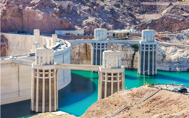
Random facts I definitely did not know about the #CORiver Grand Canyon: http://t.co/RWybaAfhYj
— Drew Beckwith (@DrewBeckwith) July 3, 2014
More Colorado River Basin coverage here.

Random facts I definitely did not know about the #CORiver Grand Canyon: http://t.co/RWybaAfhYj
— Drew Beckwith (@DrewBeckwith) July 3, 2014
More Colorado River Basin coverage here.
Here’s the release from the United States Geological Survey:
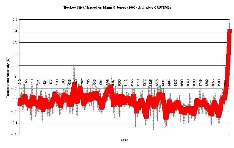
An important question in climate change research is whether we can distinguish the human fingerprint on climate from natural climate variability. Solar activity, volcanic emissions and greenhouse gases, including those from human activities, all affect the radiation and energy balance of the Earth. Variations in the energy balance lead to changes in the distribution and patterns of air temperature, rainfall, hydrology, polar sea ice and glacier mass. Internal modes of climate variability, such as ENSO and the North Atlantic Oscillation (NAO) can cause large year-to-year and decade-to-decade changes in temperature and rainfall.
Distinguishing human-induced climate change associated with carbon emissions and land use change from natural climate variability requires integrated research efforts that rely on climate modeling and paleoclimate reconstructions based on data from analyses of tree rings, ice cores, marine and terrestrial sediments, glaciers and instrumental records. In essence, this research aims to sort out the contributions from natural radiative forcing and internal climate processes from those caused either directly or indirectly by human activity. There is general and widely held scientific consensus that the observed trends in atmospheric and ocean temperature, sea ice, glaciers and climate extremes during the last century cannot be explained solely by natural climate processes and so reflect human influences.
Projects conducting research on Distinguishing Natural Climate Variability from Anthropogenic Climate Change:
Arctic Paleoclimatology
Atlantic and Gulf Coastal Plain Climate Variability
Cryospheric Studies
Geologic Records of High Sea Levels
Holocene Climate of the Pacific Coasts
Holocene Hydroclimate
Impacts of Climate Change on Coastal and Eolian Landscapes
Pacific Ocean Climate Variability
Paleoclimate Variability of the American Southwest
Radiocarbon Dating
Piñon Ridge Uranium Mill and Assets Set to Be Sold for $2 Million #EnergyFuels #Uranium Piñon Ridge http://t.co/KsLmJ71BtK
— The Watch (@watchnewspapers) July 4, 2014
More nuclear coverage here.

From the Rifle Citizen Telegram (Mike McKibbin):
Rather than wait up to another year and risk even higher costs, Rifle City Council unanimously rejected two bids on a new $25 million water treatment plant and decided to proceed under a “sole source” approach.
At a special June 25 meeting, the council also approved nearly $150,000 in project expenses, an application for a $2 million state grant to help purchase filters and equipment for the plant and the return of a $600,000 grant that was to help build a new main waterline connection to South Rifle.
The action came after two bids for the project came in $8 million to $11 million higher than the city engineer’s estimate and the funds available to build the plant. Alder Construction, located in Salt Lake City, Utah, submitted a base bid of $33.1 million and PCL Construction, located in Phoenix, Ariz., with an office in Glenwood Springs, submitted a base bid of approximately $36.5 million.
The city received a $25 million low-interest loan from the Colorado Water Resources and Power Development Authority, to help pay for the plant. Two years ago, Rifle voters approved a 3/4 cent sales tax increase to help repay the loan.
Mayor Randy Winkler said the city had underestimated the cost of the new plant.
“All building costs seem to have gone up greatly just in the last year,” he said. “So we were forced to really take a hard look at this project.”
The project was originally designed to include improvements to the city’s raw water pump station, a new 24-inch raw water pipeline to the new 40,000-square-foot plant, a radio tower at the existing Graham Mesa water plant for remote data transmission of information about the city’s water system to the pump station and then by cable to the new plant, and connections to water transmission and main lines.
City officials have said the Graham Mesa plant is aging, undersized to serve projected population growth and unable to meet possible tougher federal water quality standards in the future. Construction work was expected to last up to two years.
More Rifle coverage here.

From email from Reclamation (Kara Lamb):
Ruedi Reservoir has basically filled. It hit its water level high mark on July 2. Since that time, we’ve seen inflows to the reservoir start to back off a little. As a result, tomorrow [July 8] we will curtail the releases from the dam to the Fryingpan River by about 50 cfs. We will make the change around 10:00 a.m. After, flows past the Ruedi Dam gage should be about 265 cfs.
From email from Reclamation (Kara Lamb):
Earlier today [July 7], we reduced releases from Green Mountain Dam to the Lower Blue River. We have seen the inflows start to back off a bit. As a result, the Lower Blue is now running at about 1480 cfs.
The weekly Roaring Fork Watershed Stream Flow Report http://t.co/tjXWnveDP5 http://t.co/qJ3IDc1ePM
— RoaringFkConservancy (@rfconservancy) July 3, 2014

Here’s the release from US Senator Michael Bennet’s office:
Colorado U.S. Senator Michael Bennet today announced the U.S. Department of Agriculture (USDA) issued disaster designations for ten Southwest and San Luis Valley counties due to severe drought conditions. The designations make farmers and ranchers in these counties eligible for assistance from the Farm Service Agency.
“Drought conditions continue to plague many parts of Colorado, and our producers’ crops and livestock are suffering,” Bennet said. “These designations make crucial assistance available to our farmers and ranchers that are dealing with losses due to the severe weather. This is why we fought hard to get a full, five-year Farm Bill signed into law so our producers have a safety net to help them through tough times like these.”
Producers in the following counties are eligible for assistance: Archuleta, Conejos, Dolores, Hinsdale, La Plata, Mineral, Montezuma, Rio Grande, San Juan, and San Miguel [ed. emphasis mine].Producers in counties designated as primary or contiguous disaster areas are eligible to be considered for FSA emergency loans. Farmers in eligible counties have eight months from the date of the disaster declaration to apply for assistance. Local FSA offices can provide affected farmers and ranchers with additional information.
A former colleague of mine, Terry Baus, is showing off technology for lining pipe. Here’s his pitch:
The YouTube video that follows shows a pipe lining demonstration performed by TW Summit Corporation at the May 29, 2014 American Water Works Association Rocky Mountain Section Water Distribution Committee Workshop hosted by the City of Westminster. The spin-cast lining technology provides a permanent, structural, non-toxic, hydrophilic (can be applied to a wet surface), fast-drying, trenchless solution for reconstructing, rehabilitating and renewing potable and no-potable water conveyance systems. The lining will provide “a new pipe”, prevent exfiltration and infiltration and take the “next step” in addressing a technology void providing another much needed tool for repairing Colorado’s and the nation’s aging and leaking water infrastructure. To coin a phrase: a picture, in this case a YouTube video, is worth a thousand words. Please watch and assess for yourself how this technology may further assist us all in sealing and providing for permanent structural repairs in Colorado’s water infrastructure systems.
More infrastructure coverage here.

From The Pueblo Chieftain (Chris Woodka):
Other cities in the West ration water, use block rates to discourage water waste and even pay property owners to rip out sod. Pueblo does none of those things, and a couple of people who attended last week’s state water plan meeting at Pueblo Community College wondered why.
“It’s driven by economics,” said Terry Book, executive director of the Pueblo Board of Water Works. “Using less water drives up rates. That puts more of a burden on poorer customers. It’s a complex question.”
For years, the Pueblo water board has seen a decrease in water use that began after the city put outdoor watering restrictions in place following the 2002 drought. A 2007 study found customer attitudes had fundamentally changed. Instead of dragging hoses to water the lawn in the hottest part of the day, more Puebloans chose to set up automated sprinkler systems to run in the morning or evening. The water board also promotes Wise Water Use online and in its outreach programs. At the same time, Pueblo has kept its water rates the lowest on Colorado’s Front Range.
One woman wanted to know why homeowners are penalized for not watering their lawns. There is a difference between xeriscaping and simply letting the weeds take over, Book said. Again, it’s the poor who suffer because redoing a landscape with drought tolerant plants and reducing the square footage of bluegrass can cost thousands of dollars. Many lawns in Pueblo have been lost because of the choice to cut back on the water bill, he said.
At one point in the meeting, Book said Pueblo has a water supply for 220,000- 225,000 people — but the water board has learned that severe drought can stress even that supply. In most years, the water board has extra water to lease, mostly to farmers. Recently, the water board increased its rate on longterm contracts as a way to generate more revenue in order to keep rates low. By contrast, growth in El Paso County to the north will put pressure on other water resources in the Arkansas River basin, and water comes at a higher price.
While Pueblo’s supply seems ample for now, the water board already has taken steps to provide water for future generations by buying water rights on the Bessemer Ditch. For now, the water is being leased back to farmers at a low cost. This decision was questioned by farmer Doug Wiley, who came to the meeting and suggested fallowing urban landscapes in times of drought to provide more water to farms.
Both Wiley and Book agreed, however, that the quality of water in Pueblo is better than the Lower Arkansas Valley and so the water resources in this area should be preserved. Dissolved salts, selenium, radionuclides and minerals increase along the Arkansas River as it flows to Kansas.
“The quality of water is the issue as you move down the Arkansas Valley,” Book said.
More conservation coverage here.
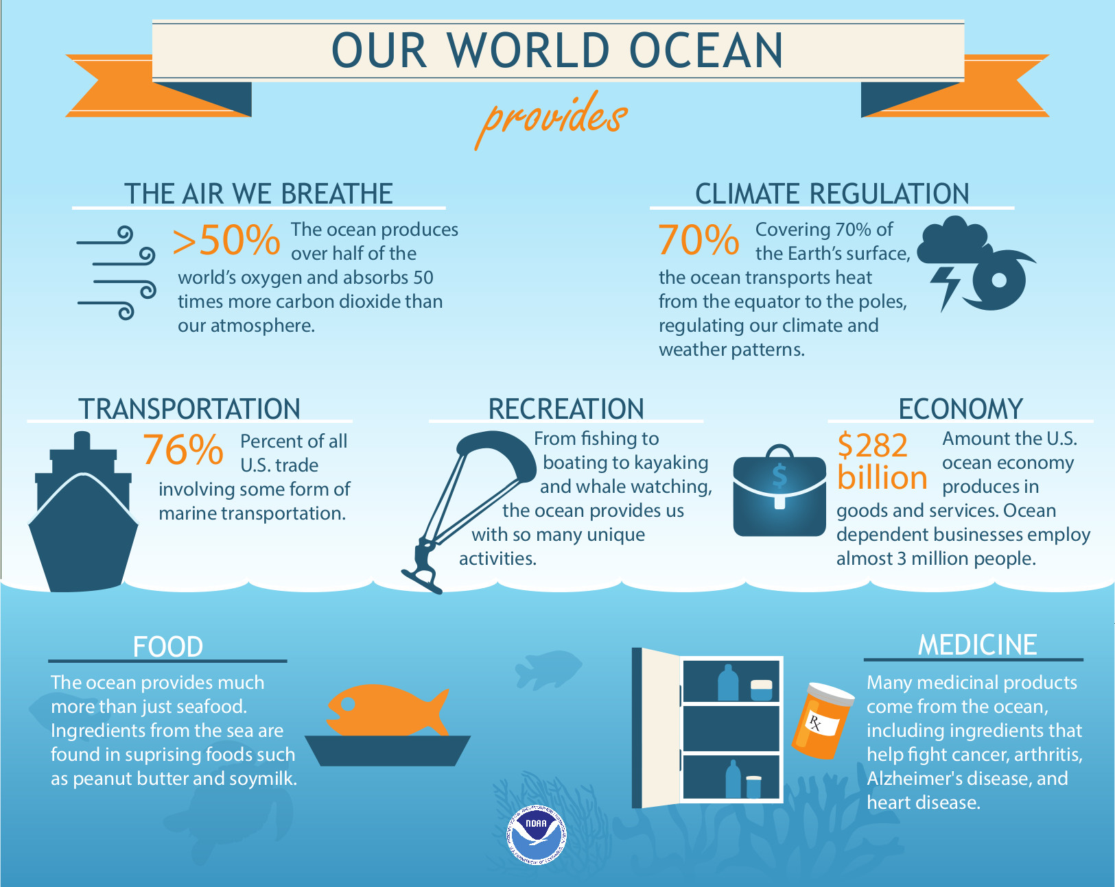
From Our Ocean Service:
Our World Ocean Provides…
The air we breathe: the ocean produces over half of the world’s oxygen and absorbs 50 times more carbon dioxide than our atmosphere. Climate regulation: covering 70% of the Earth’s surface, the ocean transports heat from the equator to the poles, regulating our climate and weather patterns. Transportation: 76% of all U.S. trade involves some form of marine transportation. Recreation: From fishing to boating to kayaking and whale watching, the ocean provides us with many unique activities. Economic benefits: the U.S. ocean economy produces $282 billion in goods and services and ocean-dependant businesses employ almost three million people. Food: the ocean provides more than just seafood; ingredients from the sea are found in suprising foods such as peanut butter and soymilk. Medicine: many medicinal products come from the ocean, including ingredients that help fight cancer, athritis, Alzheimer’s disease, and heart disease.
From email from the Eagle River Water & Sanitation District (Diane Johnson):
Business community invited to discuss water policy principles
Contacts:
Diane Johnson, Eagle River Water & Sanitation District, 970-477-5457
Alison Wadey, Vail Chamber & Business Association, 970-477-0075Join the Eagle River Water & Sanitation District and the Vail Chamber & Business Association for a business briefing on the Colorado Water Plan from noon to 1:30 p.m., Thursday (7/10) at Donovan Pavilion in Vail. A complimentary lunch will be served.
Gov. John Hickenlooper ordered work to begin on the statewide water plan in May 2013; a draft is due to the Governor’s Office no later than Dec. 10, 2014, with the final plan complete by December 2015.
Business leaders have developed statewide business community water policy principles to be part of Colorado’s Water Plan and are seeking regional input to finalize the principles. Working through local business chambers, this statewide initiative seeks local feedback on the principles, which address the business and economic development needs of Colorado.
Thursday’s speakers include:
Tom Binnings of Summit Economics will discuss the economics of water from a statewide perspective. Linn Brooks of Eagle River Water & Sanitation District will share local water operations and policy, and discuss needs in the Eagle and Colorado River basins. James Eklund, executive director of the Colorado Water Conservation Board – the state agency tasked with drafting the Colorado Water Plan. Bryan Blakely of Accelerate Colorado and Mizraim Cordero of the Colorado Competitive Council will discuss the business community water policy principles. To ensure enough food for attendees, please RSVP to the Vail Chamber & Business Association at info@vailchamber.org or 970-477-0075 by tomorrow (7/8).
More Colorado Water Plan coverage here.
From the Sky-Hi Daily News (Hank Shell):
Typically, reservoirs on the Front Range fill by May, which lowers Lake Granby enough to accept additional water during runoff season, said Kara Lamb with the U.S. Bureau of Reclamation. But flooding on the East Slope in September, coupled with additional precipitation and runoff, have kept Carter and Horsetooth reservoirs, the Colorado-Big Thompson Project’s main draw points for Front Range water users, too full to accept much water. Add above-average runoff on the Western Slope to the equation, and there is a fair amount of uncertainty whether the Alva B. Adams Tunnel will have anywhere to transport water if and when Lake Granby spills.
“There could be a little pumping to help with the spill situation,” said Brian Werner with Northern Water. “It’s dependent on this side of the mountains, and if there’s any room to put any water, so demands really haven’t started, and like I said, we’re full everywhere.”
There’s a possibility that pumping could be halted until Labor Day, Werner said.
For Grand Lake residents, pumping can mean the difference between pristine clarity and a cloudy lake. Last year, reduced pumping saw the clarity of natural Grand Lake increase, while the shallower Shadow Mountain Reservoir became more turbid…
As of July 3, Lake Granby was at 2.6 feet from capacity, with levels rising around a third of a foot per day. Werner, of Northern, said if the lake does spill, forecasters expect it to do so between July 10 and July 14.
“Our forecaster, who I just talked to, said we’re still 50-50 on whether we’re going to spill,” Werner said.
Spilling is not a very common occurrence for Lake Granby. The last time the lake spilled was in 2011, and before that it was in 2000. The large amount of snowpack has led to above-average flows this year, and reservoirs on the Front Range are already near capacity. Specifically, Carter Lake is at 99 percent full, while Horsetooth Reservoir is 99.2 percent full, according to the Bureau of Reclamation’s website.
From The Norwood Post (Regan Tuttle):
The Town of Norwood continues to make headway in water quality and availability. This past February, Norwood completed a major upgrade to the water treatment plant.
“We just completed a big project that we did last year. We’ve added a filter to the water treatment plant to help with water quality. That took about a year and was finished in February,” Public Works Director Tim Lippert said.
Lippert has been in service to the Town of Norwood — in public works, Norwood Water Commission and Norwood Sanitation District — for 22 years.
According to Lippert, the EPA, through the Colorado Department of Health, has tightened the standards for drinking water over the years. As a result, Norwood’s previous water treatment system was not in compliance.
Through many grants and low-interest loans, and the hard work of town officials, the water treatment plant is now producing more and cleaner and water than ever before…
The latest addition features a new clarifier system that converts raw water through a chemical and sand filter process to produce Norwood’s best drinking water yet…
Last year, Norwood also completed repair on the Gardner Springs water right. During that process, Lippert and his crew discovered damage to the Norwood Pipeline.
The Norwood Pipeline will now be rehabilitated through grant funding made possible by Southwest Water Conservancy in Durango.
“We had done exploratory digging there to see why it wasn’t producing. The pipe was smashed, and we are now replacing 600 feet,” Lippert said.
According to Lippert, the plastic irrigation pipes may not have been bedded properly. Over the years, the weight of the mud collapsed them.
“We couldn’t get water through it,” Lippert said. “And silting happened also because of restrictions.”
The Norwood Pipeline project will include a flume with control valves for the purpose of measuring water flow. Water from Norwood Pipeline can then be diverted into one of Norwood’s two reservoirs.
“We can then measure flow and divert it where we want,” Lippert said.
More infrastructure coverage here.
From the Enterprise Broomfield News:
Broomfield offers two water conservation programs to help residents save water and money. Residents and businesses could qualify for an irrigation audit and/or rebates if they receive treated water from Broomfield.
Free irrigation audits are provided by Slow the Flow Colorado, a nonprofit program of the Center for Resource Conservation. To schedule an irrigation audit, call 303-999-3820 ext. 217 or go to conservationcenter.org/.
Water rebates help offset the cost to replace inefficient toilets and irrigation components. More information on rebates, including qualifying models and residential rebate instructions, go to broomfield.org/index.aspx?NID=1098.
More information on water conservation, including lawn watering guidelines, can be found at broomfield.org/index.aspx?NID=439.
More conservation coverage here.
From Circle of Blue (Brett Walton):
America’s largest reservoir, Las Vegas’ main water source, and an important indicator for water supplies in the Southwest — will fall this week to its lowest level since 1937 when the manmade lake was first being filled, according to forecasts from the federal Bureau of Reclamation.
The record-setting low water mark — a surface elevation of 1,081.8 feet above sea level — will not trigger any restrictions for the seven states in the Colorado River Basin. Restrictions will most likely come in 2016 when the lake is projected to drop below 1,075 feet, a threshold that forces cuts in water deliveries to Arizona and Nevada, states at the head of the line for rationing.
But the steadily draining lake does signal an era of new risks and urgency for an iconic and ebbing watershed that provides up to 40 million people in the U.S. and Mexico with a portion of their drinking water. The rules governing the river are complex, but the risk equation is straightforward: less supply due to a changing climate, plus increasing demands from new development, leads to greater odds of shortages…
Yet despite a shrinking lake, diminishing supplies, and ardent pleas from tour guides and environmental groups to preserve a canyon-cutting marvel, the four states in the basin upriver from Lake Mead intend to increase the amount of water they take out of the Colorado River. All of the states are updating or developing new state water strategies, most of which involve using more Colorado River water, not less.
“We have mapped out how the remainder of our allocation can be used,” Eric Millis, director of the Utah Division of Water Resources, told Circle of Blue. “It’s going to happen sooner rather than later. We have a place for every drop.”
Utah — like fellow upper basin states Colorado, New Mexico, and Wyoming — is not using all the Colorado River water it was granted by a 1922 interstate compact. The four states have the legal authority to increase their Colorado River diversions.
However, the water they seek may not be available. The calculations of availability stem from wetter hydrological conditions and supply forecasts made nearly a century ago. Under the 1922 compact, the upper basin is entitled to 7.5 million acre-feet. A later agreement apportioned each state a percentage of the available supply. The upper basin’s average annual use between 2007 and 2011, the most recent figures, was 4.6 million acre-feet.
The legal entitlement, granted at a time when the river’s hydrology was poorly understood, is surely too high. All the states acknowledge that fact. “We’re not pegging our hopes or analysis on the full 7.5,” said James Eklund, director of the Colorado Water Conservation Board, the state water planning agency…
The upper basin put forward a plan this spring to keep more water in Powell. The states would do this by paying farmers not to farm and by changing how smaller mountain reservoirs are managed. Three urban water utilities in the lower basin, along with Denver and the federal government, put up $US 11 million to develop a similar basin-wide program…
Though the lower basin is using its entire allocation, the four upper basin states are not. They desire more water from the Colorado, yet exactly how much water is available is uncertain.
The only concrete number to emerge so far is 5.8 million acre-feet of water available for the upper basin, or three-quarters of what was granted. That figure, called the hydrological determination, was developed by New Mexico and the Department of the Interior in 2007 as part of a water supply study.
New Mexico is the only state using 5.8 million acre-feet as a firm number. Millis said Utah is using 6.5 million acre-feet of upper basin supply for its planning, and Colorado and Wyoming are looking at a range of values.
Eklund told Circle of Blue there is “vigorous debate” both within and between states over what number should be used to assess water availability and what the acceptable levels of risk are as water use increases.
“There’s a sliding scale of risk,” Eklund said. “The more water you develop, the more risk you take on. But that doesn’t necessarily counsel against a project.”
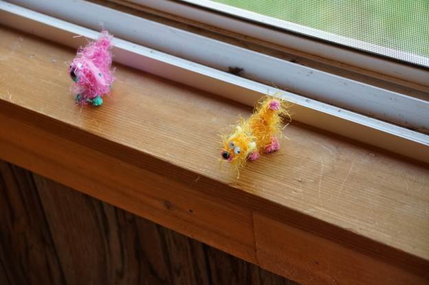
Greg Hobbs sent this picture poem in email yesterday. He’s inspired by family, country, and Colorado this 4th of July.
Interdependence Days 2014
The Columbine
our flags salute
colorful communities loved by peoples who came before
going on foot to see, preserve, and persevere
public places
to stride, and gain within
the close up
small
the great
hands of a mother
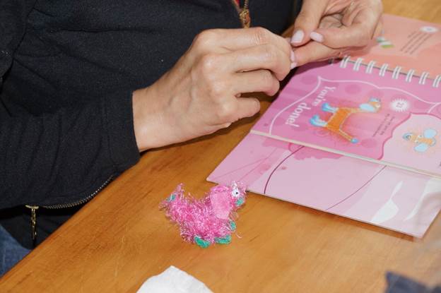
creating

pink and gold puppies
through private windows, free wild nurtured
no monopoly but precious grandmother

grandfather wizard time
with the Alleluia chorus.

at the cabin and Staunton State Park, Jefferson County, Colorado
daughter Emily, granddaughters Ella and Grace, son-in-law Mark,
Bobbie and Greg Hobbs and Strider, 7/4/2014

From The Denver Post (Jason Blevins):
Colorado rafting outfitters are relishing a surge in visitation after two years of business-sinking drought and wildfire. As river flows become less intimidating, trips are selling out. Guests are spending more. Snowpack lingers in the high country, promising a paddling season that could push into fall.
“All the indicators are super positive right now,” said Alex Mickel, who has all 90 of his employees working this week as guests flock to his Mild To Wild rafting and tour company in Durango. “We are definitely benefiting from the economic rebound, too. People are looking at longer trips, stepping up to longer days, adding Jeep tours.”
Signs are good that Colorado’s rafting industry could host more than 500,000 user days, returning to the heydays of 2006, 2007 and 2008. Even if the visits don’t reach record levels, tourists are opening wallets wider, with resort towns across the state reporting record sales tax revenue last summer and this past winter. Last year, more than 461,000 rafters riding Colorado’s rivers and streams spent $56.7 million, creating an economic impact of $145.3 million. That was a step toward recovery from the drought- and wildfire-plagued 2012 season, which ranks as the second-worst year for Colorado rafting since 1995. But 2013, too, was haunted by wildfire.
Fires around Durango pinched traffic on the popular Animas River. The Royal Gorge fire near Cañon City deterred rafters on the Arkansas River, the most trafficked river in the country. The heavily publicized Black Forest fire in Colorado Springs kept more rafters at bay.
“We will suffer more from a fire up by Colorado Springs or Denver than we will from a fire down here because those are the ones who get the big press,” said Durango’s Mickel, noting how wildfire coverage tends to deter vacationers.
This year — knock wood — lasting snowpacks and spring storms have dampened the wildfire scene, giving outfitters a head start on what could be the best season in five years.
As river flows recede from the initial gush of spring snowmelt, rafters are flocking. Last week, Ryan Barwick’s MAD Adventures and Rocky Mountain Adventures rafts filled to capacity on the Colorado and Cache la Poudre rivers and Clear Creek.
“My gut feeling is that we are seeing some pent-up demand, but it’s hard to quantify,” said Barwick, who had all 75 of his employees on deck as he reached capacity for tours on the Poudre and Clear Creek. “The economy has stabilized and people are traveling. We had our best preseason bookings in five years. Now that we are past the high-water phase, the floodgates are open.”
High flows and stormy afternoons delayed the start of the rafting season, which hits its peak this holiday weekend. But the winter’s healthy snowfall has built a lasting snowpack up high, translating to consistent flows in rivers down low. Flowing rivers have sated agricultural users farther east, and those users have yet to place widespread calls for irrigation water from reservoirs. That means rafters could enjoy sustained, buoyant flows when those calls do happen in the next two months.
The river riding season is shaping up to last well into September, maybe even October, said David Costlow, president of the Colorado River Outfitters Association, which represents 44 outfitters operating on 19 rivers and creeks in the state. That promise of consistent flows allows outfitters to book trips into the shoulder months.
“When you are not sure what the water flows are going to be, you tend not to book. But when you are going to have flows, you are more positive and people are more inclined to book trips,” said Costlow, who predicts the season user tally could top the half-million mark last seen in 2008. “Let’s hope things stay strong for a while.”
Meanwhile, the runoff was pretty well-behaved keeping flooding losses down. Here’s a report from Ryan Maye Handy writing for the Fort Collins Coloradon. Here’s an excerpt:
The snowmelt season is over in Northern Colorado and it was far less damaging than state officials initially feared.
Although state highway officials were bracing for catastrophic spring flooding in areas weakened by the September 2013 flood, there was little severe flood damage along the Front Range as the state’s snowpack melted…
Water flow in parts of the canyon almost broke records this year, according to measurements taken at the canyon’s mouth. There the river hit its peak on May 31, when it hit 6,000 cubic feet per second — equal to about 6,000 basketballs floating by each second.
That’s the second-highest peak flow recorded at the canyon mouth since 1957, according to records kept by the Northern Colorado Water Conservancy District.
“The only other time it went higher was in 1983, when it was 6,725 cfs,” said Brian Werner, a spokesman for the district.
The Poudre’s levels can be fickle — subject to rain, snowmelt and water use — and rafter Ryan Barwick, owner of Rocky Mountain Adventures, cautioned against letting one gauge speak for the rest of the river.
“We can have great flows up there for rafting, but have a trickle at the canyon mouth,” he said.
The 6,000 cfs level didn’t strike him as unusually high.
“If you talk to most boaters, they remember most years when over 5,000 in the canyon was commonplace,” he added.
The mountains west of Fort Collins have been emptied of most of their water, said Treste Huse, a hydrologist with the National Weather Service in Boulder. Snowpack measurement gauges at Joe Wright Reservoir are down to 1.7 inches of snow water equivalent — the amount of water the snow contains. The reservoir gauge had 32 inches of snow water equivalent at its peak.
Many of the northern Front Range’s snow gauges are “all melted out,” Huse said.
Spring rains in May and snowpack levels have left most of Northern Water’s reservoirs full — Horsetooth Reservoir has been full at least twice this spring, and Lake Granby is just 3 feet from spilling over, Werner said.
“We are as full as we have ever been,” he said. “We may have been this full in 1962.

Click here to read the newsletter.
More education coverage here.


From The Greeley Tribune (Eric Brown):
Proposed rules could place “basically every drop of Colorado water” under the federal government’s jurisdiction, increasing permitting requirements, mitigation and costs for projects needed to ensure future water supplies in a state that’s expecting big shortages.
That was the general consensus among the several water officials, representatives of the agriculture industry and others who traveled from across the state to voice their concerns to Rep. Cory Gardner, R-Colo., at his Greeley office on Thursday.
Gardner encouraged those at the table and others who are concerned to continue raising their voices to the Environmental Protection Agency, which will take comments on its proposed rule through Oct. 20.
The EPA has long stressed that its proposed “Waters of the U.S.” rule is simply an effort to clarify protection under the Clean Water Act for streams and wetlands, since determining Clean Water Act protection became confusing and complex following Supreme Court decisions in 2001 and 2006.
But many are stressing now that the EPA’s attempted clarification would instead expand the federal government’s reach, with much more water and area falling under the EPA’s “Waters of the U.S.” rules, according to their interpretations of the proposed rules.
New projects and certain maintenance on “Waters of the U.S.” requires federal permitting and, depending on the circumstances, possibly environmental mitigation efforts, which can mean a lot of time and money for the municipality, ditch company or whoever is overseeing the effort.
As an example, Mark Pifher with Colorado Springs Utilities compared the permitting and mitigation costs of Aurora’s Prairie Water Project — which was only $1.5 million, because it didn’t fall under “Waters of the U.S.” rules — to the $150 million in permitting and mitigation it took for the Colorado Springs Southern Delivery System, which did fall under “Waters of the U.S.” rules.
Along with more projects and maintenance facing increased permitting and costs, some on Thursday even expressed concerns of the EPA eventually taking control of water in Colorado, because the state’s individual water-rights holders wouldn’t be able to put them to use.
Water officials from across Colorado stressed that the EPA’s rules are a one-size-fits-all approach, and don’t take into account how differently water works in the semi-arid or arid West — where water storage, reuse, groundwater recharge and other efforts are needed to get by — compared to the much wetter eastern U.S.
The “connectivity” language in the proposed rules — which places areas and waters that are merely “connected” to “Waters of the U.S.” under the federal government’s jurisdiction — is particularly concerning to those who were at Gardner’s table Thursday.
The group said the fact that the EPA still believes it’s only clarifying its rules and not expanding its reach only reveals a big misunderstanding of how water works in the West and in Colorado.
Some at the table Thursday said that perhaps Congress — with representation of all states — is better equipped than the EPA to take charge of the rule-making.
Ag groups — like the Colorado Farm Bureau, which was represented at the table by Don Shawcroft, the organization’s president — are pushing their “Ditch the Rule” campaign.
Among other points, Shawcroft noted that the EPA’s existing “agriculture exemptions,” which would still apply under the new rules, wouldn’t do much good for farmers and ranchers, since those exemptions only apply to operations that are still under the same ownership and under the exact same practices as they were in 1977.
“Agriculture has changed a lot since then,” he added.
Impacts on NISP?
Eric Wilkinson — general manager of the Northern Colorado Water Conservancy District in Berthoud, which oversees the largest water-supply project in the region, the Colorado-Big Thompson Project — said “basically every ditch” and “every drop of Colorado water” could fall under the EPA’s jurisdiction under the new rules.
Because of that, he and everyone else at the table stressed, that the future costs and time to permit water projects or maintenance might detour officials, water providers or others from pursuing certain needed actions.
And in a state that, according to the 2010 Statewide Water Supply Initiative study, is expected to see a municipal and industrial water-supply gap of as many as 1 million acre-feet by 2050, and also see as many as 700,000 acres of irrigated farm ground dry up by that same year, many water projects are needed, they say.
Under the proposed rule, Wilkinson said one of the “needed projects” that Northern Water is overseeing — the Northern Integrated Supply Project, or NISP, which would build a new reservoir near Fort Collins and another one near Ault — could possibly have to “go back to the drawing board” on some its federal permitting efforts, which have already been in the works by Northern Water for more than a decade.
Wilkinson and others said the complications resulting from more area and water in Colorado falling under “Waters of the U.S.” rules could also detour collaborative water efforts between cities and farmers. As many retiring farmers over the years have sold their valuable water rights to growing cities, many are now pushing for alternative water transfers between farmers and cities that would reduce the amount of water permanently leaving the state’s farms.
Improvements to irrigation ditches and other irrigation systems, too, could require more permitting and more costs under the new rules.
“There’s certainly more questions than answers,” noted West Slope rancher and Colorado Farm Bureau Vice President Carlyle Currier.
More 2014 Colorado November election coverage here.
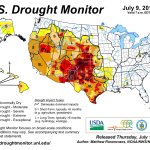
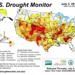
Click here to go to the US Drought Monitor website. Here’s an excerpt:
Summary
During the past 7-days, a series of weak upper-level disturbances and frontal systems at the surface brought widespread precipitation to much of the contiguous United States, outside of the Southwest and California. Heavy rain (2”-4”, locally greater) fell across portions of the Upper Mississippi Valley, the northern Plains, the Pacific Northwest, the west-central Gulf Coast region, the general vicinity of the southern Appalachians, and the Northeast. A low pressure area off the East Coast of Florida was in the process of developing into a tropical depression, and would become Tropical Storm Arthur by the end of the period.
Southern and Central Plains
Two to four inch rains fell over southern and central portions of Nebraska, prompting 1-category upgrades for these areas. In central and southern Kansas, 2-5 inch rains (locally heavier) warranted one-category improvements, especially in places which received two to three times their normal rainfall for the week. In Oklahoma, widespread one-category improvements were made in the northern portion of the state, due to very heavy rains during the past 30-days. For example, in the town of Buffalo, OK, 10.44 inches of rain fell during the past month, compared to the normal June rainfall of 4.08 inches. Flash flooding was also reported in Buffalo. On June 30th, the Oklahoma Panhandle experienced a very impressive dust storm. In the southeast portion of the state, minor degradations were rendered to the drought depiction. Texas had an unexpectedly wet week, with very heavy precipitation along the Gulf Coast (generally 3-5 inches, locally greater), and moderate to heavy precipitation (0.5-3.0 inches) in the interior East, supporting 1-category improvements. Relatively small alterations were made to the depiction in southern and far western Texas, both improvements and degradations.
Southwest and California
Little if any precipitation was observed in the Southwest during the past week. In western New Mexico, severe drought (D2) was downgraded to extreme drought (D3), and a general one-category degradation was rendered to the depiction in the southernmost counties of Luna, Dona Ana, and Otero. El Paso has received only 25 percent of its normal precipitation since January 1, 2014, making this the 7th driest year on record (so far) since 1879. High temperatures have been exacerbating drought-related impacts. Every day in June, El Paso was at or above normal, with a June departure of about +6.1 degrees F, making this the second warmest June on record, only behind June of 1994. In northeast Utah, most of the D2 area was downgraded to D3 conditions, while moderate rain (0.5-2.0 inches) supported a one-category improvement to parts of northeast Colorado. In southern Nevada, the continued lack of rain prompted the expansion of extreme drought (D3) conditions across parts of Nye, Lincoln, and Clark Counties, while in southern California, exceptional drought (D4) was expanded across Ventura, Los Angeles, and much of Orange Counties.
Looking Ahead
During July 3-7, 2014, most of the contiguous United States is expected to receive a half-inch or less of rain, though there are a few exceptions. Northern and central Florida, the Outer Banks of North Carolina, near the mid-Atlantic Coast, and the southern and eastern New England coasts may get 2-4 inches of rain, in part from what is currently Tropical Storm (projected to be hurricane) Arthur and from an active cold front approaching from the west. In the Middle Mississippi Valley, 0.5-1.0 inch of rain is forecast during this period, while 0.5-1.5 inches of rain is expected in association with the onset of the Southwest Monsoon across portions of Arizona, New Mexico and northern Texas. Temperatures during the period are anticipated to be mostly within 4 degrees of normal, though very brief departures of 8-10 degrees above normal are projected for the northern Plains region.For the ensuing 5-day period, July 8-12, 2014, there are enhanced odds of above-median rainfall in the east-central CONUS, the Great Lakes region, southern Florida, and the Southwest. Below-median precipitation is favored over the Pacific Northwest, the northern Rockies, and southwest Alaska. Mean temperatures for this period are favored to be above-normal over approximately the eastern and western thirds of the lower 48 states, and the southern half of Alaska, and near to below-normal temperatures are favored over the central third of the CONUS.
From The Pueblo Chieftain (Matt Hildner):
The U.S. Department of Agriculture has designated three San Luis Valley counties as drought-related natural disaster areas. The move, announced this week, makes farmers and ranchers in Conejos, Mineral and Rio Grande counties eligible for low-interest emergency loans.
While drought conditions have improved in the valley since last year, the three counties were eligible because they are contiguous to counties on the other side of the Continental Divide that have been declared primary disaster areas.
Farmers have until the beginning of March to apply for the loans from the Farm Service Agency.
The U.S. Drought Monitor currently lists the valley as abnormally dry, its least severe drought designation.
Last year, the valley was mired in severe drought, the third-most extreme of the monitor’s five designations.
Pueblo County and seven other Southeastern Colorado counties were given natural disaster designations in January.

Here’s the release from the Environmental Protection Agency (Click through for the photo gallery):
Nutrient pollution caused by high levels of nitrogen and phosphorus originates from many sources including, but not limited to, fertilizers and manure from agriculture and soil erosion.
Protecting clean water is essential to sustaining America’s agricultural way of life, and nutrient pollution threatens our economy, public health and quality of life. Fortunately, there are farmers who are voluntarily adopting practices to minimize nutrient runoff from their operations. These farmer heroes are providers of America’s food supply and stewards of their local water resources.
The farmers below have been identified by the National Association of Conservation Districts (NACD) and EPA for implementing specific best management practices to reduce pollution while also improving or sustaining their profits, soil quality and/or yields. We celebrate these farmer heroes who are making a difference to improve America’s water resources and invite you to read their stories.
Keeping the creek on the family farm flowing and clean makes good environmental and financial sense. Central Illinois farmer manages nitrogen use to lower costs, maintain yields and leave land in good shape for his children. For Long Island farmers, fertilizer is key to saving money, reducing work, and protecting community. Little Rock farmer helps minimize fertilizer runoff by cultivating interest in organic locally grown foods. Farmer discovers how to protect his water and increase his bottom-line. Why what happens in a little creek on my farm matters downstream. Clean water is key to my family’s farming future. What I’ve learned about protecting the privilege of farming.


From The Mountain Town News (Allen Best):
Hot and dry? Not in Colorado this year. Exactly the opposite. In Breckenridge last week, flowers overflowed the planters along Main Street. They were new, I was told, because the lingering cold had killed previous efforts at civic gaiety.
Evidence of global warming? No, but weather should not be confused with climate. We still have a major problem.
I was in Breckenridge to attend a meeting of the Colorado Association of Ski Towns. CAST consists of municipalities in all the destination ski resorts, but it has expanded to include several counties and also a few towns with a slightly looser affiliation, including Estes Park and Grand Lake, the two gateway towns to Rocky Mountain National Park.
At the meeting, Ketchum, Idaho, and Whistler, B.C., were also approved for membership, joining Jackson, Wyo., and Park City, Utah, as non-Colorado ski towns. Nederland, located west of Boulder, near the Eldora ski area, also was voted in. As the business meeting was in the middle of libations, part of a social hour at the end of the Colorado Municipal League annual conference, this approval was granted with raised glasses and cheers.
Then it was my time to speak. I nearly begged off. Walking to the front, I thought to tell my joke and announce I’d return at a later meeting, before cocktail hour, to speak my piece.
My joke went over well, and so I laid out my pitch after all. CAST, I said, should consider an advocacy role on behalf of a national carbon tax.
Now, I’m glad that I was bold. By a few days, I preceded an op-ed in the New York Times by Henry Paulson, the former chief executive of Goldman Sachs and then treasury secretary in the second term of George W. Bush.
About the same time, Rolling Stone published an essay by Al Gore, the former vice president, who also mentioned the need for a carbon tax.
Continue reading “Mountain towns should support a tax on greenhouse gas emissions — Allen Best @MountainTownNew”

Click here to go to the Spaceweather.com website for the inside skinny.
Happy Independence Day from Coyote Gulch.
From the Bureau of Reclamation, we wish all of you a safe & happy Fourth of July. Happy Birthday America! #4thofJuly pic.twitter.com/doX3FtAkjW
— Reclamation (@usbr) July 4, 2014

From The Yuma Pioneer (Tony Rayl):
The Republican River Water Conservation District Board of Directors will be holding its regular quarterly meeting Thursday, July 10, in Holyoke. It will be from 10 a.m. to 4 p.m. in the Biesemeier Meeting Room in the Phillips County Events Center.
The agenda includes a report from Colorado State Engineer Dick Wolfe on negotiations with Kansas regarding the compact compliance pipeline resolution and the Bonny Reservoir resolution. The board will receive the 2013 audit report, and is expected to approve an engagement letter for the 2014 audit.
Public comment will be heard at 1 p.m.
For more information, please contact RRWCD General Manager Deb Daniel at 332-3552, or 630-3525, or email deb.daniel@rrwcd.com. The RRWCD’s website is http://www.republicanriver.com.
More Republican River Basin coverage here.

From the Glenwood Springs Post Independent (Hannah Holm):
Which is more important: The public’s enjoyment of healthy streams, or preserving private property rights and agriculture? Do we really have to choose?
Questions swirling around proposed ballot initiatives that assert public rights to Colorado’s water and environment reflect broader tensions between public and private rights that are inherent in our democracy, as well as changing public values regarding natural resources.
The U.S. Constitution barely mentions water, but the Colorado Constitution has an entire article (16) on “Mining and Irrigation,” which provides the underpinnings of Colorado water law. In summary:
• Water in streams is owned by the public: “The water of every natural stream, not heretofore appropriated, within the state of Colorado, is hereby declared to be the property of the public, and the same is dedicated to the use of the people of the state …”
• At the same time, individuals’ rights to take water out of a stream to use it are assured: “The right to divert the unappropriated waters of any natural stream to beneficial uses shall never be denied.” Further details explain that “priority of appropriation shall give the better right…” In other words, first in time, first in right.
• Rights of way have to be provided to move water from a stream to where it’s needed: “All persons and corporations shall have the right-of-way across public, private and corporate lands for the construction of ditches, canals and flumes for the purpose of conveying water … upon payment of just compensation.”
These provisions reflect the necessity of access to water from streams for life and livelihoods in semi-arid Colorado and, according to legal scholar David Schorr, a desire to prevent that access from being controlled by a privileged few. This is a very democratic kind of desire.
Over the last 100-plus years, public values related to water have become more complicated. We all still want to drink water and eat food, but water in streams for recreation and a healthy environment have also become high priorities. And sometimes water taken out of streams to serve those long-established values of domestic use, agriculture and industry, and the livelihoods related to them, ends up leaving streams depleted and unhealthy.
The constitution clearly provides for taking water out of streams, but gives no direction about when water should be left in. The General Assembly passed laws allowing water rights to be filed for environmental and recreational purposes, but most of these rights are very junior to others and vulnerable to going unmet.
Proposed ballot initiatives to establish public rights in water and the environment seek to reverse the priority of these values. Initiative 103, “Public Trust Resources,” which focused on water, was derailed from its track to the ballot by the Supreme Court, but Initiative 89, “Local Government Regulation of Environment,” was cleared for signature collection.
Initiative 89 would amend Colorado’s constitution by asserting that Colorado citizens “have a right to Colorado’s environment, including its clean air, pure water and natural and scenic values.” It directs the state and local governments to protect these resources, and says that when local and state laws conflict, the more restrictive or protective would govern.
In his dissenting opinion, Justice Gregory Hobbs argued that the new public right to the environment “would override existing private and publicly held property rights,” and would require state and local officials “to act adversely to the interests of private parties …”
In addition to reflecting the ever-present tension between public and private rights, the dispute also reflects polarization between parties primarily interested in preserving the status quo and those seeking enhanced environmental protections.
Longtime environmental advocate and vice president of the Upper Gunnison River Water Conservancy District Steve Glazer, speaking at the Colorado Water Workshop in Gunnison in June, urged both sides in the conflict to “listen to each other more, and move together instead of apart” in order to find solutions that don’t sacrifice one set of values to serve the other.
From The Durango Herald (Sarah Mueller):
Douglas Kemper, executive director of Colorado Water Congress, joined Bruce Whitehead of the Southwestern Water Conservation District, and elected leaders to educate the council on two initiatives that could change the state’s prior appropriation system for managing water claims. Prior appropriation is a way of water allocation that controls who uses how much water, the types of uses allowed and when those waters can be used.
The secretary of state’s website said any person can draft a statewide initiative to amend the state constitution. If proponents of the ballot measure gets enough signatures, about 86,105, all voters in the state would decide the issue. The Colorado Supreme Court affirmed initiatives 89 and 75.
The Water Congress, a nonprofit group providing leadership on water issues, created a stewardship project that tracks, what it believes are, “public trust doctrine” initiatives that would change how Colorado allocates water. The group opposes public-trust initiatives. Switching to a public-trust system would mean the government would decide how to allocate water rights instead of who came first, according to Kemper.
Initiative 75 would give local governments the power to approve laws that would establish the fundamental rights of residents, communities and nature. It would give local governments expanded power over businesses, such as allowing local laws to establish or eliminate the rights of corporations and other businesses operating in the community to protect the rights of people, communities and nature.
“Those are some pretty far-reaching powers,” Kemper said. “Basically, it says those local laws would be superior to international, federal or state law.”
Initiative 89 declares that Colorado’s environment is the common property of all Coloradoans, including the clean air, pure water, and natural and scenic values. It makes state and local governments trustees of the environment and requires them to protect the environment.
Colorado Supreme Court Justice Gregory Hobbs Jr. wrote in a dissenting opinion on Initiative 89 that the initiative would create a new common property right that would override existing private and publicly held property rights.
“Initiative 89 would upend the existing regulatory balance and thrust private-property owners and governments into an uncertain future,” Hobbs wrote…
State Rep. Mike McLachlan, D-Durango, urged city councilors to draft a resolution opposing these initiatives. The Southwestern Water Conservancy District has issued a resolution in opposition to public trust initiatives.
More 2014 Colorado November election coverage here.

From The Produce News (Lora Abcarian):
[Dick Wolfe] said I-70, which runs east and west through the Centennial State, has become something of a line of demarcation. Agricultural producers north of I-70 are seeing more favorable water supplies in 2014. Traveling south of the interstate, conditions begin to change and become more extreme.
“A large driver of the water in aquifers is snowpack and runoff,” Wolfe commented, adding that snowpack was generally good in the Rocky Mountains this year. “The lowest water levels on record are in the Rio Grande Valley. In the Rio Grande, runoff continues to be bad.” Much of Colorado’s San Luis Valley, known for its production of potatoes for the fresh market, lies within the Rio Grande Water Conservation District.
The district saw the formation of Colorado’s first-ever groundwater management subdistrict which continues to take measures to reduce water consumption by agricultural interests and, at the same time, address ongoing depletions in the aquifer. “Mother Nature is that other part we have no control over,” Wolfe commented. “Over the last 10 to 15 years, the southern half of the state has been getting drier. And the Rio Grande has been consistently been in drought conditions.”
Elsewhere in Colorado, it’s another story. “The Arkansas River Basin is not looking too bad in the upper part of the state,” Wolfe noted. The headwaters of the river are located in northern Colorado, and the basin supplies water to agricultural producers in southeast Colorado.
Growers in Colorado’s Western Slope, located west of the Continental Divide, are generally reporting good water availability this season for their crops. The Colorado River and its tributaries flow through the region. “The Colorado and Gunnison rivers had great runoff conditions in the north,” Wolfe said. “The south [Western Slope] is in drought.”
There is considerable agricultural production in northeastern Colorado, the location of the South Platte River Basin. Last September, unprecedented flooding occurred in the area, with the greatest impacts affecting infrastructure and residential areas. “The runoff is now over, but we are not out of the woods yet,” said Wolfe of the potential for possible flooding attributed to rainfall.
There is concern in the South Platte River Basin about high water tables in the Sterling and Gilcrest/LaSalle areas. “That’s certainly a concern at the governor’s level,” Wolfe commented…
Officials continue with recovery efforts in northern Colorado following 2013 flooding. Wolfe said 27 dams were damaged. “That didn’t make those reservoirs unusable,” he commented. “Seventy-five percent of structures have been restored from last year’s damage.” Another 23 stream-gauging stations and 220 diversion structures were also damaged.
From email from Reclamation (Kara Lamb):
Inflow keeps coming up. As a result, we are upping the release from Green Mountain Dam to the Lower Blue River, again. By 4 p.m. [July 2] the release from the dam to the river should be around 1700 cfs.
From email from Reclamation (Kara Lamb):
Not a lot of changes for the east slope of the Colorado-Big Thompson Project this week. Horsetooth and Carter are full and will stay full through the holiday weekend. Flatiron, Pinewood and Lake Estes all fluctuate slightly, due mostly to power generation, but remain at the upper end of their storage pools. In fact, the water elevation at Pinewood is on the rise again after going down last week.
The outflow from Olympus Dam to the canyon remains at 125 cfs.
Our big news is at the mouth of the Big Thompson Canyon. We have curtailed the release of water through the concrete chute to the river. Instead, we are once again running water through the Big Thompson Power Plant. This is an exciting moment for us as the plant had been off-line since the flood.
From email from Reclamation (Kara Lamb):
We have increased releases twice from Green Mountain since my note yesterday. Yesterday afternoon, we went up to about 1400 cfs. This morning around 9 a.m. we went up to about 1600 cfs. We are still storing in Green Mountain Reservoir. It is 97% full.
The reason for these changes is we are seeing the high elevation snow melt runoff come down the Blue River. It is very likely we will see another change or two before the Holiday Weekend.
From The Leadville Herald (Danny Ramey):
The Resurrection Mining Company has filed for approval of an augmentation plan that would allow it to use water shares to replace water depleted from the Yak Tunnel and water treatment plant. Under the plan, the company would use shares it owns in Twin Lakes Reservoir to replace water depleted by its operations in California Gulch. Resurrection filed an application for approval of the augmentation plan with Division 2 of the Colorado Water Court on May 20.
Resurrection currently owns 22 shares of water in Twin Lakes. Twelve of those shares are included on a provisional basis, meaning Resurrection can remove those shares from the plan or use it for purposes other than what it was originally approved for.
In its plan, Resurrection estimates that depletions from its plant range from 3 to 7.7 acre feet of depletions a year. The plan seeks to augment five structures owned by Resurrection. Of those structures, only two cause water depletion, according to the plan. Water depletes from the Yak Surge Pond and the Yak Treatment Plant via evaporation, and some also leaves the treatment plant through the disposal of residuals used in water treatment. The water shares from Twin Lakes would be delivered to the intersection of Lake Creek and the Arkansas River under the plan.
ASARCO and Resurrection have been using water from Twin Lakes to replace depletion from their operations at the Yak since 1989. However, they have been doing so under substitute water supply plans, which expired June 14, 2014. Resurrection’s application would provide for a permanent water replacement plan. The application also asks the division to renew the substitute water supply plan.
Resurrection and ASARCO entered into a joint agreement to develop mine sites in the Leadville area in 1965. The Yak Treatment Tunnel was originally under title to ASARCO. However, when ASARCO went bankrupt, Resurrection assumed the title.
More Arkansas River Basin coverage here.

Here’s the release from Denver Water (Stacy Chesney/Travis Thompson):
Beginning July 7, and ending in early 2015, Denver Water will be upgrading Dillon Dam’s outlet works facility, which houses the system that controls the flow of water from Dillon Reservoir into the Blue River. The facility’s gates are more than 50 years old and need maintenance due to normal wear and tear. The focus of the work is to restore the gates to near original condition.
“We don’t expect this project to have much of an impact on traffic in the area, or on recreational users of the reservoir and the river,” said Jeff Archer, project engineer. “We’re working closely with county officials, as well as Colorado Parks and Wildlife. Fishing on the reservoir and the Blue River will remain available during the project.”
A Denver Water contractor will carry out the work. The majority of the construction will take place inside the fenced-in area near the Morning Glory spillway toward the Frisco side of the dam road. During construction, the contractor will occasionally be moving heavy equipment — such as cranes, loaders, excavators and trucks — around the dam area. Daily construction traffic should not impact traffic around Dillon Reservoir; however, there may be limited traffic impacts when the contractor transports large equipment at the beginning and end of construction.
In order to work on the gates, the contractor will reroute the normal flow of water around the construction in the outlet works using a bypass system that will redirect water into the Blue River while the gates are out of service. While construction activities are slated to begin in July, the bypass system likely will operate from August through December. The flows in the Blue River are expected to correspond with average flows for that time of year. In addition, a barge with a crane will be placed on the reservoir within the buoy lines near the spillway as part of the bypass system for a week in the fall. The barge will not interfere with normal activities on the reservoir.
This $3.4 million project was previously announced in 2012, but was postponed due to drought conditions, which made the project not feasible because of the bypass system needed to carry out the work.
More Denver Water coverage here.
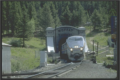
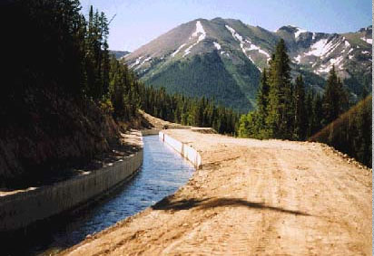
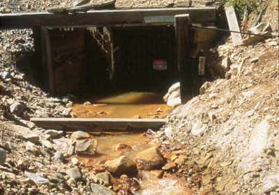
From the Sky-Hi Daily News (Hank Shell):
The Union Pacific Railroad announced on June 19 that it plans to construct a water treatment facility that will remove fine particulates and metals discharged in flows from the west portal.
As part of its discharge permit, Union Pacific must meet preset effluent limitations by April 30, 2017. The new treatment plant will help Union Pacific reach compliance with those limitations.
“It’s a victory,” said Mike Wageck, president of the East Grand Water Quality Board. “It’s definitely a victory for the river, if they’re going to be removing that coal dust that’s getting in there and removing those metals.”
The way the tunnel is bored, ground water flows from seepages inside the tunnel, picking up coal dust left by passing trains and heavy metals leached from the railroad ballast and exposed rock.
“This isn’t much different than a mineral mine,” said Kirk Klancke, East Grand Water Quality Board member. “If you just put a hole in the ground and have water leeching out, it’s going to carry the heavy metals you’ve exposed that have been buried for millennia.”
The way the Moffat Tunnel is pitched, water flows from both portals of the tunnel. To the east, water flows through a sedimentation pond before it’s discharged into South Boulder Creek. But to the west, water flows untreated into the Fraser. In 2013, average daily flows from the west portal were 171 gallons per minute, according to an implementation schedule sent from Union Pacific to the Colorado Department of Public Health and Environment.
The sediment in this discharge increases turbidity, or cloudiness, in the Fraser River…
Slag, a by-product of metal processing found in railroad ballast, leeches copper, lead, mercury and arsenic, among other elements, into the discharge and ultimately the river, according to the implementation schedule.
“Basically, from 2007 to today, we’ve been reviewing various ways we could treat the water coming out, primarily the water when it comes out of the tunnel,” said Mark Davis, a spokesman for Union Pacific.
Union Pacific examined a number of options for reaching compliance with effluent levels in the discharge, including diverting the water to publicly-owned treatment works in Winter Park, though the town ultimately decided that it would not benefit from receiving the water, pretreated or not…
Davis said he wasn’t sure when construction on the facility would begin or how much it would cost, though the state requires that Union Pacific have something in place by its compliance date of April 30, 2017.
More Fraser River watershed coverage here.
Tim Barnett of @Scripps_Ocean predicts #LakeMead may be out of water by 2036
http://t.co/bXOoVWFlb4 by @nickallen789 pic.twitter.com/hcaw2IChfI
— Nuestro Rio (@NuestroRio) July 2, 2014
More Colorado River Basin coverage here.
Click here to read the current assessment. Click here to to to the NIDIS website hosted by the Colorado Climate Center.

From email from Reclamation (Kara Lamb):
Warmer weather is bringing down that high elevation snow pack. [June 30], Denver Water upped releases from Dillon Reservoir. [July 1], we are increasing releases from Green Mountain to the Lower Blue in two changes of 100 cfs each. At 9:00 this morning, releases will go up to 1200 cfs. At 10:00 a.m., releases will go up to 1300 cfs.
From The Pueblo Chieftain (Chris Woodka):
Despite only two days with temperatures over the century mark, June was hotter and drier than usual. Monday’s high temperature of 103 tied the record for the last day of June, following a 100-degree reading on Sunday. Yet water use is down in Pueblo and the surrounding area.
“We’re unusually low,” said David Simpson, manager of the St. Charles Mesa Water District. “We really haven’t peaked at all.”
The district east of Pueblo usually sees use of 5.5 million gallons per day during hot spells, but so far has not gone above 4.5 mgd.
The Pueblo Board of Water Works is about 12 percent behind last year in pumping for the month of June, said Seth Clayton, director of administrative services.
“The city is using less in the parks,” Clayton said.
The city’s water use has averaged about 39 mgd, compared with 44 mgd last year in June. Peak use came June 20, at 46 mgd, while a year ago, the peak hit nearly 50 mgd.
“I think it’s been a little more humid, if you can ever say it’s humid in Pueblo,” Clayton said. “I think the afternoon cloud cover has helped things.”
Pueblo West has seen about 93 percent of 2013 water use so far this year. June watering was down 10 percent from 2013 and 13 percent from 2012, said Jack Johnston, metro district manager.
“We’ve hit a peak of 9 million gallons per day so far, and expect to hit 10 million in the next few days,” Johnston said. Consumers in all three areas are tending to use less water since the severe drought of 2001-03.
“We have never come back to the usage we saw prior to 2002,” Simpson said. “People have started using water more wisely.”
In Pueblo, the trend has been the same, with reduced water use in similar weather conditions for the past 12 years. One problem with selling less water is that it hurts revenues for water providers. Outdoor water use accounts for about half of all water sales.
“A lot of ours is reduced consumption by the city of Pueblo, which is not paid for anyway,” Clayton said. “On the revenue side, we’ll make up for it in other areas.”

From The Pueblo Chieftain (Chris Woodka):
The ideal state water plan: Don’t destroy the farms; keep the faucets flowing; be prepared for emergencies; leave some water in the river for fish; and teach future generations why water is so important. At least according to the crowd of 60 people who showed up Tuesday at Pueblo Community College for the final public outreach meeting of the Arkansas Valley Roundtable.
The most poignant moment of the evening came when farmer Doug Wiley spoke, quite eloquently, about the importance of agriculture to the Arkansas River basin: “My family has been putting water to good use near Avondale for 100 years, but I feel like I have a bull’s-eye on my back. . . . We call it a water plan, but it’s broader than that. It’s a free-for-all, but there’s not much farmland. We have to preserve it. . . . I think we should be talking about how we fallow parts of the cities in a drought.”
It was the one comment that drew applause from a group that grazed freely on a verdant field of topics.
A state water plan is being written by the Colorado Water Conservation Board on the order of Gov. John Hickenlooper. It’s due by the end of the year. The Arkansas Basin plank of that document is due by the end of this month. The primary purpose is dealing with a shortfall of water, which for the Arkansas Valley means supplying enough water each year by the year 2030 to serve a city the size of Pueblo. Most of that need will be in El Paso County. But filling that need means working with other needs.
Pueblo Chieftain Assistant Publisher Jane Rawlings and Pueblo City Councilwoman Eva Montoya talked about the need to control flooding on Fountain Creek caused by that growth.
Ben Wurster of the local Trout Unlimited chapter said water providers need to provide more water and operate Pueblo Dam more efficiently in order to preserve the Arkansas River fishery below the dam.
And perhaps most unexpectedly, Donna Stinchcomb, curator of the Buell Children’s Museum spoke on the need to reach out to the next generation in connection with an upcoming fall program on how artists view water: “We’re looking for children’s programs that connect them to water.”
Betty Konarski, the chairwoman of the roundtable, summed it up: “It’s a precious resource, the basis for life, and we have to make sure we will have enough.”
Meanwhile, here’s a report about the Colorado Water Plan from Marianne Goodland writing for The Fort Morgan Times. Here’s an excerpt:
The Colorado Water Plan draws upon a decade of work by the state’s eight basin roundtables, the Interbasin Compact Committee and the Colorado Water Conservation Board (CWCB). It also incorporates information from the 2010 Statewide Water Supply Initiative, which predicted the state will have a gap between water supply and demand of about 500,000 acre feet of water by 2050, with the largest gap projected for the South Platte River Basin.
During the past year, the basin roundtables and the CWCB have held dozens of town meetings on the water plan, seeking input from citizens and organizations interested in the state’s water future. Those meetings wrapped up in April, and then the basin roundtable members went to work to develop their basin implementation plans (BIPS), that will be submitted to the CWCB at the end of July. Those plans will be incorporated into the draft Colorado Water Plan, which is due to the Governor at the end of the year. The plan is to be finalized by December, 2015.
In addition to the basin implementation plans, the state water plan will include a “framework” document that outlines the issues to be addressed. The CWCB has already released eight draft chapters of this framework document this year, with four coming out in the last month. The most recent drafts covered water quality, conservation and re-use, and alternative agriculture to urban transfers. The drafts will be updated based on input from the BIPs.
The draft on agricultural transfers focused on alternative agricultural transfer methods (ATMS) and current efforts to develop more creative solutions to “buy and dry.” The draft noted several ATMs are already in place and more are on the way. These include deficit irrigation, water co-ops, water banks, water conservation easements; and flexible water markets, which was proposed in the 2014 legislative session but failed to clear the Senate. Another ATM, farrowing-leasing, which would allow for farrowing of irrigated farmland with temporary leasing of water to municipalities, is being studied under legislation passed in 2013.
More than 1,000 emails and documents have come in to the CWCB, addressing the draft chapters. Almost half of the responses came from stakeholders in the South Platte River and Metro Denver districts.
Most of the comments received by the CWCB have come either through emails to cowaterplan@state.co.us or through a webform on the water plan website, coloradowaterplan.com. CWCB staff responded to all of the comments, even those that might not be financially or technically feasible. One such comment said the state should cover its reservoirs with a thin membrane “similar to bubble wrap” to slow evaporation. Another suggested that the state halt all housing development along the Front Range.
A handful of comments addressed agricultural use, including responses that encourage more efficient irrigation systems and pointing out that agriculture is far and away the biggest user of water. But one commenter suggested a new form of “buy and dry.” Kristen Martinez of Metropolitan State University of Denver said the city of Denver could pay for businesses and residents to xeriscape their lawns, similar to a plan implemented by the city of Las Vegas. She also recommended the city of Denver invest in more efficient irrigation systems for farmers, as a trade-off for buying up agricultural water rights.
“…agriculture stands as the biggest water user, but farmers should not be the only ones to feel the pain of supply and demand,” Martinez wrote. “Most Denverites don’t give heed to the serious task of stewarding their water — not as a farmer must. Why aren’t local industries or municipal users being asked to sacrifice their lifestyle or adjust their operations?…can Colorado’s water plan please ask urban users to take ownership of their consumption, in addition to solving it by diverting farm water?”
Sean Cronin, director of the St. Vrain & Left Hand Water Conservancy District, chairs the South Platte River Basin roundtable, and pointed out that the South Platte and Metro Denver basin are collaborating on a joint BIP.
Cronin noted that although they are submitting a joint BIP, the two districts are quite diverse and one size will not fit all. “Water is very local!” he said recently. Feedback in the town meetings has been very different throughout the two districts. In Sterling, for example, he said the focus was on agriculture. In Longmont, people spoke about groundwater because of the well issues in the area. Denver’s focus was more on municipal conservation and recreational/environmental concerns.
So how will the two roundtables come up with one BIP, given the divergent views? Cronin said that they knew going into the process it would be difficult to address all of the different interests and cultures surrounding water. “It’s incredibly challenging to par it down to one solution that will make everyone happy,” he said. Cronin believes the draft BIP will instead reflect the diverse interests of the basin districts.
From KKTV (Gina Esposito):
Residents talked about flooding conditions around Fountain Creek and ways to store water during the hot and dry months. This includes ways to improve forest health and conditions after a wildfire. They also talked about they can improve the quality of delivering water to small towns.
“If we’re going to remain a vital community and economic secure, we are going to have to look how water impacts our water, our food,” the chair of the Arkansas Basin Roundtable, Betty Konarski, said.
Their input, as well as the input from similar meetings across the state, will help craft a state water plan that Governor Hickenlooper requested to improve water conditions. The governor issued an executive order last year to develop a statewide water plan. Each water basin in the state is in charge of creating a Basin Implementation Plan (BIP).
More Colorado Water Plan coverage here.

From the Glenwood Springs Post Independent (Will Grandbois):
Many talking points touched on the need for the rural mountain West to have a seat at the table, particularly on issues relating to public lands and the economy. Major talking points included regulations on gas and coal development, water usage and diversion, and the need to attract business on this side of the Continental Divide.
The scale of the conversation ranged from the hyper-local to the global. When the discussion touched on oil and gas development in the Thompson Divide, Hickenlooper, who has a geology background, expressed doubt about the area’s production potential, but acknowledged he wasn’t an expert.
When it came to global climate change, he was more vehement.
“Climate change is serious. Colorado has a lot at risk,” Hickenlooper asserted. “Half our water storage is in snowpack, and we don’t have clear places for reservoirs if we have to make up for that.”
The issue of water is a fraught one, with growing resentment for ongoing diversion of Western Slope water to the more populated Front Range. Hickenlooper was sympathetic, but challenged the idea that litigation is the best means of combatting further diversion.
“If you want to change a culture, you can’t just sit there and throw stones at each other,” he said. “Every discussion, whether it’s on the West Slope or the Front Range, needs to start at conservation.”[…]
In the end, nothing was decided at the meeting. The governor has little direct authority to implement programs that pull from the state coffers. Still, the assembled roundtable seemed gratified at the dialogue.
Rep. Coram even ventured a lighthearted comment before they adjourned.
“Empty your bladder before you go,” he quipped. “No water leaves the Western Slope.”
From KREX (Travis Khachatoorian):
Governor Hickenlooper was receptive to finding solutions to the problems. He said he’s been working to combat federal control of lands, is a proponent of exploring energy development in the potential Bookcliff Coal Mine north of Fruita and will continue urging various water basins throughout the state to come together and hash out a sensible water plan.
“I think we’re all seeing that people of goodwill can sit down and listen to the other side and say ‘all right, let me think about how we can get you what you need’,” Hickenlooper said about a Colorado water plan.
From the Vail Daily (Randy Wyrick):
Wendy Ryan stood in front of a room packed with water professionals and offered this historical perspective. In the last 1,400 years, the last 14 years were not the driest. But it’s as dry as it has ever been. Ryan is with the Colorado Climate Center at Colorado State University. She and her peers were curious about drought and wanted data, not anecdotes.
So Ryan and the Climate Center crew collected data from the years 762 through 2005, poring over records and studying tree rings, to calculate precipitation during those vast expanses of time before computers measured this sort of thing. They found that we’ve had 14 similar dry stretches during that millennia and a half. But this 14-year stretch is as dry as any of them.
“It was among the driest,” Ryan said.
Temperatures have been above average since the 1980s, Ryan said.
“The last 14 years have been a drought,” said John McClow, General Counsel of the Upper Gunnison River Water Conservancy District and one of the West’s foremost water experts…
The rivers flowing into Lake Powell are running 105 percent of normal, Ryan said, so it’ll fill a little bit. It’ll need to, [John McClow] said. Lake Powell is 45 percent full right now, McClow said. This year, for the first time in several years, it should receive more water than it releases — if it keeps raining. The years 2012-13 were the two driest years since they started keeping records 140 years ago, McClow said. Two more consecutive years like that would leave Lake Powell so low it would be unable to generate electrical power.
“People in seven states would see their power cut. They’d be forced to pay double to quadruple for power for at least eight years,” McClow said.
If that happens, it would take 12 years for Lake Powell to refill, assuming those are normal water years…
Snowpack is a fickle thing. In the Colorado River basin — that’s Eagle County and the Central Rockies resort region — it was 19 percent of normal in the drought year of 2012, and 83 percent last year. It was 121 percent this year.
On the other hand, the last four years were slightly wetter than normal, based on the average of the last 30 years, Ryan said. But it also depends on where you’re measuring. The Colorado River Basin was hammered with 223 percent of the median snowpack and 180 percent of last year’s. At the other end of the state, the drought continues. The Rio Grande basin saw just 39 percent of the median snowpack.
More Colorado River Basin coverage here.

From email from the Colorado Water Congress (Fiona Smith):
The Colorado Supreme Court published an opinion today declaring that Initiative 103 (Public Trust Resources) may not proceed towards the 2014 Ballot. A 4-3 majority holds that the Title Board lacked authority to proceed with a substituted designated representative when one of the proponents could not attend the rehearing. This decision validates a May 1 appeal by the Colorado Water Congress (CWC) and Coloradoans for Responsible Reform.
Initiative 103, by Phil Doe and Barbara Mills-Bria, proposed to establish an “inalienable right” of the people of Colorado to clean air, clean water (including groundwater), and the preservation of the environment and natural resources (called “Public Trust Resources”), as common property of all people, including future generations. It would require the state, as trustee of Public Trust Resources, to conserve and maintain them for the benefit of all the people. CWC and over 70 supporting entities from around the state opposed this Initiative on the grounds that it was unwise, unnecessary, expensive and disruptive to the responsible allocation and stewardship of Colorado’s water resources.
CWC will now shift its energy towards Initiatives 75 and 89, both of which are of concern to Colorado’s water community. A 5-2 Supreme Court majority decided today that Initiative 89 may proceed towards the 2014 Ballot. The Court similarly confirmed Initiative 75 last month. Each will require 86,105 valid signatures to be placed on the ballot in November.
Initiative 75 would strengthen “local control,” allowing local governments to adopt environmental regulations that override state laws, including the laws that limit and balance local governments’ regulation of water facilities. Initiative 89 would combine this local control theme with a Public Trust Doctrine, declaring “common property” in Colorado’s water and environment and obligating state and local government to conserve these resources as trustees. In his dissenting opinion today, Justice Gregory Hobbs cautioned that “Initiative #89 proposes to create an entirely unprecedented form of public trust duty requiring state and local governments to ‘conserve’ what are predominately privately held resources… [It] would upend the existing regulatory balance and thrust private property owners and governments into an uncertain future.”
The Colorado Water Stewardship Project, a special project of CWC, will continue to monitor Initiatives 75 and 89 and inform water stakeholders of the serious implications of amending the constitution to create a Public Trust Doctrine in Colorado.
From the Denver Business Journal (Cathy Proctor):
The so-called “public trust doctrine” measure, No. 103, had drawn opposition from the Colorado Water Congress, representing water users across the state, and the business-backed group Coloradans for Responsible Reform.
The high court ruled Monday that the Title Board, which reviews ballot proposals, made a mistake when it allowed the backers of No. 103 to have a substitute fill in during a hearing on the measure.
The court said that state law “does not allow designated representatives who are unable to attend a Title Board meeting to substitute alternates to serve in their place. Instead, the Title Board must delay its considerations until the next meeting at which both of the designated representatives who were so designated at the initial stages of the initiative process are able to attend the Title Board meeting.”
The ruling means that the proposal can’t be considered for the 2014 ballot because the Title Board is no longer meeting for the 2014 election cycle, said a spokesman for the Colorado Secretary of State’s office.
The backers of the proposal were Phil Doe and Barbara Mills-Bria. But Mills-Bria couldn’t attend a meeting of the Title Board because she as traveling to an out-of-state funeral, according to the court ruling.
The court said the Title Board should have postponed its hearing on No. 103 until Mills-Bria could attend rather than allowing a designee to fill in.
The proposal sought to establish a common property right to “clean air, clean water, including ground and surface water, and the preservation of the environment and natural resources.” It also would have required the state to conserve and maintain those elements for the benefit of all people.
The Colorado Water Congress said it opposed the initiative on the grounds that it was “unwise, unnecessary, expensive and disruptive to the responsible allocation and stewardship of Colorado’s water resources.”
The Colorado Water Congress said it would shift its resources to oppose Initiatives No. 75 and 89.
No. 75 is a proposal by the Colorado Community Rights Network that would allow cities to ban any for-profit business that community leaders don’t want to see in their towns.
No. 89, which says that Coloradans have a right to clean air, water and scenic values, is one of nine proposals that are backed by U.S. Rep. Jared Polis, D-Boulder.
The Colorado Supreme Court has rejected challenges to proposals No. 75 and No. 89, meaning supporters have until Aug. 4 to collect more than 86,105 valid signatures in order to have the initiatives placed on the fall ballot.
More 2014 Colorado November election coverage here.

From The Pueblo Chieftain (Chris Woodka):
With Southern Delivery System nearing completion, Colorado Springs is going to work on a plan to provide water for the next 50 years.
“There is a lot of uncertainty in the West when it comes to water,” Leon Basdekas, project manager for Colorado Springs Utilities integrated water planning, told the Fountain Creek Watershed Flood Control and Greenway District board Friday.
Utilities’ last water plan was in 1996 and focused almost entirely on supply. It provided options about how to develop water rights that Colorado Springs obtained in the Arkansas Valley during the 1980s. Among the options were direct reuse, reservoirs and pipelines. The water plan eventually led to SDS, a $940 million pipeline from Pueblo Dam to Colorado Springs that will be completed by 2016. Those types of options still will be considered.
“Everything is on the table,” Basdekas said.
But the new plan also will look at demand, water quality, infrastructure, energy, regulation, legal issues and public opinion, he added. The goal is to develop a sustainable future supply that also respects social values, Basdekas said.
Among the biggest challenge is managing risk during climate change. Severe drought in 2012-13 was only one indication of how future water supplies could be affected.
At the same time, Colorado Springs is looking for as much public input as possible as it begins looking at the next 50 years.
“We need public involvement, so we just don’t go into a dark room and come out with a plan,” he said.
More Arkansas River Basin coverage <a href="