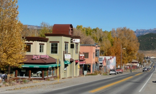
From the Telluride Daily Planet (Stephen Elliott):
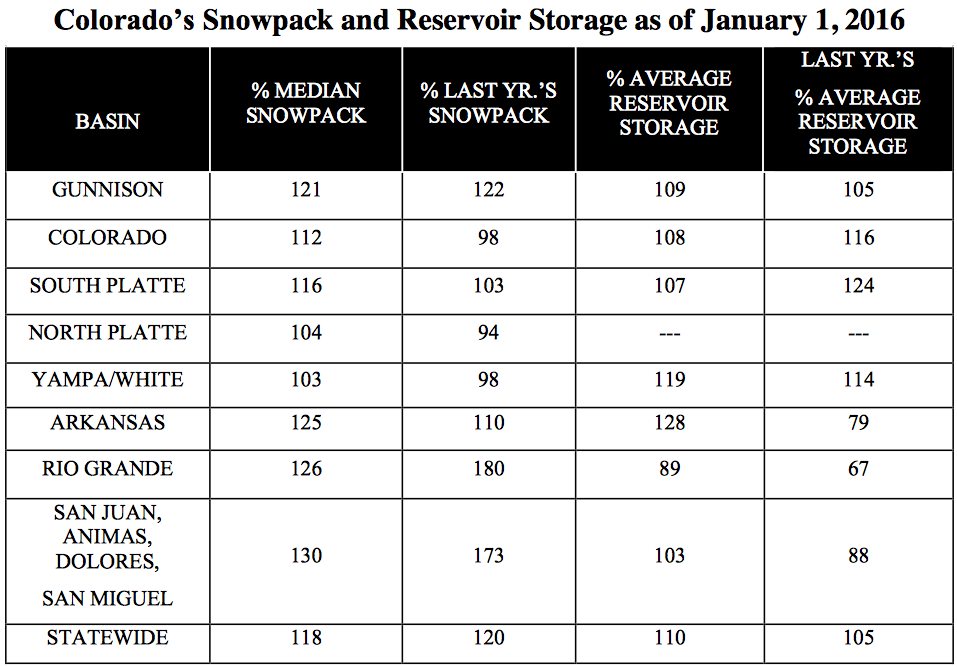
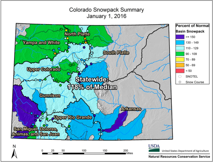
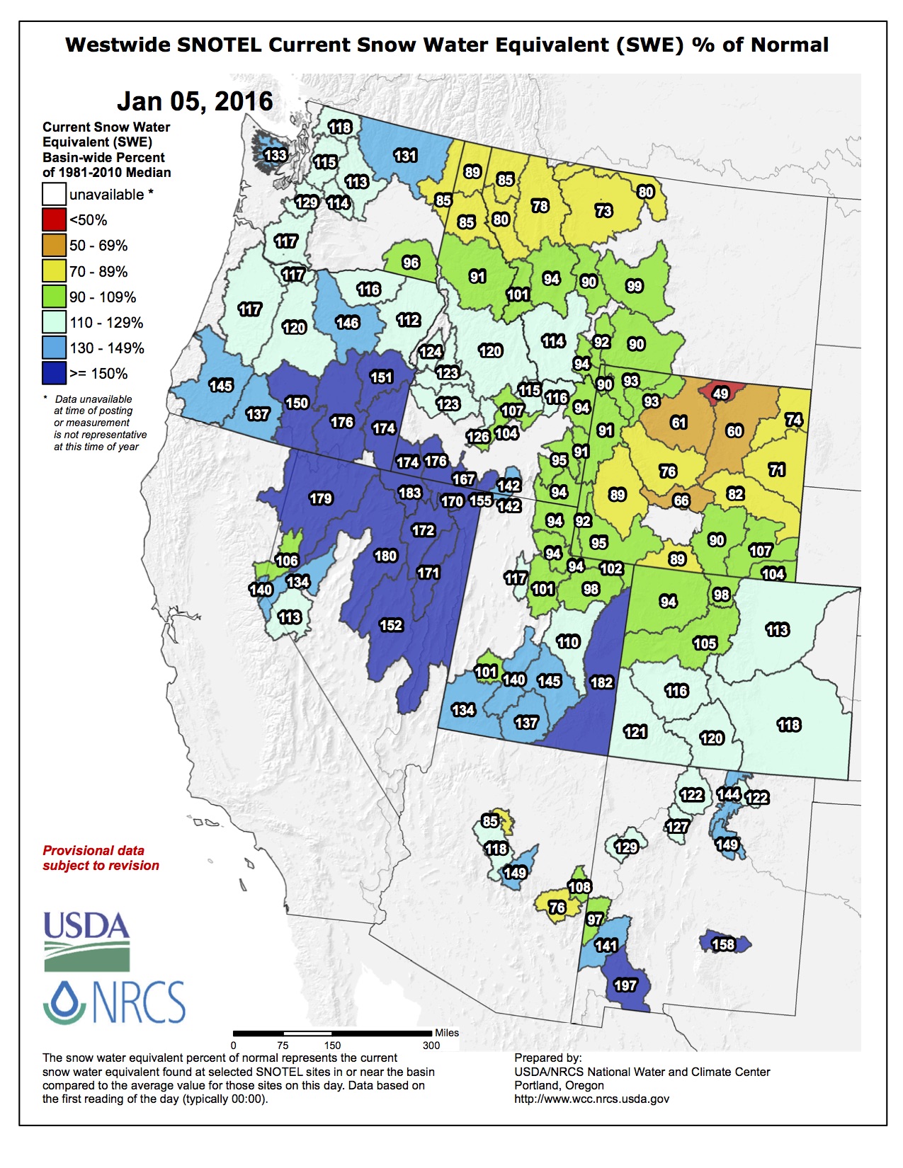
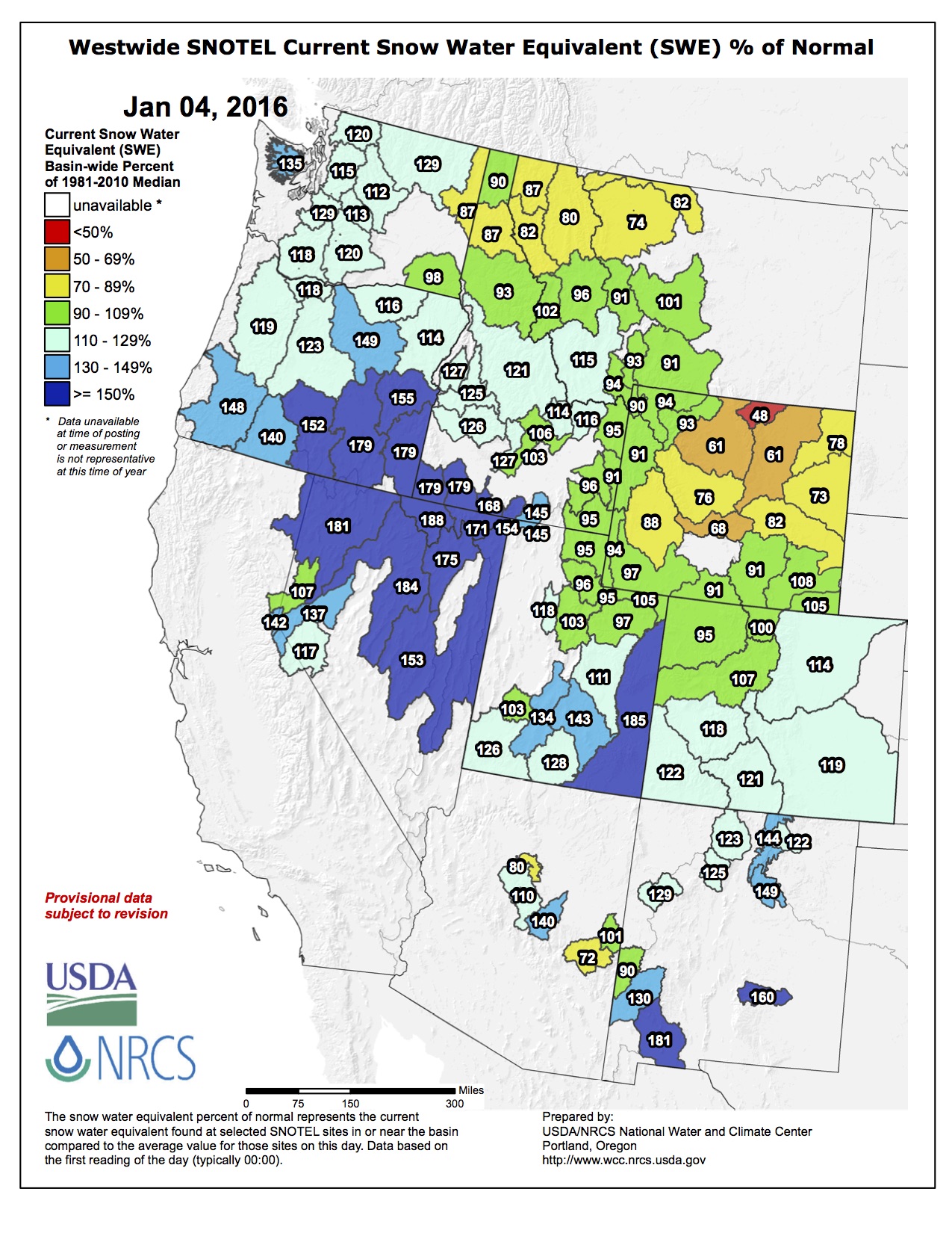
The first Colorado water supply outlook report of the year brought good news for the state and particularly the San Miguel Watershed. The report, released Jan. 1 by the U.S. Department of Agriculture’s Natural Resources Conservation Service, found that the statewide snowpack is at 118 percent of normal, the most plentiful start to a winter water season since 2011.
After several dry years, heavy precipitation early this winter and fall replenished reservoirs around the state, allowing water managers to take a cautiously optimistic look at what the summer might bring.
“To be at this point at the beginning of the year is usually a good thing,” said Brian Domonkos, snow survey supervisor for the U.S. Department of Agriculture’s Colorado program. “What we can really hope for is a prolonged spring where temperatures stay pretty cool. Hopefully it stays cool well into the summer and that runoff will run off nice and even and it’ll be a nice water supply headed into the summer.”
But weather is never a sure bet, and Domonkos said it was still early to predict a healthy water season.
“We’ve only reached about the halfway point when it comes to our snowpack accumulation season. There’s a lot that can change,” he said. “It’s not the easiest for the weather in the mountains to maintain (those high levels of precipitation), but it’s certainly possible, and it could be higher.”
All major river basins in the state have above-normal snowpacks, according to the report, but the San Miguel, Dolores, Animas and San Juan basins are collectively the highest above normal, at 130 percent. In the combined southwestern Colorado basin, which includes Telluride, December storms dropped a whopping 174 percent of the average precipitation for the month.
The Telluride Ski Resort has already reported 161 inches of snow for the season.
Reservoir storage in the combined basin is at 103 percent of average, compared to 88 percent at this time last year.
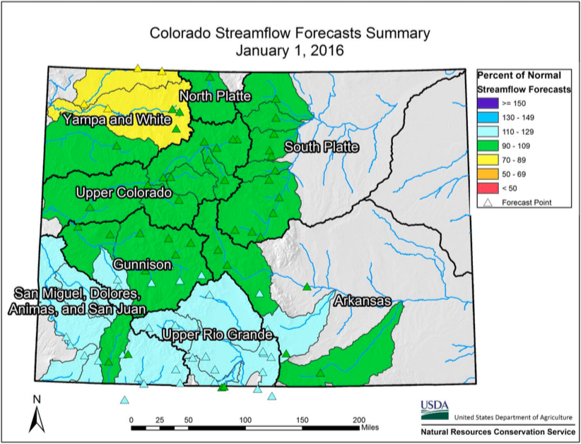
The Colorado Snow Survey’s snowpack and streamflow forecasts put the San Miguel at 161 percent of normal snowpack, the highest in the combined basin. The other river basins range from the La Plata River, at 108 percent of normal snowpack, to the Dolores River, at 157 percent of normal snowpack.
Domonkos added that the San Miguel has about twice as much water in its snowpack as at this point last year; a positive improvement, but also nowhere near record levels.
“This is way better than where we were last year, but we are a good long ways from where the maximum is,” he said.
That snow is so important because it holds the water that will keep the West green in the summer.
Statewide snowpack by basin January 1, 2016 via the NRCS
Statewide streamflow forecast January 1, 2016
Statewide snowpack map January 1, 2016 via the NRCS
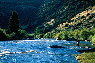
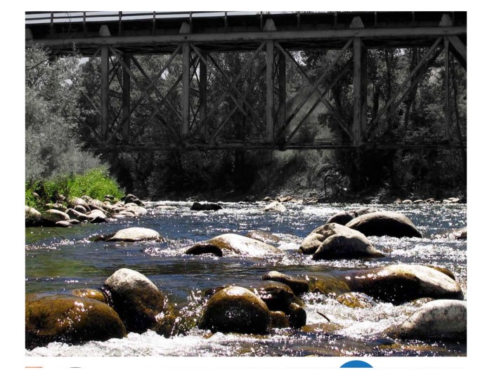
Roaring Fork River in early July 2012 via Aspen Journalism
FromAspen Journalism (Brent Gardner-Smith) via The Aspen Times:
The city of Aspen is seeking consultants to help it prepare a river management plan for the upper Roaring Fork River, which has been plagued in drought years by low flows as it winds through central Aspen.
“The city of Aspen plans to study the upper Roaring Fork River, from its headwaters to a point just below the confluence with Maroon Creek,” the city’s request for proposals, or RFP, says.
April Long, the city’s stormwater manager, said the development of a river management plan was one of the Aspen city council’s top ten goals in 2015. Long said she expects regional engineering firms specializing in water to put together teams of consultants and submit proposals to the city, which are due by Jan. 15.
“Since 2008, the city has focused on improving the quality of water discharged through its outfalls. The city now feels it is important to focus its attention on one of the other probable causes for impairment – inadequate flows during periods of drought,” the RFP says.
The city’s RFP also says it expects proposed consulting teams “to include members with experience and expertise in water resources engineering, river science, hydrology, water quality, stream geomorphology, Colorado water rights and water law, and group facilitation.”
Long said the city’s river management plan will be similar to the ‘”stream management plans” that are called for in the recently released Colorado Water Plan, and that ongoing work being done by the Colorado Water Trust for Pitkin County on ways to add more water to the river will be looked at when formulating the city’s river plan.
“Our ultimate goal for the project is to develop a plan that outlines operational, management, and physical options that improve the health of the river while respecting each stakeholder’s rights and interests,” the city’s RFP says.
The Roaring Fork River flows into the city’s boundaries at Stillwater Drive east of downtown Aspen.
The stretch of the river between there and the confluence with Castle Creek has been known to drop below 32 cubic feet per second, which the Colorado Water Conservation Board considers the minimum amount of water necessary to protect the river’s environment “to a reasonable degree.”
“In the early 2000s several studies investigated the health of the Roaring Fork River and reported a severely degraded or impaired stretch of river within the city,” the RFP says. “The instream flow determined for this stretch in the 1970s is 32 cubic feet per second. During the droughts of 2002 and 2012, the river in this stretch dropped to only 5 cfs – only 15 percent of the instream flow.”
One big factor in the amount of water in the Roaring Fork River through Aspen is the Salvation Ditch, an irrigation ditch that diverts water from the river at Stillwater Drive.
The ditch has a senior 1902 water right that allows up to 58 cfs of water to be diverted and sent across lower Red Mountain to Woody Creek.
During the drought of 2012 there were days when there was more water flowing down the Salvation Ditch than was flowing down the Roaring Fork as it winds through town.
For example, according to a study done by S.K. Mason Environmental LLC, on July 27, 2012 there was 17.4 cfs flowing in the Salvation Ditch and 7.6 cfs of water flowing down the Fork below the ditch.
However, Tom Moore, the president of the Salvation Ditch Company, said the shareholders who own land along the ditch company also need the water in dry years, they have made significant investments in the water system, and they are concerned about weakening their water right by not diverting the water.
He also pointed out that the Salvation Ditch water right is senior to the 1930s era water rights held by the Twin Lakes Reservoir and Canal Co., which diverts water under Independence Pass. As such, the Salvation Ditch plays a role in keeping water in the Roaring Fork River, he said.
The city’s Long said talking with the Salvation Ditch Co. will be an important part of the river management plan, which is why the city is seeking proposals that include consultants with an expertise in working with various stakeholders.
The city’s RFP says “we hope that by determining valuable attributes of the river, we can work together as a community to lessen impairment and improve water quality, river health, ecological health, recreational opportunities, and riparian habitat in ways that closer meet the community’s goals.”
Editor’s note: Aspen Journalism is covering rivers and water in collaboration with the Glenwood Springs Post Independent and The Aspen Times. More at http://www.aspenjournalism.org.
A view of the Salvation Ditch diversion dam and head gate, just of off Stillwater Drive, east of Aspen. Smith / Aspen Journalism
Nevadans are highly concerned about the drought; 72 percent say it is extremely or very serious according to the new 2016 Conservation in the West poll by Colorado College.
Residents ranked drought higher in importance than voters from six other western states did. The poll found 68 percent of Nevadans support additional conservation measures over diversion of water from rivers in less populated areas. State Assemblyman Edgar Flores says much of the problem could be solved if people used water wisely.
“It’s a everybody coming to the table type of issue,” Flores says. “And not just looking at how are we going to find more water, but ‘What am I doing to making sure that the water we do have, we’re preserving it and utilizing it in the most efficient manner.'”
Nevada is the driest state in the nation, with the lowest annual rainfall. The state has received $1.8 million in federal funding to implement the “Water Smart” conservation program.
The poll also asked people about public land and found a majority in the Silver State oppose efforts to transfer federal land to state control.
Mauricia Baca is executive director with the Outside Las Vegas Foundation.
“Whenever people discover these recreational opportunities they become more and more deeply connected to Nevada as a state,” says Baca. “If it were to transfer to a different sort of control where perhaps it was more privatized, that access would be restricted.”
The poll also found that more than three quarters of Nevadans say conservation is important when choosing political candidates, and 72 percent support continuing investment in the Land and Water Conservation Fund.
This image was taken during the peak outflow from the Gold King Mine spill at 10:57 a.m. Aug. 5. The waste-rock dump can be seen eroding on the right. Federal investigators placed blame for the blowout squarely on engineering errors made by the Environmental Protection Agency’s-contracted company in a 132-page report released Thursday [October 22, 2015]
Colorado mountain residents blitzed EPA and state officials with questions about cleanup of inactive mines, deeply mistrustful after the EPA-triggered Gold King disaster yet largely leaning towards a superfund approach to stop contamination of Animas River headwaters.
Nearly 50 gathered for a first public meeting Wednesday night in Silverton after local elected leaders held closed talks exploring possible federal help.
“If we do go down this process. … what assurances do we have that we’ll have funding to go into the remedial phase?” San Juan County Commissioner Pete McKay asked, leading off questioning.
“Are we just going to have more and more meetings?… We want to see some action,” Commissioner Ernest Kuhlman asked.
Among life-long residents of the area, contractor John Richardson, 68, a fly fisherman, said he favors a broad multi-basin cleanup. “I wouldn’t mind seeing mining come back, but I want to see it all cleaned up,” he said outside the town hall.
In the talks, the Environmental Protection Agency and Colorado Department of Public Health and Environment officials and local elected leaders reached agreement on a goal of cleaning up Animas headwaters and that the town of Silverton would not be included in a possible disaster designation to launch a superfund cleanup – a key local demand.
But the EPA and locals disagree as to whether an EPA-run cleanup would include just upper Cement Creek — the local preference — or other basins where acidic, metals-laced drainage from inactive mines drains into the Animas River.
The scope of a National Priority List designation was a big part of the talks, said EPA’s Johanna Miller, regional director of superfund site assessment, in an interview.
“We’re all agreed the town of Silverton would not be included, because that is a soils issue, not a water issue,” Miller said. A broader cleanup, beyond Cement Creek to include the Eureka Basin area just east of Silverton, may be necessary, she said. “Limiting it to one basin might not achieve the water quality improvements.”
[…]
While EPA officials favor a broad National Priority List designation, Silverton and San Juan County officials have been raising local concerns such as the potential for truck damage to Silverton’s streets and housing for workers they say the EPA would need to provide. And residents widely are worried about timing. “Do you think the remedial process will happen in our lifetimes?” ski businessman Grady Ham asked in the meeting. Superfund cleanups typically run for decades, limited by congressional funding.
Silverton and San Juan County officials have pressed for a narrow environmental disaster designation, covering only the upper Cement Creek area where the Gold King, Red and Bonita, Mogul and Sunnyside and other inactive mines are located, about seven miles north of Silverton. Gov. John Hickenlooper would have to request any designation — by early February if EPA officials are to consider it for a listing this year.
EPA and CDPHE officials have said it’s too early to discuss details of any remedy because the EPA and CDPHE would have to conduct a remediation investigation and a feasibility study.
The EPA set up a temporary water treatment system near the Gold King and Red and Bonita mines to filter out and neutralize heavy metals in settling ponds.
Whether or not to seek an official environmental disaster designation is a question that vexes residents of Silverton (pop. 500), an icy mountain hamlet beneath dozens of old mines leaking acidic metals-laced waste into creeks, which also contain natural concentrations of minerals. And residents’ ambivalence was clear as they asked about whether property owners could be prosecuted and whether, since the EPA caused the Gold King Disaster, the agency would be charged with running a water treatment plant in perpetuity.
“It looks like we don’t have any other choice” but to seek a federal Superfund cleanup, said Vicky Skow at the Kendall Mountain Cafe. “We need the money to clean up, or people won’t come to town.”
[…]
Among those opposed to a Superfund cleanup is Todd Hennis, owner of the Gold King Mine and of land near the former town of Gladstone where the EPA has set up the temporary water treatment system.
…the climate phenomenon known as El Niño has turned its intensity up to 11 in recent weeks, directing a firehose of moisture at the Southwestern U.S., including drought-plagued California…
This week, forecasters at the Climate Prediction Center in Maryland announced the ongoing El Niño was just as strong as the 1997-98 event — which was the strongest such event on record since reliable data began in 1950. That’s based on sea surface temperature departures from average in a particular area of the tropical Pacific Ocean, known as the “Nino 3.4 region” (other indices using atmospheric measurements actually show this event to be slightly stronger than the 1997-98 event).
Yet this El Niño is not like the 1997-98 event, nor is it all that similar to the other huge El Niño of the past several decades, which occurred in 1982-83. For one thing, the atmosphere and ocean system are doing some strange things across the Pacific Ocean, compared to what one might expect during a “typical” El Niño event.
For example, the western equatorial tropical Pacific Ocean has much milder water than would typically be seen during such an event, and the east-to-west trade winds blowing across the world’s largest ocean have not completely relaxed or reversed, as they often do during a strong El Niño.
In other words, if you look up El Niño in a climatology textbook, you’d see marked differences between the classic maps illustrating a strong event, and this one.
“While certain measures and certain indices and variables we look at at certain times may look like 1997-98… I think every El Niño expert is looking at this and saying ‘whoa, what a unique animal we have here,'” said Michelle L’Heureux, a climate forecaster and El Niño specialist at the Climate Prediction Center.
But most of all, this El Niño is taking place against the backdrop of global warming, meaning it is occurring at a time when the oceans are hotter and the air is milder and laden with more moisture, on a global basis, than it has ever been before in human history.
During 2015, global ocean temperatures repeatedly set all-time high temperature records and then exceeded them the month later. Specifically, parts of every major ocean basin were record warm during much of 2015. In November, the most recent month for which such data is available, the global sea surface temperature was the highest on record for that month, surpassing the previous record set in 2014 by 0.36 degrees Fahrenheit, or 0.20 degrees Celsius.
The average global sea surface temperature for the year-to-date was the highest for January–November in the 136-year period of record, at 1.30 degrees Fahrenheit, or 0.72 degrees Celsius, above average, surpassing the previous record set last year by 0.16 degrees Fahrenheit, or 0.09 degrees Celsius. It’s likely that scientists will announce within the next week that 2015 featured the warmest oceans of any year on record. This is due in part to El Niño, but largely manmade global warming.
While El Niño can account for an unusually mild Pacific Ocean, for example, it cannot account for the fact that parts of every major ocean basin were record warm in August and for much of 2015. It also cannot account for the rapid accumulation of ocean heat well below the surface that has been taking place.
Daniel Swain, a climate scientist at Stanford University, told Mashable that the eastern Tropical Pacific Ocean is warmer right now at this time of year than it has ever been, and this has a big effect on the weather in the midlatitudes.
No El Niño event is the same, Swain said, but since the last supercharged-El Niño ended in 1998, there has been more than a decade of global warming. “This record event is evolving in a different climate context than any of the events that we’ve previously observed,” he said.
This doesn’t mean that we have no idea what this El Niño will bring. Case in point: The forecast for a wet mid-to-late winter in California, which appears to be panning out. But it does mean that, increasingly, we should expect the unexpected.
“El Niño is still El Niño, but it’s a different El Niño,” Swain said.
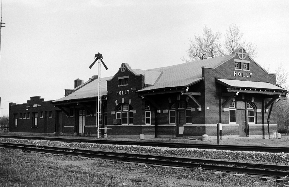
The Holly depot remained in operation for about seventy years, from 1912 until freight service ended in the early 1980s. The building now houses the town hall and library. Photo via Colorado Encyclopedia and Tom Noel
The state health department and the Environmental Protection Agency are requiring commercial and industrial water lines to be equipped with backflow devices which prevent the spread of contaminated water into a community’s drinking water system. The Holly Trustees were briefed on the development during their monthly January meeting by Mark Hartman, a water circuit rider, representing the Colorado Rural Water Association in Pueblo. The governing state ordinance 11.39(1), regarding the Backflow Prevention and Cross-Connection Control Rule, states that, “For all public water systems, the supplier must comply with the requirements specified in this rule beginning January 1, 2016.” The devices need to be installed at a reachable service line or a plumbing fixture and must be inspected annually to maintain their proper function. Holly Town Administrator, Jerry L’Estrange, presented the Trustees with a sample ordinance on the regulations last month for their review.
Hartman suggested the Trustees become pro-active in their efforts to achieve compliance before the state steps in and begins to levy fines and penalties for any delays. “The faster you work on this, the better off you will be in determining your own timeline for completion,” he stated, adding that the state health department isn’t showing a lot of leniency right now when it comes to issuing fines. “The state will come in and do an audit, a Sanitary Survey, to make sure your water system is in compliance with state regulations,” he explained. Usually, a community is given 120 days to make needed corrections to make sure that all public water systems are protected from backflow potential. He added, “The sooner you begin to make corrections after your receive results from your Sanitary Survey, it shows that you’re acting in earnest as opposed to delaying which could be interpreted that you’re acting in duress, and that could make a difference with the state.” Each customer, he said, would be responsible for having the device installed at their location.
L’Estrange said the Trustees need to agree on and approve an ordinance which will follow the rules and regulations for the backflow devices. Hartman said there are usually four steps which a community should follow to get set up: develop an ordinance, outline and plans and regulations, take a survey of all the commercial and industrial customers and provide a public education campaign so residents become aware of the needs for the system. He estimated the timeline to take about a year and a half for the project for Holly. He added that the town is not alone in this situation as all small communities throughout the state will be impacted.
For more than 50 years, the federal government has recommended adding fluoride to drinking water because it can prevent teeth demineralization.
The local effort to eliminate fluoride from drinking water has been lead by Jim Forleo, a chiropractor who said too much fluoride can have negative effects such as joint pain.
“They are giving us a drug without our consent,” he said.
However, the panel argued fluoridation helps strengthen teeth and lower the average number of cavities in adults and children.
“This is one of the most cost-effective prevention strategies you can develop,” said Dr. Larry Wolk, Colorado Department of Public Health and Environment’s executive director and chief medical officer.
Community water fluoridation is a primary attack against cavities, and it promotes healthy teeth development, especially among children in poorer communities who have limited access to dental care, he said.
While many factors including diet contribute to cavities, the recommended level of fluoride in drinking water helps lower acidity in the mouth.
“It’s constantly bathing the teeth to counteract that demineralization,” said James Sutherland.
In the meeting, fluoride opponents, countered that while a certain amount of fluoride may be safe, shouldn’t the weight and medical condition of the person help determine the appropriate dose.
“At what point do we know what the dosage is?”asked Jane Burnier.
In April, the U.S. Department of Health and Human Services recommended lowering the dosage of fluoride because so many people are exposed to it in toothpaste and mouthwash.
The Utilities Commission will talk about how to structure the decision-making process in February. It could make a recommendation as early as March, Chairman John Ballew said. But the commission is not on a set timetable.
Once a recommendation is made, Durango City Council will have the final say because fluoridation is not required by any government agency.
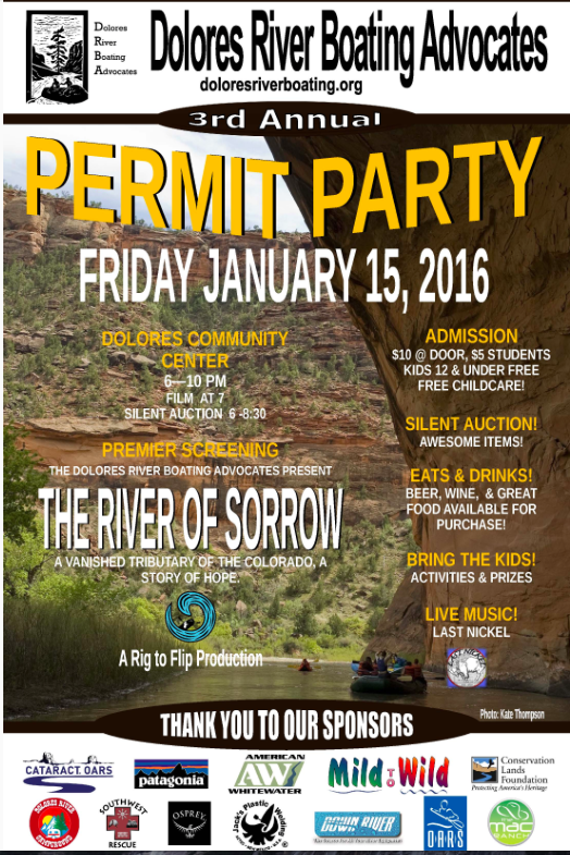
Join us Friday, January 15 for our 3rd Annual Permit Party and the film premiere of “River of Sorrow” by Rig to Flip. Doors open at 6PM and the film starts at 7. Live music by Last Nickel begins at 8. A silent auction with incredible gear and adventures (like a trip for 2 down the Yampa River!) will be held from 6 to 8:30. Tasty vittles from Absolute Bakery and beer from Dolores River Brewery will be available for purchase. Childcare and children’s activities will be provided so bring the whole family! Tickets are $10 at the door, $5 for students, and kids 12 and under are free! Don’t miss this incredible annual celebration of the Dolores River!
Flood-related issues were just part of a package of topics that Domenico and Commissioners Elise Jones and Deb Gardner covered in their “State of the County” review of what they identified as Boulder County’s accomplishments in 2015 — and what residents can expect from their county government in 2016.
They led off their annual report by noting that it may take another couple of years to complete flood recovery efforts and get more of Boulder County’s flood victims permanently resettled.
Last year, Boulder County spent about $11 million on flood-related road and bridge work. This year, repairs and replacements of county government’s transportation infrastructure are expected to cost another $41 million.
This year’s flood recovery projects on county parks and open space lands are to include work at Pella Ponds south of Hygiene and the Walden Ponds Wildlife Habitat southwest of North 75th Street and Jay Road, as well as continuing repairs to the Anne U. White Trail that runs through the Fourmile Creek Canyon.
Boulder County will be continue providing flood-survivor case management services to connect residents with available funding toward their still-unmet needs after the 2013 devastation. The commissioners said the county expects to be responsible for trying to close about 235 of those still-open cases.
The commissioners also highlighted numerous non-flood-related projects and services planned for the coming year. Among them:
The Parks and Open Space Department will continue working toward a goal of having at least 20 percent of the croplands it leases to private farmers be certified as organic, or in transition to organic, by the year 2020.
Pueblo County commissioners are close to closing one chapter of their 1041 permit for the Southern Delivery System, but some other parts remain an open book.
Commissioners Monday received staff’s findings on revegetation and land restoration efforts by Colorado Springs Utilities under the 1041 permit. They are expected to finalize that at a public hearing at 9 a.m. Jan. 25.
The findings would allow the release of about $674,000 in bonds held for the 17-mile route of buried SDS pipeline through Pueblo County. The issue has been touchy because of concerns about the sufficiency of ground cover and the legal challenge brought by Walker Ranches.
Walker Ranches settled differences with Utilities in a $7.1 million agreement that included an ongoing partnership between Utilities and landowner Gary Walker to take care of problems along that 7-mile leg.
The county’s experts concur with Colorado Springs that other efforts have been sufficient to restore the land to the same condition as surrounding areas, but commissioners want to be sure that Colorado Springs won’t just walk away if drought returns and the work along the pipeline route is damaged.
As a result, Utilities will annually inspect the easement and issue a report to the county.
Commissioners also want to hear public concerns.
“None of us wanted to approve the findings until they are posted for comment,” said Commissioner Sal Pace. The findings are available from County Planning Director Joan Armstrong or online at the county’s website.
Commission Chairwoman Liane “Buffie” McFadyen said the report filed by county land-use attorney Gary Raso captured the board’s intentions, while creating a manageable path for Utilities.
Commissioner Terry Hart wanted to be sure the Jan. 25 hearing could include more public testimony if it is warranted.
Raso said the county settlement does not preclude private landowners who are not satisfied from taking action on their own.
The revegetation issues are covered under just two of the 30 terms and conditions of the 1041 permit. Some of those have been satisfied under previous agreements, but two big pieces of the puzzle remain unsolved:
The timing of $50 million in payments to the Fountain Creek Watershed Flood Control and Greenway District. The district has taken the position that the payment is due now, but Utilities maintains it would not start until after water has been delivered to customers.
The sufficiency of stormwater control. The Environmental Protection Agency last month announced possible legal action against Colorado Springs for violation of its stormwater permit.
Colorado Springs Mayor John Suthers is scheduled to meet with commissioners at 1:30 p.m. Jan. 25, primarily on the stormwater issue. The Fountain Creek board likely will discuss the payment issue at its Jan. 22 meeting.
Utilities plans for the 50-mile SDS pipeline from Pueblo Dam to Colorado Springs to be online by April, Project Director John Fredell said Monday.
Pueblo County wants to hear your opinion on whether Colorado Springs Utilities is doing its job to restore land after building the Southern Delivery System…
It says Springs Utilities has held up its end of the bargain…
Commissioners will make a decision Jan. 25 on whether the group has done enough to restore the land, but they need your help to decide that.
“We want to take input from those who have been impacted or anyone else that has an opinion about whether or not revegetation and restoration has been met,” County Commissioner Liane “Buffie” McFadyen said.
You can share your thoughts with the county by calling 583-6105 or you can go to to Pueblo County Commissioner’s meeting on Jan. 25 at 9 a.m.
The Yampa River flows through the Carpenter Ranch. Photo courtesy of John Fielder from his new book, “Colorado’s Yampa River: Free Flowing & Wild from the Flat Tops to the Green.” — via The Mountain Town News
FromThe Colorado Springs Gazette (Ryan Maye Handy):
For many westerners, concerns over the future of water are as important as the economy and unemployment, according to results from Colorado College’s 2016 Conservation in the West poll.
The sixth annual State of the Rockies Project poll of thousands of residents in seven western states shows many people fear for the future of water in the West. The sentiment might come from a change in national economics and a rash of news about drought, said Eric Perramond, the director of CC’s State of the Rockies.
“I would say that the concerns for water use now equal and just barely exceed concern about unemployment. And that’s not unexpected given the economic recovery,” Perramond said. “(And) like most Americans, we tend to pay more attention when something is in our face.”
Conducted through phone calls to 2,800 people, the poll also gauged public opinion on federal public lands, another hot topic in the West where a Sagebrush-style rebellion in Oregon broke out in protest of federal ownership. The poll indicated public opinion seems to favor certain public lands remaining under federal oversight.
The State of the Rockies poll tends to cut through the political rhetoric, said Brendan Boepple, the project’s assistant director. When it comes to public lands and resources, people seem to be more willing to cooperate than political agendas would lead them to believe, he said.
“I think our polling shows that a lot of people want to come together on these issues,” Boepple said.
More than 80 percent – and in some cases 90 percent – of those polled in southwest states rated low river level as having high importance.
While concerns from Colorado residents weren’t as high as those of New Mexicans, Colorado recently completed its first statewide water plan, an answer to concerns that Colorado is unprepared to meet a future with more people and less water. Coloradans are also more willing to reduce water consumption than residents of other states, the poll found.
The Colorado water plan, released in December, offered many solutions to state water shortages – among them building more storage, taking water from agriculture and conservation. But if anything, the poll suggests that the days of public support for dams are over. Those polled staunchly favored conservation as the best way to handle shortage, and were opposed to diversions and reservoirs.
“That should be encouraging, at least to state water planners,” Perramond said. “In some ways it echoes what we have seen in the past 30 to 40 years. Any new facilities are hugely controversial and really difficult to get any support for.”
This year the poll expanded its scope. It added Nevada and new questions, including those about federal ownership of public lands. Republican pollster Lori Weigel of Public Opinion Strategies and Democratic pollster Dave Metz of Fairbank, Maslin, Maullin, Metz & Associates conducted the poll. The poll typically costs $150,000 to $200,000 to conduct, Boepple said.
The years of poll data will provide fodder for undergraduate researchers at CC, Perramond said.
“It’s a great set of data for anybody out there who wants to actually understand how westerners think about public lands and natural resources,” he said.
A Colorado College poll released Monday indicates a majority of Westerners don’t support the mission championed by the Oregon militia led by Ammon Bundy, said Ken Salazar, the former U.S. senator for Colorado who served four years as President Obama’s interior secretary.
The State of the Rockies Project’s Conservation in the West Poll of voters in seven Mountain West states indicated 58 percent oppose turning over lands currently under federal control to state governments, and 60 percent oppose selling pieces of public lands to reduce the federal budget deficit.
In the Bundy family’s home state of Nevada, only 30 percent of respondents said they supported the family’s mission to have the federal government cede authority to states. Ammon Bundy is leading the Oregon protesters who are occupying government buildings at a remote wildlife reserve. His father, Cliven Bundy, led a standoff in Nevada with federal agents over the Bundys unpaid grazing fees with federal authorities in April 2014.
“This research couldn’t come at a more important time, when the nation’s eyes are focused on the West,” Salazar said Monday of the new poll and the Bundy-led protest.
Colorado is among the states where some Republicans have explored the idea of state and local governments taking control of federal lands. An unsuccessful bill in last legislative session would have set up a Colorado committee of local officials to study the possibility.
“This shows us the Bundy family and the politicians who side with them are out of step with Westerners’ views,” Salazar said in a conference call with reporters about the Colorado College poll.
Just 33 percent of registered voters in seven states favored states taking over management of federal lands, compared with 58 percent opposed. The split was 31 percent in favor and 59 percent opposed in Montana. Arizona, Colorado, Nevada, New Mexico and Wyoming respondents all preferred retaining federal management of public lands by at least 52 percent. Utah voters split with 41 percent in favor of state control and 47 percent opposed.
“The bottom line is that Montanans are adamantly opposed to any efforts to weaken our public lands,” Business for Montana’s Outdoors director Marne Hayes said of the results. “Our public land and water in Montana, and our access to them, is a powerful economic advantage. We are proud of the results of this poll, which suggest that any plan to transfer control of our public lands or sell them off is a non-starter.”
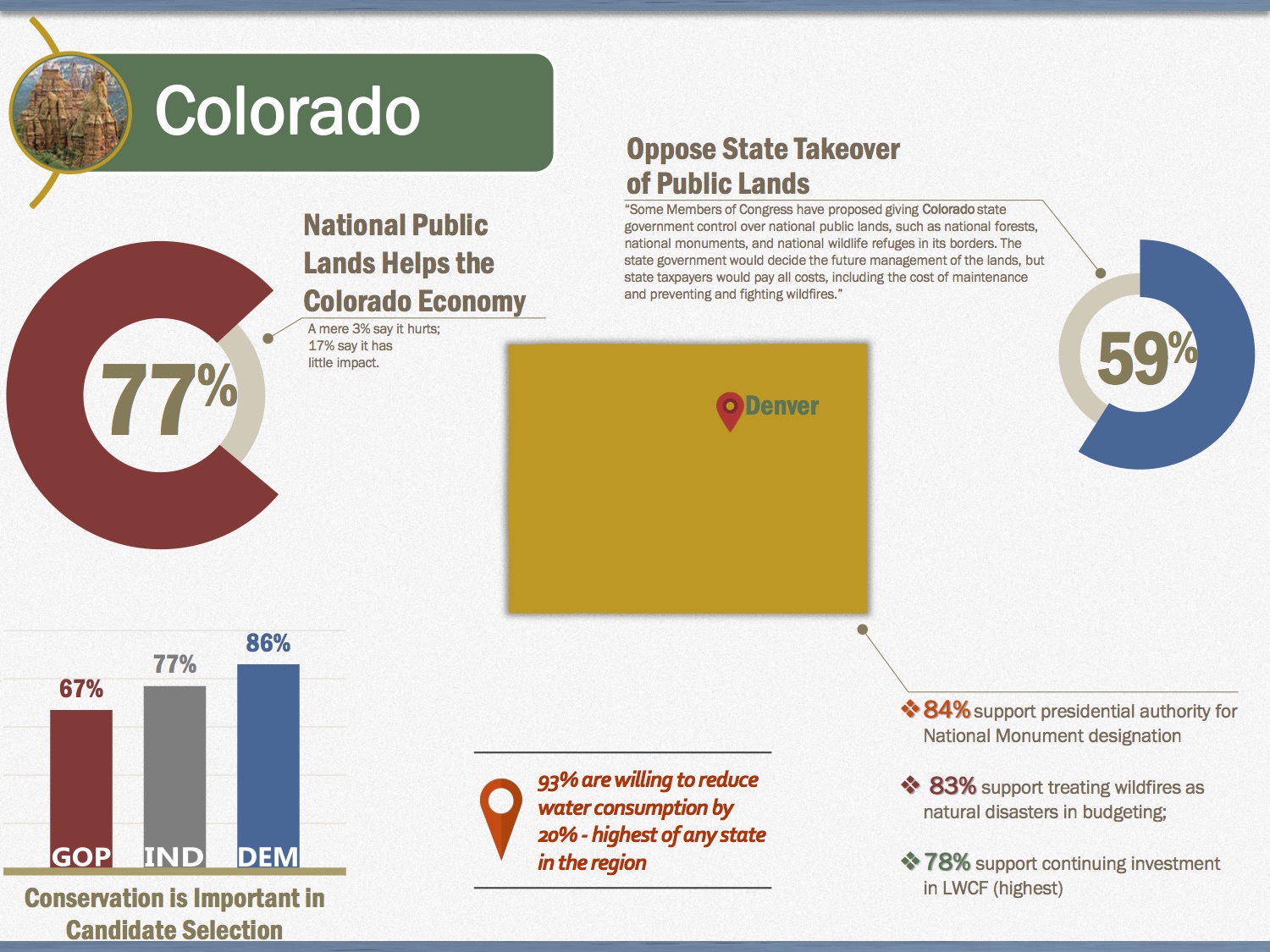
Overall, the poll found that 73 percent of voters believed having federal public lands helped the local economy, while 19 percent thought it had little economic impact and 6 percent said federal lands hurt the economy.
In state-specific questions, the poll found that 77 percent of Montanans support presidential authority for designating national monuments, with 58 percent of them saying the Upper Missouri Breaks National Monument has been a “good thing” (11 percent said it was a “bad thing”). The seven-state average in favor of presidential monument authority was 80 percent. Utah voters had the lowest support, at 66 percent in favor of monument authority.
Looking ahead to the upcoming elections, 84 percent of Latinos consider issues involving public lands, waters, and wildlife as an important factor as other issues like the economy, health care and education when deciding whether to support an elected public official. Even so, 61 percent of Latinos think that most presidential candidates don’t understand issues involving public lands, waters and wildlife. Comparatively, 56 percent of Latinos think Congressional candidates are just as uninformed.
“Hispanics view the protection of our public lands as a moral obligation. It’s natural that this community would be drawn to candidates who support conservation,” said Maite Arce, president and CEO of the Hispanic Access Foundation. “With the tremendous growth of the Latino voter bloc, especially in the Western states, we’re going to see engagement in environmental policy and advocacy for our public lands at levels we’ve never seen before.”
Former Interior Secretary Ken Salazar said the Bundys, who are at the center of a 10-day siege of a national wildlife refuge in Oregon, don’t represent the views of Western residents and are merely jockeying for attention.
“The Bundys and those who sympathize with them are far out of touch with most folks living in the West. By and large Westerners do not agree with the policies or sentiments being advocated in Oregon,” Salazar said in a Monday teleconference. “Bundy and his ilk are just squeaky wheels getting the grease.”
[…]
“What Westerners are actually concerned about is drought and water scarcity, our dependence on foreign oil, climate change and the outdoor recreation economy. Westerners want our public lands to stay public,” he said. “We may not all agree precisely on how to strike the right balance between conservation and development, but anyone who tells us we should hand our American lands over to private owners and to the states are telling us a story that will not stand the test of time.”
Interestingly, Utah residents — more than those in any other state involved in the poll — are likely to disagree with Salazar on that point.
When asked if they support or oppose turning national public lands over to the control of the state, only a slight plurality of Utahns said they opposed the move, 47 percent to the 41 percent who said they were in favor of the transfer. The poll has a margin of error of plus or minus 4.9 percent and involved 400 residents who were close to evenly split among those who identified themselves as Republican and those who said they were “Independent.” Fourteen percent said they were Democrat…
Utah residents, specifically, said they are in favor of the creation of the Bears Ears National Monument, with 66 percent who signed off on the idea.
Of those residents who took part in the poll, a significant majority said they lived in a big city or the suburbs — 63 percent — compared with 12 percent of those who said they lived in a rural area.
Poll results also indicate that the angst over the 1996 designation of the Grand Staircase-Escalante National Monument has tempered, with only 25 percent of Utah residents who insist it was a “bad thing,” in contrast to 45 percent who say it was a good thing. Another 30 percent remain undecided.
Mark Ward, senior policy analyst with the Utah Association of Counties, said rural voters and urban voters differ distinctly when it comes public lands, something that should be kept in mind with this poll’s findings.
“If you don’t live in rural Utah you are prone to think of public lands as totally iconic, these vertical up and down, spectacular-every-acre view,” he said. “But the reality is while all of Utah is beautiful, the vast majority of the acreage is quite ordinary by everyday standards. It is rangeland, it is desert and it is slopes.”
They survey also shows that the majority of Western voters, 52 percent, indicate they support continued oil and natural gas production on public lands, but want stronger safeguards to protect water and the land.
Water, in fact, resonated with Utah voters, with 88 percent of those polled indicating drought is a serious issue and 75 percent who felt conservation should have higher priority than diversion of water of water from rivers in less populated areas.
Another 56 percent of Utah voters said they would be “very willing” to make changes in their household use of water to reduce water by 20 percent, while 35 percent said they would be somewhat willing.
From the Sterling Journal-Advocate (Marianne Goodland):
Sonnenberg, who chairs the Senate Agriculture, Natural Resources and Energy Committee, has promised his staff he wouldn’t sponsor as many bills as he did in 2015: 42, a modern-day record. But he still has big plans.
Top among his priorities for 2016 is implementing parts of the state water plan, a two-year project of the Hickenlooper administration, seeking to address a looming water shortage projected for 2050.
Sonnenberg has several bills in mind to help move the state water plan along: one that would streamline the permitting process for building new storage, and another that would expand storage in existing facilities. One bill would set up a pilot project to pump water back into underground aquifers, which would reduce evaporation. Another bill would fund dredging of shallow reservoirs, such as in Pueblo and Morgan County, to expand their water storage.
Sonnenberg hasn’t fully committed to carrying those bills, but he would likely be the first legislator to tackle the state water plan. Monday, Speaker of the House Dickey Lee Hullinghorst, D-Gunbarrel, told reporters she didn’t expect to see legislation from Democrats on the water plan until next year.
Sonnenberg tried to get the permitting bill through the Interim Water Resources Review Committee last fall, but lost on a 5-5 tie, which he blamed on opposition from Gov. John Hickenlooper.
Both Sonnenberg and Becker plan to tackle the issue of conservation easements: when a landowner voluntarily agrees to conserve part of his or her land, to keep it from being developed, in exchange for tax benefits. The land cannot be used for any other purpose, either at the time of the donation or in the future.
The program has been in trouble for years amidst allegations of abuse, but it’s reached new levels, as Sonnenberg found out in a hearing last August. According to The Denver Post, a Sterling couple, Alan and Julia Gentz, donated 20 acres of land to Logan County 10 years ago, and are now facing a $708,000 tax bill from the Department of Revenue after the appraisal was rejected. The Gentzes aren’t alone, either. Sonnenberg’s hearing drew residents throughout northeastern Colorado who experienced similar problems.
“The state made a contract with the people of Colorado and then backed out of the contract and changed the rules,” Sonnenberg said. The bill is likely to carry a large price tag, likely a problem in a tight budget year. “But it’s never too early to do the right thing.”
Finally, Sonnenberg is holding one bill in his pocket as a warning to those who want to ban fracking, a bill he sponsored last year: Communities that ban fracking would lose the tax revenue they would normally expect from oil and gas operations. The oil and gas industry is already struggling, he said, and continued regulation and barriers will force those companies to take their business to other states.
The 2016 General Assembly begins official business Wednesday, Jan. 13. Hickenlooper will present his State of the State address the following day.
A screenshot from the website for Colorado’s Water Plan.
New Survey Separates Rhetoric from Reality When it Comes to Mountain West Voters’ Support for National Public Lands
Wide margins of support for local efforts to protect public lands as national monuments; voters want a balanced approach to energy development
Against an uptick in anti-public lands rhetoric from militant extremists, a new Colorado College State of the Rockies Project Conservation in the West Poll released today revealed strong public support for efforts to protect and maintain national public lands.
The poll surveyed the views of voters in seven Mountain West states on key public lands issues affecting the region, including proposals to designate new national monuments in the West, establish new environmental and safety standards for oil and gas drilling, and prioritize renewable energy production on public lands.
Central to recent local controversies in Burns, Oregon and elsewhere, the poll—for the first time in its six-year history—asked voters about efforts to turn national public lands owned by all Americans over to state or private control. 58 percent of respondents oppose giving state governments control over national public lands. 60 percent of respondents oppose selling significant holdings of public lands like national forests to reduce the budget deficit. That view was echoed in Nevada, where just 30 percent of respondents identify as supportive of Cliven Bundy, the local rancher who led an armed confrontation with federal authorities in April 2014.
“Charges of government overreach from the ideological fringes are making headlines, but in reality most Westerners in this poll favor greater protection and sensible use of the open lands and national treasures that define the region,” said Eric Perramond, professor in the Southwest Studies and Environmental Programs at Colorado College, and the Faculty Director of the State of the Rockies Project.
The poll also broke new ground in examining public views on the creation of new national monuments—a topic that has often been portrayed as controversial and unpopular in the West. Yet in Utah, a tribal proposal to protect nearly two million acres of existing public lands surrounding the Bears Ears Buttes as a national monument received 66 percent support from respondents. In Arizona, 73 percent of respondents approved of a proposal to protect 1.7 million acres of existing public lands in the Grand Canyon Watershed as a national monument.

According to the poll, monuments created at the end of the Clinton administration, which generated controversy at the time, enjoy wide margins of support today. Across the West, the poll showed overwhelming support—80 percent in favor—for future presidents protecting public lands with a national monument designation.
“These results make clear Western communities care deeply about the public lands that embody the best of our nation’s culture, spirit and beauty,” said former U.S. Interior Department Secretary Ken Salazar. “Western voters see our outdoor heritage as integral to our economy and our way of life, and they certainly don’t want to see their public lands seized by ideologues or sold off by politicians in Washington.”
The poll also looked at energy issues at a time when price fluctuations and market changes make the future of oil, gas and coal industries unpredictable. Voters expressed a balanced view when it comes to how national public lands are used by private industries:
52 percent of respondents approve of continuing drilling and mining at the current pace, but with increased safeguards for land and water—a view that significantly outweighs alternatives approaches, including increasing drilling and mining (10 percent), maintaining the current pace without additional safeguards (10 percent), and stopping all drilling and mining (22 percent).
76 percent of respondents want to continue tax incentives for solar and wind energy production.
58 percent of respondents support increasing the royalty fees paid by companies that drill for oil and gas or mine for coal and minerals on national public lands.
80 percent of respondents agree with a proposed Obama Administration rule to require oil and gas producers who operate on national public lands to use updated equipment and technology to prevent leaks of methane gas during the extraction process and reduce the need to burn off excess natural gas into the air.
Additional key findings include:
Ahead of the 2016 elections, 75 percent of respondents say issues involving public lands, waters, and wildlife are an important factor in deciding whether to support an elected public official, compared to other issues like health care and education.
83 percent of respondents believe the drought is a serious issue and in Colorado River Basin states (CO, NV, NM & UT) strong majorities favor using the current water supply more wisely over diverting more water from rivers in less populated areas.
75 percent of respondents support the renewal of the Land and Water Conservation Fund.
80 percent of respondents believe the U.S. Forest Service should be allowed to treat the largest and most expensive wildfires as natural disasters in order to have access to emergency disaster funding.
72 percent of respondents say national public lands, such as national forests, national monuments, or wildlife refuges help their state economy
This is the sixth consecutive year Colorado College has gauged the public’s sentiment on public lands and conservation issues. The 2016 Colorado College Conservation in the West survey is a bipartisan poll conducted by Republican pollster Lori Weigel of Public Opinion Strategies and Democratic pollster Dave Metz of Fairbank, Maslin, Maullin, Metz & Associates. Nevada voters were included in the survey for the first time this year.
The poll surveyed 400 registered voters in each of seven Western states (AZ, CO, MT, NV, NM, UT & WY) for a total 2,800-person sample. The survey was conducted in December and has a margin of error of +/-2.74 percent nationwide and +/ -4.9 percent statewide. The full survey and individual state surveys are available on the Colorado College website.
State infographic for Colorado via State of the Rockies Project 2016 Conservation in the West poll.
CLick here to read the newsletter. Here’s an excerpt:
Connor: Find a Fix or We Will
At the 70th Annual Conference of the Colorado River Water Users Association (CRWUA), Deputy Interior Secretary Michael Connor implied that if the lower basin states of Arizona, California, and Nevada can’t find a fix for their Colorado River’s problems, the interior secretary will find it for them. In an Arizona Daily Star article, Connor referenced the need to prevent Lake Mead from falling to dangerously low levels. Should this be the case there would be huge cutbacks in water deliveries to the agricultural sector, cities, and Indian tribes.
According to the Star, the lake has dropped more than 120 feet since 2000. It’s expected to close 2015 at 1,082 feet elevation. The first shortage in the river would be declared at 1,075 feet and Connor indicated that the risk is now up to 30 percent that Lake Mead will drop to potentially dangerous levels in five years. The article also indicated that by next year’s CRWUA conference, Connor hopes the states will have reached agreement and that Interior Secretary Jewell will come to celebrate, either that or contingency plans will need to be implemented.
The Colorado River Basin is divided into upper and lower portions. It provides water to the Colorado River, a water source that serves 40 million people over seven states in the southwestern United States. Colorado River Commission of Nevada
Snowpack is building in the mountains of southern Colorado and northern New Mexico — a positive sign so far this winter for Doña Ana County water users.
Snow levels — which turn into spring runoff that feeds the Rio Grande — are thus far tracking above average for this point in the season, boosted by a bumper El Niño weather pattern that tends to bring more precipitation to the Southwest.
A Jan. 1 federal report showed that snowpack in northern New Mexico that impacts the Rio Grande sat at 134 percent of a median average, 63 percent higher than a year ago. And snow levels in southern Colorado were at 126 percent of average, a 56 percent increase over the same time last year, according to the report from the Natural Resources Conservation Service…
Farmers, in particular, rely heavily upon the runoff, which makes its way into Elephant Butte Lake and Caballo Reservoir north of Doña Ana County. In recent years, that runoff has been scarce, resulting in slim river-water irrigation allotments by the Elephant Butte Irrigation District. At least part of the problem, irrigation officials have said, is that a given level of snowpack in recent years hasn’t been yielding as much runoff each spring as it would have in the past.
That trend has Phil King, EBID’s consultant water engineer, with mixed views about what this snowpack will mean for southern New Mexico.
“It’s the best year we’ve had in a while, but our standards have gotten really low the last few years,” he said. “There is optimism, but I’m guarded. The fact we’re doing better than 3.5 (acre)-inches, doesn’t mean we’re doing well.”
King referred to the irrigation district’s water allotment for 2013, considered the worst in nearly a century of local irrigation history. In 2015, Doña Ana County growers received an allotment of 11 acre-inches per acre — the highest since 2010, when farmers got 2 acre-feet per acre.
The district considers a full allotment to be 3 acre feet — 36 inches — per acre. An acre-foot contains about 326,000 gallons, enough to cover an acre of land to a depth of 1 foot or 12 inches.
Carryover water from last year that’s already in Elephant Butte Lake forms the basis for the irrigation season. And King said the amount of water being held for EBID would yield about an irrigation allocation, even without any new runoff that will be added this spring.
On Friday, Elephant Butte Lake contained 331,990 acre-feet of water, about 17 percent full. That is 26 percent more than a year ago, according to numbers from the U.S. Bureau of Reclamation…
Separately, the Rio Grande Citizens Forum of the U.S. Section of the International Boundary and Water Commission will hold a public meeting Jan. 21 at the USIBWC Headquarters First Floor Conference Room, 4171 N. Mesa, Bldg. C-100, El Paso, according to a meeting announcement from the agency. An item on the agenda is the impact of El Niño on the Rio Grande. A river levee certification process and floodgate repair are other topics. For information, call 915-832-4794 or e-mail mario.montes@ibwc.gov.
The Shavano Conservation District will provide an opportunity for area residents to slake their thirst for information about the Colorado Water Plan and water management.
The Irrigation and Water Efficiency Conference will address the recently adopted plan as well as management methods, Colorado water law, funding for irrigation improvements and wildlife habitat, according to a press release. Shavano Conservation District President Ken Lipton said information about the future of water use in Colorado is applicable to those whose interest is agricultural, environmental or otherwise.
“It’s important that every citizen understands the Colorado Water Plan,” Lipton said. “It’ll affect everyone.”
One of the areas the conference will cover will be small acreage management, which, according to Lipton, is growing in popularity in Montrose and Ouray counties.
John Rizza, a Small Acreage Management Specialist, is one of the speakers at the event. Water rotation among small farms and crops able to withstand drought are among the subjects he will address.
Oftentimes small acreage farms are formed by dividing land from a larger farm. In terms of water, this means a source is being used by multiple people for the first time, according to Rizza. Communication with other landowners is necessary to ensure a water source isn’t compromised through multiple people watering their fields on the same day. This is especially important in areas prone to droughts.
Another method of small acreage water management comes in the form of the perennial farm system. Perennial crops, such as the feed crops of Needle and Thread, Blue Grama, Indiana Rice Grass and Wheatgrass, are able to adapt to waterless conditions by hibernating. What results is a crop that is able to thrive until precipitation returns to an area.
“They can handle a little bit of drought and still produce a well for landowners,” Rizza said…
Other speakers include Special Policy Advisor to the Governor for Water John Stulp and former Division Four Water Court Referee Aaron Clay.
The conference is sponsored by the Bureau of Reclamation, the Colorado Department of Agriculture, the Natural Resource Conservation Service in addition to the Shavano Conservation District…
The event will be 2 p.m. Wednesday Jan. 20 at the 4-H Event Center in Ridgway. Attendees are encouraged to RSVP by calling (970) 249-8407, or emailing mendystewart@co.nacdnet.net
A draft environmental assessment statement has been completed for a proposed 7-megawatt hydroelectric plant at Pueblo Dam.
The Bureau of Reclamation is accepting comments until Jan. 30 on the project.
The project is a joint eort of the Southeastern Colorado Water Conservancy District, Colorado Springs Utilities and the Pueblo Board of Water Works.
Two generators designed to operate at both high and low flows would be constructed on the North Outlet Works, which was built as part of the Southern Delivery System. A separate connection for hydropower was included in the design.
Electrical generation would not consume any water, operating on flows that already are released from the dam.
The Western Area Power Administration would have first opportunity to purchase power, which would be available to Black Hills Energy or Utilities if WAPA declines.
However, the power lines would be connected to the Black Hills substation that provides electricity to the Juniper Pump Station that provides power for SDS to pump water to Pueblo West and El Paso County.
The assessment notes there would be potential temporary impacts on air quality, water quality and wildlife (including some fish die-o) during construction.
Long-term eects would be less noticeable and not significant, because the flows into the Arkansas River, state fish hatchery, South Outlet Works or the SDS pipeline are not altered, according to the document.
“This river, the Colorado, can be turned on and turned off down to the last drop on orders from the Interior Secretary of the United States,” a voiceover tells us. “This was the first river on earth to come under complete human control.”
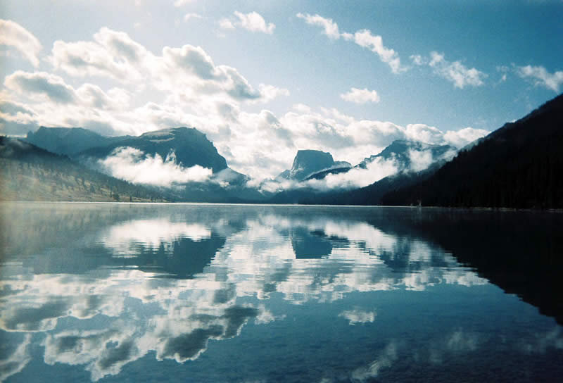
But where it starts in Wyoming as the Green River out of the Wind River Range, it is still wild, flowing down to feed an elaborate canyon ecosystem, not to mention several thirsty states.
But the question is, what’s the responsibility of headwater states like Wyoming to keep that river ecology healthy as the climate gets hotter and dryer?
Rancher Eric Barnes and his family live on Fontanelle Creek near Kemmerer in southwest Wyoming. It’s a ranch his father built in the 1950’s.
“It’s a really beautiful place because it’s kind of in the foothills of the desert.”
And it backs onto the mountains where the creek flows down to join the Green River in Fontanelle Reservoir. While droughts have devastated crops in the southwest over the last few years, Barnes was having the opposite problem.
“I had been needing to rebuild all my diversions because they’d been blowed out, just from high water in the last few years,” he says. “And I didn’t know how I was going to afford to do all these projects because all the diversions needed worked on.”
And those flood-damaged irrigation gates were expensive to replace. So he turned to Trout Unlimited who helped him turn his surplus irrigation water into a money maker. They helped him apply for a new multi-state pilot program through the Upper Colorado River Commission that pays water rights holders like Barnes not to irrigate.
Wyoming Trout Unlimited water and habitat director Cory Toye says while more flow in the stream will help droughts downstream, it’ll also help Wyoming’s wildlife that have suffered from the last 15-years of drought.
“There are tributaries where we’ve seen extended low flows over the last couple of years,” Toye says. “If there’s low conditions or tough habitat conditions in particular areas, the more we can do for trout to move around and find better habitat, the better we do.”
Here’s the release from the European Science Foundation:
Extreme Geohazards: Reducing the Disaster Risk and Increasing Resilience
Extreme hazards – rare, high-impact events – pose a serious and underestimated threat to humanity. The extremes of the broad ensemble of natural and anthropogenic hazards can lead to global disasters and catastrophes. Because they are rare and modern society lacks experience with them, they tend to be ignored in disaster risk management. While the probabilities of most natural hazards do not change much over time, the sensitivity of the built environment and the vulnerability of the embedded socio-economic fabric have increased rapidly. Exposure to geohazards has increased dramatically in recent decades and continues to do so. In particular, growing urban environments – including megacities – are in harm’s way. Because of the increasing complexity of modern society even moderate hazards can cause regional and global disasters.
Natural hazards that occur frequently on our dynamic planet are increasingly causing loss of human life and damage to goods and infrastructures at the local, regional and global scale, depending on their intensity. The Science Position Paper Extreme Geohazards: Reducing the Disaster Risk and Increasing Resilience analyses the potential effects of low-probability high-impact events, which might cause global disasters and even bring our already stressed global society beyond the limits of sustainability.
The paper, a joint initiative by the European Science Foundation (ESF), the Group on Earth Observations (GEO) and the Geohazard Community of Practice (GHCP), following a high-level ESF-COST Conference on the subject, addresses several types of geohazards, but puts special emphasis on the impending risk of catastrophic effects on populations and infrastructures should our growing and increasingly interconnected modern society be exposed to a very large volcanic eruption. The paper highlights the urgency of establishing an effective dialogue with a large community of stakeholders in order to develop robust risk management, disaster risk reduction, resilience, and sustainability plans in the coming years and decades. It also underlines the need to develop the methodology to assess the potentially global impacts that a major hazard would have on our modern society, which would provide guidance to reduce vulnerability where possible and increase general resilience in the face of surprise events. It concludes that preparedness requires a global monitoring system that could provide sufficiently early warnings, should such a major hazardous event develop.
The report is to be presented at a special session during the European Geosciences Union General Assembly (EGU) in Vienna on Tuesday 14 April 2015, 13h30. The EGU General Assembly is an event that brings together geoscientists from all over the world which makes it the perfect place to deliver such a publication…
Authors of the report Extreme Geohazards: Reducing the Disaster Risk and Increasing Resilience are Hans-Peter Plag, Mitigation and Adaptation Research Institute, Old Dominion University, Norfolk, VA, USA; Sean Brocklebank, School of Economics, University of Edinburgh, UK; Deborah Brosnan, One Health Institute, University of California Davis, Davis, CA, USA; Paola Campus, European Science Foundation, Strasbourg, France; Sierd Cloetingh, Department of Earth Sciences, Utrecht University, The Netherlands; Shelley Jules-Plag, Tiwah UG, Rossbach, Germany; Seth Stein, Department of Earth and Planetary Sciences, Northwestern University, Evanston, IL.
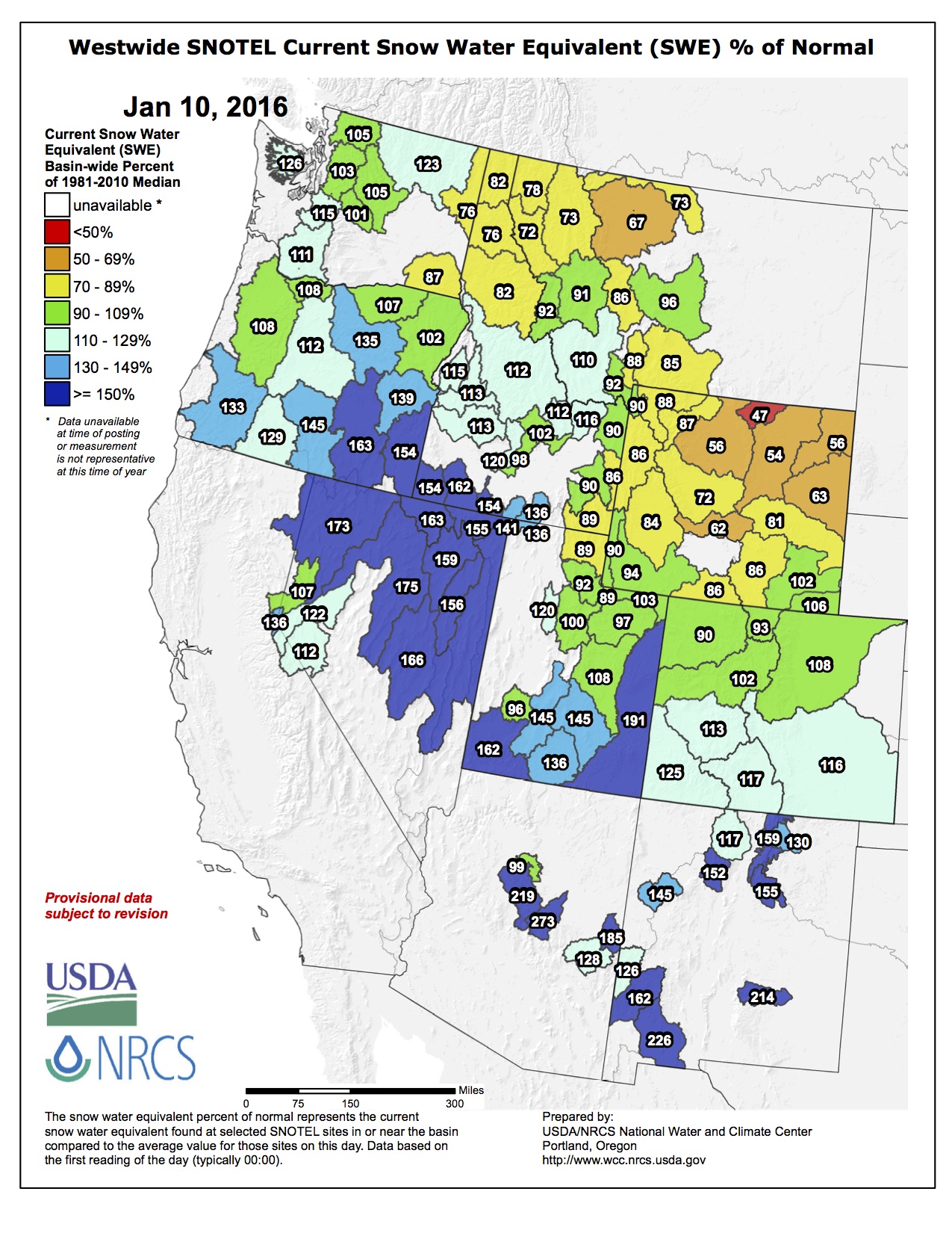
Here’s the release from the Natural Resources Conservation Service (Brian Domonkos):
The January 1 Colorado Water Supply Outlook Report provides the first written update of snowpack in Colorado since the 2016 water year began on October 1, 2015. “Statewide snowpack is 118 percent of normal, considerably better than last year’s start” says Brian Domonkos, Colorado Snow Survey Supervisor with the USDA Natural Resources Conservation Service. In a typical year about two-fifths of the seasonal snowpack has accumulated to this point, a substantial portion of the accumulation season. Remembering last year Domonkos goes on to add, “With a sizable chunk of the winter already behind us this is a good starting point, however more than half of the winter remains”. Recapping last year, after near normal conditions on January 1, accumulation through January and early February was well below normal, a storm system in late February and early March provided a notable increase before another lull in precipitation through the rest of March and April. May, however, provided a reprieve from the dry pattern producing nearly 250 percent of average precipitation statewide.
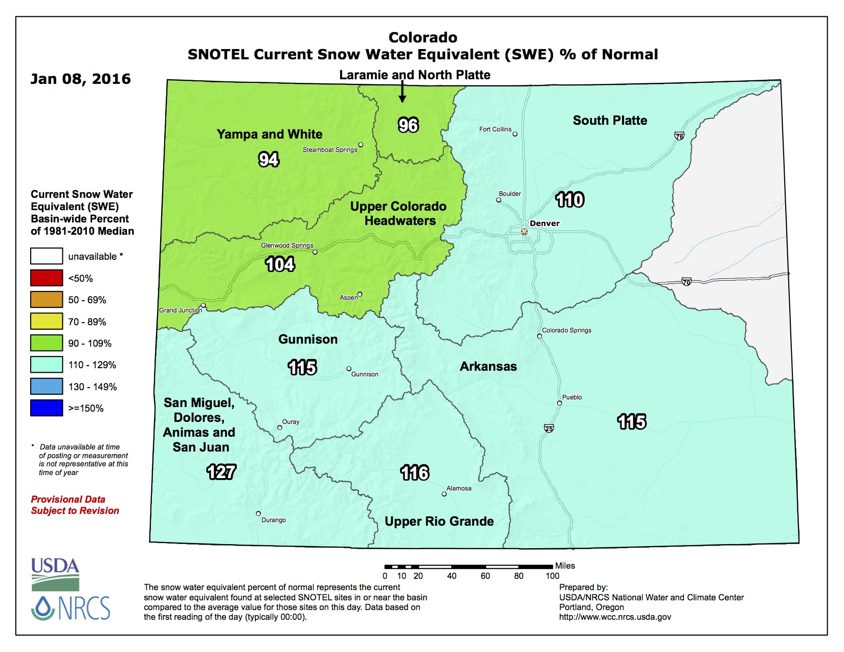
The current strong El Nino has not disappointed the state of Colorado so far in 2016, providing between 103 percent of normal snowpack in the combined Yampa and White River Basins to as high as 130 percent of normal in the combined San Miguel, Dolores, Animas, and San Juan Basins. Some past El Nino events have been known to leave the northern half of the state high and dry. However, so far nearly all watersheds have benefited from this year’s El Nino event.
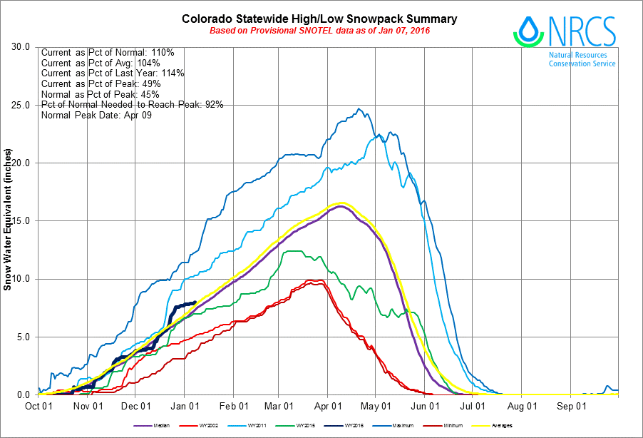
Statewide Basin High/Low graph January 7, 2016 via the NRCS
Of the 97 automated SNOTEL sites with available data, only 13 indicate snowpack is not quite up to 100 percent of normal. This does not equate to a poor start as these sites are sparse and scattered around the state. A few watersheds, including the Little Snake, Elk, Eagle, and Cache La Poudre River basins, do have slightly below normal snowpacks but are still near the median. This provides a good start for the seasonal snowpack across Colorado.
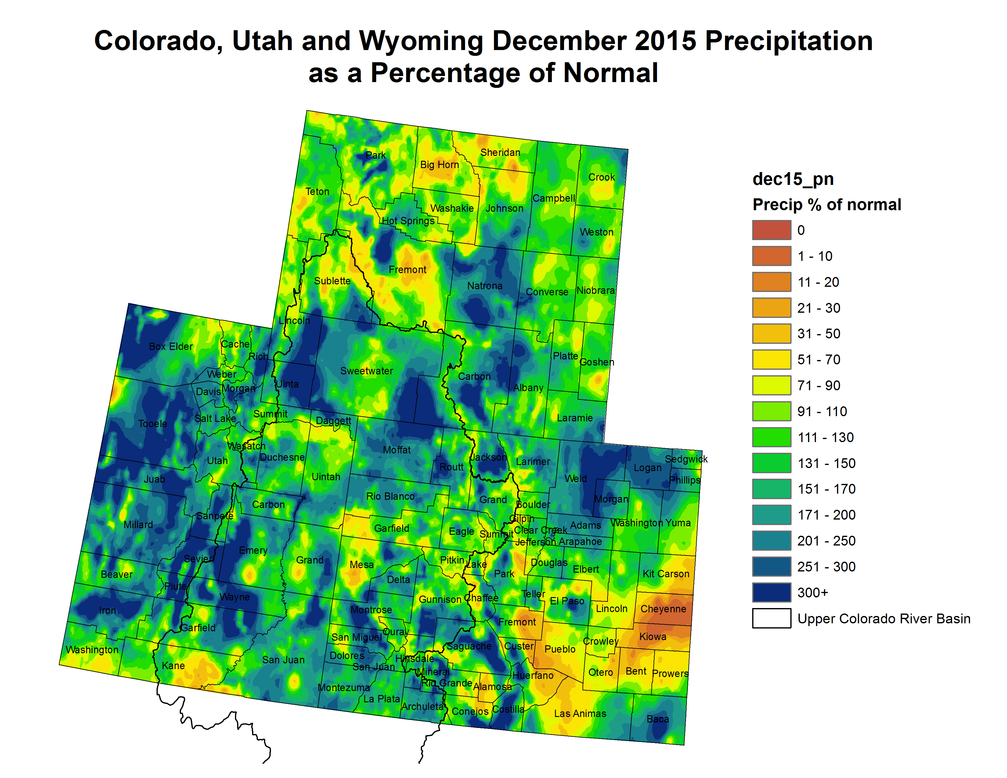
Precipitation statewide during the month of October started the water year off near normal but ramped up in November and December with monthly values of 97, 114 and 128 percent of normal, respectively. Water year-to-date precipitation is currently at 113 percent of normal. Reservoir storage is still in fair standing with help from last year’s well above average late spring precipitation. Statewide storage is 110 percent of normal where the only basin with below average total storage in the state are the combined reservoirs of the Upper Rio Grande.
While it is still early in the water supply game, streamflow forecasts are projected to be near normal for spring runoff season ranging from 80 percent of normal on the Little Snake River near Dixon to as high as 123 percent of normal Ute Creek near Ft. Garland. Snowpack is off to the best start since January 1, 2011, and the ninth best start since 1982.
Statewide Snowpack map January 8, 2016 via the NRCS
The Department of the Interior, through the Bureau of Reclamation and National Park Service (NPS), has made available for public review and comment the Draft Environmental Impact Statement (DEIS) for the Long-Term Experimental and Management Plan for the Operation of Glen Canyon Dam (LTEMP). The LTEMP would determine specific options for dam operations (including hourly, daily, and monthly release patterns), non-flow actions, and appropriate experimental and management actions that will meet the requirements of the Grand Canyon Protection Act, maintain or improve hydropower production, and minimize impacts on resources, including those of importance to American Indian Tribes.
The DEIS was filed with the Environmental Protection Agency on January 8, 2016, and a 90 day public comment period was initiated with the publication, also on January 8, 2016, of the Department of Interior’s Notice of Availability of the DEIS in the Federal Register. Written comments on the DEIS should be submitted by April 7, 2016.
The DEIS is available for reviewing on the internet at: http://ltempeis.anl.gov/. Compact disc copies of the DEIS are available for public review at the following locations:
J. Willard Marriott Library, University of Utah, 295 South 1500 East, Salt Lake City, Utah 84112.
For specific information about the web-based meetings, please refer to the LTEMP EIS website at: http://ltempeis.anl.gov/.
The purpose of the proposed action is to provide a comprehensive framework for adaptively managing Glen Canyon Dam over the next 20 years consistent with the Grand Canyon Protection Act and other provisions of applicable Federal law. The proposed action will help determine specific dam operations and actions that could be implemented to improve conditions and continue to meet the Grand Canyon Protection Act’s requirements and to minimize – consistent with law – adverse impacts on the downstream natural, recreational, and cultural resources in Glen Canyon National Recreation Area and Grand Canyon National Park, including resources of importance to American Indian Tribes.
The need for the proposed action stems from the need to use scientific information developed since the 1996 Record of Decision (ROD) to better inform the public of Department of the Interior decisions on dam operations and other management and experimental actions so that the Secretary of the Interior may continue to meet statutory responsibilities for protecting downstream resources for future generations, conserving Endangered Species Act-listed species, avoiding or mitigating impacts on National Register of Historic Places-eligible properties, and protecting the interests of American Indian Tribes, while meeting obligations for water delivery and the generation of hydroelectric power.
Click here to read the newsletter. Here’s an excerpt:
Water Leaders applications due Jan. 15
Applications for CFWE’s 2016 class of Water Leaders are being accepted through next Friday, January 15. Read application requirements, see course dates and scholarship information, and apply here.
Water Leaders participants receive extensive training in skills related to navigating conflict and diversity, leading self and others, and effective problem solving. You will leave the program with a better understanding of your strengths and how to use them, your challenges and how to work on them, skills to enhance your staff and team management work, and a network of peers to further your career growth.
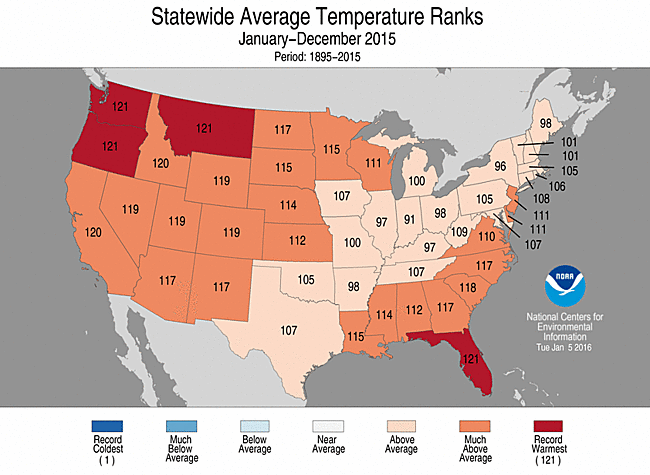
Record December boosted 2015 to 2nd warmest year for Contiguous US
Ten weather, climate disasters exceeding $1 billion impacted the nation
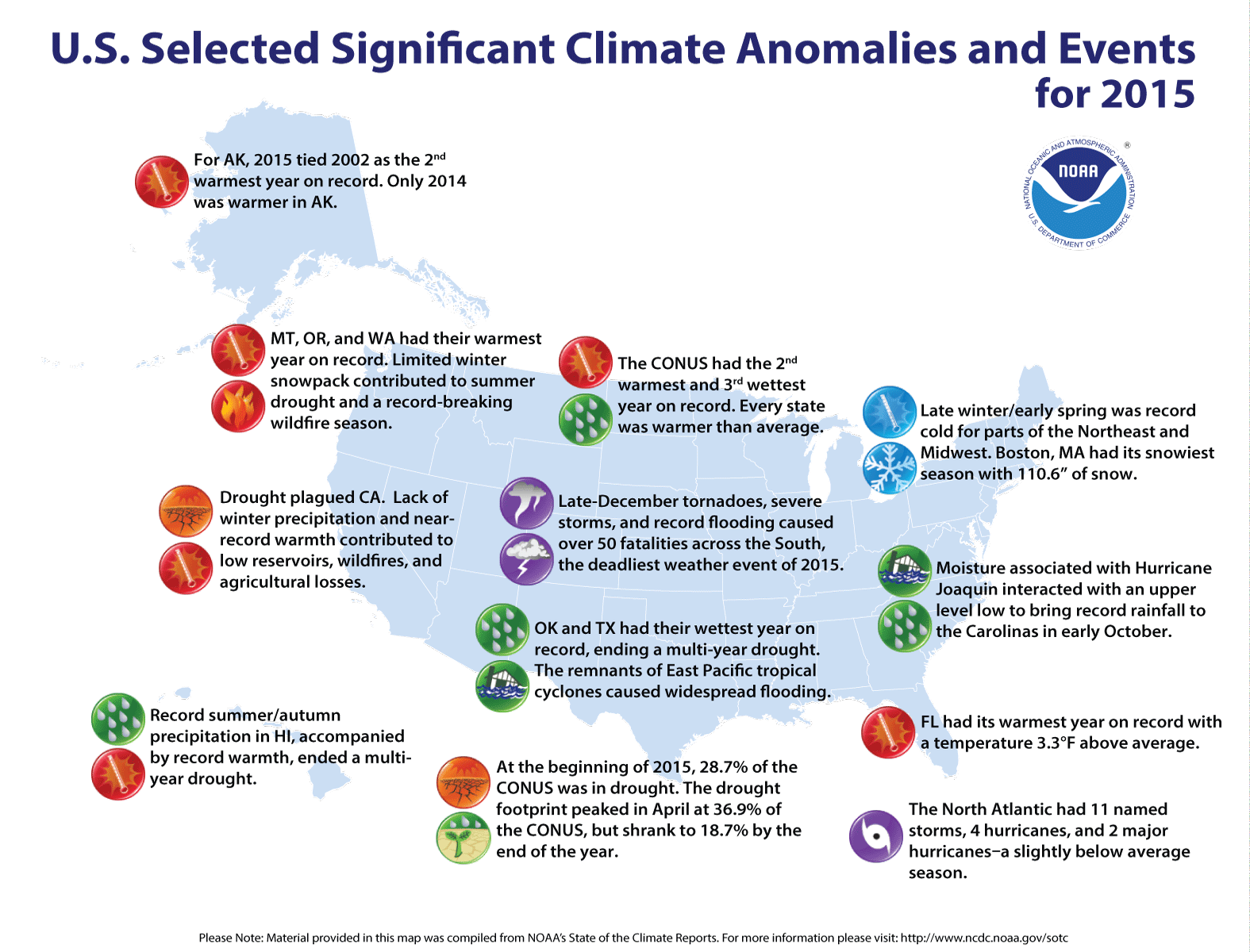
The 2015 annual average U.S. temperature was 54.4°F, 2.4°F above the 20th century average, the second warmest year on record. Only 2012 was warmer for the U.S. with an average temperature of 55.3°F. This is the 19th consecutive year the annual average temperature exceeded the 20th century average. The first part of the year was marked by extreme warmth in the West and cold in the East, but by the end of 2015, record warmth spanned the East with near-average temperatures across the West. This temperature pattern resulted in every state having an above-average annual temperature.
The average contiguous U.S. precipitation was 34.47 inches, 4.53 inches above average, and ranked as the third wettest year in the 121-year period of record. Only 1973 and 1983 were wetter. The central and southeastern U.S. was much wetter than average, while parts of the West and Northeast were drier than average. The national drought footprint shrank about 10 percent during the course of the year.
In 2015, there were 10 weather and climate disaster events, each with losses exceeding $1 billion. These events included a drought, two floods, five severe storms, a wildfire event and a winter storm. Overall, these resulted in the deaths of 155 people and had significant economic effects. Further cost figures on individual events in 2015 will be updated when data are finalized later this year.
U.S. climate highlights: 2015
Much warmer than average annual temperatures were observed across the West, Northern and Central Plains, Southeast, and Mid-Atlantic. Twenty-eight states, including Alaska, were much warmer than average during 2015 — Florida, Montana, Oregon and Washington were record warm. Alaska, California, and Idaho had their second warmest year.
Most of the central and southeastern U.S. were wetter than average, including 14 states that were much wetter than average. Oklahoma and Texas were record wet for the year, with both states becoming drought free for the first time since 2010. Parts of the Northeast and West were drier than average. Connecticut had its fourth driest year. In California, year-end precipitation helped erase early-year deficits, resulting in the state’s 13th driest year.
The U.S. Climate Extremes Index (USCEI) for 2015 was 70 percent above average, ranking as the fourth highest annual USCEI in the 106-year record and highest since 2012. The components of the USCEI that were much above average for the year included extremes in warm maximum and minimum temperatures, one-day precipitation totals and days with precipitation. The USCEI is an index that tracks extremes (falling in the upper or lower 10 percent of the record) in temperature, precipitation, drought and land-falling tropical cyclones across the contiguous United States.
Click on a thumbnail graphic to view a gallery of drought data from the US Drought Monitor. From the website:
Summary
It was a fairly dry week over much of the United States with the majority of the country seeing little to no precipitation. The exceptions were in south Texas, the Southeast, and along the Pacific coast. At the end of the current U.S. Drought Monitor period and the beginning of the next, the first of several storms started sweeping across the West Coast and into the Southwest. The resulting precipitation will be analyzed for potential improvements to the region next week. Temperatures remained well above normal for the upper Midwest and for most areas east of the Mississippi River. Departures of 5-10 degrees above normal were common from the Mid-Atlantic into the Southeast as well as in eastern North Dakota, northern Minnesota, and northern Wisconsin. Below-normal temperatures were common for most areas west of the Missouri River. Portions of the northern Rocky Mountains were 15-20 degrees below normal in the last week…
High Plains and South
Dry conditions prevailed over much of the High Plains and the South region, with southern Texas the only area showing any changes for the week. After a very wet end to the year, drought is not a concern over much of the Plains and the South-Central states. Most of the abnormally dry conditions in south Texas were removed this week, with only a few small areas of dryness remaining…
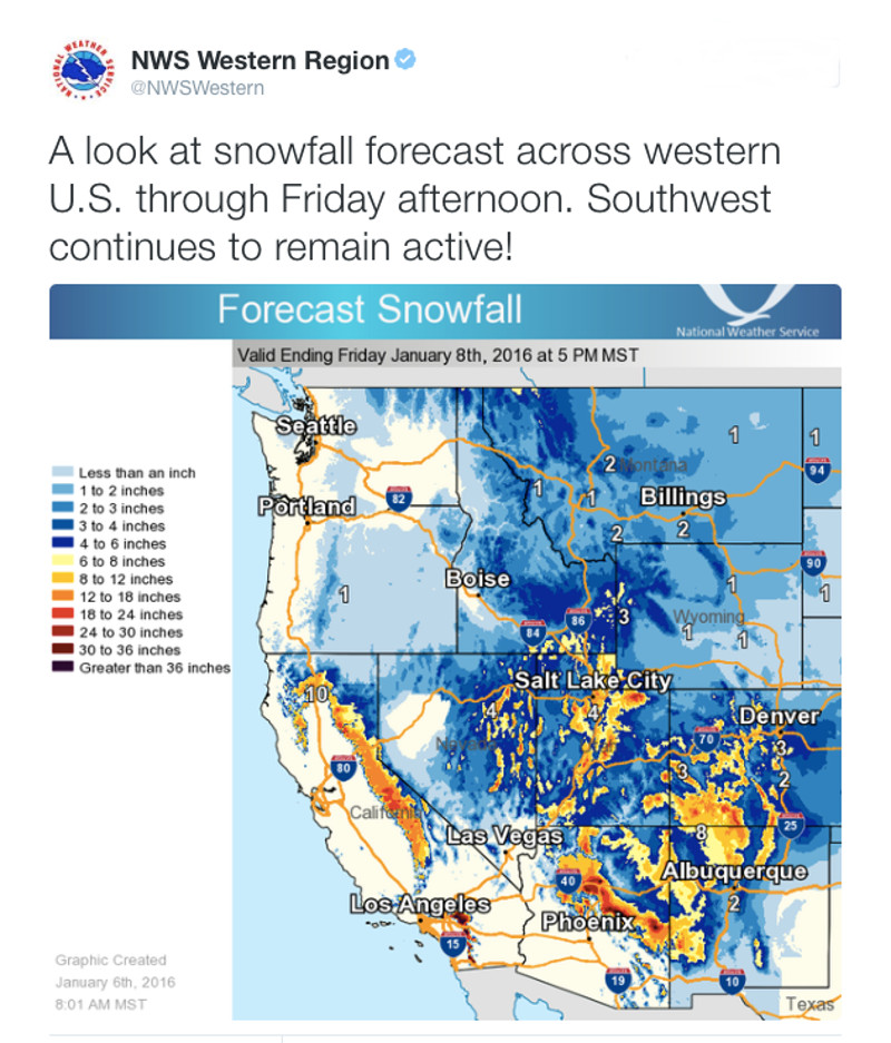
West
The weather pattern remains active over the West and the temperatures are very seasonal, cooler than the last two winters. There has been good snow accumulation in the upper elevations and rain in the lower elevations. For this week, improvements were made in eastern Washington and Oregon, where most areas to the east of Cascade Mountains had a full-category reduction in drought intensity, with moderate to severe drought lingering. Northern Idaho saw an improvement to the severe drought (D2) conditions, leaving moderate drought. Severe drought conditions also improved in southern Idaho this week. In northeast Nevada and northwest Utah, abnormally dry conditions improved slightly, and in southern Utah, moderate drought and abnormally dry conditions improved slightly. In the Four Corners region in northwest New Mexico, abnormally dry conditions improved. But prolonged dryness led to expansion of drought in northern Wyoming and southeast Montana. This area has not been as fortunate and dryness has lingered since autumn, so D0 and D1 expanded this week, pushing moderate drought into southeast Montana.
The analysis of California is ongoing, with the good start to the current water year bringing optimism to the region. The deficits over the last three years are significant enough that potential improvements are going to be slow to develop. The systems bringing precipitation to the region at the end of this current United States Drought Monitor period will be assessed next week…
Looking Ahead
Over the next 5-7 days, the active pattern will continue along the West Coast with several storms projected to bring precipitation from southern Oregon into southern California, Arizona and the Four Corners region. As these storms track eastward, much of the Midwest and East Coast will have the opportunity for ample precipitation as well. Cooler-than-normal temperatures over the western half of the country will provide a good opportunity for snow accumulation, especially at the higher altitudes. The East will see high temperatures of 8-10 degrees above normal.
The 6-10 day outlooks show that the odds for temperatures to be cooler than normal are greatest over the upper Midwest and Great Lakes regions as well as over much of the eastern United States, High Plains, and Four Corners regions. The greatest odds of warmer than normal temperatures is over the West Coast as well as much of Alaska. The best odds of above normal precipitation includes the west coast, Gulf Coast into Florida, and the Great Lakes regions. For much of the central Rocky Mountains, Midwest and into the Mid-Atlantic, there are above normal chances of below normal precipitation.
John Stulp, former State Agriculture Secretary, Prowers County Commissioner and current Special Policy Advisor to Governor Hickenlooper for Water issues, was one of eight speakers at the January 6th Crop Production Clinic held at Lamar Community College.
Stulp provided an update on the Governor’s State Water Plan which was presented to Hickenlooper last month. The ten year study provides information on current and future water needs for Colorado and how those needs will impact such areas as population growth, adequate water storage plans, conservation and environment, agricultural needs and non-consumptive uses. The information was compiled as a result of numerous Interbasin Water Committee and roundtable meetings conducted throughout the state for several years.
Stulp laid out some general statistics for the gathering, which began with a produced video detailing the aims of the study. He added, “Our future water uses are being determined by several factors including climate change, population growth, recent state forest fires and agricultural demands, all of which will impact our supplies.” Stulp commented on water distribution, adding that although most of our water flows on the western side of the Continental Divide, 80% of the population is on the east. The Western Slope population is at 562,000 with 918,000 irrigated acres and the eastern side of the state has a population count of 4,490,000 with 2,548,000 irrigated acres. Even with that amount, Stulp noted that only 5% of state surface land is irrigated. One graph showed the amount of water leaving the state from our river systems, with the Arkansas River’s estimate at 164,000 acre/feet per year.
“There will have to be some conservation efforts,” he said, noting that the state’ s projected population growth will take us to double the current 5,000,000 residents by 2050, half from the birth rate and the balance from an influx from the rest of the country. “Colorado is still one of the destination states for future growth and we need to take that into account,” he stated. Stulp told the audience that even with an additional 350,000 residents into the Denver area over the past several years; conservation efforts reduced water usage by 20%.
As southeast Colorado’s economy is heavily dependent on farming and ranching, Stulp noted that our agricultural growth will need to keep pace with state, national and global demands which will call for innovative ideas for water use, storage and conservation. Some ideas put forth from the study indicated a need for rotational fallowing, interruptible water supply, deficit irrigation, water coops and banks and water conservation easements. He noted that storage will play an important part in future water supplies, with thought being given to underground storage to reduce evaporation loss.
Palmer Land Trust: Pueblo County, Lower Ark Valley at risk
Keeping farms and ranches productive is more than just a quaint notion for the Palmer Land Trust, which sees agriculture as the thread that holds together the fabric of the Lower Arkansas Valley.
And Pueblo County should be on guard.
“This doesn’t work unless the larger community makes an investment and says, ‘We want to save this,’ ” said Matt Heimerich, coordinator for Palmer’s initiative in the Lower Arkansas Valley.
Heimerich and Executive Director Rebecca Jewett met Wednesday with The Pueblo Chieftain editorial board to discuss progress with a two-pronged program to keep irrigation water on farms and to improve sustainable ranching methods.
“We’re at the front end of our initiative to protect farmland in the Arkansas Valley,” Jewett said. “This is just a starting point.”
Two projects last year moved the effort ahead:
Palmer is working with the Nature Conservancy on turning around the 25,000-acre BX Ranch in eastern Pueblo County. A conservation easement and a trial program to better manage grasslands aim at eventually finding a buyer for one of the region’s oldest ranches.
Palmer also is helping to preserve farms on the High Line Canal near Rocky Ford in a demonstration project the trust believes can be used as a model for other ditches, including the Bessemer Ditch in Pueblo County.
“The Bessemer is closer to Pueblo and the prices of farms increase dramatically. The water rights and soil are good, and we want to work there before it’s too late,” Jewett said.
It’s not an easy process, mainly because conservation values for water rights typically reflect actual value rather the potential for future sales to cities.
Heimerich knows all too well the potential side of the equation. As a Crowley County farmer and former commissioner, he has seen the devastating effect of dewatering thousands of acres of productive farm ground when the water was sold to Pueblo, Colorado Springs and Aurora.
He’s optimistic that cities won’t be able to practice the same sort of buy-and-dry tactics of the past, but said Pueblo County is not immune and should be doing everything it can to protect agriculture.
“Think of Pueblo Chiles, that’s a great start. There’s no reason Pueblo can’t be thought of in the same way as Sonoma or Bourdeaux,” Heimerich said. “Look at what they did with Rocky Ford melons.”
In addition to branding, Heimerich wants to encourage food-processing industries to locate here in order to increase the value of local products, another area Palmer is pushing communities to act.
Finally, he thinks the newly adopted Colorado Water Plan will provide a barrier for cities to carry out the sorts of water raids which decimated Crowley County.
“Crowley County in the 1960s had the highest percentage of people who claimed agriculture as their primary source of income. I think that’s what got me interested in the land trust,” Heimerich said.
“The municipalities need water, but know that under the state water plan it will be an uphill political fight. The Palmer Land Trust is part of a way to manage water so that farmers can continue to farm.”
From Western Resource Advocates (Jon Goldin-Dubois):
As we begin the New Year I am filled with hope for real and concrete progress to protect the incredible place we call home. The past year has provided a strong foundation that we can build upon to reduce climate pollution and to protect western rivers and landscapes. Here’s what I mean:
Coming out of the climate agreements negotiated by 195 countries in Paris that concluded in December, many of the world’s nations are expected to take their first steps to address climate change. For the U.S. and most developed nations, this means cutting carbon emissions. For developing nations, the accord calls for financial incentives that will help them leapfrog carbon intensive development. Importantly, the agreement endeavors to limit warming to 1.5 degrees Celsius (scientists argue we must keep warming to under 2 degrees Celsius to stop climate change’s most devastating impacts).
Certainly, some advocates have argued that the agreement didn’t do enough. To be truthful, I would have liked to see stronger commitments to cut carbon pollution more quickly as well. But I think the agreement provides reason for hope. I say this for several reasons, not least of which is the fact that earlier in 2015 the EPA issued the Clean Power Plan, mandating carbon pollution reductions from U.S. power plants of about 33%. Clearly that’s not enough to address the U.S. share, but it does send a very strong message to the rest of the world that the U.S. is prepared to take action. In issuing the new standards earlier this year on coal-fired power plants, the Obama administration and EPA have taken our nation’s first real steps to address the carbon pollution that we know is leading to climate change. The rules have some other compelling attributes, including cleaning up air quality in communities across the country, substantial reductions in asthma attacks and other negative health impacts of dirty air, and saving consumers money.
The Paris Agreement, coupled with the Clean Power Plan, sends a strong message to power providers but also offers some predictability (which utilities want) and sets the stage for a carbon restrained, if not a carbon free, future.
I’m also optimistic because we now know that clean energy sources such as wind and solar can compete with coal on a cost basis, and that they are getting cheaper every day. This is a big part of the reason that in 2014, far more clean, renewable energy than fossil fuel-based energy was added to the electric grid in the United States. We will soon see the 2015 numbers, but this trend is projected to continue. In 2015 major utilities in our western region stated clearly that clean, renewable wind energy is now predictably their lowest-cost source for energy generation. And several solar projects are beating coal and gas on a head-to-head basis, leading to new projects that will come on line in 2016.
My hope goes beyond recent action on climate change. The end of 2015 provided some expectation that we will begin to face up to some of the severe challenges to the health of our western rivers. In Colorado, Governor Hickenlooper signed the state’s first water plan. This year presents the first opportunity to take action that forwards the plan’s goals of conservation, reuse and water sharing. 2015 also saw Governor Sandoval in Nevada addressing the region’s water challenges as he convened a drought forum to develop solutions for Nevada. While it is still unclear what the ultimate impact of the current El Nino weather system (which can bring above average precipitation to the Colorado River Basin) will mean to the West and our water supply, it seems like it is finally sinking in that we shouldn’t rely on the weather when it comes to water. We need to take action throughout the Colorado River states to ensure that we have the water we need to serve 40 million people that rely on the River. But we also must ensure that our rivers not only sustain life in our cities, but also can continue to provide the thrilling opportunities to raft and fish, and the habitat to sustain abundant wildlife – just a few of the things that make the West so spectacular.
Don’t get me wrong. There are plenty of challenges.
The nations of the world need to respond to the Paris agreement in the spirit with which it was crafted. Individual countries (and our states here in the West) need to respond by developing aggressive plans to reduce carbon pollution.
Our western states similarly need to take smart steps to protect and restore our rivers, as we plan for population and economic growth. This includes conservation, reuse, recycling, sharing water between urban and agriculture users, and smart storage solutions.
There are several ill-advised – okay, let’s be honest – flat out stupid plans to develop oil shale and tar sands throughout wilderness-quality lands in northeastern Utah that are still on the table. These plans need to be stopped.
We’ll take on these and other issues, like protection of Great Salt Lake and other iconic landscapes in the West, while working to find smart solutions on the climate, clean energy and river- and water-related efforts described above by building on the many successes of 2015.
Six days in to 2016, and yes, I am truly excited and hopeful about the prospects for making even more progress to protect the many places that we care about here in the West.
From left, President François Hollande of France; Laurent Fabius, the French foreign minister; and United Nations Secretary General Ban Ki-moon during the climate change conference on Saturday in Le Bourget, near Paris. (Credit Francois Mori/Associated Press)
Click here to read the newsletter. Here’s an excerpt:
Just add water for learning fun
Kids play in water vortices. Exhibit features also include a rainstorm and thunder-maker; water tower; waterwheel; geysers; a larger than-life toilet; and river system.
The new exhibit is made possible in part by Denver Water, and will provide multiple opportunities for children and adults to experiment with and discover water in everyday, yet remarkable ways. Exhibit features include a rainstorm and thunder-maker; water tower; waterwheel; vortices; geysers; a larger-than-life toilet; and a river system.
“Denver Water is very excited to be a part of the Children’s Museum expansion,” said Matt Bond, Denver Water Youth Education manager. “To us, the WATER exhibit is the perfect place for kids and adults to learn about water in a truly experiential way and to make memories together. Water is so precious, especially in Colorado, and educating children early helps make them smart, responsible water users forever.”
Click here to listen to David McGimpsey’s (@dtm1993) latest podcast. Here’s the intro from the website:
Irrigated agriculture expert Daniele Zaccaria joins The Water Values Podcast for an in-depth look at the state of irrigated agriculture. Daniele has been around irrigated agriculture his entire life and has a lot of knowledge to share about how irrigated agriculture works and where it’s headed. Tune in for an informative and fun talk with Daniele.
In this session, you’ll learn about:
The size of California’s agricultural sector
How much water the ag sector uses in a “normal” California year
How that water is split between groundwater and surface water
Where the water comes from for irrigated agriculture
The different irrigation methods
Which irrigation methods are more water-efficient
The trade-offs involved with improved water-efficient irrigation
Where Daniele sees irrigated ag heading in terms of water use and efficiency
So far, snowpack good, but it’s too soon to get excited
Snow. If you’re a child, it’s a blank canvas for winter fun. If you ski or snowboard, it’s the essential ingredient for recreation.
If you drive in the mountains, it can be a hazard or inconvenience.
But if you drink water and live in Colorado, snow is 75-80 percent of the water supply for the state. The early results for 2016 point to an average year ahead, so far. But anyone who has watched snowpack for long would be cautious making any projections because the snow doesn’t really start to pile up before March.
“What I see is kind of discouraging,” said Rick Sexton, caretaker at Clear Creek Reservoir for the Pueblo Board of Water Works. “But I haven’t been out in the field. So I don’t have any real good info.”
Part of Sexton’s job is to measure snow courses at sites in the Pueblo Water collection system. But that won’t start until the end of this month.
The data from the Natural Resources Conservation Service shows that snow water equivalent for the state is right about at normal, ranging from 94 percent in the northwest corner to 121 percent of median. The Arkansas River basin is at 118 percent and the Rio Grande basin at 120 percent.
Those numbers don’t tell the whole story.
“It’s one thing if you normally measure 9 inches and you get 14. It’s more than a site that normally has next to nothing and gets a couple of inches, but shows up as a bigger percentage,” Sexton explained. “Later in the year, you’re looking at bigger numbers.”
Snow depth in the mountains is about 2-3 feet across the state, with the deepest measurement at more than 6 feet at Wolf Creek.
Looking ahead, there will be a chance for snow Thursday and Friday in Pueblo and the surrounding area.
Long-term, El Nino conditions are expected to continue throughout the spring, meaning above-average precipitation, normal temperatures and higher snow totals likely in the southern part of the state.
In the paper, “Western water and climate change,” authors studied four major river basins—the Colorado River, the Rio Grande, the Klamath River and California’s Bay-Delta system—and looked at how each will be affected by climate change.
Of the four, they found that the Rio Grande Basin (which includes the river itself and its tributaries) faces the greatest challenges.
In fact, they cite the Rio Grande as the best example of how continued declines in water flow due to climate change might sink a major river system into “permanent drought.”
That’s in part because all of the river’s waters are already appropriated—or, in use by someone. That means there’s little wriggle-room in the system to deal with shrinking supplies or new demands. And as the climate warms and less surface water is available, those waters—“currently being disputed and wrangled”—will be less and less available in the coming decades.
[…]
In New Mexico, water rights are mind-bogglingly complicated. But the simplified version goes something like this: Water in streams and rivers belongs to the public and it’s held in trust by the state. The state grants water rights (which are basically private property rights) to farmers, cities or businesses who prove they can put the water to “beneficial use.” The system was set up in the early 20th century, even before statehood.
Many farmers hold older, more senior water rights, while cities often possess junior rights. The pueblos in the Middle Rio Grande have the oldest and most senior water rights—and the amount of water they actually “own” has never been quantified.
In fact, the entire Middle Rio Grande remains unadjudicated: the state has never officially determined the extent and ownership of water rights in the river.
Currently, the state says it lacks the funding to complete adjudication in the Middle Rio Grande or to incorporate climate projections into the ongoing rewrite of the state’s Water Plan.
[…]
Writing in general about the western basins they studied, Dettinger, Udall and Georgakakos write:
Higher flows in the early spring will favor what have been junior and infrequently used storage rights, and senior rights may find less flow on the descending limb of the hydrograph through the summer and fall. In fact, some of the diversions thought in the 20th century to have reliable senior water rights may be without water during the hottest and driest periods of summer.
They also point out that “environmental water” will be in short supply during the driest periods of the summer.
[…]
When possible, water managers will try to keep stretches of the Middle Rio Grande wet for rare species, such as the Silvery Minnow, that are protected under the federal Endangered Species Act. But nearly every year since 1996, stretches have typically dried sometime between June and late October, when farmers are diverting water from the river for irrigation season.
And in southern New Mexico, the Rio Grande stands dry for up to nine months of the year.
The paper isn’t all gloom and doom, however. The authors do have some good news. Sort of.
The challenges and decisions western water managers are facing are not necessarily new.
They write: “The West has already grappled with most of the problems that will face it in the future, however inadequately in some cases and however transformed some will be by larger trends in the future.”
So, what needs to happen?
The task now confronting westerners, they write, is to address those problems that have been acknowledged but not resolved — and to “prepare for the changes that will surely come.”
Progress made during 2015 set to help improve watershed
The Eagle River, its tributaries and streams and the 55 miles of the Colorado River that runs through Eagle County are directly related to our economic wealth. A healthy watershed means a strong tourism economy, the main driver in our area. And it’s not only about the money. The water attracts wildlife — moose, bear, eagles and foxes frequent our waterways. It’s drinking water for our entire
community. It is important that the visitors and residents of Eagle County understand this, and also understand the threats to and condition of our watershed, especially as the population grows. The more each of us knows about the issues affecting our watershed, the more able we are as a community to take steps as needed. At the policy making level, awareness will help our representatives make educated and responsible decisions.
Eagle River
This year was a busy year for Eagle River Watershed Council. One exciting accomplishment was launching new projects on the 55 miles of the Colorado River in Eagle County, each recommended in the 2014 Colorado River Inventory and Assessment. Among these are restoration projects that foster new alliances with the ranching community. Through collaborative efforts with private landowners, federal agencies and other nonprofit organizations, we have improved the health of this stretch of the Colorado River and provided an example of
progressive environmental attitudes toward the watershed.
Gore Creek
GORE CREEK IMPROVEMENTS
Deserving recognition at year end is the town of Vail for its efforts along Gore Creek. The town of Vail is committed to improving the health of its gold medal stream. In 2015, Vail completed the Gore Creek Water Quality Improvement Plan and has moved forward with the implementation phase of the program. Key components of the plan are to revise land-use regulations, repair damaged sections of the riparian zone and work with Colorado Department of Transportation to improve stormwater runoff systems near Interstate 70. Vail has identified 42 restoration projects and 61 stormwater runoff enhancements. Eagle River Watershed Council is excited to be working with the town of Vail to implement revegetation projects that will serve as examples of beautiful, river-friendly landscaping. The Watershed Council will continue to lead the Urban Runoff Group to create similar action plans for downstream communities.
Eagle Mine
MAKING DIRTY WATER CLEAN AGAIN
While the images from the Gold King Mine Spill shocked us, the reality is that amount of acid mine runoff is spilled into Colorado’s mountain streams every two days from thousands of abandoned mining sites. We’ve seen what the Eagle Mine is capable of doing to our river when left unchecked. In fact, this is where the Watershed Council has its roots. Every minute, 250 gallons of acid mine runoff flow into a water treatment plant in Minturn created solely for the treatment of Eagle Mine water. The plant removes an astounding 251 pounds of metals each day. The Watershed Council’s diligent efforts have held the responsible party accountable and have helped to develop a strategy to prevent a major event like the one in Silverton.
The Basin of Last Resort has been a problem for years. This is the pond on Vail Pass which catches traction sand from I-70 and prevents it from migrating into Black Gore Creek, a tributary to the Gore. The basin has reached a critical level more than once, and the permitting process to remove the sand has been cumbersome in the most bureaucratic sense. The Watershed Council is helping CDOT to design and implement a plan that allows more efficient access to the basin so that it can be cleaned more regularly. This approach will likely not be implemented until 2017, but the end result will be a long-term solution.
The Watershed Council is fortunate to have an incredibly-competent staff, expert consultants and a compassionate board of directors to guide it. But it is the support of the Eagle County community that allows us to succeed; the individuals and businesses who donate, the municipalities, the volunteers. We have a dedicated and reliable group of people who regularly attend our events. We thank you for your continued participation and want to let you know that there is always room for more. Please join us as a volunteer or at our Watershed Wednesday educational series, where we discuss and dissect relevant water topics. Also, if you share our values, then please donate or contact us about aligning your business with the Watershed Council’s Business Partner Program.
Fog-filled Grand Canyon FromThe River Blog (Nicole Duarte):
Nationwide, we removed 30 dams and restored 443 miles of rivers through dam removal or re-operation. We safeguarded 140 miles of rivers with new Wild and Scenic designations, and protected more than 447,000 acres of riverside lands…
Colorado River Basin
Focused national attention on development threats to the Colorado River’s Grand Canyon, naming it America’s Most Endangered River® of 2015…
Rivers Of The Northern Rockies
Mobilized more than 10,000 American Rivers members and supporters to contact Wyoming Governor Matt Mead, convincing him to abandon a proposal to build two new dams on the Upper Green River…
Rivers Of Puget Sound And The Columbia Basin
Achieved new Wild and Scenic River designations for more than 50 miles of rivers in Washington state — forever protecting the entire Pratt River as well as stretches of the Middle Fork Snoqualmie River and Illabot Creek, a Skagit River tributary.
Here’s the release from CIRES (Horst Machguth, Dirk Van As, Mike MacFerrin):
A new study of snow and firn layers high on the Greenland ice sheet, published in Nature Climate Change, shows that recent atmospheric warming is changing the ability of near-surface firn layers to store meltwater, which can result in a faster release of runoff from the ice sheet.
“The near-surface of the large ice sheet interior is comprised of snow that is slowly being converted into glacier ice,” explains Horst Machguth from the Geological Survey of Denmark and Greenland, who is the lead author of the study. “This porous firn layer can be up to 80 m thick. Earlier research has shown that firn acts like a sponge, and stores meltwater percolating down from the ice sheet surface by refreezing it to form ice layers. But after the Greenland Ice Sheet was hit by a series of warm summers, it was unknown how the firn reacted to exceptional amounts of meltwater. Our research aimed to clarify whether the firn was indeed capable of retaining the meltwater, or whether the sponge had been overwhelmed.”
The scientists drilled several 20 m deep cores to sample the firn, also targeting sites where similar cores had been drilled 15 to 20 years ago. At many locations, a comparison of the new and old cores revealed that the amount of refrozen ice layers in the firn had indeed increased substantially over the past two decades, consistent with the sponge theory. This sponge-like behaviour, however, was not found everywhere. Cores drilled at lower elevations indicated that the recent exceptional meltwater production had only percolated to shallow depths within the firn, aggregating into massive ice layers directly below the ice sheet surface.
“It appears that the firn was overwhelmed by the melt to a degree where so many ice lenses had formed that they started to hinder percolation of further meltwater. Initially small ice lenses grew to form ice layers of several meters in thickness that act as a lid on top of otherwise sponge-like firn. Radar measurements identified that these massive ice lenses were continuous over tens of kilometres,” says Dirk van As, a co-author of the study from the Geological Survey. “Surface meltwater wants to refreeze in firn locally, which it does at higher elevation, but at lower elevations it hits that lid of ice and is forced to stay at the surface where it cumulates.”
Satellite imagery from recent summers shows that the meltwater then formed rivers on the surface that flow towards the margin of the ice sheet. “In contrast to storing meltwater in porous firn, this mechanism increases runoff from the ice sheet,” says CIRES researcher Mike MacFerrin, a second author on the study. “This process has not previously been observed in Greenland. The extent of this ice lid capping the ice sheet firn remains unknown. For this reason, the total amount of additional ice sheet runoff associated with this newly observed process cannot yet be quantified.”
Similar changes in firn structure have been observed on various ice caps in the neighbouring Canadian Arctic, which leads to the conclusion that this phenomenon could be widespread in Greenland. “To investigate this question, we are now combining our core data with remotely sensed radar measurements from NASA, which cover the entire ice sheet and will give us a clearer picture of just how widespread this is,” explains MacFerrin.
More on the web:
Machguth, H., M. MacFerrin, D. van As, J. E. Box, C. Charalampidis, W. Colgan, R. S. Fausto, H. A. J. Meijer, E. Mosley-Thompson and R. S. W. van de Wal (2016), Greenland meltwater storage in firn limited by near-surface ice formation, Nature Climate Change.
Drive around Grand County for a little while and you’ll notice our profusion of bumper stickers with slogans admonishing you to “Save the Fraser River”.
For many folks in the valley their bumper stickers are a sign of solidarity but for others such statements are more than mere words, they represents a visceral call to action. The issues and obstacles that confront the Fraser River are deeply rooted and solutions can be difficult to agree on, let alone implement. The Fraser River and its tributaries experience what is called an altered flow regime, meaning the natural stream flows of the river have been altered. According to Kirk Klancke, President of the Colorado River Headwaters Chapter of Trout Unlimited located in Grand County, currently around 60 percent of the native flows of the Fraser River are diverted out of the valley.
“One of the problems is the stream bed is native but the flows are not,” Klancke said. “Over half are diverted out of the Fraser valley. When you have diminished flows like that the stream loses its velocity. The river needs enough velocity to flush sediment out of the rocks on the bottom.That is where the macroinvertebrate life is.”
Macroinvertebrate life, or bugs, live within the voids in the rocks on the bottom of the river, Klancke said. As the river loses its velocity the flows are not able to flush the sediment out from the rocks and the amount of bug habitat is diminished, which has a corresponding effect on the amount of bug life on the river. The amount of bug life on the river has a direct correlation to the amount of fish within the river.
The reduced native stream flows also have a strong impact on the temperature levels within the streams and rivers. “When you have diminished flows the stream becomes wide and shallow and it heats up in ways it never did before,” said Klancke. “Seventy degrees is the limit trout can withstand. We are seeing temps in some places higher than that.”
In an effort to address both of these issues several western slope interests along with eastern slope diverters such as Denver Water have partnered together to form a group called Learning by Doing. Learning by Doing is a cooperative group that seeks to address the environmental impact concerns of Grand County organizations while still providing sustained diversion of water to the Front Range. The group has been developing project ideas and in the fall of 2016 they expect to begin a large rechanneling project on the Fraser River called the Fraser Flats Habitat Project.
Project organizers are planning to rechannel approximately half a mile of the Fraser River on the Fraser Flats, just outside of the Town of Fraser. The works is being done on a section of the river owned by Devil’s Thumb Ranch. So far around $100,000 have been raised to fund the project with roughly half of those funds coming from Denver Water and the other half coming from Devil’s Thumb Ranch. Trout Unlimited also has a $5,000 grant they will apply to the project, allowing for an additional 135 feet of rechanneling.
“The idea of rechanneling is to match the stream bed to the stream flows,” said Klancke. “We create a channel within a channel.”
In the simplest terms the rechanneling work is accomplished by physically digging a deeper channel within the center of the existing streambed where water can recede to at low flow times. The new channel provides a deeper and narrower pathway for the stream to follow, increasing the velocity of water while also decreasing temperatures. The work must be performed carefully so as not to damage the natural streambed either. The native streambed remains essential for allowing larger flows of water during spring runoff. Along with digging a new channel within the Fraser River workers will also move and adjust rocks to create a healthy ratio of riffles to pools within the river.
The collaborative project is the first from the Learning by Doing group and represents a very exciting step forward for people like Klancke who spoke highly of Denver Water and that organizations willingness to engage in the process and work to further the proposed actions. Denver Water CEO/Manager Jim Lochhead echoed his views.
“The most exciting aspect to this project is that all the parties to Learning by Doing are beginning work before it is technically required under the Colorado River Cooperative Agreement,” Lochhead stated. “This is due in large part to the partnerships and relationships that have developed over the past few years, and the value we place on the environmental resources in Grand County. We don’t want to lose momentum, and the fact that Devil’s Thumb Ranch, Trout Unlimited and others in the county have stepped up to move this effort forward is a great indication of our common commitment. We look forward to continuing to work with our partners to enhance the health of the aquatic environment in Grand County.”
Learning by Doing plans to put the rechanneling project out for bidding in mid Jan. and hope to have a contractor chosen by the end of Feb. Work on the project is expected to begin in the fall of 2016.
Eisenhower fishing “little boy falls” in 1955 in Maine.
Denver Water’s collection system via the USACE EIS
West portal Moffat Water Tunnel
Macro Invertebrates via Little Pend Oreille Wildlife Refuge Water Quality Research
Colorado River Basin in Colorado via the Colorado Geological Survey
After failing to pass the state legislature in 2015, Democratic lawmakers plan to again introduce a bill allowing the use of rain barrels for outdoor irrigation. Its sponsors say Colorado is the only state that outlaws the practice.
Rep. Jessie Danielson, D-Wheat Ridge, says the new bill will look similar to the one that failed last session, but she’s also working with opponents in hopes of better success in 2016.
Directional drilling from one well site via the National Science Foundation
Here’s an interview with Mike King who is moving on from the Colorado Department of Natural Resources to Denver Water, from Bente Birkeland reporting for KUNC. Click through and listen to the whole interview. Here’s an excerpt:
Mike King, the executive director of Colorado’s Department of Natural Resources, is leaving the position at the end of January 2016 to become Denver Water’s new director of planning. Statehouse reporter Bente Birkeland sat down with him to talk about the future of the oil and gas and the state’s hydraulic fracturing debate, and his time heading the agency.
[…]
On Advice For His Successor
“I hope you’re heart is strong. This is a position where you take a lot of criticism. You have to come in with a dose of humility and also a strong sense of right and wrong and know that people are not going to agree with you at every turn. That’s the hardest thing, is knowing that you’re making people mad.”
Just so you are aware, the meeting on Wednesday night is intended to be an opportunity for the engineering firm (S20 Design) that the Town has hired to gather public input on the design of in-stream and riverbank improvements for the Eagle River Park. S20 is not working on the design of the riverside park area. Unfortunately the Vail Daily article didn’t do a great job of explaining the intent of Wednesday’s meeting so I have feeling there might be some confusion about the purpose of Wednesday’s meeting. I have attached a poster that was prepared for the upcoming meeting. Feel free to distribute this poster if you’d like.
The town of Eagle will host a public information meeting regarding the recently adopted Eagle River Corridor Plan on Wednesday.
The session is planned at 6 p.m. at Eagle Town Hall.
The Eagle River Corridor Plan was officially adopted by the Eagle Planning and Zoning Commission Dec. 1. Adoption of the plan establishes the document as the town’s guide for future growth and development along the Eagle River.
“The Eagle River is a tremendous asset of the town of Eagle, and this plan will enable the community to take better advantage of this natural resource,” said Eagle Town Board member Andy Jessen. “The community has made it clear that they want to connect the town with the river, while preserving it for future generations.”
The planning process for the Eagle River Corridor Plan began in September 2014. The plan was prepared in partnership with Community Builders (formerly the Sonoran Institute) and under the guidance and direction of a steering committee that was comprised of interested citizens, landowners, elected and appointed public officials of Eagle and Eagle County staff. There were several opportunities for public input regarding the plan and a total of five drafts were prepared throughout the course of the planning commission’s review.
“We heard loud and clear through our river corridor planning process that the community wants improved access to the river. The Chambers Park boat ramp improvements are a great start. These improvements are something that the town can build off of as the Eagle River Corridor Plan is implemented over the coming years.” — Matt FarrarAssistant planner, town of Eagle
HIGHLIGHTS OF THE PLAN
The planning area encompasses approximately 3.4 miles of the Eagle River and more than 300 acres. Design and construction of the Eagle River Park, much of which is located at the current truck parking site on the eastern side of the Eagle County Fairgrounds, was identified as a priority. The town has hired an engineering firm, S20 Design, to work on the design of in-stream and riverbank improvements and is negotiating with a landscape architect firm, studioINSITE, to create a conceptual landscape plan of the Eagle River Park that will be used to guide future discussion with the public on what the park should include.
The park plan includes a variety of amenities such as a riverside park, beaches, river viewing areas, trails and in-stream features to create a river park.
Eagle officials say the park plan reflects six major themes:
• Conservation: Protect water quality of the Eagle River and create a network of open space along the river to preserve important wetlands, riparian areas and wildlife habitat while allowing for active recreation in select areas.
• Economic development: Increase public and private sector investment within the river corridor that results in economic growth.
• Recreation: Provide high quality, river oriented recreation amenities that allow for a wide variety of user groups to enjoy the Eagle River and its immediate environs.
• Place making: Create authentic and memorable places along the Eagle River for both residents and visitors.
• Transportation and access: Provide safe and convenient public access from Eagle’s neighborhoods to the Eagle River.
• Education and awareness: Use elements of the Eagle River and adjacent land to promote understanding of the river ecosystem and other qualities of the river corridor.
“The Eagle River is probably our most under utilized natural resource,” Jessen said. “We’ve seen success with our trail building efforts; the town of Eagle River Corridor Plan allows for additional recreation opportunities in Eagle, as we continue to establish ourselves as a premier outdoor recreation destination in Colorado and provide a high quality of life for our residents and guests.”
S20 DESIGN
Last fall, the town of Eagle worked with S20 Design to improve the Chambers Park boat ramp. S20 enlarged the take-out eddy for the boat ramp and did some boulder terracing work along the edge of the eddy. The improvements to the eddy should make it easier for boaters to catch the eddy for the Chambers Park boat ramp and avoid the Rodeo Rapids down river. The boulder terracing will reduce erosion and impacts from boaters walking the bank. The boulder terracing also creates convenient access for visitors to relax and hang out next to the river.
S20 Design’s work also entailed repositioning the boulders in the weirs located upstream and downstream of the boat ramp. Upstream and downstream boulders were reconfigured to improve the function of the eddy at higher river flows to discourage people from climbing out onto the boulders at higher flows.
“The improvements made at the Chambers Park boat ramp this fall create better access to the takeout eddy and the boat ramp, improve safety and create a unique place in Eagle for people to hang out along the river,” said Matt Farrar, town of Eagle assistant planner. “We heard loud and clear through our river corridor planning process that the community wants improved access to the river. The Chambers Park boat ramp improvements are a great start. These improvements are something that the town can build off of as the Eagle River Corridor Plan is implemented over the coming years.”
For more information about the Town of Eagle River Corridor Plan, contact Matt Farrar at 970-328-9651 or matt.farrar@townofeagle.org.
Long-awaited grant funding has finally come through to finance the construction of a sorely-needed sewage treatment system in Mosca.
Alamosa County officials recently received approval of a grant request from the state’s Department of Local Affairs, or DOLA, for $634,500, which will cover a sizeable chunk of the roughly $1.2 million price tag to replace the aging septic systems in the little town.
The balance of the project’s cost will come from a grant and loan package from the United States Department of Agriculture, or USDA.
The grants were won through a spirited and determined effort largely spearheaded by Alamosa County Deputy Land Use Administrator Rachel Baird and Code Enforcement Officer Jinger Tilden.
DOLA grants require the community requesting the money to match awards with funds from other sources, some of which must be loans to ensure that agencies have some “skin in the game.” The USDA package totals $810,000, of which $160,000 is in the form of a 40-year , 2-percent interest loan that will be paid back by users of the Mosca system.
The awards signal the beginning of the end of the lengthy saga of sewage problems in the town. The 55 users of Mosca’s current system mostly residences utilize 10 clustered septic tanks installed in the early 1980s, which must be regularly pumped out. Two of the tanks are critically damaged and require bi-weekly pumping. The tanks’ leach fields are so saturated that they are essentially non-functional , and the fields are only 50 feet from wellheads, which is less than the 100-foot minimum distance now required by code. The new treatment plant will be a modern system called a sequencing batch reactor, which uses oxygen and bacteria to digest waste.
Construction on the new plant is likely to begin in spring, and officials anticipate it will be on-line before the snow falls next year.
It will cost a little more than $24,000 a year to operate , including the salary for one maintenance person, as well as money set aside in an emergency fund. The annual cost is an improvement over the current system, which the county subsidizes at a cost of more than $30,000 a year. Payments by the system’s users often added up to only $7,000 a year.
The new system will be fully self-supported by its users. Households using the current system pay $25 a month. The fee to use the new system will be higher, but a final monthly figure hasn’t been arrived at, though it will be limited to a proportion of the town’s median income.
The system is designed to be low-maintenance , long lasting, and to allow for expansion and greater capacity. The shortest lifespan of any system component is said to be 75 years. Alamosa County officials have been seeking a solution to the problem since the mid-1990 s, but three previous attempts to secure funding from the state were rebuffed.
Meanwhile, problems in the town got steadily worse. Sewer lines to houses back up regularly. Cracked tanks leak sewage to the surface, causing a foul odor to hang over the town at times.
“They’re just ticking time bombs for a health crisis,” Baird said.
The Mosca sewage issue has been a “noose around the neck” of the county for a long time, said Alamosa County Administrator Gigi Dennis.
“This is not like Greeley and the stockyards,” Dennis said. “This is not the smell of money.”
Dennis commended the efforts of Baird and Tilden. “These two ladies have been quite tenacious,” Dennis said.
Eliminating the sewage problem leaves Mosca poised for growth, Baird said.
“It’s a well-positioned town,” Baird said. “It’s the closest town to the Great Sand Dunes. The employees might just live there if there weren’t consistent odor problems.”
Dennis agreed that the new system sets Mosca up for comfortable future development .
“If they get more businesses or homeowners who want to tap into it, they’ve got a safe system they can access,” Dennis said. Tilden said that many Mosca residents felt left out of the process that left them with the clustered tanks over 30 years ago, and that she and Baird strove to ensure thorough community input in the current effort. She stressed that the county will not leave Mosca residents holding the bag with the new system.
“The county’s going to help the community,” Tilden said. “We’re not giving up on them.”
Tilden said winning the award was thrilling.
“I started crying,” Tilden said. “Rachel screamed. It was so gratifying. They’ve been trying to figure this out since 1996, and it seems we’ve finally got it all squared away.”
From the Estes Park Trail-Gazette (David Persons):
It’s been over two years since the September 2013 flood ravaged the Fish Creek area, washing away roads, destroying homes and property, and making a mess of miles of water and sewer lines.
It also destroyed Scott Ponds, a wildlife and recreation area that is a big part of the quality of life for those who live in the nearby Carriage Hills subdivision.
The flood waters actually caused the dam on the lower, or eastern-most pond (Carriage Hills No. 2) to be breached, sending an additional surge of water that resulted in significant damage along the creek area below the dam.
Since then, local officials and residents have worked closely together on a resiliency plan for the Fish Creek area and a plan to restore the Scott Ponds.
Throughout 2015, plans moved forward to that end.
First, the town hired consultant Cornerstone Engineering and Surveying, Inc. in May to begin a public process to design repairs to the dams and/or ponds.
Then it obtained funding for the project. The town was awarded a $925,000 conditional Community Development Block Grant for Disaster Recovery by the Colorado Office of Emergency Management. It requires the completion of the project within one year. The award also was partnered with another grant of $146,000 for river restoration near the Fall River power plant.
Public input was then sought in early July. The general consensus was to repair the dams rather than restore the area as a wildlife/wetlands natural area.
The Estes Park Town Board agreed with residents in mid-July and authorized town staff to move forward with plans to restore the dams. An additional public review of the plans was held in August.
In late August, the Scott Ponds dams restoration project went out to bid. That’s when the project was dealt a serious setback, or as Estes Park Public Works Director Greg Muhonen called it, “a complicated twist.”
Muhonen, addressing the Estes Park Town Board in early November, told the trustees that problems had arisen with the two companies that had submitted bids — Kelly Trucking of Golden and Dietzler Construction of Berthoud.
Muhonen said that both companies submitted bids over budget. Muhonen said Public Works staff worked with Kelly officials to reduce the scope of the project to a level that would meet the state engineer’s requirements and also meet the town’s grant funding amount. However, Kelley Trucking officials notified the town on Nov. 4 that it was withdrawing from the project due to budget constraints, redesign plan approval, and a postponed construction start date.


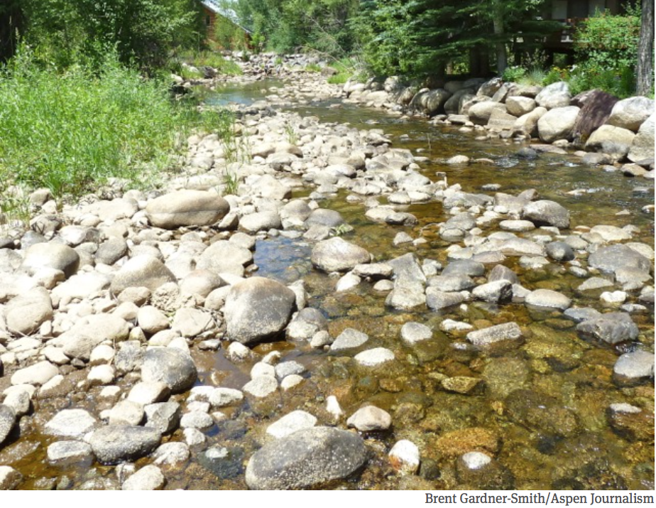
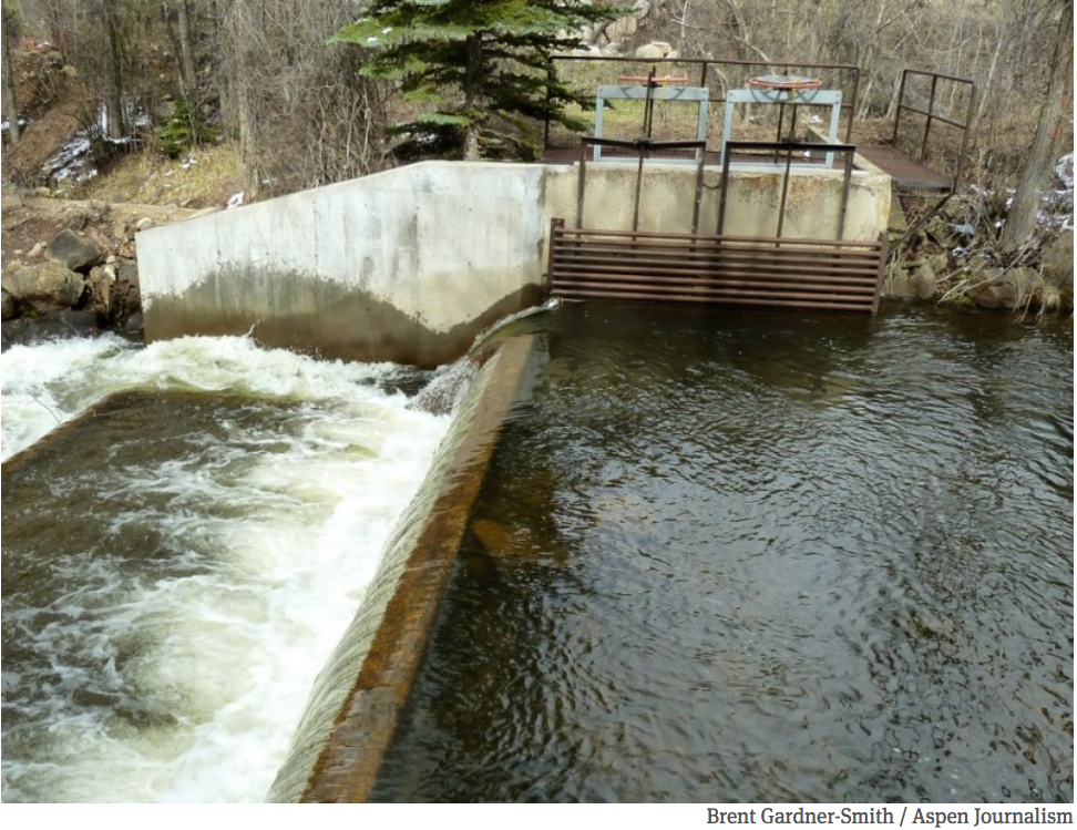
![This image was taken during the peak outflow from the Gold King Mine spill at 10:57 a.m. Aug. 5. The waste-rock dump can be seen eroding on the right. Federal investigators placed blame for the blowout squarely on engineering errors made by the Environmental Protection Agency’s-contracted company in a 132-page report released Thursday [October 22, 2015]](https://coyotegulch.blog/wp-content/uploads/2015/10/goldkingminespill1057am08052015viaepa.png)