Click here to go to the US Drought Monitor website. Here’s an excerpt:
Summary
Outside of the coastal ranges from northern California up to the Olympic Peninsula (along with the Sierra-Nevada), much of the rest of the Lower 48 states had a dry week. Temperatures were also much above-normal in the West and Pacific NW along with the New England region. In addition, even as the El Niño begins to weaken, its influence continues to bring more dryness and drought to the eastern islands of Hawaii…
Great Plains and South
Below-normal temperatures and some additional shots of moisture across North Dakota and northern Minnesota have brought about some adjustments for this week’s map with D1 being reduced in North Dakota accompanied by a trimming of D0 in North Dakota and northern Minnesota for those areas now running around 125% of normal for the Water Year-to-date (WYTD) period (since October 1). The rest of the region remains unchanged and drought free…
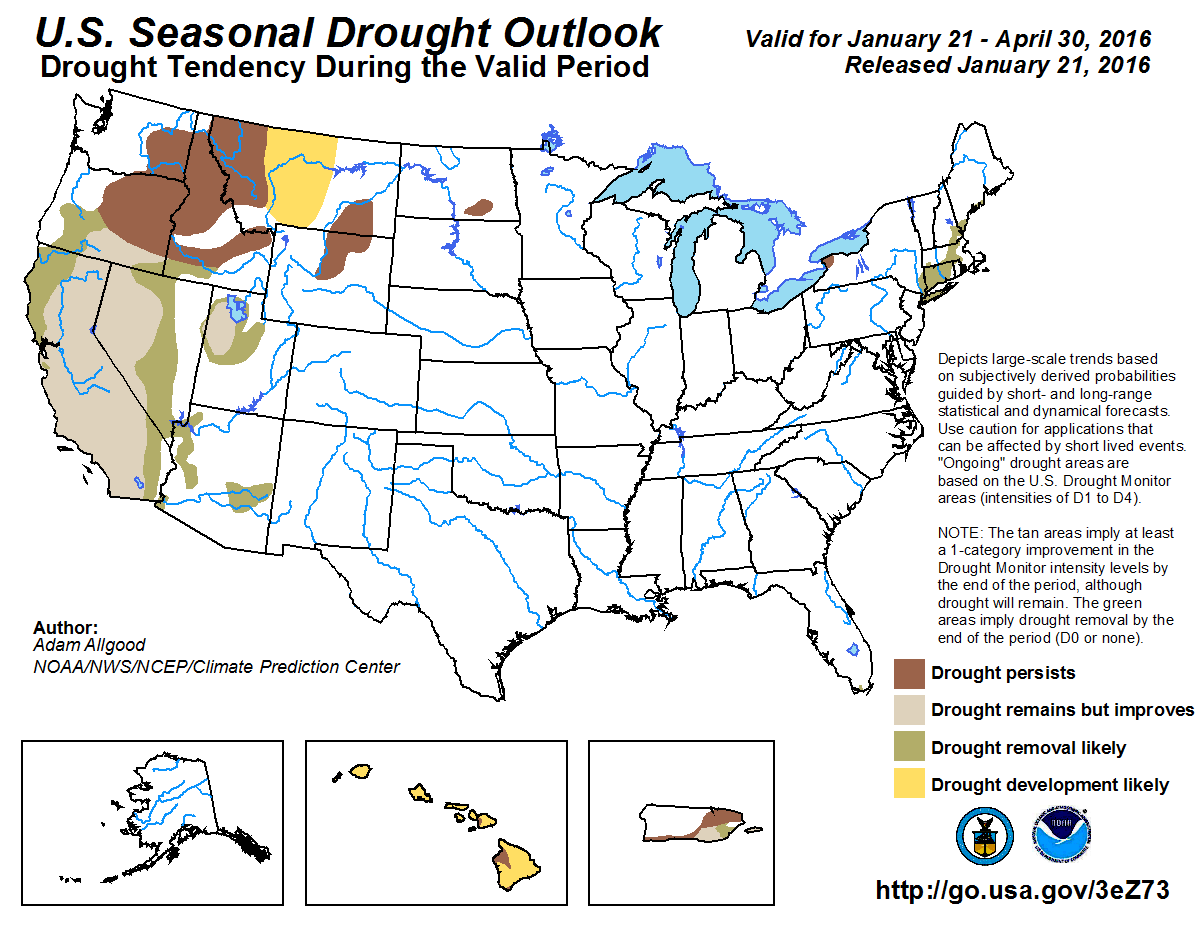
West
Changes abound across the region this week, but are mostly found outside of California where favorable precipitation continues to come in waves (also covering the coastal ranges from northern California up to the Olympic Peninsula in Washington) with favorable prospects for more precipitation on the horizon this week as well (see the “Looking Ahead” section below). That said, there were still some minor improvements (reduction of D0-D2) made this week in extreme northwestern California and southwestern/south-central Oregon in-and-around the Salmon Mountains, Siskiyou Mountains and Klamath region where WYTD snow water equivalents are running well above-normal thus far. This doesn’t mean the region is drought free by any means, but it’s certainly a good start to the Water Year as we sit near the mid-point of the snow season. Now we’ll see if Mother Nature finishes strong or changes her mind.
The biggest improvements on this week’s map can be found in eastern/northern Nevada and across parts of eastern and northern Utah. 1-category improvement for D0-D4 was contained along the eastern flanks in both states with removal of the eastern lobe of D4 in Nevada (generally located prior in-and-around the northern reaches of the Shoshone Mountains) and the eastern lobe of D2 (generally found along the Unita Mountain range) in Utah. The D0-D2 areas were also trimmed and pushed slightly westward in both Utah and Nevada to account for the favorable pattern over the past month or so. This push of improvement to the west also includes the trimming of D0 in northern Arizona as well.
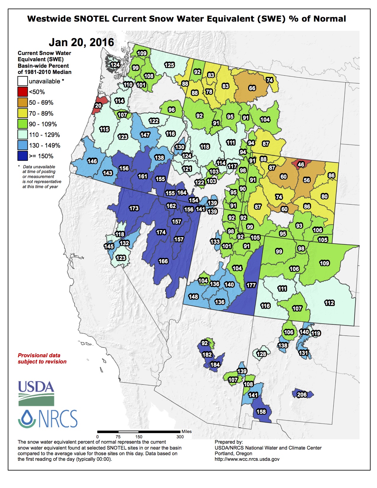
For most of the West, snowpack and snow water equivalent numbers are running above-normal to well above-normal in general. There are still some lagging totals in northern Utah and southeastern Idaho as well as in Wyoming and northwestern Montana. This issue of snow pack will be ever more important as stores of snow will hopefully continue to build as we head into the final half of the snow season, which will then be needed to begin the filling of reservoirs while also providing some buffer against the high demand that will follow come summer. The hydrological impacts (depleted streams, depleted deep soil moisture reserves, reservoirs and ground water) are the last to emerge going into drought and they will be the last to recover coming out. El Niño continues to spur on this slow recovery process (especially for those areas with the long-term “L” drought label), but much more is needed (particularly in the form of snow) to begin chipping away at the “L”, particularly in California and southern Oregon where the multi-year drought has been entrenched for some time now.
Not all areas shared in the improvement though as D0 and D1 continue to expand in western and northern Wyoming from the Big Horn range (30-50% of normal precipitation for the WYTD) west toward Yellowstone. To the north and west, improvement is noted this week in western Montana with the reduction of D0-D2 after recent storms have brought Water Year-to-date precipitation totals up to 125-200% of normal. Even so, this favorable pattern needs to continue in order to improve on the large pocket of D1-D3 found in northwestern Montana…
Looking Ahead
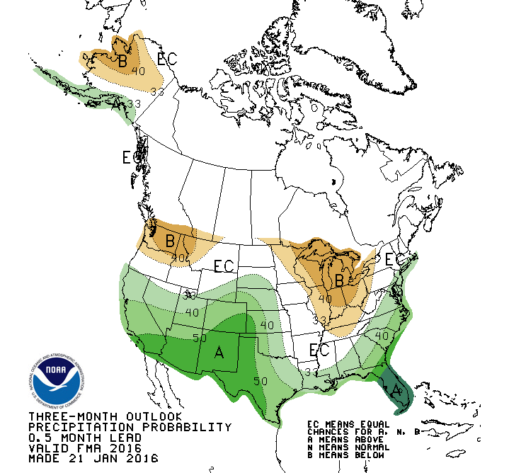
Over the next 5-7 days, temperatures are expected to run well above-normal (3-9 degrees) across the northern tier states from the Pacific NW to the Great Lakes. Below-normal temps are likely across the eastern Great Basin, central Rockies, central Plains, Midwest and across most of the eastern Seaboard from Florida northward into New England. As for precipitation, the best bet for the heaviest totals can be found in east-central California, northern California, and the coastal ranges of Oregon and Washington along with the Gulf Coast and Mid-Atlantic regions.
The 6-10 day outlooks (January 26-30, 2016) are calling for a high probability of above-normal temperatures across the entire western half of the country (from the Mississippi River to the Pacific Ocean) with the greatest signature found along the west coast from San Diego to Seattle. Alaska and New England also seems primed to share in this winter warm spell. Precipitation is also most likely across northern California, the Pacific NW and the Great Basin with a slightly better chance of above-normal rains falling across the Southeast and central Florida in particular. Some strong pockets of dryness are most likely across the country’s mid-section including the Midwest and central/southern Plains.
The Greeley area will be in good shape when it comes to water availability this year if above-average snowpack and water storage continues for the rest of the winter.
Brian Werner of the Northern Colorado Water Conservancy District explained Wednesday when it comes to Greeley and Weld County, they watch the South Platte and the Upper Colorado river basins to determine what the water supply will look like for the year.
As of Wednesday, the South Platte River basin was 9 percent above the historic average for snowpack, and the Upper Colorado basin was 6 percent above historic average.
“So we’re in good shape,” he said. “Anytime you’re above average, you like that. We want to stay there.”
Likewise, the reservoir storage for the South Platte was 7 percent above average and the Upper Colorado storage was 8 percent above average. Storage amounts were recorded Jan. 1.
“It means that Greeley, at this point in time, should have adequate to above-adequate water supply this year,” Werner said.
The El Niño weather pattern likely is a factor in the healthy snowpack so far this winter, said Nolan Doesken, Colorado state climatologist.
“There’s clearly been a much better flow of Pacific moisture this year than in the last few (years) in terms of the midwinter time period, and that’s sort of consistent with El Niño,” he said.
With snowpack in the mountains above the long-term average so far, experts from the drought-stricken Southwest were hopeful.
But water and weather experts said it’s too early to predict how deep the snow will get or how much of the Colorado River water will make its way into the river and on to Lake Powell in Utah and Arizona, one of two major reservoirs on the Colorado.
“We are cautiously optimistic, but nature has a way of doing what it wants,” said Chris Watt, a spokesman for the federal Bureau of Reclamation, which manages the water in Lake Powell.
The Colorado River serves about 40 million people and 6,300 square miles of farmland in Arizona, California, Colorado, Nevada, New Mexico, Utah and Wyoming. Mexico also is entitled to a share of the water.
Lake Powell, behind the 580-foot-high Glen Canyon Dam, has a key role in regulating and distributing the river.
Some people worry there won’t be enough water in the river to go around in the future because of protracted drought, climate change and unrealistic estimates about how much water was available in the first place. Lake Powell is only about half full after multiple dry years.
April is the key time for predicting how much water will flow into the lake from the annual spring snowmelt in the Rocky Mountains, Watt said. The bulk of the snow has fallen by then, and the runoff has begun.
Most forecasts call for average or above-average water flow in the upper Colorado River and other waterways in the state, Doesken said, but the snow season is only about half over and the picture could change quickly.
“We haven’t gotten so much snow that we’re assured of an average or above-average runoff,” Doesken said. “It could turn on us.”
Although it’s looking good, Werner agreed it’s still necessary to be cautious.
“We’re fairly confident at this point but we never get over-confident with Mother Nature,” he said.
The Colorado River Basin is divided into upper and lower portions. It provides water to the Colorado River, a water source that serves 40 million people over seven states in the southwestern United States. Colorado River Commission of Nevada
From the Associated Press (Dan Elliott) via The Durango Herald:
Snowpack in the mountains that feed the Colorado River was slightly above the long-term average on Wednesday – welcome news in the drought-stricken Southwest.
But water and weather experts said it’s too early to predict how deep the snow will get or how much of it will make its way into the river and on to Lake Powell in Utah and Arizona, one of two major reservoirs on the Colorado.
“We are cautiously optimistic, but nature has a way of doing what it wants,” said Chris Watt, a spokesman for the federal Bureau of Reclamation, which manages the water in Lake Powell…
April is the key time for predicting how much water will flow into the lake from the annual spring snowmelt in the Rocky Mountains, Watt said. The bulk of the snow has fallen by then, and the runoff has begun.
As of Wednesday, the accumulated snowfall was 104 percent of normal in the Upper Colorado River Basin, which includes the western half of Colorado, the eastern half of Utah and smaller portions of Wyoming, New Mexico and Arizona.
The river begins near the Continental Divide in Colorado, inside Rocky Mountain National Park.
Most forecasts call for average or above-average water flow in the upper Colorado River and other waterways in the state, Colorado state climatologist Nolan Doesken said, but the snow season is only about half over and the picture could change quickly.
“We haven’t gotten so much snow that we’re assured of an average or above-average runoff,” Doesken said. “It could turn on us.”
The El Niño weather pattern is likely a factor in the healthy snowpack so far this winter, Doesken said.
“There’s clearly been a much better flow of Pacific moisture this year than in the last few (years) in terms of the midwinter time period, and that’s sort of consistent with El Niño,” he said.
Klaus Wolter, a research scientist with the National Oceanic and Atmospheric Administration in Boulder, Colorado, said the state’s snowpack could fall below average during the second half of winter, but the moisture will likely rebound in the spring.
Most of Colorado’s east-facing mountain slopes, which feed the Platte and Arkansas rivers as well as the Rio Grande, ranged from 98 to 112 percent of the long-term average.
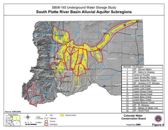
Map of the South Platte River alluvial aquifer subregions — Colorado Water Conservation Board via the Colorado Water Institute From the Sterling Journal-Advocate (Callie Jones):
The Logan County Commissioners heard an update on the dewatering grant Country Club Hills and Pawnee Ridge subdivisions are applying for during a work session Tuesday. Geologist Alan Horn spoke about how the funds will be used and the timeline for submitting the grant applications. The county is acting as a fiscal agent for the grant funds.
The grant program came about when House Bill 15-1778 was signed into law by the governor last year. The bill authorizes the Colorado Water Conservation Board, in collaboration with the State Engineer, to administer a grant program for emergency dewatering of areas in and around Gilcrest and Sterling.
Horn explained each subdivision will submit its own separate grant application, because the issues in each subdivision are different.
A total of $580,000 in grant funding is available for Sterling and Gilcrest, $290,000 for each fiscal year, 2016 and 2017.
“What I feel like would be the best way to approach this would be to try to get something as quickly as possible that could provide immediate relief for these residents in these areas,” Horn said, explaining they would like to start with temporary pipelines laying on the ground, then in the second fiscal year they could apply for funding “that would be sufficient to come out and do the excavation and bury these pipelines.”
In the Pawnee Ridge Subdivision, there are two locations that have been having trouble with high water conditions, Dakota Road and Westwood Drive, near the intersection of Westwood and Summit Drive.
Horn said on Dakota Road what he would like to do is put in a temporary pipeline and take the St. John dewatering well and a dewatering well next door, on Gene Thim’s property, manifold them together and then pump the water up so that it would discharge into the drainage and drain down into the Gentz pond, which is a natural drainage, and then the water would be bypassed on down to the river. When the water level drops work would be done to make the pipeline permanent.
Both wells will pump a total of about 400 gallons a minute.
In the Westwood area there only a couple of houses that have typically been having issues, so he would like to excavate and install a subsurface drain, which would go along Westwood Drive and would have a couple of laterals going up into the property at 18188 Westwood Dr. Horn said the homeowner, Michael Negley, installed a temporary drain several years ago when problems were real bad. Grant funds will be used to install it at a deeper level and “do a little more professional job.”
The PRN 3 well is being used to monitor the water conditions there. Horn noted as of early December the water was only about half a foot below ground surface at that well.
Water from the subsurface drain will make its way to a swell that goes into the Springdale Ditch. Horn estimated there will be no more than 50 to 100 gallons a minute draining out of this area once the drain is installed. He told the commissioners he doesn’t anticipate any damage to property.
Horn brought right of way applications for both Dakota Road and Westwood Drive. Rocky Samber asked if fees are being paid through the grant. Horn wanted to know if the county could waive those fees, which would be $100 to $200 each, because it would be helpful to the project funding availability and the CWCB looks favorably toward applicants that put forth some kind of services or funds. Samber asked if the county in the past has exempted permit fees; Horn said he believes they have.
The commissioners did not make a decision.
For the Country Club Hills Subdivision, all work will take place on public land that is being held in trust by the county, which requires a permit from the county. Horn explained they would like to excavate and install a concrete sump with an inlet structure to the little pond that’s by Cottonwood Lane. Then via a temporary pipeline to begin with — which would be made permanent later — the water would be pumped under Forest Road, under Cottonwood Lane and over to the Springdale Ditch.
He said Springdale Ditch has agreed in principal to work them on this and allow this water to be discharged to their ditch and then conveyed back to the river. Horn pointed out the good news is the water doesn’t seem to be rising as much in Country Club Hills as it is in Pawnee Ridge, so hopefully there will be some extra time to get the agreement with Springdale Ditch in place.
The pipeline will be for to six inches and will pump about 100 gallons a minute.
There was a question about who will pay for the power. The first couple of years it will be paid for by the grant funding and Scott Szabo, a resident of the subdivision, has said that he will pay for the power for future dewatering issues. Horn said there may be other residents that would be amenable to joining with him to help pay for the power.
Dave Donaldson asked if Gilcrest is more prepared to move forward than Sterling. Horn said Gilcrest has already received some funds, $80,000 or $90,000, but they’re running into some difficulties that are preventing them from expending the funds that have already been awarded. He is confident there will be enough funds for Sterling.
Horn said he hopes to have a draft application for the CWCB to review finished by the end of January. On Feb. 17 the South Platte Groundwater Basin Technical Committee will be meeting and will review the applications and pass them on to the CWCB, which will review them in mid-March. Funding should be available in mid-April.
The Security Water and Sanitation District met with the community tonight to address concerns over chemicals that have been detected in the local water supply.
A recent study from the EPA revealed that water in Security, Widefield, and Fountain has traces of PFA, a dangerous chemical.
Although the cities have some of the highest levels, city officials said the levels are still too low to be considered dangerous.
The EPA says the chemical can be removed from water at treatment plants or with activated carbon filters.
All three water districts stress that customers should not be worried about the effect this has on water quality in the area, and said their water is safe to drink.
The EPA is planning to meet with water officials in Security next week to discuss solutions.
Here’s a report about a federal court review of TABOR from Corey Hutchins writing for the Colorado Independent:
Lawyers on Thursday will argue their case before a federal judge about why they believe Colorado’s voter-initiated Taxpayer’s Bill of Rights amendment to the state Constitution is, well, a violation of the U.S. Constitution.
Since passed in the early ’90s, the complex law requires, among other things, that voters must approve of any tax increase. It also mandates governments to rebate money to taxpayers if the government takes in more revenue than expected. A Colorado Springs landlord and anti-tax folk hero named Douglas Bruce championed the amendment first in his home city, and then took it statewide in 1992. Since then it’s been the law of the land in Colorado, and has become a perennial political controversy.
“This is a highly historic case that is deeply important to the state of Colorado, and indeed, the rest of the country,” said Tim Hoover, spokesman for the Colorado Fiscal Institute in a news release about Thursday’s hearing.
“The principle argument of the complaint is that TABOR restructured state government in ways that violate the core principles of representative government guaranteed to every state under the U. S. Constitution,” according to TABORcase.org, which offers background on the lawsuit.
From NOAA. Click through and read the whole article. Here’s an excerpt:
2015 is Earth’s warmest year by widest margin on record;
December 2015 temperature record warm
The globally averaged temperature over land and ocean surfaces for 2015 was the highest among all years since record keeping began in 1880. During the final month, the December combined global land and ocean average surface temperature was the highest on record for any month in the 136-year record.
Global highlights: December 2015
During December, the average temperature across global land and ocean surfaces was 2.00°F (1.11°C) above the 20th century average. This was the highest for December in the 1880–2015 record, surpassing the previous record of 2014 by 0.52°F (0.29°C). The December temperature departure from average was also the highest departure among all months in the historical record and the first time a monthly departure has reached +2°F from the 20th century average.
During December, the globally-averaged land surface temperature was 3.40°F (1.89°C) above the 20th century average. This was the highest for December in the 1880–2015 record, surpassing the previous record of 2006 by 0.86°F (0.48°C).
During December, the globally-averaged sea surface temperature was 1.49°F (0.83°C) above the 20th century average. This was also the highest for December in the 1880–2015 record, . surpassing the previous record of 2009 by 0.36°F (0.20°C)
The average Arctic sea ice extent for December was 300,000 square miles (6.0 percent) below the 1981–2010 average. This was the fourth smallest December extent since records began in 1979, according to analysis by the National Snow and Ice Data Center based on data from NOAA and NASA.
Antarctic sea ice during December was 100,000 square miles (0.9 percent) below the 1981–2010 average.
According to data from NOAA analyzed by the Rutgers Global Snow Lab, the Northern Hemisphere snow cover extent during December was 190,000 square miles below the 1981-2010 average. This was the 19th smallest December Northern Hemisphere snow cover extent in the 50-year period of record.
For extended analysis of global temperature and precipitation patterns, please see our full December report.
Scientists reported Wednesday that 2015 was the hottest year in recorded history by far, breaking a record set only the year before — a burst of heat that has continued into the new year and is roiling weather patterns all over the world.
In the contiguous United States, the year was the second-warmest on record, punctuated by a December that was both the hottest and the wettest since record-keeping began. One result has been a wave of unusual winter floods coursing down the Mississippi River watershed.
Scientists started predicting a global temperature record months ago, in part because an El Niño weather pattern, one of the largest in a century, is releasing an immense amount of heat from the Pacific Ocean into the atmosphere. But the bulk of the record-setting heat, they say, is a consequence of the long-term planetary warming caused by human emissions of greenhouse gases.
“The whole system is warming up, relentlessly,” said Gerald A. Meehl, a scientist at the National Center for Atmospheric Research in Boulder, Colo.
It will take a few more years to know for certain, but the back-to-back records of 2014 and 2015 may have put the world back onto a trajectory of rapid global warming, after a period of relatively slow warming dating to the last powerful El Niño, in 1998…
“Is there any evidence for a pause in the long-term global warming rate?” said Gavin A. Schmidt, head of NASA’s climate-science unit, the Goddard Institute for Space Studies, in Manhattan. “The answer is no. That was true before last year, but it’s much more obvious now.”
Map of the South Platte River alluvial aquifer subregions — Colorado Water Conservation Board via the Colorado Water Institute From the South Platte Sentinel (Forrest Hershberger):
The Logan County Commissioners Tuesday received a report on an effort to lower the water level in the Pawnee Ridge and Country Club Hills subdivisions…
The legislature approved HB 12-1178 which was authored to address the rising ground water in the three communities.
In November 2015, the Logan County Commissioners agreed to act as the fiscal agent for a grant application for projects to correct the problem.
Tuesday the commissioners met with a geologist from the Colorado [Division of Water Resources].
Andy Horn, a geologist, is working with homeowners in the subdivisions who have been affected by high water. In some places, the water table is within inches of the ground surface. Horn approached the commissioners Tuesday about acting as the fiscal agent for a grant application.
He said there will be two applications, one for Pawnee Ridge and the second for the Country Club Hills subdivision.
“The issues in each subdivision are different,” Horn said.
He said HB 12-1178 allocates grant funding for two fiscal years. The Sterling subdivisions will be competing with Gilcrest and LaSalle communities for a share of the $290,000 budgeted.
The plan for the Pawnee Ridge subdivision includes piping water from dewatering wells and discharging it into the Gentz pond. Two wells will be manifold together and a flow meter installed. Horn expects about 400 gallons per minute to be discharged from the wells.
Another area of Pawnee Ridge, near Dakota Road and Westwood Drive, have only a couple of houses with issues, he said. The proposal includes installation of a subsurface drain along Westwood Drive.
He said there is one area that in December had water about six inches below ground level.
“We’ve got applications and also prepared right of way requests for Dakota Road,” he said.
The project in Country Club Hills could involve easements on land under the trust of the board of county commissioners, according to Horn.
The project will also include excavating and installation of a sump by Cottonwood Lane under Forest Road. The pipeline would be four to six inches and move about 100 gpm, he said. Horn said the pipe is bigger than needed. The design is to decrease the resistance.
“The water table doesn’t seem to be rising as much as Pawnee Ridge,” Horn said.
Power for the pump will be paid the first couple of years by a grant, according to Horn.
The Commissioners and County Attorney Alan Samber expressed concern with leaving the cost of the pump’s energy to individual landowners. Samber said a special tax district.
Horn said he would like applications completed and submitted to the Colorado Water Conservation District board by the end of February. The board meets in March.
Colorado Springs city and Utilities officials on Tuesday fended off another in a rash of recent challenges to the massive Southern Delivery System water project, scheduled to start operating April 27.
The Pueblo Board of Water Works agreed to table for one month a resolution supporting Pueblo County efforts to require guaranteed stormwater funding if the SDS is to keep its hard-won 1041 permit.
Pueblo County issued that permit only after Colorado Springs Utilities spent years negotiating and crafting complex agreements with county, local, state and multiple federal agencies.
It’s the key to the $829 million SDS, one of the biggest modern-day water projects in the West, geared to deliver up to 50 million gallons of water a day to Pueblo West, Colorado Springs, Fountain and Security.
But Utilities’ massive project and its 1041 permit are not to be confused with the city of Colorado Springs’ beleaguered MS4 permit, SDS Director John Fredell told the Water Works board.
The city’s MS4, or Municipal Separate Storm Sewer System permit, is vulnerable since longtime neglect of critical stormwater controls led the U.S. Environmental Protection Agency to cite the city in October with multiple violations.
For years, Colorado Springs hasn’t properly enforced drainage regulations, conducted adequate inspections, required developers to provide enough infrastructure or maintained and operated its own stormwater controls adequately, EPA inspections in August concluded. [ed. emphasis mine]
Now city officials are negotiating with the EPA and the Department of Justice to maintain the MS4 permit. They don’t deny the EPA’s claims. Indeed, they had discussed the problems and started scrambling for solutions shortly after John Suthers was sworn in as mayor last June, months before the EPA inspections.
Fountain Creek Watershed
But downstream Pueblo County has been a prime victim of Colorado Springs’ failure to control stormwater surging through Fountain Creek and its tributaries. And the county holds the 1041 permit, which some believe could be used as leverage.
As Colorado Springs development has sprawled farther, more sponge-like land has morphed into impermeable pavement, leaving stormwater roiling across the terrain.
Sediment in Fountain Creek has increased at least 278-fold since the Waldo Canyon fire in 2012, pushing water levels far higher, reported Wright Water Engineers Inc. of Denver, contracted by the county. [ed. emphasis mine]
Sediment grew from 90 to 25,075 tons per year while water yields increased from 2,500 to 4,822 acre-feet, the engineers found. [ed. emphasis mine]
City and Utilities officials have been meeting with those engineers and their own consulting engineering firm, MWH Global, to prioritize projects.
They’ve developed a list of 73, including 58 projects recommended by Wright Water, said city Public Works Director Travis Easton. Work on the first of those commences next week, with detention ponds to be developed along flood-prone Sand Creek near the Colorado Springs Airport.
But skepticism lingers in Pueblo County, despite that effort plus creation of a new Stormwater Division, more than doubling the number of city inspectors and enforcement staff and the vow to dedicate $19 million a year to stormwater solutions.
They’ve heard promises before, Water Works board members noted Tuesday. They want a guaranteed, ironclad source of funding to stanch the stormwater that inundates their communities. And they want it yesterday.
“History’s important,” said Dr. Thomas V. Autobee, a Water Works board member.
Jay Winner, executive director of the Lower Arkansas Valley Water Conservancy District, had threatened in August to file a federal lawsuit against Colorado Springs for violations of the Clean Water Act.
Tuesday, Winner reminded the water board of how the then-Colorado Springs City Council eradicated its stormwater enterprise fund in 2009 – soon after the 1041 permit was issued – “the definition of hoodwink.”
Voters had just passed Issue 300, requiring payments to city-owned enterprises to be phased out. The subsequent council vote still rankles downstream Fountain Creek denizens.
Still, that fund never provided more than $15.8 million, Fredell noted. By contrast, the city and Utilities now are determined to spend more than $19 million a year on stormwater for at least 10 years.
They’re working on an intergovernmental agreement that would provide the guarantees Pueblo County seeks.
“Enforceablity is always an issue,” Mark Pifher, SDS permitting and compliance manager, told the Water Works board. “But we’re in discussion with the EPA and Department of Justice. The handwriting is on the wall. There will be either a consent decree or a federal order, and nothing is more enforceable.”
“If we can work this draft into something sustainable,” Autobee said, “that’s what I’d like to see.”
Board Chairman Nicholas Gradisar said he’s encouraged by the city and Utilities’ concerted efforts and swift action. “What I’m not encouraged by is the inability to come to agreement with Pueblo County.”
Gradisar said the funding must be guaranteed in perpetuity, not only 10 years, with an enforcement mechanism that doesn’t require a federal lawsuit.
Suthers, City Council President Merv Bennett and Utilities officials will meet with the Pueblo County Board of Commissioners at 1:30 p.m. Monday to continue discussions on the fate of the 1041 permit.
That meeting is in commission chambers at the old downtown Pueblo County Courthouse, 215 W. 10th St.
That night, the Pueblo City Council is to decide on a resolution similar to that tabled by the Water Works Board. It would support the county’s efforts to obtain sustained stormwater funding from Colorado Springs.
The council meets at 7 p.m. Monday at City Hall, 1 City Hall Place, in Council Chambers on the third floor.
More coverage from Chris Woodka writing for The Pueblo Chieftain:
The Pueblo Board of Water Works decided to wait a month before dipping its toes into the fray between Colorado Springs and Pueblo County over the Southern Delivery System.
The board tabled a resolution demanding a permanent funding mechanism for stormwater control on Fountain Creek in connection with Pueblo County’s 1041 permit with SDS, after testimony muddied the waters.
After SDS Project Director John Fredell tried to convince the water board that the two issues are not related, Jay Winner, general manager of the Lower Arkansas Valley Water Conservancy District cried foul.
“When you talk about stormwater, it’s not about the law or politics,” Winner said, turning to Colorado Springs ocials and inviting them to look at the damage along Fountain Creek in Pueblo. “The people are the ones getting injured. You need to do something about stormwater. You people are causing the issue.”
Winner said the Lower Ark district has tried for more than a decade to get Colorado Springs to agree to permanent funding.
Colorado Springs City Council President Merv Bennett, under questioning by water board President Nick Gradisar, admitted that Colorado Springs has not been in compliance with its stormwater permit. He, along with Colorado Springs Councilman Andy Pico and Public Works Director Travis Easton, explained in detail how the city would spend $19 million annually to address stormwater control.
About $12 million would go toward capital costs and $7 million to maintenance.
“It’s not only for downstream users, but for the benefit of Colorado Springs,” Bennett said. “We’re not waiting.
We’re moving forward.”
Colorado Springs is trying to negotiate a 10-year agreement with Pueblo County to ensure the funds stay in place.
Part of the water board’s resolution was to support Pueblo County in the bargaining.
Gradisar questioned whether that would go far to cover $500 million in identified stormwater projects, and blamed politics for the failure of past efforts to fund flood control.
“Left to its own devices, Colorado Springs Utilities would have taken care of these problems,” Gradisar said.
Southern Delivery System route map — Graphic / Reclamation
“But your voters . . . they probably wouldn’t have passed SDS.”
Water board member Tom Autobee brought up the issue of the $50 million Colorado Springs Utilities promised to pay to the Fountain Creek Watershed Flood Control and Greenway District when SDS goes on line.
Fredell explained that the SDS pipeline, pumps and treatment plant still are in testing, so Utilities does not believe the payment is due until 2017 under the 1041 agreement. Fountain Creek district Executive Director Larry Small, a former Colorado Springs councilman, said it should have been paid last week.
Fredell argued that stormwater control is not a condition of the 1041 permit, since the permit deals with new growth related to SDS.
Since SDS is not serving customers, it does not apply, he said.
“But the damage is being caused now, what happens with SDS,” Gradisar replied?
That drew a reaction from Pueblo West Metropolitan District board member Mark Carmel, who questioned whether SDS was just a speculative venture for Colorado Springs. He called for reopening the entire 1041 permit to incorporate new concerns.
Water board member Mike Cafasso said the draft resolution presented at Tuesday’s meeting could be improved and moved to table it. Other board members agreed to take it up again at the board’s February meeting.
From email from the Urban Waterways Restoration Study:
Open House #2
for the
South Platte River:
Wednesday
January 20th, 5:30 – 7:30 pm,
R.E.I.
1416 Platte St.
2 hrs of Free Parking available for this meeting in R.E.I’s underground parking structure.
Open House #2
for
Weir Gulch:
Tuesday
February 2nd, 5:30 – 7:30pm,
Barnum Rec Center
360 Hooker St.
Give us your feedback on alternatives
Open House Format from 5:30 – 7:30 p.m.
Formal Presentation of the preliminary alternatives’ range of options will be from 6:00 – 6:45 p.m for South Platte and from 5:45 – 6:30 for Weir Gulch.
This is a family-friendly event. Light refreshments will be provided. Spanish language interpretation will be available. Other language interpretation can be provided by contacting us at our website.
Click here to read the newsletter. Here’s an excerpt:
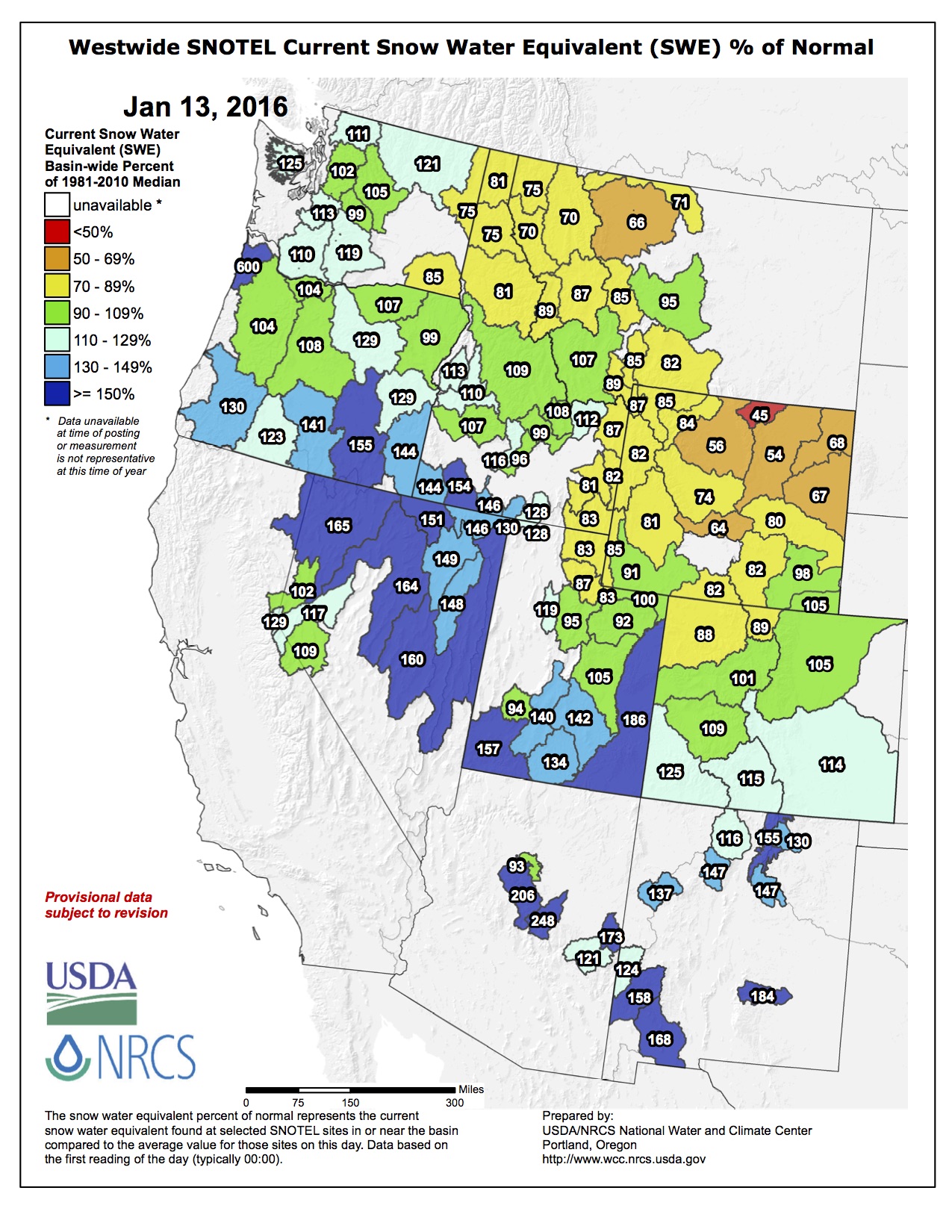
Snow accumulation season looks promising
Colorado’s 2016 snowpack is off to a good start. Most of the state’s river basins have above normal snowpack, and more importantly, above normal snow water equivalent readings. Northern Water monitors two river basins for forecasting – the Upper Colorado and the South Platte – which are at 99 percent and 105 percent of average, respectively, as of Jan. 14, 2016. Colorado’s statewide snowpack is 104 percent of average.
Precipitation in the mountains over the next few months will help determine the 2016 water supply. The National Oceanic and Atmospheric Administration is predicting a higher probability of above average precipitation for Colorado over the next three months. Beginning in February Northern Water will release monthly streamflow forecasts and which will be available here.
[In] February of 1972, the band was in England with Johns recording their self-titled debut. Eagles was released in June 1972 and featured three Top 40 singles, including the Frey-sung “Take It Easy.”
In later years, Frey, Henley and Joe Walsh, who joined the band in 1975, would maintain homes in Colorado.
CU T-shirts and Mile High shows
The band, which split in 1980 and reunited in 1994, has passed through Colorado frequently over the years.
In their initial run, the Eagles performed at CU’s Folsom Field in 1978 and 1980 — which may help explain’s Frey’s onetime penchant for wearing CU T-shirts on stage, as can be seen in old performance footage on YouTube and the documentary “History of the Eagles.”
Dave Plati, the Buffs’ sports information director, delved into that subject in a 2013 blog post, seeking input from longtime CU fixture J.C. Ancell, who served as staff adviser to Program Council — which put on campus concerts — in the ’70s.
“They used to let CU athletes in the back door in exchange for CU gear, and the Eagles often wore the shirts on and off the stage,” Ancell told Plati. “At the CU show (at Folsom Field on July 29, 1978, on their Hotel California tour), they made a deal for some backstage passes in return for a load of jerseys and other gear.
“Frey always seemed to like the CU-branded stuff.”
In 2001, the Eagles were selected to christen Denver’s just-completed Invesco Field at Mile High, performing the first-ever concert at the stadium now named Sports Authority Field.
Several more Pepsi Center dates followed in the 2000s, with the band most recently performing in Denver in 2013.
At a 2003 concert, according to the Daily Camera’s review, Frey seemingly acknowledged the Eagles’ latter-day reputation for exorbitant ticket prices.
“You’re paying, and we’re playing,” he quipped to fans, who’d shelled out up to $150 apiece to see the Pepsi Center show.
Some folks were a bit wary of a request this week from a Denver metro group for financial assistance with a water project that local water leaders were concerned might facilitate water exportation from the San Luis Valley to the Front Range.
Eric Hecox, executive director of the South Metro Water Supply Authority, asked members of the Rio Grande Basin Roundtable water group this week for $10,000 from the roundtable’s basinallocated funds for the WISE (Water, Infrastructure and Supply Efficiency) Project.
Hecox made his initial presentation this week and will return next month with the formal funding request. He told local roundtable members he had already visited the other eight basin roundtable groups throughout the state and they had been supportive of putting $10,000 each into this project in an effort to show cross-basin cooperation and support for local projects.
Hecox said the basin support would help leverage money from other sources and serve as a cash match. He said while most of the basin roundtables committed to $10,000 each, the metro basin committed $40,000 and the South Platte roundtable $15,000 towards the WISE project.
Hecox explained that the South Metro Water Supply Authority is made up of 13 independent water providers that serve areas like Highlands Ranch, Parker and Castle Rock.
What brought these groups together, Hecox explained, was their common issue of having non-tributary nonrenewable groundwater as their water supply. The group has been working together towards a better water source solution since the 1960’s and 1970’s , Hecox said, and had participated in the Two Forks Project, a dam project that never materialized . “Two Forks going away didn’t change the need for storage,” he said. To roundtable member Charlie Spielman’s comment that Two Forks was being built one gravel pit at a time, Hecox said rather than one big bucket, there are lots of smaller buckets filling that same need, and there are a lot of gravel pits being used for water storage.
“That’s not a component of our project,” he said. The authority has tried to reduce water use through significant conservation efforts , he added, and the per capita water use in their communities has decreased by 30 percent since the 2000’s .
The latest idea prompting the WISE project is to partner with Denver and Aurora water providers, which do have renewable supplies, to reuse their municipal effluent , Hecox explained. The WISE project will encompass a treatment facility that will treat that water so it can be distributed to participating communities through existing pipelines. The authority purchased the pipeline for $34 million, Hecox said, which is being changed from its original use to be used for this project.
The authority will pay Denver and Aurora $5.50 per thousand gallons to use their water supplies, pipe the water, treat it and distribute it to about two million people in the South Metro Water Supply Authority area.
Groundwater and surface water will be comingled in the pipeline, Hecox explained . He said the funding being requested from roundtables as a local match will help build a treatment plant for the groundwater, which will cost about $6.4 million.
The authority is combining $5.4 million in matching funds and will submit a grant request for $915,000, according to Hecox.
Hecox said the Rio Grande Roundtable should support this project because it addresses the statewide gap between supply and demand and because it would support the new approach of regional partnerships to address water issues throughout the state.
Hecox said that the communities in the South Metro authority have, much like many water users in the Rio Grande Basin (San Luis Valley), relied on groundwater resources, so they are trying to become mores sustainable, and the option of reusing Denver/Aurora effluent is one method of accomplishing that. The WISE project will allow area water resources to be reused multiple times, Hecox explained.
The water that the authority will be buying from Denver and Aurora was previously going down the South Platte, Hecox said.
“This will use water that was going downstream,” he said.
He added that Aurora had a few short-term leases on its water previously, but this would be a permanent one.
The authority is guaranteed supplies from Denver and Aurora until 2030, he said.
Roundtable member Steve Vandiver, general manager of the Rio Grande Water Conservation District, said this seemed to be opening up a new distribution system for the entire metro area that would make it easier to import water from other parts of the state, such as the Valley. He added that there is an export project currently proposed in the northern part of the San Luis Valley, and there have been continuous overtures over time from water speculators wishing to benefit from exporting water out of the Valley. It would seem that the WISE project would fit right into their plans, he said.
Hecox admitted the WISE project would not meet all of the metro water needs in the future, and the authority is looking at other water sources such as a cooperative project with Denver and the West Slope as well as an alternative agriculture transfer program in the South Platte Basin.
He said when the authority began the WISE project it was looking at a need for 60,000 acre feet of reusable supplies. With the WISE project, the authority is now looking in the 15,000-30 ,000-acre-foot range “above and beyond this,” he said.
He said some of Aurora’s water supply is coming from the Arkansas Basin “but none from the San Luis Valley/Rio Grande Basin.”
He said, “To my knowledge Aurora is not looking at any supplies in the Valley or the Rio Grande.”
Vandiver said the likely plumbing for any export from the San Luis Valley would be through the Arkansas Basin.
The plan we have seen would come out of here to the Arkansas,” Vandiver said. “This completes the pipeline from us to south metro ” The concern for us is that’s not necessarily a good thing for the Valley.”
Hecox said when this project began, Denver water leaders were concerned their water would be used for additional growth in Douglas County, and there are areas that are zoned, platted and designated for development, but the houses have not yet been built. He added that developers in Douglas County had not yet approached the metro water authority or its members to use the WISE project water.
He said the purpose of the WISE project would be to reuse existing water supplies for existing communities.
The roundtable took no action on Hecox’s request this week but may do so next month.
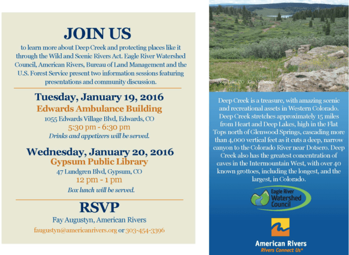
Click here for all the inside skinny from Conservation Colorado. From the website:
Conservation Colorado is joining Montezuma Land Conservancy as they host the 5th Annual Wild & Scenic Film Festival! Doors will open at 5:45 PM and films will roll at 6:30 PM. FREE wine and Dolores River Brewery beer will be provided. Yummy food will be sold separately by the Dolores PTO. Eleven inspiring films will be shown, and there will be door prizes and an awesome drawing for new members. Come learn more about conservation while enjoying local beer and great films!
Tickets are $12 in advance, $15 at the door, $5 for children.
The water in flint, michigan could affect children permanently
How is lead introduced to the body?
Humans have long known that lead can cause detrimental health effects—some claim it contributed to the fall of the Roman Empire. But the substance’s effects were first documented in children about a century ago, says Jay Schneider, a neuroscientist at Thomas Jefferson University. However, lead was still common in many household products—especially paint, in which it was used to add color and stability the mixture, until it was banned in 1978.
Lead paint, turning into dust and chips as it falls from the walls of old houses, is one of the most common ways in which children are exposed to the substance. But it shows up in other surprising places, too—in many vinyl-based products like shower curtains and raincoats, telephone cords, and some that are even designed explicitly for children, such as lunch boxes and toys.
The substance’s effects were first documented in children about a century ago.
Lead can be ingested, through water or other contaminated substances–the Environmental Protection Agency limits the amount of lead in water to 15 micrograms per liter, though some toxicologists think that limit should be lowered to 10 micrograms per liter. Lead can also be inhaled or sometimes even absorbed through the skin, though lead can’t move from water into skin, so it’s safe to bathe in lead-contaminated water as long as you don’t drink it.
Once it’s in the body, lead competes with calcium to be absorbed by the body. There are lots of factors that can affect just how much of the lead is absorbed, but there is an overall higher absorption rate for lead that is inhaled versus ingested. It sticks to red blood cells—doctors usually test the blood for proof of exposure to lead—and then moves into soft tissues, like the liver and lungs. If lead is absorbed into bones, it can stay there for decades and recirculate in the person’s blood if a bone is broken or when a woman is pregnant, potentially poisoning both the mother and the fetus.
What are the health effects and dangers of lead?
When cells in the brain absorb lead, it tends to affect the frontal cortex, the area responsible for abstract thought, planning, and attention, and the hippocampus, essential to learning and memory. But the resulting symptoms vary a lot between individuals, Schneider says. “You don’t often see the same kinds of cognitive dysfunction in all kids,” he says. “From what our research has shown, there are very significant differences in the way different brains respond to this particular toxin.”
Factors like age, sex, amount of lead in the body, and genetic makeup can drastically alter the particular combination of symptoms caused by lead poisoning in the brain–younger children and boys display the strongest neurological effects.
One thing is constant, however: lead is toxic, and if it makes its way into the still-developing brains of young children, many of the effects can be permanent. Lead can change how signals are passed within the brain, how memories are stored, even how cells get their energy, resulting in life-long learning disabilities, behavioral problems, and lower IQs.
“It can really change the programming of the brain, which will have considerable effects on subsequent behavioral and brain function,” Schneider says. “As we learn more about lead and its effects on the brain, even down to these molecular levels, if anything it’s even more dangerous than we thought.”
What are the treatments for lead exposure?
If you suspect that your child might have lead poisoning, Schneider recommends getting a complete evaluation from a pediatrician.
If a child has in fact been poisoned, however, there are woefully few treatments available. For very high levels of lead in the blood, doctors can give children chelation therapy, a chemical that binds to the lead so that the body can’t absorb it. “That can help to protect the peripheral organs, but most agents used for [treatment] don’t do anything to fix the damage that’s already been done,” Schneider says. There is no treatment for low levels of lead in the blood.
Another attempt to allow Coloradans to collect rain water that falls on their roofs has started with a drizzle of legislation.
Reps. Jessie Danielson, D-Wheat Ridge, and Daneya Esgar, D-Pueblo, introduced the first piece of legislation on the subject Wednesday, the first day of the new legislative session.
The measure is written similar to legislation last year, which died on the second-to-last day of the session after it never received a Senate floor vote.
“It’s so simple. You’ve got rain that falls on your roof. You want to store it in a barrel to put it, instead of on your lawn or on your sidewalk, on your tomato plants or your flowers,” said Danielson, the daughter of a Weld County farmer. “It’s really straightforward, and it makes a lot of sense.”
The bill would allow people to capture rain from their roof in up to two 55-gallon barrels for use in their garden or on their lawn…
Sen. Ellen Roberts, R-Durango, found herself stuck in the middle of the debate last year, working to convince her fellow Republicans, who control the Senate, to give the bill a floor vote, where it would have passed with her support.
Sen. Jerry Sonnenberg, R-Sterling, chairman of the Senate Agriculture, Natural Resources and Energy Committee, led opposition to the bill, raising concerns over eroding the state’s prior appropriations system, in which water rights are granted to the first person to take water from an aquifer or river, despite residential proximity.
Sonnenberg suggested requiring rain-barrel users to register their barrels with the state and requiring local water providers to replace water taken from rooftops.
“It was extremely burdensome and regulatory in nature, and I couldn’t support it, but I certainly appreciated him spending some time to think about what would be a path forward from his perspective,” Roberts said of Sonnenberg’s effort. “I don’t want a police state over rain barrels.”
For his part, Sonnenberg said on Friday that he is open to a new discussion this year. He is holding off on introducing his own measure on the subject to see if he can secure a compromise with the bill that has been introduced.
At the top of his list, Sonnenberg would like the Office of the State Engineer, which handles water resources, to study the issue to determine whether there would be an impact to water rights, or if the result would be too minor to merit consideration.
He would also like the legislation to consider impacts to all bodies of water in the state – such as a groundwater basin – instead of just streams.
Proponents feel vindicated after researchers with Colorado State University in September reported that allowing 100 gallons of rainwater storage per household would not decrease surface runoff by any detectable amount on a typical lot.
But Sonnenberg remains skeptical, stating that the study took into account only runoff with or without rain barrels. He said it’s possible that barrels would lead to less runoff.
“The CSU study is flawed,” he said. “CSU … has lost some credibility for not doing their due diligence with regard to water and bringing us numbers. They did not bring us numbers that add up.”
Sonnenberg has, however, backed off on the registration requirement, stating that the proposal was just a starting point.
“All I need is someone responsible and a solid legislative declaration, and I think I can convince my other folks in the water community that do not like this, that absolutely hate this, that this is a good compromise,” he said.
Channel erosion Colorado Springs July 2012 via The Pueblo Chieftain FromThe Pueblo Chieftain (Chris Woodka):
The Pueblo Board of Water Works Tuesday will consider a resolution that calls for Colorado Springs to find a permanent source of funding for stormwater control of Fountain Creek.
The resolution was provided to The Pueblo Chieftain by board President Nick Gradisar. It ties a recent Environmental Protection Agency audit of stormwater violations to a 2004 intergovernmental agreement among the board, Colorado Springs Utilities and the city of Pueblo as well as the 2009 Pueblo County 1041 permit for Southern Delivery System.
The action would direct Executive Director Terry Book to contact the EPA to relay the community’s concern over the stormwater permit violations, which were revealed in November.
It also supports Pueblo County in its enforcement of the 1041 permit, which could delay the expected operation of the SDS pipeline in April.
The water board resolution also says Utilities, which was the lead agency for obtaining the 1041 permit, should have more of a role in the stormwater negotiations.
“Pueblo Water believes any revised 1041 permit or agreement must provide an adequate enforcement mechanism such that future funding of stormwater infrastructure is no subject future funding of stormwater infrastructure is no subject to the whims of different political leaders in Colorado Springs or the other SDS participants,” the proposed resolution reads in part.
It also suggests the stormwater regulations need to be in place for as long as the SDS pipeline is in operation.
That echoes concerns expressed last year by Jay Winner, general manager of the Lower Arkansas Valley Water Conservancy District, who suggested stormwater should be a fifth utility for Colorado Springs along with water, sanitary sewer, gas and electric service.
Colorado Springs had a stormwater enterprise in place in 2009 when it received federal and Pueblo County approval to build SDS, a 50-mile, $841 million water delivery pipeline from Pueblo Dam to Colorado Springs.
After a vote to sever utility payments from the city’s general fund in November 2009, Colorado Springs City Council chose to abolish the stormwater enterprise, but left other revenuesharing mechanisms in place.
The Lower Ark has placed its proposed federal court action on hold until EPA enforcement of the state stormwater permit under the federal Clean Water Act is complete.
Pueblo County is still contemplating whether Colorado Springs has met its stormwater obligations under the 1041 permit.
Pueblo City Council is scheduled to vote on a resolution requiring Colorado Springs stormwater compliance at its Jan. 25 meeting.
Colorado Springs Mayor John Suthers and City Council have proposed a plan to redirect $19 million annually from other city and Utilities funds.
Meanwhile, here’s the view from upstream via The Colorado Springs Gazette (Billie Stanton Anleu):
Colorado Springs is revving up its stormwater program, more than doubling its staff of inspectors and engineers to deflect lawsuit threats and fix problems cited by Pueblo County and the U.S. Environmental Protection Agency.
Mayor John Suthers vowed from the start of his tenure in June to address the city’s long-neglected stormwater problems, and he soon started carving $16 million from the city’s 2016 budget to add to $3 million from Colorado Springs Utilities.
“I can’t emphasize enough, this money wasn’t easy to come by,” Suthers said. “I’ve got a lot of unhappy police officers and firefighters out there,” because raises and staff additions were frozen for the year.
That $19 million dedicated to stormwater issues this year compares with $5 million from the city’s general fund in 2015, though federal grants bolster expenditures yearly. But Pueblo County officials are lamenting the loss of the Stormwater Enterprise Fund, which the City Council dismantled in 2009. They’re pointing to the eradication of that fund as cause to possibly rescind the 1041 permit they issued to Utilities to build and operate the $829 million Southern Delivery System.
The timing of the threat couldn’t be worse. The enormous project is scheduled to start pumping April 27, delivering up to 50 million gallons of water a day to Pueblo West, Fountain, Security and Colorado Springs.
Meanwhile, the EPA has threatened to sue Colorado Springs for not meeting terms of its Municipal Separate Storm Sewer System permit, better known as the MS4. After inspections in August, the EPA reported that the city didn’t have enough resources, inspections or internal controls to maintain and operate its stormwater infrastructure properly. The city also doled out too many waivers and failed to hold developers’ “feet to the fire,” the inspectors found.
Water, of course, flows downstream. So unrestrained stormwater, excessive sedimentation and degraded water quality become problems for the people in Pueblo County.
Neither Suthers nor the City Council has denied the magnitude of those problems. Indeed, the city and Utilities have proposed an intergovernmental agreement that would guarantee a minimum of $19 million a year in floodwater projects for 10 years. Utilities would be on the hook if the city experienced an economic downturn.
In addition, the city is creating a Stormwater Division to be staffed by 58 full-time employees compared with the current 28, adding inspectors and engineers.
The budget for MS4 compliance alone is increasing from $3 million to about $7.1 million. The total comes to $8.56 million if you include the cost of MS4 responses by street sweepers, firefighters and Utilities.
From the Colorado Springs Business Journal (John Hazlehurst):
Known as perfluoroalkyls, or PFAs, research suggests the chemicals are potent carcinogens and endocrine disrupters at levels far below the Environmental Protection Agency’s provisional exposure limits for drinking water.
And no one seems to know where the contaminants are coming from — or even that they were there in the first place. The city of Fountain’s 2015 Drinking Water Quality Report doesn’t mention PFAs or any other “unregulated reportable contaminant.”
Ron Woolsey, who heads Fountain’s Water Department, was unaware of any PFA contamination of the city’s water supply or of the EPA test results. It’s not clear if the EPA reported these results to the three affected systems.
“We get about 70 percent of our water from the Frying Pan/Arkansas project, via Pueblo Reservoir,” he said. “The remaining 30 percent comes from wells in Fountain and wells on the Venetucci Farm that we share with Security and Widefield. When [CSU’s] SDS [Southern Delivery System] comes on line, we’ll get 100 percent of our water from Pueblo Reservoir.”
CSBJ provided Woolsey with links to source documents uncovered for this story.
“Thanks for that information,” he said. “You’re sort of the canary in the coal mine for us. We’re going to investigate further, talk to [Colorado Department of Public Health and Environment] and figure out what the next step will be. Those [PFA substances] sound pretty alarming.”
Both Colorado Springs and Pueblo use Fry-Ark water, and no PFAs were detected in their water systems.
It could be that water from Fountain Valley wells or surface water sources are contaminated by either landfills or residue from industrial processes, but no one is really sure.
FromThe Grand Junction Daily Sentinel (Dennis Webb):
The Colorado River District has been given some breathing room for dealing with a problem dam at its Wolford Mountain Reservoir five miles from Kremmling.
A three-person outside team of dam experts has advised the district that the Ritschard Dam is safe despite the settling that has occurred there, no immediate action is required, and the district should be deliberate in determining how to address the problem.
“The Consultant Review Board has emphatically emphasized that time is on our side,” the district’s chief engineer, John Currier, said in a memo to the district board in advance of its meeting next week.
The recommendation comes as good news to the district, which has identified the dam as the most important issue it currently faces. It already has spent about $1.5 million to install sophisticated instruments to measure the dam’s settlement. Since its completion in 1995, the rock-fill, clay-core dam has settled near its center by about two feet. While earthen dams settle, in this case the drop was a foot more than expected. The dam crest also has shifted about eight inches downstream.
The three-person team, district staff and consulting engineers are now proposing that the district hold a workshop with the Dam Safety branch of the Colorado Division of Water Resources and Denver Water, which has a leasehold interest in the reservoir, to consider next steps.
“We were thinking that some kind of work would begin in 2016 or (20)17, to begin some kind of remediation program, but now we’re saying OK, let’s dig deeper into the issue based on this third-party finding,” district spokesman Jim Pokrandt said.
He said the finding means the district has more time to make sure it takes the right next steps regarding the dam. The most expensive repair would involve rebuilding the dam, which several years ago the taxpayer-funded district estimated could cost $30 million. Another approach could involve injecting concrete into the dam to reinforce it.
The original dam and reservoir project cost $42 million, including land acquisition, permitting, construction and other expenses…
The dam sits on Muddy Creek, a tributary of the Colorado River. The river district has consulted with the town council of Kremmling, which is downstream of the reservoir on the Colorado River, and Grand County commissioners. It also has held public meetings and kept emergency managers informed of the situation.
Bill McCormick, the state’s chief of dam safety, agrees that there is no reason for immediate concern regarding the dam.
“It is displaying some unusual behavior but (the findings of) all the analysis that’s been done to date is that it’s not creating unsafe conditions,” he said.
Still, he said he thinks everyone involved agrees there’s a long-term issue pertaining to continued settling, which requires a long-term solution.
“The long-term solution isn’t clear or obvious just yet but we’re continuing to work on it,” McCormick said.
Upper Black Squirrell Creek Designated Groundwater Basin
FromThe Colorado Springs Gazette (Ryan Maye Handy):
For years, the Cherokee Metropolitan District has failed to meet one of its water quality standards, and the eastern El Paso County water district has proposed a change in state regulations to make it easier to meet that requirement.
The proposal has started an unorthodox process with the state’s Water Quality Control Commission to allow the district to have a higher level of dissolved solids – like salt – in its water. The change would only affect wells in the district, but the proposal has raised concerns from well-owners about the health of the system’s aquifer and prompted three stakeholder meetings before a rulemaking hearing in August.
The Upper Black Squirrel Creek aquifer has already been degraded by the number of wells that tap into it, well owners argue. Wells in the Cherokee district pull from an aquifer that is recharged with treated wastewater – water that, under a new requirement, would have more dissolved solids. If Cherokee fails to change regulations for its so-called “total dissolved solids” levels, it will have to spend tens of millions of dollars to meet current state requirements – a cost that will be borne by the district’s ratepayers.
The problems date back to 2010, when a new waste water treatment facility was completed without machines to treat water for total dissolved solids, known as TDS. At a Tuesday stakeholder meeting, the first in a series, Cherokee’s General Manager Sean Chambers described the consequences of this to a group of around 30 people.
“So whatever comes in the waste water plant in terms of total dissolved solids comes out the other end,” Chambers said. “Thus, we have a $30 million waste water plant that does not treat a lick of TDS.”
The district’s drinking water quality more than complies with state requirements for dissolved solids levels, but the levels in waste water pose problems. The water district typically measures 600 mg per liter of dissolved solids in its treated waste water, well over the state requirement of 400 mg per liter, said Chambers. Ever since the district opened its new facility in 2010, it has never been compliant with state standards for dissolved solids. By changing the level allowed in its water, the district hopes to save $10 million on costs over the next 20 years while it tries to become compliant.
On Tuesday, the district emphasized that dissolved solids in its water do not pose a public health risk, but only affect the water’s taste. Most water districts around the country adhere to the federal standard of 500 mg per liter of dissolved solids, except for Texas, which has its threshold set at 1,000 mg per liter, said Andrew Ross, with the state’s water control commission.
While the water district is aiming for compliance, well owners fear that more dissolved solids will continue to degrade the quality of the aquifer, said Jerod Farmer, a well owner who attended Tuesday’s meeting. Officials with the water quality control commission acknowledge that a higher presence of those solids in water can impact the aquifer’s quality.
Unlike surface water, which is regulated for quality at the federal level, groundwater quality is regulated on a state-by-state basis. Colorado’s groundwater regulations have remained relatively unchanged since the 1980s, when two regulatory structures were set up- one for statewide regulation, and another to grant individual exceptions to the state’s rules.
The Cherokee district is unique in Colorado – it has the largest facility in the state that dumps its waste water back into the groundwater. Its request to change the dissolved solids requirements in its waste water is equally unusual – the water quality commission rarely handles regulatory changes proposed by an outside agency, representatives said on Friday.
The public will get two more chances to learn about the proposed changes at stakeholder meetings on Feb. 11, time and location to be determined, and March 10 from 1 p.m. to 4 p.m., location to be determined. Both will help the commission gather as much public opinion and information as possible before the August hearing, said Lisa Carlson, who facilitated Tuesday’s meeting.
“The hope is that, when you get to the hearing, you will all be well educated and understand what the issues are in the process,” Carlson told the audience.
The orange plume flows through the Animas across the Colorado/New Mexico state line the afternoon of Aug. 7, 2015. (Photo by Melissa May, San Juan Soil and Conservation District)
From the Associated Press (Russell Contreras and Susan Montoya Bryan) via The Farmington Daily Times:
New Mexico plans to sue the federal government and the owners of two Colorado mines that were the source of a massive spill last year that contaminated rivers in three Western states, officials said Thursday.
The New Mexico Environment Department said it filed a notice of its intention to sue the U.S. Environmental Protection Agency over the spill, becoming the first to do so. The lawsuit also would target the state of Colorado and the owners of the Gold King and Sunnyside Mines…
The spill sent a yellow plume through the Animas Valley and into New Mexico and the San Juan River, forcing farmers and municipalities to shut off their taps. Farmers and ranchers on the Navajo Nation were left without a key water source for their crops and livestock for weeks.
The New Mexico regulators said they will sue if the EPA does not begin to take meaningful measures to clean up the affected areas and agree to a long-term plan that will research and monitor the effects of the spill.
“From the very beginning, the EPA failed to hold itself accountable in the same way that it would a private business,” said Ryan Flynn, state Environment Department cabinet secretary.
The federal agency is reviewing New Mexico’s plans to sue, spokeswoman Christie St. Clair said.
“EPA is working closely with the states to develop a long-term monitoring plan to evaluate potential environmental impacts from the spill and will be meeting with representatives in early February,” St. Clair said. “EPA is also reimbursing state and local agencies for response-related costs associated with the spill.”
Larry Perino, a reclamation manager for Sunnyside Mine, said the mine was not involved in the spill and has no responsibility.
“We will vigorously defend ourselves from any potential legal action,” he said.
A representative for Gold King Mine did not immediately respond to an email requests seeking comment.
Roger Hudson, a spokesman for the Colorado attorney general, said the office has not yet seen the notice and had no comment. Hudson did not say if Colorado also planned to sue the EPA.
Flynn said Colorado balked when New Mexico asked for information about the spill’s effects on the Animas River watershed that the two states share. In fact, Colorado asked New Mexico to pay about $20,000 for a public record’s request, he said.
The Navajo Nation has said it may consider legal action against the EPA but nothing formal has been filed…
The owners of the two mines have been disputing the source of the wastewater buildup for years. Colorado-based San Juan Corp., which owns the Gold King Mine, claims it stems from a project in the 1990s to plug a segment of the Sunnyside Mine. They say the plug caused the wastewater to build up and get pushed into surrounding mines, including Gold King.
Canada’s Kinross Corp., which owns Sunnyside, disputes those claims.
In 2011, Kinross offered $6.5 million to help clean mining waste from the upper Animas River while vowing to “vigorously contest” any effort to make Sunnyside liable for Superfund-related cleanup costs.
The mine has yet to spend the money but supports a “collaborative approach” among various parties, Sunnyside reclamation director Kevin Roach said.
Carbondale proposes to levy tax on carbon in electric, heat bills
Although one resident has called it ridiculous, residents in Carbondale in April will decide whether to adopt a carbon tax. If approved by voters in the town of 6,500 people, it would be among just a handful of municipal carbon taxes in the United States.
Proponents estimate that the tax would add an estimated $5 to $7 per month to the utility bill of an average home and $20 to $40 for an average business. It would not apply to sale of gasoline.
Under the plan approved by town trustees on Wednesday, revenue would be used to continue and expand programs to improve energy efficiency in homes and businesses and incentivize renewable energy. Funding has ranged from $65,000 to $100,000 for such programs, but the source of that funding—the town’s share of proceeds from natural gas and oil extraction in Garfield County—is expected to diminish in future years.
“It actually started with the trustees,” says Erica Sparhawk, of the non-profit advocacy group Clean Energy Economy for the Region, or CLEER. “This is a very educated group of trustees, dedicated to sustainability, and they take their clean energy goals seriously. So they asked us to help them research and analyze different potential funding sources, so that these kinds of programs without the town having to tap their general funds.”
With just a modest business and industrial sector, 60 percent of Carbondale’s greenhouse gases come from the town’s 2,400 homes. The town’s climate action plan envisions upgrades to those homes so that they use less energy and, coincidentally, are more comfortable to live in. The program being envisioned would address 1,000 homes in the next five years.
Trustees, as the elected members of the town board are called, believe it’s important to create n income-qualifying program, so that lower-incomer residents can benefit from the carbon tax.
Other potential use of revenues could include a large solar farm and a local micro-grid with battery storage.
Once a coal-mining town
The irony of Carbondale adopting a carbon tax is obvious. Mid-Continent Resource’s coal mine was a major payroll in the town for decades. The mine closed in 1991.
“What better place than a town called Carbondale to implement a local carbon fee and put talk into action?” asks Mayor Stacey Bernot, a native, who grew up in Carbondale when it was still a mining town.
But the demographics of the town have changed dramatically in the last 25 years, and Carbondale is now home to wide variety of innovators, creators and activists but also to a large population of immigrants who work in the construction and service sector of the Aspen-area economy. Latinos, mostly immigrants, compose 30 to 40 percent of the town’s population, and they tend to live in trailers and other lower-end housing.
Lately, carbon of another sort has concerned town residents, because of the potential for drilling for natural gas in nearby Thompson Creek Valley. It’s part of the broad swathe of the mineral-rich Piceance Basin that arcs across west-central Colorado.
Town residents have loudly opposed drilling, as they generally see drilling incompatible with the hunting and recreational uses of the valley. by one study, the Thompson Divide provides 300 jobs in the Carbondale-area economy.
Sparhawk says trustees recognize what some—including this writer—called out as an inconsistency: How can you oppose drilling in your backyard while using natural gas to heat your homes and, increasingly, to produce your electricity?
Trustees recognize the need to walk their talk, says Sparhawk. “If we are going to oppose drilling in the Thompson Divide, then we in the community need to lessen our demand for natural gas.”
Six funding mechanisms were evaluated as dedicated revenue sources for energy efficiency and renewable energy improvements in Carbondale, but after a series of work sessions with town trustees, efforts narrowed to the tax on carbon used for home heating and that proportionate of the electricity that comes from carbon sources.
Trustees are scheduled to finalize the ballot proposal at their Jan. 13 meeting.
Modeled on Boulder
Carbondale’s plan is modeled on the tax adopted in 2007 by the municipality of Boulder, Colo.. It is described on the Boulder’s website as the “nation’s first voter-approved tax dedicated to addressing climate change.”
The tax costs the average household about $1.33 a month and now generates $1.8 million a year. The tax is administered through Xcel Energy, which also provides electricity to Carbondale.
Boulder sustainability officials claim to that use of the tax money has been used to stop the growth of greenhouse gas emissions.
“What’s really interesting about Boulder’s carbon tax,” says Will Toor, a former mayor, “is just how popular it has been.” Boulder is deeply divided about whether to get a divorce from electrical provider Xcel Energy, but the 77 percent of voters last November decided to extend the tax through March 2023.
The tax applies only to electricity, and it exempts any energy produced without burning fossil fuels.
Other jurisdictions also have carbon taxes. In Arcata, Calif., a college town two hours north of San Francisco, voters in 2012 passed, by a margin of 68 percent to 32 percent, what they call an excessive electricity use tax. According to the city’s website, the 45 percent tax is assessed on residential household meters that use more than 600 percent of baseline electricity or more than an average of three residential households from one meter.
Washington D.C. also has a carbon tax levied on natural gas and electric bills. The tax in 2014 delivered $20 million to the Sustainable Energy Trust Fund, which is used to improve energy efficiency and expand renewable energy.
Just one mountain town in Colorado has flirted with a carbon tax. Joan May, an elected commissioner in San Miguel County, proposed a carbon tax on electricity and natural gas that would have generated $100,000 a year. Few towns are as liberal as Telluride, but the tax lost badly at the polls.
May says she failed to do her work in advance, leaving voters confused about the administration and use of the money. “I would solicit more support before we put it on the ballot,” she says. “It was basically ready, fire, aim.”
She says she wouldn’t change the proposal itself, though. Similar to Boulder and other programs, the money would have gone into a fund that could be tapped for energy efficiency improvements.
Argument against
In Carbondale, CLEER avoided May’s mistake in Telluride by holding community meetings. Still, there’s a bit of pushback. In a letter published in the Sopris Sun, Carl Ted Stude, a retired environmental engineer and a 10-year resident of the town, dismissed the idea as impractical.
It’s not the idea of a carbon tax that dismays him. He supports phasing in of a carbon tax at the national level. “I believe the preponderance of scientific evidence that emissions of carbon dioxide are contributing to global warming that will have long-term consequences that are more catastrophic than, say, a reduced ski season at Aspen.”
Stude sees a national tax being phased in
while subsidies and mandates for ethanol, wind turbines and cultured algae are phased out. But a municipal carbon tax in a small town like Carbondale makes no sense, he argues.
“A carbon tax at the local level would involve substantial administrative effort (read ‘economic waste’) in calculating and assessing the tax.”
Allyn Harvey, a trustee in Carbondale, doesn’t think administration will be inefficient. CLER has met with Xcel Energy, Holy Cross Electric and Source Gas, the three energy utilities, and it’s not a difficult process. A greater concern, he says, is the impact on Latino and other poor families, especially if nobody speaks English. “They may be leery of people knocking on their odors to talk about energy,” he says,.
But Harvey sees this as a major opportunities, not just for poor people to ultimately benefit from more comfortable, energy efficient homes, but for Carbondale to take control of its own destiny.
“If we wait for the federal government to take action and for partisanship to end so that we can enact a carbon tax nationwide, ti will be generations form now,” he sways. “I think there’s an opportunity for the local community tot take actions and do something about a problem that we all recognize.”
After a decade of service as chairman of one of the San Luis Valley’s leading water groups, Mike Gibson handed the “gavel” over to Nathan Coombs on Tuesday.
Gibson, of Alamosa, has led the Rio Grande Basin Roundtable for the past 10 years while also working full-time as director of the San Luis Valley Water Conservancy District, where he has served for 14 years. He retired from the district and as chairman of the roundtable board. The board, which is comprised of representatives from throughout the basin, elected Coombs from Conejos County as the new chairman.
Vice Chairman is Heather Dutton, who followed Gibson as director of the SLV Water Conservancy District and has been active in the roundtable for some time, and board secretary is Cindy Medina of Conejos County, who has held that office in the past. The roundtable administers a pot of local funds allocated by the state from severance tax funds. State legislation set up the roundtables in each basin in the state and provided for funding on a local and statewide level for water projects ranging from feasibility studies to ditch canal repairs. The Rio Grande Basin has been highly successful in the past decade in drawing funds for local water projects.
Board members recognized Gibson for his leadership during his final meeting as chairman on Tuesday in Alamosa . U.S. Representative Scott Tipton’s San Luis Valley aide Brenda Felmlee also shared the tribute Tipton had read into the congressional record in Washington D.C. honoring Gibson for his leadership with the conservancy district, roundtable , water congress and other water organizations, effective management and multiple awards. Tipton also recognized Gibson for his willingness to cooperate with others for the success of the basin.
Tipton said Gibson was “among the very best of the water managers in the 3rd Congressional District” and thanked him for his valuable work.
“I could not have done what I have done without the support especially of my board of directors,” Gibson said. The board allowed him to serve in the voluntary position as chairman of the roundtable in addition to his full-time job with the conservancy district, Gibson said, because his board recognized the importance of the water issues the roundtable was handling.
“They were very kind and supportive of letting me pursue those other interests, and hopefully I have made a contribution,” Gibson said.
Gibson also acknowledged his wife Gigi for her support. Gibson said he took early retirement from the mining company in Craig where he was working and when he learned there was an opening with the Nature Conservancy at their newly acquired Medano Ranch in the Valley, he applied for and obtained the job, with Gigi’s support.
“She said ‘it’s going to be an adventure’ .”
From the Nature Conservancy Gibson became involved in water projects and the conservancy district.
In addition to recognizing Gibson’s efforts, the roundtable acknowledged the leadership of Vice Chairman Rio de la Vista and Secretary Cindy Medina who have volunteered countless hours on water committees in addition to the roundtable meetings themselves. For example, they were involved in developing the Rio Grande Basin water plan, which was included in the statewide water plan recently approved by Governor John Hickenlooper .
Travis Smith of Rio Grande County, a local and statewide water leader, said all of those who have been part of this water effort should be recognized for what they have been able to do by working together over the past 10 years.
Smith said these positions in leadership on the roundtable have been voluntary and not without criticism.
“It’s a unique experiment,” he said.
Smith also encouraged the young people who are now taking leadership roles on water issues.
“We want to raise up water leaders,” he said.
Craig Godbout, staff member with the Colorado Water Conservation Board, which oversees the statewide and roundtable-level funding, gave the group an update on what it can expect for revenues in the near future. He said since oil and gas prices “have tanked,” severance tax revenues for water projects will likely be reduced this year by 20-30 percent compared to last year’s funding . Usually the statewide fund receives about $3 million from severance taxes in January, Godbout said, but it will probably receive $1.5-2 .5 million this year, and the basin roundtables that usually receive $120,000 infusion of funds in January will probably see $60,000-100 ,000.
Currently the Rio Grande Basin Roundtable has a balance of $318,000 in its local fund with about $110,000 in pending requests for funding , which would bring the balance down to $208,000, Godbout explained. Many of those who request locally allocated funds also request statewide funds, and the Colorado Water Conservation Board gives the final approval to both.
On Tuesday the roundtable approved, with board member Charlie Spielman dissenting, a $100,000 funding request from the Rio Grande Headwaters Land Trust (RiGHT) to assist with a conservation easement on the Nash Ranch near Del Norte. Of the $100,000 request, $10,000 will come from basin allocated funds and $90,000 from the statewide pool, if approved by the state water board this spring.
Matching funds will come from the Gates Family Foundation , Great Outdoors Colorado and the landowner, RiGHT Executive Director Nancy Butler told the roundtable members.
The easement will preserve about 200 acres, which includes hay production, cattle grazing and wetlands. RiGHT Stewardship Director Allen Law said this property is especially crucial in providing habitat for the endangered Southwestern Willow Flycatcher . Other benefits of the conservation easement are protection for wetlands and against development encroachment. Butler said RiGHT has received letters of support from the Town of Del Norte, Rio Grande County, Rio Grande Water Users and Colorado Division of Water Resources.
Spielman said he opposed funding this request because he did not believe it was the most effective use of funds to deal with the basin’s primary problem of imbalance between agricultural water use and supply.
“Implementation of this conservation easement will not have a significant positive effect dealing with the main problem,” he said. He also said if one of the goals was to prevent residential development on the property, he did not see that this property would be marketable for much more than a couple of 40-acre tracts if it were developed.
Wetland biologist Cary Aloia said if the property was developed, however, the lost southwestern willow flycatcher habitat would have to be mitigated elsewhere.
Rio Grande County Commissioner Karla Shriver said another consequence of development could be artifi- cial dams caused by property being built up for roads and homes. Division of Water Resources Division 3 Engineer Craig Cotten agreed that building up roads for even small developments along the river could create dams and cause problems with flooding.
Aside from Spielman’s “no” vote, the funding request was approved on Tuesday.
The roundtable board on Tuesday also heard the preliminary request, with a final request expected next month, from Judy Lopez for outreach and education. The request is for $30,000 from the basin funds for three years for a total of $90,000.
A “get well soon” balloon floats in the contaminated waters of the Animas River flowing through Durango on Monday afternoon August 10, 2015 — photo The Durango Herald, Shane Benjamin
Colorado mountain residents hardest-hit by the EPA-triggered Gold King Mine disaster say they’d like to make Silverton a research hub to find a better way — beyond building water treatment plants — to deal with thousands of mines leaking toxic acids.
Since August, the Environmental Protection Agency has relied on a temporary plant to remove millions of tons of metals sludge draining from the Gold King — muck from a 500-gallon-per-minute flow that won’t reach the Animas River. Running it costs taxpayers $16,000 a week.
And permanent treatment plants here and at thousands of other draining inactive mines around the West would cost billions. Beyond construction, operating costs can top $1 million a year.
Of course, the EPA must treat Gold King discharges for now, Silverton town administrator Bill Gardner said, but perpetual water treatment “may not be the longterm solution.”
Gardner advocated harnessing high science to map out underground terrain in detail, then control drainage using sophisticated plugs and sensors in tunnels.
“We can make lemonade out of lemons,” potentially bringing non-tourism business Silverton needs — and a widely applicable solution.
“We’re trying to be stewards of this watershed. This is the West. Water is precious out here. We get that big picture,” he said. “And right now we need to deal with this huge ticking time bomb around us: these leaking mines. We need to look at a holistic approach focused on inner mountain flows of water.”
Arkansas River Basin — Graphic via the Colorado Geological Survey FromThe Pueblo Chieftain (Chris Woodka):
Can a water project be all things to all people?
The Upper Arkansas Water Conservancy District wants to find out.
The Arkansas Basin Roundtable approved a $194,000 grant last week to determine if irrigated agriculture, environmental, recreation, municipal supply, hydropower and aquifer storage can be satisfied in one project.
The Colorado Water Conservation Board will consider final approval of the grant at its March meeting.
The project involves the 200-acre Lake Ranch near Salida, which the district owns.
Right now, the property is irrigated by a center- pivot sprinkler, but the plan is to expand the types of uses to include a hydropower system on the Cameron Ditch above the property, recharge ponds and wetlands on two corners of the field which are not being used and research on another corner. Farm structures occupy the remaining corner of the field.
In addition, a leasefallowing program would provide water to nearby cities, and results would be used in educational programs.
“This is the smaller program, to see if some of these ideas work,” said Terry Scanga, general manager of the Upper Ark district.
If they do, a much larger project on Trout Creek that would cover 1,800 acres and could provide an additional 20,000 acre-feet in storage would be attempted.
That would be a boon to the Upper Ark district, which formed in 1979 to improve water use for numerous smaller entities in Chaffee, Custer and Fremont counties. Past studies have looked at improving how water supply is measured, the availability of underground storage and developing a leasefallowing tool to measure consumptive use when transfers occur.
“Multiple purpose projects are necessary for providing additional needed water supplies in the 21st century,” the district noted in its grant application.
Several ditches along the Purgatoire River are in line to get a much-needed $271,000 makeover through a state grant approved last week by the Arkansas Basin Roundtable.
The roundtable approved a $90,000 grant request to improve structures on six ditch companies that have deteriorated through erosion. The ditches, along with the Purgatoire Conservancy District, will contribute $121,000 and apply for a $60,000 loan from the Colorado Water Conservation Board.
The CWCB still must act on the grant and loan at its March meeting.
“All of the ditches are in the Trinidad Project,” said Jeris Danielson, manager of the Purgatoire district. “We estimated we could lose 10 percent of the water.”
The ditch companies include Picketwire, Enlarged Southside Irrigation, Chilili, Baca, New John Flood and El Moro. All are located in the Trinidad area of Las Animas County.
The project will rebuild headgates, flumes and culverts at various locations. As part of the project, about 1,000 feet of bank along the Purgatoire River will be restored and stabilized.
The Trinidad Project is a federal project that relies on water stored in Trinidad Reservoir. Over the last 20 years, it has averaged only 40 percent of its full supply. The improvements will restore about 5,000 acre-feet (1.6 billion gallons) annually toward basin water needs, according to the application.
Tamarisk
Finally, here’s a report about efforts to mitigate flooding in La Junta from Chris Woodka writing for The Pueblo Chieftain:
An $85,000 plan to remove a “pinch point” in the Arkansas River that has caused flooding in North La Junta got the blessing of the Arkansas Basin Roundtable this week.
The roundtable approved a $25,000 grant toward the project by the North La Junta Water Conservancy District to deal with a problem that has persisted since a flood in the spring of 1999. Other funding is being provided by the Lower Arkansas Valley Water Conservancy District, Otero County and La Junta.
The grant will take out several islands of tamarisk, or saltcedar, using a drag line and reconfigure dikes that apparently only aggravated flooding through the area. Combined, the projects will increase the channel capacity of the Arkansas River through North La Junta.
“This is one of my favorite projects because we did it with one engineer and no lawyers in the room,” quipped Jay Winner, general manager of the Lower Ark district.
The 1999 flood did serious damage to North La Junta, and the district has worked steadily since then to improve channel capacity through the area. Floods in recent years have renewed fears that past efforts were not as effective as hoped.
In another move, the roundtable approved a $48,000 grant toward a $54,800 project to replace a domestic water supply pipeline that serves about 175 families in the McClave area. The grant helps hold down water rates for customers in an area that eventually will be served by the Arkansas Valley Conduit.
The Colorado Water Conservation Board will consider final approval of the grants at its March meeting.
At Iliff’s town board meeting Wednesday night the board got some long awaited good news. Jim Raymond, a representative of FEMA, and Dennis Freeman, a representative of Highline Electric, were on hand to give the board updates on the funds for the town’s much needed water line repairs.
According to Raymond the emergency work, which involved putting in a temporary pipeline and weatherizing it, has already been completed. He explained that a check for 90 percent of the cost of the emergency repair will be sent to the town, while he wants to get the request through a cursory review before the permanent work can begin. But he stressed that this was the first request they received for 2016 and as fast as it is moving, the permanent work, which involves putting in the permanent pipe and increasing the size of the overall water mains, will be done by the spring runoff.
He also explained that FEMA paying for 90 percent is not the normal rate. Normally they would cover 75 percent of the price and the town would be responsible for the other 25 percent. Raymond explained that FEMA understands that with the size of the job, 25 percent is still more than the town can pay, which is why they are covering 90 percent.
“This is the right thing to do to help out,” Raymond said.
Click here for all the inside skinny. Here’ an excerpt from the website:
Tens of millions of people and billions of dollars in agricultural production all depend on rivers born in Colorado’s mountains. In a time of rising demand and limited supply, there is a vital need for all citizens to better understand this critical resource, and to participate in decisions affecting it.
The Alliance for Sustainable Colorado, Conservation Colorado, Trout Unlimited, Brendle Group and the Sierra Club are hosting an evening designed to meet that need. Join us January 19th to hear from organizations and individuals working to address Colorado’s water issues, to learn more about the new State Water Plan, to engage in meaningful dialogue and of course watch The Great Divide.
The Great Divide is a feature length documentary film from Emmy award winning Havey Productions, in association with Colorado Humanities. It highlights the timeless influence of water in both connecting and dividing Colorado – an arid state in an arid region. The film advocates for fostering cooperation and crossing “the great divide” that represents our stance on water issues.
Governor John Hickenlooper 2016 State of State Address via KJCT8.com From the Sterling Journal Advocate (Marianne Goodland):
Gov. John Hickenlooper Thursday used his annual State of the State speech to chide lawmakers for failing to compromise last session on the state’s most pressing issues: the state’s budget, which he believes will have to be cut in 2016-17, changes to a hospital provider fee that could free up $1 billion over five years for transportation and education, and reforms to a state construction defects law that developers say prevents them from building affordable condominiums.
Last year’s partisan gridlock was due largely to split control of the General Assembly. It’s the same for this year — Republicans have a one-vote majority in the state Senate, and Democrats hold a three-vote advantage in the state House.
While democracy “wasn’t designed to be argument-free,” it also “isn’t designed to be combative to its own detriment,” Hickenlooper said. “Our conflicts aren’t serving us,” either at the state Capitol or in Washington, D.C. “We used to take pride in compromise… but in today’s politics we revel in getting our way without giving an inch, and stopping the other guy from getting anything done.”
Coloradans excel at working together after a tragedy, but that shouldn’t be the only reason lawmakers compromise on the state’s biggest challenges, Hickenlooper said…
Hickenlooper also brought up the state water plan, which was finalized in November, stating that the time has come to put it to work. He didn’t identify any specific ideas to implement it, although he promised there would be legislation to give the Colorado Water Conservation Board, the plan’s author, “greater flexibility in funding our most important water projects.”
Becker said Hickenlooper should have endorsed the Northern Integrated Supply Project, which would add two new reservoirs along the Poudre River in Larimer County. Will the governor support “the biggest privately-funded water storage plan in the state?” Becker asked.
Sonnenberg was “thrilled” with the governor’s remarks on water. The two have begun discussing the plan, water storage and related issues. “I’m pleased we’re moving forward with some aspects of the water plan,” Sonnenberg added.
During his State of the State address Thursday, Gov. John Hickenlooper outlined efforts to avoid future catastrophic incidents such as the Gold King Mine spill.
“When we recognize a threat to our natural environment, we need to take action,” Hickenlooper told a joint session of the Colorado House and Senate during remarks that lasted just over 40 minutes. “Last summer’s Gold King Mine spill showed us what can happen when abandoned mines with environmental or safety issues are not properly remediated.”
[…]
In Colorado, Hickenlooper said his administration is developing a statewide inventory of leaking mines to prioritize cleanup efforts. But the governor said Congress needs to act to minimize liability concerns associated with reclamation. Proposals in Congress would create a “good Samaritan” program, allowing private entities and state and local governments to clean up inactive mines without liability fears.
“Tackling watershed contamination presents a challenge because of federal laws that prevent cleanup efforts that fail to meet anything less than these national standards,” Hickenlooper said.
Rep. J. Paul Brown, R-Ignacio, applauded the governor for underscoring the mine issue.
“We need to address that and be looking at those areas where those old mines might be dammed up, where there might be a spill like that,” Brown said. “Hopefully we can do it in an economical way. I think there’s a lot of science showing that there may be some new techniques to clean up water that won’t be as expensive as a Superfund.”
State of the State speeches highlight water resources
Arizona
Governor Doug Ducey (R) drew a contrast between California’s drought emergency and Arizona’s forward-thinking water policies that helped keep hydrological deprivation at bay. The reality is a bit more complex. Yes, Arizona passed a groundwater act more than three decades ago that was ahead of its time. And the state does store surplus Colorado River water underground, in case of a shortage. But outside the designated groundwater management areas, aquifers are largely unregulated. Streamflows and water tables have dropped in the state’s southeast corner.
In his speech, Ducey also promoted a “water augmentation council” that he appointed in December to investigate new sources of water. Brackish groundwater is expected to be an option when the council’s report is filed July 1…
Colorado
After approving the state’s first water plan in November, Governor John Hickenlooper (D) turned in his speech to implementation. He also spoke about developing a mine-drainage inventory in the wake of the Gold King mine spill of last August…
Idaho
Governor Butch Otter (R) praised a water-sharing agreement signed by farmers who irrigate with groundwater from the Eastern Snake Plain Aquifer, a declining resource. Groundwater users agreed to cut withdrawals by more than 10 percent…
Kansas
More than two years ago, Governor Sam Brownback, returning home after two full terms in the U.S. Senate, called for Kansas officials to develop a 50-year water vision. The western third of the state relies on the declining Ogallala Aquifer to sustain its farm economy, while reservoirs in the eastern half are filling with sediment, cutting their capacity.
Brown used his State of the State speech to highlight some of the water successes during his tenure. But despite widespread acclaim for the locally driven conservative plans he championed, few districts have endorsed them.
Current funds not certain, but state plan calls for more
With funding for current water projects drying up, Arkansas Basin Roundtable members are curious about where the flood of future money will come from.
By 2020, the Colorado Water Plan calls for investigating options to provide $100 million annually for water projects over a 30-year period. Several members questioned how that could be done, but others were worried about more immediate funding.
The roundtable studied the state water plan at its monthly meeting Wednesday.
“The Legislature always wants to take water funding from the Colorado Water Conservation Board,” said Jay Winner, general manager of the Lower Arkansas Valley Water Conservancy District. “It’s easy if we don’t say anything.”
The Water Supply Reserve Account, which funds roundtable projects, is expected to receive less money this year because it is funded through mineral severance taxes. The falling price of oil and gas is expected to reduce those revenues by 25-30 percent in Colorado this year, Brent Newman of the CWCB staff said.
“At the state level, they can take the whole ball of wax,” warned Don Ament, a former lawmaker and state commissioner of agriculture, who is now a consultant. He said past raids on CWCB funding have been slow to be repaid.
Lawmakers in past years have raided the CWCB’s funds to meet shortfalls in other budget areas. That could happen again if budget pressures tighten.
Alan Hamel, the Arkansas River basin’s representative to the CWCB, said the board intends to implement the state water plan by requiring all funding requests for water projects to be tied to some part of the plan.
“We want to know where it fits into the Colorado Water Plan,” Hamel said.
Funding is slowly being deposited in an effort to determine the best way to stop flooding on Fountain Creek.
The Arkansas Basin Roundtable this week approved $41,800 for the next phase of the Fountain Creek Watershed Flood Control and Greenway District’s investigation into flood control.
The Colorado Water Conservation Board must still approve the request at its March meeting.
“We proved that water rights would not be injured,” Larry Small, the executive director of the district told the roundtable Wednesday.
In 2014, Small ran into flak from the roundtable when he proposed a large project to investigate what type of flood control project — either a dam or series of detention ponds — would be most effective.
Although water rights protection was one of the tasks of that grant request, the roundtable insisted answering the question of whether flood storage would injure downstream users.
The district hired engineer Duane Helton last year and completed a study showing it was possible to measure the amount of water temporarily impounded and replace it with water stored elsewhere.
The next phase of the project will prepare graphics to visualize the effects of implementing flood control measures for 10-, 50-. 100- and 500-year floods, Small said. That will allow more evaluation of alternatives than the earlier conceptual study of a 100-year flood by the U.S. Geological Survey.
There are still a series of other steps that must be completed before construction of flood control facilities can begin. The Fountain Creek district wants to fully evaluate the effective-ness of structures before deciding which course to pursue.
There is also the matter of funding.
Under Pueblo County’s 1041 permit for Southern Delivery System, Colorado Springs Utilities is obligated to make $50 million in payments for flood control over five years when water is delivered through the pipeline from Pueblo Dam to Colorado Springs.
Those payments should begin this year, Small believes. However, Utilities has taken the position that water must be delivered to customers before payments begin.
Colorado Springs did not make the payment Friday, so the district will determine at its meeting next Friday which course of action to pursue, Small said.
Click here to register. From email from Audubon Rockies:
Water law, customs, traditions and attitudes can seem both complex and incomprehensible, unless you know where they come from. The West is an arid country where irrigation is vital for agriculture and diversions necessary for community water supplies. All the inhabitants of the West, from the prehistoric people to the modern Americans have used similar techniques for irrigation, storage and distribution. It’s the cultural matrix that has varied widely, and often been conflicted. How we govern and use water has evolved over time and continues to do so. Old traditions and laws based on earlier values are often in conflict with newer needs and ways of thinking. Having a knowledge of this rich history and how our water ways were, and are being forged is important if we hope to resolve conflicts and create solutions that work for all of us, including the birds!
Presented by the renowned Ken Neubecker, Associate Director, Colorado River Basin Program for American Rivers.
Click here to read the discussion. Here’s an excerpt:
ENSO Alert System Status: El Niño Advisory
Synopsis: A strong El Niño is expected to gradually weaken through spring 2016, and to transitionto ENSO-neutral during late spring or early summer.
A strong El Niño continued during December, with well above-average sea surface temperatures (SSTs) across the central and eastern equatorial Pacific Ocean. All weekly Niño indices decreased slightly from the previous month. The subsurface temperatures in the central and eastern Pacific, while still well above average, weakened due to an upwelling equatorial oceanic Kelvin wave. Significant low-level westerly wind anomalies and upper-level easterly wind anomalies continued over much of the tropical Pacific. During the last week, another westerly wind burst occurred in the east-central Pacific. The traditional and equatorial Southern Oscillation Index (SOI) values remained strongly negative. Also, convection remained strong over the central and east-central tropical Pacific, and suppressed over Indonesia. Collectively, these atmospheric and oceanic anomalies reflect the continuation of a strong El Niño episode.
Most models indicate that a strong El Niño will weaken with a transition to ENSO-neutral during the late spring or early summer. The forecasters are in agreement with the model consensus, though the exact timing of the transition is difficult to predict. A strong El Niño is expected to gradually weaken through spring 2016, and to transition to ENSO-neutral during late spring or early summer (click CPC/IRI consensus forecast for the chance of each outcome for each 3-month period).
El Niño has already produced significant global impacts and is expected to affect temperature and precipitation patterns across the United States during the upcoming months (the 3-month seasonal outlook will be updated on Thursday January 21st). The seasonal outlooks for January – March indicate an increased likelihood of above-median precipitation across the southern tier of the United States, and below-median precipitation over the northern tier of the United States. Above-average temperatures are favored in the West and northern half of the country with below-average temperatures favored in the southern Plains and along the Gulf Coast.
Click here to go to the US Drought Monitor website. Here’s an excerpt:
Summary
Much of the Midwest continued to be 6-9 degrees warmer than normal in the past week. New England was warm, too, with Maine and northern New York as much as 9-12 degrees warmer than usual. Areas in northern Washington, Idaho, western Wyoming and much of California were 3-6 degrees warmer than usual, as were the coastal areas of the Mid-Atlantic and much of Florida. For areas west of the Missouri River, temperatures were generally cooler than normal, by as much as 9-12 degrees in parts of Arizona, New Mexico, Montana and South Dakota. On the wet end of the spectrum, much of southern California, southern Nevada, Arizona, southern Utah, southern Colorado, Kansas, northwest Missouri, southeast Nebraska, western Iowa, southern Florida, eastern Pennsylvania, and Maine recorded more than 200 percent of normal precipitation, with multiple storm events in the West. But the Pacific Northwest, northern Great Plains, south Texas, and the Southeast all had below-normal precipitation for the week…
High Plains and South
Portions of east Texas, east Kansas, southeast Nebraska, and the Texas Panhandle that were in the wettest part of the storm track got more than 200 percent of normal precipitation for the week. Temperatures were generally 3-6 degrees cooler than normal, as a good push of arctic air made it into the region. No changes were made in the High Plains or South on this week’s U.S. Drought Monitor…
West
As a series of storms came ashore along the West Coast and dove into the Southwest, many areas of California, Nevada, Arizona, Utah, New Mexico, and Colorado received significant amounts of rain and snow. Along with the cooler-than-normal temperatures, this was ideal for snow to accumulate in the higher elevations and for rain to infiltrate into soils. In Arizona, even though some time-scales are showing dry signals, the consensus was that the recent precipitation was enough to start showing improvements. Severe drought disappeared from Arizona, while much of the moderate drought ebbed in the central and northwest part of the state. Abnormally dry conditions shrank over much of central Arizona as well. In southwest Utah, moderate drought and abnormally dry conditions receded. Eastern Nevada has had good snow over the last several weeks, and snow water equivalent (SWE) is running 150-200 percent of normal for the water year, so moderate drought was removed over much of eastern Nevada. Continued dryness over much of northern Wyoming and southeast Montana led to a slight expansion of moderate drought and abnormally dry conditions this week. Most snow reports have this area at only 20-40 percent of SWE for this time of year.
In California, even with the rain and snow received over the last several weeks, many areas are still running below normal for precipitation and snow for the current water year. Wells, reservoirs, ground water, and soil moisture are all recovering slowly, which is to be expected after three-plus years of drought. Precipitation in northern California eased some of the exceptional drought. The consensus from California experts is that recovery will be slow, and many more storm events are needed through the rest of winter to really put a dent in the drought…
Looking Ahead
Over the next 5-7 days, an active pattern will bring precipitation to much of the Pacific Northwest and northern California, which could see as much as 8 inches of precipitation. Much of the area from the Mississippi Valley to the east also looks favorable for precipitation, with the greatest amounts along the Gulf Coast and Eastern Seaboard. Temperatures will be normal to slightly above normal over the West and East, cooler than normal over the High Plains, and above normal over the Southern Plains.
The 6-10 day outlooks show that the best chances for above normal temperatures are over the area west of the Rocky Mountains with the greatest chances over the West Coast. The best chances for below normal temperatures is over the Eastern Seaboard. The best opportunity for above normal precipitation is over much of California and into the Great Basin. Increased chances of above normal precipitation can also be anticipated over much of the Plains and into the Southeast. The greatest odds of below normal precipitation is anticipated over south Texas and the Great Lakes region into northern New England.
Construction on U.S. 34 permanent repairs in Big Thompson Canyon could come as early as spring, and initial estimates show it could cost much more than anticipated.
The total corridor project cost is set at $129 million, which comes from the $450 million of federal money allocated to all 2013 flood repairs, according to Colorado Department of Transportation spokesman Jared Fiel.
CDOT Project Leader James Usher spoke to the Board of Larimer County Commissioners Tuesday morning about the project and education planned for residents — town meetings are planned for Loveland and Estes Park a month prior to construction, though no firm dates have yet been set. Agency officials will also host a telephone town hall, neighborhood meetings and update residents and business owners via a newsletter.
Engineers initially split the construction plans into 10 segments to be completed in packages, or phases, Fiel said, which could include several segments at a time.
They estimated that the first package, east of Idylwilde, would cost about $15 million, but the price estimates from the industry came in closer to $40 million, Usher said. That phase would cover about 150,000 cubic yards of rock work.
The main reason the price came in so high, Usher said, is because all the material that would be generated for repairs was going to have to be trucked in and out of the canyon.
But Usher said the project team is looking at potential solutions and reducing some of those risks, which will lead to a significant price drop…
Usher said CDOT is aiming to minimize the inconvenience to the public and residents along the corridor while maximizing safety.
Much of the design work was completed in the past six months, he said, and now the focus is on prioritizing work while conducting public outreach. The project itself could take about two years.
From the Associated Press (Dan Elliott) via Newser.com:
A picturesque Colorado river with a peculiar French name is the latest prize in the West’s water wars, where wilderness advocates usually line up against urban and industrial development.
This showdown has a new force: City dwellers who say a vibrant river flowing past their streets, parks and buildings is essential to their community’s identity and well-being.
The Cache la Poudre — pronounced KASH luh POO-dur — got its name in the early 1800s, when French fur trappers cached gunpowder on its banks. Long a vital source of water for drinking and irrigation, it has become a treasured slice of nature in the booming towns and cities along Colorado’s Front Range corridor…
A group of 15 cities and water districts wants to divert water from the lower Poudre, below the mountains, when the river is running highest and pump it into a new reservoir. The $600 million Northern Integrated Supply Project would capture water Colorado is legally entitled to keep but has no place to store, backers say.
Since 2009, Colorado could have kept another 1.3 trillion gallons from the South Platte and its tributaries, including the Poudre, but it flowed east to Nebraska because there was no place to put it, said Brian Werner, a spokesman for the Northern Colorado Water Conservancy District, which is overseeing the project.
This debate has all the elements of a traditional Western water fight.
Backers say they need to lock up future sources of drinking water for Colorado’s fast-growing population amid the recurring droughts and uncertainty of a changing climate.
Opponents want to prevent any more losses to the “in-stream flow” of the river, already so drained by irrigation and municipal systems that short stretches run dry nearly every summer.
River advocates also want to preserve the annual spring surge that comes from melting snow, which keeps the streambed healthy by flushing out sediment and provides a thrilling ride for kayakers. They say the reservoir project could reduce the kayaking season from an average of 54 days to 35 days a year.
Rising to the surface is the argument that a vibrant urban river flowing through Fort Collins, Greeley and the towns between them is an essential part of the coveted Colorado lifestyle, where even urban residents can connect with nature.
“This is like in-stream flow for human organisms and for the replenishment and well-being of the soul,” said Patty Limerick, Colorado’s state historian and faculty director of the Center of the American West at the University of Colorado.
Rivers have long been guarded as cultural assets around the United States and beyond, said Robert F. Kennedy Jr., president of the Waterkeeper Alliance, a nationwide network of local advocacy groups.
“It’s an argument we’ve been making for a long time,” Kennedy said. “It’s a longstanding recognition of the relationship between wilderness and free-flowing waters and America’s cultural and political institutions.”
…sections of the river are lined with parks and pathways, including the 20-mile Poudre Trail upstream from Greeley. Restoration programs are in the works, and Fort Collins plans a kayak course on the river in the city.
A big change came in 1986, when 76 miles of the upper Cache la Poudre were designated as a National Wild and Scenic River, protected by the National Park Service and the U.S. Forest Service from changes that could harm its cultural and recreational importance. In 2009, Congress designated the river as a National Heritage Area, formally encouraging a community-driven approach to preserving its natural, cultural, and historic resources.
But preserving water resources is a challenge in the arid West, even for the most beloved river, and cultural arguments have no easy path through Colorado’s complex legal system, which includes a separate water court to settle disputes.
Colorado lawmakers established a narrowly defined recreational water right for kayak courses in 2001, but experts say setting aside water for cultural values would have to be negotiated among the state and owners of water rights.
Environmental reviews of the reservoir project continue and obtaining the necessary state and federal permits could take years. Lawsuits are probably inevitable, and no construction date has been set…
The project’s backers recognize the river’s cultural value and are working to protect it, Werner said. The new reservoir might even be able to release enough water to avoid the periodic dry-ups, he said.
“We’re trying to do right by the river, we really are,” he said.
Cache la Poudre River
Northern Integrated Supply Project via The Denver Post
Cache la Poudre River
Cache la Poudre River
Map of the Northern Integrated Supply Project via Northern Water
In its first Colorado Water Supply Outlook Report of the water year that began Oct. 1, 2015, the Denver office of the Natural Resources Conservation Service said statewide snowpack is 118 percent of normal. Colorado Snow Survey Supervisor Brian Domonkos characterized it as the best start to winter this decade and ranked it as the ninth best start since 1982.
“With a sizable chunk of the winter already behind us, this is a good starting point, however more than half of the winter remains,” he said in a written statement, adding that, in a typical year, Colorado has received about two fifths of the seasonal snowpack by the first week in January.
The mountains surrounding Steamboat Springs and the Yampa Valley aren’t leading the pack for Colorado, however. In fact, the Yampa/White Drainage, at 103 percent of median snowpack (water stored in the standing snow on the ground), is the lowest in the state. But at least it’s in plus territory. One year ago, the Yampa/White stood at 98 percent of median Jan. 7 and was poised to drop further during a mild February.
However, Domonkos said during a telephone interview Wednesday that snowfall patterns such as the one that delivered consistent, but modest snow accumulations of one to four inches at a time here during the week after Christmas, can be a significant contributor to overall snowpack.
The Tower site, above 10,000 feet on the Continental Divide north of Steamboat, is one of 13 snow measuring sites that were below 100 percent snowpack. Domonkos also mentioned the Elk and Little Snake watersheds in North Routt as being among the river basins that are below normal but still near the median.
There is an apparent disconnect between snowpack levels measured on the western summit of Rabbit Ears Pass — at 9,400 feet elevation where snowpack is 110 percent of median — and at the Tower site, where it’s just 69 percent of median, having slipped from 76 percent Jan. 1.
There’s more stored water on Buffalo Pass this week, with 14.8 inches, compared to 11.7 inches on Rabbit Ears. But Tower would typically have a little more than 21 inches stored in the snow on this date and hold one of the biggest snowpacks in the state.
Based on new standards of stream health, the Colorado Department of Public Health and Environment put Gore Creek on a list of impaired streams in the state in 2012. The local creek isn’t alone. A number of streams through and near mountain towns are on the list.
Still, “impaired stream” and “mountain playground” don’t sound good together. That’s why local officials have been working on plans to improve aquatic life in the creek for the past several years
That work took a lot of time because a host of causes affect the stream’s health, ranging from road sand and de-icer to runoff from parking lots to what landowners use to control weeds on their creekside properties. All of those things affect aquatic life in the creek — specifically, the small bugs that allow other aquatic life to flourish.
This week, the Vail Planning and Environmental Commission approved a town action plan to help with the creek cleanup. The Vail Town Council is expected to get its first look at the approved plan in February and will likely approve the plan soon after…
ENHANCEMENT PROJECTS
The plan has identified 42 streamside enhancement projects between the farthest reaches of East Vail and the confluence of Gore Creek with the Eagle River. Brooke Ranney, the projects and events coordinator with the Eagle River Watershed Council, said each of those areas is an acre or less in size. Those sites have also been prioritized. Most of the improvements focus on storm drainage. But some will have a direct effect on how people can reach the stream.
Ranney said one project is just west of the skier bridge in Lionshead Village. That area sees a lot of foot traffic, which has caused erosion along the banks. That project will stabilize the stream bank. But, Ranney said, the trick with that and other projects is stabilizing areas while still allowing access to the stream.
Arriving at the point of having a restoration plan in place has taken years of research and planning.
While Gore Creek landed on the state’s list in 2012, the new water-quality standards were understood several years before. Diane Johnson, of the Eagle River Water & Sanitation District, said the district started gathering data about the stream in 2008 as part of an effort to understand how the standards would affect the wastewater treatment plant just west of Lionshead in Vail.
RESEARCH GUIDES RESULTS
While the treatment plant can clean up water downstream, Johnson said there’s nothing the district can do about pollution upstream. But the research the district has done over the past several years will guide the town’s plan.
“We’re finally moving from field work, research and analysis to action,” Johnson said.
That field work has involved a lot time beating the bushes — literally. In 2015, the town hired SGM, a Glenwood Springs-based engineering company, to do a comprehensive inventory of the town’s storm sewer system.
“They did an excellent job,” Bertuglia said. “They literally got into the weeds and tracked where the (storm sewer) basins go.”
While the watershed council is a nonprofit group with a limited budget, Ranney said that group can help coordinate educational projects and, in some cases, round up volunteers for restoration projects. The council used a lot of volunteer help for a stream restoration project in Edwards a few years ago.
Community involvement is important in cleanup and restoration efforts, and Bertuglia said town residents seem ready.
“It’s encouraging how engaged the community has been,” she said.
Johnson said that’s going to be important in the future — and not just for people who live along the creek.
“We can all make personal choices,” Johnson said. “Anything that runs off your driveway or your lawn eventually makes it down to the creek.”
From the Colorado Springs Independent (J. Adrian Stanley):
“I’m looking out my window at North Cheyenne Cañon [Park] right now, and it’s just a carpet of forest out there,” [Dennis Will] says with evident dismay.
If Will had his way, the park would go from having as many as 100 trees per acre to just 30 to 75. While that lush forest is beautiful, Will says the park isn’t meant to support so much greenery. Overgrowth puts the area at risk for fire and other hazards.
His department has done significant mitigation projects in the park recently, but rains spurred new growth, and Will says finding the funds to maintain work that’s already been completed once is a challenge.
If a fire did sweep down the Cañon, it could be a disaster of epic proportions. Steep slopes would make it difficult to fight. Homes, businesses and major parts of the city’s water system would be at risk. Floods would likely follow, carrying huge loads of sediment from the erosive granite hillsides. The Cañon/Bear Creek area is also home to the threatened greenback cutthroat trout, which might not survive such a calamity…
North Cheyenne Cañon is just one of many problems. Will says Colorado Springs has the largest wildland-urban interface of any city in the state of Colorado. According to the city’s 2011 Community Wildfire Protection Plan, the interface totals 28,800 acres. To put this in perspective, 24 percent of the city’s population lives in the wildland-urban interface.
And, as the 2012 Waldo Canyon Fire showed, the interface can go from beautiful to scary very quickly…
Another major player is Colorado Springs Utilities. Its infrastructure runs through the interface, and thus, preventing another major fire is in its best interest. Utilities’ budget for such mitigation was increased from $250,000 to $1.5 million after the Waldo Canyon Fire, according to Eric Howell, Utilities’ forest program manager.
Utilities treats 1,000 to 1,500 acres per year currently and plans to begin treating as many as 3,000 acres a year in the near future. In order to achieve its mitigation goals, Utilities maintains partnerships with the U.S. Forest Service, the Colorado State Forest Service, the Coalition for the Upper South Platte, Pikes Peak Fire Learning Network, the Colorado Springs Forestry Division and the Colorado Springs Fire Department.
While Utilities’ contribution is significant, most of its money is spent on watersheds outside the city. Utilities sets aside $75,000 to help match grants procured by the city’s fire and forestry departments.
Click here to read the newsletter. Here’s an excerpt:
Don’t forget to water- — even in the winter
Even though landscape plants are dormant and brown, they should be watered periodically. By choosing to winter water, your lawn and landscape plants will have a much better chance of greening up beautifully when the warm weather of spring returns.
Choose a warm winter day above 40 degrees and unfrozen soil.
Water one to two times per month from November to April.
Water at mid-day so it can soak in before it freezes.
Remove the hose from the spigot after watering to prevent freeze damage.
Here’s the release from the University of Colorado at Boulder:
New research led by the University of Colorado Boulder indicates an ongoing loss of ice on Niwot Ridge and the adjacent Green Lakes Valley in the high mountains west of Boulder is likely to progress as the climate continues to warm.
The study area encompasses the Niwot Ridge Long-Term Ecological Research (LTER) site, thousands of acres of alpine tundra, subalpine forest, talus slopes, glacial lakes and wetlands stretching to the top of the Continental Divide in the Rocky Mountains. The Niwot Ridge LTER site, which includes Green Lakes Valley and CU-Boulder’s Mountain Research Station (MRS), is one of 26 North American LTER sites created and funded by the National Science Foundation (NSF) and one of the initial five LTER sites designated by the federal agency in 1980.
The decline of ice at the Niwot Ridge LTER site appears to be associated with rising temperatures each summer and autumn in recent years, said CU-Boulder Professor Mark Williams of the Institute of Arctic and Alpine Research, lead study author. The decline is especially evident on the Arikaree glacier — the only glacier on Niwot Ridge — which has been thinning by about 1 meter per year for the last 15 years.
“Things don’t look good up there,” said Williams. “While there was no significant change in the volume of the Arikaree glacier from 1955 to 2000, severe drought years in Colorado in 2000 to 2002 caused it to thin considerably. Even after heavy snow years in 2011 and again in 2014, we believe the glacier is on course to disappear in about 20 years given the current climate trend.”
The new study looked at changes in the cryosphere — places that are frozen for at least one month of the year– at the Niwot Ridge LTER site going back to the 1960s. In addition to the changes occurring on the Arikaree glacier, the researchers also have seen decreases in ice associated with three rock glaciers (large mounds of ice, dirt and rock) as well as subsurface areas of permafrost – frozen soil containing ice crystals.
The team used several methods to measure surface and subsurface ice on Niwot Ridge: ground-penetrating radar, which measures ice and snow thickness; resistivity, which measures the conductivity of electrical signals through ice; and seismometers to measure signals bounced through subsurface ice. “We found that a combination of all three methods provided the best picture of changing snow and ice conditions on Niwot Ridge,” said Williams.
The researchers also discovered an increased discharge of water from the Green Lakes Valley in late summer and fall after the annual snowpack had melted, a counterintuitive trend that began in the early 1980s, said Williams. The increased discharge appears to be due to higher summer temperatures melting “fossil” ice present for centuries or millennia in glaciers, rock glaciers, permafrost and other subsurface ice.
“We are taking the capital out of our hydrological bank account and melting that stored ice,” he said. “While some may think this late summer water discharge is the new normal, it is really a limited resource that will eventually disappear.”
Scientists have been gathering information on the snow, ice and plant and animal abundance and diversity on Niwot Ridge going back to the 1940s, when CU-Boulder Professor John Marr and colleagues began studies. The two highest climate stations on Niwot Ridge, one at 10,025 feet and the other 12,300 feet, have been monitoring data continuously since 1952.
“This study demonstrates declines in ice — glaciers, permafrost, subsurface ice and lake ice in the Niwot Ridge area over the past 30 years,” said Saran Twombly, LTER program director in NSF’s Division of Environmental Biology, which funded the research. “Long-term research at Niwot Ridge offers a rare opportunity to document the continuous, progressive effects of climate change on high alpine ecosystems, from ice and nutrients to plant and animal communities.”
A special issue of the journal Plant Ecology and Diversity that includes several research papers involving CU-Boulder faculty and students is being published this month. Study co-authors on the Niwot Ridge snow and ice paper, part of the special issue, include emeritus Professor Nel Caine of CU-Boulder, Professor Matthew Leopold of the University of West Australia and professors Gabriel Lewis and David Dethier of Williams College in Williamstown, Massachusetts.
From an ecological standpoint, Niwot Ridge has seen a significant increase in alpine shrubs above treeline in recent decades, said Williams. At one research site known as “The Saddle” at about at 11,600 feet in elevation and 3.5 miles from the Continental Divide, the ecosystem has gone from all tundra grasses and no shrubbery in the early 1990s to about 40 percent shrubs today.
“Places that once harbored magnificent wildflowers in this area are being replaced by shrubs, particularly willows,” he said. “The areas dominated by shrubs are increasing because of a positive feedback – patches of these shrubs act as snow fences, causing the accumulation of more water and nutrients and the growth of more shrubs.”
One nutrient, nitrogen — produced primarily by vehicle emissions and agricultural and industrial operations on the Front Range and elsewhere in the West — is being swept into the atmosphere and deposited on the tundra in increasing amounts, said Williams. Nitrogen deposition also is an issue in nearby Rocky Mountain National Park.
Niwot Ridge is part of the Roosevelt National Forest and has been designated a United Nations Educational, Scientific and Cultural Organization (UNESCO) Biosphere Reserve. The Green Lakes Valley is part of the City of Boulder Watershed and CU-Boulder’s MRS is devoted to the advancement of mountain ecosystems, providing research and educational opportunities for scientists, students and the general public.
To view a video on snow, ice and water research on Niwot Ridge visit this CU-Boulder climate website and click on “Water: A Zero Sum Game.” For more information on the Niwot Ridge LTER program and CU-Boulder’s Mountain Research Station visit this CU-Boulder webpage.