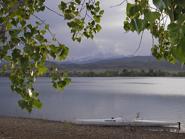
People commented how exciting it was to have taken part in the inaugural race and how they hoped to see it grow in the coming years.
I found the participants’ paddleboarding expertise was wide-ranging: some seemed to be experts and others, like me, had only done it a few times.
Justin and Kelly Beard of Golden, who won the 18-35 and 36-59 age divisions, respectively, told me that they enjoy paddleboarding on their travels across the country. The couple said they paddleboard every few weeks and were very happy to see the sport gaining popularity, describing it as very easy to pick up and family friendly.
Similarly, Marian Schwabauer of Evergreen, who won the senior division, learned to paddleboard while in Hawaii.
I’m heading up to Yelm, Washington for some R&R, and to commune with some old growth forest and the Pacific Ocean. Today is a travel day. I’ll try to catch up at the hotel tonight.
The biologists have purged this gulch of all other fish competitors.
But the first pure greenback cutthroat trout dropped into chilly streams Monday morning simply quivered at edges of eddies.
These captive-bred 1-year-olds — 960 of them — are thought to be hardier than the 4,000 hatchlings that Colorado Parks and Wildlife biologists put in Herman Gulch last year. State crews conducted a survey last week and found no evidence any of the hatchlings survived the hard winter.
A whole lot of people really want the greenback cutthroats to make it in their ancestral home.
So on Monday morning, an expanding cutthroats recovery team coordinated by CPW mobilized, with more than 50 volunteers from Trout Unlimited and other conservation groups hauling 20-pound bags of the 5-inch fish into the high-country basin…
Most understood this is something of an ecological longshot because greenback cutthroats — listed as threatened on the nation’s endangered species roster — have all but disappeared. After all, evolution is all about change, and species come and go.
Greenback cutthroats originated in the South Platte River Basin headwaters. They disappeared as humans settled the region, mining for gold that turned water toxic, stocking streams with nonnative fish in hopes of promoting tourism.
State wildlife managers declared greenback cutthroats extinct in the 1930s. But they rediscovered them in 1953 and celebrated them in 1994 as Colorado’s official state fish. However, the fish that Colorado wildlife officials touted as the state fish was a different species of cutthroat trout.
In 2012, University of Colorado genetics scientists determined that only a few greenback cutthroats survived in the wild, by a fluke, southwest of Colorado Springs, in the Arkansas River Basin. Back in the 1870s, aspiring hotel resort operator Joseph Jones had captured some greenbacks from South Platte headwaters and plopped them into Bear Creek near his property. CU scientists verified that only the descendants of those fish carried the true greenback cutthroat genes.
CPW officials now are working intensely, gathering genetic material from Bear Creek fish and breeding tens of thousands of greenback cutthroats in hatcheries created to stock Colorado streams with trout that compete with native species.
CPW crews already have transplanted some greenback cutthroats successfully into Zimmerman Lake, west of Fort Collins.
“This would be the first steam,” CPW aquatic biologist Boyd Wright said Monday, directing the transplanting operation along 3 miles of streams. “And this is a fish that evolved in streams.”
[…]
If this second attempt at getting greenback cutthroats to survive in Herman Gulch fails, CPW officials said they’ll try once more next year. State crews this year also are planning to drop cutthroats into Dry Gulch, to the west of this site, and into Rock Creek in South Park.
But much depends on how the fish respond in this ideal habitat, a basin considered ecologically healthy.
A hydroelectric plant is planned for construction downstream from the Pueblo Dam to generate renewable energy for Fort Carson. Developers are just waiting for the signal to start building.
The plant would significantly increase the amount of renewable energy Fort Carson consumes, fitting with the post’s “Net Zero” goals of becoming more environmentally friendly.
The Colorado Springs Utilities board will consider adding a military sales tariff during its meeting Wednesday. The tariff would cover costs for Utilities to act as an intermediary, selling the power to Fort Carson after buying it from the Southeastern Colorado Water Conservancy District, which would build and operate the plant, said Utilities spokeswoman Amy Trinidad.
Adding the tariff is the “last step” before the district can begin construction, said spokesman Chris Woodka.
“We’ve been ready to pull the trigger on this since January,” he said.
Currently, 8 percent of Fort Carson’s electricity is generated on-site through renewable sources such as solar panels, post spokeswoman Dani Johnson said. She could not say whether the post buys any renewable energy from off-site sources.
But Trinidad said Fort Carson does buy some renewable energy from Utilities. She could not say how much, citing customer privacy. The proposed hydroelectric deal would make up 7 percent of the post’s annual electricity purchase from Utilities, she said.
If the tariff is added, the proposal then will go before the City Council, consisting of the same members as the Utilities board, next month. If the council approves the move, construction on the plant can begin, Woodka said.
The plant would cost about $19 million, most of which comes from a loan the district took out, he said. In the years to come, energy sales are expected to cover the costs and eventually generate funds.
The plant’s construction will not have a financial impact on Utilities ratepayers, Trinidad said.
The plant is expected to generate up to 7.5 megawatts of electricity, Woodka said. Fort Carson will buy half of that, and Fountain Utilities will buy the other half.
The plant could be operational by May 2018, a peak time for generating hydroelectricity because of the high volume of water flowing from the Pueblo Dam, Woodka said.
Utilities then would buy the electricity, which will be transmitted onto its grid, and then sell it to Fort Carson without marking up the price, Trinidad said.
In the past, Fort Carson bought renewable wind energy through Utilities under short-term contracts, which have since expired, said Steve Carr, Utilities’ key account manager for Fort Carson. The pending hydroelectricity contract would last until the end of 2027.
EPA Administrator Scott Pruitt visited Utah as part of multistate tour to get input on how the agency can be more responsive to states’ needs in general and in specific how the controversial Waters of the United States rule should be retooled.
During his tour of Utah, Pruitt stopped off at the Bitner Ranch and Conservatory in Park City to get a firsthand look at a small pool of water that falls under federal regulation due to the rule, as well as a subdivision development hampered by permitting requirements…
Pruitt is acting under the direction of an executive order issued in February by President Donald Trump that called for a rollback of the so-called WOTUS rule, which inspired a firestorm of controversy when it was adopted in 2015.
Although celebrated by sportsmen’s groups and environmental organizations as the most comprehensive and significant overhaul of the Clean Water Act in more than 40 years, the rule raised the ire of states, farmers, ranchers and industry officials who complained about its scope and ambiguity.
At the time of its adoption, federal regulators insisted the rule only clarified protections for seasonal waterways that are critical to downstream communities. The EPA and Army Corps of Engineers contended the rule did not expand the scope of jurisdictional oversight — an assertion hotly contested by the National Association of Counties, which argued even ditch maintenance projects would require a Army Corps of Engineers permit.
In late June, Pruitt initiated a proposal to repeal the Waters of the United States rule and later invited states to offer their input on a new regulation that would incorporate a standard in a 2006 U.S. Supreme Court decision. That test said federal jurisdiction would only apply to “relatively permanent, standing or continuously flowing bodies of water…
Utah Farm Bureau President Ron Gibson accompanied Pruitt on the tour Tuesday and praised the EPA action.”
[…]
Environmental groups and conservation organizations that include the Theodore Roosevelt Conservation Partnership favored the regulation, citing its protection of wetlands — particularly the Prairie Pothole Region that is home to upward of 70 percent of the ducks in North America.
Seven scientific organizations that include the Society of Wetlands Scientists argued in a letter to Trump that the rule should be left intact.
In a separate announcement during his visit, Pruitt said the EPA will revisit a previous ruling on Utah’s regional haze plan, allowing the state to come up with additional visibility modeling to look at impacts from a pair of PacifCorp-owned power plants to nearby national parks.
Once again this year, the nonprofit Colorado Water Trust and the Colorado Water Conservation Board are collaborating to arrange a release of water from Stagecoach Reservoir to boost lagging flows in the Yampa River under an agreement with dam owner, the Upper Yampa Conservancy District. New this year is the support of The Nature Conservancy.
Last year, conservation releases did not begin until mid-September, but in 2017, with the river already flowing well below normal, water releases from the dam were set at 10 cubic feet per second beginning July 11. But it can’t go on forever this way.
With this year’s release, the role of the Conservation Board, a division of the State Department of Natural Resources, has expanded to include committing to contributing up to $46,692 for water releases. At the same time, the CWCB will undertake the third, and final, approved year to release water into the Yampa. The opportunity cannot be renewed under current law, Water Trust staff attorney Zach Smith said…
This year’s program will forge a new relationship with the Nature Conservancy to carry on the effort when conditions warrant. The Nature Conservancy’s Carpenter Ranch just east of Hayden straddles the Yampa, and for 2017, the global conservation organization has agreed to bring $50,000 to the effort to purchase water releases out of Stagecoach. It will also explore sustainable funding for future years.
Smith said new efforts to bolster the flows in the river during dry seasons could range from seeking ways for the Nature Conservancy and the Water Trust to collaborate on locating new funding sources to perhaps seeking a water source with long-term legal protection.
Upper Yampa Manager Kevin McBride pointed out it’s only because there is a moderate amount of water storage in the upper reaches of the Yampa that mid-summer conservation releases are possible…
Flows in the Yampa have been supplemented with the participation of the Water Trust in 2012, 2013, 2015 and 2016. The Yampa was flowing at 128 cubic feet per second Monday afternoon, 67 cfs below the median for the date…
Water Trust water resources engineer and former Steamboat resident Mickey O’Hara said the return to healthier natural flows in the Yampa this summer “depends on if, and when the monsoons happen.”
Here’s an interview with Doug Kenney from PPIC. Click through and read the whole thing. Here’s an excerpt:
The Colorado River is a crucial water source for seven states (Wyoming, Colorado, Utah, New Mexico, Arizona, Nevada, and California) and Mexico, and like many shared rivers has its share of challenges. We talked to Doug Kenney—director of the Western Water Policy Program at the University of Colorado and a member of the PPIC Water Policy Center research network―about balancing priorities in managing the river.
PPIC: What’s the basin’s biggest challenge currently?
DOUG KENNEY: That depends on what part of the basin you’re in and what sector you work in. There’s no shortage of things to worry about. Right now, most would probably say it’s the effort to maintain the levels of water stored in the big reservoirs, Lake Mead and Lake Powell. Those reservoirs provide a lot of benefits—drought protection, recreation, and hydropower—but only if they have enough water in them. They’re about half full right now, which is about as low as they can go before mandatory cuts in water deliveries—or curtailments—kick in. It’s a math problem, essentially—managing water coming in versus what’s going out. So far in this century, people have pulled more water out than consistently flows in. Obviously, that has to change.
The more chronic issue is that the Colorado has been treated more like a plumbing system than a river, so there’s been a lot of environmental damage to the river. The big environmental concerns in the basin are a result of reduced flows and some water quality issues, such as high salinity, loss of valuable sediments, and increased water temperatures. The real challenge is to remind people we’re talking about a river—the most important ecological resource of the southwest United States.
Here’s the release from Metropolitan State University at Denver (Dan Vaccaro):
Denver’s urban university and botanic garden team up to make an even bigger impact on water issues in Colorado.
The next time you’re sitting in traffic on Interstate 25 (this afternoon, probably), consider this: Colorado’s population is expected to grow by 1.5 million by 2030. And that doesn’t just mean more traffic. It means more pressure on the state’s scarcest natural resource – water.
Between the population boom and rising global temperatures, the imagination doesn’t need to wander far to see what the future of Colorado might look like. Hint: If you thought lawn-watering restrictions were bad, how about living in a world like the one imagined in the movie “Mad Max: Fury Road”?
Thankfully, there are people and organizations teaming up to tackle water issues in the state. This past spring, the Denver Botanic Gardens and the One World One Water Center at Metropolitan State University of Denver signed a partnership that will have long-term implications for the future of water education and stewardship in the Centennial State.
“Both organizations were already pursuing similar objectives,” says Jennifer Riley-Chetwynd, director of marketing and social responsibility for the Denver Botanic Gardens. “By joining forces, we can do so much more and have a bigger reach for our work.”
The plan includes stronger collaboration between MSU Denver professors and Botanic Gardens scientists, shared research projects and the pursuit of joint funding. Wherever possible, the aim is to involve students. The end goal, Riley-Chetwynd says, is to make an even bigger impact on watershed restoration and health.
As part of the agreement, Riley-Chetwynd also becomes co-director of the OWOW Center in addition to her work at the Botanic Gardens, helping to further unite the organizations. She already serves as an affiliate faculty member in the Journalism and Technical Communication Department at MSU Denver.
For Tom Cech, co-director of the OWOW Center, the partnership will help better educate future water leaders and stewards. “Our goal has always been to raise awareness of current water challenges and opportunities both in the Colorado community and among our students,” he says. “This partnership amplifies those efforts.”
While MSU Denver students have interned at the Botanic Gardens, Cech sees increased opportunities in light of the new agreement. He also imagines more events like the recent Shed ’17 water summit, co-hosted by the organizations June 29 at the Gardens.
The event brought together nearly 200 leaders from across the state and country to discuss water challenges and co-create solutions. Topics at the conference included the importance of watershed health and outdoor recreation, agriculture’s role in Colorado’s water future, and the evolution of conservation. The keynote speaker for the event was Mike Nelson, chief meteorologist at Denver7, who spoke about climate change.
Another distinctive feature of the agreement is the development of a co-branded logo, which will appear at water-related events, an aspect that Deputy Provost Sandra Haynes describes as “unique.”
“It is a testament to the breadth and depth of this collaboration between two of Denver’s most recognized institutions,” she says.
Haynes hopes the partnership will also provide more exposure for innovative university programs such as the water studies and urban agriculture minors.
This partnership comes at an important time in state history, Riley-Chetwynd says. A statewide water plan released in 2015 creates a roadmap for the future of water in Colorado. One of the main principles is removing silos to ensure that diverse groups are working efficiently and effectively.
“We need to work together to answer questions about how to deal with our population growth, where our water will come from and how we will keep urban communities viable without endangering our environment,” she says. “No one group can do all of that alone. It’s the only way forward if we’re going to make Colorado’s future sustainable.”
If all goes according to plan, the only “Fury Road” in Colorado will be I-25, particularly during rush hour.
Expanding the 5,000-acre-foot capacity reservoir has been on Greeley officials’ to-do list for more than a decade. But the type of work the city is planning takes a lot of time, mainly because it involves the federal government.
If everything goes without a hitch, Greeley officials have circled 2030 as the year they’ll increase Seaman to 10 times its current capacity…
Here’s why:
» Greeley has never expanded any of its six reservoirs, and most have been around for nearly a century.
» Increasing Seaman to 53,000 acre-feet of water from 5,000 acre-feet will put Greeley in position to satisfy the city’s water needs for decades. (An acre foot of water is enough water for two families to use for a year). The city uses between 25,000-30,000 acre-feet of water per year: That’s expected to reach 40,000 acre-feet by 2030.
Harold Evans, chairman of the water and sewer board in Greeley, likens the Seaman’s expansion to the kind of planning that has kept water flowing from the city’s Bellvue Treatment Plant area since 1907…
Right now, Greeley is working with a consultant and in conjunction with the Army Corps of Engineers to develop an environmental impact statement.
Greeley is still about two years away from having a draft of that statement.
In the meantime, Greeley officials are working to secure more water rights. The city doesn’t have enough rights to fill the expanded Seaman Reservoir. They’re 40 percent there, and as Reckentine said, it’s an everyday process. Every year, in fact, Greeley commits millions toward purchasing water rights.
Expanding the reservoir could cost $95 million more just in construction costs, according to an estimate provided in a Colorado Water Conservation Board document.
Water rights come from a variety of places, including retiring farms.
Today, Greeley typically uses its reservoirs as drought protection.
Basically, Greeley has water rights from the Colorado, Poudre, Laramie and Big Thompson rivers. But whether Greeley is able to get all of the water it’s owed depends on the rivers’ flow levels.
In drier years, Greeley would have to do without some of that water. That’s where reservoirs come in. Evans said the first reservoirs were used to finish Greeley area crops when river flows weren’t strong enough to do so in late fall.
Snowmelt and water diverted into reservoirs could be tapped for that purpose. Evans said it’s like putting money in the bank. Pound-for-pound, water’s worth more than money, though.
If and when the Seaman Reservoir expansion is complete, Greeley will likely use some of the water from that reservoir every year.
For Evans, that’s a perfect example, among many, of an investment in the future.
Evans mentions the new pipeline from the Bellvue Water Treatment Plant being installed now, with a lifespan of 75-100 years. The Seaman Reservoir has been around since the 1940s.
ABOUT MILTON SEAMAN RESERVOIR
» Built 1941
» Storage: 5,008 acre-feet
» Elevation: 5,478 feet
» Dam height: 115 feet
» Proposed enlargement date: 2029
» Proposed storage: 53,000 acre-feet
SET FOR LIFE?
The Seaman Reservoir expansion will put Greeley in a good position, but Deputy Director of Greeley Water Eric Reckentine hesitates to call it the final answer.
Greeley has a four-point plan when it comes to water:
» Maintain what you have — Greeley has reinforced water lines with concrete and fiberglass to reduce leaks.
» Secure supply to stay ahead of demand — The Windy Gap Project, which ensured water during lean times, is an example of this.
» Build storage for the lean times — The Milton Seaman Reservoir expansion project is the best example of this.
» Conserve the water you have — Greeley has a state-approved water conservation plan, and the new water budgets are another example of conservation.
THE OTHER RESERVOIRS
Here’s a quick look at Greeley’s other five reservoirs:
» Barnes Meadow Reservoir — Built in 1922 and located across Colo. 14 from Chambers Lake in the Roosevelt National Park, Barnes Meadow Reservoir holds 2,349 acre-feet of water.
» Peterson Lake Reservoir — Built in 1922, and located southwest of Chambers Lake and adjacent to Colo. 156, Peterson Lake Reservoir holds 1,183 acre-feet of water.
» Comanche Reservoir — Built in 1924, and located along Beaver Creek and west of the Colorado State University Mountain campus, the Comanche Reservoir holds 2,628 acre-feet of water.
» Hourglass Reservoir — Built in 1898, and also located along Beaver Creek and west of the Colorado State University Mountain campus, the Hourglass Reservoir holds 1,693 acre-feet of water.
» Twin Lakes Reservoir — Built in 1924, and located southwest of Pingree Park off Colo. 14, Twin Lakes Reservoir holds 278 acre-feet of water.
Doug Billingsley doesn’t know what he’s going to do to replicate the peace and quiet of his work when he retires and re-enters the hubbub of normal life. Greeley pays Billingsley to live at Milton Seaman Reservoir, about 15-20 minutes from the mouth of the Poudre Canyon. Billingsley lives in a city-provided house, and has lived there for the past eight years with his wife, who suffers from multiple sclerosis, and her caretaker.
Billingsley monitors the Seaman Reservoir. The reservoir is Greeley’s largest, and its water levels can rise and fall quickly. He must ensure the banks and dams are sound and functioning properly, and he’s charged with releasing water down the Poudre Canyon when necessary. Call him the water shepherd.
He’s used to the solitude, if not the quiet.
“I drove over the road truck for 18 years, and was by myself for up to 30 days at a time — I lived in a truck,” Billingsley said. “This is no biggie; this is heaven.”
The city pays him a salary as well as his living expenses. But there’s a catch: He’s on call 24 hours per day, seven days per week.
The floods of 2013 are a prime example. And Billingsley spent the better part of a week stuck at home after a bridge went out, trapping folks up the canyon. Of course, he had to monitor Seaman’s water levels during the flood, as well.
Billingsley’s wife loves having him at home every night, and he loves being there.
Apart from animals there’s nothing to bother a Seaman Reservoir caretaker. They’ve seen elk, mountain lions, bears, but none of them hurt anybody, he says.
…Castle Rock recently implemented new water restrictions on homeowners associations and urged residents to amp up their conservation efforts. Prolonged dry, hot weather has left one of the town’s renewable sources, the East Plum Creek, at record lows.
The town has gathered data on the creek for 18 years, Marlowe said. The gauge on East Plum Creek nearest Castle Rock shows the area at its lowest level in that time frame.
The town also recorded water use at peak levels — although that is not uncommon during hot spells, Marlowe said.
Over the summer, Castle Rock typically sees an average use of 12.4 million gallons a day. This year, officials have seen that average reach 16.5 million gallons. Peak demand is usually related to outdoor irrigation, Marlowe said, such as the watering of lawns and landscaping.
In response, the town is now requiring homeowners associations to follow a similar watering schedule that has been required of single-family homes since the 1980s. Public spaces like parks, common areas and medians can only be watered between 10 p.m. and 5 a.m. on Sundays, Wednesdays and Fridays.
Homeowners associations were also asked to cut back on issuing violations for distressed lawns and to encourage residents to reduce outdoor watering.
Marlowe said the efforts should save millions of gallons of water.
Additionally, residents and businesses can do their part by researching proper irrigation techniques, for which the town has a number of resources and classes…
Residential water restrictions in place through August only allow watering between 8 p.m. and 8 a.m…
Kaoch explained residents needn’t worry if grass doesn’t stay perfectly green in dry times, as going temporarily dormant can actually help strengthen new root systems. Conservation is most important, Kaoch said, expressing the district’s willingness to work with town staff under the new water restrictions.
For residents who want to learn more about proper irrigation and water conservation, the town offers numerous resources through the website crconserve.com. The town also runs classes for people to learn efficient watering and conservation techniques.
The Platte River is formed in western Nebraska east of the city of North Platte, Nebraska by the confluence of the North Platte and the South Platte Rivers, which both arise from snowmelt in the eastern Rockies east of the Continental Divide. Map via Wikimedia.
High Plains in eastern Colorado. Photo credit Bob Berwyn.
The plains around DIA were parched by the scorching 2012 drought, although groundwater pumping along the South Platte River enabled some farms to continue irrigating — photo by Bob Berwyn
Map of the South Platte River alluvial aquifer subregions — Colorado Water Conservation Board via the Colorado Water Institute
South Platte River Basin via the Colorado Geological Survey
The South Platte Master Plan is a study of flood mitigation and recovery possibilities along 130 miles of the South Platte River from the Morgan-Weld county line to the Nebraska State Line. Authorized and funded by the Colorado Department of Local Affairs, the plan will suggest ways to make the river more “flood resilient,” both to handle the flooding as it occurs, with minimal damage to property and structures, and to quickly recover from a flood in the aftermath.
Five big problem areas were identified in the evaluation, according to Brian Murphy, project director for CDM Smith of Denver, the contractor on the flood study. They were the amount of sediment the floods of 2013 and 2015 deposited in the study area, basically clogging the river and making flooding worse; uncontrolled water in ditches and canals, which can back up and cause damage to structures, homes, and fields; the railroad railroad right of way southwest of Messex, which contains the river along the northwest shoreline but worsens flooding on the opposite shoreline; the hunting lands along the river that provide game habitat but also blocks water flow during a flood, causing the water to spread out into neighboring cropland; and the washed-out headgates of the Henderson-Smith and Lowline ditches, which essentially turn those ditches into another channel of the river.
Stakeholders attending the meeting may have gotten some ideas of how to tackle those challenges from a 90-minute presentation by Jerry Kenny, executive director of the Platte River Recovery Implementation Program. That program comes from an agreement among Colorado, Nebraska, Wyoming, and the U.S. Department of the Interior to preserve habitat for whooping cranes, least terns, piping plovers and pallid sturgeons, four species on the endangered species list. The program maintains water at an adequate level along an 80-mile stretch of the Platte River the Nebraska cities of Lexington and Grand Island in an area call the Big Bend Area.
Kenny’s description of challenges faced in maintaining habitat for those four species brought home to the stakeholders how the river system has been affected by settlement all along its length. For instance, sediment – mostly sand – that once washed downstream past what is now Sterling and settled in the Big Bend area to create habitat for those species no longer makes it that far. Instead, repeated diversion of the river for irrigation reduces and slows down the water flow during what was once rapid spring runoff, depositing the sediment here.
That problem is exacerbated by Lake McConaughy on the North Platte near Ogallala, which traps sediment that once drifted down into Big Bend.
Kenny told the meeting that some of the challenges have been met by practices in all three of the states that have increased stream flow in the Platte River. Most notable in Colorado is the Tamarack Recharge Project near Crook, in which water is pumped into small reservoirs when there is no irrigation demand on the river, and allowed to seep back into the river so more water is available downstream.
Kenny also showed the group slides of off-stream water storage projects that have been used to create wetlands and much-needed sand islands in the project area. Presumably, some of those ideas could be used to mitigate flooding and provide some off-channel water storage in the South Platte basin as well.
After the meeting Morgan County Commissioners Jim Zwetzig and Laura Teague said they are encouraged by the “collaborative effort” shown in the PRRIP agreements…
Project manager Brian Murphy said one of the biggest challenges, once ideas and practices are identified, will be finding the dollars to do it. The PRRIP get about half of its funds from the federal government, and there is tremendous incentive in the form of a mandate to save endanger species. There is no such incentive, other than reducing unpredictable costs of recover, in flood mitigation.
“The big question is, what are the things that can bring dollars to fund this project,” Murphy said. “What are the drivers? There’s been a lot of discussion of duck habitat, open space, trails, and I think it’s going to come down to those things.”
On a more positive note, he said, the PRRIP process has broken new ground when working with the federal permitting process. Some of the techniques that project uses, such as tilling riparian areas to keep vegetation down, are considered agricultural, and so don’t need federal permits.
Monday’s meeting was the third since the plan was introduced to the public in February.
The Maroon Bells from the meadow just above the confluence of East and West Maroon creeks, and the location of the potential Maroon Creek Reservoir.
ASPEN – Aspen city officials plan to reveal this week a proposal that seeks to resolve some of the issues raised by its efforts to maintain conditional water storage rights tied to potential dams and reservoirs on upper Castle and Maroon creeks.
Last week the city approved money to study underground storage, looked into how much water storage it needs, and responded in water court to a previous filing. In the past month, city officials also have met with a number of opponents in the water case.
“Things are changing rather quickly regarding the current diligence cases,” Aspen City Manager Steve Barwick said Friday, referring to the two ongoing due diligence cases now unfolding in Division 5 water court. “I expect a completely different discussion will be taking place within one week.”
Barwick also said he and other city staff members “have a great deal of work to do toward that outcome” and he expects to hold a news conference by Friday about the city’s proposal.
As presently decreed, the Maroon Creek Reservoir would store 4,567 acre-feet of water behind a 155-foot-tall dam a mile and a half below Maroon Lake. The Castle Creek Reservoir would hold 9,062 acre-feet behind a 170-tall-reservoir on the main stem of Castle Creek 2 miles below Ashcroft.
The city originally filed for the water rights in 1965 and has periodically told the state it intends to build the dams and reservoirs, if necessary, as part of its municipal water system.
The city filed its most recent applications for due diligence Oct. 31 and is seeking to hold on to its conditional rights for another six years.
City officials do not appear to have tipped their hand to the opposing parties in the cases about the substance of this week’s announcements.
“I really don’t know what the city will present at its big announcement,” said Rob Harris, senior staff attorney at Western Resource Advocates, who recently met with city officials on potential alternatives to the reservoirs, along with a representative from Wilderness Workshop of Carbondale. “I’m assuming that this will be more in the nature of the city announcing its preferred solution, or some part thereof, rather than any sort of finalized deal with any of the parties.
“Whatever they present, the follow-up questions we’re going to be asking include whether their idea moves Castle and Maroon creeks upstream of Aspen closer to permanent protection and, if their idea involves moving any or all of the water rights, what the potential impacts and benefits of that change will be,” Harris said.
The environmental organizations opposing the city in water court also include Colorado Trout Unlimited and American Rivers.
“What would not make us happy is if they said, ‘We will significantly downsize these reservoirs but keep them in the same place,'” said Matt Rice, director of American River’s Colorado River basin program, during an interview in late June. “We’re hopeful they are coming around to the impossibility of developing those projects in the two valleys, and what that means for this diligence, and that they are getting realistic about more-appropriately sized projects that can help them meet their water supply needs.”
Rice also said that Aspen Mayor Steve Skadron met with Bob Irvin, the president and CEO of American Rivers, on June 21 at city hall for 45 minutes.
“It was an opportunity to extend an olive branch of sorts and commit to working toward a resolution to this issue in good faith,” said Rice.
The city has scheduled a second settlement conference for Aug. 2 with the 10 opposing parties in the water rights cases.
A view of the Aspen municipal golf course from Red Butte. A consulting engineer for the city of Aspen has found that an ‘in-situ’ reservoir could likely be built to store water under the golf course, which sits on about 75 feet of glacially-deposited rock and gravel. A trench filled in with a clay-like material could be dug around the perimeter of the golf course and water could be poured into the open space in the remaining gravel, and pumped back out as necessary.
Golf course option?
On Monday the city council approved a $116,000 contract with the engineering firm of Deere and Ault of Longmont to drill test bores and dig exploratory pits on the course at the Aspen Golf Club as part of a feasibility study of an in-situ, or underground reservoir.
Such an “in-situ” reservoir would likely hold about 1,200 acre-feet of water, according to a preliminary investigation done by Deere and Ault.
Deere and Ault now plans to drill up to six test bores through what is estimated to be 75-feet of gravel under the golf course, and to dig up to eight pits, of undisclosed size, to analyze the soil and gravel conditions.
City Engineer Trish Aragon said this week that a construction management plan will be required by the city’s engineering department for any drilling work that goes deeper than 50 feet.
And a permit would be required if the excavation pits disturb more than 200 square feet of surface area.
Aragon, after checking with officials at the city’s water department, said it has not yet been determined when, or where, the drilling or digging will take place.
The members of the Aspen City Council on Monday, July 10, 2017. From left, Bert Myrin, Ward Hauenstein, Mayor Steve Skadron, Ann Mullins, and Adam Frisch.
In water court
On the same day the city council approved further investigations on the golf course, the city’s water attorney, Cindy Covell of Alperstein and Covell in Denver, submitted a required response to a “summary of consultation” report filed by the division engineer in Division 5, Alan Martellaro, on January 23.
In a July 10 letter Covell told Materellaro that Aspen “understands that it must meet the required burden of proof at trial,” but otherwise she left the concerns of the state officials unaddressed.
The report, prepared after consulting with water referee Susan Ryan, challenged the core of Aspen’s applications for the dam and reservoir rights.
“I cannot recommend approval of this application until the following concerns are addressed,” Martello’s report began, in a standard opening line for such reports.
The first concern cited was about the phrase “other beneficial uses” in the city’s claims to maintain its conditional storage rights, which carry a 1971 decree date.
And the second concern was whether Aspen’s applications meet key tests in a due diligence case.
“Regarding the ‘can and will’ and the ‘anti-speculation’ doctrines,” Martellaro wrote, “the applicant must demonstrate” that it will secure necessary permits and land use approvals, that it will complete the projects “within a reasonable time,” that a “specific plan is in place to develop the subject water rights,” and that the city “is not speculating with the subject water rights.”
The issues raised by the state officials are much the same as those raised by the ten opposing parties in the two cases.
The parties, in addition to the four environmental organizations, include Pitkin County, the United State Forest Service, and four private landowners.
Two of the landowners own property in the Maroon Creek valley, Thomas and Margot Pritzker and Marcella Larsen and her family. And two own property in the Castle Creek valley, Robert Y.C. Ho and Charles Somer.
“I think the division engineer raised some serious concerns that are entirely consistent with ours,” Rice of American Rivers said in late June. “We would appreciate it if they would answer the core questions.”
But the city chose not to do that this week.
The questions raised in the summary of consultation remain open in the case, however, and may be addressed in the future by the water referee or at trial, as Covell suggested.
The location of the potential Maroon Creek dam and reservoir, just below the confluence of East and West Maroon creeks.
Supply and uncertainty
On Tuesday the city council got an update on a risk analysis being conducted by Headwaters Corp. of Nebraska regarding the city’s future water supply and demand equation.
George Oamek, the economist who is preparing the study, submitted a preliminary report to the city on July 3, in an effort to help the city council determine how much will they need in the future and where they should store it.
He told the council that in order to complete his risk analysis, he and the council members are going to have make a number of assumptions about “uncertain variables.”
He said the data recorded by now defunct stream gages on Castle and Maroon creeks from 1970 to 1994 was insufficient for his analysis, although the 24 years of data has been the basis of several other in-depth water supply and demand studies done for the city.
He said that available climate data would be hard to use to predict local conditions.
And he recommended using land use projections in Aspen and Pitkin County to determine future water demand, as opposed to the standard methodology of using population projections.
Oamek also presented a pie chart to the council that illustrated the varying degrees of uncertainty presented by each of those areas.
About 70 percent of the uncertainty, and thus required assumptions, is in the area of climate change, he said, while 20 percent was related to the gaps in the data about flows in the creek, and ten percent was tied to demand projections.
Oamek told the city council members that he was relying on them for assumptions about land use and population.
Margaret Medellin, a utilities portfolio manager for the city, told the council that Tuesday’s meeting on the Headwaters study was not the last.
“This is just the first of many conversations,” she said. “We’ll be coming back to council for quite some time.”
Editor’s note: Aspen Journalism is an independent nonprofit news organization collaborating with The Aspen Times on coverage of rivers and water. The Times published a shorter version of this story on Monday, July 17, 2017.
Colorado’s diverse landscape has a rich natural and agricultural heritage that fuels the economy. Photo: Michael Menefee
Here’s the release from Colorado State University (Mary Guiden):
Colorado is famous for its iconic landscapes, which have helped shape the state’s identity and economy. From agriculture to recreation and tourism, from minerals and fuels to forest and wildlife, Coloradans are dependent on nature for many things that enrich our lives.
Not surprisingly, state officials have repeatedly identified conservation of the state’s natural and agricultural lands as sound public policy. This includes providing incentives for conservation easements. These are legally binding agreements between private landowners and nonprofit land trusts or government to protect conservation values of a property.
A new analysis from Colorado State University found that each dollar invested by the state for these easements produced benefits of between $4 and $12 for Coloradans. Public benefits include clean water and air, scenic views, access to things produced by local farms and ranches products, and wildlife habitat: all things that contribute to a high quality of life in the state. Researchers said these data show that easements are conserving land that is important for wildlife, agriculture, tourism and outdoor recreation for Colorado’s visitors and residents alike.
Conservation easements protect specific conservation values of a property, such as wildlife habitat. Photo: Michael Menefee
“There is a substantial return to the Colorado taxpayer on investments in programs designed to conserve the features of the Colorado landscape that are so dear to all of us,” said Andrew Seidl, one of the study authors and a professor in the Department of Agricultural and Resource Economics at CSU.
Based on the new analysis, the CSU research team found the investments from the state programs conserve:
More than 114,450 acres of preliminary priority habitat for greater sage grouse
Nearly 300,000 acres of prime farmland
250 miles along designated scenic byways
More than 4,100 miles of streams, creeks and rivers
More than 270,000 acres of habitat used by elk during severe winter conditions
The state programs have invested nearly $1.1 billion on conservation easements since 1995, according to the new analysis. CSU researchers — who examined data on 2.1 million acres of Colorado lands with conservation easements — said the related benefits for state residents are as high as $13.7 billion.
The study focused on Colorado’s investments in conservation easements funded through a tax credit program and Great Outdoors Colorado. The voter-approved program uses a portion of lottery proceeds to help with efforts to protect wildlife habitat, river corridors, productive agricultural lands, iconic scenic views. It has also created trails and open spaces for Coloradans to enjoy.
Colorado is famous for its iconic landscapes. Photo: Michael Menefee
Study co-author Michael Menefee, an environmental review coordinator with CSU’s Colorado Natural Heritage Program, said the investments are filling a vital need for conservation of identified priorities on private lands. “An active partnership between private landowners and public policy can achieve what neither acting alone can accomplish,” he added.
The Colorado Office of the State Auditor released an analysis in December 2016 concluding, among other findings, that it was difficult for the public and policymakers to determine the benefits from the conservation easement program. But this new study used a more robust data set from the Colorado Ownership, Management and Protection (COMaP) database, the state’s most comprehensive map of protected lands.
COMaP started as a Geographic Information System research project in CSU’s Department of Fish, Wildlife, and Conservation Biology in 2004. Since then, it has evolved into an important tool for those around the state with an interest in privately and publicly protected lands.
“Easements are the primary tool in Colorado for conserving these many benefits while still maintaining land in private ownership – often as working farms and ranches,” said Drew Bennett, study co-author and a postdoctoral fellow at CSU.
The study’s authors will present their findings later this month at a hearing of the Colorado General Assembly’s Legislative Audit Committee. Committee members will review the programs and consider potential changes.
The study was funded by Robert L. Tate, a longtime supporter of and donor to the Warner College of Natural Resources and Colorado State University.
Formed eight years ago, the company has developed a patented process to use algae to remove nitrogen and phosphorous from public wastewater treatment plants, keeping waterways from being inundated with the compounds that starve fish and plant life of oxygen. In turn, the algae can be sold to other companies for fertilizer, biofuels and other uses.
Think of it as high tech farming.
As the global population skyrockets, nitrogen and phosphorous pollution is becoming a significant environmental concern. Often referred to as “nutrient loading,” these two elements cause algal blooms in lakes and rivers that create “dead zones” that devastate vegetation and animals.
Clearas officials say they have found a way to harness Mother Nature’s own solution to nutrient loading in a different way, making it a beneficial process that makes money instead of an ecological nightmare.
Sewage contains high levels of nitrogen and phosphorous, and those two elements happen to be what algae, the fastest-growing plant on the planet, likes to eat.
Phosphorous and nitrogen are in demand from the agriculture sector for their use as fertilizers. So rather than having life-killing algae in nature’s waterways, the nutrients can be put to use in corn fields.
“I think the simplest way to describe what we do is to say that we take harmful constituents out of the wastewater prior to discharge into our rivers, lakes and streams, and we do it biologically sustainably,” explained company CEO Jordan Lind.
There are other technologies for removing those nutrients, but they often involve chemical treatment.
Clearas formed as a company when algae farmers in the Bitterroot Valley wanted phosphorous and nitrogen from Missoula’s wastewater treatment facility to feed their biofuel. Lind recalls that the head of the wastewater facility told them they could take as much wastewater as they wanted for free, a much better alternative than buying synthetic nitrogen.
It was a “eureka” moment. Kevin McGraw, the company’s co-founder and operations manager, realized that they could develop a technology to harness wastewater’s nutrients to grow a valuable product while doing public utilities a favor…
The company developed a testing facility at Missoula’s wastewater treatment plant on North Reserve. A series of tubes feed 15,000 gallons of wastewater per day through algae and return it to the Clark Fork River much cleaner than it was before.
The company recently landed a contract to implement their Advanced Biological Nutrient Recovery technology at a Utah municipality called the South Davis Sewer District, which will be a 4-million-gallon-per-day system.
Lind said Montana has relatively lax environmental regulations on what wastewater facilities can discharge, but in other places tighter regulations mean that more and more cities will look to this technology…
In fact, some of the explosions of bright green algae that can be found in the Clark Fork River and other bodies of water across the country in the summer are caused by too much nitrogen and phosphorous from agriculture runoff, laundry detergents and other sources.
The beauty, Lind says, is that Clearas is recovering the resource rather than just removing it. They have centrifugal machines that can turn the algae into whatever consistency a customer needs, whether it’s a watery sludge for fertilizing a field or a dry cake for making plastics or fuels.
“There’s lots of potential co-products that result from the treatment process,” Lind said. “So you truly are going waste-to-value. And that’s kind of the new trend in our space. All these municipalities and large industrial plants that have wastewater, there’s value in that waste. The question is how you convert it. And our method is a proven way to do that.”
Lind said there is a lot of interest in the company’s technology in the Great Lakes region, in Europe and in Asia…
The Utah contract is the first of what the company hopes will be a long line of dominoes to fall. In essence, they hope that once one municipality sees the technology working, then others will hop on board.
It’s a little more complicated because taxpayer funds have to be used to upgrade wastewater treatment plants. However, they have high hopes. Right now, the company employs about three dozen people, and they have acquired an engineering firm to deal with helping cities implement the technology.
Andy Gordon, the company’s market development manager, said he believes the technology could transform the world.
Click here to go to the website. Click through for the links and the year to date summary. Here’s an excerpt:
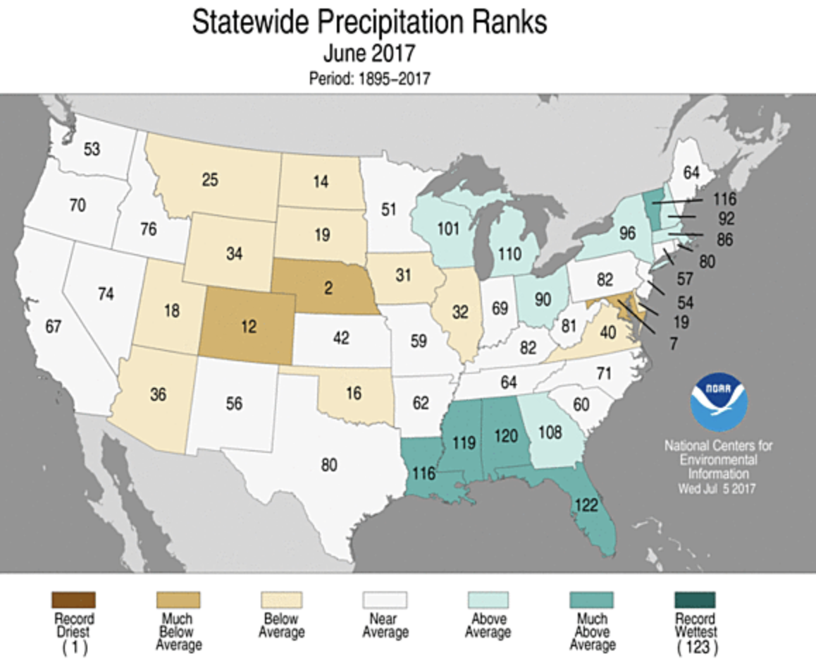
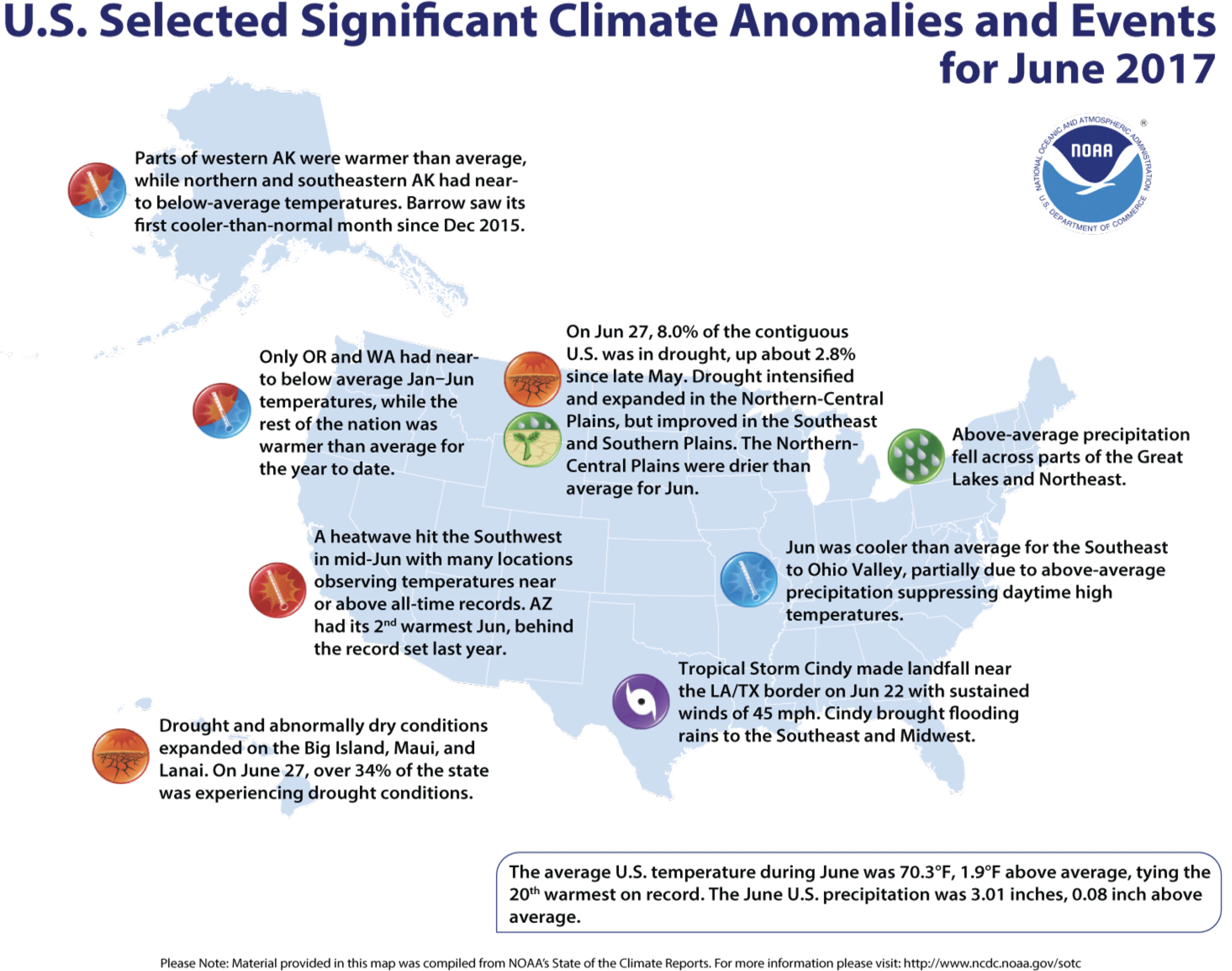
Graphic via NOAA June 2017.
Climate Highlights — June
June 2017 average temperature departures.
June 2017 percent of average precipitation.
Temperature
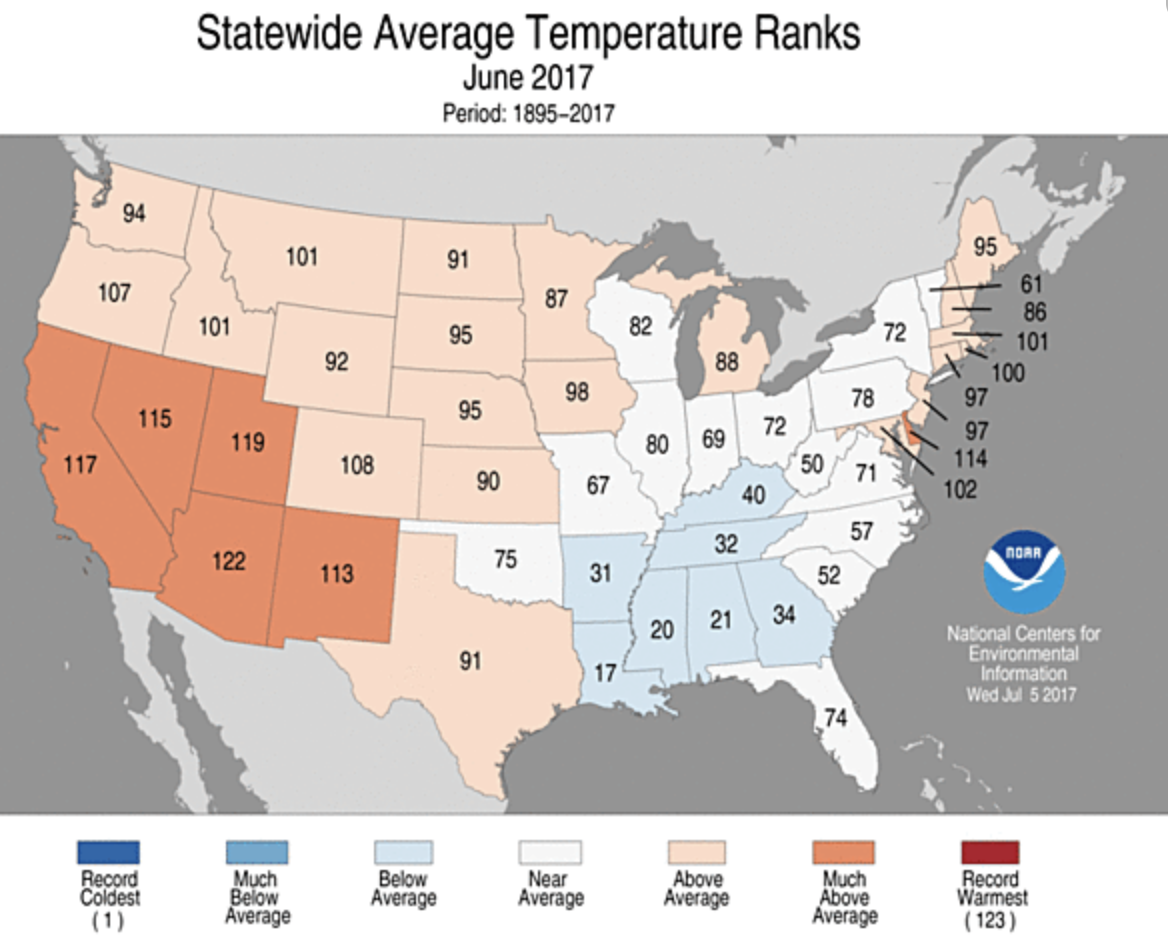
June 2017 statewide temperature ranks.
The June average temperature for the contiguous U.S. was 70.3°F, 1.9°F above the 20th century average, and tied as the 20th warmest June in 123 years of record keeping.
Above-average temperatures were observed for locations from the West Coast to Rocky Mountains, with parts of the Great Plains, Great Lakes and East Coast also warmer than average. In the Southwest, much-above-average temperatures were driven by a record-breaking heat wave in mid-June. No state was record warm, but Arizona had its second warmest June on record.
Below-average temperatures were observed in parts of the Southeast, Lower Mississippi Valley and Ohio Valley. The below-average temperatures were mostly due to much-below-average maximum temperatures, particularly along the Gulf Coast where record and near-record precipitation kept afternoon highs below average. No state was record cold.
Alaska tied its 12th warmest June in the 94-year period of record with a statewide average temperature of 51.5°F, 2.3°F above average. Western areas of the state were warmer than average, with near- to below-average temperatures along the North Slope and in southern parts of the state. Utqia’vik (Barrow) had its first cooler-than-average month since December 2015.
The contiguous U.S. average maximum (daytime) temperature during June was 83.3°F, 2.0°F above the 20th century average, and ranked as the 20th warmest on record. Above-average maximum temperatures were observed across the West, Great Plains, and Mid-Atlantic. Arizona observed its warmest June maximum temperature on record at 97.3°F, 6.4°F above average. This bested the previous record of 96.6°F in 2013. Below-average maximum temperatures were observed from the Deep South to the Ohio Valley. Five states along the Gulf Coast had much-cooler-than-average maximum temperatures, with Louisiana tying the second coolest June maximum temperature on record at 86.3°F, 3.8°F below average. The record coldest June maximum temperature for Louisiana was 85.8°F set in 1903.
The contiguous U.S. average minimum (nighttime) temperature during June was 57.3°F, 1.7°F above the 20th century average, the 14th warmest on record. Above-average minimum temperatures spanned the West, South, Great Lakes and East Coast. Below-average minimum temperatures were observed in the Ohio Valley and parts of the Great Plains. In the Northern Plains and Central Rockies, some locations observed freezing overnight temperatures in June which is an unusual but not unprecedented occurrence.
During June there were 4,343 record warm daily high (1,848) and low (2,494) temperature records, which was nearly 2.5 times the 1,752 record cold daily high (974) and low (778) temperature records.
Based on NOAA’s Residential Energy Demand Temperature Index (REDTI), the contiguous U.S. temperature-related energy demand during June was 14 percent below average and ranked near the middle of the 123-year period of record. This was due to the temperature anomaly pattern of near to below-normal temperatures in the high population centers of the South and East and above-normal temperatures in the less heavily populated West and Plains.
Precipitation
June 2017 Statewide Precipitation Ranks via NOAA.
The June precipitation total was 3.01 inches, 0.08 inch above the 20th century average, and ranked near the middle value in the 123-year period of record.
Below-average precipitation was observed across parts of the Great Basin, Northern and Central Plains, and Mid-Atlantic. Nebraska had its second driest June and Maryland had its seventh driest. Some regions in the Southwest received no precipitation in June, which is typical of early summer. No state was record dry.
Above-average precipitation fell across the Gulf Coast and from the Great Lakes to northern Northeast. Tropical Storm Cindy dropped heavy rain and caused significant flooding across parts the Southeast to Midwest as the storm tracked northward after making landfall near the Louisiana/Texas Coast on June 22. Alabama, Florida, Louisiana, Mississippi and Vermont were each much wetter than average. No state was record wet.
The Alaska June average precipitation total for June was 2.04 inches, 0.30 inch below the long-term average, and ranked as the 34th driest June since 1925. Northern and south-central parts of Alaska were drier than average with above-average precipitation in southwestern and southeastern Alaska.
According to the June 27 U.S. Drought Monitor report, 8.0 percent of the contiguous U.S. was in drought, up about 2.8 percent compared to the end of May. Drought improved across parts of the Southern Plains and Southeast. In the Southeast, drought conditions were nearly eradicated where torrential rainfall was observed over the past month, particularly along the Gulf Coast. Drought conditions expanded and worsened across the Northern to Central Plains where short-term and long-term precipitation deficits have been observed. Outside of the contiguous U.S., drought worsened for parts of Hawaii and western to central Alaska. Abnormally dry conditions improved in eastern Alaska.
Click here to listen. Here’s an excerpt from the article:
The Trump presidency has made for a jittery scientific community, and an atmosphere of anxiety — even despair — among many who feel climate change is the greatest peril facing civilization.
Their worries are shared by Katharine Hayhoe, the director of the Climate Science Center and a professor of political science at Texas Tech University.
Hayhoe is one of the most prominent climate scientists working in the United States today. She is also a Canadian — and an evangelical Christian. Her speciality is talking about climate change with people who are not already convinced of its legitimacy and urgency.
Hayhoe was named one of world’s 50 greatest leaders by Fortune magazine earlier this year, and one of Time Magazine’s 100 Most Influential People in the World in 2014. She’s also the host of a PBS online series called “Global Weirding”.
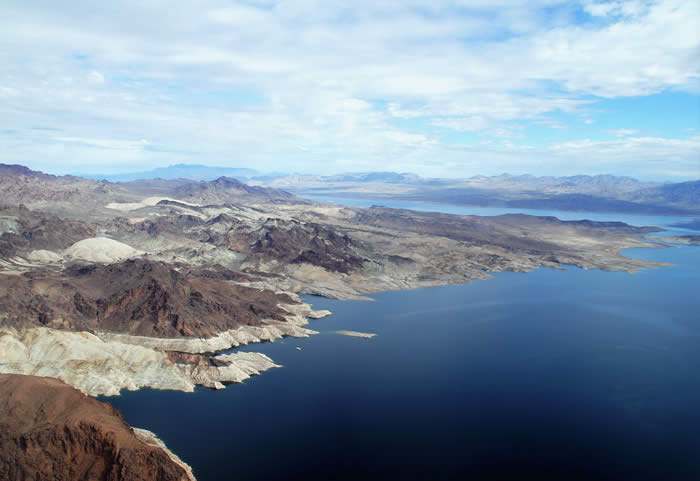
The five participants in a historic effort to help stabilize Lake Mead water levels made their agreement formal at a signing ceremony hosted by the Arizona Department of Water Resources.
As part of the $6 million partnership agreement with the Bureau of Reclamation, the State of Arizona, the City of Phoenix and the Walton Family Foundation, Inc., The Gila River Indian Community will forego delivery of 40,000 acre-feet of its 2017 Colorado River allocation.
The tribe will leave that water in Lake Mead. It will be saved in the Colorado River system rather than be tied to any defined use…
“Today’s agreement and the Community’s ongoing effort to protect the Colorado River carry immense importance for our people and our neighbors across the Southwest. Being good stewards of this most sacred resource is a part of who we are as a people and what the Gila River Indian Community has stood for across time,” said Gila River Indian Community Governor Stephen Roe Lewis.
“The first positive is that this agreement allows the Community to generate income today from water we otherwise would have stored off-reservation to create long-term credits for future marketing. This revenue will help our economy right now, in the present, without sacrificing our future or our water.
“Second, this agreement helps conserve water in Lake Mead. That conservation effort benefits our people and every resident of Arizona by helping to protect the Colorado River and our water future.”
Added Governor Lewis: “Given the central role of water in our economy and our culture, today’s agreement is truly a cause for celebration.”
The five partners effectively view the agreement as a “down payment” on an Arizona-based plan for protecting the great Colorado River-system reservoir, where water levels have been dropping rapidly in recent years as a result of long-running drought and over-allocation.
The Arizona plan – known as the “Drought Contingency Plan Plus” – represents an effort on the part of leaders in the Arizona water community to keep Lake Mead above the first shortage trigger for as long as possible…
The State of Arizona contributed $2 million to the conservation effort – part of a three-year financial commitment totaling $6 million approved this year by the Legislature and signed by Gov. Doug Ducey.
The City of Phoenix, whose mayor and council approved this agreement on June 13, provided $2 million…
The Walton Family Foundation, which believes conservation solutions that make economic sense stand the test of time, contributed $1 million…
“Today’s agreement is about coming together to forge solutions for a sustainable Colorado River that benefit people and the environment,” said Barry Gold, director of the environment program at the Walton Family Foundation.
The federal Bureau of Reclamation also contributed $1 million to this Lake Mead stabilization effort. On January 17 of this year, Reclamation provided $6 million to the Gila River Community for system conservation that resulted in the Community’s first 40,000 acre-feet stored in Lake Mead.
“We are pleased to continue to help our partners in Arizona in their efforts to conserve water in Lake Mead and to implement a Lower Basin Drought Contingency Plan with California and Nevada,” said Terry Fulp, Lower Colorado Regional Director.
The plan includes environmental enhancements and protections to ensure the Fraser River will be better off with the Moffat Project than without it.
Here’s a guest column from Kirk Klancke that’s running in the Boulder Daily Camera:
As a long-time resident of Grand County, I’ve been disappointed by recent articles in the Camera about the Moffat Firming Project permit and especially about the west slope implications of the project. Coverage has been misleading in highlighting potential negative environmental impacts while ignoring the stream habitat improvements and flow benefits in the permit that will actually improve the health of the Upper Colorado River system.
It’s important for readers to get the total picture in weighing the environmental impacts of the project.
Trout Unlimited is also a group “dedicated to protecting and restoring the Colorado River” — and we’ve spent more than a decade closely following the proposed Moffat project and working to protect the Upper Colorado. Then, a couple years ago, TU helped negotiate a settlement with Denver Water and local stakeholders in Grand County that included tough permit requirements that we believe will best protect the Upper Colorado and Fraser Rivers.
It’s true that the Moffat project will increase total diversions from the Colorado headwaters. But the project will also provide significant help to rivers and streams currently impacted by transmountain diversions, including streams diverted to meet Boulder’s water supply (through the Windy Gap project). Under terms of their permit, Denver Water must undertake mitigation and enhancement measures that will actually improve the health of streams.
For instance, as part of its commitments, Denver Water will manage diversions to help provide needed flushing flows on the Fraser and its tributaries, complete habitat and native trout restoration work in the Williams Fork basin, and contribute funds toward projects like the Fraser Flats restoration project that is already underway to improve stream and riparian habitat.
Most significantly, Denver Water will participate in an ongoing adaptive management program called “Learning by Doing” through which Denver, Grand County, Trout Unlimited and other local stakeholders are cooperating to apply mitigation and enhancement resources, monitor river and watershed conditions and make adjustments to achieve the best results over time. These efforts were launched even before Denver received their federal approvals.
While my efforts have focused on Grand County, I know that Denver Water has looked for partnerships on the east slope as well. For example, as part of the project, they will provide 5,000 acre-feet of storage in the enlarged reservoir for Boulder and Lafayette to use in providing in-stream flows at critical times, to keep downstream stretches of South Boulder Creek healthy and flowing.
Denver Water’s plans to enlarge Gross Reservoir certainly will have significant impacts on Boulder County, including disruption to lives and property around the reservoir area during construction — but these are mostly temporary impacts. It’s important to look at the project’s long-term benefits to our rivers and streams as well as to our water security.
For years I saw Denver Water as my community’s public enemy number one. But in recent times Denver Water has demonstrated a willingness to work as a partner to keep the Upper Colorado River healthy. This collaboration among stakeholders represents the best opportunity to protect and preserve the Upper Colorado River into the future.
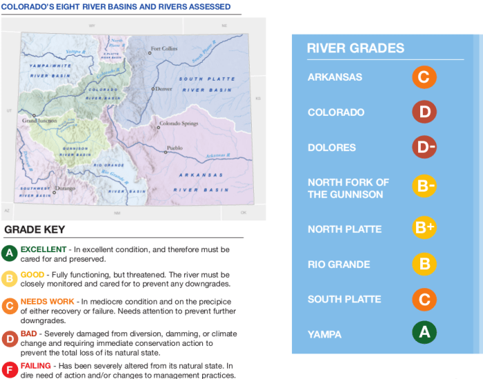
Conservation Colorado has released a new report analyzing several rivers flowing through our state and the Colorado River gets a grade of a “D”.
The report covers the health and wellbeing of eight rivers and the reason behind behind the Colorado River receiving such a low grade is because more than half of the water is diverted out for human use.
Officials say 50 percent of Denver Water comes from the Colorado River and overall 81 percent of the water is used for agriculture.
The river once reached the ocean and with the report highlighting the population of Colorado to double by 2050, officials say it is hard to see a health future.
Although Sarah McCarthy, Western Slope Field Manager for Conservation Colorado does say, this waterway still has a chance to thrive, “A big part of that solution is going to be urban water conservation so a huge part of the demand for the water in these rivers especially the Colorado River is water for urban municipalities. So if we within urban municipalities can work on water efficiency, water conservation, water recycling we can decrease that demand even as population grows.”
McCarthy says there are already multiple restoration groups working towards keeping the river healthy…
Also of the eight rivers on this report the Yampa River is the only river to receive and “A”.
FromThe Grand Junction Daily Sentinel (Dennis Webb):
The Dolores and Colorado rivers graded out poorly, and the Yampa River quite well, in an environmental group’s new scorecard grading the health of eight rivers in Colorado…
Other grades it issued include a C for the Arkansas River, a B for the Rio Grande, a C for the South Platte and a B-plus for the North Platte…
The group says in its release that the state’s rivers “are threatened by climate change, overuse, poor dam management, energy development, and the needs of a population that is set to double by 2050. The report provides several ideas to protect our rivers, including conserving water, voluntarily sharing water rights, avoiding large new water diversions, building water-smart landscapes, and implementing Colorado’s Water Plan.”
Dolores River watershed
The Dolores flows from southwest Colorado to Mesa County before veering into Utah. The report cites low flows in the river and increases in water temperature and silt and sediment that threaten coldwater native fish species. It says McPhee Dam near the community of Dolores has cut the river’s flows in half…
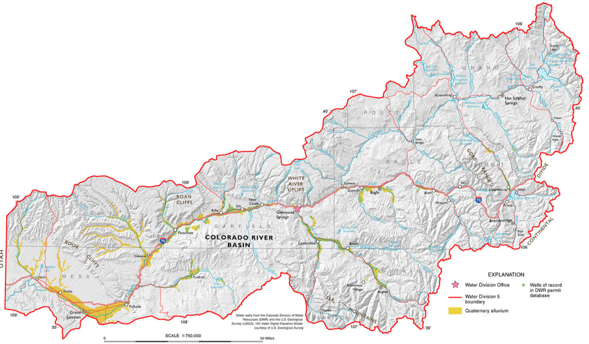
Colorado River Basin in Colorado via the Colorado Geological Survey
On the Colorado, it points to well-known concerns such as a number of dams and reservoirs on the river and its tributaries, and heavy diversions to the Front Range, including up to 60 percent of flows in the upper reaches of some headwaters tributaries.
Yampa/White/Green/North Platte river basins via the Colorado Geological Survey
The report calls the Yampa “near-pristine,” with very little diversion of water. But it adds, “Proposed new storage projects and expansions threaten this free-flowing river.”
Jim Pokrandt, spokesman for the Colorado River District, said Conservation Colorado deserves a “big thank you … for an excellent summation of the challenges facing the state’s rivers, not the least being the Colorado River. As is pointed out, all stake-holders need to share in balanced means for improvement for the betterment of the state. Everybody has a role to play. In many cases, stakeholders are working on solutions.”
Montezuma County Commissioner Larry Don Suckla disagrees with the Dolores River grade.
“I believe — I’m down there on that river all the time — that it’s doing just fine,” he said.
He said the flows don’t look any different from when he was a kid below where the dam ended up being built in the 1980s. He said the creation of McPhee Reservoir has assured minimal streamflows below it, where previously the river sometimes would almost dry up.
That’s because of water diversion that occurs for irrigation, but the region is dependent on water from the river, he said.
“It’s the lifeblood of Montezuma County, I can tell you that,” he said.
Amber Clark, program coordinator for Dolores River Boating Advocates, released a statement from the group saying, “Without question the Dolores River is challenged; that is why we at DRBA do what we do.
“However, it is extremely important to acknowledge that a lot of great collaborative work has been done and continues to be done at the local level. The problem is not dam management; there is simply not enough water for today’s competing interests and DRBA is dedicated to respecting consumptive water rights holders and working with the diversity of local stakeholders to continue finding solutions for the lower Dolores. We strongly feel that is where the best solutions come from.”
Both the boating group and Suckla praised a special water release that was made below the dam this year thanks to plentiful snowpack, boosting runoff flows to provide environmental and recreational benefits.
The boating group said in its statement, “Stakeholders — including water managers and farmers, recreationists, conservationists, fishery managers, and land managers — worked together to ensure that allocations from McPhee were met while providing a great boating season and accomplishing important ecological goals.”
It said local conversations also are occurring about a possible National Conservation Area designation for the Lower Dolores.
FromThe Grand Junction Daily Sentinel (Dennis Webb):
Two high-ranking state water officials have been promoted to the top leadership positions in their respective agencies.
Rebecca Mitchell, who was instrumental in creating Colorado’s Water Plan as a water supply planning section chief for the Colorado Water Conservation Board, recently was named its new director by the 15-member board that oversees the agency.
She replaces James Eklund, an attorney with family roots in the Collbran area who has taken a job in a law firm.
The water board, with its 45-member staff, provides policy direction on water issues and is the state’s most comprehensive water information resource. The CWCB under Eklund oversaw the execution of Gov. John Hickenlooper’s order to create the plan for meeting future water needs in the state, with Mitchell helping carry the water by working within the agency and with other entities and the public in developing the plan.
Meanwhile, Hickenlooper this week announced the appointment of Kevin Rein as the new state engineer and director of the 260-employee Colorado Division of Water Resources, also known as the State Engineer’s Office.
He replaces Dick Wolfe, who retired after 10 years in the position.
Rein has been deputy state engineer since 2008, and first joined the division a decade earlier.
The division administers Colorado’s water rights system, issues water well permits, represents the state in interstate water compact proceedings, monitors streamflow and water use, approves dam construction and repair, conducts dam safety inspections, and maintains numerous water information databases.
“The importance of water administration has never been more clear as we implement Colorado’s Water Plan,” Hickenlooper said in a news release. “Kevin’s experience and leadership will be crucial to our state’s long-term success in protecting this vital resource.”
Rein said in the release, “The Division of Water Resources boasts a team of committed individuals focused on administering the state’s water resources and serving the public, and I am honored by this leadership opportunity.”
Mitchell worked in the public and private sectors as a consulting engineer before joining the water board. She has also served as the water policy and issues coordinator within the Colorado Department of Natural Resources’ executive director’s office.
She said in a release, “Coloradans and our water communities are working like never before to solve our state’s challenges collaboratively.
The same kind of cooperation that led to Colorado’s Water Plan will fuel the long-running effort necessary to continue putting the plan into action. What a privilege to be part of this process.”
The Fort Collins Coloradoan is running a podcast about the flood with Erin Udell. Click through to listen. Here’s an excerpt:
20 years ago, on the night of July 28, 1997, heavy rainfall led to water reaching over the College Avenue bridge bikes now whizz under. Vehicles were swept away in rising floodwaters, trailers in a mobile home park off of Spring Creek were destroyed and five women lost their lives.
In a 31-hour period, Fort Collins saw 10 to 14 inches of rain. In its wake, the flood left an estimated $200 million in damage and had many people asking why.
Click here to read the discussion. Here’s an excerpt:
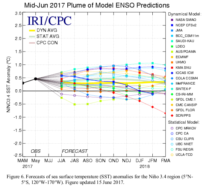
Synopsis: ENSO-neutral is favored (~50 to 55% chance) into the Northern Hemisphere winter 2017-18.
During June, ENSO-neutral continued, although equatorial sea surface temperatures (SSTs) remained above average in the central and east-central Pacific Ocean. The latest weekly Niño index values were near +0.5°C in the Niño-4 and Niño-3.4 regions, and closer to zero in the Niño-3 and Niño-1+2 regions. The upper-ocean heat content anomaly was above average during June, reflecting above-average sub-surface temperatures across the central and eastern Pacific. In the atmosphere, tropical convection was suppressed over the west-central tropical Pacific and enhanced over the Maritime Continent. The lower-level and upper-level winds were near average over most of the tropical Pacific, and the Southern Oscillation Index (SOI) and Equatorial SOI were slightly negative to near-zero. Overall, the ocean and atmosphere system remains consistent with ENSO-neutral.
Some models predict the onset of El Niño (3-month average Niño-3.4 index at or greater than 0.5°C) during the Northern Hemisphere summer. However, more than half of the models favor ENSO-neutral through the remainder of 2017. These predictions, along with the near-average atmospheric conditions over the Pacific, lead forecasters to favor ENSO-neutral into the winter (~50 to 55% chance). However, chances for El Niño remain elevated (~35-45%) relative to the long-term average. In summary, ENSO-neutral is favored (~50 to 55% chance) into the Northern Hemisphere winter 2017-18 (click CPC/IRI consensus forecast for the chance of each outcome for each 3-month period).
The latest ENSO forecast by CPC/IRI is holding steady since last month and favoring ENSO-neutral conditions (50-55% chance) into the winter of 2017-18. Although not favored, El Niño development has an elevated chance of occurring (~35-45%) relative to the long-term average (~25-35%), so we still need to keep our eyes on this possibility.
A little threshold teasing
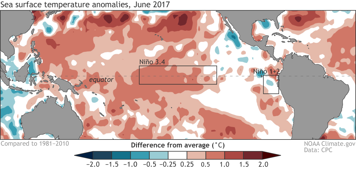
The ocean temperatures in the Niño3.4 region have remained nearly steady over the past three months. The temperature in June was about 0.4°C (0.7°F) above the long-term average in one of our most historically consistent SST datasets.
Average sea surface temperature (SST) during June 2017, shown as departure from the long-term (1981-2010) average. Red shading shows where SSTs were above average and blue shading shows where they were below average. Climate.gov figure from CPC data.
In fact, this persistent warmth means that the latest three-month average (April–June) Niño3.4 temperature has reached 0.5°C above the long-term average, which is one condition necessary to declare El Niño. This is the first time we’ve hit this threshold since April–June of last year. Does that mean we can declare that El Niño has awoken from its yearlong slumber? Let’s not get too excited just yet!
Regular readers may remember that El Niño is a seasonal phenomenon, so forecasters require that the Niño3.4 temperatures persist above the 0.5°C threshold for at least five consecutive three-month seasons. (If you ever forget, this nifty little cheat sheet can help you out). Therefore, forecasters have to decide if there is sufficient reason to expect these elevated Niño 3.4 temperatures to continue.
One factor that limits forecasters’ confidence in the persistence of El Niño conditions is the current state of the atmosphere. As you may recall, the El Niño/Southern Oscillation (ENSO) is a coupled phenomenon that requires cooperation between the atmosphere and ocean to develop. Over the past month, the atmosphere really has not resembled anything that we would expect in a typical El Niño. In particular, we have seen enhanced cloudiness and rainfall near Indonesia instead of the International Date Line, which directly contradicts the pattern of cloudiness and rainfall that is associated with El Niño. This general atmospheric pattern has been quite stubborn, holding fairly steady throughout the calendar year thus far.
Places that were more (purple) or less (orange) cloudy than the 1981-2010 average during March 2017, based on satellite observations of outgoing longwave radiation (heat). Thick clouds block heat from radiating out to space, so less radiation equals more clouds, and more radiation equals clearer skies. Climate.gov map from CPC OLR data.
Returning to the idea of ENSO as a coupled phenomenon, right now it’s as if the ocean is trying to get the atmosphere’s attention, but the atmosphere is just not that interested.
What forecasters see ahead
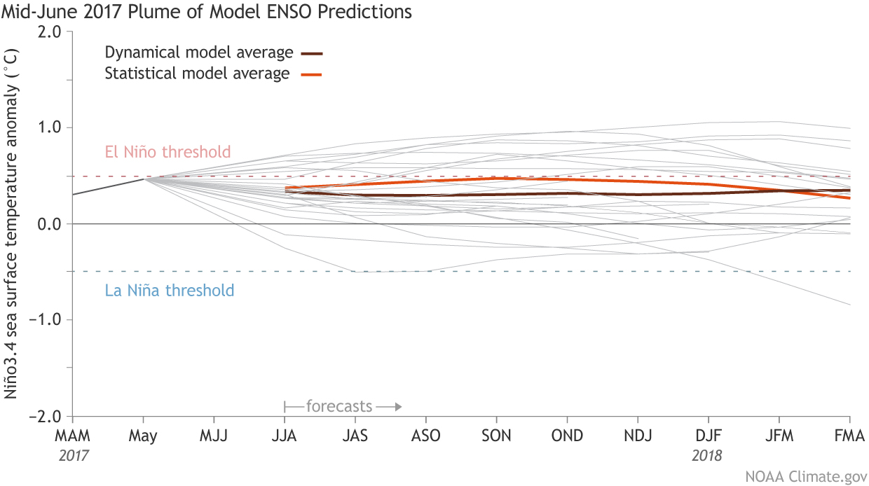
Just because the atmosphere seems disinterested in the ocean’s signals now doesn’t mean that the two cannot get on the same page and bring about a full-fledged El Niño in the months ahead. In addition to our analysis of the recent evolution of the atmosphere and ocean, forecasters rely on a variety of dynamical and statistical forecast models for guidance. The most recent model forecasts indicate a high probability that the sea surface temperature in the Niño3.4 region will remain at least slightly above average through winter of 2017-18. In addition, the average of the dynamical forecasts in the North American Multi-Model Ensemble falls just below the 0.5°C threshold for El Niño, which is a very slight forecast uptick relative to last month.
Climate model forecasts for the Niño3.4 Index made in mid-June 2017, from the IRI/CPC Prediction Plume. The brown line indicates the average of the dynamical models and the orange line shows the average of the statistical models. Thin grey lines show each individual model that goes into the average. Niño3.4 values in excess of +0.5C are generally reflective of El Niño conditions. Image modified by NOAA Climate.gov.
These forecasts, however, indicate that only a minority of models forecast full-blown El Niño development (and very few suggest La Niña development). Given that neither the forecast models nor the current state of ocean/atmosphere coupling seems too enthusiastic about El Niño or La Niña development in the near future, the forecast is sticking with the continuation of ENSO-neutral conditions.
Despite the ENSO-neutral forecast lean, we still have a fair number of models forecasting at least a weak El Niño through the upcoming winter. Therefore, forecasters certainly are not ruling out the development of El Niño; in fact, they are calling for an elevated chance, relative to average, of El Niño onset. Specifically, El Niño typically occurs about 25-35% of the time, depending on the specific month, but forecasters predict the chances have risen to about 35-45% for the upcoming fall and winter. These forecast probabilities, however, are not high enough for the CPC to issue an El Niño Watch.
Closing the book on the “coastal” El Niño of 2017
As we previously discussed in February and April, extreme warming off the coast of Peru this past winter and spring, a phenomenon known as a “coastal El Niño,” resulted in severe flooding throughout Peru. The top figure above shows us that conditions in the eastern tropical Pacific (see the boxed Niño 1+2 region) have cooled considerably, resulting in near-average ocean temperatures off Ecuador and Peru and putting a welcome end to this coastal El Niño.
The consequences of this extreme event, however, will linger for much longer. A recent report indicates that this particular “coastal” El Niño event caused 158 deaths and severely affected more than 290,000 people. These severe impacts highlight why the global community must do its best to deliver accurate long-range forecasts of ENSO in its myriad forms. As Tony and Emily discussed earlier, however, the coastal El Niño does not always lead to the type of basin-wide El Niño that results in clearer impacts over the United States, and so we must rely on other tools for our predictions.
That means that we will be doing our best to fine-tune our ENSO forecasts in the months ahead, so stay tuned for more updates!
One of the top priorities of the Colorado Corn Administrative Committee (CCAC) has long been assisting local farmers in their quest to produce more food, feed, fuel and fiber with less resources and through more economically and agronomically sustainable production methods.
And that tradition continued in 2017, as the CCAC’s Research Action Team in January committed another $130,100 to various projects focusing on drought-tolerance, crop disease mitigation, hybrid development, crop residue management, and other aspects of sustainability in agriculture.
These investments come in addition to the $650,000-plus that the CCAC invested in research endeavors from 2011-2016.
For decades, the CCAC has provided dollars – as well as input and other resources – to a long list of projects that have evaluated irrigation practices, alternative water-transfer methods, seed varieties, root structure, meat quality, farm safety, environmental impacts, biofuels and rotational fallowing, among a number of other focuses.
Along the way, the CCAC has teamed up with municipalities, businesses, universities, research facilities, the state of Colorado and many others – relationships the organization will continue building upon in the never-ending effort to bring more tools and knowledge to Colorado’s producers.
The funds for these research projects comes from a one-penny-per-bushel assessment on corn grown in Colorado, with the farmers who serve as CCAC board members ultimately deciding where those dollars are invested.
“The Colorado Corn Administrative Committee invests and leverages its dollars and resources toward endeavors that run the gamut of market development, outreach, education and regulatory affairs. But our research projects rank among the most important investments, if not the most critical,” said CCAC President Mike Lefever, a Longmont-area resident who farms ground near Haxtun. “Taking continuous steps forward in producing more with less resources – and discovering the most sustainable methods of doing so – is absolutely vital, not only for us farmers, but for everyone. And with the knowledge gained from these research projects, we continue taking the needed steps forward.”
Following meetings and presentations in recent weeks, the CCAC’s Research Action Team agreed to fund the following projects:
• $48,249 to Colorado State University’s John McKay, to fund various local efforts needed for involving Colorado in a national collaborative project, aimed at identifying the specific genes that cause elite hybrids to be sensitive to drought.
• $43,663 to CSU’s Kirk Broders, to further examine the bacterial pathogen Xanthomonas vasicola pv vasculorum (Xvv) – officialy reported in the U.S. in 2016 (although it had likely been present before that), with some of the most severe disease pressure observed in Colorado. The information gained from the research will be used to develop mitigation strategies and outreach and education materials.
• $30,000 to CSU’s Todd Gaines, to lead research on the glyphosate-resistant weed Palmer amaranth (Amaranthus palmeri), with specific goals aimed at addressing environmental and economic sustainability for growers, providing practical value for weed management, and addressing management issues related to biotechnology.
• $8,188 to CSU Extension’s Joel Schneekloth, to quantify the effects of residue removal and/or tillage on winter soil moisture recharge in irrigated agriculture, as well as the impacts to irrigation requirements for the following growing season and other aspects of these corn-production methods.
***
The projects listed above come in addition to the Colorado Corn Administrative Committee’s investments in other ongoing or recently concluded research projects, which are :
• $141,282 ($47,094 per year, over three years) to Colorado State University’s Raj Khosla, Robin Reich and Louis Longchamps, to research and determine the most productive, efficient, profitable and sustainable practices in irrigated corn production. In particular, this project will examine the agronomic advantages of using variable-rate and precision irrigation methods, precision-nitrogen management, and variable-seeding rates.
• $45,747 over three years to Colorado State University to evaluate precision water and nutrient management practices.
• $31,580 to Kirk Broders at Colorado State University, to complete a comprehensive survey of bacterial, fungal and viral pathogens of corn grown in Colorado, including foliar, ear, stalk and root pathogens. This information will later be used to direct future pathological studies of corn at CSU. Read more here.
• $30,425 to Colorado State University’s Troy Bauder and Erik Wardle, for their “BMP Research and Demonstration” project, which over two years will monitor the effects of improved nutrient management methods commonly practiced by corn growers, to better understand the agronomic and water quality benefits from these practices. This is expected to be useful in a triennial review for the Colorado Water Quality Control Commission, helping quantify the good work producers are already doing in this area. Read more here.
• $26,700 to Erick Carlson at CSU, to develop additional methods for reducing deep percolation of nitrates into groundwater, through investigating the functioning of wetlands created by irrigation runoff to trap and process nitrates. Read for here.
• $26,520 to CSU for evaluation of drought-tolerant corn varieties in dryland conditions.
• $25,000 to CSU’s Phil Westra and Scott Nissen, for various objectives at the Center for Ecology, Evolution & Management of Pesticide Resistance.
• $24,850 to Godsey Precision AG LLC, to look in-depth at water savings with variable-rate irrigation for farmers using water from the Ogallala Aquifer. Specifically it will examine the water-holding capacity of the top two feet of soil and the crop’s water use throughout the season, and also determine the differences in fields with 39,600, 36,000 and 32,000 plants per acre, and how many soil probes are needed in-season to accurately monitor soil moisture.
• $21,240 to Jerry Johnson and Sally Sauer with Colorado State University, to continue testing yield performance of four drought tolerant corn hybrids compared to four traditional, non-drought tolerant hybrids, at three different plant densities, under dryland production conditions in northeast Colorado.
• $17,287 to Louis Comas with the U.S. Department of Agriculture’s Agricultural Research Service, to continue overseeing development of a tool for monitoring and managing water stress in corn.
• $15,604 to Louise Comas with the USDA’s Agricultural Research Service, to create a tool to help corn producers identify when their crop is going into stress, help estimate potential yield impacts of that stress, and help producers in assessing potential impacts from constraints in their water supplies.
• $11,900 to the USDA’s Agricultural Research Service for a 2016 water stress monitoring project.
• $3,866 to Joel Schneekloth with the Colorado Water Institute, to study the impact of residue removal and tillage upon the soil characteristics important to crop production and crop-production economics
Here’s the release from the Western Governor’s Association:
Western Governors have urged the U.S. House of Representatives Committee on Appropriations to provide adequate funding for the National Integrated Drought Information System (NIDIS) in recognition of its significant role in western water management.
“Adequate measures to manage western water resources in the face of inevitable future drought conditions must be prioritized and implemented,” notes the letter sent on June 30, 2017. “Serving a valuable role in western water management and drought response, the NIDIS program improves precipitation forecasts needed to provide early drought warning, and should be adequately funded.”
The letter, signed by Western Governors’ Chair and Montana Gov. Steve Bullock and WGA Vice Chair and South Dakota Gov. Dennis Daugaard, was sent to U.S. House of Representatives Committee on Appropriations Chairman Rodney Frelinghuysen and Ranking Member Nita Lowey.
The GISTEMP monthly temperature anomalies superimposed on a 1980-2015 mean seasonal cycle.
June 2017 was the fourth warmest June in 137 years of modern record-keeping, according to a monthly analysis of global temperatures by scientists at NASA’s Goddard Institute for Space Studies (GISS) in New York.
Last month was 0.69 degrees Celsius warmer than the mean June temperature from 1951-1980. It is surpassed by June 2016 (+0.79 °C) and June 2015 and 1998 (+0.78 °C) and only insignificantly warmer than June 2005 (+0.68 °C).
Except for June 1998, the ten warmest months of June occurred between 2005 and 2017.
The monthly analysis by the GISS team is assembled from publicly available data acquired by about 6,300 meteorological stations around the world, ship- and buoy-based instruments measuring sea surface temperature, and Antarctic research stations.
A global map of the June 2017 LOTI (land-ocean temperature index) anomaly, relative to the 1951-1980 June average
The modern global temperature record begins around 1880 because previous observations didn’t cover enough of the planet. Monthly analyses are sometimes updated when additional data becomes available, and the results are subject to change.
Click here to go to FaceBook to view Conservation Colorado’s introductory video.
Click here to read the report card. From the website:
Our rivers in Colorado are a fundamental staple to our communities, our economy, our environment, and our way of life. Unfortunately, they are threatened by climate change, overuse, poor dam management, energy development and the needs of a growing population. In order to take action to protect our rivers, we must first have a clear understanding of what threatens them. That’s why Conservation Colorado just released a new report that assesses the health of eight major rivers across the state. Read the full report here.
It’s a provocative report, and it’s meant to be, Conservation Colorado water advocate Kristin Green said during a phone interview Thursday.
“We want to bring attention to some of the opportunities we have to improve our water quality,” Green said. “In all of these, there’s a call to action.”
Green’s team graded one river in each of Colorado’s eight river basins, assigning an “A” grade only to the Yampa River, which flows through Steamboat Springs.
The Colorado River earned a “D,” and the South Platte River earned a “C.”
Reasons for the grades ranged from water diversion — which Greeley and at least a dozen other Front Range communities do with the Colorado River, diverting water across the continental divide to quench residents’ thirst — as well as water quality issues arising from farm or yard runoff, legacy mining pollution and sediment from wildfires.
Local water officials don’t agree with the grades, or the approach, saying these types of reports are consistently negative and unbalanced.
“It’s all subjective,” said Brian Werner, spokesman for Northern Water Conservancy District, which manages the Big Thompson water project. “Find another organization, and they may look at it differently.”
Werner said it’s good that reports like this get people thinking about water quality and conservation, but he said these types of reports often leave out discussion of the positive steps water officials have taken over the years.
The report assigned individual grades the rivers to make up their overall grades. Water quality in the South Platte, which feeds the majority of the state’s population, was rated “D.”
[…]
“Colorado is not an extremely industrialized state,” [Eric] Reckentine said. “So what are we comparing against?”
Reckentine acknowledged the South Platte River Basin has issues, including farm runoff. It’s why Greeley is in the early stages of a pilot program working with farmers to reduce that runoff.
Other parts of the report focused on the diversion of water, as well as dams and reservoirs, impacting the natural state of Colorado’s rivers and river basins. That focus knocked the Colorado River because of the amount of water Front Range communities pump out…
Werner had plenty to say on these rivers’ natural state. When it comes to the Colorado River, Werner said Trout Unlimited supports diversion projects that will actually improve fish habitat in the river.
And the South Platte, Werner said, didn’t flow year-round before people got to Colorado.
“Now, because of diversions, it flows year-round,” Werner said. “If there’s no water in there, there can’t be any fish.”
“They pick out this little slice; they don’t look at the big picture,” Werner said.
For Werner, the big picture is the mission to provide water for another 5 million people in the coming decades, and to do so while keeping conservation top of mind.
Reckentine agreed.
“It’s all part of the consideration,” Reckentine said. “We have a very intricate conservation plan, and demand reduction is a critical component of our future water planning.”
A statewide environmental organization has released its first-ever “rivers report card,” which ranks the health and well-being of eight Colorado rivers.
The ranking takes into account several factors including water quality, flow, amount of water diverted out of the basin, and existence of major dams. Only one river in Colorado received an “A” on the report card, with four other rivers graded at “C” or worse.
Rivers are important for Colorado’s environment as a whole, and they are also major destinations for outdoor activities. Conservation Colorado put the report card together to help Coloradans understand how to better take care of our rivers.
In the report, the group provides details on what the results mean, as well as more information on how to protect our rivers. Find the full report, an interactive web tool, and more at Conservation Colorado’s website.
In a river report card released Thursday, Conservation Colorado gave the Dolores River a D-minus based on low flows below McPhee Dam.
The environmental group says improved dam management is needed to better support long-term ecological and recreational values on the river.
“We recognize there has been some recent local action to improve conditions below the dam, but there is room for improvement,” said Kristin Green, a water advocate for Conservation Colorado.
The Dolores was graded on flow, water quality, water diverted out of basin and major dams.
“Based on flow data from the last 10 years, McPhee Dam has reduced the rivers flows by 50 percent,” resulting in an F, the report said.
Water quality received a D because the reduced flows have resulted in dramatic increases in water temperature and increases in silt and sediment, both of which threaten native fish.
According to the report, the river received a low grade because nearly two-thirds of its water has been diverted every year, “which is incredibly unsustainable if we aim to conserve this river for the future.”
Among major dams, the river got a C because river flow has been “severely impaired” and “management of McPhee Dam is a critical component to the viability of the lower Dolores River.”
The report concludes that “overall, the Dolores River is in poor condition below McPhee Dam, but it is in no way a lost cause.”
Green said the wide-ranging solutions to improve conditions include conservation by water users, voluntary leasing of water for downstream benefits and adjusting water law’s “use it or lose it” so water-right holders are not penalized for conserving water…
In response to the low grade, Mike Preston, general manager for the Dolores Water Conservation District, which manages the dam, explained that in the past 10 years, there has been a sustained effort by a diverse group of stakeholders to improve ecological and recreational aspects of the lower Dolores…
This year, there was a large and extended release below the dam that peaked at 4,000 cubic feet per second and flushed sediments, scoured channels and distributed seeds. This month, pulse releases from a reserved fish pool were triggered to flush non-native and predatory smallmouth bass off their nests to reduce populations in favor of native fish.
Preston said dam managers have worked more closely with boaters to accommodate their needs and preferred flow levels. To further fine-tune downstream management, teams descended on the river this year to study the effects of the high flows.
“There were more ecological and recreational studies done on the lower Dolores this year than ever before,” Preston said.
Water conservation by all water users is one solution that helps improve flows below the dam. Preston said that when farmers use less water to produce the same amount of crops, more water stays in the reservoir contributing to carryover storage the next year.
“Carryover storage year to year benefits everyone, including agricultural users, the downstream fishery and boaters,” he said.
To increase conservation, the district promotes cost-sharing programs for farmers to switch from side roll sprinklers to the more efficient center-pivot sprinklers.
More collaboration with groups with differing opinions on best use of water has improved the outlook and possibilities for the lower Dolores, Preston and Green said.
McPhee managers also have worked more closely with Colorado Parks and Wildlife, the Dolores River Boating Advocates, American Whitewater and The Nature Conservancy…
In response to the report, Sam Carter, of the Dolores River Boating Advocates, said there is no question that the Dolores River is challenged, but it is not due to poor reservoir operations.
“The problem is not dam management, there is simply not enough water for today’s competing interests,” he said. “It is extremely important to acknowledge that a lot of great collaborative work has been done at the local level.”
He said boating groups are dedicated to respecting water-right holders and are working with a diversity of stakeholders to find solutions for the lower Dolores.
“This year is a great example of the progress that has been made. We worked to together to ensure McPhee allocations were met, while providing a great boating season and accomplishing important ecological goals. Local conversations about a possible National Conservation Area for the Lower Dolores are still underway.”
Western Governors’ Association Policy Resolution 2017-04: States have jurisdiction over water resource allocation decisions and are responsible for balancing state water resource needs within the objectives of the federal Clean Water Act. Western Governors recognize the importance of the Safe Drinking Water Act, its standards for drinking water contaminants, and adequate federal support for states’ missions to meet federal drinking water system requirements. Western Governors also urge adequate federal funding and support of states’ efforts to address water quality. Read, download the Resolution
Click here to go to the US Drought Monitor website. Here’s an excerpt:
Summary
This U.S. Drought Monitor week saw hot and dry conditions persist across the western U.S as a ridge of high pressure anchored over the region exacerbated drought conditions in eastern Montana as well as elevating fire danger across the region. According to the National Interagency Fire Center, ~70 large wildfires are currently burning across the West. On Friday and Saturday, daily high-temperature records were broken at various locations including: Las Vegas (116°F), Los Angeles (98°F), Phoenix (118°F), Reno (104°F), Boise (104°F), and Salt Lake City (104°F). Some relief from the heat came as monsoonal circulation returned to the Southwest bringing scattered showers and thunderstorms to portions of the Southwest and eastern Great Basin, although accumulations were generally less than 1 inch for the week. In drought-stricken areas of eastern Montana and the Dakotas, excessive heat continued to deplete soil moisture and further stressed rain-fed crops, pastures, and rangelands. In South Dakota, 72% of the spring wheat crop is currently rated as poor to very poor while Montana is not far behind at 62%, according the U.S. Department of Agriculture (USDA). Overall, declining conditions have resulted in the U.S. spring wheat crop being rated at 39% in poor to very poor condition. Further south in Oklahoma, rainfall during the past several weeks has led to improvements in soil moisture in eastern and southern portions of the state. Elsewhere, short-term precipitation deficits and dry soils led to expansion of areas of moderate drought in Iowa while the eastern U.S. remained drought-free on this week’s map…
The Plains
Areas of Moderate Drought (D1), Severe Drought (D2), and Extreme Drought (D3) expanded across eastern Montana, North Dakota, and South Dakota where hot and dry conditions continued as well as reports of declining crop conditions and hay shortages. In South Dakota, “soybeans statewide are showing thin stands, slow growth, and small size for this time of time year” according to the South Dakota State University (SDSU) Extension. In North Dakota, small grain crop failures are being reported as well as reports of producers selling off livestock. According to the USDA’s latest Crop Progress, the percentage of topsoil rated very short to short is as follows: Montana (89%), South Dakota (79%), Nebraska (65%), and North Dakota (62%). In eastern Montana, hot and dry weather persisted with limited precipitation. According to the July 10th Montana Crop Progress (USDA), “Haying is running at least two weeks ahead of schedule in some parts of the state, but little is on the market as livestock operations are hesitant to sell given that much of the state is experiencing drought.” In the southern Plains, some minor improvements were made in areas of Abnormally Dry (D0) and Moderate Drought (D1) in Oklahoma where precipitation has been above normal during the past 30 days in contrast to below normal precipitation in central and western portions of the state where areas of Moderate Drought (D1) expanded. During the past week, average temperatures in the northern Plains and eastern Montana were 4 to 10-plus degrees above normal with the greatest anomalies observed in eastern Montana where temperatures soared into the low 100s. Overall, the region saw some isolated storms which produced only minor accumulations – generally less than 1 inch…
The West
During the past week, the hot and dry pattern continued across most of the West with record-breaking high temperatures reported from Phoenix to Boise during the weekend. In the Southwest, the monsoon has been off to a slow start overall. Since the beginning of the month, storm activity has been spotty across portions of Arizona, Nevada, and New Mexico yielding limited precipitation amounts and elevating fire risk with dry lightning and high wind gusts. In central Arizona, a new area of Moderate Drought (D1) was added to the map in Yavapai County where short-term dryness and surface water flows are well below normal on the Agua Fria and Verde rivers. In central Utah, an area of Moderate Drought (D1) was introduced in response to below normal precipitation during the past 90 days as well as low streamflows on the Sevier River and below normal reservoir storage levels at the Sevier Bridge Reservoir (36% of average). Areas of Abnormally Dry (D0) were expanded across southwestern Utah in response to short-term dryness, dry vegetation, and pockets of below normal soil moisture. In western Colorado, short-term precipitation deficits and dry soils led to expansion of areas of Abnormally Dry (D0). In California, despite having a very wet winter, the USDA is reporting the extent of topsoil moisture rated very short to short at 70% with subsoil moisture very short to short at 75%…
Looking Ahead
The NWS WPC 7-Day Quantitative Precipitation Forecast (QPF) calls for moderate precipitation accumulations (1 to 3 inches) across portions of the Southwest and Central Rockies as monsoonal moisture is expected to return while the remainder of the West will continue in a dry pattern. Much of the Eastern tier of the conterminous U.S. is expected to receive accumulations ranging 1 to 3 inches with the heaviest accumulations forecasted for south Florida, eastern portions of the Carolinas, and southern New England. In the Midwest, widespread accumulations of 1 to 2.5 inches are expected across eastern and northern portions of the region. The CPC 6–10 day outlooks call for a high probability of above-normal temperatures across the northern half of the conterminous U.S., Gulf Coast, and California. Below normal temperatures are expected in southeastern Arizona, northern Texas, Oklahoma, and Arkansas. Below-normal precipitation is forecast for the Pacific Northwest, central Plains, Midwest, Mid-Atlantic, and Northeast while there is a high probability of above-normal precipitation across the Southeast, South, Southwest, Great Basin, and Intermountain West.
As severe weather brewed in the Texas panhandle late in the afternoon of May 16, NOAA National Weather Service forecasters alerted residents in parts of western Oklahoma about the potential for large hail and damaging tornadoes that evening, particularly in the area around Elk City.
Ninety minutes later, a dangerous, rain-wrapped EF-2 tornado struck the small town: It killed one, injured eight, and destroyed about 200 homes and more than 30 businesses.
Normally, meteorologists issue warnings based on radar depictions or spotter reports. By then, a tornado could be minutes from touching down. This time, the NWS issued an additional advisory for parts of four counties in southwest Oklahoma stating “… a high probability that tornado warnings will be issued.”
A new, experimental forecast model made it possible.
Forecasters that day were working with researchers from NOAA’s National Severe Storms Laboratory who were testing a prototype Warn-on-Forecast system (watch this video), a new research tool that has the potential to dramatically improve predictions of extreme weather at specific locations up to three hours in advance.
It was the first time the Warn on Forecast (WoF) model was used by the NWS in this way.
“We had a picture of the storms and their evolution before they became life-threatening,” said Todd Lindley, science operations officer with the NOAA NWS Norman Forecast Office in Oklahoma. “We used this model guidance to forecast with greater lead time and greater confidence.”
“Based on the information from the NWS, we knew storms would intensify when they reached our area and were able to activate the outdoor warning sirens about 30 minutes ahead of the tornado,” said Lonnie Risenhoover with Beckham County Emergency Management.
As the storm evolved, a faster timeline of information-sharing
On May 12, the NOAA Storm Prediction Center had already identified the possibility of severe weather in the region, and early in the morning on May 16 they updated their forecast calling for significant tornadoes. At 1:50 p.m., NWS issued a particularly dangerous situation (PDS) tornado watch for 33 counties in western Oklahoma and the Texas panhandle.
Soon after, WoF prototype forecasts began to identify a specific area in the eastern Texas panhandle as the likely starting point for potential life-threatening weather.
“That level of detail and lead time in a forecast is new,” said NSSL Director Steve Koch. “To have information conveying a sense of certainty in so small of an area that far in advance is a success.”
The WoF combines the best weather prediction technologies from NSSL in Norman and NOAA’s Global Systems Division at the Earth Systems Research Lab in Boulder, Colorado.
WoF isn’t operational yet — more works needs to be done — but it represents a significant step on NOAA’s path to providing more precise hazardous weather information to the public sooner.
It’s just one example of how NOAA weather researchers work hand-in-hand with forecasters to develop and test scientific advances to protect lives, property and commerce.
Here’s the release from Governor Hickenlooper’s office:
Gov. John Hickenlooper today announced Kevin Rein’s appointment as the new State Engineer and Director of the Colorado Division of Water Resources. Rein replaces Dick Wolfe, who retired at the end of June after 10 years in the position.
Rein has served as the Deputy State Engineer since 2008, where he directed and supervised the review and engineering evaluation of substitute water supply plans; water court and well permit applications; subdivision water supply plans; and other instruments that guide the management of water rights throughout Colorado. He has worked for the Division since 1998.
“The importance of water administration has never been more clear as we implement Colorado’s Water Plan,” said Governor John Hickenlooper. “Kevin’s experience and leadership will be crucial to our state’s long-term success in protecting this vital resource.”
As State Engineer, Rein will oversee and manage the Division of Water Resources within the Department of Natural Resources. The Division is responsible for administering Colorado’s water rights system, issuing water well permits, representing Colorado in interstate water compact proceedings, monitoring streamflow and water use, approving dam construction repair and safety inspections, and maintaining numerous water information databases.
“The chance to serve the state in this new capacity is an honor and a privilege,” Rein said. “The Division of Water Resources boasts a team of committed individuals focused on administering the state’s water resources and serving the public, and I am honored by this leadership opportunity. We will work with our customers to solve problems, exercise good stewardship, and assist the public in understanding Colorado’s water heritage.”
The State Engineer’s Office was created in 1881 and includes 260 employees. Its mission is to competently and dependably administer and distribute the waters of Colorado in accordance with the laws of the state, ensure that dams and water wells are properly constructed and maintained to ensure public safety, and to develop, maintain, and provide access to accurate and timely information regarding water resources.
Colorado’s looming water shortage would be easier to quench if farmers and ranchers were willing to part, if only temporarily, with some of their supplies.
But most are not.
“I’m in agriculture to produce, not to sell or lease water,” said Logan County farmer Gene Manuello.
The state’s water situation can be boiled down to three simple factors.
One is numeric: Agriculture slurps up as much as 89 percent of available water in Colorado, compared to municipalities and industry, which use 7 and 4 percent, respectively.
The second is power: Farmers and ranchers typically hold senior water rights that trump the junior water rights held by cities, suburbs and manufacturers. In Colorado, and in most western states, the first person to claim the water right gets to use it. Everyone else and their water needs come next on the priority list. The arrangement is known as the doctrine of prior appropriation, and it’s been the defining principle of Colorado water going back to the 1850s, before we were even a state. Our byzantine system of water laws favor farmers and ranchers and essentially encourages them to use all the water to which they’re entitled, or risk losing it.
The third factor is shortage: Colorado’s current population of 5.6 million people is expected to soar to as much as 10 million by 2050. Estimates show that, if water supplies aren’t reconfigured and redistributed by that time, demands caused by climate change and urban and suburban growth will leave the state looking more like desert Nevada than semi-arid Colorado.
Colorado’s looming water shortage is projected to be about one million acre-feet of water per year. A family of four, on average, uses about a half-acre foot of water per year, or about 163,000 gallons of water per year. So a million acre-foot shortage would impact virtually every Coloradan and in every way of life: farmers, city dwellers, businesses, oil and gas drillers, environmentalists, birders, anglers, rafters, kayakers and everyone else who values the health and vibrancy of Colorado’s rivers.
Almost all of the new residents expected in the next three decades, possibly another four million or more, are likely to settle on the state’s Front Range and its urban population centers. That underscores a longtime conflict in Colorado’s water landscape: While 80 percent of the water in Colorado is west of the Continental Divide, 80 percent of the population is on the Eastern Slope, mostly in the Front Range cities between Fort Collins and Pueblo. That fact is at the heart of decades of angst for Western Slope residents who believe the Eastern Slope wants all their water, especially from the Colorado River, versus those on the Eastern Slope who point out that most of the state’s agriculture is based on their side of the Divide.
Gov. John Hickenlooper unveiled Colorado’s first statewide water plan in November 2015 as a blueprint for finding a massive amount of water to keep up with growth and climate change’s effects on water supplies. Although the plan lacks specifics, it will rely largely on a host of possible solutions from municipal water users and from industrial users, which generally have the most junior water rights in the state.
The water plan puts a strong emphasis on keeping farm- and ranchland intact in an era of unprecedented growth. By 2050, the state estimates that irrigated farmland could shrink from 3.5 million acres currently to about 2.7 million acres. The largest hit is expected in the South Platte River Basin, which covers most of the northern Front Range and northeastern plains, and includes seven of Colorado’s ten most productive agricultural counties. The South Platte Basin holds 80 percent of the state’s population, but only 20 percent of its water supply. Growth along that corridor is expected to take out of production up to 35 percent of irrigated acreage in what Hickenlooper says would be a big blow to Colorado’s farm economy and culture.
For all its emphasis on the need to preserve farms and ranches, Hickenlooper’s water plan also recognizes that agricultural water needs to be at least part of solving Colorado’s massive water shortage in the next three decades. It is banking on a host of ideas for temporarily transferring water from farms and ranches to quench other, pressing needs. The state says those methods could glean 5 percent of the state’s projected shortfall. That is, if agriculture is inclined to participate.
But, at least so far, interest has been tepid. Farmers and ranchers are reluctant to embrace new practices, fearing that Colorado’s use-it-or-lose-it system of water law will strip their long-term water rights.
Colorado’s future water demands pit agriculture’s massive water consumption against virtually every other need for water out there.
Share and store alike
To find the water for cities, suburbs, towns and industry, yet still keep agriculture viable, the water plan borrows on an idea that southwestern states have been using for a decade: alternative transfer methods, or ATMs.
In one method, known as rotational fallowing, farmers forgo planting and irrigating their land for a growing season and lease the water saved, over the short term, to utilities or districts that serve cities and towns. Say, for example, a farmer has rights to 100 acre-feet of water. One acre-foot is about 326,000 gallons, or enough water to supply two families of four for a year. That farmer decides to lease 10 acre-feet to a city for one growing season, maybe cutting back on the acreage of winter wheat planted. The farmer is paid for that water, which in a time of low wheat prices may be more valuable than the crop itself and the city receives, at least temporarily, enough water to satisfy 80 people for a year.
The state invested close to $6 million between 2009 and 2017 into encouraging farmers and other water users to participate in agricultural transfer method programs, dating back to the authorization of these grant and pilot programs in 2007.
Agricultural water transfers have been a way of life for Chris and Mary Kraft, who operate two dairy farms and grow 900 acres of corn and hay near the city of Fort Morgan. The Krafts have for the past 20 years leased 2,500 acre-feet of their water every year to Xcel Energy for a nearby power plant. Neighboring farms also participate in that lease program. In dry years, Chris Kraft said in a recent webinar, he can tap into nearby Jackson Lake for water to sustain his crops, if needed. Other farmers may have to dry up a portion of their land in order to meet their obligations to Xcel. But in wet years, such as the last three, the lease payments go to make improvements – including conservation measures – to the ditch system that transports the water to farms and the power plant.
“The whole community benefits from the arrangement,” Chris Kraft said.
Transfer methods are an alternative to “buy and dry” – a practice in which farmers and ranchers sell their water rights to cities and stop raising their crops. The choice comes down to whether to sell out and use the profit for retirement, or to, as the Krafts do, temporarily lease water and receive an annual payment from the cityfolk who are thirsty for it. One option irreversibly dries up the land, and the other keeps it in production and preserves families’ roots on their farms.
Those roots are embodied in the words of novelist, environmental activist and farmer Wendell Berry, who in his book Bringing it to the Table, asked, “Why do farmers farm, given their economic adversities on top of the many frustrations and difficulties normal to farming?
“As always the answer is: ‘Love. They must do it for love.’ Farmers farm for the love of farming. They love to watch and nurture the growth of plants. They love to live in the presence of animals. They love to work outdoors. They love the weather, maybe even when it is making them miserable. They love to live where they work and to work where they live… They love the measure of independence that farm life can still provide.”
As Chris Kraft sees it, water transfers could in the long run be a lot more costly to cities than they anticipate. He pointed out that transferring water rights in Morgan County, for example, means that cities like Aurora that are leasing the water have to set up pipelines and pumping stations because they’re at a higher elevation from the farmland. That means the true cost of water transfers comes not just in paying the farmer for the lease, but also paying for the infrastructure and electricity to operate the pumping stations. As the old adage goes, “water runs uphill to money.”
The better solution, he said, is to store water in underground aquifers (which is done by pumping water into those aquifers) so that in wet years, excess water can be stored and then available in times of drought. That kind of storage is available: Colorado has four major underground aquifers, all located along the state’s Eastern Slope. A series of bedrock aquifers that stretches from Greeley to Colorado Springs and from the foothills to Limon has been identified as a strong possibility for storage in future years.
“The state needs some kind of alternate storage to make up for the new people moving here,” Kraft said. “It won’t be cheap. And when there’s a high demand situation, the last drop of water will be the most expensive.”
Storage first, ATMs second is also the view of Joe Frank, who manages the Lower South Platte Water Conservancy District, based in Sterling. Frank said the state needs to capture and store its available water first, noting that water coming out agricultural transfers still needs a place for that water to be stored.
In good years, Frank said, the South Platte has water available that isn’t already committed through interstate agreements or through local water rights. An agricultural water transfer should act as a way to bolster water supplies in years when the water isn’t as plentiful. “Storage should be the focal point,” Frank told The Colorado Independent. He believes ATMs should be part of a combined coordinated project with new or refurbished storage, such as underground aquifers. “Otherwise you put a lot of pressure on drying up agricultural land. Even though it’s an ATM, it’s still taking ag land out of production. The less we can do that, the better.”
For Manuello, who has been growing corn and hay and raising cattle since the 1970s near Sterling, water leasing undermines the very reason he works in farming and ranching. “I believe in agriculture and ag production, so any process to take irrigated acres out of production doesn’t work for me.”
Although he understands that leasing water temporarily helps keep some farms going, Manuello said the state’s inclusion of ATMs in its water plan sends a strong message to farmers that population growth should come at the expense of agriculture. Until the state exhausts other options for gleaning and storing more water, he said, “I have a problem taking water off the land or even promoting the idea” of ATMs.
Those who watch the growing use of water transfers don’t see them as a magic bullet, but more of a compromise and one that won’t fix the problem of 100,000 new Colorado residents every year.
Carlyle Currier, a Western Slope cattle rancher, told The Independent that some in the agriculture community worry that ATMs are just a slower way of putting farm and ranchland out of production. But as an alternative to “buy and dry,” ATMs can provide farmers and ranchers with, at least in the short term, “the chance to retain ownership of their water rights” and at the same time keep their farm and ranches sustainable, he said.
A hard sell
Aside from heartland ideology, there are market and meteorological forces at play that help explain why agricultural water transfers aren’t catching on.
On the face of it, you’d think waning commodity prices would drive up farmers’ interest. Some of the state’s biggest crops like corn and wheat are at their lowest prices in 20 years. Beef prices also are lean. The value of farmers’ and ranchers’ water rights often exceeds the value of what they’re growing. You’d think growers driven financially to consider temporarily leasing their water under ATMs should be able to find willing buyers.
But that’s not the case, at least some parts of the state.
ATM pilot projects have been under way for the past six years in the Lower Arkansas Valley Water Conservancy District, which encompasses most of southeastern Colorado. The district’s executive director Jay Winner said he has 5,000 leases for water available from local farmers eager to temporarily lease their water rights to cities to offset the hit from low commodity prices. But no one wants them right now, Winner said, largely because the state is not facing drought conditions or water restrictions for the first time since 2012. The only interest he has had is from the Security Water District south of Colorado Springs, which is battling contamination in its water from toxic chemicals believed to come from a nearby military base.
The Colorado Water Conservation Board – the state agency that oversees water and administers agricultural transfer programs – has identified other significant barriers ATMs must overcome in order to succeed. In addition to the costs of building pipelines and storage, there are the potential high costs associated with transferring water rights, which are tied to the process of gaining approval through the state’s water courts. Changing a water right can take up to five years and cost hundreds of thousands of dollars, according to Greg Baker of Aurora Water. Another barrier is that constantly switching farm and ranchland in and out of production can create soil and weed problems that could lower farmers’ lower crop yields and hurt their bottom line.
Perhaps the most significant barrier is a desire by water providers, such as municipal water utilities, to find permanent water supplies rather than the temporary water provided by an ATM. Cities – and the developers building in them – are looking for reliable, sustainable sources of water rather than quick fixes that come at the whims of farmers and ranchers, and with the unpredictability of how much it rains or snows year to year.
But these temporary transfers do serve a purpose, according to Baker. Sometimes temporary is better, he indicated, because it’s cheaper to lease water than to obtain permanent water supplies, and all costs are passed along to customers. Even then, however, temporary transfers can take a lot of time; Baker pointed to an example from 2003 when Aurora wanted water leases from the Arkansas Valley to solve that year’s drought. By the time the water finally reached Aurora, it was 2005 and the drought was over. The water was used to refill reservoirs depleted by the drought, so it didn’t go to waste and did work to their benefit, he said. “Leases are good for hedging our bets” for future water shortages, Baker said. But he added that there haven’t been enough of those leases for Aurora Water to determine just how practical they can be.
Learning to ‘play nice’
In April, the Colorado Water Institute at Colorado State University released a report that looked at the future of agricultural transfer methods.
Brad Udall, one of the report’s authors, said that while these methods won’t quench all Colorado’s water needs, the water plan likely won’t meet its goals without them. There should be a way, he mused, to carry out ATMs that persuades long-feuding agriculture and municipalities they “can play nice together.”
The “water world is remarkably conservative, as it should be,” Udall said, and ATMs are relatively new. “And whenever you have that conflict, you will have a hard time getting a foothold [in making changes]. What we really need are good cases where it works.”
As a case in point, Udall – a member of The Colorado Independent’s board of directors – pointed to a project known as the Super Ditch in the Lower Arkansas Valley Water Conservancy District. The ditch is a water-leasing collaboration among nine water districts that took about seven years of stop-and-start, often painful negotiations. Udall noted that the state engineer put 60 conditions on one of the proposed deals tied to the Super Ditch. Water from the Super Ditch agreement flows to Fountain and Security, south of Colorado Springs, and in Fowler, in Otero County in southeastern Colorado.
The other part of the problem, and it’s one inherent to water, Udall said, is that every deal is different. The Water Institute advocates for some continuity among these deals, which would help reduce the costs of reaching legal agreements between teams of engineers and lawyers. Those costs can become “barnacles on the ship of commerce,” Udall said.
“They can overburden and eventually kill deals that would otherwise work.”
Recognizing that ATMs will be necessary in helping to solve Colorado’s water woes, the state has been more than willing to invest in them and fund efforts to educate farmers in hopes that they’ll overcome some of their reluctance. The Colorado Water Conservation Board has put $1 million annually into ATM grants since 2009. One grant, to the Parker Water and Sanitation District, allowed Colorado State University to set up farm demonstration on irrigation patterns for corn crops, which reduced water use by 30 to 40 percent. The Super Ditch made 500 acre-feet of water available through rotational fallowing. Another concept, known as water banks, lets farmers and cities “bank” water in an existing reservoir, without risk of losing water rights, and allows other water users to tap that water for a negotiated price.
Another transfer method that focuses on growing water-efficient crops, which frees up water for leasing, hasn’t been well received because farmers raise concerns that they lack the expertise or even the equipment to grow these different crops. With the average age of a Colorado farmer at 59, that’s not a small ask. Colorado’s two largest commodities – corn and wheat – are considered water-intensive crops; water-efficient crops that can be watered more efficiently include vegetables or the grain sorghum, which can be used for cattle feed in place of corn or wheat.
Then there’s deficit irrigation, a method that requires a crop be watered just enough to produce minimal yields, but which farmers say translates into minimal prices.
Water transfers may not yet be the boon in agriculture that state officials would like, but the environmental community is definitely taking an interest, as a way to shore up stream flows in some of Colorado’s jeopardized waterways.
One good example is taking place on the Little Cimarron River, a tributary of the Gunnison River that flows between Gunnison and Montrose most of the year. But the Little Cimarron goes dry in the summer, leaving its plants to wither and threatening its renowned trout habitat.
In an effort to improve the stream flows, the Colorado Water Trust is working on its first-ever permanent sharing of water that would boost stream flows in waterways that typically go dry, and in turn endanger the river’s ecosystem. The alternative transfer method planned for the Little Cimarron relies on temporarily using the water from nearby foreclosed land, formerly a farm near Cimarron (east of Montrose), that was purchased by Western Rivers Conservancy, which gave the water rights to the Trust. A smaller portion of those water rights were sublet to the Colorado Water Conservation Board, the state agency that awards grants for ATM pilots.
Under the plan, the farm’s water will be diverted during the driest times of the year into the Little Cimarron, allowing for enough water – and at a cool enough temperature – to provide a sustainable habitat for trout. The Trust’s Amy Beatie says her organization has a “projection tool” that indicates the best time to divert water into the river and how much is needed to maintain its flows.
Beatie acknowledges that water transfers off of agricultural land has its detractors. She pointed out that some of the pushback comes from long-standing beliefs about state water law.
“We got good at moving water out of rivers but there’s no provision [in state law] to protect rivers,” especially once those river flows drop to critically low levels. “The Constitution says the right to divert [water] shall never be denied,” she said, and that tells water users “take all you want and flat-line rivers across the state.”
While Colorado is a bit late to the game of protecting its rivers, Beatie said, climate change and population growth are moving the state forward on discussing ways to help restore or maintain rivers.
Says Beatie: “If everyone in [the water] community is willing to give up a little, we can look at restoring flows in other rivers.”
A Google Earth image of the crop circles in the lower Arikaree River watershed, highlighting the river reaches that were dry (red), disconnected pools (yellow), and flowing (blue) at the lowest water in late summer 2007. Only one segment of 9 miles of flowing river remained as habitat for fish. The river flows from left to right. Image created by Jeff Falke, University of Alaska Fairbanks.
Here’s the release from Colorado State University:
Farmers in the Great Plains of Nebraska, Colorado, Kansas and the panhandle of Texas produce about one-sixth of the world’s grain, and water for these crops comes from the High Plains Aquifer — often known as the Ogallala Aquifer — the single greatest source of groundwater in North America. A team of researchers, including Colorado State University Professor Kurt Fausch and Jeff Falke, a CSU alumnus and an assistant professor at the University of Alaska Fairbanks, have discovered that more than half a century of groundwater pumping from the aquifer has led to long segments of rivers drying up and the collapse of large-stream fishes.
If pumping practices are not modified, scientists warn that these habitats will continue to shrink, and the fish populations along with them.
The research team combined modeling from the past and future to assess changes in Great Plains streams and their fish populations associated with groundwater pumping from the High Plains Aquifer. The findings have implications for watersheds around the world, because irrigation accounts for 90 percent of human water use globally, and local and regional aquifers are drying up.
A ‘train wreck’
The Arikaree River in 2000 in early summer, when water is near its maximum extent. Photo: Kurt Fausch
Fausch said the study results are sobering. Based on earlier observations and modeling by Falke and a team of graduate students and faculty at CSU, the Arikaree River in eastern Colorado, which is fed by the aquifer and used to flow about 70 miles, will dry up to about one-half mile by 2045.
“You have this train wreck where we’re drying up streams to feed a growing human population of more than 7 billion people,” Fausch said.
Fausch described the situation as a “wicked problem,” one with no good solution. “More water is pumped out every year than trickles back down into the aquifer from rain and snow,” he said. “We are basically drying out the Great Plains.”
Pumping has dried up streams, small rivers
Since the 1950s, pumping has extracted nearly as much water as what exists in Lake Erie — about 100 trillion gallons — and almost none of it trickles back into the aquifer.
“This pumping has dried up long segments of many streams and small rivers in the region,” Fausch said. From 1950 to 2010, a total of 350 miles of stream dried up in the large area the team studied in eastern Colorado, southwestern Nebraska and northwestern Kansas. “Our models project that another 180 miles of stream will dry up by 2060,” Fausch said. An orangethroat darter, one of the nine remaining native fish species in the Arikaree River. Photo: Jeremy Monroe, Freshwaters Illustrated.
The loss of fish in the area is also a concern. “What we’re losing are the fishes that require habitat found only in the rivers and large streams of the region, and replacing them with those that can survive in the small streams that are left,” Fausch said. “We are losing whole populations of species from rivers in that region because there’s no habitat for them.”
As an example, seven of the 16 native fish species that were once found in the Arikaree River have disappeared since the first surveys were done in the 1940s. These fish include small minnows, suckers and catfish, species that the CSU scientist said are not among those that are currently federally endangered or threatened, so there’s little regulatory authority to preserve the habitats.
“We’re losing fish that people really don’t know about,” said Fausch. “They are cool and very beautiful, but not charismatic.”
Losing a river means losing more than fishes
Effects from the groundwater pumping will extend beyond the fishes and streams, too. Farmers in that area hope to conserve enough water so that future generations can continue to work on the land. And the everyday places that benefit from water could also disappear.
“If they lose the river, they’ll not only lose fishes, but they’ll also lose water for their cattle, and cottonwoods that provide shade,” Fausch explained. “They also lose the grass that grows in the riparian zone, which is critical forage for cattle in summer. Some of that’s your livelihood, but it’s also the place you go for picnics, and to hunt deer and turkeys. If you lose the river, you lose a major feature of what that landscape is.”
Center pivot sprinklers in the Arikaree River basin to irrigate corn. Each sprinkler is supplied by deep wells drilled into the High Plains aquifer.
Fausch said that there are some signs of progress, despite the grim findings. Local officials have put meters on wells to ensure that farmers pump only the amount of water allowed under their permits. And farmers are always experimenting with new technology that will allow them to optimize the amount of water they use to achieve the highest crop yields, since it takes electricity to pump the water from deep underground and this is an important cost to them. This doesn’t mean that the groundwater levels that feed streams are not declining, but instead are declining at a slower rate than in the past, he said.
Growing dryland crops an option
One additional option, though it might be a hard sell, is for farmers to grow dryland crops, meaning that they rely only on rainfall each year, instead of pumping water. The problem is the crop yields then vary widely from year to year, depending on the rain.
“Every farmer understands that eventually they will no longer be able to afford to pump as much water,” said Fausch. “Farmers are amazing economists. New options such as economical drip irrigation are being discussed, and farmers will likely switch to these options when they become available.”
Fausch, who has studied rivers throughout his entire career, grows wistful when talking about the research. “When we lose these rivers, we will lose them for our lifetime, our children’s lifetime, and our grandchildren’s lifetime,” he said.
Even if all pumping were stopped tomorrow, the aquifer would refill very slowly, over the next 100 years or more, said Fausch. As the groundwater table rose, rivers would start to flow again.
“Groundwater declines are linked to changes in Great Plains stream fish assemblages” was published in Proceedings of the National Academy of Sciences.
Falke received his doctorate in fisheries biology from CSU in 2009. The research team includes scientists from Kansas State University, Tennessee Technological University, U.S. Geological Survey, Colorado Parks and Wildlife, Westar Energy and The Nature Conservancy.
On April 7, 2016, the Environmental Protection Agency proposed adding the “Bonita Peak Mining District” to the National Priorities List, making it eligible for Superfund. Forty-eight mine portals and tailings piles are “under consideration” to be included. The Gold King Mine will almost certainly be on the final list, as will the nearby American Tunnel. The Mayflower Mill #4 tailings repository, just outside Silverton, is another likely candidate, given that it appears to be leaching large quantities of metals into the Animas River. What Superfund will entail for the area beyond that, and when the actual cleanup will begin, remains unclear. Eric Baker
Good representatives, at every level of government, are willing to go the extra mile.
In mid-June, Durango City Councilor Dean Brookie, La Plata County Commissioner Brad Blake and San Juan County Commissioner Scott Fetchenhier did just that, both literally and figuratively, by traveling to Washington, D.C. with Ty Churchwell of the Durango office of Trout Unlimited.
Armed with letters and messages from counties and town councils, chambers of commerce and other Animas River stakeholders, their aim was to meet with Environment Protection Agency director Scott Pruitt. Their goal: to lobby for priority status and adequate funding for the Bonita Peak Mining District Superfund project, now in its investigative stages.
Heading east, the four were worried. While Pruitt had announced that Superfund projects – there are 1,300 across the country – would be a top priority of the agency under the Trump administration, the preliminary 2018 federal budget released in March showed a 25 percent cut in funding for the program.
To their chagrin, the first part of the mission failed. Pruitt was out of the country and could not keep his appointment.
But good representatives are by nature persistent. And optimistic. Instead of a meeting with Pruitt, the four met with eight high-ranking EPA officials and were joined via phone by more staff members in Denver intimately familiar with the Bonita Peak listing.
Churchwell came away convinced that the cleanup and mitigation of acid mine drainage contaminating the headwaters of the Animas River is at the top of the agency’s list.
“The response was that Bonita Peak is a stated priority of the EPA,” he said. “We feel confident that the agency is deeply committed.” More proof of that statement is evident in the work now being done. While many Superfund sites sit idle, Churchwell said, the Bonita Peak project is underway.
That Brookie, Blake and Fetchenhier came away convinced as well is due in no small part to the negative publicity generated by the Gold King Mine spill in August, 2015. The EPA’s role in causing the disaster is well known, and the visitors to Washington were not about to let the agency off the hook. As Brookie reminded EPA staff, “You had your hands on the shovel.”
That played into the other message the group wanted to convey, Churchwell added, that this project can be the agency’s “opportunity to shine, and demonstrate how a federal agency can respond and do it right.”
All indications are that the agency agrees.
Before leaving Washington, the four also met with Sens. Michael Bennet and Cory Gardner and Rep. Scott Tipton to ask the trio for a coordinated and united show of support for the project.
We are both fortunate and thankful for the efforts made by our local elected officials to ensure the EPA makes good on the promise the Superfund program holds for a restored Animas River watershed.
Thanks also go to Churchwell for organizing and finding the means to fund the journey; no taxpayer money was used for the trip. In return, he would like to see sustained local interest and community oversight of the project. More opportunities to participate arrive next month with a series of informative meetings followed by a tour of the mining district in September.
We should all capitalize on the momentum generated by the visit; find details at http://wearetheanimas.com.
Lonetree Reservoir near Loveland, Colorado | Photo credit photokayaker via Flickr.
From the Loveland Reporter-Herald (Pamela Johnson) via The Denver Post:
The new lease holder for Lonetree Reservoir says that public access for boating and fishing at the reservoir southwest of Loveland will continue after Colorado Parks and Wildlife’s lease expires.
The state agency that has managed recreation at the reservoir since the 1970s announced last week that it was outbid for the lease, starting in June 2018, and claimed in a news release that public access to the reservoir would end at that time.
Tuesday, Berthoud Heritage Metropolitan District, which won the new lease, announced that they will not only continue to allow fishing and boating but have plans to improve the reservoir. Details of that access and any planned improvements have not yet been released, the district reported in a press release.
“We are thrilled to have been awarded the lease of Lonetree Reservoir,” John Turner, president of the district, said in a press release.
“We will keep this amenity open to the public. We have the resources to improve, manage and maintain this reservoir to an elevated level in which we have not seen with the current lessee.”



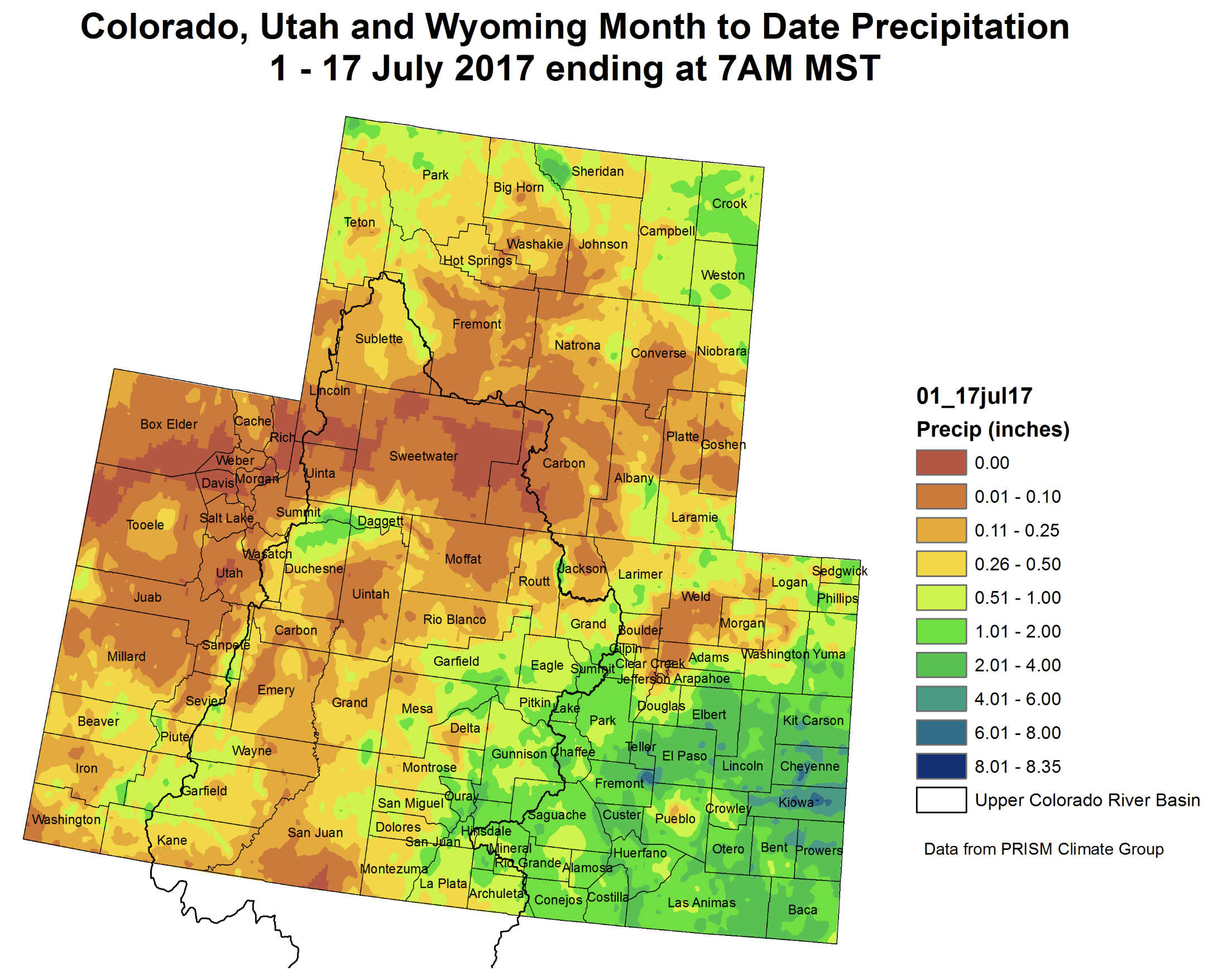


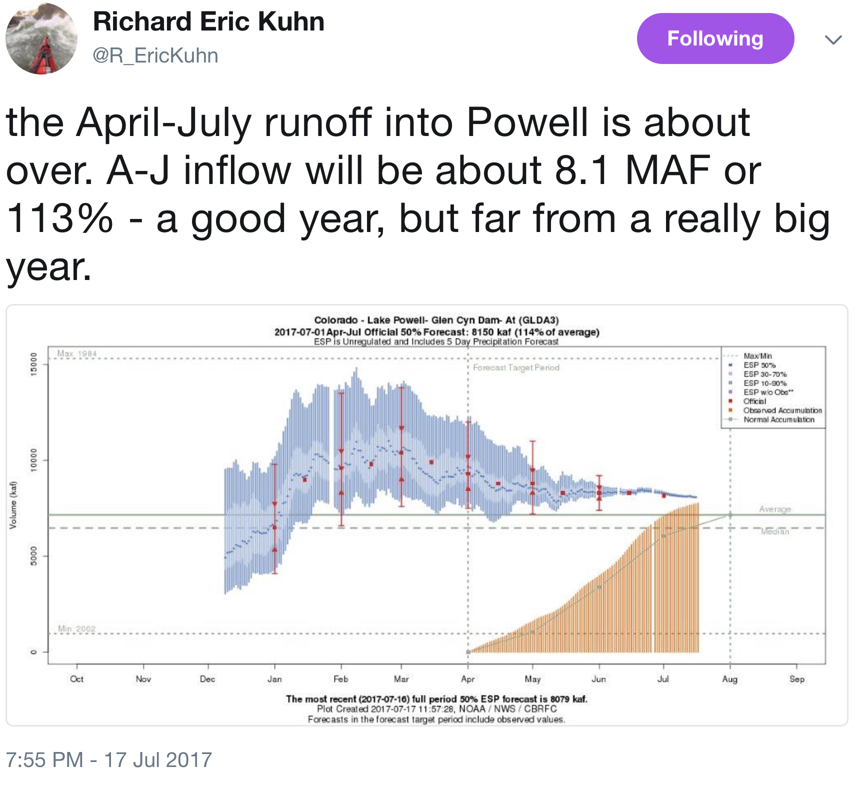
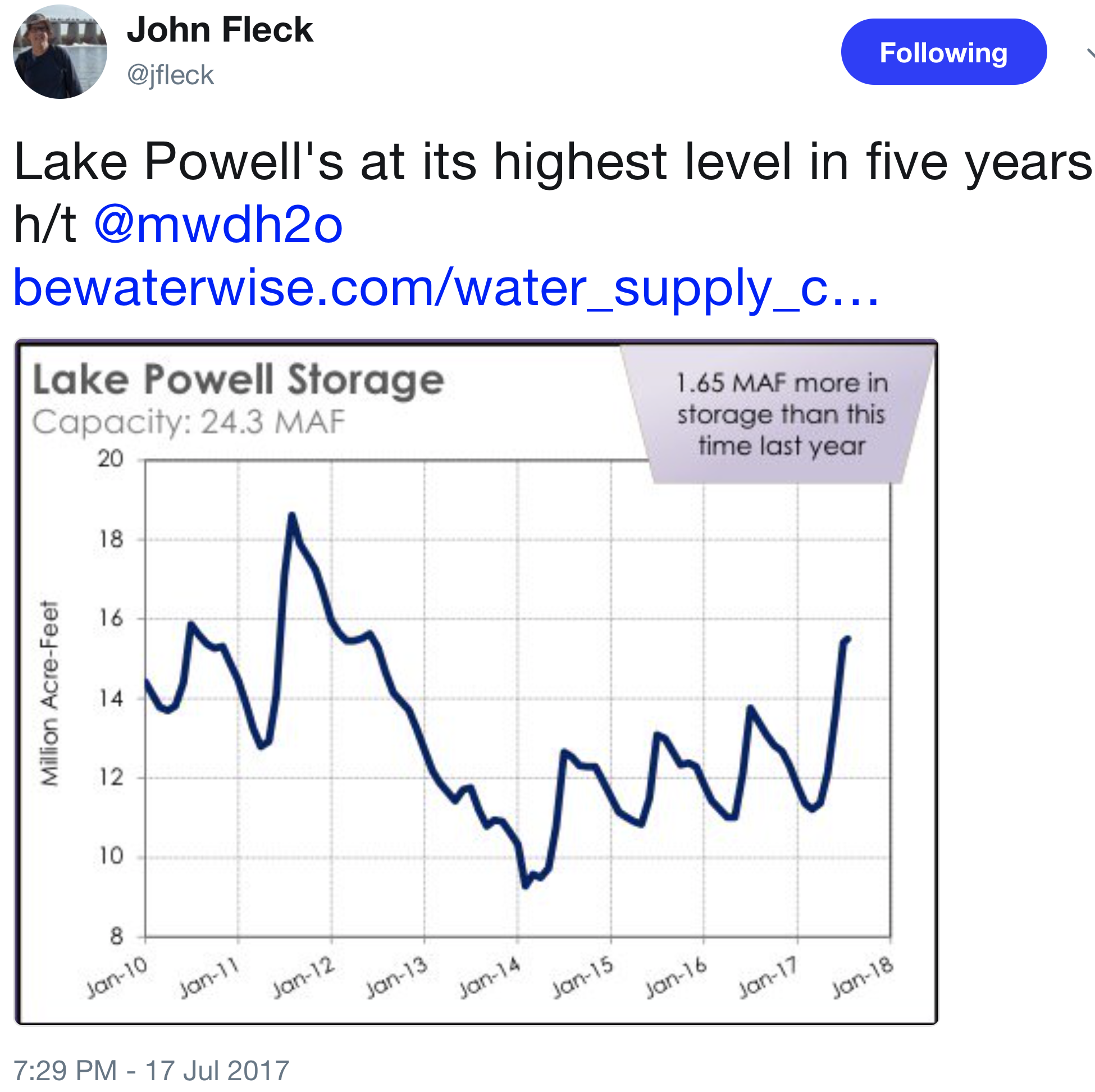
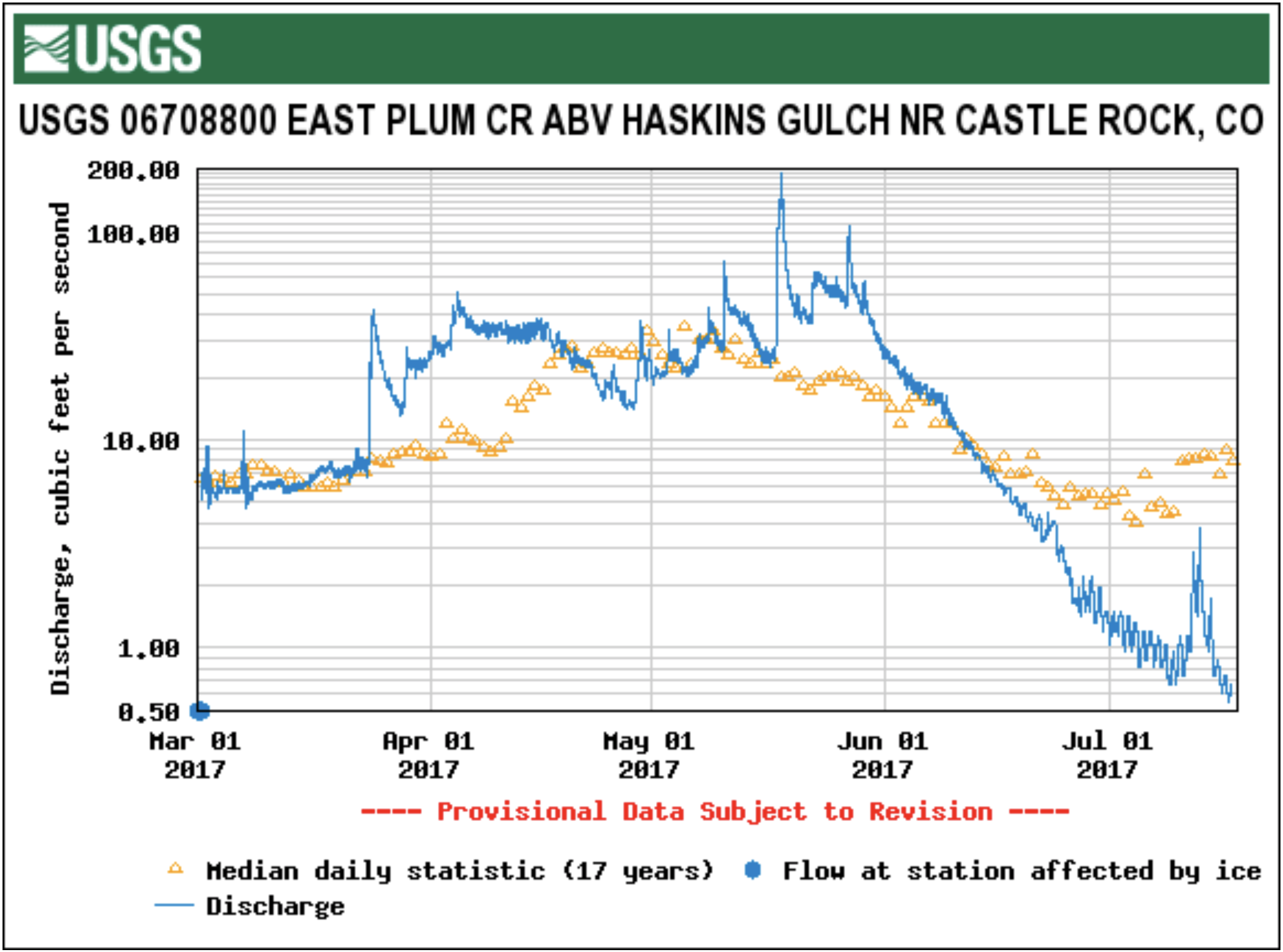


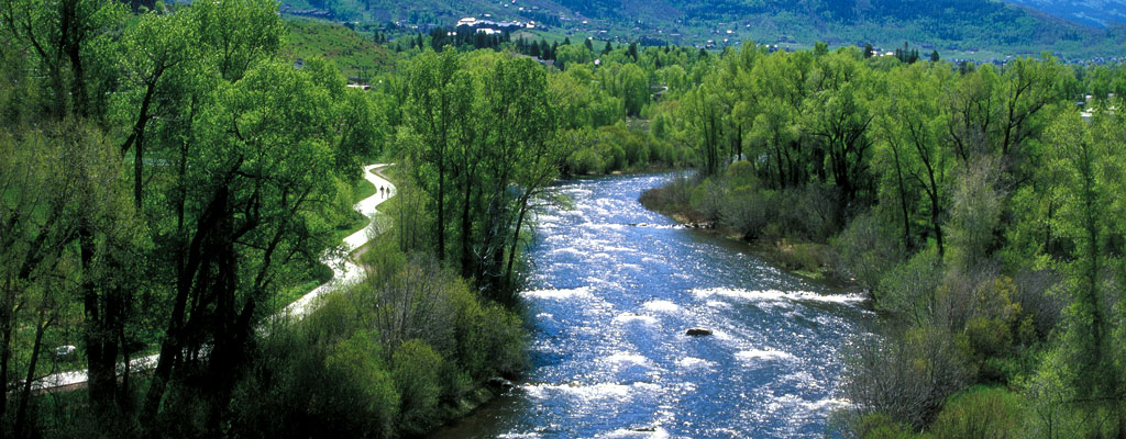


 June 2017 average temperature departures.
 June 2017 percent of average precipitation.