Yale #Climate Opinion Maps – U.S. 2016 #ActOnClimate #KeepItInTheGround

From the Yale Program on Climate Communication (Jennifer Marlon, Peter Howe, Matto Mildenberger and Anthony Leiserowitz):

This version of the Yale Climate Opinion Maps is based on data through the year 2016. Public opinion about global warming is an important influence on decision making about policies to reduce global warming or prepare for the impacts, but American opinions vary widely depending on where people live. So why would we rely on just one national number to understand public responses to climate change at the state and local levels? Public opinion polling is generally done at the national level, because local level polling is very costly and time intensive. Our team of scientists, however, has developed a geographic and statistical model to downscale national public opinion results to the state, congressional district, and county levels. We can now estimate public opinion across the country and a rich picture of the diversity of Americans’ beliefs, attitudes, and policy support is revealed. For instance, nationally, 70% of Americans think global warming is happening. But the model shows that only 49% of people in Emery County, Utah agree. Meanwhile 72% in neighboring Grand County, Utah believe global warming is happening. Explore the maps by clicking on your state, congressional district, or county and compare the results across questions and with other geographic areas. Beneath each map are bar charts displaying the results for every question at whichever geographic scale is currently selected. See the methods page for more information about error estimates. This research and website are funded by the Skoll Global Threats Fund, the Energy Foundation, the 11th Hour Project, the Grantham Foundation for the Protection of the Environment, the MacArthur Foundation, the Overlook Foundation and the Endeavor Foundation. We are very grateful to Connie Roser-Renouf, Ed Maibach, Lisa Fernandez, Eric Fine, Bessie Schwarz, Mike Slattery, and Seth Rosenthal for their assistance with and support of the project. For further questions about these maps or what they mean, please see our Frequently Asked Questions tab (above).

Water managers seek certainty in Colorado Basin — @AspenJournalism

The Colorado River, not far below the Utah-Colorado state line, flowing toward the lower basin.

GRAND JUNCTION — Bringing more certainty to an unruly and unpredictable Colorado River system was a common theme among water managers speaking at the Colorado River District’s annual seminar Friday­­.

Although the drought that has gripped much of the Colorado River Basin for the past 16 years has eased up a bit, population growth and the long dry spell have pushed the river’s supplies to the limit, with every drop of water in the system now accounted for.

Meanwhile, the effects of climate change on the Colorado’s future flows are still a big question mark, and it could mean wide variability in the years to come, with periods of punishing drought followed by a sudden record-setting wet year, as California recently experienced.

Bill Hasencamp, general manager of Colorado River resources for the Metropolitan Water District of Southern California, described how in April 2015, snowpack in the Sierras was at an all-time low. But by this spring, it was at an all-time high, after a winter of heavy precipitation.

The change in snowpack eventually led to huge fluctuations in water prices – from $1,800 per acre-foot at the height of the drought to just $18 per acre-foot this year, Hasencamp said.

That kind of turbulence places enormous pressure on the Colorado River Basin’s big municipalities, which must secure their water supplies for millions of people, said Eric Kuhn, the general manager of the River District, which is based in Glenwood Springs and helps protect western Colorado’s water resources.

Kuhn is retiring next year and was making his last formal presentation as general manager of the river district. As he heads into retirement, he’s working on a book with author John Fleck about the history of managing the Colorado River and the creation of the Colorado Compact.

“The reality is — and we all have to accept this — big-city providers need certainty,” he said. However, Kuhn said he didn’t think that means more transmountain diversions from the Western Slope.

The most obvious source of additional water for cities is agriculture, which holds the lion’s share of senior water rights on the Colorado River, but no one is eager to see rural areas sacrificed for urban growth, Kuhn said.

So, he added, water managers throughout the basin are figuring out ways to adapt 19th-century water laws to a 21st-century reality.

The upper Colorado River below the Pumphouse put-in.

System conservation

Cooperative agreements between irrigators and municipalities are one option, providing cities with additional sources of water during dry periods.

Already, a three-year pilot initiative called the System Conservation Pilot Program has shown that farmers and ranchers are open to using less water in exchange for compensation.

Beginning in 2014, four of the big Colorado River Basin municipalities and the Bureau of Reclamation contributed $15 million to fund water conservation projects throughout the basin.

The program was in limbo after this year while officials worked out some issues, but Hasencamp said Friday that the funders have agreed to continue the pilot program for another year, in 2018.

For water managers, these kinds of flexible arrangements, along with rigorous water efficiency, recycling, and reuse efforts, are the key to finding “certainty” on an inherently volatile river system.

Still, those solutions will not be easy.

As Bill Trampe, a longtime rancher from Gunnison County, explained, less irrigation often comes with unintended consequences such as diminished return flows to the river and nearby fields.

And as Lurline Underbrink Curran, the former county manager for Grand County, described, efforts to heal the destructive impacts of existing water diversions on the Fraser River, a tributary of the Colorado, means accepting that future diversions will in fact take place.

“We tried to form friendships that would help us do more with what we had,” she said.

California’s Salton Sea presents another dilemma, which reaches back up into Colorado River system.

The salty inland lake, created by an accidental breach in an irrigation canal, is drying up.

Since 2002, the state of California has been paying the Imperial Valley Irrigation District to keep the Salton Sea on life support by delivering 800,000 acre-feet of water, but that initiative expires at the end of this year.

Continuing the water deliveries means using up more of the Colorado River’s dwindling supplies, but letting it dry up means exposing local residents to a lakebed full of toxic dust.

None of these problems is new, but as many of the speakers at the river district’s annual seminar explained, water managers now have more tools than ever before to address those challenges — and new urgency with which to apply them.

Recent successes include the successful negotiation of an updated binational water agreement between the U.S. and Mexico, called Minute 232, that is expected to be signed this month. It will outline how the two countries share future shortages on the Colorado River.

“We’re at a point where we can work together, and the success we’ve had is from collaboration,” said Becky Mitchell, the new director of the Colorado River Conservation Board. “It’s really all hands on deck.”

Editor’s note: Aspen Journalism is collaborating with the Glenwood Springs Post Independent, the Aspen Times, the Vail Daily and the Summit Daily News on coverage of rivers and water. The Post Independent published this story in its print edition on Sunday, Sept. 17, 2017. The Aspen Times published it in its print edition on Monday, Sept. 18, 2017. The Vail Daily published it in its print edition on Sept. 18, as did the Summit Daily News.

Increased sedimentation due to wildfire

From News Deeply (Alastair Bland):

New research predicts that an increase in the frequency and magnitude of wildfires will double the rates of sedimentation in one-third of the West’s large watersheds, reducing reservoir storage and affecting water supplies.

In the Paonia Reservoir, completed in 1962 in Gunnison County, Colorado, for example, the dam’s outlet was built 60ft off the lake’s bottom. Now, Randle says, the bottom of the lake is above the outlet. The outlets in many other small reservoirs have become clogged with sediment, requiring expensive dredging or even the removal of the dams. Other times, boat ramps and marinas get buried and filled in. According to Randle, about 35 percent of the reservoirs managed by his agency have been surveyed for sediment fill. With most reservoirs, however, how much capacity has been lost is a matter of educated guesswork.

“Lake Powell probably has 1 million acre-feet less water than what we think,” Randle says.

And now the problem is predicted to get much worse.

According to new research from the U.S. Geological Survey, in many regions erosion rates are now accelerating thanks to wildfires and climate change. The western U.S., which relies on reservoirs for vital water storage and flood control, will be particularly impacted.

The problems of reservoir sedimentation have been at least somewhat understood for centuries, and most dams in the United States have been built with average rates of upslope erosion factored into the placement of the outflow pipes…

Authors of the USGS study, which was published September 7 in the journal Geophysical Research Letters, wrote that projected increases in the frequency and magnitude of wildfires will double the rates of sedimentation in one-third of 471 large watersheds in the western U.S. within the next 33 years. In almost nine out of 10 of the watersheds assessed, sedimentation could increase by at least 10 percent, the researchers warned. In some watersheds, the researchers predict, erosion and sedimentation could increase by 1,000 percent. Climate change, they concluded, is the underlying culprit.

Randle says climate change – which may already be increasing the intensity of droughts and, in turn, wildfires – is driving a vicious cycle whereby sedimentation rates increase. This reduces reservoir storage space, “which leaves you less prepared for the next drought.”

[…]

water and forest managers well know the correlation between fires and post-burn erosion. For example, more than 1 million cubic yards of sediment entered Strontia Springs Reservoir, a major supply lake for Denver Water, following the Hayman fire, which burned 138,000 acres in Colorado in 2002…

Once sediment has settled to the bottom, the most effective means of removal is dredging, which can be costly.

“It’s much more expensive to dredge out your reservoirs after a fire than it is to take preventive action, like reducing fuel loads and restoring forests,” said Jason Kreitler, a research geographer with the USGS and a coauthor of the study.

Dredging a reservoir can cost as much as $60 per cubic yard of material, according to Randle. Some operations remove hundreds of thousands, and even millions, of cubic yards of material. Finer-grained silt and clay is cheaper to deal with.

“Sand and gravel is coarser and tends to do more damage to the dredging equipment,” he noted.

Denver Water has spent $27 million removing debris and sediment from Strontia Springs Reservoir, according to a June report. The Los Angeles County Public Works plans to spend $190 million dredging four reservoirs impacted by sediment from the 2009 Station fire, according to a 2013 report from the U.S. Department of the Interior.

Fecko says his agency has removed 44,000 cubic yards of material from Ralston Afterbay, a small hydroelectric reservoir on the Middle Fork of the American River, at a cost of $2.2 million. Still, the reservoir has lost about 50 percent of its storage capacity thanks to long-term sedimentation, he says.

Besides lost reservoir storage, there are other impacts from sedimentation. Downstream from dams, rivers become depleted of gravel – essential for spawning salmon…

Randle, at the Bureau of Reclamation, thinks all water agencies and local governments would be wise to take a proactive stance against sediment entering reservoirs.

The #Climate Optimist’s Manifesto #ActOnClimate #KeepItInTheGround

Click here to go to the Climate Optimist’s website. Here’s the manifesto:

We must, we can and we will solve climate change. It’s that simple.

And that difficult.

Because the climate change challenge is so great and its consequences are so serious.

Which makes optimism essential. Because hope beats fear. It’s the attitude that inspires progress.

We behave, buy, vote and work for change because we are optimists. And our vocal optimism will take our actions even further. It will make others bold. Political action, business innovation, new investment and global transformation all become possible.

Optimism has always had this power. Humanity has eradicated diseases, overcome great injustices and even reached the stars because enough of us believed we could.

And when we succeed this time, we’ll solve more than climate change. Renewable energy means jobs. Solar energy can help free people from poverty. Cutting pollution benefits our health.

And we’re already doing this. Our optimism is fuelled by the new solutions, inventions and daily efforts from individuals and organisations across the world.

Each of us must face climate change in our own way. We choose belief in a better future. We choose action. We choose hope.

Solving climate change starts with the belief that we can. We are climate optimists. Opt In.

What does ‘solving climate change’ mean?

It means two things:

• Keep well below 2° C of global warming. That’s the level that governments agreed is safe in the COP21 Paris Agreement.
• Help the people who are at risk from the climate change effects that are already happening.

By 2020 we can bend the curve of emissions to make this a reality. That fast.

And we want even more.

The world’s governments have also agreed 17 Global Goals, including ending poverty and hunger, reducing inequality and creating decent jobs through economic growth. We believe that solving climate change can help reach these goals. That’s what we’re most optimistic about.

Can we actually do it?

Fatalism is tempting. We’ve all heard about the scale of the threat. Our optimism doesn’t change the seriousness of what we are facing.

Solving climate change means transforming some of our industries. Especially energy, travel and agriculture. It also means new industries, new jobs and new products need to be invented.

And that’s already begun. More so than most people are aware of. Huge levels of investment are going into renewable energy. Entrepreneurs are creating new climate friendly business models. And millions of people across the world have changed how they eat, buy, vote, build, work and travel.

You can join them.

What can I do?

Opt in to climate optimism. And share your belief that we can solve this.

Then take action in your own life, especially doing things that will make you healthier and happier.

And shine a light on solutions. Find out about the amazing progress already happening.

Climate Prediction Center temp. and precip. outlooks through 12/31/2017

Three month temperature outlook through December 31, 2017 via the Climate Prediction Center.
Three month precipitation outlook through December 31, 2017 via the Climate Prediction Center.

#Drought news: Say hello to the new US Drought Monitor website

Click here to go to the US Drought Monitor website. Here’s an excerpt:

Summary

Following Hurricane Irma’s arrival in Florida on September 10 and subsequent demise across the Southeast, generally dry weather dominated the country for a few days. However, the first two significant autumn storms of the season arrived across the northern Plains and Northwest, starting on September 14. Eventually, precipitation fell as far south as the Intermountain West and eastward into the upper Midwest. Several areas of the country, however, remained mostly dry and continued to see mounting short-term rainfall deficits. As a result, portions of the central and southern Plains, as well as the mid-South and lower Midwest, experienced general increases in the coverage of dryness and drought. In mid-September, there was an abrupt weather-pattern change that not only provided the northern Plains and Northwest with much-needed precipitation, but also brought a warming trend to the eastern half of the nation and notably cooler weather to the West…

High Plains

The High Plains region had a mix of improvement and deterioration. Improvement in the drought depiction was most prominent in the western Dakotas, where heavy rain fell, while deteriorating conditions affected parts of Kansas and environs. In fact, some additional severe drought (D2) was introduced in Kansas, where topsoil moisture rated very short to short (by the U.S. Department of Agriculture) jumped from 38 to 58% during the 2 weeks ending September 17. In contrast, North Dakota’s topsoil moisture was rated 44% very short to short on the 17th, down 18 percentage points from the previous week. However, rangeland and pastures in the Dakotas were slow to recover—typical following a hard-hitting drought—with 58% rated very poor to poor in both states on September 17. Also on the 17th, South Dakota led the nation—among major production states—in very poor to poor ratings for sorghum (29%), corn (28%), and soybeans (19%)…

South

Short-term dryness brought modest expansion of dryness (D0) and moderate to severe drought (D1 to D2) to various areas. Topsoil moisture rated very short to short increased at least 10 percentage points each of the last 2 weeks to reach 57% by September 17 in Texas, 47% in Oklahoma, and 43% in Arkansas, according to the U.S. Department of Agriculture. Winter wheat planting is underway in the region, and the crop will soon need rain to support proper autumn establishment. In Texas, 14% of the intended winter wheat acreage had been planted by September 17; Oklahoma had planted 11%…

West

Montana and environs finally received much-needed precipitation, starting on September 14. Prior to the storminess, Cut Bank, Montana, had reported 88 days (June 18 – September 13) with precipitation totaling 0.01 inch or less, breaking the station’s record of 74 days set from October 22, 1908 – January 3, 1909. Cut Bank’s streak ended with a 0.47-inch total on September 14-15. Elsewhere in Montana, daily-record totals for September 15 included 1.22 inches in Billings; 1.10 inches in Great Falls; 1.02 inches in Helena; and 0.65 inch in Butte. Helena had just completed its own record-setting streak—61 consecutive days (July 10 – September 8) without measurable precipitation. Helena’s previous warm-season record for days without accumulating precipitation had been 38 days, from September 1 – October 8, 1880. And, Helena’s previous longest spell without measurable precipitation—60 days—had occurred in the dead of winter from December 15, 1986 – February 12, 1987. Farther west, the season’s first significant precipitation arrived in the Northwest a few days after Montana’s event. Spokane, Washington, did not receive measurable rain from June 29 – September 16, a record-setting span of 80 days (previously, 75 days in 1917), but netted 0.84 inch from September 17-19. More substantial precipitation fell in western sections of Washington and Oregon, curbing the wildfire threat and aiding containment efforts. Through September 19, year-to-date U.S. wildfires had consumed 8.53 million acres of vegetation. In recent years, only 2015 (8.85 million acres) and 2012 (8.61 million acres) had a higher burned acreage on that date.

The rain and high-elevation snow brought some improvements in the drought depiction. Nevertheless, areas that received the most significant precipitation—including some of Montana’s extreme to exceptional drought (D3 to D4) areas—experienced up to one category of improvement. Since drought relief occurred so late in the growing season, and because the drought has been historic in nature, improvement in rangeland and pasture conditions may not be realized until spring. Rangeland and pastures rated very poor to poor on September 17 included 77% in Montana and 65% in Washington. However, topsoil moisture rated very short to short by the U.S. Department of Agriculture improved in Montana from 99 to 65% during the week ending September 17, while Idaho improved from 68 to 44%. The improvements in topsoil moisture should benefit recently planted winter wheat; Washington led the nation with 43% of its wheat planted by September 17…

Looking Ahead

During the next couple of days, a storm system and its attendant cold front will push eastward toward a ridge of high pressure parked over the eastern U.S. Initially, the front will make little progress, resulting in an axis of heavy rain stretching from the upper Midwest to the southern High Plains. Five-day rainfall totals could reach 2 to 4 inches or more along that axis, while isolated 1- to 3-inch amounts can be expected from the Pacific Northwest to the northern Rockies. Early next week, a warming trend will commence in the Far West, while cool conditions will shift eastward across the Plains. Late-season warmth and general dryness will continue, however, in the East.

The NWS 6- to 10-day outlook for September 26 – 30 calls for the likelihood of below-normal temperatures across large sections of the Rockies and Plains, while warmer-than-normal weather will prevail in the Pacific Coast States and across the eastern one-third of the U.S. Meanwhile, below-normal rainfall in the Southeast and Northwest should contrast with wetter-than-normal conditions across New England, the upper Great Lakes region, and southern portions of the Rockies and Plains.

Community Open House & Reception: Edwards wastewater facility improvements, September 26, 2017

Edwards Wastewater Treatment Facility photo credit Eagle River Water & Sanitation District.

Click here to view the Eagle River Water & Sanitation event page and to register:

Join us for a reception and tour of the $25 million Edwards wastewater treatment facility solids handling improvement project. Now that the landscaping is done, we’re ready for visitors!

Please register so we can plan enough food for all participants.

  • 11 a.m. to 2 p.m. – Open house, facility tours, and complimentary food.
  • Noon to 1 p.m. – Welcome, acknowledgements, speakers, and short tour.
  • […]

    Improvements include:

  • Preliminary treatment enhancements.
  • Expansion of the solids digestion process.
  • Rehabilitation of solids dewatering.
  • Landscaping and aesthetic updates.
  • New odor control systems.
  • How Colorado can get real serious about reducing its carbon footprint — The Mountain Town News

    From The Mountain Town News (Allen Best):

    In Colorado, as elsewhere, recent polling by Yale University shows strong recognition that climate change is real, the result of human activity, and something that we must address.

    But do it now? Really shake things up? Well, maybe it can wait. It ranks very low on the list of priorities for most people. Kick that can down the road.

    A report released [September 20, 2017] by Western Resource Advocates and Conservation Colorado called Colorado’s Climate Blueprint argues that Colorado must seize very tool available to do its part in holding temperature increases to no more than 1.5 to 2 degrees Celsius.

    “We need to reduce our carbon pollution very quickly,” says Stacy Tellinghuisen, a co-author of the report. “We can’t wait for the federal government to take action. So we have laid out a blueprint for a three-legged stool of action.”

    Colorado has been doing things. Emissions in the electrical sector has fallen, since 2007, the result of switching from coal-fired generation to cleaner-burning natural gas but also as a result of the deepening penetration of renewables. Transportation sector emissions have also declined.

    But the growing evidence uncovered by scientists argues that, if anything, their assessment of the risk has been conservative. Temperatures are rising, and so are sea levels. Coral reef is disappearing. If the hurricanes and bark beetle epidemics are not directly a result of the warming climate, their severity may well be exacerbated.

    And if they’ve tended toward conservative predictions, what does that say about when they believe the spit really hits the fan within a few decades?

    All of this argues for rapid reduction, not just stabilizing, of emissions.

    Gov. John Hickenlooper in July announced a goal of reducing greenhouse gas emissions 26 percent by 2025 as compared to 2005 base levels. He did not, however, identify exactly how to achieve this, as I wrote in an article for the Colorado Independent. See: “What will it take to reach the climate change goals set by Gov. Hickenlooper?

    Colorado has led the way on regulations designed to limit emissions of methane. Photo/Allen Best

    These two groups, arguably Colorado’s most influential environmental organizations, want significant reductions beyond Hickenlooper’s 2025 goals. By 2030, as compared to 2005 levels, they want a goal of 45 percent reduction in emissions and a 90 percent reduction by mid-century.

    Unlike Hickenlooper’s order, they go into depth. Some are the the usual suspects. For example, the Colorado Public Utilities Commission can push the shift already underway from coal, in particular, to renewable sources. Colorado legislators need to ensure new buildings better maximize energy efficiency.

    But the report points to several levers that the Air Quality Control Commission can pull to achieve action. One is advanced regulations that reduce the venting and flaring of methane, as is commonly done in the Wattenberg and other natural gas fields.

    Tellinghuisen says the gasfield emissions of methane are among the most difficult areas for regulation. In 2010, they represented almost 8 percent of Colorado’s total carbon pollution. Colorado subsequently became a national leader in its regulation of methane emissions after the state’s two largest operators, Anadarko and Noble, working with the Environmental Defense Fund, emerged with an agreement. But more methane, the primary constituent of natural gas, remains to be captured instead of being allowed to be wasted. If prices of natural gas were higher, producers would have more incentive to attend to leaks and capture what is now being flared. Methane has 22 to 28 times the heat-trapping properties of carbon dioxide.

    The two groups would also like to see more stringent fuel economy standards for vehicles, similar to what California and 10 other states have adopted. Colorado, they say, should adopt policies that yield one million electric cars by 2030. It ranked 12th in the nation in sales of EVs from 2011 through 2016.

    What may be most notable about the report is the embrace of market-based solutions. The power of markets has been proven frequently in solving environmental problems. Markets, by definition, must have incentives, in this case a price on carbon in this case. This could be achieved through a cap-and-trade regime or the more straight-forward carbon tax.

    California has adopted a cap-and-trade system, and several states in the northeast have cap-and-trade as it applies to electrical production. British Columbia has a carbon tax. That province adopted a tax of 410 in 2008 and, as previously planned, elevated it to $30 in 2012. As the New York Times noted in a March 2016 story, that was then the equivalent of $22.20 in U.S. dollars. Economists at Duke University and the University of Ottawa in a 2015 study concluded that the carbon tax had reduced emission by 5 to 15 percent with “negligible effects on aggregate economic performance.”

    The tax proceeds are rebated to the public in the form of other tax reductions. A group called Citizens’ Climate Lobby advocates the same revenue-neutral approach in advocating for what it calls a carbon fee and dividend.

    From her study, Tellinghuisen believes a higher tax is needed to motivate changes in the transportation and other sectors. A tax of $20 per ton of CO2 emissions would result in a price increase of only 20 cents per gallon on gasoline. That, Tellinghuisen points out, would likely be lost in the noise of price fluctuations at the gas pump. It’s not enough to motivate changes such as, for example, cause people to ride light rail.

    A constitutional provision in Colorado would also pose a challenge to automatic price increases in carbon prices if Colorado should follow the British Columbia model. The Taxpayers’ Bill of Rights, or TABOR, requires specific voter approval for many specific tax increases.

    Many economists say the minimum starting price for a carbon tax would be $40, if it is to produce significant changes, elevating to about $75 a ton.

    Voters in Washington state, belying their reputation for liberal instincts, rejected a proposed carbon tax there last November. Among the arguments was that the tax is regressive, hurting poor people more than other sectors of society.

    About Allen Best
    Allen Best is a Colorado-based journalist. He publishes a subscription-based e-zine called Mountain Town News, portions of which are published on the website of the same name, and also writes for a variety of newspapers and magazines.

    @CWCB_DNR/@DWR_CO: September 2017 #Drought Update

    Here’s the update from the Colorado Water Conservation Board and the Colorado Division of Water Resources (Taryn Finnessey/Tracy Kosloff):

    Following cooler than average temperatures in August across much of the state, September has been hot and dry. Consequently, both abnormally dry and moderate drought conditions have expanded across western Colorado. Reservoir storage is well above average, and municipal water providers have no immediate concerns with levels of supply and demand in their systems.

  • After receiving only 69 percent of statewide average precipitation in August at SNOTEL stations, September precipitation to date remains low at 30 percent of average as of September 14. The South Platte was the only basin to receive normal precipitation levels in August (100 percent); while the Arkansas is the only basin to receive above normal precipitation (122 percent) September to date. All other basins are experiencing well below average precipitation for the month, ranging from zero (Yampa/ White) to 44 percent (Upper Colorado).
  • Reservoir storage statewide is at 120 percent of normal, with all basins above average. The Rio Grande basin is reporting above average storage (133 percent) for the first time since 2009. The Colorado and Yampa/ White basins have the lowest storage levels in the state at 110 percent of normal.
  • 31 percent of Colorado is classified as abnormally dry (D0), while 4 percent is classified as experiencing moderate drought, predominantly concentrated in Rio Blanco and Garfield Counties.
  • Warmer than normal temperatures have affected Colorado over the last few weeks, with western slope temperatures averaging as much as eight degrees above normal.
  • ENSO-neutral conditions remain, but a La Nina watch has been issued by NOAA with more than 50 percent likelihood of a La Nina developing. Short term forecasts show that temperatures should cool off, with parts of the west receiving significant precipitation. This is a welcome change for those areas currently battling forest fires.
  • Long term forecast shows no major indication towards wet or dry in the upcoming months. If La Niña conditions set in, mountain snows are often enhanced during the winter season, but fall and spring tend to be dry.
  • @SenBennetCO, et al., introduce Hardrock Mining and Reclamation Act of 2017

    During mining (top), the water table is often lowered to access ore, exposing the rock to oxygen and creating acid mine drainage. Sealing off a mine can return the water table to pre-mining levels (bottom), creating anoxic conditions inside the mine and preventing further acidification. Credit: K. Cantner, AGI.

    From The Durango Herald (Mia Rupani):

    Colorado Sen. Michael Bennet, along with Sens. Tom Udall, D-N.M., Martin Heinrich, D-N.M., Ron Wyden, D-Ore., and Edward Markey, D-Mass., introduced the Hardrock Mining and Reclamation Act of 2017 on Tuesday to update the nation’s antiquated hard-rock mining laws.

    The bill would reform the General Mining [Act] of 1872 that allows companies to extract minerals such as gold and silver on federal public lands without paying royalties, and while avoiding liability for any environmental damage.

    The proposed legislation would help pay for abandoned mine cleanup and prevent future disasters.

    Bennet referenced the 2015 Gold King Mine spill that sent an estimated 3 million gallons of heavy-metals laced mine wastewater into the Animas and San Juan rivers in a news release on Tuesday…

    If passed, the legislation would make seven primary changes to the General Mining Law of 1872:

  • Require hard-rock mining companies to pay an annual rental payment for claimed public land, similar to other users.
  • Set a royalty rate for new operations of 2 to 5 percent based on the gross income of new production on federal land.
  • Create a Hardrock Minerals Reclamation Fund for abandoned mine cleanup through an abandoned mine reclamation fee of 0.6 percent to 2 percent.
  • Give the secretary of the Interior the authority to grant royalty relief to mining operations based on economic factors.
  • Require an exploration permit and mining operations permit for noncasual mining operations on federal land.
  • Permit states, political subdivisions and Indian tribes to petition the secretary of the Interior to have lands withdrawn from mining.
  • Require an expedited review of areas that may be inappropriate for mining.
  • The bill is supported by leaders throughout Southwest Colorado, including La Plata County Commissioner Julie Westendorff, Durango City Councilor Dean Brookie, San Juan County Commissioner Pete McKay and Trout Unlimited’s Ty Churchwell.

    CPC issues La Niña watch

    Typical La Nina weather patterns over North America via NOAA.

    From 9News.com (Cory Reppenhagen):

    La Nina alters the flow of the Polar Jet Stream over the United States. This will often track storms just to the northeast of Colorado, and it lowers the probability of us getting southern storm tracks that deliver upslope winds, which the Front Range and the Foothills rely on for big snow.

    But when the NOAA Winter Outlook is issued with a La Nina, it usually shows little impact one way or the other for Colorado, because our winters can be so variable anyway, but historically, the data does allow you to draw some conclusions.

    La Nina winters have historically, brought warmer, and drier conditions to the Denver metro and the bulk of the I-25 corridor.

    Last year, La Nina conditions developed in August and carried into January, and we finished the winter with neutral conditions. That resulted in the lowest amount of snow that Denver has seen in 128 years.

    While a La Nina doesn’t guarantee less snow for Denver, the data allows some conclusions to be drawn. The last four La Nina’s have resulted in below average snowfall, and 15 out 19 La Ninas since 1950 have also resulted in below average snow for Denver.

    Our mountains have a different La Nina story. They had record snowfall in many areas, during last year’s La Nina. That’s because they can benefit from different jet stream patterns, like a straight westerly jet stream pattern, that is sometimes referred to as the Pineapple Express.

    The mountains intercept the moisture coming from the Pacific Ocean, while the lee side of the mountains, where Denver is, catch nothing but warm, dry air.

    That’s just how the last few La Nina winters have played out for Denver.

    #AnimasRiver: #GoldKingMine update

    On April 7, 2016, the Environmental Protection Agency proposed adding the “Bonita Peak Mining District” to the National Priorities List, making it eligible for Superfund. Forty-eight mine portals and tailings piles are “under consideration” to be included. The Gold King Mine will almost certainly be on the final list, as will the nearby American Tunnel. The Mayflower Mill #4 tailings repository, just outside Silverton, is another likely candidate, given that it appears to be leaching large quantities of metals into the Animas River. What Superfund will entail for the area beyond that, and when the actual cleanup will begin, remains unclear.
    Eric Baker

    From The Associated Press (Dan Elliott):

    The 12-inch (30-centimeter) valve will regulate wastewater pouring from the Gold King Mine in the San Juan Mountains of southwestern Colorado, where the EPA inadvertently triggered a wastewater spill while excavating at the mine entrance in August 2015…

    The valve will be mounted in a steel-and concrete barrier about 70 feet (20 meters) inside the mine. The barrier will have water-tight access doors so workers and equipment can get deeper into the mine for cleanup and investigation.

    The EPA is also drilling a 170-foot (50-meter) horizontal well into another part of the Gold King to drain any water building up there. That water would be routed through a temporary treatment plant below the mine where wastewater draining from the main entrance is cleaned up.

    The EPA said it can control the flow of wastewater from the new drain to avoid another blowout.

    The documents did not say say how much the work will cost and the EPA did not immediately respond to emails and a phone call Wednesday seeking comment.

    The work is expected to be completed next month.

    Peter Butler, a leader of the volunteer Animas River Stakeholders Group, which works to improve water quality in the area, said he agreed with the EPA’s decision to install the barrier and drainage well.

    “It’s probably a good idea,” he said. “They are showing an abundance of caution.”

    Wastewater has flowed from the Gold King for years, and since the 2015 blowout, it has poured out at a rate of about 500 gallons (1,900 liters) a minute.

    Mine waste flows are unpredictable In the San Juan Mountains, where underground water flows through an interconnected warren of mine tunnels and natural faults.

    Precautions such as the barrier, valve and horizontal drain will make it safer for investigators to enter the mines and try to figure out the water flows, Butler said.

    The Gold King and dozens of other mining-related sites in the region were designated a Superfund district in 2016.

    Solving the problem of the declining Ogallala aquifer: “It’s for the generation that’s not here” — Dwane Roth

    The High Plains Aquifer provides 30 percent of the water used in the nation’s irrigated agriculture. The aquifer runs under South Dakota, Wyoming, Nebraska, Colorado, Kansas, Oklahoma, New Mexico and Texas.

    From The Hutchinson News (Amy Bickel):

    Because of technology, [Dwane] Roth is working to embrace what might seem like an unfathomable concept in these parts – especially when you can’t see what is happening underground.

    Sometimes the crop isn’t thirsty.

    “It’s difficult to shut off,” Roth said. “But I called my soil moisture probe guy. He said the whole profile was full and it was only the top 2 inches that was actually dry. So there was no need to turn that irrigation engine on and pump from the Ogallala.”

    Now he is hoping to change the mindset of his peers across a landscape where corn is king and the Ogallala Aquifer – the ocean underneath the High Plains – has been keeping the decades-old farm economy going on the semi-arid Plains.

    At least it is for now.

    Underlying eight states across the Great Plains, the Ogallala provides water to about one-fifth of the wheat, corn, cotton and cattle production in the United States. It’s also a primary drinking water supply for residents throughout the High Plains.

    But the aquifer that gives life to these fields is declining. It took 6,000 years to fill the Ogallala Aquifer from glacier melt. It has taken just 70 years of irrigation to put the western Kansas landscape into a water crisis.

    An economy centered on water is drying up.

    With his own water levels declining, Roth wants to make sure there is water for the next generation, including his nephews who recently returned to the farm.

    On this hot, summer day, water seeped out of a high-tech irrigation system he is testing on his Finney County farm. Soil probes are scattered about, telling him what is happening below the surface.

    Roth also has pledged to the state to cut back his usage by 15 percent through changing farming practices and implementing new technology.

    He wants to make a difference, but, he stressed, he can’t slow the decline alone.

    For the past two years, Roth’s fields have been part of a closely watched demonstration project aimed at showing farmers how to use less irrigation water on their crops. Now he he is taking it a step further.

    With some areas in northern Finney County declining by more than 70 feet since 2005, Roth is helping spearhead a regional effort to curtail pumping through a Local Enhanced Management Area. LEMAs were implemented five years ago as a tool to extend the life of the state’s water resources.

    He’s not the only one looking toward the future. A small but growing group of irrigators are considering different tools to cutback water use. Some are implementing technology. Some are looking at LEMAs. Others are forming their own, farm-wide plans for mandatory cutbacks.

    “It’s for the kids you don’t see yet,” Roth said of why he’s doing this. “It’s for the generation that’s not here.”

    Ogallala aquifer via USGS

    A quick look at Ogallala Aquifer water rights governance

    Ogallala aquifer boundaries

    From High Plains Public Radio (Susan Stover):

    Texas manages groundwater with the Rule of Capture. The groundwater belongs to the landowner without a defined limit. It’s sometimes known as the Law of the Biggest Pump.

    Colorado and Kansas water law is based on prior appropriation, known as First in Time, First in Right. A water right owner can pump their permitted amount if it doesn’t impair a more senior right – a water right that was established earlier in time. When there isn’t enough water to meet all needs, the owners of senior water rights have priority. The priority system works well for streams. When stream flow is low, it is generally clear which upstream, junior users must be cut off to protect the more senior water rights.

    For groundwater, it is more complex to identify which water wells are impairing a more senior water well. Groundwater often provides a baseflow to streams; when heavy groundwater pumping lowers the water table so there is no longer a connection to the stream and stream flow declines, is that impairment?

    Colorado state law dealt with such concerns by defining “designated groundwater basins,” those in which groundwater contributes little to stream flow. The Ogallala aquifer lies in designated groundwater basins. This allows more groundwater to be pumped, which lowers the water table, but with less risk of impairing surface water rights.

    In Kansas, action is taken when a junior water right well’s pumping directly impairs a senior water right well, whether it uses groundwater or surface water. However, no action is taken if problems are due to regional groundwater declines. Like Colorado, Kansas allows the decline of the Ogallala aquifer to get the economic benefit from the water.

    Management of the Ogallala aquifer is a balance between protecting existing water right holders and conserving water for the future. Attitudes change over time on what is a proper balance. Much water law encouraged development of the aquifer and protects current users. Is that balance shifting more toward conserving and extending this resource further into the future?

    Durango: Using the power of the market to tackle climate change, September 25, 2017 — League of Women Voters at Fort Lewis College

    Graphic via Fox and Hounds Daily.

    From League of Women Voters at Fort Lewis College via The Durango Herald:

    Addressing the challenges associated with global warming and climate change will be more difficult now that President Trump has signaled his intent to withdraw from the Paris climate agreement and roll back several regulations that would help keep U.S. emissions on their current downward path. Even with full implementation of the Paris Accord, further measures are needed by all nations to achieve the deep reductions in emissions by mid-century that many studies suggest are warranted.

    This task is difficult but not impossible, as shown by the amazing progress the U.S. has made in reducing other forms of air pollution over the last four decades. EPA data show that from 1970 to 2016, emissions of the six most common local air pollutants were reduced by 73 percent, while the economy grew by 253 percent. Repeating this success story over the next 30 to 40 years for carbon dioxide and other greenhouse gases is the challenge before us.

    What measures are available to further reduce emissions? Which approaches would be most cost-effective? And, given the current political climate in Washington, D.C., what can Colorado and other states do? As professionals working on these issues, we are excited to participate in a community discussion at a forum, “Putting a price on carbon emissions,” sponsored by the League of Women Voters at Fort Lewis College on Monday, Sept. 25.

    We will use this forum to explore two market-based approaches to reducing greenhouse gas emissions – carbon taxes and cap-and-trade. Carbon taxes increase the cost of fossil fuels in order to reduce consumption and, therefore, emissions. Under cap-and-trade, the government sets an overall limit (cap) on emissions and then requires sources of pollution to obtain an allowance for every ton of carbon they emit. Allowances are either auctioned or freely allocated by the state. Once a company holds an allowance, they can either use it to comply or sell (trade) it on the market.

    While there are many differences between carbon taxes and cap-and-trade, they both use a price on carbon to reduce emissions. Many policy experts believe that these market-based approaches hold the greatest promise for allowing us to make a smooth transition from fossil fuels to renewable energy and other zero-carbon technologies.

    There are also existing models of these policies that can provide inspiration for Colorado and beyond.

    On the carbon tax front, a right-of-center government in the Canadian province of British Columbia instituted a revenue-neutral carbon tax in 2008. The carbon tax rate is now one of the highest carbon prices in the world at $24 per metric ton of CO2, equal to about 24 cents per gallon of gasoline or 2.4 cents per kilowatt-hour of coal-fired power. As expected, the policy has helped to reduce emissions. It has also helped cushion the financial impact of the carbon tax on households and businesses: the “revenue-neutral” component of the policy means that carbon tax revenue is balanced with reductions in existing taxes.

    One of us (Bauman) led a ballot measure campaign to pass a similar revenue-neutral carbon tax in Washington state, but it was defeated at the polls in November 2016, in part because the support of Audubon Washington and Citizens Climate Lobby was countered by opposition from the Sierra Club and other groups that wanted to devote carbon tax revenue to clean energy and social justice efforts. Were Colorado to consider a carbon tax, climate activists would have to grapple with similar challenges because the state constitution requires taxes on motor fuels to go into the highway fund. On the plus side, a “clean the air, fix the roads” coalition might unite businesses and environmentalists behind a carbon tax.

    On the cap-and-trade front, the California legislature recently extended and strengthened its landmark cap-and-trade program to require an additional 40 percent reduction in emissions by 2030.

    This program is being jointly implemented by California and Quebec through the Western Climate Initiative, and those two jurisdictions will be joined next year by the province of Ontario.

    Unlike other cap-and-trade programs in the U.S. and Europe, the Western Climate Initiative is the only one that applies economy-wide, covering 85 percent of total greenhouse gas emissions. This is a demonstration of another flexible, market-based approach that can be used to reduce emissions as we work to mitigate the worst impacts of global warming and climate change.

    While the two of us do not agree on everything, we do agree that putting a strong price on carbon would be a huge step forward, and we hope that you will join us at the LWV forum at 7 p.m. Monday, Sept. 25, at FLC, Noble Hall, Room 130, to discuss these issues in more detail.

    Yoram Bauman, a recent transplant from Seattle to Salt Lake City, has a PhD in economics, makes a living as a “stand-up economist” and was the founder and co-chair of the Carbon Washington I-732 ballot measure. Reach him at yoram@standupeconomist.com.

    Patrick Cummins, of Durango, is a Senior Policy Advisor with the Center for the New Energy Economy at Colorado State University and former Executive Director of the Western Climate Initiative.

    @ColoWaterWise 9th Annual Symposium, October 24, 2017

    Click here to go to the website to register.

    Join us for the 9th Annual Colorado WaterWise Water Conservation Symposium in Denver, Colorado! We have a great program being created that will appeal to many audiences.

    Register now as space is limited.

    When: Tuesday, October 24, 2017, 8:15 AM – 4:00 PM

    Location: Lowry Conference Center, 1061 Akron Way, Building 697, Denver, CO 80230

    @ColoradoClimate: Weekly Climate, Water and #Drought Assessment of the Intermountain West

    Click here to read the current assessment. Click here to go the NIDIS website hosted by the Colorado Climate Center.

    #ColoradoRiver: Interview with Hualapai tribe representatives #COriver

    Grand Canyon vicinity map via Arizona State University.

    Here’s an interview with Hualapai tribes representatives from Julie Kelso and Utah Public Radio. Click through for the whole program. Here’s an excerpt:

    Hualapai and surrounding tribes have inhabited the Grand Canyon region since 700 AD. They survived harsh desert conditions using their knowledge of plants and wildlife behavior, for example using their understanding of the seasonal movements of antelope, sheep and deer to procure food.

    Today Hualapai continue to practice sacred ceremonies and collect cultural resources within the canyon. But dams and other development have altered the riparian plant community which now includes many invasive species.

    Ka-Voka Jackson, a member of the Hualapai tribe and graduate student at the University of Nevada, Las Vegas is currently researching methods to remove invasive plants while reestablishing native plants that are culturally important

    “To me the Colorado River is really sacred and held really close in my heart because on my reservation we grew up along the Colorado River in the Grand Canyon,” she said. “And so being able to work in Glen Canyon National Recreation area is a really important because I am closer to home and our ancestral lands did extend as far as Glen Canyon, so we have ties to that area.”

    Tribe and federal agencies have collaborated for decades to manage natural and cultural resources within the Canyon, but cultural and institutional barriers can be much harder to cross than borders drawn on a map.

    Ka-Voka and others realized that the perspectives and goals of traditional western scientists often differ from those with local and historical knowledge.

    “I think there is a big gap between the traditional ecological knowledge that tribes hold versus the western science, and they don’t communicate,” she said. “There is a gap in that communication but I think they could hugely benefit each other. The tribes have been living here a very long time, so they have a lot of knowledge and it’s often not brought into the science world. There are a lot of reasons for that. A lot of people who hold this traditional knowledge don’t necessarily want to give it to the western scientists because they don’t want it to be exploited, it can be sold as a product, or they don’t want it used out of context. We hold a lot of this knowledge very close. I don’t want to pressure these knowledge holders to give up their knowledge, but I do want them to carefully use it in a way that can benefit everybody.”

    Rock me Mama like a water wagon wheel – News on TAP

    Before Denver Water was founded in 1918, there were many years of water competition in Denver.

    Source: Rock me Mama like a water wagon wheel – News on TAP

    Chainsaw crew gives buzz-cut to historic canal – News on TAP

    Partnership with Mile High Youth Corps aims to build the conservation leaders of tomorrow.

    Source: Chainsaw crew gives buzz-cut to historic canal – News on TAP

    @ColoradoWater: #ColoradoRiver District names lone finalist for GM position #COriver

    Andy Mueller photo credit MountainLawFirm.com.

    From the Colorado River District via The Glenwood Springs Post Independent:

    The Colorado River District’s board of directors has named Andrew (Andy) A. Mueller of Glenwood Springs as its sole final candidate to succeed Eric Kuhn as general manager of the multicounty water conservation district.

    Kuhn is retiring after 36 years with the district. The river district board met Tuesday and voted unanimously naming Mueller as the lone finalist for the position.

    Mueller is an attorney and a former river district board member. He also served as board president and vice president.

    “The board was impressed with Mueller’s credentials, background and vision for the district,” board President Tom Alvey from Delta County said in a news release. “We were fortunate to have an outstanding pool of candidates from which Mr. Mueller rose to the top.”

    The release quoted Mueller as saying, “I’m honored and humbled by my selection. I’ve long held the Colorado River District in the highest regard. I look forward to working with the board and staff of the district to continue the district’s history of excellence and protection of western Colorado’s vital stake in the Colorado River system.”

    Mueller was selected after a nationwide search. Per state law, no offer of employment can be made for at least 14 days following Mueller’s selection. No starting date or other details of employment have been established, the release said.

    The general manager reports to the 15-member River District board of directors and is responsible for the day-to-day operations of the district and management of the 25-member staff.

    Mueller is currently a partner with the Glenwood Springs law firm of Karp Neu Hanlon. He was previously the managing partner at the Ouray-based firm of Hockersmith & Mueller. Mueller served as Ouray County’s director on the Colorado River District’s board from 2006 to January 2015.

    The Colorado Legislature created the Colorado River District in 1937 “for the conservation, use and development of the water resources of the Colorado River and its principal tributaries.”

    @USBR Announces Public Scoping Meetings for the Platte River Recovery Implementation Program, Proposed First Increment Extension, Environmental Assessment

    Here’s the release from the US Bureau of Reclamation (Brock Merrill):

    The Bureau of Reclamation is preparing an environmental assessment (EA) for the Platte River Recovery Implementation Program, Proposed First Increment Extension. Reclamation, working with the states of Wyoming, Colorado, and Nebraska, water users, and environmental and conservation organizations, proposes to extend the First Increment of the basin-wide, cooperative Recovery Implementation Program by 13 years. Reclamation is doing this to meet its obligations under the Endangered Species Act.

    The purpose of this action is to continue implementing projects that provide additional water, in order to accomplish the following:

  • Reduce flow shortages in the Platte River aimed at conforming with U.S. Fish and Wildlife Service target flows
  • Continue land management activities necessary to provide habitat for target threatened and endangered species
  • Continue integrated monitoring, research, and adaptive management, in order to assess the progress of the program and inform future management decisions
  • Reclamation will hold four public scoping meetings during the 45-day scoping period to gather information from other agencies, interested parties, and the public on the scope of alternatives for the EA. The public is encouraged to attend the open house EA scoping meetings, to learn more about the proposal and to assist Reclamation in identifying issues.

    The public scoping meetings on the EA are scheduled as follows (All meetings will be held 6:00 – 8:00 p.m.):

  • October 4, 2017, at Goshen County Fair Grounds, 7078 Fairgrounds Road, Torrington, Wyoming
  • October 5, 2017, at The Ranch Events Complex, 5280 Arena Circle, Loveland, Colorado (Located in the Larimer County Conference Center; park in Lot B)
  • October 11, 2017, at Hotel Grand, 2503 S. Locust Street, Grand Island, Nebraska
  • October 12, 2017, at Platte River Recovery Implementation Program Executive Director’s Office, 4111 4th Avenue, Suite 6, Kearney, Nebraska
  • At each meeting, the public will have the opportunity to provide written input on resources to be evaluated, significant issues or concerns, and potential alternatives.

    Written comments are due by close of business November 2, 2017. Members of the public may submit written comments at the public scoping meetings, via email to platteriver@usbr.gov, or by mail to:

    Bureau of Reclamation
    Attention: Brock Merrill
    P.O. Box 950
    Torrington, WY 82240

    For additional information, please visit the project website at http://www.usbr.gov/gp/nepa/platte_river/index.html.

    Pleasant View: Experimental “Water Dragon” drip system trial

    Photo credit: AgriExpo.com.

    From The Cortez Journal (Jim Mimiaga):

    The High Desert Conservation District has teamed up with farmer Brian Wilson and Teeter Irrigation, of Johnson City, Kansas, to determine if the company’s trademarked Dragon-Line system will work for this area.

    Instead of using the nozzles on the center pivot to irrigate, a row of drip lines are attached that drag behind the sprinkler watering the crop at its base instead of from above.

    “It saves water and reduces evaporation, erosion and runoff,” said Travis Custer, agricultural consultant with High Desert. “It is the first trial of the technology in the area.”

    To compare crop yields, one section of the center pivot irrigates a field of wheat normally from spray nozzles, and an adjacent section utilizes a series of drip lines attached to the nozzles. After harvest, the yields will be compared. Soil moisture monitors have also been installed in areas watered by the drip and nozzle sections of the sprinkler.

    The hybrid center pivot and drip line technology was created by Teeter Irrigation, and launched in 2015. The technology has proven effective in Kansas and other plain states that irrigate from an underground aquifer, Custer said.

    But since local farms use surface water delivered via ditches and pipelines that carry more debris, a filter system had to be installed on the center pivot being used on the Pleasant View trial…

    Farmers have switched to center-pivot sprinkler technology because it is less labor-intensive than side-roll sprinklers, which must be moved by hand. Center pivots are automated, and move in a circular pattern, watering from a row of nozzle heads. Water flow and speed are adjustable and can be controlled remotely.

    But center pivots work best on flatter ground. On undulating farmland and fields with steeper slopes, center pivots can cause water to pool in low spots and run off the field or drain into the sprinkler’s wheel tracks, creating muddy conditions.

    What’s exciting is that the drip-system attachment to the center-pivot could eliminate those problems because the water is delivered at ground level, said Steve Miles, board member of the High Desert Conservation District…

    It appears to be working in the test plots. The lower areas of the drip-line section are not getting waterlogged, and there is less runoff the field. How often the filter-system has to be flushed is also part of the experiment.

    #CDPHE is considering limits for PFCs

    Widefield aquifer via the Colorado Water Institute.

    From The Denver Post (Bruce Finley):

    Colorado health officials grappling with groundwater contamination from firefighting foam — containing a toxic chemical the federal government allows — have proposed to set a state limit to prevent more problems.

    A Colorado Department of Public Health and Environment limit for the perfluorinated chemicals (PFCs) also could give leverage in compelling cleanup by the Air Force, which has confirmed high levels of PFCs spreading from a military air base east of Colorado Springs. More than 65,000 residents who relied on the underground Widefield Aquifer as a water source have had to find alternative supplies or install new water-cleaning systems as a plume of PFCs contamination moves south through the Fountain Valley watershed.

    “We need to be able to have not just a carrot, but a stick,” CDPHE environmental toxicologist Kristy Richardson said last week, discussing the effort to set a state limit.

    The proposed maximum allowable level of 70 parts per trillion in groundwater — matching a health advisory level the Environmental Protection Agency declared in May 2016 for two types of PFCs — wouldn’t be finalized until April, Richardson said. A boundary has yet to be drawn for where the limit would apply.

    But such regulatory action could help state officials navigate a complex environmental problem. Other states have set PFC limits as scientists raise concerns about PFCs, which have been linked to health harm, including low birth weights and kidney and testicular cancers. Few public health studies have been done, even though people south of Colorado Springs apparently have ingested PFCs for years in public drinking water.

    An Air Force investigation confirmed contamination of groundwater by PFCs used in the aqueous film-forming foam that fire departments widely use to put out fuel fires, such as those caused by airplane crashes. PFCs also are found widely in consumer products, including stain-proof carpet, microwave popcorn bags and grease-resistant fast-food wrappers.

    The chemical properties that make make PFCs useful keep them from breaking down once spilled, especially in water. Scientists say people and wildlife worldwide have been exposed at low levels.

    At the Peterson Air Force Base, PFCs contamination of groundwater has been measured at levels up to 88,000 ppt with soil contamination levels as high as 240,000 ppt. And Richardson said PFC levels in groundwater south of Colorado Springs — communities including Security, Widefield, Fountain, Stratmoor Hills, Garden Valley and the Security Mobile Home Park — were measured at a median level of 120 ppt — well above the EPA health advisory limit.

    Richardson favored a broad area for the groundwater limit — “so that maybe we can begin to look at other sources. … My biggest concern is the extent” of the plume, she said.

    Lawsuit targets O&G exploration on public lands in #NV #ActOnClimate #KeepItInTheGround

    Reno, Nevada photo credit Wikipedia.

    From the Associated Press via The Fort Collins Coloradoan:

    The Sierra Club and Center for Biological Diversity say the U.S. Bureau of Land Management illegally failed to consider potential consequences of hydraulic fracturing, known as fracking, ranging from harm to the greater sage grouse to contamination of fragile desert water sources and emission of climate-altering greenhouse gases.

    The suit filed last week in federal court in Reno seeks an order forcing the bureau to rescind oil drilling leases it sold in June for as low as $2 per acre on three land parcels covering about 9 square miles (23 square kilometers).

    The groups are asking a judge to forbid permits on an additional 103 parcels totaling 296 square miles (767 square kilometers) until the agency complies with the National Environmental Policy Act and other laws they say require a thorough examination of the potential effects of fracking.

    “The Trump administration wants to turn public lands into private profits for the fossil fuel industry at the peril of local communities and wildlife,” said Clare Lakewood, an attorney at the Center for Biological Diversity’s Climate Law Institute in Oakland, California.

    President Donald Trump has taken other steps to open up federal lands to energy production, including proposals to eliminate national monuments designated by former President Barack Obama.

    Patrick Donnelley, the center’s state director in Nevada, said the drilling leases in Nevada mark the first time the Trump administration has reversed a draft proposal by the previous administration to keep some otherwise unprotected lands off limits to drilling. He says the government is flouting environmental rules “to push their oil and gas agenda.”

    Fracking has led to a boom in natural gas production but raised widespread concerns about possible groundwater contamination and even earthquakes. The method uses huge amounts of pressurized water, sand and chemicals to extract oil and natural gas from rock formations deep underground.

    The lawsuit says it can release carcinogens and other hazardous pollutants into the air and water while emitting massive amounts of methane, a significant driver of climate change.

    Extreme makeover — water utility edition – News on TAP

    Denver Water is redeveloping its near century-old operations complex in preparation for the next 100 years.

    Source: Extreme makeover — water utility edition – News on TAP

    Rock me Mama like a water wagon wheel – News on TAP

    Before Denver Water was founded in 1918, there were many years of water competition in Denver.

    Source: Rock me Mama like a water wagon wheel – News on TAP

    Eric Kuhn: “100 years ago the #ColoradoRiver was a beast” #CRDseminar #COriver @R_EricKuhn

    Eric Kuhn detailing Upper Colorado River Basin issues at his final Colorado River District Seminar as the General Manager. Photo credit: Sinjin Eberle.

    Eric Kuhn prepared for his final Colorado River District Seminar, “Points of No Return,” by riding his bike east to west across the Colorado National Monument the day before. He has announced his retirement from the district and I’m sure he’ll make good use of the time on his road bike, mountain bike, and kayak. He undoubtedly has outdoor interests that I don’t know about. He will be missed by those of us that have learned to listen to his wise counsel about the hardest working river in the world, the Colorado River.

    Subject of Eric Kuhn’s morning presentation at the Colorado River District Seminar September 15, 2017.

    He assured folks in the room, on Twitter and live on Facebook that the seminar was not his last, just his last as the GM of the district he worked at for 34 years. In his early retirement he is authoring a book on Colorado River hydrology that he hopes will “de-nerdify” the subject and appeal to a wide audience. The water nerds in the room all hoped to snag a copy as soon as is it avaiable.

    He explained the politics and history of the River. “100 years ago the Colorado River was a beast,” he said, adding, “and we were in a wet time but already seeing shortages.” The beast would unleash huge floods in the Lower Basin, submerging towns and farms and destroying headworks and other facilities. Late in the irrigation season the river often failed to deliver water to finish crops.

    Photo of one of Eric Kuhn’s slides at the Colorado River District Seminar September 15, 2017.

    Kuhn detailed the US Supreme Court decision in Wyoming v. Colorado where the court ruled that Wyoming irrigators were senior to a proposed project on the Laramie River in Colorado. Both states relied on “The Doctirine of Prior Appropriation” within their boundaries.

    Coloradans, led by Delph Carpenter, realized the danger to development of water in Colorado if prior appropriation prevailed on the Colorado River. The Lower Basin states of Arizona and California were first in time and the Upper Basin states were at risk of not being able to develop the farms, cities, and industry at a fast enough pace. The result was the Colorado River Compact which allocated water equally to the Upper Basin and Lower Basin based on the hydrology at Lee Ferry.

    Delph Carpenter’s 1922 Colorado River Basin map with Lake Mead and Lake Powell shown. The two giant reservoirs have always been part of the governance of the river.

    The Lower Basin needed storage to manage the river and the Upper Basin needed time. Boulder (now Hoover) Dam, and Lake Mead would fulfill the need for flood control, hydropower, and late-season irrigation water. Lake Powell was slated to store the Upper Basin water for downstream deliveries.

    A hundred years later:

    Photo of one of Eric Kuhn’s slides from the Colorado River District Seminar September 15, 2017.

    During his talk Eric stated that the West Slope, “Should not support and more transmountain diversions,” because that would put, “plans at risk.”

    While not being a “not one more drop” line in the sand it still is a pretty strong statement. Kuhn cited protection of West Slope agriculture, the power pool at Lake Powell, and the Upper Basin delivery requirements under the “Law of the River,” the recreation industry, water quality, and the environment, as reasons.

    “River governance must be as flexible to meet a wide range of future possibilities”, he said.

    He believes that we need to reduce consumptive use on the river. He added that, the Lower Basin will have to make the lion’s share and they are doing that. Then he backed it up with the numbers:

    Streamflow at Lee Ferry via Eric Kuhn Colorado River District Seminar September 15, 2017. Photo credit: Abby Burk.
    Colorado River water budget from Eric Kuhn, Colorado River District Seminar September 15, 2017.
    Realities of the Colorado River Basin, Eric Kuhn Colorado River District Seminar September 15, 2017.

    Mr. Kuhn said that, “If we had a 1950s drought we would probably drain Lake Powell.”

    Moving forward:

    Photo of slide by Eric Kuhn Colorado River District Seminar September 15, 2017.
    Tweet by Luke Runyon KUNC Colorado River District Seminar September 15, 2017.

    Eric was preceded on the program Bill Hasencamp from the Metropolitan Water District of Southern California. He said that 1 in 17 Americans get their water from the district (and their members), 19 million folks all told.

    “I am from the Lower Basin and we’re about as different as can be,” he said,

    Metropolitan recently approved documents for Minute 323 and money to continue the Lower Basin System Conservation Program.

    Metropolitan’s water supplies come from the Colorado River, Northern California, and locally through conservation and reuse:

    Photo of slide from Bill Hasencamp Colorado River District Seminar September 15, 2017.
    Tweet from Ruth Hutchins Water Center at Colorado Mesa University September 15, 2017.

    California has an active water market, he said, but there is great variability in price:

    Price per acre-foot for California water markets.

    Demand for water is low this year due to huge winter snowpack:

    “The Salton Sea will a dramatic effect on how water is managed going forward,” said Hasencamp. The water body, formed when the Colorado River destroyed an irrigation headworks during construction and has become important habitat for birds displaced by San Diego’s growth. Now it is drying up due to the lack of irrigation return flows and has become a health hazard for residents nearby.

    Tweet from the Metropolitan Water District of Southern California Colorado River District Seminar September 15, 2017.

    Hasencamp stressed the importance of solving California’s Bay Delta problem. The proposed project will cost $17 billion and firm up the water supply from Northern California:

    Photo credit Sinjin Eberle Colorado River District Seminar September 15, 2017.

    Hasencamp closed by quoting Abraham Lincoln, “The best way to predict your future is to create it.”

    Dave Kanzer from the Colorado River District moderated a panel about irrigation efficiency. The goal is to avoid unexpected consequences such as increased salinity or less water in the streams due to lower return flows.

    Panel member Bill Trampe said that society has to tell irrigators what is required. The return flows from irrigation provide habitat for wildlife and after a 150 years or so that habitat is part of the fabric of the watershed. Absent direction from society ranchers and farmers will go where the money is because the business is very tough.

    There was a long session about challenges and successes in Grand County with Lurline Curran, Paul Bruchez, and Mely Whiting. The county at the headwaters of the Colorado River sees 60% of its water exported to the East Slope by Denver Water and Northern Water. The two water agencies are working on projects to firm up supplies and the result could be that more headwaters flows could move east.

    One project will rebuild the channel of the Fraser River to better fit the lower flows to keep river temperatures colder. Rocks are being placed to create pools for trout.

    Another project, in concert with Northern’s Windy Gap Firming project will create a new natural channel around the reservoir to take it off-channel. The hope is that there will be greater scouring of the Colorado River below the reservoir to support stonefly populations that have been severely impacted.

    Proposed bypass channel for the Colorado River with Windy Gap Reservoir being taken offline, part of the agreements around Northern Water’s Windy Gap Firming project.

    At lunch Jack Schmidt explained his research into the Glen Canyon Institute’s proposal to drain Lake Powell to dead pool and store the water in Lake Mead. He said that their numbers with respect to evaporation and seepage may not be supported by the studies he has found. He confirmed that under a changed hydrology due to climate change that the option of re-drilling the original bypass tunnels around Glen Canyon Dam to completely drain Lake Powell might work to restore the Grand Canyon.

    Afternoon sessions included a panel with Heather Hansman and Eric Kuhn with their thoughts on telling water stories and concluded with a panel of members of the Colorado Water Conservation Board and its new Director, Becky Mitchell.

    The Colorado River District staff knocked it out of the park again this year. Thanks again.

    Take a trip through the Tweets from the conference. The hash tag was #CRDseminar. Be sure to click on the “Latest” button at the top of the page, scroll down to the bottom and read upward from oldest to newest Tweets.

    Luke Runyon and Coyote Gulch getting set for the Twitter fest at the Colorado River District seminar September 15, 2017.

    Snow in Grand County #snowpack

    Lookng east from Arapaho Bay near Grand Lake on Saturday afternoon. Photo by Bryce Martin / Sky-Hi News.

    From The Sky-Hi News (Bryce Martin):

    A cold front that moved through Grand County on [September 15, 2017] night brought the perfect conditions for snow, even though the fall leaves are still in the midst of their splendorous changes in hue.

    While the start of autumn is still a few days away, officially beginning Sept. 22, it already feels like winter, one of the most glorious times for the area.

    Peaks across the county, particularly along the Continental Divide, were coated in the powdery stuff overnight; the snow-capped peaks still highly visible Saturday afternoon with light cloud coverage.

    #Colorado sues U.S. Army/USFWS over Rocky Mountain Arsenal clean up

    Rocky Mountain Arsenal back in the day

    From CBS Denver:

    The arsenal stopped production of chemical weapons and pesticides in the early 80s. Cleanup was finished seven years ago and now much of the area has been turned into a wildlife refuge but many toxic compounds remain.

    Colorado says the potential for trouble is still there unless the property has proper control.

    “It was referred to as one of the most contaminated pieces of property on the planet,” said Colorado Department of Health and Environment spokesman Doug Knappe.

    Knappe manages the hazardous waste program for the state health department.

    Now, the agency he works for is suing the U.S. Army, U.S. Fish and Wildlife Service and Shell Oil. The lawsuit claims that an area called “Basin F” still poses a potential threat, “all of these constitute threats to human health and environment.”

    He says the state needs proper management of the site.

    “We don’t have control of that and we therefore can’t ensure for the protection of humans, health and environment,” said Knappe.

    Much of the hazardous waste remains in landfills or contained under covers. The state says even though some ground water remains contaminated, it is treated.

    Water managers seek certainty in #ColoradoRiver Basin — @AspenJournalism #CRDseminar #COriver

    The end of the tunnel that brings water from Hunter Creek to the Fryingpan River drainage, and then on to the eastern slope. Photo credit: Brent Gardner-Smith, Aspen Journalism.

    From Aspen Journalism (Sarah Tory) via The Glenwood Springs Post Independent:

    Bringing more certainty to an unruly and unpredictable Colorado River system was a common theme among water managers speaking at the Colorado River District’s annual seminar Friday­­.

    Although the drought that has gripped much of the Colorado River basin for the past 16 years has eased up a bit, population growth and the long dry spell have pushed the river’s supplies to the limit, with every drop of water in the system now accounted for.

    Meanwhile, the effects of climate change on the Colorado’s future flows are still a big question mark, and it could mean wide variability in the years to come, with periods of punishing drought followed by a sudden record-setting wet year, as California recently experienced.

    Bill Hasencamp, general manager of Colorado River resources for the Metropolitan Water District of Southern California, described how in April 2015, snowpack in the Sierras was at an all-time low. But by this spring, it was at an all-time high, after a winter of heavy precipitation.

    The change in snowpack eventually lead to huge fluctuations in water prices – from $1,800 per acre-foot at the height of the drought to just $18 per acre-foot this year, Hasencamp said.

    That kind of turbulence places enormous pressure on the Colorado River Basin’s big municipalities, which must secure their water supplies for millions of people, said Eric Kuhn, the general manager of the River District, which is based in Glenwood Springs and helps protect Western Colorado’s water resources.

    Kuhn is retiring next year and was making his last formal presentation as general manager of the river district. As he heads into retirement, he’s working on a book with author John Fleck about the history of managing the Colorado River and the creation of the Colorado Compact.

    “The reality is — and we all have to accept this — big-city providers need certainty,” he said. However, Kuhn said he didn’t think that means more transmountain diversions from the West Slope.

    The most obvious source of additional water for cities is agriculture, which holds the lion’s share of senior water rights on the Colorado River, but no one is eager to see rural areas sacrificed for urban growth, Kuhn said.

    So, he added, water managers throughout the basin are figuring out ways to adapt 19th century water laws to a 21st century reality.

    Cooperative agreements between irrigators and municipalities are one option, providing cities with additional sources of water during dry periods.

    Already, a three-year pilot initiative called the System Conservation Pilot Program has shown that farmers and ranchers are open to using less water in exchange for compensation.

    Beginning in 2014, four of the big Colorado River Basin municipalities and the Bureau of Reclamation contributed $15 million to fund water conservation projects throughout the basin.

    The program was in limbo after this year while officials worked out some issues, but Hasencamp said Friday that the funders have agreed to continue the pilot program for another year, in 2018.

    For water managers, these kinds of flexible arrangements, along with rigorous water efficiency, recycling and reuse efforts, are the key to finding “certainty” on an inherently volatile river system.

    Still, those solutions will not be easy.

    As Bill Trampe, a longtime rancher from Gunnison County, explained, less irrigation often comes with unintended consequences such as diminished return flows to the river and nearby fields.

    And as Lurline Underbrink Curran, the former county manager for Grand County, described, efforts to heal the destructive impacts of existing water diversions on the Fraser River, a tributary of the Colorado, means accepting that future diversions will in fact take place.

    “We tried to form friendships that would help us do more with what we had,” she said.

    California’s Salton Sea presents another dilemma, which reaches back up into Colorado River system.

    The salty inland lake, created by an accidental breach in an irrigation canal, is drying up.

    Since 2002, the state of California has been paying the Imperial Valley Irrigation District to keep the Salton Sea on life support by delivering 800,000 acre-feet of water, but that initiative expires at the end of this year.

    Continuing the water deliveries means using up more of the Colorado River’s dwindling supplies, but letting it dry up means exposing local residents to a lakebed full of toxic dust.

    None of these problems is new, but as many of the speakers at the river district’s annual seminar explained, water managers now have more tools than ever before to address those challenges — and new urgency with which to apply them.

    Recent successes include the successful negotiation of an updated binational water agreement between the U.S. and Mexico, called Minute 232, that is expected to be signed this month. It will outline how the two countries share future shortages on the Colorado River.

    “We’re at a point where we can work together, and the success we’ve had is from collaboration,” said Becky Mitchell, the new director of the Colorado River Conservation Board. “It’s really all hands on deck.”

    Aspen Journalism is collaborating with the Glenwood Springs Post Independent, the Aspen Times, the Vail Daily and the Summit Daily News on coverage of rivers and water. More at http://www.aspenjournalism.org.

    New Climate Risk Classification Created to Account for Potential “Existential” Threats

    Researchers projected warming scenarios that vary based on what societal actions are taken to reduce emissions. Graphic credit: Scripps Institution of Oceanography.

    From the Scripps Institution of Oceanography (Robert Monroe):

    A new study evaluating models of future climate scenarios has led to the creation of the new risk categories “catastrophic” and “unknown” to characterize the range of threats posed by rapid global warming. Researchers propose that unknown risks imply existential threats to the survival of humanity.

    These categories describe two low-probability but statistically significant scenarios that could play out by century’s end, in a new study by Veerabhadran Ramanathan, a distinguished professor of climate and atmospheric sciences at Scripps Institution of Oceanography at the University of California San Diego, and his former Scripps graduate student Yangyang Xu, now an assistant professor at Texas A&M University.

    The risk assessment stems from the objective stated in the 2015 Paris Agreement regarding climate change that society keep average global temperatures “well below” a 2°C (3.6°F) increase from what they were before the Industrial Revolution.

    Even if that objective is met, a global temperature increase of 1.5°C (2.7°F) is still categorized as “dangerous,” meaning it could create substantial damage to human and natural systems. A temperature increase greater than 3°C (5.4°F) could lead to what the researchers term “catastrophic” effects, and an increase greater than 5°C (9°F) could lead to “unknown” consequences which they describe as beyond catastrophic including potentially existential threats. The specter of existential threats is raised to reflect the grave risks to human health and species extinction from warming beyond 5°C, which has not been experienced for at least the past 20 million years.

    The scientists term warming probability of five percent or less as a “low-probability high-impact” scenario and assess such scenarios in the analysis “Well Below 2°C: Mitigation strategies for avoiding dangerous to catastrophic climate changes,” which appears today in the journal Proceedings of the National Academy of Sciences.

    Ramanathan and Xu also describe three strategies for preventing the gravest threats from taking place.

    “When we say 5 percent-probability high-impact event, people may dismiss it as small but it is equivalent to a one-in-20 chance the plane you are about to board will crash,” said Ramanathan. “We would never get on that plane with a one-in-20 chance of it coming down but we are willing to send our children and grandchildren on that plane.”

    The researchers defined the risk categories based on guidelines established by the Intergovernmental Panel on Climate Change (IPCC) and previous independent studies. “Dangerous” global warming includes consequences such as increased risk of extreme weather and climate events ranging from more intense heat waves, hurricanes, and floods, to prolonged droughts. Planetary warming between 3°C and 5°C could trigger what scientists term “tipping points” such as the collapse of the West Antarctic Ice Sheet and subsequent global sea-level rise, and the dieback of the Amazon rainforest. In human systems, catastrophic climate change is marked by deadly heat waves becoming commonplace, exposing over 7 billion people to heat related mortalities and famine becoming widespread. Furthermore, the changes will be too rapid for most to adapt to, particularly the less affluent, said Ramanathan.

    Risk assessments of global temperature rise greater than 5°C have not been undertaken by the IPCC. Ramanathan and Xu named this category “unknown??” with the question marks acknowledging the “subjective nature of our deduction.” The existential threats could include species extinctions and major threats to human water and food supplies in addition to the health risks posed by exposing over 7 billion people worldwide to deadly heat.

    With these scenarios in mind, the researchers identified what measures can be taken to slow the rate of global warming to avoid the worst consequences, particularly the low-probability high-impact events. Aggressive measures to curtail the use of fossil fuels and emissions of so-called short-lived climate pollutants such as soot, methane and HFCs would need to be accompanied by active efforts to extract CO2 from the air and sequester it before it can be emitted. It would take all three efforts to meet the Paris Agreement goal to which countries agreed at a landmark United Nations climate conference in Nov 2015.

    “This report shines a bright light on the existential threat that climate change presents to all humanity,” said Calif. Governor Edmund G. Brown Jr., who has collaborated with Ramanathan on carbon neutrality measures in the state. “Scientists have many ideas about how to reduce emissions, but they all agree on the urgency of strong and decisive action to remove carbon from the economy.”

    Xu and Ramanathan point out that the goal is attainable. Global CO2 emissions had grown at a rate of 2.9 percent per year between 2000 and 2011, but had slowed to a near-zero growth rate by 2015. They credited drops in CO2 emissions from the United States and China as the primary drivers of the trend. Increases in production of renewable energy, especially wind and solar power, have also bent the curve of emissions trends downward. Other studies have estimated that there was by 2015 enough renewable energy capacity to meet nearly 24 percent of global electricity demand.

    Short-lived climate pollutants are so called because even though they warm the planet more efficiently than carbon dioxide, they only remain in the atmosphere for a period of weeks to roughly a decade whereas carbon dioxide molecules remain in the atmosphere for a century or more. The authors also note that most of the technologies needed to drastically curb emissions of short-lived climate pollutants already exist and are in use in much of the developed world. They range from cleaner diesel engines to methane-capture infrastructure.

    “While these are encouraging signs, aggressive policies will still be required to achieve carbon neutrality and climate stability,” the authors wrote.

    The release of the study coincides with the start of Climate Week NYC in New York, a summit of business and government leaders to highlight global climate action. Ramanathan and colleagues will deliver a complementary report detailing the “three-lever” mitigation strategy of emissions control and carbon sequestration on Sept. 18 at the United Nations. That report was produced by the Committee to Prevent Extreme Climate Change, chaired by Ramanathan, Nobel Prize winner Mario Molina of UC San Diego, and Durwood Zaelke, who leads an advocacy organization, the Institute for Governance and Sustainable Development, with 30 experts from around the world including China and India.

    #ColoradoRiver District seminar recap @ColoradoWater #CRDseminar #COriver

    Rebecca Mitchell was named to the Colorado Water Conservation Board on July 5, 2017. Photo credit the Colorado Independent.

    From The Grand Junction Daily Sentinel (Dennis Webb):

    Becky Mitchell, who has been the director of the Colorado Water Conservation Board for about two months, spoke Friday at the Colorado River District’s annual water seminar in Grand Junction.

    She told attendees that when it comes to meeting the state’s water needs, “it’s really all hands on deck. Everyone here plays an important role. … What you’re doing is equally as important as anything we’re doing.”

    Steps already taken by entities ranging from her agency to the river district to agricultural interests, environmental stakeholders and members of river basin roundtables “have really shown me that we are at a point where we’re ready to work together and that the success that we’ve had has been because of collaboration,” Mitchell said.

    In comments to the group and in an interview, she addressed the monetary challenges for Colorado in meeting its future water needs. An initial estimate for paying for projects identified in the new water plan in coming decades was about $20 billion — already a daunting amount — but Mitchell’s agency now believes the price tag could be twice that much when the cost of water quality projects, generally involving water or wastewater treatment, are included.

    The state water board is looking into the cost issue through a statewide water supply initiative analysis that is expected to come out next year…

    She said it will be important to rely on a prioritization of projects by roundtable groups in each river basin. Also key is to focus on projects that provide multiple benefits, because having multiple interests in a project could lead to multiple sources of money to pay for it, she said.

    “It’s not necessarily the responsibility of the state to come up with the entire amount to implement the water plan,” Mitchell said. “A lot of it goes back to the local level and how we can support work that’s being done on the ground.”

    Mitchell worked on developing the plan as a staff member of her agency before being promoted after her predecessor, James Eklund, left to take a job as an attorney with a legal firm.

    “We’re at a really important time in the state where we have a capability to make a big difference in how we’re looking at our water future. It’s an exciting time and I’m excited to be a part of it,” Mitchell said.

    As for Eastern Slope/Western Slope water matters, “I am optimistic that we’ll be able to work through issues like we have done. When we’ve found solutions, it’s when we’ve come together regardless of the side of the (Continental) Divide. I think where we’re going to see solutions is where we come together,” she said.

    Eric Kuhn along the banks of the Colorado River in Glenwood Springs, general manager of the Colorado River District. Photo via the Grand Junction Daily Sentinel.

    From KJCT8.com:

    The Colorado River is the hardest working river in the world, that’s according to local experts. Hundreds of water experts are gathered in the valley to put together their game plan to tackle the biggest challenges facing the river.

    The General Manager Colorado River Water Conservation District, Erik Kuhn, says there are a lot of ideas to better manage the Colorado River, before it runs out in southern California. In order to stretch the water even further, one idea is to move the waters in Lake Powell to Lake Mead.

    “So it would allow for the recovery of lands that are now inundated by water in Lake Powell, natural recovery of those. It’s called the ‘Fill Mead First’. He’s talking about that. We don’t think that works very well for a number of reasons. But it’s one of those things that’s caught a lot of press attention of late,” Kuhn said.

    The Colorado River helps supply water to people in Denver all the way to about 20 million people in the Los Angeles, California area.

    The Colorado River Basin is divided into upper and lower portions. It provides water to the Colorado River, a water source that serves 40 million people over seven states in the southwestern United States. Colorado River Commission of Nevada

    @CWCB_DNR stream recovery work nears completion four years after 2013 floods

    Air search for flood victims September 2013 via Pediment Publishing

    From email from the Colorado Water Conservation Board (Todd Hartman):

    Colorado Water Conservation Board joins partners for innovative approach to restore stream channels, protect property and improve ecological conditions

    The record-smashing floods of 2013 ravaged Front Range waterways, rerouting and flattening stream channels, eroding streambanks, degrading fish habitat and stripping trees and vegetation from riparian areas.

    Four years later, many of those waterways have been repaired, restored and even improved due to efforts led by the Colorado Water Conservation Board and myriad partners at the state, federal and community level.

    With most attention properly focused on the recovery of communities, reconstruction of homes and property as well as road, bridge and infrastructure repair, CWCB and its partners have quietly redesigned and rebuilt stream channels in a way that has improved stream flows, boosted fish habitat and created more resilient waterways in the event of future floods.

    Work is expected to be largely complete by the spring of 2018 on numerous waterways well-known and important to many communities. Coal Creek, Fountain Creek, the St. Vrain, Fish Creek, Fall River, the South Platte and other streams have benefited from intensive planning and channel construction work that reflects unprecedented collaboration to recreate streams in a way not only protective of nearby property, but with high ecological function.

    That meant not only repairing and replanting streamside habitat but also creating stream channels that work for a variety of flows. A narrow interior channel allows for better passage of sediment and healthier flows even during periods of low water, a feature that can also benefit aquatic life. Those channels were constructed within wider channels to accommodate larger flows that might fill the banks or extend onto floodplains.

    “This was a new way of doing business,” said Kevin Houck, chief of CWCB’s watershed and flood protection section. “Typically, after events like this, you’ll see efforts to simply armor the stream bank quickly, for purpose of safety and protecting property. We took a different, more holistic approach and we’re excited to see the results on the ground.”

    Shortly after the floods, the CWCB assembled a team of experts at all levels of government to help communities develop short-term and long-term plans to stabilize and recreate damaged stream channels. This team quickly determined that stream rehabilitation would best be guided by a master-planning process at the watershed level, directed by an array of local stakeholders.

    Master plans were developed for Fish Creek and Fall River by the Estes Valley Watershed Coalition, Big Thompson River (Big Thompson River Coalition), Little Thompson River (Little Thompson River Coalition), St. Vrain Creek (St. Vrain Creek Coalition), Left Hand Creek (Left Hand Watershed Oversight Group), Fourmile Creek (Fourmile Creek Coalition), Coal Creek (Coal Creek Canyon Watershed Partnership), Middle South Platte (Middle South Platte Watershed Alliance), and Fountain Creek (Fountain Creek Watershed Flood Control and Greenway District).

    Since the development of the master plans, the CWCB has partnered with the State Department of Local Affairs (DOLA), the Natural Resources Conservation Service (NRCS), and local sponsors to implement projects identified within the plans. The CWCB and DOLA are managing over $100 million in recovery funds directed towards stream rehabilitation. Money for the work has come from the U.S. Departments of Agriculture (NRCS) and Housing and Urban Development, state and local entities and private foundations. The majority of the funding is going towards implementation, but some of it has supported project design and capacity for the local watershed coalitions that are managing many of the projects.

    As of the four-year anniversary, most of the projects are complete or under active construction at this time. A detailed description of all projects and many images of the work can be found at the website for the Colorado Emergency Watershed Protection Plan, http://www.coloradoewp.com. The public can also follow progress on Twitter by following @ColoradoEWP.

    I don’t know how I missed the great website and Twitter feed.

    Scott Hummer, general manager of North Poudre Irrigation Company, talks about how his agency worked with Fort Collins Natural Areas and Colorado Parks and Wildlife to include a fish passage when the irrigation company replaced a diversion structure on the Poudre River that was destroyed by the 2013 floods. Work was completed [in February 2016]. (Pamela Johnson / Loveland Reporter-Herald)

    Taking water innovation to the next level at National Western – News on TAP

    Denver Water, CSU join forces to develop a world-class center for water research, innovation and education.

    Source: Taking water innovation to the next level at National Western – News on TAP

    The @ColoradoWater #CRDseminar is today

    Colorado National Monument from the Colorado River Trail near Fruita September 2014

    Follow the goings on at hash tag #CRDseminar or my Twitter feed @CoyoteGulch.

    @AmericanRivers: River anatomy

    Graphic credit: American Rivers

    From American Rivers:

    THE UNITED STATES HAS MORE THAN 2.9 MILLION MILES OF RIVERS.

    They range from small streams and wetlands to large waterways. No two of these rivers are the same. Each river is unique to its landscape, winding through low foothills and valleys, rushing clear and cold from mountain forests, or sweeping warm and muddy down desert canyons.

    ANATOMY OF A RIVER

    No matter how different our rivers are, however, all rivers share some basic anatomy features.

    2017 wildfire season so far = $8 billion #ActOnClimate #KeepItInTheGround

    Sprague Fire September 2017. Photo credit the Associated Press via The Flathead Beacon.

    From The Associated Press via The Fort Collins Coloradoan:

    Wildfires have ravaged the West this summer with 64 large fires burning across 10 states as of Thursday, including 21 fires in Montana and 18 in Oregon. In all, 48,607 wildfires have burned nearly 13,000 square miles (33,586 square kilometers) in forests so choked with trees that they are at “powder keg levels,” as one Forest Service ecologist put it.

    Agriculture Secretary Sonny Perdue said the severe fire season means officials “end up having to hoard all of the money that is intended for fire prevention, because we’re afraid we’re going to need it to actually fight fires.”

    The emphasis on firefighting means that money for prescribed burns, insect control and other prevention efforts is diverted to putting out fires in what Perdue called a self-defeating cycle. The end result is that small trees and vegetation remain in the forest for future fires to feed on…

    The spending figure announced Thursday marks the first time wildfire spending by the Forest Service has topped $2 billion. The previous record was $1.7 billion in 2015.

    The figures do not include spending by Interior Department agencies such as the Bureau of Land Management and National Park Service, nor do they include spending by state and local governments.

    The Interior Department says it has spent at least $391 million with several weeks left in the fire season. The previous record for combined federal firefighting costs was $2.1 billion in 2015.

    Lower South Platte Water Conservancy District 2018 budget numbers

    The Platte River is formed in western Nebraska east of the city of North Platte, Nebraska by the confluence of the North Platte and the South Platte Rivers, which both arise from snowmelt in the eastern Rockies east of the Continental Divide. Map via Wikimedia.

    From The Sterling Journal-Advocate (Jeff Rice):

    The Lower South Platte Water Conservancy District’s budget will exceed $1 million for the first time in 2018.

    The district’s Board of Directors Executive Committee got its first look at the proposed budget during Tuesday’s meeting.

    District manager Joe Frank pointed out that the budget is somewhat inflated by two grants totaling more than $341,000 the district has received, one from the Colorado Water Conservation Board and one by the U.S. Bureau of Reclamation. The CWBC grant will be used to match the USBR grant to help develop a marketing plan for the Northeast Colorado Water Cooperative.

    The district also will enjoy about a 4 percent increase in general property tax, mostly from increased valuations on real estate.

    Total increase in the budget is about $70,000, or roughly 6.8 percent over this year’s budget, which also contained large water study project grants.

    The Bureau of Reclamation grant of $236,245 is one of nine the bureau awarded earlier this month as part of its WaterSMART Water Marketing Strategies program.

    LSPWCD will use the funds to help the NECWC find ways to develop infrastructure for water exchanges, primarily when water augmentation plans are involved…

    …pumps and pipelines cost money, Frank said, and a lot of it, and that means heavy participation by everyone who needs water. The “water marketing strategy” the NECWC has in mind would try to expand participation with municipalities and industrial water users who are not yet part of the cooperative.

    That’s all part of an effort established by the Colorado Water Plan unveiled in November 2015 to address a looming gap in water supplies. Without water development, the gap between supply and demand in the South Platte River Basin is expected to grow to 196,000 acre feet by 2050. That, according to the Bureau of Reclamation’s statement on the grants, “is creating a growing incentive to identify creative solutions, driving up interest in water marketing by multiple types of water users.”

    Fountain Creek: #Colorado Springs Nov. 7 stormwater ballot measure cost

    The Fountain Creek Watershed is located along the central front range of Colorado. It is a 927-square mile watershed that drains south into the Arkansas River at Pueblo. The watershed is bordered by the Palmer Divide to the north, Pikes Peak to the west, and a minor divide 20 miles east of Colorado Springs. Map via the Fountain Creek Watershed Flood Control and Greenway District.

    From The Colorado Springs Independent (Pam Zubeck):

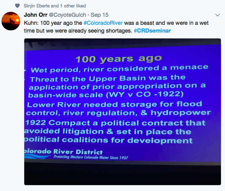
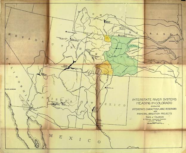
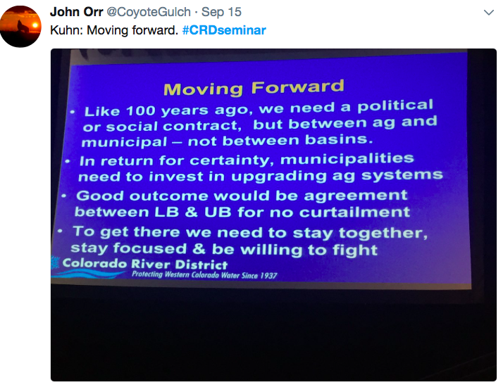
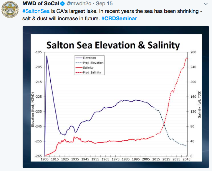
    The city’s stormwater measure on the Nov. 7 ballot has stirred a lot of debate. Some don’t like the flat-fee concept — $5 per household, and $30 per acre for commercial land. Others say too many details remain unresolved.

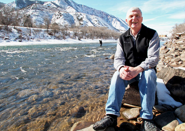
    But one thing is beyond dispute: Colorado Springs’ stormwater system sucks, and it’s going to take many years and a lot of dough to fix it. Far from a sexy topic, stormwater drainage gets no respect, and the consequences of that came into full focus during a tag-along with Water Resources Engineering Division Manager Rich Mulledy on Aug. 31.

    To grasp the gravity of the problem, you have to get down in the weeds, literally, to see what’s going on along channels that border roads where tens of thousands of cars whiz by daily, their drivers unaware of possible catastrophes waiting to happen.
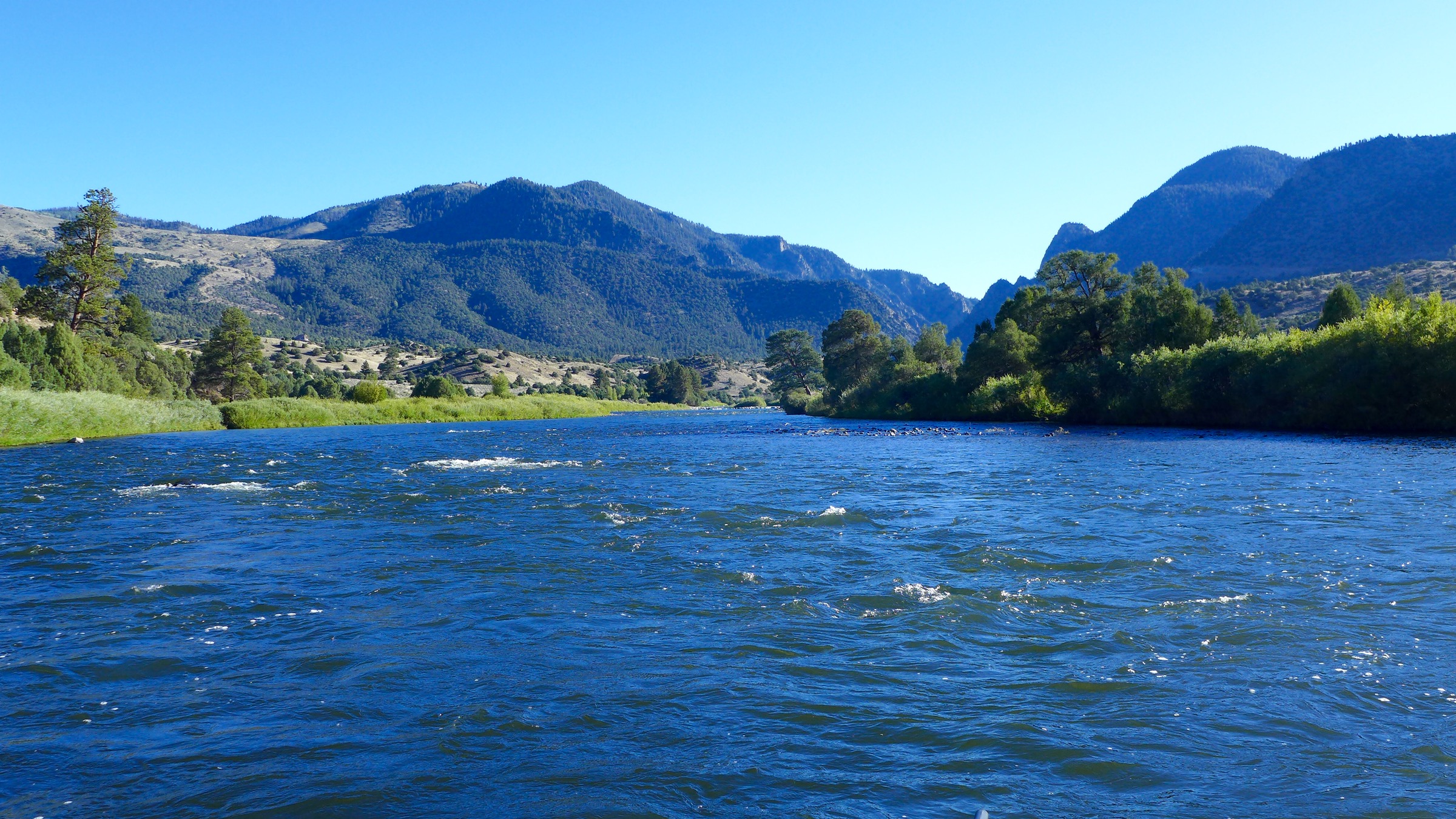
    Monument Creek

    Mulledy, a slim 38-year-old engineer and Colorado Springs native sporting a Chicago Cubs cap, leads the way on a short hike behind the Goose Gossage Youth Sports Complex on Mark Dabling Boulevard. “So if you’re playing ball out here,” he quips, “you wouldn’t know about it.”

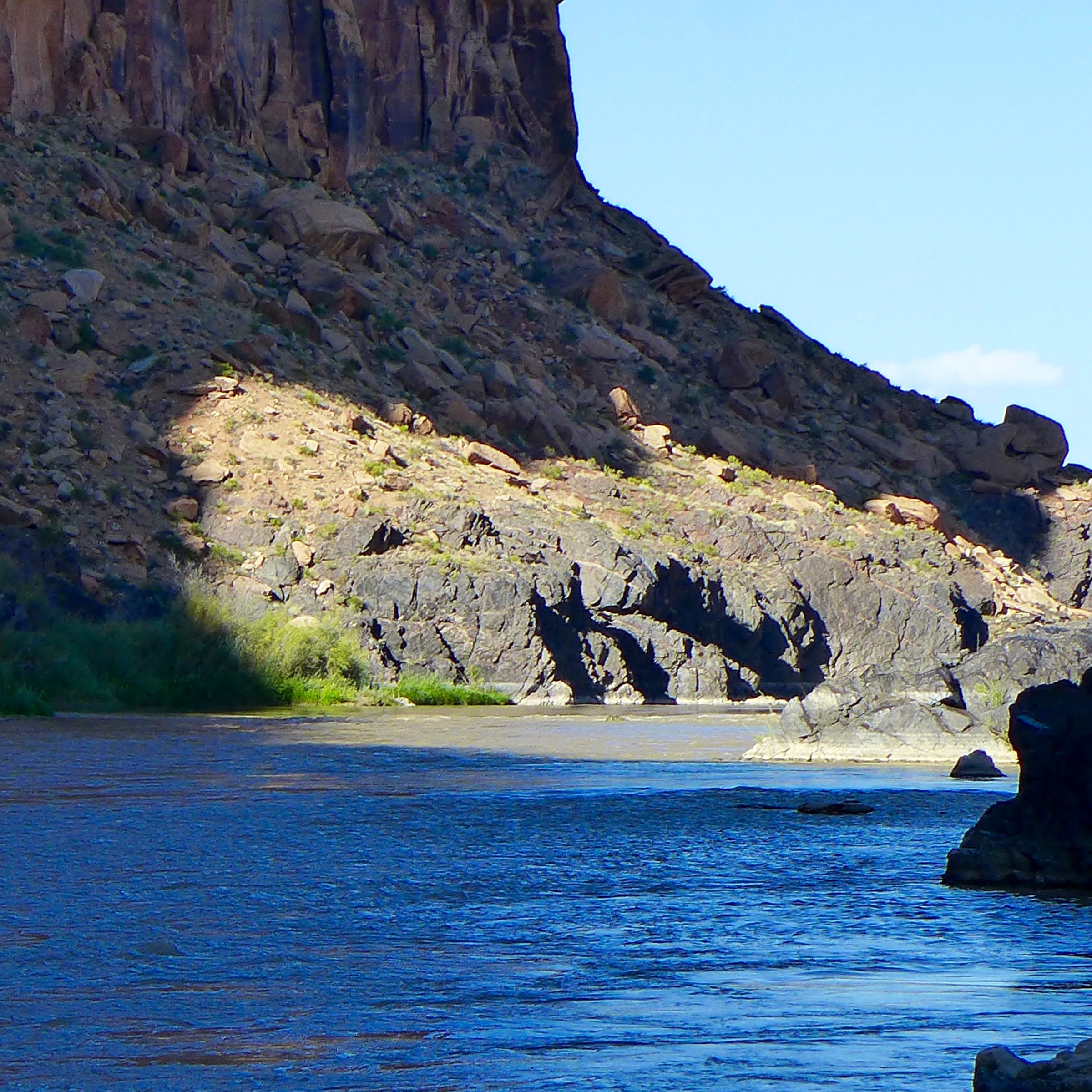
    Beyond the outfield fences, he passes through trees before scampering down a steep embankment to a sandbar where Monument Creek gurgles its way along an embankment prone to sloughing, which sends sand, gravel and trash careening down the creek to its confluence with Fountain Creek, which, in turn, flows south to the Arkansas River east of Pueblo.

    Fountain Creek, Mulledy says, is unlike any other in the United States due to its wild fluctuations in flows, from 125 cubic feet per second during normal times to 25,000 cfs in heavy storms. “There’s no other creek that’s a sand bottom creek that sees that kind of flash,” Mulledy says. “It’s a tough creek.”

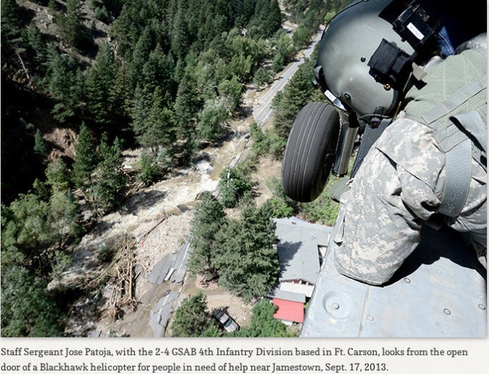
    Rushing runoff from Colorado Springs crumbles banks and sends hundreds of thousands of tons of sediment to Pueblo County, whose officials are none too pleased. There, sediment clogs levees and befouls the Arkansas River. After a 2014 regional ballot measure to fund drainage projects failed at the polls, Pueblo County officials threatened to rescind their construction permit for Colorado Springs’ Southern Delivery System (SDS) pipeline that delivers water from Pueblo Reservoir, unless the city dealt with stormwater. A deal approved by City Council in April 2016 enabled SDS’s activation in exchange for the city spending $460 million on drainage over the next 20 years. That spending eats into the general fund budget, which Mayor John Suthers says is needed to hire more cops and firefighters. Hence, the stormwater fee measure, which is intended to lift that burden.

    On this August day, Mulledy doesn’t have to point out damage from Monument Creek’s raging waters. A 20- to 25-foot dirt wall towers along the east side of the creek, where waters carve the banks and threaten to undermine the wall, triggering a collapse of a plateau above. That could bring a storage business crashing down.

    “The natural tendency of a stream is to move,” Mulledy explains. “Point [sand] bars move and push the water into the bank. It’s a built environment, so we built up next to it. Now, there’s nowhere for the river to move.”

    The city plans to install grouted boulders along a 350-foot stretch at the base of the wall, tying into bedrock. Then, the area will be backfilled with dirt to create a slope, which will be sown with seed to encourage vegetation. “Then it can hold itself, even in big storms,” he says.

    Sounds simple, but getting the right kind of heavy equipment into the creek area poses a challenge. “With road work, you can drive up, mill it and pave it,” Mulledy says. “Here, we have to create an access point. We have to bring material in, then we have to armor it for a 100-year [flood] event.” Moreover, the stream’s path itself will need to be moved west to allow workers to construct the project. Lastly, drop structures will be built to flatten the creek bed and retard the water’s flow.

    Cost: $750,000.

    After the project is completed in 2020, Mulledy says, the site should be inspected annually to assure it holds.

    North Douglas Creek

    As cars speed by on Interstate 25 just yards away, Mulledy hikes down a slope, through sunflowers and thistle, to the edge of North Douglas Creek where he warns visitors to stay away from the edge — a drop of 30 feet to the creek bed.

    Here, the creek has eroded soils so dramatically that part of a concrete box culvert has broken off and been carried about 20 yards downstream. Gas and water lines are exposed, along with a drainage pipe, which juts some 10 feet from the canyon wall, acting as a yardstick for how far the banks have been chipped away.

    “Colorado Springs Utilities is worried about that gas line and so are we,” Mulledy says.
    To the north is Johnson Storage and Moving, while on the south side lies a construction materials business. Both are threatened.

    “Johnson Storage is losing their lot,” Mulledy says, noting the embankment is chipping off several feet per year. Erosion is so bad, Sinton Road adjacent to the culvert could topple some day.

    One of the problems stems from development practices in the 1960s and ’70s that followed the then-conventional wisdom to simply move storm flows out of the city as fast as possible. Now, best management practices call for slowing down those flows using detention ponds and drop structures. “We have a better understanding than we used to,” Mulledy says.

    This segment of Douglas Creek is part of the city’s network of 270 miles of open channels and 500 miles of storm sewers — subject to inspection by federal regulators of the city’s municipal separate storm sewer system, or MS4, permit, issued through the Environmental Protection Agency.

    Violations of that permit and the Clean Water Act led the EPA and the state to sue the city last year. The case is pending and could take years to resolve as the city reconstitutes its program to address water quality and conveyance, compliance with plan review and site inspection for new developments, and maintenance of its entire system.

    This particular spot is so tenuous that Mulledy says crews visit it whenever heavy rains come. The fix, he says, will require installation of concrete walls along the bend in the creek to stop sloughing earth, structural fill and grouted rock. A crane will be employed to remove chunks of the concrete culvert.

    Cost: $3.5 million.

    Like many other projects, this undertaking will require the approval of federal flood plain managers and the Army Corps of Engineers. Work is slated for 2020.

    Pine Creek

    The most spectacular sight of the day comes at a canyon just north of the Margarita at Pine Creek restaurant, which sits dangerously close to a roughly 50-foot drop-off to Pine Creek below. Another on the city’s list of 71 projects included in the intergovernmental agreement with Pueblo, this site will require stacking boulders to create a wall at least 10 feet high, from the creek bed to the bottom of an exposed limestone shear. Below that limestone is a clay layer notoriously susceptible to erosion. Under that lies pure shale, easily crumbled, especially when the creek runs up to 10 feet deep during 10-year storms. “It’s a little stream,” Mulledy says, “until it rains.”

    The project was specifically identified by Pueblo County due to the large amounts of sediment washing into the creek and on to Pueblo via Fountain Creek. Pine Creek starts in Black Forest, winds through Falcon Estates and finally barrels through this canyon before it meets with Monument Creek about a quarter mile away. Power lines along the ridge top are mere feet from the canyon’s lip, and about 100 yards upstream, a bridge might be in danger eventually, Mulledy says.

    Like the others, this site will be challenging to access, driving the cost up, he adds.

    Cost: $2 million.

    The project will be designed next year, and construction is due to begin in 2019.
    Green Crest Channel

    Green Crest Channel almost claimed a couple of businesses and a portion of Austin Bluffs Parkway back in 2010 before the city shored up the dissolving embankment with a project completed in 2015.

    Mulledy worked on the solution to the problem while he was an engineer with Matrix Design Group, later joining the city in February 2016. By buttressing the banks and installing drop structures and grouted boulders, the stream is now healthy and lined with vegetation, such as willows, that appears historic but was placed there by Matrix as part of the project.

    Because the new features, including four drop structures, slow the stream’s flow in Templeton Gap, erosion is dramatically curtailed downstream.

    Cost: $2.8 million.

    Another project upstream from Green Crest will further secure the waterway. At Siferd Street in Park Vista, just east of Academy Boulevard, even a small rain creates monster flooding from an over-topped Templeton Gap waterway. Plans call for crews to raise the road by several feet, lower the creek, and install a box culvert and five drop structures downstream. Work begins in 2020.

    Cost: $3.75 million.

    Those projects just scratch the surface of problems that become evident when face-to-face with the city’s stream system. With the price tag in the high millions, Mulledy notes he wants to maximize those dollars. That’s why his staff works hand-in-glove with Utilities and the Parks Department to find opportunities to incorporate trails and recreation facilities where plausible.

    “Most of our projects are on green corridors,” he says, “so we look for opportunities for green spaces.”

    Hualapai #ColoradoRiver Settlement Bill Reintroduced in U.S. Senate #COriver

    Photo By Ericm1022 (Own work) CC BY-SA 3.0, via Wikimedia Commons

    From KNAU (Ryan Heinsius):

    Republican Senators John McCain and Jeff Flake have reintroduced a bill that would settle claims by the Hualapai Tribe to the Colorado River. Supporters say the deal is crucial for economic development on the reservation.

    The settlement between the Hualapai, federal government and other water users would allocate 4,000 acre feet, or 1.3 billion gallons, per year to the tribe. A 70-mile pipeline would deliver the water from Diamond Creek to Peach Springs and the Hualapai-owned Grand Canyon Skywalk and connecting Grand Canyon West resort.

    The tribe has limited access to groundwater, and says the $170 million project would benefit tourism and boost employment. Hualapai officials say the resort employs 600 people with more than a million visitors each year.

    However, Interior Department officials last year testified that the project’s costs would exceed estimates, and don’t justify the relatively small amount of water it would provide.

    @HighCountryNews: #US and #Mexico agree to share a shrinking #ColoradoRiver #COriver

    A celebration of the return of water to the Delta near San Luis Rio Colorado

    From The High Country News (Emily Benson):

    On a sunny March morning in 2014, dam operators lifted a gate on the Morelos Dam on the Colorado River, at the U.S.-Mexico border. Water gushed toward the river’s dry delta at the Gulf of California. This “pulse flow” coursed downstream for several weeks, nourishing cottonwood and willow saplings and boosting bird and other wildlife populations.

    Though most of the water soaked through the parched riverbed to aquifers below, enough remained aboveground to allow the river to meet the gulf for the first time since the late 1990s. That reminded people throughout the basin of the Colorado’s importance — and how humans have altered it. The 2012 international agreement that made the flow possible and addressed other river-management issues expires at the end of 2017. Officials, however, are expected to sign a new pact in the coming weeks. That deal, called “Minute 323,” will extend and expand the previous agreement — and reduce the risk of a catastrophic water shortage that could leave fields and faucets dry.

    Under the new agreement, Mexico would commit to voluntary reductions in water use beyond those specified in 2012 when Mead drops, according to a summary of Minute 323 several water agencies presented to their boards. But those extra restrictions only go into effect if the U.S. Lower Basin states also agree to similar cutbacks, called the “drought contingency plan.”

    That kind of cooperation is critical for the success of basin-wide plans, says Jennifer Pitt, the director of the National Audubon Society’s Colorado River Program and U.S. co-chair of the Minute 323 environmental working group. (High Country News board member Osvel Hinojosa serves as the co-chair from Mexico.) “It only works if they all jump in the pool at the same time.”

    The Lower Basin states are still at least a few months away from taking that leap. While water agencies hope to have the drought contingency plan finished by mid-2018, obstacles abound, including conflicts between Arizona water managers and disagreements over the Salton Sea in California, which is fed by Colorado River water. Still, the conditional agreement from Mexico adds an extra incentive for finalizing the Lower Basin plan. After all, “(Mexico) wouldn’t owe any more than they do today if the Lower Basin fails to act,” says Chuck Cullom, the Colorado River programs manager at the Central Arizona Water Conservation District. That would leave the U.S. to face additional water shortages on its own.

    Adiós Cassini, beautiful scientific research robot

    From Universe Today (Nancy Atkinson):

    “With Cassini, we had a rare opportunity and we seized it,” said Linda Spilker, Cassini Mission Scientist.

    And on Friday, September 15, we say goodbye to this incredible spacecraft.

    Since 2004, Cassini has been orbiting Saturn, exploring the magnificent gas giant planet while weaving through an incredibly diverse assortment of 60-plus icy moons, and skimming along the edges of the complex but iconic icy rings.

    Cassini’s findings have revolutionized our understanding of the entire Saturn system, providing intriguing insights on Saturn itself as well as revealing secrets held by moons such as Enceladus, which should be a big iceball but instead is one of the most geothermally active places in our solar system. And thanks to the Huygens lander, we now know Saturn’s largest moon, Titan is eerily Earthlike, but yet totally alien.

    “The lasting story of Cassini will likely be its longevity and the monumental amount of scientific discovery,” Cassini Project Manager Earl Maize told me last year. “It was absolutely the right spacecraft in the right place at the right time to capture a huge array of phenomena at Saturn.”

    But after 20 years in space, the Cassini spacecraft is running out of fuel, and so Cassini will conduct a sacred act known as ‘planetary protection.’ This self-sacrifice will ensure any potentially habitable moons of Saturn won’t be contaminated sometime in the future if the drifting, unpowered spacecraft were to accidentally crash land there. Microbes from Earth might still be adhering to Cassini, and its RTG power source still generates warmth. It could melt through the icy crust of one of Saturn’s moons, possibly, and reach a subsurface ocean.

    For a mission this big, this long and this unprecedented, it will end in spectacular fashion. Called the Grand Finale — which actually began last spring — Cassini has made 22 close passes through the small gap between Saturn’s cloud tops and the innermost ring. This series of orbits has sent the spacecraft on an inevitable path towards destruction.

    And tomorrow, on its final orbit, Cassini will plunge into Saturn’s atmosphere at tens of thousands of kilometers per hour. Like the science-churning machine it has been throughout its mission, Cassini will continue to conduct science observations until the very end, sending back long-sought after data about Saturn’s atmosphere. But eventually, the spacecraft will be utterly destroyed by the gas planet’s heat and pressure. It will burn up like a meteor, and become part of the planet itself…

    But I’ll also leave you with this: Instead of feeling like the mission is over, I prefer to think of Cassini as living forever, because of all the data it provided that has yet to be studied.

    Delivering water with Denver’s chess masters – News on TAP

    How operators distribute a reliable and efficient supply to one-quarter of the state’s population.

    Source: Delivering water with Denver’s chess masters – News on TAP

    Travel day to Grand Junction #CRDSeminar @ColoradoWater #ColoradoRiver #COriver

    Grand Junction back in the day with the Grand Mesa in background

    I’m heading over to Grand Junction for the Colorado River District’s Annual Seminar. I’ll try to catch up tonight from the hotel. With any luck I’ll get lost in the aspens on the way back to Denver.

    The hash tag for seminar is #CRDSeminar. You can follow the goings on at @CoyoteGulch.

    Crystal River via Aspen Journalism

    #Drought news: D0 (Abnormally Dry) shows up from #Denver to #FortCollins, precipitation on the way?

    Click here to go to the US Drought Monitor website. Here’s an excerpt:

    Summary

    While Hurricane Irma pummeled Florida and (to a lesser extent) other parts of the Southeast, most other parts of the contiguous 48 states caught little if any precipitation, save for scattered moderate to isolated heavy precipitation in parts of the Northeast. Irma brought intense rains (approaching 1.5 feet in some spots) and powerful wind gusts (measured at 140 mph at one place on the West Coast of the Florida Peninsula) that removed any suggestion of dryness from the Southeast. Enough precipitation fell on part of eastern Maine to shave down areas of D0 and D1 from the west, but most of the country — from the Ohio and lower Mississippi Rivers westward to the Pacific Coast – recorded little precipitation, if any. Only isolated patches in the eastern Great Lakes Region and the lower Colorado River Valley recorded more than an inch of rain…

    High Plains

    The dry week in the central Plains led to a significant expansion of D0 and (to a lesser extent) D1 in northern Oklahoma, Kansas, and southern Nebraska. Farther north, the most notable change was the broad development of D1 in most of eastern North Dakota and adjacent northwestern Minnesota, with scattered small areas in the Dakotas declining into severe or extreme drought. Farther west in the High Plains, light precipitation at best has fallen over the last 30 days, keeping dryness and drought essentially intact, with D0 developing in central and eastern sections of the Denver to Ft. Collins, CO…

    West

    The last 30 days have been quite dry from the Rockies westward to the Pacific Coast. [ed. emphasis mine] Totals exceeding 0.5 inch were limited to parts of the southeastern Rockies, the Colorado River Valley, the higher elevations of central Arizona, and a swath along the Montana/Wyoming border. For the last 3 months, precipitation totals were among the lowest 2 percent on record in a broad areas from most of Montana westward across central and northern Idaho, Washington, and the northern half of Oregon. The most marked change introduced this week was the expansion of D1 conditions across the northern tier of Oregon, part of central Idaho, and some of interior Washington, though an area in central and south-central parts of that state (where year-to-date precipitation totals are higher than in surrounding areas) remained at D0. In addition, D2 and D3 were expanded in parts of northern Montana, and several other small areas of deterioration were introduced in Idaho and southern Montana.

    Dry conditions have abetted the development and rapid spread of wildfires across the northern Rockies and adjacent areas, and (more seasonably) in portions of the Great Basin and California. So far, over 8.2 million acres have been scorched by wildfires nationally [ed. emphasis mine], approaching 150 percent of the 10-year average for the year-to-date. Of the 8.2 million acre total, almost 40 percent (3.2 million acres) have been in the northern Rockies and Great Basin…

    Looking Ahead

    Beneficial precipitation is expected during September 14 – 18, 2017 across much of the drought-afflicted areas in the northern Plains and Rockies. Between 1.5 and 3.5 inches are expected across all but the western and northern tiers of Montana, and central and southwestern sections of North Dakota. Moderate rains (0.5 to locally 1.5 inches) is expected in the Upper Midwest and the central Plains, as well as the far Pacific Northwest west of the Cascades. Light precipitation at best is anticipated in other areas of dryness and drought.

    The ensuing 5 days (September 19 – 23, 2017) look to bring a reversal in the temperature pattern recently observed across the 48 states, with odds favoring cooler than normal weather from the northern High Plains and southern Rockies to the Pacific Coast, and warmer than normal conditions expected in the central and eastern parts of the county. There are enhanced chances for above-normal precipitation from central and northern sections of the High Plains westward to the Pacific Coast, most of the Great Plains north of Texas, and the middle and upper Mississippi Valley. Odds also favor above-normal precipitation in the Copper Basin of Alaska. Meanwhile, subnormal precipitation is favored in the East, Southeast, most of Texas, and the southern Rockies.

    7-Day Quantitative Precipitation Forecast September 14 through September 21, 2017 via NOAA.

    #ColoradoRiver: IID board votes yes on #Minute323 agreements #COriver

    The Colorado River is about 1,400 miles long and flows through seven U.S. states and into Mexico. The Upper Colorado River Basin supplies approximately 90 percent of the water for the entire basin. It originates as rain and snow in the Rocky and Wasatch mountains. Credit USGS.

    From The Imperial Valley News:

    During yesterday’s regularly scheduled meeting, the Imperial Irrigation District Board of Directors approved a series of agreements to Minute No. 323, a potential amendment to the 1944 treaty with Mexico, which would be key to continuing cooperative efforts on both sides of the border in support of the Colorado River system through 2026.

    Directors approved seven domestic agreements that serve to implement Minute No. 323, an international agreement that is expected to be executed before the end of the year by the United States and Mexican governments. The district is one of a number of water agencies in the Southwest to have signed the agreements.

    Current interim binational cooperative measures and shortage sharing provisions on the river under Minute No. 319, which was executed in 2012, are set to expire on December 31, 2017. These would continue with the execution of Minute No. 323…

    The agreements build on the coordinated operations and water management concepts implemented by the 2007 Interim Guidelines. They also extend or replace binational cooperative measures from Minute No. 318 that address the April 2010 earthquake in the Mexicali valley, and Minute No. 319, the five-year interim shortage and surplus agreement that defines additional operational coordination when Lake Mead drops below 1,075 feet.

    In conjunction with the execution of Minute No. 323, the agreements continue to allow Mexico to store water in Lake Mead and provide for Mexico’s continued sharing of shortages and surpluses through 2026. The agreements also provide for a potentially larger drought response partnership with U.S. water users through the development of the Basin States drought contingency plan and Mexico’s binational water scarcity contingency plan.

    Additional components include binational cooperative conservation projects, environmental programs, salinity management efforts and the opportunity for additional conservation and desalination projects in Mexico.

    The agreements also authorize $31.5 million in U.S. funding for pilot water conservation programs in Mexico that would generate 229,100 acre-feet of conservation. Approximately 70,000 acre-feet of this conservation is designated for Mexican environmental purposes, 50,000 acre-feet will benefit the Colorado River system and 27,275 acre-feet will be assigned to each partnering U.S. water agency (IID, Southern Nevada Water Authority, the Metropolitan Water District of Southern California and the Central Arizona Water Conservation District). The four agencies would fund $15 million ($3.75 million each over 10 years) and the Bureau of Reclamation would provide $16.5 million. The potential would then exist for a second round of binational conservation projects upon completion of these projects.

    The U.S. and Mexico sections of the International Boundary and Water Commission are developing Minute No. 323.