@EPA delays coal plant wastewater rule #KeepItInTheGround #ActOnClimate

Diagram of a typical steam-cycle coal power plant (proceeding from left to right). Graphic credit: Wikipedia.

From the Associated Press via The Colorado Springs Gazette:

The rule requires steam electric power plants to control the amount of coal ash-contaminated wastewater flushed from their plants.

The water contains toxic heavy metals such as lead, arsenic and mercury, and while it’s pumped to holding ponds it often ends up in rivers and lakes. The rule sets the first specific limits on those toxins.

EPA Administrator Scott Pruitt says postponing the rule for two years would give utilities relief from deadlines to upgrade pollution-control equipment while the agency revisits the requirements.

Environmental groups sued over an earlier effort to postpone the rule. They say they’ll challenge this move as well.

@MJVentrice : For this day in history, arctic sea ice is currently lower than any year in our archive, surpassing 2016. Forecast suggests a rebound though

@NorthernWater is drawing down Horsetooth for Soldier Canyon Dam outlet works maintenance

Horsetooth Reservoir looking west from Soldier Dam. Photo credit: Northern Water.

From The Fort Collins Coloradoan (Jacy Marmaduke):

In all, Horsetooth dropped 32 feet between Aug. 1 and Sept. 13. The reason for the decrease is two-fold, according to reservoir manager Northern Water.

One reason for the level change is the approaching end of the irrigation season. Water users often didn’t need to take advantage of their water rights earlier in the summer, when storm clouds dropped rain on Northern Colorado several times a week.

But as the weather’s dried up, Northern Water has delivered more water to ditch companies for irrigation, spokesman Brian Werner said. The Poudre and South Platte Rivers are running lower now that snowpack has waned, so irrigation water is coming out of storage at Horsetooth.

The Soldier Canyon Dam is located on the east shore of Horsetooth Reservoir, 3.5 miles west of Fort Collins, Colorado. The zoned earthfill dam has an outlet works consisting of a concrete conduit through the base of the dam, controlled by two 72-inch hollow-jet valves. The foundation is limey shales and sandstones overlain with silty, sandy clay. Photo credit Reclamation.

The releases are also necessary because Northern Water is planning maintenance on the Soldier Canyon Dam outlet works in early November, Werner said. Lower water levels make it easier for divers to access dams for repairs.

Horsetooth stood at 5,391 feet on Wednesday morning, which is about average for this time of year, Werner said. On Aug. 1, Horsetooth’s elevation was 5,423 feet, or 7 feet below full…

Northern Water plans to draw down Horsetooth another 4 feet but will do so more gradually during the coming weeks, Werner said. The reservoir will probably reach more of an “equilibrium” between inflows and outflows this weekend, he added.

Colorado-Big Thompson Project east slope facilities

Evening Visits — Greg Hobbs

This slideshow requires JavaScript.

Evening Visits

Lord, help us understand
what we cannot know for sure,
every day’s a gift,

Every evening an opportunity,
to practice grace and thankfulness,
to place our faith in community,

For all we have, for all the nows
and now, is the chance
of being, day and evening,

Together and alone,
to walk the shore and mountain path,
to lift our voices,

Work for peace,
honor hope,
love greatly.

Greg Hobbs (written 9/11/2001)
(Colorado Foundation for Water Education, Colorado Mother of Rivers, Water Poems at 75)

@WaterLawReview: Diving into the legal issues behind giving standing to water bodies, both here in the U.S. and abroad

Ganges River watershed via Wikipedia.

Click here to go to Water Law Review website to read the whole article. Here’s an excerpt (Michael Larrack):

Rights of Water Sources in the U.S.

The idea of granting legal rights to inanimate objects, specifically natural resources, is not alien to the United States. There are advantages to granting a water source specific rights, discussed at length by Cristopher Stone, Professor of Law at the University of Southern California, in a 1972 journal article. Stone argued giving an entity like a river judicial standing, or a right to sue for a perceived harm, would allow for greater justice for ecological harms. For example, if a polluter dumps in a river, the only current avenue for recovery is for those non-river entities harmed by the pollution to sue. If pollution doesn’t significantly bother a downstream user, or that user is a polluter itself, that individual may not ever bring a suit and the harm would go unchecked. A river could sue for the entirety of harms suffered.

U.S. Supreme Court Justice Douglas agreed with Stone, in a dissenting opinion also authored in 1972, Sierra Club v. Morton. His dissent cited public concern for nature and ecology, and called for those with a meaningful relation to water to be able to speak for it. He used the analogy of ships and corporations, both of which have legal personality that grants them rights in litigation. While stirring, this view has failed to gain traction in the following decades.

A likely cause for this is that it could be politically unpopular. The Blaze, a conservative U.S. news source, pushed back against the New Zealand law. Ironically, it attacks the law for one of the same reasons Stone argued natural resources should have standing. The Blaze article is concerned with giving rights to non-living entities, when New Zealand does not recognize rights for unborn children because it does not ban abortion. As Stone himself recognized, there is difficulty in getting Americans to accept an inanimate object has standing. As an example, he cites the backlash from corporate personhood, a debate that still goes on. And at a more technical level, water as a commercial commodity with multitudes of competing interests and disagreement over what constitutes “public interest” and “beneficial use” in the American West’s established prior appropriation system complicates matters.

A framework for assessing ecosystem services in acequia irrigation communities of the Upper Río Grande watershed

An acequia along the Las Trampas in northern New Mexico is suspended on a trestle. (Eddie Moore/Albuquerque Journal)

Here’s a paper that suggests an analysis of acequia flood irrigation and the environment that exists now is needed prior to a move to drips, from N. Raheem, et al. that’s posted on the Taos Acequia Association Website:

‘What we need to do is inventory the different types of agricultural landscapes and bring to light the typical rural architecture, such as the acequias and desagües (irrigation supply canals and excess water drains). We need to find ways of conserving the landscape, including the flora and fauna as well as the role the agricultural landscape has played in the evolution of the surrounding area. Before we abandon the past (flood irrigation) for the contemporary (drip irrigation), we need a thorough analysis of the pros and cons of each system for the whole cultural landscape. The future may be one where the old and new learn to coexist, such as the hoe with the plow’ (Arellano, 2014, p. 204). © 2015 Wiley Periodicals, Inc.

@ColoradoClimate: Weekly Climate, Water and #Drought Assessment of the Intermountain West

Upper Colorado River Basin September 2017 precipitation through September 12, 2017.

Click here to read the current assessment. Click here to go to the NIDIS website hosted by the Colorado Climate Center.

COGCC fines Encana for spill near Parachute

Parachute/Battlement Mesa area via the Town of Parachute.

From The Denver Post (Bruce Finley):

The Colorado Oil and Gas Conservation Commission imposed the penalty for a leak discovered in June 2016 on the 320-acre Bishop Ranch. It is part of a consent agreement that clears Encana and Hunter Ridge from further state penalties for degrading water quality.

Encana spokesman Doug Hock on Monday couldn’t say how much liquid leaked but stated company crews “eliminated the source of the release within hours of discovery” and that “the impacts have been contained.”

COGCC officials did not respond to queries about whether the leak has been stopped or continues to threaten health and safety.

The hydrocarbons degraded a ranch where land managers count on pristine conditions to sustain deer and elk, essential for Colorado’s increasingly lucrative business of recreation.

Bishop Ranch operators filed a civil lawsuit July 18 against Encana in Rio Blanco County claiming the pipeline leaked huge amounts of hydrocarbons that continue to contaminate springs, streams, underground water, vegetation and soil. The lawsuit alleges the environmental damage ruined a planned $5 million sale of the ranch.

The court case hasn’t been resolved. Encana has sold off its Colorado oil and gas assets. Denver-based Caerus Oil and Gas took over wells in northwestern Colorado in June.

Bishop Ranch owner Mike Bishop on Monday scoffed at the COGCC penalty, calling it pathetic and highly unlikely to deter future violations of state environmental rules…

Bishop Ranch attorneys acknowledged an effort by Encana to contain and filter contaminated water and move it into a cattle pond on contaminated land nearby that the company purchased.

“It has been 58 weeks since the spill was discovered. Encana continues to recover condensate from the contaminated springs at a rate of about 2 barrels (84 gallons) every day,” attorney Mark Mason said. “This environmental nightmare does not end with the payment of a nominal fine by a company that has now essentially left the state. Mr. Bishop … will not let them quietly sweep this one under the rug.”

Last year, COGCC officials notified Encana subsidiary Hunter Ridge that they were considering penalties for a failure to manage waste in northwestern Colorado in a way that protects water, among other violations.

A state document provided to the Denver Post Monday says that as of Aug. 1, Hunter Ridge had spent $2.7 million and recovered 1,195 barrels, or 50,190 gallons, of condensate from the release that contaminated Bishop Ranch and is continuing “to pursue the necessary remediation work.”

State documents didn’t include any estimate of how much liquid leaked from Hunter Ridge’s underground pipeline.

#ColoradoRiver: Dog Island restoration update

McInnis Canyon National Recreation Area via the BLM

From The Grand Junction Daily Sentinel (Kelly Slivka):

[Kate] Graham is the assistant director for the Colorado Canyons Association, a nonprofit that works closely with the Bureau of Land Management to care for and protect the three National Conservation Areas skirting Grand Junction — Gunnison Gorge, Dominguez-Escalante and McInnis Canyons, the last of which is home to Dog Island.

With the help of an army of volunteers from the wide conservation network that operates in western Colorado, Graham, her co-workers and BLM officials have been attempting to restore Dog Island’s vegetation after a visitor from Breckenridge set off fireworks there two summers ago, in August of 2015, and burnt it to a crisp…

[Troy] Schnurr has been keeping track of the local stretch of the Colorado for 27 years, and he’s one of the people spearheading the Dog Island restoration efforts.

The island, a large, sand and stone bank a little over a half-mile long, sits about two-thirds of the way between the Loma Boat Launch, just northwest of Fruita, and Westwater, the first river access point across the border in Utah.

It’s a very popular river outpost, hosting a shady, roomy campground on its western side, and it’s now slowly starting to recover from the fire.

It’s not a barren wasteland but has greened up ­— yes, with fast-growing, weedy Russian knapweed but also with sage, salt grass and many other native and non-native plants.

And though most of the cottonwoods studding the island are now scorched skeletons, fresh foliage from sucker shoots have begun to poke up from around some of the burnt trunks — a sign that the fire didn’t completely fry the root systems…

But these little victories toward recovery belie the painstaking, time-consuming and unpredictable road of restoration.

Invaders

Invasive plant species famously excel at taking over landscapes after fires or other destruction, and knapweed and Canadian thistle reign on Dog Island, creating a sea of weeds in which young native sumac shrubs can hardly be seen, much less thrive.

“Ecologically, this is a pretty sick island,” Schnurr said.

More than the proliferation of weeds, Schnurr mourns the loss of cottonwoods, staple riverside habitat that stabilizes river banks and shelters wild animals — and recreators — from the elements.

Some of the cottonwoods on Dog Island were probably over a hundred years old, Schnurr said, but only took a moment to burn down the night of the fire.

“We’ll never see old cottonwoods like this again on this stretch in my lifetime,” he said, gazing at the bleached white trunks of the dead trees.

After the 2015 Dog Island fire was doused, Schnurr was one of the first people to survey the damage and begin clean-up.

He and other BLM officials, including Collin Ewing, who manages the region’s National Conservation Areas, brought in a crew from the Western Colorado Conservation Corps, an organization that recruits youth volunteers to help with service projects, and began to clear out fallen trees and burnt tamarisk, another invasive plant overwhelming many parts of Ruby Horsethief.

By the fall of 2016, Graham and the Colorado Canyons Association had secured funding through the Colorado Water Conservation Board to restore three areas in Ruby Horsethief, one of which was Dog Island.

The association worked with Ewing, Schnurr and others to replant the island’s native species, like sumac, supplied by the Upper Colorado Plant Center in Meeker, a nonprofit that specializes in revegetating disturbed environments with natural growth.

The group also continued to clear out dead tamarisk, and they trimmed back extraneous cottonwood growth to encourage the recovering trees to focus their energy on establishment.

The game-plan for Dog Island now, a year after the original restorative push and two years after the burn, is to treat invasive weeds with herbicide and wait for nature to take its course, Schnurr said. He said once the weeds die, the native plants should move in to replace them.

But there’s more hands-on work to be done elsewhere in the canyons. Dog Island isn’t the only target for Schnurr’s and Graham’s conservation and restoration efforts.

Along the 25-mile Ruby Horsethief stretch, the Colorado snakes through the McInnis Canyons National Conservation Area and borders the Black Ridge Canyons Wilderness, protected lands managed for use by the BLM.

“Lack of water doesn’t stop growth” — Eric Wilkinson

Northern Integrated Supply Project (NISP) map July 27, 2016 via Northern Water.

From The Fort Collins Coloradoan (Rebecca Powell):

The panel last week gave its unanimous support to Northern Colorado Water
Conservancy District’s plan, which set out to address the impacts of the Northern Integrated Supply Project on fish and wildlife.

Concerns about the plan have centered on peak water flows and whether flows outlined in the plan will be enough to allow for a flushing that is vital to the Poudre River’s health…

Both Fort Collins City Council and Larimer County commissioners reviewed the plan, which was released in June.

Council sent comments back to the commission with recommendations, such as guaranteeing three days of peak flows on the river for critical flushing.

Commissioners opted not to send feedback to the commission, and its members said they were comfortable with the plan…

Northern Water is working with 15 Front Range partners who seek to build the project to meet water demands brought upon by future growth.

“Lack of water doesn’t stop growth. It just changes where it comes from,” Northern Water General Manager Eric Wilkinson told the Coloradoan Editorial Board on Monday. “In Colorado, it’s going to come from ag. … Without this project, there are 100 square miles of farms that will be dried up to provide that water.”

[…]

Now NISP must go through more water quality mitigation as part of the Federal Clean Water Act.

An Army Corps of Engineers decision on whether to allow the nearly $1 billion project is expected in 2018, after the proposal has cleared regulatory hurdles in Colorado.

#ColoradoRiver: Hualapai Tribe settles water rights claim #COriver

Photo By Ericm1022 (Own work) CC BY-SA 3.0, via Wikimedia Commons

From Fronteras Desk (Laurel Morales):

The Hualapai Tribe has agreed to end a decades-long conflict over Colorado River water rights in exchange for a $134 million pipeline that will supply water to the tribe’s Grand Canyon tourist attractions.

About a million people visit Grand Canyon West each year to step out on the glass skywalk over the natural wonder.

Hualapai Chairman Damon Clarke spoke before the Senate Indian Affairs Committee last year, and said the attraction employs 300 tribal members and 300 non-natives. He said most drive two hours to work each day to live near a water source.

“We’re proud of the fact that the tribe is moving forward towards achieving full employment for our members and economic self-sufficiency, but the severe lack of water on the reservation is a major obstacle in reaching these goals,” Clarke said.

Senators John McCain and Jeff Flake have introduced legislation that would give the Hualapai 4,000 acre feet of Colorado River water each year.

Little Thompson Water District wins AWWA #Colorado Section taste test

Map via the Little Thompson Water District

From The Greeley Tribune (Tyler Silvy):

Sample No. 5, we’d find out later, was from Little Thompson, and it is this year’s winner, folks.

Here’s how it went:

Eight samples are set in front of you on numbered coasters. You’re given a sheet to rate each sample 1-10, with 10 being the best-tasting water on this earth and 1 being the opposite of that.

Other than that, there wasn’t much in the way of instruction.

So I briefly tasted each sample, starting at No. 8 and working my way down while making little marks along the way. Then I tasted the ones I marked poorly again, again working my way toward the ones that caught my attention in a good way.

A final taste of my top three yielded a winner — at least in my book.

But then there was a final round, then there was a tie, and each of those things caused more water to be consumed and so I can really see now why the folks running the competition recommended a pre-competition restroom break.

Greeley, which won last year’s competition, didn’t enter this year’s competition. It didn’t have to. Consider it a first-round bye thanks to the city winning the national championship last year.

Aurora came in second and Louisville took third. Little Thompson will go on to the national competition next, as Greeley attempts to defend its title.

Warmer Air Means More Evaporation and Precipitation #ActOnClimate #KeepItInTheGround

Graphic credit: Climate Central

From Climate Central:

Climate change intersects with hurricanes by increasing storm rainfall, intensity, and surge.

A warming atmosphere causes more evaporation, meaning more water is available for precipitation. For every 1°F increase in temperature, the atmosphere can hold around 4 percent more water vapor, which leads to heavier rain and increases the risk of flooding of rivers and streams. We saw the impact of extreme rainfall during Harvey. Though no research has yet been done to attribute the staggering rainfall totals from this storm to climate change, the downpours are very much in line with heavy precipitation trends.

September 11, 2001

Via WallpaperMaven.com

On the morning of September 11, 2001 I was in my office at home at the computer and my son came into the room.

“Papa, a plane just hit the World Trade Center,” he said.

What a journey the U.S. has been on since then. The current administration just announced another troop surge into Afghanistan, now our longest war with no end in sight.

“They won’t give peace a chance” — Joni Mitchell

@CWCB_DNR: #Colorado Watershed Restoration Program Guidance and Application

Photo via the Rio Grande Restoration Project

Click here to go to the Colorado Water Conservation Board website:

What is the Colorado Watershed Restoration Grant Program?

The Program provides grants for watershed/stream restoration and flood mitigation projects throughout the state.

Examples of Funded Projects

Who can apply for a Grant?

Organizations interested in developing watershed/stream restoration and flood mitigation studies and projects. Contact Chris Sturm, 303-866-3441 x3236, to discuss project eligibility.

How can the money be used?

Grant money may be used for planning and engineering studies, including implementation measures, to address technical needs for watershed restoration and flood mitigation projects throughout the state. Special consideration is reserved for planning and project efforts that integrate multi-objectives in restoration and flood mitigation. This may include projects and studies designed to:

  • Restore stream channels,
  • ­

  • Provide habitat for aquatic and terrestrial species,
  • ­

  • Restore riparian areas,
  • ­

  • Reduce erosion,
  • ­

  • Reduce flood hazards, or
  • ­

  • Increase the capacity to utilize water.
  • How do I apply for a Grant?

    1. Read the program guidance document.
    Program Guidance

    2. Contact Chris Sturm at CWCB to discuss potential applications: 303-866-3441 x3236.

    3. Complete the application and submit by November 3, 2017.
    Application

    Three agencies urge #California to approve #SaltonSea agreement #ColoradoRiver #COriver

    From The Palm Springs Desert Sun (Ian James):

    The State Water Resources Control Board met Thursday to hear comments on the proposed agreement, which sets targets for state agencies tasked with building thousands of acres of ponds, wetlands and other dust-control projects around the lake over the next 10 years.

    The proposed deal represents a new consensus strategy for the Salton Sea among state and local agencies after years of delays, disagreements and widespread frustration. The agreement resulted from negotiations involving the Imperial Irrigation District, Imperial County, the San Diego County Water Authority and officials in Gov. Jerry Brown’s administration.

    IID General Manager Kevin Kelley said the agreement “represents the most significant advance to date at the Salton Sea.”

    “It’s viable, it represents consensus between our three agencies and I believe it’s achievable, and that’s really what we need at the Salton Sea,” Kelley told the board during the meeting in Sacramento, flanked by representatives of Imperial County and the San Diego County Water Authority. “It is not all that we wanted, but it works.”

    The State Water Board released a draft of the agreement, technically called a “stipulated order,” in mid-August and plans to release a final draft soon before considering whether to approve it.

    Members of the state board said they understand the urgency of acting quickly because the Salton Sea is now less than four months away from a critical deadline when some of the Colorado River water that flows into the lake will be cut off and its shorelines will begin to shrink more rapidly.

    The state’s 10-year plan, which was released in March and is the foundation of the agreement, says a total of 29,800 acres of dust-control projects and habitat areas should be built around the lake by the end of 2028.

    If fully built, those ponds, wetlands and other projects would cover less than half of the more than 60,000 acres of dry lakebed that’s projected to be left exposed over the next 10 years – meaning that vast areas of dust-spewing lakebed are still expected to be left exposed, posing worsening health threats in an area that already suffers from extremely high asthma rates.

    After years of inaction by state agencies, though, the three agencies said their agreement offers a clear path forward that they hope will kick-start the state’s efforts.

    They said the deal also would ensure the state board continues to have jurisdiction to see that the state follows through on its plans after Brown leaves office.

    The agreement lays out annual targets for the construction of dust-control projects and habitat areas ranging from 500 acres to 4,200 acres. It says at least 50 percent of the total acreage must “provide habitat benefits for fish and wildlife,” while other areas could be dust-control projects that don’t require water. Those methods could include plowing sections of lakebed or laying down bales of hay to block windblown dust.

    Under the current wording, if state agencies fail to meet an annual acreage target by more than 20 percent for two years in a row, they would be required to develop a plan to “cure the deficiency” within 12 months. Several environmental groups, however, said the two-year period would be too long and suggested state agencies should be held accountable if they fall behind for a single year.

    Several participants in the negotiations said that time allowance could be shortened to a single year in the final draft.

    The agreement brings accountability to the state’s plan by specifying what would happen if state agencies don’t get their projects done on time, said Imperial County Counsel Katherine Turner…

    Maureen Stapleton, general manager of the San Diego County Water Authority, called it a “balanced, thoughtful plan that is fair to all.”

    The state’s $383-million plan remains largely unfunded, with only $80.5 million approved so far. California lawmakers been discussing a proposed measure that would include $280 million for projects at the Salton Sea, but the measure – and the dollar amount – have yet to secure final approval in the Legislature.

    The bond measure would also have to be approved by voters next year…

    Michael Lynes of Audubon California pointed out that bird populations have been crashing as the lake grows saltier and the habitat deteriorates. Birds that have seen major declines in numbers include white pelicans, double-crested cormorants and eared grebes.

    Ignacio Ochoa, an organizer with the Sierra Club, pointed out that dust from thousands of acres of exposed lakebed is already affecting people’s health and leading to high rates of respiratory illnesses…

    The lake, which has no outlet and is already saltier than the ocean, has been getting progressively saltier and regularly gives off a stench resembling rotten eggs. While Thursday’s meeting was underway, in face, the South Coast Air Quality Management District issued an odor advisory for the Coachella Valley due to the smelly gases, specifically hydrogen sulfide, coming from the lake.

    The Salton Sea is about to start shrinking more rapidly next year under the water transfers. The 2003 agreement called for the Imperial district to send “mitigation water” from its canals into the sea through 2017 – a period intended to give state agencies time to prepare for dealing with the effects.

    At the end of this year, that flow of water will be cut off and the lake’s shorelines will retreat more rapidly. Over the next 30 years, the lake is projected to shrink by a third.

    Building in infrastructure resilience in our warmer world #ActOnClimate

    The City of Boulder’s Open Space and Mountain Parks Department (OSMP) has begun a major restoration project that will improve native fish habitat in Boulder Creek and restore natural areas surrounding the creek. This ecological project also will repair damage from the 2013 floods by returning Boulder Creek to its pre-flood channel, and will include the planting of more than 11,000 native trees and shrubs. These plantings will help improve the creek’s sustainability and resiliency, and help mitigate damage to private and public property during future floods. These efforts are occurring in two areas east of Boulder. Photo credit the City of Boulder.

    From The Conversation (Thaddeus R. Miller/Mikhail Chester):

    Unfortunately, Harvey delivered and then some with early estimates of the damage at over US$190 billion, which would make it the costliest storm in U.S. history. The rain dumped on the Houston area by Harvey has been called “unprecedented,” making engineering and floodplain design standards look outdated at best and irresponsible at worst.

    But to dismiss this as a once-in-a-lifetime event would be a mistake. With more very powerful storms forming in the Atlantic this hurricane season, we should know better. We must listen to those telling a more complicated story, one that involves decades of land use planning and poor urban design that has generated impervious surfaces at a fantastic pace…

    Invest in and redesign institutions, not just infrastructure. When analyzing breakdowns in infrastructure, it is tempting to blame the technical design. Yet design parameters are set by institutions and shaped by politics, financing and policy goals.

    So failures in infrastructure are not just technical failures; they are institutional ones as well. They are failures in “knowledge systems,” or the ability to generate, communicate and utilize knowledge within and across institutions…

    Design for climate change. When it comes to infrastructure’s ability to handle more extreme events that are predicted to come with climate change, the primary problem is not bad engineering or faulty technical designs. Instead, it’s that infrastructure are typically sized based on the intensity and frequency of historical events. Yet these historical conditions are now routinely exceeded: since 1979, Houston alone has experienced three 500-year storms.

    Climate change will make preparing for future storms much harder. These events are not just associated with precipitation and inland flooding but include more extreme heat, cold, drought, wildfires, coastal flooding and wind. Buildings, roads, water networks and other infrastructure last decades and designing for historical events may result in more frequent failure as events become more frequent or intense with climate change. Infrastructure designers and managers must shift from risk-based to resilience-based thinking, so that our systems can better withstand and bounce back from these extreme events…

    Manage infrastructure as interconnected and interdependent. In his 1987 essay, “Atchafalaya,” writer John McPhee explores efforts by the U.S. Army Corps of Engineers to control the Atchafalaya and Mississippi River systems. He brilliantly showed that rather than bringing predictability to a complex and meandering riverine system, the Old River Control system created unpredictability. “It’s a mixture of hydrologic events and human events… This is planned chaos… Nobody knows where it’s going to end.”

    While floodplain management has made advances since then, the impact of development and infrastructure design is still often considered on a piecemeal basis. As Montgomery County engineer Mark Mooney noted in a recent Houston Chronicle article, “I can show you on any individual project how runoff has been properly mitigated. Having said that, when you see the increase in impervious surfaces that we have, it’s clear the way water moves through our county has changed. It’s all part of a massive puzzle everyone is trying to sort out.”

    […]

    Create flexible infrastructure. Given that our infrastructures are centralized and satisfy demands that don’t change rapidly (we use water and electricity much in the way we did over the past century), they tend to be inflexible. Yet we need our urban systems and the infrastructure that support them to be resilient. And flexibility is a necessary precondition for resilience.

    Current designs favor robustness and redundancy. These infrastructure tend to be difficult to change and the managing institutions are often structured and constrained in ways that create barriers to flexibility. Consider the difference in flexibility of landline versus mobile phones, in terms of both use and changing the hardware. Similarly, new strategies are needed to incorporate flexibility into our infrastructure. In the case of hurricanes, roadways with smart signaling and controls that dynamically adjust stoplights and reverse lanes to allow vehicles to evacuate quickly would be of significant value.

    Design infrastructure for everyone. Large disasters almost always highlight systemic social inequalities in our communities, as we saw in the 1995 Chicago heat wave, Hurricane Katrina and now Hurricane Harvey.

    Yet as cities rebuild and other cities watch to glean lessons, we consistently sidestep the historical legacies, public policies and political-economic structures that continue to make low-income and minority populations, such as homeless people, more vulnerable to extreme weather events. For this to change, infrastructure must be designed with the most vulnerable in mind first.

    From American Rivers (Daniel Nylen):

    American Rivers, funded by the Wildlife Conservation Society’s Climate Adaptation Fund, is working to help the California Department of Water Resources (DWR) improve and expand the Yolo Bypass to provide more frequent inundation of this critical floodplain habitat while reducing flood risk for Sacramento and other downstream communities. As part of this grant, American Rivers is also conducting an outreach campaign to help promote multi-benefit flood management and floodplain restoration throughout the Central Valley. We realized that high quality compelling imagery of completed projects, projects in planning stages, and floodplains in action were missing from our campaign. So we tasked ourselves with creating an image archive that could be used indefinitely by us and our partners for advocacy and outreach for years to come.

    In order to document conditions along the San Joaquin River following an epic winter and collect stock imagery of the San Joaquin River for the image archive, American Rivers teamed up with LightHawk, a nonprofit that accelerates conservation through the powerful perspective of flight. Pilots volunteer their planes and time to fly missions that create new imagery, collect data, or inform the public about some of our environment’s most pressing issues. This work could not have been done without LightHawk and their volunteer pilots, who fill a critical gap that is often hard to fund.

    Back in June, I met up with Bill Rush, one of LightHawk’s dedicated volunteer pilots, for a flight along the San Joaquin River. Bill lives in the Santa Cruz mountains and volunteers for LightHawk, Flying Doctors, and Baja Communidad. As a photographer, I knew I couldn’t pass up this opportunity even though I have a fear of flying. During the 2-hour flight, we followed the river from Stockton to Mendota and back up again. Luckily, the pilot’s many years of experience, combined with the fact that I was intently focused on what was 2,000 feet below me, resulted in a smooth and productive flight.

    Though it was June, the river was still relatively high (around 5,000 cubic feet per second) – high enough to see a few activated floodplains, but low enough to see impacts from the high flows that were endured for many months. Smaller levee breaches were clear in some areas (notice the beautiful sand patterns on farm fields in some of the photos), and other areas were still green and vibrant even though it was nearing mid-summer. I was also able to document several completed floodplain restoration projects and ones in planning stages that are being led by American Rivers and its partners. Overall, the flight provided invaluable imagery and data on the San Joaquin River after one of the wettest winters in recent years.

    Given projected impacts to rivers due to climate change – increased frequency of wetter winters and drier summers – the imperative for more resilient approaches to water and flood management are more important than ever. By working with nature, instead of against it, we can improve the resiliency of California’s water infrastructure to more extreme floods and droughts.

    CPW okays NISP wildlife mitigation plan

    Aerial view of the roposed Glade Reservoir site — photo via Northern Water

    From The Sterling Journal-Advocate (Jeff Rice) via The Fort Morgan Times:

    The plan that was approved Thursday addresses the impacts to fish and wildlife due to the development and water diversion associated with NISP. Brian Werner, spokesman for Northern Water, said Friday the approval is a significant advancement of the plan.

    “This was a significant step, there’s no question about that,” he said. “This is a big box we can check off, but there are still a few boxes ahead of us.”

    The plan now goes to the Colorado Water Conservation Board, which could give its approval to the project as early as the Sept. 20 board meeting, and then to the governor’s desk for signature.

    There are plenty more boxes to be checked after that; the Environmental Impact Statement could be finished by the spring of 2018, Army Corps of Engineers approval could come sometime in early 2019, and then it’s back to the state level for what’s called a 401 Water Quality Certification.

    Northern’s Werner said it could be 2021 or 2022 before anybody starts moving dirt. He said a proposed law to shorten the length of time it takes to bring water projects online wouldn’t affect NISP..

    According to a CPW statement released on Thursday, the agency has been talking with Northern Water about the concept of this project for the last decade. Northern Water, CPW and the Department of Natural Resources have been discussing the fish and wildlife mitigation and project in earnest since October 2015. After more than two years of discussions, Northern Water presented and released a public draft of the plan at the June commission meeting. Ken Kehmeier, senior aquatic biologist with CPW, said Thursday he thinks the plan “provides a reasonable solution for fish and wildlife mitigation.”

    “We understand the public’s concern for the river which is why CPW staff has been engaged in discussions for close to a decade,” he said. “If we were not involved from the onset, the level of mitigation, enhancement and protection of the river corridor and aquatic habitat would not be such a large part of Northern’s plans.”

    A significant part of the mitigation plan, Kehmeier said, is what’s called the “conveyance refinement” flow, or year-round baseline flow plan for the river. The conveyance refinement intended to eliminate existing dry-up points on a 12-mile stretch of the Poudre River through Fort Collins. Average winter flows at the Lincoln Street Gate will be nearly doubled compared with current levels.

    “The conveyance flow program is significant to the fishery and aquatic life because it keeps water in the river on a year round basis,” Kehmeier said. “Overall, the conveyance flow will significantly benefit the aquatic life in the river during the low flow times of the year.”

    As part Northern Water’s plan, a new reservoir will be created for water storage and recreation opportunities for the public. Northern Water has agreed to provide $3 million plus an additional $50,000 per year for CPW hatchery expansion so that the new Glade Reservoir can be managed as a recreational fishery. Additional fishing opportunities will benefit the local and Colorado economy, as the fishing industry generates $1.9 billion in economic activity annually.

    Northern Water has also agreed to provide wildlife habitat mitigation and enhancements on the west side of the reservoir, including the purchase of 1,380 acres to protect the reservoir drainage area and big-game habitat from development. This is critical winter range habitat for a non-migratory elk herd.

    From email from Northern Water:

    The Colorado Parks and Wildlife Commission unanimously approved the Fish and Wildlife Mitigation and Enhancement Plan submitted by Northern Water for the Northern Integrated Supply Project at its meeting Thursday in Steamboat Springs.

    The plan will protect the environment, fish and other wildlife in and near the Cache la Poudre River during and after NISP construction.

    Read the CPW press release.

    “This is a significant milestone for us,” said Jerry Gibbens, Northern Water’s NISP mitigation coordinator.

    “We believe the plan is one of the most robust, if not the most robust, mitigation and enhancement plans ever proposed for a water project in Colorado,” said Northern Water General Manager Eric Wilkinson.

    After years of discussion and multiple modifications to the proposed plan, CPW staff and commissioners expressed satisfaction with the updated plan.

    “If you look at this as a package, we’ve hit a balance,” said Ken Kehmeier, CWC’s senior aquatic biologist. “This is a reasonable approach.”

    Northern Water incorporated CPW’s recommendations into the revised plan to help minimize impacts to fish and wildlife habitat during all phases of the project. Northern Water also agreed to minimize the impacts of NISP operations on peak flows in the Poudre River, including adjusting water diversion rates gradually to avoid sudden changes in river flows.

    The peak flow mitigation is a first-of-its-kind commitment to maintain peak flows in the Poudre River nearly every year for geomorphic and aquatic habitat purposes.

    The refined conveyance portion of the plan “will get us water in the river 24/7, 365,” said Kehmeier.

    This year-round baseline flow plan will be crucial for the river’s aquatic habitat and connectivity. The conveyance refinement flow is intended to eliminate existing dry-up points on a 12-mile stretch of the Poudre River through Fort Collins. Average winter flows at the Lincoln Street Gage will be nearly doubled compared with current levels.

    In addition, wildlife habitat mitigation and enhancements will be made on the west side of Glade Reservoir. This includes the purchase of 1,380 acres that will be used to protect the reservoir drainage area from development and to preserve big-game habitat, including that of non-migratory elk.

    Trout Unlimited also supports the NISP Fish and Wildlife Mitigation and Enhancement Plan. David Nickum, executive director of Trout Unlimited said at the meeting Thursday, “We feel this is a solid mitigation plan.”

    After a decade of conceptualization and two years of serious discussion, CPW’s approval was made possible by the dedicated efforts of both Northern Water and CPW staff.

    “The NISP participants want to thank all who have worked on this mitigation plan, CPW and Northern Water staff, for developing a plan we all can stand behind,” said Chairman Chris Smith of the NISP participants committee. “The plan makes for a better Poudre River.”

    Thanks to all NISP supporters who sent comments to the CPW prior to yesterday’s vote!

    Read the Fish and Wildlife Mitigation and Enhancement Plan.

    Northern Integrated Supply Project (NISP) map July 27, 2016 via Northern Water.

    Club 20 Fall Conference recap #COpolitics

    Colorado Capitol building

    Here’s a report from Charles Ashby writing in The Grand Junction Daily Sentinel. Click through to read the whole article. Here’s an excerpt:

    “The one issue that I did not anticipate, but appreciate more than any of the other (issues), is water,” [George] Brauchler said Friday shortly after meeting with the Grand Junction Economic Partnership about business issues. “On the Front Range, the water issue is when I turn on my tap, is it there? Getting around the state as much as I have over the past five months, water is a huge issue.” Brauchler said his lack of understanding about water issues prompted him to meet with numerous water experts, including those with the Colorado River District.

    His main takeaway, which is still under development, is more storage and more conservation…

    [Donna] Lynne was the only candidate for the Democratic Party nomination to make it to the Grand Valley for the Club 20 meeting, giving the keynote address at Saturday’s lunch.

    For the past 18 months working as Hickenlooper’s chief operating officer, Lynne said she’s learned much about the workings of Colorado government.

    As an expert in health care matters, Lynne said one of her main focuses will be on getting the cost down, which has been a particularly troublesome issue for rural parts of the state.

    “We need to talk about having enough (health care) plans in the state, and providing statewide coverage,” Lynne said. “The increases in the individual market unfortunately are a function of people dropping in and out of coverage, and we need to figure out how to encourage them to stay in for the entire year. That’s what’s hurting a lot of the health plans.”

    From WesternSlopeNow.com (Briseida Holguin):

    Water rights and public lands are two topics that both Republican Rep. Scott Tipton and Republican Sen. Cory Gardner from Colorado discussed in detail.

    Relocating the Bureau of Land Management is a high priority for Gardner, “If your in Washington D.C. you’re a thousand miles removed from 99% of the acres managed by the Bureau of Land Management,”

    Gardner says he has had great conversations with Secretary of the Interior Ryan Zinke to move this forward…

    Along with public lands Tipton says protecting the state’s forest will save Colorado from having fires and says the House of Representatives recently passed the Resilient Federal Forest Act.

    “To be able to go in and to treat those forests, to be able to bring them back to life, to be able to cut down that dead timber. Let’s look at the positives of what can happen when we are actively managing these forests in responsible way,” Tipton said.

    Both lawmakers also find themselves on the same page about water rights.

    “In Colorado water is a private property right,” Tipton said.

    “The federal government should not be able to dictate to Colorado what a Colorado water law or permit is allowed to be,” Gardner said.

    Both Gardner and Tipton feel legislation on Colorado water rights will soon pass.

    “We’re able to pass that through the house of representatives and out of the committee with by partisan support. That is now over in the senate waiting for action. I’m pleased to be able to report to you that the committee that Cory sits on just dealt the first hearing on that legislation,” Tipton said.

    Tipton says he is optimistic that Congress will pass a law to protect Colorado’s water rights and that it will soon be on the president’s desk for his signature.

    Strontia Springs: The little reservoir that could – News on TAP

    80 percent of Denver’s drinking water passes through Strontia Springs Reservoir — one of the smallest in Denver Water’s system.

    Source: Strontia Springs: The little reservoir that could – News on TAP

    #ClimateChange: “SEASON OF SMOKE In a Summer of Wildfires and Hurricanes, My Son Asks “Why Is Everything Going Wrong?” — Naomi Klein

    Graphic via WildFireToday.com September 9, 2017.

    Here’s an in-depth report from Naomi Klein writing for the Intercept. Click through and read the whole article, and resolve to accelerate your efforts to mitigate the Climate Crisis. Here’s an excerpt:

    …for large parts of North America, Europe, and Africa, this summer has not been about water at all. In fact it has been about its absence; it’s been about land so dry and heat so oppressive that forested mountains exploded into smoke like volcanoes. It’s been about fires fierce enough to jump the Columbia River; fast enough to light up the outskirts of Los Angeles like an invading army; and pervasive enough to threaten natural treasures, like the tallest and most ancient sequoia trees and Glacier National Park.

    For millions of people from California to Greenland, Oregon to Portugal, British Columbia to Montana, Siberia to South Africa, the summer of 2017 has been the summer of fire. And more than anything else, it’s been the summer of ubiquitous, inescapable smoke.

    For years, climate scientists have warned us that a warming world is an extreme world, in which humanity is buffeted by both brutalizing excesses and stifling absences of the core elements that have kept fragile life in equilibrium for millennia. At the end of the summer of 2017 — with major cities submerged in water and others licked by flames — we are currently living through Exhibit A of this extreme world, one in which natural extremes come head-to-head with social, racial, and economic ones.

    #FakeWeather

    I checked the forecast before coming to British Columbia’s Sunshine Coast, a ragged strip of coastline marked by dark evergreen forests that butt up against rocky cliffs and beaches strewn with driftwood, the charming flotsam from decades of sloppy logging operations. Reachable only by ferry or floatplane, this is the part of the world where my parents live, where my son was born, and where my grandparents died. Though it still feels like home, we now only get here for a few weeks a year.

    The government of Canada weather site predicted that the next week would be glorious: an uninterrupted block of sun, clear skies, and higher than average temperatures. I pictured hot afternoons paddling in the Pacific and still, starry nights.

    But when we arrive in early August, a murky blanket of white has engulfed the coast and the temperature is cool enough for a sweater. Forecasts are often wrong, but this is more complicated. Somewhere up there, above the muck, the sky is clear of clouds. The sun is particularly hot. Yet intervening in those truths is a factor the forecasters did not account for: huge quantities of smoke, blown up to 400 miles from the province’s interior, where about 130 wildfires are burning out of control.

    Enough smoke has descended to turn the sky from periwinkle blue to this low, unbroken white. Enough smoke to reflect a good portion of the sun’s heat back into space, artificially pushing temperatures down. Enough smoke to transform the sun itself into an angry pinpoint of red fire surrounded by a strange halo, unable to burn through the relentless haze. Enough smoke to blot out the stars. Enough smoke to absorb any possible sunsets. At the end of the day, the red ball abruptly disappears, only to be replaced by a strange burnt-orange moon.

    The smoke has created its own weather system, powerful enough to transform the climate not just where we are, but in a stretch of territory that appears to cover roughly 100,000 square miles. And the smoke, a giant smudge on the satellite images, respects no borders: not only is about a third of British Columbia choked, but so are large parts of the Pacific Northwest, including Seattle, Bellingham, and Portland, Oregon. In the age of #fakenews, this is #fakeweather, a mess in the sky created, in large part, by toxic ignorance and political malpractice.

    La Tuna fire September 2017 photo credit StrangeSounds.com

    Water year 2017: Wet winter, fiery summer #ActOnClimate #KeepItInTheGround

    Sprague Fire September 2017. Photo credit the Associated Press via The Flathead Beacon.

    From the Associated Press (Dan Elliott):

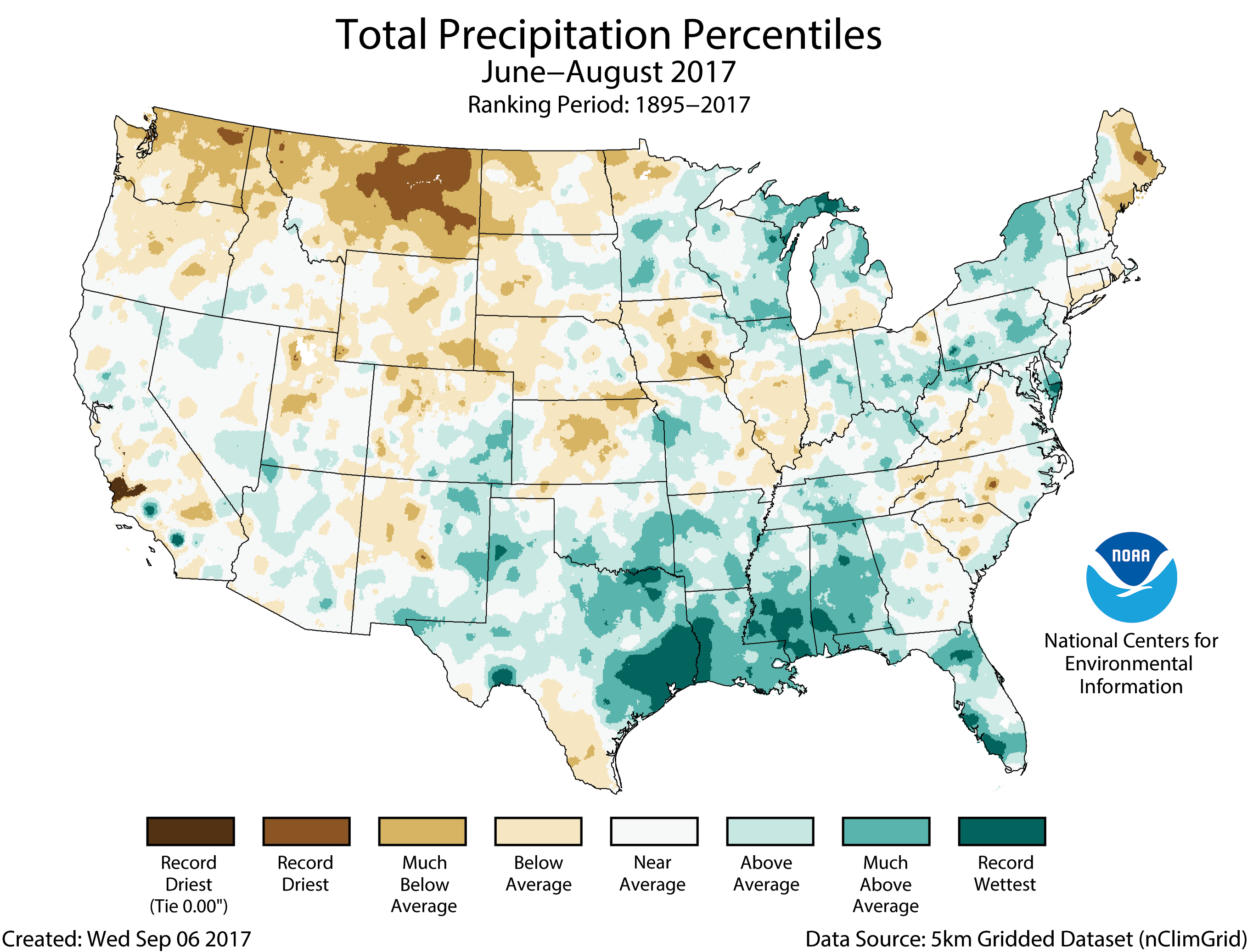
    HOW DID WE GET HERE?

    Heavy snows last winter brought relief from a long, brutal drought across much of the West and produced a lush growth of natural grasses — thicker and taller than many vegetation experts had ever seen. But the weather turned very hot very fast in the spring, and the snow melted much faster than expected.

    All the grass that grew high dried out, and so did forests at higher elevations, leaving plenty of fuel for wildfires, said Bryan Henry, a manager at the National Interagency Fire Center, which coordinates wildfire-fighting.

    Summer lightning storms then dumped less rain than usual and weather conditions kept the humidity low, creating a natural tinderbox in many states…

    HOW BIG ARE THE FIRES?

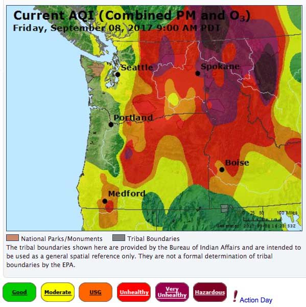
    By Thursday, more than 76 large fires were burning in nine Western states — including 21 in Montana and 18 in Oregon, according to the interagency fire center.

    So far this year, wildfires have burned more than 12,500 square miles (32,000 square kilometers) nationwide. In the past decade, only two years were worse at this point in the wildfire season: 2015 and 2012.

    For all of 2015, a record 15,800 square miles (41,000 square kilometers) burned. In 2012, 14,600 square miles (38,000 square kilometers) were scorched…

    WHAT ABOUT CLIMATE CHANGE?

    It’s making things worse for fires, said Jonathan Overpeck, dean of the School for Environment and Sustainability at the University of Michigan.

    Hotter and drier weather is a symptom of human-caused climate change, and that’s making fires worse by leaving forests and other vegetation more flammable…

    “It’s not of course playing the only role,” he said. “There’s natural variability at work.”

    “Humans are contributing to an ever-increasing degree to wildfires in the West as they emit greenhouse gases and warm the planet and warm the West,” Overpeck said.

    TREE-EATING BEETLES

    Two dozen species of beetles have killed trees on nearly 85,000 square miles (220,000 square kilometers) in the Western U.S. since 2000. They’re responsible for about 20 percent of the 6.3 billion standing dead trees across the West, according to the U.S. Forest Service.

    Researchers disagree on whether forests with beetle-killed trees are more likely to burn, or if they burn differently, than healthier forests.

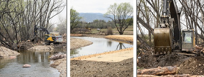
    Any standing dead tree — whether killed by beetles, drought, lightning or other causes — can crash down, posing hazards for firefighters who must adjust their tactics to avoid them…

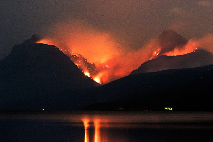
    HOW BAD ARE THE LOSSES?

    Nine firefighters have died and 35 have been injured this year, according to the national Wildland Fire Lessons Learned Center. Two of the deaths came during training.

    Fires have destroyed an estimated 500 single-family homes and 32 commercial buildings this year, the interagency fire center said.

    Janet Ruiz of the Insurance Information Institute sees a hopeful trend in fewer houses lost to wildfires in recent years. Ruiz credits better-equipped firefighters and homeowners who take steps to minimize the danger such as clearing trees away from buildings and installing screens over dwelling openings to keep embers out…

    HOW MUCH HAS FIREFIGHTING COST?

    Federal spending to fight fires appears to be headed for a record.

    The two main firefighting agencies, the U.S. Forest Service and the U.S. Department of Interior, report spending of more than $2.1 billion so far. That’s about the same as they spent in all of 2015, the most expensive wildfire season on record.

    Those figures do not include individual state spending, which no single agency compiles. Montana has spent $50 million, exhausting its firefighting reserve fund in just over a month. Oregon has spent $28 million, but the state expects to be reimbursed for part of that by the federal government and others…

    DON’T SOME FIRES HELP THE ENVIRONMENT?

    Yes. Fires can burn away undergrowth, preventing buildups of flammable vegetation that can make big fires even worse. They can also help some forests and grassland rejuvenate.

    But very hot fires can damage the soil and make it water-resistant, which produces heavy runoff during rainstorms and snowmelt, which in turn can cause severe erosion, mud slides and floods.

    Silt from fire-damaged valleys can clog streams, which kills fish.

    The silt can also settle to the bottom of reservoirs, taking up space needed to store drinking water and forcing utilities to spend heavily to dredge it out.
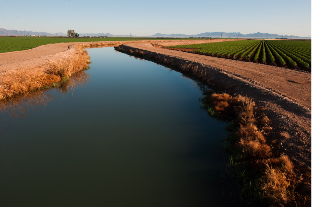
    #CRDSeminar: The #ColoradoRiver District “Points of No Return” focuses on ‘Big River’ challenges

    Click here to go the website to register.

    After 36 years working at the River District, this will be Eric Kuhn’s last seminar on staff. Now a renowned Colorado River statesman, he will give a glimpse into his upcoming memoirs via his candid, well-studied perspectives. His legacy includes many durable agreements that have brought peace to the once turbulent Colorado River; he will not only speak to the many lessons learned but of the uncertain future of the west’s lifeblood.

    Keynoting the lunchtime program is Dr. Jack Schmidt (Utah State University and former Glen Canyon Monitoring and Research Center Director) who has authored a critical analysis of a controversial proposal to drain Lake Powell and fill Lake Mead first. Although the proposal is touted as a way to open up the submerged Glen Canyon, reduce evaporation and thereby increase water supply, Schmidt’s analysis raises serious questions about the technical viability of this approach.

    During the main program, two western Colorado ranchers, Don Schwindt of Cortez, Bill Trampe of Gunnison and Dave Kanzer of the Colorado River District, will discuss how the move to irrigation efficiency equipment can have both desired benefits and unintended consequences, especially to late season streamflows.

    Addressing one of the many complexities for the Lower Colorado River Basin will be Bill Hasencamp, Manager with Metropolitan Water District of Southern California by presenting on the challenges of the Salton Sea and the Bay-Delta.

    Our line-up also includes a good report from Grand County collaborators Paul Bruchez, Mely Whiting and Lurline Curran on transforming the Upper Colorado River with healthy improvements.

    Authors Heather Hansman and Eric Kuhn will discuss their respective upcoming books on the Green River and the Colorado River.

    Additionally, newly named Director Becky Mitchell of the Colorado Water Conservation Board and Board members John McClow and Heather Dutton will discuss the current water picture and how to move ahead on solving Colorado’s water challenges.

    The very full and detailed agenda is on line at http://www.ColoradoRiverDistrict.org. To register, please contact Meredith TODAY for the reduced rate via email to mspyker@crwcd.org or by calling 970-945-8522. Credit cards accepted.

    Pagosa Springs: 11th annual Water 101 and 201 Seminar, October 5, 2017

    Photo credit: Colorado.com

    From The Pagosa Springs Sun (Elaine Chick):

    Tens of millions of people, billions of dollars of agricultural production and an enormous amount of economic activity across a vast swath of America from California to the Mississippi River are all dependent on rivers born in the mountains of Colorado.

    In a time of mounting demand and limited supply, the need for all citizens to better understand and participate in decisions affecting this critical resource is paramount. Colorado’s population is expected to double by 2050, with a good portion of that occurring on the Western Slope. Where will all that water come from?

    To discuss this, as well as a multitude of other issues, Pagosa Springs will once again be the location for the educational 11th annual Water 101 and 201 seminars.

    Sponsored by the Water Information Program, the seminars will take place on Oct. 5 from 8:30 a.m. to 5 p.m. and on Oct. 6 from 8:30 a.m. to noon at the Ross Ara- gon Community Center (451 Hot Springs Blvd.).

    The seminar qualifies for 11 continuing education credits (CECs) for Realtors and six CECs for lawyers for completion of both days. The seminars are open to the general public as well.

    Topics include water law, an explanation of water-related agencies and organizations, the Colorado Water Plan and implementation, as well as discussion about timely and important water topics and issues. The 201 session will provide more in-depth information on water law to include compacts and the water court process.

    David Robbins and J.C. Ulrich (Greg Hobbs) at the 2013 Colorado Water Congress Annual Convention

    The seminar features a lineup of quali ed speakers, including the keynote, Colorado Supreme Court Justice Gregory Hobbs (retired), as well as representatives from fed- eral, state and local agencies.

    Space is limited, so register early. The early-bird registration fee is $40 before Sept. 22 for the 101 workshop, $30 for the 201 session before Sept. 22, and $60 for both days. For those seeking CECs, add $10 to each of the preceding. The registration fee includes snack and an information packet both days, as well as lunch on Oct. 5.

    For more information or to register, go to: https://swwcd.org/ event/water-101-201-seminar, contact the Water Information Program at 247-1302 or visit http://www.waterinfo.org.

    Delph Carpenter’s 1922 Colorado River Basin map with Lake Mead and Lake Powell via Greg Hobbs.

    Morgan County Commissioners give green light to #solar farm #ActOnClimate

    Photovoltaic Solar Array

    From The Fort Morgan Times (Paul Albani-Burgio):

    The Morgan County Commissioners voted 3 to 0 Tuesday to approve a conditional use permit and variance for the construction of a solar farm on 20 acres of land near the intersection of County Road 21 and County Road N southeast of Fort Morgan.

    The farm is being built by Starlight Energy Corporation on land owned by Peter V. and Karen V. Anderson. Commissioner Mark Arndt said Starlight is proposing to sell the electricity that is generated from the farm to the Morgan County Rural Electric Association to provide power for Morgan County residents but a power purchase agreement has not been finalized. Arndt said Starlight has also talked about Fort Morgan Light and Power as a possible buyer of the electricity that will be generated.

    The facility is expected to generate about 2 megawatts of solar power per year and a half of a megawatt of natural gas power. Though the number of homes powered by a megawatt of solar energy depends on average sunshine, electricity consumption, temperature and wind in a given area, it is estimated that one megawatt can power about 650 homes.

    Starlight Energy CEO Brian Bentley said the company was hoping to have the solar farm constructed and operational in the first quarter of 2018. Bentley said a portion of the facility that will generate natural gas when not enough solar power is being generated should be operational by the fourth quarter of this year.

    Survey says? You like us, but we aren’t perfect – News on TAP

    92 percent of Denver Water’s customers are satisfied, but there is room for improvement.

    Source: Survey says? You like us, but we aren’t perfect – News on TAP

    @MSUDenver: Water Studies Online Certificate

    From Metropolitan State University at Denver (Terry Bower):

    In response to the reality of declining water resources, Metropolitan State University of Denver Innovative and Lifelong Learning has partnered with the One World One Water Center to offer a new Water Studies Online Certificate, an opportunity to learn about the history, law, and management of water in Colorado and the western United States.

    From lifelong learners who want to know more about water preservation to those working in green and sustainable professions, this unique certificate provides introductory level training and skills relevant to a wide range of fields in the nonprofit, corporate, and public sectors, including water industries, conservation, agriculture, construction, engineering, and law.

    What you get with the Water Studies Online Certificate:

  • Flexible schedule – Control your own schedule with a self-paced format that’s 100% online
  • One-on-one networking and advisement – Receive a personal advising session with an expert in the Colorado water industry
  • Real-world applications – Develop a capstone project to directly apply what you’ve learned to real-world situations
  • Career opportunities – Find job demand in a growth industry. Wherever you live, someone’s job is to be in charge of water.

    Registration opens October 3. Courses start January 2018. For more information, please contact Innovative and Lifelong Learning at lifelonglearning@msudenver.edu or 303.721.1313.

  • Go Roadrunners! (John Orr, class of 1978)

    @USGS: Warmer and Longer Summers Portend Increased Stream Temperatures in the Northern Rockies

    Profile of the North Fork of the Flathead River, Montana. Photo credit Jonny Armstrong.

    Here’s the release from the United States Geological Survey (Clint Muhlfeld):

    A new U.S. Geological Survey study provides a larger window into the future for understanding how seasonal stream temperatures may change in one of the most ecologically diverse ecosystems in North America – the Crown of the Continent Ecosystem, USA and Canada.

    Summary: Climate warming is expected to increase stream temperatures in mountainous regions of western North America, yet the degree to which future climate change may influence seasonal patterns of stream temperature is uncertain. Much of the scientific and management focus of future changes in stream temperatures has focused instead on average summer temperatures. This new study used a comprehensive database of stream temperature records (~4 million bi-hourly recordings) and high-resolution climate and land surface data to estimate monthly stream temperatures and potential change under future warming scenarios. Results imply increasing trends in stream temperature warming during spring, summer, and fall, with the largest increases predicted during summer. Additionally, stream temperatures characteristic of current August temperatures, the warmest month of the year, may be exceeded during July and September, suggesting an earlier onset and extended duration of warm summer stream temperatures. The study provides the first broad scale analysis of seasonal climate effects on stream temperature in this internationally important ecosystem for better understanding climate change impacts on freshwater habitats and guiding conservation and climate adaptation strategies for aquatic species.

    The study, “Projected warming portends seasonal shifts of stream temperatures in the Crown of the Continent Ecosystem, USA and Canada”, was published in the journal Climate Change.

    CPW Commission unanimously approves NISP Fish and Wildlife Mitigation and Enhancement Plan @NorthernWater

    Here’s the release from Colorado Parks and Wildlife:

    The Colorado Parks and Wildlife Commission has unanimously approved the Fish and Wildlife Mitigation and Enhancement Plan submitted by Northern Water for the Northern Integrated Supply Project on the Poudre River in Northeast Colorado. This plan is designed to address the impacts to fish and wildlife due to the development and water diversion associated with NISP.

    Colorado Parks & Wildlife (CPW) staff has been talking with Northern Water about the concept of this project for the last decade. Northern Water, CPW and the Department of Natural Resources have been discussing the Fish and Wildlife Mitigation and Enhancement Plan project in earnest since October 2015. Following more than two years of discussions, Northern Water presented and released a public draft of the Plan at the June Commission meeting.

    CPW staff feel that Northern Water’s plan provides a reasonable solution for fish and wildlife mitigation.

    “We understand the public’s concern for the river which is why CPW staff has been engaged in discussions for close to a decade,” said Ken Kehmeier, senior aquatic biologist with CPW. “If we were not involved from the onset, the level of mitigation, enhancement and protection of the river corridor and aquatic habitat would not be such a large part of Northern’s plans,” said Kehmeier.

    Northern Water has made modifications to its project design and operations, and has committed to work with CPW. Recommendations by CPW are aimed at minimizing impacts to fish and wildlife habitat during all phases of the project. Some of these include:

  • Peak Flow Operations Plan, pg. 46
  • the “conveyance refinement” flow, or year-round baseline flow plan for the river;
  • the retrofit of four diversions that currently do not allow fish passage or sediment transport;
  • Big game habitat mitigation and enhancements
  • The Peak Flow Operations Plan will minimize the impacts of NISP operations on peak flows, higher flows in the spring. Peak flow is important for maintaining spawning habitat for fish and aquatic life. Northern Water has agreed to ramping water diversions gradually to avoid sudden changes in river flows and allow fish to adjust.

    The conveyance refinement is crucial for aquatic habitat and river connectivity. This process is intended to eliminate existing dry-up points on a 12-mile stretch of the Poudre River through Fort Collins. Average winter flows at the Lincoln Street Gate will be nearly doubled compared with current levels.

    “The conveyance flow program is significant to the fishery and aquatic life because it keeps water in the river on a year round basis,” Kehmeier said. The conveyance flow will also meet the Fort Collins River Health Assessment Framework flow of 20 cfs 97 of the time at the Lincoln Street Gage.

    “Overall, the conveyance flow will significantly benefit the aquatic life in the river during the low flow times of the year,” Kehmeier said.

    As part Northern Water’s plan, a new reservoir will be created for water storage and recreation opportunities for the public. Northern Water has agreed to provide $3 million plus an additional $50,000 per year for CPW hatchery expansion so that the new Glade Reservoir can be managed as a recreational fishery. Additional fishing opportunities will benefit the local and Colorado economy, as the fishing industry generates $1.9 billion in economic activity annually.

    Northern Water has also agreed to provide wildlife habitat mitigation and enhancements on the west side of the reservoir, including the purchase of 1,380 acres to protect the reservoir drainage area and big-game habitat from development. This is critical winter range habitat for a non-migratory elk herd.

    CPW recognizes that the water quality mitigation is not complete and the proposed project still needs to go through a 401 certification as part of the federal Clean Water Act process. This certification will be conducted by Colorado Department of Health and Environment. As part of a recommendation prompted by the Colorado Water Plan, CPW staff will participate in that process and feel that it will further enhance protection of the Poudre River.

    Temperature issues occur in the river on a year-round basis; the conveyance refinement and multi-level outlet tower at Glade Reservoir will aid in mitigating the temperature issues and other potential water quality issues, for example, sediment transport during low flow. The releases from the reservoir will be aerated and the multi-level outlet will allow water to be mixed if it is needed at a particular temperature.

    The Poudre River Adaptive Management Plan, pg 97, will allow a collective group of interested parties that include the City of Fort Collins, Northern Water, CPW, Larimer County and others to go back and make corrections to the plan and operation if any are necessary. The plan will also allow CPW and other parties to continue conducting projects to benefit the river to include floodplain connection, fish habitat enhancements and mitigate sediment transport.

    The Fish and Wildlife Mitigation and Enhancement Plan will now go to the Colorado Water Conservation Board for review.

    The full Fish and Wildlife Mitigation and Enhancement Plan can be found here: http://www.northernwater.org/sf/docs/default-source/default-document-library/2017-08-22-nisp-fwmep_draft-final-1.pdf?sfvrsn=90f38624_2

    Northern Integrated Supply Project (NISP) map July 27, 2016 via Northern Water.

    @USBR Launches Prize Competition Seeking Ways to Improve Data Visualization for #ColoradoRiver Basin #COriver

    Graphic credit Consider.biz

    Here’s the release from the US Bureau of Reclamation (Peter Soeth):

    The Bureau of Reclamation is launching a new prize competition seeking innovative, interactive, and user-driven ways to display data that supports management of the Colorado River Basin. Visualizations improve data exploration, analysis, interpretation, and communication.

    Reclamation’s Hydraulic Engineer Jon Rocha works on methods of presenting complex data in a user-friendly way. “Think about your daily weather forecast. Most people see a colorful map with temperatures,” Rocha said. “But, underneath that map is really lots and lots of data.”

    Reclamation is making a total prize purse of $60,000 available, to be divided among the winners. A maximum single award for this competition is $20,000 with no prizes below $5,000 being provided for fully successful solutions. No cash prizes are guaranteed unless they meet or exceed the Solution Requirements. Partial cash prizes will be considered for solutions that meet some, but not all, of the requirements.

    Successful solutions will include one or more of the following elements:

  • Integrated visualization of multiple relevant CRB data types and/or ancillary information. This may include mashups of data from Reclamation and other sources, combination of multiple data types, and/or integration of data with ancillary information.
  • User-customizable visualization of data and/or ancillary information. This may include user-driven selection of data parameters, time periods, or geographical range, or configuration of visualization layout or content to meet user needs and preferences.
  • Interactive visualization of data and/or ancillary information. This may include zooming or panning around a visualization, drilling down into data, clicking through animations, inputting information, and/or responding to queries or requests from the visualization.
  • Reclamation is collaborating with the U.S. Geological Survey, the Colorado Basin River Forecast Center, the Natural Resource Conservation Service and the U.S. Section of the International Boundary and Water Commission.

    Learn more by visiting https://www.usbr.gov/research/challenges/datavis.html.

    A look at what to expect from the early Water Year 2018

    Three month precipitation outlook through November 30, 2017 via the Climate Prediction Center.
    Three month temperature outlook through November 30, 2017 via the Climate Prediction Center.

    From The Aspen Times (Scott Condon):

    The National Weather Service isn’t expecting the winter to be dominated by El Nino, when temperatures in the Southern Pacific Ocean are above normal, or La Nina, when temperatures are below normal. Instead, they expect El Nino Southern Oscillation Neutral conditions, known as ENSO Neutral.

    “Basically what that means for us in western Colorado is a wildcard winter,” said Megan Stackhouse, a meteorologist with the weather service in Grand Junction. “There is no preferred track for storms. If we happen to be in the storm track, we can be wet and snowy. If we are more likely out of the storm track, we will be dry.”

    Past winters with ENSO Neutral conditions brought a mixed bag to western Colorado. In 2012-13 and 2014-15 there was below normal precipitation across Colorado for the winter, she said. In 2013-14 there was above normal precipitation across the northern and eastern areas of the state.

    “One thing that all three of those winters had in common was the presence of a persistent ridge of high pressure situated over the West Coast,” Stackhouse said. That tends to block low-pressure systems that drop in snowstorms from the northwest.

    Aspen’s experiences during the three most recent ENSO Neutral winters were slightly different from the state as a whole. The Aspen Water Plant, which tracks weather data for the weather service, recorded 163 inches of snow in 2012-13 compared with an average of 155 inches going back to winter 1934-35. Snowfall at the water plant also was above average in 2013-14 with 200 inches.

    Snowfall was below average in 2014-15 with just 149.5 inches at the water plant.

    Winter outlooks are starting to dribble in from commercial forecasting firms and websites oriented toward skiers. AspenWeather.net, a micro-forecaster for the Roaring Fork Valley, will hold its annual winter outlook party Sept. 21 at the Limelight Hotel in Aspen.

    Elsewhere, meteorologist Chris Tomer of OnTheSnow.com foresees the storm track cutting northwest to southeast through Colorado, producing “normal snowfall in the central and southwestern mountains and above-normal snowfall in the north.”

    He fearlessly predicted 100 percent of normal snowfall at Aspen, Vail and Wolf Creek, while foreseeing 115 percent of normal snowfall at Steamboat and Loveland.

    Tomer said the ENSO Neutral conditions in the Southern Pacific from September into early December were driving his forecast. However, he said he sees a shift toward a minor La Nina between mid-December and March.

    Tomer also expects normal to slightly below-normal snowfall at California resorts after a monster season last year.

    “Keep in mind this is an early-season, broad-brush forecast,” Tomer wrote. “It’s important to watch ocean temperatures in September and make adjustments.”

    Joel Gratz, meteorologist at another online site for skiers, Open Snow, wrote this week that it is too early to make reliable predictions for the winter. Long-range forecasts are notoriously inaccurate, he said.

    However, he was willing to share the latest of the long-range forecasts made by the U.S. National Oceanic and Atmospheric Administration’s Climate Prediction Center. Its outlook, released Aug. 17, indicated warmer than normal temperatures across much of the U.S. for December, January and February. Most of Colorado was forecast to be significantly warmer than average during those months.

    @NatGeo: Why the US Clean Water Rule Needs to Stay in Place #WOTUS #CleanWaterRules @EPA

    Colorado River headwaters tributary in Rocky Mountain National Park photo via Greg Hobbs.

    From National Geographic (Sandra Postel):

    Floodplains, tributaries, wetlands, lakes, ponds, rivers and groundwater form an interconnected whole that helps ensure clean, safe, reliable water supplies. A well-functioning water cycle naturally moderates both floods and droughts, reducing societal risks from both.

    The Trump administration’s proposal to rescind the Obama-era Clean Water Rule would further break the natural water cycle just at the time we need to double-down on repairing it…

    The motivation for the Clean Water Rule arose from Supreme Court decisions, in particular the 2006 case of Rapanos v. United States, that sowed consideration confusion about which waters came under the jurisdiction of the federal Clean Water Act, and which did not.

    Both the Environmental Protection Agency (EPA) and the Army Corps of Engineers (the Corps) were spending considerable time and tax dollars determining whether or not a particular stream or wetland was protected under the Act. Just between 2008 and 2015, the agencies had to make some 100,000 case-by-case determinations, causing backlogs and delays.

    The 2015 rule, also known as the Waters of the United States (WOTUS) rule, clarified the definition and expanded protection to headwater streams and some 20 million acres (8 million hectares) of wetlands. An EPA-Corps economic analysis of the rule published in May of that year found that while the additional water protections would have negative economic impacts on certain industries and farm enterprises, the benefits to society from cleaner and more secure water supplies exceeded those costs.

    In June 2017, as the Trump administration moved to rescind the rule, EPA Administrator Scott Pruitt ordered agency staff to redo the economic analysis and omit the half billion dollars of benefits associated with wetland protection, according to reporting by the New York Times.

    Scientists are speaking out against the repeal of the 2015 Clean Water Rule.

    A letter already signed by more than 320 scientists (including me) from academia, state agencies, nonprofits, and the private sector notes that more than 1,200 peer-reviewed publications clearly establish “the vital importance” of wetlands and headwater streams “to clean water and the health of the nation’s rivers.”

    In an amicus curiae (literally, friend of the court) brief to the Supreme Court in the Rapanos case, ten scientists (including me) argued that “when it comes to the connection of tributaries, streams, and wetlands to navigable waters and interstate commerce, there is no ecological ambiguity….[I]f the Clean Water Act does not protect these resources, then it does not protect navigable waters from pollution, and it cannot achieve its goals.”

    @NOAA: Assessing the U.S. Climate in August 2017

    Click here to read the whole report:

    Summer was warmer and wetter than average for the United States

    Driven by record warmth in the West, the national average summer (June–August) temperature for the contiguous U.S. was 72.7°F, 1.3°F above average and the 15th warmest summer in the 123-year period of record. The season’s precipitation averageof 9.19 inches was 0.87 inch above average and the 16th wettest summer on record.

    For the month of August, much-below-average temperatures in the Midwest and High Plains offset the record warmth along the West Coast. The August national temperature was near average at 72.0°F, 0.1°F below average, tying 1921 as the 53rd coolest on record. The August precipitation average for the contiguous U.S. was 3.34 inches, 0.7 inch above average, the seventh wettest in the 123-year period of record.

    See all August, summer, and year-to-date U.S. temperature and precipitation maps.

    This monthly summary from NOAA’s National Centers for Environmental Information is part of the suite of climate information services NOAA provides to government, business, academia, and the public to support informed decision-making.

    Summer Temperature

  • Above-average temperatures spanned the western third of the country. California and Nevada were record warm, and six additional western states had temperatures among their 10 warmest. This was California’s second consecutive record warm summer; its last four summers are among its five warmest.
  • Nine states in the South and Midwest observed a cooler-than-average summer in 2017. This was primarily a result of cooler-than-average afternoons across these regions.
  • Seventeen of the past twenty summers, including the last seven, have been warmer than average.
  • Summer Precipitation

  • Mississippi observed a record amount of summer precipitation at 20.75 inches, 7.75 inches above average. This exceeded the previous record set in 1989 by 0.41 inch. Alabama, Florida, Louisiana, and Texas also had much above average precipitation for the season.
  • The Northwest, Northern Plains, parts of the Midwest, and parts of New England experienced a dry summer. Montana had its second driest summer on record, 3.20 inches below average, reflecting worsening drought conditions during the season and setting the stage for extensive wildfires.
  • Other Summer Weather and Climate Indicators

  • Although the nation on average was wet, drought expanded during the season, most notably in the Northern Plains, according to the U.S. Drought Monitor (link is external). Nationally, 11.8 percent of the contiguous U.S. ended the season in drought, up 6.5 percentage points since the beginning of the summer season. Montana’s drought coverage ballooned from 0.0 percent to 90.2 percent during the season, with nearly one quarter of the state in the most severe classification (D4, “Exceptional Drought”). Similarly, drought grew during summer in North Dakota from 24.1 percent coverage to 65.8 percent coverage, and in South Dakota from 20.4 percent to 68.9 percent.
  • The U.S. Climate Extremes Index (USCEI) for the summer was 24 percent above average and the 16th highest value on record. On the national scale, extremes in warm maximum and minimum temperatures were much above average. The USCEI is an index that tracks extremes falling in the upper or lower 10 percent of the record. The index covers land-falling tropical cyclones, temperature, precipitation, and drought across the contiguous U.S.
  • August Temperature

  • Although the August temperature was categorized as near-average nationally, there were stark regional differences. The western U.S. was very warm, while the central U.S. was quite cool.
  • California, Oregon, and Washington each had their warmest August on record. The California statewide average temperature of 77.8°F tied with 1967 and 2012 at 4.1°F above average. Oregon’s average temperature was 69.8°F, 5.9°F above average. Washington’s was 68.7°F, 5.2°F above average.
  • Average temperatures in parts of the High Plains and Midwest were much below average for August, owing especially to much cooler than average afternoons in the region. Missouri had its seventh coolest August on record with an average temperature of 72.0°F, 4.0°F below average. It was the eighth coolest in Iowa and Kansas, the ninth coolest in Oklahoma, and the 10th coolest in Illinois and Nebraska.
  • August Precipitation, Including Hurricane Harvey

  • Texas was record wet, mostly due to powerful and slow-moving Hurricane Harvey and its remnants. Precipitation across the state averaged 6.57 inches, 4.26 inches above average. Louisiana averaged 12.64 inches, 8.0 inches above average, resulting in its second wettest August, 0.38 inch shy of the record set just in 2016, which also saw widespread very heavy rainfall and flooding.
  • Locally in areas of Texas and Louisiana, precipitation amounts were historic due to Hurricane Harvey. At least 22 stations reported more than 500 percent of normal, or five times their normal rainfall for August. Monthly totals in excess of 40 inches were recorded by long-time NOAA observers in Lumberton, Beaumont, and at the Houston National Weather Service office.
  • Other August Weather and Climate Indicators

  • According to the August 29 U.S. Drought Monitor report, 11.8 percent of the contiguous U.S. was in drought, relatively unchanged since early August. Drought and abnormal dryness contracted across the Plains, in Alaska, Puerto Rico, and the Southwest and Mid-Atlantic regions. Drought and abnormal dryness expanded or intensified in the Pacific Northwest, northern Rockies, northern High Plains of Montana, and parts of the Midwest, Southeast, Kansas, Maine, and Hawaii.
  • The year-to-date temperature averaged across the contiguous U.S. was 56.7°F, 2.8°F above the 20th century average. This ranks as the third warmest January–August period on record.
  • Four Atlantic states—Florida, Georgia, and the Carolinas—were warmest on record for the period. No state fell in the “Near Average” category or cooler.
  • Year-to-Date Precipitation

  • The year-to-date precipitation for the contiguous U.S. was 24.1 inches, 3.4 inches above average, and the wettest in the 123-year period of record.
  • Ten states—scattered in parts of the South, Midwest, Northeast, and West—had precipitation totals among their 10 largest for the period. Only North Dakota (seventh driest) had a year-to-date precipitation considered much below average.
  • Erie, Broomfield, Thornton and Lafayette are all developing oil & gas rules

    Drilling rig and production pad near Erie school via WaterDefense.org

    From The Denver Post (Bruce Finley):

    Colorado residents fed up with what they see as the state’s failure to protect people and the environment are fighting fossil-fuel development inside their towns by making new rules requiring odor control, bigger setbacks and company disclosure of underground oil and gas flowlines.

    But the industry and state government are ready to fight back.

    An odor-control measure in Erie, letting police hit companies with tickets for foul fumes, takes effect next week.

    Erie, Broomfield, Thornton and Lafayette are each developing map submission rules, with leaders saying the fatal April 17 house explosion in Firestone makes this a no-brainer. Broomfield residents also will vote on whether to change their charter to require protection of health, safety and the environment as preconditions before drilling inside city limits can be done…

    “The odor ordinance? We will see how that is applied in Erie,” COGA president Dan Haley said in an interview at a fossil-fuels energy summit in Denver. “It clearly was an effort to go after oil and gas. It will have broader impacts if it is applied aggressively.”

    And Thornton’s latest 750-feet setback and flowline-removal rule, Haley said, is a case where “you have a City Council passing illegal regulations after a very limited stakeholder process.”

    […]

    Gov. John Hickenlooper announced Tuesday that an existing 811 notification system will be used to give site-specific underground flowline information to residents, planners and builders — instead of a public website. COGA favors that approach because pipeline information quickly becomes outdated as new lines are installed, Haley said. Industry leaders and Hickenlooper invoked the potential for terrorism or monkey-wrenching, too, should flow line network maps be made public…

    But Lafayette mayor Christine Berg bristled at “loopholes” favoring oil and gas companies and said locals must be able to protect health, safety and the environment within urban boundaries.

    “We are putting something on our books saying we want to know where the flowlines are. The city does not have a good sense of where the existing lines are,” Berg said. “This is within our purview. We have fought before. We are not averse to working through the judicial system.

    “What has happened is that local control issues have not made it onto a statewide ballot. And we haven’t gotten traction with state lawmakers. This is what the communities want.”

    Not only are industry groups prepared to challenge local rules they see as restrictive, but state COGCC officials are asking the state Supreme Court to review and reject the Martinez decision. State Supreme Court rulings already have buttressed COGCC power by striking down moratoriums and bans on drilling inside municipal limits such as those attempted by Longmont and Fort Collins.

    But as oil and gas drilling gets closer to communities, the more Front Range residents are compelling elected leaders to set limits, using land-use and zoning codes to control industrial operations.

    #Drought news: D0 (Abnormally Dry) expanded and D1 (Moderate) introduced in W. #Colorado

    Click here to go to the US Drought Monitor website. Here’s an excerpt:

    Summary

    This past week saw too much rainfall and historic flooding along the Gulf Coast as a result of Hurricane Harvey. After dumping record-breaking rainfall on the Texas coast, the remnants of Harvey tracked to the northeast, bringing excess rainfall from the Lower Mississippi Valley to the Mid-Atlantic states. Despite this, pockets of abnormal dryness continue to develop in the Southeast in areas that missed the bands of heavy rains. With Hurricane Irma approaching the United States, there is a potential for heavy rainfall to alleviate these conditions

    While many eyes were on the devastation in Texas, drought continued to intensify in the Pacific Northwest. Record-breaking heat and dry streaks have parched vegetation and fueled devastating wildfires across the region. Smoke from these fires traveled along the jet stream and stretched to the East Coast…

    High Plains

    Above-normal temperatures continued across the Dakotas and the Nebraska Panhandle this past week. A band of rain moved through the region during the week, though amounts were generally less than one inch. North-central North Dakota saw increases in severe drought where rainfall was less than 25 percent of normal over the last 30 to 60 days and satellite based-vegetation indicators were showing stress. South-central North Dakota saw a one-category improvement in areas where rainfall deficits, soil moisture, and well levels have begun to show recovery and pastures have responded to rains over the last 30 days. Western South Dakota saw a small one-category deterioration due to a continued lack of rainfall, low soil moisture and streamflow values, and vegetation stress. Southeastern South Dakota and northeastern Nebraska saw one-category improvements in areas where precipitation deficits, soil moisture, and vegetation indicators have returned to normal or near-normal values. Improvements also occurred in the abnormally dry area in the Nebraska Panhandle and in the moderate drought in central Kansas…

    West

    Hot, dry weather continued across much of the Northwest, causing conditions to deteriorate a conditions in many locations as rainfall deficits increased and hot temperatures dried out vegetation. Many locations in the region have experienced a record-breaking 80-plus days without rain over the last three months. The dry conditions have fueled wildfires across the region, prompting public health warnings because of decreases in air quality. Changes to this week’s map include an expansion of severe and extreme drought in central Montana and the introduction of moderate drought in eastern Washington and western Washington and Oregon. Conditions also deteriorated in southern Idaho and the Upper Colorado River Basin as rainfall deficits grew and streamflow fell below normal. Southern Idaho, Wyoming, Utah, and western Colorado saw expansions in abnormally dry conditions while eastern Utah and northwest Colorado also saw an expansion of [moderate] drought.

    Looking Ahead

    Since the Tuesday morning cut-off for this week’s map, 1 to 3 inches of rain has fallen in two swaths, one in eastern North and South Carolina and the other stretching along a cold front from the Mid-South to New England. The front will continue to bring rain and cooler temperatures, 5-15 degrees below normal, to the East Coast. The East will likely see even more rainfall from Irma, a large and powerful hurricane that is expected to make landfall in the Southeast this weekend. Heavy rains of 1 to 10 inches, with isolated higher amounts, are forecast for parts of the Florida Peninsula, Georgia, and South Carolina with the locations of heaviest rainfall depending on Irma’s eventual track.

    The National Weather Service’s Weather Prediction Center forecasts warm and dry conditions are expected from the Northern Plains into the Northern Rockies where temperatures may be 5 to 20 degrees above normal. Forecast thunderstorms are also expected to bring much needed rainfall to southeastern Oregon with amounts of 1 to 1.5 inches. Rainfall from 0.5 to locally over 1 inch is also forecast for northern New Mexico, southwest Colorado, and northern Utah, and in southern Nevada, northwest Arizona, and southeast California through early next week.

    Here’s a look at precipitation for Colorado in August:

    Upper Colorado River Basin precipitation as a percent of normal August 2017 via the Colorado Climate Center.

    Mining jobs at West Elk without methane emissions? — The Mountain Town News #ActOnClimate #keepitintheground

    West Elk Mine. Photo/WildEarth Guardians via The Mountain Town News.

    From The Mountain Town News (Allen Best):

    Solomon-like wisdom in methane emissions or something else?

    One of Colorado’s larger sources of greenhouse gas emissions is something few people see, a coal mine located an hour or two from both Crested Butte and Aspen.

    There, invisibly, methane wafts into the atmosphere, trapping heat. That methane has now become a major issue as Colorado Gov. John Hickenlooper tries to balance economic and environmental goals.

    He did so last week with a Solomon-like gesture. He endorsed a proposal to approve a royalty rate reduction at the West Elk Mine from 8 to 5 percent for operations in a new coal seam that Arch Coal, the operator, says will be economically challenging.

    But in return for that royalty reduction, Hickenlooper wants to see a “good-faith commitment to dedicating significant time and resources” to an effort to capture methane vented from the mine and possibly put it to beneficial use.

    Arch plans to bore holes from the surface into the mine to release methane gas. Without venting, miners would be endangered.

    A precedent exists for methane capture. In a complicated financing deal, the methane coming from the nearby Elk Creek mine was captured several years ago and is being burned to generate electricity. It still produces carbon dioxide, but methane as measured over the course of a century has 23 times the heat-trapping capacity of carbon dioxide.

    Craig Station is the No. 2 source of greenhouse gas emissions in Colorado, behind Comanche station at Pueblo. Photo/Allen Best

    The West Elk alone is responsible for 0.5 percent of all greenhouse gas emissions in Colorado, according to the calculations of Ted Zukoski, an attorney for Earthjustice, which represents various groups that oppose the mine expansion. The North Fork mines are said to be among the gassiest in the world.

    As of 2015, West Elk’s methane emission were the equivalent of half a million tons of carbon dioxide. Colorado’s largest CO2 producers that same year were the Comanche and Craig power plants, which produced 8.4 million tons and 8.2 million tons of CO2.

    This royalty reduction will cost the state, but just how much will depend upon how much coal ends up being mined. Hickenlooper estimated $4 million over a five-year period. Environmentalists, however, calculated lost royalties of up to $12 million.

    The Crested Butte-based High Country Conservation Advocates expressed frustration with Hickenlooper’s stance. Matt Reed, the public lands director for the HCCA, said the governor’s office holds that it has little power to limit methane pollution from the mine in cases such as this one, where the federal government is the ultimate decision-maker.

    Reed tells the Crested Butte News his group disagrees. The state has power under current law to require permits for coal mine emissions because of its authority to regulate emissions of both volatile organic compounds, which are ozone (smog) precursors, and hazardous air pollutants. They are emitted along with methane. As recently as January, state health regulators said they reserved the right to undertake enforcement action.

    The Crested Butte group also points to state law that it says authorizes rules be created to control for emissions of hydrocarbons … and any other chemical substance.”

    But Gunnison County Commissioner John Messner sees the Hickenlooper letter sending a “strong message that the analysis, development and implementation of a methane capture and utilization plan is to be expected in the North Fork of Gunnison County and the key word here is that it is to be implemented.”

    For the coal mine expansion to go forward, Arch Coal will need a permit from the U.S. Forest Service to build temporary roads into what is now a designated roadless area. That agency’s decision will be posted Friday, Sept. 8, in the Federal Register.

    In an editorial a week before the governor’s letter was released, the Grand Junction Sentinel said the “coal industry has one foot in the grave and the other on a banana peel.” It urged him to take exactly the position that he took.

    The newspaper—located in a fossil-fuel-friendly-town—went on to urge Hickenlooper to “use the mine as an example of why Colorado needs a carbon credit cap-and-trade market to monetize waste methane.”

    Ironically, California’s cap-and-trade is partly the reason why electricity is now being generated from the Elk Creek Mine. Tom Vessels, who put the generating system together, secured money from California, because he is reducing a greenhouse gas. But Holy Cross Energy—which serves Aspen and Vail areas—also is paying a premium for the electricity, and Aspen Skiing Co. provided money to ensure that deal happened.

    About Allen Best
    Allen Best is a Colorado-based journalist. He publishes a subscription-based e-zine called Mountain Town News, portions of which are published on the website of the same name, and also writes for a variety of newspapers and magazines.

    Chatfield Reallocation Project update

    Proposed reallocation pool — Graphic/USACE

    From TheDenverChannel.com (Connor Wist):

    The water supply project reallocates a portion of the storage space in Chatfield Reservoir from flood control to joint flood control and multipurpose use. The project will raise the water level in the reservoir by 12 feet.

    Chatfield Reservoir holds an estimated 350,000-acre feet of flood storage. The project takes 20,600-acre feet for re-purposing and also uses 2,100-acre feet for an environmental pool to improve water flow, water quality and recreation. The additional storage space will also be used by municipal and agricultural water providers to help meet the water needs of the state.

    The U.S. Army Corps of Engineers is currently reviewing the final design plans. The project costs more than $134 million and is being funded by eight project participants. Six of the participants are water providers, and two are state entities.

    Construction is slated to begin in fall 2017 and will span over a three year period. Project organizers said the recreation construction would mainly happen during 2018. The project plans for completion by early winter 2020. For updates on closures in the park during construction, click here.

    The latest E-Newsletter is hot off the presses from @WaterCenterCMU


    Click here to read the newsletter. Here’s an excerpt:

    Upper Colorado River Basin Water Forum

    Keynote Speakers!
    John Fleck, Director of the University of New Mexico’s Water Resources Program and author of Water is for Fighting Over and Other Myths about Water in the West

    Brian Richter, President, Sustainable Waters

    Draft Program

    San Luis Valley: “We have had a good season so far” — Craig Cotten

    Map of the Rio Grande watershed, showing the Rio Chama joining the Rio Grande near Santa Fe. Graphic credit WikiMedia.

    From The Alamosa News (Ruth Heide):

    Following record rainfall in July, water levels in area rivers have declined significantly, according to Colorado Division of Water Resources Division 3 Engineer Craig Cotten.

    He said the annual streamflows on both the Rio Grande and Conejos River systems will wind up above normal, however, and the Rio Grande Basin (San Luis Valley) should have no trouble meeting its Compact obligations to downstream states.

    “We have had a good season so far,” he said on Tuesday.

    The basin experienced a good runoff, followed by a drop-off of flows and then above-average precipitation that bolstered streamflows, in some areas significantly, Cotten explained.

    “We always anticipate precipitation in the monsoon periods, July and August time period, but the extent of that was a little bit unanticipated,” he added.

    Streamflows in the San Luis Valley have dropped significantly in the last couple of weeks, Cotten said, on both the Rio Grande and Conejos River systems. The Rio Grande is currently below average for this time of year but should total about 700,000 acre feet streamflow for the year, which is above the average of 650,000 acre feet.

    The Conejos River system should wind up with about 425,000 acre feet, which is well above the average of just over 300,000 acre feet…

    Currently, irrigators are being curtailed 13 percent on the Rio Grande and 37 percent on the Conejos system, according to Cotten who said only three ditches with the highest priority are taking water on the Conejos River system right now.

    Cotten said his goal is to meet the Compact obligation with some to spare but not over-deliver too much downstream…

    With irrigation still ongoing, the Rio Grande Compact reservoir storage in Elephant Butte and Caballo Reservoirs in New Mexico has dropped below 400,000 acre feet to about 350,000 acre feet, Cotten explained. When that happens, reservoirs like Platoro Reservoir in the Valley that were built after the Compact went into effect cannot store water until the Compact reservoir storage in New Mexico exceeds 400,000 acre feet again. The storage prohibition will probably last until January, Cotten said.

    Irrigation use is tapering off somewhat in the Valley for most crops except alfalfa, which is gearing up for a third cutting.

    @USBR: Nine Projects $2.1 Million for Planning Activities in the Development of WaterSMART Water Marketing Strategies

    A canal moving water. Canals like this one may be used to move water in a water market.

    Here’s the release from the US Bureau of Reclamation (Peter Soeth):

    Projects in California, Colorado, Idaho, Oregon and Washington were selected to help establish or expand water markets or water marketing transactions

    Bureau of Reclamation Acting Commissioner Alan Mikkelsen announced that nine projects will receive $2.1 million for planning activities to help establish or expand water markets or water marketing transactions. The nine projects are located in California, Colorado, Idaho, Oregon and Washington.

    “Through water markets, willing buyers and sellers come together to share the water within their delivery area,” Mikkelsen said. “Water managers need a variety of tools to manage water to assure a sustainable supply into the future. Water markets are just one of those tools.”

    The full description of the selected projects is available at https://www.usbr.gov/watersmart/weeg/watermarketing.html. The selected projects are:

    Central Oregon Irrigation District (Oregon)
    Reclamation Funding: $400,000 Total Project Cost: $800,000

    East Bay Municipal Utility District (California)
    Reclamation Funding: $400,000 Total Project Cost: $1,062,127

    El Dorado County Water Agency (California)
    Reclamation Funding: $400,000 Total Project Cost: $842,218

    Grand Valley Water Users Association (Colorado)
    Reclamation Funding: $128,000 Total Project Cost: $265,900

    Kittitas Reclamation District (Washington)
    Reclamation Funding: $198,990 Total Project Cost: $433,154

    Lower South Platte Water Conservancy (Colorado)
    Reclamation Funding: $236,245 Total Project Cost: $708,961

    Shoshone-Bannock Tribes (Idaho)
    Reclamation Funding: $42,887 Total Project Cost: $85,775

    The New Cache La Poudre Irrigating Company, Inc. (Colorado)
    Reclamation Funding: $192,950 Total Project Cost: $397,705

    Warm Springs Water and Power Enterprises (Oregon)
    Reclamation Funding: $172,062 Total Project Cost: $344,124

    Water marketing strategy grants are used to conduct planning activities in developing a water marketing strategy. Water marketing refers to water rights transactions and includes the lease, sale or exchange of water rights undertaken in accordance with state and federal laws between willing buyers and sellers.

    @infiniteharvest: An indoor hydroponic vertical farm

    Vertical farming graphic via VisualCapitalist.com.

    Click here to go to the website:

    Infinite Harvest

    Infinite Harvest is an indoor hydroponic vertical farm located in Lakewood, Colorado. Through our unique growing system we provide fresh and nutritious produce year-round that is consistent in flavor and superior in quality, all grown with little environmental impact. We sell our products to local restaurants and food markets along the Colorado Front Range. Ask your favorite retailer if they offer our products and see what delicious foods can be made with our products.

    Infinite Harvest and the Future of Food Production

    The ability to grow food and feed people today is becoming more difficult every year. Diminishing farm land contends with erratic weather patterns, growing population and diminishing natural resources. Localized farming and urban farming are two solutions to feed local populations with fresh food while sustainable agriculture and organic farming are movements to combat environmental damage caused by large scale farming. Infinite Harvest hits the sweet spot between all these farming movements.

    As an Indoor vertical farm, Infinite Harvest is able to grow produce all year long and in places where farming could never occur – in large cities and industrialized communities, in vast desserts and mountainous regions. By building vertical farms anywhere, we can feed people everywhere. Equally important, the environmental impact of Infinite Harvest’s vertical farm is significantly less than that of a traditional farm, even an organic farm.

    Infinite Harvest’s year round growing cycles means seasonality is no longer an issue. Want to eat arugula in July or March, with Infinite Harvest that is no problem; neither is Thai Basil in December or Micro Greens in April or Bibb Lettuce in October. This is a game changer for restaurants and their customers. We provide local, farm fresh and high-quality produce at any time of the year because at Infinite Harvest, it’s always the growing season.

    From The Denver Post (Joseph Rios):

    Walk down the aisles of the 5,400-square-foot building, and you’re flanked by green, leafy plants growing on white tiers.

    Infinite Harvest’s crops are grown in a controlled environment — lights, humidity, temperature, gases (think carbon dioxide), nutrients and fertigation, can all be regulated. Fertigation provides nutrients to plants and soil through an irrigation system.

    “We can’t control the sun, but we can control the LED lights. The only thing unnatural (about our farming methods) is our ability to control the environment,” said founder Tommy Romano.

    Infinite Harvest’s methods also differ in other ways from those used on many traditional farms, Romano said.

    “We don’t use any pesticides or herbicides, no foliar sprays whatsoever. What you eat is 100 percent plant. We have a phrase that we pretty much use: We are ‘going beyond organic,’” Romano said.

    “Going beyond organic” means producing crops in a way that is better for the environment, Romano said. He estimates Infinite Harvest uses 95 percent less water than a traditional farm with the same harvest.

    “We bring the water right to the plants rather than letting it seep through the soil. We don’t spray, we don’t irrigate through sprinkler systems. We save a lot of water from that standpoint,” Romano said.

    Infinite Harvest, which was 5 years old when it made Lakewood its home in 2014, is currently growing about 60,000 plants. Romano said it has the capacity to feed roughly 2 percent of the more than 140,000 people who live in Lakewood, based on average annual consumption rate. It’s owned by a group of shareholders interested in boosting efficiency in modern farming. One example of Infinite Harvest’s efficiency: It can grow and harvest year-round with no worry about weather damage.

    @ColoradoClimate: Weekly Climate, Water and #Drought Assessment of the Intermountain West

    Upper Colorado River Basin precipitation as a percent of normal August 2017 via the Colorado Climate Center.

    Click here to read the current assessment. Click here to go to the NIDIS website hosted by the Colorado Climate Center.

    @WaterValues podcast: A Different Approach to Ag Water and Soil Health with Jimmy Emmons

    Click here to listen to the podcast:

    Jimmy Emmons, a 3rd generation Oklahoma farmer, describes the benefits of no-till farming combined with a soil health program. Jimmy explains how no-till farming uses less water, fits within the natural water cycle and reduces nutrient run-off and soil loss. You will be amazed as Jimmy explains the results of his conversion of his farmland to the no-till method with soil healthy practices.

    In this session, you’ll learn about:

  • Jimmy’s background and why he switched to no till farming
  • The natural water cycle on the prairie
  • Why cover crops are an important piece of the ag water puzzle
  • Why and how traditional farming method practitioners view cover crops
  • How yields are impacted by the conversion to no till farming and soil health practices
  • How farm equipment manufacturers are reacting to the increased use of no till farming
  • #ColoradoRiver: Down with the Glen Canyon Dam? — @HighCountryNews #COriver

    Here’s an in-depth report about decommissioning Glen Canyon Dam from Krista Langlois writing for The High Country News. Click through and read the whole article. Here’s an excerpt:

    For wilderness lovers, the 710-foot-tall concrete wall stuck out of the Colorado River like a middle finger — an insult that helped ignite the modern environmental movement. In 1981, the radical group Earth First! faked a “crack” on the dam by unfurling a 300-foot-long black banner down the structure’s front. The Sierra Club’s first executive director, David Brower, considered the dam’s construction a personal failure and spent the rest of his life advocating for its removal. And in his iconic novel The Monkey Wrench Gang, author Edward Abbey imagined a group of friends secretly plotting to blow up the dam and free the Colorado River.

    In real life, though, Glen Canyon Dam and Lake Powell made it possible for millions of people to live and grow food in the arid Southwest. Together, the dam and the reservoir store precious snowmelt for year-round use, help generate electricity for 5.8 million homes, and enable states from the Upper Colorado River Basin to fulfill their legal obligation to deliver water to downstream states. Last year, the federal government underscored its support for the dam by finalizing a plan that will guide management for the next two decades.

    Even so, an unprecedented interest in dam removals and the specter of climate change have created fresh hope for those who want to see the drowned canyon resurrected. From 1990 to 2010, the population of the American Southwest grew by 37 percent, even as the amount of water flowing into the Colorado River system shrank amid a historic drought. More people using fewer resources means that neither Lake Powell nor Lake Mead, the downstream reservoir created by Hoover Dam, have been full since 1999. And climate change promises to squeeze the water supply even further, with future droughts expected to bring even hotter and drier conditions.

    Meanwhile, Lake Powell may be squandering the very resource it was designed to protect. Every day, water slowly seeps into the soft, porous sandstone beneath the reservoir and evaporates off its surface into the desert air. When more water flowed in the system, this hardly mattered. But in an era where “every drop counts,” says Eric Balken, executive director of the nonprofit Glen Canyon Institute, it calls for a drastic re-evaluation of the Colorado River’s plumbing. “The Colorado River can no longer sustain two huge reservoirs,” Balken says. “There isn’t enough water.”

    That’s one reason the Glen Canyon Institute is pushing an audacious proposal called “Fill Mead First,” which calls for the U.S. Bureau of Reclamation to drain Lake Powell and send the water downstream to Lake Mead. In theory, combining two reservoirs into one would shrink their surface area, reducing the amount of water that’s lost to evaporation. It would also mitigate seepage, since Lake Mead is surrounded by hard volcanic rock rather than sandstone. The Colorado River would run freely through Glen Canyon and the Grand Canyon, but Glen Canyon Dam would stay in place to store water if cooler, wetter conditions return — a compromise of sorts.

    Not long ago, the idea of breaching Glen Canyon Dam was laughably unrealistic. Since 1999, though, more than 850 dams have been removed from U.S. rivers, and ecological restorations that once seemed pie-in-the-sky are looking increasingly probable. There’s just one problem: The science behind Fill Mead First is as muddy as the Colorado River itself.

    Study: Elbert County water supplies look good into the future

    Denver Basin aquifer map

    From The Elbert County News (Jodi Horner):

    The purpose of the study was to determine what water sources would be available to the county through 2050.

    Forsgren found that Elbert County has 54 million acre-feet of water available right now…

    The study found that the rate of use is affecting water availability at a rate of less than 1 percent a year.

    In 2018 the demand volume is anticipated at 8,100 acre-feet per year (AFY). By the year 2050 the expected demand is 9,005 AFY.

    “Based on population projections by DOLA, the county has enough water for in excess of 300 years,” said County Commissioner Grant Thayer, a retired engineer with experience in reservoir engineering.

    Variables considered

    When Forsgren assembled information for the case scenarios of how the county might source water in the future, it took into account four variables: agricultural transfers (if a shift in agriculture occurs and how that would impact water supply), non-renewable groundwater, reusable water and imported water.

    Koger reiterated that importing water is not the goal at this point.

    “It is not easy; it requires an expensive infrastructure,” he said. “It’s much cheaper to drill for water.”

    […]

    The impact of Douglas County and surrounding areas was brought up several times throughout the evening.

    “How can it (the water level) be measured if Douglas County goes crazy and pumps a lot, what does it do to us?” Paul Hunter of Elizabeth asked.

    Koger, who lives in Elbert County, agreed that water usage in surrounding areas will impact the water levels beneath Elbert County.

    “We are dependent on how quickly people around us use water,” he said.

    “Everyone is using the same aquifers,” Koger said, indicating that the study was specifically done to find out how much water the county has available and “project out what the options would be for Elbert County.”

    “It’s a planning study — we are finding what looks like a likely future,” Koger explained. “There are so many variables ahead of us — it’s more of a matter of monitoring what’s going on and planning for what we think will happen.”

    […]

    The Forsgren presentation of the preliminary draft information is available to download from the Elbert County website at http://www.elbertcounty-co.gov.

    Cleanup bill for US military bases could top $2 billion

    Photo via USAF Air Combat Command

    From The Spokane Spokesman-Review (Chad Sokol):

    It may cost up to $2 billion to clean up toxic firefighting chemicals that have leaked from more than 400 U.S. military installations, including Fairchild Air Force Base, a group of Democratic senators said Tuesday in a letter to the Senate Appropriations Committee.

    The senators, including Patty Murray and Maria Cantwell of Washington, attributed that cost estimate to U.S. Department of Defense officials.

    The senators requested a study of the chemicals known as PFOS and PFOA, which were key ingredients in a foam that was used for decades to douse aircraft fires at military bases and civilian airports…

    Other senators who signed the letter include Michael Bennet of Colorado, Jeanne Shaheen and Maggie Hassan of New Hampshire, Kirsten Gillibrand of New York and Bob Casey of Pennsylvania.

    They asked that funds be included in the 2018 budget for the Centers for Disease Control, the EPA and the Department of Defense to study the spread of the chemicals, the health effects and viable alternatives for the toxic firefighting foam.

    The chemicals have been linked with cancer, thyroid problems and immune system disorders, although scientists aren’t sure exactly how they interact in the human body.

    Not your average pledge drive: A revival on the river – News on TAP

    Denver Water and Greenway Foundation team up to provide more water for fishing, farmers and fun on the South Platte.

    Source: Not your average pledge drive: A revival on the river – News on TAP