
From The Steamboat Pilot & Today (Bryce Martin):
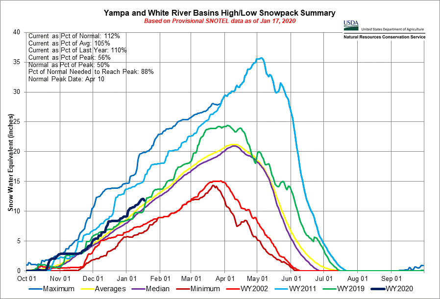
The current snowpack of the Yampa and White River Basin, which encompasses Routt County, is currently 18% above average, according to data from the Natural Resource Conservation Service.
“My observations have been that this is tracking pretty similar to the 2019 snow year,” said Kelly Romero-Heaney, Steamboat Springs city water resources manager. Last year’s snowpack was mostly well above average in Routt County, though not quite record setting, she explained…
A snow telemetry site maintained by the Conservation Service on Rabbit Ears, at an elevation of 9,400 feet, recorded a snow depth of 37 inches, according to Jan. 1 measurements. That site typically reaches peak April 28 then melts off. As of Saturday, Jan. 18, there are 13.3 inches of snow water equivalent, a measure that considers the amount of water contained in the snowpack.
At the Bear River telemetry site, at 9,080 feet elevation south of the town of Yampa in the Flat Tops area, the snow depth was recorded at 22 inches, with 5.1 inches of snow water equivalent.
Snow depth at the Tower telemetry site, which is at 10,500 feet elevation on Buffalo Pass, was 56 inches as of Jan. 1, with 24.5 inches of snow water equivalent.
So far this season, Steamboat Resort has received 196 inches of total snowfall. That’s more than the 152 inches recorded to this date last year and 109 in 2018, which was a tough season for snowpack.
Midmountain snow depth at Steamboat Resort stands at 49 inches as of Saturday, with 66 inches on the upper mountain and 50 inches at the base, according to the website onthesnow.com, which records snow data for ski resorts.
From The Denver Post (Chris Bianchi):
After a lightning-fast start to the winter season that saw more than 2 feet of snowfall by the end of November, Denver’s only had one day of measurable snow since Nov. 29. Since Nov. 30, Denver has only received 2.8 inches of snow at the city’s official weather observation site at Denver International Airport.
At the city’s more centrally-located Stapleton Airport climate site, only 2.5 inches of snow have fallen there since Nov. 30. Additionally, all of that snow came on only one day: Dec. 28. That means since the end of November, Denver’s seen only one total day of measurable snowfall at both of its primary observation locations…
As mentioned earlier in January, though, this type of mid-winter pattern can change in Denver. Typically, late winter and spring are Denver’s busiest snow months of the year, although busier falls like this past one aren’t particularly unusual.