Bird migration timing skewed by #climate, new research finds — @ColoradoStateU #ActOnClimate

A long-billed curlew in flight. Photo: Nick Saunders via Colorado State University

Here’s the release from Colorado State University (Mary Guiden):

Life cycles for birds, insects and trees are shifting in this current era of a rapidly changing climate. How migration patterns, in particular, are changing and whether birds can track climate change is an open question.

Kyle Horton, assistant professor at Colorado State University, led a new study analyzing nocturnal bird migration that he hopes will lead to more answers about shifting migration patterns. He and the research team used 24 years of radar data from NOAA, the National Oceanic and Atmospheric Administration, for the study.

The research team – including scientists from the Cornell Lab of Ornithology and the University of Massachusetts – found that spring migrants were likely to pass certain stops earlier now than they would have 20 years ago. Temperature and migration timing were closely aligned, with the greatest changes in migration timing occurring in regions warming most rapidly. During fall, shifts in migration timing were less apparent.

The study, one of the first to examine the impacts of climate change on migration timing at a continental scale, is published December 16 in Nature Climate Change.

Analysis using cloud computing revealed patterns of millions of birds

Horton described the breadth of the research as “critically important,” with the team observing the nocturnal migratory behaviors of hundreds of species representing billions of birds.

“To see changes in timing at continental scales is truly impressive, especially considering the diversity of behaviors and strategies used by the many species the radars capture,” he said. Yet while the team saw these shifts, Horton noted that this doesn’t necessarily mean that migrants are keeping pace with climate change.

Migratory birds serve an important role in ecosystems. They eat and take insects off the land, disperse seeds and serve other significant functions, including measuring health in these ecosystems.

Andrew Farnsworth, the study’s senior author and a research associate at Cornell Lab of Ornithology, said the team’s research answered, for the first time, key questions on birds and climate change.

“Bird migration evolved largely as a response to changing climate,” he said. “It’s a global phenomenon involving billions of birds annually. And it’s not a surprise that birds’ movements track changing climates. But how assemblages of bird populations respond in an era of such rapid and extreme changes in climate has been a black box. Capturing scales and magnitudes of migration in space and time has been impossible until recently.”

Researchers accessed NOAA datasets through Amazon Web Services as part of the agency’s Big Data Project, designed to provide access to data in a more efficient way.

Horton said that this access to the data and cloud computing greatly enhanced the team’s ability to synthesize the findings.

“To process all of these data, without cloud computing, it would have taken over a year of continuous computing,” he said. Instead, the team crunched the numbers in about 48 hours.

While Amazon Web Services provided access to the data, new algorithms designed by scientists at the University of Massachusetts revealed the potential of these radar data for biologists. Specifically, the scientists designed new computer vision techniques to remove weather data, a problem that had challenged biologists from decades.

“Historically, a person had to look at each radar image to determine whether it contained rain or birds,” said Dan Sheldon, associate professor of computer science at the University of Massachusetts Amherst. “We developed ‘MistNet,’ an artificial intelligence system to detect patterns in radar images and remove rain automatically.”

Fall migration tends to be ‘messier’

Horton, who works in the Department of Fish, Wildlife and Conservation Biology at CSU, said that the lack of change in fall migration patterns was a little surprising, though migration also tends to be a “little bit messier” during those months.

“In the spring, we see bursts of migrants, moving at a fairly rapid pace, ultimately to reach the breeding grounds,” he explained. “However, during the fall, there’s not as much pressure to reach the wintering grounds, and migration tends to move at a slower, more punctuated pace.”

During the fall, birds are not competing for mates, and the path to reach their destination is more relaxed. There’s also a wider age range of birds migrating, as the young eventually realize they need to migrate, too. The combination of these factors makes fall migration more challenging to study.

Horton said the findings have implications for understanding future patterns of bird migration, since the birds rely on food and other resources as they travel. Under climate change, the timing of blooming vegetation or emergence of insects may be out of sync with the passage of migratory birds. This seemingly subtle shift could have negative consequences for the health of migratory birds.

Researchers plan to expand their data analysis to include Alaska, where climate change is having more serious impacts than in the lower 48 states in the U.S.

#Drought news: 180-day #precipitation deficits remain the largest (more than 6 inches) across southwest #Colorado

Click on a thumbnail graphic to view a gallery of drought data from the US Drought Monitor.

Click here to go to the US Drought Monitor Website hosted by the Colorado Climate Center. Here’s an excerpt:

This Week’s Drought Summary

An area of upper-level low pressure entered southern California by December 26 and then progressed east across the Four Corners region. This upper-level low resulted in heavy rain and high-elevation snow from southern California east to southwest Colorado and New Mexico. A surface low developed across the south-central Great Plains on December 28 with a subsequent track northeast to the upper Mississippi Valley and Great Lakes. Heavy snow fell to the northwest of this low pressure system, while moderate to heavy rainfall accompanied the cold front as it shifted east from the Great Plains to the East Coast. Following the heavy precipitation across the Pacific Northwest during mid to late December, precipitation average below normal during the final week of December. Enhanced onshore flow resulted in periods of heavy precipitation along the Alaska Panhandle, but longer-term precipitation deficits persist. A low pressure system and trailing front brought locally heavy rain and damaging winds to parts of the Hawaiian Islands this past week…

High Plains

A low pressure system developed across the southern Great Plains on Dec 28 and then tracked northeast to Iowa and Minnesota. Along and northwest of the surface low track, beneficial precipitation (0.5 to 1.5 inches) fell from the western half of Kansas north to southern and eastern Nebraska. This recent precipitation prompted a 1 to 2-category improvements to the short-term drought areas in Kansas. A 2-category improvement was justified where more than 1 inch of precipitation occurred and 90-day precipitation is either at or above normal. However, severe drought (D2) continues west of Garden City and Liberal, Kansas. In contrast to the improving conditions for Kansas, abnormal dryness (D0) was extended north across western Wyoming where 90-day precipitation deficits are 2 to 6 inches. Drought impacts were modified to long-term only in southwest Colorado due to recent snowfall. Snow water content is running 125 to 135 percent of normal as of December 29, but 6-month SPI values support the severe drought (D2) category in southwest Colorado…

West

A vigorous upper-level trough crossed southern California and the desert Southwest from December 25 to 27. Widespread moderate to heavy rain and high-elevation snow (0.5 to 2 inches, liquid equivalent) accompanied this upper-level trough. Snowfall amounts exceeded two feet in the mountains of southern California, while 4 to 12 inches was recorded in the higher elevations of Arizona. This recent precipitation along with support from longer-term SPI values resulted in a 1-category improvement to Dx levels in parts of Arizona and southwest Utah. 180-day precipitation deficits remain the largest (more than 6 inches) across southwest Colorado.

Drier weather returned to the Pacific Northwest during the final week of December. Following the period of heavy precipitation during mid to late December, no changes were made to the ongoing abnormal dryness (D0) and short-term moderate drought (D1) areas. Water year to date (since October 1) precipitation deficits of more than 12 inches, 28-day stream flows in the lowest 10th percentile, and basin average snow water content less than 50 percent support the short-term moderate drought (D1) across parts of Oregon and Washington…

South

As an upper-level trough ejected from the desert Southwest, a surface low developed over the southern Great Plains. Beneficial rainfall (more than 1 inch) resulted in improving conditions across the eastern Oklahoma Panhandle and northwest Oklahoma. Moderate (D1) to severe (D2) drought continues across southwest Oklahoma and adjacent areas of the Texas Panhandle and northwest Texas which received lighter rainfall amounts (0.75 inches of less). Changes to the drought depiction across the remainder of Texas included a slight reduction in D0/D1 in central and southwest parts of the state, based on recent rainfall and lack of short-term dryness. Although it was a dry week across deep southern Texas, a reassessment of indicators supported a slight reduction of severe (D2) drought. A small area of severe (D2) drought was added to Burleson County, based on 120-day indicators. On December 29, a cold front crossed the lower Mississippi Valley where 0.5 to 2 inches of rainfall occurred. The heaviest rain fell to the north and east of the ongoing D0 to D2 areas…

Looking Ahead

During the next 5 days (January 2 to 6), another surface low is forecast to develop across the southern Great Plain on January 2. This surface low and trailing cold are likely to bring heavy rainfall (1 to 3 inches) to the lower Mississippi Valley and Tennessee Valley with more modest amounts (1 inch or less) along the East Coast. A low pressure system with onshore flow is expected to bring rain and high-elevation snow to the Pacific Northwest, beginning of January 4. Although rainfall of around an inch is forecast along the Texas Gulf Coast during the next week, dry weather is likely across the remainder of Texas. Mild temperatures are forecast to prevail across the continental U.S. during the first week of January 2020, while bitterly cold temperatures persist throughout Alaska.

The CPC 6-10 day extended range outlook (January 6 to 10, 2020) indicates a slight tilt in the odds for above normal precipitation across much of the central and northeastern U.S. Below normal precipitation is favored for the Southeast along with California and the Southwest. The highest confidence in the temperature outlook exists across Alaska where below normal temperatures are likely to persist into the second week of January. Below normal temperatures are favored for the Great Basin and Rockies, while a warming trend is anticipated across the south-central and eastern U.S.

US Drought Monitor one week change map ending December 31, 2019.

Just for grins here’s a gallery of early January Drought Monitor national maps for the past few years.

@ColoradoClimate: Weekly #Climate, #Water and #Drought Assessment of the Intermountain West

Click here to read the current assessment. Click here to go to the NIDIS website hosted by the Colorado Climate Center. Here’s the summary:

Summary: December 31, 2019

The last week over the Intermountain West has been a fairly quiet one, with little precipitation falling throughout the region with the exception of the four corners area. Northern Wyoming, northern Utah, and eastern Colorado were dry while SE Utah and SW Colorado received 2.01-4.20” of precipitation over the last week. Temperatures across the Upper Colorado River Basin were near to slightly warmer than average. The warmer areas included NE Wyoming and eastern Colorado. Colorado foothills did see below average temperatures, Park county experiencing temperatures of 9 to 12 degrees cooler than average. Month-to-date, the higher elevations of the IMW have received between 2 and 6 inches of precipitation, with the lower elevations mostly getting at least an inch. This is a pretty normal pattern for this time of year, although some areas are a bit drier than average for the month. Despite that, 30 and 60 day SPIs look pretty good for the entire region, with some drier 30 and 60-day SPIs creeping into northwest Wyoming.

SNOTEL snowpack for the Intermountain West is off to a good start, with basin-wide averages ranging from slightly below average in western WY to over 200% of average in southern Utah. Individual SNOTEL sites in western WY are struggling a bit with areas in Teton county showing 5-23rd Percentile, but Utah and Colorado snowpack are in good condition with much of the region snow covered right now. Snow cover is helpful for croplands to protect them from extreme cold and wind. We are entering a dry and windy time of year, which can be harsh on the lands. Anytime there is snow cover, it is helpful. Unfortunately there really isn’t any snow cover in southeast Colorado.

EDDI product for 1 week shows high evaporative demand. While we don’t typically rely on this product in the winter, it is telling us a few things, it’s drier, windy, and warmer. While there isn’t much to evaporate right now from the croplands, these types of conditions are tougher on the dormant vegetation.

Most of the stream flow gauges are ice affected right now with only 72 stations reporting conditions. However, the majority of those that are reporting are reporting conditions in the normal range.

Over the next week, the higher elevations of northern Utah, western Wyoming, and western Colorado are forecasted to receive more precipitation. Northwest Wyoming is forecast to receive 0.50-3.00” of precipitation, this could be beneficial to those low SNOTEL sites mentioned above. Central Utah and western Colorado are forecast to get between 0.5 and 1.5 inches over the next week. Eastern Colorado, Arizona and New Mexico are looking to miss out on the bigger accumulations, which is typical for this time of year. Cool temperatures will dominate the region through the next couple of weeks as the Climate Prediction Center is forecasting a higher possibility of the cooler than average temperatures continuing.

Community Agriculture Alliance: NRCS and #conservation on private lands — Steamboat Today

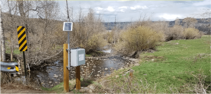
Bear River at CR7 near Yampa / 3:30 PM, May 16, 2019 / Flow Rate = 0.52 CFS. Photo credit: Scott Hummer

Here’s a guest column from Clinton Whitten (NRCS) that’s running on Steamboat Today:

The Natural Resources Conservation Service is an agency within the U.S. Department of Agriculture that provides free technical assistance, or advice, to land owners and managers regarding resource concerns on their property. The main mission of the NRCS is to help address natural resource issues on private lands through voluntary conservation activities.

We can help landowners conserve and restore water, air, forests, rangelands and other natural resources. The services we provide range from providing a simple soils report of your property to developing a full conservation plan for an agricultural operation. These services are free, private and voluntary.

Every county in the U.S. has resource concerns that are unique to the climate and land uses of the area. The following is a list of the common resource concerns in Routt County that NRCS currently encounters. This list is not comprehensive, but it covers the issues that we address the most.

  • Irrigation improvements help increase water use efficiency. In Routt County, this primarily involves improving infrastructure to increase control of flood irrigation water.
  • Grazing management plans help ensure the sustainability of livestock operations and the ecosystems they are utilizing. This can include assistance with infrastructure that would help to facilitate a grazing plan, such as cross fences and watering facilities.
  • Wildlife habitat management plans help improve the habitat of a variety of species on private lands.
  • Forest management plans help improve the health of private lands forest ecosystems. Implementation of management practices, such as thinning, planting, mastication, etc., have the goal of creating a more sustainable forest.
  • Seeding recommendations for the restoration of rangeland, pastureland and disturbed areas to reestablish native grasses which benefits soils and overall ecosystem health.
    Stream and riparian restoration improve both water quality and fish and wildlife habitat.
  • Many of these resource concerns are best addressed using the expertise of a range of organizations and agencies. That is why the NRCS works to develop partnerships with many different local groups.

    We are currently working with the Upper Yampa Water Conservancy District to develop a grant program that will better assist local irrigators to upgrade their head gates and install measuring devices. Forest management plans and projects are developed in coordination with the Colorado State Forest Service.

    The Steamboat NRCS office currently has two partner biologists from Trout Unlimited and Bird Conservancy of the Rockies who assist with the development of conservation plans. By partnering with different entities the NRCS is able to leverage more funds and provide better technical expertise to the private land owners and managers of Routt County.

    If you think you have a resource issue on your property and would like technical assistance, contact the NRCS office at 970-879-3225.

    Clinton Whitten is the resource team lead with the National Resource Conservation Service.