
Click here to read the current assessment. Click here to go to the NIDIS website hosted by the Colorado Climate Center. Here’s the summary:
Summary: December 31, 2019
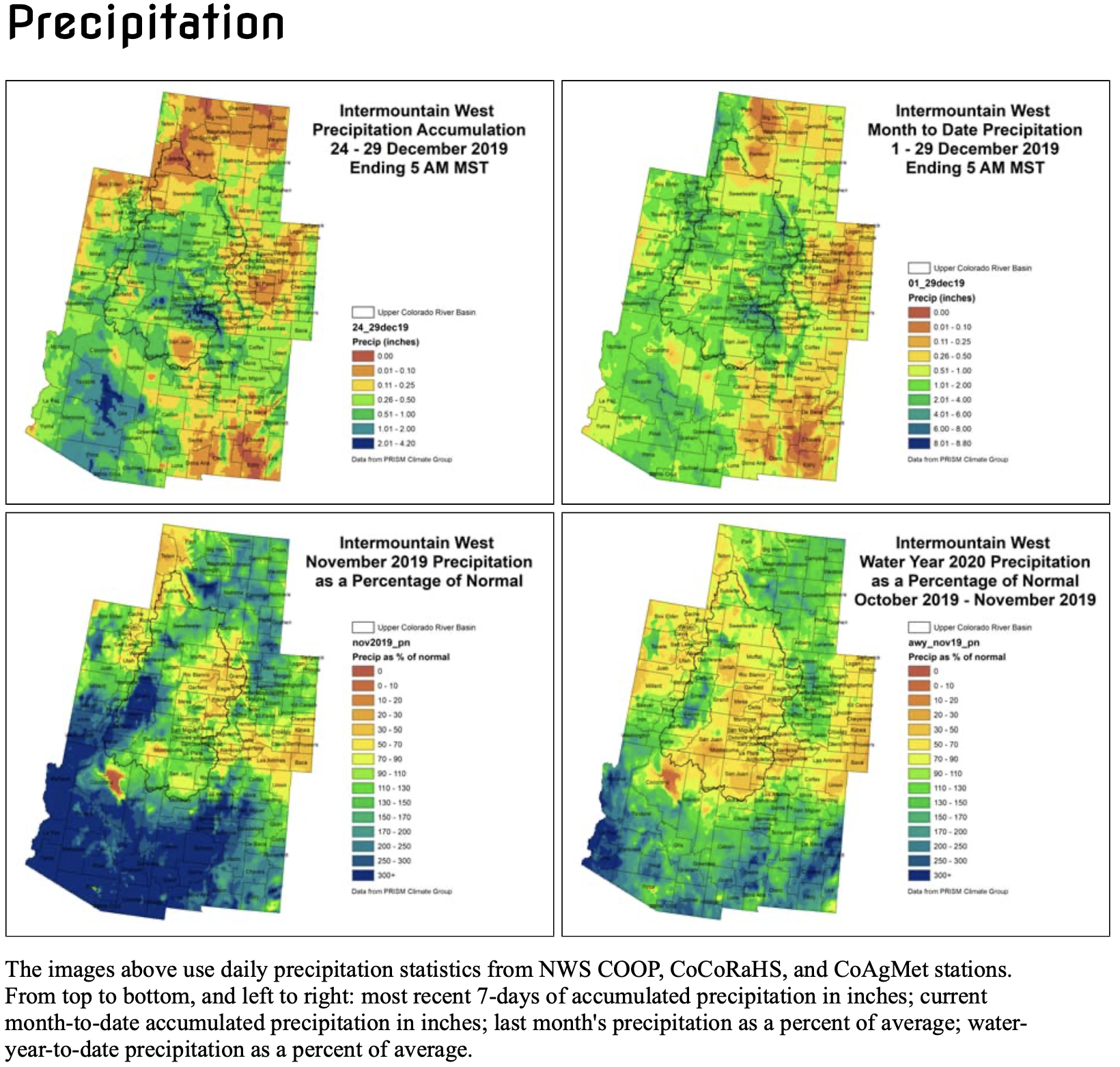
The last week over the Intermountain West has been a fairly quiet one, with little precipitation falling throughout the region with the exception of the four corners area. Northern Wyoming, northern Utah, and eastern Colorado were dry while SE Utah and SW Colorado received 2.01-4.20” of precipitation over the last week. Temperatures across the Upper Colorado River Basin were near to slightly warmer than average. The warmer areas included NE Wyoming and eastern Colorado. Colorado foothills did see below average temperatures, Park county experiencing temperatures of 9 to 12 degrees cooler than average. Month-to-date, the higher elevations of the IMW have received between 2 and 6 inches of precipitation, with the lower elevations mostly getting at least an inch. This is a pretty normal pattern for this time of year, although some areas are a bit drier than average for the month. Despite that, 30 and 60 day SPIs look pretty good for the entire region, with some drier 30 and 60-day SPIs creeping into northwest Wyoming.
SNOTEL snowpack for the Intermountain West is off to a good start, with basin-wide averages ranging from slightly below average in western WY to over 200% of average in southern Utah. Individual SNOTEL sites in western WY are struggling a bit with areas in Teton county showing 5-23rd Percentile, but Utah and Colorado snowpack are in good condition with much of the region snow covered right now. Snow cover is helpful for croplands to protect them from extreme cold and wind. We are entering a dry and windy time of year, which can be harsh on the lands. Anytime there is snow cover, it is helpful. Unfortunately there really isn’t any snow cover in southeast Colorado.
EDDI product for 1 week shows high evaporative demand. While we don’t typically rely on this product in the winter, it is telling us a few things, it’s drier, windy, and warmer. While there isn’t much to evaporate right now from the croplands, these types of conditions are tougher on the dormant vegetation.
Most of the stream flow gauges are ice affected right now with only 72 stations reporting conditions. However, the majority of those that are reporting are reporting conditions in the normal range.
Over the next week, the higher elevations of northern Utah, western Wyoming, and western Colorado are forecasted to receive more precipitation. Northwest Wyoming is forecast to receive 0.50-3.00” of precipitation, this could be beneficial to those low SNOTEL sites mentioned above. Central Utah and western Colorado are forecast to get between 0.5 and 1.5 inches over the next week. Eastern Colorado, Arizona and New Mexico are looking to miss out on the bigger accumulations, which is typical for this time of year. Cool temperatures will dominate the region through the next couple of weeks as the Climate Prediction Center is forecasting a higher possibility of the cooler than average temperatures continuing.