Post-holiday drought makes for its own ‘Dry January’ — News on TAP

But avoid temptation to fire up the irrigation system — just a little hand watering will do fine. The post Post-holiday drought makes for its own ‘Dry January’ appeared first on News on TAP.

via Post-holiday drought makes for its own ‘Dry January’ — News on TAP

Aspinall Unit operations update: Streamflow forecast for April-July = 87% of average

Gunnison River Basin High/Low graph January 27, 2020 via the NRCS.

From email from Reclamation (Erik Knight):

Releases from the Aspinall Unit will be decreased to 800 cfs on Wednesday, January 29th. Snowpack in the Upper Gunnison Basin is currently at 106% of normal. The Jan 15th runoff forecast for Blue Mesa Reservoir predicts 87% of average for April-July inflows. Flows in the lower Gunnison River are currently above the baseflow target of 1050 cfs. River flows are expected to stay above the baseflow target for the foreseeable future.

Pursuant to the Aspinall Unit Operations Record of Decision (ROD), the baseflow target in the lower Gunnison River, as measured at the Whitewater gage, is 1050 cfs for January through March.

Currently, there are no diversions into the Gunnison Tunnel and flows in the Gunnison River through the Black Canyon are around 1100 cfs. After this release change Gunnison Tunnel diversions will still be at zero and flows in the Gunnison River through the Black Canyon will be around 800 cfs. Current flow information is obtained from provisional data that may undergo revision subsequent to review.

This scheduled release change is subject to changes in river flows and weather conditions. For questions or concerns regarding these operations contact Erik Knight at (970) 248-0629 or e-mail at eknight@usbr.gov

Colorado Drought Monitor January 21, 2020.

State looks to address #Texas v. #NewMexico water case — The New Mexico Political Report

Map of the Rio Grande watershed. Graphic credit: WikiMedia

From Santa Fe New Mexican (Robert Nott) via The New Mexico Political Report:

State leaders looking for a way to address a litigated claim that New Mexico is not providing enough water to Texas under a decades-old compact want funding for a water conservation pilot program south of Elephant Butte.

Though the plan remains vague, both Gov. Michelle Lujan Grisham and the Legislative Finance Committee are proposing to support it by allocating funding to the project in the 2021 fiscal year.

The plan would let water users in the southern part of the state figure out how and when to leave certain areas of their farms unplanted — or fallow — to conserve ground and surface water.

“It’s the start of a solution to the lack of water resources south of Elephant Butte,” said Senate Majority Leader Peter Wirth, D-Santa Fe, who first announced the plan at a Journey Santa Fe event this month. “It’s critical that the solution comes from the farmers down there.”

The Governor’s Office is proposing a $10 million allocation in next year’s budget for a year’s implementation of the pilot program. The LFC’s $30 million proposal takes a three-year approach to the plan, Wirth said.

Either way, many state legislators from both political parties believe the far-from-fleshed-out pilot needs more legislative oversight…

Wirth and State Engineer John D’Antonio both said that while the plan in itself is a solid step toward conserving water, the shadow of the legal fight over the Rio Grande — litigation that is pending before the U.S. Supreme Court — adds urgency to the action.

The Rio Grande Compact of the late 1930s set up a complicated deal in which Colorado, New Mexico and Texas all are allocated a certain amount of water from the river…

The Texas-New Mexico legal conflict started in 2013 when Texas argued New Mexico farmers are using too much water, including through the drilling of wells, from the Rio Grande as it flows through New Mexico on its way to Texas.

In 2017, the Supreme Court denied New Mexico’s legal motions to dismiss the Texas complaint…

D’Antonio said his office is looking at temporarily fallowing some of the land that uses Rio Grande water and then studying the hydrological effects of it to see if the plan could sustain a similar long-term effort among farmers willing to take part.

The lower Rio Grande water users would “pay into a fund that would compensate those farmers for fallowing,” he said. “The initial money the state would put up would allow for that program to evolve over time.”

[…]

John Utton, a water attorney who represents several water-users in the southern part of the state — including New Mexico State University and the Camino Real Regional Utility Authority — said it’s vital planners look at areas that could be permanently fallowed without damaging the state’s agricultural business.

“There may be time where there is more land available and other times when we need to shrink a little bit but we don’t want to permanently fallow agricultural efforts,” he said. “Pecans, green chile and onions are all an important part of our economy and need to be kept viable.”

Center for #ColoradoRiver Studies: “The Future of Lake Powell” February 20, 6:30 pm at Star Hall in Moab, Utah #COriver #aridification

Lake Powell, created with the 1963 completion of Glen Canyon Dam, is the upper basin’s largest reservoir on the Colorado River. But 2000-2019 has provided the least amount of inflow into the reservoir, making it the lowest 20-year period since the dam was built, as evidenced by the “bathtub ring” and dry land edging the reservoir, which was underwater in the past. As of October 1, 2019, Powell was 55 percent full. Photo credit: Eco Flight via Water Education Colorado

From email from the Center for Colorado River Studies:

A forum discussion on what politics, policy, and climate change have in store for Lake Powell.


Thursday, February 20, 6:30 pm
Historic Star Hall, Moab, Utah
Free and open to the public!

Join us, and a panel of experts, to start a conversation about long-term issues associated with management of Lake Powell. Since the Colorado River began filling Glen Canyon in 1963, the future of Lake Powell has been up for discussion. Climate change, politics and water-use policy all now factor into the fate of this vast reservoir in southern Utah.</blockquote>

#Snowpack news

Click on a thumbnail graphic to view a gallery of snowpack data from the NRCS.

And, here’s the Westwide SNOTEL basin-filled map via the NRCS.

Westwide SNOTEL basin-filled map January 27, 2020 via the NRCS.

@NOAA Gets Go-Ahead to Study Controversial #Climate Plan B — Scientific American #geoengineering #ActOnClimate #KeepItInTheGround

This 2009 image taken by NASA’s Terra satellite shows ship tracks—clouds that form as water condenses around the particles in ships’ exhaust—over the Pacific Ocean south of Alaska. Credit: Jeff Schmaltz MODIS Rapid Response Team; Robert Simmon and Jesse Allen NASA

“These geoengineering technologies condemn the ocean to acidification and us all to continued toxic air pollution and higher energy costs from fossil fuels. Plan B very much sub-optimal.” — Jonathan Overpeck (@GreatLakesPeck)

From Climatewire (John Fialka) via E&E News via Scientific American:

The top climate change scientist for NOAA said he has received $4 million from Congress and permission from his agency to study two emergency—and controversial—methods to cool the Earth if the U.S. and other nations fail to reduce global greenhouse gas emissions.

David Fahey, director of the Chemical Sciences Division of NOAA’s Earth System Research Laboratory, told his staff yesterday that the federal government is ready to examine the science behind “geoengineering”—or what he dubbed a “Plan B” for climate change.

Fahey said he has received backing to explore two approaches.

One is to inject sulfur dioxide or a similar aerosol into the stratosphere to help shade the Earth from more intense sunlight. It is patterned after a natural solution: volcanic eruptions, which have been found to cool the Earth by emitting huge clouds of sulfur dioxide.

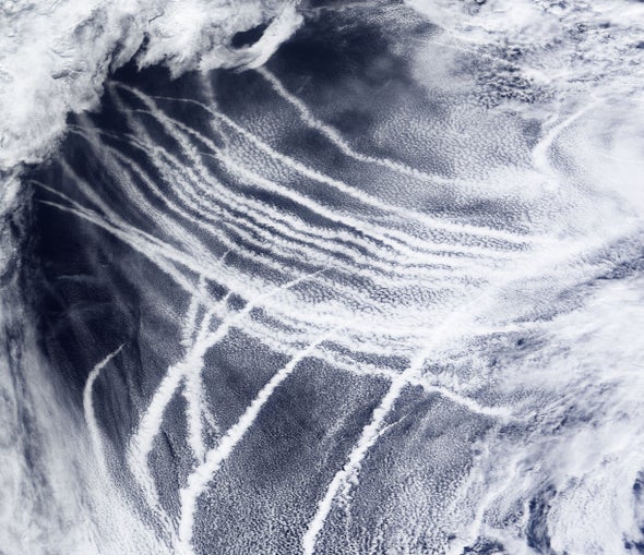
The second approach would use an aerosol of sea salt particles to improve the ability of low-lying clouds over the ocean to act as shade.

This technique is borrowed from “ship tracks”—or long clouds left by the passage of ocean freighters that are seen by satellites as reflective pathways. They could be widened by injections of vapor from seawater by specialized ships to create shading effects.

Research in both techniques, Fahey emphasized, are recommended in a forthcoming study by the National Academies of Sciences, Engineering, and Medicine titled “Climate Intervention Strategies that Reflect Sunlight to Cool Earth.”

But in a sign of how controversial the topic is, Fahey recommended changing the nomenclature from geoengineering to “climate intervention,” which he described as a “more neutral word.”

Fahey also emphasized this is not an approval to move forward with geoengineering. Rather, it’s to prepare the U.S. government for a political decision if the world fails to adequately limit the rise of global warming…

“One of the things I’m interested in doing is let’s separate the science out,” he added. The idea is to give policymakers a clear view of how a hurry-up bid to save the planet would work.

Even then, the results likely wouldn’t be immediate. Fahey showed slides and graphics that noted that a Plan B might take until the next century to complete the cooling…

There would be drawbacks, he noted, after being asked by a researcher whether injections of sulfur dioxide into the atmosphere might reduce seafood by acidifying the oceans.

“When you put aerosols up into the atmosphere, it does a lot of things,” Fahey, a physicist, responded. “That opens up this whole menu of things that you’d have to worry about.”

He said other aerosols such as calcite or titania “might have less impact, but nobody knows. We want to look at them in the laboratory.”
Several smaller nations have complained that the use of aircraft to inject aerosols into the atmosphere might alter the weather or destroy the ozone layer, which protects humans from some of the more harmful radiation from sunlight.

Fahey suggested that a scientific approach would require solving a list of unknowns, including tests to find out what’s in the stratosphere today and how to get aerosols to spread there homogeneously. Another likely area of research: unintended consequences…

At the moment, the government has no planned experiments and NOAA’s authority does not extend into the stratosphere. But there is a bill in Congress called the “Climate Intervention Research Act” that would broaden its jurisdiction…

Until now, neither Congress nor the administration has ventured to tackle the Plan B issue. The closest thing to testing it is a Harvard University-sponsored project called the “Stratospheric Controlled Perturbation Experiment” (SCoPEx).

It proposes a small-scale test using a propeller-driven balloon. It would ascend to a height of 12 miles over New Mexico and then release less than 2.2 pounds of calcium carbonate…

The idea is to create a tubular area in the sky—about six-tenths of a mile long and 109 yards in diameter—through which the sensor-packed balloon could slowly move back and forth, mixing the air and monitoring the solar-reflecting abilities of the scattered materials. It also would track the impact of the treated area on the surrounding atmosphere.

When SCoPEx would happen remains unknown.

Harvard, sensitive to the question of how to govern such experiments, has appointed an outside advisory committee to help oversee and evaluate the test. According to David Keith, a Harvard physicist who is one of the leaders of the project, the outside committee would help determine if and when the experiment should move forward.

Funding for the experiment will come from Harvard research funds and a list of outside contributors to a fund controlled by Harvard’s Solar Geoengineering Research Program. Compared with U.S. space, defense and climate-related experiments, the cost of the effort would be minuscule.

Keith could not be reached for comment about Fahey’s announcement, but Fahey said NOAA supports the Harvard stratospheric test and has contributed an instrument to help it measure the dispersion of particles.