Partner, Kogovsek and Associates, Inc.
Ex-Officio: Federal Affairs Liaison
Christine Arbogast is a native Coloradan. She has a degree in journalism and political science and has worked with Congressman Ray Kogovsek since 1979. Since 1985 when Kogovsek & Associates was established, the small firm has worked primarily in the Western states on resource and tribal issues as well as local government concerns, capital construction projects and health care. Christine is an active member of the Water Congress Federal Affairs Committee and the National Water Resources Association. She chairs the NWRA’s federal affairs committee, and is a member of the Colorado River Water Users’ Association and the National Congress of American Indians.
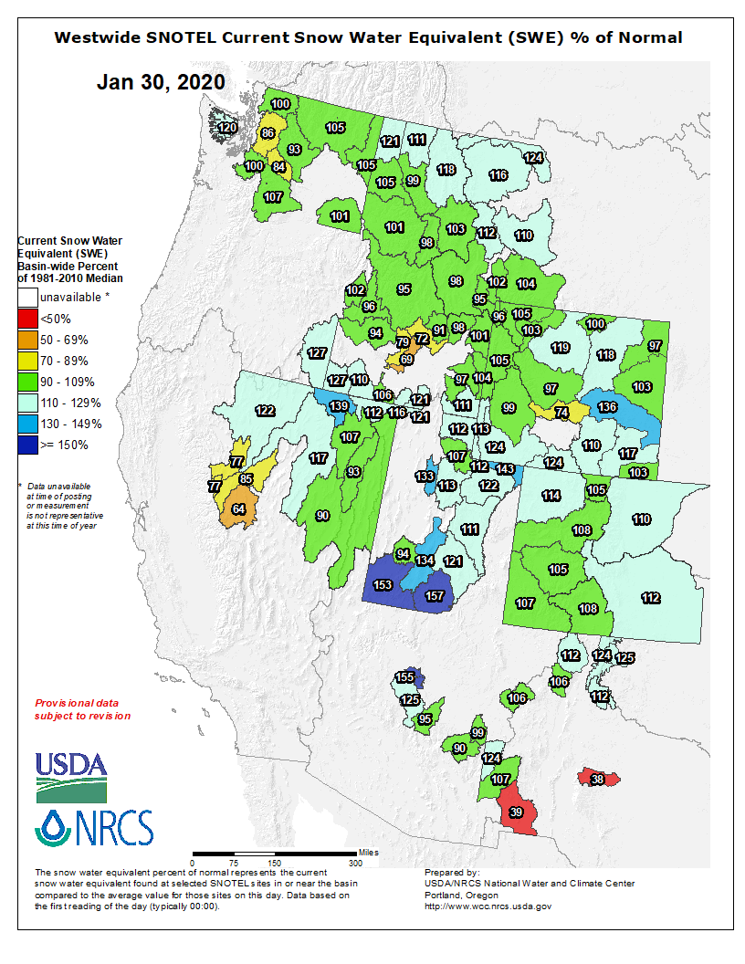
Colorado snowpack is registering well above normal across the state, and reservoirs are plenty full, a situation water managers say bodes well for this year’s water supply, assuming that spring snows materialize as they normally do.
“We’ve been shut out [in terms of snowfall] on the Front Range and Eastern Plains,” said Peter Goble, climate specialist at Colorado State University’s Colorado Climate Center. “But January is normally our dry season. If there is a good time to be shut out, it’s now.”
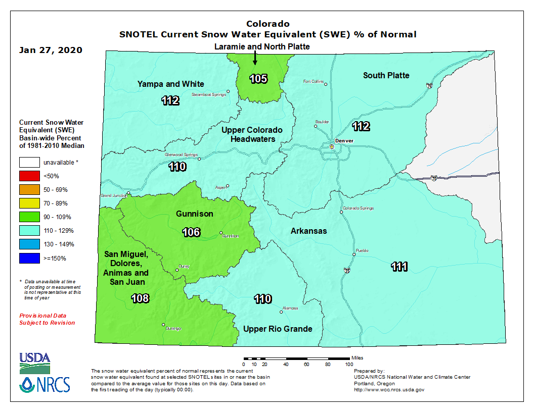
Even with a dry January, statewide snowpack is measuring at 110 percent of average. Snowpack along the Front Range is registering at 111 percent in the South Platte River Basin and 112 percent in the Arkansas Basin.
Colorado snowpack basin-filled map January 27, 2020 via the NRCS.
Consistent high mountain snows are helping keep ultra-dry conditions at bay, Goble said at a meeting of the state’s Water Availability Task Force on Jan. 23 in Denver.
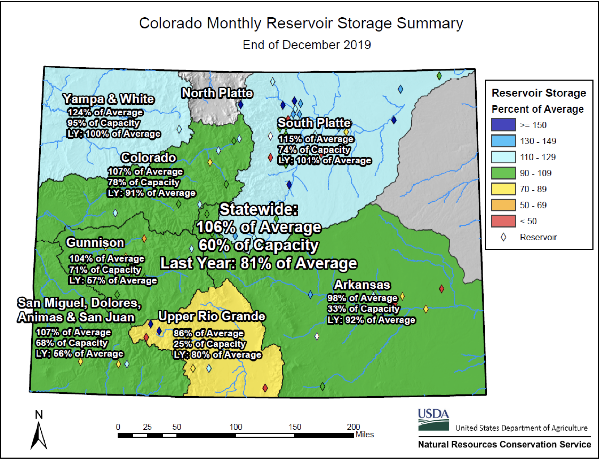
Reservoir levels are also holding strong, with stored water statewide measuring at 106 percent of average. The same time last year that number was just 81 percent.
Looking ahead to the warm spring months, Goble said he had some concerns that forecasts called for an essentially equal chance of wet or dry weather.
Southern Colorado and the Eastern Plains have been hit particularly hard by chronic drought conditions over the past eight years, and weather watchers expressed concern that these regions will suffer if the spring turns out to be warmer and drier than normal.
Still, Karl Wetlaufer, assistant snow survey supervisor for the Natural Resources Conservation Service, said mountain snows are remarkably healthy and consistent across the state.
Snow levels in each of the major river basins are above average and nearly equivalent. The Yampa River Basin, in northwestern Colorado, stands at 114 percent of average this week, while the upper Rio Grande is measuring at 110 percent of average.
Snowpack is closely watched across Colorado because every region in the state relies on melting mountain snows for the majority of their water supplies.
Each month, until May, the snowpack is measured and runoff forecasts are made so that water managers can plan for the year.
Though Colorado left a severe drought behind last spring, after a winter of spectacularly deep snows, a dry fall pushed large swaths of the state back into drought, according to the U.S. Drought Monitor.
Now just under half of the state, largely the southern portion, is classified as being in moderate or severe drought.
Still, if the spring turns out to be dry, forecasts indicate snowpack will likely be in the 85 percent of average range at their peak in mid-April. But if spring storms bring plentiful snow, that number could easily soar above 115 percent of average. And even that may be conservative.
“We could see something really wacky happen that will bring us well above even this current forecast,” Goble said.
Jerd Smith is editor of Fresh Water News. She can be reached at 720-398-6474, via email at jerd@wateredco.org or @jerd_smith.
Water managers are cautiously optimistic about the current snowpack and predicted runoff, even though the overall picture right now points to a moderate-dry year for the Gunnison Basin.
“I feel like we’re in pretty good shape. Of course, you can’t have too much snow. It’s like having too much fun,” said Steve Anderson, manager for the Uncompahgre Valley Water Users Association.
“But we’ve got full reservoir accounts. It’s kind of amazing, but we’re almost exactly where we were a year ago at this time. If we can have what we had last February, March and April, we would be in really good shape, but we could settle for less and still be in good shape.”
Within the Bureau of Reclamation’s Aspinall Unit, the snow-water equivalent was 110 percent of normal for this time of the year, as of Monday, BuRec hydrologist Erik Knight said…
According to the runoff forecast as of Jan. 1, Blue Mesa’s inflow was close to 87 percent of average, at 590,000 acre feet. Ridgway and Taylor Park each were sitting comfortably at 86 percent of average.
“With mid-January at 590,000 acre feet, that just puts us in that average-dry category. That is based on historic numbers. We consider ourselves to be in an average-dry year,” Knight said. “It’s got the opportunity to go any direction so far.”
[…]
The drought monitor shows moderate drought, with pockets of severe drought as of mid-month, although compared with the situation at the same time last year, that is an improvement.
Precipitation-wise, Montrose was sitting a bit below average just prior to Monday’s surprise storm, according to the National Weather Service.
For the month of January, Montrose had measured 0.28 inches; usually, it is 0.56. The tally did not include precip from Monday’s snow dump, which as of 6 a.m. that day, was about 1.5 inches — 18-hundredths of an inch liquid equivalent.
Anderson also said statewide efforts continue to update the Colorado Water Plan, slated for completion in 2023, and to fully fund its implementation.
Voters last November passed Proposition DD, establishing a 10-percent tax on net proceeds from sports betting, to help pay for implementation…
He also invited water users to UVWUA’s annual board meeting, set to begin at noon Feb. 4, at Bill Heddles Recreation Center in Delta. Keynote speakers include Greg Peterson of the Colorado Ag Water Alliance and Jim Pokrandt of the Colorado River District.
Northern Integrated Supply Project (NISP) map July 27, 2016 via Northern Water.
FromBiz West Media/Boulder Daily Camera (Dan Mika) via The Fort Morgan Times:
The Colorado Department of Public Health and Environment gave approval to efforts to build the Northern Integration Supply Project, or NISP, securing one of three final permits the Northern Colorado Water Conservancy District needs before it can start on the $1.1 billion water project.
In a letter to Northern Water earlier this week, officials said the state has “reasonable assurance” the project would comply with all required water quality standards at the state levels.
The letter said while the project wouldn’t directly discharge pollutants into water sources, it has “the potential to cause or contribute to long-term water quality impacts.” It is requiring member cities to monitor 21 locations along the NISP for water conditions needed to sustain healthy aquatic ecosystems, and to watch for bacteria, sediment and runoff material that could harm humans in contact with the river…
NISP member cities and organizations include the Fort Collins Loveland Water District, Left Hand Water District, Erie, Lafayette, Windsor, Frederick, Firestone and Dacono…
Northern Water spokesman Jeff Stahla said the state’s approval is a major milestone for the project as it approaches the final few months of getting required permits.
“This is something we’ve been working on for years to submit the required data, and we’re pleased to see this response from the state,” he said.
Northern Water requires two more permits before it can start construction on the project. A final decision from the U.S. Army Corps of Engineers is expected by June, while the utility next month plans to file for a “1041 local powers” permit with Larimer County. Residents would then have 90 days to offer feedback before county commissioners make a decision.
The state’s report card on infrastructure is not necessarily one to hang on a refrigerator this year, as officials with the Colorado Section of the American Society of Civil Engineers said Thursday there is room for improvement.
The organization gave 14 categories of infrastructure in Colorado an overall grade of a ‘C-.’ The 2020 Report Card for Colorado’s Infrastructure was released Thursday…
According to the report, civil engineers evaluated the following individual categories: aviation (B), bridges (C+), dams (C+), drinking water (C-) [ed. empahasis mine], energy (C+), hazardous waste (C-), levees (D+), parks (C), rail (B-), roads (C-), schools (D+), solid waste (C-), transit (C-) and wastewater (C-). Schools received one of the lowest grades (D+), exhibiting needs that far exceed the funding available for necessary replacements, repairs or upgrades – adding up to an approximately $14 billion funding gap…
The Report Card, which did not list specific cities or areas in the state, was created as a public service to residents and policymakers to inform them of the infrastructure needs in their state. Civil engineers used their expertise and school report card letter grades to condense complicated data into an easy-to-understand analysis of Colorado’s infrastructure network…
Officials said though drinking water capacity is currently sufficient, some rural areas are challenged to provide clean water to their constituents due to aging pipelines.
Water consumption in Colorado is nearly 50% lower than the national average. Officials said that is mostly due to a successful public education program focusing on water conservation implemented in the early 2000s by various water utilities…
Dams scored about the national average at a “C+.” In Colorado, the number and quality of Emergency Action Plans have significantly increased: Today, approximately 98% of high hazard potential dams now have an EAP, putting fewer residents at risk in the event of a dam failure…
Click on a thumbnail graphic below to view a gallery of drought data from the US Drought Monitor.
US Drought Monitor January 28, 2020.
West Drought Monitor January 28, 2020.
Colorado Drought Monitor January 28, 2020.
Click here to go to the US Drought Monitor website. Here’s an excerpt:
This Week’s Drought Summary
A series of Pacific weather systems continued to move across the contiguous U.S. (CONUS) in a fairly westerly jet stream flow during this U.S. Drought Monitor (USDM) week. The systems dropped copious amounts of precipitation along the Coastal and Cascade mountain ranges of Northern California and the Pacific Northwest, with above-normal precipitation continuing across most of the Pacific Northwest to the Rockies. The Pacific systems were dried out once they crossed the Rockies, but some picked up Gulf of Mexico moisture to provide above-normal precipitation from parts of New Mexico northeastward to the Great Lakes. Surface lows were generated by the upper-level Pacific systems, with some tracking to the Northeast and others moving along the Gulf Coast. The Gulf lows gave Texas to the Lower Mississippi Valley above-normal precipitation, while the others generated above-normal precipitation in the Middle Appalachian to Mid-Atlantic states. It was drier than normal from California to the Rio Grande Valley, across most of the northern Plains and Southeast, and parts of the central High Plains and Ohio Valley. With a westerly flow, most of the CONUS was warmer than normal, with only the Southeast having near to cooler-than-normal temperatures…
Much of the High Plains region had less than a tenth of an inch of precipitation this week. Half an inch or more fell across southeastern Nebraska to southern Kansas and in the mountains of Colorado and western Wyoming, with pockets of 0.25-0.50 inch elsewhere. Although 6-month precipitation deficits are still significant, D2 was deleted in western and southern Colorado where recent precipitation made 1 to 3-month precipitation deficits and drought indicators less severe and where mountain snowpack was near normal. D0-D2 were trimmed slightly in southwest Kansas where precipitation was above normal this week. Reports from eastern Colorado indicate that the recent lack of precipitation is deteriorating conditions. Topsoil is blowing about in the wind, and winter wheat needs more moisture before green-up, so this area will be watched for deterioration in the coming weeks. Based on USDA reports, topsoil moisture was short to very short (dry to very dry) across 61% of Colorado, 32% of Kansas, and 24% of Wyoming; 23% of the pasture and rangeland was in poor to very poor condition in Colorado; and 24% of Colorado’s winter wheat and 23% of winter wheat in Kansas was in poor to very poor condition. USDA reports from Colorado’s southeastern counties included: “conditions were noted as extremely dry and moisture was needed. A reporter noted high winds severely damaged or blew out winter wheat stands in [some] areas. Livestock were being heavily supplemented.”[…]
The Pacific weather systems continued to drop several inches of precipitation across coastal areas of Oregon, Washington, and northern California. More than 2 inches was estimated from radar across the coast to Cascades, with 5 inches widespread and locally over 10 inches occurring in parts of Washington. Their westerly track and fast movement dried them out once they traversed the Cascade range, with half an inch to an inch of precipitation falling in the lee areas of Washington and less than half an inch in the Oregon lee regions. The persistent precipitation has made up for deficits over the last month across the coastal regions, and last 2 months in western Washington, but deficits are still widespread and severe for the last 3 to 24 months. Mountain snowpack (SNOTEL snow water equivalent, or SWE) was improved in some basins. But with warmer-than-normal temperatures causing the precipitation to fall more as rain rather than snow, many other basins across the Pacific Northwest still had below-normal SWE values. The western edge of D0-D1 was pulled back in Washington and Oregon to reflect the persistent precipitation, and D1 was pulled back in north central Washington and central Oregon, but otherwise no change was made to the depiction in the Pacific Northwest.
Northern California received 2 or more inches of precipitation this week, but amounts dropped off rapidly to the south, with little to no precipitation falling in Southern California to southern Nevada. Pockets of half an inch or more of precipitation occurred over the higher elevations of Utah and the Four Corners. In California, according to the state Department of Water Resources, Sierra Nevada snowpack, which was 105% of average (for the date) on December 23, stood at 74% of the late-January average on January 28. January has been quite dry across the state, with precipitation deficits occurring in places out to the last 6 months. As a result, a large area of D0 was added to the central valleys and from the Bay area to the Sierra Nevada, stretching into the Reno area of Nevada. According to USDA reports, 65% of topsoil moisture was short to very short, and 87% of winter wheat was in poor to very poor condition, in New Mexico. In northeastern New Mexico, “wheat was stressed from the lack of moisture.” But precipitation this week and previous weeks has lessened deficits in the Great Basin to southern Rockies, resulting in pullback of D0 in western Utah and deletion of D2 in east-central Utah and north central New Mexico…
Eastern portions of the South region received widespread half inch or more of precipitation, while western Texas was dry, especially along the Rio Grande Valley. An inch or more of precipitation fell from eastern Texas and southeast Oklahoma to the Mississippi River, with embedded areas of 2+ inches along the Gulf Coast and from northern Louisiana to southern Arkansas. Half an inch or more also fell in the Oklahoma panhandle and northern portions of the Texas panhandle. Consequently, drought and abnormal dryness contracted in parts of Texas, Oklahoma, Louisiana, and Arkansas. But drought or abnormal dryness expanded or intensified in parts of western Texas, southern Louisiana, and southeast Mississippi. The USDA reported that 28% of Tennessee’s pasture and rangeland was in poor to very poor condition, but, as for the Southeast, this was due to autumn drought, followed by insufficient time for re-growth before winter…
Looking Ahead
A low pressure system brought precipitation to the southern Plains during Tuesday, January 28, after the cutoff time for this week’s USDM, and it moved across the Southeast on Wednesday, January 29, while another Pacific system brought precipitation to the Pacific Northwest. During the next 2 weeks, Pacific weather systems will continue to cross the CONUS in a westerly jet stream flow, with low pressure systems also developing along the Gulf of Mexico coast. For January 30-February 3, 3 or more inches of additional precipitation are forecast for coastal Oregon and Washington, with an inch or more across the northern Rockies and 0.25 inch or more for the rest of the Pacific Northwest to northern High Plains, Great Basin to central Rockies, and east-central Arizona. Most of California, southern Nevada, and Arizona to New Mexico are forecast to be dry. Little to no precipitation is also predicted for much of the Plains. Half an inch or more is expected from eastern Texas to the Lower Mississippi Valley and the central Gulf Coast, with an inch or more widespread from Georgia to North Carolina and across southern Florida. Half an inch or less of precipitation is predicted for the rest of the country from the Mississippi River eastward. Temperatures are predicted to be warmer than normal across most of the CONUS, with some below-normal maximum temperatures in the Southwest. For February 4-8, odds favor below-normal precipitation from California to Utah, and across most of Texas to Oklahoma, while above-normal precipitation is favored across Alaska and most of the rest of the CONUS. The outlook calls for warmer-than-normal temperatures from the Mississippi River to East Coast and the Alaska panhandle, and colder-than-normal temperatures in the Southwest and much of Alaska.
US Drought Monitor one week change map ending January 28, 2020.
Click here to read the current assessment. Click here to go to the NIDIS website hosted by the Colorado Climate Center. Here’s the summary:
Summary: January 28, 2020
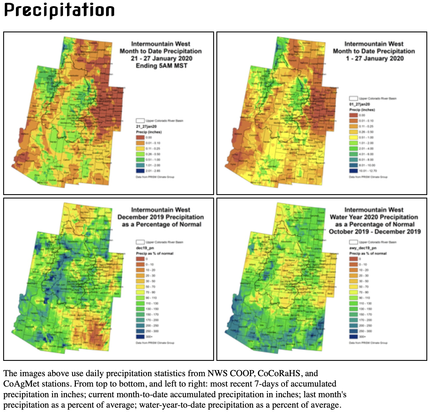
Snowpack continues to steadily accumulate throughout the Intermountain West, while conditions stayed dry on the plains east of the Continental Divide. The highest accumulations occurred in the northern Wasatch, Tetons, and northern Colorado Rockies. This is a fairly typical pattern for this time of year. Best accumulations ranged from 1.00-2.00″. The central Rockies and Wasatch received 0.50-1.00″. The lower elevations of the Upper Colorado River Basin and San Luis Valley received a couple rounds of snow, but accumulations were light, totaling less than one quarter of an inch of moisture.
Temperatures remained cooler than normal in the Upper Colorado River Basin, and were milder than normal east of the Continental Divide. This is a continuation of the pattern we have been seeing throughout much of January and February. A number of generally weak weather disturbances have tracked across the region from the west or northwest. These have been sufficient for keeping seasonal snowpack accumulation on pace with normal, and temperatures down in the mountain valleys. However, these airmasses have been drying out over the leeward side of the Rockies, leaving scant moisture for the plains. Some areas of eastern Colorado did receive a few tenths of an inch of moisture yesterday evening (1/27), which is enough to hold off on degraditions, but not enough for improvements.
Streamflows across the region are mostly in the normal range, though we are currently in base flow conditions, and a high fraction of gages are ice affected. Reservoir storage levels in Colorado and Utah are at or above average with the exception of some smaller reservoirs, whose levels may be low due to management practices rather than climatic conditions.
January impacts in the Intermountain West can be difficult to ascertain. Stresses to water resources, ecosystems, and agriculture from dry conditions generally manifest after snowmelt. At the moment, this is making drought recovery difficult to judge in southern and western Colorado/eastern Utah. The 2019 monsoon season was an abject failure, leading to increased consumptive use, decreased dryland productivity, and increased fire danger. All of this evidence lead to D2, severe drought being instated. D2 has been removed where precipitation/snowpack has been most promising, but not everywhere.
Remaining pockets of D2 exist in western Colorado/eastern Utah and the San Luis Valley. This D2 is still potentially justifiable based on 6-month precipitation deficits. However, the accompanying short-term drought impacts have been arrested for the season. There are no USDM Drought Impact Reporter entries for Colorado in the last 30 days. As the snowpack season continues to mature, and snowpack stays above average, our degree of certainty that similar impacts will not return upon snowmelt increases.
Outlook: A weak disturbance is currently exitiing the region. Another one will push through Wednesday into Thursday. High pressure and unseasonably warm temperatures are expected to cover the region over the weekend.
The Climate Prediction Center is indicating an increased chance of below normal temperatures and above normal precipitation over the 8-14 day time frame. A stronger low pressure system is currently forecast to track across the region next Monday/Tuesday, leaving much cooler air in its wake. For some, this may end up being the coldest air of the winter season.