
Click here to read the current assessment. Click here to go to the NIDIS website hosted by the Colorado Climate Center. Here’s the summary:
Summary: January 28, 2020
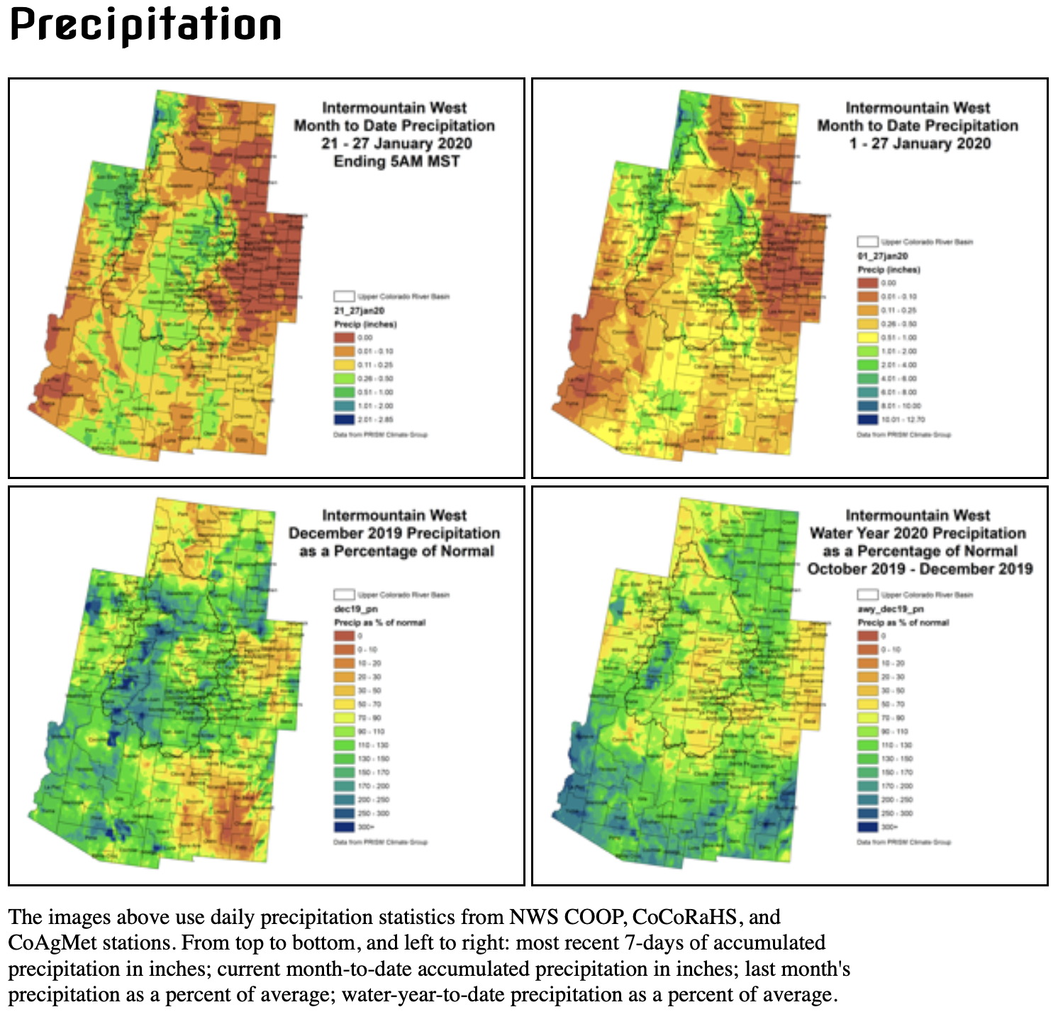
Snowpack continues to steadily accumulate throughout the Intermountain West, while conditions stayed dry on the plains east of the Continental Divide. The highest accumulations occurred in the northern Wasatch, Tetons, and northern Colorado Rockies. This is a fairly typical pattern for this time of year. Best accumulations ranged from 1.00-2.00″. The central Rockies and Wasatch received 0.50-1.00″. The lower elevations of the Upper Colorado River Basin and San Luis Valley received a couple rounds of snow, but accumulations were light, totaling less than one quarter of an inch of moisture.
Temperatures remained cooler than normal in the Upper Colorado River Basin, and were milder than normal east of the Continental Divide. This is a continuation of the pattern we have been seeing throughout much of January and February. A number of generally weak weather disturbances have tracked across the region from the west or northwest. These have been sufficient for keeping seasonal snowpack accumulation on pace with normal, and temperatures down in the mountain valleys. However, these airmasses have been drying out over the leeward side of the Rockies, leaving scant moisture for the plains. Some areas of eastern Colorado did receive a few tenths of an inch of moisture yesterday evening (1/27), which is enough to hold off on degraditions, but not enough for improvements.
Streamflows across the region are mostly in the normal range, though we are currently in base flow conditions, and a high fraction of gages are ice affected. Reservoir storage levels in Colorado and Utah are at or above average with the exception of some smaller reservoirs, whose levels may be low due to management practices rather than climatic conditions.
January impacts in the Intermountain West can be difficult to ascertain. Stresses to water resources, ecosystems, and agriculture from dry conditions generally manifest after snowmelt. At the moment, this is making drought recovery difficult to judge in southern and western Colorado/eastern Utah. The 2019 monsoon season was an abject failure, leading to increased consumptive use, decreased dryland productivity, and increased fire danger. All of this evidence lead to D2, severe drought being instated. D2 has been removed where precipitation/snowpack has been most promising, but not everywhere.
Remaining pockets of D2 exist in western Colorado/eastern Utah and the San Luis Valley. This D2 is still potentially justifiable based on 6-month precipitation deficits. However, the accompanying short-term drought impacts have been arrested for the season. There are no USDM Drought Impact Reporter entries for Colorado in the last 30 days. As the snowpack season continues to mature, and snowpack stays above average, our degree of certainty that similar impacts will not return upon snowmelt increases.
Outlook: A weak disturbance is currently exitiing the region. Another one will push through Wednesday into Thursday. High pressure and unseasonably warm temperatures are expected to cover the region over the weekend.
The Climate Prediction Center is indicating an increased chance of below normal temperatures and above normal precipitation over the 8-14 day time frame. A stronger low pressure system is currently forecast to track across the region next Monday/Tuesday, leaving much cooler air in its wake. For some, this may end up being the coldest air of the winter season.