Photo shows the Brackish Groundwater National Desalination Research Facility – BGNDRF, in Alamogordo, NM via USBR
Here’s the release from the Bureau of Reclamation (Peter Soeth):
The Bureau of Reclamation is awarding $3.6 million to 10 projects for advanced water treatment research and development. The Desalination and Water Purification Research Program funding seeks to improve technologies for water supply development from nontraditional waters, including seawater, brackish groundwater, and municipal wastewater.
“Interest in desalination as a water source is growing in the United States,” said Chief Engineer David Raff. “Improving technologies to treat water will make the advanced treatment of water more affordable for communities throughout the country and increase water supplies for the nation.”
Reclamation selected six laboratory projects and four pilot-scale research projects. The $3.6 million will be matched by $5.3 million in non-federal funding to support the research projects. The selected projects are:
PILOT-SCALE PROJECTS
Carollo Engineers, Inc. (Arizona) – $403,002
Sephton Water Technology, Inc. (California) – $139,968
Gradiant Osmotics LLC (Massachusetts) – $800,000
Massachusetts Institute of Technology (Massachusetts) – $799,989
LABORATORY PROJECTS
Yale University (Connecticut) – $250,000
New Mexico Institute of Technology and Mining (New Mexico) – $249,969
University of Cincinnati (Ohio) – $249,630
SolMem, LLC (Texas) – $241,506
University of Houston (Texas) – $249,466
William Marsh Rice University (Texas) – $250,000
A laboratory-scale study involving small flow rates. They are used to determine the viability of a novel process, new materials, or process modifications. A pilot-scale project tests a novel process to determine the technical, practical, and economic viability of the process and are generally preceded by laboratory studies that demonstrate if that the technology works.
To learn more about Reclamation’s Desalination and Water Purification Research Program and see complete descriptions of the research projects, please visit http://www.usbr.gov/research/dwpr.
In part 1 of this installment of TomTalks, Nona and Hope are joined by Mike Kintgen from the Denver Botanic Gardens who teaches us about the drought in Colorado and the frequency of droughts we have experienced in history.
Stay tuned for the second part of this presentation to learn about the affects of drought and what YOU can do to help!
Screen shot from the Vimeo film, “Rio Grande Headwaters Restoration Project: Five Ditches,” https://vimeo.com/364411112
Bessemer Ditch circa 1890 via WaterArchives.org
Click here for all the inside skinny and register:
As land trusts conserve private land, they also protect water rights. Some of Colorado’s land trusts are going beyond the parcel-by-parcel approach to conservation and are tackling big water challenges in a regional way.
During this March 9 webinar, we’ll learn how land trusts work with water rights in Colorado. Then we’ll focus on two visionary projects: Colorado Open Lands and partners in the San Luis Valley are reimagining conservation easements and putting them to work to slow groundwater decline and encourage aquifer sustainability. And the Palmer Land Conservancy is protecting irrigated farmland east of Pueblo along the Bessemer Ditch with conservation easements and, thanks to a high-level landscape-scale analysis, Palmer is combatting the effects of buy and dry by keeping water on the area’s most productive ag land.
How are land trusts making these projects work? Why are they well-positioned to play such an important role in water management? Is there an opportunity for more land trusts to tackle water management challenges in these big, innovative ways? Join us to explore these questions and come prepared with your own.
With speakers:
Melissa Daruna, Keep It Colorado
Sarah Parmar, Colorado Open Lands
Ed Roberson, Palmer Land Conservancy
Presented in partnership by Water Education Colorado and Keep It Colorado
Navajo Generating Station was the largest coal-fired power plant in the American West, a testament to the political bargaining generations ago that divvied up the region’s land, minerals, and water. But the facility’s time is now up. In November 2019, the power plant stopped producing electricity. In December 2020, the trio of 775-foot smokestacks came tumbling down. Six weeks ago, the precipitators that prevented fine coal particles from being emitted into the air were dynamited, crumbling to the desert floor like felled beasts.
In the end, Navajo Generating Station will be little more than a memory. But it also leaves behind an unsettled legacy. Besides a few scattered buildings, a transmission line, and a rail line, what will remain after the facility is decommissioned is a water rights dispute.
The coal-fired power plant that sat on Navajo Nation land in the northeastern corner of Arizona did not just generate electricity. It also drew water from the Colorado River, an essential input for cooling the plant’s machinery.
What happens to that water now that the plant is being decommissioned? Who gets to decide how it is used? In a drying region in which every drop of water is accounted for and parceled out, the stakes are high and the legal claims are unresolved.
The three players are the Navajo Nation, state of Arizona, and the federal government. The ground rules are established in decades-old interstate compacts and more recent federal laws. On the horizon are unsettled water rights claims and new infrastructure. A pipeline to deliver water to the Navajo Nation in Arizona is under construction today — but due to legal complexities there is no certainty that water will immediately flow through the pipes once the system is completed.
As crews proceed with the demolition of Navajo Generating Station, water in northeastern Arizona amounts to a lingering question mark for a basin dealing with climate stress and inequality in water access for the Navajo people…
The Colorado River was part of the bargain, too. Its water, drawn from nearby Lake Powell, was needed to remove heat created during power generation. In a 1968 resolution, the Navajo Tribal Council approved the consumptive use of 34,100 acre-feet of water from the river for the facility, an agreement that was in place until the end.
Across the West, a generation of coal-fired power plants is reckoning with the same fate as Navajo Generating Station. State mandates combined with cheaper sources of electricity from sun, wind, and natural gas and expensive pollution controls are nudging the owners to retire coal-fired units.
There are benefits to this trend and not just for reducing heat-trapping gases, said Stacy Tellinghuisen of the Boulder, Colorado-based nonprofit group Western Resource Advocates. Closing these facilities brings the possibility of making water available for other industrial, municipal, agricultural, or environmental uses.
Few transfers of water rights from closed power plants have taken place because it is a complex and time-intensive process, Tellinghuisen told Circle of Blue. “Most plants have closed in the last five years,” she said. “The water rights process is slower than that.”
One place where a transfer has taken place is in Colorado. In 2013, Black Hills Energy closed the coal-fired W.N. Clark plant, located in Cañon City. In 2020, the company sold its water rights back to Cañon City Hydraulic and Irrigating Ditch Company for eventual use in irrigated agriculture…
In the case of Navajo Generating Station, water rights are where the accounting becomes tricky. The Colorado River is divided by legal compacts into upper and lower basins. The compacts allocate water between the seven states, while a treaty outlines obligations to Mexico. Most of Arizona is in the lower basin, along with California and Nevada. But not all of Arizona. A sliver of its northeastern corner is located in the upper basin. Nearly all of Arizona’s upper basin land is on the Navajo Nation.
The Upper Colorado River Compact of 1948, negotiated among the states and endorsed by Congress, provides Arizona’s upper basin with 50,000 acre-feet of Colorado River water.
The 1968 tribal council resolution states that the Navajo would not claim the water as long as Navajo Generating Station was operating. If the plant shut down, the resolution directs the Secretary of the Interior to return the water “to the Navajo Tribe for their exclusive use and benefit.”
Pollack, the water lawyer, said that the Navajo Nation’s position is that the 50,000 acre-feet in Arizona’s upper basin allocation “was intended for the benefit of the Navajo Nation.” The Nation also does not believe its water rights are circumscribed by the Upper Colorado River Compact.
How could the Navajo Nation access this water? Pollack presented two hypothetical scenarios. If the Nation, within reservation lands, wanted to dam and draw water from waterways or pump groundwater that is linked to streams, it could do so on its own, Pollack argued. Such a scenario is highly unlikely, he said, given the infrastructure that would be required to store and move water.
A more plausible scenario would be drawing water from Lake Powell, as did the power plant. That option would require a contract with the Bureau of Reclamation, which operates the reservoir. Pollack said he believes Reclamation would then consult with the state of Arizona before approving any contract.
How does the state view its role? In response to written questions, the Arizona Department of Water Resources described what it believes is the process for allocating upper basin water.
“An entity wishing to use any of Arizona’s Upper Basin allocation would need to apply to ADWR for a permit to appropriate the water,” according to the statement. “The director of ADWR would make a decision on the application based on criteria in statute, including whether the entity would put the water to a beneficial use. Water from Arizona’s Upper Basin allocation could also be allocated to an Arizona Indian tribe pursuant to a Congressionally approved Indian water rights settlement.”
There are other opinions. Mike Pearce, a partner with the Phoenix law firm Gammage & Burnham, told Circle of Blue that from his perspective the water that was used by Navajo Generating Station “would revert back to the state of Arizona to be allocated under state law.”
[…]
The water in question is not a large amount in the big picture — Arizona’s lower basin, after all, is allocated 2.8 million acre-feet from the Colorado River. But in a region that is drying as the planet warms, every drop of water is important. In the face of these hydrological changes, veteran scholars of the basin have questioned the wisdom of allowing additional withdrawals from the river. Plus, there are equity concerns. An estimated 30 percent of Navajo Nation households do not have running water, which requires them to haul water to their homes, often by driving dozens of miles roundtrip…
Some upper basin water is already being put to use in Arizona. Subtracting Navajo Generating Station, the state’s upper basin use amounted to about 11,500 acre-feet in 2018, mostly for municipal purposes in Page and debits for reservoir evaporation.
What about the rest? For now, the unused portion of Arizona’s 50,000 acre-feet is what is known colloquially as “system water.” It stays in Lake Powell and helps the upper basin meet its water delivery obligation to the lower basin.
Though currently there is not much demand in Arizona’s upper basin, there is one potential use in the near term. An act of Congress in 2009 authorized the Navajo-Gallup water supply project, a system intended to deliver water to the eastern half of the Navajo Nation, as well as the Jicarilla Apache Nation and the town of Gallup, New Mexico.
The law sets aside 22,650 acre-feet for the Navajo Nation in New Mexico, and 6,411 acre-feet for the Navajo Nation in Arizona. The water for the Arizona section is supposed to be subtracted from Arizona’s upper basin allocation.
There is a catch, though. The law states that the water can only be delivered to the Navajo Nation in Arizona if the Nation settles its water rights claims to two other Arizona basins: the Little Colorado River and the lower basin of the Colorado. The Little Colorado River adjudication is ongoing in state court.
For Pollack, the addition of that clause is an insult. It ties water access for Navajo communities in the upper basin to negotiations about other water sources…
Installing pipe along the Navajo-Gallup Water Supply Project. Photo credit: USBR
While the legal conflict simmers, the Bureau of Reclamation is continuing to build out the Navajo-Gallup supply system, a project that includes about 280 miles of pipeline in addition to two treatment plants and several pumping stations.
Patrick Page, area manager of Reclamation’s Four Corners Construction Office, wrote to Circle of Blue in an email that major components are now under construction: two pumping stations and a 30-mile section of mainline pipe.
Congress set a deadline of December 31, 2024 to complete the project. But Reclamation can extend that deadline with the agreement of the Navajo Nation and the state of New Mexico. Page said that an extension might be necessary depending on the design assessment of a key intake structure. The wait for water might grow longer.
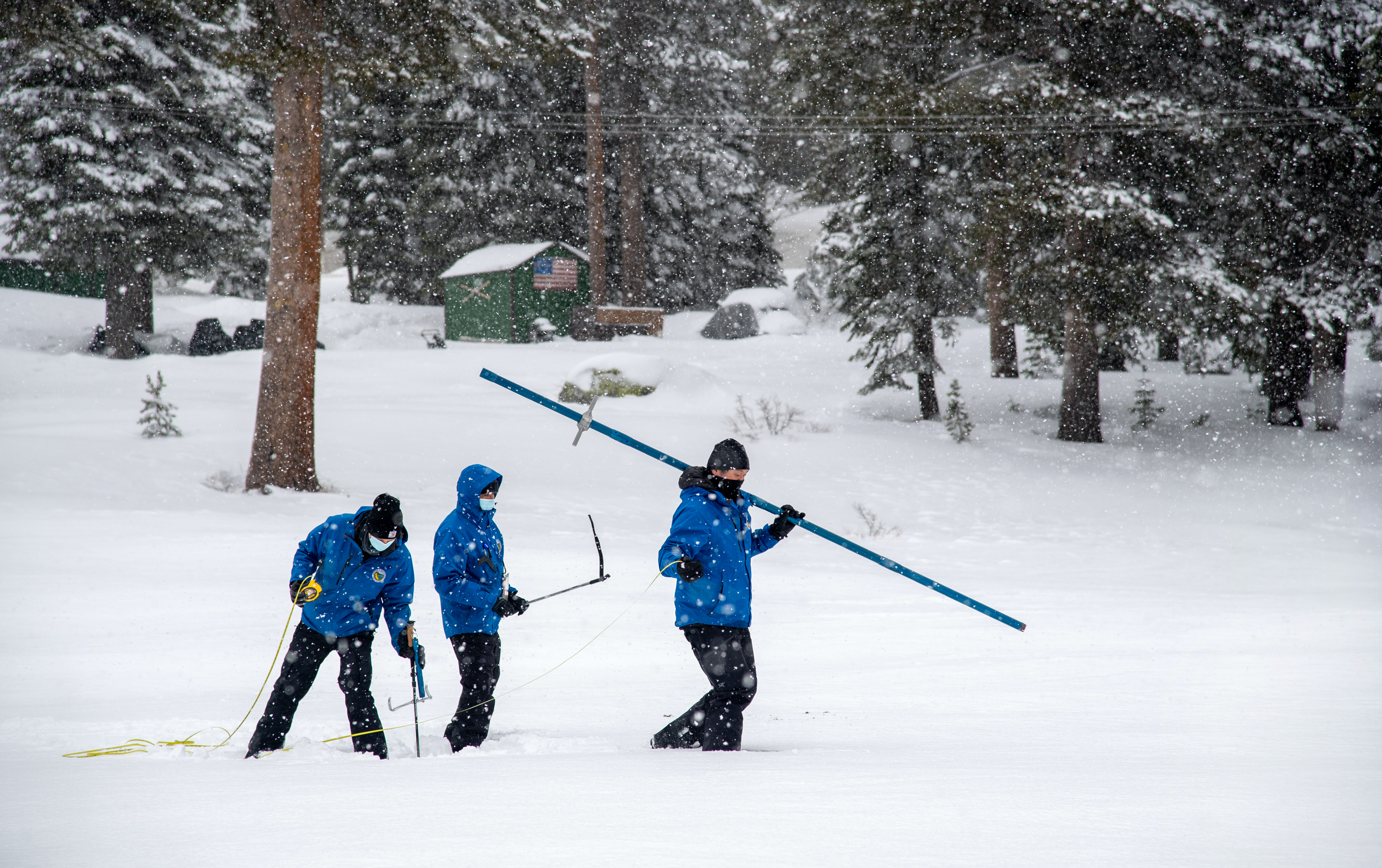
Nick Ellis, Electrical Engineer in Statewide Monitoring Network Section, Ramesh Gautam, Chief of California Cooperative Snow Surveys Program, and Sean de Guzman, Chief of the California Department of Water Resources Snow Surveys and Water Supply Forecasting Section, conduct the second media snow survey of the 2021 season at Phillips Station in the Sierra Nevada Mountains. The survey is held approximately 90 miles east of Sacramento off Highway 50 in El Dorado County. Photo taken February 3, 2021.
Here’s a release from the California Department of Water Resources:
The Department of Water Resources (DWR) today conducted the second manual snow survey of the season at Phillips Station. The manual survey recorded 63 inches of snow depth and a snow water equivalent (SWE) of 17 inches, which is 93 percent of average for this location. The SWE measures the amount of water contained in the snowpack and is a key component of DWR’s water supply forecast.
“The recent blast of winter weather was a welcome sight, but it was not enough to offset this winter’s dry start,” said DWR Director Karla Nemeth. “While there is still a chance we will see additional storms in the coming weeks, the Department and other state agencies are preparing for the potential for a second consecutive year of dry conditions.”
Statewide snow survey measurements reflect those dry conditions. Measurements from DWR’s electronic snow survey stations indicate that statewide the snowpack’s SWE is 12.5 inches, or 70 percent of the February 3 average, and 45 percent of the April 1 average. April 1 is typically when California’s snowpack is the deepest and has the highest SWE.
Fall 2020 was extremely dry, especially in the Sierra Nevada, and follows last year’s below-average snow and precipitation. With only a couple months remaining in California’s traditional wet season, Californians should look at ways to reduce water use at home. Each individual act of conservation makes a difference over time. Visit http://SaveOurWater.com to learn easy ways to save water every day.
The winter storms that dumped heavy snow and rain across California early in 2021 are likely not enough to negate what will be a critically dry year, state water officials believe.
California’s Department of Water Resources on Tuesday recorded a snow depth of 56 inches and water content of 21 inches at Phillips Station in the Sierra Nevada. The water content of the overall snowpack was 61% of the average for March 2 and 54% of the average for April 1, when it is historically at its maximum.
Surveys of the Sierra snowpack, which normally supplies about 30% of California’s water, are a key element of the department’s water-supply forecast.
December, January and February are typically the wettest part of the “water year,” which starts Oct. 1. In January, when L.A. should have received 3.12 inches of rain, only 2.44 inches fell.
Without any serious storms on the horizon, California will end this year dry, Sean de Guzman, the department’s chief of Snow Surveys and Water Supply Forecasting, said at a Tuesday news conference.
Though Californians have made progress in embracing wise water habits, “our state’s water future remains uncertain due to the variability in precipitation and changing climate,” he said.
California’s reservoirs are beginning to see the impact of a second consecutive year with below-average precipitation across the state, de Guzman said…
Phillips Station recorded more precipitation than other locations around the state. It’s located in the central Sierra, where storm systems in January and February dumped heavy amounts of rain and snow. Stations further south have less precipitation, de Guzman said.
This year is so far similar to 2014, which came in the midst of California’s most recent severe drought, which ran from 2012 to 2016.