Last summer, the Aspen Global Change Institute’s first subalpine soil-moisture and snowpack-monitoring station began transmitting live data to researchers, stakeholders and the Aspen water department.
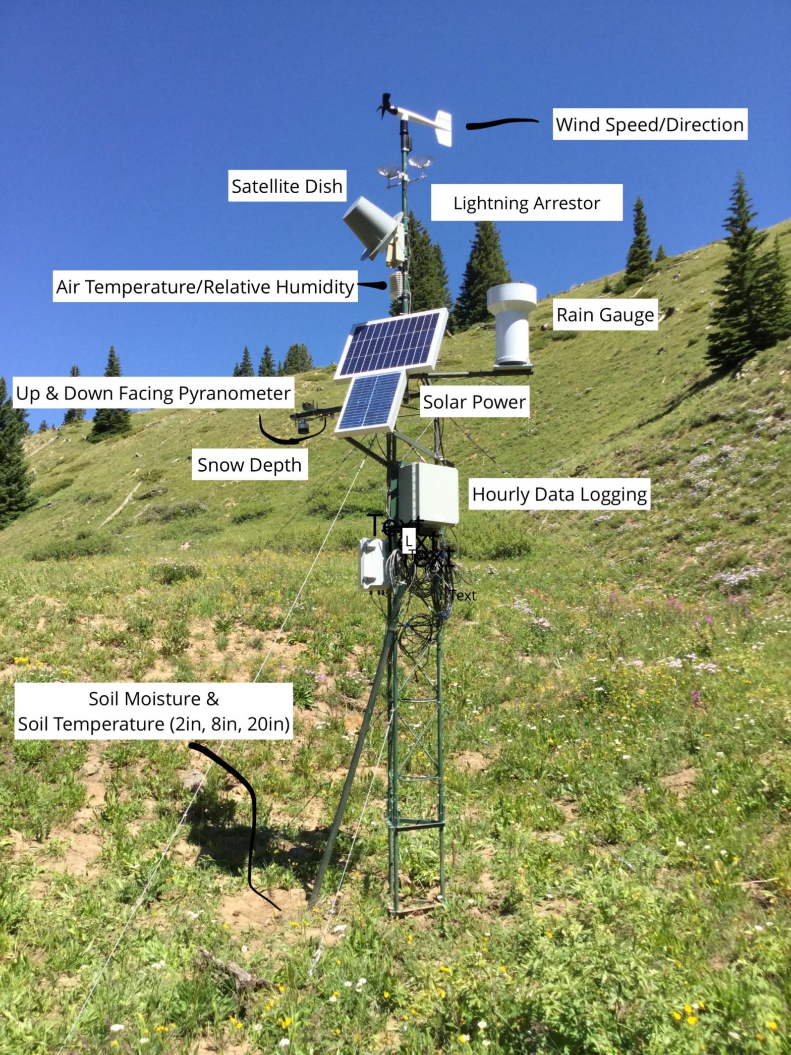
The station, which sits at 11,500 feet on Cooper Basin Road near the edge of the Castle Creek watershed, tracks soil moisture at multiple depths; soil temperature; snow depth; wind speed and direction; air temperature; humidity; and radiative balance. That data is made available online in real time.
“The new station fills a gap in that there wasn’t information being measured at that elevation,” AGCI research director Julie Vano said recently.
AGCI now has 10 stations covering the major elevation zones and ecosystems present in the Roaring Fork Valley.
The stations, known as the Interactive Roaring Fork Observation Network (iRON), gather data on soil-moisture levels, which are key but understudied variables in streamflow forecasting. In the 2020 Western Water Assessment report for the Colorado River upper and lower basins, scientists emphasized that surface soil-moisture data — critical for streamflow forecasting and for monitoring the impacts of climate change on the hydrologic cycle — was sparse.
Gathering data at all elevations throughout the Roaring Fork Valley provides scientists with a localized, clearer picture of how climate change is impacting the hydrologic cycle at the Colorado basin’s headwaters. The study of headwater areas is important because 15% of the upper and lower basins’ surface area — primarily the high mountains of the Western Slope, but also spanning mountainous areas in Utah and Wyoming — provides 85% of total annual runoff into the Colorado River.
The Castle Creek iRON station collects data such as snow depth, wind speed and direction, and radiative balance. CREDIT: ELISE OSENGA/AGCI
A storehouse of data
The AGCI network gives scientists the opportunity to study how elevation and varying ecosystems shape soil-moisture retention.
“People who live in the mountains know that everything varies a lot in a pretty small geographic distance,” said AGCI community science manager Elise Osenga. “You’ll have changes in soil type, changes in plants, even changes in rainfall from one mile to the next mile over.”
As the network continues to accumulate data, it will create a local picture of climate change’s impacts on the water cycle. Throughout the upper basin, scientists have shown that snowmelt and runoff are occurring earlier than they did between 1950 and 2000. Every degree Fahrenheit of warming is expected to reduce upper-basin runoff by between 2-6%. Having a data record for a specific basin will give these impacts a local focus, Vano said.
Since 2015, AGCI staffers have been submitting their data to international hydrologic and soil-moisture databases.
“Since we started sharing, over 1,800 requests for our data have been made,” Osenga said.
The AGCI is working to create partnerships with other soil-moisture monitoring basins and research institutions across the West to share data, allowing for future hydrologic studies involving intrabasin comparisons.
“Nothing is fully underway just yet,” Osenga said.
Determining climate-change trends via iRON data will take time to develop. The first iRON station was created in 2012. Of the 10, six have been installed since 2015. As the length of the record grows, it will become increasingly easier to detect climate change trends, Vano said.
Adding to the uncertainty, the Colorado River basin has been in an extended dry period marked by frequent droughts since 2000, marking “the driest 21-year period in the Colorado River basin in more than 100 years of record keeping and one of the driest in the past 1,200,” according to a 2021 U.S. Bureau of Reclamation report on water-supply security.
“We have really short data records, and those data records exist within an already really dry period,” Osenga said of iRON.
So, in order to gain an understanding of soil moisture in the Roaring Fork Valley, data from future potentially droughtless years is needed, Osenga said.
While drought is predicted to become more frequent and intense in the future, it is less clear how precipitation trends — which are the greatest drivers of soil moisture — will take shape. Some models indicate that precipitation could increase in the upper basin in the coming decade, which would reshape iRON’s soil-moisture data, Osenga said.
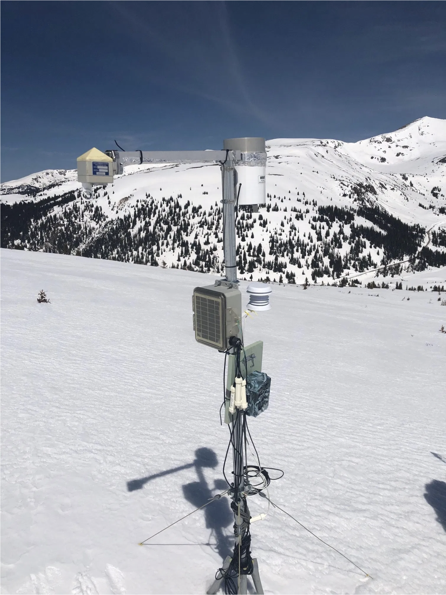
An Interactive Roaring Fork Observation Network (iRON) station sits at Independence Pass. Like the Castle Creek site, the Independence Pass station measures snow depth, wind speed and wind direction. But only the Castle Creek station measures radiative balance, or the amount of light absorbed — not reflected — by snow. CREDIT: KARIN TEAGUE/COURTESY IMAGE
Don’t be so predictable
While long-term trends from the Roaring Fork data remain ambiguous, yearly data provides useful insights for the Aspen water department in predicting spring- and summer-streamflow conditions.
“When I’m not in meetings and other obligations, I’m constantly looking at data,” said Steve Hunter, utilities resource manager for the city of Aspen.
To better predict spring streamflow, Hunter checks weather and snowpack data from national organizations such as the U.S. Geological Service and the National Resource Conservation Service. Hunter frequently checks data from the NRCS Snow Telemetry (SNOTEL) sites in the Roaring Fork watershed. The SNOTEL site at Independence Pass is closest to Castle Creek, which provides the majority of Aspen’s water, Hunter said. On Wednesday, the snow-water equivalent measured at Independence Pass was at 13.8 inches, which is 91% of average, calculated from data from 1981 to 2010. Snow depth, which is different from SWE, at Independence Pass was at 52 inches. At the Castle Creek iRON station, snow depth was at 53 inches.
Hunter also tracks the information coming from iRON. Soil-moisture data ends in the fall, when frozen water begins accumulating on the soil as snow. In the fall of 2020, seven of nine stations had the lowest levels of soil moisture on iRON station record, said Osenga. (The Castle Creek iRON station was not included in analysis.) Of the two with higher water levels than prior years, one station is in an irrigated area, providing an artificial boost to moisture levels, Osenga said.
Dry fall soil conditions mean that as snow begins to melt this spring, more water will soak in — and be absorbed by plants and the atmosphere — before running into local creeks and rivers, Osenga said.
Hunter is holding out hope that more stormy weather could give the snowpack the boost it needs for adequate streamflow this spring and summer.
“We’re just hoping we get a lot of snow and then liquid precipitation in the spring,” said Hunter.
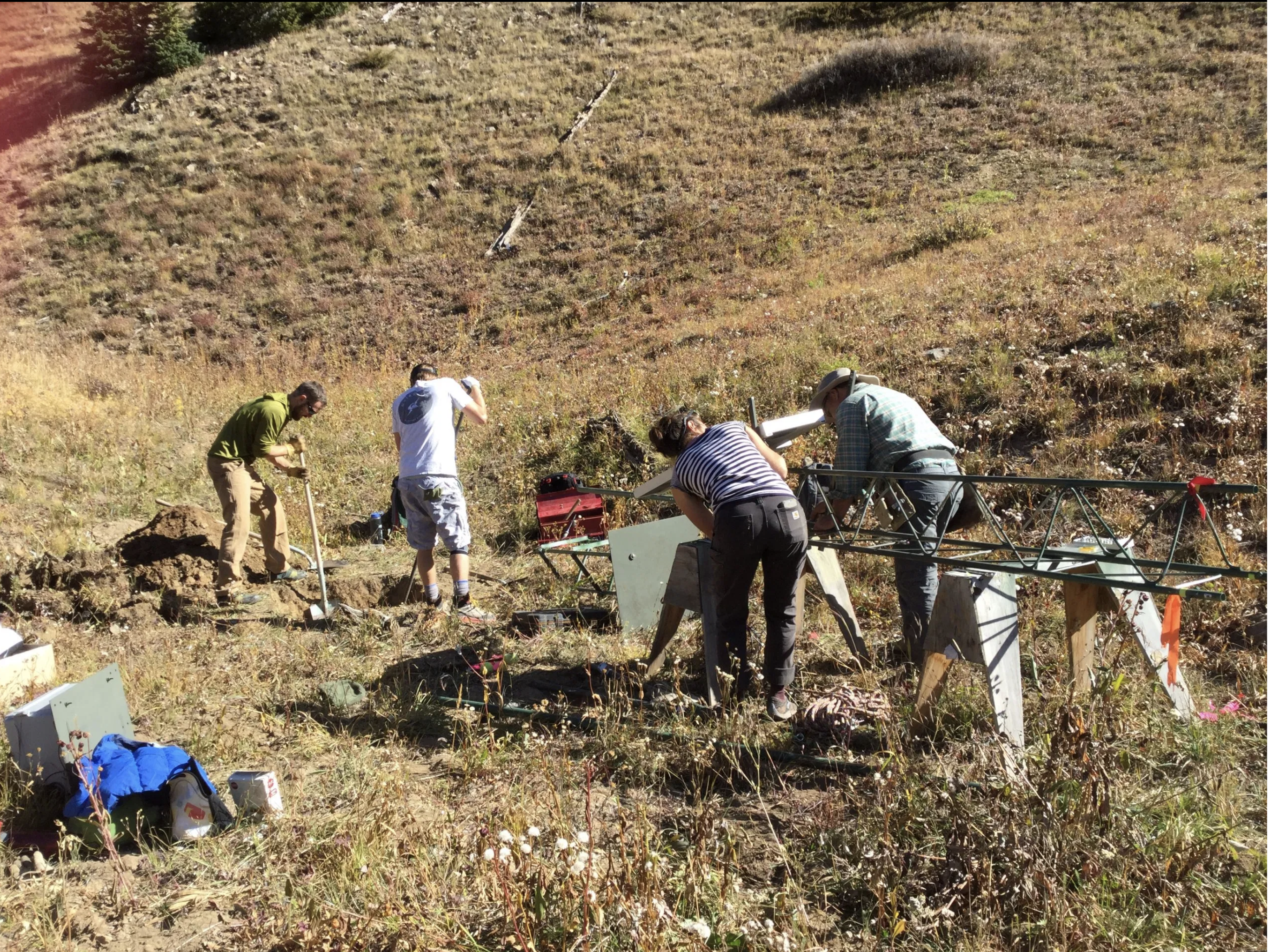
AGCI and Pitkin County staffers lift the newly constructed Castle Creek station upright on Oct. 7, 2019. CREDIT: LIZ MAURO/COURTESY IMAGE
Deciding what’s important
While the AGCI plans on expanding its reach through collaborations, the organization does not plan to add more iRON sites in the near future. Each site has been funded by a combination of partners, including private organizations, government entities and educational interests.
“It’s supported by the community, which is really amazing,” Vano said of iRON. “You don’t see that often in the world of science. So, the community is really deciding that understanding these changes is really important.”
This story ran in the March 26 edition of The Aspen Times.
Map of the Roaring Fork River drainage basin in western Colorado, USA. Made using USGS data. By Shannon1 – Own work, CC BY-SA 4.0, https://commons.wikimedia.org/w/index.php?curid=69290878
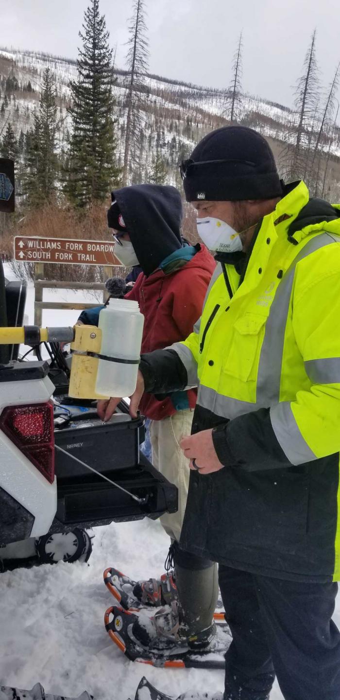
Water Quality Operations crew member Nick Riney delivers water into a sample bottle secured by colleague Tyler Torelli. The pair will fill several bottles, including some that they’ll drive back to Denver Water’s laboratory in southwest Denver for testing. Photo credit: Denver Water.
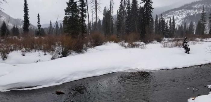
They snowshoed through a campground hidden under soft drifts, stepped carefully to the banks of the Middle Fork of the Williams Fork River, then broke the ice to find free-flowing water.
Nick Riney and Tyler Torelli worked efficiently, dipping a long-poled scoop into the waterway and filling several pint-sized plastic bottles with samples of the cold, clear stream.
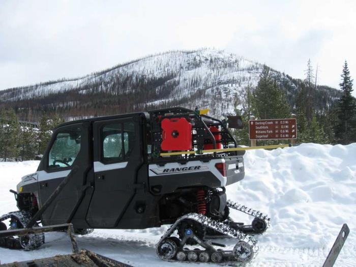
Sturdy even in finger-pinching cold, the two set up a make-shift lab on the back end of the Sno-Cat, pulled equipment out of chubby metal suitcases and ran field tests right on the spot. Twenty degrees and snowfall aren’t the ideal working conditions for most, but these guys consider it a “pretty good office” all the same.
And their work on a mid-February day in Grand County gave Denver Water’s Water Quality Operations team an early look at how last summer’s Williams Fork Fire, which burned nearly 15,000 acres northeast of Silverthorne, might have affected the water flowing through the area.
See and hear what’s required to do this work:
By sampling water as it pours through the mountains, long before it reaches any reservoirs or treatment plants, Denver Water can understand what’s happening on the landscape. Samples that veer from typical readings could indicate unexpected pollution, echoes of old mining activity or, increasingly, the impacts of forest fires.
Understanding those impacts helps prepare water quality experts for potential impacts to reservoirs or treatment processes.
The field test results came back in a healthy range, with no indication yet that a significant amount of sediment left by the summer of record fires in Colorado had ended up in the water.
Riney and Torelli prepare to run field tests on water samples using portable equipment set up on the back edge of their Sno-Cat. The field tests can analyze the turbidity of the samples, offering clues as to the impacts of wildfire. Photo credit: Denver Water.
“That’ll change,” Riney said, as the winter turns to spring and melting snow and monsoons more readily pull soil and ash from the scorched hillsides to the east of the tributary.
“But right now, this water is clean. Turbidity is low. We like to see that,” he said. “We’ll keep tracking these spots every month and try to understand just how much damage this fire did to the landscape.”
To be sure, the burned lands around the Williams Fork River don’t present a risk to Denver’s drinking water, primarily because this water travels to an “exchange” reservoir, where it will be sent down the Colorado River to make up for other West Slope water that is diverted to the Front Range.
Even so, understanding the impacts of the fire on water quality is important, allowing Denver Water and its partners, including the U.S. Forest Service, to take steps to prepare for, and reduce, those effects.
Denver Water recently began making monthly treks to this high-country stream to monitor a wetland protection project nearby. The utility has long made quarterly trips to the area as part of its broader field-testing program to track water quality across its mountain watershed.
A topographic map showing the area targeted by water sampling crews in mid-March. This area in the Arapaho National Forest is north of Silverthorne and east of Highway 9. Photo credit: Denver Water.
As part of that work, Water Quality Operations crews visit eight counties and collect samples from 77 locations. It’s work that’s distinct from the testing that goes on at reservoirs, water treatment plants and within the distribution system that bring water to household taps.
To collect samples from the Middle Fork stream, Riney and Torelli towed a Sno-Cat up and over Ute Pass Road off Highway 9, turned south in County Road 30 and went to work near Sugarloaf Campground.
“This sampling work keeps us well attuned to what’s happening in our watershed and can at times serve as an early warning for issues we may need to be watching out for further downstream,” said James Berrier, water quality monitoring supervisor at Denver Water. “We want to understand, is this just a temporary issue or something that could have a longer-term impact?”
Sampling teams measure for an array on indicators. In the field, they look at temperature, pH (which measures acidity), conductivity (which helps determine salt levels), turbidity and dissolved oxygen, which is an important factor for aquatic life.
Other water samples are transported back to Denver Water’s laboratory at the Marston Treatment Plant in southwest Denver (which will be moving in the future to its new home at Denver’s emerging National Western Center). Tests there include measuring for fluoride, chloride, nitrates, E. coli, nutrients and dissolved metal.
A Sno-Cat helps Water Quality Operations crews access stream sections that are far from roadways, moving quickly over deep snow to eliminate longer walks on snowshoes. On this day, Denver Water crews were northeast of Silverthorne and just west of the Byers Peak Wilderness Area. They were about to head toward Sugarloaf Campground, a destination indicated on the nearby signage. Photo credit: Denver Water.
Samples collected a few months from now may shed light on how much damage the Williams Fork fire did to the land.
Burned Area Emergency Response teams with the U.S. Forest Service have initially concluded that the fire did varying levels of damage. Their assessments found 23% of the area suffered high-intensity burn, while 40% was unburned or experienced low-intensity fire.
Burn levels also can show up in water quality, through indicators such as ash, sediment, metals and other signatures.
“Soil erosion modelling predicts that post-fire erosion rates are generally very low (close to pre-fire conditions) in areas with minimal fire impacts on ground cover and soils. However, rates of erosion increase dramatically … in moderate and high soil burn severity areas, especially on steeper slopes,” according to the response team’s December 2020 assessment.
Denver Water has already accumulated significant expertise and partnerships related to wildfire impacts. Collaborative efforts include From Forests to Faucets, a team approach from Denver Water, the Forest Service, the Natural Resources Conservation Service and the Colorado State Forest Service.
he Williams Fork River, lined by snow-covered banks. Photo credit: Denver Water.
These agencies, together with local groups, address overgrown forests on the front end with tree-thinning projects and repairing landscapes damaged by the kind of intense fires that dramatically slow the recovery of soils and vegetation.
“We have experience, unfortunately, with the havoc that wildfires and their aftermath can wreak on our water quality,” Berrier said, referencing major fires in the late 1990s and early 2000s that put enormous strain on reservoirs and treatment on the south end of Denver Water’s collection system, challenges that the utility is still working to overcome today.
“Tracking impacts to the water once the fires are out is a key step in getting our arms around what might be in store in the years to come.”