Rising temperatures and lack of rain threaten to decrease water supplies and bring more wildfires this summer and in the years to come.
The Western US is in the midst of yet another dangerous dry spell. The drought has been building over the past year, and since November, a greater stretch of the West has been in the most severe category of drought than at any time in the 20 years that the National Drought Mitigation Center has been keeping records.
Western states are already facing water shortages, and with the National Weather Service projecting that the dry stretch will continue, the problems that accompany droughts are likely to pile up heading into this summer…
That last drought also led to other fallouts: billions of dollars in economic losses as farmers were forced to let fields lie fallow and a 50 percent drop in electricity production from dams. It also contributed to the death of over 100 million trees, which fuels bigger wildfires, like the ones that ripped through the West last summer. If the current drought continues, similarly stark consequences lie ahead.
Unfortunately, these droughts in rapid succession aren’t an aberration but rather a sign of what’s to come. Climate change is driving more severe droughts and spurring longer, more troubling “megadroughts” across the Western states. Here’s what you need to know about what the future holds for these states as temperatures rise.
The latest episode in a megadrought
This time last year, the West was relatively drought-free after a wet winter in 2019. But by now, the region has swung from 27 percent in drought to 77 percent, according to the latest data from the US Drought Monitor released March 11.
What happened?
Over the past year, the drought has been building due to a lack of rain, a weak summer monsoon in the Southwest, and intense summer heat waves. “If I had to pinpoint one thing that really drove the drought to where we are right now, it was the heat of last summer,” said Brian Fuchs, a climatologist at the University of Nebraska’s National Drought Mitigation Center.
High summer temperatures sucked the moisture out of the soil and evaporated water resources.
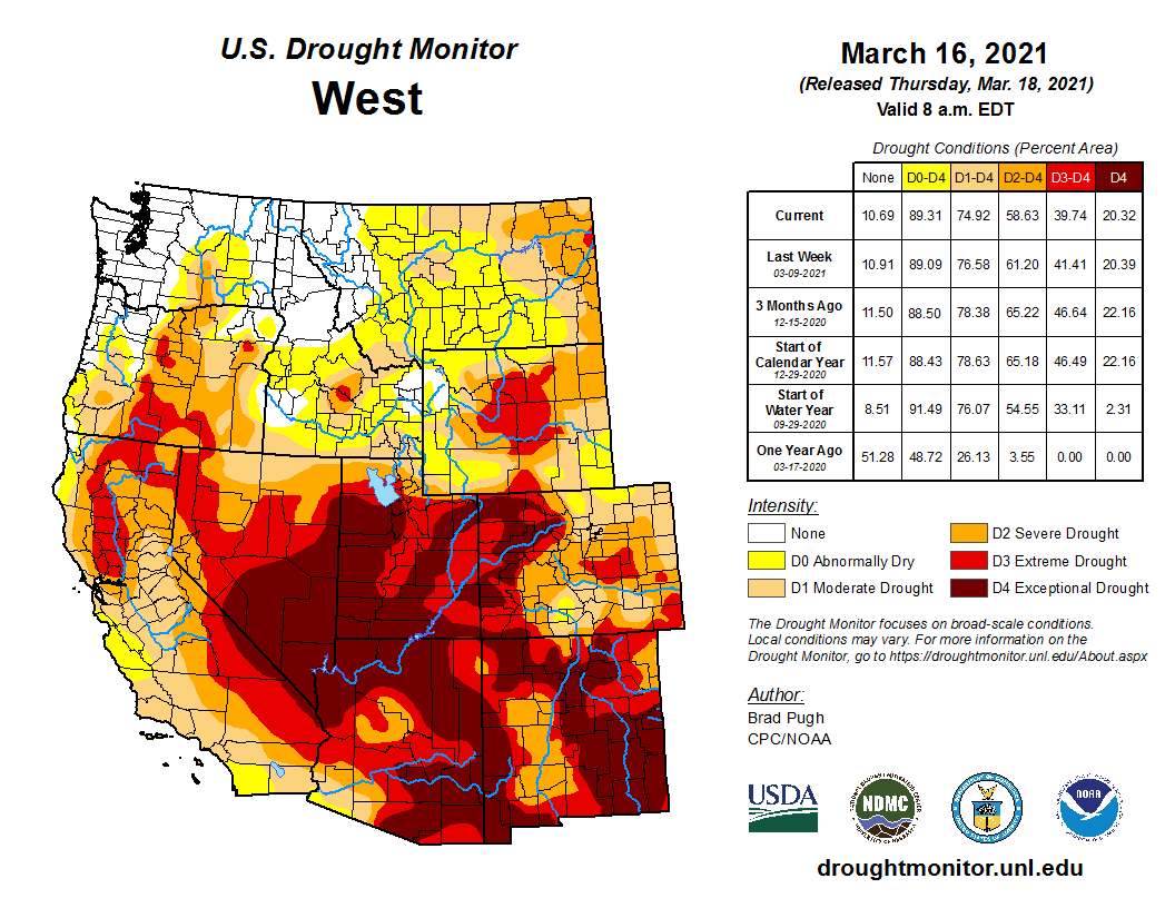
The Four Corners, where Utah, Arizona, New Mexico, and Colorado meet, has been the epicenter of this drought, Fuchs said. The dark splotch on the map below shows that those states as well as Nevada have been experiencing the most intense drought.
US Drought Monitor March 16, 2021.
Now the West is in the winter wet season, but due, in part, to the La Niña weather pattern, too little rain and snow is falling to make up for the preceding dry months.
Some rain and snow may still fall, but the National Weather Service’s seasonal forecast projects that drought conditions will persist across the Western US through May, the end of the current forecast period. “We do have some time to maybe put a dent in some of these deficits that we’ve seen through the winter,” said Fuchs. “Now the idea that we are going to catch up completely — that’s going to be tough.”
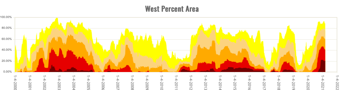
The trajectory of this drought episode remains unclear, but scientists say that it is actually part of a bigger megadrought — a decades-long dry spell, punctuated by severe droughts. This megadrought began around 2000, and as the chart below shows, the majority of land in the West has been in some level of drought ever since.
West drought time series ending March 18, 2021 via the US Drought Monitor.
To understand why the West is in a megadrought, the role of climate change, and what it means for the region’s future, we first need to look at some historical clues.
What’s behind longer and more intense droughts? Climate change.
Based on data from tree rings and other ecological records of weather and climate patterns of the last few thousand years, we know that the West is no stranger to drought. In an April 2020 tree ring study published in Science, researchers found that several megadroughts occurred between 850 and 1600 — before humans started pumping massive amounts of greenhouse gases into the atmosphere. These droughts were likely caused by cool temperatures in the Pacific Ocean that prevented rainfall from reaching the Southwest.
While natural variability has been a factor in recent droughts, the current megadrought is also being driven by climate change, according to the study. Higher temperatures, caused by greenhouse gases, have increased evaporation and decreased precipitation in the spring across the region. The researchers were able to identify that climate change accounted for 46 percent of the drought’s severity.
Without climate change, there still would have been a drought, but “anthropogenic warming was critical for placing 2000–2018 on a trajectory consistent with the most severe past megadroughts,” they wrote. The current megadrought, which they traced from 2000 through 2018, was the second driest 19-year episode in the 1,200-year record.
This finding is not just important for how we understand the current crisis, but also for the coming decades in the Western US as temperatures continue to climb.
The latest National Climate Assessment, authored by 13 US federal agencies in 2018, laid out a grim future for the Southwestern states: Rising temperatures will increase the likelihood of megadroughts in the region and make droughts more frequent and severe, according to the scientific literature cited.
While annual precipitation in the Southwest may not necessarily decrease, the hotter annual temperatures will burn off more moisture, contributing to droughts, the researchers explained in the Science tree ring study.
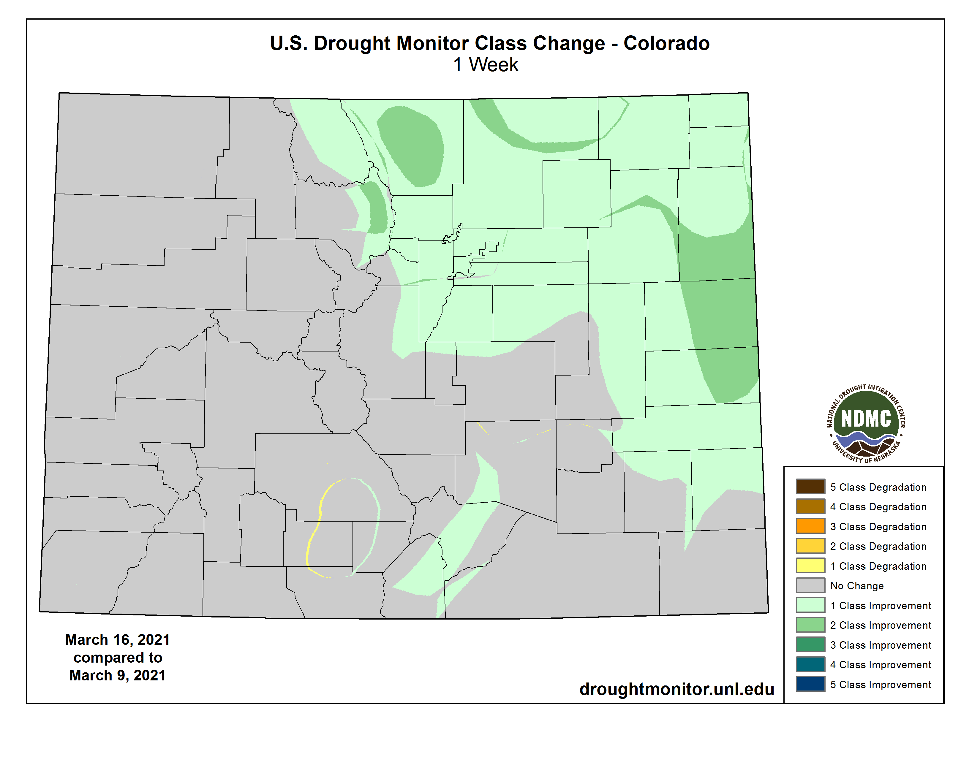
Following last weekend’s storm system that brought wet snow or rain to much of eastern Colorado, the state’s drought map has shown some signs of improvement according to the National Drought Mitigation Center.
The western half of the state saw little moisture and virtually no change in drought conditions. Much of the area is in extreme or exceptional drought, though parts of the southwest are experiencing severe conditions. Eastern portions of Jackson and Grand counties were on the edge of the storm system and move from extreme to severe drought.
Colorado Drought Monitor March 16, 2021.
The most notable improvements came in northeast Colorado, where areas of extreme drought received enough moisture to fall to severe or, in some locations, moderate conditions.
Central Larimer County moved from severe conditions to abnormally dry, along with portions of northern Weld and northwest Logan County. Severe drought remains in portions of Grand, Teller, El Paso, Pueblo, Crowley, Kiowa, Lincoln and Elbert counties.
In the southeast, severe conditions remain in Las Animas, Baca, and Prowers counties. Central Kiowa County, centered on Eads, had been the sole location on the Eastern Plains to remain in exceptional drought, however, after receiving an inch and a half or more of rain, the area moved into extreme drought. Most other portions of the County that had been in extreme conditions moved to severe drought.
US Drought Monitor one week change map for Colorado ending March 16, 2021.
[The National Drought Mitigation Center] reports that, across the region, the weekend’s strong and slow-moving low pressure system brought widespread heavy precipitation – more than two inches liquid equivalent – to northeast Colorado, southeast Wyoming, southwest South Dakota, northern Kansas, and much of Nebraska. Denver received 27.1 inches of snowfall March 13-14, making it the fourth largest snowfall on record.
The heavy snowfall brought snow water content close to average for mid-March across most of Colorado and Wyoming.
Overall, 15 percent of Colorado is in exceptional drought, while another 24 percent is experiencing exceptional conditions. Severe drought covers 33 percent of the state, with an addition 24 percent in moderate drought. Just four percent of the state is abnormally dry, and there are no drought-free areas.
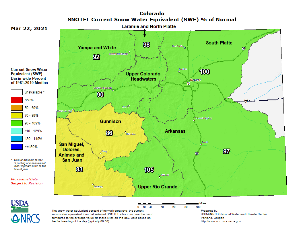
Following last weekend’s major snowstorm, Colorado’s snowpack has improved, but it still lags behind the 30-year median.
The percent of normal snow-water equivalent — the amount of water held in the snowpack — in all eight of the state’s major river basins has increased since early March, according to the U.S. Department of Agriculture’s Natural Resources Conservation Service, but five basins remain below normal levels for this time of year.
The Upper Colorado basin, which Summit County falls into, has increased its snow-water equivalent by 4 percentage points since March 5 and is currently at 89% of normal according to the Conservation Service. Breaking things down even further, the latest numbers show that the snow-water equivalent is 87% of the 30-year median at Copper Mountain and 94% at Hoosier Pass.
Blue River sub-basin SWE March 22, 2021 via the NRCS.
While the snowpack isn’t quite where it normally is this time of year, the snow has picked up recently. National Weather Service reports show that March snowfall is above average with 12.5 inches tallied so far at the Dillon weather station. Normal snowfall accumulation recorded at the station through March 18 is 9.5 inches. March’s above-average snowfall follows snowfall that was below normal levels in December, January and February…
“That Blue River above Dillon SnoTel group … as of yesterday is showing 88% of normal,” Huse said in reference to Summit County’s snowpack level. “It went up with this last storm, maybe by an inch of snow-water equivalent, just not as much as areas east of the divide. So it got a little boost from this storm, still below normal, but a little better than it was.”
Treste Huse explained that the snowpack in Summit County looks similar to 2018 levels, which had the lowest snowpack of the previous five years. Huse said that by mid-April, hydrologists will be able to better gauge what the snowpack level will mean for the rest of the year in terms of water supplies, drought and other environmental factors and added that Summit County’s 88% snowpack “isn’t bad” for now…
Colorado snowpack basin-filled map March 22, 2021 via the NRCS.
Huse added that the drought severity in Summit County has been improving over the past month and a half, but things didn’t change this week. According to the U.S. Drought Monitor, which uses a scale of drought intensity that ranges from D0, abnormally dry, to D4, exceptional drought, the southern half of Summit County is in a D2 severe drought and the northern half is in a D3 extreme drought.